5. environmental analysis - city of irvine
TRANSCRIPT

5. Environmental Analysis
Great Park Neighborhoods Draft Supplemental EIR City of Irvine • Page 5.4-1
5.4 HAZARDS AND HAZARDOUS MATERIALS
This section evaluates the potential impacts of the Modified Project on human health and the environment due to exposure to hazardous materials or conditions associated with the Proposed Project Site, project construction, and project operations. Potential project impacts and appropriate mitigation measures or standard conditions are included as necessary. The analysis in this section is based, in part, upon the following source:
• Orange County Great Park EIR, City of Irvine, May 2003
In addition, numerous reports relating to hazards and hazardous materials have been prepared concerning the Proposed Project Site, including:
County of Orange. October 1998. James A. Musick Jail Expansion and Operation FEIR No. 564.
County of Orange. August 2001.MCAS El Toro Community Reuse Plan FEIR, Volume 2B.
Earth Tech Inc. April 2003. Draft Final Environmental Baseline Survey, Former Marine Corps Air Station, El Toro, California.
Earth Tech Inc. September 2003. Final Environmental Baseline Survey, Former Marine Corps Air Station, El Toro, California.
Weston Solutions, Inc. 2004. Draft Radiological Release Report, IRP Sites 3 and 5 (including APHO 46), Anomaly Area 3, and Building 244, Former Marine Corps Air Station, El Toro, California.
U.S. Department of the Navy. September 1997b. Final Record of Decision, Operable Units 2A and 3A, No Action Sites, Marine Corps Air Station El Toro, California. Southwest Division, Naval Facilities Engineering Command, San Diego, California.
______. June 2001. Final Record of Decision, Operable Unit 3B, No Action Sites 7 and 14, Marine Corps Air Station, El Toro, California. Southwest Division, Naval Facilities Engineering Command, San Diego, California.
______. May 2002a. Base Realignment and Closure Business Plan for Marine Corps Air Station, El Toro, California. Southwest Division, Naval Facilities Engineering Command, San Diego, California.
______. June 2002b. Record of Decision for Operable Unit 1, Site 18 – Regional Volatile Organic Compound Groundwater Plume, Operable Unit 2A – VOC Source Area, Former Marine Corps Air Station, El Toro, California.
_______. 2004. Final Finding of Suitability to Lease for Carve-outs Within Parcels I, II, and III, Former Marine Corps Air Station, El Toro, California.
_______. 2004. Final Finding of Suitability to Transfer (Parcel IV and Portions of Parcels I, II, and III), Former Marine Corps Air Station, El Toro, California.
_______. 2005. Final Finding of Suitability to Transfer #2 (Portions of Parcels II and III), Former Marine Corps Air Station, El Toro, California.

5. Environmental Analysis
HAZARDS AND HAZARDOUS MATERIALS
Page 5.4-2 June 2011
______. April 2006. Final Record of Decision, Operable Units 2A – Site 24, VOC Source Area Vadose Zone, Former Marine Corps Air Station El Toro, California. Southwest Division, Naval Facilities Engineering Command, San Diego, California.
______. 2007a. Final Record of Decision, Operable Unit 3A, Sites 8, 11, and 12, Marine Corps Air Station, El Toro, California.
_______. 2008. Final Finding of Suitability to Transfer#3 (Carve-outs I-C and II-U), Former Marine Corps Air Station, El Toro, California.
_______. 2009. Final Finding of Suitability to Transfer #4 for Carve-Outs I-B, I-E, I-G, I-H, I-I, I-J, I-L, I-M, I-P, II-G, II-I, II-P, and III-D, Former Marine Corps Air Station, El Toro, California.
_______. 2010. Final Finding of Suitability to Transfer #5 for Carve-Outs I-F, I-K, I-N, I-O, I-S, II-E, II-L, II-M, II-R, and Building 746, Former Marine Corps Air Station, El Toro, California.
_______. 2011. Final Finding of Suitability to Transfer #6 for Carve-Outs I-D, I-Q, I-R, II-B, II-K, II-N, II-O, III-B-1, III-B-2, III-E, and III-F, Former Marine Corps Air Station, El Toro, California.
The data used for the analysis in this Section is based on the data used in the Hazards and Hazardous Materials Chapter of the 2003 OCGP EIR as updated and expanded upon by the above listed references.
5.4.1 Environmental Setting
The following discussion of environmental setting is adapted from the 2003 OCGP EIR and updated to reflect current conditions on the Proposed Project Site. The operation of many facilities located in Planning Area 51 historically involved the use, storage, transfer, and disposal of hazardous materials. The following discussion summarizes information from the Base Realignment and Closure Business Plan for MCAS El Toro, dated May 2002 (DON 2002a), and other sources that informed the Certified EIR, as well as other relevant sources prepared after the Certified EIR, including the Final Finding of Suitability for Transfer (“FOST”) 1 through FOST 6 documents. As described below, those six FOSTs document that all necessary remediation has been completed to protect human health and the environment on 3329.7 acres of the former MCAS El Toro. At the time the Certified EIR was finalized, not all of the property comprising the Proposed Project Site had been determined to have necessary remediation complete. Information concerning remediation is subject to periodic change as additional information is generated from cleanup programs and activities that are being planned for, or are in progress. This information may be found at the MCAS El Toro Information Repository Collection located both at the Heritage Park Regional Library in Irvine, California, and at the former MCAS El Toro library.
The military mission at the former MCAS El Toro commenced towards the end of World War II and concluded with the closure of the air station in 1999. During the approximate 55 years of military operation, the air station activities and operation and maintenance of military aircraft and automotive vehicles, required the use of a large variety of hazardous materials. These hazardous materials consisted of petroleum-based products such as aviation and vehicular fuels, engine and lubricating oils, solvents, cleaners, paints, thinners, pesticides and herbicides; chlorinated/halogenated compounds, including trichloroethylene (“TCE”) and polychlorinated biphenyls (“PCB”); some radioactive materials; ordnance munitions; and propellants. Use of these materials typically involves the generation of hazardous byproducts and waste. A risk of explosion is associated with some of these materials. Oil-water separators (“OWS”) were located throughout the former air
5. Environmental Analysis
HAZARDS AND HAZARDOUS MATERIALS
Great Park Neighborhoods Draft Supplemental EIR City of Irvine • Page 5.4-3
station at various facility locations. Wastewater from aircraft wash areas and vehicle wash racks passed through OWSs to the sanitary sewer and storm drainage systems. Materials recovered from the OWSs were handled as hazardous waste. Fuel storage areas also generated hazardous waste when fuel storage tanks were cleaned and sludge was pumped out, or when fueling/defueling or loading/unloading operations resulted in spills. Permitted hazardous waste storage areas were located throughout the former air station and held hazardous, flammable, and unused chemical material and wastes. Ordnance munitions were used, handled, stored, and disposed of in PA 51. Pesticides and herbicides historically were used at the former air station to control rodents, vectors, and weeds, as well as on agricultural parcels leased to farming operations. PCB transformers were in use throughout the former air station.
Although a total of 1,114 buildings have been surveyed, abated, and demolished since certification of the 2003 OCGP EIR, there are 180 buildings (both residential and non-residential) remaining on the former MCAS El Toro. Many of these remaining buildings and facilities may contain hazardous building materials such as asbestos-containing building materials (“ACM”) and lead-based paint (“LBP”). ACM is associated with respiratory ailments, including cancers, which are caused by inhaling asbestos fibers, as well as with gastro-intestinal disease associated with ingestion of ACM. Friable (brittle or readily crumbled) ACM is more readily released into the air than non-friable ACM. Lead is known to have adverse effects on the human body, particularly in children. Exposure is usually through ingestion and inhalation. Both ACM and LBP were in common use prior to 1980 when many of the structures in Planning Area 51 were built. Prior to demolition of any of the remaining buildings, all asbestos-containing materials (1% asbestos), all assumed ACM (“AACM”), and all asbestos-containing construction materials (“ACCM”; >0.1% to 1%) will be abated in conformity with all applicable federal, State and local laws and regulations.
Many of the existing public streets in the vicinity of the Proposed Project Site were probably used by vehicles transporting hazardous materials and waste to and from Planning Area 51 and the region, which would have resulted in the potential for hazardous spills. Rail cars on the railroad tracks that traverse the Proposed Project Site may also have transported hazardous materials. Hazardous materials (jet fuel and natural gas) were also transported onto the former MCAS El Toro site by pipeline. There is an existing fuel pipeline in the railroad right-of-way along the southern boundary of the Proposed Project Site.
Environmental Regulations Affecting MCAS El Toro
In 1975, the Department of Defense (“DOD”) initiated a pilot program to investigate past disposal sites at military installations. In 1980, the Installation Restoration Program (“IRP”) was established to identify and remediate hazardous contamination sites that originated at military installations. IRP sites are sources of environmental contamination that either are within the boundaries of the installation or originated on the installation and subsequently migrated off-site. The IRP is comprised of three phases. The first phase was an Initial Assessment Study (“IAS”) to identify disposal sites and contaminated areas through record searches, on-site surveys, and employee interviews. The second phase consisted of a confirmation study to verify and characterize contamination and rank sites for priority of cleanup. The last phase was the identification, development and implementation of remedial measures to remove the contamination and/or restore the sites to acceptable conditions. The intent of these IRP actions was to protect human health and safety, and the environment. The IRP is an “in-house” program managed by DOD with the participation of state regulatory agencies as appropriate.
As the IRP only addresses contaminated sites that are within federal jurisdiction, it does not include a public review and comment process or independent third party review. At the former MCAS El Toro, the IRP sites are those covered by the Comprehensive Environmental Response, Compensation, and Liability Act

5. Environmental Analysis
HAZARDS AND HAZARDOUS MATERIALS
Page 5.4-4 June 2011
(“CERCLA”). That 1980 “Superfund” legislation and subsequent amendments to it created a national framework for the identification and cleanup of contaminated sites, provided standards and financial assistance for site cleanups and imposed liability on parties responsible for such contamination.
The Resource Conservation and Recovery Act (“RCRA”), adopted in 1976, provide the basic framework for federal regulation of hazardous waste. The California Department of Toxic Substances Control (“DTSC”) is authorized to implement the State hazardous waste program in lieu of federal RCRA regulations. RCRA provides for “cradle-to-grave” regulation of hazardous wastes including generation, treatment, transportation, and disposal. RCRA sites at the Proposed Project Site consist of temporary accumulation areas (“TAA”) and solid waste management units (“SWMU”). Sites that are contaminated with petroleum products (which are not federally regulated), are not covered by the IRP or RCRA, but rather are managed by state agencies.
On the former MCAS El Toro, RCRA addresses existing and former hazardous waste storage and management facilities, while CERCLA addresses the release of hazardous materials and hazardous waste. There are both RCRA and CERCLA sites located on the Proposed Project Site. The DTSC manages implementation of RCRA, while the United States Environmental Protection Agency (“USEPA”) manages the implementation of CERCLA. Under CERCLA the USEPA established a National Priorities List (“NPL”) for the expenditure of cleanup funds for contaminated sites ranked most hazardous by a Hazard Ranking System (“HRS”). The former MCAS El Toro was officially placed on the NPL in February 1990. As a result of this listing, the former military base is also listed on the State list of hazardous waste sites, known as the “Cortese List,” prepared pursuant to California Government Code Section 65962.5. In 2005, the USEPA determined that no hazardous substances had come to be located on approximately 1,013 acres of the former MCAS El Toro, and therefore concluded that those areas were not part of the NPL.
Site Evaluation and Risk Assessment Methods
The site evaluation and cleanup method(s) selection under CERCLA is generally referred to as the Remedial Investigation and Feasibility Study process (“RI/FS”). The RI covers site assessment activities under which lead agencies evaluate the nature and extent of site contamination, general site conditions, and begin to identify possible cleanup methods. Considerations for remedial action objectives are provided in 40 Code of Federal Regulations Section 300.430(e)(2)(i), which states that remedial actions selected must attain a degree of cleanup and control further releases so as to, at a minimum, assure protection of human health and the environment. In the FS process, comprehensive cleanup options are developed and evaluated to select alternatives. Permanent solutions are preferred as opposed to mere containment or re-disposal of contaminated materials. The USEPA and individual states approve cleanup plans, including cleanup standards, in a formal document called a Record of Decision (“ROD”). Final cleanups should reduce contamination to levels that meet federal Clean Water Act and Safe Drinking Water Act standards as well as potentially more stringent Applicable or Relevant and Appropriate Requirements (“ARAR”) standards.
All IRP sites on military installations follow the comprehensive, step-by-step CERCLA RI/FS process. Although some sites may require interim remedial actions, permanent cleanup follows the signing of a ROD. For evaluated sites that are determined to not have any contamination or have insignificant levels of contamination, no feasibility study is conducted and the process is completed with a No Further Action ROD. Some sites may require the implementation of interim remedial actions.
As lead agency, the Department of the Navy (“DON” or “Navy”) is responsible for the establishment of cleanup goals. The DON’s approach to the former MCAS El Toro site has been to evaluate and identify remediation strategies that allow for unrestricted use of as much of the land and resources as possible.
5. Environmental Analysis
HAZARDS AND HAZARDOUS MATERIALS
Great Park Neighborhoods Draft Supplemental EIR City of Irvine • Page 5.4-5
Prior to issuance of any grading permits, the Applicant will demonstrate to the City of Irvine that the development will not create any increased risk to human health and the environment.
Base Realignment and Closure Cleanup Plan and Environmental Baseline Survey
In March 1993, the former MCAS El Toro was listed for closure by the Base Realignment and Closure Act (“BRAC III”). DON established a BRAC Cleanup Team (“BCT”) to manage and coordinate closure activities and to prepare a BRAC Cleanup Plan (“BCP”) for the former MCAS El Toro. The BCT is also the decision-making body for the level and methodology of remediation. The BCT includes representatives from DON, the USEPA, DTSC, and the Santa Ana Regional Water Quality Control Board (“RWQCB”).
The scope of the BCP considers the following regulatory mechanisms:
• BRAC III
• National Environmental Policy Act
• RCRA
• CERCLA, as amended by the Superfund Amendments and Reauthorization Act (“SARA”), and the Community Environmental Response Facilitation Act (“CERFA”)
• Other applicable state and local laws
The BCP objectives for the environmental restoration program for MCAS El Toro are as follows:
• Expedite and improve environmental response actions to facilitate the disposal and reuse of the site
• Protect human health and the environment
• Comply with existing federal, state, and local statutes and regulations
• Conduct IRP activities in a manner consistent with Section 120 of CERCLA as amended by SARA
• Meet the provisions of the Federal Facilities Agreement (“FFA”)
• Continue efforts to identify potentially contaminated areas
• Establish priorities for environmental restoration-related compliance activities so that property disposal and reuse goals can be met
• Design schedules and cost estimates for performing remedial activities for IRP sites and compliance program issues
• Identify and map areas suitable for transfer by deed/lease and areas unsuitable for transfer by deed
The BCP for the former MCAS El Toro described the status of environmental restoration and compliance programs. The first BCP was first issued in 1994 and was updated annually thereafter, with the most current
5. Environmental Analysis
HAZARDS AND HAZARDOUS MATERIALS
Page 5.4-6 June 2011
version referenced in the Certified EIR being the version released in May 2002. The May 2002 BCP outlined 866 locations of concern (“LOCs”) targeted for further investigation or remediation, including IRP sites (major confirmed release sites identified early in the Navy’s processes), temporary hazardous waste Accumulation Areas (“TAAs”), solid waste management units (“SWMUs”), underground storage tanks (“USTs”), aboveground storage tanks (“ASTs”), wastewater system sites, PCB-containing transformer and other equipment sites, and miscellaneous sites, such as those identified through reviewing aerial photos (“APHOs”). The programs outlined in the BCP support the environmental restoration of the former MCAS El Toro site and its disposal and reuse. The May 2002 BCP described active remediation sites, the status of other studies and assessments being conducted, and other on-going compliance-related programs. It also emphasized expedited remedial actions rather than lengthy site characterization studies and prolonged RI/FS activities. Several methods are used to streamline and accelerate cleanup of the former MCAS El Toro. Presumptive remedies use preferred technologies developed for common categories of waste sites to ensure consistency in remedy selection, as well as reduce time and cleanup costs at appropriate sites. Currently accepted presumptive remedies exist for volatile organic compounds (“VOCs”) and municipal and military landfills. Other strategies for streamlining cleanup include overlapping cleanup phases and committing to partnership among the BCT.
An environmental baseline survey (“EBS”) was conducted in 1995 for the purpose of identifying which portions of the former MCAS El Toro site were eligible for transfer or sale as uncontaminated. That study also provided information regarding the general environmental status of other structures, facilities and other portions of the former MCAS El Toro site. In preparation for transfer of available land, the DON updated its 1995 EBS with an April 2003 Draft Final EBS. The April 2003 Draft Final EBS represented the most relevant evaluation of continuing remediation efforts undertaken by the DON at the time the Certified EIR was being prepared, and thus was used in preparation of the Certified EIR. The April 2003 Draft Final EBS updated the information in the 2002 BCP, reviewed each potential LOC identified during the history of environmental investigations at El Toro MCAS, and recommended whether further action was necessary to investigate or remediate each LOC. The DON evaluated potential soil contamination adjacent to and underneath certain runway extensions, and concluded that no evidence of significant levels of contamination exists in these areas. It concluded that of the 3,738 acres of former MCAS El Toro property expected to become available for transfer, approximately 84 percent is environmentally suitable for transfer of fee title. The updated EBS also concluded that widespread unidentified contamination is not likely to exist at the former MCAS El Toro. The Final EBS was submitted in September 2003, and its recommendations were approved by the USEPA, DTSC and the RWQCB.
Findings of Suitability to Transfer and Finding of Suitability to Lease
After approval of the September 2003 Final EBS, the DON identified portions of the former MCAS El Toro property where there either were no LOCs identified in the EBS, or the only LOCs identified were ones which the Supplemental Environmental Baseline Survey (“SEBS”) concluded required no further action, and proposed those areas for inclusion in FOST 1 (2004), described below. All other areas, i.e. those which were LOCs identified in the SEBS as requiring further investigation or action, were proposed for inclusion in a Finding of Suitability to Lease (“FOSL”) (2004), described below.

5. Environmental Analysis
HAZARDS AND HAZARDOUS MATERIALS
Great Park Neighborhoods Draft Supplemental EIR City of Irvine • Page 5.4-7
Together, FOST 1 and the FOSL describe the entirety of the portions of El Toro MCAS transferred by the Navy in 2005, which includes all of the property comprising the Proposed Project site (which is the same site for both the Approved Project and the Modified Project). FOST 1 and the FOSL summarize the state of knowledge about the property as of their respective dates of publication.
FOST 1 (2004)
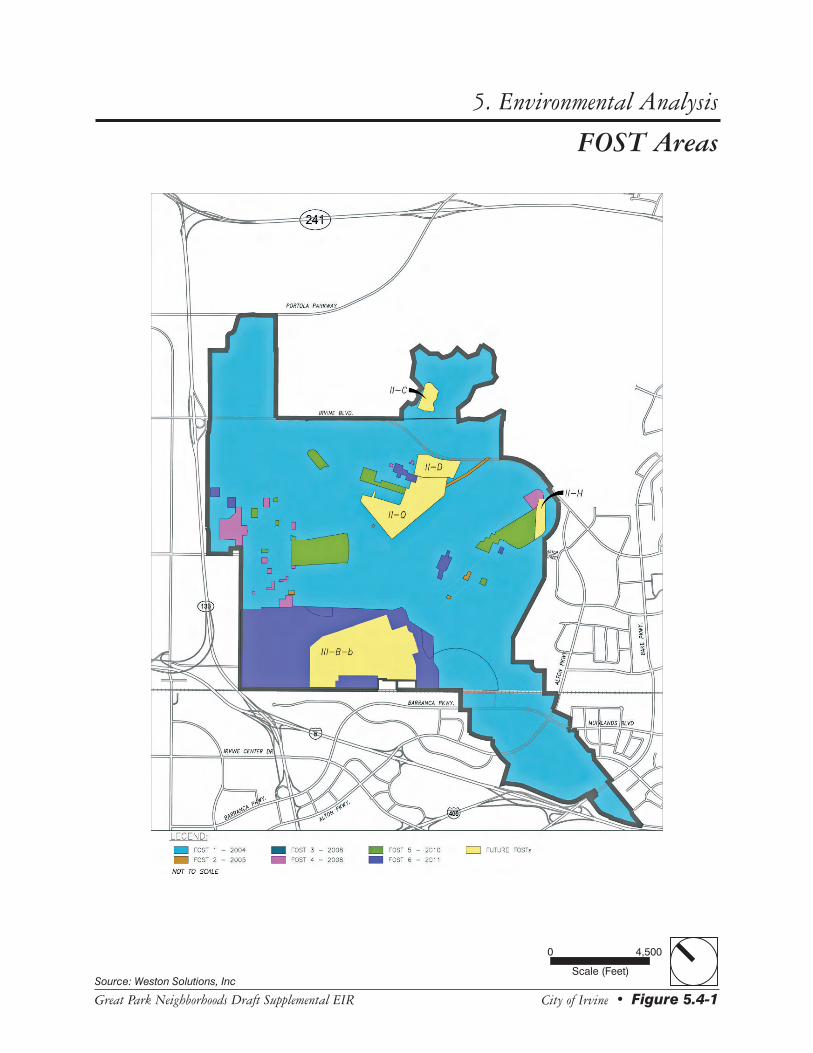
The regulatory agencies’ approval of FOST 1 represented their approval of “No Further Action” for the 2,137 acres of developable property. Figure 5.4-1 shows the boundaries of the acreage transferred with each FOST. Importantly, all of the area covered by FOST 1 (and FOST 2) has been approved for “unrestricted use” by the environmental regulators.
FOST 1 contains a variety of site-specific deed notifications, not restrictions, related to issues on particular parcels, including notifications for IRP sites, USTs and ASTs, wastewater and related systems, PCBs, medical/biohazardous waste, ordnance, pesticides, radon, ACMs, and LBP.
FOSL (2004)
After completion of the SEBS, the Navy identified discrete portions of the former MCAS El Toro property which contained LOCs identified in the SEBS as requiring additional investigation or action, and designated each of these areas as “Carve-Out Areas.” Generally, the boundaries of the Carve-Out Areas were drawn conservatively, with buffer areas placed around the relevant LOCs. Carve-Out Areas are also commonly referred to as “FOSL” areas or sometimes as “LIFOC” areas, because they are covered by a Lease in Furtherance of Conveyance from the Navy.
Unlike FOST property, which has been cleared for unrestricted use, the Carve-Out Areas are subject to strict restrictions on what activities can be conducted. The FOSL contains the following “General Restrictions” for the Carve-Out Areas: No digging, soil disturbance, etc., without Navy approval; no new wells without approval; no groundwater disturbance that may affect plume migration; no disturbance of monitoring wells, response action equipment, security features, or associated utilities.
There is an established process for obtaining Navy approval for conducting these otherwise prohibited activities. It involves preparing a Project Evaluation Review Form (“PERF”) which describes the proposed activity and the mitigation measures which will be taken to ensure it is conducted safely and will not exacerbate any problems or interfere with the Navy’s environmental cleanup activities. Once the Navy approves the PERF, it is then submitted to the BCT members for approval. The FOSL also contains specific notifications similar to those in the FOST for IRP sites, USTs/ASTs, wastewater and related systems, PCBs, ordnance, pesticides, radon, ACM, and LBP.
Subsequent FOSTs: 2 through 6.
As a result of investigations and other actions since 2004, some of the Carve-Out Areas identified in the original FOSL have now been identified by the Navy as not requiring further action, and therefore as being appropriate for inclusion in a FOST. The date of each subsequent FOST and the acreage encompassed by each is listed below. Together, FOSTs 1 through 6 represent a finding that all remediation necessary to protect public health and the environment has been conducted on 3,329 of the 3,700 acres that comprise the Proposed Project Site. For specific information regarding the sites that have been cleaned up and transferred, please refer to FOSTs 1 through 6.

5. Environmental Analysis
HAZARDS AND HAZARDOUS MATERIALS
Page 5.4-8 June 2011
As in FOST 1, the subsequent FOSTs approved unrestricted use of the property covered by each FOST. The subsequent FOSTs also contained specific notification requirements similar to those in FOST 1 for IRP sites, USTs/ASTs, wastewater and related systems, PCBs, ordnance, pesticides, radon, ACM, LBP, and school sites.
The DON is required to complete all necessary remedial actions before fee title to the former MCAS El Toro is transferred from federal ownership. However, even after title is transferred, the federal government is required to conduct further remediation if additional contamination caused by DON actions is discovered or if a prior remedy fails to perform adequately. Federal law also provides that the DON may be required to indemnify the new owners or certain other parties for liabilities arising from claims of personal injury or property damage resulting from the release or threatened release of any hazardous substances, pollutants or contaminants, or petroleum or petroleum derivatives attributable to DON actions on military installations.
There have been 6 conveyances of real property from the DON to the Applicant to date:
• FOST #1 conveyed approximately 2,798 acres.
• FOST #2 conveyed approximately 8 acres.
• FOST #3 conveyed approximately 3.9 acres.
• FOST #4 conveyed approximately 42.9 acres.
• FOST #5 conveyed approximately 119.3 acres.
• FOST #6 conveyed approximately 356.45 acres.
These conveyances are documented in the following documents:
• Final Finding of Suitability to Transfer (Parcel IV and Portions of Parcels I, II, and III), Former Marine Corps Air Station El Toro, California (DON 2004)
• Final Finding of Suitability to Transfer #2 (Portions of Parcels II and III), Former Marine Corps Air Station El Toro, California (DON 2005)
• Final Finding of Suitability to Transfer #3 (Carve-outs I-C and II-U), Former Marine Corps Air Station El Toro, California (DON 2008)
• Final Finding of Suitability to Transfer #4 (Carve-outs I-B, I-E, I-G, I-H, I-I, I-J, I-L, I-M, I-P, II-G, II-I, II-P, and III-D), Former Marine Corps Air Station El Toro, California (DON 2008)
• Final Finding of Suitability to Transfer #5 (Carve-outs I-F, I-K, I-N, I-O, I-S, II-E, II-L, II-M, II-R and Building 746), Former Marine Corps Air Station El Toro, California (DON 2010)
• Final Finding of Suitability to Transfer #6 (Carve-outs I-D, I-Q, I-R, II-B, II-K, II-N, II-O, III-B-1, III-B-2, III-E, and III-F), Former Marine Corps Air Station El Toro, California (DON 2011)
FOST Areas
Source: Weston Solutions, Inc
City of Irvine • Figure 5.4-1Great Park Neighborhoods Draft Supplemental EIR
5. Environmental Analysis
0 4,500
Scale (Feet)
5. Environmental Analysis
HAZARDS AND HAZARDOUS MATERIALS
Page 5.4-10 June 2011
This page intentionally left blank.
5. Environmental Analysis
HAZARDS AND HAZARDOUS MATERIALS
Great Park Neighborhoods Draft Supplemental EIR City of Irvine • Page 5.4-11
Environmental Restoration Programs at MCAS El Toro
Installation Restoration Program
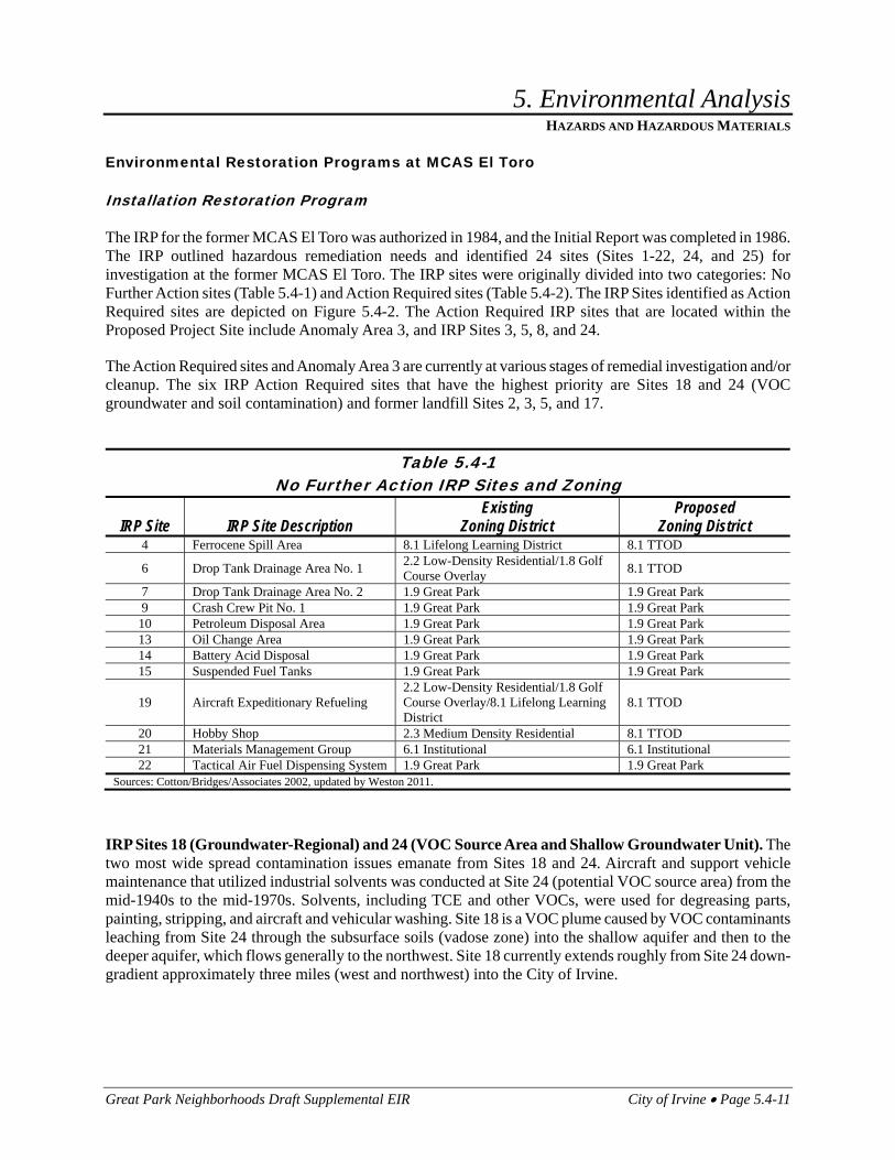
The IRP for the former MCAS El Toro was authorized in 1984, and the Initial Report was completed in 1986. The IRP outlined hazardous remediation needs and identified 24 sites (Sites 1-22, 24, and 25) for investigation at the former MCAS El Toro. The IRP sites were originally divided into two categories: No Further Action sites (Table 5.4-1) and Action Required sites (Table 5.4-2). The IRP Sites identified as Action Required sites are depicted on Figure 5.4-2. The Action Required IRP sites that are located within the Proposed Project Site include Anomaly Area 3, and IRP Sites 3, 5, 8, and 24.
The Action Required sites and Anomaly Area 3 are currently at various stages of remedial investigation and/or cleanup. The six IRP Action Required sites that have the highest priority are Sites 18 and 24 (VOC groundwater and soil contamination) and former landfill Sites 2, 3, 5, and 17.
Table 5.4-1
No Further Action IRP Sites and Zoning
IRP Site IRP Site Description Existing
Zoning District Proposed
Zoning District 4 Ferrocene Spill Area 8.1 Lifelong Learning District 8.1 TTOD
6 Drop Tank Drainage Area No. 1 2.2 Low-Density Residential/1.8 Golf Course Overlay 8.1 TTOD
7 Drop Tank Drainage Area No. 2 1.9 Great Park 1.9 Great Park 9 Crash Crew Pit No. 1 1.9 Great Park 1.9 Great Park 10 Petroleum Disposal Area 1.9 Great Park 1.9 Great Park 13 Oil Change Area 1.9 Great Park 1.9 Great Park 14 Battery Acid Disposal 1.9 Great Park 1.9 Great Park 15 Suspended Fuel Tanks 1.9 Great Park 1.9 Great Park
19 Aircraft Expeditionary Refueling 2.2 Low-Density Residential/1.8 Golf Course Overlay/8.1 Lifelong Learning District
8.1 TTOD
20 Hobby Shop 2.3 Medium Density Residential 8.1 TTOD 21 Materials Management Group 6.1 Institutional 6.1 Institutional 22 Tactical Air Fuel Dispensing System 1.9 Great Park 1.9 Great Park
Sources: Cotton/Bridges/Associates 2002, updated by Weston 2011.
IRP Sites 18 (Groundwater-Regional) and 24 (VOC Source Area and Shallow Groundwater Unit). The two most wide spread contamination issues emanate from Sites 18 and 24. Aircraft and support vehicle maintenance that utilized industrial solvents was conducted at Site 24 (potential VOC source area) from the mid-1940s to the mid-1970s. Solvents, including TCE and other VOCs, were used for degreasing parts, painting, stripping, and aircraft and vehicular washing. Site 18 is a VOC plume caused by VOC contaminants leaching from Site 24 through the subsurface soils (vadose zone) into the shallow aquifer and then to the deeper aquifer, which flows generally to the northwest. Site 18 currently extends roughly from Site 24 down-gradient approximately three miles (west and northwest) into the City of Irvine.

5. Environmental Analysis
HAZARDS AND HAZARDOUS MATERIALS
Page 5.4-12 June 2011
Table 5.4-2 Action Required IRP Sites and Zoning – Modified Project
IRP Site IRP Site Description Existing
Zoning District Proposed
Zoning District 1 EOD Range 1.4 Preservation 1.4 Preservation 2 Magazine Road landfill 1.4 Preservation 1.4 Preservation
3 Original Landfill 1.9 Great Park/8.1 Lifelong Learning District 1.9 Great Park/8.1 TTOD
5 Perimeter Road Landfill 1.9 Great Park 8.1 TTOD
8 DRMO Storage Yard 6.1 Institutional/3.2 Transit Oriented Development
6.1 Institutional/3.2 Transit Oriented Development
11 Transformer Storage Area 1.9 Great Park 1.9 Great Park 12 Sludge Drying Beds 6.1 Institutional 6.1 Institutional 16 Crash Crew Pit No. 2 1.9 Great Park 1.9 Great Park 17 Communications Station Landfill 1.4 Preservation 1.4 Preservation
24 VOC Source Area 6.1 Institutional/1.9 Great Park/3.2 Transit Oriented Development
6.1 Institutional/1.9 Great Park/3.2 Transit Oriented Development
Sources: Cotton/Bridges/Associates 2002, updated by Weston 2011.
Remediation for Sites 18 and 24 is a two-step process. Soil remediation of Site 24 by soil vapor extraction (“SVE”) was planned to prevent or significantly minimize further impact to the groundwater. The interim ROD for Site 24 was signed in 1997, and SVE treatment commenced in 1999. Testing of the vadose zone was completed in 2000 and a draft closure report was issued in 2001. For Site 18, the DON, the Orange County Water District (“OCWD”), and the Irvine Ranch Water District (“IRWD”) negotiated an agreement to construct and operate a joint water supply treatment project that would remove contaminants from the groundwater to levels acceptable to the regulatory agencies (the “Irvine Desalter Project”).
In addition to the interim ROD issued for the contaminated soil on Site 24, a final ROD for groundwater contamination at Sites 18 and 24 was signed in June 2002. Please refer to the Final Record of Decision, Operable Unit 1, Site 18 – Regional Volatile Organic Compound Groundwater Plume, Operable Unit 2A, Site 24 – VOC Source Area, Former MCAS El Toro, California (DON 2002b) for additional information. Pursuant to a settlement agreement, the Final ROD selected a groundwater extraction and VOC treatment remedy to address the TCE contamination that incorporated a modified version of the Irvine Desalter Project. The OCWD, IRWD, and the settling federal agencies, comprised of the Department of Justice (“DOJ”) and the DON, reached an agreement documenting that the Modified Irvine Desalter Project, operated by OCWD/IRWD, would accept and treat VOC-impacted groundwater from IRP Site 24 (DOJ 2001). A Draft Final (100-Percent) Design Submittal for the Irvine Desalter Project was submitted in May 2005 (Tetra Tech 2005). The Final 100-Percent Design Submittal finalized the engineering design and specifications for the Site 24 Shallow Groundwater Unit (“SGU”) remedial action at IRP Site 24 (Weston 2005). The ongoing groundwater remedy of extracting and treating VOC-impacted groundwater began in 2006. A Final Performance Monitoring and Sampling and Analysis Plan (“PMP”) for OU-1 and OU-2A Groundwater Remedy was submitted in August 2007 (Earth Tech 2007). A Final Operating Properly and Successfully (“OPS”) Report for IRP Site 24 was submitted on July 13, 2010 (Weston 2010a). E-mail concurrences were provided on that OPS Report by the RWQCB on July 2, 2010, and the DTSC on July 6, 2010. The USEPA concurred with the OPS Report on September 9, 2010 (USEPA 2010). Current groundwater plume information can be obtained from IRP Site 24 Groundwater Monitoring Report (Weston 2010b).

Installation Restoration Program Sites
Source: Weston Solutions, Inc
City of Irvine • Figure 5.4-2Great Park Neighborhoods Draft Supplemental EIR
5. Environmental Analysis
0 4,500
Scale (Feet)
District 1(North)
District 1(North)
District 4District 4
District 7District 7
District 8District 8
District 1(South)
District 1(South)
5
5
405
133
241

5. Environmental Analysis
HAZARDS AND HAZARDOUS MATERIALS
Page 5.4-14 June 2011
This page intentionally left blank.
5. Environmental Analysis
HAZARDS AND HAZARDOUS MATERIALS
Great Park Neighborhoods Draft Supplemental EIR City of Irvine • Page 5.4-15
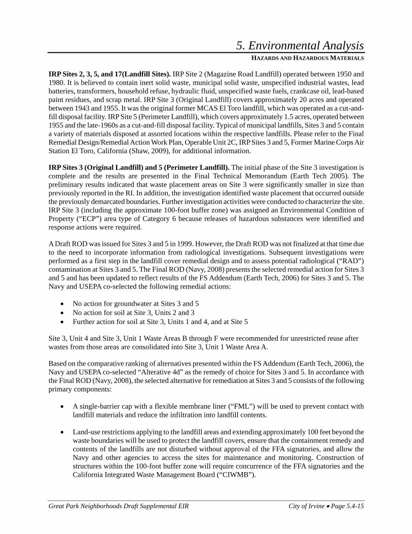
IRP Sites 2, 3, 5, and 17(Landfill Sites). IRP Site 2 (Magazine Road Landfill) operated between 1950 and 1980. It is believed to contain inert solid waste, municipal solid waste, unspecified industrial wastes, lead batteries, transformers, household refuse, hydraulic fluid, unspecified waste fuels, crankcase oil, lead-based paint residues, and scrap metal. IRP Site 3 (Original Landfill) covers approximately 20 acres and operated between 1943 and 1955. It was the original former MCAS El Toro landfill, which was operated as a cut-and-fill disposal facility. IRP Site 5 (Perimeter Landfill), which covers approximately 1.5 acres, operated between 1955 and the late-1960s as a cut-and-fill disposal facility. Typical of municipal landfills, Sites 3 and 5 contain a variety of materials disposed at assorted locations within the respective landfills. Please refer to the Final Remedial Design/Remedial Action Work Plan, Operable Unit 2C, IRP Sites 3 and 5, Former Marine Corps Air Station El Toro, California (Shaw, 2009), for additional information.
IRP Sites 3 (Original Landfill) and 5 (Perimeter Landfill). The initial phase of the Site 3 investigation is complete and the results are presented in the Final Technical Memorandum (Earth Tech 2005). The preliminary results indicated that waste placement areas on Site 3 were significantly smaller in size than previously reported in the RI. In addition, the investigation identified waste placement that occurred outside the previously demarcated boundaries. Further investigation activities were conducted to characterize the site. IRP Site 3 (including the approximate 100-foot buffer zone) was assigned an Environmental Condition of Property (“ECP”) area type of Category 6 because releases of hazardous substances were identified and response actions were required.
A Draft ROD was issued for Sites 3 and 5 in 1999. However, the Draft ROD was not finalized at that time due to the need to incorporate information from radiological investigations. Subsequent investigations were performed as a first step in the landfill cover remedial design and to assess potential radiological (“RAD”) contamination at Sites 3 and 5. The Final ROD (Navy, 2008) presents the selected remedial action for Sites 3 and 5 and has been updated to reflect results of the FS Addendum (Earth Tech, 2006) for Sites 3 and 5. The Navy and USEPA co-selected the following remedial actions:
• No action for groundwater at Sites 3 and 5 • No action for soil at Site 3, Units 2 and 3 • Further action for soil at Site 3, Units 1 and 4, and at Site 5
Site 3, Unit 4 and Site 3, Unit 1 Waste Areas B through F were recommended for unrestricted reuse after wastes from those areas are consolidated into Site 3, Unit 1 Waste Area A.
Based on the comparative ranking of alternatives presented within the FS Addendum (Earth Tech, 2006), the Navy and USEPA co-selected “Alterative 4d” as the remedy of choice for Sites 3 and 5. In accordance with the Final ROD (Navy, 2008), the selected alternative for remediation at Sites 3 and 5 consists of the following primary components:
• A single-barrier cap with a flexible membrane liner (“FML”) will be used to prevent contact with landfill materials and reduce the infiltration into landfill contents.
• Land-use restrictions applying to the landfill areas and extending approximately 100 feet beyond the waste boundaries will be used to protect the landfill covers, ensure that the containment remedy and contents of the landfills are not disturbed without approval of the FFA signatories, and allow the Navy and other agencies to access the sites for maintenance and monitoring. Construction of structures within the 100-foot buffer zone will require concurrence of the FFA signatories and the California Integrated Waste Management Board (“CIWMB”).

5. Environmental Analysis
HAZARDS AND HAZARDOUS MATERIALS
Page 5.4-16 June 2011
A Final Remedial Design/Remedial Action Work Plan dated August 2009 and Operation and Maintenance/Long-Term Monitoring Plan dated November 2010 have been prepared and approved by the DTSC and the field construction activities have been completed. A Removal Action Completion Report is due to the DTSC in 2012.
IRP Sites 2 (Magazine Road Landfill) and 17 (Communication Station Landfill). IRP Site 2 (Magazine Road Landfill) operated between 1950 and 1980. It is believed to contain inert solid waste, municipal solid waste, unspecified industrial wastes, lead batteries, transformers, household refuse, hydraulic fluid, unspecified waste fuels, crankcase oil, lead-based paint residues, and scrap metal. IRP Site 17 operated between 1981 and 1993, and was used for the disposal of municipal debris, cooking grease, oils, and fuels. Initially, the presumptive remedy for Site 17 was capping the former landfill with a soil cover (and a flexible membrane for several portions of the landfill) plus implementation of institutional controls and long-term groundwater monitoring, as proposed by the DON and taken into consideration by Cal/EPA and the USEPA. A potential presence of radioactive materials on Site 17, resulting from the disposal of radium paint residues, was identified in the Historical Radiological Assessment (“HRA”) report. As a result, the DON conducted site specific radiological investigations for the presence of radioactive materials. Please refer to the Final Interim ROD, Operable Unit 2B, Landfill Sites 2 and 17, MCAS El Toro, California (Bechtel National, Inc. 2000) for additional information.
Based on results of investigations at Sites 2 and 17, the DON issued a technical memorandum recommending No Further Action (Earth Tech 2001b). The FFA signatories reviewed the technical memorandum and requested supplemental sampling to collect additional data necessary to support the No Further Action recommendation. These supplemental sampling results were submitted to the FFA signatories for their consideration. Following the evaluation of alternatives, and with input from the FFA and members of public, the remedy selected for IRP Sites 2 and 17 consists of the installation of a single-barrier cap with a flexible membrane liner, as well as land use restrictions to protect the integrity of the landfill cover system, prevent future irrigation, and prevent use of groundwater at IRP Site 2. Please refer to the Final Operation and Maintenance Plan, Installation Restoration Program Sites 2 and 17, Former Marine Corps Air Station, El Toro, California (BNI, 2009) for additional information. The Final Remedial Design Submittal (Earth Tech 2005a) provides details concerning specifications for the implementation of the selected remedy that was approved by the FFA signatories. The final landfill cover was installed by the Remedial Action Contract (“RAC”) contractor in accordance with the Final Interim ROD (DON, 2000a) and the Final Design Submittal (Earth Tech, 2005a). The remedial implementation was documented in the DTSC-approved Final Remediation Verification Completion reports dated February 2009.
As specified in the applicable ROD, the landfills at Sites 2 and 17 will be maintained and monitored for a period of not less than 30 years after completion of the closure construction or as long as the wastes pose a threat to water quality.
IRP Sites 8, 11, and 12. IRP Site 8 is the Defense Reutilization and Marketing Office (DRMO) Storage Yard where PCB-containing transformer fluids were released. It operated from the mid-1970s to early 1999. PCB-containing transformers were stored at IRP Site 11 (the Transformer Storage Area) between 1968 and 1983. The remedial action for OU-3A, IRP Site 11 was completed in 2005 in accordance with the selected remedy documented in the applicable ROD (DON, 1999a). The regulatory agency-concurred Remedial Action Report (Accord and Earth Tech, 2006) documented that no additional response actions are needed to protect human health and the environment at IRP Site 11, and the site can be released for unrestricted reuse. Wastewater sludge was spread on land at two locations adjacent to IRP Site 12 (Sludge Drying Beds) from 1943 to 1972. Site 12 also includes former sewage and industrial wastewater treatment plant sites. The HRA Report also

5. Environmental Analysis
HAZARDS AND HAZARDOUS MATERIALS
Great Park Neighborhoods Draft Supplemental EIR City of Irvine • Page 5.4-17
identified IRP Sites 8 and 12 as potentially associated with the storage or disposal of radium paint residues. According to information in the HRA Report, IRP Site 8 may have received, for temporary storage waiting for disposal, empty radium paint containers and debris from the demolition of the Radium Paint Shop at Building 296. IRP Site 12 may have received sludge contaminated with Radium 226 from the sanitary sewage treatment plant that resulted from the disposal of radium paint into the sanitary sewer system.
Investigations conducted at Site 8 include Phase I and II RIs, during which shallow soil samples were collected. These investigations indicated that VOCs, SVOCs, PAHs, PCBs, pesticides, petroleum hydrocarbons, and target analyte list metals above background levels are present in shallow soil at Site 8. Results of the sampling were used to perform risk calculations. Based on the results of risk calculations, a Draft ROD was issued that recommended No Further Action for Units 1, 2, and 4 of Site 8 (DON 1999b). Further Action was recommended for Units 3 and 5 of Site 8, due to excess risk caused by PCB and PAH concentrations. Pursuant to comments received on the Draft ROD, risk calculations were conducted, based on updated toxicity and exposure values provided by the USEPA and Cal/EPA, and the Navy issued a Final Technical Memorandum Risk Reevaluation for Sites 8, 11, and 12 (Earth Tech 2003c). Based on additional analytical results, IRP Site 8, Unit 5 (Units 1 through 4 are located within Navy leased area CO III-B-3) was determined to require No Further Action.
IRP Site 8, Units 1 and 4 were selected for further response action under CERCLA. The development and evaluation of remedial action alternatives for Ra-226-impacted soil at IRP Site 8, Units 1 and 4 was conducted in a FS Addendum for IRP Site 8 (Earth Tech, 2006), which was finalized in February 2006. Following finalization of the applicable ROD (DON, 2007), and prior to issuance of the RD/RA Work Plan (Accord, 2008a), pre-excavation sampling was conducted to refine the lateral and vertical extents of non-radiological COCs exceeding their respective target cleanup goals at IRP Site 8, Unit 3 and IRP Site 12, Unit 3. Remediation of Sites 8 and 12 through excavation in accordance with the applicable ROD (DON, 2007) has been completed by the Navy and both sites are awaiting closure from regulatory agencies.
IRP Site 16. Aviation fuels (JP-5, AVGAS), chlorinated solvents, hydraulic fluid, crankcase oil, white phosphorus, magnesium phosphate, and napalm were burned in unlined pits for fire training at IRP Site 16 (Crash Crew Pit No. 2) from 1972 to 1985. A Phase I Remedial Investigation was conducted for this site. A ROD documenting the selected remedy, namely monitored natural attenuation for groundwater with institutional controls, was signed in 2003 (DON 2003). A Final OPS Report was completed in September 2007 (DON 2007) and received regulatory agency concurrence (U.S. EPA 2007, DTSC 2007, RWQCB 2007). In accordance with CERCLA Section 120(h)(3), once an OPS determination has been granted, the Navy can transfer the property subject to the covenants in CERCLA Section 120(h)(3). The Draft Remedial Action Completion Report (“RACR”) (DON, 2011) prepared for Site 16 documents that the deep vadose zone (from 10 feet below ground surface [bgs] to groundwater, which is present at approximately 170 feet bgs) response action (i.e., monitoring) is complete and No Further Action is required for the deep vadose zone at Site 16. The Draft RACR Report meets the requirements of a Closure Report as specified in the Final ROD (DON 2003). The Final ROD documented No Further Action for surface and shallow soil (0 – 10 feet bgs) at IRP Site 16. Based on the results of soil gas monitoring, petroleum corrective actions including SVE and MPE remediation, and modeling results, it is unlikely for VOCs to further impact groundwater (due to infiltration) at concentrations exceeding drinking water standards. As a result, it has been recommended that the requirement for positive drainage within the Main Pit on Site 16 be eliminated. An Explanation of Significant Differences (“ESD”) will be prepared to document the change in Land Use Controls (“LUCs”) and will be submitted to the Administrative Record File for Site 16.

5. Environmental Analysis
HAZARDS AND HAZARDOUS MATERIALS
Page 5.4-18 June 2011
IRP Site 1 (Explosive Ordnance Disposal Range) (located off the Proposed Project Site). The Explosive Ordnance Disposal (“EOD”) Range, located in the habitat preserve area on the former MCAS El Toro site, is currently inactive. It was used for the disposal of excess and/or defective ordnance between 1952 and 1999. Hazardous materials including sulfur trioxide, chlorosulfonic acid, and perchlorate, have been associated with the site. Post closure status of the EOD Range has not yet been determined. It may be closed by the DON under CERCLA, transferred to another federal, state, or local agency, or continue to be used as an EOD facility by a law enforcement agency(ies). The DON operations at Site 1 were terminated by the DTSC in mid-1999 because the DON was operating a non-permitted disposal facility. As such, formal closures activities conducted by the DON are anticipated to begin in the near future. Currently, if a public agency desires to re-open the site as an EOD facility, then that agency will be required to prepare an application for, and receive a, Part B Permit from the DTSC to operate it as a treatment, storage and disposal facility. The DOJ is considering retaining Site 1 as an EOD range. The Phase II Remedial Investigation was completed in 2005 (Final Report dated December 2006) and a Draft Final Feasibility Study (FS) Report dated August 2009 was prepared to assess remedial alternatives for perchlorate-impacted groundwater within and downgradient of IRP Site 1.
Anomaly Area 3
Anomaly Area 3 (“AA3”) is an approximately 13-acre site located in the northwest section of the Proposed Project Site near Pusan Way and adjacent to the Agua Chinon Wash in zoning district designation 2.2 Low Density Residential. AA3 is considered a former refuse disposal area for construction debris. To date, the DON has conducted a geophysical investigation, exploratory trenching, radiological screening, and installed monitoring wells and vadose zone wells. Preliminary results indicated the presence of buried metallic and construction debris, along with plastics, asbestos, pipes, wood and concrete. The 2000 HRA showed that radiological readings in the soil were at or below background levels. AA3 has therefore been considered to meet the radiological criteria for unrestricted use. Some groundwater samples exceeded the maximum contaminant levels and will be subject to further investigation. Soil levels for arsenic, total petroleum hydrocarbons, lead, and benzo(a)pyrene exceed industrial and residential Preliminary Remedial Goal standards.
The 2008 RI/FS Report presents results from the remedial investigation conducted to characterize environmental conditions at AA3 and to estimate potential risks to human health and the environment. The FS presents an evaluation of remedial alternatives. The final remedy for the site selected in the Final ROD, approved by DTSC on September 2, 2010, includes waste consolidation, grading of the existing cover, and construction of a finger dike to control storm water in the vicinity of Agua Chinon Wash. The selected remedy includes institutional controls which are identified in the Proposed Plan (DON, 2008). The remedial alternatives are expected to be completed by 2012.
Jet Fuel Distribution System
The Defense Fuel Supply Point Norwalk Pipeline was used as a jet fuel distribution system in support of the military mission at the former MCAS El Toro. The pipeline originated in Norwalk, California, entered the Proposed Project Site near the existing commissary located adjacent to Irvine Boulevard, and ran through the former air station housing to the former storage tank facilities. A portion of the pipeline was located in Carve-out II-U. In May 1999, all the jet fuel was purged from the entire pipeline using a pigging process and was replaced with an inert gas (nitrogen). The pipeline was removed in 2006, with the exception of approximately 100 feet that remains in place under the Agua Chinon Wash. That 100-foot section of the pipeline was closed

5. Environmental Analysis
HAZARDS AND HAZARDOUS MATERIALS
Great Park Neighborhoods Draft Supplemental EIR City of Irvine • Page 5.4-19
off in place. The property associated with the pipeline in Carve-out II-U was conveyed to the Applicant in FOST #3 (DON 2008).
UST 651
UST 651 was a horizontal petroleum tank formerly situated on the west side of Building 651. The tank was removed and remediation was conducted in 2000. Carve-out I-B encompasses the petroleum plume caused by the leaking UST. Land use controls for Carve-out I-B where the petroleum plume exists will be implemented to limit the exposure to hazardous substances and to maintain the integrity of remedial actions until remediation is complete and federal and state cleanup levels have been met. The Navy will retain access to the site to allow for ongoing sampling and maintenance of existing groundwater monitoring network.
Resource Conservation and Recovery Act Facility Assessment
A RCRA Facility Assessment (“RFA”) was conducted for the former MCAS El Toro between 1990 and 1993. The purpose of the RFA was to identify SWMUs and TAAs where there was an actual, or potential for, release of hazardous waste into the environment, and whether further actions might be required. The RFA was finalized on May 31, 1996. It presents results, recommendations and closure strategies for SWMUs and TAAs. Some of these sites are incorporated in the IRP; others are handled under alternative regulatory procedures. The RCRA sites must meet current environmental compliance requirements. The State of California considers any site from which hazardous constituents may migrate to be a SWMU, but corrective action can be addressed through the Federal Facilities Agreement for the former MCAS El Toro or through responses to petroleum releases with oversight provided by the RWQCB. DTSC has determined that all corrective action obligations required under RCRA for the property subject to FOSTs 1, 2, 3 and 4 (a total of 2854.8 acres) are complete. Final RCRA Corrective Action Complete Determination Packages are documented in FOSTs 1 through 4. Because of continuing groundwater monitoring at FOST 5 and 6 sites, RCRA corrective actions have not been determined to be complete for those sites.
Compliance Program Sites and Other Locations of Concern
A number of compliance programs are in effect at the former MCAS El Toro which cover different types of locations of concern, including USTs, less-than 90-day accumulation areas, PCB transformers, and OWSs. Many of these facilities were used to support operations on the former air station.
A storage tank assessment was conducted at former MCAS El Toro to address compliance and closure issues related to USTs/ASTs. The September 2003 Final EBS provides the most recent and comprehensive assessment of the status of storage tanks at the former MCAS El Toro. The Orange County Health Care Agency (“OCHCA”) oversees tank closure and ensures that the proper locations are sampled when tanks are removed. The RWQCB oversees site assessments, site remediation, and groundwater remediation associated with releases of hazardous substances from USTs. Based on the April 2003 Draft Final EBS, a total of 404 USTs were in use at the former air station. Of those USTs, 357 have been remediated and have received findings of No Further Action from the appropriate regulatory authority. Of a total of 39 ASTs used in support of the military mission at the former MCAS El Toro, 36 have been remediated and have received findings of No Further Action.
The DTSC states that the former MCAS El Toro contains two hazardous waste management units (“HWMU”). The HWMUs include a hazardous waste container storage area and an open burn/open detonation (“OB/OD”) hazardous waste treatment unit. A hazardous waste facility permit (a RCRA-equivalent

5. Environmental Analysis
HAZARDS AND HAZARDOUS MATERIALS
Page 5.4-20 June 2011
permit) to operate the hazardous waste container storage area designated as Building 673-T3 was issued in August 1993 by the DTSC. The permit allowed the storage of hazardous wastes for longer than 90-days in Building 673-T3. In March 1996, the closure certification report was accepted by the DTSC and the container storage area was considered closed.
Emergency Plans
The former MCAS El Toro (PA 51 and 30) is a potential emergency response staging area in the event of a large regional catastrophe (e.g. a severe earthquake) because of its capacity for processing and storing large quantities of cargo. The County of Orange, in coordination with all other local jurisdictions and emergency service providers in the County, is responsible for the preparation, maintenance, and implementation of emergency response plans and emergency evacuation plans for the County. The “Orange County Emergency Plan” is the official emergency plan for the County. That Plan is a basic reference and training document for emergency preparedness, response, recovery, mitigation, and provides the authority and basis for the development of more detailed departmental and functional standard operating procedures. It also incorporates the standardized emergency management system (“SEMS”) established by the California Governor’s Office of Emergency Services (“OES”). The SEMS standardizes the response to emergencies involving multiple jurisdictions or agencies.
Wildland Fires
The Habitat Preserve, Wildlife Corridor, and Recreational areas in the northeastern portion of PA 51 would be exposed to the highest level of fire risk from wildfires because these areas and adjacent areas area currently defined as having high risk for wildland fires.
5.4.2 Thresholds of Significance
Based on Appendix G of the CEQA Guidelines, the City has determined that a project would normally have a significant effect on the environment if the project would:
H-1 Create a significant hazard to the public or the environment through the routine transport, use, or disposal of hazardous materials.
H-2 Create a significant hazard to the public or the environment through reasonably foreseeable upset and accident conditions involving the release of hazardous materials into the environment.
H-3 Emit hazardous emissions or handle hazardous or acutely hazardous materials, substance, or waste within one-quarter mile of an existing or proposed school.
H-4 Be located on a site which is included on a list of hazardous materials compiled pursuant to Government Code Section 65962.5 and, as a result, would create a significant hazard to the public or the environment.
H-5 For a project located within an airport land use plan or, where such a plan has not been adopted, within two miles of a public airport or public use airport, would result in a safety hazard for people residing or working in the project area.

5. Environmental Analysis
HAZARDS AND HAZARDOUS MATERIALS
Great Park Neighborhoods Draft Supplemental EIR City of Irvine • Page 5.4-21
H-6 For a project in the vicinity of a private airstrip, result in a safety hazard for people residing or working in the project area.
H-7 Impair implementation of or physically interfere with an adopted emergency response plan or emergency evacuation plan.
H-8 Expose people or structures to a significant risk of loss, injury, or death involving wildland fires, including where wildlands are adjacent to the urbanized areas or where residences are intermixed with wildlands.
Although some of these impact areas were identified as less than significant or no impact in the Initial Study, all of the impact areas stated above are addressed in the following section.
5.4.3 The Approved Project
Hazardous Materials and Wastes
The Certified EIR analyzed the impacts of hazardous materials and wastes associated with the Proposed Project Site. It identified no significant impacts associated with the No Further Action IRP sites. The Certified EIR disclosed the following environmental consequences of developing the Proposed Project Site with the originally approved 3,625 dwelling units and approximately 6.5 million square feet of non-residential development as significant impacts:
• Construction activities involving demolition and possible substantial remodeling of existing structures in the Proposed Project Site as the Proposed Project Site develops could result in the disturbance of structures and soils containing asbestos-containing building materials (ACM) and lead-based paint.
• IRP Site 24 is located in the 6.1 Institutional, 1.9 Great Park, and 3.2 Transit Oriented Development zoning districts. The site may be conveyed with temporary restrictions on use that are not appropriate for transportation facility use. This is considered a significant impact.
• Future uses of IRP Site 3 may be potentially constrained by the implementation of institutional controls.
• IRP Site 16 (Crash Crew Pit No. 2) is located in the 1.9 Great Park zoning district. The site may be conveyed with temporary restrictions on use that are not appropriate for recreational land uses.
Emergency Plans
The Certified EIR determined the originally approved 3,625 dwelling units and approximately 6.5 million square feet of non-residential development would not be expected to interfere with emergency response and evacuation plans on the basis that other sites within Orange County are already designated as emergency staging areas and portions of the Proposed Project Site would remain available for use by non-aviation emergency response equipment. Accordingly, the Certified EIR concluded that the residential and non-residential uses would not result in a significant impact related to emergency response and evacuation plans.

5. Environmental Analysis
HAZARDS AND HAZARDOUS MATERIALS
Page 5.4-22 June 2011
Wildland Fires
The Certified EIR concluded that the Habitat Reserve, Wildlife Corridor, and Recreational areas in the northeastern portion of Planning Area 51 would be exposed to the highest level of fire risk from wildland fires under the originally approved 3,625 dwelling units and approximately 6.5 million square feet of non-residential development, and that reuse of existing buildings require inspection for conformance to fire life safety code requirements. The Certified EIR identified the wildland fire impacts as significant.
5.4.4 Environmental Impacts of the Modified Project
Existing Plans, Programs, and Policies
The following measures are existing plans, programs, or policies that apply to the Modified Project which will help to reduce and avoid potential impacts related to hazards and hazardous materials:
PPP 4-1 If any underground storage tanks (“USTs”) are encountered during site grading and excavation activities, they shall be removed in accordance with the existing standards and regulations of, and oversight by, the Orange County Health Care Agency (“OCHCA”), based on compliance authority granted through the California Code of Regulations, Title 23, Division 3, Chapter 16, Underground Tank Regulations. The process for UST removal is detailed in the OCHCA's “Underground Storage Tanks: The Basics.” Soil samples from areas where storage tanks have been removed or where soil contamination is suspected shall be analyzed for hydrocarbons including gasoline and diesel in accordance with procedures set forth by OCHCA. If hydrocarbons are identified in the soil, the appropriate response/remedial measures will be implemented as directed by OCHCA with support review from the Regional Water Quality Control Board until all specified requirements are satisfied and a Tank Closure Letter is issued. Any aboveground storage tank (“AST)” in existence at the commencement of site development shall be removed in accordance with all applicable regulations under the oversight of Orange County Fire Authority. Compliance requirements relative to the removal/closure of storage tanks are set forth through the California Health and Safety Code, Sections 25280 through 25299.
PPP 4-2 During demolition, grading, and excavation, workers shall comply with the requirements of Title 8 of the California Code of Regulations, Section 1532.1, which provides for exposure limits, exposure monitoring, respiratory protection, and good working practice by workers exposed to lead. Lead-contaminated debris and other wastes shall be managed and disposed of in accordance with the applicable provision(s) of the California Health and Safety Code.
PPP 4-3 Prior to approval of a conditional use permit, project applicants shall prepare a Fire Master Plan for submittal to the Orange County Fire Authority (“OCFA”) consistent with OCFA Guideline B-09 (Fire Master Plans for Commercial and Residential Development).
PPP 4-4 Federal law requires compliance with Rule 29 of the Code of Federal Regulations (“CFR”) Part 1926. Prior to site demolition activities, building materials shall be carefully assessed for the presence of lead-based paint, and its removal, where necessary, must comply with state and federal regulations, including Occupational Safety and Health Administration (“OSHA”) 29 CFR Part 1926. The OSHA rule establishes standards for occupational health and environmental controls for lead exposure. The standard also includes requirements addressing exposure assessment, methods of compliance, respiratory protection, protective clothing and equipment,

5. Environmental Analysis
HAZARDS AND HAZARDOUS MATERIALS
Great Park Neighborhoods Draft Supplemental EIR City of Irvine • Page 5.4-23
hygiene facilities and practices, medical surveillance, medical removal protection, employee information and training, signs, recordkeeping, and observation of monitoring. Furthermore, the requirements of California Code of Regulations, Title 17, Division 1, Chapter 8, identify procedures that must be followed for accreditation, certification, and work practices for lead-based paint and lead hazards. Section 36100 thereof specifically sets forth requirements for lead-based paint abatement in public and residential buildings.
PPP 4-5 Prior to site demolition activities, building materials must be carefully assessed for the presence of asbestos-containing materials (“Acmes”), and removal of this material, where necessary, must comply with state and federal regulations, including SCAQMD Rule 1403, which specifies work practices with the goal of minimizing asbestos emissions during building demolition and renovation activities, including the removal and associated disturbance of ACMs. The requirements for demolition and renovation activities include asbestos surveying; notification; ACM removal procedures and time schedules; ACM handling and cleanup procedures; and storage, disposal, and landfill disposal requirements for asbestos-containing waste materials.
PPP 4-6 During site decommissioning and demolition activities, hazardous wastes must be managed in accordance with the requirements of Title 22, Division 4.5 of the California Code of Regulations. Title 22 sets forth the requirements with which hazardous-waste generators, transporters, and owners or operators of treatment, storage, or disposal facilities must comply. These regulations include the requirements for packaging, storage, labeling, reporting, and general management of hazardous waste prior to shipment. In addition, the regulations identify standards applicable to transporters of hazardous waste such as the requirements for transporting shipments of hazardous waste, manifesting, vehicle registration, and emergency accidental discharges during transportation.
PPP 4-7 During demolition, grading, and excavation, workers shall comply with the requirements of Title 8 of the California Code of Regulations, Section 1529, which provides for exposure limits, exposure monitoring, respiratory protection, and good working practices by workers exposed to asbestos. Asbestos-contaminated debris and other wastes shall be managed and disposed of in accordance with the applicable provision(s) of the California Health and Safety Code.
PPP 4-8 Evidence of soil and/or groundwater contamination (e.g., chemical odors, staining) unrelated to above/underground storage tank releases may be encountered during site development. The appropriate agency (e.g., OCHCA, DTSC, or the RWQCB) shall be notified if these conditions are encountered during construction or grading activities. With their oversight, an environmental site assessment shall be completed and a determination shall be made as to whether cleanup is required. Cleanup activities are required to be consistent with all applicable federal, State and local rules, regulations, and laws. A cleanup would not be considered complete until confirmatory samples of soil and/or groundwater reveal levels of contamination below the standards established by the oversight agency. Alternatively, a risk assessment may be prepared for the site to determine that there are no human or environmental risks associated with leaving contamination below specific levels in place. Construction in the impacted area shall not proceed until a “no further action” clearance letter or similar determination is issued by the oversight agency, or until a land use covenant is implemented.
5. Environmental Analysis
HAZARDS AND HAZARDOUS MATERIALS
Page 5.4-24 June 2011
Project Design Features
There are no project design features that apply to the Modified Project to help to reduce and avoid potential impacts related to hazards and hazardous materials.
Impact Threshold Analysis
The following analysis focuses on the potential public health and safety impacts associated with implementation of the Modified Project, in light of the additional information that has become available since the Certified EIR was prepared, including information in FOSTs 1 through 6 and other relevant documents, and in light of the differences between the Modified Project and the Approved Project. As detailed above, the additional information made available since the Certified EIR relates to additional remedial actions, investigations and risk assessments supporting new regulatory “No Further Action” determinations. Therefore, the additional information reduces potential adverse impacts related to hazardous materials that may have existed at the time the Certified EIR was prepared. As indicated in each subsection below, the differences between the Modified Project and the Approved Project do not increase the potential impacts associated with hazardous materials because the property the Navy and regulators have determined to be suitable for residential use will not result in unacceptable exposures under any density scenario. District 4 – the one area that was not designated for housing in the Approved Project, but is so designated in the Modified Project, does not have any active hazardous material release sites and has been determined by the Navy and the regulators to be suitable for residential use.
IMPACT 5.4-1: THE MODIFIED PROJECT WOULD NOT CREATE A SIGNIFICANT HAZARD TO THE PUBLIC OR THE ENVIRONMENT THROUGH THE ROUTINE TRANSPORT, USE, OR DISPOSAL OF HAZARDOUS MATERIALS. [IMPACT H-1]
Impact Analysis: There is a potential impact of the Modified Project resulting from the routine transport of hazardous materials on the proposed streets in the Proposed Project Site. This same potential impact exists for all freeways, local streets, and railroad tracks in the project vicinity, surrounding areas, and the region. However, federal and state regulations strictly control the design and size of transport vehicles, the training of vehicle operators, the types and quantities of materials that can be transported, the documentation of the material from its source to its destination, and procedures in the event of an accidental spill. In addition, California Department of Transportation, the California Highway Patrol, and local law enforcement and fire authorities are trained in emergency response procedures for safely responding to accidental spills of hazardous and toxic substances.
Many of the proposed land uses such as the recreational/cultural/open spaces, and sports park are not likely to use and store substantial quantities of hazardous materials other than typical materials such as cleaners and relatively small amounts of paints and thinners, fuels and oil, pesticide and other chemicals used for building and/or grounds maintenance. Other proposed uses such as a golf course, agriculture, auto center parking, educational, and research and development may store, handle and use hazardous materials and generate hazardous waste. However, business activities or facilities will be required to comply with all regulatory requirements and permit conditions administered by applicable federal, state and local regulatory agencies with jurisdiction over hazardous material storage and use and hazardous waste management.
The Certified EIR concluded that the originally approved 3,625 dwelling units and approximately 6.5 million square feet of non-residential development were not expected to result in a significant adverse impact related
5. Environmental Analysis
HAZARDS AND HAZARDOUS MATERIALS
Great Park Neighborhoods Draft Supplemental EIR City of Irvine • Page 5.4-25
to the transport, use, or disposal of hazardous materials on or through the Proposed Project Site and that therefore, no mitigation was required. None of the information made available since the Certified EIR was prepared changes that conclusion, and neither do any of the modifications being made by the Modified Project.
IMPACT 5.4-2: THE MODIFIED PROJECT WOULD NOT CREATE A SIGNIFICANT HAZARD TO THE PUBLIC OR THE ENVIRONMENT THROUGH REASONABLY FORESEEABLE UPSET AND ACCIDENT CONDITIONS INVOLVING THE RELEASE OF HAZARDOUS MATERIALS INTO THE ENVIRONMENT. [IMPACT H-2]
Impact Analysis: Construction activities involving demolition and possible substantial remodeling of existing structures in the Proposed Project Site as development under the Modified Project occur could result in the disturbance of structures and/or soils containing ACMs or LBPs. The Certified EIR concluded this was a potential significant impact of the originally approved 3,625 dwelling units and approximately 6.5 million square feet of non-residential development. Although a total of 1,114 pre-existing buildings have been surveyed, abated, and demolished since the Certified EIR, there are 180 buildings remaining (both residential and non-residential) on the Proposed Project Site, so it is still considered a potentially significant impact of the Modified Project.
All non-residential construction projects of one acre or more require the project proponent to seek coverage under the National Pollutant Discharge Elimination System (“NPDES”) General Construction Storm Water Discharge Permit. This coverage requires a Storm Water Pollution Prevention Plan (“SWPPP”), which identifies all materials storage areas and construction vehicle/equipment staging areas and any other areas where hazardous materials are used and stored. The SWPPP must include Best Management Practices (“BMPs”) to ensure that unauthorized discharges of hazardous materials do not drain into storm drains or natural drainages during construction.
Major grading and/or land altering actions may result in the disturbance of previously unidentified contaminated soils that could expose construction workers to contamination. Proper management actions and regulatory compliance, including implementing a hazardous materials management plan for construction activities, testing if soils are suspected of containing contaminants, and reporting findings to regulatory agencies, will minimize potential impact from such occurrences.
There is also a potential impact associated with accidental releases of stored hazardous materials such as fuels and paint and potential leakage associated with construction equipment parking and staging areas. However, construction activities are also required to comply with all regulatory requirements and permit conditions administered by appropriate federal, State, and local regulatory agencies.
Continued groundwater remediation efforts at IRP Sites 18 and 24 could result in a minor release of VOCs into the environment. However, the individual VOC emissions from the site remediation activities do not pose a significant impact on the air quality of the region because the emissions are filtered through a vapor phase carbon filter prior to release into the atmosphere. Implementation of mitigation measures such as site watering to control fugitive dust emissions during construction as described in Section 5.2, Air Quality, will reduce the potential impacts of construction-related releases to below a level of significance. No significant long-term impacts associated with the release of hazardous materials into the environment are anticipated as a result of the Modified Project.

5. Environmental Analysis
HAZARDS AND HAZARDOUS MATERIALS
Page 5.4-26 June 2011
The conclusions about the potentially significant impacts of the Modified Project set forth in this discussion of Impact 5.4-2 are the same conclusions made in the Certified EIR about the originally approved 3,625 dwelling units and approximately 6.5 million square feet of non-residential development. None of the information made available since the Certified EIR was finalized changes those conclusions, and neither do any modifications being made by the Modified Project.
IMPACT 5.4-3: THE MODIFIED PROJECT WOULD NOT EMIT HAZARDOUS EMISSIONS OR HANDLE HAZARDOUS OR ACUTELY HAZARDOUS MATERIALS, SUBSTANCES, OR WASTE WITHIN ONE-QUARTER MILE OF AN EXISTING OR PROPOSED SCHOOL. [IMPACT H-3]
Impact Analysis: This Proposed Project Site is not located within one-quarter mile of an existing school. Since the Certified EIR was finalized, various locations within the Proposed Project Site that have been determined to be suitable for unrestricted use have been considered for one or more proposed schools. This is not considered a significant impact because any school would be located in an area that has been determined suitable for unrestricted use and a Preliminary Environmental Assessment, per DTSC guidelines, will be performed to ensure there is no exposure to hazardous emissions, materials, or waste at any proposed school site.
IMPACT 5.4-4: THE MODIFIED PROJECT WOULD BE LOCATED ON A SITE WHICH IS INCLUDED ON A LIST OF HAZARDOUS MATERIALS SITES COMPILED PURSUANT TO GOVERNMENT CODE SECTION 65962.5. [IMPACT H-4]
Impact Analysis: As described above, the Modified Project is located on a site which is included on the “Cortese List” of hazardous materials sites compiled pursuant to Government Code Section 65962.5. But, that fact does not in and of itself indicate that the Modified Project will create a significant hazard to the public or the environment. This discussion of Impact 5.4-4 evaluates the active IRP sites which have not yet received a formal “No Further Action” determination from the relevant regulatory agencies in order to determine whether the underlying conditions which have resulted in portions of the Proposed Project Site remaining on the Cortese List create a significant hazard to the public or environment. Those active sites are depicted in Figure 5.4-2.
The active IRP sites are superimposed on Figure 5.4-1. Zoning districts of the Modified Project in relation to the active IRP sites are shown in Table 5.4-2. Note that none of the active IRP sites are in District 4, which was not designated for housing in the Approved Project but is so designated in the Modified Project.
The potential impacts of the active sites are analyzed in the discussion that follows. At each of these sites, substantial progress has been made toward achieving regulatory closure since the Certified EIR was prepared.
IRP Sites 18 and 24 (VOC Contamination)
Remediation of contaminated soils at IRP Site 24 began in spring of 1999 and was completed in 2001. IRP Site 24 is located in zoning districts categorized as 6.1 Institutional, 1.9 Great Park, and 3.2 Transit Oriented Development. The DON’s human health risk assessment for Site 24 indicates that neither a recreational or institutional land use of the Proposed Project Site would result in a higher than acceptable risk. The Final ROD addressing Site 24 was issued by the DON in June 2002. The ROD selected a groundwater extraction and VOC treatment remedy addressing the TCE plume in the shallow groundwater unit. The groundwater remedy of extracting and treating VOC-impacted groundwater was implemented in 2006. A Final OPS Report for Site 24 was submitted on July 13, 2010. The USEPA concurred with the OPS Report on September 9,

5. Environmental Analysis
HAZARDS AND HAZARDOUS MATERIALS
Great Park Neighborhoods Draft Supplemental EIR City of Irvine • Page 5.4-27
2010. The DON intends to remediate the existing contamination of the shallow groundwater at Site 24 to an unrestricted standard. This remediation process will likely take a period of years to complete and during this time the DON has implemented institutional controls to limit access to groundwater and related activities to portions of Site 24. The Draft Final Finding of Suitability to Transfer #6 (DON, 2010) identifies institutional controls that the DON must implement and enforce in the form of land use or activity restrictions to be implemented for a portion of Site 24. These institutional controls are as follows:
• The DON will provide OCWD/IRWD access to the property for implementation of the Irvine Desalter Project. Lease of the property to the Applicant will contain provisions for continuing access, rights-of-way licenses, and easements as necessary for such remediation activities.
• The DON has informed the Applicant that a groundwater treatment system will be operating as prescribed and that the operator has the right to collect soil samples to confirm that the Applicant’s operations have not released hazardous substances that could impact the treatment system.
• OCWD/IRWD will provide reasonable access to the DON, USEPA, and the DTSC to sample pretreated and treated groundwater as necessary.
• Land-use restrictions will be implemented through two legal instruments: 1) Environmental Restriction Covenant and Agreements addressing on-Station real property containing the IRP Site 24 groundwater plume and associated buffer zone and 2) quitclaim deeds between the transferee and the DON conveying on-Station real property containing the IRP Site 24 groundwater plume and associated buffer zone.
• OCHCA and IRWD will assure that permits are applied for and obtained for any new water wells in the on-Station VOC groundwater plume and will take necessary enforcement action to assure permits are obtained and complied with.
• The DON shall provide annually copies of permit applications and permits that it has received from OCHCA and IRWD during the previous year, beginning one year from the issuance of the OU1 and OU2A ROD, and ending when remediation has been completed.
• The DON shall monitor and inspect the status of compliance with the land-use restrictions in the Environmental Restriction Covenant and Agreements and quitclaim deeds protecting on-Station extraction, injection, and monitoring wells, and associated piping and equipment concurrently with inspections of such engineering controls and equipment.
• If a violation of land-use restrictions is identified and/or documented by either the DON or the DTSC, the identifying entity will provide notification to all appropriate regulatory agencies within 10 working days.
IRP Site 18 is a plume of TCE that extends below the ground surface into the aquifer system located off-site of the former MCAS El Toro and out side of the Proposed Project Site. The institutional controls that the DON must implement and enforce for IRP Site 18 are as follows:
• Any person planning to construct a water well within the off-Station VOC plume must apply for and obtain a permit for construction.
5. Environmental Analysis
HAZARDS AND HAZARDOUS MATERIALS
Page 5.4-28 June 2011
• The DON will be provided with copies of any well permit applications received or permits issued within the geographic scope of the off-Station groundwater plume until remediation of the plume has been completed.
• The DON shall provide annually updated maps delineating the VOC groundwater plume until remediation has been completed.
The DON shall annually provide copies of permit applications and permits that it has received during the previous year, beginning one year from the issuance of the OU1 and OU2A ROD, and ending when remediation has been completed. Implementation of the institutional controls described above will reduce any potential exposures from VOC Sites 18 and 24 such that implementation of the Modified Project would have a less than significant impact. In recognition of the importance of the above-described institutional controls to the environmental remediation program and to human health and safety, this DSEIR specifies compliance with them as mitigation measures, even though such compliance would otherwise be legally required (see Mitigation Measure HH 2 below).
IRP Sites 2, 3, 5, and 17 (Landfills)
Issues relating to IRP Sites 2, 3, 5, and 17 (landfills), including settling, are not expected to constrain proposed land uses within the Proposed Project Site. Possible exposure issues due to the potential presence of radioactive materials in the former landfills resulting from the disposal of radium paint residues were identified in the HRA report. As a result, the DON conducted site specific radiological investigations for the presence of radioactive materials and proceeded with the remedies described in the discussion that follows.
IRP Sites 2 (Magazine Road Landfill) and 17 (Communications Station Landfill) are located in the proposed zoning district designated as 1.4 Preservation. The remediation for these sites, consisting of the installation of a clay cap and implementation of institutional controls, has been completed. The institutional controls specified for IRP Sites 2 and 17 prohibit the following:
• Residential use of the sites and construction of hospitals for humans, schools for persons under 21 years of age, day care centers for children or any permanently occupied human habitation on the sites;
• Construction of facilities, structures, or appurtenances; excavation; or any other land-disturbing activity into or on the surface of the landfills that may affect the drainage or increase erosion or infiltration unless prior approval is obtained from the DON and FFA signatories;
• Construction of structures within 1,000 feet of the edge of the landfill without prior approval from the DON and FFA signatories;
• Planting deep-rooted plants that could threaten the integrity of the landfill cap;
• Irrigating the surface of the landfill except when it is used for establishment, repair, and maintenance of vegetative cover required for effective performance of the cap;
• Land-disturbing activity on lands adjacent to the landfill and currently or formerly owned by the DON that may cause adverse effects upon the landfill through erosion of the surface or diversion of off-site surface water runoff onto the landfill, unless mitigation measures are installed;

5. Environmental Analysis
HAZARDS AND HAZARDOUS MATERIALS
Great Park Neighborhoods Draft Supplemental EIR City of Irvine • Page 5.4-29
• Removal of or damage to security features or to monitoring equipment and associated pipelines and appurtenances.
Because remediation at Sites 2 and 17 has been completed, and the zoning proposed for those sites does not permit any of the activities prohibited by the above-listed institutional controls, implementation of the Modified Project is considered to have a less than significant impact.
IRP Site 3 (Original Landfill) is located in the proposed zoning districts designated as 1.9 Great Park. The remediation for this site, consisting of the installation of a synthetic liner and implementation of institutional controls, has been completed. Due to the use of institutional controls, Site 3 and a possible buffer site surrounding it will not be available for immediate reuse activity.
IRP Site 5 (Perimeter Road Landfill) is located in the proposed zoning district designated as 1.9 Great Park. The remediation for this site, consisting of the installation of a synthetic liner and implementation of institutional controls, has been completed.
Implementation of the institutional controls described above will reduce any potential exposures from the landfill sites 2, 3, 5, and 17 such that the Modified Project would have a less than significant impact. In recognition of the importance of these institutional controls to the environmental remediation program, this DSEIR specifies compliance with them as mitigation measures, even though such compliance would otherwise be legally required (see Mitigation Measure HH 2 below).
IRP Site 8
IRP Site 8 is located in zoning district designations 6.1 Institutional and 3.2 Transit Oriented Development. As mentioned previously, information in the HRA Report indicates that IRP Site 8 may have received empty radium paint containers and debris from the demolition of the Radium Paint Shop at Building 296 for temporary storage awaiting disposal. The remediation of this site, consisting of excavation and proper disposal of shallow soil contamination, confirmation sampling, and site restoration, has been completed. The site is still awaiting official closure documentation. Once that documentation is received, the DON intends to convey the site as suitable for unrestricted use. Therefore, no significant impacts are anticipated to be associated with this site.
IRP Sites 11 and 12
IRP Site 11 (Transformer Storage Area) is located in a zoning district designation 1.9 Great Park and Site 12 (Sludge Drying beds) is located in a zoning district designation 6.1 Institutional. Site 12 may have received sludge contaminated with Radium 226 from the sanitary sewage treatment plant due to the disposal of radium paint into the sanitary sewer system. Remediation at Site 12, consisting of excavation and proper disposal of shallow soil contamination, confirmation sampling, and site restoration, has been completed. The site is still awaiting official closure documentation. Remediation at Site 11, consisting of excavation and proper disposal of shallow soil contamination, confirmation sampling, and site restoration, has been completed and the site has been granted a No Further Action status. Site 11 is located in 1.9 Great Park and as the site is suitable for unrestricted use, there is no significant impact associated with this site.

5. Environmental Analysis
HAZARDS AND HAZARDOUS MATERIALS
Page 5.4-30 June 2011
IRP Sites 7, 14, and 16
IRP Site 7 (Drop Tank Drainage) is located in zoning district designation 1.9 Great Park. Site 7 received concurrence for No Further Action in the applicable final ROD signed in June 2001. The DON intends to convey the site as suitable for unrestricted use, there is no significant impact anticipated with the site.
IRP Site 14 (Battery Acid Disposal Area) is located in zoning district designation 1.9 Great Park. Site 14 received concurrence for No Further Action in the applicable final ROD signed in June 2001. As the DON intends to convey the site as suitable for unrestricted use, there is no significant impact associated with the site.
IRP Site 16 (Crash Crew Pit No. 2) is located in zoning district designation 1.9 Great Park. Because of the potential risks associated with the existing groundwater contamination, the DON may restrict use of the site until the groundwater is remediated to an appropriate risk level, at which time the site would be released for unrestricted use. This remediation process will likely take multiple years to complete, and during this time various institutional controls could be implemented to limit certain activities and unauthorized access to the site. Those institutional controls are likely to be similar to those specified for IRP Sites 18 and 24, described above. Implementation of those institutional controls will reduce any potential exposures from IRP Site 16 such that the Modified Project would have a less than significant impact. In recognition of the importance of these institutional controls to the environmental remediation program, this DSEIR specifies compliance with them as mitigation measures, even though such compliance would otherwise be legally required (see Mitigation Measure HH 2 below).
IRP Site 1 (EOD Range) is located in zoning district designation 1.4 Preservation. Post closure status of the EOD Range has not been determined, although at the time of preparation of this DSEIR it is intended to be retained by the Federal government. It could be closed by the DON under CERCLA, transferred to another agency, or continue to be used as an EOD facility. If a government agency desires to use Site 1 as an EOD facility, then a RCRA Part B Permit would be required from Cal/EPA and the DTSC. In this circumstance, an independent remedial investigation outside of the current CERCLA program would be required as well as an independent cleanup, as appropriate. If this circumstance does not materialize, then remediation of the site will remain within current CERCLA program requirements. Because Site 1 will remain federal property, it is not intended for public access or use, therefore no significant impacts are anticipated as a result of any contamination that exists on Site 1. Accordingly, no significant impact is expected.
Anomaly Area 3
Anomaly Area 3 is an approximately 13-acre site located in the northwest section of the Proposed Project Site near Pusan Way and adjacent to the Agua Chinon Wash in zoning district designation 2.2 Low Density Residential. This site is considered a former refuse disposal area for construction debris. To date, the DON has conducted a geophysical investigation, exploratory trenching, radiological screening, installed monitoring wells and vadose zone wells and has started implementing its Proposed Plan. Preliminary results indicate the presence of buried metallic and construction debris, along with plastics, asbestos, pipes, wood and concrete. Radiological readings in the soil were at or below background levels. Some groundwater samples exceeded the maximum contaminant levels and are subject to further investigation. Soil levels for arsenic, total petroleum hydrocarbons, lead, and benzopyrene exceed industrial and residential PRG standards. Remedial actions under implementation at the site include limited site grading, minor waste consolidation, construction of a finger dyke, placement of riprap, implementation of institutional controls, and long-term monitoring. The
5. Environmental Analysis
HAZARDS AND HAZARDOUS MATERIALS
Great Park Neighborhoods Draft Supplemental EIR City of Irvine • Page 5.4-31
institutional controls put in place by the DON prohibit the following without prior approval from Navy regulators:
• Residential use of the sites and construction of hospitals for humans, schools for persons under 21 years of age, day care centers for children or any permanently occupied human habitation on the sites;
• Construction of facilities, structures, or appurtenances; excavation; or any other land-disturbing activity into or on the surface of the landfills that may involve adverse impacts upon the performance of the cap or affect the drainage and/or erosion controls;
• Construction of structures within 100 feet of the edge of the landfill until such time as monitoring demonstrates that contamination is not migrating;
• Planting deep-rooted plants that have the potential to interfere with the performance of the landfill cap in minimizing infiltration;
• Irrigating the surface of the landfill except when it is used for establishment, repair, and maintenance of vegetative cover required for effective performance of the cap;
• Alteration, disturbance, or removal of any component of a response action, including but not limited to a landfill cap (if constructed), monitoring wells, or survey monuments;
• Removal of or damage to security features or to monitoring equipment and associated pipelines and appurtenances.
Due to the use of institutional controls, Anomaly Area 3 and a possible buffer site surrounding it will not be available for immediate reuse activity. Implementation of the institutional controls described above will reduce any potential exposures from Anomaly Area 3 such that the Modified Project would have a less than significant impact. In recognition of the importance of these institutional controls to the environmental remediation program, this DSEIR specifies compliance with them as mitigation measures, even though such compliance would otherwise be legally required (see Mitigation Measure HH 2 below).
Jet Fuel Distribution System
The Norwalk Pipeline was used as a jet fuel distribution system in support of the military mission at the former MCAS El Toro. As detailed above, the entire pipeline was flushed and filled with an inert gas, and the majority of it was removed in 2006, with the exception of approximately 100 feet that was closed off and left in place under the Agua Chinon Wash. The presence of the pipeline that remains is considered a less than significant impact because it contains inert material.
UST 651
As detailed above, UST 651 was a horizontal underground petroleum tank that has since been removed and remediation was conducted. Prior leakage at the site of the former UST created a petroleum plume encompassed by Carve-out I-B. Land use restrictions consisting of a minimum 10-foot exclusion area around existing equipment and groundwater monitoring wells for Carve-out I-B will be implemented by the DON to limit the exposure to hazardous substances and to maintain the integrity of remedial actions until remediation

5. Environmental Analysis
HAZARDS AND HAZARDOUS MATERIALS
Page 5.4-32 June 2011
is complete and federal and state cleanup levels have been met. The Navy will retain access to the site to allow for ongoing sampling and maintenance of the existing groundwater monitoring network. Implementation of the land use restrictions related to UST 651 will reduce any potential impacts to a level of less than significant. In recognition of the importance of the land use restrictions, this DSEIR specifies compliance with them as mitigation measures, even though such compliance would otherwise be legally required (see Mitigation Measure HH 2 below). No significant impacts are anticipated as a result of Modified Project activities related to the vicinity of UST 651.
Summary of Impact of Active Sites
Although the Modified Project is located on a site which is included on the “Cortese List” of hazardous materials sites compiled pursuant to Government Code Section 65962.5, the active sites described above will not create a significant impact. As indicated above, the Navy has established institutional controls for many of the sites and this DSEIR specifies compliance with those institutional controls as mitigation measures, even though such compliance would otherwise be legally required (see Mitigation Measure HH 2 below). The conclusions about the potential impacts of the Modified Project set forth in this discussion of Impact 5.4-4 are not the same conclusions as those in the Certified EIR about the originally approved 3,625 dwelling units and approximately 6.5 million square feet of non-residential development, because new information about the specific nature of the institutional controls established by the Navy has been made available since the Certified EIR was prepared. Impacts due to the Modified Project being located on a site which is included on a list of hazardous materials sites compiled pursuant to Government Code Section 65962.5 will be less than significant for the reasons set forth above.
IMPACT 5.4-5: THE MODIFIED PROJECT IS NOT LOCATED WITHIN AN AIRPORT LAND USE PLAN OR, WHERE SUCH A PLAN HAS NOT BEEN ADOPTED, WITHIN TWO MILES OF A PUBLIC AIRPORT OR PUBLIC USE AIRPORT. [IMPACT H-5]
Impact Analysis: The Modified Project is a non-aviation plan for the former MCAS El Toro site. Absence of aviation uses on the site would eliminate the risk of aircraft accidents. The Certified EIR concluded this was not a significant impact of the originally approved 3,625 dwelling units and approximately 6.5 million square feet of non-residential development. None of the information made available since the Certified EIR was finalized changes this conclusion, and neither do any of the changes in the local density or location of housing proposed by the Modified Project.
IMPACT 5.4-6: THE MODIFIED PROJECT IS NOT LOCATED IN THE VICINITY OF A PRIVATE AIRSTRIP. [IMPACT H-6]
Impact Analysis: The Modified Project is not in the vicinity of a private airstrip. Accordingly, the Certified EIR concluded there was no related significant impact of the originally approved 3,625 dwelling units and approximately 6.5 million square feet of non-residential development. None of the information made available since the Certified EIR was finalized changes this conclusion, and neither do any of the modifications being made by the Modified Project.

5. Environmental Analysis
HAZARDS AND HAZARDOUS MATERIALS
Great Park Neighborhoods Draft Supplemental EIR City of Irvine • Page 5.4-33
IMPACT 5.4-7: THE MODIFIED PROJECT WOULD NOT IMPAIR IMPLEMENTATION OF OR PHYSICALLY INTERFERE WITH AN ADOPTED EMERGENCY RESPONSE PLAN OR EMERGENCY EVACUATION PLAN. [IMPACT H-7]
Impact Analysis: There is a minimal impact as a result of changes that would be necessary to current emergency response and evacuation plans. Following annexation, the City of Irvine assumed responsibility for the Proposed Project Site and revised its existing emergency response and evacuation plans. The land use changes associated with the Modified Project also require revisions to the Orange County Emergency Plan. Currently, former MCAS El Toro is designated a potential emergency response staging area for fixed-wing aircraft and emergency response equipment. The implementation of a non-aviation plan for the Proposed Project Site will remove the site as a potential emergency response staging area for fixed-wing aircraft. Two other sites in the County, the Los Alamitos Armed Forces Reserve Center in Los Alamitos and Mile Square Regional Park in Fountain Valley, will remain designated emergency staging areas. Portions of the Proposed Project Site could remain available to non-aviation emergency response equipment. Therefore, the Modified Project is not expected to interfere with emergency response and evacuation plans once they are revised and would not result in a significant impact related to emergency response and evacuation plans. The Certified EIR concluded this was not a significant impact of the originally approved 3,625 dwelling units and approximately 6.5 million square feet of non-residential development. None of the information made available since the Certified EIR was finalized changes this conclusion, and neither do any of the modifications being made by the Modified Project.
IMPACT 5.4-8: THE MODIFIED PROJECT COULD EXPOSE PEOPLE OR STRUCTURES TO A SIGNIFICANT RISK OF LOSS, INJURY OR DEATH INVOLVING WILDLAND FIRES, INCLUDING WHERE WILDLANDS ARE ADJACENT TO URBANIZED AREAS OR WHERE RESIDENCES ARE INTERMIXED WITH WILDLANDS. [IMPACT H-8]
Impact Analysis: There is an impact resulting from exposure of people and structures to wildland fires. The Habitat Preserve, Wildlife Corridor, and Recreational areas in the northeastern portion of PA 51 will be exposed to the highest level of fire risk from wildfires because these areas and adjacent areas area currently defined as having high risk for wildland fires. The Modified Project will result in an increase in both population and structures that will be located adjacent to this high fire risk area. Reuse of pre-existing structures on the Proposed Project Site will require the City to inspect the building for conformance National Fire Protection Association Code 101: Fire Life Safety requirements. The Certified EIR concluded that there would be a potentially significant impact of exposure of people and structures to risk of loss, injury or death involving wildland fires under originally approved 3,625 dwelling units and approximately 6.5 million square feet of non-residential development.
Using the state of the art fire modeling, the specific risk to each District proposed for development under the Modified Project has been identified and performance based protection systems designed to insure adequate distances, construction features and placement of structure for a systems approach to fire safety within the entire community. These protections include:
• All dwelling units shall be equipped with fire sprinklers. Dwelling units in District 7 will also including added attic fire sprinkler protection for units that adjoin the fuel modification zones.
o Sprinklers and optimization of hydrant placement reduce the dependence upon firefighter hose-lines and the effect of increased hose-pulls.

5. Environmental Analysis
HAZARDS AND HAZARDOUS MATERIALS
Page 5.4-34 June 2011
o Sprinklers reduce the likelihood of requiring multiple apparatus response to an incident as the fire will most likely be contained or extinguished upon arrival.
o Sprinklers provide additional time to effect ground operations and mitigate the delay in extending the pre-attached hoselines.
• Ember intrusion protection will be on all units within the Modified Project regardless of the location. All interface units which have direct exposure to a possible wildland fire will have all of the Chapter 7A CBC / Chapter 49 CFC protections and no venting on the exposed side of the structure.
• Fire Department Access to wildland areas for suppression efforts, including but not limited to:
o Drivable surfaces and roadways which can be used for both maintenance of the interface areas and fire suppression activities.
o Additional restricted parking on some single loaded streets to increase fire department access for rapid attack/suppression efforts.
• Increased access/accessibility by using emergency drive-through cul-de-sacs providing multiple paths to street with red curbing at entry and exit.
o Street name signs provided at emergency drive-through cul-de-sacs for OCFA identification
o Fire hydrants provided at each of the cul-de-sacs drive-throughs
• Use of methods to decrease fire department response time and to insure effective reporting of emergencies, including the use of “wayfinding” signs for residences where paseo access is used for front door.
• The use of gridded street layout whenever possible and emergency cul-de-sac pass-through’s (both vehicle and pedestrian) to improve travel options and to provide two means of access to most structures. Multiple paths of vehicle travel also reduce obstructions to emergency response by reducing congestion. Including a gridded street system with multiple points of entry to tracts and having multiple wide through roads will allow quick travel to the vicinity of an incident.
• Use of narrower roads, which reduces speeds and the chance of vehicle or pedestrian accidents, which in turn reduces the number of calls to the fire department.
• Restrictions on building height to three stories.
• Placement of fire hydrants at corners and use of double blue dots to improve visibility and accessibility and reduce chance of hydrants being obstructed by vehicles.
• Placement of mid-block where parking is already prohibited, and hydrant placement along wildland side of road in District 7 will increase the fire department’s ability to quickly contain a fire in this area.

5. Environmental Analysis
HAZARDS AND HAZARDOUS MATERIALS
Great Park Neighborhoods Draft Supplemental EIR City of Irvine • Page 5.4-35
A Fire Safety Risk Analysis was completed for the Modified Project (see Appendix O). This process was completed using a systems approach that looks at each level of protection (Fire, EMS, Widland, HazMat, Rescue and Service calls) separately and then again in the aggregate to make an integrated protection plan that insures the highest level of protection without excessive costs to the developer or the OCFA for a project that will be an exemplary community for many years to come in both its quality of life and its ability to be served and kept safe without excessive cost to the community and those who serve it. A response time analysis provided for all residences and submitted with Fire Master Plan shows that all areas of all Districts fully comply with OCFA standards for the first arrival emergency unit, fire paramedic and for the full complement of an effective response force from existing fire stations in the area. As a result, wildland hazards are not considered significant.
5.4.5 Cumulative Impacts
The assessment of potential cumulative impacts with regard to hazards and hazardous materials refers to the potential for on-site and off-site hazardous materials to have a cumulative effect on the health and well-being of project occupants. The hazardous materials study area considered for cumulative impacts consists of (1) the area that could be affected by Modified Project activities, and (2) the areas affected by other off-site projects where activities could directly or indirectly affect the presence or dispersion of hazardous materials onto the Proposed Project Site. In general, only projects occurring adjacent or very close to the Proposed Project Site are considered to potentially have a cumulative impact due to the limited impact area associated with releases of hazardous materials. A number of the areas adjacent to the Proposed Project Site have been developed since 2003 with the appropriate study and mitigation. In addition, substantial portions of the Proposed Project Site which may have posed cumulative impacts to Modified Project development have been remediated and released for unrestricted use. The DON process has addressed and remediated the potential instances between the site and adjacent areas where possible impacts where identified. Finally, the cumulative impacts of Sites 18 and 24 has been reduces by the remediation processes initiated in 2006. The Modified Project is consistent with a residential development and will involve the use of limited amounts of hazardous materials. In addition, the contribution of hazardous materials use and hazardous waste disposal with implementation of the project is minimal. With implementation of this study, the institutional restrictions imposed by the DON that are described above, and the other PPPs described previously, the cumulative impact of hazardous materials releases or emissions from past, present, and reasonably foreseeable projects in the project vicinity will be less than significant.
5.4.6 Level of Significance Before Mitigation
The following potential impacts are considered less than significant: 5.4-1, 5.4-3, 5.4-5, 5.4-6, 5.4-7 and 5.4-8. Without mitigation, the following impacts would be significant:
• Impact 5.4-2 Construction activities involving demolition and possible substantial remodeling of existing structures in the Proposed Project Site as the Proposed Project Site develops could result in the disturbance of structures and soils containing ACMs or LBPs. The Certified EIR concluded this was a potentially significant impact of the originally approved 3,625 dwelling units and approximately 6.5 million square feet of non-residential development. None of the information made available since the Certified EIR was finalized changes that conclusion, and neither do any of the changes in the local density or location of housing proposed by the Modified Project.

5. Environmental Analysis
HAZARDS AND HAZARDOUS MATERIALS
Page 5.4-36 June 2011
The presence of ACMs and LBPs in or from structures may pose a future hazard to the public if the materials degrade or are otherwise disturbed. The Certified EIR concluded this was a potentially significant impact of the originally approved 3,625 dwelling units and approximately 6.5 million square feet of non-residential development. None of the information made available since the Certified EIR was finalized changes that conclusion, and neither do any of the modifications being made by the Modified Project. However, it should be noted that many of the structures containing ACMs and LBPs have since been removed.
• Impact 5.4-4 The Certified EIR concluded that the potential for (at that time unspecified) land use restrictions and institutional controls to be imposed at IRP Sites 24, 16 and 3 was a potentially significant impact of the originally approved 3,625 dwelling units and approximately 6.5 million square feet of non-residential development. Since the Certified EIR was prepared, FOSTs 4, 5 and 6 have been issued and each of them specifies in detail the nature of the restrictions and institutional controls that must be implemented at these sites (and others identified above). As a result of the specific details of the institutional controls now being set forth in legal documents, it is evident that the institutional controls will not create potentially significant impacts; rather, required compliance with those institutional controls ensures that there will not be a potentially significant impact arising from implementation of the Modified Project. In recognition of the importance of these institutional controls to the environmental remediation program and human health and safety, this DSEIR specifies compliance with those institutional controls as mitigation measures, even though such compliance would otherwise be legally required (see Mitigation Measure HH 2 below).
5.4.7 Mitigation Measures
Applicable Mitigation Measures from the Certified EIR
Each mitigation measure specified for the t in the Certified EIR is set forth below. This DSEIR proposes that Mitigation Measures HH1 and HH2 from the Certified EIR be modified for the Modified Project as set forth below; deletions from the original mitigation measures are identified in strikeout text and underlined text is used to signify new additions. Where modifications are being proposed, an explanation for the modification is set forth prior to the revised mitigation measure. The remaining hazards and hazardous materials Mitigation Measures are the same for the Modified Project as for the Approved Project.
The Certified EIR’s Mitigation Measure HH1 requires updating because much of the abatement it requires has been completed since the Certified EIR was prepared. In addition, many of its requirements are triggered upon the transfer of the property from the Navy to the City of Irvine, and that transfer has already occurred for a substantial portion of the property associated with the Modified Project. Therefore, this DSEIR modifies Mitigation Measure HH1 to read as follows:
HH-1 For any remaining structures known to contain asbestos-containing materials (“ACMs”) that will be renovated and/or demolished, Heritage Fields shall ensure that all asbestos is removed and disposed of in accordance with applicable federal, state and local regulatory requirements.

5. Environmental Analysis
HAZARDS AND HAZARDOUS MATERIALS
Great Park Neighborhoods Draft Supplemental EIR City of Irvine • Page 5.4-37
Prior to occupancy, renovation or demolition of any remaining structures constructed before October 1988, and in which the presence of ACMs is unknown, an asbestos survey shall be conducted by Heritage Fields. This requirement can be waived if an architect or project engineer responsible for the construction of the structure or an accredited asbestos inspector signs a statement that no ACM was specified as a building material, and to the best of their knowledge, no ACMs were used as a building material. If the asbestos survey identifies ACMs, the applicant shall ensure that all asbestos is removed and disposed of in accordance with applicable federal, state and local regulatory requirements.
Any existing structures in which ACMs have been identified and which will remain in use shall be addressed in an Operation and Maintenance Plan and must be managed in accordance with applicable laws.
Any renovation and/or lead-based paint (“LBP”) abatement activities on residential units at former MCAS El Toro, shall be conducted in accordance with all applicable federal, state and local regulatory requirements.
HH1 a. Prior to the conveyance of the property and issuance of subsequent grading permits, where the presence of ACMs is identified, the DON or its transference shall ensure that all available information concerning ACMs has been provided to the City of Irvine, and the purchasers of the property, including:
• The type, location and condition of ACMs
• The results of any asbestos testing
• Description of asbestos control measures taken, if any
• The costs or time necessary to remove existing ACMs
• The results of any site-specific asbestos inventory updates
b. For any structures known to contain ACMs that will be renovated and/or demolished prior to transfer, the DON shall ensure that all asbestos is removed and disposed of in accordance with applicable federal, state and local regulatory requirements.
c. Prior to transfer of any structure constructed before October 1988, scheduled for renovation and/or demolition, and in which the presence of ACMs is unknown, an asbestos survey shall be conducted by the DON. This requirement can be waived if an architect or project engineer responsible for the construction of the structure or an accredited asbestos inspector signs a statement that no ACM was specified as a building material, and to the best of their knowledge, no ACMs were used as a building material.
d. Any existing structures in which ACMs have been identified and which will remain in use shall be addressed in an Operation and Maintenance Plan and must be managed in accordance with applicable laws.
5. Environmental Analysis
HAZARDS AND HAZARDOUS MATERIALS
Page 5.4-38 June 2011
e. Any renovation and/or LBP abatement activities on residential units at former MCAS El Toro, shall be conducted in accordance with all applicable federal, state and local regulatory requirements.
The Certified EIR’s Mitigation Measure HH2 requires updating because its requirements are triggered upon the transfer of the property from the Navy to the City of Irvine, and that transfer has already occurred for a substantial portion of the property associated with the Modified Project. In addition, since the Certified EIR was prepared, FOSTs 4, 5 and 6 have been issued and each of them specifies in detail the nature of the restrictions and institutional controls that must be implemented. Therefore, this DSEIR modifies Mitigation Measure HH2 to read as follows:
HH-2 The portions of the Proposed Project Site located on the active Installation Restoration Program (“IRP”) Sites listed in Table 5.4-2, Action Required IRP Sites and Zoning – Modified Project, of the DSEIR for the Modified Project shall be used only in accordance with the requirements of the applicable Final Finding of Suitability for Transfer or Finding of Suitability to Lease, including in strict compliance with all lease restrictions (such as restrictions against soil or groundwater disturbance without approval from the Department of the Navy and regulators) and all institutional controls (such as restrictions against disturbing the integrity of physical remedial components like caps or groundwater treatment systems and other restrictions imposed by the Department of the Navy).
HH2 a. Prior to transfer, the City shall receive from the DON, with the concurrence of the appropriate regulatory agencies, a statement that the “Action Required” IRP Site 3 is to be conveyed for restricted use and that all institutional controls have been identified and implemented. The City Irvine will adopt appropriate rules, policies, and regulations necessary to avoid actions that compromise the integrity of the remediated sites and that uphold the institutional controls. The actions of the City of Irvine shall be in accordance with the General Development Standards for the zone, which requires the Planning Commission to approve a master plan for the entire Planning Area indicating location, acreage, and types of land use within the Planning Area. As stated under Sec. 9-51-5 General Development Standards, boundaries and acreages are approximate and shall be established by master plan approval.
b. Prior to transfer, if the DON chooses to impose temporary restrictions on the use of Sites 16 and 24 pending adequate remediation of groundwater, the City of Irvine shall receive from the DON a statement of temporary restrictions on the use of the sites and the release of the sites for restricted use following implementation of adequate remediation of groundwater. The City of Irvine shall adopt appropriate rules, policies, and regulations necessary to avoid actions that compromise the integrity of the remediated sites and that uphold the institutional controls. The actions of the City of Irvine shall be in accordance with the General Development Standards for the zone, which requires the Planning Commission to approve a master plan for the entire Planning Area indicating location, acreage, and types of land use within the Planning Area. As stated under Sec. 9-51-5 General Development Standards, boundaries and acreages are appropriate and shall be established by master plan approval.
HH-3 The Community Development Department, in coordination with the Orange County Fire Authority (“OCFA”), will be responsible for review of all development plans, which would include evaluation of very high fire severity zones, special fire protection plans, and any requirements for fuel modification zones. Projects potentially impacted by wildland fire hazards will be subject to OCFA Guidelines for “Development Within and Exclusion from Very High Fire Severity Zones”

5. Environmental Analysis
HAZARDS AND HAZARDOUS MATERIALS
Great Park Neighborhoods Draft Supplemental EIR City of Irvine • Page 5.4-39
and “Fuel Modification Plans and Maintenance.” Additionally, all demolition, renovation, and construction activities in the project area will be subject to review by OCFA to ensure adequate fire protection, water flow, emergency access, design features, etc., according to the standards of the Uniform Fire Code and the California Fire Code. Due to the implementation of these standard fire protection procedures, the modified project is not anticipated to result in significant short- or long-term adverse impacts related to fire hazards.
HH-4 Prior to issuance of occupancy permits of any existing structure at the former MCAS El Toro, a fire life-safety evaluation of the structure including recommendations for improvements required for compliance with current Building Codes for use of existing structures adopted by the City of Irvine and plans for any required improvements shall be submitted to the Chief Building Official for review and approval.
HH-5 Prior to the issuance of a grading permit, the applicant shall prepare and the Director of Community Development shall approve a protocol plan (including but not limited to worker training, health and safety precautions, additional testing requirements, and emergency notification procedures) in the event that unknown hazardous materials are discovered during grading, construction, and/or related development activities. Additionally, said protocol plan will be revised should the discovery of previously unknown hazardous materials be made during any of the above mentioned development activities. The applicant and/or property owner that discovers contamination due to past military operations not previously identified by the Department of Navy (“DON”) shall be responsible for notifying DON, appropriate regulatory agencies, and the Director of Community Development of the City of Irvine in a timely manner. Additionally, said Protocol Plan shall be revised should the discovery of previously unknown hazardous materials be made during any of the above mentioned development activities.
HH-6 The City of Irvine shall develop and maintain the location and status, as well as other pertinent information, of all monitoring wells on the former MCAS El Toro in a geographic information systems database (“GIS”). The City will review all permit applications on the former air station for monitoring well locations that may be affected by a permit, and require applicants to maintain appropriate access. Access to monitoring wells will be limited to authorized personnel.
Additional Mitigation Measures for the Modified Project
No additional mitigation measures are necessary.
5.4.8 Level of Significance After Mitigation
The Certified EIR concluded that, after mitigation, the impacts discussed therein would be less than significant with the exception of Impact 5.4-8 on the Habitat Preserve, Wildlife Corridor, and Recreational areas in the northeastern portion of PA 51. The Certified EIR concluded this was a potentially significant impact of the originally approved 3,625 dwelling units and approximately 6.5 million square feet of non-residential development. However, as discussed above, the design features associated with the Modified Project have been evaluated for fire protection and the wildland fire hazard is now considered less than significant.

5. Environmental Analysis
HAZARDS AND HAZARDOUS MATERIALS
Page 5.4-40 June 2011
This page intentionally left blank.