4.3 threatening processes and management issues
TRANSCRIPT

SECTION 4 - ASSESSMENT OF WETLANDS – THREATENING PROCESSES
4.3 Threatening processes and management issues The estimated 42% loss (Section 4.1) of wetland habitat on the Fleurieu can be attributed to various threatening processes, both past and present. Threatening processes regarding Fleurieu Peninsula swamps has been well documented (MLRSEW Recovery Team, in prep a; Duffield et al. 2000; Littlely & Cutten 1993). Section 1.2 of this report addresses general known threats and management issues of swamps on the Fleurieu Peninsula identified from previous literature.
This section however, provides an analysis of the data collected for the wetland inventory project, and provides an overview of the current types and extent of threatening processes on a regional basis. Weed infestations, overgrazing by domestic stock, pugging, nutrient enrichment from agricultural activity and various forms of altered hydrological processes and water extraction are shown to be the most severe and frequent disturbance issues relevant to wetlands on the Fleurieu (Fig. 4.24)
i
i
i i
Sali
i ion
ial i
Altered Water Regime
Dams
Dump ng
Fragmentat on
Lack of disturbance
Nutr ent enr chment
Pathogen
nity
Vegetat on destruct
Water extraction
Weeds
Past PotentMin mum Moderate High Severe
0 50 100 150 200 250 Frequency
Figure 4.24. Extent of threatening processes on the Fleurieu Peninsula based on field survey and existing data.
A lack of disturbance regime can also be a threat to some swamp types on the Fleurieu, particularly those within the reserve system where swamps can become overgrown and develop into monocultures where only a few species prevail. It has been shown that some disturbance regimes including prescribed heavy grazing (stocking) for short periods of time, prescribed burning, and slashing are beneficial for particular wetland types (Fleurieu Peninsula swamps) provided correct disturbance regimes are implemented. Management trials and experiments are being conducted by the MLRSEW Recovery Team (MLRSEW Recovery Team, in prep a) and management plans for individual swamps on private land have been developed through the Swamptrial project (M. Drew pers. comm., Swamptrial Project Officer, MLRSEW Recovery Team).
The most common disturbance to wetlands is overgrazing by stock, where over 80% of all wetlands surveyed could be described as overgrazed to some extent (Figure 4.25). Pasture weeds are the most common weed infestation type, followed by noxious weeds (those proclaimed in South Australia). Other common disturbances included altered water regimes (decreased water supply), pugging by stock, and degraded buffers. Some of the most common threatening processes are further discussed in the following sections.
FLEURIEU PENINSULA WETLAND INVENTORY 56

SECTION 4 - ASSESSMENT OF WETLANDS – THREATENING PROCESSES
Weeds - pine forest encroachm
ent
Weeds - pasture
Weeds - noxious
Weeds - garden
Water obstruction - roads
Water obstruction - dense reedbed
Water obstruction - construced bank
Water extraction - pum
p station
Water extraction - forestry uptake
Water extraction - drains
Verm
in - introduced birds
Verm
in - foxes
Verm
in - feral deer
Verm
in - cats
Vegetation destruction - slashing
Vegetation destruction - herbicide
Vegetation destruction - grading
Vegetation destruction - fire
Tracks - walking
Tracks - vehicle
Tracks - cows
Salinity - increased from
natural state
Salinity - decreased from
natural state
Recreational - visitor disturbance
Recreational - over-fishing
Pathogen - P
hytophthora cinamom
i infection
Overgrazing - stock
Overgrazing - native
Nutrient enrichm
ent - urban runoff
Nutrient enrichm
ent - stormw
ater discharge
Nutrient enrichm
ent - dairy effluent
Nutrient enrichm
ent - agricultural
Mining - S
and quarry
Lack of disturbance regime - overgrow
n
Groundw
ater change - lowering
Fragmentation - roads
Fragmentation - clearing
Erosion - channel
Erosion - bank
Dum
ping - household refuse
Degraded buffer - degraded
Degraded buffer - absent
Dam
s - within w
etland
Dam
s - upstream
Dam
s - downstream
Changed S
oil Character - pugging
Altered w
ater regime - w
ater extraction/irrigation
Altered W
ater Regim
e - decreased
Altered W
ater Regim
e - complete drainage
Figure 4.25. Threatening processes of wetlands recorded during field survey for the Fleurieu Peninsula wetland inventory.
FLEURIEU PENINSULA WETLAND INVENTORY
% o
f tot
al w
etla
nds
surv
eyed
90
80
70
60
50
40
30
20
10
0
57

SECTION 4 - ASSESSMENT OF WETLANDS – THREATENING PROCESSES
Weed Infestation Weed infestations were the most commonly recorded threatening process within wetlands on the Fleurieu Peninsula, and also the most severe threat to wetland biodiversity. Fleurieu Peninsula wetlands often occur in low-lying or perched spring areas where water and nutrient regimes support many weed species. Wetlands are often small, have high edge:interior ratios and lack buffering vegetation which increase susceptibility to weed infestation (MLRSEW Recovery Team, in prep a). Many other disturbance regimes such as grazing of domestic stock also promote weed species dispersion into swamp areas. Weed infestations in Fleurieu Peninsula wetlands include woody weeds, pasture grasses and herbs, noxious weeds, encroachment of pines from surrounding forestry practices, and escaped garden plants (Figure 4.25).
A total of 153 species of introduced plants were recorded within wetlands on the Fleurieu Peninsula. Table 4.5 lists the 30 most commonly recorded weed species within wetlands on the Fleurieu Peninsula and indicates (#) those that were recorded as serious threats to wetland ecosystems (high and severe threat extent level as determined by level of disturbance categories for field survey (Appendix 4)).
Table 4.5. Most commonly recorded weed species in wetlands on the Fleurieu Peninsula
No. of wetlands (% of all Common Name Species wetlands with flora data) # Yorkshire Fog # Blackberry # Jointed Rush # Greater Bird's-foot Trefoil Sweet Vernal Grass Lesser Hawkbit Rough Cat's Ear # Cocksfoot # Gorse Spear Thistle # Clover White Cudweed # Radiata Pine African Daisy Lesser Quaking-grass Water Buttons # Watercress # White Arum Lily Paspalum Black Nightshade # Phalaris Cape Weed # Water Couch Lesser Canary-grass Soft Rush Large Quaking-grass Rough Dog's-tail Grass Sorrel Hairy Bird's-foot Trefoil Ribwort
*Holcus lanatus *Rubus sp. *Juncus articulatus*Lotus uliginosus*Anthoxanthum odoratum*Leontodon taraxacoides ssp. taraxacoides*Hypochaeris radicata*Dactylis glomerata*Ulex europaeus*Cirsium vulgare*Trifolium sp. *Vellereophyton dealbatum*Pinus radiata*Senecio pterophorus var. pterophorus*Briza minor*Cotula coronopifolia*Rorippa nasturtium-aquaticum*Zantedeschia aethiopica*Paspalum dilatatum*Solanum nigrum*Phalaris aquatica*Arctotheca calendula*Paspalum distichum*Phalaris minor*Juncus effusus*Briza maxima*Cynosurus echinatus*Acetosella vulgaris*Lotus suaveolens*Plantago lanceolata var. lanceolata
173 (76%) 123 (54%)
101 (44%) 98 (43%)
58 (26%) 49 (22%)
46 (20%) 46 (20%)
39 (17%) 34 (15%)
31 (14%) 27 (12%)
26 (11%) 20 (9%)
18 (8%) 18 (8%)
16 (7%) 16 (7%)
15 (7%) 15 (7%) 14 (6%)
14 (6%) 14 (6%)
13 (6%) 13 (6%)
12 (5%) 12 (5%)
10 (4%) 10 (4%)
10 (4%) 10 (4%) Montpellier Broom *Genista monspessulana
# species recorded as high or severe threat.
FLEURIEU PENINSULA WETLAND INVENTORY 58
SECTION 4 – ASSESSMENT OF WETLANDS – THREATENING PROCESSES
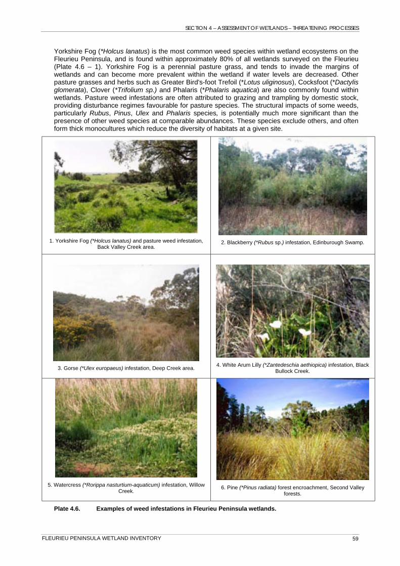
Yorkshire Fog (*Holcus lanatus) is the most common weed species within wetland ecosystems on the Fleurieu Peninsula, and is found within approximately 80% of all wetlands surveyed on the Fleurieu (Plate 4.6 – 1). Yorkshire Fog is a perennial pasture grass, and tends to invade the margins of wetlands and can become more prevalent within the wetland if water levels are decreased. Other pasture grasses and herbs such as Greater Bird's-foot Trefoil (*Lotus uliginosus), Cocksfoot (*Dactylis glomerata), Clover (*Trifolium sp.) and Phalaris (*Phalaris aquatica) are also commonly found within wetlands. Pasture weed infestations are often attributed to grazing and trampling by domestic stock, providing disturbance regimes favourable for pasture species. The structural impacts of some weeds, particularly Rubus, Pinus, Ulex and Phalaris species, is potentially much more significant than the presence of other weed species at comparable abundances. These species exclude others, and often form thick monocultures which reduce the diversity of habitats at a given site.
1. Yorkshire Fog (*Holcus lanatus) and pasture weed infestation, Back Valley Creek area.
2. Blackberry (*Rubus sp.) infestation, Edinburough Swamp.
3. Gorse (*Ulex europaeus) infestation, Deep Creek area. 4. White Arum Lilly (*Zantedeschia aethiopica) infestation, Black Bullock Creek.
5. Watercress (*Rorippa nasturtium-aquaticum) infestation, Willow Creek.
6. Pine (*Pinus radiata) forest encroachment, Second Valley forests.
Plate 4.6. Examples of weed infestations in Fleurieu Peninsula wetlands.
FLEURIEU PENINSULA WETLAND INVENTORY 59
SECTION 4 - ASSESSMENT OF WETLANDS – THREATENING PROCESSES
Noxious weeds (those proclaimed in South Australia) including Blackberry (*Rubus sp.) and Gorse (*Ulex europaeus) are major problems in the margins of and within many wetlands (Plate 4.6 – 2 & 3). Treatment of these infestations within wetlands otherwise in good condition should be a priority action. Several stream systems on the Fleurieu Peninsula have White Arum Lilly (*Zantedeschia aethiopica) infestations and appears to be mostly restricted to a few sub-catchments including Hindmarsh catchment, Tent Rock Creek, upper sections of Deep Creek and Black Bullock Creek (Plate 4.6 – 4). Watercress (*Rorippa nasturtium-aquaticum) was a serious threat to several wetlands surveyed in the Southern Fleurieu Peninsula region, where thick mats of watercress dominated the aquatic and damp areas of the wetland (Plate 4.6 – 5).
Many wetlands are located within or adjacent to pine forest plantations. Encroaching pines have been recorded as a threatening process in these wetlands, although in most cases can be practicably treated (Pickett 2003). Plate 4.6 – 6 shows juvenile pines growing within a swamp area. The felling of large pines within swamps was also recorded as a management issue, where disturbance is caused by heavy machinery and felled pines are left within the wetland boundary.
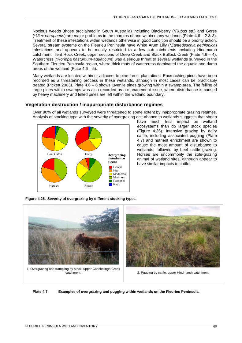
Vegetation destruction / inappropriate disturbance regimes Over 80% of all wetlands surveyed were threatened to some extent by inappropriate grazing regimes. Analysis of stocking type with the severity of overgrazing disturbance to wetlands suggests that sheep
have much less impact on wetland ecosystems than do larger stock species (Figure 4.26). Intensive grazing by dairy cattle, including associated pugging (Plate 4.7) and nutrient enrichment are shown to cause the most amount of disturbance to wetlands, followed by beef cattle grazing. Horses are uncommonly the sole-grazing animal of wetland sites, although appear to have similar impacts to cattle.
Figure 4.26. Severity of overgrazing by different stocking types.
catchment. 1. Overgrazing and trampling by stock, upper Carickalinga Creek
2. Pugging by cattle, upper Hindmarsh catchment.
Plate 4.7. Examples of overgrazing and pugging within wetlands on the Fleurieu Peninsula.
FLEURIEU PENINSULA WETLAND INVENTORY 60
SECTION 4 - ASSESSMENT OF WETLANDS – THREATENING PROCESSES
Landholders are legally entitled to graze stock in wetland remnants identified as Fleurieu Peninsula swamps under the EPBC Act provided the land is grazed by the same species and at the same grazing pressure at which has been carried out over the last 10 years (Regulation 5(1) (zh) (i) Native Vegetation Act 1991). Public awareness of the importance of swamp ecosystems on the Fleurieu Peninsula has been raised considerably through the MLRSEW Recovery Program. This has resulted in many positive changes in land use practices on individual properties including grazing exclusion or implementation of beneficial grazing regimes.
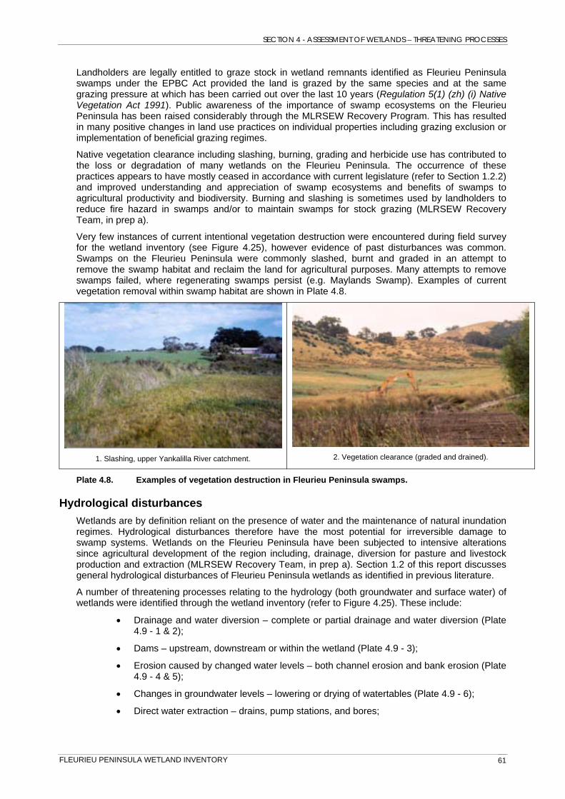
Native vegetation clearance including slashing, burning, grading and herbicide use has contributed to the loss or degradation of many wetlands on the Fleurieu Peninsula. The occurrence of these practices appears to have mostly ceased in accordance with current legislature (refer to Section 1.2.2) and improved understanding and appreciation of swamp ecosystems and benefits of swamps to agricultural productivity and biodiversity. Burning and slashing is sometimes used by landholders to reduce fire hazard in swamps and/or to maintain swamps for stock grazing (MLRSEW Recovery Team, in prep a).
Very few instances of current intentional vegetation destruction were encountered during field survey for the wetland inventory (see Figure 4.25), however evidence of past disturbances was common. Swamps on the Fleurieu Peninsula were commonly slashed, burnt and graded in an attempt to remove the swamp habitat and reclaim the land for agricultural purposes. Many attempts to remove swamps failed, where regenerating swamps persist (e.g. Maylands Swamp). Examples of current vegetation removal within swamp habitat are shown in Plate 4.8.
1. Slashing, upper Yankalilla River catchment. 2. Vegetation clearance (graded and drained).
Plate 4.8. Examples of vegetation destruction in Fleurieu Peninsula swamps.
Hydrological disturbances Wetlands are by definition reliant on the presence of water and the maintenance of natural inundation regimes. Hydrological disturbances therefore have the most potential for irreversible damage to swamp systems. Wetlands on the Fleurieu Peninsula have been subjected to intensive alterations since agricultural development of the region including, drainage, diversion for pasture and livestock production and extraction (MLRSEW Recovery Team, in prep a). Section 1.2 of this report discusses general hydrological disturbances of Fleurieu Peninsula wetlands as identified in previous literature.
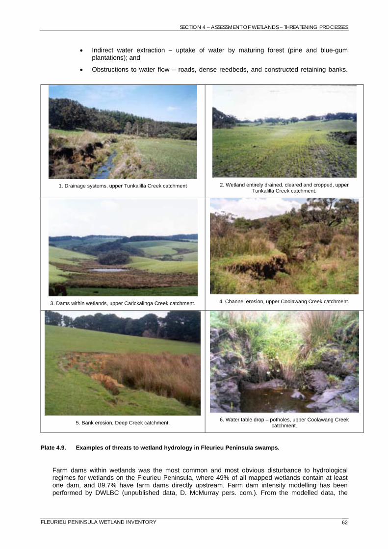
A number of threatening processes relating to the hydrology (both groundwater and surface water) of wetlands were identified through the wetland inventory (refer to Figure 4.25). These include:
• Drainage and water diversion – complete or partial drainage and water diversion (Plate 4.9 - 1 & 2);
• Dams – upstream, downstream or within the wetland (Plate 4.9 - 3);
• Erosion caused by changed water levels – both channel erosion and bank erosion (Plate 4.9 - 4 & 5);
• Changes in groundwater levels – lowering or drying of watertables (Plate 4.9 - 6);
• Direct water extraction – drains, pump stations, and bores;
FLEURIEU PENINSULA WETLAND INVENTORY 61
SECTION 4 – ASSESSMENT OF WETLANDS – THREATENING PROCESSES
• Indirect water extraction – uptake of water by maturing forest (pine and blue-gum plantations); and
• Obstructions to water flow – roads, dense reedbeds, and constructed retaining banks.
1. Drainage systems, upper Tunkalilla Creek catchment 2. Wetland entirely drained, cleared and cropped, upper Tunkalilla Creek catchment.
3. Dams within wetlands, upper Carickalinga Creek catchment. 4. Channel erosion, upper Coolawang Creek catchment.
5. Bank erosion, Deep Creek catchment. 6. Water table drop – potholes, upper Coolawang Creek catchment.
Plate 4.9. Examples of threats to wetland hydrology in Fleurieu Peninsula swamps.
Farm dams within wetlands was the most common and most obvious disturbance to hydrological regimes for wetlands on the Fleurieu Peninsula, where 49% of all mapped wetlands contain at least one dam, and 89.7% have farm dams directly upstream. Farm dam intensity modelling has been performed by DWLBC (unpublished data, D. McMurray pers. com.). From the modelled data, the
FLEURIEU PENINSULA WETLAND INVENTORY 62
SECTION 4 – ASSESSMENT OF WETLANDS – THREATENING PROCESSES
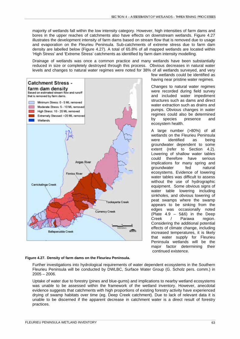
majority of wetlands fall within the low intensity category. However, high intensities of farm dams and bores in the upper reaches of catchments also have effects on downstream wetlands. Figure 4.27 illustrates the development intensity of farm dams based on stream flow that is removed due to usage and evaporation on the Fleurieu Peninsula. Sub-catchments of extreme stress due to farm dam density are labelled below (Figure 4.27). A total of 65.8% of all mapped wetlands are located within ‘High Stress’ and ‘Extreme Stress’ catchments as identified by farm dam intensity modelling.
Drainage of wetlands was once a common practice and many wetlands have been substantially reduced in size or completely destroyed through this process. Obvious decreases in natural water levels and changes to natural water regimes were noted for 38% of all wetlands surveyed, and very
few wetlands could be identified as having near pristine water regimes.
Changes to natural water regimes were recorded during field survey and included water impediment structures such as dams and direct water extraction such as drains and pumps. Obvious changes in water regimes could also be determined by species presence and ecosystem health.
A large number (>80%) of all wetlands on the Fleurieu Peninsula were identified as being groundwater dependent to some extent (refer to Section 4.2). Lowering of shallow water tables could therefore have serious implications for many spring and groundwater fed natural ecosystems. Evidence of lowering water tables was difficult to assess without the use of hydrographic equipment. Some obvious signs of water table lowering including sinkholes, and obvious lowering of peat swamps where the swamp appears to be sinking from the edges was occasionally noted (Plate 4.9 – 5&6) in the Deep Creek / Parawa region. Considering the additional potential effects of climate change, including increased temperatures, it is likely that water supply for Fleurieu Peninsula wetlands will be the major factor determining their continued existence.
Figure 4.27. Density of farm dams on the Fleurieu Peninsula.
Further investigations into hydrological requirements of water dependent ecosystems in the Southern Fleurieu Peninsula will be conducted by DWLBC, Surface Water Group (G. Scholz pers. comm.) in 2005 – 2006.
Uptake of water due to forestry (pines and blue-gums) and implications to nearby wetland ecosystems was unable to be assessed within the framework of the wetland inventory. However, anecdotal evidence suggests that catchments with high proportions of existing forestry activity have experienced drying of swamp habitats over time (eg. Deep Creek catchment). Due to lack of relevant data it is unable to be discerned if the apparent decrease in catchment water is a direct result of forestry practices.
FLEURIEU PENINSULA WETLAND INVENTORY 63
SECTION 4 - ASSESSMENT OF WETLANDS – CONDITION
4.4 Condition Condition of wetlands was assessed primarily through the development of a condition index determined from data collected through field survey. Indices for assessing wetland condition have been investigated by Spencer et al. (1998) and Danielson (2001). Spencer et al. (1998) developed a rapid appraisal wetland condition index based on four attributes – soils, fringing vegetation, aquatic vegetation and water quality. Indicators of ecological integrity within these attributes were assessed and allocated subjective ratings in order to determine a condition index for each wetland (Spencer et al. 1998; Danielson 2001). Previous wetland inventories in South Australia (Seaman 2002a,b,c,d; 2003) used subjective rapid assessment scores from field survey and identified three condition ratings – degraded, natural and intact.
A subjective assessment of wetland condition was included as part of the Fleurieu Peninsula wetland inventory field survey protocol (Appendix 3 & 4), and generally follows methods developed by Seaman (2002a). This included a subjective assessment of the condition of aquatic and riparian vegetation specific to the Fleurieu Peninsula using the following categories:
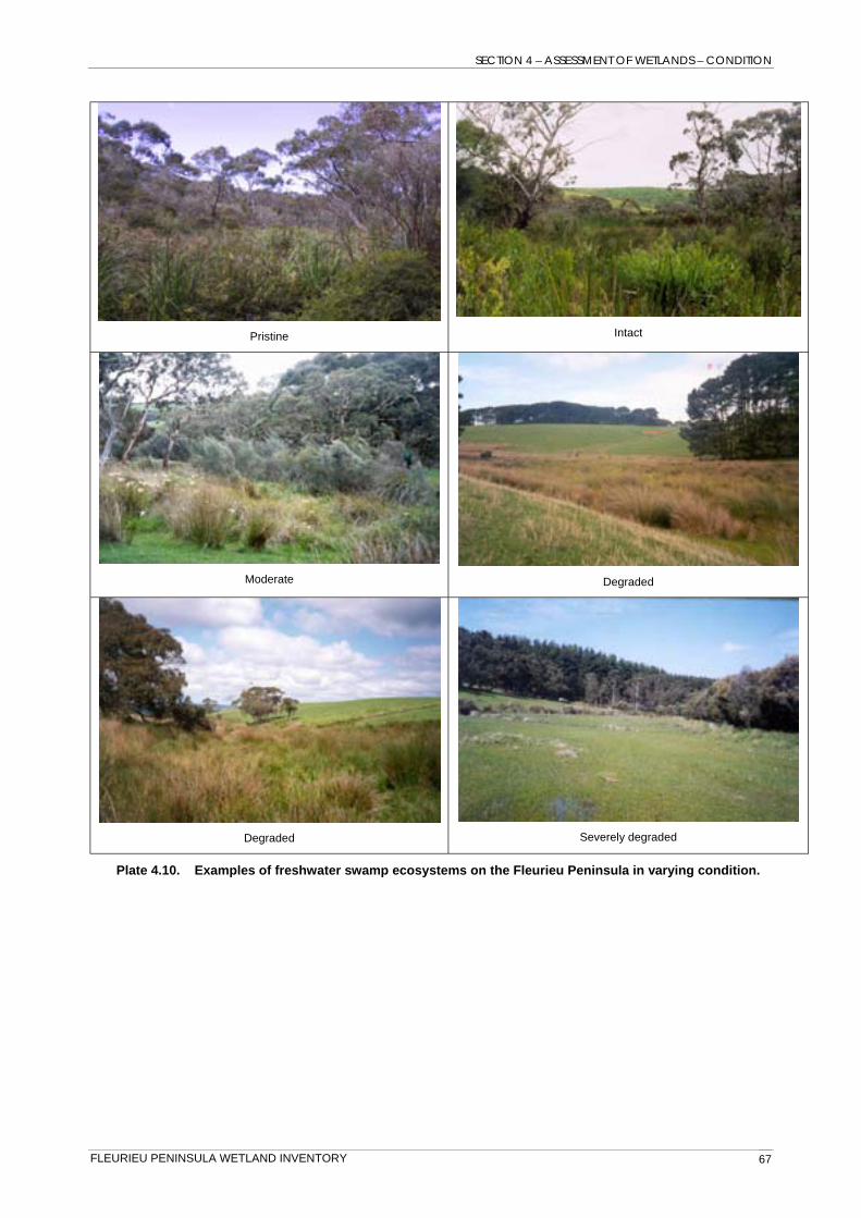
Wetland vegetation condition categories
• None: no vegetation present (ie, completely removed);
• Degraded: <30% native vegetation cover with an abundance of exotic species and evidence of a high level of disturbance;
• Moderate: between 30-75% native vegetation cover, few exotics with minor evidence of disturbance;
• Intact: >75% native vegetation cover with little or no evidence of disturbance.
The field survey protocol also included a subjectively assigned indication of overall wetland condition as defined by the following categories:
Overall wetland condition categories
• Severely degraded: very high level of disturbance evident to the extent that wetland values are destroyed or irreversibly modified (eg. Wetland drained). Received vegetation condition assessments of ‘none’ or ‘degraded’;
• Degraded: high level of disturbance evident. Verging on un-rectifiable damage. Received vegetation condition assessments of ‘degraded’;
• Moderate: disturbance evident although many natural values remaining. Most damage rectifiable with improved management. Received vegetation condition assessment scores of mostly ‘moderate’;
• Intact: small amounts of relatively insignificant disturbance evident, with high native species diversity. Native vegetation buffer present for at least some of the wetland perimeter. Any damage is generally rectifiable. Received vegetation condition assessments of ‘intact’ or ‘moderate’;
• Pristine: No (or very minor) obvious disturbance, with high native species diversity and cover. Native vegetation buffer present for the majority of the wetland perimeter. Received vegetation condition assessments of ‘intact’. Usually formally conserved within the reserve system or similar.
The subjective condition assessment results were used as a guide for developing and testing the condition index analysis. Condition analysis and resulting maps were also checked by relevant Fleurieu Peninsula wetland experts (Mount Lofty Ranges Southern Emu-wren Recovery Team) for abnormalities and errors. Adjustments were then made where required. The category descriptions as described above were retained in the final assessment.
Wetlands where data was not available for some or all of the selected parameters required remotely assessing condition by aerial photo interpretation to provide a complete condition assessment for all wetlands on the Fleurieu Peninsula. Aerial photo condition assessments relied on assessing the presence and apparent density of aquatic vegetation, presence of native vegetation buffers, and visual similarity to wetlands of known condition.
FLEURIEU PENINSULA WETLAND INVENTORY 64

SECTION 4 – ASSESSMENT OF WETLANDS – CONDITION
Parameters used to assess condition A ranking system was developed that uses the data incorporated in SAWID to score wetlands on parameters that were identified as potentially influencing wetland condition. The following parameters were calculated for each wetland body using data collected through the wetland inventory process:
• Percentage of exotic species recorded; • Cover abundance of exotic species (weediness); • Total flora diversity; • Major threatening processes, ranked in order of extent of disturbance;
Hydrological disturbance extent; Pugging extent; Over-grazing extent; and Nutrient enrichment.
• Presence of vegetation layers; • Presence of major vegetation growth forms; • Cover of vegetation (overstorey and understorey cover); • Salinity levels (adjusted for naturally brackish systems); • Width of native buffer; and • Percentage of wetland perimeter with native vegetation buffer.
Additive ranking analysis Scoring of parameters was performed using an Additive Ranking Analysis procedure where each parameter was scored relative to perceived importance to wetland condition. Scores for each parameter where added for each wetland to obtain a “Condition Score”. All analysis was performed automatically using specifically designed queries within SAWID.
The resulting scores were assigned into the five condition groups described above using significant cut-off points.
Limitations It is important to note that condition was assessed on a whole of wetland scale, and attempts to provide an overall condition rating for each wetland. The assessment does not provide for patch variation within wetland bodies, and therefore cannot be considered accurate at scales other than that presented within this report.
Significantly, 69.1% of the condition analysis was reliant on aerial photograph interpretation to some degree due to data deficiencies for most wetlands. Errors resulting from no on-ground verification are expected.
Condition ratings of ‘pristine’ and ‘severely degraded’ were only assigned to those wetlands with sufficient data to determine these ratings. It is therefore likely that many wetlands listed as ‘degraded’ would be identified as ‘severely degraded’ given sufficient data. It is unlikely that further wetlands of the ‘pristine’ category would exist on the Fleurieu Peninsula, due to targeted field survey of wetlands in good condition, and consultation with Fleurieu Peninsula swamp experts (M. Pickett pers. comm.).
Results of condition analysis Map 3 (back of this report) shows wetland condition results mapped for the Fleurieu Peninsula. The majority of wetlands (53% of the total number) were considered degraded or worse, and only 2% of wetlands on the Fleurieu Peninsula can still be regarded as pristine (Figure 4.28). Significantly, when represented by total wetland area, the percentage of total wetland area mapped as degraded is substantially reduced (32% of the total wetland area degraded or worse). This largely reflects the susceptibility of smaller wetlands to disturbance regimes, where edge-effects are greatest. Larger wetland bodies are more likely to be in better condition, where 43% of the total wetland area on the Fleurieu Peninsula is considered intact or better (Figure 4.28).
FLEURIEU PENINSULA WETLAND INVENTORY 65

SECTION 4 – ASSESSMENT OF WETLANDS – CONDITION
Figure 4.28. Condition of wetlands expressed as a percentage of all wetlands on the Fleurieu Peninsula.
Plate 4.10 provides examples of wetlands within each of the condition categories identified through the analysis. Wetlands identified as pristine tended to be floristically diverse, large and often surrounded by native vegetation buffer. Degraded wetlands tended to be species poor and missing shrub-layer and buffering vegetation. Severely degraded systems included those that have been very severely disturbed by drainage and clearance.
Tenure Analysis of wetland condition within four of the major land tenure types on the Fleurieu Peninsula provides an indication of the effects of differing tenure on wetland condition. The majority of wetlands identified as pristine were located within Conservation Parks owned and managed by DEH, and Forestry SA reserves, however these land tenures only account for a small percentage of the total number of wetlands, <2% and 3% respectively (refer to Section 4.1). A comparatively small proportion of pristine wetlands were found on privately owned land (Figure 4.29). In cases where multiple tenures existed, the primary tenure was used in the analysis.
The large majority (92%) of all wetlands mapped for the Fleurieu Peninsula are within freehold tenure. Significantly, 52.5% of these wetlands were identified as degraded or worse (Figure 4.29). This can be attributed to certain land use types not compatible with wetland conservation, resulting in long-term degradation patterns. However, a significant number (21.7%) of wetlands identified in moderate to
intact condition remain within freehold tenure, many of which are specifically managed for private conservation purposes and provide for the largest total area of intact wetlands within the study area.
Land owned by Local Government includes areas of public land that are often not managed specifically for conservation purposes (including roadside reserves, recreation reserves and vacant land within residential areas). The large proportion of degraded wetlands within this tenure is largely due to the location of Local Government reserves, usually in a highly populated or disturbed environment (e.g. roadside reserves).
Figure 4.29. Condition of wetlands within major land tenures (expressed as % number) of the Fleurieu Peninsula.
FLEURIEU PENINSULA WETLAND INVENTORY 66
SECTION 4 – ASSESSMENT OF WETLANDS – CONDITION
Pristine Intact
Moderate Degraded
Degraded Severely degraded
Plate 4.10. Examples of freshwater swamp ecosystems on the Fleurieu Peninsula in varying condition.
FLEURIEU PENINSULA WETLAND INVENTORY 67
SECTION 4 - ASSESSMENT OF WETLANDS – CONDITION
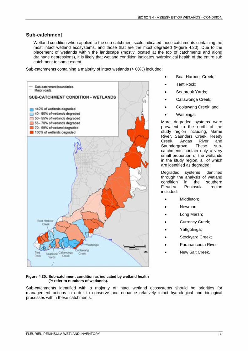
Sub-catchment Wetland condition when applied to the sub-catchment scale indicated those catchments containing the most intact wetland ecosystems, and those that are the most degraded (Figure 4.30). Due to the placement of wetlands within the landscape (mostly located at the top of catchments and along drainage depressions), it is likely that wetland condition indicates hydrological health of the entire sub catchment to some extent.
Sub-catchments containing a majority of intact wetlands (> 60%) included:
• Boat Harbour Creek;
• Tent Rock;
• Seabrook Yards;
• Callawonga Creek;
• Coolawang Creek; and
• Waitpinga.
More degraded systems were prevalent to the north of the study region including, Marne River, Saunders Creek, Reedy Creek, Angas River and Saundergrove. These sub-catchments contain only a very small proportion of the wetlands in the study region, all of which are identified as degraded.
Degraded systems identified through the analysis of wetland condition in the southern Fleurieu Peninsula region included:
• Middleton;
• Newman;
• Long Marsh;
• Currency Creek;
• Yattgolinga;
• Stockyard Creek;
• Paranancoota River
• New Salt Creek.
Figure 4.30. Sub-catchment condition as indicated by wetland health (% refer to numbers of wetlands).
Sub-catchments identified with a majority of intact wetland ecosystems should be priorities for management actions in order to conserve and enhance relatively intact hydrological and biological processes within these catchments.
FLEURIEU PENINSULA WETLAND INVENTORY 68

SECTION 4 – ASSESSMENT OF WETLANDS – CONDITION
Character The general condition of wetlands within each of the major wetland character groups identified in Section 4.2 is indicated in Figure 4.31 below. Many of the shrub-dominated freshwater swamps and peat swamps were identified as intact or pristine condition, whereas sedge-dominated systems tended to be more degraded. Wetlands missing a shrub-layer due to past disturbance regimes included some sedge-dominated freshwater swamps. The large proportion of degraded sedge-dominated swamps and drainage depressions can be attributed to this factor, where the character of the wetland has been substantially modified by disturbance regimes (ie, from shrub-dominated to sedge-dominated). However, many naturally occurring sedge-dominated peat swamps in intact condition were also identified. Very few tree-dominated and fern-dominated freshwater swamps were identified in the study area, although where present, were usually in good condition (Figure 4.31).
Swamp systems, particularly permanent perched peat swamps, were generally more intact than drainage depression wetlands which were often inundated on a seasonal basis. Seasonally flooded wetlands are more susceptible to weed invasions during drier periods, which in turn affects the overall condition of the wetland.
W aste treatment wetlands, sedge-dominated
Tree-dominated freshwater swamp
Tree-dominated freshwater perched swamp
Tree-dominated freshwater drainage depression
Shrub-dominated freshwater swamp
Shrub-dominated freshwater perched swamp
Shrub-dominated freshwater perched peat swamp
Shrub-dominated freshwater peat swamp
Shrub-dominated freshwater drainage depression
Sedge-dominated freshwater swamp
Sedge-dominated freshwater perched peat swamp
Sedge-dominated freshwater peat swamp
Sedge-dominated freshwater drainage depression
Sedge-dominated brackish drainage depression
Reed-dominated freshwater swamp
Reed-dominated freshwater drainage depression
Reed-dominated fresh/brackish swamp
Reed-dominated fresh/brackish peat swamp
Reed-dominated brackish drainage depression
Fern-dominated freshwater peat swamp
Fern-dominated freshwater drainage depression
Estuarine saltmarsh
Estuarine reedbed
Pristine
Intact
Moderate
Degraded
Severely degraded
0 4 8 12 16 20 24 28 32 36 40
No. of wetlands
Figure 4.31. Condition of wetland character groups on the Fleurieu Peninsula (as determined from field survey data).
FLEURIEU PENINSULA WETLAND INVENTORY 69

SECTION 4 - ASSESSMENT OF WETLANDS – SIGNIFICANT WETLANDS
4.5 Wetlands of high ecological importance Significant wetlands in Australia have been identified using criteria set out by the ANZECC Wetlands Network in 1994. A wetland can be considered Nationally important if it meets at least one of the following criteria:
1. It is a good example of a wetland type occurring within a biogeographic region in Australia.
2. It is a wetland which plays an important ecological or hydrological role in the natural functioning of a major wetland system/complex.
3. It is a wetland which is important as the habitat for animal taxa at a vulnerable stage in their life cycles, or provides a refuge when adverse conditions such as drought prevail.
4. The wetland supports 1% or more of the National populations of any native plant or animal taxa.
5. The wetland supports native plant or animal taxa or communities which are considered endangered or vulnerable at the National level.
6. The wetland is of outstanding historical or cultural significance.
Application of the criteria to individual wetland sites involves a large degree of subjectivity, where different surveyors can interpret aspects of a site’s significance differently. Information gaps also compound the difficulty of identifying significant wetlands.
Due to the broad and qualitative nature of the criteria, potentially hundreds of wetlands on the Fleurieu Peninsula would meet at least one of these criteria. However, not all would be considered ‘Nationally Important’ and would be too cumbersome to include on the Directory of Important Wetlands (AG DEH 2004). Simply listing the criteria also does not enable the identification of stratified significance levels.
A significance analysis was developed for the Fleurieu Peninsula which enabled the identification of significance levels for wetlands using data collated through the wetland inventory process. This analysis attempted to incorporate quantifiable data relating to the criteria listed above.
Parameters used to assess significance A ranking system was developed that uses the data incorporated in SAWID to score wetlands on parameters that were identified as potentially influencing wetland significance. The following parameters were calculated for each wetland body using data collected through the wetland inventory process:
• Condition (as indicated by condition index and aerial photo interpretation);
• Total area of the wetland;
• Part of a larger wetland complex;
• Presence of EPBC Act listed flora, fauna and vegetation communities;
• Presence of threatened flora and fauna (state-wide), ranked in order of most threatened;
• Total diversity of native species;
• Percentage of total species recorded that are listed as threatened;
• Presence of any cultural or social significance; and
• Rarity of the wetland type (as identified by character analysis).
Additive ranking analysis Scoring of the parameters was performed using an Additive Ranking Analysis procedure where each parameter was scored relative to perceived importance to ecological significance. Scores for each parameter where added for each wetland to obtain a “Significance Score” (where high scores indicate high significance).
Each parameter to be scored was divided into data ranges. Scores were subjectively assigned to each of the range values within each parameter. These were assigned to each range relative to perceived
FLEURIEU PENINSULA WETLAND INVENTORY 70
SECTION 4 – ASSESSMENT OF WETLANDS – SIGNIFICANT WETLANDS
importance to ecological significance. The resulting scores were assigned into five groups using significant cut-off points:
• Most significant – scores above 30;
• Significant – scores between 20 and 30;
• Notable – scores between 10 and 20;
• Not significant – scores below 10; and
• Insufficient data – data missing for all or some of the essential parameters.
Consultation with regional experts on the findings of the significance analysis was undertaken to ensure additional significant wetlands had not been overlooked by the analysis. No changes to the significance values were made through this process, and the listing is generally accepted as complete for the scale of this study and the current level of knowledge of Fleurieu Peninsula wetlands.
Limitations Insufficient data for many swamps on the Fleurieu Peninsula may have resulted in significant or notable wetlands being overlooked by the analysis. However, due to the relative comprehensive knowledge of Fleurieu Peninsula wetlands established through the Mount Lofty Ranges Southern Emu-wren Recovery Program, it is considered unlikely that many significant ecosystems other than those identified would have been missed.
The ranking of significant wetlands is highly dependant on the amount of data collected for specific wetlands. As there are uneven survey efforts for wetlands throughout the Fleurieu Peninsula, those that are well surveyed are more likely to be identified as significant. Additionally, more comprehensive data collected in future surveys for some wetlands may increase their significance score, and therefore their relative significance on a regional scale.
Results of the significance analysis The significance analysis identified 8 wetlands of very high significance (most significant), 11 wetlands of high significance (significant), and 52 wetlands that were identified as ‘notable’ within the region. Map 4 (back of this report) shows the locations of all wetlands identified as significant for the Fleurieu Peninsula. Table 4.6 and Table 4.7 provide lists of wetlands identified within these groupings.
All wetlands currently listed on the Directory of Important Wetlands 3rd edition for the Fleurieu Peninsula (Environment Australia 2001) were identified within the significance analysis (Table 4.6 and Table 4.7). Table 4.6. Significant wetlands identified on the Fleurieu Peninsula.
Criteria DIW
Most Significant Wetland ID Wetland Name Tenure Management
S2663 Black Swamp Private/Public Freehold Finniss River SA034#
S2566 Glenshera Swamp Public DEH; NPWSA Myponga River SA030
S2174 Illawong Swamp (Martins Block) Private/Public DEH; Forestry SA; Freehold; NPWSA Tunkalilla Creek SA036
S2704 Swampy Creek Private Freehold Tookayerta SA034
S2181 Congeratinga Swamp Public Forestry SA Anacotilla River
S2321 Maylands Swamp Private Freehold Coolawang Creek
S2217 Gold Diggings Swamp Private/Public Freehold; Forestry SA Callawonga Creek
S2149 Private Freehold
Significant
Seabrook Swamps Boat Harbour Creek
S2664 Tookayerta Creek Private Freehold Tookayerta SA034
S2130 Upper Boat Harbour Creek Wetlands Public DEH; NPWSA Boat Harbour Creek
S2123 Upper Deep Creek Wetlands Public DEH; NPWSA Deep Creek
FLEURIEU PENINSULA WETLAND INVENTORY 71
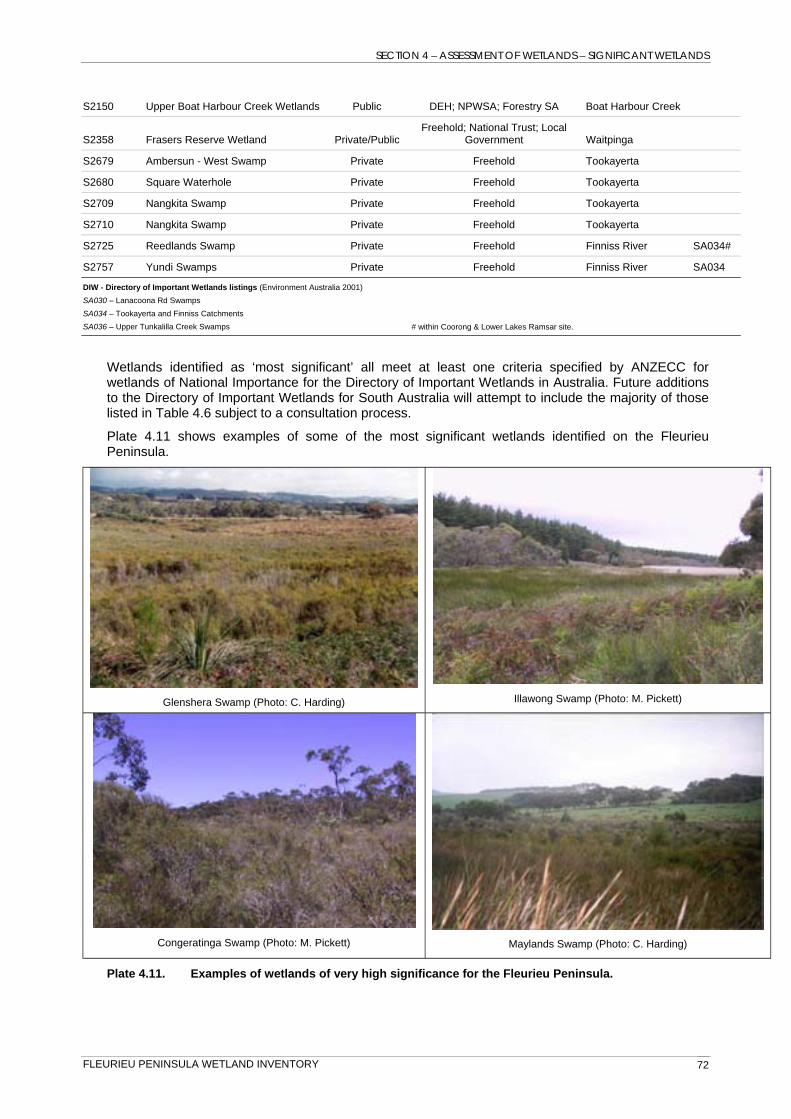
SECTION 4 – ASSESSMENT OF WETLANDS – SIGNIFICANT WETLANDS
S2150 Upper Boat Harbour Creek Wetlands Public DEH; NPWSA; Forestry SA Boat Harbour Creek
Freehold; National Trust; Local S2358 Frasers Reserve Wetland Private/Public Government Waitpinga
S2679 Ambersun - West Swamp Private Freehold Tookayerta
S2680 Square Waterhole Private Freehold Tookayerta
S2709 Nangkita Swamp Private Freehold Tookayerta
S2710 Nangkita Swamp Private Freehold Tookayerta
S2725 Reedlands Swamp Private Freehold Finniss River SA034#
S2757 Yundi Swamps Private Freehold Finniss River SA034
DIW - Directory of Important Wetlands listings (Environment Australia 2001) SA030 – Lanacoona Rd Swamps SA034 – Tookayerta and Finniss Catchments SA036 – Upper Tunkalilla Creek Swamps # within Coorong & Lower Lakes Ramsar site.
Wetlands identified as ‘most significant’ all meet at least one criteria specified by ANZECC for wetlands of National Importance for the Directory of Important Wetlands in Australia. Future additions to the Directory of Important Wetlands for South Australia will attempt to include the majority of those listed in Table 4.6 subject to a consultation process.
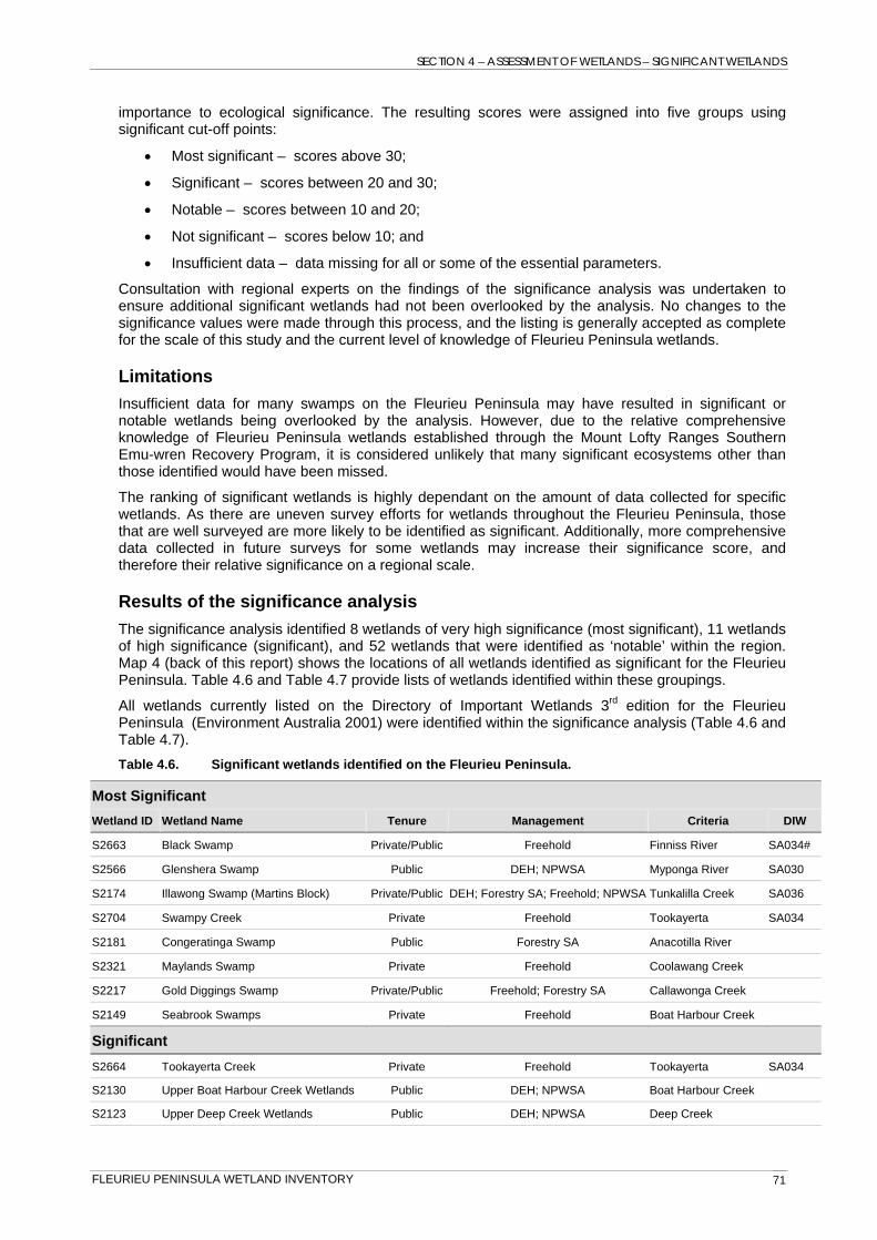
Plate 4.11 shows examples of some of the most significant wetlands identified on the Fleurieu Peninsula.
Illawong Swamp (Photo: M. Pickett) Glenshera Swamp (Photo: C. Harding)
Congeratinga Swamp (Photo: M. Pickett) Maylands Swamp (Photo: C. Harding)
Plate 4.11. Examples of wetlands of very high significance for the Fleurieu Peninsula.
FLEURIEU PENINSULA WETLAND INVENTORY 72

SECTION 4 – ASSESSMENT OF WETLANDS – SIGNIFICANT WETLANDS
Regionally notable wetlands include the 57 wetlands listed in Table 4.7. Many of these wetlands meet ANZECC criteria and five are currently included within listings of wetland complexes on the Directory of Important Wetlands (Environment Australia 2001). However, as an individual wetland body, these wetlands generally would not be considered Nationally Important relative to other more significant systems identified through this analysis. Regionally notable wetlands are commonly included on the Directory as part of a larger complex of hydrologically connected wetlands.
Table 4.7. Regionally notable wetlands.
Notable
Wetland ID Wetland Name Tenure Management Sub-catchment
S2622 Mount Compass School Swamp Private Freehold Tookayerta SA034
S2595 Higgs Swamp (Upper) Private Freehold Myponga River
S2142 Upper Boat Harbour Creek Wetlands Private Freehold Boat Harbour Creek
Upper Hindmarsh River Catchment SA035 S2906 Gum Tree Gully Private Freehold Hindmarsh
S2727 Parkens Swamp Private Freehold Finniss River
S2596 Higgs Swamp (Lower) Private Freehold Myponga River
S2549 Upper Hindmarsh River Catchment Wetlands Private Freehold Hindmarsh
S2483 Upper Boundy River Swamps Private Freehold Inman River
S2444 Upper Boundy River Swamps Private Freehold Inman River
S2705 Swampy Creek Private Freehold; SA Water Tookayerta SA034
S2155 Upper Deep Creek Swamps (Pitchers) Private/Public Forestry SA; Freehold Deep Creek
S2354 Willow Creek Swamps Private Freehold Coolawang Creek
S2301 Upper Callawonga Creek Wetlands -Woolcocks Swamp Private Freehold Yankalilla River
S2124 The Wither Swamp Private Freehold Deep Creek
S2678 Ambersun - East Swamp Private Freehold Tookayerta
S2641 Pambula Rd Swamps Private Freehold Hindmarsh
Upper Hindmarsh River Catchment Freehold; Local S2540 Wetlands Private/Public Government Hindmarsh
S2279 Upper Tunkalilla Creek Swamps -Williams Private Freehold Tunkalilla Creek
Freehold; DEH; S2877 Burnfoot Wetlands Private Leasehold Hindmarsh
S2126 Black Bullock Creek Wetlands Private Freehold Deep Creek
S2873 Burnfoot Wetlands Public DEH; Leasehold Hindmarsh
S2744 Blackfellow Creek Swamps Private Freehold Finniss River
S2576 Upper Myponga Catchment Swamps Private Freehold Myponga River
S2351 Upper Coolawang Creek Wetlands Private Freehold Coolawang Creek
S2345 Upper Coolawang Creek Wetlands Private Freehold Coolawang Creek
S2241 Tent Rock Creek Wetlands Private Freehold Tent Rock
S2205 Upper Callawonga Creek Wetlands Private Freehold Callawonga Creek
S2194 Second Valley Forest Wetlands – Allan Flat Public Forestry SA Yattagolinga
S2333 Upper Coolawang Creek Wetlands Private Freehold Coolawang Creek
S2707 Willowburn Swamp Private Freehold Tookayerta SA034
FLEURIEU PENINSULA WETLAND INVENTORY 73

SECTION 4 – ASSESSMENT OF WETLANDS – SIGNIFICANT WETLANDS
DEH; NPWSA; S2131 Upper Boat Harbour Creek Wetlands Private/Public Freehold Boat Harbour Creek
Freehold; Southern S2920 Lawless Lane Swamps Private Bluegum Myponga River
S2763 Hope Forest Wetland Private Freehold Finniss River
S2669 Nangkita Swamps Private Freehold Tookayerta SA034
S2632 Burnfoot Wetlands Private Freehold Hindmarsh
S2586 Lawless Lane / Myponga Swamps Private Freehold Myponga River
S2365 Upper Waitpinga Creek Wetlands Private Freehold Waitpinga
S2353 Willow Creek Swamps Private Freehold Coolawang Creek
S2326 Bramley Swamp Private Freehold Coolawang Creek
S2296 Williams Swamps Private Freehold Yankalilla River
S2210 Upper Callawonga Creek Wetlands Private Freehold Callawonga Creek
S2141 Upper Boat Harbour Creek Wetlands Private Freehold Boat Harbour Creek
S2865 Wadnama Swamps Private Freehold Hindmarsh
S2115 Upper Tapanappa Creek Wetlands Public DEH; NPWSA Tapanappa Creek
S2430 Back Valley Creek Wetlands Private Freehold Inman River
S2404 Back Valley Creek Swamps Private Freehold Inman River
S2323 Bramley Swamp Private Freehold Coolawang Creek
S2187 Dog Trap Creek Swamps Public DEH; NPWSA Deep Creek
S2615 Old Glenshera Wetlands Private Freehold Tookayerta
S2577 Old Glenshera Wetlands Private Freehold Myponga River
S2472 Upper Boundy River Swamps Private Freehold Inman River
S2214 Upper Callawonga Creek Wetlands Private Freehold Callawonga Creek
Directory of Important Wetlands listings (Environment Australia 2001) SA034 – Tookayerta and Finniss Catchments SA035 – Upper Hindmarsh River Catchment
The Directory of Important Wetlands in Australia (Environment Australia 2001) is currently being revised by the Department for Environment and Heritage SA in preparation for the 4th edition. The revision of wetlands listed for the Fleurieu Peninsula includes several alterations to the current listings and the addition of new listings in light of the results of the wetland inventory. The revision of wetlands included on the Directory will be subject to a consultation process with relevant stakeholders. The listing of wetlands on this Directory does not provide for any formal legal protection of the listed wetlands, but provides for National recognition of the importance of these wetlands.
Significantly only eight wetlands identified in the significance analysis are wholly or partially protected within the State reserve system, and only four are within private Heritage Agreements.
FLEURIEU PENINSULA WETLAND INVENTORY 74

SECTION 4 - ASSESSMENT OF WETLANDS – MANAGEMENT PRIORITIES
4.6 Management Priorities Analyses of the threatening processes known to effect wetlands identified as ecologically significant on the Fleurieu Peninsula provides a preliminary list of potential priorities for management actions. The number of threatening processes and the extent of the disturbance caused by each threat were considered(Table 4.8 lists).
Table 4.8. Management priorities for significant wetland ecosystems of the Fleurieu Peninsula.
Wetland ID Wetland Name Ecological Significance Overall threatening process
extent score
S2194 Second Valley Forest Wetlands – Allan Flat Notable 31
S2680 Square Waterhole Significant 19
S2174 Illawong Swamp (Martins Block) Most Significant 15
S2877 Burnfoot Wetlands Notable 13
S2321 Maylands Swamp Most Significant 12
S2577 Old Glenshera Wetlands Notable 12
S2354 Willow Creek Swamps Notable 12
S2704 Swampy Creek Most Significant 12
S2615 Old Glenshera Wetlands Notable 11
S2124 The Wither Swamp Notable 10
S2353 Willow Creek Swamps Notable 10
S2632 Burnfoot Wetlands Notable 9
S2323 Bramley Swamp Notable 9
FLEURIEU PENINSULA WETLAND INVENTORY 75
SECTION 4 - ASSESSMENT OF WETLANDS – FUTURE DIRECTIONS
4.7 Future directions and recommendations A number of future directions and recommendations relating specifically to wetlands on the Fleurieu Peninsula have been identified through the wetland inventory process, although were unable to be acted upon within the scope of this study.
• Mapping of wetlands performed for the Fleurieu Peninsula wetland inventory provides a significantly improved coverage of wetland bodies for the region, however falls short of identifying various habitat types within wetland bodies. Significantly, some habitat types within wetlands on the Fleurieu Peninsula are listed as endangered under the EPBC Act (Fleurieu Peninsula swamps). Identification of these areas is therefore of importance to ensuring their future management and protection. Refinement of the wetland mapping could be achieved through further ground-truthing of wetlands and the production of habitat maps within priority wetlands.
• Although the wetland inventory made significant progress towards understanding the wetland communities and values on the Fleurieu Peninsula, there are still many wetlands on private property of potential importance where no data currently exists. Future wetland inventories or wetland studies on Fleurieu Peninsula wetlands should concentrate efforts on previously unsurveyed wetlands that have been identified in good condition through aerial photograph interpretation within this study.
• Wetlands of high ecological significance were identified in the current project which could benefit from management actions. It is suggested that these listings be considered for targeting future wetland restoration and enhancement projects on the Fleurieu Peninsula.
• The poor representation of Fleurieu Peninsula wetlands in the States reserve system emphasises the need to target those in good condition for potential inclusions as property becomes available. Only ten of the 71 wetlands identified as ecologically significant through the wetland inventory are within or partially within the reserve system or under Heritage Agreements. Wetlands on private property are amongst the most intact wetland habitat remaining in the region. Targeted education programs and promotion of the benefits of Heritage Agreements could increase the number of wetlands formally conserved on private property.
• Monitoring of wetland ecosystems on the Fleurieu Peninsula is not discussed within the wetland inventory and was not within the project scope. However the inventory itself provides a potential platform from which to begin monitoring of ecological health of priority wetland ecosystems. The inventory process is repeatable, and the continued updating of wetland inventory information will allow ongoing monitoring of wetland ecosystems in the future.
• Future water allocation plans for the Eastern and Western Mount Lofty Ranges conducted by DWLBC will rely heavily on data collected through the wetland inventory process for determining environmental water requirements for water dependant ecosystems in the region. The water allocation plan should ensure that all wetlands identified as significant in the region receive sufficient water supply in the future to guarantee their on-going protection and maintenance.
• Future land use planning should take into consideration impacts on wetlands in the region. This is a legal requirement under the EPBC Act for those wetlands known as Fleurieu Peninsula swamps. Wetland mapping should be provided to local government agencies and policy and planning bodies to facilitate the consideration of wetlands in local and regional planning procedures.
• Potential impacts of some land use types on wetlands (e.g. forestry practices) should be investigated to confirm anecdotal evidence of lowering ground-water tables and subsequent drying of wetland bodies. Implementation of bore hydrographs in selected wetland sites (e.g. sites suspected of artificial drying; sites surrounded by newly planted pine and blue-gum forest; and control sites unaffected by forestry or surrounded by native vegetation) should be monitored into the future to record actual impacts of forestry on ground-water dependent ecosystems.
• A number of significant gaps in the current knowledge base for wetlands on the Fleurieu Peninsula were identified during the collation of data. Of specific notice was the lack of
FLEURIEU PENINSULA WETLAND INVENTORY 76
SECTION 4 – ASSESSMENT OF WETLANDS – FUTURE DIRECTIONS
aquatic fauna information, particularly relating to fish and aquatic invertebrates. Due to the rapid nature of the inventory method there was no sampling of fish or aquatic invertebrates within this survey. It is likely that many wetlands on the Fleurieu Peninsula are important sites for native freshwater fish and contain endemic invertebrates. Future studies, such as fish inventories for the Lower Lakes (Wedderburn & Hammer 2003) and the Eastern Mount Lofty Ranges (Hammer, in prep), would improve the knowledge of southern Fleurieu Peninsula wetlands.
• Limited water chemistry parameters were collected as part of the Fleurieu Peninsula wetland inventory and did not include an assessment of nutrient, pesticide, herbicide and heavy metal loads in surface waters. Given the intensive nature of animal based industries (e.g. dairies) in the region, it is likely that many wetlands receive significant amounts of nutrient pollution. The effects of nutrient pollution on wetland ecosystems could be examined by providing for water chemistry analysis in future wetland monitoring programs.
• The basic hydrology of Fleurieu Peninsula wetlands is generally poorly understood, where most wetlands appear to be reliant on multiple water sources – groundwater and surface water interactions. Determining the extent of dependence of wetlands to a particular water source where multiple water sources exist requires implementation of bore hydrograph monitoring at strategic sites. This information would provide valuable input into the future management of wetland sites. Similarly, there is a poor understanding of water regimes for wetlands on the Fleurieu Peninsula relating to wetting and drying cycles in response to natural groundwater depth variability throughout the year and the influx of local runoff and recharge into the groundwater system.
• The MLRSEW Recovery Program has provided management plans and implemented restoration projects for wetlands on private property, and providing there is sufficient funding, will continue to do so. The wetland inventory for the Fleurieu Peninsula can be used to strategically target sites of known high ecological value for future management plans and funding investment. The inventory also provides information regarding threatening processes and suggested conservation measures. Those sites of high ecological value should be priorities for addressing any management issues present.
• Ideally, wetland inventory is an on-going process which is repeatable in the future to allow long-term, broad assessments of the condition of wetland resources in a region over time. Repetition of the wetland inventory process is relatively easily achieved, as the majority of the design phase of the inventory is now complete. It is suggested that large time-frames, such as once every ten years, would be most beneficial for showing changes in wetland condition and values on a regional scale.
FLEURIEU PENINSULA WETLAND INVENTORY 77
REFERENCES
REFERENCES
AG DEH (2003). Swamps of the Fleurieu Peninsula – Nationally threatened species and ecological communities (Information sheet). Australian Government Department of the Environment & Heritage, [WWW document] URL: http://www.deh.gov.au/biodiversity/threatened/infosheets/pubs/fleurieu-swamps.pdf [Accessed Jun 2004].
AG DEH (2004). Australian Wetlands Database. Australian Government, Department of the Environment and Heritage, [WWW document] URL: http://www.deh.gov.au/water/wetlands/database/ [Accessed Dec 2004].
Armstrong, D.M., Croft, S.J. & Foulkes, J.N. (2003). A Biological Survey of the Southern Mount Lofty Ranges, South Australia, 2000 – 2001. Department for Environment & Heritage, Adelaide.
Australian Government (2001). The contribution of mid to low rainfall forestry and agroforestry to greenhouse and natural resource management outcomes. Australian Greenhouse Office and the Murray Darling Basin, [WWW document] URL: http://www.greenhouse.gov.au/land/lowrainfall/section2.html [Accessed Dec 2004].
Beilharz, M. (1996). Techniques for survey, inventory and classification. In Manual of Wetlands Management, Department of Natural Resources and Environment, Melbourne.
Bureau of Meteorology (2004). Climate Averages for South Australian sites. Bureau of Meteorology, [WWW document] URL: http://www.bom.gov.au/climate/averages/tables/ca_sa_names.shtml [Accessed Nov 2004].
Bickford, S. (2000). Environmental History of the Fleurieu Peninsula. PhD in progress, Department of Geological and Environmental Studies, University of Adelaide, South Australia.
Blason, M. & Curruthers, S. (in prep). Biodiversity Plan for the Southern Mount Lofty Ranges. Department for Environment and Heritage, Adelaide.
Cable, T., Brack, V. & Holmes, V. (1989). Simplified Method for Wetland Habitat Assessment. Environmental Management 13:2.
Corrick, A.H. & Norman, F.I. (1980). Wetlands of Victoria I: wetlands and waterbirds of the Snowy River and Gippsland Lakes catchment. Proceedings of the Royal Society of Victoria 91: 1-15.
2
Costa, L., Farinha, J., Vives, P., Hecker, N. & Silva, E. (2001). Regional wetland inventory approaches: the Mediterranean example. In: Wetland inventory, assessment and monitoring: practical techniques and identification of major issues, eds C. Finlayson, N. Davidson & N. Stevenson, Proceedings of Workshop 4,
nd International Conference on Wetlands and Development, Daker, Senegal, 8-14 November 1998, Supervising Scientist Report 161, Supervising Scientist, Darwin.
Croft, S. (1999). A Strategy for the Fleurieu Peninsula Swamps. Unpublished Report prepared Environment Australia Biodiversity Group and Conservation Council of South Australia.
Cugley G., Shukla, C. & Sarneckis, K. (2002). Ambient Water Quality Monitoring of the River Murray 1990 – 1999 Report no. 1, Environment Protection Agency, Adelaide.
Danielson, T.J. (2001). Methods for Evaluating Wetland Condition: Introduction to Wetland Biological Assessment. U.S. Environmental Protection Agency, Office of Water, Washington, DC.
Department for Environment & Heritage (2003). BDBSA Minimum Dataset Requirements – paper. Department for Environment and Heritage.
Department for Environment & Heritage (2005). Stipiturus Conservation Park Management Plan – Draft. Department for Environment & Heritage, Adelaide.
Department for Environment and Heritage & Department of Water, Land and Biodiversity (2003). Wetlands Strategy for South Australia. Department for Environment & Heritage, South Australia.
Duffield, R. & Hill, B. (2002). Swamp Management Guidelines for the Fleurieu Peninsula. Conservation Council of South Australia, Adelaide.
Duffield, R., Milne, T., Reeve, M. & Hill, B. (2000). Nomination for Listing the Fleurieu Peninsula Swamps as an Endangered Ecological Community Under Section 181 of the Environment Protection and
FLEURIEU PENINSULA WETLAND INVENTORY 78
REFERENCES
Biodiversity Conservation Act 1999. Conservation Council of South Australia and the Nature Conservation Society of South Australia, Adelaide.
DWLBC (2002). Soil and Land Information. Spatial Data – Soil Landscapes of South Australian Agricultural Areas in GIS Format. Department of Water Land and Biodiversity Conservation, Adelaide.
DWR (2000). State Water Plan 2000. Department for Water Resources, South Australia.
Environment Australia (2001). A Directory of Important Wetlands in Australia, 3rd edn. Environment Australia, Canberra.
Finlayson, C.M. (1999). Protocols for an Australian National Wetland Inventory. In: Techniques for Enhanced Wetland Inventory and Monitoring. C.M. Finlayson & A.G. Spiers (eds), Supervising Scientist Report No. 147, Canberra, Australia. pp. 119-45.
Finlayson, C.M. (2004). A Framework for Developing an Australian Wetland Inventory. Report to National Wetland Inventory Taskforce. Environmental Research Institute of the Supervising Scientist, Darwin, Australia
Finlayson, C.M., Begg, G.W., Howes, J., Davies, J., Tagi, K. & Lowry, J. (2002). A Manual for an Inventory of Asian Wetlands: Version 1.0. Wetlands International Global Series 10, Kuala Lumpur, Malaysia.
Goodrick, G.N. (1970). A survey of wetlands of coastal New South Wales. CSIRO Division, Wildlife Research Technical Memorandum 5.
Gotch, T. (in prep, 2006). Great Artesian Basin Springs Inventory. Arid Areas Catchment Water Management Board.
Hammer, M. (in prep). Eastern Mount Lofty Ranges Fish Inventory. Native Fish Australia (SA) Inc., Adelaide.
Harding, C. (2004). Wetland Inventory: Corangamite Region – remote sensing and assessment of selected wetlands within the Corangamite Catchment Management Authority boundary. Report to Corangamite Catchment Management Authority. Centre for Environmental Management, University of Ballarat.
Harding, C. (in prep, 2006). Upper South East Wetland Inventory – assessment and priority setting for wetland restoration. Department for Environment & Heritage, South East.
Heard, L. & Channon, B. (1997). Guide to a native vegetation survey using the biological survey of South Australia methodology. Geographic Analysis and Research Unit, Department of Housing and Urban Development.
Hyde, M. K. (1997). A Survey of the Remnant Roadside Vegetation on the Fleurieu Peninsula, South Australia. Wallowa Mallee Research, Vol. 1.
Hyde, M. K. (1998). A Survey of the Remnant Roadside Vegetation on the Fleurieu Peninsula, South Australia. Wallowa Mallee Research, Vol. 2.
Hyde, M. K. (1999). A Survey of the Remnant Roadside Vegetation on the Fleurieu Peninsula, South Australia. Wallowa Mallee Research, Vol. 3.
Jensen, A., Paton, P., Mowbray, T., Simpson, D., Kinnear, S. & Nichols, S. (1996). Wetlands Atlas of the South Australian Murray Valley. South Australian River Murray Wetlands Management Committee, Department of Environment and Natural Resources, Adelaide.
Keenan, R.J., Gerrand, A., Sadanandan, N. & Parsons, M. (2004). Plantations and Water – Plantation impacts on stream flow. Science for Decision Makers, Australian Government, Bureau of Rural Sciences, June 2004.
Lamprey, S.E. & Mitchell, L.H. (1979). Biogeographical and Landform Survey of Fleurieu Peninsula, South Australia. Core Group, Evaluation Panel for Natural Areas in South Australia, Australian Heritage Commission, Adelaide.
Liddicoat, C. & Herrmann, T. (2002). Southern Fleurieu Peninsula Salinity Management Plan, Rural Solutions SA (Unpublished Report).
Liddicoat, C., New, B. & Herrmann, T. (2004). Salinity and water quality management in the Inman River, Waitpinga and Coolawang Creek catchments, South Australia. Department of Water, Land and Biodiversity Conservation. Report, DWLBC 2004/05
FLEURIEU PENINSULA WETLAND INVENTORY 79

REFERENCES
Littlely, T. & Cutten, J. (1994). Draft Recovery Plan for the Mt Lofty Ranges Southern Emu-wren (Stipiturus malachurus intermedius). Conservation Council of South Australia, Adelaide.
Littlely, T. (1998). A Biological Survey of the Fleurieu Peninsula Swamps. Report prepared for the Nature Conservation Society of South Australia, Adelaide.
Lloyd, L. & Balla, S. (1986). Wetlands & Water Resources of South Australia – Part 3: South Australian Gulf Drainage Division. Department of Environment and Planning, Adelaide.
Mitchell, L., Prizibilla, A. & Dendy, T. (1981). A Botanical Survey of the Remnant Vegetation and Wetlands in the Central and North Eastern Mount Lofty Ranges. Department for the Environment, Adelaide.
MLRSEW Recovery Team (in prep a). Draft Recovery Plan for Fleurieu Peninsula Swamps 2004-2008. Conservation Council of South Australia, Adelaide.
MLRSEW Recovery Team (in prep b). Draft Recovery Plan for MLR Southern Emu-wren (Stipiturus malachurus intermedius) 2004 – 2008. Conservation Council of South Australia, Adelaide.
Munson, B.H., Axler, R., Hagley, C., Host, G., Merrick, G. & Richards, C. (2004). Water On the Web – WOW 2004. University of Minnesota Duluth and Lake Superior College. [WWW document] URL: http://waterontheweb.org/index.html [Accessed Nov 2004].
National Land and Water Resources Audit (2003). Water quality issues in Australia. Australian Natural Resources Atlas V2.0. [WWW document] URL: http://audit.ea.gov.au/anra/water/water_frame.cfm?region_type=AUS®ion_code=AUS&info=quality [Accessed Nov 2004].
Pickett, M. (2003). A Survey of the Fleurieu Peninsula Swamp Threatened Ecological Community (EPBC ACT 1999) and Distribution of the Mount Lofty Ranges Southern Emu-wren in Second Valley Forest. Report prepared for Forestry SA.
Prosser, I., Ogden, R. & Bunn, S. (1999). The Influence of Space and Time, Chapter 2. In: Riparian Land Management Technical Guidelines Vol. 1: Principles of Sound Management (S. Lovett & P. Price eds), LWRRDC, Canberra.
Ramsar Convention Bureau (2001). Ramsar Information Paper No. 1 [WWW document]. URL: http://ramsar.org/about_infopack_1e.htm [Accessed Jun 2004]
Ramsar Convention Bureau (2002a). Draft resolution– Enhancing the Information on Wetlands of International Importance (Ramsar sites). [WWW document]. URL: http://ramsar.org/cop8_dr13-e [Accessed 20 December 2003].
Ramsar Convention Bureau (2002b). Wetlands: water, life and culture – Ramsar COP8 DOC.11: Climate Change and Wetlands. [WWW document]. URL: http://ramsar.org/cop8_doc11_e.htm [Accessed Nov 2005].
Riggert, T.L. (1966). Wetlands of Western Australia 1964-1966. Department of Fisheries and Fauna, Western Australia, Perth.
Roberts, S. (2002). Effects of water regime on recruitment of plants from the soil seed/bud bank of eight patch types in a peat swamp at Mt Compass, South Australia. Unpublished Honours Thesis, Flinders University of South Australia.
Seaman, R.L. (2002a). Wetland Inventory for the Mount Lofty Ranges. Department for Environment and Heritage, Adelaide.
Seaman, R.L. (2002b). Wetland Inventory of Kangaroo Island. Department for Environment and Heritage, Adelaide.
Seaman, R.L. (2002c). Wetland Inventory for the Northern Agricultural Districts, South Australia. Department for Environment and Heritage, Adelaide.
Seaman, R.L. (2002d). Wetland Inventory for Eyre Peninsula, South Australia. Department for Environment and Heritage, Adelaide.
Seaman, R.L. (2003). Coorong and Lower Lakes Ramsar Habitat Mapping Program. Department for Environment and Heritage, South Australia.
Sinclair Knight Merz Pty Ltd. (2001). Environmental Requirement of Groundwater Dependent Ecosystems. Technical report No. 2. Environment Australia, Canberra.
FLEURIEU PENINSULA WETLAND INVENTORY 80
REFERENCES
Southern Districts Environment Group (1988). Condition of Remnant Vegetation on Fleurieu Peninsula, Report to Minister of Environment and Planning. Department of Environment and Planning, Adelaide.
Spencer, C., Robertson, A.I. & Curtis, A. (1998). Development and testing of a rapid appraisal wetland condition index. Journal of Environmental Management 54: 143-159.
Taylor, B. (in prep, 2006). Wetland Inventory for the Lower South East Region. Department for Environment and Heritage, Mt. Gambier.
Walker, S. (2003). Frog Census 2002: Community monitoring of water quality and habitat condition in South Australia using frogs as indicators. Environment Protection Authority, Adelaide.
Wainwright, P. (2004). Wetland Inventory for Protected Areas of South Australia – A summary. Department for Environment and Heritage, Adelaide.
Wainwright, P. (in prep, 2005). Wetland Inventory for the Channel Country region – South Australia. Department for Environment and Heritage, Adelaide.
Wedderburn, S. & Hammer, M. (2003). The Lower Lakes Fish Inventory: distribution and conservation of freshwater fishes of the Ramsar Convention Wetland at the terminus of the Murray Darling Basin, South Australia. Native Fish Australia (SA) Inc., Adelaide.
Wilson, T.J. (1999). Wetland Inventory and Habitat Requirements – Wetlands Waterlink. Department for Environment & Heritage, South Australia.
FLEURIEU PENINSULA WETLAND INVENTORY 81