4 design process - university of british columbia design process.pdf · 4 design process 4.1.1 this...
TRANSCRIPT
4 Design Process
��� �����������
4.1.1 This section moves from the principles and policy drivers described in the previous section into guidance on how to implement effective streets. This first chapter will focus on process, high level principles and the establishment of a multi-disciplinary approach.
�� ����������������������������������
4.2.1 Government expectations on the layout and design of residential environments are articulated in Better Places to Live1. It identifies 14 attributes of successful housing:
1 ODPM and CABE (2001)Better Places to Live: by design
The purposes of this Chapter are to:
� Set out the design process in broad terms and to reinforce the necessity for collaborative working
� Demonstrate the need for a Development Team approach from Local Authorities
� Look at the key principles within the design process – a masterplan for all schemes, the movement framework, the need for a network of streets and the use of design codes
Movement A movement framework which is safe, direct and attractive to all users
Mix A rich mix of housing opportunities
Community A sense of neighbourhood and community ownership
Structure A coherent structure of buildings, spaces, landscape and routes for movement
Layout Street layout and design which is appropriate to use and context
Place Attractive and clearly defined public and private spaces
Amenity Pleasant gardens and private amenity space
Parking Convenient but unobtrusive car parking
Safety A safe and secure environment
Space Well planned homes which provide space and functionality
Adaptability Housing which is robust and adaptable to changing requirements
Maintenance An environment which can be well maintained over the long-term
Sustainability Housing designed to minimise resource consumption
Detail Well considered detailing of buildings and spaces
��� ����������������������������������������������
4.3.1 Streets that service housing are, therefore, multifunctional places that have to satisfy a wide range of objectives, some of which can conflict with others. This means that the process of design and approval should facilitate discussion and negotiation. This can be assisted by early decisions as to the role and character of streets, but there will invariably be a need to make compromises, such as where an objective of accommodating a particular level of traffic flow has to be balanced against the needs of pedestrians crossing the road. Another example would be satisfying a level of parking demand while limiting the visual impact of vehicles on an important view or street scene.
4.3.2 Placing an individual street within a “movement and place hierarchy” will help in deciding the appropriate balance, but many detailed issues can arise that cannot be expressed in this simple framework.
4.3.3 Furthermore, there are many disparate professions and institutions with a role to play in the design and management of streets, as described in Chapter 1, and some will have priorities that conflict with those of others. There is a need to;
� Set overall objectives for a particular location;
� Identify potential conflicts between these objectives; and
� Make the best choice of design solution.
��� ��� ���������
4.4.1 These principles apply at all stages in the design process, including when deciding how the street is to be maintained. The developer’s design team may need to engage with several departments within the local planning and highway authorities in order to identify all of the relevant issues. The public sector, in turn, should coordinate its activities in order to avoid its planning and highways departments, for example, from imposing conflicting conditions on the developer.
4.4.2 Local authorities should make it easy for developers and applicants to engage with the council on design and related issues, for example by providing a single point of contact. Some local authorities operate a Development Team approach whereby all of the council’s departments with an interest in street design work together during the design and approval process (see box below). This has clear advantages and is to be encouraged for both small and large developments.
��� �����������������
4.5.1 For existing streets, local authorities (or parts of a unitary authority) should coordinate the activities of their departments so that no single aspect dominates design and maintenance considerations. One way of achieving this is by developing a Public Realm Strategy or Streets Strategy which sets out the authority’ overall aims and objectives, and establishes a minimum level of design quality that must be achieved. This strategy may need to include a requirement for higher standards of design and maintenance to be applied to particular parts of the network, based on their positions within the movement / place hierarchy, or other considerations.
The Development Team Approach – Case Study: Walsall
Walsall has run a Development Team for some three years and the feedback received from participants has been good. The development industry appreciate being able to plan into their development programmes pre application advice which is from a wide perspective and types of disciplines. There is always a highway officer at the meeting and also representatives from Pollution Control, Housing services, Building Control, Development Control, ecology, landscape, arboriculture, sometimes leisure services, education and often from the Environmental Agency.
Meetings are scheduled every three weeks and there are up to three available slots. Developers, agents etc. book themselves into a slot (subject to availability) at least 10 days before the meeting and this must include a minimum of a covering letter and proposed layout. Schemes can be in outline or detailed but must be at least major planning application in size. Copies are circulated to the representatives at least five working days in advance in order that they can get a feel for what is proposed and perhaps visit the site.
At the meeting they allow the developers (usually their architect) to present their proposal and this can take the form of handouts, holding up boards or power point presentations etc. (it is up to them). A discussion round the various representatives for initial comments or questions is had and the developer can explain or respond. After they have covered all the disciplines they go back to the developer for any further points / questions. A minimum of an hour per slot is allowed but sometimes this may extend to two hours depending on the nature and complexity of the proposal.
Notes of the meeting are circulated to the representatives who can then reflect on the content and add to the notes before they become agreed minutes. Once agreed the Chair or Vice Chair writes a full response (varies from 3 to 15 pages) to the developer or their representative. Usually within three weeks of the meeting.
In many instances they are finding that this usually results in schemes coming in as planning applications in enhanced forms when, particularly in terms of highways, matters have been accepted or subsequently amended following input from the Development Team.
FRED BLOGGS, WALSALL COUNCIL
��� ������������������
4.6.1 The design process is an inclusive one and requires collaborative working between developers, their consultants and the various roles undertaken by professionals within the planning and highway authorities.
4.6.2 This section sets out the steps that are necessary to ensure that policy and best practice considerations are brought to bear on the design and layout of a masterplan and the streets that will be built within it.
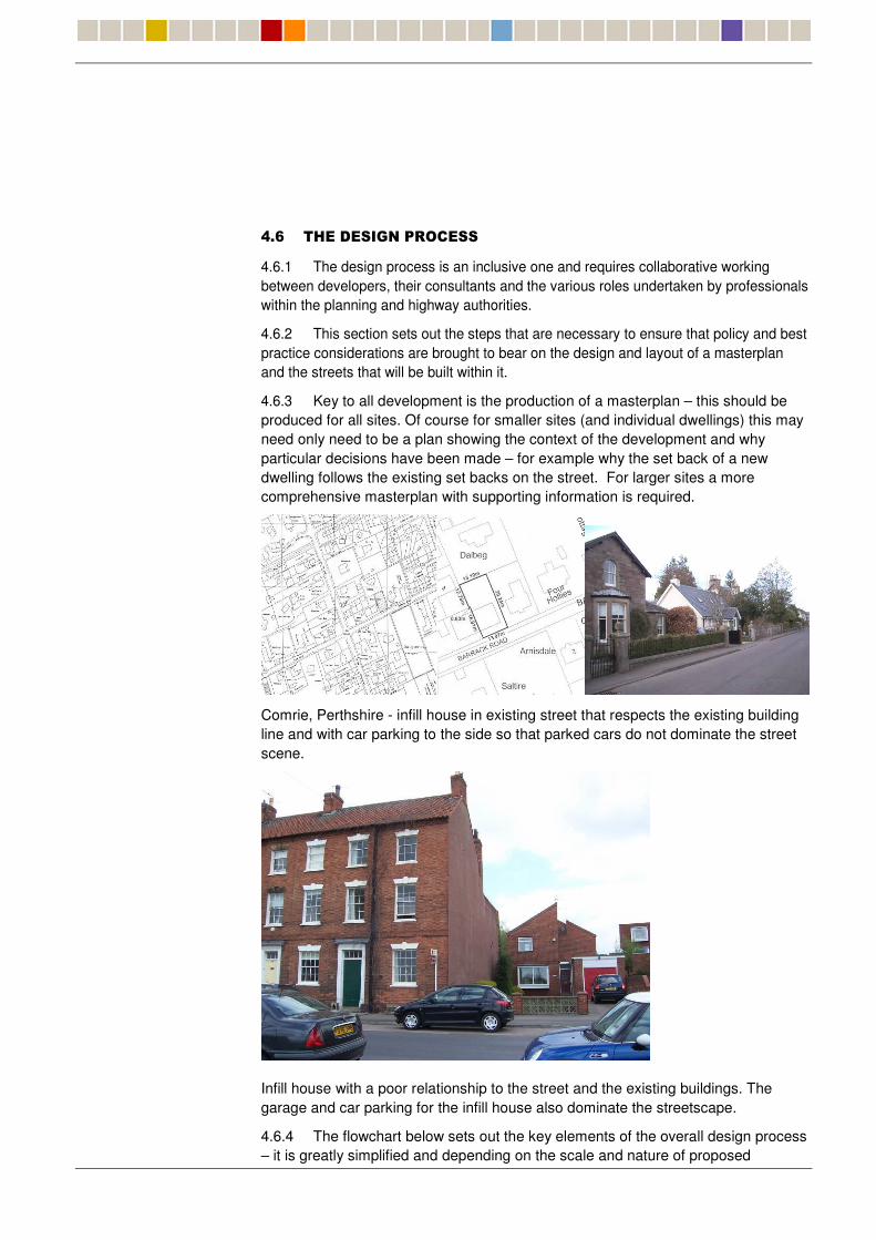
4.6.3 Key to all development is the production of a masterplan – this should be produced for all sites. Of course for smaller sites (and individual dwellings) this may need only need to be a plan showing the context of the development and why particular decisions have been made – for example why the set back of a new dwelling follows the existing set backs on the street. For larger sites a more comprehensive masterplan with supporting information is required.
Comrie, Perthshire - infill house in existing street that respects the existing building line and with car parking to the side so that parked cars do not dominate the street scene.
Infill house with a poor relationship to the street and the existing buildings. The garage and car parking for the infill house also dominate the streetscape.
4.6.4 The flowchart below sets out the key elements of the overall design process – it is greatly simplified and depending on the scale and nature of proposed
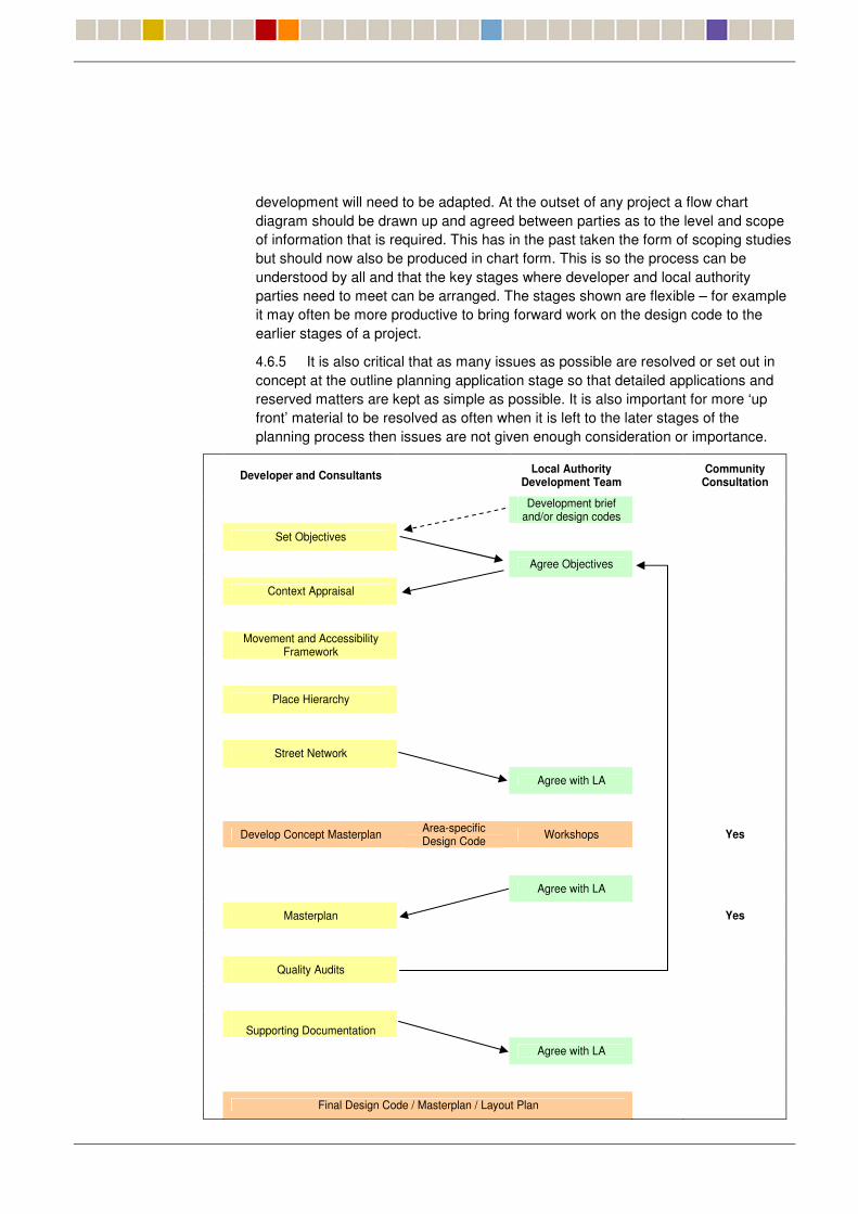
development will need to be adapted. At the outset of any project a flow chart diagram should be drawn up and agreed between parties as to the level and scope of information that is required. This has in the past taken the form of scoping studies but should now also be produced in chart form. This is so the process can be understood by all and that the key stages where developer and local authority parties need to meet can be arranged. The stages shown are flexible – for example it may often be more productive to bring forward work on the design code to the earlier stages of a project.
4.6.5 It is also critical that as many issues as possible are resolved or set out in concept at the outline planning application stage so that detailed applications and reserved matters are kept as simple as possible. It is also important for more ‘up front’ material to be resolved as often when it is left to the later stages of the planning process then issues are not given enough consideration or importance.
Developer and Consultants Local Authority
Development Team Community Consultation
Development brief and/or design codes
Set Objectives
Agree Objectives
Context Appraisal
Movement and Accessibility Framework
Place Hierarchy
Street Network
Agree with LA
Develop Concept Masterplan Area-specific Design Code Workshops Yes
Agree with LA
Masterplan Yes
Quality Audits
Supporting Documentation
Agree with LA
Final Design Code / Masterplan / Layout Plan
Outline Planning Application Yes
A Design Process Flow Chart should be tailored to each project (an illustrative example is shown above).
4.6.6 The most effective process will be one where the different parties work together. This can be achieved by bringing together the various parties at key stages and the suggested times at which this should take place are identified in the flowchart. The key stages of the process to outline planning are described in more detail below:
��� �� ��������
4.7.1 Objectives must be set and agreed by all parties and a feedback loop used during the process to determine that they are being met. They may need to be revised as the process proceeds – any revisions are to be agreed by all parties. Objectives should include issues in relation to the uses that should take place on the site and speed (i.e. all streets 20mph or less).
4.7.2 It is important to ensure that the work to produce the place and street hierarchies and the masterplan fits into the wider planning process. In particular:
� The intention to develop and the planning motive should be identified at the start of the design process (usually from a local plan allocation or regeneration strategy).
� Other local and national guidance should be consulted (see Chapter 3).
��! ������������������
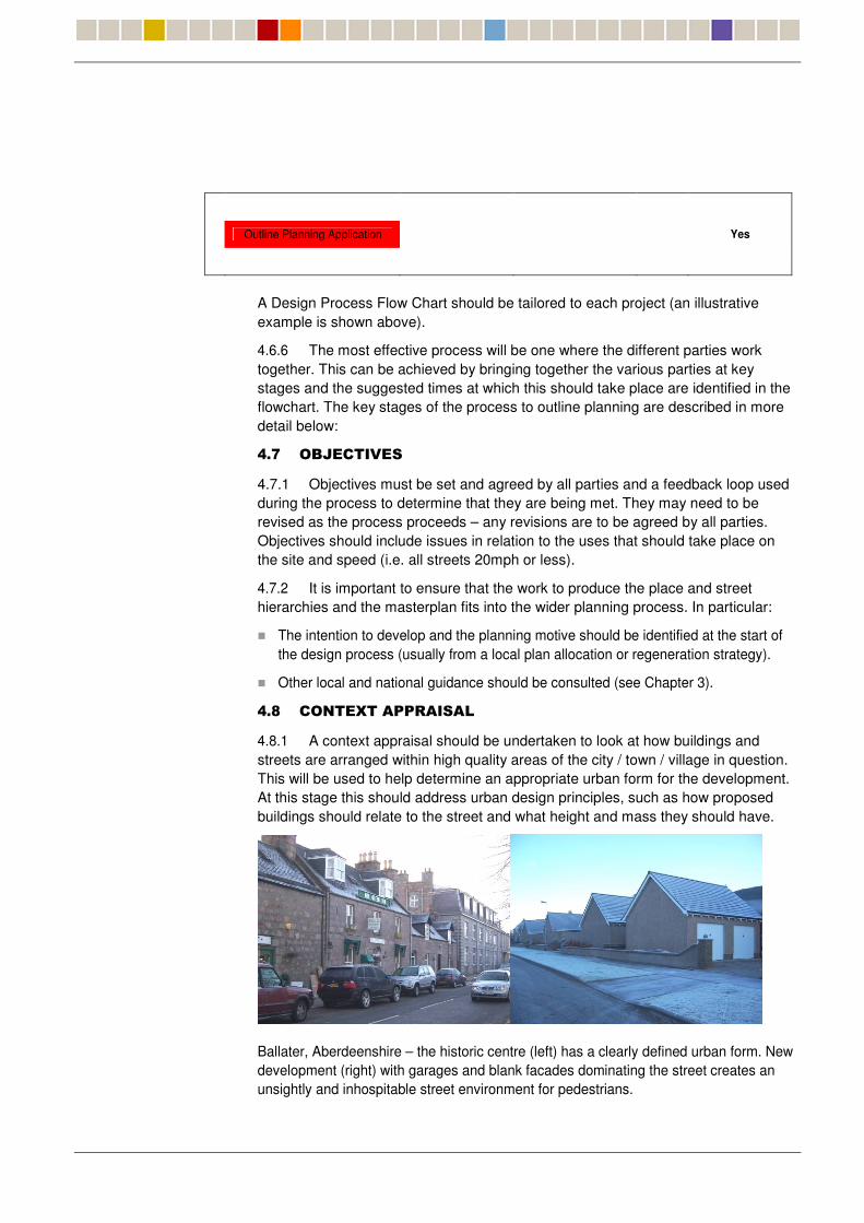
4.8.1 A context appraisal should be undertaken to look at how buildings and streets are arranged within high quality areas of the city / town / village in question. This will be used to help determine an appropriate urban form for the development. At this stage this should address urban design principles, such as how proposed buildings should relate to the street and what height and mass they should have.
Ballater, Aberdeenshire – the historic centre (left) has a clearly defined urban form. New development (right) with garages and blank facades dominating the street creates an unsightly and inhospitable street environment for pedestrians.
��" ��������������� ��#�
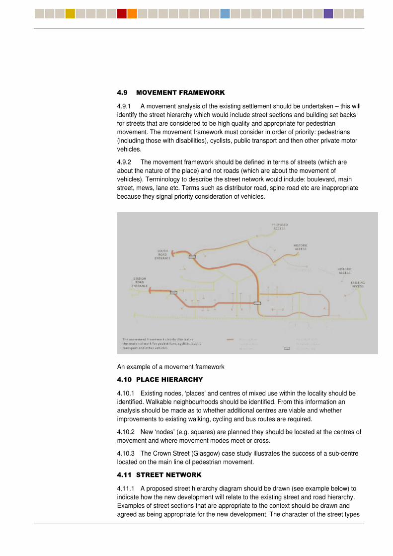
4.9.1 A movement analysis of the existing settlement should be undertaken – this will identify the street hierarchy which would include street sections and building set backs for streets that are considered to be high quality and appropriate for pedestrian movement. The movement framework must consider in order of priority: pedestrians (including those with disabilities), cyclists, public transport and then other private motor vehicles.
4.9.2 The movement framework should be defined in terms of streets (which are about the nature of the place) and not roads (which are about the movement of vehicles). Terminology to describe the street network would include: boulevard, main street, mews, lane etc. Terms such as distributor road, spine road etc are inappropriate because they signal priority consideration of vehicles.
An example of a movement framework
���$ ��������������%�
4.10.1 Existing nodes, ‘places’ and centres of mixed use within the locality should be identified. Walkable neighbourhoods should be identified. From this information an analysis should be made as to whether additional centres are viable and whether improvements to existing walking, cycling and bus routes are required.
4.10.2 New ‘nodes’ (e.g. squares) are planned they should be located at the centres of movement and where movement modes meet or cross.
4.10.3 The Crown Street (Glasgow) case study illustrates the success of a sub-centre located on the main line of pedestrian movement.
���� ����������� ��#�
4.11.1 A proposed street hierarchy diagram should be drawn (see example below) to indicate how the new development will relate to the existing street and road hierarchy. Examples of street sections that are appropriate to the context should be drawn and agreed as being appropriate for the new development. The character of the street types
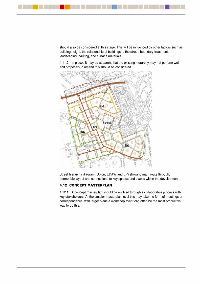
should also be considered at this stage. This will be influenced by other factors such as building height, the relationship of buildings to the street, boundary treatment, landscaping, parking, and surface materials.
4.11.2 In places it may be apparent that the existing hierarchy may not perform well and proposals to amend this should be considered.
Street hierarchy diagram (Upton, EDAW and EP) showing main route through, permeable layout and connections to key spaces and places within the development
��� �������������������
4.12.1 A concept masterplan should be evolved through a collaborative process with key stakeholders. At the smaller masterplan level this may take the form of meetings or correspondence, with larger plans a workshop event can often be the most productive way to do this.
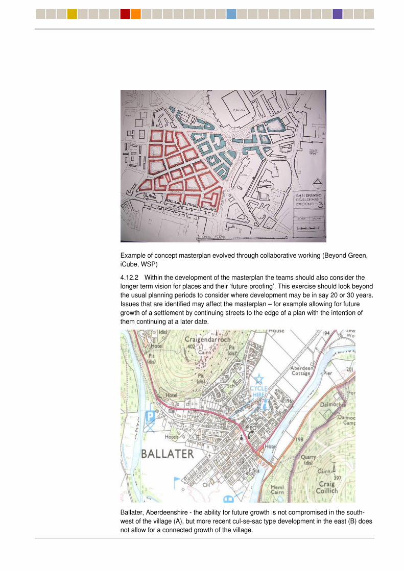
Example of concept masterplan evolved through collaborative working (Beyond Green, iCube, WSP)
4.12.2 Within the development of the masterplan the teams should also consider the longer term vision for places and their ‘future proofing’. This exercise should look beyond the usual planning periods to consider where development may be in say 20 or 30 years. Issues that are identified may affect the masterplan – for example allowing for future growth of a settlement by continuing streets to the edge of a plan with the intention of them continuing at a later date.
Ballater, Aberdeenshire - the ability for future growth is not compromised in the south-west of the village (A), but more recent cul-se-sac type development in the east (B) does not allow for a connected growth of the village.
���� �����������
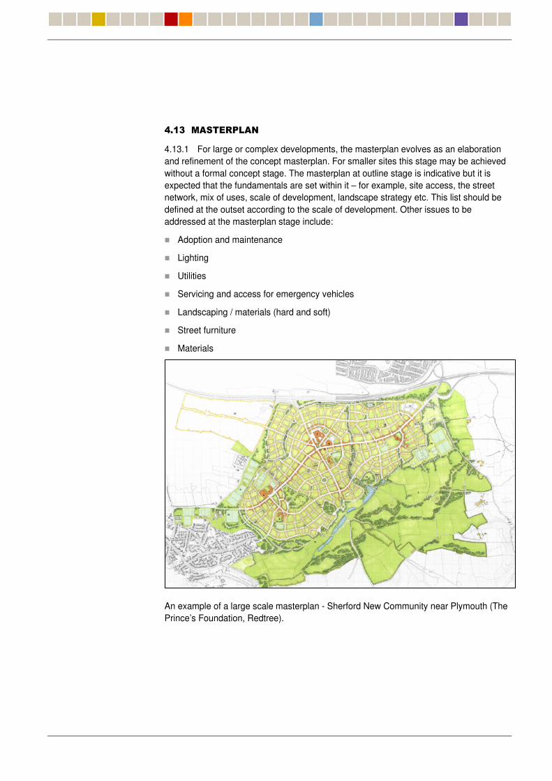
4.13.1 For large or complex developments, the masterplan evolves as an elaboration and refinement of the concept masterplan. For smaller sites this stage may be achieved without a formal concept stage. The masterplan at outline stage is indicative but it is expected that the fundamentals are set within it – for example, site access, the street network, mix of uses, scale of development, landscape strategy etc. This list should be defined at the outset according to the scale of development. Other issues to be addressed at the masterplan stage include:
� Adoption and maintenance
� Lighting
� Utilities
� Servicing and access for emergency vehicles
� Landscaping / materials (hard and soft)
� Street furniture
� Materials
An example of a large scale masterplan - Sherford New Community near Plymouth (The Prince’s Foundation, Redtree).
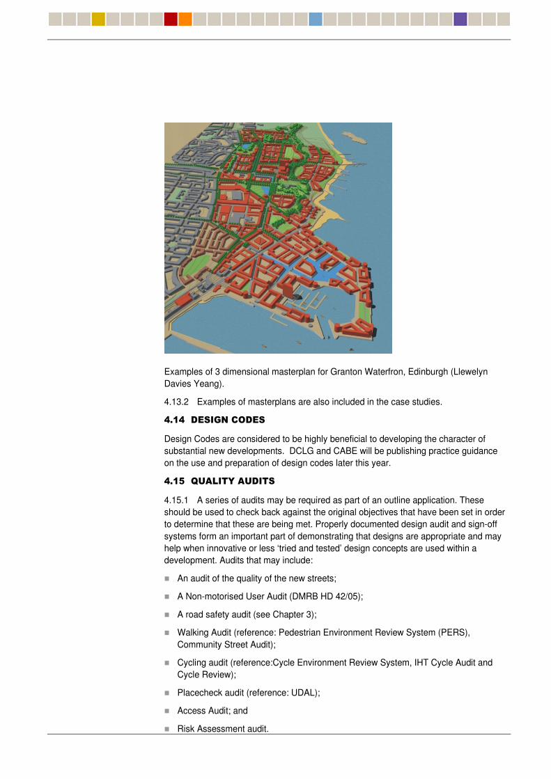
Examples of 3 dimensional masterplan for Granton Waterfron, Edinburgh (Llewelyn Davies Yeang).
4.13.2 Examples of masterplans are also included in the case studies.
���� �����������
Design Codes are considered to be highly beneficial to developing the character of substantial new developments. DCLG and CABE will be publishing practice guidance on the use and preparation of design codes later this year.
���� &����%������
4.15.1 A series of audits may be required as part of an outline application. These should be used to check back against the original objectives that have been set in order to determine that these are being met. Properly documented design audit and sign-off systems form an important part of demonstrating that designs are appropriate and may help when innovative or less ‘tried and tested’ design concepts are used within a development. Audits that may include:
� An audit of the quality of the new streets;
� A Non-motorised User Audit (DMRB HD 42/05);
� A road safety audit (see Chapter 3);
� Walking Audit (reference: Pedestrian Environment Review System (PERS), Community Street Audit);
� Cycling audit (reference:Cycle Environment Review System, IHT Cycle Audit and Cycle Review);
� Placecheck audit (reference: UDAL);
� Access Audit; and
� Risk Assessment audit.
4.15.2 Most types of planning application will also be accompanied by a Design and Access Statement. This will explain how high quality design and issues such as access for people with mobility impairments have been addressed in the proposal.
���� ����������������������
4.16.1 Various supporting information will need to be agreed at the outset. This may include:
� A Transport Assessment (TA) incorporating an assessment of traffic impact;
� An Environmental Assessment (EA) or Environmental Impact Assessment (EIA);
� A Travel Plan;
� Section 38, section 106 and section 278 documentation; and
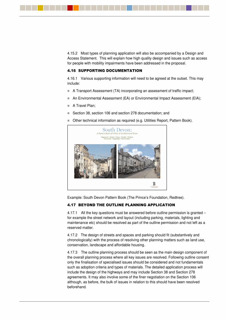
� Other technical information as required (e.g. Utilities Report, Pattern Book).
Example: South Devon Pattern Book (The Prince’s Foundation, Redtree).
���� ��%�����������������������������������
4.17.1 All the key questions must be answered before outline permission is granted – for example the street network and layout (including parking, materials, lighting and maintenance etc) should be resolved as part of the outline permission and not left as a reserved matter.
4.17.2 The design of streets and spaces and parking should fit (substantively and chronologically) with the process of resolving other planning matters such as land use, conservation, landscape and affordable housing.
4.17.3 The outline planning process should be seen as the main design component of the overall planning process where all key issues are resolved. Following outline consent only the finalisation of specialised issues should be considered and not fundamentals such as adoption criteria and types of materials. The detailed application process will include the design of the highways and may include Section 38 and Section 278 agreements. It may also involve some of the finer negotiation on the Section 106 although, as before, the bulk of issues in relation to this should have been resolved beforehand.
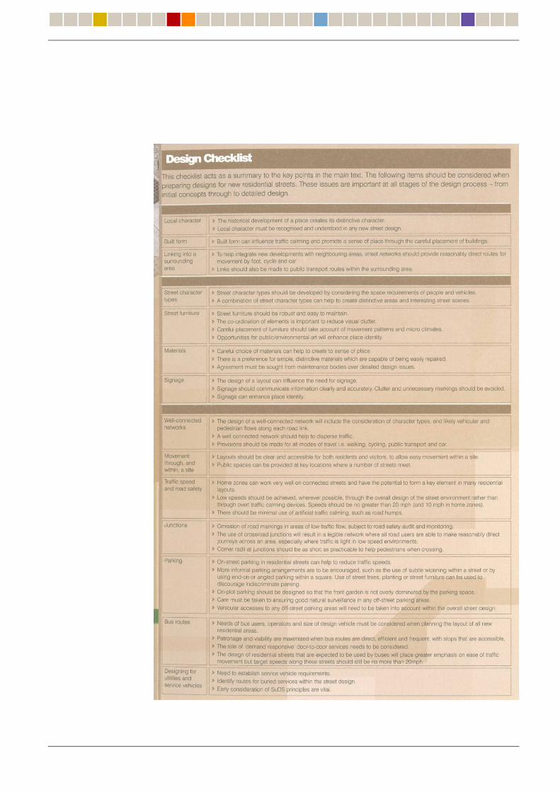

4.17.4 It may be useful to generate a design checklist. For example the above checklist has been produced as part of the Scottish Executive document: PAN76: New Residential Streets.