3011 - validation checklist – amendment application for ...€¦ · (business rule: 10 b days...
TRANSCRIPT
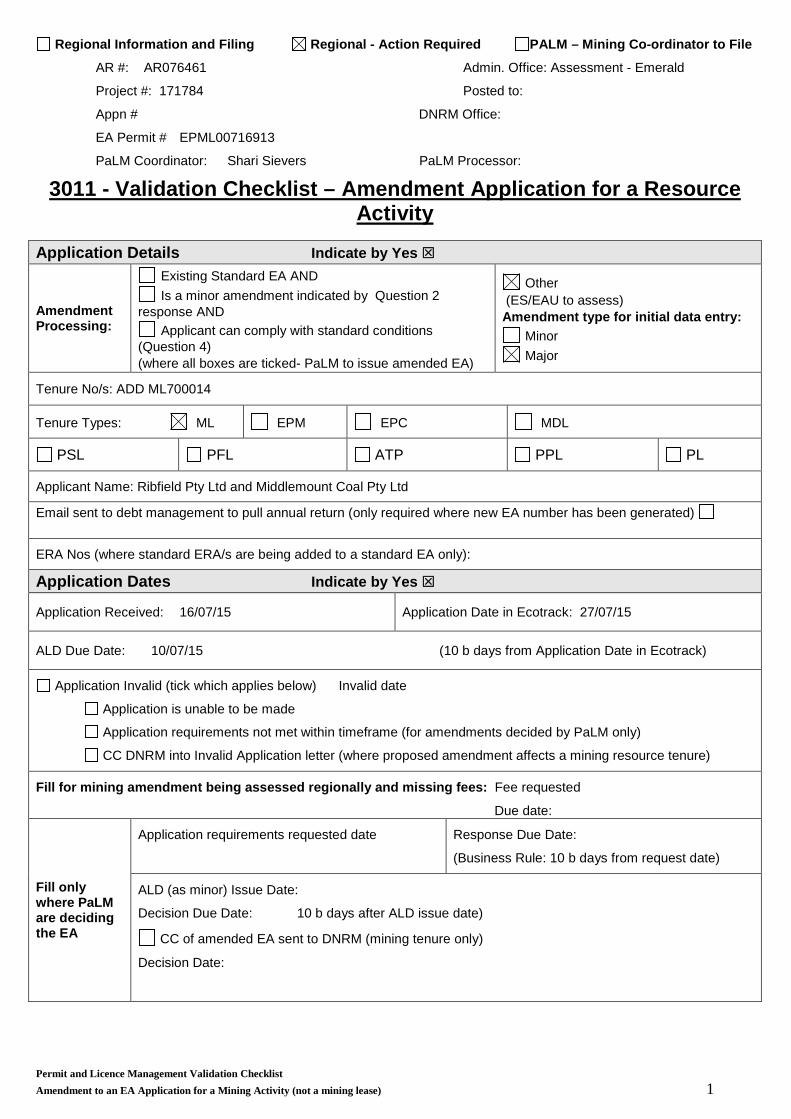
Regional Information and Filing Regional - Action Required PALM – Mining Co-ordinator to File
AR #: AR076461 Admin. Office: Assessment - Emerald
Project #: 171784 Posted to:
Appn # DNRM Office:
EA Permit # EPML00716913
PaLM Coordinator: Shari Sievers PaLM Processor:
3011 - Validation Checklist – Amendment Application for a Resource Activity
Application Details Indicate by Yes
Amendment Processing:
Existing Standard EA AND Is a minor amendment indicated by Question 2
response AND Applicant can comply with standard conditions
(Question 4) (where all boxes are ticked- PaLM to issue amended EA)
Other (ES/EAU to assess) Amendment type for initial data entry:
Minor Major
Tenure No/s: ADD ML700014
Tenure Types: ML EPM EPC MDL
PSL PFL ATP PPL PL
Applicant Name: Ribfield Pty Ltd and Middlemount Coal Pty Ltd
Email sent to debt management to pull annual return (only required where new EA number has been generated)
ERA Nos (where standard ERA/s are being added to a standard EA only):
Application Dates Indicate by Yes
Application Received: 16/07/15 Application Date in Ecotrack: 27/07/15
ALD Due Date: 10/07/15 (10 b days from Application Date in Ecotrack)
Application Invalid (tick which applies below) Invalid date
Application is unable to be made
Application requirements not met within timeframe (for amendments decided by PaLM only)
CC DNRM into Invalid Application letter (where proposed amendment affects a mining resource tenure)
Fill for mining amendment being assessed regionally and missing fees: Fee requested
Due date:
Fill only where PaLM are deciding the EA
Application requirements requested date Response Due Date:
(Business Rule: 10 b days from request date)
ALD (as minor) Issue Date:
Decision Due Date: 10 b days after ALD issue date) CC of amended EA sent to DNRM (mining tenure only)
Decision Date:
Permit and Licence Management Validation Checklist Amendment to an EA Application for a Mining Activity (not a mining lease) 1

Validity Check Indicate by Yes
For all amendment applications
Ticked No in sections 1 and 3 of the front checklist of the application form if to the above the application is invalid: Notice of Invalid Application Issue Date
Application Checks Indicate by Yes
For all amendment applications For all amendment applications
Admin: Form completed, signed and dated
All attachments present
Correct fee paid Receipt sent to client
Supplementary Annual Fee required
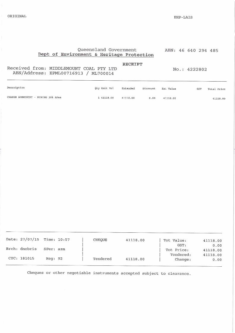
2 payments made Amount Paid $ 295.60 Receipt No 2776150 Date Paid 16/07/15 Second amount - $41,118,
4222802 27/07/15
Other Agency Interests: Indigenous Heritage Located within a Wild Rivers Area
Biodiversity Offset Policy List any other features found in Ecomaps: ERREBS, RIDA:
Is the resource activity located anywhere within an area of regional interest. If fill below – which regional interest area, have or will you require a Regional Interest Development Approval
Priority Agricultural Areas (PAAs) application reference Priority Living Areas (PLAs) application reference Strategic Environmental Areas (SEAs) application
reference Strategic Cropping Area (SCA, formerly Strategic Cropping
Land) application reference No regional interests development approval required, I am
an exempt activity
Reference #: Confirmation regional office has received application #: Yes/No
Q17 - EIS complete and risks unchanged. If no to above: Q19 - “Environmental Impact assessment ” on application form Administrative check to determine applicant has submitted:
a description of the environmental values likely to be affected by each relevant activity; and
details of any emissions or releases likely to be generated by each relevant activity; and
a description of the risk and likely magnitude of impacts on the environmental values; and
details of the management practices proposed to be implemented to prevent or minimise adverse impacts; and details of how the land the subject of the application will be rehabilitated after each relevant activity ceases
Q20 - Applicable regardless of whether EIS has been completed: “Waste management” on application form Administrative check to determine:
Applicant has indicated not applicable on application form
Applicant has given description of the proposed measures for minimising and managing waste generated by the ERA activities
Q21 - “Site Management Plan or Environmental Protection Order” on application form Administrative check to determine:
Applicant has indicated there is no site management plan or environmental protection order on the application form Applicant has given details of the site management plan
Permit and Licence Management Validation Checklist Amendment to an EA Application for a Resource Activity 2
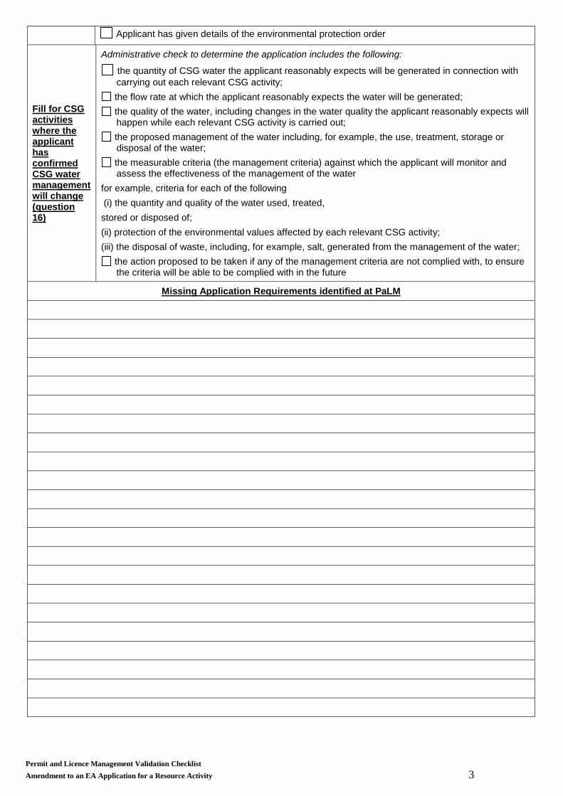
Applicant has given details of the environmental protection order
Fill for CSG activities where the applicant has confirmed CSG water management will change (question 16)
Administrative check to determine the application includes the following:
the quantity of CSG water the applicant reasonably expects will be generated in connection with carrying out each relevant CSG activity;
the flow rate at which the applicant reasonably expects the water will be generated; the quality of the water, including changes in the water quality the applicant reasonably expects will happen while each relevant CSG activity is carried out;
the proposed management of the water including, for example, the use, treatment, storage or disposal of the water;
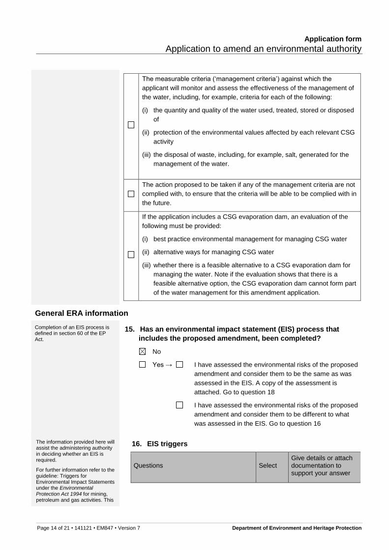
the measurable criteria (the management criteria) against which the applicant will monitor and assess the effectiveness of the management of the water
for example, criteria for each of the following (i) the quantity and quality of the water used, treated, stored or disposed of; (ii) protection of the environmental values affected by each relevant CSG activity; (iii) the disposal of waste, including, for example, salt, generated from the management of the water;
the action proposed to be taken if any of the management criteria are not complied with, to ensure the criteria will be able to be complied with in the future
Missing Application Requirements identified at PaLM
Permit and Licence Management Validation Checklist Amendment to an EA Application for a Resource Activity 3
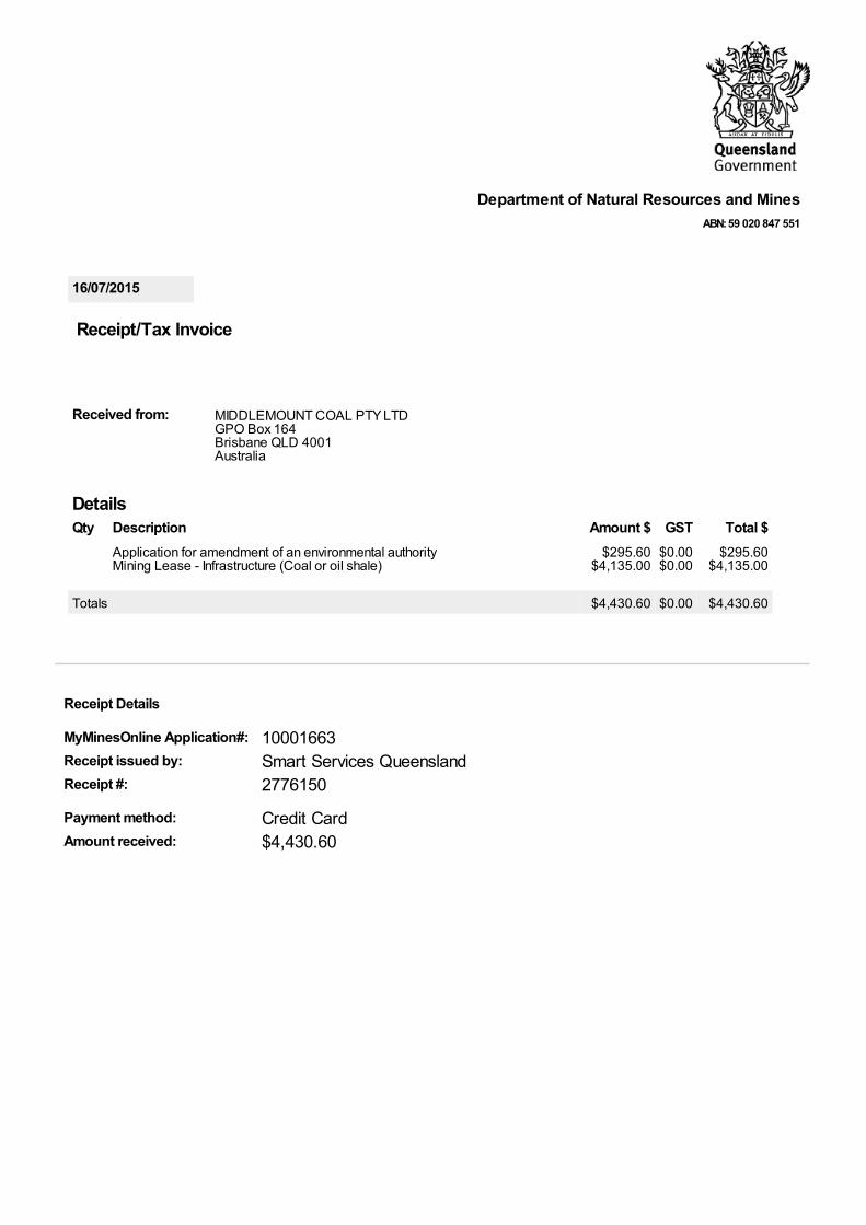
16/07/2015
DetailsQty Description Amount $ GST Total $
Application for amendment of an environmental authorityMining Lease - Infrastructure (Coal or oil shale)
$295.60$4,135.00
$0.00$0.00
$295.60$4,135.00
Totals $4,430.60 $0.00 $4,430.60
Department of Natural Resources and MinesABN: 59 020 847 551
Receipt/Tax Invoice
Received from: MIDDLEMOUNT COAL PTY LTD GPO Box 164Brisbane QLD 4001Australia
Receipt Details
MyMinesOnline Application#: 10001663Receipt issued by: Smart Services QueenslandReceipt #: 2776150
Payment method: Credit CardAmount received: $4,430.60

N O LAN DRIV E
DYSA
RT MIDDLE
MOUNT R
OAD
BARWON MIDDLEMOUNT ROAD
CENTENARY DRIVE NORTH
!
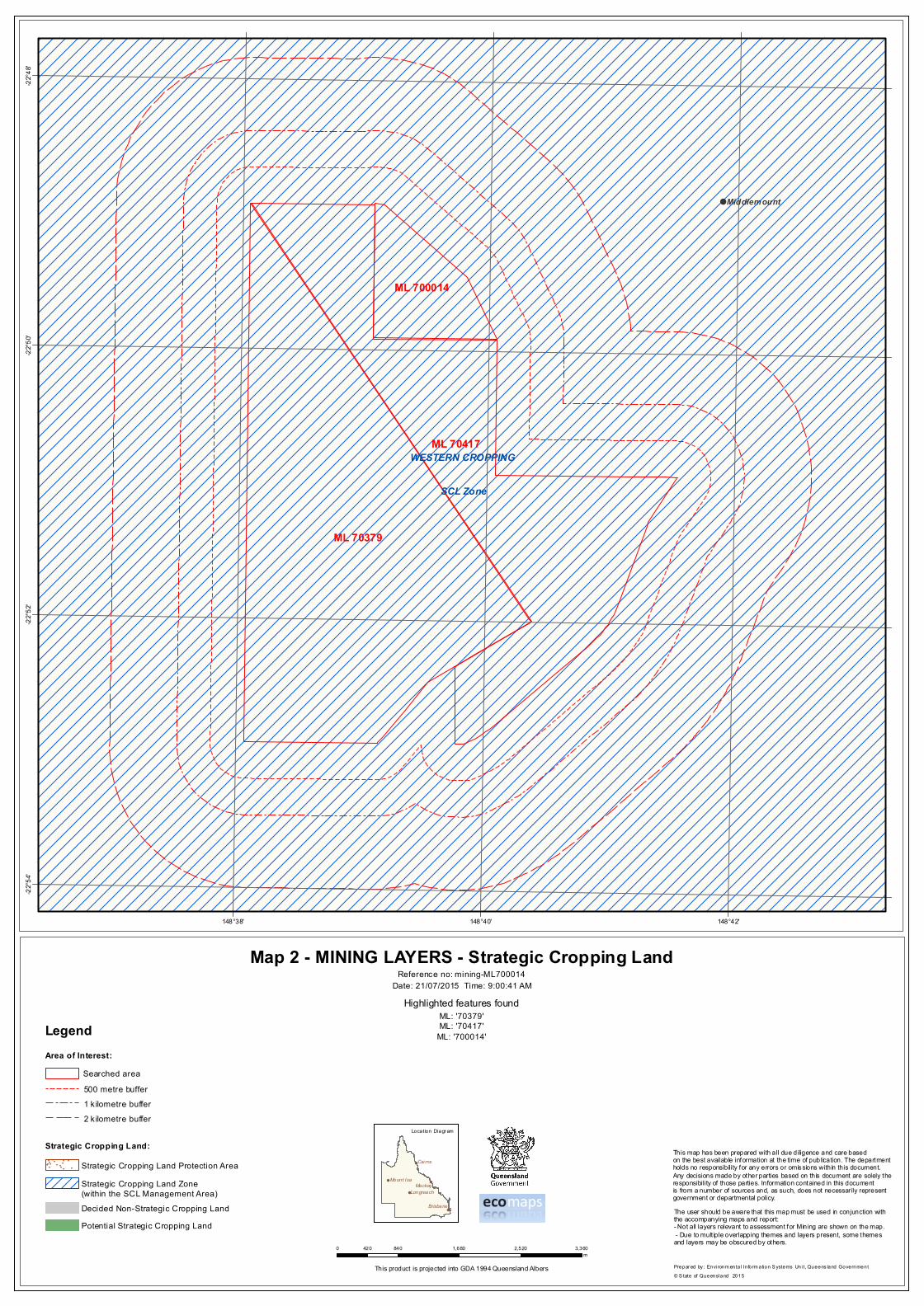
ML 70379
ML 70417
ML 700014
Middlemount
ISAAC REGIONALCENTRAL
148°42'
148°42'
148°40'
148°40'
148°38'
148°38'-22
°48'
-22°4
8'
-22°5
0'
-22°5
0'
-22°5
2'
-22°5
2'
-22°5
4'
-22°5
4'
!
!
!!
!Cairns
Mackay
Brisbane
Mount Isa
Longreach
0 720 1,440 2,160 2,880360m
Location Diagr am
This product is projected into GDA 1994 Queensland Albers
Area of Interest:
Prepar ed by : Scienc e In form ation Delivery, Queensland G ov er nm ent© S tate of Queensland 2015
This map has been prepared with all due diligence and care basedon the best available information at the time of publication. The departmentholds no responsibility for any errors or omissions within this document.Any decisions made by other parties based on this document are solely theresponsibility of those parties. Information contained in this documentis from a number of sources and, as such, does not necessarily representgovernment or departmental policy.
Map 1 - MINING LAYERS
Highlighted features foundML: '70379'ML: '70417'
ML: '700014'
Reference no: mining-ML700014
Repealed High Preservation AreasRepealed Preservation A reas
Category ACategory BCategory CCategory C - Points
! TownsRailway Lines
Freeways, Motorways and HighwaysSecondary or Local Connector Roads, StreetsOther roads and tracks
Cadastre
Repealed Nominated Waterways
LOCAL GOVERNMENT AREAS500 metre bufferSearched area
1 kilometre buffer2 k ilometre buffer
Legend
Environmentally Sensitive Areas for Mining:
Wild River Areas:
DEHP Regions
#
* Layers shown for each of Category’s A B and C on the map are grouped together into one symbol. These layers are individually listed in the accompanying report under relevant subheadings.The user should be aware that this map must be used in conjunction with the accompanying maps and report. Due to mult iple overlapping themes and layers present, some themes/layers may be obscured by others.
Date: 21/07/2015 Time: 9:00:35 AM
"
"
"
""
"
""
""
" ""
"
"
!
WESTERN CROPPING
SCL Zone
ML 70379
ML 70417
ML 700014
Middlemount
148°42'148°40'148°38'
-22°4
8'-22
°50'
-22°5
2'-22
°54'
!
!
!!
!Cairns
Mackay
Brisbane
Mount Isa
Longreach
0 840 1,680 2,520 3,360420m
Location Diagr am
This product is projected into GDA 1994 Queensland Albers Prepar ed by : Envi ronm enta l In form ation S ystems Uni t, Queens land Government© S tate of Queensland
This map has been prepared with all due diligence and care basedon the best available information at the time of publication. The departmentholds no responsibility for any errors or omissions within this document.Any decisions made by other parties based on this document are solely theresponsibility of those parties. Information contained in this documentis from a number of sources and, as such, does not necessarily representgovernment or departmental policy.
Map 2 - MINING LAYERS - Strategic Cropping Land
Highlighted features foundML: '70379'ML: '70417'
ML: '700014'
Reference no: mining-ML700014
2015
Strategic Cropping Land Protection Area
The user should be aware that this map must be used in conjunction with the accompanying maps and report:- Not all layers relevant to assessment for Mining are shown on the map. - Due to mult iple overlapping themes and layers present, some themes and layers may be obscured by others.
"
"
"
"
"
""
""
"
""
"
"
"
"
"
"
"
"
"
Strategic Cropping Land Zone (within the SCL Management Area)
Potential Strategic Cropping Land
Area of Interest:
500 metre bufferSearched area
1 kilometre buffer2 k ilometre buffer
Legend
Strategic Cropping Land:
Decided Non-Strategic Cropping Land
Date: 21/07/2015 Time: 9:00:41 AM

mining (21/07/2015 09:00:19)ML: '70379', ML: '70417', ML: '700014'
Page 1
Location Layers - within found features (i.e. no buffer)DEHP Regions
DEHP Region
CENTRAL
Local Government Boundaries (DCDB)
LGA Name
ISAAC REGIONAL
Mining Districts
Mining District Name
EMERALD
Mining Interests - within found features (i.e. no buffer)Indigenous Cultural Heritage
Grid ID
94969
95385
95386
95801
95802
Trigger for ECSU ** No Data Found **
Wild Rivers Layers - within found features (i.e. no buffer) Wild River Nominated Waterways Declared - Repealed ** No Data Found **
Wild River Preservation Area Boundaries Declared - Repealed ** No Data Found **
Strategic Cropping Land Layers - within found features (i.e. no buffer)SCL - Zones (within the SCL Management Area)
SCL Zone Name (Within the SCL Management Area)
WESTERN CROPPING
SCL - Strategic Cropping Land Decisions ** No Data Found **
SCL - Pending Validation Applications ** No Data Found **
SCL - Protection Areas ** No Data Found **
SCL - Potential Strategic Cropping Land ** No Data Found **
Category A - within found features (i.e. no buffer) National Parks ** No Data Found **
Regional Parks (general) ** No Data Found **
Forest Reserves ** No Data Found **
Wet Tropics World Heritage Area ** No Data Found **
Great Barrier Reef Marine Park Authority Boundary Management Areas ** No Data Found **
State Marine Parks other than General Use Zones ** No Data Found **
Category B - within found features (i.e. no buffer)Endangered Remnant Regional Ecosystems Biodiversity Status
Regional Ecosystem RE Percents Biodiversity Status
11.3.1 100 E
11.3.1/11.3.1 70/30 E
11.3.1/11.3.1 90/10 E
11.3.1/11.3.2 60/40 E/OC
11.4.9 100 E
Koala Plan 2006 to 2016 for ECSU ** No Data Found **
Queensland Heritage Register Boundaries ** No Data Found **
Fish Habitat Areas (QLD Fisheries Act 1994) ** No Data Found **
Marine Plants ** No Data Found **
Forest Special Management Areas (SMA) ** No Data Found **
Cultural Heritage Registered Areas ** No Data Found **
Designated Landscape Areas other than Stanbroke ** No Data Found **
General Use Zones of Marine Parks ** No Data Found **
World Heritage Areas (QLD) ** No Data Found **
mining (21/07/2015 09:00:20)ML: '70379', ML: '70417', ML: '700014'
Page 2
Ramsar Sites (QLD) ** No Data Found **
Coordinated Conservation Areas ** No Data Found **
Category C - within found features (i.e. no buffer) Palmer River Historic Mining Sites ** No Data Found **
Dams, Weirs, Barrages - QLD 100k (NRM) ** No Data Found **
Drainage Areas ** No Data Found **
Erosion Prone Area Plans ** No Data Found **
State Forests and Timber Reserves ** No Data Found **
Stanbroke Designated Landscape Area ** No Data Found **
River Improvement Trust Areas ** No Data Found **
Declared Irrigation Areas (boundaries) ** No Data Found **
Declared Catchments of Dams of QLD (NRM) ** No Data Found **
Regional Parks (resource use area) ** No Data Found **
Nature Refuges ** No Data Found **
Coastal Management Districts (from 3 Feb 2012) ** No Data Found **
Category A:500 - 500(m Buffer) National Parks ** No Data Found **
Regional Parks (general) ** No Data Found **
Forest Reserves ** No Data Found **
Wet Tropics World Heritage Area ** No Data Found **
Great Barrier Reef Marine Park Authority Boundary Management Areas ** No Data Found **
State Marine Parks other than General Use Zones ** No Data Found **
Category B:500 - 500(m Buffer)Endangered Remnant Regional Ecosystems Biodiversity Status
Regional Ecosystem RE Percents Biodiversity Status
11.3.1 100 E
11.3.1/11.3.1 70/30 E
11.3.1/11.3.1 90/10 E
11.3.1/11.3.2 60/40 E/OC
11.4.8 100 E
11.4.9 100 E
11.4.9b 100 E
Koala Plan 2006 to 2016 for ECSU ** No Data Found **
Queensland Heritage Register Boundaries ** No Data Found **
Fish Habitat Areas (QLD Fisheries Act 1994) ** No Data Found **
Marine Plants ** No Data Found **
Forest Special Management Areas (SMA) ** No Data Found **
Cultural Heritage Registered Areas ** No Data Found **
Designated Landscape Areas other than Stanbroke ** No Data Found **
General Use Zones of Marine Parks ** No Data Found **
World Heritage Areas (QLD) ** No Data Found **
Ramsar Sites (QLD) ** No Data Found **
Coordinated Conservation Areas ** No Data Found **
Category C:500 - 500(m Buffer) Palmer River Historic Mining Sites ** No Data Found **
Dams, Weirs, Barrages - QLD 100k (NRM) ** No Data Found **
Drainage Areas ** No Data Found **
Erosion Prone Area Plans ** No Data Found **
State Forests and Timber Reserves ** No Data Found **
Stanbroke Designated Landscape Area ** No Data Found **
River Improvement Trust Areas ** No Data Found **
Declared Irrigation Areas (boundaries) ** No Data Found **
Declared Catchments of Dams of QLD (NRM) ** No Data Found **

mining (21/07/2015 09:00:20)ML: '70379', ML: '70417', ML: '700014'
Page 3
Regional Parks (resource use area) ** No Data Found **
Nature Refuges ** No Data Found **
Coastal Management Districts (from 3 Feb 2012) ** No Data Found **
Wild Rivers Layers:500 - 500(m Buffer) Wild River Nominated Waterways Declared - Repealed ** No Data Found **
Wild River Preservation Area Boundaries Declared - Repealed ** No Data Found **
Category A:1000 - 1000(m Buffer) National Parks ** No Data Found **
Regional Parks (general) ** No Data Found **
Forest Reserves ** No Data Found **
Wet Tropics World Heritage Area ** No Data Found **
Great Barrier Reef Marine Park Authority Boundary Management Areas ** No Data Found **
State Marine Parks other than General Use Zones ** No Data Found **
Category B:1000 - 1000(m Buffer)Endangered Remnant Regional Ecosystems Biodiversity Status
Regional Ecosystem RE Percents Biodiversity Status
11.3.1 100 E
11.3.1/11.3.1 70/30 E
11.3.1/11.3.1 90/10 E
11.3.1/11.3.2 60/40 E/OC
11.4.8 100 E
11.4.8/11.4.9 80/20 E/E
11.4.9 100 E
11.4.9b 100 E
Koala Plan 2006 to 2016 for ECSU ** No Data Found **
Queensland Heritage Register Boundaries ** No Data Found **
Fish Habitat Areas (QLD Fisheries Act 1994) ** No Data Found **
Marine Plants ** No Data Found **
Forest Special Management Areas (SMA) ** No Data Found **
Cultural Heritage Registered Areas ** No Data Found **
Designated Landscape Areas other than Stanbroke ** No Data Found **
General Use Zones of Marine Parks ** No Data Found **
World Heritage Areas (QLD) ** No Data Found **
Ramsar Sites (QLD) ** No Data Found **
Coordinated Conservation Areas ** No Data Found **
Category C:1000 - 1000(m Buffer) Palmer River Historic Mining Sites ** No Data Found **
Dams, Weirs, Barrages - QLD 100k (NRM) ** No Data Found **
Drainage Areas ** No Data Found **
Erosion Prone Area Plans ** No Data Found **
State Forests and Timber Reserves ** No Data Found **
Stanbroke Designated Landscape Area ** No Data Found **
River Improvement Trust Areas ** No Data Found **
Declared Irrigation Areas (boundaries) ** No Data Found **
Declared Catchments of Dams of QLD (NRM) ** No Data Found **
Regional Parks (resource use area) ** No Data Found **
Nature Refuges ** No Data Found **
Coastal Management Districts (from 3 Feb 2012) ** No Data Found **
Wild Rivers Layers:1000 - 1000(m Buffer) Wild River Nominated Waterways Declared - Repealed ** No Data Found **
Wild River Preservation Area Boundaries Declared - Repealed ** No Data Found **
Category A:2000 - 2000(m Buffer)
mining (21/07/2015 09:00:20)ML: '70379', ML: '70417', ML: '700014'
Page 4
National Parks ** No Data Found **
Regional Parks (general) ** No Data Found **
Forest Reserves ** No Data Found **
Wet Tropics World Heritage Area ** No Data Found **
Great Barrier Reef Marine Park Authority Boundary Management Areas ** No Data Found **
State Marine Parks other than General Use Zones ** No Data Found **
Category B:2000 - 2000(m Buffer)Endangered Remnant Regional Ecosystems Biodiversity Status
Regional Ecosystem RE Percents Biodiversity Status
11.3.1 100 E
11.3.1/11.3.1 70/30 E
11.3.1/11.3.1 90/10 E
11.3.1/11.3.2 60/40 E/OC
11.4.8 100 E
11.4.8/11.4.9 80/20 E/E
11.4.8/11.4.9 90/10 E/E
11.4.9 100 E
11.4.9/11.4.8 75/25 E/E
11.4.9b 100 E
11.9.5/11.9.1 80/20 E/E
Koala Plan 2006 to 2016 for ECSU ** No Data Found **
Queensland Heritage Register Boundaries ** No Data Found **
Fish Habitat Areas (QLD Fisheries Act 1994) ** No Data Found **
Marine Plants ** No Data Found **
Forest Special Management Areas (SMA) ** No Data Found **
Cultural Heritage Registered Areas ** No Data Found **
Designated Landscape Areas other than Stanbroke ** No Data Found **
General Use Zones of Marine Parks ** No Data Found **
World Heritage Areas (QLD) ** No Data Found **
Ramsar Sites (QLD) ** No Data Found **
Coordinated Conservation Areas ** No Data Found **
Category C:2000 - 2000(m Buffer) Palmer River Historic Mining Sites ** No Data Found **
Dams, Weirs, Barrages - QLD 100k (NRM) ** No Data Found **
Drainage Areas ** No Data Found **
Erosion Prone Area Plans ** No Data Found **
State Forests and Timber Reserves ** No Data Found **
Stanbroke Designated Landscape Area ** No Data Found **
River Improvement Trust Areas ** No Data Found **
Declared Irrigation Areas (boundaries) ** No Data Found **
Declared Catchments of Dams of QLD (NRM) ** No Data Found **
Regional Parks (resource use area) ** No Data Found **
Nature Refuges ** No Data Found **
Coastal Management Districts (from 3 Feb 2012) ** No Data Found **
Wild Rivers Layers:2000 - 2000(m Buffer) Wild River Nominated Waterways Declared - Repealed ** No Data Found **
Wild River Preservation Area Boundaries Declared - Repealed ** No Data Found **
Lot and Plan List - within found features (i.e. no buffer)Cadastre - Lot and Plan list
Lot Plan Lotplan Tenure
11 TT443 11TT443 LL
2 SP248577 2SP248577 FH
3 SP210524 3SP210524 FH
5 SP210524 5SP210524 FH

mining (21/07/2015 09:00:20)ML: '70379', ML: '70417', ML: '700014'
Page 5
9 CNS131 9CNS131 LL
B SP210524 BSP210524 EA
D CNS136 DCNS136 EA
E CNS136 ECNS136 EA
K ROP130 KROP130 EA
L CNS100 LCNS100 EA
ML 700014 Resource authority public report
The Queensland Government supports and encourages the dissemination and exchange of its information.The copyright in this publication is licensed under a Creative Commons Attribution 3.0 Australia (CC BY)licence.
Under this licence you are free, without having to seek our permission, to use this publication in accordancewith the licence terms.
You must keep intact the copyright notice and attribute the State of Queensland as the source of thepublication.
For more information on this licence, visit www.creativecommons.org/licenses/by/3.0/au/ deed.en While everycare is taken to ensure the accuracy of this product, the Queensland Government makes no representationsor warranties about its accuracy, reliability, completeness or suitability for any particular purpose and disclaimsall responsibility and all liability (including without limitation, liability in negligence) for all expenses, losses,damages (including indirect or consequential damage) and costs which you might incur as a result of theproduct being inaccurate or incomplete in any way and for any reason.

2334444445
Table of Contents
Table of ContentsPermit detailsHoldersAreaTerm historyNative titlePurpose and mineralsRelated permitsFinancialActivities
ML 700014 Resource authority public report
Printed on: 21/07/2015 at 8:45:32 AM Page 2 of 5
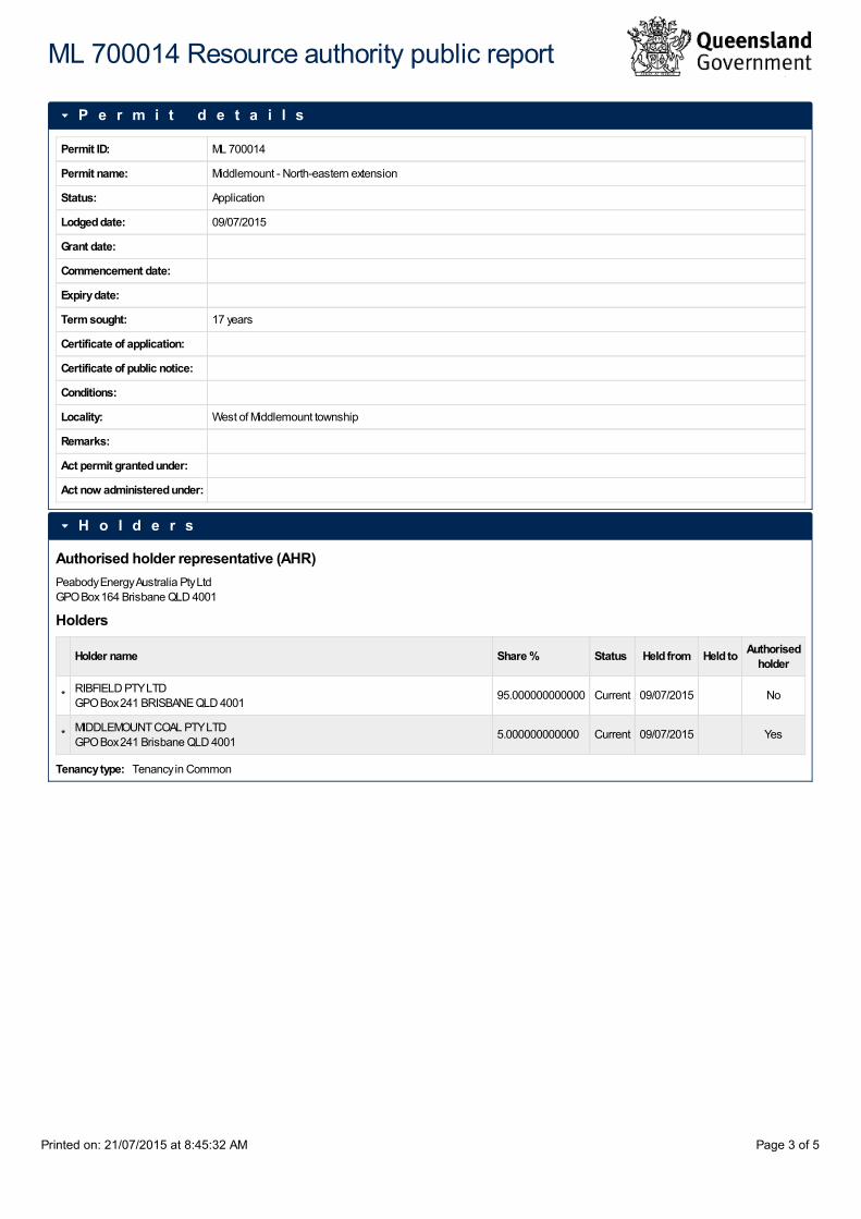
Permit ID: ML 700014
Permit name: Middlemount - North-eastern extension
Status: Application
Lodged date: 09/07/2015
Grant date:
Commencement date:
Expiry date:
Term sought: 17 years
Certificate of application:
Certificate of public notice:
Conditions:
Locality: West of Middlemount township
Remarks:
Act permit granted under:
Act now administered under:
Authorised holder representative (AHR)Peabody Energy Australia Pty LtdGPO Box 164 Brisbane QLD 4001
Holders
Holder name Share % Status Held from Held to Authorisedholder
* RIBFIELD PTY LTDGPO Box 241 BRISBANE QLD 4001
95.000000000000 Current 09/07/2015 No
* MIDDLEMOUNT COAL PTY LTDGPO Box 241 Brisbane QLD 4001
5.000000000000 Current 09/07/2015 Yes
Tenancy type: Tenancy in Common
P e r m i t d e t a i l s
H o l d e r s
ML 700014 Resource authority public report
Printed on: 21/07/2015 at 8:45:32 AM Page 3 of 5

Location: View Map
Mining district: Emerald
Local authority: Isaac Regional Council
Area: 197.1960 Hectares
Surface area:
Exclusions:
Marked out date: 09/07/2015 11:00
Sub-blocksNo data available
Background land
Land identifier Landusage
Compensationrequired Finalised
LOT 3 ON SP210524 N/A Permit N
Survey plansNo data available
Relinquishment details
No data available
Sub-blocks retainedNo data available
Term Date noticeissued Date lodged Date approved Date commenced Date term
ends Term Act grantedunder
09/07/2015
Current process Description
Exclusive Land (100%)
Purpose
Stock pile ore / overburden
Pre-requisite permits: PP 74264
Rent details
Area units: 198 Hectares
Rate/unit area:
A r e a
T e r m h i s t o r y
N a t i v e t i t l e
P u r p o s e a n d m i n e r a l s
R e l a t e d p e r m i t s
F i n a n c i a l
ML 700014 Resource authority public report
Printed on: 21/07/2015 at 8:45:32 AM Page 4 of 5
No data available
A c t i v i t i e s
ML 700014 Resource authority public report
Printed on: 21/07/2015 at 8:45:32 AM Page 5 of 5


Application form
Page 1 of 21 • 141121 • EM847 • Version 7 ABN 46 640 294 485
Environmental authority
Application to amend an environmental authority
This approved form is to be used when applying to amend an environmental authority under sections 222 to 227 of the
Environmental Protection Act 1994 (EP Act) for an environmentally relevant activity (ERA).
An application to amend an environmental authority is not appropriate in all circumstances. If you answer yes to
any of the questions in the checklist below, you cannot use this application form. If you answer no to all of the
questions in the checklist, you may continue to use this application form.
This form also contains a question relating the Regional Planning Interests Act 2014. If you are proposing to
undertake resource activities in an area of regional interests, a regional interest development approval (RIDA)
may be needed. Further information, including applications forms, can be found on the Department of State
Development, Infrastructure and Planning (DSDIP) website, www.dsdip.qld.gov.au.
You are encouraged to have a pre-lodgement meeting before applying to amend your environmental authority. If
you would like to have a pre-lodgement meeting:
for prescribed ERAs 2, 3 and 4—contact the Department of Agriculture, Fisheries and Forestry by email
for any other ERA—please fill out and lodge the form “Application for a pre-design/pre-lodgement
meeting” (EM11251), prior to lodging this application form.
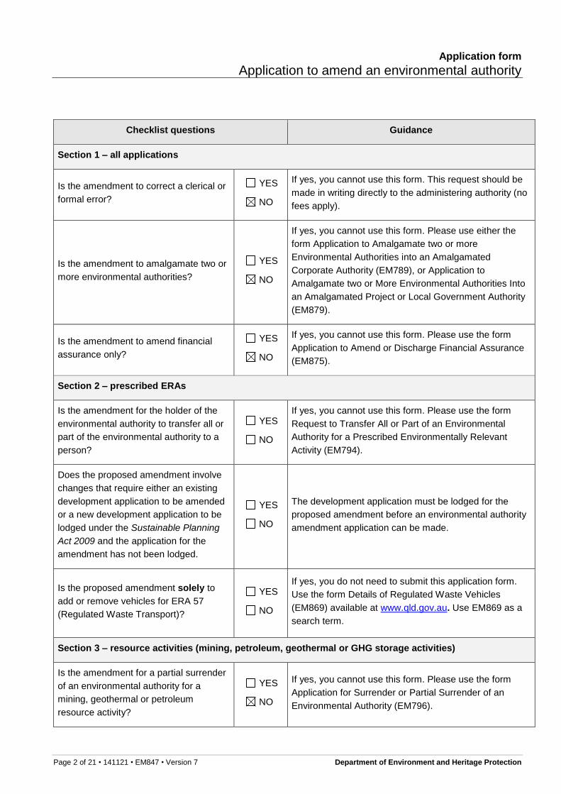
Checklist for making an amendment application
You must complete this checklist before you continue with the application form.
If your application is for:
a prescribed ERA → fill in Section 1 and Section 2 of the checklist below
a resource activity → fill in Section 1 and Section 3 of the checklist below
both a prescribed ERA and a resource activity → fill in sections 1, 2 and 3 of the checklist below
If you have answered yes to any of the below questions, you cannot use this application form. If you have
answered no to all of the below questions, you may continue to use this application form.
1 This is the publication number. The publication number can be used as a search term to find the latest version
of a publication at www.qld.gov.au.
Application form
Application to amend an environmental authority
Page 2 of 21 • 141121 • EM847 • Version 7 Department of Environment and Heritage Protection
Checklist questions Guidance
Section 1 – all applications
Is the amendment to correct a clerical or
formal error?
YES
NO
If yes, you cannot use this form. This request should be
made in writing directly to the administering authority (no
fees apply).
Is the amendment to amalgamate two or
more environmental authorities?
YES
NO
If yes, you cannot use this form. Please use either the
form Application to Amalgamate two or more
Environmental Authorities into an Amalgamated
Corporate Authority (EM789), or Application to
Amalgamate two or More Environmental Authorities Into
an Amalgamated Project or Local Government Authority
(EM879).
Is the amendment to amend financial
assurance only?
YES
NO
If yes, you cannot use this form. Please use the form
Application to Amend or Discharge Financial Assurance
(EM875).
Section 2 – prescribed ERAs
Is the amendment for the holder of the
environmental authority to transfer all or
part of the environmental authority to a
person?
YES
NO
If yes, you cannot use this form. Please use the form
Request to Transfer All or Part of an Environmental
Authority for a Prescribed Environmentally Relevant
Activity (EM794).
Does the proposed amendment involve
changes that require either an existing
development application to be amended
or a new development application to be
lodged under the Sustainable Planning
Act 2009 and the application for the
amendment has not been lodged.
YES
NO
The development application must be lodged for the
proposed amendment before an environmental authority
amendment application can be made.
Is the proposed amendment solely to
add or remove vehicles for ERA 57
(Regulated Waste Transport)?
YES
NO
If yes, you do not need to submit this application form.
Use the form Details of Regulated Waste Vehicles
(EM869) available at www.qld.gov.au. Use EM869 as a
search term.
Section 3 – resource activities (mining, petroleum, geothermal or GHG storage activities)
Is the amendment for a partial surrender
of an environmental authority for a
mining, geothermal or petroleum
resource activity?
YES
NO
If yes, you cannot use this form. Please use the form
Application for Surrender or Partial Surrender of an
Environmental Authority (EM796).
Application form
Application to amend an environmental authority
Page 3 of 21 • 141121 • EM847 • Version 7 Department of Environment and Heritage Protection
Definitions of terms used in this form
Where there is inconsistency between the definition of terms used here and the terms used in the EP Act, the
terms in the EP Act apply.
Condition conversion For an environmental authority, means an amendment replacing all the
conditions of the authority with the standard conditions for the environmentally
relevant activity which the authority relates. The relevant eligibility criteria and
standard conditions must be able to be met.
Environmentally relevant
activity (ERA)
A resource activity or a prescribed ERA
ERA project A prescribed ERA project or a resource project.
Mobile and temporary ERA A prescribed ERA, other than an activity that is dredging material, extracting
rock or other material, or the incinerating of waste:
(a) carried out at various locations using transportable plant or equipment,
including a vehicle
(b) that does not result in the building of any permanent structures or any
physical change of the landform at the locations (other than minor
alterations solely necessary for access and setup including, for example,
access ways, footings and temporary storage areas)
(c) carried out at any 1 of the locations:
(i) for less than 28 days in a calendar year, or
(ii) for 28 or more days in a calendar year only if the activity is
necessarily associated with, and is exclusively used in, the
construction or demolition phase of a project.
Prescribed ERA An environmentally relevant activity that is not a resource activity and is
prescribed under section 19 of the EP Act.
Prescribed ERA project All prescribed ERAs carried out, or proposed to be carried out, as a single
integrated operation.
Registered suitable operator A person who, or a corporation which, under section 318I of the EP Act has
been assessed as being suitable to carry out an ERA and has been listed on
the suitable operator register.

Application form
Application to amend an environmental authority
Page 4 of 21 • 141121 • EM847 • Version 7 Department of Environment and Heritage Protection
Resource activity An activity that is any of the following:
(a) a geothermal activity
(b) a greenhouse gas (GHG) storage activity
(c) a mining activity
(d) a petroleum activity.
Resource project Resource activities carried out, or proposed to be carried out, under 1 or more
resource tenures, in any combination, as a single integrated operation.
Significant project A project declared under section 26 of the State Development and Public
Works Act 1971 to be a significant project.
Single integrated operation Occurs when all the below criteria is met:
(a) the activities are carried out under the day-to-day management of a
single responsible individual, for example, a site or operations manager
(b) the activities are operationally interrelated
(c) the activities are, or will be, carried out at 1 or more places
(d) the places where the activities are carried out are separated by distances
short enough to make feasible the integrated day-to-day management of
the activities.

Application form
Application to amend an environmental authority
Page 5 of 21 • 141121 • EM847 • Version 7 Department of Environment and Heritage Protection
GUIDE
If you require assistance in answering any part of this form, or have any questions about your application please contact the relevant department. Contact details are at the end of this form
The environmental authority number and details may be found on the existing environmental authority or quoted in other correspondence received from the administering authority.
If more space is required for any responses, please attach additional information as a separate page.
If there is an agent acting on behalf of the environmental authority holder, provide details in this section. An agent could be a consultant or a contact for the environmental authority holder.
As statutory documents need to be sent to all applicants, this section can also be used when there are multiple environmental authority holders to nominate an address for statutory documentation to be sent ‘care of’ to.
Application details
1. Environmental authority number
ENVIRONMENTAL AUTHORITY NUMBER
EPML00716913
ENVIRONMENTAL AUTHORITY HOLDER NAMES
Middlemount Coal Pty Ltd / Ribfield Pty Ltd
Agent details / address for service
The address supplied here will also be used as a service address for sending
statutory documents. If blank, statutory documents will be sent to the address
previously supplied for the holder or principal applicant for the environmental
authority.
INDIVIDUAL OR BUSINESS NAME (INCLUDE TRADING NAME IF RELEVANT)
MIDDLEMOUNT COAL PTY LTD
RESIDENTIAL ADDRESS OR REGISTERED BUSINESS ADDRESS (NOT A POST OFFICE
BOX ADDRESS)
Level 1, 100 Melbourne Street, South Brisbane QLD 4101
POSTAL ADDRESS (WHERE DIFFERENT FROM ABOVE)
GPO Box 241
BRISBANE QLD 4001
CONTACT PERSON
Paul Statham
PHONE
(07) 4985 0059
FACSIMILE
(07) 3179 2098
CROSS IF YOU DO NOT WANT TO RECEIVE CORRESPONDENCE VIA EMAIL

Application form
Application to amend an environmental authority
Page 6 of 21 • 141121 • EM847 • Version 7 Department of Environment and Heritage Protection
Criteria for a major or minor amendment and guidance on the difference between the two can be found in the guideline: ‘Major and minor amendments’ EM959 and s. 223 of the EP Act).
2. Describe in detail the proposed amendment and the reason the
amendment is being sought
The decision of whether the amendment is major or minor is made by the administering authority. However, the administrative process requires you to indicate whether you think the proposed amendment will constitute a major or minor amendment. If you have questions regarding whether your amendment will be minor or major you are encouraged to arrange a pre-lodgement meeting with the administering authority. Please indicate below whether you think the proposed amendment will constitute a major or minor amendment.
Minor amendment (condition conversion) – you wish to convert all
conditions of your EA to the standard conditions for the ERAs to which the
EA relates
Go to question 22.
By selecting this amendment type you are certifying that you have a
complete and thorough understanding of, and can comply with the ERA
Standard (eligibility criteria and standard conditions).
Minor amendment (threshold) – Please complete the detailed description
below
Major amendment – please complete the detailed description below
For a minor amendment (threshold) or major amendment, provide a detailed
description of your proposed amendment .
Include a justification of how your proposed amendment meets the criteria for a
major or minor amendment and attach any supporting information to this
application.
If the amendment is to add or delete a location, tenure or activity, or to change
the threshold of an activity, provide details.
PROVIDE FULL DETAILS OF THE PROPOSED AMENDMENT (IF INSUFFICIENT ROOM,
ATTACH A SEPARATE DOCUMENT).
Extension of the East Dump overburden
emplacement and associated infrastructure.
Refer to attached Section 226 Consideration
Report for the complete project description.

Application form
Application to amend an environmental authority
Page 7 of 21 • 141121 • EM847 • Version 7 Department of Environment and Heritage Protection
3. Describe the land where the proposed amended activities will
be carried out
The activity will be carried out within the existing approved footprint
of the environmental authority.
The activity is mobile and temporary and will be carried out in a
new area:
AREA OF OPERATION E.G. PARTICULAR LOCAL GOVERNMENTS
The activity will be carried out at a new fixed location as follows:
STREET NUMBER
STREET NAME
OFF DYSART-MIDDLEMOUNT ROAD
SUBURB/TOWN
MIDDLEMOUNT
POSTCODE
4746
LOT/PLAN
3/SP210524
PORT (IF APPLICABLE)
TENURE DETAILS (IF APPLICABLE)
PROSPECTING PERMIT 74264. AN APPLICATION FOR A MINING LEASE IS BEING LODGED FOR THE PROJECT.
GENERAL DESCRIPTION OF LAND E.G. ENVIRONMENTAL VALUES, BIOREGIONS AND REGIONAL ECOSYSTEMS, TERRAIN, SHALLOW GROUND WATER SYSTEMS, FLOODPLAINS, SPRINGS AND SOIL DESCRIPTIONS
A DESCRIPTION OF THE LAND IS PRESENTED IN SECTIONS 2 AND 4 OF THE ATTACHED SECTION 226 CONSIDERATION REPORT.

Application form
Application to amend an environmental authority
Page 8 of 21 • 141121 • EM847 • Version 7 Department of Environment and Heritage Protection
4. Is the proposed amendment to either add a new ERA, or amend
an existing ERA?
No → go to question 5
Yes In making the proposed amendment, I can comply with the
eligibility criteria and do not need to vary any of the standard
conditions.
In making the proposed amendment, I can comply with the
eligibility criteria but am seeking to vary one or more of the
standard conditions. Details of the proposed variation are
provided in the table below:
ERA NUMBER AND THRESHOLD
STANDARD CONDITION TO BE VARIED
REQUESTED VARIATION
JUSTIFICATION FOR REQUESTED VARIATION
In making the proposed amendment, I cannot comply with the
relevant eligibility criteria for all relevant activities and further detail
has been provided below.
DETAILS INCLUDING ERA NUMBER AND THRESHOLD

Application form
Application to amend an environmental authority
Page 9 of 21 • 141121 • EM847 • Version 7 Department of Environment and Heritage Protection
If you currently have a Plan of Operations in place and would like to change the amount of financial assurance held, please contact Permit and Licence Management. Details are provided at the end of this form.
5. Do you currently have financial assurance held as part of the
approved environmental authority
No
Yes → I will not need to change the financial assurance in relation to
this amendment.
I will be changing the financial assurance and have attached
the form Application to Amend or Discharge Financial
Assurance for an Environmental Authority (EM875)
I will be changing the financial assurance and will be
amending or replacing my Plan of Operations.
For information on the type of ERAs, please refer to the business and industry website: www.business.qld.gov.au. Use ‘environmentally relevant activities’ as a search term.
6. What is the ERA type you are applying to amend?
Prescribed ERA—this application involves only prescribed ERA activities
go to question 7
Resource activity—this application involves resource activities go to
question 11
Prescribed ERA information
This question is only relevant to prescribed ERAs as resource activities will not trigger assessable development under the Sustainable Planning Act 2009.
7. Are there any development permits in effect or have any
development applications been made under the Sustainable
Planning Act 2009 to carry out the proposed amendment?
No → go to question 8
Yes → provide a list of applicable development permits or applications
below
DEVELOPMENT PERMIT/ APPLICATION NUMBER
DEVELOPMENT PERMIT/ APPLICATION NAME
ASSESSMENT MANAGER
DATE OF APPLICATION OR APPROVAL
EXPIRY DATE
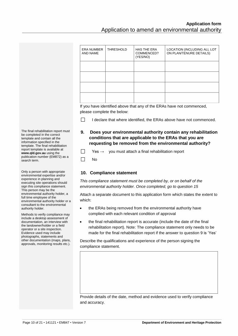
Provide a list of all the ERAs that are to be removed from the environmental authority and identify whether the ERA has commenced.
8. Is this application to remove an ERA from your
environmental authority?
No → go to question 15
Yes → indicate which ERAs are to be removed, then go to question 99
Application form
Application to amend an environmental authority
Page 10 of 21 • 141121 • EM847 • Version 7 Department of Environment and Heritage Protection
ERA NUMBER AND NAME
THRESHOLD HAS THE ERA COMMENCED? (YES/NO)
LOCATION (INCLUDING ALL LOT ON PLAN/TENURE DETAILS)
If you have identified above that any of the ERAs have not commenced,
please complete the below:
I declare that where identified, the ERAs above have not commenced.
The final rehabilitation report must be completed in the correct template and contain all the information specified in the template. The final rehabilitation report template is available at www.qld.gov.au using the publication number (EM872) as a search term.
9. Does your environmental authority contain any rehabilitation
conditions that are applicable to the ERAs that you are
requesting be removed from the environmental authority?
Yes → you must attach a final rehabilitation report
No
Only a person with appropriate environmental expertise and/or experience in planning and executing site operations should sign this compliance statement. This person may be the environmental authority holder, a full time employee of the environmental authority holder or a consultant to the environmental authority holder.
Methods to verify compliance may include a desktop assessment of documentation, an interview with the landowner/holder or a field operator or a site inspection. Evidence used may include photographs, statements and other documentation (maps, plans, approvals, monitoring results etc.).
10. Compliance statement
This compliance statement must be completed by, or on behalf of the
environmental authority holder. Once completed, go to question 15
Attach a separate document to this application form which states the extent to
which:
the ERAs being removed from the environmental authority have
complied with each relevant condition of approval
the final rehabilitation report is accurate (include the date of the final
rehabilitation report). Note: The compliance statement only needs to be
made for the final rehabilitation report if the answer to question 9 is ‘Yes’
Describe the qualifications and experience of the person signing the
compliance statement.
Provide details of the date, method and evidence used to verify compliance
and accuracy.
Application form
Application to amend an environmental authority
Page 11 of 21 • 141121 • EM847 • Version 7 Department of Environment and Heritage Protection
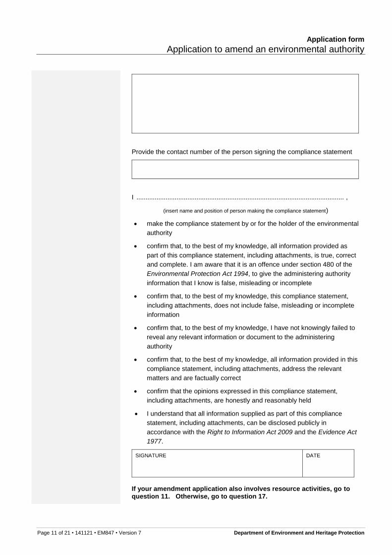
Provide the contact number of the person signing the compliance statement
I .................................................................................................................. ,
(insert name and position of person making the compliance statement)
make the compliance statement by or for the holder of the environmental
authority
confirm that, to the best of my knowledge, all information provided as
part of this compliance statement, including attachments, is true, correct
and complete. I am aware that it is an offence under section 480 of the
Environmental Protection Act 1994, to give the administering authority
information that I know is false, misleading or incomplete
confirm that, to the best of my knowledge, this compliance statement,
including attachments, does not include false, misleading or incomplete
information
confirm that, to the best of my knowledge, I have not knowingly failed to
reveal any relevant information or document to the administering
authority
confirm that, to the best of my knowledge, all information provided in this
compliance statement, including attachments, address the relevant
matters and are factually correct
confirm that the opinions expressed in this compliance statement,
including attachments, are honestly and reasonably held
I understand that all information supplied as part of this compliance
statement, including attachments, can be disclosed publicly in
accordance with the Right to Information Act 2009 and the Evidence Act
1977.
SIGNATURE DATE
If your amendment application also involves resource activities, go to question 11. Otherwise, go to question 17.
Application form
Application to amend an environmental authority
Page 12 of 21 • 141121 • EM847 • Version 7 Department of Environment and Heritage Protection
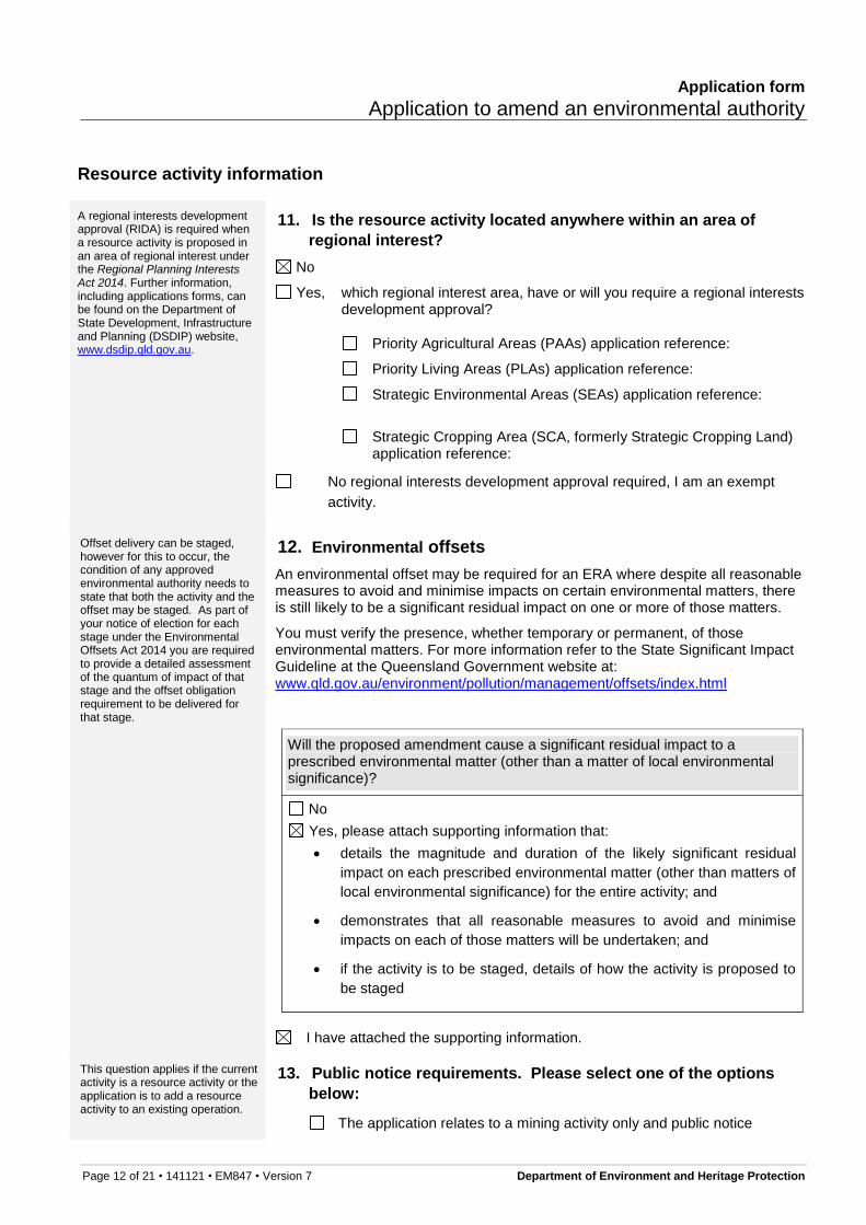
Resource activity information
A regional interests development approval (RIDA) is required when a resource activity is proposed in an area of regional interest under the Regional Planning Interests Act 2014. Further information, including applications forms, can be found on the Department of State Development, Infrastructure and Planning (DSDIP) website, www.dsdip.qld.gov.au.
11. Is the resource activity located anywhere within an area of
regional interest?
No
Yes, which regional interest area, have or will you require a regional interests development approval?
Priority Agricultural Areas (PAAs) application reference:
Priority Living Areas (PLAs) application reference:
Strategic Environmental Areas (SEAs) application reference:
Strategic Cropping Area (SCA, formerly Strategic Cropping Land) application reference:
No regional interests development approval required, I am an exempt
activity.
Offset delivery can be staged, however for this to occur, the condition of any approved environmental authority needs to state that both the activity and the offset may be staged. As part of your notice of election for each stage under the Environmental Offsets Act 2014 you are required to provide a detailed assessment of the quantum of impact of that stage and the offset obligation requirement to be delivered for that stage.
12. Environmental offsets
An environmental offset may be required for an ERA where despite all reasonable measures to avoid and minimise impacts on certain environmental matters, there is still likely to be a significant residual impact on one or more of those matters.
You must verify the presence, whether temporary or permanent, of those environmental matters. For more information refer to the State Significant Impact Guideline at the Queensland Government website at: www.qld.gov.au/environment/pollution/management/offsets/index.html
Will the proposed amendment cause a significant residual impact to a prescribed environmental matter (other than a matter of local environmental significance)?
No
Yes, please attach supporting information that:
details the magnitude and duration of the likely significant residual
impact on each prescribed environmental matter (other than matters of
local environmental significance) for the entire activity; and
demonstrates that all reasonable measures to avoid and minimise
impacts on each of those matters will be undertaken; and
if the activity is to be staged, details of how the activity is proposed to
be staged
I have attached the supporting information.
This question applies if the current activity is a resource activity or the application is to add a resource activity to an existing operation.
13. Public notice requirements. Please select one of the options
below:
The application relates to a mining activity only and public notice
Application form
Application to amend an environmental authority
Page 13 of 21 • 141121 • EM847 • Version 7 Department of Environment and Heritage Protection
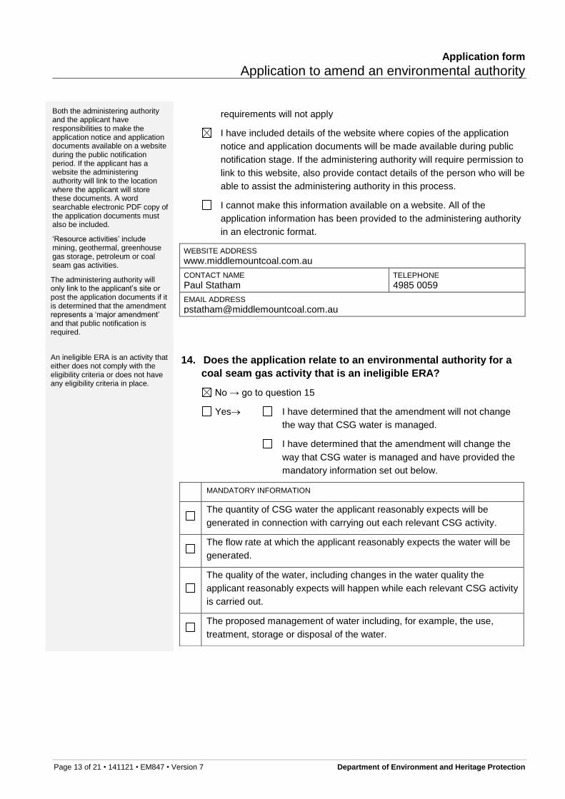
Both the administering authority and the applicant have responsibilities to make the application notice and application documents available on a website during the public notification period. If the applicant has a website the administering authority will link to the location where the applicant will store these documents. A word searchable electronic PDF copy of the application documents must also be included.
‘Resource activities’ include mining, geothermal, greenhouse gas storage, petroleum or coal seam gas activities.
The administering authority will only link to the applicant’s site or post the application documents if it is determined that the amendment represents a ‘major amendment’ and that public notification is required.
requirements will not apply
I have included details of the website where copies of the application
notice and application documents will be made available during public
notification stage. If the administering authority will require permission to
link to this website, also provide contact details of the person who will be
able to assist the administering authority in this process.
I cannot make this information available on a website. All of the
application information has been provided to the administering authority
in an electronic format.
WEBSITE ADDRESS
www.middlemountcoal.com.au
CONTACT NAME
Paul Statham TELEPHONE
4985 0059
EMAIL ADDRESS
An ineligible ERA is an activity that either does not comply with the eligibility criteria or does not have any eligibility criteria in place.
14. Does the application relate to an environmental authority for a
coal seam gas activity that is an ineligible ERA?
No → go to question 15
Yes I have determined that the amendment will not change
the way that CSG water is managed.
I have determined that the amendment will change the
way that CSG water is managed and have provided the
mandatory information set out below.
MANDATORY INFORMATION
The quantity of CSG water the applicant reasonably expects will be
generated in connection with carrying out each relevant CSG activity.
The flow rate at which the applicant reasonably expects the water will be
generated.
The quality of the water, including changes in the water quality the
applicant reasonably expects will happen while each relevant CSG activity
is carried out.
The proposed management of water including, for example, the use,
treatment, storage or disposal of the water.
Application form
Application to amend an environmental authority
Page 14 of 21 • 141121 • EM847 • Version 7 Department of Environment and Heritage Protection
The measurable criteria (‘management criteria’) against which the
applicant will monitor and assess the effectiveness of the management of
the water, including, for example, criteria for each of the following:
(i) the quantity and quality of the water used, treated, stored or disposed
of
(ii) protection of the environmental values affected by each relevant CSG
activity
(iii) the disposal of waste, including, for example, salt, generated for the
management of the water.
The action proposed to be taken if any of the management criteria are not
complied with, to ensure that the criteria will be able to be complied with in
the future.
If the application includes a CSG evaporation dam, an evaluation of the
following must be provided:
(i) best practice environmental management for managing CSG water
(ii) alternative ways for managing CSG water
(iii) whether there is a feasible alternative to a CSG evaporation dam for
managing the water. Note if the evaluation shows that there is a
feasible alternative option, the CSG evaporation dam cannot form part
of the water management for this amendment application.
General ERA information
Completion of an EIS process is defined in section 60 of the EP Act.
15. Has an environmental impact statement (EIS) process that
includes the proposed amendment, been completed?
No
Yes → I have assessed the environmental risks of the proposed
amendment and consider them to be the same as was
assessed in the EIS. A copy of the assessment is
attached. Go to question 18
I have assessed the environmental risks of the proposed
amendment and consider them to be different to what
was assessed in the EIS. Go to question 16
The information provided here will assist the administering authority in deciding whether an EIS is required.
For further information refer to the guideline: Triggers for Environmental Impact Statements under the Environmental Protection Act 1994 for mining, petroleum and gas activities. This
16. EIS triggers
Questions Select Give details or attach documentation to support your answer

Application form
Application to amend an environmental authority
Page 15 of 21 • 141121 • EM847 • Version 7 Department of Environment and Heritage Protection
guideline is available at www.qld.gov.au, using the search term ‘triggers for environmental impact statements’.
Only answer this question if the current
ERA project is for an existing mine
extracting between 2–10 million tonnes
per year of run of mine (ROM) ore or
coal.
Is the proposed ERA amendment for an
increase in the annual extraction of more
than 100% or 5 million tonnes per year
(whichever is the lesser)?
YES
NO
N/A
No change to the
mining rate is
proposed.
Only answer this question if the current
ERA project is for an existing mine
extracting over 10 million tonnes per year
of ROM ore or coal.
Is the proposed ERA amendment for an
increase in annual extraction of more
than 10% or 10 million tonnes per year
(whichever is the lesser)?
YES
NO
N/A
Only answer this question if the current
ERA project is for an existing mine
extracting over 20 million tonnes per year
of ROM ore or coal extraction.
Is the proposed ERA amendment for an
increase in annual extraction of greater
than 25%?
YES
NO
N/A
Is the proposed ERA amendment for a
mining activity that will extend into a
Category A or B environmentally
sensitive area, unless previously
authorised by the state?
YES
NO
N/A
The Project will not
extend into a Category
A or B environmentally
sensitive area.
Is the proposed ERA amendment for a
mining activity that would involve a
substantial change in mining operations?
For example: from underground to open
cut, or (for underground mining) a
change in operations that currently
causes little subsidence but with the
proposed ERA amendment, is likely to
cause substantial subsidence?
YES
NO
N/A
No substantial change
to the mining
operations is
proposed.

Application form
Application to amend an environmental authority
Page 16 of 21 • 141121 • EM847 • Version 7 Department of Environment and Heritage Protection
Is the proposed ERA amendment for a
mining activity and a novel or unproven
resource extraction process, technology
or activity, is being proposed?
YES
NO
N/A
The amendment does
not relate to a novel or
unproven resource
extraction process,
technology or activity.
Is the proposed ERA amendment for a
petroleum and gas activity that is likely to
have a total disturbance area of greater
than 2000 hectares at any 1 time during
the life of the proposed project? This
includes areas occupied by well pads
(single or multi-directional), access
tracks and roads, water storages, and
process plants
YES
NO
N/A
The amendment does
not relate to a
petroleum or gas
activity.
Is the proposed ERA amendment for a
petroleum and gas activity that is likely to
involve the construction of a high
pressure pipeline over a distance of 300
kilometres or greater?
YES
NO
N/A
The amendment does
not relate to a
petroleum or gas
activity.
Is the proposed ERA amendment for a
petroleum and gas activity that is likely to
involve the construction of a liquefied
natural gas plant?
YES
NO
N/A
The amendment does
not relate to a
petroleum or gas
activity.
The administering authority may decide that an EIS is required for the amendment application (refer to section 142 of the EP Act).
Public notification may also be applicable to the amendment if the application is for a resource activity and the proposed amendment is considered to be a ‘major amendment’ (as defined in section 223 of the EP Act).
17. Assessment of the environmental impact and provision of
specific supporting information
You must provide an assessment of the likely impact of the proposed
amendment on the environmental values, including the following mandatory
information in the table below, unless the not applicable check box is ticked.
Only tick the ‘Not Applicable’ check box if the proposed amendment does not
cause a change to the environmental values, aspects and impacts as
approved under the current environmental authority.
Where the ‘Not Applicable’ option is selected, sufficient information must be
provided to support this determination, as the determination forms part of the
required assessment.
MANDATORY INFORMATION
A description of the environmental values likely to be
affected by the proposed amendment
Provided
N/A
Details of any emissions or releases likely to be Provided
Application form
Application to amend an environmental authority
Page 17 of 21 • 141121 • EM847 • Version 7 Department of Environment and Heritage Protection
generated by the proposed amendment N/A
A description of the risk and likely magnitude of
impacts on the environmental values
Provided
N/A
Details of the management practices proposed to be
implemented to prevent or minimise adverse impacts
Provided
N/A
Details of how the land the subject of the application
will be rehabilitated after each relevant activity
ceases.
Provided
N/A
To provide a response to the mandatory information, specific supporting
information must be provided to the administering authority, the type and
detail of which will depend on your particular ERA project. Support material for
technical information requirements, is located on the business and industry
website www.business.qld.gov.au.
You must include a description of the proposed measures for minimising and managing waste generated by the proposed amendments.
For further information on technical information to provide with your application, please refer to the business and industry website www.business.qld.gov.au
:
18. Provide details of the proposed measures for minimising and
managing waste generated by any amendments to the
relevant activity.
WASTE MANAGEMENT DETAILS. IF WASTE IS TO BE MANAGED ACCORDING TO AN EXISTING WASTE MANAGEMENT PLAN, PROVIDE THE RELEVANT PAGE OR SECTION NUMBERS.
Detailed information on waste management is provided in Section 3.4 of the
attached Section 226 Consideration Report.
19. Is this land currently subject to an environmental protection
order or a site management plan?
No
Yes → I have an environmental protection order in place and
the details are provided below.
I have a site management plan in place and the
details are provided below.

Application form
Application to amend an environmental authority
Page 18 of 21 • 141121 • EM847 • Version 7 Department of Environment and Heritage Protection
PROVIDE THE REFERENCE NUMBER AND BRIEF DETAILS
20. Is any part of the land currently recorded in, or previously
been recorded in, the environmental management register?
No
Yes, complete the below table and provide the additional details
PLEASE TICK
RELEVANT BOXES YES NO
ADDITIONAL DETAILS
Has the land been
removed from the
environmental
management
register?
If yes is ticked, you must attach
evidence (e.g. a notice) advising
that details have been removed
from the environmental
management register
The first step towards payment is to calculate the fees payable. Information on these fees can be located in the information sheets “Fees for permits for environmentally relevant activities (ERAs)” (EM33) and “Summary of annual fees for environmentally relevant activities (ERAs)” (EM389), available at www.qld.gov.au. Use the document number (e.g. EM33) as a search term.
To pay by credit card you will need to provide contact details so you can be contacted for your credit card payment to be made over the phone.
A condition conversion is a minor amendment. For other amendments the decision of whether the amendment is ‘major’ or ‘minor’ is made by the administering authority. However, you are required to pay either the ‘minor’ or the ‘major’ fee you think
21. Payment of fees
Application fee: $ 285.60
You may pay your fee via cheque, money order or credit card.
Select the payment method below:
Payment by cheque or money order made payable to the
Department of Environment and Heritage Protection
(attached).
Payment by cheque or money order made payable to the
Department of Agriculture, Fisheries and Forestry
(attached).
Please contact me (the applicant) for credit card payment:
Phone number: 49850059


Application form
Application to amend an environmental authority
Page 21 of 21 • 141121 • EM847 • Version 7 Department of Environment and Heritage Protection
Further information
The latest version of this publication and other publications referenced in this document can be found at www.qld.gov.au using the relevant publication number (EM847 for this form) as a search term.
Please submit your completed application to:
For a mining ERA where the proposed amendment impacts upon the
resource tenure:
Mining Registrar
Department of Natural Resources and Mines
DNRM have a list of office locations for mining registrars on their website
www.dnrm.qld.gov.au
For ERA 2, ERA 3 or ERA 4
Post: Senior Environmental Scientist Animal Industries Department of Agriculture, Fisheries and Forestry PO Box 102 TOOWOOMBA QLD 4350
Enquiries: Phone: (07) 4688 1374 Fax: (07) 4688 1192 Email: [email protected]
For all other ERAs
Post: Permit and Licence Management Department of Environment and Heritage Protection GPO Box 2454 BRISBANE QLD 4001
Courier or hand delivery: Permit and Licence Management Department of Environment and Heritage Protection Level 3, 400 George Street BRISBANE QLD 4000 Business hours: 8:30am–4:30pm
Enquiries: Website: www.business.qld.gov.au Email: [email protected] Phone: 13 QGOV (13 74 68)

MIDDLEMOUNT COAL NORTH-EASTERN EXTENSION
SECTION 226 CONSIDERATION REPORT
JUNE 2015

MIDDLEMOUNT - NORTH-EASTERN EXTENSION SECTION 226 CONSIDERATION REPORT
JUNE - 2015 Project No. GCL-12-21
Document No. 00684635

North-eastern Extension – Section 226 Consideration Report
i
TABLE OF CONTENTS
1 INTRODUCTION 1
1.1 PURPOSE AND STRUCTURE OF THIS DOCUMENT 1
1.2 BACKGROUND 3
1.3 PROJECT OVERVIEW 3
1.4 PROPONENT 3
2 LOCATION AND MINING TENEMENTS 4
3 PROJECT DESCRIPTION 4
3.1 DUMP CONSTRUCTION 4
3.2 WATER MANAGEMENT 5
3.3 REHABILITATION AND POST MINING LAND USE 5
3.4 WASTE MANAGEMENT 5
4 ENVIRONMENTAL VALUES 6
4.1 LAND 6
4.2 WATER 6
4.3 BIODIVERSITY 8
4.4 CLIMATE – AIR AND NOISE 10
4.5 CULTURAL HERITAGE 11
5 PLANNING CONSIDERATIONS 12
5.1 ENVIRONMENTAL PROTECTION ACT 1994 12
5.2 ENVIRONMENTAL IMPACT STATEMENT TRIGGERS 12
5.3 MINERAL RESOURCES ACT 1989 15
5.4 STATUATORY APPROVALS 15
6 SCOPE OF ENVIRONMENTAL ASSESSMENT 18
6.1 PRELIMINARY RISK ASSESSMENT 18
6.2 AIR QUALITY 18
6.3 NOISE 20
6.4 WATER 21
6.5 BIODIVERSITY 22
7 STAKEHOLDER ENGAGEMENT 23
8 REFERENCES 23

North-eastern Extension – Section 226 Consideration Report
TABLE OF CONTENTS (continued)
ii
LIST OF TABLES
Table 1 Threatened Species with the Potential to Occur within the Project Area
Table 2 EP Act Section 226 – Requirements for Amendment Application Generally
Table 3 EP Act Section 223 – Minor Amendment Criteria
Table 4 Mining Projects – Triggers for Brownfield Sites (Amendment Applications)
Table 5 Principal Statutory Approvals
Table 6 Air Quality Objectives Relevant to the Project
Table 7 Acoustic Quality Objectives Relevant to the Project
LIST OF FIGURES
Figure 1 General Arrangement
Figure 2 Regional Ecosystem Mapping

North-eastern Extension – Section 226 Consideration Report
1
1 INTRODUCTION
1.1 PURPOSE AND STRUCTURE OF THIS DOCUMENT
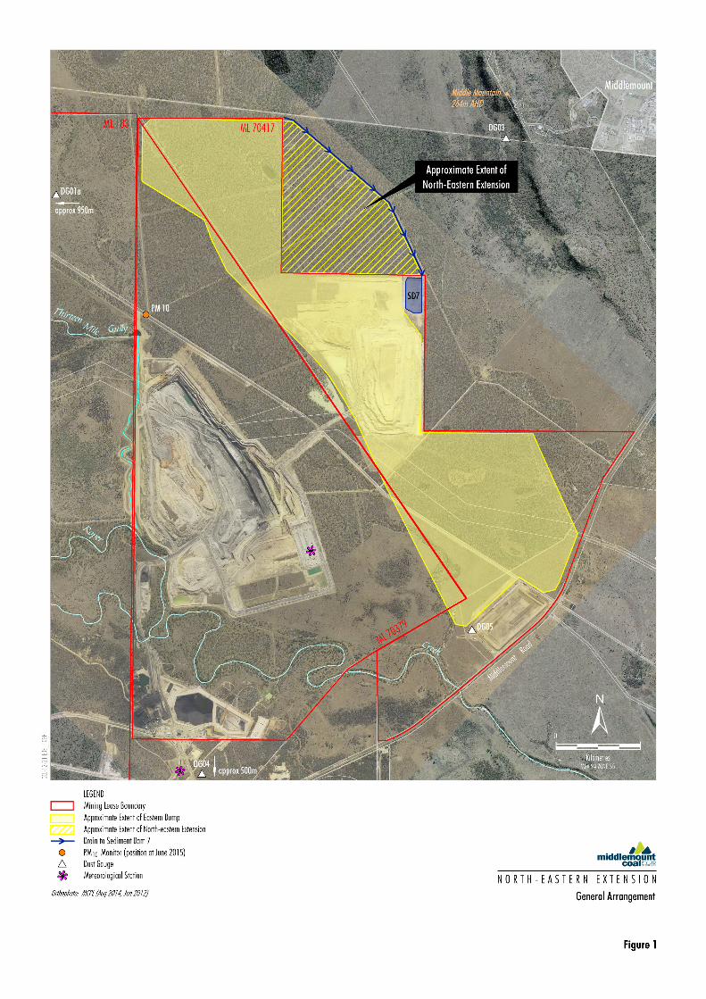
Middlemount Coal Pty Ltd (MCPL) requests an amendment of the Middlemount Coal Mine
Environmental Authority (EA) (EPML00716913) in accordance with Section 224 of the Environmental
Protection Act 1994 (EP Act) to authorise the North-eastern Extension (the Project), an extension to
the eastern out-of-pit overburden dump (the “East Dump”) within Prospecting Permit (PP) 74264
(Figure 1). The EA amendment application has been prepared to accompany an application for a
Mining Lease for infrastructure for the Project area under the Mineral Resources Act 1989 (MR Act).
This document has been prepared to accompany an EA amendment application in consideration of
Section 226 of the EP Act. This document provides a description of the Project, potential impacts on
identified environmental values and further environmental assessments that will be conducted by
MCPL during the second half of 2015.
It is anticipated that the Department of Environment and Heritage Protection (DEHP) will use the
information presented in this document to:
make an assessment level decision in accordance with Section 228 of the EP Act;
decide whether an Environmental Impact Statement (EIS) is required for the Project under
Section 143 of the EP Act; and
if necessary, prepare an Information Request in accordance with Section 140 of the EP Act to
request further information required to assess the EA amendment application.
The remainder of this document is structured as follows:
Section 1 Introduction – provides a background to the Middlemount Coal Mine and an overview and
justification of the proposed Project.
Section 2 Location and Mining Tenements – describes the location of the Middlemount Coal Mine
and relevant mining tenements.
Section 3 Project Description – provides a description of the Project.
Section 4 Environmental Values – identifies the environmental values relevant to the Project.
Section 5 Planning Considerations – describes the applicable statutory planning instruments and
identifies where the requirements of Section 226 of the EP Act are addressed.
Section 6 Scope of Environmental Assessments – identifies key environmental risks of relevance to
the Project, provides an analysis of the likely nature and extent of potential impacts, and
identifies the scope of environmental assessments to be conducted by MCPL for the
Project.
Section 7 Stakeholder Engagement – outlines consultation already undertaken and proposed to be
carried out for the Project.
Section 8 References – Lists documents referenced in Sections 1 to 7.

North-eastern Extension – Section 226 Consideration Report
3
1.2 BACKGROUND
Middlemount Coal Pty Ltd (MCPL) owns and operates the Middlemount Coal Mine, an existing open
cut coal mine located approximately 7 kilometres (km) to the south-west of the Middlemount township
(Figure 1) within the Isaac Regional Local Government Area.
The Middlemount Coal Mine EA was amended on 29 June 2012 to approve the expansion of open cut
mining operations within Mining Leases (ML) 70379 and 70417 (referred to as “Stage 2” of the
Middlemount Coal Mine). The EA was most recently amended on 24 October 2014.
Stage 2 allows for open cut mining of run-of-mine (ROM) coal up to 24 hours per day, seven days per
week, using a conventional truck and shovel fleet at a rate of up to 5.4 million tonnes per annum
(Mtpa). ROM coal is mined in a general west to east direction within ML 70379, with overburden and
interburden material emplaced in-pit behind the advancing open cut operations, and within the East
Dump, located within ML 70417.
ROM coal is processed through a coal handling and preparation plant to produce approximately
4.1 Mtpa of PCI and coking coal for the export market. Product coal is transported by rail to the
Dalrymple Bay Coal Terminal and Abbot Point Port.
1.3 PROJECT OVERVIEW MCPL has identified an opportunity to improve the mining efficiency and rehabilitation outcomes by
extending the East Dump beyond part of the eastern extent of ML 70417 (Figure 1). The extension
will alleviate the “saw tooth” layout of the currently approved dump design which will in-turn improve
the efficiency of the mine plan and reduce the area of the dump slope that requires rehabilitation.
The existing dump design would reduce the length of the external dump slope by approximately 10%.
The rehabilitation of dump slopes (or batters) is typically the most difficult component of dump
rehabilitation. Decreasing the area of slope that is required to be rehabilitated would decrease
rehabilitation costs.
A more uniform dump design (i.e. by removing part of the “saw tooth” configuration) will also improve
mining efficiency and the overall viability of the Middlemount Coal Mine.
The Project does not involve any change to the currently approved mining rate, open cut pit footprint,
processing rate or workforce. A detailed description of the Project is provided in Section 3.
1.4 PROPONENT MCPL is the proponent for the Project. MCPL is an incorporated joint venture between Peabody
Energy Australia Pty Ltd and Yancoal Australia Ltd.
The registered address for the proponent is:
Middlemount Coal Pty Ltd
Level 1, 100 Melbourne Street
SOUTH BRISBANE QLD 4001

North-eastern Extension – Section 226 Consideration Report
4
2 LOCATION AND MINING TENEMENTS The Project is located immediately adjacent to the Middlemount Coal Mine, on freehold land owned by
MCPL (Lot 3 SP210524), within PP 74264. The land within the Project footprint is currently used for
low intensity cattle grazing under an agistment agreement.
Middlemount township is located approximately 2.4 km to the east of the Project, at its nearest point
(Figure 1). Middlemount was established as a mining town in the 1980s and is primarily supported by
the surrounding mining operations to this day. The Project and the town are separated by Middle
Mountain which rises approximately 100 metres (m) above the surrounding landscape (to a height of
approximately 260 m Australian Height Datum [AHD]).
Concurrent with the EA amendment application, MCPL is applying for a Mining Lease across the
Project footprint.
3 PROJECT DESCRIPTION
The Project would be developed using the existing mining fleet and existing workforce.
3.1 DUMP CONSTRUCTION
The Project would involve the extension of the currently approved East Dump using the same
overburden emplacement methodology described in the Middlemount Coal Mine Plan of Operations.
Prior to overburden placement, the Project area would be progressively cleared and topsoil would be
stripped and stockpiled for use in rehabilitation works. Where topsoil cannot be directly used for
progressive rehabilitation it would be stockpiled for use at a later date.
Overburden would be transported from the open cut to the East Dump using the mines overburden
haul fleet. Overburden emplacement would commence in the south-western corner of the Project
area and progress in a north-easterly direction. The East Dump extension would be constructed to the
same height as the currently approved East Dump, i.e. up to 64 m above existing ground level.
Geochemical testwork has found that there is a low to negligible risk of acid mine drainage from
overburden at the Middlemount Coal Mine. Notwithstanding, laboratory characterisation of
overburden material during operations would be conducted to confirm acid generation potential,
consistent with existing operations. Any material that is found to be potentially acid forming will not be
used as capping material and will be buried within the overburden dump with material that has a
positive acid neutralising capacity (MCPL, 2011).
Consistent with existing operations, coarse reject material would only be placed within in-pit waste
rock dumps.
Overburden at the Middlemount Coal Mine has been found to be susceptible to dispersion and is
erosion prone. Consistent with existing operations, testing of overburden would be conducted to
identify material with a high susceptibility for dispersion and slaking. Less dispersive material would
be used as capping material.
North-eastern Extension – Section 226 Consideration Report
5
3.2 WATER MANAGEMENT The Project would be designed and operated in accordance with the Middlemount Coal Mine Water
Management Plan (WRM, 2014) and the Erosion and Sediment Control Plan (WRM, 2012).
Consistent with the site’s existing water management strategy, runoff from undisturbed areas would be
diverted around mining activities.
Runoff from the East Dump extension would be directed to sediment dams using a drain along the
eastern extent of the emplacement (Figure 1). Sediment Dam 7 (approved as part of the Stage 2
Project) would be utilised to accommodate runoff from the expanded dump area. Water captured in
Sediment Dam 7 would be transferred within the site water management system for use in dust
suppression or managed in accordance with the site’s Erosion and Sediment Control Plan (WRM,
2012).
Overburden dumps would be rehabilitated to control drainage, including the use of rock lined drains to
reduce sediment load where required, in accordance with the Water Management Plan (WRM, 2014).
3.3 REHABILITATION AND POST MINING LAND USE
Rehabilitation of the East Dump extension would be conducted in accordance with the Middlemount
Coal Mine Rehabilitation Management Plan (MCPL 2012, and associated 2014 addendum).
The East Dump extension would be rehabilitated consistent with the existing rehabilitation landform
design criteria and post mining landuse in the EA, and in accordance with the existing Rehabilitation
Management Plan.
Consistent with EA Condition F31, the East Dump extension would be rehabilitated to a stable
landform with a self-sustaining vegetation cover. The slopes of the East Dump will be rock mulched
and will be less than 18.5 degrees (1V:3H slopes). The top surface of the East Dump will have slope
angle of less than 2%, will be fully covered with topsoil and will minimise the potential for long term
ponding of water.
3.4 WASTE MANAGEMENT
General waste minimisation principles would be applied at the Project in accordance with the Waste
Reduction and Recycling Act 2011 waste management hierarchy to minimise the quantity of wastes
that require off-site disposal.
In accordance with the Environmental Protection Regulation 2000, MCPL would maintain a waste
inventory and monitor all trackable wastes.

North-eastern Extension – Section 226 Consideration Report
6
4 ENVIRONMENTAL VALUES
Environmental values are the qualities (e.g. aesthetic, social and cultural values) or physical
characteristics of the environment that are conducive to ecological health, public amenity or safety.
Sections 4.1 to 4.5 describe the environmental values relevant to the Project.
4.1 LAND
As described in Section 2, the Project is located on freehold land owned by MCPL which is currently
used for low intensity cattle grazing under and agistment agreement. The natural topography is
relatively flat, with an elevation typically ranging from approximately 160 to 170 m AHD.
Approximately 1.5 km to the east of the Project Middle Mountain rises to an elevation of 260 m AHD.
The land within the Project area is considered to be agricultural land “Class C”, which represents
pasture land (i.e. land that is suitable only for improved or native pastures due to limitations which
preclude continuous cultivation for crop production) (MCPL, 2011). No Strategic Cropping Land is
mapped within, or in the vicinity of the Project (Department of Natural Resources and Mines [DNRM],
2014a).
Lot 3 on SP210524, within which the Project is located, is listed on the Environmental Management
Register as having livestock dips and mine wastes, however an inspection of the land and DEHP
records did not identify any potentially contaminated sites such as livestock dips or rubbish dumps.
The Bingegang Pipeline, a water supply pipeline between the Bingegang Weir and the town of Dysart
and nearby mining operations, is being realigned around the Middlemount Coal Mine. The realigned
pipeline will be located to the east of the proposed East Dump extension.
The environmental values relevant to land were identified using the DEHP Guideline Application
Requirements for Activities with Impacts to Land. The following environmental values for land
relevant to the Project have been identified:
The existing land uses of low intensity cattle grazing on unimproved pasture, remnant and
regrowth vegetation and mining and petroleum exploration activities.
The intrinsic soil health, function and suitability (i.e. the ability for the soil to sustain growth of
native vegetation and grasses for cattle grazing).
The natural interaction of the land with other ecosystems.
The cultural and spiritual values of the land.
The qualities of the land that are conducive to human health and well being.
The qualities of the land that are conducive to protecting the aesthetics of the environment.
The scope of the Project environmental assessments relevant to the environmental values for land is
described in Section 6.5.
4.2 WATER Locally, the Project is located within the Roper Creek catchment, which forms part of the Mackenzie
North-western Tributaries sub catchment, within the Mackenzie River Sub-basin of the greater Fitzroy
Basin.
North-eastern Extension – Section 226 Consideration Report
7
No watercourses or drainage lines are located within the Project area. One drainage line, an
unnamed ephemeral tributary of Roper Creek, is located approximately 500 m east of the Project. It is
poorly defined in some areas upstream of Dysart-Middlemount Road, with a channel depth of less
than 0.5 m in some locations (WRM, 2014). Flow is interrupted at two locations by farm dams and the
channel is not apparent on aerial photographs and survey about 185 m upstream of
Dysart-Middlemount Road. The drainage line reappears at Dysart-Middlemount Road where it
discharges under the road via several box culverts.
The DNRM confirmed that within ML 70417 (and therefore upstream of ML 70417), this drainage line
is not a watercourse, rather a drainage feature defined under the Water Act 2000 (Water Act) that
facilitates overland flow (DNRM, 2014b). Any flow in the drainage feature was determined to be of an
insufficient volume to sustain basic ecological processes and maintain biodiversity. Accordingly, no
watercourses are located within or adjacent to the Project area.
Water quality in the vicinity of the Middlemount Coal Mine is considered to be highly turbid, with
moderate and variable electrical conductivity, low nutrient levels and low dissolved oxygen levels at
times. The concentrations of some metals are also elevated above the water quality objectives for the
area (WRM, 2014).
Water quality monitoring of the site sediment dams has shown that runoff from waste rock
emplacements is generally consistent with the EPP Water water quality objectives with the following
characteristics:
fresh to brackish, with a median electrical conductivity of 600 µS/cm;
has moderate sulfate levels with a median of 24 mg/L;
is moderately alkaline with a pH ranging from 8.1 to 9.2; and
has metal concentrations generally below the default water quality objective trigger levels.
Groundwater aquifers in the vicinity of the Project are present in three general geological units, namely
the Alluvium (generally <5 m thick), the Tertiary unit and the coal measures. Shallow groundwater
flow and recharge is expected to be limited by significant clay deposits within the Alluvium and Tertiary
units, however sand layers are likely to contain local aquifers, with groundwater considered to be
brackish to saline. Similarly, groundwater within the Permian strata is brackish to saline (MCPL,
2011).
Groundwater use in the vicinity of the Project is limited, with the closest landholder bores located to
the north of Middlemount township. Groundwater is considered to be of limited use, with low yields
and relatively high salinity reported in nearby registered groundwater bores. Similarly, a census of
nearby landholder bores, the closest being approximately 4 km from the open cut mining extent,
generally found that groundwater is used on rare occasions for stock watering. The groundwater level
in registered and census bores was found to be approximately 15 to 40 m below ground level (MCPL,
2011).
The Environmental Protection (Water) Policy, 2009 (EPP [Water]) lists the environmental values and
the water quality objectives to enhance or protect the environmental values. As described in the EPP
(Water), environmental values of a water resource are particular values or uses of the water that are
conducive to a healthy ecosystem or for public amenity, safety or health and that require protection
from the effects of habitat alteration, waste releases, contaminated runoff and changed flows.

North-eastern Extension – Section 226 Consideration Report
8
Schedule 1 of the EPP (Water) describes that the environmental values for the Mackenzie River sub-
basin are presented in the Mackenzie River Sub-basin Environmental Values and Water Quality
Objectives (DEHP, 2011). The following environmental values for surface water relevant to the Project
have been identified:
The intrinsic value of aquatic ecosystems, habitat and wildlife.
The suitability of water supply for production of healthy livestock.
Visual amenity of waterways.
Cultural and spiritual values.
The Project lies within the “Mackenzie Groundwaters” zone. The following environmental values for
groundwater relevant to the Project have been identified:
Aquatic ecosystems.
Farm supply/use.
Stock water.
Cultural and spiritual values.
As no irrigation, recreation or industrial activities rely on groundwater in the vicinity of the Project,
these values are not considered relevant. Similarly, there is no reliance on groundwater in the vicinity
of the Project for drinking water, and as such, this is not considered a relevant environmental value.
The scope of the environmental assessments relevant to the environmental values for water is
described in Section 6.4.
4.3 BIODIVERSITY
The Project is located within the Brigalow Belt North Bioregion, in the Isaac-Comet Downs subregion
(Naturecall, 2014). The Brigalow Belt North Bioregion covers an area of approximately 59,824 km2
(Thackway & Cresswell, 1995) and has been largely cleared for dryland farming, grazing and mining,
with remaining vegetation being highly fragmented and primarily limited to linear strips and isolated
remnants (Naturecall, 2014).
The Project area and surrounds is generally comprised of remnant and regrowth dry eucalypt
woodland and acacia dominated open forest, woodlands and shrubland, according to the Queensland
Herbarium’s Broad Vegetation Group mapping.
The Queensland Herbarium’s regional ecosystem (RE) mapping shows that only one vegetation type
is present within the Project area, namely RE 11.5.3 Eucalyptus populnea and/or E. melanophloia
and/or Corymbia clarksoniana on Cainozoic sand plains/remnant surfaces (Figure 2). Under the
Nature Conservation Act 1992, RE 11.5.3 has a “least concern” VM Act class and a “no concern at
present” biodiversity status.
The Queensland Herbarium has not mapped any endangered or of concern REs mapped within, or in
the immediate vicinity of, the Project area (Figure 2). A search of the Environmentally Sensitive Areas
mapping tool does not show any Category A or B Environmentally Sensitive Areas within the Project
area.
A patch of endangered RE, namely RE 11.4.8 and 11.4.9, is located approximately 500 m to the east
of the Project (Figure 2), however this endangered RE would not be disturbed by the Project. No
endangered REs would be disturbed by the Project.


North-eastern Extension – Section 226 Consideration Report
10
No wetlands are located within the Project area.
Database searches for threatened species were undertaken for the Project area, and eight threatened
species were identified as having a potential to occur within a 25 km radius (Table 1).
A number of weed species have been identified in the Project area and surrounds, including Chloris
gayana (Rhodes Grass), Urochloa mosambicensis (Sabi Grass), Heteropogon contortus (Black
Speargrass) and Cenchrus ciliaris (Buffel Grass) (NatureCall, 2014).
Table 1
Threatened Species with the Potential to Occur within the Project Area
Scientific Name Common Name Conservation Status
1
NC Act EPBC Act
Cerbera dumicola - NT -
Solanum elachophyllum - E -
Dichanthium queenslandicum King Blue-grass V E
Geophaps scripta scripta Squatter pigeon (southern species) V V
Denisonia maculate Ornamental snake V V
Cyclorana verrucosa Rough Collared Frog NT -
Paradelma orientalis Brigalow Scaly Foot V -
Phascolarctos cinereus Koala SLC V 1 Conservation status under the NC Act and EPBC Act (current as of June 2015).
NT = Near Threatened E = Endangered V = Vulnerable
NC Act = Nature Conservation Act 1992.
EPBC Act = Commonwealth Environment Protection and Biodiversity Conservation Act 1999.
The environmental values relevant to biodiversity were identified using the DEHP Guideline
Application Requirements for Activities with Impacts to Land. The following environmental values for
biodiversity relevant to the Project have been identified:
The health and biodiversity of the aquatic and terrestrial flora species and communities.
The health and condition of fauna species and their habitats.
The scope of the environmental assessments relevant to the environmental values for biodiversity is
described in Section 6.5.
4.4 CLIMATE – AIR AND NOISE
The Project area experiences a sub-humid to semi-arid climate, with annual average rainfall in the
order of 600 millimetres (mm) per year and significantly higher evaporation levels, in the order of 2,000
to 2,400 mm per year (MCPL, 2011).
Easterly to north-easterly winds prevail during spring and summer, with calmer winds from the south to
south-east being dominant during winter and autumn.
Meteorological and air quality monitoring stations have been established at the Middlemount Coal
Mine in accordance with the EA. Two continuous, real time meteorological monitoring stations monitor
wind speed, wind direction, temperature, rainfall and relative humidity (Figure 1). A portable, real time
PM10 air quality monitor and a network of four dust gauges are used to monitor air quality impacts
(Figure 1).

North-eastern Extension – Section 226 Consideration Report
11
No rural residences are located in the vicinity of the Project, with the nearest sensitive places being
within the Middlemount township, approximately 2.5 km to the east of the Project area.
The Environmental Protection (Air) Policy, 2008 (EPP [Air]) lists the environmental values and the air
quality objectives to enhance or protect the environmental values. As described in the EPP (Air),
environmental values for air have been developed to protect the health and biodiversity of
ecosystems, human health and wellbeing, aesthetics and agricultural use.
The following environmental values for air relevant to the Project have been identified:
The qualities of the air environment that are conducive to protecting the health and biodiversity of
ecosystems.
The qualities of the air environment that are conducive to human health and wellbeing.
The qualities of the air environment that are conducive to protecting the aesthetics of the
environment, including the appearance of buildings, structures and other property.
The qualities of the air environment that are conducive to protecting agricultural use of the
environment.
The Environmental Protection (Noise) Policy, 2008 (EPP [Noise]) lists the environmental values and
the acoustic quality objectives to enhance or protect the environmental values. As described in the
EPP (Noise), environmental values of the acoustic environment have been developed to protect the
health and biodiversity of ecosystems, human health and wellbeing and community amenity.
The following environmental values for the acoustic environment relevant to the Project have been
identified:
The qualities of the acoustic environment that are conducive to human health and wellbeing,
including by ensuring a suitable acoustic environment for individuals to sleep, study or learn, be
involved in recreation, including relaxation and conversation.
The qualities of the acoustic environment that are conducive to protecting the amenity of the
community.
The qualities of the acoustic environment that are conducive to protecting the health and
biodiversity of ecosystems.
The scope of the environmental assessments relevant to the environmental values for air and the
acoustic environment are described in Sections 6.2 and 6.3 respectively.
4.5 CULTURAL HERITAGE
MCPL has approved Cultural Heritage Management Plans (CHMPs) in place with the Barada Barna
People and BBKY #4 native title claimants. Management of Aboriginal cultural heritage will continue
to be conducted in accordance with the CHMPs. The CHMPs will be updated where required to
include the Project.
No items or sites of non-indigenous cultural heritage are located within the Project area.

North-eastern Extension – Section 226 Consideration Report
12
5 PLANNING CONSIDERATIONS
As described in Section 1, this document has been prepared to support an EA amendment application
in accordance with Section 226 of the EP Act.
5.1 ENVIRONMENTAL PROTECTION ACT 1994
Approval for the Project is proposed via the EA amendment provisions under Chapter 5, Part 7 of the
EP Act.
This document has been prepared to provide DEHP with a description of the Project, to identify the
environmental values relevant to the Project, and to provide a summary of the potential impacts and
mitigation measures for the Project. It is anticipated that DEHP will use the information presented in
this document to:
make an assessment level decision in accordance with Section 228 of the EP Act;
decide whether an EIS is required for the Project under Section 143 of the EP Act; and
if necessary, prepare an Information Request in accordance with Section 140 of the EP Act to
request further information needed to assess the EA amendment application.
Section 226 of the EP Act states the requirements for EA amendment applications generally. These
requirements, and how they are considered as part of the EA amendment application process are
provided in Table 2.
The information presented in this document will enable DEHP to make an assessment level decision
in accordance with Section 228 of the EP Act. Consideration of the Project against the minor
amendment requirements of Section 223 of the EP Act is presented in Table 3.
5.2 ENVIRONMENTAL IMPACT STATEMENT TRIGGERS
Section 142 of the EP Act prescribes the site-specific applications for which DEHP must require an
EIS to be completed. The Project does not trigger the EIS requirements identified in Section 142.
Section 143 of the EP Act prescribes that an EIS may be required for particular site-specific
applications for resource activities. The DEHP Guideline Triggers for Environmental Impact
Statements under the Environmental Protection Act 1994 for mining and petroleum activities lists
potential ‘EIS triggers’ for amendment applications for existing mining sites (brownfield sites) (Table 4).
Based on the assessment in Table 4, an EIS should not be required for the Project having regard to
this guideline.

North-eastern Extension – Section 226 Consideration Report
13
Table 2 EP Act Section 226 – Requirements for Amendment Application Generally
Section 226 Requirement Consideration
An amendment application must
(a) be made to the administering authority; and This report will accompany an amendment application submitted to the administering authority (DEHP).
(b) be made in the approved form; and The amendment application will be made in the approved form.
(c) be accompanied by the fee prescribed under a regulation; and
The prescribed fee will accompany the application.
(d) describe the proposed amendment; and Sections 1 and 3 describe the proposed amendment.
(e) describe the land that will be affected by the proposed amendment; and
The land affected by the Project is summarised in Section 2.
(f) describe any development permits in effect under the Planning Act for the carrying out of the relevant activity for the authority; and
Not applicable.
(g) state whether each relevant activity will, if the amendment is made, comply with any eligibility criteria for the activity; and
The Project would operate under an amended version of the existing Middlemount Coal Mine EA (site-specific EA).
(h) if the application states that each relevant activity will, if the amendment is made, comply with any eligibility criteria for the activity - include a declaration that the statement is correct; and
The Project would operate under an amended version of the existing Middlemount Coal Mine EA (site-specific EA).
(i) state whether the application seeks to change a condition identified in the authority as a standard condition; and
There are no applicable ‘standard conditions’ for the Middlemount Coal Mine EA, which is a site-specific EA. The application does not seek to change a standard condition in the EA.
(j) if the application relates to a new relevant resource tenure for the authority that is an exploration permit or GHG permit - state whether the applicant seeks an amended environmental authority that is subject to the standard conditions for the relevant activity or authority, to the extent it relates to the permit; and
The application does not relate to a new exploration permit or GHG permit.
(k) include an assessment of the likely impact of the proposed amendment on the environmental values, including -
Environmental values relevant to the Project are described in Section 4, and potential impacts to the environmental values are summarised in Section 6. Specialist studies conducted as part of the environmental assessments will further consider the potential impacts to the identified environmental values and compliance with performance based (model) mining conditions.
(i) a description of the environmental values likely to be affected by the proposed amendment; and
(ii) details of any emissions or releases likely to be generated by the proposed amendment; and
Potential emissions and releases are identified in Sections 6.2, 6.3 and 6.4. Specialist studies conducted as part of the environmental assessments will predict the emissions and releases associated with the Project to verify compliance with performance based (model) mining conditions.
(iii) a description of the risk and likely magnitude of impacts on the environmental values; and
A preliminary risk assessment has been conducted and is presented in Section 6.1 and will be reviewed as part of the environmental assessments.
(iv) details of the management practices proposed to be implemented to prevent or minimise adverse impacts; and
Potential management measures are summarised in Section 6. Specialist studies conducted as part of the environmental assessments will identify specific management measures to prevent or minimise adverse impacts associated with the Project and verify compliance with performance based (model) mining conditions.

North-eastern Extension – Section 226 Consideration Report
14
Table 2 (continued) EP Act Section 226 – Requirements for Amendment Application Generally
Section 226 Requirement Consideration
(v) details of how the land the subject of the application will be rehabilitated after each relevant activity ceases; and
A summary of rehabilitation measures is presented in Section 3.3. MCPL will update the Plan of Operations and Rehabilitation Management Plan to describe rehabilitation of the Project prior to commencement of Project operations.
(l) include a description of the proposed measures for minimising and managing waste generated by any amendments to the relevant activity; and
A summary of waste management is provided in Section 3.4.
(m) include details of any site management plan or environmental protection order that relates to the land the subject of the application; and
Not applicable.
(n) include any other document relating to the application prescribed under a regulation.
Not applicable.
Table 3
EP Act Section 223 – Minor Amendment Criteria
Minor Amendment Criteria Consideration
Minor amendment means an amendment that the administering authority is satisfied -
Not applicable for the reason identified in Table 2. No changes to standard conditions are required.
(a) is not a change to a condition identified in the authority as a standard condition; and
(d) does not significantly increase the level of environmental harm caused by the relevant activity; and
The Project is not expected to significantly increase the level of environmental harm given the nature of the receiving environment (Section 4).
(e) does not change any rehabilitation objectives stated in the authority in a way likely to result in significantly different impacts on environmental values than the impacts previously permitted under the authority; and
The Project would not require any change to the existing rehabilitation objectives described in the EA.
(f) does not significantly increase the scale or intensity of the relevant activity; and
The Project would not increase the scale or intensity of mining.
(g) does not relate to a new relevant resource tenure for the authority …; and
The application relates to a new Mining Lease Application.
(h) involves an addition to the surface area for the relevant activity of no more than 10% of the existing area; and
The Project involves an extension of the East Dump of approximately 200 ha. The area of ML 70379 and ML 70417 is approximately 2,670 ha
(g) for an environmental authority for a petroleum activity …; and
Not applicable. The EA is not for a petroleum activity.
(h) if the amendment relates to a new relevant resource tenure for the authority that is an exploration permit or GHG permit …
Not applicable. The application does not relate to a new exploration permit or GHG permit.
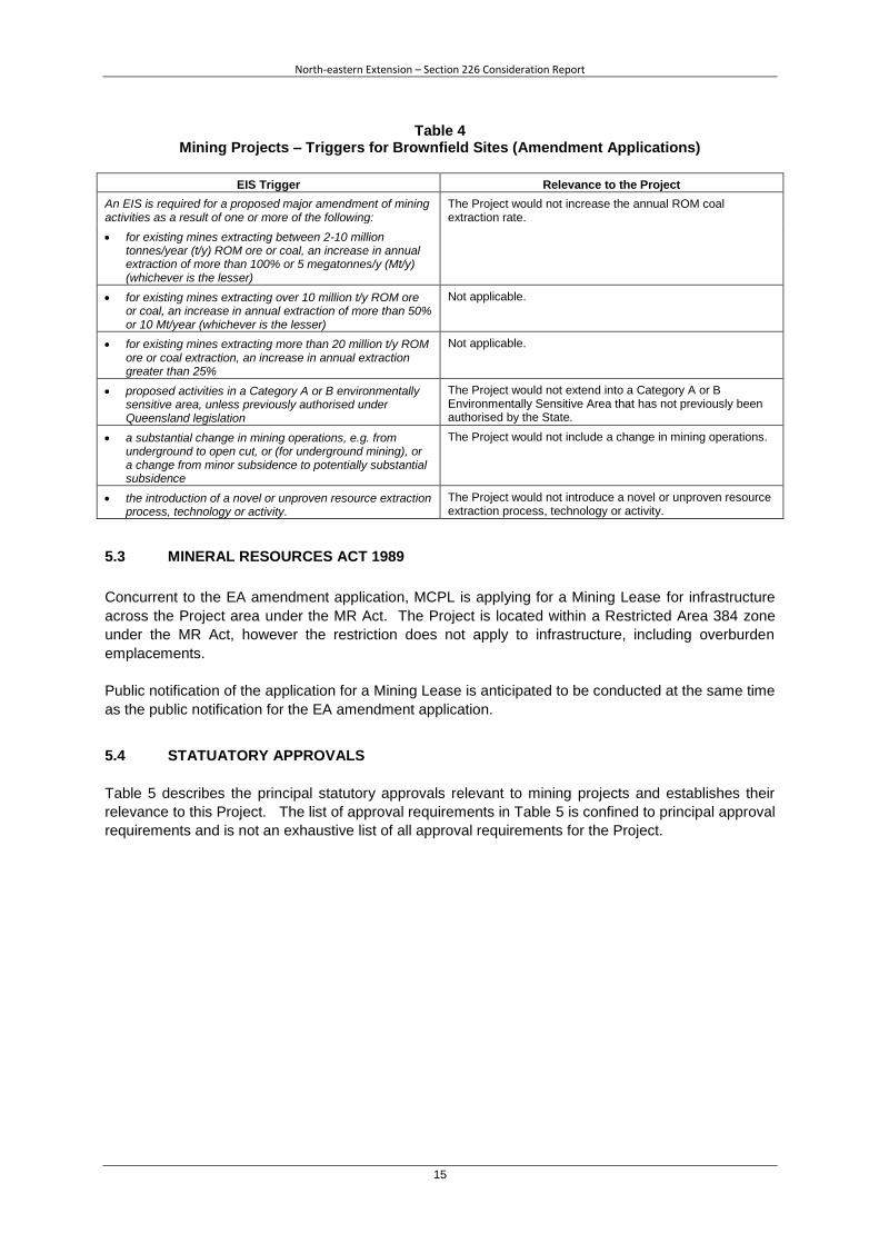
North-eastern Extension – Section 226 Consideration Report
15
Table 4 Mining Projects – Triggers for Brownfield Sites (Amendment Applications)
EIS Trigger Relevance to the Project
An EIS is required for a proposed major amendment of mining activities as a result of one or more of the following:
The Project would not increase the annual ROM coal extraction rate.
for existing mines extracting between 2-10 million tonnes/year (t/y) ROM ore or coal, an increase in annual extraction of more than 100% or 5 megatonnes/y (Mt/y) (whichever is the lesser)
for existing mines extracting over 10 million t/y ROM ore or coal, an increase in annual extraction of more than 50% or 10 Mt/year (whichever is the lesser)
Not applicable.
for existing mines extracting more than 20 million t/y ROM ore or coal extraction, an increase in annual extraction greater than 25%
Not applicable.
proposed activities in a Category A or B environmentally sensitive area, unless previously authorised under Queensland legislation
The Project would not extend into a Category A or B Environmentally Sensitive Area that has not previously been authorised by the State.
a substantial change in mining operations, e.g. from underground to open cut, or (for underground mining), or a change from minor subsidence to potentially substantial subsidence
The Project would not include a change in mining operations.
the introduction of a novel or unproven resource extraction process, technology or activity.
The Project would not introduce a novel or unproven resource extraction process, technology or activity.
5.3 MINERAL RESOURCES ACT 1989
Concurrent to the EA amendment application, MCPL is applying for a Mining Lease for infrastructure
across the Project area under the MR Act. The Project is located within a Restricted Area 384 zone
under the MR Act, however the restriction does not apply to infrastructure, including overburden
emplacements.
Public notification of the application for a Mining Lease is anticipated to be conducted at the same time
as the public notification for the EA amendment application.
5.4 STATUATORY APPROVALS
Table 5 describes the principal statutory approvals relevant to mining projects and establishes their
relevance to this Project. The list of approval requirements in Table 5 is confined to principal approval
requirements and is not an exhaustive list of all approval requirements for the Project.

North-eastern Extension – Section 226 Consideration Report
16
Table 5 Principal Statutory Approvals
Legislation Administering Authority Approval Trigger Approval Relevance to Project
Native Title Act 1993 Attorney General’s Department
The Native Title Act 1993 provides for the recognition and protection of native title rights in Australia. The Act provides a mechanism to determine whether native title rights exist and what the rights and interests are that comprise that native title rights.
Indigenous Land Use Agreements or right to negotiate processes will be undertaken with relevant native title claimants where applicable
Native Title has been extinguished across the entire Project area.
Environment Protection Act 1994 (EP Act)
DEHP The EP Act regulates Environmentally Relevant Activities and provides the mechanism for authorising activities which cause or may cause environmental harm.
EA Approval to carry out an Environmentally Relevant Activity which is a mining activity. The existing EA would be amended as necessary to authorise the Project.
Mineral Resources Act 1989 (MR Act)
DNRM The MR Act regulates mining activities in Queensland and provides the mechanism for securing mining tenements, including EPCs, MDLs and Mining Leases.
Mining Lease The Project would be located beyond the Mining Leases relevant to the EA (i.e. ML 70379 and ML 70417). Concurrent to the EA amendment application, MCPL is applying for a Mining Lease over the Project area.
Water Act 2000 DNRM The Water Act 2000 regulates the taking of and/or interference with water within the State.
Water permit
Water licence
Riverine protection permit
The Project would not change the current water taking or interference associated with the Middlemount Coal Mine. No further approval under the Water Act is anticipated to be required for the Project.
Regional Planning Interests Act 2014
DEHP The Regional Planning Interests Act 2014 regulates resource activities in areas of regional interest, including Priority Agricultural Areas, Priority Living Areas, Strategic Cropping Areas and Strategic Environmental Areas.
Regional Interests Authority The Project is not located within any Priority Agricultural Areas, Priority Living Areas, Strategic Cropping Areas or Strategic Environmental Areas and is therefore not anticipated to require a Regional Interests Authority.

North-eastern Extension – Section 226 Consideration Report
17
Table 5 (continued) Principal Statutory Approvals
Legislation Administering Authority Approval Trigger Approval Relevance to Project
Aboriginal Cultural Heritage Act 2003 (ACH Act)
DEHP The ACH Act aims to provide effective recognition, protection and conservation of Aboriginal cultural heritage in Queensland.
The Act establishes a duty of care for activities that may harm Aboriginal cultural heritage, and requires the development of an approved CHMP.
CHMP The existing Middlemount Coal Mine CHMP would be reviewed and revised as necessary to incorporate the Project.
Vegetation Management Act 1999 (VM Act)
DEHP The VM Act regulates the clearing of native vegetation.
Development Permit (IDAS processes under SP Act applies)
No approval under the VM Act is anticipated to be required for the Project as any vegetation cleared as part of the Project would be within a Mining Lease.
Nature Conservation Act 1992 (NC Act)
DEHP The NC Act regulates the disturbance of listed and protected flora and fauna.
Licences/Permits/ Approvals
The Project area may include habitats containing species listed under the NC Act. The Project may also impact upon protected animals, plants or areas. This would require relevant licences and permits under the NC Act.
Sustainable Planning Act 2009 (SP Act)
Department of State Development, Infrastructure and Planning (DSDIP)
The SP Act is the principal legislation in Queensland for the co-ordination and integration of planning at the local, regional and state levels. The SP Act makes provisions for the Integrated Development Assessment System (IDAS) which establishes a framework for assessment of development applications. The SP Act also makes provisions for the development of State Planning Policies (SPP).
Developments on a mining tenement, excluding building work and work on a Queensland heritage place, are considered to be exempt development under the SP Act.
Development permit No approvals under the SP Act would be required for the Project as all development would be located entirely within a Mining Lease.

North-eastern Extension – Section 226 Consideration Report
18
6 SCOPE OF ENVIRONMENTAL ASSESSMENT
6.1 PRELIMINARY RISK ASSESSMENT
A preliminary risk assessment has been undertaken to identify the key environmental risks associated
with the Project and involved the following steps:
1. Identification of Potential Risks – Consideration of how the Project is likely to affect the
environmental values of the Project area.
2. Identification of Key Potential Environmental Risks – From the potential risks above, what are
the key risks, considering the extent of the potential impacts and the nature of the potential
impacts.
3. Preliminary Consideration of the Study Requirements – Each of the key environmental risks
identified above were considered with respect to the level and scope of assessment that would be
required for the environmental assessments.
The key potential environmental risks identified by the preliminary risk assessment were:
Air quality impacts at sensitive places.
Noise impacts at sensitive places.
Surface water resources as a result of disturbance from open cut mining and site water
management, including water quality impacts to receiving waters.
Vegetation and habitat disturbance associated with land clearing.
The preliminary assessment of the key potential environmental risks included consideration of:
the existing environment using sufficient baseline data;
potential impacts of all stages of the Project;
measures that could be implemented to avoid, mitigate, rehabilitate/remediate, monitor and/or
offset the potential impacts of the Project; and
contingency plans and/or adaptive management for managing any potentially significant residual
risks to the environment.
Sections 6.2 to 6.5 provide further detail on the potential impacts on environmental values and
management measures, and the scope of the environmental assessments to be conducted.
Assessment of the key risks would be undertaken by recognised specialist consultants.
6.2 AIR QUALITY
Potential Impacts and Mitigation Measures
The hauling and emplacement of overburden material has the potential to generate particulate matter
(i.e. dust) in the form of:
total suspended particulate matter (TSP);
particulate matter with an equivalent aerodynamic diameter of 10 micrometres (µm) or less (PM10)
(a subset of TSP); and

North-eastern Extension – Section 226 Consideration Report
19
particulate matter with an equivalent aerodynamic diameter of 2.5 µm or less (PM2.5) (a subset of
TSP and PM10).
Exposure to suspended particular matter can result in adverse health impacts. The likely risk of these
impacts to a person depends on a range of factors including the size, chemical composition and
concentration of the particulate matter, and the existing health of the person. Particulate matter also
has the potential to cause nuisance (amenity) effects when it is deposited on surfaces.
As described in the EPP (Air), air quality objectives are prescribed to enhance or protect
environmental values. The air quality objectives for the indicators relevant to the Project are
presented in Table 6.
Table 6
Air Quality Objectives Relevant to the Project
Indicator Environmental Value Averaging Period Criteria (µg/m3)
TSP Health and wellbeing 1 year 90
PM10 Health and wellbeing 24 hours 50
PM2.5 Health and wellbeing 24 hours 25
Health and wellbeing 1 year 8
Source: EPP (Air).
µg/m3 = micrograms per cubic metre.
The EPP (Air) does not prescribe air quality objectives for particulate matter indicators for the ‘health
and biodiversity of ecosystems’ and ‘protecting the aesthetic environment’ environmental values.
The low sulfur content of Australian diesel, in combination with the fact that mining equipment is widely
dispersed over mine sites is such that the air quality objectives for sulfur dioxide described in the EPP
(Air) would not be exceeded, even in operations such as the Project that would use large volumes of
diesel. Similarly, nitrogen dioxide and carbon monoxide emissions from diesel combustion would be
limited and widely dispersed. Accordingly, the air quality objectives for these indicators are not
considered relevant to the Project.
The Project is not anticipated to significantly change the existing level of air quality impact associated
with the Middlemount Coal Mine given there would be no change to the current mining rate or fleet,
and the East Dump extension area would not see mining operations move significantly closer to
sensitive places.
MCPL would continue to implement a range of air quality management and mitigation measures to
minimise particulate matter emissions, including:
progressive rehabilitation of waste rock emplacements and topsoil stockpiles;
haul road and stockpile dust suppression;
real time meteorological and air quality monitoring;
blast management measures;
dust suppression on drill rigs; and
enclosure of bins and water sprays on CHPP conveyors.
It is noted that no complaints regarding air quality impacts associated with the existing operation have
been received by Middlemount Coal Mine in the last 12 months.

North-eastern Extension – Section 226 Consideration Report
20
Environmental Assessment
The potential air quality impacts associated with the Project would be confirmed through an Air Quality
Assessment as part of the environmental assessments. The previous air quality assessments, history
of air quality monitoring, effectiveness of management measures and nature of the proposed
extensions to the existing operations would be considered to assess the potential change in air quality
impacts at nearby sensitive receivers.
Consideration would be given to the DEHP Guideline Application Requirements for Activities with
Impacts to Air during the development of the Air Quality Assessment to identify any additional
management and mitigation measures.
6.3 NOISE
Potential Impacts and Management Measures
The hauling and emplacement of overburden material has the potential to generate noise impacts at
nearby sensitive places.
Noise may cause environmental nuisance or harm when it negatively affects environmental values,
including human health and wellbeing, community amenity or the health and biodiversity of
ecosystems.
As described in the EPP (Noise), acoustic quality objectives are prescribed to enhance or protect
environmental values. The acoustic quality objectives for sensitive receptors relevant to the Project
area are presented in Table 7.
Table 7 Acoustic Quality Objectives Relevant to the Project
Sensitive Place Acoustic Quality Objective
Dwelling (for outdoors)
(daytime and evening)
LAeq,adj,1hr 50 dBA
LA10,adj,1hr 55 dBA
LA1,adj,1hr 65 dBA
Source: EPP (Noise).
dBA = A-weighted decibels.
LAeq = Equivalent continuous noise level.
LA10 = Noise level exceeded by 10% of the measured period.
LA1 = Noise level exceeded by 1% of the measured period.
Similar to potential air quality impacts, the Project is not anticipated to significantly change the existing
level of noise impact associated with the Middlemount Coal Mine given there would be no change to
the current mining rate or fleet, and the East Dump extension area would not see mining operations
move significantly closer to sensitive places.
It is noted that no complaints regarding noise impacts associated with the existing operation have
been received by Middlemount Coal Mine in the last 12 months.
North-eastern Extension – Section 226 Consideration Report
21
Environmental Assessment
The potential noise impacts associated with the Project would be confirmed through a Noise
Assessment as part of the environmental assessments. The previous noise impact assessments,
history of noise monitoring, effectiveness of management measures and nature of the proposed
extensions to the existing operations would be considered to assess the potential change in noise
impacts at nearby sensitive places.
Consideration would be given to the DEHP Guideline Application Requirements for Activities with
Noise Impacts during the development of the Noise Impact Assessment to identify any additional
noise management and mitigation measures.
6.4 WATER
Potential Impacts and Management Measures
The direct disturbance and emplacement of overburden material and controlled release from sediment
dams associated with the Project has the potential to impact surface drainage regimes and
downstream water quality.
The existing site water management system would be progressively augmented to incorporate the
Project, including modification of water management infrastructure (e.g. Sediment Dam 7, clean water
and mine affected water diversions). The extension of the water management system would be
designed to protect the identified environmental values by separating runoff from disturbed,
rehabilitated and undisturbed catchments. The extension of the water management system would be
operated to release water in accordance with the EA release conditions and protect the environmental
values of the receiving environment.
An extensive surface water monitoring network has been established at the Middlemount Coal Mine
which includes upstream and downstream monitoring points and monitoring points on all licensed
discharge points. Monitoring of water in sediment dams is also conducted. MCPL would continue to
monitor surface water in accordance with the Water Management Plan.
A Water Management Plan for the Middlemount Coal Mine (WRM, 2014) has been prepared in
accordance with the EA conditions. The Water Management Plan includes a study of potential
contaminants, a water balance model, a description of the site water management system, measures
to manage and prevent saline and acid rock drainage, contingency procedures for emergencies and a
monitoring and review program for the effectiveness of the water management plan. The Water
Management Plan will be revised to incorporate the Project.
Environmental Assessment
An environmental assessment of the potential impacts to water will be conducted by MCPL to verify
compliance with the performance based EA conditions. A Surface Water Assessment would be
conducted, including:
revision of the existing site water balance model;
an assessment of potential impacts of any release via erosion and sediment control structures.
Middlemount Coal Mine has an operational site water balance model which would be revised to
incorporate the Project. The site water balance model would be revised cognisant of the EA water
release conditions to size and design the Project water management infrastructure.
North-eastern Extension – Section 226 Consideration Report
22
The Surface Water Assessment would identify the chemical and physical properties of surface waters
within the area that may be affected by the Project and assess the potential impacts of any discharges
(as determined by the revision of the site water balance model) on the quality and quantity of receiving
waters. It is anticipated that there would be no significant changes to the potential impacts to
receiving waters given Project water releases would be consistent with the existing EA (developed in
accordance with the Model Mining Conditions).
Consideration would be given to the DEHP Guideline Application Requirements for Activities with
Impacts to Water during the development of the Surface Water Assessment to assist in identifying
improvements to management and mitigation measures.
6.5 BIODIVERSITY Potential Impacts and Management Measures Vegetation and fauna habitat would be directly disturbed through clearing associated with the
associated with the Project. The Project will not disturb any Environmentally Sensitive Areas,
including endangered Regional Ecosystems. Based on the Queensland Herbarium RE mapping, the
Project would only disturb least concern vegetation.
The potential impacts to biodiversity would be minimised through avoidance, minimisation of
clearance, conducting clearance in accordance with the Species Management Program, mitigation
such as rehabilitation of the Project area in accordance with rehabilitation objectives (Section 3.3) and
through offset and compensatory measures to maintain or improve the biodiversity values of the
surrounding region in the medium to long-term.
Environmental Assessment
An environmental assessment of the potential impacts to biodiversity will be conducted by MCPL. A
Terrestrial Ecology Assessment would be conducted to assess the potential impacts to biodiversity
associated with the Project, including:
field validated RE mapping;
flora and fauna species, particularly threatened species listed under the NC Act;
Environmentally Sensitive Areas; and
Wetlands.
Direct impacts to the existing ecological environment would be assessed during each stage of the
Project, where relevant.
The assessment would describe proposed avoidance and mitigation measures to protect or enhance
natural values, and propose indicators to monitor potential impacts. In particular, measures would be
described to protect threatened or near-threatened species.
Consideration of biodiversity offset requirements would be included in the environmental assessment
in accordance with relevant Queensland Environmental Offsets Policy. The assessment will describe
the magnitude and duration of potential significant residual impacts and describe how the activity and
any associated offset would be staged.
Consideration would be given to the DEHP Guideline Application Requirements for Activities with
Impacts to Land during the development of the Terrestrial Ecology Assessment to identify potential
improvements to management and mitigation measures.

North-eastern Extension – Section 226 Consideration Report
23
7 STAKEHOLDER ENGAGEMENT
MCPL will hold a pre-lodgement meeting with the DNRM regarding the Project, and will continue to
consult with the DNRM, DEHP and Isaac Regional Council during the EA amendment application
assessment process.
If DEHP decides the application to be a major EA amendment, formal public notification and
submission periods will be conducted during the notification stage of the process (in accordance with
Part 4 of the EP Act).
8 REFERENCES
Department of Environment and Heritage Protection (2011) Mackenzie River Sub-basin Environmental
Values and Water Quality Objective.
Department of Natural Resource and Mines (2014a) Trigger Map for Strategic Cropping Land in
Queensland – Version 3.0.
Department of Natural Resources and Mines (2014b) Statement of Reasons: Watercourse
determination for mining lease for Middlemount Mine. Unpublished advice to Middlemount Coal
Pty Ltd.
Middlemount Coal Pty Ltd (2011) Middlemount Coal Project Stage 2 Environmental Impact Statement.
February 2011.
NatureCall (2014) Ecological Assessment Report: Project: Bingegang Pipeline Relocation,
Middlemount Coal Mine, Middlemount.
Thackway, R. and Cresswell, I.D. (1995) An interim biogeographic regionalisation for Australia: a
framework for setting priorities in the National Reserves System Cooperative Program,
Version 4.0.
WRM Water and Environment (2012) Middlemount Coal Mine – Erosion and Sediment Control Plan.
WRM Water and Environment (2014) Middlemount Mine Water Management Plan.

Application for Mining Lease
Permit Application (ID: 10001663) - COMPLETE
Lodged On: 09/07/2015 12:13 PM
Mineral Resource Act 1989
PERMIT PRE-REQUISITE DETAILS
Pre-requisite permits
Permit type Permit number Authorised holder Expiry date
PP 74264 MIDDLEMOUNT COAL PTY LTD 23/07/2015
PERMIT DETAILS
Permit name: Middlemount - North-eastern extension
Permit type: Mining Lease - Infrastructure (Coal or oil shale)
Permit term: 17 Years
General locality of the application: West of Middlemount township
Specific infrastructures: Stock pile ore / overburden
Form MMOL-14 Version 1
PERMIT HOLDER DETAILS
Holder:
ACN:
Email address:
Business number:
Mobile number:
RIBFIELD PTY LTD
080772283
Address:
Town/City:
State:
Postcode:
Country:
GPO Box 241
BRISBANE
QLD
4001
Australia
Holder:
ACN:
Email address:
Business number:
Mobile number:
MIDDLEMOUNT COAL PTY LTD
122348412
Address:
Town/City:
State:
Postcode:
Country:
GPO Box 241
Brisbane
QLD
4001
Australia
Holder address details:
Authorised Holder Representative (AHR) address details:
Name:
Email address:
Business number:
Mobile number:
Peabody Energy Australia Pty Ltd
Address:
Town/City:
State:
Postcode:
Country:
GPO Box 164
32397253
Brisbane
QLD
4001
Australia
Client name Percent holding Authorised
RIBFIELD PTY LTD 95.000000000000 No
MIDDLEMOUNT COAL PTY LTD
5.000000000000 Yes
PERMIT AREA
Which datum standard have you used? MGA94
Provide coordinates for the datum post: 669453.0E 7476001.0N 55Z, 669582.0E 7475984.0N 55Z, 670730.0E 7474996.0N 55Z, 671138.0E 7474136.0N 55Z, 669433.0E 7474155.0N 55Z
When was the land marked out? 09/07/2015 11:00 AM
Is surface area within the permit area required?
Whole.
Provide width of access (m): 10.00
Provide any relevant information about access including start and end points:
10m wide access track commencing from Dysart - Middlemount Road. Proceeding north-west, 5m south of the northern boundary of Lot 5 on SP210524, then proceeding north-west, 5m west of the western boundary of Easement BZ on SP273876 (yet to be registered but shown in shape file) and ending at the southern boundary of the proposed mining lease.
Size of area applied for (ha): 197.1960
Size of surface area applied for (ha): 197.1960
Local government area(s): Isaac Regional Council

LAND INFORMATION DETAILS
Does this application involve the surrender of a granted permit in favour of whole or part of this application?
No
Is there any restricted land associated with this permit application?
No
Is the lease area within the surface of reserve?
No
Are you making this application jointly with the holder of the ATP permit?
No
Are you making this application with the consent of that holder?
No
Is the land applied for situated within an area of a greenhouse gas (GHG) permit?
No
Overlapping permits
Permit type Permit number Authorised holder Expiry date
ATP 1103 CH4 PTY LTD 31/12/2018
Land details
Description Proposed usage
Current usage Compensation required?
Lot 3 on plan SP210524 - Freehold Par N/A Permit Industrial No
NATIVE TITLE
Native title process: Exclusive Land (100%)
I confirm that when a full assessment is completed, if native title must be addressed, a native title process will be required and advertising fees will be requested by the department:
Yes
ENVIRONMENTAL AUTHORITY
The environmental authority application is: Application for amendment of an environmental authority
Suitable registered operator details
Holder Suitable Operator Status Registered No.
RIBFIELD PTY LTD Registered 347796
MIDDLEMOUNT COAL PTY LTD Registered 601484
PROPOSED PROGRAM AND PLAN
Duration: 5 Years
As the authorised holder representative, I understand and agree to the obligations associated with the permit: Yes
OBLIGATIONS
PAYMENT DETAILS
Fee type Details Amount ($)
EPAMAM Application for amendment of an environmental authority 295.60
APPMLINFCOAL Mining Lease - Infrastructure (Coal or oil shale) 4,135.00
Total Fee: 4,430.60

OFFICE USE ONLY
Received AT: __________________
DATE: __________________
FEE Paid: __________________
Received BY: __________________
TIME: __________________
RECEIPT no: __________________
UPLOADED DOCUMENTS
Section File name Uploaded by Date uploaded
AHR Letter of authority - AHR [email protected]
07/07/2015 02:18 PM
Environmental authority
Amendment Application [email protected]
07/07/2015 02:34 PM
Financial Capability Financial capability statement [email protected]
07/07/2015 02:41 PM
Financial Capability Financial Commitment [email protected]
07/07/2015 02:41 PM
Land availability Land details [email protected]
07/07/2015 02:32 PM
Land availability Coal Seam Gas (CSG) statement [email protected]
07/07/2015 02:32 PM
Land availability CSG criteria statement [email protected]
07/07/2015 02:32 PM
Permit area Access area file [email protected]
09/07/2015 08:13 AM
Permit area Map of boundaries and access [email protected]
09/07/2015 08:13 AM
Permit area Area file [email protected]
09/07/2015 08:13 AM
Permit area Statement justifying the area [email protected]
09/07/2015 09:22 AM
Permit area Graphic representation of area [email protected]
09/07/2015 08:13 AM
Permit area Surface area justification statement
09/07/2015 08:13 AM
Permit details Permit term justification statement [email protected]
07/07/2015 02:12 PM
Technical capability Other resource commitment statement
07/07/2015 02:41 PM
Technical capability Technical capability statement [email protected]
07/07/2015 02:41 PM
Work program Proposed development plan [email protected]
07/07/2015 02:38 PM

Disclaimer
© State of Queensland, 2014.
The Queensland Government supports and encourages the dissemination and exchange of its information. The copyright in this publication is licensed under a Creative Commons Attribution 3.0 Australia (CC BY) licence.
Under this licence you are free, without having to seek our permission, to use this publication in accordance with the licence terms.
You must keep intact the copyright notice and attribute the State of as the source of the publication.
For more information on this licence, visit http://creativecommons.org/licenses/by/3.0/au/deed.en
The information contained herein is subject to change without notice. The Queensland Government shall not be liable for technical or other errors or omissions contained herein. The reader/user accepts all risks and responsibility for losses, damages, costs and other consequences resulting directly or indirectly from using this information.