3) - bsee data center · pdf filetypical diverter and bop schematics are enclosed herewith....
TRANSCRIPT

3):
In ?*ply Refer Tot October 19, 19 8
tiugnea-Penny Offshore Exploration, Inc. Attentions iu . Greg Dicliarry 1515 Poydras, Suit* 2270 ItM Orleans., Louisiana f3*%
Gon'lenen:
Reference ta wade to >**ur- j„f plo»»vr Bun 1 '-N5**©* Operations Coordination Dooui-ent (DOCD) anri acooz*^-/iog aftfora*'*4 sived October 11, 1926, for taWjH flfifcsl BMW am? pffa Blocks 14 5, South .ificaller Area. This DOCD includes the activiti*:: prs^ifc t'ltiSftom a, Well Be. 1, and Walls A through K.
In accordance with 30 C?K 250.34(f), this DOCD is hereby d*e»ed submitted and i s nov bain* co&sider^d. for approval.
Your ootitroi nufrb* is S-2l8g and should bo referenced in your coeaauni-oatioo and oorreaoc ience cQuoaroiaje this POO.
Sincerely yours,
<3L (Orig. Sg&) A. DonaW Giroir D. Bourgeois Regional Supervisor Field Operations
I J: Lease OCS-G 5604 (OPS-3-2) (FILE ROOM) . Lease OCS-G 5605 (OPS-3-2) (FILE ROOM) OPS-3-4 w/Publio info. Copy of the DOCD
iooi^p. info. (PUBLIC rtfiCOHDS)
MJTolbert:cck:10/12/88:doc ;o»
Program Seryjces
OCT 211P88
Infcrjfnation Services SecUon y

H U G H E S - D S N N Y 0*. IORE EXPLORATION, I N C MEW OR1EA OUISIANA 70112
ISI5 POYDRAS SUITE 2270
(SO*) 524 - 4)A9
Mr. Daniel Bourgeon Regional Supervisor Office of F ie ld Operations U. S. Department of the In te r i o r
October 5, 1988
f ' : n era ls Management Service 120i Elmwood Park Boulevard New Orleans, Louisiana 70123-2394
RE: Supplemental Development Operations Coordination Document OCS-G 5604/5605, Blocks 144/145 South Timbalier Area, Offshore Louisiana
Gentlemen:
In accordance with the provisions of Title 30 CFR 250.34, Hughes-Denny Offshore Exploration, Inc., hereby submits for your review and approval nine (9) copies of a Supplemental Development Operations Coordination Document for lease OCS-G 5604/5605, South Timbalier Area, Blocks 144/145. Five (b) copies are "Proprietary Information" and four (4) copies "Public Information .
Hughes-Denny anticipates commencing activities under this proposed DOCD on January 15, 1989.
Should additional information be required, please contact me or our Regulatory Agent, Ms. Judy Davidson at (713) 558-0607.
Sincerely,
GD:JD:ljk Enclosures [L-D0CD]

•' SUPPLEMENTAL DEVELOPMENT OPERATIONS COORDINATION DOCUMENT
HUGHES-DENNY OFFSHORE EXPLORATION, INC. BLOCKS 144/145, SOUTH TIMBALIER AREA
OCS-G 5604/5605 OFFSHORE, LOUISIANA
In compliance with T i t l e 30 CFR 250.34 and Notice to Lessees 84-1 dated February 10, 1984, the fol lowing information is submitted for the Supplemental Development Operations Coordination Document (DOCD) for leases OCS-G 5604 and 5605, Sou Timbalier Area, Blocks 144/145.
DESCRIPTION
Hughes-Denny Offshore Exploration, Inc. is the designated Operator of South Timbalier Area, Blocks 144/145, OCS-G 5604/5605 Under this Supplemental Development Operations Coordination Document, Hughes-Denny proposes to install a 4-pile Production Platform "A" at 806' FSL & 662' FEL of Block 144, d r i l l ten (10) additional wells and place 12 wells on production. Two wells, Location "A" in Block 144 (to be drilled as Well No. 1) and temporarily abandoned Well No. 1 in Block 145 were approved under a Plan of Exploration. Hydrocarbons will be transported via a proposed pipeline from Platform "A" to a sub-sea tie-in in South Timbalier 172.
SCHEDULE QF ACTIVITIY
Hughes-Denny's activities under this proposed DOCD for Blocks 144/145 will commence January 15, 1988 and extend until February 1, 1991 when production is expected to commence.
The following schedule details the chronological order of the proposed events leading to f u l l production.
Activi ty
A. Dr i l l & Complete Well No. 2 in Block 145
B. De ign Platform "A"
C. Fabricate Platform "A"
D. Insta l l Platform "A"
E. D r i l l & Complete 9 wel ls . Tie-back 2 Exploration we l ls .
F. Insta l l Production Equipment and Pipeline to South Timbalier 172
G. Hook-u, and Commence Production
Approximate start-up Date
January 15, 1989
Apr i l 1, 1989
July 1, 1989
March 1, 1990
Apr i l 1, 1990
January 1, 1991
February 1, 1991

DRILLING EQUIPMENT
The proposed wells will be drilled with a typical jackup drilling rig. Typical diverter and BOP schematics are enclosed herewith.
Safetv features wi" include well control and blovout prevention equipment as desc oed in Title 0 CFR 250.50. The appropriate l i f e rafts, l i f e jackets, ring buoys, etc., as prescribed by the U. S. Coast Guard will be maintained on the f a c i l i t y at all times.
LOCATION QF THE 8LQCK, PLATFORM ANO FACILITIES
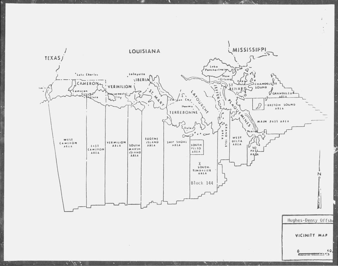
South Timbalier Area Blocks 144/145 are lc:ated approximately 40 miles south of the Louisiana coastline. Water depth n the block is approximately 90'. A map showing the location of Blocks 144/145 relative to tn shoreline is attached.
Hughes-Denny will utilize an existing onshore base located in Venice, Louisiana. This will serve as port of debarkation for supplies and crews. This base is capable of providing the services necessary for completion and production activities. I t has 24-hour service, a radio tower with a phone patch, dock space, equipment and supply storage base, drinking and d r i l l water, etc. Durin^ . r i l l i n g , i t is estimated that one crew boat will makn
seven (7) round trips per week, one supply boat will make seven (7) round trips per week, dnd a helicopter will make ten (10) round trips per week. During production, i t is estimated one supply boat will make four (4) round trips per week, and a helicopter will make three (3) round trips per week to the block. The activities associated with South Timbalier Blocks 144/145 should not result in any increase in the size and number c onshore support and storage facilities or land and personnel requirements.
GEOLOGICAL ANO GEOPHYSICAL DATA
A structure map is enclosed as Exhibit "C". Information regarding geological hazards and surface locat ons relative to anomalies was included in the Plan of Exploration for South Timbalier 144/145.
The estimated l i f e of reserves for Blocks 144/145 is years.
Production from the platform is expected to be
SHALLOW HAZARDS REPORT
A Shallow Hazards Report is enclosed.
POLLUTION PREVENTION INFORMATION
Pollution prevention control measures will be in accordance with 30 CFR 250.40. Hughes-Denny has on f i l e with the MMS an approved Oil Spill Contingency Plan for the Gulf of Mexico. In the event of a spi l l , this plan will be actuated. Hughes-Denny Exploration, Inc. is a member of Clean Gulf Associates which provides spill containment equipment and clean-up equipment

at service bases located on the Gulf Coasts of Louisiana, Texas, Alabama, Florida and Miss iss ipp i , i f a sp i l l should occur from the proposed operations, the equipment located at Grand Is le , Louisiana would be u t i l i zed f i r s t , w i th addit ional equipment moved in from other bases, i f necessary. Fast boat response with o i l boom, skimmers, pump and storage tanks would require approximately 6-12 hours, including preparation time. A heavy equipment system would require approximately 48 hours, including six hours preparation t me.
D r i l l c u t t i n c , and excess d r i l l i n g f lu ids w i l l be disposed of in accordance with appl icable environmental regulations. The d r i l l i n g f l u i d components and additives to be used is enclosed.
EXHIBITS
Platform Drawings Vicinity Map & Location Plat Structure Map Rig Schematics Mud Additives Shallow Hazards Report Environmental Report Air Quality Review


L MISSISSIPPI
T E X A S ;
N r
Hughes-Denny Offsh
vicintrr MAf
*0


BLOWOUT PREVENTER STACK WITH A
HYDRIL DIVERTER
20* DIVERTER 2000 PSI
CHOKE LINE
®

DRILLING MUD COMPONENTS
COMMON CHEMICAL OR CHEMICAL TRADE NAME
Aluminum Stearate "AXTAFLO-S" Barite Calcium Carbonate Calcium Chlordie Calcium Oxide Calcium Sulfate Carboxymethyl Cellulose Caustic Potash Caustic Soda Chrome Lignite Chrome Lignosulfonate Drill ing Detergent "E-Pal" Ferrochrome Lignosulfonate Gel
Gypsum Ligni te Lignosulfonate "Mud Sweep" "MOR-REX" "Shale-Trol" Sapp Soda Ash Sodium Bicarbonate Sodium Carboxymethyl Cellulose Sodium Chloride Sodium Chromate Starch "TX-9010" "TORQ-Trim" "Black Magic" "Black Magic Supermix1' Diesel
"JVI flake" MICA "Pipe-Lax" "Wall-Nut" Wood Fibers
DESCRIPTION OF MATERIAL
Aluminum Stearate Nonionic Surfactant Barium Sulfate (BaSo4) Aragonite (CaCoi) Hydrophilite (CaC12) Lime (Quick) Anhydrite (CaS04J Carboxymethyl Cellulose Potassium Hvdr:te Sodium Hydroxide (NaOH) Chrome Ligni ce Chrome Lignosulfonate Soap Non-toxic, biodegradable defoamer Derived from wood pulp Sodium montmorillonite, bentonite, attapulgite CaSo4.2H20 I ignite Lignosulfonate Cement Pre-flush Hydroloyzed Cereal solid Qrgano-aluminum complex Sodium Acid Pyrophosphate Sodium Carbonate NaHC03 Sodium Carboxymethyl Cellulose NaCI NaCr04.10H20 Corn Starch Biodegradable drilling lubricant Biodegradable drilling lubricant Oil base mud cone. Sacked concentrated oil base mud Used to mix certain loss-circulation pills Plastic f o i l , shredded cellophane Loss-circulation material Surfactant mixed with diesel Ground walnut shel1s Loss-circulation material

P.O. Box 218753 Houston. Texas 77218 713-558-0607
ENVIRONMENTAL REPORT
FEDERAL LEASES OCS-G 5604/5605
SOUTH TIMBALIER AREA, BLOCKS 144/145
OFFSHORE, LOUISIANA
THE FOLLOWING ENVIRONMENTAL REPORT WAS PREPARED BY J. CONNOR CONSULTING FOR HUGHES-DENNY OFFSHORE EXPLORATION FOR COASTAL ZONE CONSISTENCY DETERMINATION BY THE STATE OF LOUISIANA ON OPERATIONS PROPOSED TO BE CONDUCTED IN THE DEVELOPMENT OPERATIONS COORDINATION DOCUMENT FOR LEASES OCS-G 5604/5605. FOR INQUIRIES REGARDING THIS REPC,IT PLEASE CONTACT:
HUGHES-DENNY ( ;HORE EXPLORATION
1515 POYDRAS, SUITE 2270
NEW ORLEANS, LOUISIANA 70112
OCTOBER, 1988

TABLE OF CONTENTS
TITLE PAGE i
TABLE OF CONTENTS i i
I . DESCRIPTION OF PROPOSED ACTION 1
a DESCRIPTION OF PROPOSED TRAVEL MODES, ROUTES AND ] FREQUCNr
3. ONSHORE JUPPORT SYSTEMS 1 C. NEW IR UNUSUAL TFCHNOLOGY 1 D. VICINIIY MAP 1 t. PROPO.ED MEANS f j TRANSPORT OIL AND GAS TO SHORE 2
ROUTES, QUANTIZES
I I . DESCRIPTION 0 AFFECTED ENVIRONMENT 2
\ . COMMERCIAL FISHING ' 2 6. SHIPPING ?• C. PLEASURE BOATING, SPORT FISHING AND RECREATION 3 D. POTENTIAL OR KNOWN CULTURAL RESOURCES 4 E. ECOLOGICALLY SENSITIVE FEATURES 5 F. PIPELINES AND CABLES 5 G. OTHER MINERAL USES 6 H. OCEAN DUMPING 6 I . ENDANGERED OR THREATENED SPECIES AND CRITICAL 6
HABITAT
I I I . UNAVOIDABLE ADVERSE ENVIRONMENTAL EFFECTS 7
A. WATER QUALITY B. EFFECTS ON MARINE ORGANISMS C. WETLANDS AND BEACH D. AIR QUALITY E. COMMERCIAL FISHING F. SHIP NAVIGATION S G. CULTURAL RESOURCES 8
H. RECREATION AND AESTHETIC VALUES 8
IV. SUMMARY 9
REFERENCES 10
-i i -
-Ui...... bc.iny plans tu conduct development activities on South Timbalier Area BUcks 144/145, OCS-G 5604/5605. As proposed, the Supplemental Development Operations Coordination Document for South Timbalier Area Flocks 144/145 will include: (1) install Platform "A", (2) d r i l l ten (10) additional wells and (3) place twelve wells on production.
At this time, planned commencement date for development activities is on or about January 15, 1989.
i\. DESCRIPTION OF PROPOSED TRAVEL MODES, ROUTES AND FREQUENCY
Crew, supply boats ;nd helicopters will be dispatched from a support nase located in Venice Louisiana. The boats will normally move to the block via the '«iost direct ..ute from Venice, Louisiana, however, boats operating in the field may travel trom other facilities nearby. Following is an escimate of trips to the proposed operation.
Cre . Boat Supply Boat Heli copter
Drilling Operations Production Operations
7 trips per week 7 trips per wee 10 trips per weer
0 trip per week 4 trips per week 3 trips per week
_ u
6. ONSHORE SUPPORT BASE
The proposed ac t i v i t i es w i l l u t i l i z e a support base located at VSMCO, Louisiana. This base provide- 24-hour service, a radio tower wit-patch docK space, o f f ice space, partcing l o t , equipme «r«d supniy stor^ ; space, dr ink ing and d r i l l water, etc:. The proposed development act*'*/, .es wi i l help tc maintain th is base at I : pre ent level j f a c t i v i i y , :<o expanse n of the Physical f a c i l i t i e s u r the creation o f new jobs is expected to reiUi from the work planned in r.on junction with th is block
C NEW OR UNUSUAL TFIHN0L0GY
No new techniques o~ unusual technology w i l l be required for these operations.
D. VICINITY MAP
South' Timbalier Area Blocks 144/145 ore located approximately 40 miles offshore Loui j iana. Water d?pth is approximately 72 ' . See Attachment I .
- 1 -

E. PROPOSED MEANS TO TRANSPORT OIL AND GAS TO SHORE, ROUTES, QUANTITIES
F'QcV ic"e hydrocarbon? will be transported via pipelines in and or near or' 144/145.
I I utSLRiPTION CF AFFECTED ENVIRONMENT
A. COMMERCIAL FISHING
The aulf of Mexico is the single most important area for fisheries production in che United S:ates. In 193b, the total landings ail fisheries in the Gulf was about 2.4 billion pounds, valued at $596 n i l ion dockside, and represented about 38% of the total nited States ". andi ngs by pounds and 26% by value, ir. 1985, the top four U.o. ports in ouantity of commercia' fishery landings were Cameron, Louisiana; Pascagoula-Moss Point, Mississippi; and Du"!*" ' ' auvin and Empire-Venice, Louisiana.
The Gulf shrimp fishery jepresents ch* single most valuable fishery in the United States with landings (heads remivedj averaging approximately 230 milli o i lbs/yr. The majc- shrimp spec es include-brown, white, and pink shrimp. In 1981 production reached almost 270 million pounds worth over $4 11 •ai 111 on dockside. In ac . i : i on to shrimp, the blue crao significantly contributes to the Gulf's :rustacean landings. In 1985, about 56 million pounds of blue crabs, worth about $16 million, were "ken in th* ffulf's nta shore estuaries and sounds. Oysters are the main v. sk rur s ed ': the Gulf, nearshore esC"aii*' ind sounds, and oyster '.: i ".in 1385 wjre approximately 26.5 million pound? valued at about . I lion.
In the Gulf the following commercial fishes were the- must economically important in 19£5 and are arranged in ord-ir of decreasing priority: gulf menhaden, groupers and scamp, red snappe.*, black mul'et, reti d" im, ye lowfin tuna, catfish and bullheads, swordfish, black drum, spocteci $?atrout, ^eiiow-tail snapper, pompano, verm,iIon snapper, and king mackerel -rii cero.
The menhaden purse seine fishery ;s the most important fishery in terms of pounds landed. In 1985, 1.9 billian pounds valued at $67 million were la .»•: in the Gulf. Menhaden are used in the manufacture of fish meal and sol ut 1 es for additives to livestock feeds, and oroduction of fish o i l . Also, sma 1 amounts are used for bait and canned p f food.
The industrial bottomfish trawl fishery produces stoik for the pet food industry, bait, animai food, and fishmeai. This fishery reached peak production in the early 1970's at about 115 m ions pounds, worth aoout $2.8 million; however, i t nas declined in recent ye *s.
Shrimp is by far the most valuable component of the Louisiana landings. The menhaden fishery is the largest in terms of pounds landed. In 1935, the total commercial landings for Louisiana were about V7 billion Minds, worth Si29 million. Louisiana ranked f i r s t in the Unitec States in pounds landed and second in value.
B. SHIPPING
Fairways play an impc -u.it r V a in ihe avoidance of col l is ions on the OCS. pa r t i cu l a r l y in the case ot the large oceangoing vessels, but not a l l ves els stay w i th in the fairways. Many others, such as f ishing boats and OCS support vessels, t ravel through ar»?.s with h*gh concentrations of f ixed structures. In such cases the most le^ni tant mi*.1y?' ' t r factor is the requirement for
place fo r a whi le, i t often becomes a i j i . mark and an aid to navigation for vessels tha t operate in the area on a regular basis.
South Timbalier 144/145 -ire clear of a l l shipping r ^*ways and anchorage areas. The p l a t e r * and each of the marine vessel a servicing this operation w i l l be equir t * wUh a l l U. S. Coast Guard require; navigationa 1 safety aids.
C. PLEASURE BOATING, SPORT FISHING AND RECREATION
The northern Gulf or Mexico cc ista l zone is one o^'the major recreational regions of the 1'i.ited , ;a tes, oar t icu lar ly in correction with marine f ishing and beach-related a c T i i . 4 * c : The shorefronti along the Gulf coasts of Alabama, Miss iss ipp i , Louisiana, and Texas of fer a d ivers i ty of natural and developed landscapes and s?a-:apes. "ho coastal beaches, barr ier islands, estuarine bays and sends, r w e r deltas, and tr'dal marshes are sxtensively and in tens ive ly L ' t i l \ i i for : ?creatioi al ac t i v i t y by • . • . no t ' , of the Gulf South and t o u n s t s frots th roug.v j t the Nation, as well .v„ IVOM foreign countr ies. Publicly-owned and administered areas such ac National seashores, parks, beaches, and w i l d l i f e lands, as well as specially -.esign?ted preservation areas such as h is :o r i c and natural sites and landiwki", wilderness areas, w i l d l i f e aoctuar--s, aod scenic r ivers at t ract r e s i d e s and v i s i to rs throughout the year Ccnmrjrcial and private recreative"! f a c i l i t i e s and establish: ;»nts, sua: is resor ts , marine:, amusement parts, and ornamental garden?. al^o serve a: primary interest areas aod supper-; services fcr people who se f < enjoyment from the recreat iorai n ources associated with the Gulf.
The two major recreational areas ~ost d i rec t l y associated with offshore leasing and potent ia l ly affected by i t ara the offshore marine environment and the coastal shorefront of the adjoining states. 7f»s enly major recreational ac t i v i t y occurring on the CCS is offshen tunne recreational f ishing and d iv ing. Studies, reports, and conference proceedings pufc. i:, ied by MMS and others have documented a substantial recrea : iona; f ishery, including scuba div ing, d i r ec t l y associated with o i l and gas production platforms. The recreational f ishing associated with o i l and gas s t r . - . i r e s st'-ms from the i r function as high p ro f i l e a r t i f i c i a l f ishing reefs. P epcrt OH the 1984 Marine Recreational F'shery Stat is t ics Surveys presenter, j MF5 at v.he Sixth Annual Gulf of Mexico Information Transfer Meeting ind'e te-j majority of the offshore recreational f ishing m t r . Central Gulf of rlev'co is d i r e c t l y associated with o i l and gas st ructuro: . There are current-., about 4,OOP onshore o i l and gas structures in *.«e Central and Western Gulf of Mexico. Ma , : :her stud-.es have demonstrates -.hat when o i l and ga? structures are KciSaib le tc marine recreational tishermen and scuba divers they are a majc at t ract ion fo r marine recreational ac t i v i t ies and are a posit ive i n f l u f .'. . tourism and coastal economics.
After a structure has been in
-3-
With the exception of Grand Isle and vicinity and a stretch of beach area in Cameron Parish, (. veto/Constance/Ocean View Beaches, Holly Beach, Hackbcrry Bea:h) Louisiana has very lvnited bea'-h area suitable for recreation. Most of i t is very narrow, of noor recreat onal quality and generall> inaccessible by automobile, some of t'e highest quality beach areas In coastal Lo:i:cl*na are found along the barrier islands chain off Terrebonne Parish. Sever*.l additional significant recreational resources are found along the Gulf U*vS%. Louisiana has ornamental gardens, scenic roads, rivers, and trails.
0. POTENTIAL OR Ucttffi CULTURAL RESOURCES
Archaeological resources are any objects "~ features which are man-made or modified by human activity. Significant ar naeologiral resources are either historic or prehistoric and, as defined by 36 CFR 60.6, generally include properties greater than 5C years old which are associated with events that nave made a sign i f . ant contribution to the broad patterns of our history; are associated with the lives cf persons significant in the past; embody the distinctive characteristics of a type, perio^. or method of construction; represent the work of a master; possess high artistic values; represent a significant and distinguishable entity whose competent:, may lack individual distinction; or have yi>_-ded, or may be likely to yield, 'nformation important in prehistory or history.
Although most historic archaeological resources on the OCS arc shipwrecks, ot'it; :ypes of historic sites, such as the inip Sr.oal Lighthouse, may occur in Federal waters.
Figures indicate that less than c% of pre-ZOth century ships reported in the Gulf and less, than 10% of all ships reported Inst between 1500 and 1945 have known locations. Considering the problems with inaccurate wreck reporting, dri f t and breakup of wreck:., and snips which have been lost but never reported, i t becomes apparent that veiy litt'ie is really known about the locations of historic shipwrecks in the Gulf of Mexico.
In order to deal with the management prublems of this larpely unlocated resource basa, a high probability zone for tne occurrence or shipwrecks (Zone 1) was propostd by the baseline study (CEI, 1977). l\r< zone was delineated by using geograrim: factor.., such ai" approaches to seaports, straits, shoals, reefs, and historic shipping routes, as indicators of high sripwreck potenti al.
Required remote sensing surveys on the OCS have recorded evidence of approximately 57 potential wrecks. Ten of these are definite wrecks while the remaining 47 would require further investigation for positive identification Eighty percent of these possible wrecks were recorded wHhin Zone 1 which, according to the baseline study, is where the highest incidence of shipwrecks should occur.

E. ECOIOGICALLY C.NSITIVE FEATURES
Barrier beaches are a common landform along the Gulf Coast and stretch in an irregular chain from Florida to Texas. These elongated, narrow landforms are composes *f snnd and other loose sediments transported by waves, currents, stor* surges, and wind. In geological terms, barrier islands are a young phenomenon, being formed only in the last 5000 to 6000 years. The term "barrier1, identifies the structure as one that protects other features, such as bay.-,, estuaries, and marshes, from direct wave attack of the open ocean. The waters in these bays and estuaries are a blend of the terrestrial-freshwater systems of the mainland and the saltwater system of the ocean, and among the richest ecosystems known. Many of the species that inhabit the bays, estuaries, and adjacent marshes use these areas as spawning, nursery, and feed grounds.
Another benefit of both the islands and their adjacent marshes and bays is that of providing nab:-ats for a large number of birds and other animals. The islands also provile habitat for several threatened or endangered species, for 'ample, the oggerhead turtle, the southern bald eagle, alligators, and brown pelicans.
The shelf ir.d shelf edge of the Central and Western Gulf are characterized by topograph.c features which are inhabited by benthic communities. The benthic organisms on these features appear to be depth rented; however, the actual limiting factors are temperature and light penetration (turbidity and sedimentation).
The Central Guif of Mexico lists 16 topographic features.
Shelf Edge Bunks hidshelf Banks
Bright Bank Scnnier Bank McGrail Bank 29 Fathom Bank Rankin Bank Fishnet Bank Alderdice Bank Rezak Bank Sidner Bank Ewing Bank Jakkula Bank Bouma Bank Parker Bank Sackett Bank Diaphus Bank Sweet Bank
F. PIPELINES AND CABLES
Pipelines crossing Blocks 144/145 are described ; o detai l in the Shallow Hazard Analysis submitted for these blocks.
Hughes-Denny as a prudent operator w i l l avoid a l l pipelines and cables in this block during development a c t i v i t i e s .
-5-

G. OTHER MINERAL USES
The activities proposed for South Timbalier 144/145 will have no direct or indirect impact on other mineral uses.
H. OCEAN DUMPING
Ocean dumping is prohibited in this area.
I . ENDANGERED OR THREATENED SPECIES ANO CRITICAL HABITAT
Five federally listed endangered whale species occur within the Central Gulf. These include fin, humpback, right, sei, and sperm whales. Generally, these large cetaceans inhabit the continental slope and deep oceanic waters, occasionally they are sighted nearshore (Scnmidly, 1981). Sperm whales have been sighted near the Louisiana Delta ana offshore Brownsville (Fritts et al., 1983).
Four federally listed endangered turtle species (Kemp's ridley, green, hawksbill, and leatherback turtles) and one threatened species (loggerhead turtle) occur in the Gulf of Mexico.
The American alligator occurs generally throughout the Central Gulf coastal areas. The alligator is listed as langered throughout its range except in the coastal areas of Florida and T s where i t is listed as threatened and in Louisiana where i t is listed as threatened by similarity of appearance".
The red-cockaded woodpecker occurs primarily in mature open pine forest throughout the Eastern anJ Central Gulf area and into eastern Texas.
Arctic peregrine falcons migrate along the eastern coast of Florida, the Florida Keys, and the Gulf coast of Texas. Some peregrine falcons overwinter along the Gulf coastal areas.
The endangered eskimo curlew's northward migration corridor crosses the Louisiana and Texas coastal areas.
Brown pelican's occur along the coast of Cameron Parish, Louisiana. Bald eagles inhabit several Gulf coastal counties.
These species may be affected by the development of coastal lands and/or the occurrence of oil spills which may affect t*e species directly or through their food sources. Since the proposed ac.vities include no plans for the development of the coastal lands, the impact on endangered or threatened species is primarily based on the occurrence of oil spills.
Hughes-Denny as a prudent operator, will take the necessary measures to reduce the probability of oil spills. Hughes-Denny's proposed development operations on Blocks W/145 should not pose a threat to any endangered or threatened species.

I I I . UNAVOIDABLE ADVERSE ENVIRONMENTAL EFFECTS
A. WATER QUALITY
Production activities will temporarily reduce water quality adjacent to the location. This will increase turbidity in a plume down-current from the work site. Released waters and a minor oil spill could also contribute to water quality degradation.
B. EFFECTS ON MARINE ORGANISMS
Some organisms will be killed and some will be temporarily functionally impaired as a result of development operations. Tne most affected groups will be plankton and benthos immediately around the platform. Damage will both mechanical and toxicological. Discharge of hole cuttings will damage plankton within the plume and bury some of the less mobile benthic fauna. These impacts are considered to be localized, short term and reversible at the population level.
An oil s p i l l could affect a broad spectrum of marine most effects would be localized and short term. Any turtles would be significant.
orqanisms. effects on
De
However, mammals and
C. WETLANDS AND BEACH
In the unlikely event of a spill occurring and reaching shore, organisms in wetland and beach habitats could be killed or functionally impaired. Human community disruption could also occur. Although all such effects would be localized, any effects on endangered species and/or critical habitats would be significant.
D. AIR QUALITY
The air quality at the lease site will be degraded temporarily during operations, but should return to normal once operations are measurably completed. Offshore activities probably will not affect onshore air quality. Air oual ity at the onshore base will be only insignificantly reduced by onshore activities. Any such effect will be temporary.
E. COMMERCIAL FISHING
Of the various types of fishing ^ear in use in the OCS areas, trawls have the greatest chance for operational conflicts with oil and gas activities. Losses may, however, be compensated under the Fishermen's Contingency Fund or other legal routes. Trawl nets can be snagged on underwater stubs causing damage or loss of the nets. In addition, i t is conceivable that snags could damage underwater production equipment or pipelines causing a spill of oil or gas. Because safety equipment is installed, which shuts in production when a loss of pressure occurs, the likelihood of a major spill resulting thereby is considered very ^mall. Less frequently, large objects which were lost
-7-
overuoard from petroleum industry boats, pipeline lay barges, and platforms are caught by fishing gear resulting in damage to the gear and/or its catch of fish; however, occurrence of this type of incident is low. Also, commercial fishermen would probably not harvest fish in the area of an oil sp i l l , as spilled oil could coat or contaminate commercial fish species rendering them unmarketable. Other unavoidable adverse impacts include loss of fish space caused by installation of unburied pipelines, rigs, platforms, or by other OCS-related structures. There may be some localized competition for shore facilities. These effects and any effect that the development operations will have on stocks of important species are considered minor.
F. SHIP NAVIGATION
Very l i t t l e interference can be expected between the platform and marine vessels utilized during production operations and ships that use established fairways. However, at night and during rough weather, fog, and heavy seas, ships not using established fairways could collide with the platform.
G. CULTURAL RESOURCES
There is only a small probability that an unknown cultural resource exists in the lease area.
H. RECREATION AND AESTHETIC VALUES
The platform and marine vessels may represent an obstacle to some sport fisherman, but such an effect is expected to be negligible and not permanent.
Even though existing regulations and orders prohibit indiscriminate littering of the marine environment with trash, offshore oil and gas operations involving men, machines, equipment, and supplies is bound to result in some littering of the ocean. Human nature and accidents associated with offshore operations will contribute some floatable debris to the ocean environment which will eventually come ashore on major recreational beaches.
The effects that normal operations or a minor oil spill would have on any fish stocks important to sport fishermen are also considered to be negligible.
A minor oil spill and/or non-petroleum floating debris could foul beaches inshore of the lease area. The fouling of the beaches would be an aesthetic detriment that could adversely affect recreation. Any effects on beach recreation could adversely affect tourism and, consequently, the local economy.

IV. SUMMARY
The proposed activity will be carried out and completed with the guarantee of the following items.
A. The best available and safest technoloqies will be utilized throughout the project. This includes meeting alt applicable requirements for equipment types, general project layout, safety systems, and equipment and monitoring systems.
B. All operations are covered by a Minerals Management Service approved 1 Spill Contingency Plan.
C. All applicable Federal, State and Local requirements regarding air emission and water quality and discharge for the proposed activities, as well as any other permit conditions, will be complied with.
D. The proposed activities described in detail in the Development Plan will comply with Louisiana's Coastal Management Program and will be conducted in a manner consistent with such Program.

REFERENCES
1. Final Environmental Impact Statement, Proposed Oil and Gas Lease Sales 94, 98 and 102, Gulf of Mexico OCS Region, OCS EIS, MMS 84-0057.
2. Final Environmental Impact Statement, Proposed Oil and Gas Lease Sales 94, 98 and 102, Gult ot Mexico OCS Region, OCS EIS, MMS 84-0057, visuals.
3. Fisheries of the United States, 1985, April, 1986.
4. The Ecology of Petroleum Platforms in tne Northwestern Gulf of Mexico: A Community Profile, Bureau of Land Management Open File Report 82-03, July, 1982.
5. Environmental Report West Cameron Area Blocks 516 and 524, March, 1987.
6. BLM Draft Environmental Impact Statement, OCS Oil and Gas Lease Sales A-52 and 62.
7. BLM Final Environmental Impact Statement, OCS -Oil and Gas Lease Sales A-62 and bZ.
8. BLM Final Environmental Impact Statement, OCS Oil and Gas Lease Sale 47.
9. Minerals Management Service, 1983. Final Regional Environmental Impact Statement, Guff Qf Mexico. U.S. Department of the Interior.
10. Final Environmental Impact Statement, Proposed Oil and Gas Lease Sales 110 and 112, Gulf of Mexico OCS Region, OCS TIS, MMS 86-0087.
11. Final Environmental Impact Statenent, Proposed Oil and Gas Lease Sales 110 and 112, Gulf of Mexico OCS KegTon, OCS EIS, MMS "86-0087, visuals.
12. Final Environmental Impact Statement, Proposed Oil and Gas Lease Sales 113, 115 and 116, Gulf ot Mexico OCS Region, OCS EIS, MMS-87-0077.
-10-
Hughes-Denny Qffsh
ViClMlTT MM*
0

Box 218753 Houston, Texas 77218 713-558-0607
October 5, 1988
PROJECTED AIR EMISSION SCHEDULE ¥0\ DEVEL0PMFNT/PR0DUC7IC PROJECT
GENERAL INFORMATION
Location of Faci1ity:
Distance Offshore: Name of Platform: Operator:
Conect Person: Wel Footage Drilled, 1989 Well Footage Drilled, 1990 Date Drilling Will Begin: Date Production Will Begin
South Timbalier 144/145 OCS-G 5604/5605 40 miles Platform "A" Hughes-Denny Offshore Exploration 1515 Poydras, Suite 2270 New Orleans, Louisiana 70112 Mr. Greg Dicharry 13900' 108,900' January 1, 1S39 February 1, 19.91
MAJOR SOURCE (OFFSHORE)
Power used aboard drilling vessel; approximate footage to be drilled 122800'*
**
Emitted Substance
CO SO 2
NOX VOC TSP
1989
2.75 .88
12.93 1.04 .92
Projected Emissions **Tons/Year
jm 21.56 6.86
101.28 8.17 7.19
Based on 60 hphr/ft. from Table 4-3, "Atmospheric Emissions from Offshore Oil and Gas Development and Production", EPA No. 450/3-77-026, June, 1977
Emission factors from Table 3.3.3-1, "Compilation of Air Pollutant Emission Factors", Third Edition, EPA Report AP-42, August, 1977

Projected Air Emissions Hughes-Denny Offshore Exploration South Timbalier 144/145 Page i
MINOR SOURCLS (OFFSHORE)*
Projected Emissions Emitted Substance 1 cons/year)
1985 1190
CG .24 1.73 SO .01 .05 2
NOx .04 .24 VOC 02 .17 TSP .01 .08
* Tables 3.2.1-3, 3.2.3-1 and 2.1-1, "Compi1ation'of Air Pollutant Emiss u Factors", Third "dicion, EPA Report AP-42, August, 1977.
NOTE: Emission fiyures during activity associated with production will oe minimal. Emission factors are based at the highest levels: which will be during drilling in 1989 and 1990.
TOTAL ALL SOURCES (tons/year)
1989 CO SO NOX VOC TSP — — 2
Major 2.75 .88 12.93 1.04 .92 Minor .24 .01 .04 .02 .01 TOTAL 1799 739 12797 T M 791
1990
Major 21.56 6.86 101.28 8.17 7.19 Minor 1.73 .05 .24 .17 .08 TOTAL 7T779 6T9T T0T757 971* 7777
ONSHORE SOURCES
These should be about the same as minor sources unless new facilities are installed at the onshore base. No additional facilities are required or planned at this time.
EMISSION EXEMPTION DETERMINATION
2/3 1/ -» For CO: E =• 3400 - 3400(40) - 39,767 tons/year For NOx, VOC, TSP & SO : E * J;.3U =• 33.3(40) - 1332 tons/year
?
Projected Air Emissions Hughes-Denny Offshore Exploration South Timbalier 144/145 Page 3
PREDICTED PRflOUi••ON AND DRILLING ACTIVITY AT PLATFORM
Gas Produc con * Gil Production * Oate Production Will Begi. : February 1, 1991
TRANSPORTATION SERVICES
Supply Boats (3000 hp) trips Per Week During Drilling - 7 Trips Per Week During Production - 4
Crew Boats Trips Per Week During Drilling - 7 Trips Per Week During Production - 0
Helicopter Trips Per Week During Drilling - 10 Trips Per Week During Production - 3
METHODOLOGY
Platform: Boats: Helicopters:
Horsepower - hour method Horsepower - hour method Landing/Takeoff (LTO) cycle method
REFERENCES
Production - EPA 450/3-77-026 (June, 1977) - "Atmospheric Emissions from Offshore Oil and Gas Development and Production", pp. 81-116.
Boats - EPA Report AP-42 - "Compilation of Air Pollutant Emission Factors", 3rd Edition, (August, 1977), pp. 116, 125 and 127
FINDINGS QF AIR QUALITY REVIEW
As per DOI/MMS regulations, this facility is exempt from further air quality review as i t has been determined that its operations will not have a significant adverse environmental impact on air quality.

COASTAL ZONE MANAGEMENT
CONSISTENCY CERTIFICATION
DEVELOPMENT OPERATIONS COORDINATION DOCUMENT
SOUTH TIMBALIER 144/145
OCS-G 5604/5605
The proposed activities described in detail in this Plan comply with Louisiana's approved Coastal Zone Management Program and will be conducted in a manner consistent with such Program.
-11-