2.2 biological resources - escondido
TRANSCRIPT

2.2 Biological Resources
June 2017 9993 The Villages – Escondido Country Club EIR 2.2-1
2.2 Biological Resources
This section addresses the potential biological resources impacts associated with implementation of The Villages – Escondido Country Club Project (Project). The analysis is based on the review of existing biological resources, technical data, and applicable laws, regulations, and guidelines, as well as The Villages Biological Technical Report, which is included as Appendix 2.2-1 to this Environmental Impact Report (EIR).
2.2.1 Existing Conditions
2.2.1.1 Environmental Setting
Regional
The City of Escondido (City) is located within the boundary of the Multiple Habitat Conservation Program (MHCP) for the Cities of Carlsbad, Encinitas, Escondido, Oceanside, San Marcos, Solana Beach, and Vista, which the San Diego Association of Governments (SANDAG) adopted in 2003 (SANDAG 2003). The City of Escondido (City) is located within the boundary of the County of San Diego’s South County and North County MSCP areas, and adjacent to the City of San Diego’s MSCP Cornerstone Lands at Hodges Reservoir and San Pasqual Valley. The MHCP is a comprehensive, multiple jurisdictional planning program designed to create, manage, and monitor an ecosystem preserve in northwestern San Diego County.
Each jurisdiction is responsible for preparing a subarea plan to implement the MHCP in its jurisdiction. A draft subarea plan, the Draft Escondido Subarea Plan, has been prepared for incorporated and unincorporated areas of Northern San Diego County but has not been adopted. A public review draft of the Draft Escondido Subarea Plan was released in 2001 (City of Escondido 2001). The Draft Escondido Subarea Plan covers the entire City boundary and approximately 3,000 acres of unincorporated County land within the City’s sphere of influence (City of Escondido 2012).
Project Site
The approximately 109-acre Project site is located in the northwest portion of the City, along both sides of West Country Club Lane west of Nutmeg Street. The Project is approximately 0.5 miles to the west of Interstate 15 (I-15), and about 2 miles north of State Route 78. The Project site is generally located within the northern foothill humid temperate eco-region of north San Diego County. Generalized climate in the region is regarded as dry, subhumid mesothermal, with warm, dry summers and cold moist winters. Mean annual precipitation is between 10 and 20 inches, and the mean annual temperature is between 59°F and 64°F. The frost-free season is 260 to 300 days.

2.2 Biological Resources
June 2017 9993 The Villages – Escondido Country Club EIR 2.2-2
The Project site is a former 18-hole golf course surrounded by existing residential development. The surrounding residential development consists of single-family detached residences on a variety of lot sizes, attached single-family residences (duplexes) of several different densities, and several common-interest developments. The country club and golf course are no longer active, and the site is currently characterized by disturbed, fallow land. Surrounding land uses include residential development in all directions. As a result, the site is subject to a number of previous and ongoing anthropogenic (human-caused) disturbances that include pedestrian use, domestic pet use (i.e., dogs and cats), invasive species, and regular night lighting and noise. The hydrology and vegetation composition of the site has evidently changed dramatically since the golf course operations have ceased. The man-made channels and basins/ponds that occur are no longer maintained and supported by irrigation water from the golf course and as a result, most are in a dysfunctional state.
Although the plan is not approved or adopted, the Project site is located within the boundaries of the Draft Escondido MHCP Subarea Plan, within undesignated land outside of biological core and linkage areas and focused planning areas. This means that although the Project site is within the proposed boundaries of the Draft Escondido Subarea Plan, the site does not have heightened biological significance as core habitat or linkage land facilitating animal movement.
Methodology
An initial general biological survey of the Project site was conducted by HELIX biologist Karl Osmundson on March 23, 2016. The survey included a general inventory of existing conditions and focused primarily on verifying existing vegetation communities or habitat types, assessing suitability for sensitive plant and animal species, assessing potential jurisdictional waters and wetlands, and identifying any other potential sensitive resources. Physical parameters assessed included vegetation and soil conditions, presence of indicator plant and animal species, slope, aspect, and hydrology. The Project site was surveyed on foot and with the aid of binoculars, and representative photographs of the site were taken. Plant and animal species observed or otherwise detected were recorded in field notebooks. Animal identifications were made in the field by direct visual observation or indirectly by detection of calls, burrows, tracks, or scat. Plant identifications were made in the field or in the lab through comparison with voucher specimens or photographs. The locations of special-status plant and animal species incidentally observed or otherwise detected were mapped. The Project site was also examined for evidence of potential jurisdictional waters and wetlands, including vernal pools.
Vegetation Communities/Habitat Types
Seven vegetation communities/habitat types occur in the Project site: freshwater marsh, disturbed wetland, non-native riparian, disturbed land, man-made earthen channel, man-made concrete
2.2 Biological Resources
June 2017 9993 The Villages – Escondido Country Club EIR 2.2-3
channel, and man-made basin/pond. Classification generally follows Holland (1986) and Oberbauer et al. (2008), where applicable. Classification of man-made channels and ponds/basins were further refined in Appendix 2.2-1 for clarity of the type of conveyance and detention feature in the context of jurisdictional waters and wetlands.
Freshwater Marsh
Freshwater marsh is dominated by perennial emergent monocots, 5 to 13 feet tall, forming incomplete to completely closed canopies. This vegetation type occurs along the coast and in coastal valleys near river mouths and around the margins of lakes and springs, freshwater, or brackish marshes. These areas are semi- or permanently flooded yet lack a significant current (Holland 1986). Dominant species include cattails (Typha spp.) and bulrushes (Scirpus spp.), along with umbrella sedges (Cyperus spp.), rushes (Juncus spp.), and spike-sedge (Eleocharis sp.).
Freshwater marsh occurs over approximately 0.04 acres confined to limited portions of the earthen channels in the southeastern portions of the site. Broad-leaved cattail (Typha latifolia) is the dominant species observed, much of which was dead or desiccated due to the golf course areas no longer being artificially irrigated.
Disturbed Wetland
Disturbed wetland is dominated by exotic wetland species that invade areas that have been previously disturbed or have undergone periodic disturbances. These non-native plants become established more readily following natural or human-induced habitat disturbance than the native wetland flora. Characteristic species of disturbed wetlands include giant reed (Arundo donax), cocklebur (Xanthium strumarium var. canadense), umbrella sedge (Cyperus involucratus), wild celery (Apium graveolens), and tamarisk (Tamarix sp.).
Approximately 0.04 acres of disturbed wetland is mapped within the southeastern portion of the site. Dominant species include rabbitsfoot grass (Polypogon monspeliensis), senesced (dead) cattail, and gum tree (Eucalyptus camaldulensis) samplings.
Non-Native Riparian
Non-native riparian comprises densely vegetated riparian thickets dominated by non-native, invasive species. Characteristic species include giant reed, tamarisk, gum trees (Eucalyptus sp.), palms (Phoenix spp. and Washingtonia spp.), Bermuda grass (Cynodon dactylon), castor-bean (Ricinus communis), and pampas grass (Cortaderia spp.), along with natives such as arrowweed (Pluchea sericea), Fremont cottonwood (Populus fremontii), and willows (Salix spp.). It occurs along disturbed water courses.
2.2 Biological Resources
June 2017 9993 The Villages – Escondido Country Club EIR 2.2-4
A narrow, 0.21-acre stand of low-quality, non-native riparian habitat occurs in the southeastern portion of the site adjacent to West Country Club Lane, between Nutmeg Street to the east and La Brea Street to the west. This habitat is dominated by gum tree, giant reed, Peruvian peppertree (Schinus molle), saltcedar (Tamarix sp.), and a few scattered, native willows (Salix lasiolepis). The understory is bare or characterized by dead or desiccated due to the golf course areas no longer being artificially irrigated.
Disturbed Land
Disturbed land includes areas in which there is a dominance of ruderal (weedy) and ornamental vegetation in areas that were previously developed or subject to regular maintenance; the vegetative cover comprises less than 10% of the surface area (disregarding natural rock outcrops); and/or there is evidence of soil surface disturbance and a predominance of non-native and/or weedy species that are indicators of such surface disturbance.
Approximately 100.7 acres of the approximately 109-acre disturbed and developed site is mapped over the old golf course grounds on the site. These areas show extensive sign of disturbance, large patches of non-native ruderal forbs (weeds), remnant golf course developments (e.g., cart paths, bunkers), and ornamental vegetation scattered throughout.
Man-Made Earthen Channel
Several man-made earthen channels occur throughout the site that formerly served as irrigation and storm water conveyance features for the golf course. Many of these features have uniform channel widths and depths, indicative of having been excavated. Many of these features are bare or overgrown with non-native grasses and forbs due to the golf course areas no longer being artificially irrigated and maintained. Approximately 0.1 acres of earthen channels have been delineated on the site.
Man-Made Concrete Channel
Several man-made concrete channels and swales also occur throughout the site. These channels also formerly served as irrigation and stormwater conveyance features for the golf course. Many of the concrete channels appear to have been excavated in uplands to convey water to and from the artificial basins/ponds for the golf course, especially in areas where water would not have naturally flowed or been conveyed over the landscape. Approximately 0.2 acres of concrete channels have been delineated on the site.
2.2 Biological Resources
June 2017 9993 The Villages – Escondido Country Club EIR 2.2-5
Man-Made Basin/Pond
Several man-made basins and ponds also occur on the site, which are either concrete- or earthen-lined. The total estimated surface area is 1.9 acres. Since the golf course operations have ceased, many of the ponds have completely dried out due to the golf course areas no longer being artificially irrigated. The earthen-lined ponds were mostly bare during the 2016 surveys.
Flora and Fauna
A total of 62 plant species in the Project site were identified, of which 40 (65%) are non-native species. No special-status plant species were observed. A total of 36 animal species were observed or otherwise detected in the Project site during the biological surveys, including 34 bird and 2 mammal species. No special-status animal species were observed. Special-status plant and wildlife species that are known to the region are not expected to occur within the Project site due to the general lack of suitable habitat and the fact that the Project site has previously been developed as a golf course.
2.2.1.2 Regulatory Setting
Federal
Federal Endangered Species Act
The federal Endangered Species Act of 1973 (ESA), as amended (16 U.S.C. 1531 et seq.), provides for listing of endangered and threatened species of plants and animals and designation of critical habitat for listed animal species. The ESA also prohibits all persons subject to U.S. jurisdiction from “taking” endangered species, which includes any harm or harassment. Section 7 of the ESA requires that federal agencies, prior to project approval, consult the U.S. Fish and Wildlife Service (USFWS) and/or the National Marine Fisheries Service to ensure adequate protection of listed species that may be affected by the project.
Migratory Bird Treaty Act
All migratory bird species that are native to the United States or its territories are protected under the federal Migratory Bird Treaty Act (MBTA), as amended under the Migratory Bird Treaty Reform Act of 2004 (Senate Bill 2547). The MBTA is generally protective of migratory birds but does not actually stipulate the type of protection required. In common practice, the MBTA is now used to place restrictions on disturbance of active bird nests during the nesting season (generally February 1 to August 31). In addition, USFWS commonly places restrictions on disturbances allowed near active raptor nests.

2.2 Biological Resources
June 2017 9993 The Villages – Escondido Country Club EIR 2.2-6
Clean Water Act
The federal Water Pollution Control Act Amendments of 1972 (Clean Water Act; 33 U.S.C. 1251 et seq.), as amended by the Water Quality Act of 1987 (PL 1000-4), is the major federal legislation governing water quality. The purpose of the Clean Water Act is to “restore and maintain the chemical, physical, and biological integrity of the nation’s waters.” Discharges into waters of the United States are regulated under Section 404. Waters of the United States include (1) all navigable waters (including all waters subject to the ebb and flow of tides); (2) all interstate waters and wetlands; (3) all other waters, such as intrastate lakes, rivers, streams (including intermittent streams), mudflats, sand flats, wetlands, sloughs, or natural ponds; (4) all impoundments of waters mentioned above; (5) all tributaries to waters mentioned above; (6) the territorial seas; and (7) all wetlands adjacent to waters mentioned above. In California, the State Water Resources Control Board and the nine Regional Water Quality Control Boards (RWQCBs) are responsible for implementing the Clean Water Act. Important applicable sections of the Clean Water Act are discussed below:
Section 303 requires states to develop water quality standards for inland surface and ocean waters and submit to the EPA for approval. Under Section 303(d), the state is required to list waters that do not meet water quality standards and to develop action plans, called total maximum daily loads, to improve water quality.
Section 304 provides for water quality standards, criteria, and guidelines.
Section 401 requires an applicant for any federal permit that proposes an activity that may result in a discharge to waters of the United States to obtain certification from the state that the discharge will comply with other provisions of the Clean Water Act. Certification is provided by the respective RWQCB.
Section 402 establishes the National Pollutant Discharge Elimination System (NPDES), a permitting system for the discharge of any pollutant (except for dredge or fill material) into waters of the United States. The NPDES program is administered by the RWQCB. Conformance with Section 402 is typically addressed in conjunction with water quality certification under Section 401.
Section 404 provides for issuance of dredge/fill permits by the U.S. Army Corps of Engineers (ACOE). Permits typically include conditions to minimize impacts on water quality. Common conditions include (1) ACOE review and approval of sediment quality analysis before dredging, (2) a detailed pre- and post-construction monitoring plan that includes disposal site monitoring, and (3) required compensation for loss of waters of the United States.

2.2 Biological Resources
June 2017 9993 The Villages – Escondido Country Club EIR 2.2-7
State
California Endangered Species Act
Similar to the federal ESA, the California ESA of 1970 provides protection to species considered threatened or endangered by the State of California (California Fish and Game Code, Section 2050 et seq.). The California ESA recognizes the importance of threatened and endangered fish, wildlife, and plant species and their habitats, and prohibits the taking of any endangered, threatened, or rare plant and/or animal species unless specifically permitted for education or management purposes.
California Fish and Game Code
The California Fish and Game Code regulates the handling and management of the state’s fish and wildlife. Most of the code is administered or enforced by the California Department of Fish and Wildlife (CDFW; prior to January 2013, California Department of Fish and Game (CDFG)). One section of the code generally applies to public infrastructure projects such as the proposed Project:
Section 1602 regulates activities that would divert or obstruct the natural flow or substantially change the bed, channel, or bank of any river, stream, or lake that supports fish or wildlife. CDFW has jurisdiction over riparian habitats associated with watercourses. Jurisdictional waters are delineated by the outer edge of riparian vegetation or at the top of the bank of streams or lakes, whichever is wider. CDFW jurisdiction does not include tidal areas or isolated resources.
California Environmental Quality Act
Primary environmental legislation in California is found in the California Environmental Quality Act (CEQA) and its implementing guidelines (CEQA Guidelines), which require that projects with potential adverse effects (or impacts) on the environment undergo environmental review. Adverse environmental impacts are typically mitigated as a result of the environmental review process in accordance with existing laws and regulations.
California Native Plant Society
The California Native Plant Society (CNPS) maintains a list of special-status plant species based on collected scientific information. Designation of these species by the CNPS does not constitute legal status or protection under federal or state endangered species legislation. CNPS’s California Rare Plant Ranks (CRPRs) are defined as follows: CRPR 1A (plants presumed extinct), CRPR 1B (plants rare, threatened, or endangered in California and elsewhere), CRPR 2 (plants rare, threatened, or endangered in California, but more numerous elsewhere), CRPR 3
2.2 Biological Resources
June 2017 9993 The Villages – Escondido Country Club EIR 2.2-8
(plants about which more information is needed—a review list), and CRPR 4 (plants of limited distribution—a watch list). In general, substantial adverse effects to plants designated as CRPR 1A, 1B, or 2 would be considered significant.
California Natural Community Conservation Planning Act of 1991
The Natural Community Conservation Planning Act of 1991 provides a framework for state and local government, as well as private interest efforts for the protection of regional biodiversity and the ecosystems upon which they depend. Natural community conservation plans allow for the appropriate, compatible economic activity to occur while ensuring the long-term conservation of multiple species. As a result of this act, the Carlsbad Habitat Management Plan was prepared under the MHCP.
California Fish and Game Code
The California Fish and Game Code provides specific protection and listing for several types of biological resources. Sections 1600 et seq. of the California Fish and Game Code require notification and, if required, a Streambed Alteration Agreement for any activity that would alter the flow, change, or use any material from the bed, channel, or bank of any perennial, intermittent, or ephemeral river, stream, and/or lake. Typical activities that require notification include excavation or fill placed within a channel, vegetation clearing, structures for diversion of water, installation of culverts and bridge supports, cofferdams for construction dewatering, and bank reinforcement.
Pursuant to California Fish and Game Code Section 3503, it is unlawful to take, possess, or needlessly destroy the nest or eggs of any bird, except as otherwise provided by this code or any regulation made pursuant thereto. Raptors and owls and their active nests are protected by California Fish and Game Code Section 3503.5, which states that it is unlawful to take, possess, or destroy any birds of prey or to take, possess, or destroy the nest or eggs of any such bird unless authorized by CDFW. Section 3513 states that it is unlawful to take or possess any migratory non-game bird as designated in the MBTA. These regulations could require that construction activities (particularly vegetation removal or construction near nests) be reduced or eliminated during critical phases of the nesting cycle unless surveys by a qualified biologist demonstrate that nests, eggs, or nesting birds will not be disturbed, subject to approval by CDFW and/or USFWS.
Local
City of Escondido – Mature and Protected Tree Ordinance
The City establishes regulations and standards for the preservation, protection, and selected removal of mature and protected trees. A City-issued vegetation removal permit is required before
2.2 Biological Resources
June 2017 9993 The Villages – Escondido Country Club EIR 2.2-9
clearing, pruning, or destroying vegetation and before any encroachments by construction activities that disturb the root system within the dripline (i.e., the outer extent margin of a tree’s canopy) of any mature and protected trees. Issuance of a vegetation removal permit requires the submittal of a tree survey and, as applicable, a tree protection and/or replacement mitigation plan. Tree protection, removal, and replacement standards are outlined in the City’s General Plan and in Chapter 33 (Zoning), Article 55 (Grading and Erosion Control) of the City’s Municipal Code (Ordinance 2001-21). The City’s General Plan recognizes any oak tree species and other mature trees, as defined below, as significant aesthetic and ecological resources deserving protection within the boundaries of the City. Section 33-1052 and 33-1068 of the City’s Municipal Code sets forth rules and standards for mature tree removal, protection, and replacement.
Section 33-1502 (Definitions)
A mature tree is any self-supporting woody perennial plant, native or ornamental, with a single well-defined stem or multiple stems supporting a crown of branches. The single stem, or one of multiple stems of any mature oak tree (genus Quercus), shall have a diameter 4 inches or greater when measured at 4.5 feet diameter at breast height (DBH) above the tree’s natural grade. All other mature trees shall have a DBH of 8 inches, or greater, for a single stem or one of the multiple stems.
A protected tree is any oak that has a 10-inch or greater DBH, or any other tree species or individual specimen listed on the historic register, or is determined to substantially contribute to the historic character of a property or structure listed on the local historic register, pursuant to Article 40 of the Escondido Zoning Code.
Section 33-1068 (Vegetation Clearing and Protection)
Pursuant to this section, regulations and standards are established to safeguard life and property and the public welfare concerning the preservation, protection, and selected removal of mature trees, protected trees, and historically significant trees located within the boundaries of the City.
A vegetation removal permit and appropriate standards for the replacement of vegetation approved for removal is required before clearing, pruning, or destroying City-regulated vegetation, and before any encroachments by construction activities that destroy or disturb the root system within the dripline of regulated trees. Issuance of a vegetation removal permit requires the submittal of a tree survey and may potentially require a tree replacement and/or protection plan.
Section 33-1069 (Vegetation Protection and Replacement)
Pursuant to this section, every feasible effort and measure to avoid damage to existing trees to remain on site shall be taken by the owner and developer during clearing, grading, and

2.2 Biological Resources
June 2017 9993 The Villages – Escondido Country Club EIR 2.2-10
construction activity, including the placement of City-approved tree protection barriers. If mature trees cannot be preserved on site, they shall be replaced at a minimum ratio of 1:1. If protected trees cannot be preserved on site they shall be replaced at a minimum ratio of 2:1. However, the number, size, and species of replacement trees can be determined on a case-by-case basis by the City’s Director of Community Development.
City of Escondido General Plan
Resource Conservation Element
1. Biological and Open Space Resources
Goal 1: Preservation and enhancement of Escondido’s open spaces and significant biological resources as components of a sustainable community.
Biological and Open Space Resources Policy 1.1: Establish and maintain an interconnected system of open space corridors, easements, trails, public/quasi-public land, and natural areas that preserves sensitive lands, permanent bodies of water, floodways, and slopes over 35 percent, and provides for wildlife movement.
Biological and Open Space Resources Policy 1.2: Maintain open space and rural residential uses around the perimeter of the city to serve as a buffer from the surrounding urbanizing areas.
Biological and Open Space Resources Policy 1.3: Protect land areas with steep topography (generally over 25%) from intensive urban development, regulate development in areas with topographic constraints such as steep slopes, and include these areas within the overall open space system.
Biological and Open Space Resources Policy 1.4: Coordinate the planning and development of the overall open space system with other public facilities and services within Escondido.
Biological and Open Space Resources Policy 1.5: Participate in the planning and preservation of an interconnected biological resources and open space plan with appropriate federal, state, and local agencies that enhances the viability of the regional ecosystem.
Biological and Open Space Resources Policy 1.6: Preserve and protect significant wetlands, riparian, and woodland habitats as well as rare, threatened or endangered plants and animals and their habitats through avoidance. If avoidance is not possible,

2.2 Biological Resources
June 2017 9993 The Villages – Escondido Country Club EIR 2.2-11
require mitigation of resources either on- or off-site at ratios consistent with State and federal regulations, and in coordination with those agencies having jurisdiction over such resources.
Biological and Open Space Resources Policy 1.7: Require that a qualified professional conduct a survey for proposed development projects located in areas potentially containing significant biological resources to determine their presence and significance. This shall address any flora or fauna of rare and/or endangered status, declining species, species and habitat types of unique or limited distribution, and/or visually prominent vegetation.
Biological and Open Space Resources Policy 1.8: Require that proposed development projects implement appropriate measures to minimize potential adverse impacts on sensitive habitat areas, such as buffering and setbacks. In the event that significant biological resources are adversely affected, consult with appropriate state and federal agencies to determine adequate mitigation or replacement of the resource.
Biological and Open Space Resources Policy 1.9: Encourage proposed development projects to minimize the removal of significant stands of trees unless needed to protect public safety and to limit tree removal to the minimum amount necessary to assure continuity and functionality of building spaces.
Biological and Open Space Resources Policy 1.10: Prohibit any activities in riparian areas other than those permitted by appropriate agencies to protect those resources.
Biological and Open Space Resources Policy 1.11: Construct appropriate barriers to be maintained by property owners or homeowners’ associations that restrict access to areas containing sensitive biological resources.
Biological and Open Space Resources Policy 1.12: Promote the use of native plants for public and private landscaping purposes within the city (City of Escondido 2012).
2.2.1.3 Sensitive Biological Resources
Sensitive Natural Communities
As used in this EIR, sensitive vegetation communities/habitat types consist of land that supports unique vegetation communities or the habitats of rare or endangered species or subspecies of animals or plants. The Project site is characterized by disturbed and developed land associated with the abandoned Escondido Country Club and golf course. Native and naturalized habitat is largely absent from the site, with the exception of the small stands of freshwater marsh, disturbed
2.2 Biological Resources
June 2017 9993 The Villages – Escondido Country Club EIR 2.2-12
wetland, and non-native riparian habitat in the southeastern portions of the site. As a whole, these areas are dominated by non-native plant species; however, scattered native species (e.g., broad-leaved cattail, arroyo willow) are present in limited numbers that contribute to the biological function of these areas. Therefore, these small pockets of freshwater marsh, disturbed wetland, and non-native riparian are considered sensitive natural communities.
Special Status Plant Species
Special-status plant species have been afforded special status and/or recognition by the USFWS and CDFW, and may also be included in the CNPS’s Inventory of Rare and Endangered Plants. Their status is often based on one or more of three distributional attributes: geographic range, habitat specificity, and/or population size. A species that exhibits a small or restricted geographic range (such as those endemic to the region) is geographically rare. A species may be more or less abundant but occur only in very specific habitats. Lastly, a species may be widespread but exists naturally in small populations.
Special-Status Plant Species Observed
No special-status plant species were observed within the Project site during the 2016 surveys. No records of previous observations exist from USFWS, California Natural Diversity Database, CNPS, and SanBIOS species data.
Special-Status Plant Species with Potential to Occur
None of the special-status plant species known to the region have a high potential to occur within the Project site due primarily to the lack of suitable conditions, habitat conversion and disturbances from previous golf course uses, and prevalence of non-native vegetation. The site does not support the vegetation associations, soils, or hydrology required by many of the special-status plants known to the region. Special-status plant species analyzed for their potential to occur on the site are identified in Appendix 2.2-1.
Mature and Protected Trees
The City regulates the removal of mature and protected trees as defined under their General Plan and municipal code. The 2016 surveys confirmed the presence of both mature and protected trees within the site. Of the mature trees, 18 were coast live oak (Quercus agrifolia) trees with DBH greater than 10 inches, which are further considered protected trees by the City. No heritage trees or other protected trees occur. The complete results of the tree surveys are provided in Appendix 2.2-1.

2.2 Biological Resources
June 2017 9993 The Villages – Escondido Country Club EIR 2.2-13
Special-Status Animal Species
Special-status animal species include those that have been afforded special status and/or recognition by the USFWS and CDFW. In general, the principal reason an individual taxon (species or subspecies) is given such recognition is the documented or perceived decline or limitations of its population size or geographical extent and/or distribution, resulting in most cases from habitat loss.
Special-Status Animal Species Observed or Otherwise Detected
No special-status animal species were observed within the Project site during HELIX’s 2016 surveys. No records of previous observations exist from USFWS, the California Natural Diversity Database, and SanBIOS species data.
Special-Status Animal Species with Potential to Occur
None of the special-status animal species known to the region have a high potential to occur within the Project site due primarily to the lack of suitable habitat, isolation of the site from undeveloped habitat blocks in the region, and disturbances associated with the highly urbanized setting. The site does not support the constituent elements required by many of the special-status animals known to the region for nesting/breeding, foraging, dispersal, and other life history requirements. Special-status animal species analyzed for their potential to occur on the site are identified in Appendix 2.2-1.
Several non-listed, sensitive Watch List1 bird species could potentially nest and/or forage over the site, although the potential is low. These species are relatively common to the region and include species such as Cooper’s hawk (Accipiter cooperii).
Raptor Foraging
Surveys for raptors, potential nests, and other sign (i.e., pellets, feathers, discarded prey items, perches) were conducted concurrent with the March 23 and November 11, 21, and 23, 2016, general biological and tree surveys at the site. In its current state, the Project site provides marginal foraging opportunities for common raptors that are resident and migratory to the region, such as red-tailed hawk (Buteo jamaicensis), redshouldered hawk (Buteo lineatus), and great horned owl (Bubo
virginianus). The ornamental trees provide suitable perching habitat and the remnant golf course
1 The “Watch List” is a list of U.S. bird species most in need of conservation action as identified by a team of
scientists from the North American Bird Conservation Initiative (NABCI).

2.2 Biological Resources
June 2017 9993 The Villages – Escondido Country Club EIR 2.2-14
fairways provide open habitat for hunting. Prey items for certain raptor species are likely present, although no evidence of prey items was observed during the 2016 surveys. Taller, weedy species cover a good portion of the ground and would likely make foraging more difficult. As such, the Project site provides some function and value for raptor foraging. Because the site has been a golf course for decades, it has likely not functioned as a local or regional foraging resource of importance for raptors. Other more expansive areas occur in the region that provide foraging habitat.
Jurisdictional Waters and Wetlands
Several man-made drainage features and basins occur throughout portions of the Project site that were previously created for conveyance of stormwater and irrigation run-on/runoff, as well as aesthetic water features for the golf course. Water that flows through the network of these man-made features is largely controlled with small dikes, dams, pipes, and holding basins, all of which either terminate within uplands on the site or discharge into the existing storm drain or municipal separate storm sewer system for the site and surrounding developments.
Based on information reviewed, the features on the site are geographically isolated with no downstream connectivity to a navigable waterway due to their termination within uplands on site or the existing municipal separate storm sewer system. The features have been created wholly within uplands, as evidenced by historical imagery and other maps. As such, the features are geographically isolated and would not qualify as waters of the United States as regulated by ACOE pursuant to Clean Water Act Section 404. As detailed below, the isolated features would, however, qualify as waters of the state subject to RWQCB jurisdiction and streambed and riparian habitat subject to CDFW jurisdiction.
Waters of the State
Potential RWQCB jurisdiction within the Project site includes 0.08 acres (550 linear feet) of wetland waters of the state and 2.48 acres (7,615 linear feet) of non-wetland waters of the state, as summarized in Table 2.2-1, Waters of the State. The waters are all isolated and regulated by the RWQCB pursuant to the Porter-Cologne Water Quality Control Act.
Streambed and Riparian Habitat
Potential CDFW jurisdiction within the Project site includes 0.29 acres (1,704 linear feet) of riparian-vegetated streambed and 2.27 acres (6,461 linear feet) of unvegetated streambed, as summarized in Table 2.2-2, Streambed and Riparian Habitat.
2.2 Biological Resources
June 2017 9993 The Villages – Escondido Country Club EIR 2.2-15
Habitat Connectivity and Wildlife Corridors
Wildlife corridors connect otherwise isolated pieces of habitat and allow movement or dispersal of plants and animals. Local wildlife corridors allow access to resources such as food, water, and shelter within the framework of their daily routine. Regional corridors provide these functions over a larger scale and link two or more large habitat areas, allowing the dispersal of organisms and the consequent mixing of genes between populations. A corridor is a specific route used for the movement and migration of species, and may be different from a linkage in that it represents a smaller or narrower avenue for movement. A linkage is an area of land that supports or contributes to the long-term movement of animals and genetic exchange by providing live-in habitat that connects to other habitat areas. Many linkages occur as steppingstone linkages that are composed of a fragmented archipelago arrangement of habitat over a linear distance. Important corridors and linkages have been identified on a local and regional scale throughout the MHCP (SANDAG 2003) and the County MSCP (County of San Diego 1998). The planning objectives of most corridors and linkages in western San Diego County include establishing a connection between the northern and southern regional populations of the coastal California gnatcatcher (Polioptila californica californica), in addition to facilitating movement and connectivity of habitat for large mammals and riparian bird species.
No known wildlife corridors or linkage areas are mapped as occurring on or in the immediate vicinity of the Project site. The site is surrounded by existing development and as a result does not by itself function as a wildlife corridor or linkage. The nearest undeveloped block of habitat occurs approximately 500 feet to the northwest of the site. This area is separated from the Project site by existing roadways and residential homes. The site is further characterized by open, exposed areas that lack suitable cover and resources that are typically associated with wildlife movement areas. Common birds and mammals might move through the site to forage and during dispersal activities; however, they would not be expected to use the site as a wildlife corridor, linkage, or specific travel route to and from nursery sites other important resources.
2.2.2 Analysis of Project Effects and Determination as to Significance
2.2.2.1 Guidelines for the Determination of Significance
For purposes of this EIR, Appendix G of the CEQA Guidelines (14 CCR 15000 et seq.) will apply to the direct, indirect, and cumulative impact analyses. A significant impact to biological resources would result if the Project would:
A. Have a substantial adverse effect, either directly or through habitat modifications, on any species identified as a candidate, sensitive, or special status species in local or regional

2.2 Biological Resources
June 2017 9993 The Villages – Escondido Country Club EIR 2.2-16
plans, policies, or regulations, or by the California Department of Fish and Wildlife or U.S. Fish and Wildlife Service.
B. Have a substantial adverse effect on any riparian habitat or other sensitive natural community identified in local or regional plans, policies, regulations or by the California Department of Fish and Wildlife or U.S. Fish and Wildlife Service.
C. Have a substantial adverse effect on federally protected wetlands as defined by Section 404 of the Clean Water Act (including, but not limited to, marsh, vernal pool, coastal, etc.) through direct removal, filling, hydrological interruption, or other means.
D. Interfere substantially with the movement of any native resident or migratory fish or wildlife species or with established native resident or migratory wildlife corridors, or impede the use of native wildlife nursery sites.
E. Conflict with any local policies or ordinances protecting biological resources, such as a tree preservation policy or ordinance.
F. Conflict with the provisions of an adopted Habitat Conservation Plan, Natural Community Conservation Plan, or other approved local, regional, or state habitat conservation plan.
2.2.2.2 Analysis
A. Would the Project have a substantial adverse effect, either directly or through habitat
modifications, on any species identified as a candidate, sensitive, or special status
species in local or regional plans, policies, or regulations, or by the California
Department of Fish and Wildlife or U.S. Fish and Wildlife Service?
No special-status plant or animal species were observed on the Project site during 2016 site surveys conducted for the Project. Federal, state, and County-listed species known to occur in the Project area are listed below.
Special-Status Plant and Wildlife Species
Special-status plant and wildlife species that are known to the region were not found during surveys on the Project site due to general lack of suitable habitat. Additionally, the fact that the Project site has previously been developed and disturbed as a golf course makes it unlikely that special-status plant and wildlife species would occur. Therefore, no impacts on special-status species are anticipated.
2.2 Biological Resources
June 2017 9993 The Villages – Escondido Country Club EIR 2.2-17
Raptor Foraging
In its current state, the Project site provides marginal foraging opportunities for common raptors that are resident and migratory to the region. The ornamental trees provide suitable perching habitat and the remnant golf course fairways provide open habitat for hunting. There is likely the presence of prey items for certain raptor species. Taller, weedy species cover a good portion of the ground and would likely make foraging more difficult. As such, the Project site provides some function and value for raptor foraging; although the function and value is relatively low considering the urban setting of the site and surrounding area. Because the site was an active golf course for decades, it has likely not functioned as a local or regional foraging resource of importance for raptors. The fragmented and urbanized nature of the site and surrounding area limits the potential for raptors to occur given the proximity to existing developments and related disturbances, such as ongoing human activity, noise, and lighting. Other more expansive areas occur in the local area and region that provide better quality foraging habitat, such as Daley Ranch, which is a 3,058-acre conservation area located in the City approximately 2.5 miles east of the site. Therefore, impacts are expected to be less than significant.
Nesting Birds
The Project site contains trees, shrubs, and other vegetation that provide suitable nesting habitat for common birds, including raptors, protected under the MBTA and California Fish and Game Code. Significant impacts to nesting birds could occur if suitable nesting habitat is removed during the general bird breeding season (January 15 to September 15). This would be a potentially significant
impact (Impact BI-1). See Section 2.2.5 for mitigation measures.
B. Would the Project have a substantial adverse effect on any riparian habitat or other
sensitive natural community identified in local or regional plans, policies, regulations or
by the California Department of Fish and Wildlife or U.S. Fish and Wildlife Service?
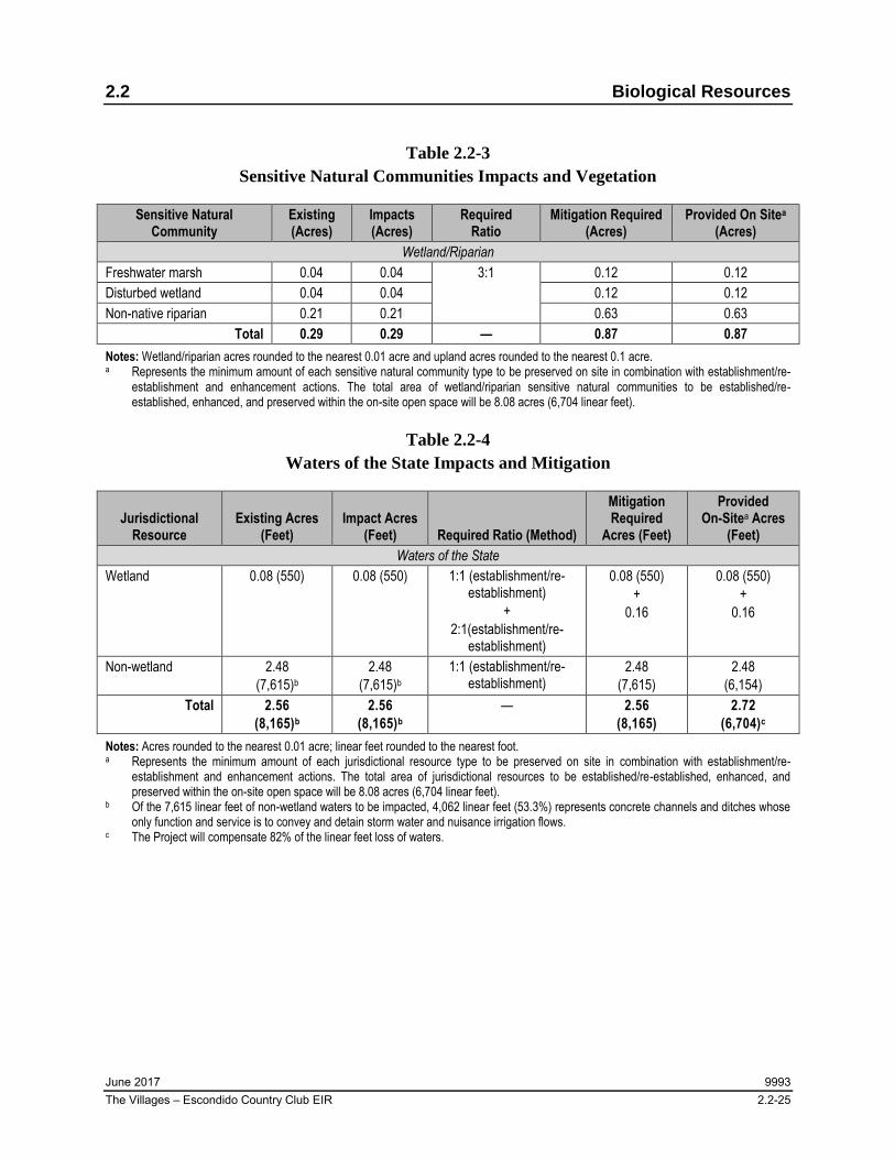
The Project site is characterized by disturbed and developed land associated with the former Escondido Country Club and golf course. Native and naturalized habitat is largely absent from the site, with the exception of the small stands of freshwater marsh, disturbed wetland, and non-native riparian in the eastern and southeastern portions of the site, which are considered sensitive natural communities. As summarized in Table 2.2-3, Sensitive Natural Communities Impacts and Vegetation, and illustrated in Figure 2.2-1, Vegetation Impacts, the Project would remove or permanently disturb 0.29 acres of sensitive natural communities. This would be a potentially
significant impact (Impact BI-2); see Section 2.2.5 for mitigation measures.
C. Would the Project have a substantial adverse effect on federally protected wetlands as
defined by Section 404 of the Clean Water Act (including, but not limited to, marsh,

2.2 Biological Resources
June 2017 9993 The Villages – Escondido Country Club EIR 2.2-18
vernal pool, coastal, etc.) through direct removal, filling, hydrological interruption, or
other means?
Several man-made drainage features and basins occur throughout portions of the Project site that were previously created for conveyance of stormwater and irrigation, as well as aesthetic water features for the former golf course. Water that flows through the network of these man-made features is largely controlled with small dikes, dams, pipes, and holding basins, all of which either terminate within uplands on the site or discharge into the existing storm drain or municipal separate storm sewer system for the site and surrounding developments. The features on the site are geographically isolated with no downstream connectivity to a navigable waterway due to their termination within uplands on site or the existing municipal separate storm sewer system. As such, the features would not qualify as waters of the United States as regulated by ACOE pursuant to Clean Water Act Section 404. Therefore, no impacts on federally protected wetlands would occur.
The isolated features would, however, qualify as isolated waters of the state subject to RWQCB jurisdiction and streambed and riparian habitat subject to CDFW jurisdiction. The Project would remove or permanently disturb 2.56 acres of these waters (see Table 2.2-4, Waters of the State Impacts and Mitigation; Table 2.2-5, Streambed and Riparian Impacts and Mitigation; Figure 2.2-2, Potential Waters of the State Impacts; and Figure 2.2-3, Potential CDFW Jurisdiction/Impacts), which would constitute a potentially significant impact (Impact BI-3). Projects in the region are required to meet a no-net-loss standard for both function and spatial area of wetland and non-wetland resources; see Section 2.2.5 for mitigation measures.
In addition, pursuant to regulatory requirements, the Project applicant would notify the RWQCB with a Report of Waste Discharge and obtain Waste Discharge Requirements to demonstrate compliance with the Porter-Cologne Water Quality Control Act. Also pursuant to regulatory requirements, the Project would notify the CDFW and, if required, obtain a Streambed Alteration Agreement to demonstrate compliance with the California Fish and Game Code. The Project would be required to implement any additional mitigation measures and permit conditions prescribed by the RWQCB and CDFW in permits.
D. Would the Project interfere substantially with the movement of any native resident or
migratory fish or wildlife species or with established native resident or migratory
wildlife corridors, or impede the use of native wildlife nursery sites?
The Project site is surrounded by existing development, and as such, does not by itself function as and does not contribute to any wildlife corridors or linkages. There is no wildlife, wildlife corridors, or wildlife movement on site. The Project incorporates a network of linear open space corridors to enhance existing disturbed drainages and riparian areas on site. Therefore,
2.2 Biological Resources
June 2017 9993 The Villages – Escondido Country Club EIR 2.2-19
the Project would not substantially interfere with the movement of any wildlife species or impede the use of nursery sites. Therefore, impacts associated with wildlife movement and nursery sites would be less than significant.
E. Would the Project conflict with any local policies or ordinances protecting biological
resources, such as a tree preservation policy or ordinance?
The Project site contains mature and protected trees subject to the mitigation requirements of Section 33-1069, Article 55 of Chapter 33 of the City’s Municipal Code; see Section 2.2.2.2, Regulatory Setting, under City of Escondido – Mature and Protected Tree Ordinance. The Project would result in unavoidable impacts to these trees, including up to 601 mature trees and 18 protected trees. In Appendix 2.2-1 of this EIR, a comprehensive inventory of protected and mature trees is included as Appendix G. Due to the unavoidable impacts on mature and protected trees, the Project would conflict with local policies or ordinances protecting biological resources, and impacts would be potentially significant (Impact BI-4).
F. Would the Project conflict with the provisions of an adopted Habitat Conservation
Plan, Natural Community Conservation Plan, or other approved local, regional, or
state habitat conservation plan?
The project site occurs within the boundaries of the North County Multiple Habitat Conservation Program (MHCP). The only Subarea Plan that has been approved and adopted within the North County MHCP is the City of Carlsbad MHCP Subarea Plan, also known as the Carlsbad Habitat Management Plan (HMP). The Project occurs within the boundaries of the Draft Escondido MHCP Subarea Plan, however it has not been approved or adopted.
Within the North County MHCP, the site is situated in areas identified as Developed/Disturbed Land, outside of areas targeted for conservation, including Focused Planning Area (FPA), Hardline Areas (90% to 100% Conservation), Softline Areas (Less than 90% Conservation), Hardline Preserves, Major Amendment Area, Natural Habitats (Outside of FPA), Core Gnatcatcher Conservation, Biological Core and Linkage Area (BCLA), and Edge Habitat. No suitable habitat for covered species or other resources targeted for conservation under the North County MHCP occurs on the Project site. As such, the Project is not proposed in any areas targeted for conservation and would not conflict with the provisions of the North County MHCP. No impact would occur.
Within the Draft Escondido MHCP Subarea Plan, the site also occurs in areas identified as Developed/Disturbed Land, outside of FPA, Hardline Areas (90% to 100% Conservation), Softline Areas (Less than 90% Conservation), Hardline Preserves, Natural Habitats (Outside of FPA), and BCLA. No suitable habitat for covered species and other resources targeted for

2.2 Biological Resources
June 2017 9993 The Villages – Escondido Country Club EIR 2.2-20
conservation under the Draft Escondido MHCP Subarea Plan occurs on the site. As such, the Project is not proposed in any areas targeted for conservation and would not conflict with the provisions or preclude the future implementation of the Draft Escondido MHCP Subarea Plan. Therefore, the Project does not conflict with any adopted Habitat Conservation Plan, Natural Conservation Community Plan, or other approved local, regional, or state habitat conservation plan, and no impact would occur.
2.2.3 Cumulative Impact Analysis
A cumulative study area for biological resources was identified based on the local environmental setting and areas that share similar biological resources as those determined to occur on the Project site. The cumulative study area includes the areas within 1.0 mile of the Project site that occur north of El Norte Parkway, south of Congressional Glen, east of Woodland Parkway, and west of the I-15. This study area is considered adequate based on the disturbed and developed nature of the Project site and immediate vicinity and overall lack of sensitive biological resources (see Appendix 2.2-1).
Special-Status Plant and Wildlife Species
As previously discussed, the Project has the potential to result in significant impacts to nesting birds; therefore, it could cumulatively contribute to an impact on these resources. Avoidance of nesting birds is a regulatory requirement for any project occurring within the cumulative study area. Nesting birds are protected under federal and state policy, including the MBTA and California Fish and Game Code, respectively. In complying with the MBTA and California Fish and Game Code, cumulative projects are required to restrict impacts on potential nesting habitat to periods when birds are not nesting (i.e., to periods that occur outside of regional breeding seasons). However, without the appropriate mitigation, in combination with other cumulative projects, the Project would potentially contribute to a cumulatively considerable impact to nesting birds (Impact BI-CUM-1); see Section 2.2.5, Mitigation.
Jurisdictional Waters and Wetlands
As previously discussed, potential significant impacts were identified at the project level for issues related to jurisdictional waters and wetlands. Pursuant to regulatory requirements, projects are required to notify the appropriate regulatory agencies and obtain the appropriate permits to demonstrate compliance with existing regulations protecting jurisdictional resources. The regulatory permitting process ensures that every project with unavoidable impacts on jurisdictional resources implements required avoidance, minimization, and compensatory mitigation measures and obtains the appropriate permits. Projects in the region are required to meet a no-net-loss standard for both function and spatial area of wetland and non-wetland

2.2 Biological Resources
June 2017 9993 The Villages – Escondido Country Club EIR 2.2-21
resources. However, without appropriate mitigation, the Project in combination with cumulative projects would potentially contribute to the cumulative impact to jurisdictional waters and wetlands (Impact BI-CUM-2); see Section 2.2.5 for mitigation measures.
Conflict with Local Policies or Ordinances Protecting Biological Resources
As previously described, the Project could result in significant impacts to mature and protected trees. Pursuant to regulatory requirements, projects in the City are required to compensate the loss of mature and protected trees. However, without the appropriate mitigation, the Project combined with other cumulative projects would potentially contribute to the cumulative impact to mature and protected trees (Impact BI-CUM-3); see Section 2.2.5 for mitigation.
2.2.4 Significance of Impacts Prior to Mitigation
Before mitigation, impacts to special-status species, riparian habitat or sensitive natural communities, and jurisdictional wetlands and waterways would be potentially significant.
Impact BI-1 Significant impacts to nesting birds could occur if suitable nesting habitat is removed during the general bird breeding season (January 15 to September 15).
Impact BI-2 The Project would impact approximately 0.29 acres of wetland/riparian sensitive natural communities.
Impact BI-3 The Project would impact approximately 2.56 acres of wetland and jurisdictional waters.
Impact BI-4 The Project would result in unavoidable impacts to up to 601 mature trees and 18 protected trees.
Impact BI-CUM-1 The Project would potentially contribute to a cumulatively considerable impact to nesting birds.
Impact BI-CUM-2 The Project would potentially contribute to a cumulatively considerable impact to jurisdictional waters and wetlands.
Impact BI-CUM-3 The Project would potentially contribute to a cumulatively considerable impact to mature and protected trees.

2.2 Biological Resources
June 2017 9993 The Villages – Escondido Country Club EIR 2.2-22
2.2.5 Mitigation
The following mitigation would reduce Impact BI-1 and Impact BI-CUM-1 to a level less than significant:
M-BI-1 Nesting Bird and Raptor Avoidance. If initial grading and vegetation removal activities (i.e., earthwork, clearing, and grubbing) must occur during the general bird breeding season for migratory birds and raptors (January 15 and September 15), the Project applicant shall retain a qualified biologist to perform a pre-construction survey of potential nesting habitat to confirm the absence of active nests belonging to migratory birds and raptors afforded protection under the Migratory Bird Treaty Act and California Fish and Game Code. The pre-construction survey shall be performed no more than 7 days before the start of the activities. If the qualified biologist determines that no active migratory bird or raptor nests occur, the activities shall be allowed to proceed without any further requirements. If the qualified biologist determines that an active migratory bird or raptor nest is present, no construction activities shall occur until the young have fledged the nest and the nest is confirmed to no longer be active, as determined by the qualified biologist.
The following mitigation would reduce Impact BI-2, Impact BI-3, and Impact BI-CUM-2 to a level less than significant:
M-BI-2 Restoration, Preservation, and Management of On-Site Open Space. The Project applicant shall prepare and submit to the City of Escondido (City) and/or other responsible agencies of the Project for approval a Restoration Plan for the establishment/reestablishment and enhancement of sensitive habitat within the Project’s open space. The Restoration Plan shall provide for replacement of impacted sensitive habitat, i.e., wetland/riparian sensitive natural communities and jurisdictional wetlands and waters in an amount to satisfy a no-net-loss standard for both function and spatial area of wetland and non-wetland resources. The Restoration Plan shall include 5 years of maintenance and monitoring to ensure the restoration effort is successful.
The Project applicant shall record a conservation easement, restrictive covenant, or other protective mechanism approved by the City and/or other responsible agencies of the Project over the establishment/reestablishment and enhancement areas. The conservation easement shall be included on final Project plans. The Project applicant shall prepare and submit to the City and/or other responsible agencies of the Project a Long-Term Management Plan for the on-site biological
2.2 Biological Resources
June 2017 9993 The Villages – Escondido Country Club EIR 2.2-23
conservation easement areas. The Long-Term Management Plan shall include area specific management directives for maintenance, monitoring, and management of the conservation easement areas in perpetuity.
The applicant shall also establish a non-wasting endowment for an amount approved by the City based on a Property Analysis Record or similar cost estimation method to secure the ongoing funding for the perpetual maintenance, monitoring, and management of the biological conservation easement area by an agency, non-profit organization, or other entity approved by the City. Upon approval of the draft Long-Term Management Plan, the applicant shall submit the final Long-Term Management Plan to the City and/or other responsible agencies of the Project and a contract with the approved land manager, as well as transfer the funds for the non-wasting endowment to a non-profit conservation entity.
The Project applicant shall install appropriate permanent fencing, along the boundary of the open space to discourage human access. The Project applicant shall also install signage on the fence to educate and inform the public about the open space and to prohibit access. The fencing shall be shown on all final Project plans.
The following mitigation would reduce Impact BI-4 and Impact BI-CUM-3 to a level less than significant:
M-BI-3 Mature and Protected Tree Replacement. The Project applicant shall replace impacted mature trees at a minimum 1:1 ratio, unless otherwise determined by the City. The Project applicant shall replace protected trees at a minimum 2:1 ratio, unless otherwise determined by the City. The number, size, and species of replacement trees shall be determined on a case-by-case basis by the City’s Director of Community Development.
2.2.6 Significance of Impacts After Mitigation
M-BI-1 would reduce Impact BI-1 and Impact BI-CUM-1 by ensuring that if an active migratory bird or raptor nest is identified, no construction activities shall occur until the young have fledged the nest and the nest is confirmed to no longer be active, as determined by the qualified biologist. Additionally, the Project would incorporate open space elements that would function as foraging habitat for raptors and other species. By avoiding migratory bird and raptor nests, and incorporating functional foraging habitats for raptors and other species, Impact BI-1 and Impact BI-CUM-1 would be reduced to less than significant.
By developing the Restoration Plan (M-BI-2), the Project would ensure that its impacts to 0.29 acres of wetland/riparian sensitive natural communities and 2.56 acres of wetland and waterways

2.2 Biological Resources
June 2017 9993 The Villages – Escondido Country Club EIR 2.2-24
would be offset by establishment of new, superior habitat to satisfy a no net loss standard for both function and spatial area of wetland and non-wetland resources. In fact, there would be a considerable net gain in wetland/riparian sensitive natural communities on the site compared to existing conditions, and the Project would result in a biologically superior condition compared what currently exists. Implementation of the Restoration Plan would reduce Impact BI-2, Impact BI-3, and Impact BI-CUM-2 to less than significant levels.
M-BI-3 would reduce Impact BI-4 and Impact BI-CUM-3 by replacing impacted mature trees at a minimum 1:1 ratio and replacing protected trees at a minimum 2:1 ratio, unless otherwise determined by the City. This would reduce Impact BI-4 and Impact BI-CUM-3 to less than significant.
With implementation of M-BI-1 through M-BI-3, all impacts associated with biological resources would be reduced to less than significant levels.
Table 2.2-1
Waters of the State
Jurisdictional Resource Area (acres) Length (feet) Wetland waters of the state 0.08 550
Non-wetland waters of the state 2.48 7,615
Total 2.56 8,165
Table 2.2-2
Streambed and Riparian Habitat
Jurisdictional Resource Area (Acres) Length (Feet) Riparian–Vegetated Streambed
Freshwater marsh 0.04 382
Disturbed wetland 0.04 168
Non-native riparian 0.21 1,154
Subtotal 0.29 1,704
Unvegetated Streambed
Man-made earthen channel 0.11 2,399
Man-made concrete channel 0.24 2,976
Man-made basin/pond 1.92 1,086
Subtotal 2.27 6,461
Total 2.56 8,165
2.2 Biological Resources
June 2017 9993 The Villages – Escondido Country Club EIR 2.2-25
Table 2.2-3
Sensitive Natural Communities Impacts and Vegetation
Sensitive Natural Community
Existing (Acres)
Impacts (Acres)
Required Ratio
Mitigation Required (Acres)
Provided On Sitea (Acres)
Wetland/Riparian
Freshwater marsh 0.04 0.04 3:1 0.12 0.12
Disturbed wetland 0.04 0.04 0.12 0.12
Non-native riparian 0.21 0.21 0.63 0.63
Total 0.29 0.29 — 0.87 0.87 Notes: Wetland/riparian acres rounded to the nearest 0.01 acre and upland acres rounded to the nearest 0.1 acre. a Represents the minimum amount of each sensitive natural community type to be preserved on site in combination with establishment/re-
establishment and enhancement actions. The total area of wetland/riparian sensitive natural communities to be established/re-established, enhanced, and preserved within the on-site open space will be 8.08 acres (6,704 linear feet).
Table 2.2-4
Waters of the State Impacts and Mitigation
Jurisdictional Resource
Existing Acres (Feet)
Impact Acres (Feet) Required Ratio (Method)
Mitigation Required
Acres (Feet)
Provided On-Sitea Acres
(Feet) Waters of the State
Wetland 0.08 (550) 0.08 (550) 1:1 (establishment/re-establishment)
+
2:1(establishment/re-establishment)
0.08 (550)
+
0.16
0.08 (550)
+
0.16
Non-wetland 2.48
(7,615)b
2.48
(7,615)b
1:1 (establishment/re-establishment)
2.48
(7,615)
2.48
(6,154)
Total 2.56 (8,165)b
2.56 (8,165)b
— 2.56 (8,165)
2.72 (6,704)c
Notes: Acres rounded to the nearest 0.01 acre; linear feet rounded to the nearest foot. a Represents the minimum amount of each jurisdictional resource type to be preserved on site in combination with establishment/re-
establishment and enhancement actions. The total area of jurisdictional resources to be established/re-established, enhanced, and preserved within the on-site open space will be 8.08 acres (6,704 linear feet).
b Of the 7,615 linear feet of non-wetland waters to be impacted, 4,062 linear feet (53.3%) represents concrete channels and ditches whose only function and service is to convey and detain storm water and nuisance irrigation flows.
c The Project will compensate 82% of the linear feet loss of waters.

2.2 Biological Resources
June 2017 9993 The Villages – Escondido Country Club EIR 2.2-26
Table 2.2-5
Streambed and Riparian Impacts and Mitigation
Jurisdictional Resource
Existing Acres (Feet)
Impact Acres (Feet)
Required Ratio (Method)
Mitigation Required
Acres (Feet)a
Provided On Siteb Acres
(Feet)b Riparian –Vegetated Streambed
Freshwater marsh 0.04 (382) 0.04 (382) 3:1
(establishment/re-establishment, restoration
/rehabilitation, enhancement, or
preservation)
0.12 (N/A) 0.12 (N/A)
Disturbed wetland 0.04 (168) 0.04 (168) 0.12 (N/A) 0.12 (N/A)
Non-native riparian
0.21 (1,154) 0.21 (1,154) 0.63 (N/A) 0.63 (N/A)
Subtotal 0.29 (1,704) 0.29 (1,704) — 0.87 (N/A) 0.87 (N/A)
Unvegetated Streambed
Man-made earthen channel
0.11 (2,399) 0.11 (2,399) 1:1
(establishment/re-establishment,
restoration/rehabilitation, enhancement, or
preservation)
0.11 (N/A) 0.11 (N/A)
Man-made concrete channel
0.24 (2,976) 0.24 (2,976)
None
— —
Man-made basin/pond
1.92 (1,086) 1.92 (1,086) — —
Subtotal 2.27 (6,461) 2.27 (6,461) — 0.11 (N/A) 0.11 (N/A)
Total 2.56 (8,165) 2.56 (8,165) — 0.98 (N/A) 0.98 (N/A) Note: Acres rounded to the nearest 0.01 acre; linear feet rounded to the nearest foot. a Mitigation for loss of linear feet not required. b Represents the minimum amount of each jurisdictional resource type to be preserved on site in combination with establishment/re-
establishment and enhancement actions. The total area of jurisdictional resources to be established/re-established, enhanced, and preserved within the on-site open space will be 8.08 acres (6,704 linear feet).

Vegetation ImpactsFIGURE 2.2-1
The Villages – Escondido Country Club EIR
SOURCE: RECON (2014), HELIX (2016)

2.2 Biological Resources
June 2017 9993 The Villages – Escondido Country Club EIR 2.2-28
INTENTIONALLY LEFT BLANK

Potential Waters of the State ImpactsFIGURE 2.2-2
The Villages – Escondido Country Club EIR
SOURCE: RECON (2014), HELIX (2016)

2.2 Biological Resources
June 2017 9993 The Villages – Escondido Country Club EIR 2.2-30
INTENTIONALLY LEFT BLANK

Potential CDFW Jurisdiction ImpactsFIGURE 2.2-3
The Villages – Escondido Country Club EIR
SOURCE: RECON (2014), HELIX (2016)

2.2 Biological Resources
June 2017 9993 The Villages – Escondido Country Club EIR 2.2-32
INTENTIONALLY LEFT BLANK