2020 pavement condition annual report
TRANSCRIPT
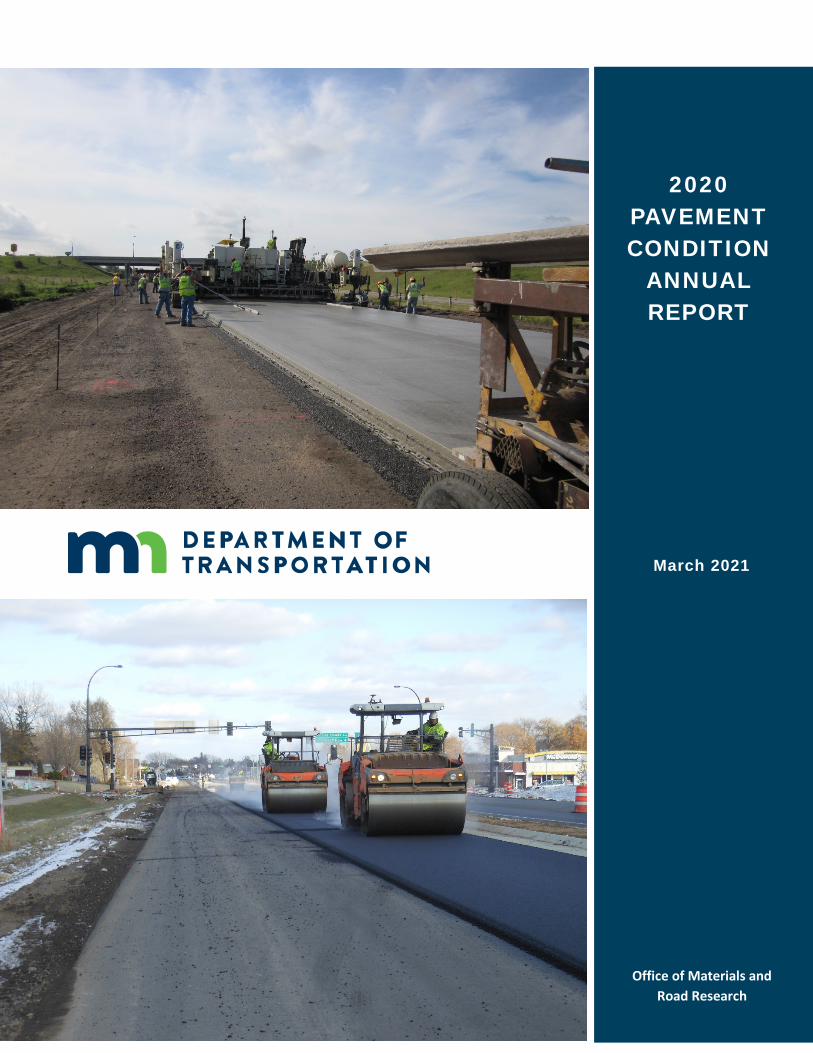
2020 PAVEMENT CONDITION
ANNUAL REPORT
March 2021
Office of Materials and Road Research
Pavement Management

Table of Contents
INTRODUCTION .................................................................................................................................. 1 BACKGROUND .................................................................................................................................... 1 DATA COLLECTION ............................................................................................................................. 1 INDICES AND MEASURES ................................................................................................................... 2 RQI: Ride Quality Index ................................................................................................................... 2 SR: Surface Rating ........................................................................................................................... 2 PQI: Pavement Quality Index .......................................................................................................... 3 RSL: Remaining Service Life ............................................................................................................. 3 PERFORMANCE CATEGORIES ............................................................................................................. 3 PERFORMANCE TARGETS .................................................................................................................. 4 STATEWIDE HISTORICAL RQI TRENDS ............................................................................................... 5 2011-2024 “Good” RQI Trend ........................................................................................................ 5 2011-2024 “Poor” RQI Trend ......................................................................................................... 5 RQI COMPARISON by ATP ................................................................................................................. 6 “Good” RQI Comparison................................................................................................................. 6 “Poor” RQI Comparison .................................................................................................................. 6 AVERAGE REMAINING SERVICE LIFE (ARSL) ...................................................................................... 7 2011-2020 ARSL Trend .................................................................................................................... 7 ARSL Comparison ............................................................................................................................ 7 PREDICTED PAVEMENT CONDITIONS AND ACCURACY .................................................................... 7 GOVERNMENT ACCOUNTING STANDARDS BOARD, STATEMENT 34 .............................................. 8 ADDITIONAL INFORMATION ............................................................................................................. 9
List of Tables
Table 1. Ride Quality Index (RQI) Performance Categories ........................................................................... 4 Table 2. Ride Quality Index (RQI) Targets by System .................................................................................... 4 Table 3. Comparison of Predicted 2020 and Actual 2020 RQI by System ..................................................... 8
List of Figures Figure 1. MnDOT’s Area Transportation Partnership (ATP) Boundaries .................................................. 10 Figure 2. Statewide “Good” Ride Quality Index, Actual 2011-2020, Predicted 2021-2024...................... 11 Figure 3. Statewide “Poor” Ride Quality Index, Actual 2011-2020, Predicted 2021-2024 ....................... 12 Figure 4. “Good” Ride Quality Index, Comparison of 2020 Data by ATP .................................................. 13 Figure 5. “Poor” Ride Quality Index, Comparison of 2020 Data by ATP .................................................... 14 Figure 6. Interstate System 2019 versus 2020 “Good” Ride Quality Index ............................................... 15 Figure 7. Other-NHS System 2019 versus 2020 “Good” Ride Quality Index ............................................. 16 Figure 8. Non-NHS System 2019 versus 2020 “Good” Ride Quality Index ................................................ 17 Figure 9. Interstate System 2019 versus 2020 “Poor” Ride Quality Index ................................................ 18 Figure 10. Other-NHS System 2019 versus 2020 “Poor” Ride Quality Index .............................................. 19 Figure 11. Non-NHS System 2019 versus 2020 “Poor” Ride Quality Index ................................................. 20 Figure 12. Statewide Average Remaining Service Life, 2011-2020 ............................................................. 21 Figure 13. Average Remaining Service Life, Comparison of 2020 Data by ATP .......................................... 22 Figure 14. Statewide Average Pavement Quality Index (PQI) for GASB 34 Reporting ................................ 23
1
INTRODUCTION
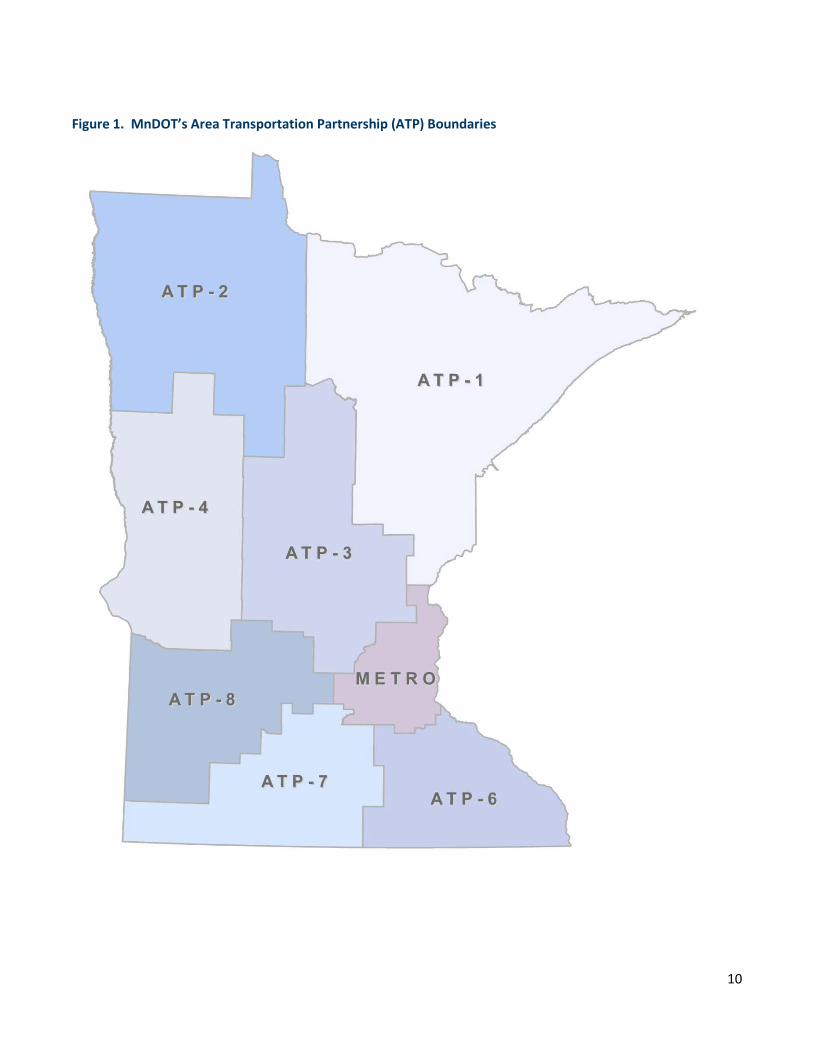
This report is prepared annually by the Minnesota Department of Transportation (MnDOT) Pavement Management Unit to provide information concerning trunk highway pavement performance. It discusses statewide performance trends compared with established targets and compares performance between the eight Area Transportation Partnerships (ATP).
BACKGROUND
MnDOT’s trunk highway system consists of approximately 12,000 centerline miles (14,300 roadway miles) of pavement. This system consists of bituminous, concrete, and composite pavement with a wide range of conditions, ages, and performance. Each year, the Pavement Management Unit collects pavement roughness and digital image data on the entire trunk highway system, in both directions, and calculates several different metrics related to pavement performance. Condition data has been collected on the trunk highway network since the late 1960s.
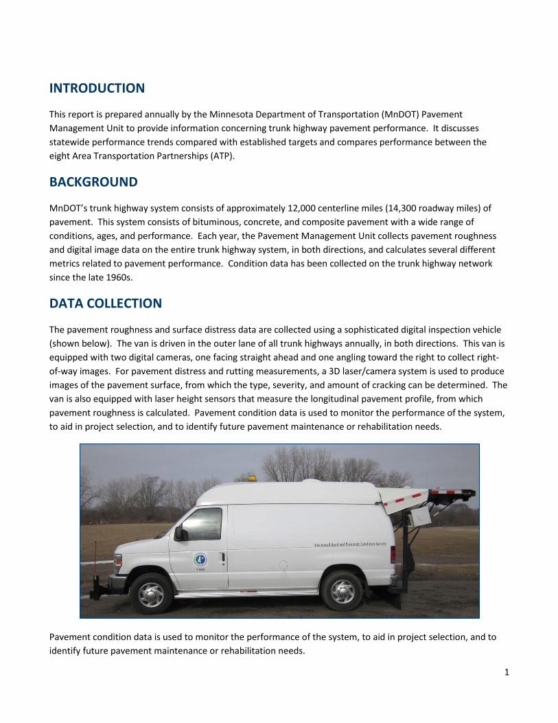
DATA COLLECTION
The pavement roughness and surface distress data are collected using a sophisticated digital inspection vehicle (shown below). The van is driven in the outer lane of all trunk highways annually, in both directions. This van is equipped with two digital cameras, one facing straight ahead and one angling toward the right to collect right-of-way images. For pavement distress and rutting measurements, a 3D laser/camera system is used to produce images of the pavement surface, from which the type, severity, and amount of cracking can be determined. The van is also equipped with laser height sensors that measure the longitudinal pavement profile, from which pavement roughness is calculated. Pavement condition data is used to monitor the performance of the system, to aid in project selection, and to identify future pavement maintenance or rehabilitation needs.
Pavement condition data is used to monitor the performance of the system, to aid in project selection, and to identify future pavement maintenance or rehabilitation needs.
2
INDICES AND MEASURES
MnDOT’s pavement condition data is reduced to several indices for reporting the statewide pavement performance measures in MnDOT’s 20-year Transportation Plan: Ride Quality Index (RQI), Surface Rating (SR), Pavement Quality Index (PQI), and Remaining Service Life (RSL). Each index captures a different aspect of the pavement’s health and can be used to rank pavement sections and predict the need for future maintenance and rehabilitation. They are each briefly described below.
RQI: Ride Quality Index
The RQI is MnDOT’s ride, or smoothness, index. It uses a zero to five rating scale, rounded to the nearest tenth. The higher the RQI, the smoother the road is. The RQI is intended to represent the rating that a typical road user would give to the pavement’s smoothness as felt while driving his/her vehicle. Most new construction projects have an initial RQI above 4.0. Pavements are normally designed for a terminal RQI value of 2.5. When a road has reached its terminal RQI value it does not mean the road cannot be driven on, but rather that it has deteriorated to the point where most people feel it is uncomfortable and a major rehabilitation is likely needed.
The RQI is calculated from the pavement’s longitudinal profile, measured by the front mounted lasers on the digital inspection vehicle. A mathematical simulation, called the International Roughness Index (IRI), is then run to estimate the amount of vertical movement a standard vehicle would experience if driven down the road. The IRI is the roughness index used by every state DOT in the U.S. as well as most countries in the world. In the past, MnDOT has taken a rating panel of 30 to 40 people into the field and driven them over hundreds of test sections to get their perception of the smoothness of various pavement sections. Following right behind them was the digital inspection vehicle. This provides us with a direct correlation between the IRI, as measured by the van, and the perceived roughness, as felt by the rating panel.
SR: Surface Rating
Pavement distresses are those defects visible on the pavement surface. They are symptoms, indicating some problem or phenomenon of pavement deterioration such as cracks, patches, and ruts. The type and severity of distress a pavement has can provide great insight into what the future maintenance and/or rehabilitation needs will be.
MnDOT uses the SR to quantify pavement distress. The distress identification procedure used to determine the SR is done using computer workstations in the Pavement Management Unit of the Office of Materials and Road Research, located in Maplewood, MN. Specialized software is used to examine and analyze the digital images of the pavement captured by the van. The van captures several images simultaneously: front, side, and down.
Since 2017, condition surveys have been done using the AutoCrack system. The AutoCrack software looks at 3D images of the pavement surface and determines if any cracks or other distresses exist. If so, it then determines the location within the lane and also classifies distress by type and severity, and calculates length and/or width. A second system, called AutoClass, is then used to convert the AutoCrack distress types and severities into MnDOT distress types and severities. Because the system is automated, continuous distress surveys covering 100% of the length of each section are done. On undivided roadways, only the outside lane in the increasing
3
direction (north or east) is rated when the SR is measured. On divided routes, the outside lane in both directions is rated.
The percentage of each distress in the section is determined and multiplied by a weighting factor to get a weighted distress value. The weighting factors are greater for higher severity levels of the same distress and greater for distress types that indicate more serious problems exist in the roadway such as alligator cracking or broken panels. The weighted distresses are then combined to determine the SR. The SR ranges from 0.0 to 4.0 and is rounded to the nearest tenth. A higher SR means better condition. A road with no defects is rated at 4.0. A road in need of major rehabilitation or reconstruction will generally have an SR near or below 2.5.
PQI: Pavement Quality Index
The PQI is a composite index, equal to the square root of the product of RQI and SR. As such, it gives an overall indication of the condition of the pavement, taking into account both the pavement smoothness and cracking. The PQI is the index used to determine if the state highway system is meeting performance thresholds established for the Government Accounting Standards Board, Standard 34 (GASB 34).
RSL: Remaining Service Life
The RSL is an estimate, in years, until the RQI will reach a value of 2.5, which is generally considered the end of a pavement’s design life. Most pavements will need some type of major rehabilitation when the RQI has reached this value. The RSL is determined from pavement deterioration curves. A regression curve is fit through the historical RQI data for each pavement section and the year the RQI will reach 2.5 is estimated. If there is insufficient historical data to make this calculation, default models, based on statewide pavement performance, are used. Rehabilitation activities with long service lives will add a considerable number of years to the RSL of a pavement. Short-term fixes, such as patching, may increase the pavement smoothness for a short time, but do not result in many additional years of RSL.
Each year, the RSL is calculated for all highway segments. From these values, a length-weighted Average Remaining Service Life (ARSL) is calculated for the entire trunk highway system as well as for each ATP. Service life is added when some type of maintenance or rehabilitation is done on a pavement section. Service life is lost when the condition of a pavement section deteriorates due to aging. The ARSL of the highway system increases if the projects being done add more life to the system than the sum of the deterioration of all the other sections.
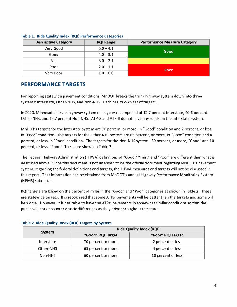
PERFORMANCE CATEGORIES
MnDOT currently categorizes pavement condition, as measured by the RQI, into five equal categories as shown in Table 1. When reporting performance measures, the top two and bottom two categories are combined and referred to as “Good” and “Poor,” respectively. These terms will be used for the remainder of this report.
4
Table 1. Ride Quality Index (RQI) Performance Categories Descriptive Category RQI Range Performance Measure Category
Very Good 5.0 – 4.1 Good
Good 4.0 – 3.1 Fair 3.0 – 2.1 Poor 2.0 – 1.1
Poor Very Poor 1.0 – 0.0
PERFORMANCE TARGETS
For reporting statewide pavement conditions, MnDOT breaks the trunk highway system down into three systems: Interstate, Other-NHS, and Non-NHS. Each has its own set of targets.
In 2020, Minnesota’s trunk highway system mileage was comprised of 12.7 percent Interstate, 40.6 percent Other-NHS, and 46.7 percent Non-NHS. ATP-2 and ATP-8 do not have any roads on the Interstate system.
MnDOT’s targets for the Interstate system are 70 percent, or more, in “Good” condition and 2 percent, or less, in “Poor” condition. The targets for the Other-NHS system are 65 percent, or more, in “Good” condition and 4 percent, or less, in “Poor” condition. The targets for the Non-NHS system: 60 percent, or more, “Good” and 10 percent, or less, “Poor.” These are shown in Table 2.
The Federal Highway Administration (FHWA) definitions of “Good,” “Fair,” and “Poor” are different than what is described above. Since this document is not intended to be the official document regarding MnDOT’s pavement system, regarding the federal definitions and targets, the FHWA measures and targets will not be discussed in this report. That information can be obtained from MnDOT’s annual Highway Performance Monitoring System (HPMS) submittal.
RQI targets are based on the percent of miles in the “Good” and “Poor” categories as shown in Table 2. These are statewide targets. It is recognized that some ATPs’ pavements will be better than the targets and some will be worse. However, it is desirable to have the ATPs’ pavements in somewhat similar conditions so that the public will not encounter drastic differences as they drive throughout the state.
Table 2. Ride Quality Index (RQI) Targets by System
System Ride Quality Index (RQI)
“Good” RQI Target “Poor” RQI Target Interstate 70 percent or more 2 percent or less
Other-NHS 65 percent or more 4 percent or less
Non-NHS 60 percent or more 10 percent or less
5
STATEWIDE HISTORICAL RQI TRENDS
In 2020, the smoothness of the state highway system improved considerably, with 896 more miles in the “Good” category and 306 fewer miles in the “Poor” category, compared to 2019. By far, the biggest improvement was on the Non-NHS system.
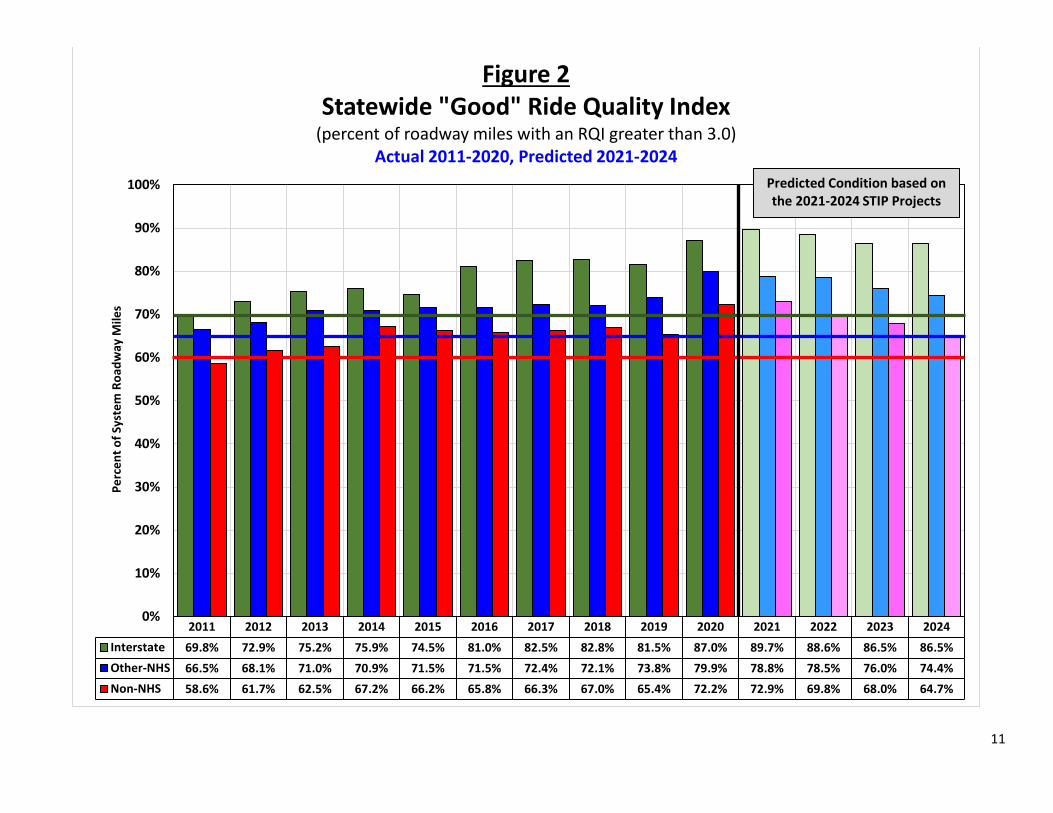
2011-2024 “Good” RQI Trend (Figure 2)
The percent of statewide miles in “Good” condition increased from 70.9 percent in 2019 to 77.2 percent in 2020. The Interstate system improved from 81.5 percent to 87.0 percent, the Other-NHS system improved from 73.8 percent to 79.9 percent and the Non-NHS system improved from 65.4 percent to 72.2 percent. In 2020 there were 11,029 roadway miles in “Good” condition, 896 more than there were in 2019.
Based on the pavement projects listed in the 2021-2024 State Transportation Improvement Program (STIP), the percent of miles in “Good” condition is expected to decline on all three systems. The Interstate system is expected to decline from 87.0 percent to 86.5 percent in 2024. The Other-NHS system is expected to decline from 79.9 percent to 74.4 percent. The Non-NHS system is expected to decline the most, from 72.2 percent to 64.7 percent. This results in an overall expected decrease of 1,105 miles of “Good” road over the next four years.
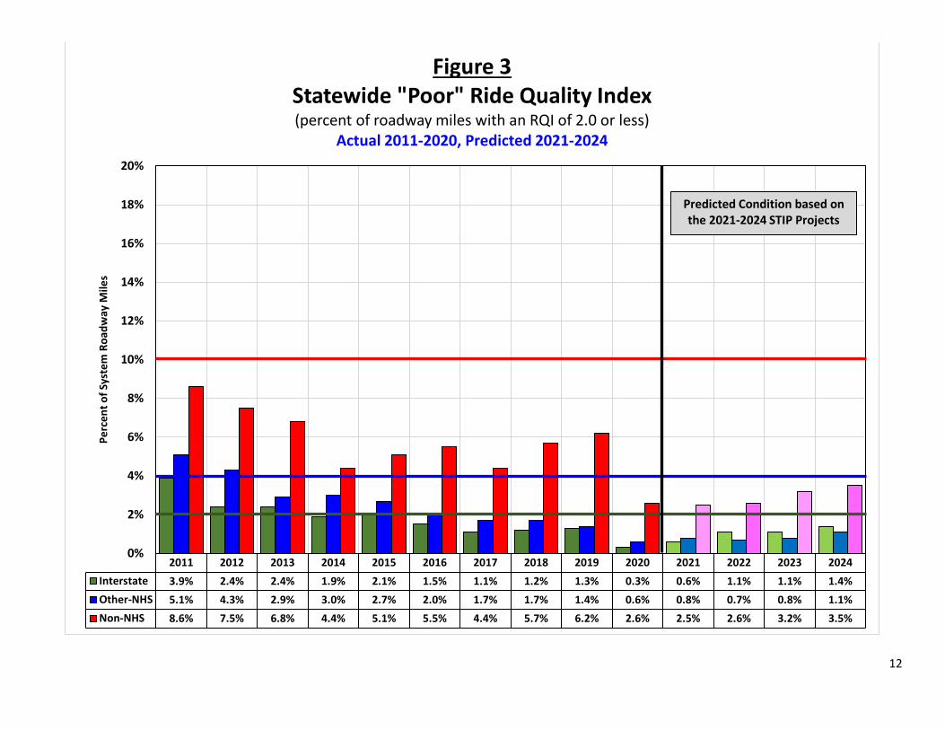
2011-2024 “Poor” RQI Trend (Figure 3)
The percent of statewide miles in “Poor” condition decreased from 3.6 percent in 2019 to 1.5 percent in 2020. The Interstate system had 0.3 percent “Poor,” compared to 1.3 percent in 2019. The Other-NHS system improved with a decrease in “Poor” from 1.4 percent to 0.6 percent. The Non-NHS system had the largest reduction in “Poor,” from 6.2 percent to 2.6 percent. In 2020 there were 215 roadway miles in “Poor” condition, 306 fewer miles than there were in 2019.
Based on the pavement projects listed in the 2021-2024 STIP, all three systems are expected to worsen and have an increase in the percent of miles in “Poor” condition over the next four years. The Interstate system is expected to increase from 0.3 percent “Poor” to 1.4 percent. The Other-NHS system is expected increase from 0.6 percent to 1.1 percent. The Non-NHS system is expected to increase from 2.6 percent to 3.5 percent. This results in an overall expected increase of 155 miles of “Poor” road over the next four years.
Once a pavement falls into the “Poor” category, it normally will require major rehabilitation or reconstruction to restore any meaningful amount of service life. These types of repairs are expensive, thus making it much harder with a limited budget to recover once the number of miles in this condition becomes very high.
6
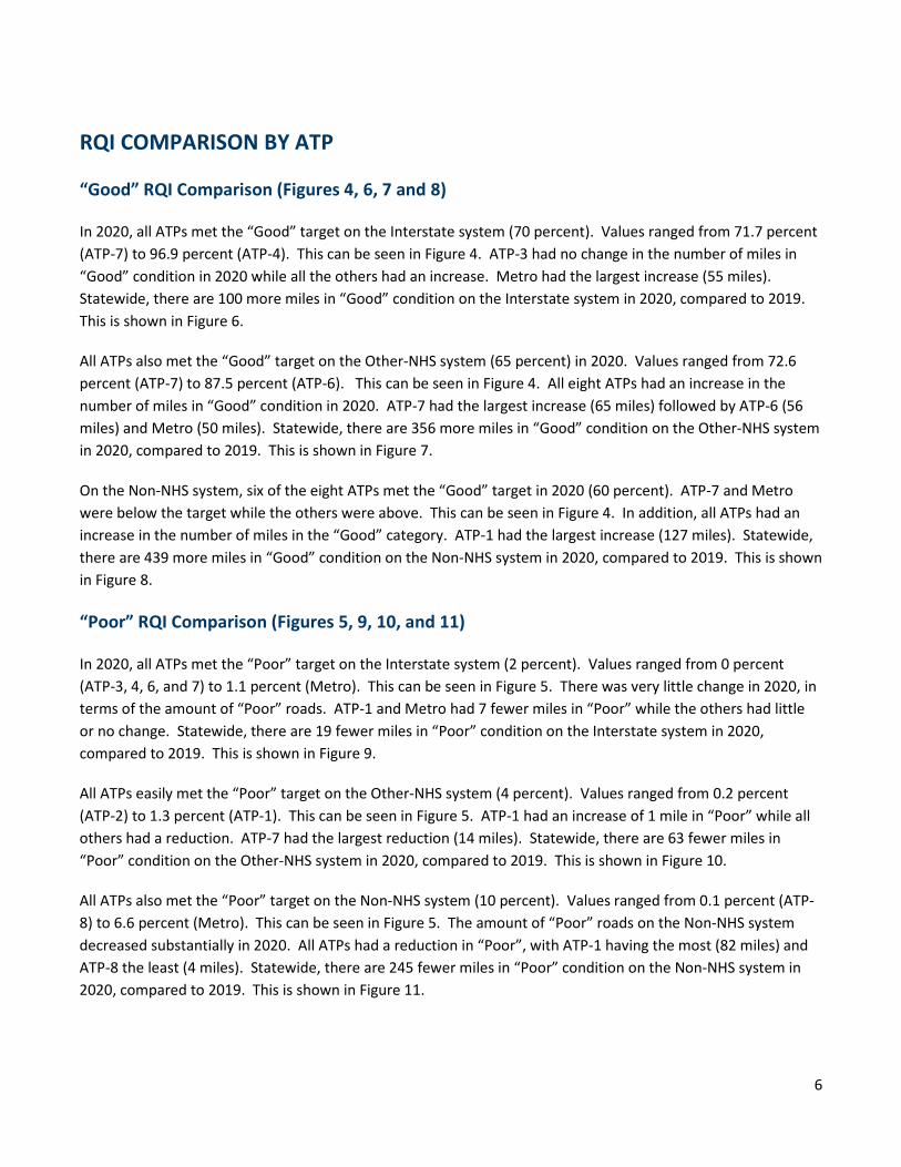
RQI COMPARISON BY ATP
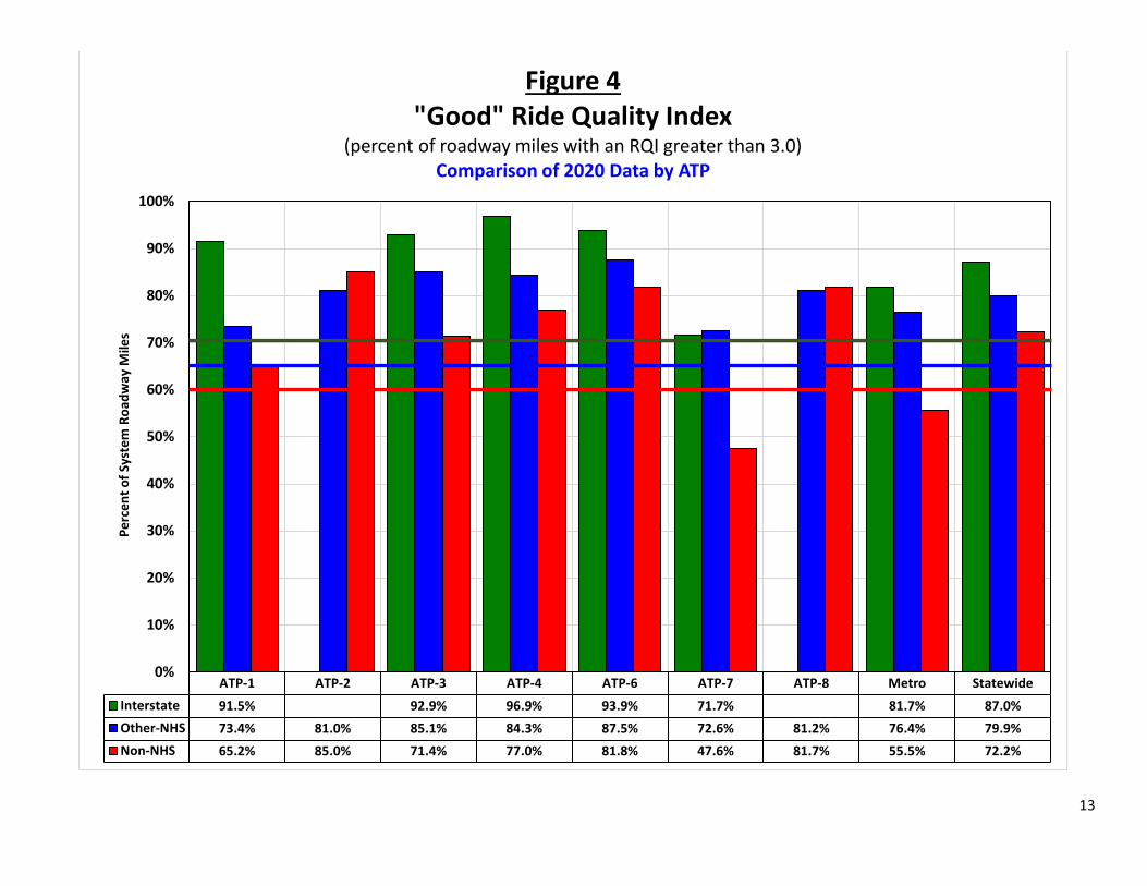
“Good” RQI Comparison (Figures 4, 6, 7 and 8)
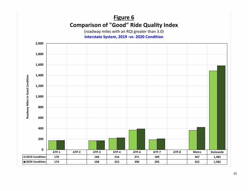
In 2020, all ATPs met the “Good” target on the Interstate system (70 percent). Values ranged from 71.7 percent (ATP-7) to 96.9 percent (ATP-4). This can be seen in Figure 4. ATP-3 had no change in the number of miles in “Good” condition in 2020 while all the others had an increase. Metro had the largest increase (55 miles). Statewide, there are 100 more miles in “Good” condition on the Interstate system in 2020, compared to 2019. This is shown in Figure 6.
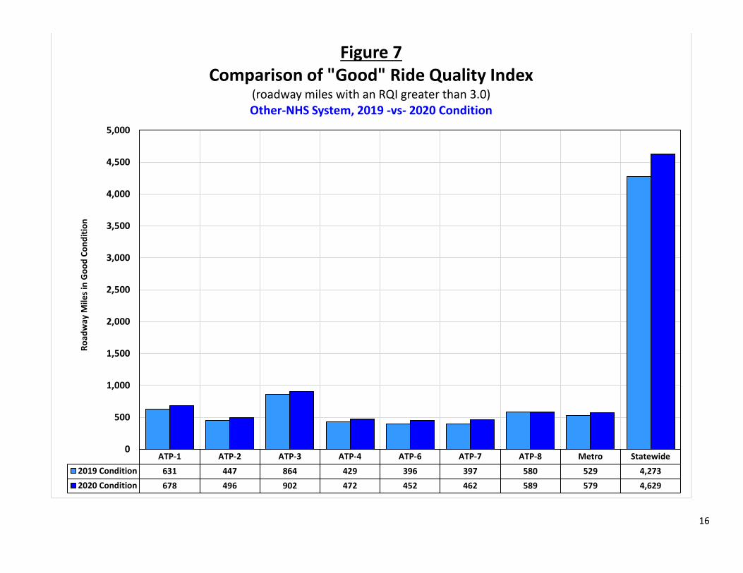
All ATPs also met the “Good” target on the Other-NHS system (65 percent) in 2020. Values ranged from 72.6 percent (ATP-7) to 87.5 percent (ATP-6). This can be seen in Figure 4. All eight ATPs had an increase in the number of miles in “Good” condition in 2020. ATP-7 had the largest increase (65 miles) followed by ATP-6 (56 miles) and Metro (50 miles). Statewide, there are 356 more miles in “Good” condition on the Other-NHS system in 2020, compared to 2019. This is shown in Figure 7.
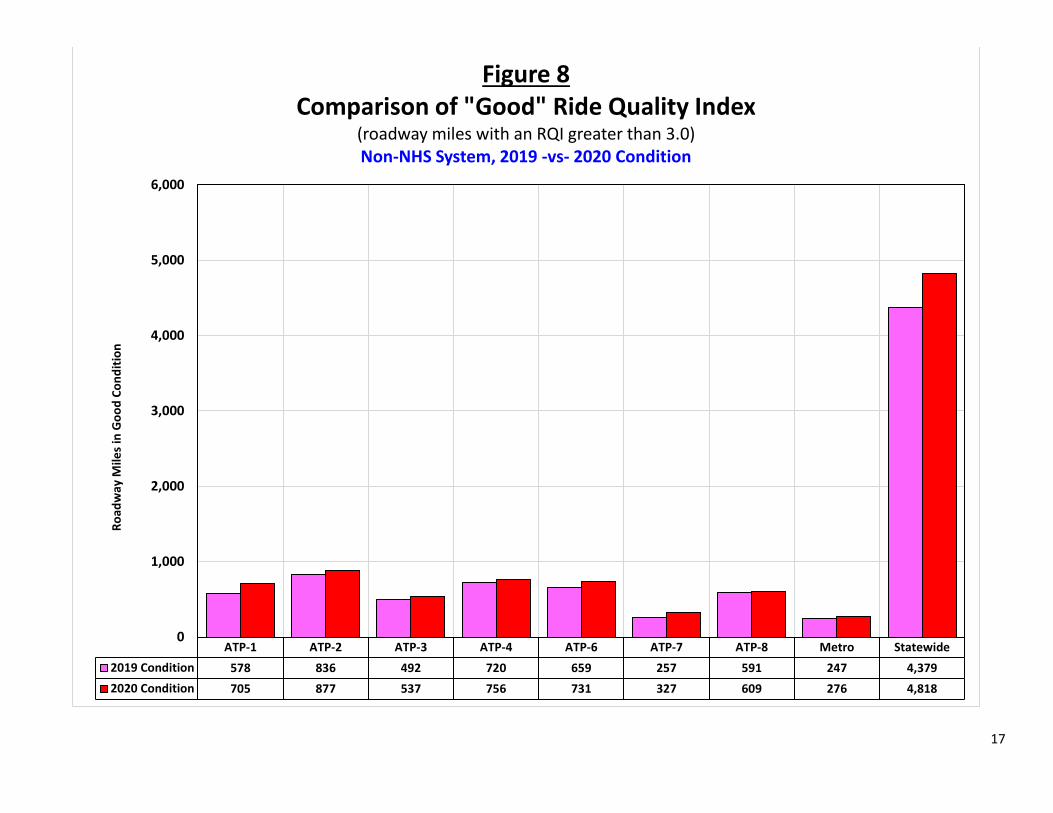
On the Non-NHS system, six of the eight ATPs met the “Good” target in 2020 (60 percent). ATP-7 and Metro were below the target while the others were above. This can be seen in Figure 4. In addition, all ATPs had an increase in the number of miles in the “Good” category. ATP-1 had the largest increase (127 miles). Statewide, there are 439 more miles in “Good” condition on the Non-NHS system in 2020, compared to 2019. This is shown in Figure 8.
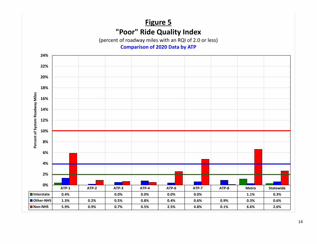
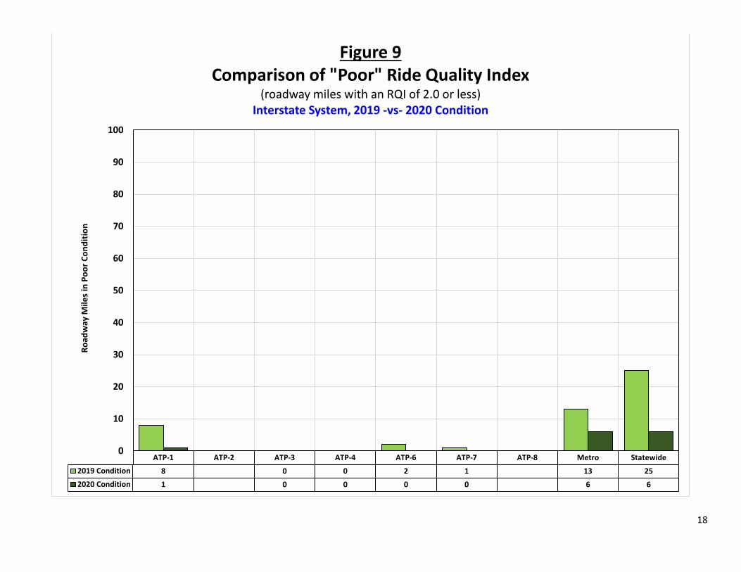
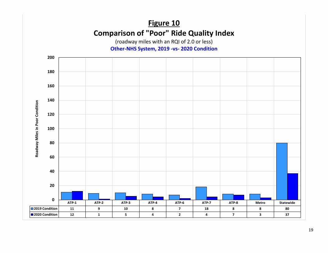
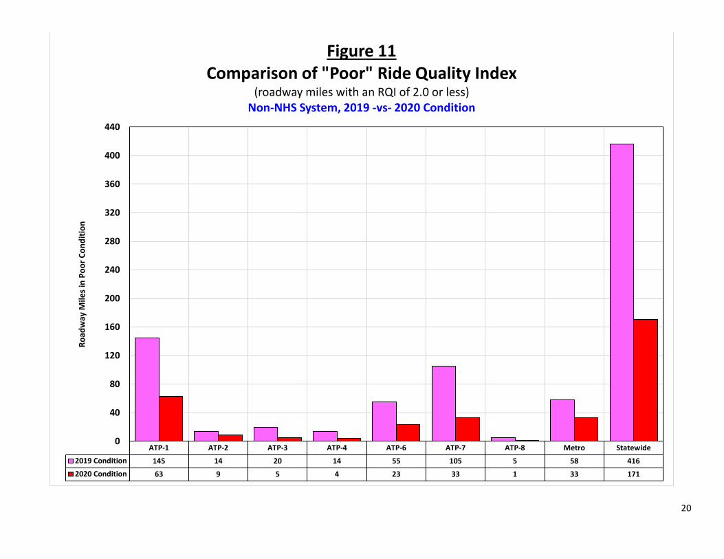
“Poor” RQI Comparison (Figures 5, 9, 10, and 11)
In 2020, all ATPs met the “Poor” target on the Interstate system (2 percent). Values ranged from 0 percent (ATP-3, 4, 6, and 7) to 1.1 percent (Metro). This can be seen in Figure 5. There was very little change in 2020, in terms of the amount of “Poor” roads. ATP-1 and Metro had 7 fewer miles in “Poor” while the others had little or no change. Statewide, there are 19 fewer miles in “Poor” condition on the Interstate system in 2020, compared to 2019. This is shown in Figure 9.
All ATPs easily met the “Poor” target on the Other-NHS system (4 percent). Values ranged from 0.2 percent (ATP-2) to 1.3 percent (ATP-1). This can be seen in Figure 5. ATP-1 had an increase of 1 mile in “Poor” while all others had a reduction. ATP-7 had the largest reduction (14 miles). Statewide, there are 63 fewer miles in “Poor” condition on the Other-NHS system in 2020, compared to 2019. This is shown in Figure 10.
All ATPs also met the “Poor” target on the Non-NHS system (10 percent). Values ranged from 0.1 percent (ATP-8) to 6.6 percent (Metro). This can be seen in Figure 5. The amount of “Poor” roads on the Non-NHS system decreased substantially in 2020. All ATPs had a reduction in “Poor”, with ATP-1 having the most (82 miles) and ATP-8 the least (4 miles). Statewide, there are 245 fewer miles in “Poor” condition on the Non-NHS system in 2020, compared to 2019. This is shown in Figure 11.
7
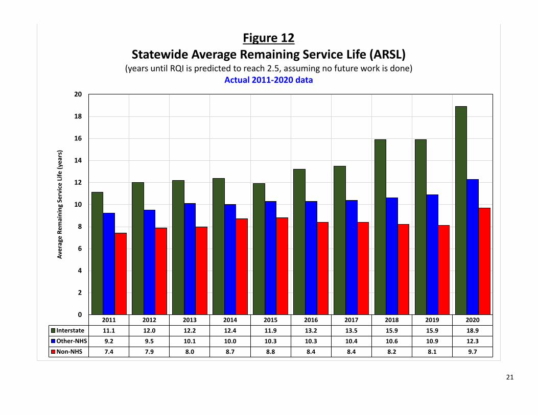
AVERAGE REMAINING SERVICE LIFE (ARSL)
The Average Remaining Service Life (ARSL) is defined as the number of years until the RQI reaches a value of 2.5 or less. This is the point where most people begin to complain that a road’s roughness is objectionable and some type of major rehabilitation is likely needed.
2011-2020 ARSL Trend (Figure 12)
The 2020 ARSL was 18.9 years on the Interstate system, 12.3 years on the Other-NHS system, and 9.7 years on the Non-NHS, all improvements over last year. The ARSL of the Interstate system increased the most, from 15.9 years to 18.9 years, its highest level ever. The ARSL of the Other-NHS system increased from 10.9 years to 12.3 years while the Non-NHS system increased from 8.1 years to 9.7 years. This is shown in Figure 12.
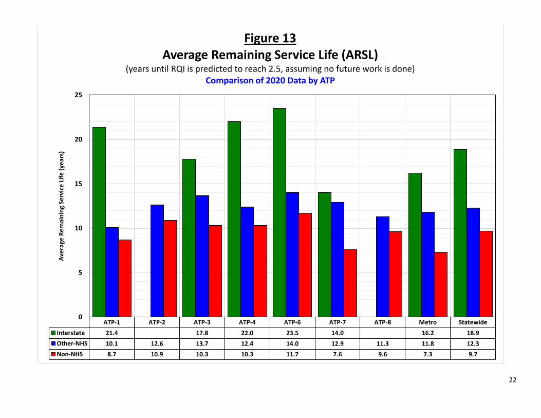
ARSL Comparison (Figure 13)
By ATP, the ARSL of the Interstate system ranges from 14.0 years (ATP-7) to 23.5 years (ATP-6). The ARSL of the Other-NHS system ranges from 10.1 years (ATP-1) to 14.0 years (ATP-6). The ARSL of the Non-NHS system ranges from 7.3 (Metro) to 11.7 (ATP-6). This is shown in Figure 13.
PREDICTED PAVEMENT CONDITIONS AND ACCURACY
Future pavement conditions are predicted using the pavement management system. These predictions are used to provide managers with insight into the impact different funding scenarios will have on pavement conditions. The accuracy of these predictions is reviewed yearly to reassure management that the pavement management system is operating correctly, therefore making it a reliable tool for predicting future needs.
The prediction of future pavement conditions relies on regression curves built into the pavement management system. The curves are either based on section specific historical data or statewide data. If there is adequate historical data since the last rehabilitation on a section, a regression curve is fit through the data and used to predict the RQI. If there is inadequate historical data for the section, or if the regression through the historical data results in an unrealistic curve, then a default curve is used to predict the future RQI. Default curves were developed for all pavement fixes in the pavement management system in the mid-1980s and subsequently updated in 1992 and 2008. The default curves are based on historical statewide performance. For pavement sections scheduled for work during the STIP, default regression curves are used to predict future conditions.
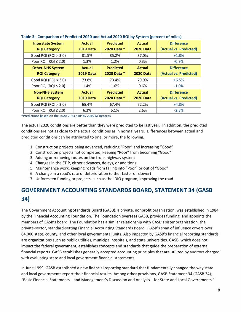
Table 3 compares the predicted 2020 pavement conditions, using last year’s data, with the actual 2020 measured conditions.
8
Table 3. Comparison of Predicted 2020 and Actual 2020 RQI by System (percent of miles) Interstate System
RQI Category Actual
2019 Data Predicted
2020 Data * Actual
2020 Data Difference
(Actual vs. Predicted) Good RQI (RQI > 3.0) 81.5% 85.2% 87.0% +1.8% Poor RQI (RQI ≤ 2.0) 1.3% 1.2% 0.3% -0.9% Other-NHS System
RQI Category Actual
2019 Data Predicted
2020 Data * Actual
2020 Data Difference
(Actual vs. Predicted) Good RQI (RQI > 3.0) 73.8% 73.4% 79.9% +6.5% Poor RQI (RQI ≤ 2.0) 1.4% 1.6% 0.6% -1.0%
Non-NHS System RQI Category
Actual 2019 Data
Predicted 2020 Data *
Actual 2020 Data
Difference (Actual vs. Predicted)
Good RQI (RQI > 3.0) 65.4% 67.4% 72.2% +4.8% Poor RQI (RQI ≤ 2.0) 6.2% 5.1% 2.6% -2.5%
*Predictions based on the 2020-2023 STIP by 2019 M-Records
The actual 2020 conditions are better than they were predicted to be last year. In addition, the predicted conditions are not as close to the actual conditions as in normal years. Differences between actual and predicted conditions can be attributed to one, or more, the following.
1. Construction projects being advanced, reducing “Poor” and increasing “Good” 2. Construction projects not completed, keeping “Poor” from becoming “Good” 3. Adding or removing routes on the trunk highway system 4. Changes in the STIP, either advances, delays, or additions 5. Maintenance work, keeping roads from falling into “Poor” or out of “Good” 6. A change in a road’s rate of deterioration (either faster or slower) 7. Unforeseen funding or projects, such as the IDIQ program, improving the road
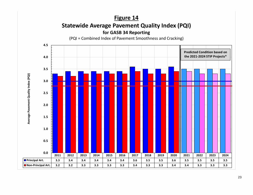
GOVERNMENT ACCOUNTING STANDARDS BOARD, STATEMENT 34 (GASB 34)
The Government Accounting Standards Board (GASB), a private, nonprofit organization, was established in 1984 by the Financial Accounting Foundation. The Foundation oversees GASB, provides funding, and appoints the members of GASB’s board. The Foundation has a similar relationship with GASB’s sister organization, the private-sector, standard-setting Financial Accounting Standards Board. GASB’s span of influence covers over 84,000 state, county, and other local governmental units. Also impacted by GASB’s financial reporting standards are organizations such as public utilities, municipal hospitals, and state universities. GASB, which does not impact the federal government, establishes concepts and standards that guide the preparation of external financial reports. GASB establishes generally accepted accounting principles that are utilized by auditors charged with evaluating state and local government financial statements.
In June 1999, GASB established a new financial reporting standard that fundamentally changed the way state and local governments report their financial results. Among other provisions, GASB Statement 34 (GASB 34), “Basic Financial Statements—and Management’s Discussion and Analysis—for State and Local Governments,”
9
requires that major infrastructure assets acquired or having major additions or improvements in fiscal years beginning after June 15, 1980, be capitalized in financial statements. In addition, the cost of using the assets must be reflected. Source: U.S. Department of Transportation, Federal Highway Administration, Office of Asset Management, Primer: GASB 34 (November 2002).
One of the primary purposes of GASB 34 is to demonstrate to the public, and others, that the agency is maintaining its infrastructure in an acceptable condition and does not have any undisclosed liabilities looming in the future.
In terms of determining the cost of using the assets, GASB 34 allows governments to report either a depreciation expense or to apply an alternative modified/preservation approach. Governments may use the modified approach in lieu of depreciating their assets if they have a systematic approach to managing their assets that, at a minimum, meets the following four requirements:
• Having a current inventory of eligible assets • Documenting the condition of those assets via a reproducible assessment procedure • Demonstrating that assets are being preserved at a level predetermined by the government • Estimating the actual cost to maintain and preserve the assets.
MnDOT has chosen to use the modified/preservation approach since it can meet all the requirements listed above. For the purposes of GASB 34, MnDOT established that the state highway system will be maintained, at a minimum, at the following levels.
• Principal Arterial System: Average PQI of 3.0 or higher • Non-Principal Arterial System: Average PQI of 2.8 or higher
Figure 14 shows how actual and predicted pavement conditions, based on the 2021-2024 STIP, compare with the established GASB 34 levels.
As shown in Figure 14, both the PA and NPA systems are expected to be safely above the GASB 34 minimum thresholds throughout the entire STIP.
ADDITIONAL INFORMATION
Additional information about the condition and performance of the state highway system, including color-coded maps of the most recent indices, can be obtained from the Pavement Management Unit’s website: http://www.dot.state.mn.us/materials/pvmtmgmt.html
Or by contacting:
David Janisch, Pavement Management Engineer MnDOT Office of Materials and Road Research 1400 Gervais Avenue, Mailstop 645 Maplewood, MN 55109 (651) 366-5567 [email protected]
10
Figure 1. MnDOT’s Area Transportation Partnership (ATP) Boundaries
11
2011 2012 2013 2014 2015 2016 2017 2018 2019 2020 2021 2022 2023 2024Interstate 69.8% 72.9% 75.2% 75.9% 74.5% 81.0% 82.5% 82.8% 81.5% 87.0% 89.7% 88.6% 86.5% 86.5%Other-NHS 66.5% 68.1% 71.0% 70.9% 71.5% 71.5% 72.4% 72.1% 73.8% 79.9% 78.8% 78.5% 76.0% 74.4%Non-NHS 58.6% 61.7% 62.5% 67.2% 66.2% 65.8% 66.3% 67.0% 65.4% 72.2% 72.9% 69.8% 68.0% 64.7%
0%
10%
20%
30%
40%
50%
60%
70%
80%
90%
100%
Perc
ent o
f Sys
tem
Roa
dway
Mile
s
Figure 2Statewide "Good" Ride Quality Index
(percent of roadway miles with an RQI greater than 3.0)Actual 2011-2020, Predicted 2021-2024
Predicted Condition based on the 2021-2024 STIP Projects
12
2011 2012 2013 2014 2015 2016 2017 2018 2019 2020 2021 2022 2023 2024Interstate 3.9% 2.4% 2.4% 1.9% 2.1% 1.5% 1.1% 1.2% 1.3% 0.3% 0.6% 1.1% 1.1% 1.4%Other-NHS 5.1% 4.3% 2.9% 3.0% 2.7% 2.0% 1.7% 1.7% 1.4% 0.6% 0.8% 0.7% 0.8% 1.1%Non-NHS 8.6% 7.5% 6.8% 4.4% 5.1% 5.5% 4.4% 5.7% 6.2% 2.6% 2.5% 2.6% 3.2% 3.5%
0%
2%
4%
6%
8%
10%
12%
14%
16%
18%
20%
Perc
ent o
f Sys
tem
Roa
dway
Mile
s
Figure 3Statewide "Poor" Ride Quality Index(percent of roadway miles with an RQI of 2.0 or less)
Actual 2011-2020, Predicted 2021-2024
Predicted Condition based on the 2021-2024 STIP Projects
13
ATP-1 ATP-2 ATP-3 ATP-4 ATP-6 ATP-7 ATP-8 Metro StatewideInterstate 91.5% 92.9% 96.9% 93.9% 71.7% 81.7% 87.0%Other-NHS 73.4% 81.0% 85.1% 84.3% 87.5% 72.6% 81.2% 76.4% 79.9%Non-NHS 65.2% 85.0% 71.4% 77.0% 81.8% 47.6% 81.7% 55.5% 72.2%
0%
10%
20%
30%
40%
50%
60%
70%
80%
90%
100%
Perc
ent o
f Sys
tem
Roa
dway
Mile
s
Figure 4"Good" Ride Quality Index
(percent of roadway miles with an RQI greater than 3.0)Comparison of 2020 Data by ATP
14
ATP-1 ATP-2 ATP-3 ATP-4 ATP-6 ATP-7 ATP-8 Metro StatewideInterstate 0.4% 0.0% 0.0% 0.0% 0.0% 1.1% 0.3%Other-NHS 1.3% 0.2% 0.5% 0.8% 0.4% 0.6% 0.9% 0.3% 0.6%Non-NHS 5.9% 0.9% 0.7% 0.5% 2.5% 4.8% 0.1% 6.6% 2.6%
0%
2%
4%
6%
8%
10%
12%
14%
16%
18%
20%
22%
24%
Perc
ent o
f Sys
tem
Roa
dway
Mile
s
Figure 5"Poor" Ride Quality Index
(percent of roadway miles with an RQI of 2.0 or less)Comparison of 2020 Data by ATP
15
ATP-1 ATP-2 ATP-3 ATP-4 ATP-6 ATP-7 ATP-8 Metro Statewide2019 Condition 170 168 216 371 189 367 1,4822020 Condition 174 168 223 390 205 422 1,582
0
200
400
600
800
1,000
1,200
1,400
1,600
1,800
2,000
Road
way
Mile
s in
Goo
d Co
nditi
on
Figure 6Comparison of "Good" Ride Quality Index
(roadway miles with an RQI greater than 3.0)Interstate System, 2019 -vs- 2020 Condition
16
ATP-1 ATP-2 ATP-3 ATP-4 ATP-6 ATP-7 ATP-8 Metro Statewide2019 Condition 631 447 864 429 396 397 580 529 4,2732020 Condition 678 496 902 472 452 462 589 579 4,629
0
500
1,000
1,500
2,000
2,500
3,000
3,500
4,000
4,500
5,000
Road
way
Mile
s in
Goo
d Co
nditi
on
Figure 7Comparison of "Good" Ride Quality Index
(roadway miles with an RQI greater than 3.0)Other-NHS System, 2019 -vs- 2020 Condition
17
ATP-1 ATP-2 ATP-3 ATP-4 ATP-6 ATP-7 ATP-8 Metro Statewide2019 Condition 578 836 492 720 659 257 591 247 4,3792020 Condition 705 877 537 756 731 327 609 276 4,818
0
1,000
2,000
3,000
4,000
5,000
6,000
Road
way
Mile
s in
Goo
d Co
nditi
on
Figure 8Comparison of "Good" Ride Quality Index
(roadway miles with an RQI greater than 3.0)Non-NHS System, 2019 -vs- 2020 Condition
18
ATP-1 ATP-2 ATP-3 ATP-4 ATP-6 ATP-7 ATP-8 Metro Statewide2019 Condition 8 0 0 2 1 13 252020 Condition 1 0 0 0 0 6 6
0
10
20
30
40
50
60
70
80
90
100
Road
way
Mile
s in
Poo
r Con
ditio
n
Figure 9Comparison of "Poor" Ride Quality Index
(roadway miles with an RQI of 2.0 or less)Interstate System, 2019 -vs- 2020 Condition
19
ATP-1 ATP-2 ATP-3 ATP-4 ATP-6 ATP-7 ATP-8 Metro Statewide2019 Condition 11 9 10 8 7 18 8 8 802020 Condition 12 1 5 4 2 4 7 3 37
0
20
40
60
80
100
120
140
160
180
200
Road
way
Mile
s in
Poo
r Con
ditio
n
Figure 10Comparison of "Poor" Ride Quality Index
(roadway miles with an RQI of 2.0 or less)Other-NHS System, 2019 -vs- 2020 Condition
20
ATP-1 ATP-2 ATP-3 ATP-4 ATP-6 ATP-7 ATP-8 Metro Statewide2019 Condition 145 14 20 14 55 105 5 58 4162020 Condition 63 9 5 4 23 33 1 33 171
0
40
80
120
160
200
240
280
320
360
400
440
Road
way
Mile
s in
Poo
r Con
ditio
n
Figure 11Comparison of "Poor" Ride Quality Index
(roadway miles with an RQI of 2.0 or less)Non-NHS System, 2019 -vs- 2020 Condition
21
2011 2012 2013 2014 2015 2016 2017 2018 2019 2020Interstate 11.1 12.0 12.2 12.4 11.9 13.2 13.5 15.9 15.9 18.9Other-NHS 9.2 9.5 10.1 10.0 10.3 10.3 10.4 10.6 10.9 12.3Non-NHS 7.4 7.9 8.0 8.7 8.8 8.4 8.4 8.2 8.1 9.7
0
2
4
6
8
10
12
14
16
18
20
Aver
age
Rem
aini
ng S
ervi
ce L
ife (y
ears
)
Figure 12Statewide Average Remaining Service Life (ARSL)
(years until RQI is predicted to reach 2.5, assuming no future work is done)Actual 2011-2020 data
22
ATP-1 ATP-2 ATP-3 ATP-4 ATP-6 ATP-7 ATP-8 Metro StatewideInterstate 21.4 17.8 22.0 23.5 14.0 16.2 18.9Other-NHS 10.1 12.6 13.7 12.4 14.0 12.9 11.3 11.8 12.3Non-NHS 8.7 10.9 10.3 10.3 11.7 7.6 9.6 7.3 9.7
0
5
10
15
20
25
Aver
age
Rem
aini
ng S
ervi
ce L
ife (y
ears
)
Figure 13Average Remaining Service Life (ARSL)
(years until RQI is predicted to reach 2.5, assuming no future work is done)Comparison of 2020 Data by ATP
23
2011 2012 2013 2014 2015 2016 2017 2018 2019 2020 2021 2022 2023 2024Principal Art. 3.3 3.4 3.4 3.4 3.4 3.4 3.6 3.5 3.5 3.6 3.5 3.5 3.5 3.5Non-Principal Art. 3.2 3.2 3.3 3.3 3.3 3.3 3.4 3.3 3.3 3.4 3.4 3.3 3.3 3.3
0.0
0.5
1.0
1.5
2.0
2.5
3.0
3.5
4.0
4.5
Aver
age
Pave
men
t Qua
lity
Inde
x (P
QI)
Figure 14Statewide Average Pavement Quality Index (PQI)
for GASB 34 Reporting(PQI = Combined Index of Pavement Smoothness and Cracking)
Predicted Condition based on the 2021-2024 STIP Projects*