pavement condition report · roadway ac pavement condition rating guide ... but to also understand...
TRANSCRIPT
PAVEMENT CONDITION REPORT
Department of Facility MaintenanceDecember 2012
TABLE OF CONTENTS
Executive Summary ..................................................................................................................1Figure 1. Inputs to Pavement Condition Index.........................................................................1Figure 2. Summary Oahu Pavement Condition Index for the City & County of Honolulu........2
Methodology and Process .........................................................................................................2Figure 3. Pavement Survey Inspection Form. ..........................................................................3Figure 4. Roadway AC Pavement Condition Rating Guide.....................................................4
Pavement Condition Index Information ..................................................................................5Figure 5. Oahu Pavement Condition Index Table for the City & County of Honolulu..............5Figure 6. Oahu Pavement Condition Index Summary for the City & County of Honolulu........5Figure 7. Oahu Pavement Condition Index Categories for the City & County of Honolulu ......5Figure 8. Oahu Roads by Summary Condition October 2012...................................................6
Next Steps..................................................................................................................................7Ensuring a Successful, Sustainable Pavement Management Program ...................................7Future View...............................................................................................................................8
Figure 9. Initial PVMS configuration ......................................................................................8Figure 10. Fully implemented PVMS configuration ................................................................9
Glossary of Terms.....................................................................................................................10Example of Pavement Condition Index Category: Good............................................................11Example of Pavement Condition Index Category: Satisfactory..................................................12Example of Pavement Condition Index Category: Fair ..............................................................13Example of Pavement Condition Index Category: Poor.............................................................14Example of Pavement Condition Index Category: Very Poor ....................................................15Example of Pavement Condition Index Category: Serious.........................................................16Example of Pavement Condition Index Category: Failed...........................................................17
1
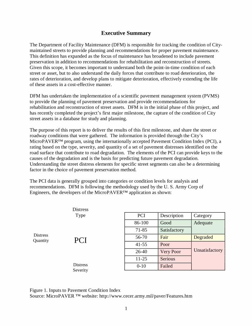
Executive Summary
The Department of Facility Maintenance (DFM) is responsible for tracking the condition of City-maintained streets to provide planning and recommendations for proper pavement maintenance. This definition has expanded as the focus of maintenance has broadened to include pavement preservation in addition to recommendations for rehabilitation and reconstruction of streets. Given this scope, it becomes important to understand both the point-in-time condition of each street or asset, but to also understand the daily forces that contribute to road deterioration, the rates of deterioration, and develop plans to mitigate deterioration, effectively extending the life of these assets in a cost-effective manner.
DFM has undertaken the implementation of a scientific pavement management system (PVMS)to provide the planning of pavement preservation and provide recommendations for rehabilitation and reconstruction of street assets. DFM is in the initial phase of this project, and has recently completed the project’s first major milestone, the capture of the condition of Citystreet assets in a database for study and planning.
The purpose of this report is to deliver the results of this first milestone, and share the street or roadway conditions that were gathered. The information is provided through the City’s MicroPAVER™ program, using the internationally accepted Pavement Condition Index (PCI), a rating based on the type, severity, and quantity of a set of pavement distresses identified on the road surface that contribute to road degradation. The elements of the PCI can provide keys to the causes of the degradation and is the basis for predicting future pavement degradation. Understanding the street distress elements for specific street segments can also be a determining factor in the choice of pavement preservation method.
The PCI data is generally grouped into categories or condition levels for analysis and recommendations. DFM is following the methodology used by the U. S. Army Corp of Engineers, the developers of the MicroPAVER™ application as shown:
PCI Description Category86-100 Good71-85 Satisfactory
Adequate
56-70 Fair Degraded41-55 Poor26-40 Very Poor11-25 Serious0-10 Failed
Unsatisfactory
Figure 1. Inputs to Pavement Condition IndexSource: MicroPAVER ™ website: http://www.cecer.army.mil/paver/Features.htm
DistressType
DistressSeverity
PCIDistressQuantity
2
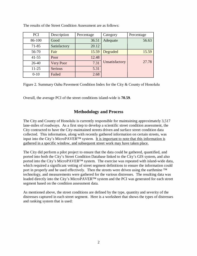
The results of the Street Condition Assessment are as follows:
PCI Description Percentage Category Percentage86-100 Good 36.5171-85 Satisfactory 20.12
Adequate 56.63
56-70 Fair 15.59 Degraded 15.5941-55 Poor 12.4826-40 Very Poor 7.3111-25 Serious 5.310-10 Failed 2.68
Unsatisfactory 27.78
Figure 2. Summary Oahu Pavement Condition Index for the City & County of Honolulu
Overall, the average PCI of the street conditions island-wide is 70.59.
Methodology and Process
The City and County of Honolulu is currently responsible for maintaining approximately 3,517lane-miles of roadways. As a first step to develop a scientific street condition assessment, the City contracted to have the City-maintained streets driven and surface street condition data collected. This information, along with recently gathered information on certain streets, was input into the City’s MicroPAVER™ system. It is important to note that this information is gathered in a specific window, and subsequent street work may have taken place.
The City did perform a pilot project to ensure that the data could be gathered, quantified, and ported into both the City’s Street Condition Database linked to the City’s GIS system, and also ported into the City’s MicroPAVER™ system. The exercise was repeated with island-wide data, which required a significant vetting of street segment definitions to ensure the information could port in properly and be used effectively. Then the streets were driven using the earthmine ™ technology, and measurements were gathered for the various distresses. The resulting data was loaded directly into the City’s MicroPAVER™ system and the PCI was generated for each street segment based on the condition assessment data.
As mentioned above, the street conditions are defined by the type, quantity and severity of the distresses captured in each street segment. Here is a worksheet that shows the types of distresses and ranking system that is used:
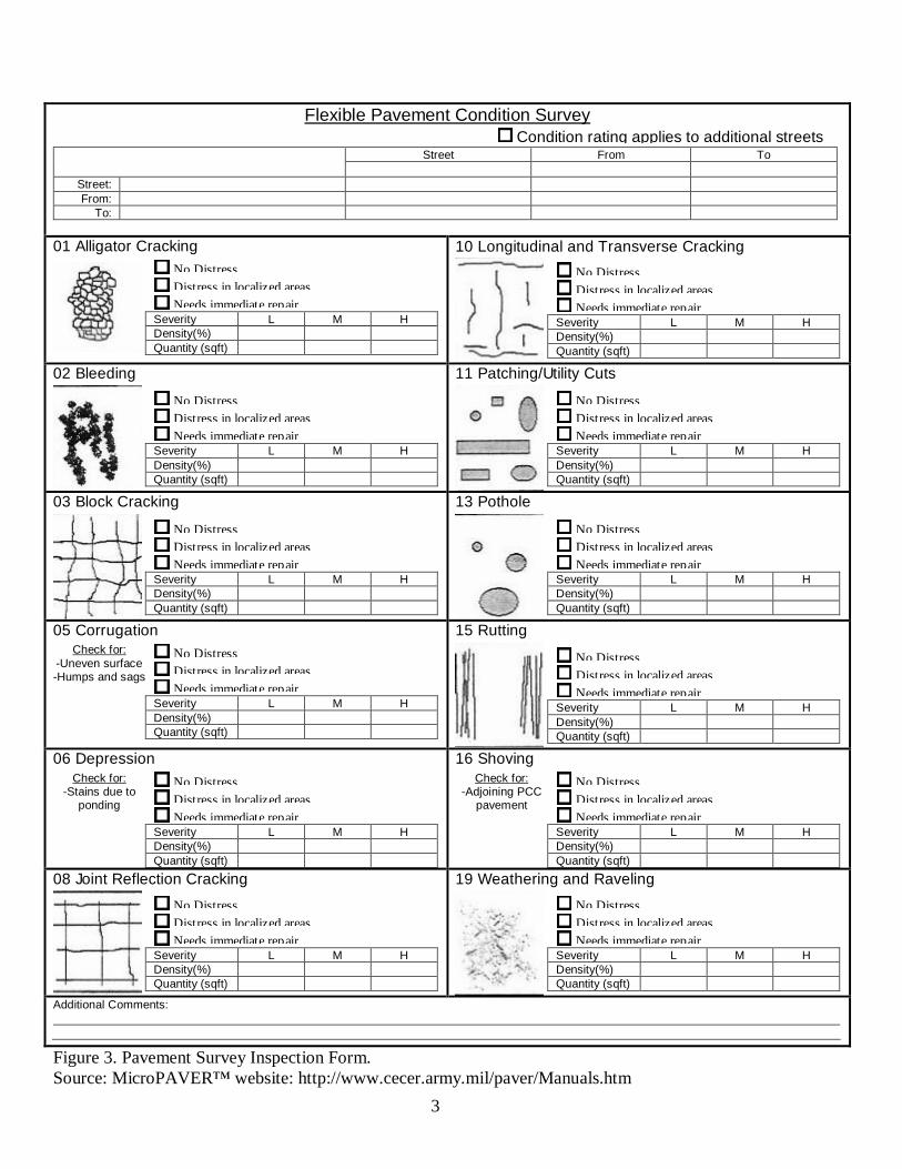
3
Figure 3. Pavement Survey Inspection Form. Source: MicroPAVER™ website: http://www.cecer.army.mil/paver/Manuals.htm
Flexible Pavement Condition SurveyCondition rating applies to additional streets
Street From To
Street:From:
To:
01 Alligator CrackingNo DistressDistress in localized areasNeeds immediate repair
Severity L M HDensity(%)Quantity (sqft)
10 Longitudinal and Transverse Cracking
No DistressDistress in localized areasNeeds immediate repair
Severity L M HDensity(%)Quantity (sqft)
02 Bleeding
No DistressDistress in localized areasNeeds immediate repair
Severity L M HDensity(%)Quantity (sqft)
11 Patching/Utility Cuts
No DistressDistress in localized areasNeeds immediate repair
Severity L M HDensity(%)Quantity (sqft)
03 Block Cracking
No DistressDistress in localized areasNeeds immediate repair
Severity L M HDensity(%)Quantity (sqft)
13 Pothole
No DistressDistress in localized areasNeeds immediate repair
Severity L M HDensity(%)Quantity (sqft)
05 CorrugationCheck for:
-Uneven surface-Humps and sags
No DistressDistress in localized areasNeeds immediate repair
Severity L M HDensity(%)Quantity (sqft)
15 Rutting
No DistressDistress in localized areasNeeds immediate repair
Severity L M HDensity(%)Quantity (sqft)
06 DepressionCheck for:
-Stains due to ponding
No DistressDistress in localized areasNeeds immediate repair
Severity L M HDensity(%)Quantity (sqft)
16 ShovingCheck for:
-Adjoining PCC pavement
No DistressDistress in localized areasNeeds immediate repair
Severity L M HDensity(%)Quantity (sqft)
08 Joint Reflection Cracking
No DistressDistress in localized areasNeeds immediate repair
Severity L M HDensity(%)Quantity (sqft)
19 Weathering and Raveling
No DistressDistress in localized areasNeeds immediate repair
Severity L M HDensity(%)Quantity (sqft)
Additional Comments:

4
The different types of distresses are rated high, medium and low. The table below describes how the ratings are determined.
SEVERITYROAD AC DISTRESSLOW MEDIUM HIGH
01. ALLIGATOR CRACKING (SF: L,M,H)
FINE, HAIRLINE CRACKS, SOME INTERCONNECT-ING, NO SPALLING
NETWORK OF CRACKS, MAY BE LIGHTLY SPALLED. PIECES ARE WELL-DEFINED, SPALLING.
02: BLEEDING (SF: L,M,H) VERY SLIGHT, VISIBLE ONLY FEW DAYS, DOES NOT STICK TO SHOES
ASPHALT STICKS TO SHOES ONLY FOR A FEWWEEKS OF THE YEAR.
EXTENSIVE, STICK TO SHOES, VISIBLE SEVERAL WEEKS OF THE YEAR.
03. BLOCK CRACKING (SF: L,M,H)
NOT FILLED CRACKS <3/8” WIDE; FILLED CRACKS IN SATISFACTORY CONDITON.
1) NOT FILLED CRACKS 3/8” TO 3”. 2) NOT FILLED CRACKS TO 3’ WITH LIGHT AND RANDOM CRACKS.3) FILLED CRACKS WITH LIGHT & RANDOM CRACKS.
1) NOT FILLED OR FILLED CRACKS. WITH LIGHT & RANDOM CRACKS AROUND2) NOT FILLED CRACKS .3”.3) CRACK OF ANY WIDTH WITH SEVERELY BROKEN PAVEMENT.
05. CORRUGATION (SF: L,M,H)
CAUSES LOW SEVERITY RIDE QUALITY CAUSES MEDIUM SEVERITY RIDE QUALITY CAUSES HIGH SEVERITY RIDE QUALITY
06. DEPRESSION (DEPTH) ½” TO 1” 1” TO 2” > 2”08. JOINT REFLECTION CRACKING (LF: L,M,H)
IF NOT FILLED, 3/8”, IF FILLED, ANY WIDTH, GOOD CONDITION SEAL.
1) NOT FILLED CRACKS 3/8” TO 3”.2) NOT FILLED CRACKS UP TO 3” WITH LIGHT & RANDOM CRACKS.3) FILLED CRACKS WITH LIGHT AND RANDOM CRACKS.
1) NOT FILLED OR FILLED CRACKS WITH MEDIUM SEVERITY RANDOM CRACKS AROUND.2) NOT FILLED CRACKS >.3”.3) CRACK OF ANY WIDTH WITH SEVERELY BROKEN PAVEMENT.
10. LONGITUDINAL & TRANSVERSE CRACKING (LF: L,M,H)
NOT FILLED CRACKS. <3/8” WIDE; FILLED CRACKS.IN SATISFACTORY CONDITION
1) NOT FILLED CRACKS 3/8” TO 3”.2) NOT FILLED CRACKS UP TO 3” WITH LIGHT & RANDOM CRACKS3) FILLED CRACKS WITH LIGHT AND RANDOM CRACKS
1) NOT FILLED OR FILLED CRACKS WITH LIGHT AND RANDOM CRACKS AROUND.2) NOT FILLED CRACKS >.3”.3) CRACK OF ANY WIDTH WITH SEVERLEY BROKEN PAVEMENT
11. PATCH & UTILITY CUT PATCH (SF: L,M,H)
IN GOOD CONDITION & PERFORMS SATISFACTORILY.
SOMEWHAT DETERIORATED, AFFECTS RIDE QUALITY, MODERATELY DETERIORATED IN PATCH.
BADLY DETERIORATED, AFFECTS RIDE QUALITY, REPLACE SOON.
13. POTHOLE (COUNT: L,M,H)
1) 4”” TO 8” DIAMETER & MAXIMUM DEPTH ½” TO 2”2) 8” TO 18” & MAXIMUM DEPTH ½” TO 1”
1) 4”’ TO 8” DIAMETER IF MAXIMUM DEPTH > 2”.2) 8” TO 18” DIAMETER IF MAXIMUM DEPTH >1”.3) 18” TO 30” IF MAXIMUM DEPTH ½” TO 1”.
18” TO 30” IF MAXIMUM DEPTH > 1”.
15. RUTTING (SF: L,M,H) MEAN RUT DEPTH ¼” TO ½”. MEAN RUT DEPTH ½” TO 1”. MEAN RUT DEPTH >1”.16. SHOVING (SF: L,M,H) CAUSES LOW SEVERITY RIDE QUALITY. CAUSES MEDIUM SEVERITY RIDE QUALITY. CAUSES HIGH SEVERITY RIDE QUALITY.19/ RAVELING & WEATHERING (SF: L,M,H)
AGGREGATE OR BINDER STARTED WEARING AWAY. SURFACE IS STARTING TO PIT. IF OIL SPILLAGE CANNOT BE PENETRATED BY COIN.
AGGREGATE OR BINDER WORN AWAY. SURFACE MODERATELY ROUGHT & PITTED. IF OIL SPILLAGE, CAN BE PENETRATED WITH COIN.
CONSIDERABLE WEAR AWAY OF AGGREGATE OR BINDER. SURFACE VERY ROUGH AND PITTED. PITTED AREA <4” DIAMETER & <1/2” DEPTH. IF OIL SPILLAGE, AGGREGATE COME LOOSE.
GENERAL COMMENTS1. CRACK WIDTHS SHOULD BE MEASURED FROM THE INNER WALLS OF THE CRACK.2. A CRACK FILLER IN SATISFACTORY CONDITION PREVENTS INFILTRATION OF INCOMPRESSIBLES & WATER.3. IF PATCH IS RECORDED, NO OTHER DISTRESSES SHOULD BE RECORDED ON THE PATCH.4. CONDUCTING A PCI SURVEY IMMEDIATELY AFTER THE APPLICATION OF A SURFACE TREATMENT IS NOT MEANINGFUL.
Figure 4. Roadway AC Pavement Condition Rating Guide.Source: MicroPAVER™ website: http://www.cecer.army.mil/paver/Manuals.htm
5
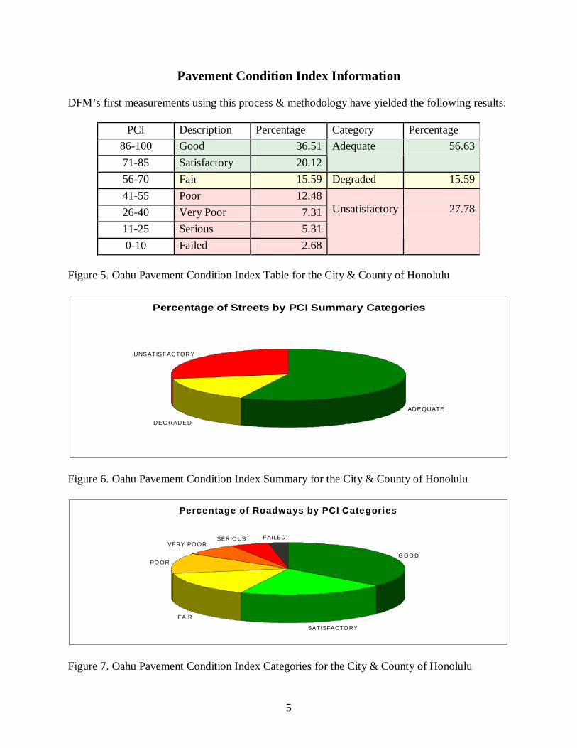
Pavement Condition Index Information
DFM’s first measurements using this process & methodology have yielded the following results:
PCI Description Percentage Category Percentage86-100 Good 36.5171-85 Satisfactory 20.12
Adequate 56.63
56-70 Fair 15.59 Degraded 15.5941-55 Poor 12.4826-40 Very Poor 7.3111-25 Serious 5.310-10 Failed 2.68
Unsatisfactory 27.78
Figure 5. Oahu Pavement Condition Index Table for the City & County of Honolulu
Percentage of Streets by PCI Summary Categories
ADE QUATE
DEG RADE D
UNS ATIS FACTORY
Figure 6. Oahu Pavement Condition Index Summary for the City & County of Honolulu
Percentage of Roadways by PCI Categories
G OO D
SATISFACTO RY
FAIR
PO OR
VERY PO ORSERIO US FAILED
Figure 7. Oahu Pavement Condition Index Categories for the City & County of Honolulu
6
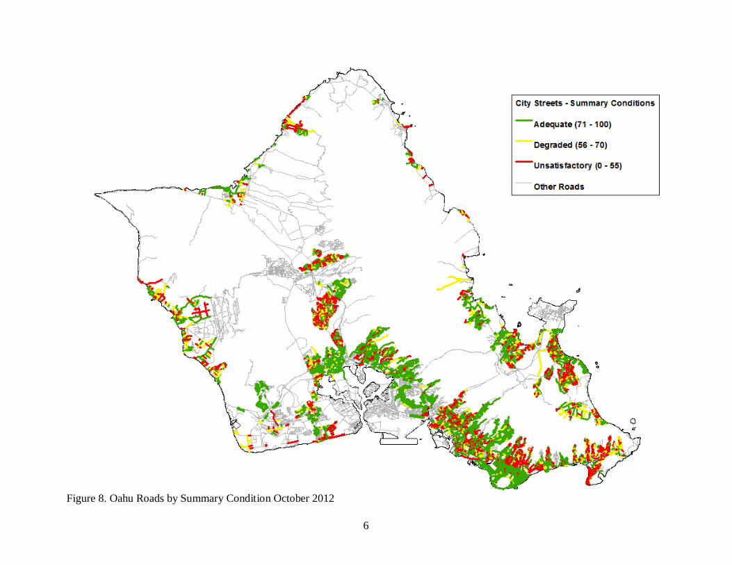
Figure 8. Oahu Roads by Summary Condition October 2012
7
Next Steps
As noted above, the gathering of street conditions is one of the initial milestones that DFM needsto develop recommendations and plans for pavement preservation. Some of the other steps include assigning all street segments to a category to help determine the rate of deterioration. Factors such as load, volume of traffic, bus routes, and residential vs. commercial use are considered, as well as environmental considerations if prevalent in a given area. Other information, such as original construction date and date of last rehabilitation or maintenance are also key to developing a proper strategy. DFM is working to collect this data, develop the appropriate categories and assign the categories to each street segment.
DFM is targeting the end of the third quarter of FY 2013 for this data to be entered into MicroPAVER™. DFM will then start to run models and scenarios, and based on work that needs to be done and funding parameters, recommendations will be developed and pavement preservation applications will be planned.
In parallel, DFM will work on issuing another contract for street condition data collection. It is critical to measure regularly, and at the beginning, more frequently to help develop additional data points, so that the rate(s) of decline of City streets can be determined. Technically a minimum of three data points are necessary, and more data helps us to refine the models. Funding currently exists to gather the next set of street conditions over the summer of 2013, and receive processed data in the fall of 2013.
Ensuring a Successful, Sustainable Pavement Management Program
DFM has developed a two-year plan to initiate this program. Fortunately, the City is aided by a $1,000,000 grant from the Oahu Metropolitan Planning Organization, but in order to ensure the program continues successfully, the following is needed:
Ensure the proper organization structure and staffing to manage and support this functiono Support ongoing training and incorporation of technology as it develops
Maintain funding for scheduled street condition data collectiono Best practice is to measure every one to two years
Stay current with the expanding technological developments in the pavement preservation field
o Industry forums are extremely important Support testing and evaluation of various pavement preservation technology
o Hawaii’s unique weather and high UV provide significant challenge Develop metrics for reporting and improving the system
8
Future View
Here is how the system looks while under development:
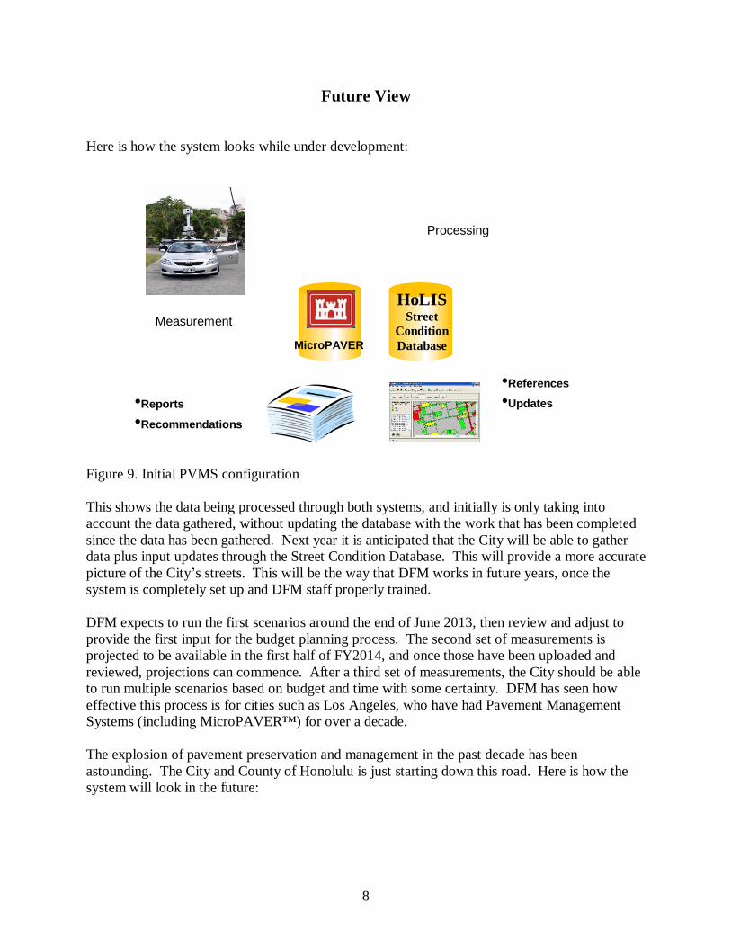
Figure 9. Initial PVMS configuration
This shows the data being processed through both systems, and initially is only taking into account the data gathered, without updating the database with the work that has been completed since the data has been gathered. Next year it is anticipated that the City will be able to gather data plus input updates through the Street Condition Database. This will provide a more accurate picture of the City’s streets. This will be the way that DFM works in future years, once the system is completely set up and DFM staff properly trained.
DFM expects to run the first scenarios around the end of June 2013, then review and adjust to provide the first input for the budget planning process. The second set of measurements is projected to be available in the first half of FY2014, and once those have been uploaded and reviewed, projections can commence. After a third set of measurements, the City should be able to run multiple scenarios based on budget and time with some certainty. DFM has seen how effective this process is for cities such as Los Angeles, who have had Pavement Management Systems (including MicroPAVER™) for over a decade.
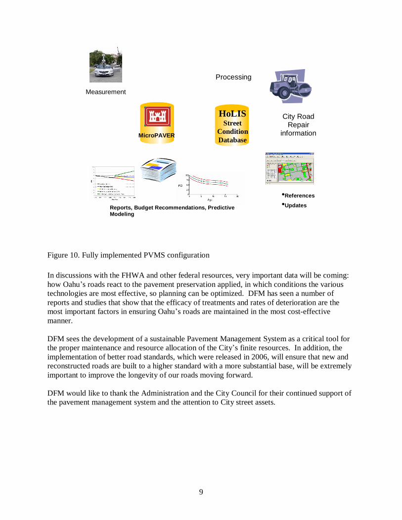
The explosion of pavement preservation and management in the past decade has been astounding. The City and County of Honolulu is just starting down this road. Here is how the system will look in the future:
HoLISStreet
Condition Database
Measurement
Processing
MicroPAVER
•Reports
•Recommendations
•References
•Updates
9
Figure 10. Fully implemented PVMS configuration
In discussions with the FHWA and other federal resources, very important data will be coming: how Oahu’s roads react to the pavement preservation applied, in which conditions the various technologies are most effective, so planning can be optimized. DFM has seen a number of reports and studies that show that the efficacy of treatments and rates of deterioration are the most important factors in ensuring Oahu’s roads are maintained in the most cost-effective manner.
DFM sees the development of a sustainable Pavement Management System as a critical tool for the proper maintenance and resource allocation of the City’s finite resources. In addition, the implementation of better road standards, which were released in 2006, will ensure that new and reconstructed roads are built to a higher standard with a more substantial base, will be extremely important to improve the longevity of our roads moving forward.
DFM would like to thank the Administration and the City Council for their continued support of the pavement management system and the attention to City street assets.
HoLISStreet
Condition Database
Measurement
Processing
MicroPAVER
City Road Repair
information
Reports, Budget Recommendations, Predictive Modeling
•References
•Updates
10
Glossary of Terms
Term DefinitionAC Asphalt Concreteearthmine ™ Geospatial mapping and measuring tool that captures 3-D images,
developed by NASA for the Mars Rover project. Data collection is at 10 meter capture intervals.
GIS Graphical information System. The City uses ArcGIS.HoLIS Honolulu Land Information System the name for the City’s GIS
Lane Mile the area of a roadway that is the width of a single lane of traffic for the length of one mile.
MicroPAVER™ The Pavement Maintenance Management System -- originally was developed in the late 1970s to help the Department of Defense (DOD) manage M&R for its vast inventory of pavements. It uses inspection data and a pavement condition index (PCI™) rating from zero (failed) to 100 (excellent) for consistently describing a pavement's condition and for predicting its Maintenance & Repair needs many years into the future.
Pavement Condition Index
The PCI measures pavement condition rating based on the type, severity, and quantity of a set of pavement distresses identified on the road surface that contribute to road degradation on a scale from 0 to 100. ASTM has adopted the PCI as standard practice for roads (D-6433-10).
Pavement Distress A type of flaw in the pavement that can show underlying concerns of that section pavement.
PVMS Acronym for the City’s Pavement Management System, which includes the City’s Street Condition Database that resides in the City’s GIS and the MicroPAVER™ pavement management software.
Street Condition Database
A custom database developed to store condition information for each street segment. This database is checked when concerns are raised, and will be updated with roadwork upon acceptance and inspection.
Street Segment Defined portions of City streets for the better development of accurate assessment and maintenance/repair work. Key to developing a pavement management strategy.
11
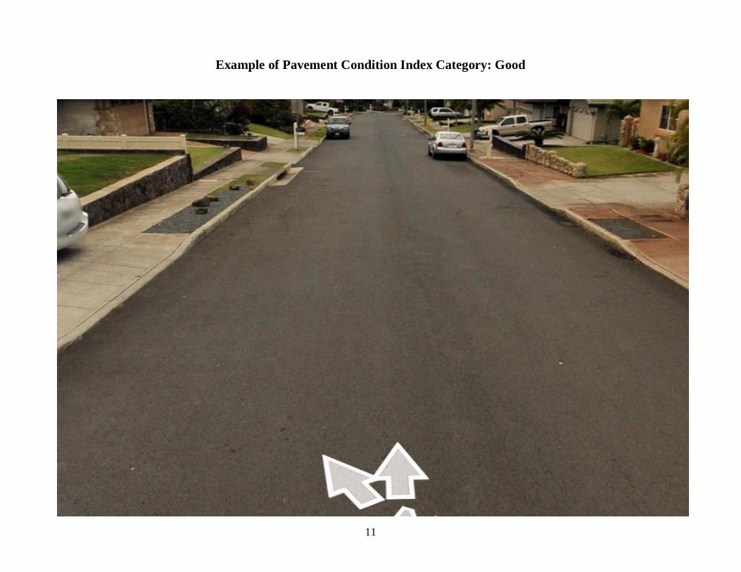
Example of Pavement Condition Index Category: Good
12
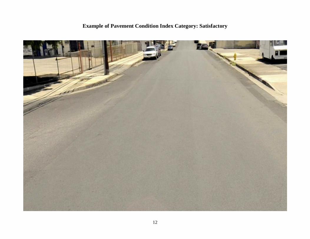
Example of Pavement Condition Index Category: Satisfactory
13
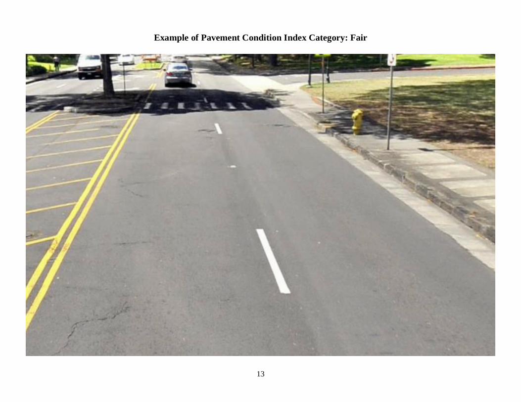
Example of Pavement Condition Index Category: Fair
14
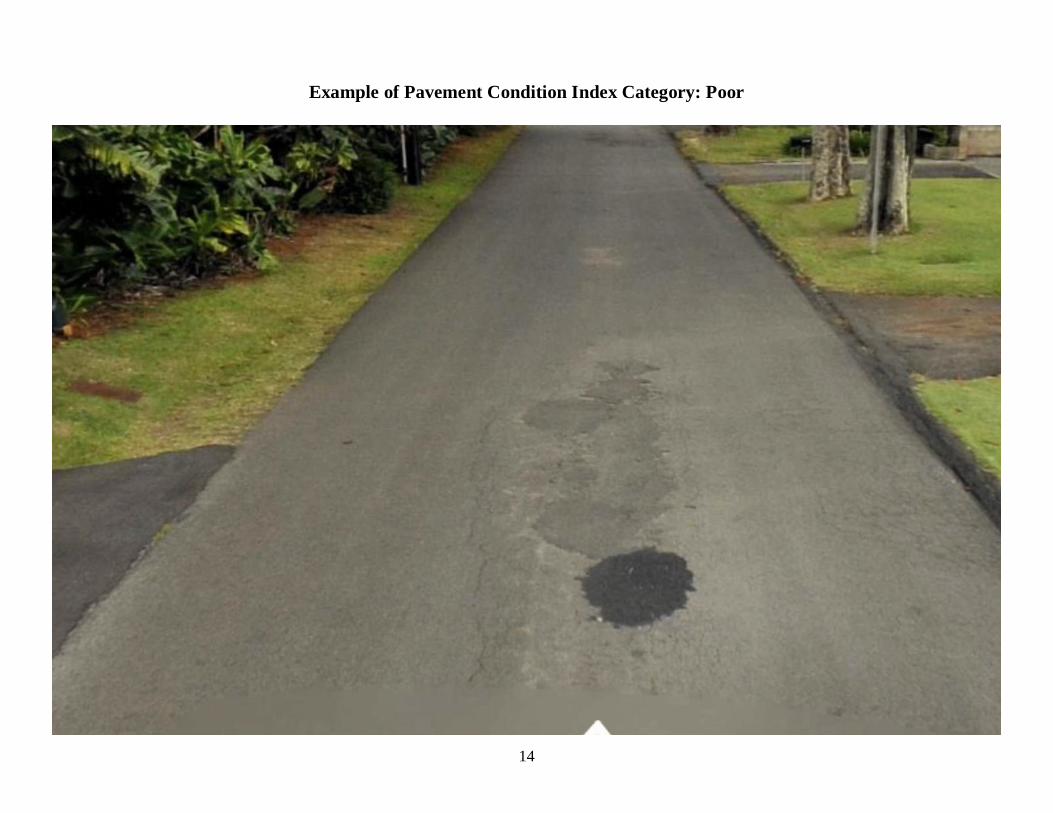
Example of Pavement Condition Index Category: Poor
15
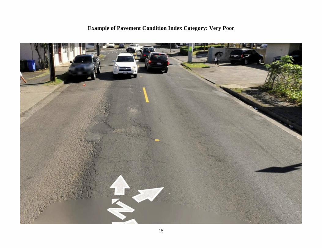
Example of Pavement Condition Index Category: Very Poor
16
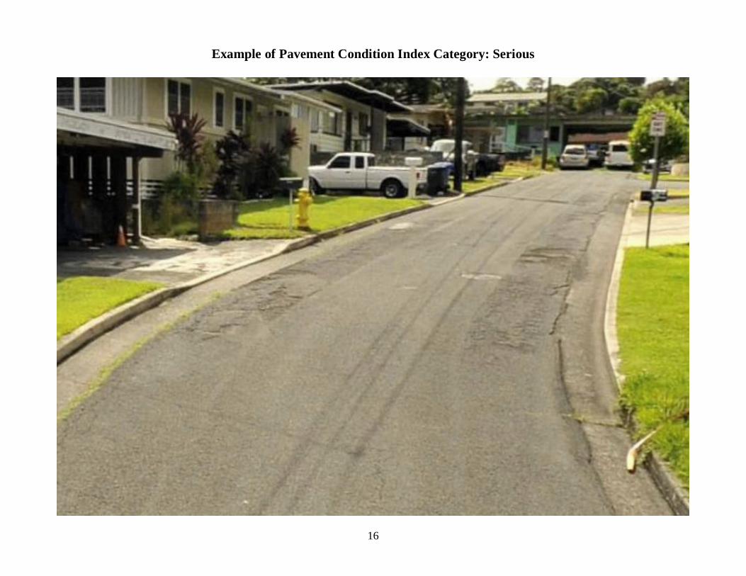
Example of Pavement Condition Index Category: Serious
17
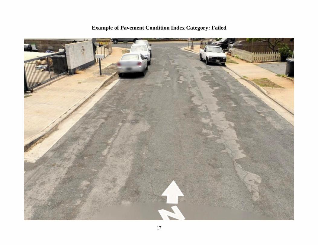
Example of Pavement Condition Index Category: Failed