2016 integrated water quality monitoring and assessment
TRANSCRIPT
Maine Department of Environmental Protection 2016 Integrated Water Quality Report
Maine DEP 2016 Integrated Report Appendices i
Final 2/28/2018
MAINE DEPARTMENT OF ENVIRONMENTAL PROTECTION 17 State House Station | Augusta, Maine 04333-0017
www.maine.gov/dep
2016 Integrated Water Quality
Monitoring and Assessment Report Appendices:
Acronyms, HUC Maps, Definitions, Integrated Lists of Surface Waters,
And Maine’s Implementation of EPA’s 303(d)
Vision
Maine Department of Environmental Protection 2016 Integrated Water Quality Report
Maine DEP 2016 Integrated Report Appendices ii
Table of Contents Appendix I: Acronyms, Maps, Definitions ........................................................................................ 1
Acronyms Found in the Body of the 2016 Integrated Report ..................................................... 1
Hydrologic Unit Code (HUC) Maps for Appendices II through V ............................................... 5
10-Digit HUCs Map (named) ...................................................................................................... 6
10-Digit HUCs Map (numbered) ................................................................................................. 7
Definitions for Terms Common in Appendices II through V ....................................................... 8
Appendix II: Rivers and Streams ..................................................................................................... 9
Category 1: Rivers and Streams Fully Attaining All Designated Uses ....................................... 9
Category 2: Rivers and Streams Attaining Some Designated Uses - Insufficient Information for
Other Uses ............................................................................................................................... 20
Category 3: Rivers and Streams with Insufficient Data or Information to Determine if
Designated Uses are Attained (One or More Uses may be Impaired)..................................... 56
Category 4-A: Rivers and Streams with Impaired Use, TMDL Completed .............................. 66
Category 4-B: Rivers and Streams Impaired by Pollutants - Pollution Control Requirements
Reasonably Expected to Result in Attainment ......................................................................... 99
Category 4-C: Rivers and Streams with Impairment not Caused by a Pollutant ................... 115
Category 5-A: Rivers and Streams Impaired by Pollutants Other Than Those Listed in 5-B
Through 5-D (TMDL Required) .............................................................................................. 117
Category 5-B: Rivers and Streams Impaired for Bacteria Only, TMDL Required .................. 137
Category 5-C: Waters Impaired by Atmospheric Deposition of Mercury ............................... 137
Category 5-D: Rivers and Streams Impaired by Legacy Pollutants ....................................... 137
Appendix III: Lakes ...................................................................................................................... 145
Category 1: Lake Waters Fully Attaining All Designated Uses .............................................. 145
Category 2: Lake Waters within Hydrologic Unit Attaining Some Designated Uses - Insufficient
Information for Other Uses (HUCs with lakes added are in bold) .......................................... 149
Category 3: Lake Waters with Insufficient Data or Information to determine if Designated Uses
are Attained (One or More Uses may be Impaired) ............................................................... 154
Category 4-A: Waters Impaired by Atmospheric Deposition of Mercury................................ 154
Category 4-A: Lake Waters with Impaired Use Other than Mercury, TMDL Completed ....... 155
Category 4-C: Lake Waters with Impairment not Caused by a Pollutant ............................... 156
Category 5-A: Lake Waters Needing TMDLs ......................................................................... 156
Appendix IV Maine Wetlands Assessment .................................................................................. 158
Category 1: Wetland Habitat Fully Attaining All Designated Uses ......................................... 158
Category 2: Wetland Habitat Attaining Some Designated Uses - Insufficient Information for
Other Uses ............................................................................................................................. 158
Category 3: Wetland Habitat with Insufficient Data or Information to Determine if Designated
Uses are Attained (One or More Uses may be Impaired) ...................................................... 163

Maine Department of Environmental Protection 2016 Integrated Water Quality Report
Maine DEP 2016 Integrated Report Appendices iii
Category 4-A: Wetland Habitat with Impaired Use, TMDL Completed .................................. 165
Category 4-B: Wetland Habitat Impaired by Pollutants - Pollution Control Requirements
Reasonably Expected to Result in Attainment ....................................................................... 167
Category 4-C: Wetland Habitat with Impairment not Caused by a Pollutant ......................... 167
Category 5-A: Wetland Habitat Impaired by Pollutants Other Than Those Listed in 5-B
Through 5-D (TMDL Required) .............................................................................................. 168
Category 5-D: Wetland Habitat Impaired by Legacy Pollutants ............................................. 168
Appendix V: Estuarine and Marine Waters ................................................................................. 170
Category 1: Estuarine and Marine Waters Fully Attaining All Designated Uses .................... 170
Category 2: Estuarine and Marine Waters Attaining Some Designated Uses – Insufficient
Information for Other Uses ..................................................................................................... 170
Category 3: Estuarine and Marine Waters with Insufficient Data or Information to Determine if
Designated Uses are Attained (One or More Uses may be Impaired)................................... 173
Category 4-A(a): Estuarine and Marine Waters with Impaired Use - TMDL Completed ....... 173
Category 4-A(b): Estuarine and Marine Waters with Impaired Use – TMDL Completed
(Bacteria from Combined Sewer Overflows) .......................................................................... 174
Category 4-B-1: Estuarine and Marine Waters Impaired by Pollutants – Pollution Control
Requirements Reasonably Expected to Result in Attainment ............................................... 175
Category 4-C: Estuarine and Marine Waters with Impairment not Caused by a Pollutant .... 176
Category 5-A: Estuarine and Marine Waters Impaired by Pollutants Other Than Those Listed
in 5-B Through 5-D - TMDL Required .................................................................................... 176
Category 5-B-1(a): Estuarine and Marine Waters Impaired for Bacteria Only – TMDL Required
................................................................................................................................................ 177
Category 5-B-1(b): Estuarine and Marine Waters Impaired for Bacteria Only (Formerly
Category 2) – TMDL Required ............................................................................................... 191
Category 5-B-1(c): Estuarine and Marine Waters Impaired for Bacteria Only (Formerly
Category 3) – TMDL Required ............................................................................................... 198
Category 5-D: Estuarine and Marine Waters Impaired by Legacy Pollutants ........................ 199
Appendix VI: Maine’s Implementation of EPA’s 303(d) Vision .................................................... 200
Maine Department of Environmental Protection 2016 Integrated Water Quality Report
Maine DEP 2016 Integrated Report Appendices 1
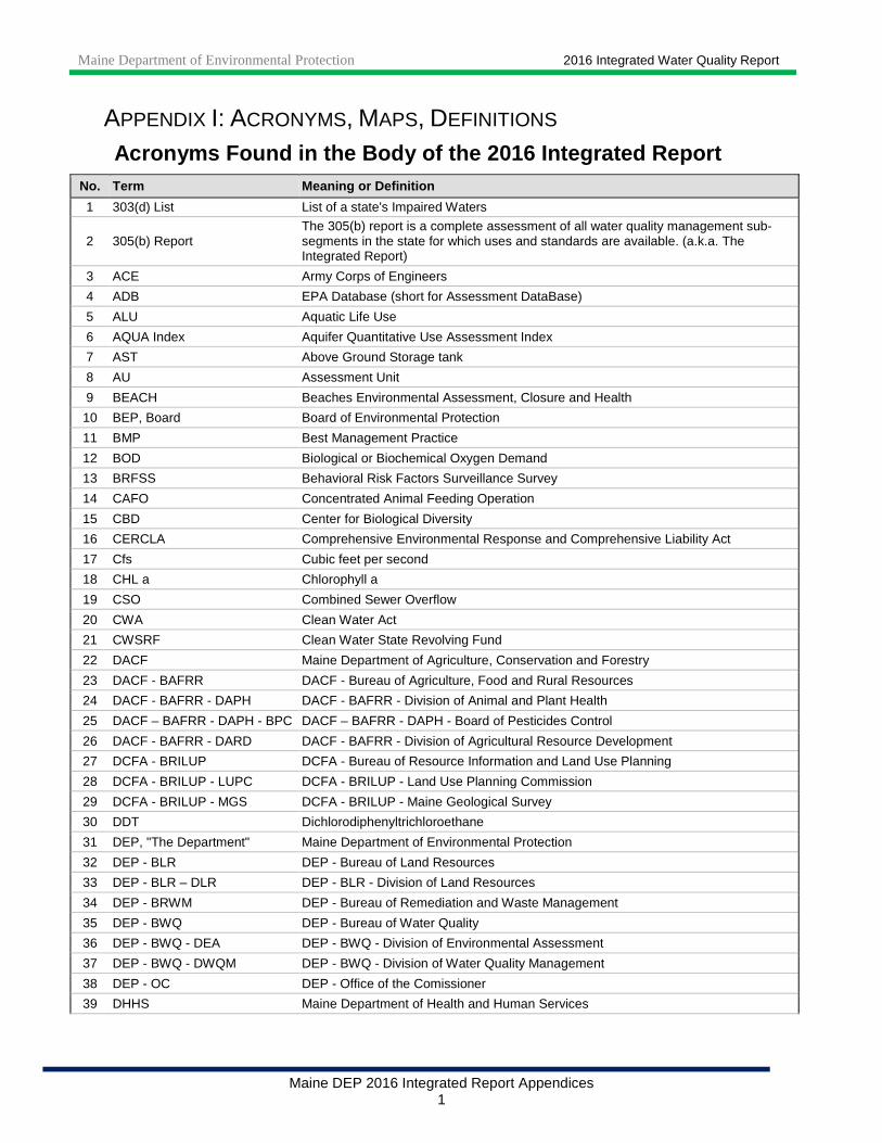
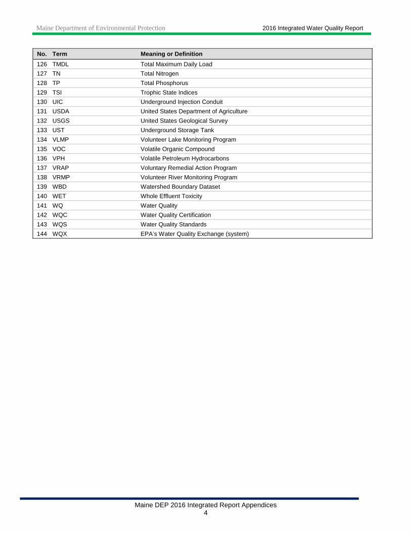
APPENDIX I: ACRONYMS, MAPS, DEFINITIONS Acronyms Found in the Body of the 2016 Integrated R eport
No. Term Meaning or Definition
1 303(d) List List of a state's Impaired Waters
2 305(b) Report The 305(b) report is a complete assessment of all water quality management sub-segments in the state for which uses and standards are available. (a.k.a. The Integrated Report)
3 ACE Army Corps of Engineers
4 ADB EPA Database (short for Assessment DataBase)
5 ALU Aquatic Life Use
6 AQUA Index Aquifer Quantitative Use Assessment Index
7 AST Above Ground Storage tank
8 AU Assessment Unit
9 BEACH Beaches Environmental Assessment, Closure and Health
10 BEP, Board Board of Environmental Protection
11 BMP Best Management Practice
12 BOD Biological or Biochemical Oxygen Demand
13 BRFSS Behavioral Risk Factors Surveillance Survey
14 CAFO Concentrated Animal Feeding Operation
15 CBD Center for Biological Diversity
16 CERCLA Comprehensive Environmental Response and Comprehensive Liability Act
17 Cfs Cubic feet per second
18 CHL a Chlorophyll a
19 CSO Combined Sewer Overflow
20 CWA Clean Water Act
21 CWSRF Clean Water State Revolving Fund
22 DACF Maine Department of Agriculture, Conservation and Forestry
23 DACF - BAFRR DACF - Bureau of Agriculture, Food and Rural Resources
24 DACF - BAFRR - DAPH DACF - BAFRR - Division of Animal and Plant Health
25 DACF – BAFRR - DAPH - BPC DACF – BAFRR - DAPH - Board of Pesticides Control
26 DACF - BAFRR - DARD DACF - BAFRR - Division of Agricultural Resource Development
27 DCFA - BRILUP DCFA - Bureau of Resource Information and Land Use Planning
28 DCFA - BRILUP - LUPC DCFA - BRILUP - Land Use Planning Commission
29 DCFA - BRILUP - MGS DCFA - BRILUP - Maine Geological Survey
30 DDT Dichlorodiphenyltrichloroethane
31 DEP, "The Department" Maine Department of Environmental Protection
32 DEP - BLR DEP - Bureau of Land Resources
33 DEP - BLR – DLR DEP - BLR - Division of Land Resources
34 DEP - BRWM DEP - Bureau of Remediation and Waste Management
35 DEP - BWQ DEP - Bureau of Water Quality
36 DEP - BWQ - DEA DEP - BWQ - Division of Environmental Assessment
37 DEP - BWQ - DWQM DEP - BWQ - Division of Water Quality Management
38 DEP - OC DEP - Office of the Comissioner
39 DHHS Maine Department of Health and Human Services

Maine Department of Environmental Protection 2016 Integrated Water Quality Report
Maine DEP 2016 Integrated Report Appendices 2
No. Term Meaning or Definition
40 DHHS – Maine CDC, MCDC, or MCDC&P DHHS – Maine Center for Disease Control and Prevention
41 DHHS - MCDC - DEH DHHS - MCDC - Division of Environmental Health
42 DHHS - MCDC - DEH - DWP DHHS - MCDC - DEH - Drinking Water Program
43 DHHS - MCDC - DEH - DWP - WHPP DHHS - MCDC - DEH - DWP - Wellhead Protection Program
44 DHHS - MCDC - DEH - RCP DHHS - MCDC - DEH - Radiation Control Program
45 DHHS - MCDC - DPHS DHHS - MCDC – Division of Public Health Systems
46 DHHS - MCDC - DPHS - HETL DHHS - MCDC - DPHS - Health and Environmental Testing Laboratory
47 DIF&W Maine Department of Inland Fisheries and Wildlife
48 DLWA Damariscotta Lake Watershed Association
49 DMR Department of Marine Resources
50 DMR - BPH Maine DMR - Bureau of Public Health
51 DOC Dissolved Organic Carbon
52 DOT, MDOT Maine Department of Transportation
53 DRO Diesel Range Organics
54 DSMOA Defense State Memorandum of Agreement
55 EDD Electronic Data Deliverable
56 EGAD Environmental and Geographic Analysis Database
57 EPA United States Environmental Protection Agency
58 EPA-New England Region 1 of the EPA (covers CT, MA, ME, NH, RI & VT)
59 EPH Extractable Petroleum Hydrocarbons
60 EQIP Environmental Quality Incentives Program
61 ESRI Environmental Systems Research Institute
62 FERC Federal Energy Regulatory Commission
63 FFY Federal Fiscal Year
64 FTAL Fish Tissue Action Level
65 GIS Geographic Information Systems - computerized mapping systems
66 GPA Great Pond Class A
67 GRO Gasoline Range Organics
68 GW-A Potable drinking water in the state classification
69 GW-B Non-potable drinking water in the state classification
70 HUC Hydrologic Unit Code
71 IR Integrated (Water Quality Assessment and Monitoring) Report
72 LDM Linear Discriminant Model
73 LEA Lakes Environmental Association
74 LIHEAP Low Income Home Energy Assistance Program
75 MCL Maximum Contaminant Level
76 MDL Minimum Detection Limit
77 MEG Maximum Exposure Guideline
78 MEGIS Maine Office of Geographic Information Systems (GIS)
79 MEPDES Maine Pollutant Discharge Elimination System
80 mg/L Milligrams Per Liter
81 MHB Maine Healthy Beaches Program
82 MMI Maine Milfoil Initiative
Maine Department of Environmental Protection 2016 Integrated Water Quality Report
Maine DEP 2016 Integrated Report Appendices 3
No. Term Meaning or Definition
83 MRS Maine Revised Statutes (formerly known as MRSA, Maine Revised Statutes Annotated)
84 MS4 Municipal Separate Storm Sewer Systems
85 NCCA National Coastal Condition Assessment
86 NHD National Hydrography Dataset
87 NHDES New Hampshire Department of Environmental Services
88 NOITC Notice of Intent to Comply
89 NPS Nonpoint Source (of Pollution)
90 NRCS Natural Resources Conservation Service
91 NRPA Natural Resources Protection Act
92 NS&T National Status and Trends
93 NWCA National Wetland Condition Assessment
94 NWQI National Water Quality Initiative
95 O&M Operations and Maintenance (procedures)
96 OA Ocean Acidification
97 OBD Overboard Discharge
98 PAH Polycyclic Aromatic Hydrocarbon
99 PCB Polychlorinated Biphenyl
100 pCi/L Picocuries Per Liter
101 pdf Portable Document Format
102 PL Public Law
103 POTW Publicly Owned Treatment Works - e.g. a municipal wastewater treatment plant
104 Ppb Parts Per Billion
105 Ppm Parts Per Million
106 PRAWN EPA’S PRogram tracking, beach Advisories,Water quality standards, and Nutrients database
107 PSP Paralytic Shellfish Poisoning
108 QA/QC Quality Assurance/Quality Control
109 QAPP Quality Assurance Project/Program Plan
110 QMP Quality Management Plan
111 QMS Quality Management System
112 RCRA Resource Conservation and Recovery Act
113 RPA Range Pond Association
114 SCGP Small Community Grant Program
115 SCUBA Self-Contained Underwater Breathing Apparatus
116 SDE Spatial Database Engine
117 SDT Secchi Disk Transparency
118 SDWA Safe Drinking Water Act
119 SOP Standard Operating Procedures
120 SPCC Spill Prevention, Control, and Countermeasures
121 SPU Standard Platinum Units
122 STORET EPA Database (short for STOrage and RETrieval)
123 STP Sewage Treatment Plant
124 SVOC Semi Volatile Organic Compound
125 SWAT Surface Water Ambient Toxics
Maine Department of Environmental Protection 2016 Integrated Water Quality Report
Maine DEP 2016 Integrated Report Appendices 4
No. Term Meaning or Definition
126 TMDL Total Maximum Daily Load
127 TN Total Nitrogen
128 TP Total Phosphorus
129 TSI Trophic State Indices
130 UIC Underground Injection Conduit
131 USDA United States Department of Agriculture
132 USGS United States Geological Survey
133 UST Underground Storage Tank
134 VLMP Volunteer Lake Monitoring Program
135 VOC Volatile Organic Compound
136 VPH Volatile Petroleum Hydrocarbons
137 VRAP Voluntary Remedial Action Program
138 VRMP Volunteer River Monitoring Program
139 WBD Watershed Boundary Dataset
140 WET Whole Effluent Toxicity
141 WQ Water Quality
142 WQC Water Quality Certification
143 WQS Water Quality Standards
144 WQX EPA’s Water Quality Exchange (system)
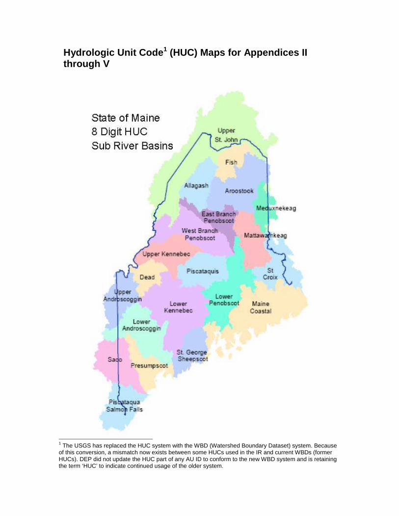
Hydrologic Unit Code 1 (HUC) Maps for Appendices II through V
1 The USGS has replaced the HUC system with the WBD (Watershed Boundary Dataset) system. Because of this conversion, a mismatch now exists between some HUCs used in the IR and current WBDs (former HUCs). DEP did not update the HUC part of any AU ID to conform to the new WBD system and is retaining the term ‘HUC’ to indicate continued usage of the older system.

Maine Department of Environmental Protection 2016 Integrated Water Quality Report
Maine DEP 2016 Integrated Report Appendices 6
10-Digit HUCs Map (named)

Maine D
epartm
ent o
f Enviro
nm
ental P
rotectio
n
2016 Integrated Water Q
uality Report
Maine D
EP
2016 Integrated Report A
ppendices 7
10-Digit H
UC
s Map (num
bered)
The USGS has replaced the HUC system with the WBD (Watershed Boundary Dataset) system. In the course of this conversion, some 10-digit HUCs used in this publication were altered or eliminated. DEP did not update the HUC part of any AU ID to conform to the new WBD system and is retaining the term ‘HUC’ to indicate continued usage of the older system.
Maine Department of Environmental Protection 2016 Integrated Water Quality Report
Maine DEP 2016 Integrated Report Appendices 8
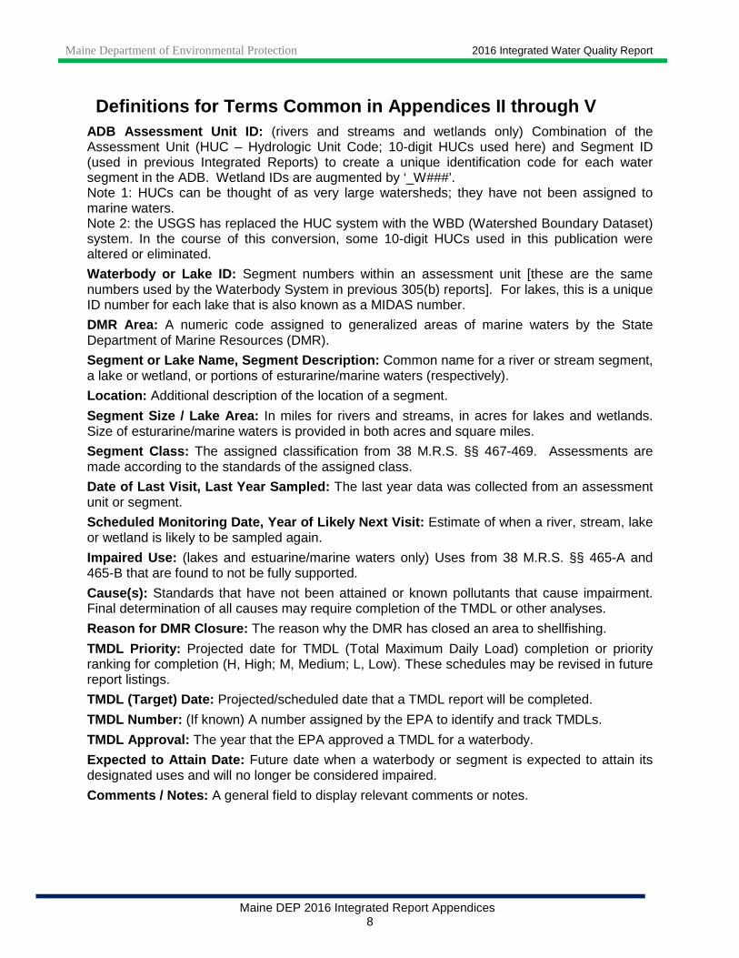
Definitions for Terms Common in Appendices II throu gh V ADB Assessment Unit ID: (rivers and streams and wetlands only) Combination of the Assessment Unit (HUC – Hydrologic Unit Code; 10-digit HUCs used here) and Segment ID (used in previous Integrated Reports) to create a unique identification code for each water segment in the ADB. Wetland IDs are augmented by ‘_W###’. Note 1: HUCs can be thought of as very large watersheds; they have not been assigned to marine waters. Note 2: the USGS has replaced the HUC system with the WBD (Watershed Boundary Dataset) system. In the course of this conversion, some 10-digit HUCs used in this publication were altered or eliminated.
Waterbody or Lake ID: Segment numbers within an assessment unit [these are the same numbers used by the Waterbody System in previous 305(b) reports]. For lakes, this is a unique ID number for each lake that is also known as a MIDAS number.
DMR Area: A numeric code assigned to generalized areas of marine waters by the State Department of Marine Resources (DMR).
Segment or Lake Name, Segment Description: Common name for a river or stream segment, a lake or wetland, or portions of esturarine/marine waters (respectively).
Location: Additional description of the location of a segment.
Segment Size / Lake Area: In miles for rivers and streams, in acres for lakes and wetlands. Size of esturarine/marine waters is provided in both acres and square miles.
Segment Class: The assigned classification from 38 M.R.S. §§ 467-469. Assessments are made according to the standards of the assigned class.
Date of Last Visit, Last Year Sampled: The last year data was collected from an assessment unit or segment.
Scheduled Monitoring Date, Year of Likely Next Visi t: Estimate of when a river, stream, lake or wetland is likely to be sampled again.
Impaired Use: (lakes and estuarine/marine waters only) Uses from 38 M.R.S. §§ 465-A and 465-B that are found to not be fully supported.
Cause(s): Standards that have not been attained or known pollutants that cause impairment. Final determination of all causes may require completion of the TMDL or other analyses.
Reason for DMR Closure: The reason why the DMR has closed an area to shellfishing.
TMDL Priority: Projected date for TMDL (Total Maximum Daily Load) completion or priority ranking for completion (H, High; M, Medium; L, Low). These schedules may be revised in future report listings.
TMDL (Target) Date: Projected/scheduled date that a TMDL report will be completed.
TMDL Number: (If known) A number assigned by the EPA to identify and track TMDLs.
TMDL Approval: The year that the EPA approved a TMDL for a waterbody.
Expected to Attain Date: Future date when a waterbody or segment is expected to attain its designated uses and will no longer be considered impaired.
Comments / Notes: A general field to display relevant comments or notes.

Maine Department of Environmental Protection 2016 Integrated Water Quality Report
Maine DEP 2016 Integrated Report Appendices 9
APPENDIX II: RIVERS AND STREAMS Note 1: Bold text indicates waters that were newly created in Category 1 during this reporting cycle
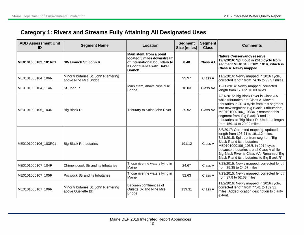
Category 1: Rivers and Streams Fully Attaining All Designated Uses
ADB Assessment Unit ID Segment Name Location Segment
Size (miles) Segment
Class Comments
ME0101000101_101R Baker Branch St. John R Tributary to Southwest Branch St. John R 44.95 Class AA
Nature Conservancy reserve 7/28/2015: Baker Branch St. John R is Class AA while tributaries are Class A. Moved tributaries in 2014 cycle from this segment into new segment ‘Baker Branch St. John R tributaries’, ME0101000101_101R01; renamed this segment from ‘Baker Branch St. John R and its tributaries’ to ‘Baker Branch St. John R’. Updated length from 210.92 to 44.95 miles.
ME0101000101_101R01 Baker Branch St. John R tributaries 361.5 Class A
Nature Conservancy reserve 7/28/2015: Split out from segment 'Baker Branch St. John R and its tributaries', ME0101000101_101R, in 2014 cycle because tributaries are all Class A while Baker Branch St. John River is Class AA. Renamed 'Baker Branch St. John R and its tributaries' to 'Baker Branch St. John R'.
ME0101000102_101R SW Branch St. John R and its tributaries
Excludes main stem from 5 miles downstream of international boundary to confluence with Baker Branch
251.17 Class A
Nature Conservancy reserve 12/7/2016: Newly mapped in 2016 cycle. Split out main stem segment (ME0101000102_101R01) because of differing segment classes. Added location description to clarify extent. Corrected this segment from Class AA to A. Corrected length from 142.9 to 251.17 miles.
Maine Department of Environmental Protection 2016 Integrated Water Quality Report
Maine DEP 2016 Integrated Report Appendices 10
Category 1: Rivers and Streams Fully Attaining All Designated Uses
ADB Assessment Unit ID Segment Name Location Segment
Size (miles) Segment
Class Comments
ME0101000102_101R01 SW Branch St. John R
Main stem, from a point located 5 miles downstream of international boundary to its confluence with Baker Branch
8.40 Class AA
Nature Conservancy reserve 12/7/2016: Split out in 2016 cycle from segment ME0101000102_101R, which is Class A. Newly mapped.
ME0101000104_106R Minor tributaries St. John R entering above Nine Mile Bridge 99.97 Class A 11/2/2016: Newly mapped in 2016 cycle,
corrected length from 74.36 to 99.97 miles.
ME0101000104_114R St. John R Main stem, above Nine Mile Bridge
16.03 Class AA 12/30/2014: Newly mapped, corrected length from 17.4 to 16.03 miles.
ME0101000106_103R Big Black R Tributary to Saint John River 29.92 Class AA
7/31/2015: Big Black River is Class AA while tributaries are Class A. Moved tributaries in 2014 cycle from this segment into new segment 'Big Black R tributaries', ME0101000106_103R01; renamed this segment from 'Big Black R and its tributaries' to 'Big Black R'. Updated length from 159.14 to 29.92 miles.
ME0101000106_103R01 Big Black R tributaries 191.12 Class A
3/6/2017: Corrected mapping, updated length from 195.71 to 191.12 miles. 7/31/2015: Split out from segment 'Big Black R and its tributaries', ME0101000106_103R, in 2014 cycle because tributaries are all Class A while Big Black River is Class AA. Renamed 'Big Black R and its tributaries' to Big Black R'.
ME0101000107_104R Chimenticook Str and its tributaries Those riverine waters lying in Maine 24.67 Class A 7/23/2015: Newly mapped, corrected length
from 25.35 to 24.67 miles.
ME0101000107_105R Pocwock Str and its tributaries Those riverine waters lying in Maine 52.63 Class A 7/23/2015: Newly mapped, corrected length
from 37.8 to 52.63 miles.
ME0101000107_106R Minor tributaries St. John R entering above Ouellette Bk
Between confluences of Oulette Bk and Nine Mile Bridge
139.31 Class A
11/2/2016: Newly mapped in 2016 cycle, corrected length from 77.41 to 139.31 miles. Added location description to clarify extent.

Maine Department of Environmental Protection 2016 Integrated Water Quality Report
Maine DEP 2016 Integrated Report Appendices 11
Category 1: Rivers and Streams Fully Attaining All Designated Uses
ADB Assessment Unit ID Segment Name Location Segment
Size (miles) Segment
Class Comments
ME0101000107_114R St. John R Main stem, from Nine Mile Bridge to Ouellette Bk 44.52 Class AA
12/30/2014: Updated location description in 2014 cycle from 'Main stem, above Ouellette Bk' to 'Main stem, from Nine Mile Bridge to Ouellette Bk' to clarify extent. Corrected length from 47.2 to 44.52 miles.
ME0101000108_107R Little Black R and its tributaries Tributaries to St. John River 150.47 Class A 7/21/2015: Newly mapped, corrected length from 111.07 to 150.47 miles.
ME0101000109_106R Minor tributaries St. John R entering above Little Black R
Between confluences of Little Black River and Oulette Brook 56.36 Class A
10/26/2016: Newly mapped in 2016 cycle, corrected length from 63.22 to 56.36 miles; includes Oulette Brook. Added location description to clarify extent.
ME0101000201_119R Eagle Lake Allagash R tributaries 296.70 Class A
Allagash Wilderness Waterway 12/14/2016: Includes tributaries to Allagash River that enter Eagle Lake from Chamberlain Lake via Lock Dam. Newly mapped in 2016 cycle, corrected length from 98.83 to 296.70 miles. Excludes Class AA section of Allagash Stream, ME0101000201_119R01.
ME0101000201_119R01 Allagash Stream From outlet of Allagash Lake to confluence with Chamberlain Lake
5.34 Class AA 12/14/2016: Split out in 2016 cycle from ME0101000201_119R, which is Class A. Newly mapped.
ME0101000202_119R Heron (Churchill) Lake Allagash R tributaries 152.76 Class A
Allagash Wilderness Waterway 7/29/2015: Corrected segment class from AA to A and length from 97.52 to 152.76 miles.
Maine Department of Environmental Protection 2016 Integrated Water Quality Report
Maine DEP 2016 Integrated Report Appendices 12
Category 1: Rivers and Streams Fully Attaining All Designated Uses
ADB Assessment Unit ID Segment Name Location Segment
Size (miles) Segment
Class Comments
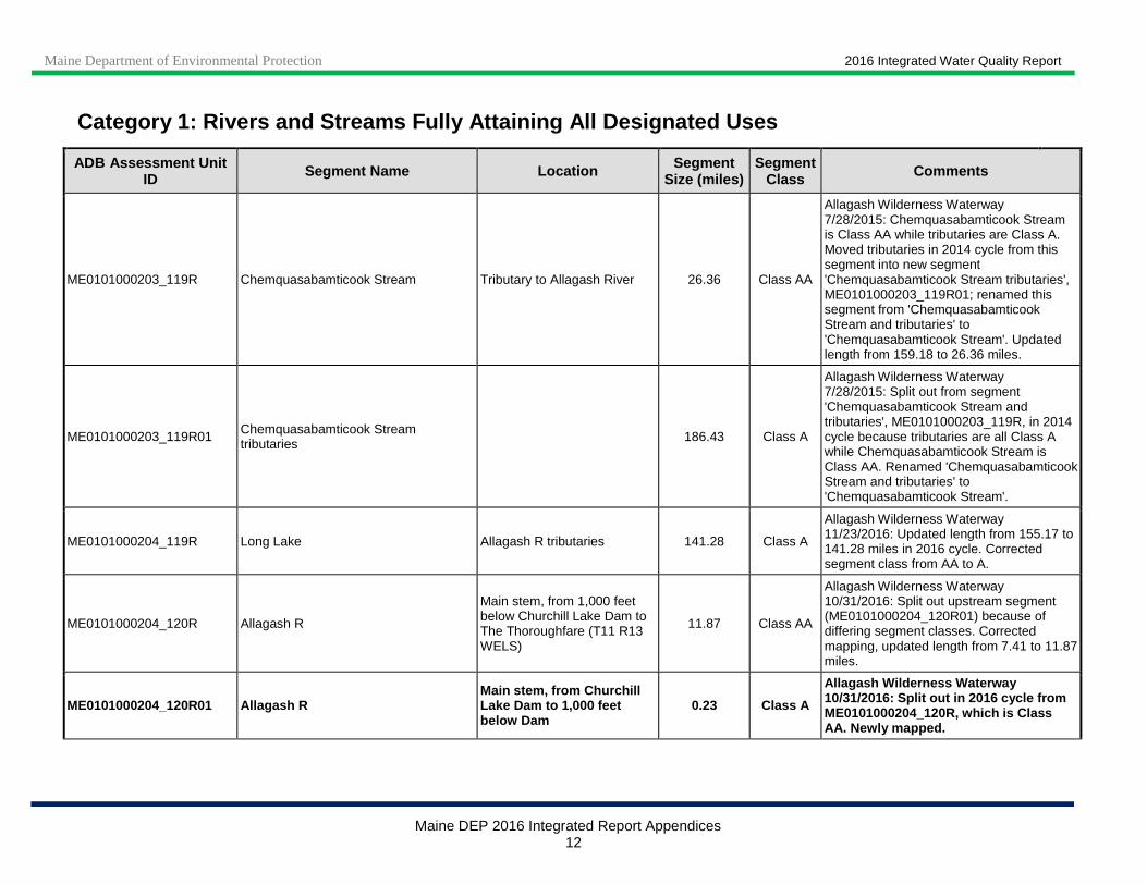
ME0101000203_119R Chemquasabamticook Stream Tributary to Allagash River 26.36 Class AA
Allagash Wilderness Waterway 7/28/2015: Chemquasabamticook Stream is Class AA while tributaries are Class A. Moved tributaries in 2014 cycle from this segment into new segment 'Chemquasabamticook Stream tributaries', ME0101000203_119R01; renamed this segment from 'Chemquasabamticook Stream and tributaries' to 'Chemquasabamticook Stream'. Updated length from 159.18 to 26.36 miles.
ME0101000203_119R01 Chemquasabamticook Stream tributaries 186.43 Class A
Allagash Wilderness Waterway 7/28/2015: Split out from segment 'Chemquasabamticook Stream and tributaries', ME0101000203_119R, in 2014 cycle because tributaries are all Class A while Chemquasabamticook Stream is Class AA. Renamed 'Chemquasabamticook Stream and tributaries' to 'Chemquasabamticook Stream'.
ME0101000204_119R Long Lake Allagash R tributaries 141.28 Class A
Allagash Wilderness Waterway 11/23/2016: Updated length from 155.17 to 141.28 miles in 2016 cycle. Corrected segment class from AA to A.
ME0101000204_120R Allagash R
Main stem, from 1,000 feet below Churchill Lake Dam to The Thoroughfare (T11 R13 WELS)
11.87 Class AA
Allagash Wilderness Waterway 10/31/2016: Split out upstream segment (ME0101000204_120R01) because of differing segment classes. Corrected mapping, updated length from 7.41 to 11.87 miles.
ME0101000204_120R01 Allagash R Main stem, from Churchill Lake Dam to 1,000 feet below Dam
0.23 Class A
Allagash Wilderness Waterway 10/31/2016: Split out in 2016 cycle from ME0101000204_120R, which is Class AA. Newly mapped.
Maine Department of Environmental Protection 2016 Integrated Water Quality Report
Maine DEP 2016 Integrated Report Appendices 13
Category 1: Rivers and Streams Fully Attaining All Designated Uses
ADB Assessment Unit ID Segment Name Location Segment
Size (miles) Segment
Class Comments
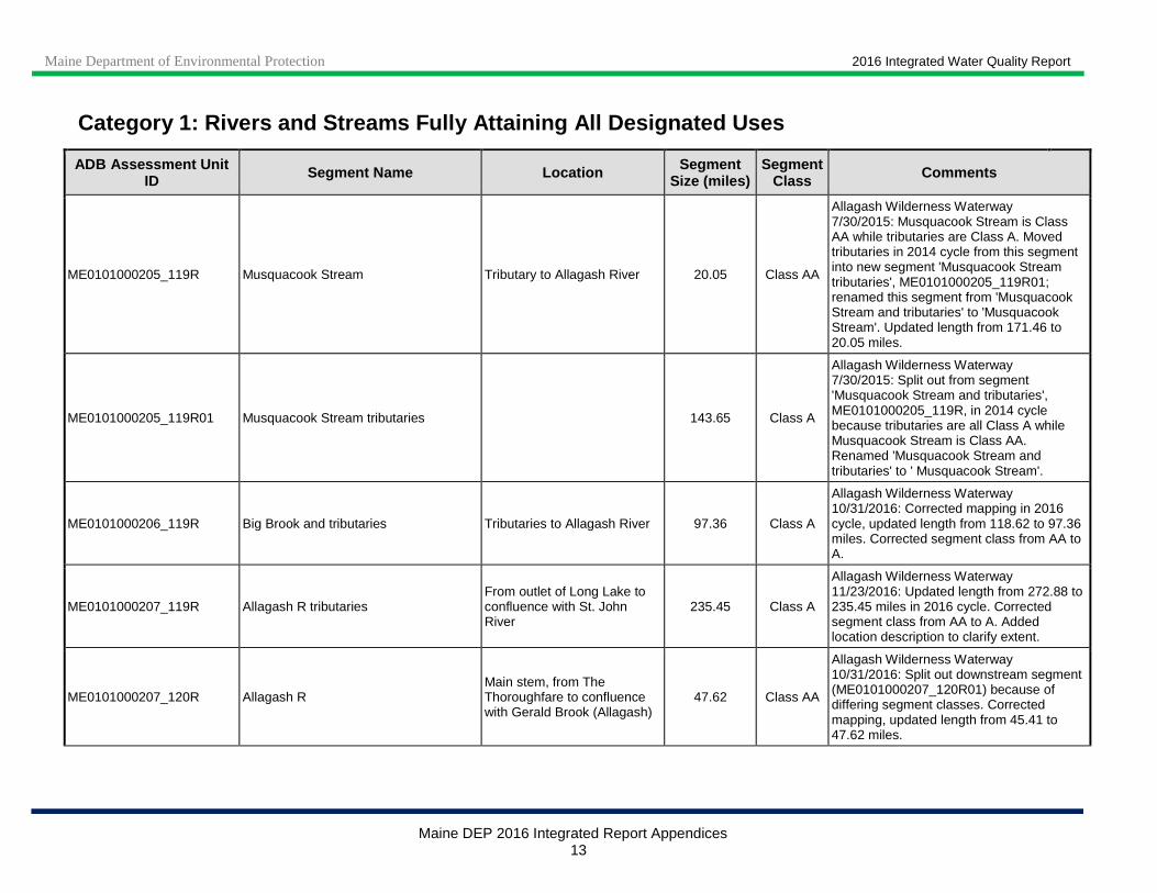
ME0101000205_119R Musquacook Stream Tributary to Allagash River 20.05 Class AA
Allagash Wilderness Waterway 7/30/2015: Musquacook Stream is Class AA while tributaries are Class A. Moved tributaries in 2014 cycle from this segment into new segment 'Musquacook Stream tributaries', ME0101000205_119R01; renamed this segment from 'Musquacook Stream and tributaries' to 'Musquacook Stream'. Updated length from 171.46 to 20.05 miles.
ME0101000205_119R01 Musquacook Stream tributaries 143.65 Class A
Allagash Wilderness Waterway 7/30/2015: Split out from segment 'Musquacook Stream and tributaries', ME0101000205_119R, in 2014 cycle because tributaries are all Class A while Musquacook Stream is Class AA. Renamed 'Musquacook Stream and tributaries' to ' Musquacook Stream'.
ME0101000206_119R Big Brook and tributaries Tributaries to Allagash River 97.36 Class A
Allagash Wilderness Waterway 10/31/2016: Corrected mapping in 2016 cycle, updated length from 118.62 to 97.36 miles. Corrected segment class from AA to A.
ME0101000207_119R Allagash R tributaries From outlet of Long Lake to confluence with St. John River
235.45 Class A
Allagash Wilderness Waterway 11/23/2016: Updated length from 272.88 to 235.45 miles in 2016 cycle. Corrected segment class from AA to A. Added location description to clarify extent.
ME0101000207_120R Allagash R Main stem, from The Thoroughfare to confluence with Gerald Brook (Allagash)
47.62 Class AA
Allagash Wilderness Waterway 10/31/2016: Split out downstream segment (ME0101000207_120R01) because of differing segment classes. Corrected mapping, updated length from 45.41 to 47.62 miles.
Maine Department of Environmental Protection 2016 Integrated Water Quality Report
Maine DEP 2016 Integrated Report Appendices 14
Category 1: Rivers and Streams Fully Attaining All Designated Uses
ADB Assessment Unit ID Segment Name Location Segment
Size (miles) Segment
Class Comments
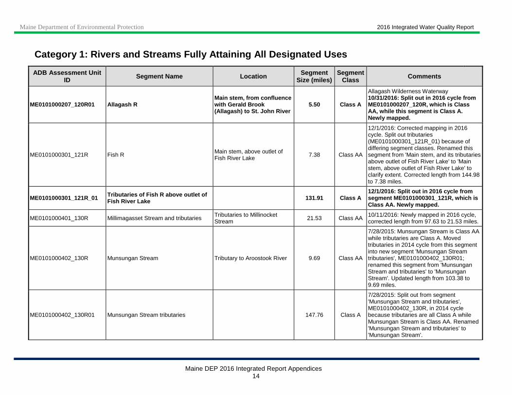
ME0101000207_120R01 Allagash R Main stem, from confluence with Gerald Brook (Allagash) to St. John River
5.50 Class A
Allagash Wilderness Waterway 10/31/2016: Split out in 2016 cycle from ME0101000207_120R, which is Class AA, while this segment is Class A. Newly mapped.
ME0101000301_121R Fish R Main stem, above outlet of Fish River Lake 7.38 Class AA
12/1/2016: Corrected mapping in 2016 cycle. Split out tributaries (ME0101000301_121R_01) because of differing segment classes. Renamed this segment from 'Main stem, and its tributaries above outlet of Fish River Lake' to 'Main stem, above outlet of Fish River Lake' to clarify extent. Corrected length from 144.98 to 7.38 miles.
ME0101000301_121R_01 Tributaries of Fish R above outlet of Fish River Lake 131.91 Class A
12/1/2016: Split out in 2016 cycle from segment ME0101000301_121R, which is Class AA. Newly mapped.
ME0101000401_130R Millimagasset Stream and tributaries Tributaries to Millinocket Stream 21.53 Class AA 10/11/2016: Newly mapped in 2016 cycle,
corrected length from 97.63 to 21.53 miles.
ME0101000402_130R Munsungan Stream Tributary to Aroostook River 9.69 Class AA
7/28/2015: Munsungan Stream is Class AA while tributaries are Class A. Moved tributaries in 2014 cycle from this segment into new segment 'Munsungan Stream tributaries', ME0101000402_130R01; renamed this segment from 'Munsungan Stream and tributaries' to 'Munsungan Stream'. Updated length from 103.38 to 9.69 miles.
ME0101000402_130R01 Munsungan Stream tributaries 147.76 Class A
7/28/2015: Split out from segment 'Munsungan Stream and tributaries', ME0101000402_130R, in 2014 cycle because tributaries are all Class A while Munsungan Stream is Class AA. Renamed 'Munsungan Stream and tributaries' to 'Munsungan Stream'.

Maine Department of Environmental Protection 2016 Integrated Water Quality Report
Maine DEP 2016 Integrated Report Appendices 15
Category 1: Rivers and Streams Fully Attaining All Designated Uses
ADB Assessment Unit ID Segment Name Location Segment
Size (miles) Segment
Class Comments
ME0101000403_130R Mooseleuk Stream and tributaries Tributaries to Aroostook River 159.07 Class A 10/24/2016: Corrected segment class from AA to A in 2016 cycle.
ME0101000404_130R Umcolcus Stream and tributaries Tributaries to Aroostook River 103.87 Class A 7/27/2015: Newly mapped, updated length from 77.28 to 103.87 miles. Also corrected segment class from AA to A.
ME0101000405_131R St. Croix Stream tributaries Tributaries to St. Croix L 123.16 Class A
1/3/2017: St. Croix Stream begins at outlet of St. Croix Lake. Updated segment name in 2016 cycle from 'St. Croix Stream' to 'St. Croix Stream tributaries' to clarify extent. Corrected mapping and updated length from 127.97 to 123.16 miles. Corrected segment class from AA to A.
ME0101000406_131R St. Croix Str and its tributaries Tributaries to Aroostook R, excluding mainstem below Hall Brook (T9 R5 WELS)
205.37 Class A
1/3/2017: Corrected mapping in 2016 cycle. Split out lowermost section of mainstem St. Croix Stream (ME0101000406_131R01) because of differing segment classes; added location description to clarify extent. Corrected length from 124.68 to 205.37 miles, and segment class from AA to A.
ME0101000406_131R01 St. Croix Stream
From confluence with Hall Brook (T9 R5 WELS) to confluence with Aroostook River
7.73 Class AA 1/3/2017: Split out in 2016 cycle from segment ME0101000406_131R, which is Class A. Newly mapped.
ME0101000407_130R Aroostook R Main stem above St. Croix Stream 34.29 Class AA
3/2/2017: Aroostook River is Class AA while most tributaries are Class A. Moved tributaries in 2016 cycle from this segment into new segments ME0101000407_130R01 and ME0101000407_130R02. Updated location description for this segment from 'Main stem, and tributaries above St. Croix Stream' to 'Main stem above St. Croix Stream'. Corrected mapping and updated length from 141.83 to 34.29 miles.
Maine Department of Environmental Protection 2016 Integrated Water Quality Report
Maine DEP 2016 Integrated Report Appendices 16
Category 1: Rivers and Streams Fully Attaining All Designated Uses
ADB Assessment Unit ID Segment Name Location Segment
Size (miles) Segment
Class Comments
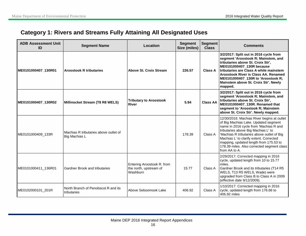
ME0101000407_130R01 Aroostook R tributaries Above S t. Croix Stream 226.57 Class A
3/2/2017: Split out in 2016 cycle from segment 'Aroostook R; Mainstem, and tributaries above St. Croix Str', ME0101000407_130R because tributaries are Class A while mainstem Aroostook River is Class AA. Renamed ME0101000407_130R to 'Aroostook R; Mainstem above St. Croix Str'. Newly mapped.
ME0101000407_130R02 Millinocket Stream (T8 R8 WELS) Tributary to Aroostook River 5.94 Class AA
3/2/2017: Split out in 2016 cycle from segment 'Aroostook R; Mainstem, and tributaries above St. Croix Str', ME0101000407_130R. Renamed that segment to 'Aroostook R; Mainstem above St. Croix Str'. Newly mapped.
ME0101000409_133R Machias R tributaries above outlet of Big Machias L 178.39 Class A
12/30/2016: Machias River begins at outlet of Big Machias Lake. Updated segment name in 2016 cycle from 'Machias R and tributaries above Big Machias L' to 'Machias R tributaries above outlet of Big Machias L' to clarify extent. Corrected mapping, updated length from 175.53 to 178.39 miles. Also corrected segment class from AA to A.
ME0101000411_136R01 Gardner Brook and tributaries Entering Aroostook R. from the north, upstream of Washburn
15.77 Class A
2/29/2017: Corrected mapping in 2016 cycle, updated length from 10 to 15.77 miles. Gardner Brook and its tributaries (T14 R5 WELS, T13 R5 WELS, Wade) were upgraded from Class B to Class A in 2009 (effective date 9/12/2009).
ME0102000101_201R North Branch of Penobscot R and its tributaries Above Seboomook Lake 406.92 Class A
1/10/2017: Corrected mapping in 2016 cycle, updated length from 176.66 to 406.92 miles

Maine Department of Environmental Protection 2016 Integrated Water Quality Report
Maine DEP 2016 Integrated Report Appendices 17
Category 1: Rivers and Streams Fully Attaining All Designated Uses
ADB Assessment Unit ID Segment Name Location Segment
Size (miles) Segment
Class Comments
ME0102000106_202R Nesowadnehunk Stream and tributaries Tributaries to West Branch Penobscot River 96.89 Class AA
Baxter State Park 12/30/2016: Corrected length in 2016 cycle from 56.94 to 96.89 miles.
ME0102000107_202R Nahmakanta Stream and tributaries Tributaries to West Branch Penobscot River 155.20 Class A
Nature Conservancy Reserve, State Ecological Reserve 1/27/2017: Corrected mapping in 2016 cycle, updated length from 97.36 to 155.20 miles. Corrected segment class from AA to A.
ME0102000109_202R Tributaries of West Branch Penobscot R between Ripogenus Dam and outlet of Ferguson and Quakish Lake
Tributaries partly or wholly in Baxter State Park 56.66 Class AA
Baxter State Park 2/28/2017: Corrected mapping in 2016 cycle. Split out ME0102000109_202R01 because of differing segment classes (A versus AA). Updated segment name from 'Tributaries of West Branch Penobscot R above Ferguson L' to 'Tributaries of West Branch Penobscot R between Ripogenus Dam and outlet of Ferguson and Quakish Lake' and added Location to clarify extent. Updated length from 207.95 to 56.66 miles.
ME0102000109_202R01
Tributaries of West Branch Penobscot R between Ripogenus Dam and outlet of Ferguson and Quakish Lake
Tributaries wholly outside of Baxter State Park 206.94 Class A
2/28/2017: Split out in 2016 cycle from segment ME0102000109_202R because of differing segment classes (A versus AA). Newly mapped.

Maine Department of Environmental Protection 2016 Integrated Water Quality Report
Maine DEP 2016 Integrated Report Appendices 18
Category 1: Rivers and Streams Fully Attaining All Designated Uses
ADB Assessment Unit ID Segment Name Location Segment
Size (miles) Segment
Class Comments
ME0102000201_206R Webster Bk and its tributaries
Webster Bk main stem (from 1,000 ft below Telos Dam to confluence with East Branch Penobscot R) and all its tributaries with portions in Baxter State Park
44.31 Class AA
Baxter State Park 2/15/2017: Corrected mapping in 2016 cycle, updated length from 188.67 to 44.31 miles. Updated name from ‘Webster Bk and tributaries of East Branch Penobscot R’ to ‘Webster Bk and its tributaries’ to clarify extent. Updated location description from ‘Above Grand Matagamon’ to ‘Webster Bk main stem (from 1,000 ft below Telos Dam to confluence with East Branch Penobscot R) and all its tributaries with portions in Baxter State Park’ to clarify extent. Split out segment ME0102000201_206R01 because of differing segment classes (A versus AA). Excludes waters in segment ME0101000201_119R01.
ME0102000201_206R01 Webster Bk and its tributaries
Webster Bk main stem (upper 1,000 ft below Telos Dam) and all its tributaries with no portions in Baxter State Park
122.04 Class A
2/15/2017: Split out in 2016 cycle from segment ME0102000201_206R because of differing segment classes (A versus AA). Newly mapped. Excludes waters in segment ME0101000201_119R.
ME0102000202_206R Tributaries of East Branch Penobscot R above Grand Lake Matagamon Dam 180.12 Class AA
Baxter State Park 2/17/2017: Corrected mapping in 2016 cycle to include only tributaries partly or wholly in Baxter State Park. Updated length from 167.03 to 180.12 miles. Updated name from 'Tributaries of East Branch Penobscot R at Grand Matagamon' to 'Tributaries of East Branch Penobscot R above Grand Lake Matagamon Dam' to clarify extent.

Maine Department of Environmental Protection 2016 Integrated Water Quality Report
Maine DEP 2016 Integrated Report Appendices 19
Category 1: Rivers and Streams Fully Attaining All Designated Uses
ADB Assessment Unit ID Segment Name Location Segment
Size (miles) Segment
Class Comments
ME0102000202_206R01 Tributaries of East Branch Penobscot R above Grand Lake Matagamon Dam
39.44 Class A
2/17/2017: Split out in 2016 cycle from segment ME0102000202_206R, which only includes Class AA tributaries partly or wholly in Baxter State Park. Tributaries in this new segment are wholly outside of the Park and are Class A. Newly mapped.
ME0103000101_301R South Branch Moose R and its tributaries 61.14 Class A
12/29/2016: Corrected segment class from AA to A in 2016 cycle, and length from 48.72 to 61.14 miles.
ME0103000102_301R Moose R from inlet of Attean Pd to Number One Brook in Beattie TWP 40.71 Class AA
12/29/2016: Corrected mapping in 2016 cycle. Split out Moose R headwaters (ME0103000102_301R01) and tributaries (ME0103000102_301R_01) because of differing segment classes (A versus AA). Renamed this segment from 'Moose R and its tributaries above Attean Pd' to 'Moose R from inlet of Attean Pd to Number One Brook in Beattie TWP' to clarify extent. Corrected length from 139.43 to 40.71 miles.
ME0103000102_301R01 Moose R above Number One Brook Beattie TWP 2.89 Class A 12/29/2016: Split out in 2016 cycle from segment ME0103000102_301R, which is Class AA. Newly mapped.
ME0103000102_301R_01 Moose R tributaries above Atte an Pd 324.29 Class A 12/29/2016: Split out in 2016 cycle from segment ME0103000102_301R, which is Class AA. Newly mapped.
Total mileage for segments in Category 1 5,958
Maine Department of Environmental Protection 2016 Integrated Water Quality Report
Maine DEP 2016 Integrated Report Appendices 20
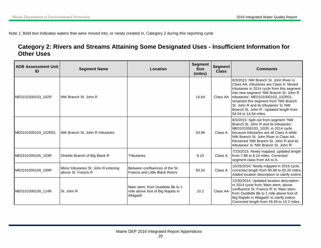
Note 1: Bold text indicates waters that were moved into, or newly created in, Category 2 during this reporting cycle
Category 2: Rivers and Streams Attaining Some Desig nated Uses - Insufficient Information for Other Uses
ADB Assessment Unit ID Segment Name Location
Segment Size
(miles)
Segment Class Comments
ME0101000103_102R NW Branch St. John R 14.64 Class AA
8/3/2015: NW Branch St. John River is Class AA, tributaries are Class A. Moved tributaries in 2014 cycle from this segment into new segment 'NW Branch St. John R tributaries', ME0101000103_102R01; renamed this segment from 'NW Branch St. John R and its tributaries' to 'NW Branch St. John R'. Updated length from 54.04 to 14.64 miles.
ME0101000103_102R01 NW Branch St. John R tributaries 43.98 Class A
8/3/2015: Split out from segment ''NW Branch St. John R and its tributaries', ME0101000103_102R, in 2014 cycle because tributaries are all Class A while NW Branch St. John River is Class AA. Renamed 'NW Branch St. John R and its tributaries' to 'NW Branch St. John R'.
ME0101000105_103R Shields Branch of Big Black R Tributaries 8.14 Class A 7/23/2015: Newly mapped, updated length from 7.88 to 8.14 miles. Corrected segment class from AA to A.
ME0101000109_109R Minor tributaries St. John R entering above St. Francis R
Between confluences of the St. Francis and Little Black Rivers 93.20 Class A
10/26/2016: Newly mapped in 2016 cycle, corrected length from 90.89 to 93.20 miles. Added location description to clarify extent.
ME0101000109_114R St. John R Main stem, from Ouellette Bk to 1 mile above foot of Big Rapids in Allagash
10.2 Class AA
12/30/2014: Updated location description in 2014 cycle from 'Main stem, above confluence St. Francis R' to 'Main stem, from Ouellette Bk to 1 mile above foot of Big Rapids in Allagash' to clarify extent. Corrected length from 26.59 to 10.2 miles.

Maine Department of Environmental Protection 2016 Integrated Water Quality Report
Maine DEP 2016 Integrated Report Appendices 21
Category 2: Rivers and Streams Attaining Some Desig nated Uses - Insufficient Information for Other Uses
ADB Assessment Unit ID Segment Name Location
Segment Size
(miles)
Segment Class Comments
ME0101000110_108R St. Francis R and its tributaries Tributaries to St. John River 186.1 Class A 10/17/2016: Newly mapped in 2016 cycle, corrected length from 134.93 to 186.1 miles.
ME0101000111_109R Minor tributaries St. John R entering above Fort Kent
Between confluences of the Fish and St. Francis Rivers 42.22 Class A
10/25/2016: Newly mapped in 2016 cycle, corrected length from 44.0 to 42.22 miles. Added location description to clarify extent.
ME0101000111_114R St. John R Main stem, from 1 mile above foot of Big Rapids in Allagash to confluence of St. Francis River
17.8 Class A
12/30/2014: This assessment unit had been created in error. In 2014 cycle it was changed as follows to enable correct AU river coverage: location description was changed from 'Main stem, above Fort Kent' to 'Main stem, from 1 mile above foot of Big Rapids in Allagash to confluence of St. Francis River', length from 1.4 to 17.8 miles, and segment class from AA to A.
ME0101000111_115R St. John R Main stem, from the confluence of the St. Francis River to the international bridge in Fort Kent
16.1 Class A
12/30/2014: Updated location description in 2014 cycle from 'Main stem, above Fort Kent' to 'Main stem, from the confluence of the St. Francis River to the international bridge in Fort Kent' to clarify extent. Corrected length from 17.49 to 16.1 miles.
ME0101000112_110R Minor tributaries St. John R entering above Madawaska
Between international bridge in Madawaska and confluence of the Fish River
42.87 Class B 10/25/2016: Newly mapped in 2016 cycle, corrected length from 40.67 to 42.87 miles. Added location description to clarify extent.
ME0101000112_115R St. John R Main stem, from the international bridge in Fort Kent to the confluence of the Fish River
0.63 Class A
12/30/2014: Updated location description in 2014 cycle from 'Main stem, above Madawaska' to 'Main stem, from the international bridge in Fort Kent to the confluence of the Fish River' to clarify extent.
ME0101000113_111R Minor tributaries St. John R entering above Grand Isle
Between downstream end of La Grand Island and international bridge in Madawaska
48.60 Class B 10/26/2016: Newly mapped in 2016 cycle, corrected length from 14.58 to 48.60 miles. Added location description to clarify extent.

Maine Department of Environmental Protection 2016 Integrated Water Quality Report
Maine DEP 2016 Integrated Report Appendices 22
Category 2: Rivers and Streams Attaining Some Desig nated Uses - Insufficient Information for Other Uses
ADB Assessment Unit ID Segment Name Location
Segment Size
(miles)
Segment Class Comments
ME0101000114_112R Violette Str and its tributaries (riverine waters only)
Below confluence with Caniba Brook in Van Buren 41.39 Class B
10/18/2016: Violette Stream and tributaries are Class B below confluence with Caniba Brook, Class A above. Moved upstream mainstem and tributaries in 2016 cycle from this segment into new segment 'Violette Str and its tributaries above confluence with Caniba Brook ', ME0101000114_112R01; added clarifying location description to this segment. Updated length from 72.02 to 41.39 miles.
ME0101000114_112R01 Violette Str and tributaries above confluence with Caniba Bk
Grand Isle, T17 R3 WELS, Van Buren; tributaries to St John River 44.19 Class A
10/18/2016: Split out from segment 'Violette Str and its tributaries (riverine waters only)', ME0101000114_112R, in 2016 cycle because mainstem and tributaries above confluence with Caniba Brook are Class A (Class B below). Added clarifying location description to original segment. ME0101000116_117R
ME0101000115_113R Minor tributaries St. John R entering below Violette Str
Between Violette Stream and international border in Hamlin 74.01 Class B
10/24/2016: Newly mapped in 2016 cycle, corrected length from 47.34 to 74.01 miles. Added location description to clarify extent. Also corrected Violette Bk to Violette Str.
ME0101000115_118R St. John R Main stem, from Van Buren WWTF to international boundary 10.5 Class C
12/30/2014: Updated location description in 2014 cycle from 'Main stem, below Van Buren' to 'Main stem, from Van Buren WWTF to international boundary' to clarify extent. Corrected length from 10.02 to10.5 miles.
ME0101000116_113R Minor tributaries St. John R entering beloe Grand Falls 5.79 Class B
Maine Department of Environmental Protection 2016 Integrated Water Quality Report
Maine DEP 2016 Integrated Report Appendices 23
Category 2: Rivers and Streams Attaining Some Desig nated Uses - Insufficient Information for Other Uses
ADB Assessment Unit ID Segment Name Location
Segment Size
(miles)
Segment Class Comments
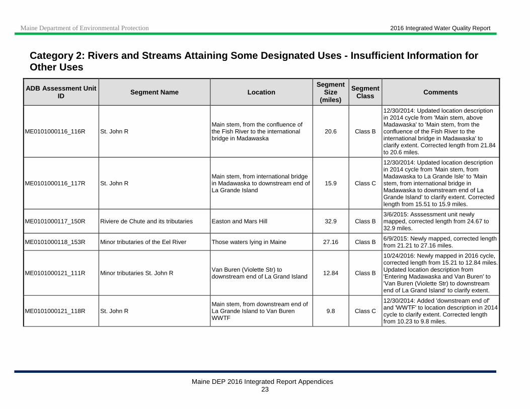
ME0101000116_116R St. John R Main stem, from the confluence of the Fish River to the international bridge in Madawaska
20.6 Class B
12/30/2014: Updated location description in 2014 cycle from 'Main stem, above Madawaska' to 'Main stem, from the confluence of the Fish River to the international bridge in Madawaska' to clarify extent. Corrected length from 21.84 to 20.6 miles.
ME0101000116_117R St. John R Main stem, from international bridge in Madawaska to downstream end of La Grande Island
15.9 Class C
12/30/2014: Updated location description in 2014 cycle from 'Main stem, from Madawaska to La Grande Isle' to 'Main stem, from international bridge in Madawaska to downstream end of La Grande Island' to clarify extent. Corrected length from 15.51 to 15.9 miles.
ME0101000117_150R Riviere de Chute and its tributaries Easton and Mars Hill 32.9 Class B 3/6/2015: Asssessment unit newly mapped, corrected length from 24.67 to 32.9 miles.
ME0101000118_153R Minor tributaries of the Eel River Those waters lying in Maine 27.16 Class B 6/9/2015: Newly mapped, corrected length from 21.21 to 27.16 miles.
ME0101000121_111R Minor tributaries St. John R Van Buren (Violette Str) to downstream end of La Grand Island 12.84 Class B
10/24/2016: Newly mapped in 2016 cycle, corrected length from 15.21 to 12.84 miles. Updated location description from 'Entering Madawaska and Van Buren' to 'Van Buren (Violette Str) to downstream end of La Grand Island' to clarify extent.
ME0101000121_118R St. John R Main stem, from downstream end of La Grande Island to Van Buren WWTF
9.8 Class C
12/30/2014: Added 'downstream end of' and 'WWTF' to location description in 2014 cycle to clarify extent. Corrected length from 10.23 to 9.8 miles.

Maine Department of Environmental Protection 2016 Integrated Water Quality Report
Maine DEP 2016 Integrated Report Appendices 24
Category 2: Rivers and Streams Attaining Some Desig nated Uses - Insufficient Information for Other Uses
ADB Assessment Unit ID Segment Name Location
Segment Size
(miles)
Segment Class Comments
ME0101000302_121R Fish R Main stem, from outlet of Fish River Lake to outlet of Portage Lake 21.52 Class AA
12/2/2016: Newly mapped in 2016 cycle. Split out tributaries (ME0101000302_121R _01) because of differing segment class (A versus AA). Updated location description from 'Main stem, and its tributaries above outlet of Portage L.' to 'Main stem, from outlet of Fish River Lake to outlet of Portage Lake' to clarify extent. Corrected length from 106.81 to 21.52 miles.
ME0101000302_121R_01 Tributaries of Fish R from outlet of Fish River Lake to outlet of Portage Lake
75.76 Class A 12/2/2016: Split out in 2016 cycle from segment ME0101000302_121R, which is Class AA. Newly mapped.
ME0101000302_122R Fish R Main stem, from outlet of Portage Lake to outlet of St. Froid Lake
17.98 Class AA
11/28/2016: Newly mapped in 2016 cycle. Split out tributaries (ME0101000302_122R_01) because of differing segment class. Updated location description from ‘Main stem, and tributaries above the outlet of St. Froid Lake’ to ‘Main stem, from outlet of Portage Lake to outlet of St. Froid Lake’ to clarify extent. Corrected length from 214.23 to 17.98 miles.
ME0101000302_122R_01 Tributaries of Fish R from outlet of Portage Lake to outlet of St. Froid Lake
159.73 Class A 11/28/2016: Split out in 2016 cycle from segment ME0101000302_122R, which is Class AA. Newly mapped.
ME0101000303_123R Tributaries of Fish R entering above outlet of Mud Lake 93.97 Class B
12/2/2016: Newly mapped in 2016 cycle, updated length from 87.36 to 93.97 miles. Excludes North Fork McLean Brook (ME0101000303_123R01).

Maine Department of Environmental Protection 2016 Integrated Water Quality Report
Maine DEP 2016 Integrated Report Appendices 25
Category 2: Rivers and Streams Attaining Some Desig nated Uses - Insufficient Information for Other Uses
ADB Assessment Unit ID Segment Name Location
Segment Size
(miles)
Segment Class Comments
ME0101000303_124R Tributaries of Fish R from outlet of Mud Lake to outlet of Cross Lake 67.25 Class B
12/2/2016: Newly mapped in 2016 cycle, updated length from 24.5 to 67.25 miles. Updated location description from 'Tributaries of Fish R above the outlet Cross L' to 'Tributaries of Fish R from outlet of Mud Lake to outlet of Cross Lake' to clarify extent. Excludes Dickey Brook (ME0101000303_124R01) and Daigle Brook (ME0101000303_124R02).
ME0101000303_125R Tributaries of Fish R from outlet of Cross Lake to outlet of Square Lake 103.84 Class B
12/5/2016: Newly mapped in 2016 cycle, updated length from 83.5 to 103.84 miles. Updated location description from 'Tributaries of Fish R above the outlet Square L' to 'Tributaries of Fish R from outlet of Cross Lake to outlet Square Lake' to clarify extent.
ME0101000303_126R Fish R Main stem, from outlet of St. Froid Lake to outlet of Eagle Lake 10.22 Class A
12/5/2016: Newly mapped in 2016 cycle. Split out tributaries (ME0101000303_126R_01) because of differing segment class. Updated location description from 'Main stem, and tributaries above outlet of Eagle L' to 'Main stem, from outlet of St. Froid Lake to outlet of Eagle Lake' to clarify extent. Corrected length from 104.4 to 10.22 miles.
ME0101000303_126R_01 Tributaries of Fish R from outlet of St. Froid Lake to outlet of Eagle Lake 96.07 Class B
12/5/2016: Split out in 2016 cycle from segment ME0101000303_126R, which is Class A. Newly mapped. Excludes Pinette Brook and tributaries (ME0101000303_126R_02), which are Class A, and tributaries above outlet of Square Lake (3 segments).
Maine Department of Environmental Protection 2016 Integrated Water Quality Report
Maine DEP 2016 Integrated Report Appendices 26
Category 2: Rivers and Streams Attaining Some Desig nated Uses - Insufficient Information for Other Uses
ADB Assessment Unit ID Segment Name Location
Segment Size
(miles)
Segment Class Comments
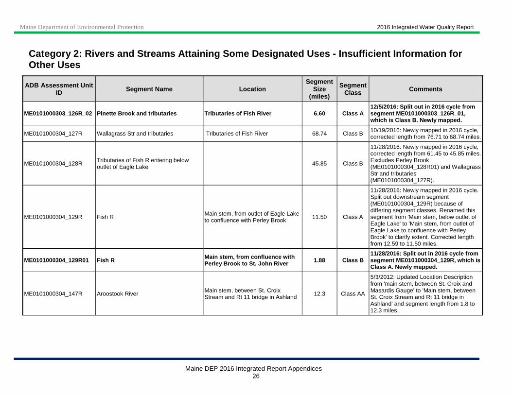
ME0101000303_126R_02 Pinette Brook and tributaries Tributaries of Fish R iver 6.60 Class A 12/5/2016: Split out in 2016 cycle from segment ME0101000303_126R_01, which is Class B. Newly mapped.
ME0101000304_127R Wallagrass Str and tributaries Tributaries of Fish River 68.74 Class B 10/19/2016: Newly mapped in 2016 cycle, corrected length from 76.71 to 68.74 miles.
ME0101000304_128R Tributaries of Fish R entering below outlet of Eagle Lake 45.85 Class B
11/28/2016: Newly mapped in 2016 cycle, corrected length from 61.45 to 45.85 miles. Excludes Perley Brook (ME0101000304_128R01) and Wallagrass Str and tributaries (ME0101000304_127R).
ME0101000304_129R Fish R Main stem, from outlet of Eagle Lake to confluence with Perley Brook 11.50 Class A
11/28/2016: Newly mapped in 2016 cycle. Split out downstream segment (ME0101000304_129R) because of differing segment classes. Renamed this segment from 'Main stem, below outlet of Eagle Lake' to 'Main stem, from outlet of Eagle Lake to confluence with Perley Brook' to clarify extent. Corrected length from 12.59 to 11.50 miles.
ME0101000304_129R01 Fish R Main stem, from confluence with Perley Brook to St. John River 1.88 Class B
11/28/2016: Split out in 2016 cycle from segment ME0101000304_129R, which is Class A. Newly mapped.
ME0101000304_147R Aroostook River Main stem, between St. Croix Stream and Rt 11 bridge in Ashland 12.3 Class AA
5/3/2012: Updated Location Description from 'main stem, between St. Croix and Masardis Gauge' to 'Main stem, between St. Croix Stream and Rt 11 bridge in Ashland' and segment length from 1.8 to 12.3 miles.

Maine Department of Environmental Protection 2016 Integrated Water Quality Report
Maine DEP 2016 Integrated Report Appendices 27
Category 2: Rivers and Streams Attaining Some Desig nated Uses - Insufficient Information for Other Uses
ADB Assessment Unit ID Segment Name Location
Segment Size
(miles)
Segment Class Comments
ME0101000408_132R Scopan Stream and tributaries 83.16 Class B
4/9/2012: Changed AU name from 'Squapan Stream and tributaries' to 'Scopan Stream and tributaries', in keeping with ME LD 797 "An Act to Fully Implement the Legislation to Prohibit Offensive Place Names'.
ME0101000408_136R Minor tributaries of Aroostook R entering between confluence 25.54 Class A
ME0101000410_133R Machias R and its tributaries 182.92 Class AA
ME0101000411_134R Little Machias R and its tributaries 66.96 Class A
ME0101000411_135R Beaver Brk and its tributaries Tributaries to Aroostook River 112.12 Class A
8/4/2015: Newly mapped in 2014 cycle, corrected length from 104.55 to 112.12 miles. Beaver Brook and its tributaries (T14 R6 WELS, T14 R5 WELS, T13 R5 WELS, Portage Lake, Ashland, Castle Hill) were upgraded from Class B to Class A in 2009 (effective date 9/12/2009).
ME0101000411_136R Minor tributaries of Aroostook R above Washburn Gauge
92.29 Class B
Minor tributaries entering above confluence with Machias River are Class A; all tributaries downstream of Machias River confluence, Class B.
ME0101000411_137R Salmon Brk and its tributaries Tributaries to Aroostook River 66.29 Class B
10/19/2016: Corrected mapping in 2016 cycle, updated length from 52.37 to 66.29 miles. 5/22/2012: Excludes mainstem Salmon Brook: new Category 3 listing [Salmon Brook (Washburn), ME0101000411_137R01] for Aquatic Life Use (algae/periphyton).

Maine Department of Environmental Protection 2016 Integrated Water Quality Report
Maine DEP 2016 Integrated Report Appendices 28
Category 2: Rivers and Streams Attaining Some Desig nated Uses - Insufficient Information for Other Uses
ADB Assessment Unit ID Segment Name Location
Segment Size
(miles)
Segment Class Comments
ME0101000411_147R Aroostook River Main stem between Rt 11 bridge in Ashland and Washburn Gauge 22.2 Class B
5/3/2012: Changed Location Description from 'main stem, above Washburn Gauge' to 'Main stem between Rt 11 bridge in Ashland and Washburn Gauge' and Use Class A to Use Class B; updated length from 29.39 to 22.2 miles.
ME0101000412_138R Minor tributaries Aroostook R Entering from south above Presque Isle 11.96 Class B
ME0101000412_139R Presque Isle Str Main stem and tributaries above confluence of Alder Brk and Alder Brk and tributaries
134.6 Class A
3/10/2015: Location description changed in 2014 cycle from 'Main stem above confluence of Alder Brk' to 'Main stem and tributaries above confluence of Alder Brk and Alder Brk and tributaries' to clarify extent. Newly mapped, corrected length from 108.56 to 134.6 miles.
ME0101000412_140R Presque Isle Str
Main stem between Alder Brook and (former) Presque Isle Sewer District outfall, and tributaries below confluence with Alder Brk
119.2 Class B
3/10/2015: Location description changed in 2014 cycle from 'Main stem below confluence of Alder Brk' to 'Main stem between Alder Brook and (former) Presque Isle Sewer District outfall, and tributaries below confluence with Alder Brk' to clarify and correct extent. The following tributaries are excluded from this segment because they are separate assessment units: Dudley Brook (Chapman); Unnamed Stream (P.I. airport) - 'Hanson Brook, BioSta 743'; Kennedy Brook (Presque Isle); N Br Presque Isle Stream; and No. Br. Presque Isle Stream between Mapleton and Presque Isle. Newly mapped in its entirety, corrected length from 48.17 to 119.2 miles.

Maine Department of Environmental Protection 2016 Integrated Water Quality Report
Maine DEP 2016 Integrated Report Appendices 29
Category 2: Rivers and Streams Attaining Some Desig nated Uses - Insufficient Information for Other Uses
ADB Assessment Unit ID Segment Name Location
Segment Size
(miles)
Segment Class Comments
ME0101000412_140R01 No. Br. Presque Isle Stream between Mapleton and Presque Isle
From Mapleton Sewer District outfall to confluence with Presque Isle Stream
5.2 Class B
3/5/2015: Segment was delisted in 2006 cycle to Category 2 for Aquatic Life Use. This segment is also in Category 5-D for legacy DDT; this listing was previously included in 14.68-mile assessment unit ME0101000412_140R03_02, N Br Presque Isle Stream. In 2014 cycle, 5-D listing was added to this AU and ME0101000412_140R03_02 was shortened (from 14.68 to 10.7 miles) to exclude this segment (to avoid overlapping listings). This segment was also newly mapped and the length was corrected from 11.49 to 5.2 miles. Previously 5-A listed. Removal of Mapleton POTW complete. 2004 biomonitoring showed attainment of Class A biocriteria at Station 11 (0.2 km downstream of former Mapleton POTW).
ME0101000412_141R Minor tributaries Aroostook R Entering north and west above Caribou 39.57 Class B
ME0101000412_143R Minor tributaries Aroostook R Entering from south below Presque Isle Str 9.91 Class B
ME0101000412_148R Aroostook River Main stem between Washburn Gauge and confluence with Presque Isle Stream
10.0 Class B
5/3/2012: Changed Location Description from 'main stem, above Caribou' to 'Main stem between Washburn Gauge and confluence with Presque Isle Stream' and updated length from 24.17 to 10.0 miles.
ME0101000413_142R Caribou Str and its tributaries Tributaries to Aroostook River; excluding Caribou Stream in Caribou 53.97 Class B
10/11/2016: Newly mapped in 2016 cycle, corrected length from 33.18 to 53.97 miles.
ME0101000413_144R Minor tributaries Aroostook R Entering from north below Caribou 35.0 Class B

Maine Department of Environmental Protection 2016 Integrated Water Quality Report
Maine DEP 2016 Integrated Report Appendices 30
Category 2: Rivers and Streams Attaining Some Desig nated Uses - Insufficient Information for Other Uses
ADB Assessment Unit ID Segment Name Location
Segment Size
(miles)
Segment Class Comments
ME0101000413_145R Little Madawaska R and tributaries Above (Little) Madawaska Dam; tributaries to Aroostook River 237.64 Class A
3/7/2017: Newly mapped in 2016 cycle, corrected length from 247.46 to 237.64 miles. Added location to clarify extent.
ME0101000413_146R Limestone Str and its tributaries 40.45 Class B
ME0101000413_146R01 Webster Brook Tributary to Limestone Stream 4.9 Class B
5/23/2012: Corrected stream length from 12.1 to 4.9 miles. Delisted to Category 2 due to TMDL monitoring data showing attainment of bacteria standards. Was included in multi-stream bacteria TMDL (approved 9/28/09).
ME0101000502_153R S Branch of Meduxnekeag R and its tributaries 61.33 Class B
ME0101000503_151R N Branch of Meduxnekeag R and its tributaries 153.88 Class A
ME0101000504_152R Meduxnekeag R Main stem, and tributaries 234.13 Class B Except South and West Branches of Meduxnekeag River and their tributaries.
ME0102000102_201R West Branch of Penobscot R And its tributaries above Seboomook L outlet/dam 394.39 Class A
1/30/2017: Newly mapped in 2016 cycle, corrected length from 194.24 to 394.39 miles.
ME0102000103_201R01 West Branch of Penobscot R and its tributaries at Chesuncook
From Seboomook Lake Dam to Chesuncook Lake Inlet 375.66 Class A
2/1/2017: Newly mapped in 2016 cycle, corrected length from 233.11 to 375.66 miles. Added location description to clarify extent. Excludes 1-mile segment of mainstem West Branch Penobscot River below Seboomook Lake Dam (ME0102000103_201R02 and ME0102000103_201R03).
Maine Department of Environmental Protection 2016 Integrated Water Quality Report
Maine DEP 2016 Integrated Report Appendices 31
Category 2: Rivers and Streams Attaining Some Desig nated Uses - Insufficient Information for Other Uses
ADB Assessment Unit ID Segment Name Location
Segment Size
(miles)
Segment Class Comments
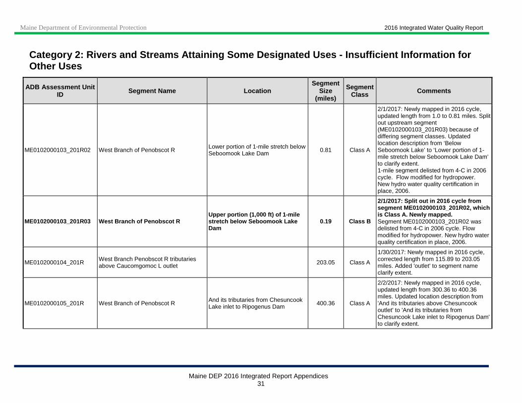
ME0102000103_201R02 West Branch of Penobscot R Lower portion of 1-mile stretch below Seboomook Lake Dam 0.81 Class A
2/1/2017: Newly mapped in 2016 cycle, updated length from 1.0 to 0.81 miles. Split out upstream segment (ME0102000103_201R03) because of differing segment classes. Updated location description from ‘Below Seboomook Lake’ to ‘Lower portion of 1-mile stretch below Seboomook Lake Dam’ to clarify extent. 1-mile segment delisted from 4-C in 2006 cycle. Flow modified for hydropower. New hydro water quality certification in place, 2006.
ME0102000103_201R03 West Branch of Penobscot R Upper portion (1,000 ft) of 1-mile stretch below Seboomook Lake Dam
0.19 Class B
2/1/2017: Split out in 2016 cycle from segment ME0102000103_201R02, which is Class A. Newly mapped. Segment ME0102000103_201R02 was delisted from 4-C in 2006 cycle. Flow modified for hydropower. New hydro water quality certification in place, 2006.
ME0102000104_201R West Branch Penobscot R tributaries above Caucomgomoc L outlet 203.05 Class A
1/30/2017: Newly mapped in 2016 cycle, corrected length from 115.89 to 203.05 miles. Added 'outlet' to segment name clarify extent.
ME0102000105_201R West Branch of Penobscot R And its tributaries from Chesuncook Lake inlet to Ripogenus Dam 400.36 Class A
2/2/2017: Newly mapped in 2016 cycle, updated length from 300.36 to 400.36 miles. Updated location description from 'And its tributaries above Chesuncook outlet' to 'And its tributaries from Chesuncook Lake inlet to Ripogenus Dam' to clarify extent.
Maine Department of Environmental Protection 2016 Integrated Water Quality Report
Maine DEP 2016 Integrated Report Appendices 32
Category 2: Rivers and Streams Attaining Some Desig nated Uses - Insufficient Information for Other Uses
ADB Assessment Unit ID Segment Name Location
Segment Size
(miles)
Segment Class Comments
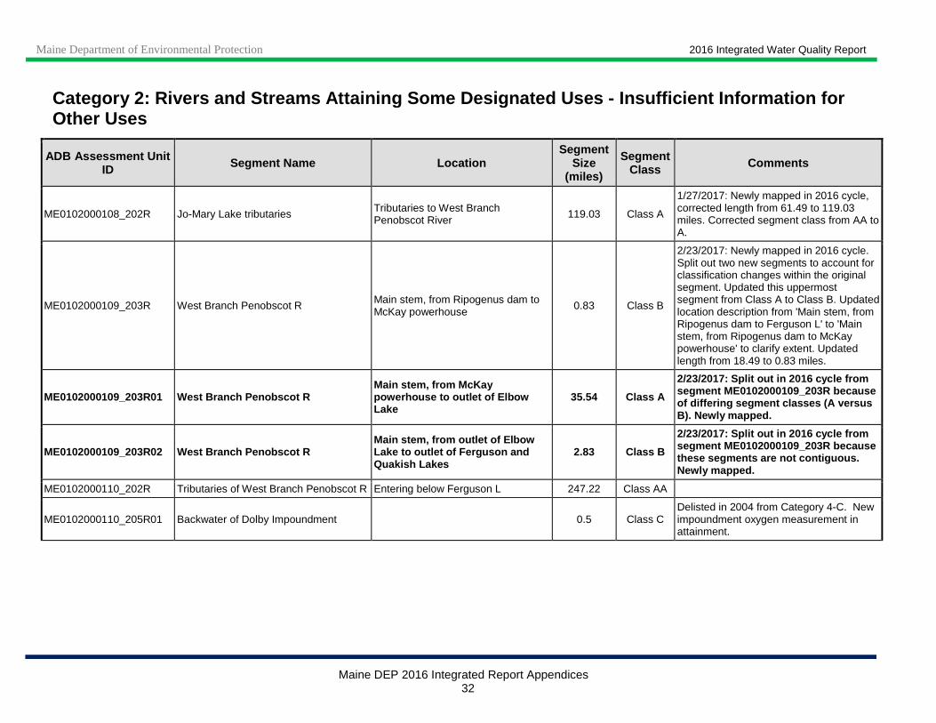
ME0102000108_202R Jo-Mary Lake tributaries Tributaries to West Branch Penobscot River 119.03 Class A
1/27/2017: Newly mapped in 2016 cycle, corrected length from 61.49 to 119.03 miles. Corrected segment class from AA to A.
ME0102000109_203R West Branch Penobscot R Main stem, from Ripogenus dam to McKay powerhouse
0.83 Class B
2/23/2017: Newly mapped in 2016 cycle. Split out two new segments to account for classification changes within the original segment. Updated this uppermost segment from Class A to Class B. Updated location description from 'Main stem, from Ripogenus dam to Ferguson L' to 'Main stem, from Ripogenus dam to McKay powerhouse' to clarify extent. Updated length from 18.49 to 0.83 miles.
ME0102000109_203R01 West Branch Penobscot R Main stem, from McKay powerhouse to outlet of Elbow Lake
35.54 Class A
2/23/2017: Split out in 2016 cycle from segment ME0102000109_203R because of differing segment classes (A versus B). Newly mapped.
ME0102000109_203R02 West Branch Penobscot R Main stem, from outlet of Elbow Lake to outlet of Ferguson and Quakish Lakes
2.83 Class B
2/23/2017: Split out in 2016 cycle from segment ME0102000109_203R because these segments are not contiguous. Newly mapped.
ME0102000110_202R Tributaries of West Branch Penobscot R Entering below Ferguson L 247.22 Class AA
ME0102000110_205R01 Backwater of Dolby Impoundment 0.5 Class C Delisted in 2004 from Category 4-C. New impoundment oxygen measurement in attainment.

Maine Department of Environmental Protection 2016 Integrated Water Quality Report
Maine DEP 2016 Integrated Report Appendices 33
Category 2: Rivers and Streams Attaining Some Desig nated Uses - Insufficient Information for Other Uses
ADB Assessment Unit ID Segment Name Location
Segment Size
(miles)
Segment Class Comments
ME0102000202_207R East Branch Penobscot R Above Grand Lake (Mattagamon) Dam 26.53 Class A
2/10/2017: Split out in 2016 cycle from segment 'East Branch Penobscot R, Main stem from Seboeis R to 1,000 ft downstream of Grand Lake (Mattagamon) Dam' (formerly 'Main stem above Seboeis R', ME0102000203_207R), because of differing HUC (0102000202 versus 0102000203). This portion of the main stem was not previously included in any other existing segment.
ME0102000203_206R Tributaries of East Branch Penobscot R above Seboeis R
From Seboeis R to Grand Lake (Mattagamon) Dam 6.01 Class AA
2/14/2017: Newly mapped in 2016 cycle, corrected length from 62.57 to 6.01 miles. Added location description to clarify extent. Split out majority of waters in this segment because of differing segment classes (A versus AA).
ME0102000203_206R01 Tributaries of East Branch Penobscot R above Seboeis R
From Seboeis R to Grand Lake (Mattagamon) Dam 96.32 Class A
2/14/2017: Split out in 2016 cycle from ME0102000203_206R because of differing segment classes (A versus AA).

Maine Department of Environmental Protection 2016 Integrated Water Quality Report
Maine DEP 2016 Integrated Report Appendices 34
Category 2: Rivers and Streams Attaining Some Desig nated Uses - Insufficient Information for Other Uses
ADB Assessment Unit ID Segment Name Location
Segment Size
(miles)
Segment Class Comments
ME0102000203_207R East Branch Penobscot R Main stem from Seboeis R to 1,000 ft downstream of Grand Lake (Mattagamon) Dam
20.78 Class AA
2/10/2017: Newly mapped in 2016 cycle, corrected length from 22.89 to 20.78 miles. Updated location description from 'Main stem above Seboeis R' to 'Main stem from Seboeis R to 1,000 ft downstream of Grand Lake (Mattagamon) Dam' to clarify extent. Split out 1,000 ft section below Dam because of differing segment classes. Also split out main stem above Dam from this segment because it is located in HUC 0102000203 and not included in any other existing segment. Created segment ME0102000202_207R to address this problem.
ME0102000203_207R01 East Branch Penobscot R Main stem from 1,000 ft downstream of Grand Lake (Mattagamon) Dam to Dam
0.19 Class A
2/10/2017: Split out from segment 'East Branch Penobscot R, Main stem from Seboeis R to 1,000 ft downstream of Grand Lake (Mattagamon) Dam' (ME0102000203_207R) in 2016 cycle, because of differing segment class (A versus AA).
ME0102000204_206R Seboeis River and tributaries 228.46 Class AA
ME0102000205_206R Tributaries of East Branch Penobscot R below Seboeis R 264.48 Class AA
ME0102000205_207R East Branch Penobscot R Main stem from confluence with West Branch Penobscot R to Seboeis R
27.31 Class AA
2/10/2017: Newly mapped in 2016 cycle, corrected length from 24.97 to 27.31 miles. Updated location description from 'Main stem above Seboeis R’ to ‘Main stem from confluence with West Branch Penobscot R to Seboeis R’ to clarify extent.
Maine Department of Environmental Protection 2016 Integrated Water Quality Report
Maine DEP 2016 Integrated Report Appendices 35
Category 2: Rivers and Streams Attaining Some Desig nated Uses - Insufficient Information for Other Uses
ADB Assessment Unit ID Segment Name Location
Segment Size
(miles)
Segment Class Comments
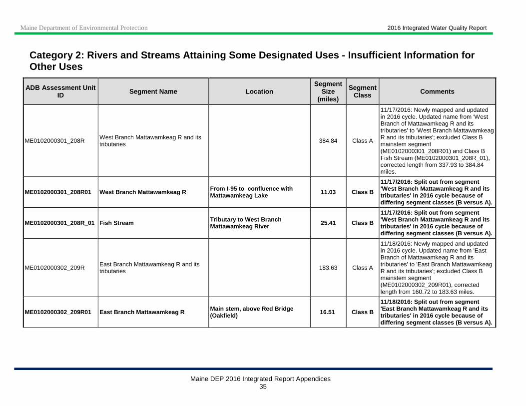
ME0102000301_208R West Branch Mattawamkeag R and its tributaries 384.84 Class A
11/17/2016: Newly mapped and updated in 2016 cycle. Updated name from 'West Branch of Mattawamkeag R and its tributaries' to 'West Branch Mattawamkeag R and its tributaries'; excluded Class B mainstem segment (ME0102000301_208R01) and Class B Fish Stream (ME0102000301_208R_01), corrected length from 337.93 to 384.84 miles.
ME0102000301_208R01 West Branch Mattawamkeag R From I-95 to confluence with Mattawamkeag Lake 11.03 Class B
11/17/2016: Split out from segment 'West Branch Mattawamkeag R and its tributaries' in 2016 cycle because of differing segment classes (B versus A).
ME0102000301_208R_01 Fish Stream Tributary to West Branch Mattawamkeag River 25.41 Class B
11/17/2016: Split out from segment 'West Branch Mattawamkeag R and its tributaries' in 2016 cycle because of differing segment classes (B versus A).
ME0102000302_209R East Branch Mattawamkeag R and its tributaries 183.63 Class A
11/18/2016: Newly mapped and updated in 2016 cycle. Updated name from 'East Branch of Mattawamkeag R and its tributaries' to 'East Branch Mattawamkeag R and its tributaries'; excluded Class B mainstem segment (ME0102000302_209R01), corrected length from 160.72 to 183.63 miles.
ME0102000302_209R01 East Branch Mattawamkeag R Main stem, above Red Bridge (Oakfield) 16.51 Class B
11/18/2016: Split out from segment 'East Branch Mattawamkeag R and its tributaries' in 2016 cycle because of differing segment classes (B versus A).

Maine Department of Environmental Protection 2016 Integrated Water Quality Report
Maine DEP 2016 Integrated Report Appendices 36
Category 2: Rivers and Streams Attaining Some Desig nated Uses - Insufficient Information for Other Uses
ADB Assessment Unit ID Segment Name Location
Segment Size
(miles)
Segment Class Comments
ME0102000303_212R Minor tributaries of Mattawamkeag R From confluence of East and West Branches to Baskahegan Stream 118.55 Class A
11/21/2016: Newly mapped in 2016 cycle, corrected length from 82.9 to 118.55 miles. Updated location description from 'Below confluence of E and W Branch' to 'From confluence of East and West Branches to Baskahegan Stream' to clarify extent.
ME0102000303_213R Mattawamkeag R, Main stem, from confluence of East and West Branches to Baskahegan Stream
15.81 Class A
11/15/2016: Newly mapped in 2016 cycle, corrected length from 15.46 to 15.81 miles. Updated location description from 'Main stem, below confluence with E and W Branch' to 'Main stem, from confluence of East and West Branches to Baskahegan Stream' to clarify extent.
ME0102000304_210R Baskahegan Str and its tributaries Tributaries to Mattawamkeag River 271.76 Class A 11/21/2016: Newly mapped in 2016 cycle, corrected length from 202.99 to 271.76 miles.
ME0102000305_212R Minor tributaries of Mattawamkeag R Entering between Baskahegan Str and Kingman TWP townline 282.46 Class A
11/21/2016: Newly mapped in 2016 cycle, corrected length from 218.28 to 282.46 miles. Updated location description from ‘Below confluence with Baskahegan Str' to ‘Entering between Baskahegan Str and Kingman TWP townline' to clarify extent.
ME0102000305_213R Mattawamkeag R Main stem, from Baskahegan Stream to Spencer Brook 22.76 Class A
11/15/2016: Newly mapped in 2016 cycle, corrected length from 21.9 to 22.76 miles. Updated location description from 'Main stem, below confluence with Baskahegan Str' to 'Main stem, from Baskahegan Stream to Spencer Brook ' to clarify extent.
ME0102000306_211R Molunkus Str and its tributaries Tributaries to Mattawamkeag River 281.53 Class A 11/15/2016: Newly mapped in 2016 cycle, corrected length from 238.97 to 281.53 miles.
Maine Department of Environmental Protection 2016 Integrated Water Quality Report
Maine DEP 2016 Integrated Report Appendices 37
Category 2: Rivers and Streams Attaining Some Desig nated Uses - Insufficient Information for Other Uses
ADB Assessment Unit ID Segment Name Location
Segment Size
(miles)
Segment Class Comments
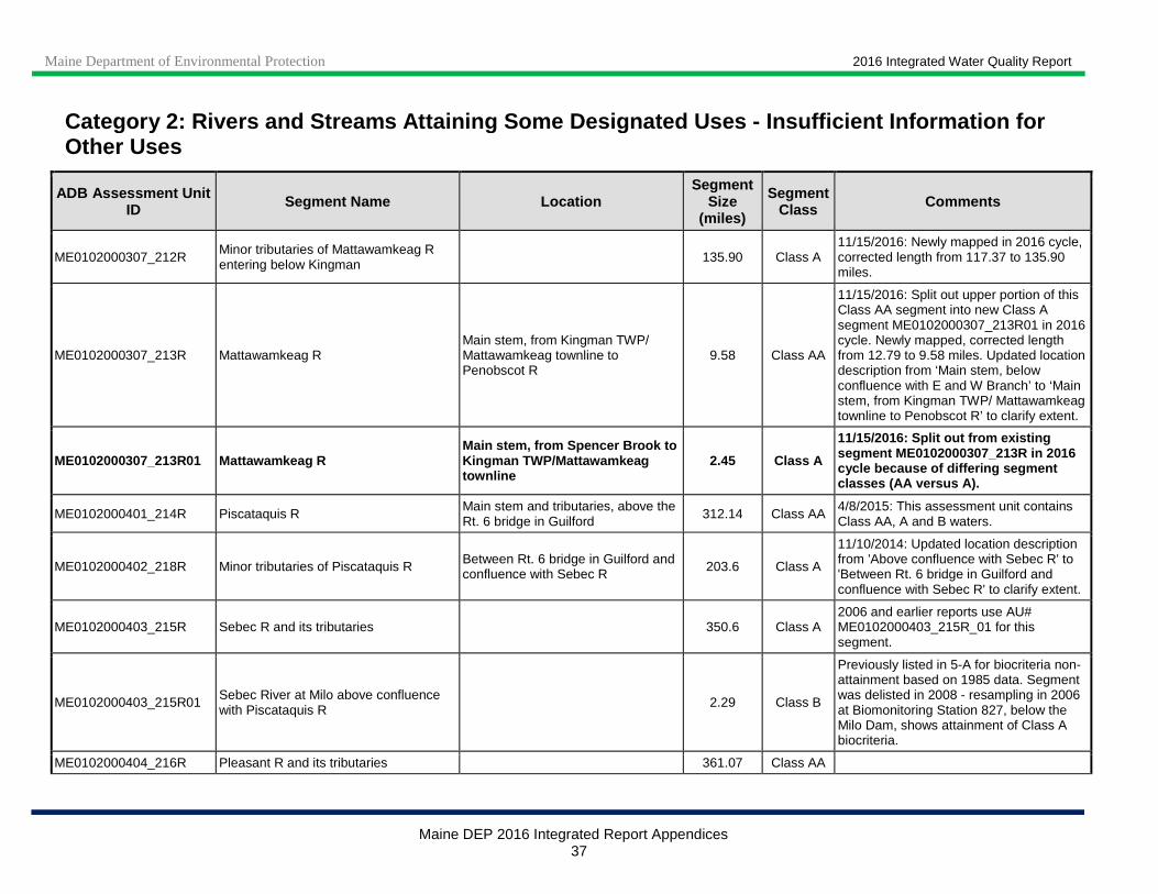
ME0102000307_212R Minor tributaries of Mattawamkeag R entering below Kingman 135.90 Class A
11/15/2016: Newly mapped in 2016 cycle, corrected length from 117.37 to 135.90 miles.
ME0102000307_213R Mattawamkeag R Main stem, from Kingman TWP/ Mattawamkeag townline to Penobscot R
9.58 Class AA
11/15/2016: Split out upper portion of this Class AA segment into new Class A segment ME0102000307_213R01 in 2016 cycle. Newly mapped, corrected length from 12.79 to 9.58 miles. Updated location description from ‘Main stem, below confluence with E and W Branch’ to ‘Main stem, from Kingman TWP/ Mattawamkeag townline to Penobscot R’ to clarify extent.
ME0102000307_213R01 Mattawamkeag R Main stem, from Spencer Brook to Kingman TWP/Mattawamkeag townline
2.45 Class A
11/15/2016: Split out from existing segment ME0102000307_213R in 2016 cycle because of differing segment classes (AA versus A).
ME0102000401_214R Piscataquis R Main stem and tributaries, above the Rt. 6 bridge in Guilford 312.14 Class AA
4/8/2015: This assessment unit contains Class AA, A and B waters.
ME0102000402_218R Minor tributaries of Piscataquis R Between Rt. 6 bridge in Guilford and confluence with Sebec R 203.6 Class A
11/10/2014: Updated location description from 'Above confluence with Sebec R' to 'Between Rt. 6 bridge in Guilford and confluence with Sebec R' to clarify extent.
ME0102000403_215R Sebec R and its tributaries 350.6 Class A 2006 and earlier reports use AU# ME0102000403_215R_01 for this segment.
ME0102000403_215R01 Sebec River at Milo above confluence with Piscataquis R
2.29 Class B
Previously listed in 5-A for biocriteria non-attainment based on 1985 data. Segment was delisted in 2008 - resampling in 2006 at Biomonitoring Station 827, below the Milo Dam, shows attainment of Class A biocriteria.
ME0102000404_216R Pleasant R and its tributaries 361.07 Class AA
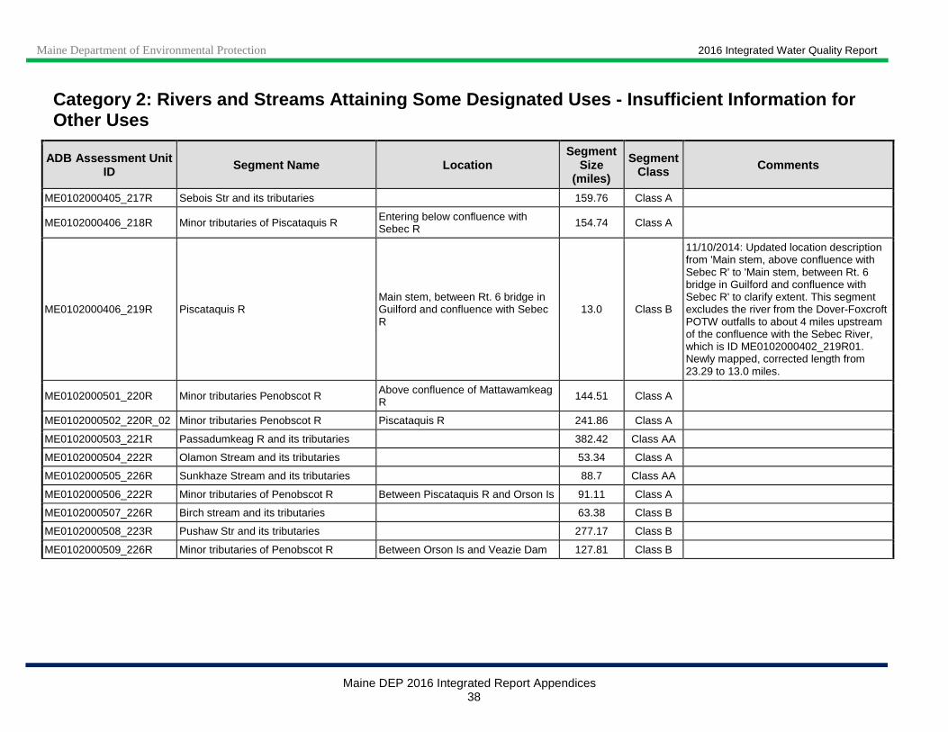
Maine Department of Environmental Protection 2016 Integrated Water Quality Report
Maine DEP 2016 Integrated Report Appendices 38
Category 2: Rivers and Streams Attaining Some Desig nated Uses - Insufficient Information for Other Uses
ADB Assessment Unit ID Segment Name Location
Segment Size
(miles)
Segment Class Comments
ME0102000405_217R Sebois Str and its tributaries 159.76 Class A
ME0102000406_218R Minor tributaries of Piscataquis R Entering below confluence with Sebec R 154.74 Class A
ME0102000406_219R Piscataquis R Main stem, between Rt. 6 bridge in Guilford and confluence with Sebec R
13.0 Class B
11/10/2014: Updated location description from 'Main stem, above confluence with Sebec R' to 'Main stem, between Rt. 6 bridge in Guilford and confluence with Sebec R' to clarify extent. This segment excludes the river from the Dover-Foxcroft POTW outfalls to about 4 miles upstream of the confluence with the Sebec River, which is ID ME0102000402_219R01. Newly mapped, corrected length from 23.29 to 13.0 miles.
ME0102000501_220R Minor tributaries Penobscot R Above confluence of Mattawamkeag R 144.51 Class A
ME0102000502_220R_02 Minor tributaries Penobscot R Piscataquis R 241.86 Class A
ME0102000503_221R Passadumkeag R and its tributaries 382.42 Class AA
ME0102000504_222R Olamon Stream and its tributaries 53.34 Class A
ME0102000505_226R Sunkhaze Stream and its tributaries 88.7 Class AA
ME0102000506_222R Minor tributaries of Penobscot R Between Piscataquis R and Orson Is 91.11 Class A
ME0102000507_226R Birch stream and its tributaries 63.38 Class B
ME0102000508_223R Pushaw Str and its tributaries 277.17 Class B
ME0102000509_226R Minor tributaries of Penobscot R Between Orson Is and Veazie Dam 127.81 Class B

Maine Department of Environmental Protection 2016 Integrated Water Quality Report
Maine DEP 2016 Integrated Report Appendices 39
Category 2: Rivers and Streams Attaining Some Desig nated Uses - Insufficient Information for Other Uses
ADB Assessment Unit ID Segment Name Location
Segment Size
(miles)
Segment Class Comments
ME0102000509_226R02 Boynton Brook Bradley, trib to Great Works Stream/Penobscot River 2.64 Class A
5/24/2012: Classification corrected from (erroneous) Class B to Class A. Delisted to Category 2 due to newer monitoring data showing attainment of bacteria standards. 9/28/2009: Recreational use impairments now Category 4A due to approval of statewide bacteria TMDL.
ME0102000510_224R Kenduskeag Str and its tributaries 199.83 Class B
ME0102000510_224R02 Kenduskeag Stream Bangor, Bullseye Bridge to Penobscot R 2.96 Class C
7/17/2012: Corrected statutory class to Class C (was B). Recreational use impairments Category 4-A due to approval of statewide bacteria TMDL by EPA 9/28/09. Segment delisted to Category 2 in 2010 for recreational uses due to TMDL monitoring data showing attainment of bacteria standards. Listing was inadvertently omitted in 2010 report.
ME0102000511_225R Souadabscook Str and tributaries 156 Class AA
ME0102000512_228R Marsh River and its tributaries (nontidal portions) 199.77 Class B
ME0102000513_226R Minor tributaries Penobscot R Between Veazie Dam and Reeds Bk (non-tidal portions) 62.12 Class B 8/14/2012: Corrected spelling of Reed
Brook to Reeds Brook.
ME0102000513_227R Minor tributaries entering from the east to Penobscot R
Between Reeds Bk and south end of Verona Is 185.21 Class B 8/14/2012: Corrected spelling of Reed
Brook to Reeds Brook.
ME0102000513_227R01 Mill Stream (Orrington) Tributary to Penobscot River 1.11 Class B 10/11/2016: Newly mapped in 2016 cycle, corrected length from 2.0 to 1.11 miles. AKA Mill Creek.
ME0102000513_228R Minor tributaries entering from the west to Penobscot R
Between Reeds Bk and south end of Verona Is 26.57 Class B
8/14/2012: Corrected spelling of Reed Brook to Reeds Brook.

Maine Department of Environmental Protection 2016 Integrated Water Quality Report
Maine DEP 2016 Integrated Report Appendices 40
Category 2: Rivers and Streams Attaining Some Desig nated Uses - Insufficient Information for Other Uses
ADB Assessment Unit ID Segment Name Location
Segment Size
(miles)
Segment Class Comments
ME0103000103_301R Moose R and its tributaries above Rt 201 Jackman
From Route 201 bridge, Jackman to inlet of Attean Pond 235.92 Class A
12/29/2016: Newly mapped in 2016 cycle. Corrected location description from 'Moose R from the outlet of Attean Pond to Route 201 bridge, Jackman' to 'From Route 201 bridge, Jackman to inlet of Attean Pond'. Updated length from 88.74 to 235.92 miles. 9/10/2014: Corrected segment Class from AA to A, added location description to clarify extent.
ME0103000103_302R Moose R and its tributaries at Long Pond
Moose R from Route 201 bridge, Jackman to confluence with Long Pond
113.6 Class A
9/10/2014: Mainstem Moose River is Class B from Rt 201 in Jackman to Long Pond, tributaries are Class A. Added location description to clarify extent.
ME0103000104_302R Moose River and tributaries at Brassua L 134.37 Class A
ME0103000105_303R Moosehead Lake and minor tributaries of Moosehead Lake 401.92 Class A
ME0103000106_304R Minor tributaries of Kennebec R entering above Dead R 268.45 Class AA
ME0103000106_306R Kennebec R Main stem, above confluence of Dead R 19.16 Class AA
ME0103000201_307R North Branch of Dead R and its tributaries 131.98 Class A
ME0103000203_309R Flagstaff Lake and minor tributaries of Flagstaff Lake 96.52 Class A
ME0103000204_310R Tributaries of Dead R entering below Flagstaff Lake 204.87 Class A
ME0103000204_311R_01 Dead R, main stem 22.2 Class AA
Excluding 1-mile segment (ME0103000204_311R_02) below Flagstaff Lake which is listed in Category 4-C, flow modified for hydropower.
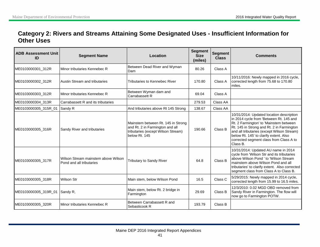
Maine Department of Environmental Protection 2016 Integrated Water Quality Report
Maine DEP 2016 Integrated Report Appendices 41
Category 2: Rivers and Streams Attaining Some Desig nated Uses - Insufficient Information for Other Uses
ADB Assessment Unit ID Segment Name Location
Segment Size
(miles)
Segment Class Comments
ME0103000301_312R Minor tributaries Kennebec R Between Dead River and Wyman Dam
80.26 Class A
ME0103000302_312R Austin Stream and tributaries Tributaries to Kennebec River 170.80 Class A 10/11/2016: Newly mapped in 2016 cycle, corrected length from 75.68 to 170.80 miles.
ME0103000303_312R Minor tributaries Kennebec R Between Wyman dam and Carrabassett R 69.04 Class A
ME0103000304_313R Carrabassett R and its tributaries 279.53 Class AA
ME0103000305_315R_01 Sandy R And tributaries above Rt 145 Strong 138.67 Class AA
ME0103000305_316R Sandy River and tributaries
Mainstem between Rt. 145 in Strong and Rt. 2 in Farmington and all tributaries (except Wilson Stream) below Rt. 145
190.66 Class B
10/31/2014: Updated location description in 2014 cycle from 'Between Rt. 145 and Rt. 2 Farmington' to 'Mainstem between Rt. 145 in Strong and Rt. 2 in Farmington and all tributaries (except Wilson Stream) below Rt. 145' to clarify extent. Also corrected segment class from Class A to Class B.
ME0103000305_317R Wilson Stream mainstem above Wilson Pond and all tributaries Tributary to Sandy River 64.8 Class B
10/31/2014: Updated AU name in 2014 cycle from 'Wilson Str and its tributaries above Wilson Pond ' to 'Wilson Stream mainstem above Wilson Pond and all tributaries' to clarify extent. Also corrected segment class from Class A to Class B.
ME0103000305_318R Wilson Str Main stem, below Wilson Pond 16.5 Class C 5/29/2015: Newly mapped in 2014 cycle, corrected length from 15.99 to 16.5 miles.
ME0103000305_319R_01 Sandy R, Main stem, below Rt. 2 bridge in Farmington 29.69 Class B
12/3/2010: 0.02 MGD OBD removed from Sandy River in Farmington. The flow will now go to Farmington POTW.
ME0103000305_320R Minor tributaries Kennebec R Between Carrabassett R and Sebasticook R 193.79 Class B
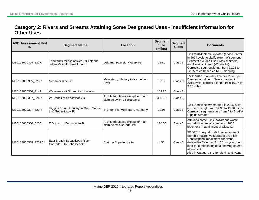
Maine Department of Environmental Protection 2016 Integrated Water Quality Report
Maine DEP 2016 Integrated Report Appendices 42
Category 2: Rivers and Streams Attaining Some Desig nated Uses - Insufficient Information for Other Uses
ADB Assessment Unit ID Segment Name Location
Segment Size
(miles)
Segment Class Comments
ME0103000305_322R Tributaries Messalonskee Str entering below Messalonskee L dam Oakland, Fairfield, Waterville 128.5 Class B
12/17/2014: Name updated (added 'dam') in 2014 cycle to clarify extent of segment. Segment exludes Fish Brook (Fairfield) and Perkins Stream (Waterville). Corrected segment length from 21.23 to 128.5 miles based on NHD mapping.
ME0103000305_323R Messalonskee Str Main stem; tributary to Kennebec River 9.10 Class C
10/11/2016: Excludes 1.3-mile Rice Rips Dam impoundment. Newly mapped in 2016 cycle, corrected length from 10.27 to 9.10 miles.
ME0103000306_314R Wesserunsett Str and its tributaries 109.85 Class B
ME0103000307_324R W Branch of Sebasticook R And its tributaries except for main stem below Rt 23 (Hartland) 350.13 Class B
ME0103000307_329R Higgins Brook, tributary to Great Moose L. & Sebasticook R. Brighton Plt, Wellington, Harmony 19.96 Class B
10/11/2016: Newly mapped in 2016 cycle, corrected length from 97.99 to 19.96 miles. Corrected segment class from A to B. AKA Higgins Stream.
ME0103000308_325R E Branch of Sebasticook R And its tributaries except for main stem below Corundel Pd 190.86 Class B
Attaining some uses, hazardous waste remediation project complete. 2003 biocriteria in attainment of Class C.
ME0103000308_325R01 East Branch Sebasticook River Corundel L to Sebasticook L Corinna Superfund site 4.51 Class C
9/15/2014: Aquatic Life Use impairment (benthic macroinvertebrates) and Fish Consumption impairment (Benzene) delisted to Category 2 in 2014 cycle due to long-term monitoring data showing criteria attainment. Also in Category 5-D for dioxin and PCBs.
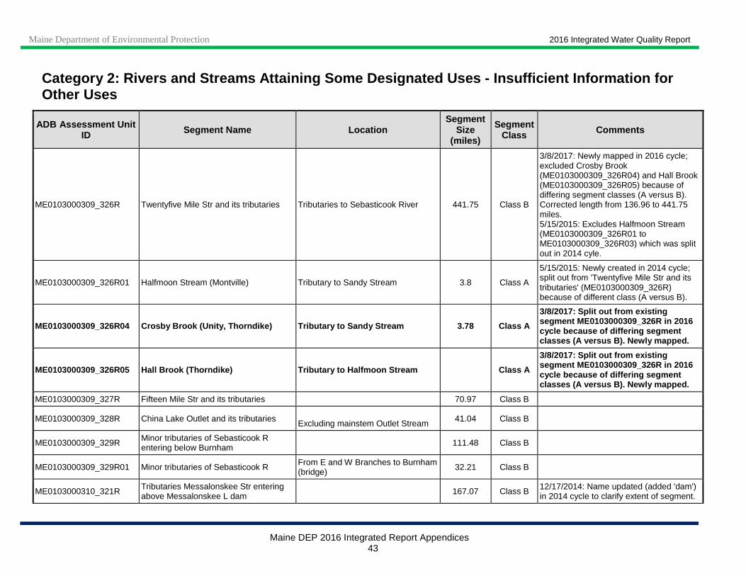
Maine Department of Environmental Protection 2016 Integrated Water Quality Report
Maine DEP 2016 Integrated Report Appendices 43
Category 2: Rivers and Streams Attaining Some Desig nated Uses - Insufficient Information for Other Uses
ADB Assessment Unit ID Segment Name Location
Segment Size
(miles)
Segment Class Comments
ME0103000309_326R Twentyfive Mile Str and its tributaries Tributaries to Sebasticook River 441.75 Class B
3/8/2017: Newly mapped in 2016 cycle; excluded Crosby Brook (ME0103000309_326R04) and Hall Brook (ME0103000309_326R05) because of differing segment classes (A versus B). Corrected length from 136.96 to 441.75 miles. 5/15/2015: Excludes Halfmoon Stream (ME0103000309_326R01 to ME0103000309_326R03) which was split out in 2014 cyle.
ME0103000309_326R01 Halfmoon Stream (Montville) Tributary to Sandy Stream 3.8 Class A
5/15/2015: Newly created in 2014 cycle; split out from 'Twentyfive Mile Str and its tributaries' (ME0103000309_326R) because of different class (A versus B).
ME0103000309_326R04 Crosby Brook (Unity, Thorndike) Tributary to Sandy Stream 3.78 Class A
3/8/2017: Split out from existing segment ME0103000309_326R in 2016 cycle because of differing segment classes (A versus B). Newly mapped.
ME0103000309_326R05 Hall Brook (Thorndike) Tributar y to Halfmoon Stream Class A
3/8/2017: Split out from existing segment ME0103000309_326R in 2016 cycle because of differing segment classes (A versus B). Newly mapped.
ME0103000309_327R Fifteen Mile Str and its tributaries 70.97 Class B
ME0103000309_328R China Lake Outlet and its tributaries Excluding mainstem Outlet Stream 41.04 Class B
ME0103000309_329R Minor tributaries of Sebasticook R entering below Burnham 111.48 Class B
ME0103000309_329R01 Minor tributaries of Sebasticook R From E and W Branches to Burnham (bridge) 32.21 Class B
ME0103000310_321R Tributaries Messalonskee Str entering above Messalonskee L dam 167.07 Class B 12/17/2014: Name updated (added 'dam')
in 2014 cycle to clarify extent of segment.

Maine Department of Environmental Protection 2016 Integrated Water Quality Report
Maine DEP 2016 Integrated Report Appendices 44
Category 2: Rivers and Streams Attaining Some Desig nated Uses - Insufficient Information for Other Uses
ADB Assessment Unit ID Segment Name Location
Segment Size
(miles)
Segment Class Comments
ME0103000311_334R Cobbosseecontee Str and its tributaries 185.45 Class B
ME0103000311_335R Minor tributaries Kennebec R Cobbosseecontee Str to Merrymeeting Bay (Chops) 144.38 Class B
5/28/2014: Corrected 'Cobbossee Stream' (incorrect/colloquial name) in segment name to 'Cobbosseecontee Stream' (correct/official name).
ME0103000312_333R Minor tributaries Kennebec R Between Sebasticook R and Cobbosseecontee Str 132.5 Class B
5/28/2014: Corrected 'Cobbossee Stream' (incorrect/colloquial name) in segment name to 'Cobbosseecontee Stream' (correct/official name).
ME0103000312_333R01 Bond Brook (Augusta) 10.0 Class B
ME0103000312_335R02 Togus Stream (Chelsea) 2.01 Class B
ME0103000312_336R Kennebec R Main stem, from Dead R to Wyman Dam
21.53 Class A 10/11/2016: Newly mapped in 2016 cycle, corrected length from 24.86 to 21.53 miles.
ME0103000312_337R Kennebec R Main stem, from Wyman Dam to Carrabassett R
18.8 Class A
5/20/2015: Newly mapped, corrected length from 23.14 to 18.8 miles. Previously Category 4-C. New certification issued. Aquatic life monitoring in attainment 2001, 2002.
ME0104000101_402R Mooseleukmeguntic - Cupsuptic R and its tributaries 38.33 Class AA
ME0104000101_403R Mooseleukmeguntic -Kennebago R and its tributaries 82.69 Class AA
ME0104000102_404R Umbagog - Rapid R and its tributaries 141.6 Class AA
ME0104000102_405R Umbagog Tributaries of Umbagog Lake and segments of minor tributaries entering Androscoggin R in NH
43.95 Class A
ME0104000103_401R Azicohos - Magalloway R And its tributaries upstream of the Maine-NH border 137.8 Class A
ME0104000104_401R Magalloway - Sturtevant Str and its tributaries 13.75 Class A
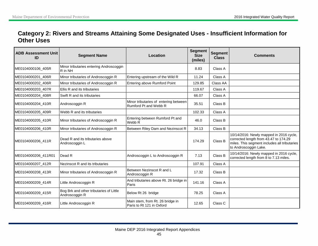
Maine Department of Environmental Protection 2016 Integrated Water Quality Report
Maine DEP 2016 Integrated Report Appendices 45
Category 2: Rivers and Streams Attaining Some Desig nated Uses - Insufficient Information for Other Uses
ADB Assessment Unit ID Segment Name Location
Segment Size
(miles)
Segment Class Comments
ME0104000106_405R Minor tributaries entering Androscoggin R in NH
8.83 Class A
ME0104000201_406R Minor tributaries of Androscoggin R Entering upstream of the Wild R 11.24 Class A
ME0104000202_406R Minor tributaries of Androscoggin R Entering above Rumford Point 129.85 Class AA
ME0104000203_407R Ellis R and its tributaries 119.67 Class A
ME0104000204_408R Swift R and its tributaries 66.07 Class A
ME0104000204_410R Androscoggin R Minor tributaries of entering between Rumford Pt and Webb R 35.51 Class B
ME0104000205_409R Webb R and its tributaries 102.33 Class A
ME0104000205_410R Minor tributaries of Androscoggin R Entering between Rumford Pt and Webb R 46.0 Class B
ME0104000206_410R Minor tributaries of Androscoggin R Between Riley Dam and Nezinscot R 34.13 Class B
ME0104000206_411R Dead R and its tributaries above Androscoggin L 174.29 Class B
10/14/2016: Newly mapped in 2016 cycle, corrected length from 43.47 to 174.29 miles. This segment includes all tributaries to Androscoggin Lake.
ME0104000206_411R01 Dead R Androscoggin L to Androscoggin R 7.13 Class B 10/14/2016: Newly mapped in 2016 cycle, corrected length from 8 to 7.13 miles.
ME0104000207_412R Nezinscot R and its tributaries 107.91 Class A
ME0104000208_413R Minor tributaries of Androscoggin R Between Nezinscot R and L Androscoggin R 17.32 Class B
ME0104000209_414R Little Androscoggin R And tributaries above Rt. 26 bridge in Paris 141.16 Class A
ME0104000209_415R Bog Brk and other tributaries of Little Androscoggin R Below Rt 26 bridge 78.25 Class A
ME0104000209_416R Little Androscoggin R Main stem, from Rt. 26 bridge in Paris to Rt 121 in Oxford 12.65 Class C

Maine Department of Environmental Protection 2016 Integrated Water Quality Report
Maine DEP 2016 Integrated Report Appendices 46
Category 2: Rivers and Streams Attaining Some Desig nated Uses - Insufficient Information for Other Uses
ADB Assessment Unit ID Segment Name Location
Segment Size
(miles)
Segment Class Comments
ME0104000209_417R_01 Little Androscoggin R, Main stem, below Rt. 121 bridge in Oxford
24.49 Class C
ME0104000210_418R Sabattus R and its tributaries 22.45 Class B
ME0104000210_418R01 Sabattus River between Sabattus P and Androscoggin R
From Sabattus Pond to limits of Lisbon urban area 9.1 Class C
11/4/2014: Sabattus Pond Watershed Project Phase III completed (January 2010-September 2012). Pond continues to have high nutrient levels; no new river data available. 5/1/2012: Sabattus Pond eutrophic and source of SOD in river; lake TMDL complete 2004; slow recovery is expected. This AU was split into upper, Class C segment and lower, Class B segment (ME0104000210_418R03) in 2012 cycle, location description was updated and length was reduced from 11.4 to 9.1 miles; aquatic life use impairment (Benthic-Macroinvertebrate Bioassessments) was delisted to Category 2 due to classification attainment at 3 biomonitoring stations (S-359, S-629, S-630) on 2-3 occasions. Aquatic life use impairment due to DO and nutrient/eutrophication biological indicators continues (Category 5-A). Also in Category 5-A for DO and nutrient/eutrophication biological indicators.
ME0104000210_419R Minor tributaries of Androscoggin R Between L Androscoggin R and Brunswick Dam 89.77 Class B
ME0104000210_420R Minor tributaries of Merrymeeting Bay 94.31 Class B
ME0105000101_501R Tributaries of St. Croix R Entering above outlet of Spednik L 111.07 Class A
ME0105000102_502R St. Croix R Main stem, from outlet of Spednik Lake to Spednik Falls
110.55 Class A
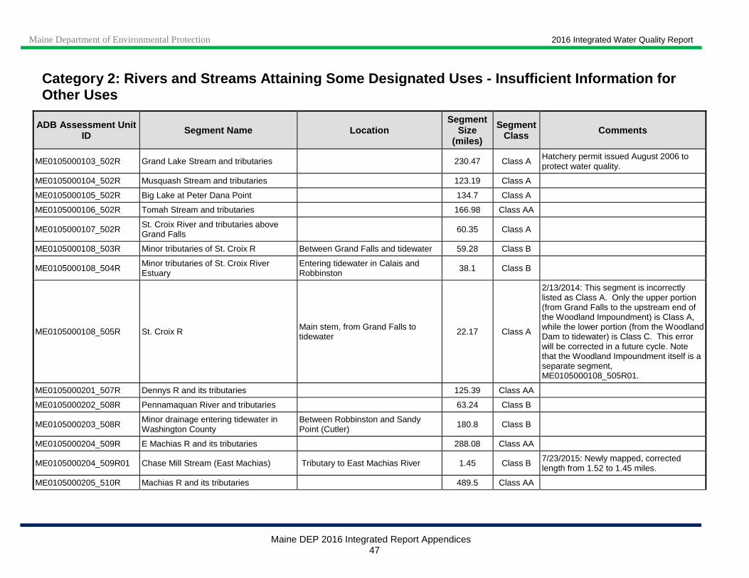
Maine Department of Environmental Protection 2016 Integrated Water Quality Report
Maine DEP 2016 Integrated Report Appendices 47
Category 2: Rivers and Streams Attaining Some Desig nated Uses - Insufficient Information for Other Uses
ADB Assessment Unit ID Segment Name Location
Segment Size
(miles)
Segment Class Comments
ME0105000103_502R Grand Lake Stream and tributaries 230.47 Class A Hatchery permit issued August 2006 to protect water quality.
ME0105000104_502R Musquash Stream and tributaries 123.19 Class A
ME0105000105_502R Big Lake at Peter Dana Point 134.7 Class A
ME0105000106_502R Tomah Stream and tributaries 166.98 Class AA
ME0105000107_502R St. Croix River and tributaries above Grand Falls 60.35 Class A
ME0105000108_503R Minor tributaries of St. Croix R Between Grand Falls and tidewater 59.28 Class B
ME0105000108_504R Minor tributaries of St. Croix River Estuary
Entering tidewater in Calais and Robbinston 38.1 Class B
ME0105000108_505R St. Croix R Main stem, from Grand Falls to tidewater 22.17 Class A
2/13/2014: This segment is incorrectly listed as Class A. Only the upper portion (from Grand Falls to the upstream end of the Woodland Impoundment) is Class A, while the lower portion (from the Woodland Dam to tidewater) is Class C. This error will be corrected in a future cycle. Note that the Woodland Impoundment itself is a separate segment, ME0105000108_505R01.
ME0105000201_507R Dennys R and its tributaries 125.39 Class AA
ME0105000202_508R Pennamaquan River and tributaries 63.24 Class B
ME0105000203_508R Minor drainage entering tidewater in Washington County
Between Robbinston and Sandy Point (Cutler) 180.8 Class B
ME0105000204_509R E Machias R and its tributaries 288.08 Class AA
ME0105000204_509R01 Chase Mill Stream (East Machias) Tributary to East Machias River 1.45 Class B 7/23/2015: Newly mapped, corrected length from 1.52 to 1.45 miles.
ME0105000205_510R Machias R and its tributaries 489.5 Class AA

Maine Department of Environmental Protection 2016 Integrated Water Quality Report
Maine DEP 2016 Integrated Report Appendices 48
Category 2: Rivers and Streams Attaining Some Desig nated Uses - Insufficient Information for Other Uses
ADB Assessment Unit ID Segment Name Location
Segment Size
(miles)
Segment Class Comments
ME0105000206_508R Roque Bluffs Coastal Minor drainages entering tidewater between Sandy Pt (Cutler) and E Machias R
51.68 Class B
ME0105000207_513R Chandler R and its tributaries 57.11 Class B
ME0105000207_513R01 Minor drainages entering tidewater in Addison and Harrington 39.85 Class A
ME0105000208_511R Pleasant R and its tributaries 109.2 Class AA
ME0105000208_511R01 Bog Stream (T18 MD BPP) Tributary to Pleasant River 1.13 Class B
8/20/2015: Newly mapped, length corrected from 1.02 to 1.13 miles. Previously 5-A listed. Aquaculture facility closed. 8/20/2012: Town corrected (was T18MD).
ME0105000209_512R_01 Narraguagus R and its tributaries 323.8 Class AA
ME0105000209_513R Minor drainages entering tidewater in Machias Bay 30.39 Class B
ME0105000209_513R01 Roque Bluff Coastal Minor drainages entering tidewater between E Machias R and Pleasant R
90.14 Class B
ME0105000210_513R Tunk Stream and tributaries 54.42 Class A
ME0105000211_513R Bois Bubert Coastal And Tunk Str 76.96 Class B
ME0105000212_515R W Branch of Union R and its tributaries 210.3 Class B
ME0105000212_516R E Branch of Union R and its tributaries 159.2 Class B
ME0105000212_517R Minor tributaries of Graham Lake 203.69 Class B
8/19/2012: Green Lake National Fish Hatchery (Ellsworth) permit re-issued 9/9/2009, exp date 9/9/2014; minor modification issued 8/7/12 (no effect on exp date).
ME0105000212_518R Tributaries of Union R entering below outlet of Graham Lake 64.14 Class B
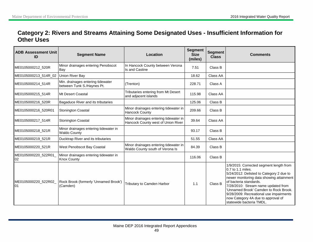
Maine Department of Environmental Protection 2016 Integrated Water Quality Report
Maine DEP 2016 Integrated Report Appendices 49
Category 2: Rivers and Streams Attaining Some Desig nated Uses - Insufficient Information for Other Uses
ADB Assessment Unit ID Segment Name Location
Segment Size
(miles)
Segment Class Comments
ME0105000212_520R Minor drainages entering Penobscot Bay
In Hancock County between Verona Is and Castine
7.51 Class B
ME0105000213_514R_02 Union River Bay 18.62 Class AA
ME0105000214_514R Min. drainages entering tidewater between Tunk S./Haynes Pt. (Trenton) 228.71 Class A
ME0105000215_514R Mt Desert Coastal Tributaries entering from Mt Desert and adjacent islands 115.98 Class AA
ME0105000216_520R Bagaduce River and its tributaries 125.06 Class B
ME0105000216_520R01 Stonington Coastal Minor drainages entering tidewater in Hancock County 209.66 Class B
ME0105000217_514R Stonington Coastal Minor drainages entering tidewater in Hancock County west of Union River 39.64 Class AA
ME0105000218_521R Minor drainages entering tidewater in Waldo County 93.17 Class B
ME0105000219_521R Ducktrap River and its tributaries 51.55 Class AA
ME0105000220_521R West Penobscot Bay Coastal Minor drainages entering tidewater in Waldo County south of Verona Is 84.39 Class B
ME0105000220_522R01_02
Minor drainages entering tidewater in Knox County 116.06 Class B
ME0105000220_522R02_01
Rock Brook (formerly 'Unnamed Brook') (Camden) Tributary to Camden Harbor 1.1 Class B
1/9/2015: Corrected segment length from 0.7 to 1.1 miles. 5/24/2012: Delisted to Category 2 due to newer monitoring data showing attainment of bacteria standards. 7/28/2010: Stream name updated from 'Unnamed Brook' Camden to Rock Brook. 9/28/2009: Recreational use impairments now Category 4A due to approval of statewide bacteria TMDL.
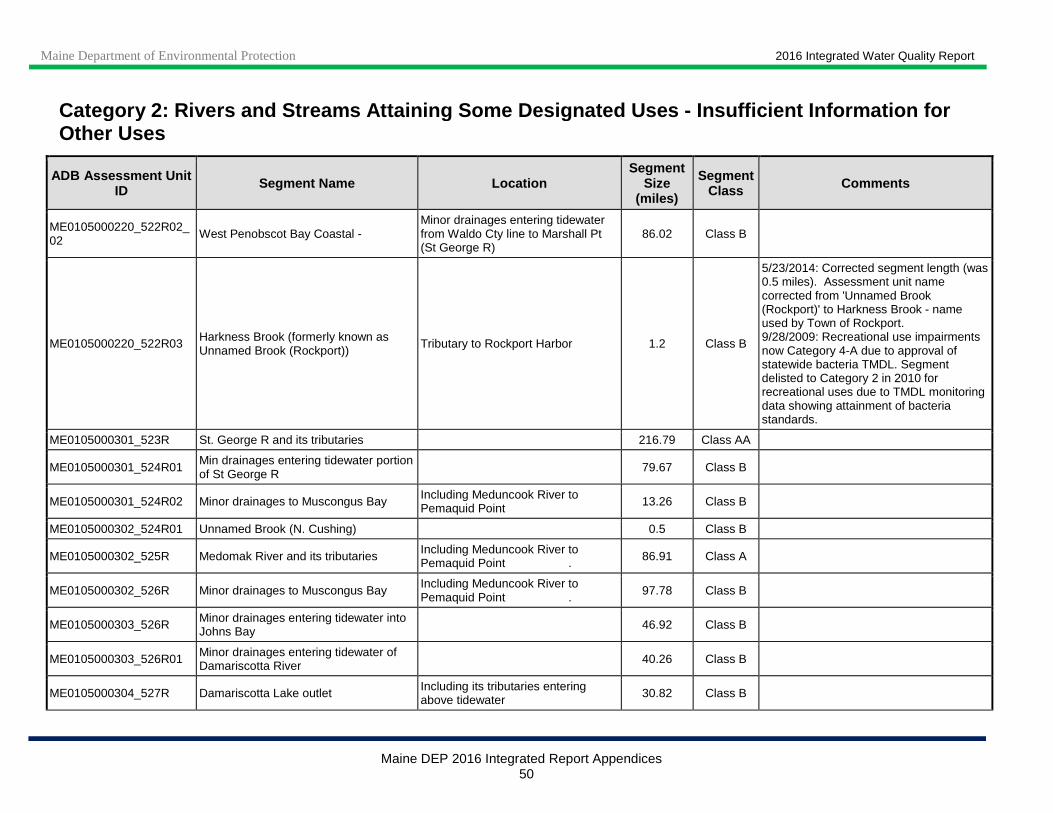
Maine Department of Environmental Protection 2016 Integrated Water Quality Report
Maine DEP 2016 Integrated Report Appendices 50
Category 2: Rivers and Streams Attaining Some Desig nated Uses - Insufficient Information for Other Uses
ADB Assessment Unit ID Segment Name Location
Segment Size
(miles)
Segment Class Comments
ME0105000220_522R02_02 West Penobscot Bay Coastal -
Minor drainages entering tidewater from Waldo Cty line to Marshall Pt (St George R)
86.02 Class B
ME0105000220_522R03 Harkness Brook (formerly known as Unnamed Brook (Rockport))
Tributary to Rockport Harbor 1.2 Class B
5/23/2014: Corrected segment length (was 0.5 miles). Assessment unit name corrected from 'Unnamed Brook (Rockport)' to Harkness Brook - name used by Town of Rockport. 9/28/2009: Recreational use impairments now Category 4-A due to approval of statewide bacteria TMDL. Segment delisted to Category 2 in 2010 for recreational uses due to TMDL monitoring data showing attainment of bacteria standards.
ME0105000301_523R St. George R and its tributaries 216.79 Class AA
ME0105000301_524R01 Min drainages entering tidewater portion of St George R 79.67 Class B
ME0105000301_524R02 Minor drainages to Muscongus Bay Including Meduncook River to Pemaquid Point 13.26 Class B
ME0105000302_524R01 Unnamed Brook (N. Cushing) 0.5 Class B
ME0105000302_525R Medomak River and its tributaries Including Meduncook River to Pemaquid Point . 86.91 Class A
ME0105000302_526R Minor drainages to Muscongus Bay Including Meduncook River to Pemaquid Point . 97.78 Class B
ME0105000303_526R Minor drainages entering tidewater into Johns Bay 46.92 Class B
ME0105000303_526R01 Minor drainages entering tidewater of Damariscotta River 40.26 Class B
ME0105000304_527R Damariscotta Lake outlet Including its tributaries entering above tidewater 30.82 Class B

Maine Department of Environmental Protection 2016 Integrated Water Quality Report
Maine DEP 2016 Integrated Report Appendices 51
Category 2: Rivers and Streams Attaining Some Desig nated Uses - Insufficient Information for Other Uses
ADB Assessment Unit ID Segment Name Location
Segment Size
(miles)
Segment Class Comments
ME0105000304_527R01 Damariscotta River below lake outlet 0.2 Class B
ME0105000305_528R Sheepscot R and its tributaries 186.3 Class AA
ME0105000305_529R01 Minor drainages entering tidewater of Damariscotta River 7.07 Class B
ME0105000305_529R02 Minor drainages entering tidewater of Sheepscot River 82.55 Class B
ME0105000306_529R Minor drainages entering tidewater of Sheepscot Bay 93.8 Class B
ME0105000306_530R Minor drainages entering tidewater of Sheepscot Bay 50.48 Class B
ME0105000307_530R Min. drainages entering tidewater of Kennebec Estuary Below the Chops 133.36 Class B
ME0106000101_605R Crooked R and its tributaries 173.58 Class AA
ME0106000101_606R Sebago Lake and its tributaries 256.73 Class A
ME0106000102_603R Royal R and its tributaries 131.86 Class A
ME0106000102_603R03 Eddy Brook (New Gloucester) Tributary to Collyer Brook 3.71 Class B 10/17/2016: Newly mapped in 2016 cycle, corrected length from 3.68 to 3.71 miles.
ME0106000102_603R04 Hatchery Brook (Gray) Tributary to Cole Brook (Gray) 1.09 Class B
1/9/2017: Newly mapped in 2016 cycle, corrected length from 0.87 to 1.09 miles. 8/9/2012: Final hatchery permit issued 2/7/12; exp date 2/7/17. Macroinvertebrates met class in 2010.
ME0106000102_603R05 Royal River Segment below Collyer Bk 2.15 Class B
Segment delisted in 2006. CERCLA hazardous waste site; water quality criteria are met down-gradient of the contaminated site.
ME0106000102_604R Min. drainages entering tidewater Between Royal River and Presumpscot River 14.65 Class B
10/11/2016: Newly mapped in 2016 cycle, corrected length from 9.8 to 14.65 miles. Excludes Norton Brook (ME0106000106_607R12).
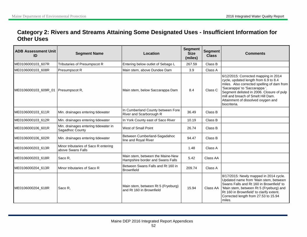
Maine Department of Environmental Protection 2016 Integrated Water Quality Report
Maine DEP 2016 Integrated Report Appendices 52
Category 2: Rivers and Streams Attaining Some Desig nated Uses - Insufficient Information for Other Uses
ADB Assessment Unit ID Segment Name Location
Segment Size
(miles)
Segment Class Comments
ME0106000103_607R Tributaries of Presumpscot R Entering below outlet of Sebago L 267.59 Class B
ME0106000103_608R Presumpscot R Main stem, above Dundee Dam 3.9 Class A
ME0106000103_609R_01 Presumpscot R, Main stem, below Saccarappa Dam 8.4 Class C
6/12/2015: Corrected mapping in 2014 cycle, updated length from 6.9 to 8.4 miles. Also corrected spelling of dam from 'Sacarappa' to 'Saccarappa '. Segment delisted in 2006. Closure of pulp mill and breach of Smelt Hill Dam. Attainment of dissolved oxygen and biocriteria.
ME0106000103_611R Min. drainages entering tidewater In Cumberland County between Fore River and Scarborough R 36.49 Class B
ME0106000103_612R Min. drainages entering tidewater In York County east of Saco River 10.19 Class B
ME0106000106_601R Min. drainages entering tidewater in Sagadhoc County West of Small Point 26.74 Class B
ME0106000106_602R Min. drainages entering tidewater Between Cumberland-Sagadahoc line and Royal River 94.47 Class B
ME0106000203_613R Minor tributaries of Saco R entering above Swans Falls 1.48 Class A
ME0106000203_618R Saco R, Main stem, between the Maine-New Hampshire border and Swans Falls 5.42 Class AA
ME0106000204_613R Minor tributaries of Saco R Between Swans Falls and Rt 160 in Brownfield 209.74 Class A
ME0106000204_618R Saco R, Main stem, between Rt 5 (Fryeburg) and Rt 160 in Brownfield
15.94 Class AA
8/17/2015: Newly mapped in 2014 cycle. Updated name from 'Main stem, between Swans Falls and Rt 160 in Brownfield' to 'Main stem, between Rt 5 (Fryeburg) and Rt 160 in Brownfield' to clarify extent. Corrected length from 27.53 to 15.94 miles.

Maine Department of Environmental Protection 2016 Integrated Water Quality Report
Maine DEP 2016 Integrated Report Appendices 53
Category 2: Rivers and Streams Attaining Some Desig nated Uses - Insufficient Information for Other Uses
ADB Assessment Unit ID Segment Name Location
Segment Size
(miles)
Segment Class Comments
ME0106000204_618R01 Saco R, Fryeburg Main stem, Swans Falls to Rt 5 (Fryeburg) 3.76 Class AA
8/17/2015: Corrected length from 5.0 to 3.76 miles. 9/28/2009: Approval of statewide bacteria TMDL. All TMDL bacteria monitoirng values were low - delisted to Category 2 due to TMDL monitoring data showing attainment of bacteria standards.
ME0106000205_613R Minor tributaries of Saco R Between Rt 160 in Brownfield and Ossipee River 116.42 Class A
ME0106000205_618R Saco R, Main stem, between Rt 160 in Brownfield and Ossipee River 20.37 Class AA
8/17/2015: Newly mapped in 2014 cycle. Corrected length from 14.95 to 20.37 miles.
ME0106000209_614R Ossipee R and its tributaries 105.38 Class B
ME0106000209_614R01 Ossipee R Mainstem below Kezar Falls 5.0 Class B
4/14/2015: Corrected spelling of segment name from 'Ossippee R' to 'Ossipee R' in 2014 cycle. 9/28/2009: Approval of statewide bacteria TMDL. Delisted to Category 2 due to TMDL monitoring data showing attainment of bacteria standards.
ME0106000210_615R Little Ossipee R and its tributaries 266.16 Class B
ME0106000210_616R Minor tributaries of Saco R Between Little Ossipee River and tidewater 214.67 Class B
ME0106000211_613R Minor tributaries of Saco R Between the Ossipee River and Little Ossipee River 75.58 Class B
ME0106000211_616R01 Deep Brook (Saco) Tributary to Saco River 4.35 Class B 10/11/2016: Newly mapped in 2016 cycle, corrected length from 2.5 to 4.35 miles.
ME0106000211_617R Min. tributaries of Saco River Estuary Entering tidewater between head of tide and Camp Ellis 12.0 Class B
ME0106000211_618R Saco R Main stem, between the Maine-New Hampshire border and Swans Falls 14.71 Class AA

Maine Department of Environmental Protection 2016 Integrated Water Quality Report
Maine DEP 2016 Integrated Report Appendices 54
Category 2: Rivers and Streams Attaining Some Desig nated Uses - Insufficient Information for Other Uses
ADB Assessment Unit ID Segment Name Location
Segment Size
(miles)
Segment Class Comments
ME0106000211_619R Saco R Main stem, between the Little Ossipee River and I-95 in Saco
21.95 Class A
8/17/2015: Corrected segment class from AA to A in 2014 cycle. Also split out most downstream portion, which is Class B, see ME0106000211_619R05. Updated name from 'Main stem, between the Little Ossipee River and tidewater' to 'Main stem, between the Little Ossipee River and I-95 in Saco' and length from 24.1 to 21.95 miles. This segment excludes 0.2-mile sub-segments _619R02 through _619R04.
ME0106000211_619R02 Saco River (Dayton) Below Skelton Dam 0.2 Class A
ME0106000211_619R03 Saco River (West Buxton) Below West Buxton Dam 0.2 Class A
ME0106000211_619R04 Saco River (Bar Mills) Below Bar Mills Dam 0.2 Class A
ME0106000211_619R05 Saco R Main stem, between I-95 in Saco and tidewater 2.37 Class B
8/17/2015: Split out from segment 'Main stem, between the Little Ossipee River and tidewater', ME0106000211_619R, in 2014 cycle because this portion is Class B while upper portion is Class A. Renamed historic segment to 'Main stem, between the Little Ossipee River and I-95 in Saco'.
ME0106000301_622R Kennebunk R and its tributaries 84.05 Class B
ME0106000302_623R Mousam R Main stem, above Rt. 224 bridge in Sanford and all tributaries to the entire main stem
170.61 Class B
3/4/2011: Category 2--Biomonitoring station 259, 2010 sample shows attainment of Class C biocriteria. Added 5.7 miles that had been erroneously placed in AU ME0106000302_628R01.
ME0106000302_624R Min. drainages entering tidewater Between Mousam River and the Ogunquit-York boundary 98.83 Class B
Maine Department of Environmental Protection 2016 Integrated Water Quality Report
Maine DEP 2016 Integrated Report Appendices 55
Category 2: Rivers and Streams Attaining Some Desig nated Uses - Insufficient Information for Other Uses
ADB Assessment Unit ID Segment Name Location
Segment Size
(miles)
Segment Class Comments
ME0106000302_628R Mousam River mainstem below Cold Water Brook From Kesslen Dam to tidewater 0.4 Class B
7/24/2015: Split segment into two in 2014 cycle to create new Category 4-C segment ME0106000302_628R03; also corrected mapping of segment to end at tidewater. These actions reduced the segment length from 9.8 to 0.4 miles. Location description changed from 'From Cold Water Brook (below Estes Lake) to tidewater' to 'From Kesslen Dam to tidewater' to describe new extent.
ME0106000303_621R Min. drainages entering tidewater Between Saco River and Kennebunk River 37.41 Class B
ME0106000304_625R02 Great Works R, Main stem, above Rt. 9 bridge in N Berwick and all tributaries
137.32 Class B
ME0106000304_626R Min. drainages entering tidewater Between Ogunquit-York boundary and Piscataqua Estuary 99.62 Class B
ME0106000305_627R Minor tributaries of Salmon Falls River 155.81 Class B
ME0106000305_629R Great Works R Main stem, below Rt. 9 bridge in N Berwick 15.19 Class B 10/11/2016: Newly mapped in 2016 cycle,
corrected length from 15.23 to 15.19 miles.
ME0106000305_630R03 Salmon Falls R, Main stem, from Great East Lake to Rt 9 22.2 Class B
ME0106000310_626R Min. drainages entering Tidewater of the Piscataqua Estuary 36.22 Class B
ME0106000310_626R01 Smelt Brook (York) Tributary to York River 4.51 Class B 10/17/2016: Newly mapped in 2016 cycle, corrected length from 3.18 to 4.51 miles.
Total mileage for segments only in Category 2 27,343
Total mileage for segments in Category 2 and at lea st one other category 19
Maine Department of Environmental Protection 2016 Integrated Water Quality Report
Maine DEP 2016 Integrated Report Appendices 56
Category 3: Rivers and Streams with Insufficient Data or Information to De termine if Designated Uses are Attained (One or More Uses may be Impaired )
ADB Assessment Unit ID Segment Name Location
Segment Size
(miles)
Segment Class Comments
Scheduled Monitoring
Date
ME0101000303_123R01 North Fork McLean Brook
St Agatha, tributary to Fish River 5.6 Class B
5/27/2014: Mapshed and watershed survey complete. McLean Brook Watershed BMP Implementation Project completed (January 2010-October 2012). 5/23/2012: New Category 3 listing for Aquatic Life Use: Biomonitoring station S-922, macroinvertebrates and algae (periphyton) attained Class C in 2009, likely due to sedimentation issues resulting from agriculture (80% of watershed area). Resampling needed to confirm whether impairment exists. Will be included in a Statewide NPS TMDL when analysis is complete.
2014
ME0101000304_128R01 Perley Brook (Fort Kent)
Includes South Perley Bk and North Br Perley Bk; trib to Fish R
16 Class B
5/23/2012: New Category 3 listing in 2012 cycle for Aquatic Life Use: biomonitoring station S-727 showed algae (periphyton) met Class C in 2004 and 2009, likely due to agriculture effects (30% of watershed area). Resampling needed to confirm whether impairment exists.
2014
ME0101000411_137R01 Salmon Brook (Washburn) Tributary to Aroostook River 6.38 Class B
10/19/2016: Corrected mapping in 2016 cycle, updated length from 6.6 to 6.38 miles. 5/22/2012: New Category 3 listing in 2012 cycle for Aquatic Life Use: biomonitoring station S-377 showed algae (periphyton) Class C in 2009, likely due to agriculture effects (24% of watershed area). Resampling needed to confirm whether impairment exists.
2014

Maine Department of Environmental Protection 2016 Integrated Water Quality Report
Maine DEP 2016 Integrated Report Appendices 57
Category 3: Rivers and Streams with Insufficient Data or Information to De termine if Designated Uses are Attained (One or More Uses may be Impaired )
ADB Assessment Unit ID Segment Name Location
Segment Size
(miles)
Segment Class Comments
Scheduled Monitoring
Date
ME0101000412_140R02 Dudley Brook (Chapman)
Tributary to North Branch Presque Isle Stream 6.41 Class A
11/4/2014: Dudley Brook Watershed-based Management Plan completed in April 2009. Watershed Restoration Project Phase 1 underway (September 2014 to June 2016). Category 3 listing inadvertently omitted in 2012 report. 5/23/2012: New Category 3 listing for Aquatic Life Use: biomonitoring station S-215 showed algae (periphyton) Class C results in 2009, potentially due to naturally high alkalinity. Resampling needed to confirm whether impairment exists. Also in Category 4-A (invertebrates, TP, TN and Sediments).
2014
ME0101000413_142R01 Caribou Stream (Caribou) Below Rt 164 2.73 Class B
5/23/2012: New biomonitoring station S-935: macroinvertebrates attained Class A, algae Class C in 2009. Resample.
2014
ME0101000501_150R01 Prestile Stream below dam in Mars Hill
From Mars Hill dam (Rt 1A) to international border 7.9 Class B
3/6/2015: New assessment unit in 2014 cycle; split out from segment ME0101000501_150R, formerly called 'Prestile Str and tributaries entering below dam in Mars Hill'. Split was necessary because new Category 3 Aquatic Life Use listing (macroinvertebrates and algae) in 2012 cycle in ME0101000501_150R only applied to mainstem Prestile Stream, not tributaries. Also in Category 5-D for legacy DDT.
2014
ME0101000501_150R02 Rocky Brook Mars Hill, tributary to Prestile Stream 8.9 Class B
5/27/2014: Mapshed and watershed survey complete. Algae sampling planned for 2014. 5/22/2012: New Category 3 listing in 2012 cycle for Aquatic Life Use: biomonitoring station S-375 showed algae (periphyton) non-attainment in 2004 and Class C in 2009, likely due to agriculture effects (46% of watershed area). Resampling needed to confirm whether impairment exists. Will be included in a Statewide NPS TMDL when analysis is complete.
2014
Maine Department of Environmental Protection 2016 Integrated Water Quality Report
Maine DEP 2016 Integrated Report Appendices 58
Category 3: Rivers and Streams with Insufficient Data or Information to De termine if Designated Uses are Attained (One or More Uses may be Impaired )
ADB Assessment Unit ID Segment Name Location
Segment Size
(miles)
Segment Class Comments
Scheduled Monitoring
Date
ME0101000504_152R01_02 Meduxnekeag R. mainstem below Meduxnekeag L.
Mainstem between Meduxnekeag L. and So. Br. Meduxnekeag R.
10.8 Class B
12/14/2016: Algae met Class B aquatic life standards at S-1028 in 2014. 2013 and 2014 data indicate little change in DO. 6/2/2015: Watershed-based management plan completed in March 2015. Extensive wetlands along parts of this segment likely contribute to low dissolved oxygen occurrence. In 2013-14 NRCS provided technical and funding assistance (EQIP funds thru the NWQI) to several landowners to improve conservation practices on agricultural lands in the Nickerson Lake sub-watersheds to make progress reducing impairments in the Meduxnekeag River. 6/21/2012: Length corrected (was 9.5 miles) due to improved mapping information. 2009 and 2010 data indicate little change in DO and total phosphorus values. 2007 and 2008 data submitted by Houlton Band of Maliseet Indians documents environmental indicators of nutrient problems including diurnal DO swings, increased algal coverage and low DO.
2012
ME0102000502_220R_01 Mattanawcook Stream (Lincoln) From Mattanawcook Dam to
confluence with Penobscot River
1.28 Class C
Category 3 listed due to sediment data showing elevated dioxin, mercury and PCBs: fish tissue data needed to determine if fish consumption use is impaired. Dissolved oxygen and bacteria delisted to Category 2 in 2006. Removed from Urban Impaired Streams list in 2010- cause is not due to urban stormwater.
2020

Maine Department of Environmental Protection 2016 Integrated Water Quality Report
Maine DEP 2016 Integrated Report Appendices 59
Category 3: Rivers and Streams with Insufficient Data or Information to De termine if Designated Uses are Attained (One or More Uses may be Impaired )
ADB Assessment Unit ID Segment Name Location
Segment Size
(miles)
Segment Class Comments
Scheduled Monitoring
Date
ME0102000511_225R01_01 Souadabscook Stream
Main stem below Hammond Pd
7.3 Class AA
5/28/2014: Benthic macroinvertebrates attained Class A in 2006 and 2011 at biomonitoring station S-291 (below landfill) and Class A in 2006 at S-290 (above landfill). Algae (periphyton) met Class B in 2006 and 2011 at both stations. Future candidate for delisting because of natural conditions - upstream Hermon and Hammond Ponds were determined to be naturally eutrophic and delisted to Category 2 in 2012 cycle. 7/18/2012: Corrected length from 5.5 to 7.3 miles. Eutrophic lake source (Hermon Pond TMDL required). Data inconclusive for river segment.
2016
ME0102000513_227R03 Silver Lake Outlet Bucksport, Silver Lake Dam to Penobscot River 1.37 Class B
5/28/2014: New Category 3 listing in 2014 cycle for Aquatic Life Use: benthic macroinvertebrates only attained Class C in 2011 (biomonitoring station S-285) due to flow regulation and habitat (including in riparian buffer) modification.
2016
ME0102000513_228R01 Cove Brook (Winterport) Tributary to Penobscot River 5.8 Class AA
5/15/2015: New Category 3 listing in 2014 cycle for Aquatic Life Use: biomonitoring station S-681showed algae (periphyton) only met Class C in 2003 and 2011. Resampling needed to confirm whether impairment exists.
2016
ME0103000305_316R01 Barker Stream (Farmington) Tributary to Sandy River 6.9 Class B
5/21/2015: Corrected mapping in 2014 cycle, updated length from 8.22 to 6.9 miles. Monitoring for general water quality parameters (including dissolved oxygen) planned for 2016. Errors or inconsistencies in the original data. Limited new data indicates attainment.
2016
ME0103000305_317R01 Meadow Brook (Wilton)
Wilton and Jay, trib to Wilson Stream 3.39 Class B Potential sources for impairment unknown,
inconclusive data.

Maine Department of Environmental Protection 2016 Integrated Water Quality Report
Maine DEP 2016 Integrated Report Appendices 60
Category 3: Rivers and Streams with Insufficient Data or Information to De termine if Designated Uses are Attained (One or More Uses may be Impaired )
ADB Assessment Unit ID Segment Name Location
Segment Size
(miles)
Segment Class Comments
Scheduled Monitoring
Date
ME0103000306_314R01 Wesserunsett Stream at Athens Tributary to Kennebec River 1.7 Class B
5/22/2015: Corrected mapping in 2014 cycle (removed section mapped in Cornville), updated length from 2.67 to 1.7 miles. Monitoring for general water quality parameters (including dissolved oxygen) and bacteria planned for 2015. Errors or inconsistencies in the data.
2015
ME0103000306_320R01 Carrabassett Stream (Canaan, Skowhegan) Tributary to Kennebec River 10.4 Class B
5/21/2015: Corrected mapping in 2014 cycle, updated length from 19.88 to 10.4 miles. Monitoring for general water quality parameters (including dissolved oxygen) planned for 2015. Errors or inconsistencies in the data.
2015
ME0103000306_339R_01 Kennebec R, Shawmut Dam 5.5 Class C
5/15/2015: The Kennebec River above and below this segment is in Categories 4-B for legacy dioxin and 5-D for legacy PCBs. These impairments were previously inadvertently omitted from this segment; they were added in the 2014 cycle. Category 3 for potential aquatic life use impairment; insufficient data to delist: macroinvertebrate community attained Class C in 2004 but did not attain in 2002.
ME0103000309_329R02 Twelvemile Brook (Clinton) Tributary to Sebasticook River 6.5 Class B
5/21/2015: Corrected mapping in 2014 cycle, updated length from 3 to 6.5 miles. Monitoring for general water quality parameters (including dissolved oxygen) planned for 2015. Errors or inconsistencies in the data.
2015
ME0103000309_329R04 Farnham Brook (Pittsfield) Tributary to Sebasticook River 3 Class B
5/22/2015: Monitoring for general water quality parameters (including dissolved oxygen) planned for 2015. Potential sources for impairment unknown, inconclusive data.
2015
Maine Department of Environmental Protection 2016 Integrated Water Quality Report
Maine DEP 2016 Integrated Report Appendices 61
Category 3: Rivers and Streams with Insufficient Data or Information to De termine if Designated Uses are Attained (One or More Uses may be Impaired )
ADB Assessment Unit ID Segment Name Location
Segment Size
(miles)
Segment Class Comments
Scheduled Monitoring
Date
ME0103000311_334R01 Mud Mills Stream (Monmouth)
Tributary to Wilson Stream/Lake Annabessacook 6.8 Class B
5/20/2015: Corrected mapping in 2014 cycle, updated length from 10.5 to 6.8 miles. Monitoring for general water quality parameters (including dissolved oxygen) planned for 2015. Errors or inconsistencies in the data.
2015
ME0103000311_334R02 Potters Brook (Litchfield)
Tributary to Pleasant Pond/Cobbosseecontee Stream
4.0 Class B
5/20/2015: Corrected mapping in 2014 cycle, updated length from 4.23 to 4.0 miles. Monitoring for general water quality parameters (including dissolved oxygen) planned for 2015. Errors or inconsistencies in the data.
2015
ME0103000311_334R06 Weston Brook (Manchester)
Tributary to Cobbosseecontee Lake/Stream 2.4 Class B
6/17/14: New Category 3 listing in 2014 cycle for Aquatic Life Use: biomonitoring station S-920 showed algae (periphyton) only met Class C in 2009 and 2012. Resampling needed to confirm whether impairment exists.
2017
ME0103000312_333R01_01 Tanning Brook Manchester, tributary to Bond Brook
5 Class B Biomonitoring Station 744 showed that the macroinvertebrate community attained only Class C in 2004; needs resampling.
2017
ME0103000312_335R01 Kimball Brook (Pittston)
Tributary to Eastern River 3.5 Class B
5/20/2015: Corrected mapping in 2014 cycle, updated length from 3.38 to 3.5 miles. Monitoring for general water quality parameters (including dissolved oxygen) planned for 2015. Errors or inconsistencies in the data.
2015
ME0103000312_420R01 Abagadasset River (Richmond, Bowdoinham)
Tributary to Merrymeeting Bay 14.9 Class B
5/20/2015: Newly mapped in 2014 cycle, corrected length from 13.33 to 14.9 miles. Monitoring for general water quality parameters (including dissolved oxygen) planned for 2015. Errors or inconsistencies in the data.
2015
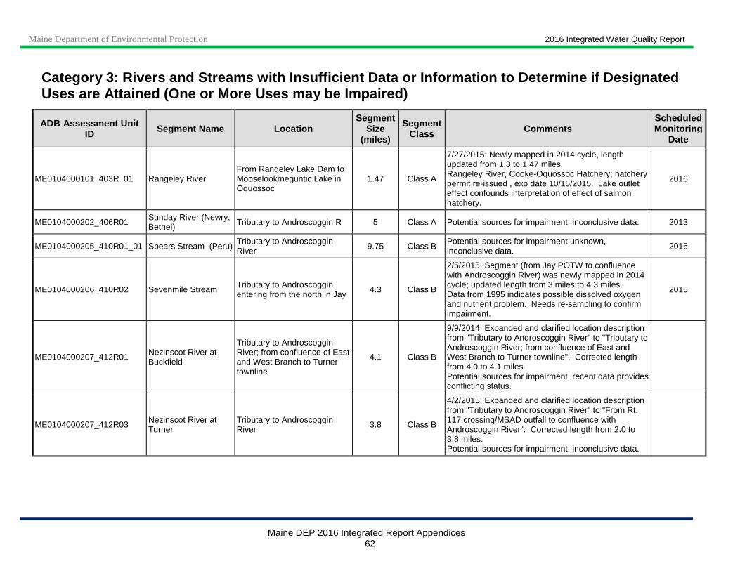
Maine Department of Environmental Protection 2016 Integrated Water Quality Report
Maine DEP 2016 Integrated Report Appendices 62
Category 3: Rivers and Streams with Insufficient Data or Information to De termine if Designated Uses are Attained (One or More Uses may be Impaired )
ADB Assessment Unit ID Segment Name Location
Segment Size
(miles)
Segment Class Comments
Scheduled Monitoring
Date
ME0104000101_403R_01 Rangeley River From Rangeley Lake Dam to Mooselookmeguntic Lake in Oquossoc
1.47 Class A
7/27/2015: Newly mapped in 2014 cycle, length updated from 1.3 to 1.47 miles. Rangeley River, Cooke-Oquossoc Hatchery; hatchery permit re-issued , exp date 10/15/2015. Lake outlet effect confounds interpretation of effect of salmon hatchery.
2016
ME0104000202_406R01 Sunday River (Newry, Bethel) Tributary to Androscoggin R 5 Class A Potential sources for impairment, inconclusive data. 2013
ME0104000205_410R01_01 Spears Stream (Peru) Tributary to Androscoggin River 9.75 Class B
Potential sources for impairment unknown, inconclusive data. 2016
ME0104000206_410R02 Sevenmile Stream Tributary to Androscoggin entering from the north in Jay 4.3 Class B
2/5/2015: Segment (from Jay POTW to confluence with Androscoggin River) was newly mapped in 2014 cycle; updated length from 3 miles to 4.3 miles. Data from 1995 indicates possible dissolved oxygen and nutrient problem. Needs re-sampling to confirm impairment.
2015
ME0104000207_412R01 Nezinscot River at Buckfield
Tributary to Androscoggin River; from confluence of East and West Branch to Turner townline
4.1 Class B
9/9/2014: Expanded and clarified location description from "Tributary to Androscoggin River" to "Tributary to Androscoggin River; from confluence of East and West Branch to Turner townline". Corrected length from 4.0 to 4.1 miles. Potential sources for impairment, recent data provides conflicting status.
ME0104000207_412R03 Nezinscot River at Turner
Tributary to Androscoggin River 3.8 Class B
4/2/2015: Expanded and clarified location description from "Tributary to Androscoggin River" to "From Rt. 117 crossing/MSAD outfall to confluence with Androscoggin River". Corrected length from 2.0 to 3.8 miles. Potential sources for impairment, inconclusive data.

Maine Department of Environmental Protection 2016 Integrated Water Quality Report
Maine DEP 2016 Integrated Report Appendices 63
Category 3: Rivers and Streams with Insufficient Data or Information to De termine if Designated Uses are Attained (One or More Uses may be Impaired )
ADB Assessment Unit ID Segment Name Location
Segment Size
(miles)
Segment Class Comments
Scheduled Monitoring
Date
ME0104000208_413R08 Bobbin Mill Brook (Lake Auburn Outlet, Auburn)
Tributary to Androscoggin River 2.42 Class B
10/11/2016: Corrected mapping, updated length from 3.45 to 2.42 miles in 2016 cycle. 6/7/2012: Conflicting biomonitoring results (at station S-357): macroinvertebrates attained only Class C in 1998 (likely due to natural conditions) but met Class B in 2003 and 2008; algae (periphyton) showed non-attainment in 2008. Resampling needed to confirm whether impairment exists.
2013
ME0104000209_414R02 Penneseeewassee Lake Outlet
Norway, tributary to Little Androscoggin River
1.8 Class B New information inconclusive. 2016
ME0104000209_415R01 Davis Brook (Poland) Tributary to Little Androscoggin River 1.2 Class B Errors or inconsistencies in the data. 2016
ME0105000108_505R01 Woodland Impoundment St Croix River, Baileyville 4.8 Class C
8/19/2014: Dissolved oxygen data show criteria attainment outside of mixing zone. Sampling scheduled for 2015. Corrected mapping in 2014 cycle, updated length from 5.2 to 4.8 miles. Insufficient data. Long term river study in progress 2006.
2014
ME0105000213_519R Union R Main stem (Ellsworth) 2.94 Class B
12/2/2014: New treatment plant is online, which is expected to improve mixing and dissolved oxygen levels. Sampling will be scheduled for 2015. 9/12/12: Sampled in 2007; new WQ model for dissolved oxygen under construction. New treatment plant scheduled to be completed by the end of 2012. Resampling planned for 2013.
2015
ME0106000103_607R04 Piscataqua River (Falmouth)
Tributary to Presumpscot River
11.9 Class B
6/1/2012: New Category 3 listing for aquatic life use; biomonitoring station S-787 showed algae (periphyton) non-attainment in 2005 and Class C in 2010. Needs resampling. Category 2 for contact recreation due to TMDL monitoring data showing attainment of bacteria standards. Was included in statewide bacteria TMDL (approved 9/28/09).
2015
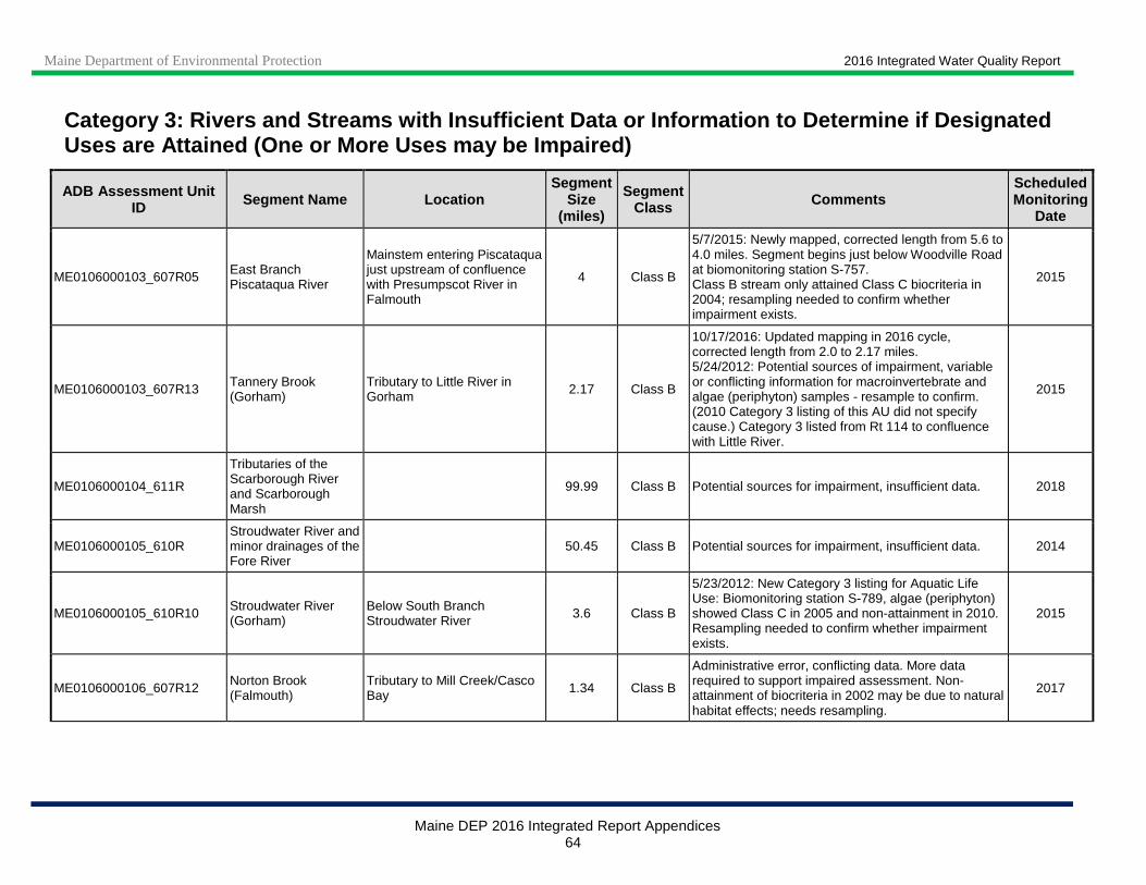
Maine Department of Environmental Protection 2016 Integrated Water Quality Report
Maine DEP 2016 Integrated Report Appendices 64
Category 3: Rivers and Streams with Insufficient Data or Information to De termine if Designated Uses are Attained (One or More Uses may be Impaired )
ADB Assessment Unit ID Segment Name Location
Segment Size
(miles)
Segment Class Comments
Scheduled Monitoring
Date
ME0106000103_607R05 East Branch Piscataqua River
Mainstem entering Piscataqua just upstream of confluence with Presumpscot River in Falmouth
4 Class B
5/7/2015: Newly mapped, corrected length from 5.6 to 4.0 miles. Segment begins just below Woodville Road at biomonitoring station S-757. Class B stream only attained Class C biocriteria in 2004; resampling needed to confirm whether impairment exists.
2015
ME0106000103_607R13 Tannery Brook (Gorham)
Tributary to Little River in Gorham 2.17 Class B
10/17/2016: Updated mapping in 2016 cycle, corrected length from 2.0 to 2.17 miles. 5/24/2012: Potential sources of impairment, variable or conflicting information for macroinvertebrate and algae (periphyton) samples - resample to confirm. (2010 Category 3 listing of this AU did not specify cause.) Category 3 listed from Rt 114 to confluence with Little River.
2015
ME0106000104_611R
Tributaries of the Scarborough River and Scarborough Marsh
99.99 Class B Potential sources for impairment, insufficient data. 2018
ME0106000105_610R Stroudwater River and minor drainages of the Fore River
50.45 Class B Potential sources for impairment, insufficient data. 2014
ME0106000105_610R10 Stroudwater River (Gorham)
Below South Branch Stroudwater River 3.6 Class B
5/23/2012: New Category 3 listing for Aquatic Life Use: Biomonitoring station S-789, algae (periphyton) showed Class C in 2005 and non-attainment in 2010. Resampling needed to confirm whether impairment exists.
2015
ME0106000106_607R12 Norton Brook (Falmouth)
Tributary to Mill Creek/Casco Bay 1.34 Class B
Administrative error, conflicting data. More data required to support impaired assessment. Non-attainment of biocriteria in 2002 may be due to natural habitat effects; needs resampling.
2017
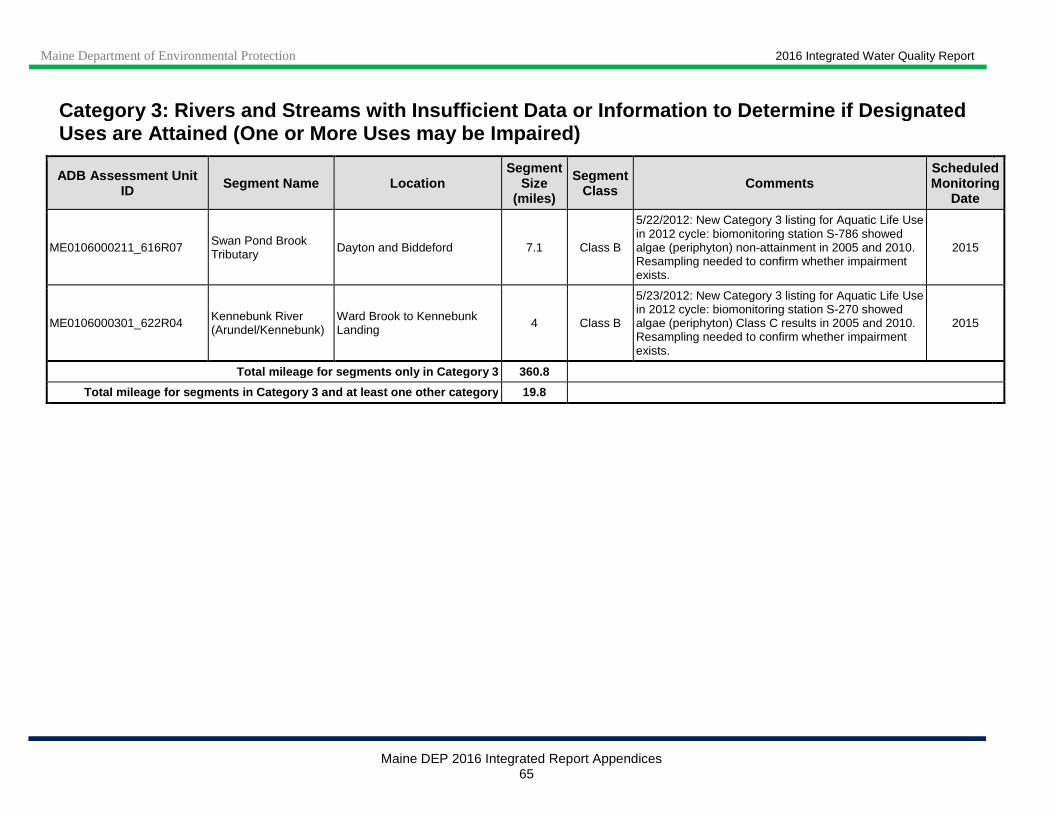
Maine Department of Environmental Protection 2016 Integrated Water Quality Report
Maine DEP 2016 Integrated Report Appendices 65
Category 3: Rivers and Streams with Insufficient Data or Information to De termine if Designated Uses are Attained (One or More Uses may be Impaired )
ADB Assessment Unit ID Segment Name Location
Segment Size
(miles)
Segment Class Comments
Scheduled Monitoring
Date
ME0106000211_616R07 Swan Pond Brook Tributary Dayton and Biddeford 7.1 Class B
5/22/2012: New Category 3 listing for Aquatic Life Use in 2012 cycle: biomonitoring station S-786 showed algae (periphyton) non-attainment in 2005 and 2010. Resampling needed to confirm whether impairment exists.
2015
ME0106000301_622R04 Kennebunk River (Arundel/Kennebunk)
Ward Brook to Kennebunk Landing 4 Class B
5/23/2012: New Category 3 listing for Aquatic Life Use in 2012 cycle: biomonitoring station S-270 showed algae (periphyton) Class C results in 2005 and 2010. Resampling needed to confirm whether impairment exists.
2015
Total mileage for segments only in Category 3 360.8
Total mileage for segments in Category 3 and at lea st one other category 19.8

Maine Department of Environmental Protection 2016 Integrated Water Quality Report
Maine DEP 2016 Integrated Report Appendices 66
Note 1: Bold text indicates waters that were moved into Category 4-A during this reporting cycle
Note 2: An * in the field SEGMENT SIZE indicates that an estimate of affected river miles is not provided since it is highly variable depending on an overflow event.
Note 3: Waters that are included in Maine’s implementation of EPA’s 303(d) Vision are indicated in italics.
Category 4-A: Rivers and Streams with Impaired Use, TMDL Completed
Waters Impaired by Atmospheric Deposition of Mercury: All freshwaters formerly listed in Category 5-C were moved to Category 4-A in the 2008 cycle due to US EPA approval of a Regional Mercury TMDL in December 2007. Maine has a fish consumption advisory for fish taken from all freshwaters due to mercury. Many waters, and many fish from any given water, do not exceed the action level for mercury. However, because it is impossible for someone consuming a fish to know whether the mercury level exceeds the action level, the Maine Department of Health and Human Services decided to establish a statewide advisory recommending limits on consumption for all freshwater fish. Maine has instituted statewide programs for removal and reduction of mercury sources.
Category 4-A: Rivers and Streams with Impaired Use Other than Mercury, TMDL Completed
ADB Assessment Unit ID Segment Name Location Cause
Segment Size
(miles)
Segment Class
TMDL Number Comments
ME0101000105_103R01 Shields Branch of Big Black R Mainstem Escherichia coli 9.4 Class A 37774
11/10/2014: Unclear whether Canadian POTW is causing, or contributing to DO and bacteria impairments, local livestock operations are more likely sources. Data collection planned for 2015. Corrected segment class from AA to A. 10/19/2011: St. Pamphile Canada POTW discharge is probable source of DO non-attainment (Category 5-A); PI office of DEP tracking questions of inadequate sewage treatment. Mapping corrected, length updated (was 8.16 miles). 12/3/2009: Recreational use impairments now Category 4-A due to approval of statewide bacteria TMDL. Also in Category 5-A for DO.
ME0101000121_117R St. John River at Madawaska
Variable, CSO affected Escherichia coli 0* Class C 37779
9/28/2009: Recreational use impairments now Category 4-A due to approval of statewide bacteria TMDL.

Maine Department of Environmental Protection 2016 Integrated Water Quality Report
Maine DEP 2016 Integrated Report Appendices 67
Category 4-A: Rivers and Streams with Impaired Use Other than Mercury, TMDL Completed
ADB Assessment Unit ID Segment Name Location Cause
Segment Size
(miles)
Segment Class
TMDL Number Comments
ME0101000303_124R01 Dickey Brook Tributary to Cross Lake/Fish River
Nutrient/Eutrophication Biological Indicators 16.4 Class B 30683
6/13/2014: Algae sampling planned for 2014. Corrected mapping in 2014 cycle, reduced length from 19.5 to 16.4 miles. Includes East and West Forks as well as mainstem. 9/25/2012: New Category 4-A listing in 2012 cycle for aquatic life use due to algae (periphyton) non-attainment (2003 and 2009, biomonitoring station S-688). All impairments covered under EPA approved TMDL for Cross Lake and Daigle Pond (9/15/2006, TMDL #30683).
ME0101000303_124R01 Dickey Brook Tributary to Cross Lake/Fish River Oxygen, Dissolved 16.4 Class B 30683
ME0101000303_124R01 Dickey Brook Tributary to Cross Lake/Fish River
Periphyton (Aufwuchs) Indicator Bioassessments
16.4 Class B 30683
ME0101000303_124R02 Daigle Brook Tributary to Cross Lake/Fish River
Nutrient/Eutrophication Biological Indicators 7.4 Class B 30681
11/19/2014: No new stream data but 2013 data show elevated productivity in Daigle Pond. Corrected mapping in 2014 cycle, reduced length from 7.99 to 7.4 miles. Daigle Brook is included in the Daigle Pond and Cross Lake TMDL; attainment of Daigle Pond water quality targets will ensure attainment of Daigle Brook uses. TMDL approved by EPA 9/28/06.
ME0101000303_124R02 Daigle Brook Tributary to Cross Lake/Fish River Oxygen, Dissolved 7.4 Class B 30681
ME0101000412_140R02 Dudley Brook (Chapman)
Tributary to North Branch Presque Isle Stream
Benthic-Macroinvertebrate Bioassessments (Streams)
6.41 Class A 38550
11/4/2014: Dudley Brook Watershed-based Management Plan completed in April 2009. Watershed Restoration Project Phase 1 underway (September 2014 to June 2016). Category 3 listing inadvertently omitted in 2012 report. 5/23/2012: New Category 3 listing in 2012 cycle for Aquatic Life Use: biomonitoring station S-215 showed algae (periphyton) Class C results in 2009, potentially due to naturally high alkalinity. Resampling needed to confirm whether impairment exists. 4/26/2010: EPA approval of TMDL- delisted to Category 4-A (invertebrates, TP, TN and Sediments).
ME0101000412_140R02 Dudley Brook (Chapman)
Tributary to North Branch Presque Isle Stream
Nitrogen (Total) 6.41 Class A 38549
ME0101000412_140R02 Dudley Brook (Chapman)
Tributary to North Branch Presque Isle Stream
Phosphorus (Total) 6.41 Class A 38548
ME0101000412_140R02 Dudley Brook (Chapman)
Tributary to North Branch Presque Isle Stream
Sedimentation/Siltation 6.41 Class A 38550

Maine Department of Environmental Protection 2016 Integrated Water Quality Report
Maine DEP 2016 Integrated Report Appendices 68
Category 4-A: Rivers and Streams with Impaired Use Other than Mercury, TMDL Completed
ADB Assessment Unit ID Segment Name Location Cause
Segment Size
(miles)
Segment Class
TMDL Number Comments
ME0101000412_140R03_01 Presque Isle Stream at Presque Isle
Tributary to Aroostook River
Ammonia (Un-ionized) 1 Class B 2529 11/21/2015: Segment is from (former) Presque Isle Sewer District (PISD) outfall to confluence with Aroostook River. PISD outfall removed from Presque Isle Stream around 2004. 2012 data for ammonia, BOD and TP did not indicate impairment. 8/22/2000: Aquatic life use impairments Category 4-A due to TMDL approval.
ME0101000412_140R03_01 Presque Isle Stream at Presque Isle
Tributary to Aroostook River
BOD, Biochemical oxygen demand 1 Class B 2529
ME0101000412_140R03_01 Presque Isle Stream at Presque Isle
Tributary to Aroostook River Phosphorus (Total) 1 Class B 2529
ME0101000412_143R01 Everett Brook (Ft. Fairfield)
Tributary to Aroostook River Oxygen, Dissolved 3.53 Class B 66217
10/5/2016: Aquatic life use impairment moved to Category 4-A in 2016 cycle due to approval of Statewide NPS TMDL (8/9/2016). 11/10/2015: Statewide NPS TMDL to go out for public review in late 2015. 5/23/2012: New Category 3 listing in 2012 cycle for Aquatic Life Use: biomonitoring station S-924 showed algae (periphyton) non-attainment in 2009, likely due to agriculture effects (76% of watershed area). Will be included in a Statewide NPS TMDL for aquatic life use impairment (DO) when analysis is complete.
ME0101000412_143R02 Merritt Brook
Entering Aroostook R. from south, downstream of Presque Isle
Benthic-Macroinvertebrate Bioassessments (Streams)
2.8 Class B 66220
10/5/2016: Aquatic life use impairment moved to Category 4-A in 2016 cycle due to approval of Statewide NPS TMDL (8/9/2016). 11/10/2015: Statewide NPS TMDL to go out for public review in late 2015. Corrected spelling from 'Merrit' to 'Merritt' in 2014 cycle. 12/2/2011: New 5-A listing in 2012 cycle for Aquatic Life Use; biomonitoring (station 742) in 2009 - non-attainment for benthic macroinvertebrates and algae (periphyton); in 2004 - non-attainment for algae. Previously Category 3 due to
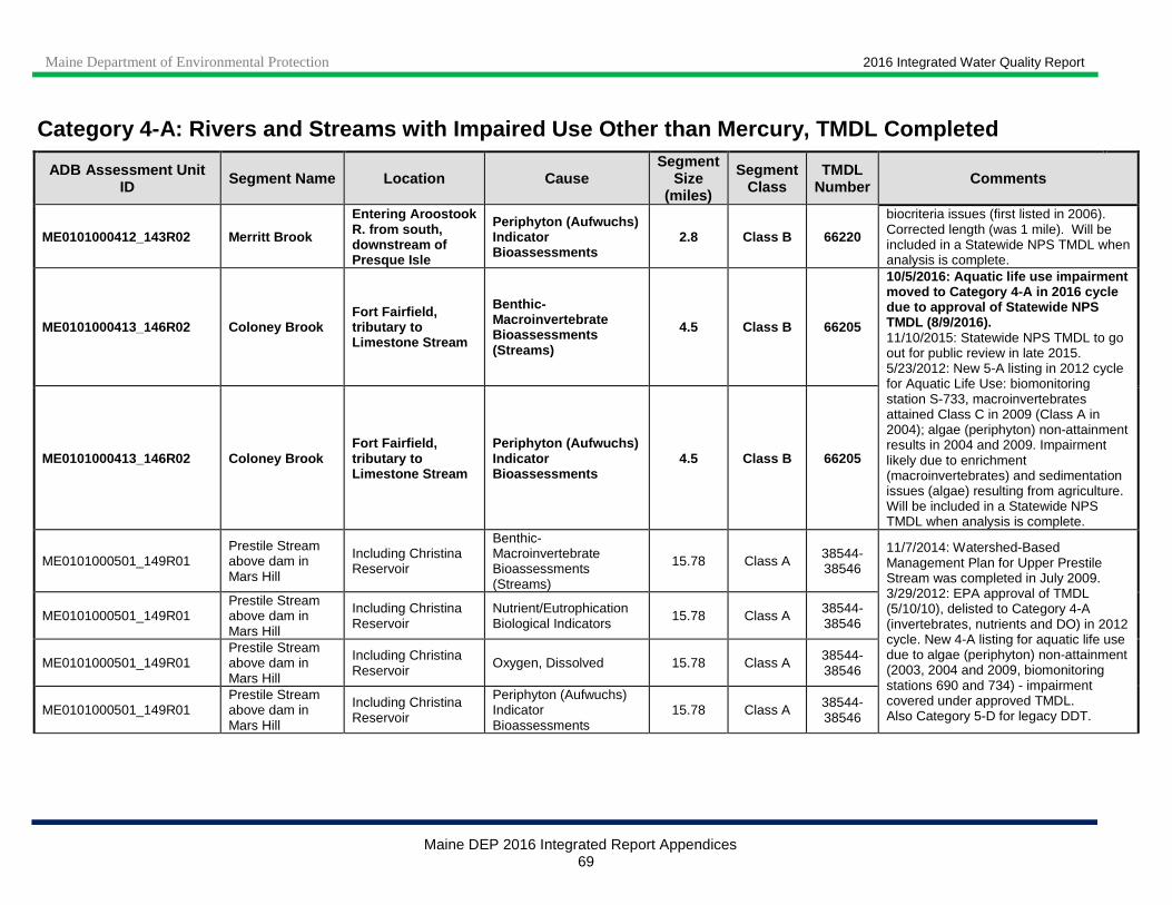
Maine Department of Environmental Protection 2016 Integrated Water Quality Report
Maine DEP 2016 Integrated Report Appendices 69
Category 4-A: Rivers and Streams with Impaired Use Other than Mercury, TMDL Completed
ADB Assessment Unit ID Segment Name Location Cause
Segment Size
(miles)
Segment Class
TMDL Number Comments
ME0101000412_143R02 Merritt Brook
Entering Aroostook R. from south, downstream of Presque Isle
Periphyton (Aufwuchs) Indicator Bioassessments
2.8 Class B 66220
biocriteria issues (first listed in 2006). Corrected length (was 1 mile). Will be included in a Statewide NPS TMDL when analysis is complete.
ME0101000413_146R02 Coloney Brook Fort Fairfield, tributary to Limestone Stream
Benthic-Macroinvertebrate Bioassessments (Streams)
4.5 Class B 66205
10/5/2016: Aquatic life use impairment moved to Category 4-A in 2016 cycle due to approval of Statewide NPS TMDL (8/9/2016). 11/10/2015: Statewide NPS TMDL to go out for public review in late 2015. 5/23/2012: New 5-A listing in 2012 cycle for Aquatic Life Use: biomonitoring station S-733, macroinvertebrates attained Class C in 2009 (Class A in 2004); algae (periphyton) non-attainment results in 2004 and 2009. Impairment likely due to enrichment (macroinvertebrates) and sedimentation issues (algae) resulting from agriculture. Will be included in a Statewide NPS TMDL when analysis is complete.
ME0101000413_146R02 Coloney Brook Fort Fairfield, tributary to Limestone Stream
Periphyton (Aufwuchs) Indicator Bioassessments
4.5 Class B 66205
ME0101000501_149R01 Prestile Stream above dam in Mars Hill
Including Christina Reservoir
Benthic-Macroinvertebrate Bioassessments (Streams)
15.78 Class A 38544-38546
11/7/2014: Watershed-Based Management Plan for Upper Prestile Stream was completed in July 2009. 3/29/2012: EPA approval of TMDL (5/10/10), delisted to Category 4-A (invertebrates, nutrients and DO) in 2012 cycle. New 4-A listing for aquatic life use due to algae (periphyton) non-attainment (2003, 2004 and 2009, biomonitoring stations 690 and 734) - impairment covered under approved TMDL. Also Category 5-D for legacy DDT.
ME0101000501_149R01 Prestile Stream above dam in Mars Hill
Including Christina Reservoir
Nutrient/Eutrophication Biological Indicators
15.78 Class A 38544-38546
ME0101000501_149R01 Prestile Stream above dam in Mars Hill
Including Christina Reservoir
Oxygen, Dissolved 15.78 Class A 38544-38546
ME0101000501_149R01 Prestile Stream above dam in Mars Hill
Including Christina Reservoir
Periphyton (Aufwuchs) Indicator Bioassessments
15.78 Class A 38544-38546
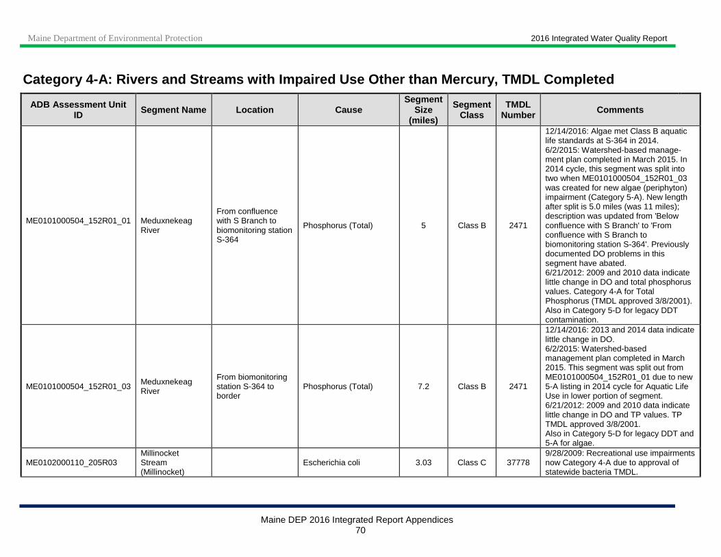
Maine Department of Environmental Protection 2016 Integrated Water Quality Report
Maine DEP 2016 Integrated Report Appendices 70
Category 4-A: Rivers and Streams with Impaired Use Other than Mercury, TMDL Completed
ADB Assessment Unit ID Segment Name Location Cause
Segment Size
(miles)
Segment Class
TMDL Number Comments
ME0101000504_152R01_01
Meduxnekeag River
From confluence with S Branch to biomonitoring station S-364
Phosphorus (Total) 5 Class B 2471
12/14/2016: Algae met Class B aquatic life standards at S-364 in 2014. 6/2/2015: Watershed-based manage-ment plan completed in March 2015. In 2014 cycle, this segment was split into two when ME0101000504_152R01_03 was created for new algae (periphyton) impairment (Category 5-A). New length after split is 5.0 miles (was 11 miles); description was updated from 'Below confluence with S Branch' to 'From confluence with S Branch to biomonitoring station S-364'. Previously documented DO problems in this segment have abated. 6/21/2012: 2009 and 2010 data indicate little change in DO and total phosphorus values. Category 4-A for Total Phosphorus (TMDL approved 3/8/2001). Also in Category 5-D for legacy DDT contamination.
ME0101000504_152R01_03 Meduxnekeag River
From biomonitoring station S-364 to border
Phosphorus (Total) 7.2 Class B 2471
12/14/2016: 2013 and 2014 data indicate little change in DO. 6/2/2015: Watershed-based management plan completed in March 2015. This segment was split out from ME0101000504_152R01_01 due to new 5-A listing in 2014 cycle for Aquatic Life Use in lower portion of segment. 6/21/2012: 2009 and 2010 data indicate little change in DO and TP values. TP TMDL approved 3/8/2001. Also in Category 5-D for legacy DDT and 5-A for algae.
ME0102000110_205R03 Millinocket Stream (Millinocket)
Escherichia coli 3.03 Class C 37778 9/28/2009: Recreational use impairments now Category 4-A due to approval of statewide bacteria TMDL.

Maine Department of Environmental Protection 2016 Integrated Water Quality Report
Maine DEP 2016 Integrated Report Appendices 71
Category 4-A: Rivers and Streams with Impaired Use Other than Mercury, TMDL Completed
ADB Assessment Unit ID Segment Name Location Cause
Segment Size
(miles)
Segment Class
TMDL Number Comments
ME0102000402_219R_02 Piscataquis River at Dover Foxcroft
Variable, (formerly) CSO affected Escherichia coli 0* Class B 37776
11/25/2014: Dover-Foxcroft has completed CSO abatement, no CSO events since 2005. 9/28/2009: Recreational use impairments now Category 4-A due to approval of statewide bacteria TMDL.
ME0102000403_215R_02 Sebec River at Milo
Variable, (formerly) CSO affected Escherichia coli 0* Class B 37776
11/25/2014: Milo has completed CSO abatement, no CSO events since 2008. 9/28/2009: Recreational use impairments now Category 4-A due to approval of statewide bacteria TMDL.
ME0102000506_222R01 Costigan Brook (Costigan)
Tributary to Penobscot River Escherichia coli 0.78 Class B 37775
8/21/2012: Corrected assessment unit name [was Costigan Str (Costigan)]. Corrected mapping and updated length (from 0.78 to 2.7 miles). 9/28/2009: Recreational use impairments now Category 4-A due to approval of statewide bacteria TMDL. Also in Category 5-A for DO.
ME0102000509_226R01 Otter Stream, Milford
Tributary to Great Works Stream and Penobscot River
Escherichia coli 11.1 Class B 37775
10/24/2014: Monitoring in 2011 and 2012 continued to show occasional criteria exceedances. Added Location description (Tributary to Great Works Stream and Penobscot River) in 2014 cycle and corrected length from 6.27 to 11.1 miles. 9/28/2009: Recreational use impairments now Category 4-A due to approval of statewide bacteria TMDL.
ME0102000509_233R_02 Penobscot River at Orono
Variable, CSO affected Escherichia coli 0* Class B 37776
11/25/2014: CSO abatement ongoing, no CSO events since 2011. 9/28/2009: Recreational use impairments now Category 4-A due to approval of statewide bacteria TMDL.
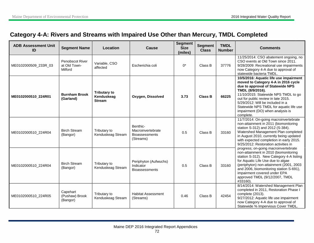
Maine Department of Environmental Protection 2016 Integrated Water Quality Report
Maine DEP 2016 Integrated Report Appendices 72
Category 4-A: Rivers and Streams with Impaired Use Other than Mercury, TMDL Completed
ADB Assessment Unit ID Segment Name Location Cause
Segment Size
(miles)
Segment Class
TMDL Number Comments
ME0102000509_233R_03 Penobscot River at Old Town-Milford
Variable, CSO affected Escherichia coli 0* Class B 37776
11/25/2014: CSO abatement ongoing, no CSO events at Old Town since 2011. 9/28/2009: Recreational use impairments now Category 4-A due to approval of statewide bacteria TMDL.
ME0102000510_224R01 Burnham Brook (Garland)
Tributary to Kenduskeag Stream
Oxygen, Dissolved 3.73 Class B 66225
10/5/2016: Aquatic life use impairment moved to Category 4-A in 2016 cycle due to approval of Statewide NPS TMDL (8/9/2016). 11/10/2015: Statewide NPS TMDL to go out for public review in late 2015. 5/29/2012: Will be included in a Statewide NPS TMDL for aquatic life use impairment (DO) when analysis is complete.
ME0102000510_224R04 Birch Stream (Bangor)
Tributary to Kenduskeag Stream
Benthic-Macroinvertebrate Bioassessments (Streams)
0.5 Class B 33160
11/7/2014: On-going macroinvertebrate non-attainment in 2011 (biomonitoring station S-312) and 2012 (S-384). Watershed Management Plan completed in August 2010, currently being updated with expected completion in early 2015. 9/25/2012: Restoration activities in progress; on-going macroinvertebrate non-attainment in 2010 (biomonitoring station S-312). New Category 4-A listing for Aquatic Life Use due to algae (periphyton) non-attainment (2001, 2003 and 2006, biomonitoring station S-691), impairment covered under EPA approved TMDL (9/12/2007, TMDL #33160).
ME0102000510_224R04 Birch Stream (Bangor)
Tributary to Kenduskeag Stream
Periphyton (Aufwuchs) Indicator Bioassessments
0.5 Class B 33160
ME0102000510_224R05 Capehart (Pushaw) Brook (Bangor)
Tributary to Kenduskeag Stream
Habitat Assessment (Streams) 0.46 Class B 42454
8/14/2014: Watershed Management Plan completed in 2011, Restoration Phase I complete (2013). 9/27/2012: Aquatic life use impairment now Category 4-A due to approval of Statewide % Impervious Cover TMDL.
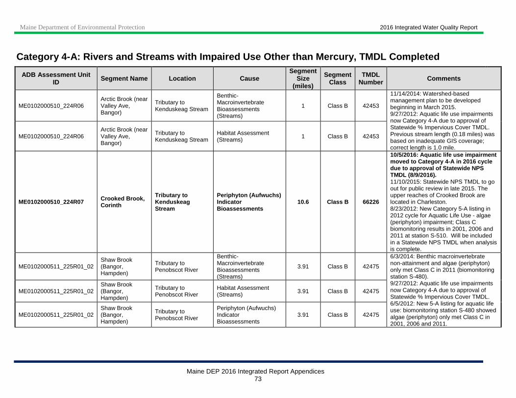
Maine Department of Environmental Protection 2016 Integrated Water Quality Report
Maine DEP 2016 Integrated Report Appendices 73
Category 4-A: Rivers and Streams with Impaired Use Other than Mercury, TMDL Completed
ADB Assessment Unit ID Segment Name Location Cause
Segment Size
(miles)
Segment Class
TMDL Number Comments
ME0102000510_224R06 Arctic Brook (near Valley Ave, Bangor)
Tributary to Kenduskeag Stream
Benthic-Macroinvertebrate Bioassessments (Streams)
1 Class B 42453
11/14/2014: Watershed-based management plan to be developed beginning in March 2015. 9/27/2012: Aquatic life use impairments now Category 4-A due to approval of Statewide % Impervious Cover TMDL. Previous stream length (0.18 miles) was based on inadequate GIS coverage; correct length is 1.0 mile.
ME0102000510_224R06 Arctic Brook (near Valley Ave, Bangor)
Tributary to Kenduskeag Stream
Habitat Assessment (Streams) 1 Class B 42453
ME0102000510_224R07 Crooked Brook, Corinth
Tributary to Kenduskeag Stream
Periphyton (Aufwuchs) Indicator Bioassessments
10.6 Class B 66226
10/5/2016: Aquatic life use impairment moved to Category 4-A in 2016 cycle due to approval of Statewide NPS TMDL (8/9/2016). 11/10/2015: Statewide NPS TMDL to go out for public review in late 2015. The upper reaches of Crooked Brook are located in Charleston. 8/23/2012: New Category 5-A listing in 2012 cycle for Aquatic Life Use - algae (periphyton) impairment; Class C biomonitoring results in 2001, 2006 and 2011 at station S-510. Will be included in a Statewide NPS TMDL when analysis is complete.
ME0102000511_225R01_02 Shaw Brook (Bangor, Hampden)
Tributary to Penobscot River
Benthic-Macroinvertebrate Bioassessments (Streams)
3.91 Class B 42475
6/3/2014: Benthic macroinvertebrate non-attainment and algae (periphyton) only met Class C in 2011 (biomonitoring station S-480). 9/27/2012: Aquatic life use impairments now Category 4-A due to approval of Statewide % Impervious Cover TMDL. 6/5/2012: New 5-A listing for aquatic life use: biomonitoring station S-480 showed algae (periphyton) only met Class C in 2001, 2006 and 2011.
ME0102000511_225R01_02 Shaw Brook (Bangor, Hampden)
Tributary to Penobscot River
Habitat Assessment (Streams) 3.91 Class B 42475
ME0102000511_225R01_02 Shaw Brook (Bangor, Hampden)
Tributary to Penobscot River
Periphyton (Aufwuchs) Indicator Bioassessments
3.91 Class B 42475
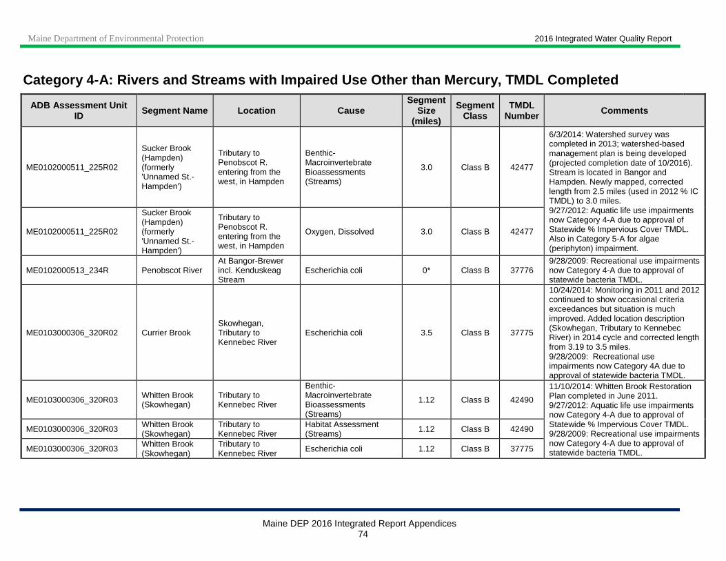
Maine Department of Environmental Protection 2016 Integrated Water Quality Report
Maine DEP 2016 Integrated Report Appendices 74
Category 4-A: Rivers and Streams with Impaired Use Other than Mercury, TMDL Completed
ADB Assessment Unit ID Segment Name Location Cause
Segment Size
(miles)
Segment Class
TMDL Number Comments
ME0102000511_225R02
Sucker Brook (Hampden) (formerly 'Unnamed St.-Hampden')
Tributary to Penobscot R. entering from the west, in Hampden
Benthic-Macroinvertebrate Bioassessments (Streams)
3.0 Class B 42477
6/3/2014: Watershed survey was completed in 2013; watershed-based management plan is being developed (projected completion date of 10/2016). Stream is located in Bangor and Hampden. Newly mapped, corrected length from 2.5 miles (used in 2012 % IC TMDL) to 3.0 miles. 9/27/2012: Aquatic life use impairments now Category 4-A due to approval of Statewide % Impervious Cover TMDL. Also in Category 5-A for algae (periphyton) impairment.
ME0102000511_225R02
Sucker Brook (Hampden) (formerly 'Unnamed St.-Hampden')
Tributary to Penobscot R. entering from the west, in Hampden
Oxygen, Dissolved 3.0 Class B 42477
ME0102000513_234R Penobscot River At Bangor-Brewer incl. Kenduskeag Stream
Escherichia coli 0* Class B 37776 9/28/2009: Recreational use impairments now Category 4-A due to approval of statewide bacteria TMDL.
ME0103000306_320R02 Currier Brook Skowhegan, Tributary to Kennebec River
Escherichia coli 3.5 Class B 37775
10/24/2014: Monitoring in 2011 and 2012 continued to show occasional criteria exceedances but situation is much improved. Added location description (Skowhegan, Tributary to Kennebec River) in 2014 cycle and corrected length from 3.19 to 3.5 miles. 9/28/2009: Recreational use impairments now Category 4A due to approval of statewide bacteria TMDL.
ME0103000306_320R03 Whitten Brook (Skowhegan)
Tributary to Kennebec River
Benthic-Macroinvertebrate Bioassessments (Streams)
1.12 Class B 42490
11/10/2014: Whitten Brook Restoration Plan completed in June 2011. 9/27/2012: Aquatic life use impairments now Category 4-A due to approval of Statewide % Impervious Cover TMDL. 9/28/2009: Recreational use impairments now Category 4-A due to approval of statewide bacteria TMDL.
ME0103000306_320R03 Whitten Brook (Skowhegan)
Tributary to Kennebec River
Habitat Assessment (Streams) 1.12 Class B 42490
ME0103000306_320R03 Whitten Brook (Skowhegan)
Tributary to Kennebec River Escherichia coli 1.12 Class B 37775
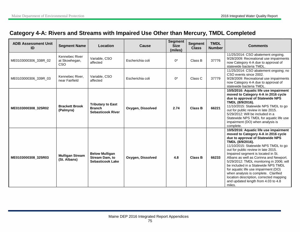
Maine Department of Environmental Protection 2016 Integrated Water Quality Report
Maine DEP 2016 Integrated Report Appendices 75
Category 4-A: Rivers and Streams with Impaired Use Other than Mercury, TMDL Completed
ADB Assessment Unit ID Segment Name Location Cause
Segment Size
(miles)
Segment Class
TMDL Number Comments
ME0103000306_338R_02 Kennebec River at Skowhegan, CSO
Variable, CSO affected Escherichia coli 0* Class B 37776
11/25/2014: CSO abatement ongoing. 9/28/2009: Recreational use impairments now Category 4-A due to approval of statewide bacteria TMDL.
ME0103000306_339R_03 Kennebec River, near Fairfield
Variable, CSO affected Escherichia coli 0* Class C 37779
11/25/2014: CSO abatement ongoing; no CSO events since 2002. 9/28/2009: Recreational use impairments now Category 4-A due to approval of statewide bacteria TMDL.
ME0103000308_325R02 Brackett Brook (Palmyra)
Tributary to East Branch Sebasticook River
Oxygen, Dissolved 2.74 Class B 66221
10/5/2016: Aquatic life use impairment moved to Category 4-A in 2016 cycle due to approval of Statewide NPS TMDL (8/9/2016). 11/10/2015: Statewide NPS TMDL to go out for public review in late 2015. 5/29/2012: Will be included in a Statewide NPS TMDL for aquatic life use impairment (DO) when analysis is complete.
ME0103000308_325R03 Mulligan Stream (St. Albans)
Below Mulligan Stream Dam, to Sebasticook Lake
Oxygen, Dissolved 4.8 Class B 66233
10/5/2016: Aquatic life use impairment moved to Category 4-A in 2016 cycle due to approval of Statewide NPS TMDL (8/9/2016). 11/10/2015: Statewide NPS TMDL to go out for public review in late 2015. Impaired segment is located in St. Albans as well as Corinna and Newport. 5/29/2012: TMDL monitoring in 2006; will be included in a Statewide NPS TMDL for aquatic life use impairment (DO) when analysis is complete. Clarified location description, corrected mapping and updated length from 4.03 to 4.8 miles.
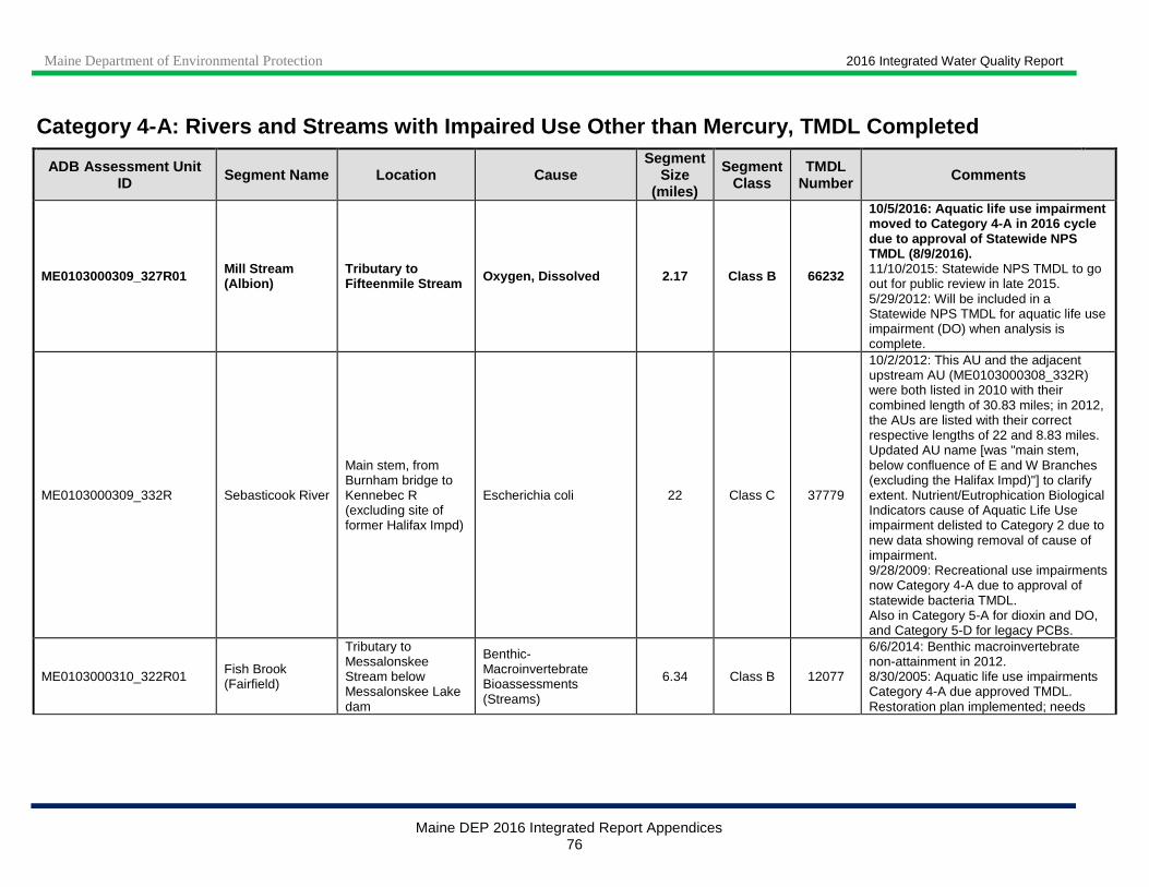
Maine Department of Environmental Protection 2016 Integrated Water Quality Report
Maine DEP 2016 Integrated Report Appendices 76
Category 4-A: Rivers and Streams with Impaired Use Other than Mercury, TMDL Completed
ADB Assessment Unit ID Segment Name Location Cause
Segment Size
(miles)
Segment Class
TMDL Number Comments
ME0103000309_327R01 Mill Stream (Albion)
Tributary to Fifteenmile Stream Oxygen, Dissolved 2.17 Class B 66232
10/5/2016: Aquatic life use impairment moved to Category 4-A in 2016 cycle due to approval of Statewide NPS TMDL (8/9/2016). 11/10/2015: Statewide NPS TMDL to go out for public review in late 2015. 5/29/2012: Will be included in a Statewide NPS TMDL for aquatic life use impairment (DO) when analysis is complete.
ME0103000309_332R Sebasticook River
Main stem, from Burnham bridge to Kennebec R (excluding site of former Halifax Impd)
Escherichia coli 22 Class C 37779
10/2/2012: This AU and the adjacent upstream AU (ME0103000308_332R) were both listed in 2010 with their combined length of 30.83 miles; in 2012, the AUs are listed with their correct respective lengths of 22 and 8.83 miles. Updated AU name [was "main stem, below confluence of E and W Branches (excluding the Halifax Impd)"] to clarify extent. Nutrient/Eutrophication Biological Indicators cause of Aquatic Life Use impairment delisted to Category 2 due to new data showing removal of cause of impairment. 9/28/2009: Recreational use impairments now Category 4-A due to approval of statewide bacteria TMDL. Also in Category 5-A for dioxin and DO, and Category 5-D for legacy PCBs.
ME0103000310_322R01 Fish Brook (Fairfield)
Tributary to Messalonskee Stream below Messalonskee Lake dam
Benthic-Macroinvertebrate Bioassessments (Streams)
6.34 Class B 12077
6/6/2014: Benthic macroinvertebrate non-attainment in 2012. 8/30/2005: Aquatic life use impairments Category 4-A due approved TMDL. Restoration plan implemented; needs

Maine Department of Environmental Protection 2016 Integrated Water Quality Report
Maine DEP 2016 Integrated Report Appendices 77
Category 4-A: Rivers and Streams with Impaired Use Other than Mercury, TMDL Completed
ADB Assessment Unit ID Segment Name Location Cause
Segment Size
(miles)
Segment Class
TMDL Number Comments
ME0103000310_322R01 Fish Brook (Fairfield)
Tributary to Messalonskee Stream below Messalonskee Lake dam
Oxygen, Dissolved 6.34 Class B 12077
follow-up monitoring in 2012 to determine current status.
ME0103000311_334R03 Jock Stream (Wales)
Tributary to Cobbosseecontee Lake/Stream
Nutrient/Eutrophication Biological Indicators 9.43 Class B 66230
10/5/2016: Aquatic life use impairment moved to Category 4-A in 2016 cycle due to approval of Statewide NPS TMDL (8/9/2016). 11/10/2015: Statewide NPS TMDL to go out for public review in late 2015. Stream is also located in Monmouth. 5/29/2012: Will be included in a Statewide NPS TMDL when analysis is complete.
ME0103000311_334R03 Jock Stream (Wales)
Tributary to Cobbosseecontee Lake/Stream
Oxygen, Dissolved 9.43 Class B 66230
ME0103000311_334R05 Cobbosseecontee Stream (Gardiner)
Tributary to Kennebec River, from outlet of Pleasant Pond to Kennebec R.
Phosphorus (Total) 6.51 Class B 9998
10/11/2016: Corrected mapping, updated length from 8.2 to 6.51 miles in 2016 cycle. 11/4/2014: Original, incorrect/colloquial name of AU (Cobbossee Stream) updated to correct/official name, Cobbosseecontee Stream. Watershed Management Plan completed in March 2008. Eutrophic lake source - Pleasant Pond nutrient levels and trophic state indicators remain high. 5/31/2012: Corrected length from 7 to 8.2 miles. 2010 cycle: TP Cause of aquatic life use impairment moved to Category 4-A due to approval of Pleasant Pond TMDL (included this AU; 5/20/2004). Also in Category 5-A for macroinvertebrates and algae.
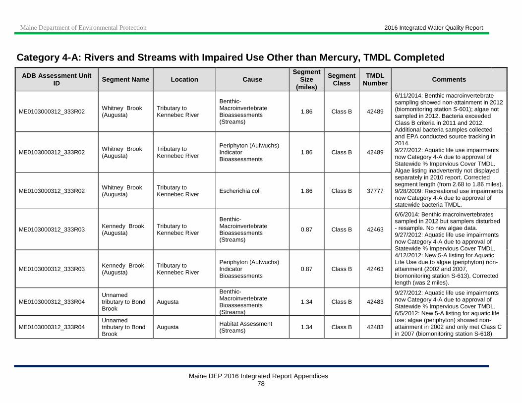
Maine Department of Environmental Protection 2016 Integrated Water Quality Report
Maine DEP 2016 Integrated Report Appendices 78
Category 4-A: Rivers and Streams with Impaired Use Other than Mercury, TMDL Completed
ADB Assessment Unit ID Segment Name Location Cause
Segment Size
(miles)
Segment Class
TMDL Number Comments
ME0103000312_333R02 Whitney Brook (Augusta)
Tributary to Kennebec River
Benthic-Macroinvertebrate Bioassessments (Streams)
1.86 Class B 42489
6/11/2014: Benthic macroinvertebrate sampling showed non-attainment in 2012 (biomonitoring station S-601); algae not sampled in 2012. Bacteria exceeded Class B criteria in 2011 and 2012. Additional bacteria samples collected and EPA conducted source tracking in 2014. 9/27/2012: Aquatic life use impairments now Category 4-A due to approval of Statewide % Impervious Cover TMDL. Algae listing inadvertently not displayed separately in 2010 report. Corrected segment length (from 2.68 to 1.86 miles). 9/28/2009: Recreational use impairments now Category 4-A due to approval of statewide bacteria TMDL.
ME0103000312_333R02 Whitney Brook (Augusta)
Tributary to Kennebec River
Periphyton (Aufwuchs) Indicator Bioassessments
1.86 Class B 42489
ME0103000312_333R02 Whitney Brook (Augusta)
Tributary to Kennebec River Escherichia coli 1.86 Class B 37777
ME0103000312_333R03 Kennedy Brook (Augusta)
Tributary to Kennebec River
Benthic-Macroinvertebrate Bioassessments (Streams)
0.87 Class B 42463
6/6/2014: Benthic macroinvertebrates sampled in 2012 but samplers disturbed - resample. No new algae data. 9/27/2012: Aquatic life use impairments now Category 4-A due to approval of Statewide % Impervious Cover TMDL. 4/12/2012: New 5-A listing for Aquatic Life Use due to algae (periphyton) non-attainment (2002 and 2007, biomonitoring station S-613). Corrected length (was 2 miles).
ME0103000312_333R03 Kennedy Brook (Augusta)
Tributary to Kennebec River
Periphyton (Aufwuchs) Indicator Bioassessments
0.87 Class B 42463
ME0103000312_333R04 Unnamed tributary to Bond Brook
Augusta
Benthic-Macroinvertebrate Bioassessments (Streams)
1.34 Class B 42483
9/27/2012: Aquatic life use impairments now Category 4-A due to approval of Statewide % Impervious Cover TMDL. 6/5/2012: New 5-A listing for aquatic life use: algae (periphyton) showed non-attainment in 2002 and only met Class C in 2007 (biomonitoring station S-618).
ME0103000312_333R04 Unnamed tributary to Bond Brook
Augusta Habitat Assessment (Streams) 1.34 Class B 42483
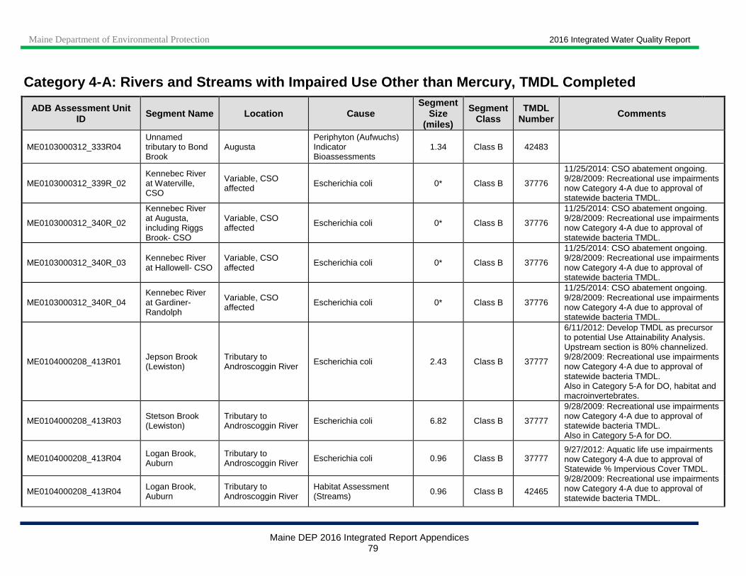
Maine Department of Environmental Protection 2016 Integrated Water Quality Report
Maine DEP 2016 Integrated Report Appendices 79
Category 4-A: Rivers and Streams with Impaired Use Other than Mercury, TMDL Completed
ADB Assessment Unit ID Segment Name Location Cause
Segment Size
(miles)
Segment Class
TMDL Number Comments
ME0103000312_333R04 Unnamed tributary to Bond Brook
Augusta Periphyton (Aufwuchs) Indicator Bioassessments
1.34 Class B 42483
ME0103000312_339R_02 Kennebec River at Waterville, CSO
Variable, CSO affected Escherichia coli 0* Class B 37776
11/25/2014: CSO abatement ongoing. 9/28/2009: Recreational use impairments now Category 4-A due to approval of statewide bacteria TMDL.
ME0103000312_340R_02
Kennebec River at Augusta, including Riggs Brook- CSO
Variable, CSO affected Escherichia coli 0* Class B 37776
11/25/2014: CSO abatement ongoing. 9/28/2009: Recreational use impairments now Category 4-A due to approval of statewide bacteria TMDL.
ME0103000312_340R_03 Kennebec River at Hallowell- CSO
Variable, CSO affected
Escherichia coli 0* Class B 37776
11/25/2014: CSO abatement ongoing. 9/28/2009: Recreational use impairments now Category 4-A due to approval of statewide bacteria TMDL.
ME0103000312_340R_04 Kennebec River at Gardiner-Randolph
Variable, CSO affected Escherichia coli 0* Class B 37776
11/25/2014: CSO abatement ongoing. 9/28/2009: Recreational use impairments now Category 4-A due to approval of statewide bacteria TMDL.
ME0104000208_413R01 Jepson Brook (Lewiston)
Tributary to Androscoggin River Escherichia coli 2.43 Class B 37777
6/11/2012: Develop TMDL as precursor to potential Use Attainability Analysis. Upstream section is 80% channelized. 9/28/2009: Recreational use impairments now Category 4-A due to approval of statewide bacteria TMDL. Also in Category 5-A for DO, habitat and macroinvertebrates.
ME0104000208_413R03 Stetson Brook (Lewiston)
Tributary to Androscoggin River Escherichia coli 6.82 Class B 37777
9/28/2009: Recreational use impairments now Category 4-A due to approval of statewide bacteria TMDL. Also in Category 5-A for DO.
ME0104000208_413R04 Logan Brook, Auburn
Tributary to Androscoggin River Escherichia coli 0.96 Class B 37777
9/27/2012: Aquatic life use impairments now Category 4-A due to approval of Statewide % Impervious Cover TMDL. 9/28/2009: Recreational use impairments now Category 4-A due to approval of statewide bacteria TMDL.
ME0104000208_413R04 Logan Brook, Auburn
Tributary to Androscoggin River
Habitat Assessment (Streams) 0.96 Class B 42465
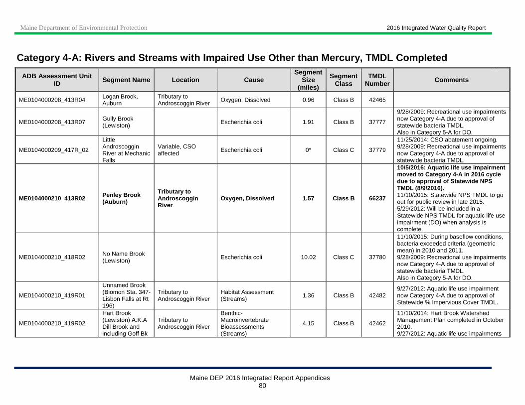
Maine Department of Environmental Protection 2016 Integrated Water Quality Report
Maine DEP 2016 Integrated Report Appendices 80
Category 4-A: Rivers and Streams with Impaired Use Other than Mercury, TMDL Completed
ADB Assessment Unit ID Segment Name Location Cause
Segment Size
(miles)
Segment Class
TMDL Number Comments
ME0104000208_413R04 Logan Brook, Auburn
Tributary to Androscoggin River Oxygen, Dissolved 0.96 Class B 42465
ME0104000208_413R07 Gully Brook (Lewiston) Escherichia coli 1.91 Class B 37777
9/28/2009: Recreational use impairments now Category 4-A due to approval of statewide bacteria TMDL. Also in Category 5-A for DO.
ME0104000209_417R_02
Little Androscoggin River at Mechanic Falls
Variable, CSO affected Escherichia coli 0* Class C 37779
11/25/2014: CSO abatement ongoing. 9/28/2009: Recreational use impairments now Category 4-A due to approval of statewide bacteria TMDL.
ME0104000210_413R02 Penley Brook (Auburn)
Tributary to Androscoggin River
Oxygen, Dissolved 1.57 Class B 66237
10/5/2016: Aquatic life use impairment moved to Category 4-A in 2016 cycle due to approval of Statewide NPS TMDL (8/9/2016). 11/10/2015: Statewide NPS TMDL to go out for public review in late 2015. 5/29/2012: Will be included in a Statewide NPS TMDL for aquatic life use impairment (DO) when analysis is complete.
ME0104000210_418R02 No Name Brook (Lewiston) Escherichia coli 10.02 Class C 37780
11/10/2015: During baseflow conditions, bacteria exceeded criteria (geometric mean) in 2010 and 2011. 9/28/2009: Recreational use impairments now Category 4-A due to approval of statewide bacteria TMDL. Also in Category 5-A for DO.
ME0104000210_419R01
Unnamed Brook (Biomon Sta. 347-Lisbon Falls at Rt 196)
Tributary to Androscoggin River
Habitat Assessment (Streams) 1.36 Class B 42482
9/27/2012: Aquatic life use impairment now Category 4-A due to approval of Statewide % Impervious Cover TMDL.
ME0104000210_419R02
Hart Brook (Lewiston) A.K.A Dill Brook and including Goff Bk
Tributary to Androscoggin River
Benthic-Macroinvertebrate Bioassessments (Streams)
4.15 Class B 42462
11/10/2014: Hart Brook Watershed Management Plan completed in October 2010. 9/27/2012: Aquatic life use impairments

Maine Department of Environmental Protection 2016 Integrated Water Quality Report
Maine DEP 2016 Integrated Report Appendices 81
Category 4-A: Rivers and Streams with Impaired Use Other than Mercury, TMDL Completed
ADB Assessment Unit ID Segment Name Location Cause
Segment Size
(miles)
Segment Class
TMDL Number Comments
ME0104000210_419R02
Hart Brook (Lewiston) A.K.A Dill Brook and including Goff Bk
Tributary to Androscoggin River
Habitat Assessment (Streams) 4.15 Class B 42462
now Category 4-A due to approval of Statewide % Impervious Cover TMDL. 6/5/2012: New 5-A listing for Aquatic Life Use: biomonitoring station S-663 showed algae (periphyton) non-attainment in 2003 and 2004 and Class C in 2008. 9/28/2009: Recreational use impairments now Category 4-A due to approval of statewide bacteria TMDL.
ME0104000210_419R02
Hart Brook (Lewiston) A.K.A Dill Brook and including Goff Bk
Tributary to Androscoggin River Oxygen, Dissolved 4.15 Class B 42462
ME0104000210_419R02
Hart Brook (Lewiston) A.K.A Dill Brook and including Goff Bk
Tributary to Androscoggin River
Periphyton (Aufwuchs) Indicator Bioassessments
4.15 Class B 42462
ME0104000210_419R02
Hart Brook (Lewiston) A.K.A Dill Brook and including Goff Bk
Tributary to Androscoggin River Escherichia coli 4.15 Class B 37777
ME0104000210_420R01
Unnamed tributary (Brunswick 2) to Androscoggin R
Biomon Sta 641 (near River Rd. Brunswick) 43.91538/69.98089
Benthic-Macroinvertebrate Bioassessments (Streams)
1.85 Class B 42486 9/27/2012: Aquatic life use impairments now Category 4-A due to approval of Statewide % Impervious Cover TMDL.
ME0104000210_420R01
Unnamed tributary (Brunswick 2) to Androscoggin R
Biomon Sta 641 (near River Rd. Brunswick) 43.91538/69.98089
Habitat Assessment (Streams) 1.85 Class B 42486
ME0104000210_420R02
Unnamed tributary (Brunswick 3) to Androscoggin R
Biomon Sta 642 (near Water St. Brunswick) 43.92167/69.95586
Benthic-Macroinvertebrate Bioassessments (Streams)
0.56 Class B 42488 9/27/2012: Aquatic life use impairments now Category 4-A due to approval of Statewide % Impervious Cover TMDL.
ME0104000210_420R02
Unnamed tributary (Brunswick 3) to Androscoggin R
Biomon Sta 642 (near Water St. Brunswick) 43.92167/69.95586
Habitat Assessment (Streams) 0.56 Class B 42488
ME0104000210_420R03
Unnamed tributary (Brunswick 4) to Androscoggin R
Biomon Sta 643 (near Jordan Ave., Brunswick) 43.91077/69.94130
Benthic-Macroinvertebrate Bioassessments (Streams)
1.73 Class B 42485 9/27/2012: Aquatic life use impairments now Category 4-A due to approval of Statewide % Impervious Cover TMDL.
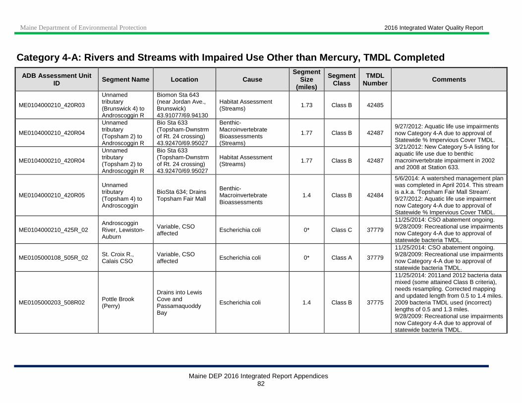
Maine Department of Environmental Protection 2016 Integrated Water Quality Report
Maine DEP 2016 Integrated Report Appendices 82
Category 4-A: Rivers and Streams with Impaired Use Other than Mercury, TMDL Completed
ADB Assessment Unit ID Segment Name Location Cause
Segment Size
(miles)
Segment Class
TMDL Number Comments
ME0104000210_420R03
Unnamed tributary (Brunswick 4) to Androscoggin R
Biomon Sta 643 (near Jordan Ave., Brunswick) 43.91077/69.94130
Habitat Assessment (Streams) 1.73 Class B 42485
ME0104000210_420R04
Unnamed tributary (Topsham 2) to Androscoggin R
Bio Sta 633 (Topsham-Dwnstrm of Rt. 24 crossing) 43.92470/69.95027
Benthic-Macroinvertebrate Bioassessments (Streams)
1.77 Class B 42487 9/27/2012: Aquatic life use impairments now Category 4-A due to approval of Statewide % Impervious Cover TMDL. 3/21/2012: New Category 5-A listing for aquatic life use due to benthic macroinvertebrate impairment in 2002 and 2008 at Station 633.
ME0104000210_420R04
Unnamed tributary (Topsham 2) to Androscoggin R
Bio Sta 633 (Topsham-Dwnstrm of Rt. 24 crossing) 43.92470/69.95027
Habitat Assessment (Streams) 1.77 Class B 42487
ME0104000210_420R05
Unnamed tributary (Topsham 4) to Androscoggin
BioSta 634; Drains Topsham Fair Mall
Benthic-Macroinvertebrate Bioassessments
1.4 Class B 42484
5/6/2014: A watershed management plan was completed in April 2014. This stream is a.k.a. 'Topsham Fair Mall Stream'. 9/27/2012: Aquatic life use impairment now Category 4-A due to approval of Statewide % Impervious Cover TMDL.
ME0104000210_425R_02 Androscoggin River, Lewiston-Auburn
Variable, CSO affected Escherichia coli 0* Class C 37779
11/25/2014: CSO abatement ongoing. 9/28/2009: Recreational use impairments now Category 4-A due to approval of statewide bacteria TMDL.
ME0105000108_505R_02 St. Croix R., Calais CSO
Variable, CSO affected Escherichia coli 0* Class A 37779
11/25/2014: CSO abatement ongoing. 9/28/2009: Recreational use impairments now Category 4-A due to approval of statewide bacteria TMDL.
ME0105000203_508R02 Pottle Brook (Perry)
Drains into Lewis Cove and Passamaquoddy Bay
Escherichia coli 1.4 Class B 37775
11/25/2014: 2011and 2012 bacteria data mixed (some attained Class B criteria), needs resampling. Corrected mapping and updated length from 0.5 to 1.4 miles. 2009 bacteria TMDL used (incorrect) lengths of 0.5 and 1.3 miles. 9/28/2009: Recreational use impairments now Category 4-A due to approval of statewide bacteria TMDL.

Maine Department of Environmental Protection 2016 Integrated Water Quality Report
Maine DEP 2016 Integrated Report Appendices 83
Category 4-A: Rivers and Streams with Impaired Use Other than Mercury, TMDL Completed
ADB Assessment Unit ID Segment Name Location Cause
Segment Size
(miles)
Segment Class
TMDL Number Comments
ME0105000213_514R_01 Card Brook (Ellsworth)
Tributary to Union River
Benthic-Macroinvertebrate Bioassessments (Streams)
1.2 Class B 42457
5/23/2014: Benthic macroinvertebrates only attained Class C in 2011 (biomonitoring station S-815). Stream corridor survey completed in 2011 indicated that the large upstream wetland contributes to low DO levels. 9/27/2012: Aquatic life use impairments now Category 4-A due to approval of Statewide % Impervious Cover TMDL. 9/28/2009: Recreational use impairments now Category 4-A due to approval of statewide bacteria TMDL.
ME0105000213_514R_01 Card Brook (Ellsworth)
Tributary to Union River Oxygen, Dissolved 1.2 Class B 42457
ME0105000213_514R_01 Card Brook (Ellsworth)
Tributary to Union River Escherichia coli 1.2 Class B 37775
ME0105000217_520R01 Carleton Stream (Blue Hill)
Between First and Second Pond, below former mine
Benthic-Macroinvertebrate Bioassessments (Streams)
1.23 Class C 10917
5/27/2014: Added location description to clarify extent. Benthic macroinvertebrate non-attainment at station S-525 in 2009 and at S-526 in 2009 and 2011. No iron data available past 2001; sampling scheduled for 2014. 10/7/2004: Aquatic life use impairments Category 4-A due to approved TMDL.
ME0105000217_520R01 Carleton Stream (Blue Hill)
Between First and Second Pond, below former mine
Iron 1.23 Class C 10917
ME0105000218_521R01 Warren Brook (Belfast)
Tributary to Passagassawakeag River
Oxygen, Dissolved 6.04 Class B 66227
10/5/2016: Aquatic life use impairment moved to Category 4-A in 2016 cycle due to approval of Statewide NPS TMDL (8/9/2016). 11/10/2015: Statewide NPS TMDL to go out for public review in late 2015. This stream is in Belfast as well as Belmont and Morrill. 5/29/2012: Will be included in Statewide NPS TMDL when analysis is complete.
ME0105000220_522R01_01 Megunticook River (Camden)
From Megunticook Lake to tidewater Escherichia coli 3.56 Class B 37775
9/16/2014: Bacteria exceeded Class B criteria in 2011 and 2012. Added location description. 9/28/2009: Recreational use impairments now Category 4-A due to approval of statewide bacteria TMDL.
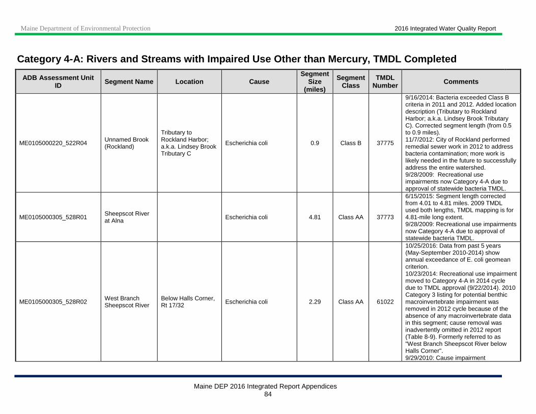
Maine Department of Environmental Protection 2016 Integrated Water Quality Report
Maine DEP 2016 Integrated Report Appendices 84
Category 4-A: Rivers and Streams with Impaired Use Other than Mercury, TMDL Completed
ADB Assessment Unit ID Segment Name Location Cause
Segment Size
(miles)
Segment Class
TMDL Number Comments
ME0105000220_522R04 Unnamed Brook (Rockland)
Tributary to Rockland Harbor; a.k.a. Lindsey Brook Tributary C
Escherichia coli 0.9 Class B 37775
9/16/2014: Bacteria exceeded Class B criteria in 2011 and 2012. Added location description (Tributary to Rockland Harbor; a.k.a. Lindsey Brook Tributary C). Corrected segment length (from 0.5 to 0.9 miles). 11/7/2012: City of Rockland performed remedial sewer work in 2012 to address bacteria contamination; more work is likely needed in the future to successfully address the entire watershed. 9/28/2009: Recreational use impairments now Category 4-A due to approval of statewide bacteria TMDL.
ME0105000305_528R01 Sheepscot River at Alna Escherichia coli 4.81 Class AA 37773
6/15/2015: Segment length corrected from 4.01 to 4.81 miles. 2009 TMDL used both lengths, TMDL mapping is for 4.81-mile long extent. 9/28/2009: Recreational use impairments now Category 4-A due to approval of statewide bacteria TMDL.
ME0105000305_528R02 West Branch Sheepscot River
Below Halls Corner, Rt 17/32 Escherichia coli 2.29 Class AA 61022
10/25/2016: Data from past 5 years (May-September 2010-2014) show annual exceedance of E. coli geomean criterion. 10/23/2014: Recreational use impairment moved to Category 4-A in 2014 cycle due to TMDL approval (9/22/2014). 2010 Category 3 listing for potential benthic macroinvertebrate impairment was removed in 2012 cycle because of the absence of any macroinvertebrate data in this segment; cause removal was inadvertently omitted in 2012 report (Table 8-9). Formerly referred to as "West Branch Sheepscot River below Halls Corner". 9/29/2010: Cause impairment

Maine Department of Environmental Protection 2016 Integrated Water Quality Report
Maine DEP 2016 Integrated Report Appendices 85
Category 4-A: Rivers and Streams with Impaired Use Other than Mercury, TMDL Completed
ADB Assessment Unit ID Segment Name Location Cause
Segment Size
(miles)
Segment Class
TMDL Number Comments
erroneously dropped in 2006 (non-attainment of recreational uses). Review of recent data confirms excursions of Class AA bacteria criteria (geo-mean AA limit =29). Also in Category 5-A for algae (periphyton).
ME0105000305_528R03 Dyer River below Rt 215
Tributary to Sheepscot River Escherichia coli 9.35 Class B 37775
11/10/2015: Bacteria exceeded Class B criteria in 2012. Dyer River Watershed Bacteria and NPS Survey completed in March 2011. 9/28/2009: Recreational use impairments now Category 4-A due to approval of statewide bacteria TMDL. Also in Category 4-A for DO.
ME0105000305_528R03 Dyer River below Rt 215
Tributary to Sheepscot River Oxygen, Dissolved 9.35 Class B 66228
10/5/2016: Aquatic life use impairment moved to Category 4-A in 2016 cycle due to approval of Statewide NPS TMDL (8/9/2016). 11/10/2015: Statewide NPS TMDL to go out for public review in late 2015. 5/29/2012: Will be included in a Statewide NPS TMDL when analysis is complete. Also in Category 4-A for bacteria.
ME0105000305_528R04 Trout Brook (Alna)
Tributary to Sheepscot River Oxygen, Dissolved 7.7 Class A 66234
10/5/2016: Aquatic life use impairment moved to Category 4-A in 2016 cycle due to approval of Statewide NPS TMDL (8/9/2016). 11/10/2015: Statewide NPS TMDL to go out for public review in late 2015. Corrected segment Class to A in 2014 cycle (Trout Brook was upgraded from Class B to Class A on 9/13/03). 5/29/2012: TMDL monitoring for dissolved oxygen in 2005 and 2007; will be included in a Statewide NPS TMDL when analysis is complete. Corrected
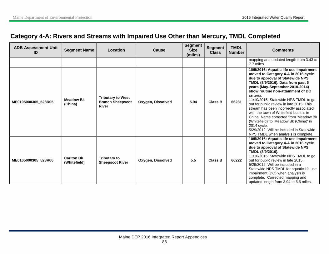
Maine Department of Environmental Protection 2016 Integrated Water Quality Report
Maine DEP 2016 Integrated Report Appendices 86
Category 4-A: Rivers and Streams with Impaired Use Other than Mercury, TMDL Completed
ADB Assessment Unit ID Segment Name Location Cause
Segment Size
(miles)
Segment Class
TMDL Number Comments
mapping and updated length from 3.43 to 7.7 miles.
ME0105000305_528R05 Meadow Bk (China)
Tributary to West Branch Sheepscot River
Oxygen, Dissolved 5.94 Class B 66231
10/5/2016: Aquatic life use impairment moved to Category 4-A in 2016 cycle due to approval of Statewide NPS TMDL (8/9/2016). Data from past 5 years (May-September 2010-2014) show routine non-attainment of DO criteria. 11/10/2015: Statewide NPS TMDL to go out for public review in late 2015. This stream has been incorrectly associated with the town of Whitefield but it is in China. Name corrected from 'Meadow Bk (Whitefield)' to 'Meadow Bk (China)' in 2014 cycle. 5/29/2012: Will be included in Statewide NPS TMDL when analysis is complete.
ME0105000305_528R06 Carlton Bk (Whitefield)
Tributary to Sheepscot River Oxygen, Dissolved 5.5 Class B 66222
10/5/2016: Aquatic life use impairment moved to Category 4-A in 2016 cycle due to approval of Statewide NPS TMDL (8/9/2016). 11/10/2015: Statewide NPS TMDL to go out for public review in late 2015. 5/29/2012: Will be included in a Statewide NPS TMDL for aquatic life use impairment (DO) when analysis is complete. Corrected mapping and updated length from 3.94 to 5.5 miles.
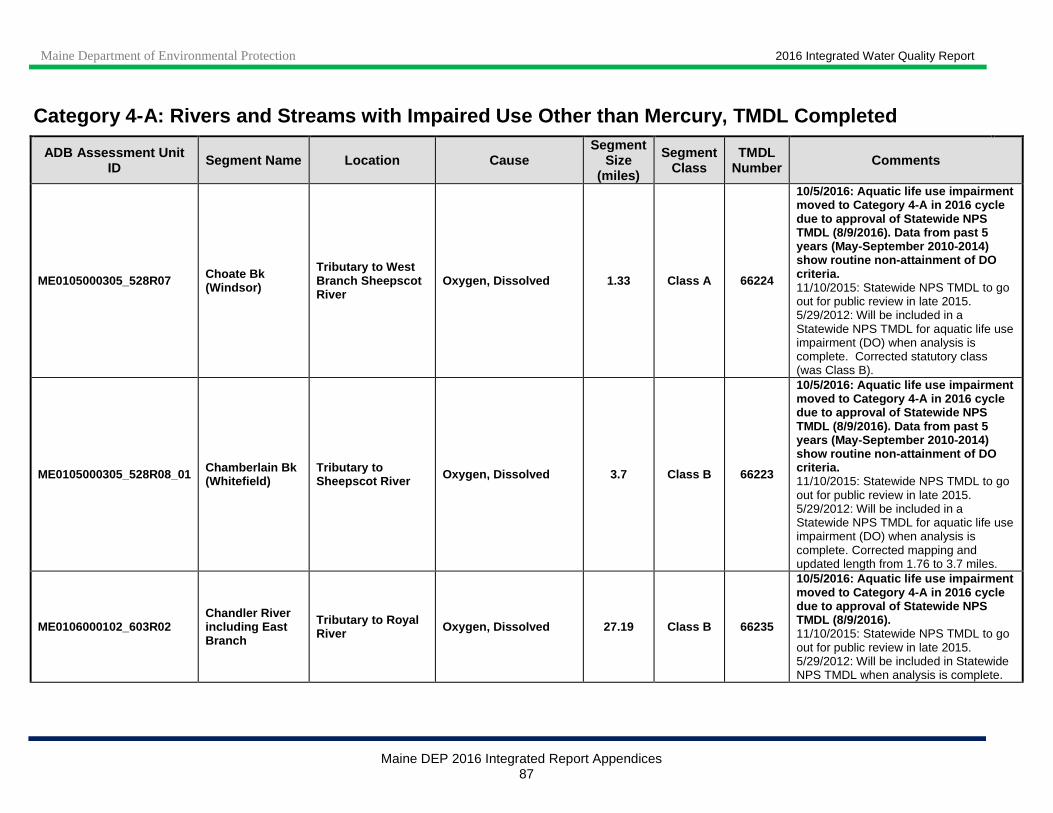
Maine Department of Environmental Protection 2016 Integrated Water Quality Report
Maine DEP 2016 Integrated Report Appendices 87
Category 4-A: Rivers and Streams with Impaired Use Other than Mercury, TMDL Completed
ADB Assessment Unit ID Segment Name Location Cause
Segment Size
(miles)
Segment Class
TMDL Number Comments
ME0105000305_528R07 Choate Bk (Windsor)
Tributary to West Branch Sheepscot River
Oxygen, Dissolved 1.33 Class A 66224
10/5/2016: Aquatic life use impairment moved to Category 4-A in 2016 cycle due to approval of Statewide NPS TMDL (8/9/2016). Data from past 5 years (May-September 2010-2014) show routine non-attainment of DO criteria. 11/10/2015: Statewide NPS TMDL to go out for public review in late 2015. 5/29/2012: Will be included in a Statewide NPS TMDL for aquatic life use impairment (DO) when analysis is complete. Corrected statutory class (was Class B).
ME0105000305_528R08_01 Chamberlain Bk (Whitefield)
Tributary to Sheepscot River Oxygen, Dissolved 3.7 Class B 66223
10/5/2016: Aquatic life use impairment moved to Category 4-A in 2016 cycle due to approval of Statewide NPS TMDL (8/9/2016). Data from past 5 years (May-September 2010-2014) show routine non-attainment of DO criteria. 11/10/2015: Statewide NPS TMDL to go out for public review in late 2015. 5/29/2012: Will be included in a Statewide NPS TMDL for aquatic life use impairment (DO) when analysis is complete. Corrected mapping and updated length from 1.76 to 3.7 miles.
ME0106000102_603R02 Chandler River including East Branch
Tributary to Royal River Oxygen, Dissolved 27.19 Class B 66235
10/5/2016: Aquatic life use impairment moved to Category 4-A in 2016 cycle due to approval of Statewide NPS TMDL (8/9/2016). 11/10/2015: Statewide NPS TMDL to go out for public review in late 2015. 5/29/2012: Will be included in Statewide NPS TMDL when analysis is complete.
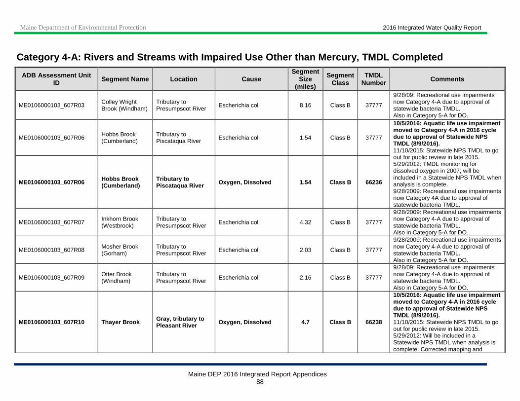
Maine Department of Environmental Protection 2016 Integrated Water Quality Report
Maine DEP 2016 Integrated Report Appendices 88
Category 4-A: Rivers and Streams with Impaired Use Other than Mercury, TMDL Completed
ADB Assessment Unit ID Segment Name Location Cause
Segment Size
(miles)
Segment Class
TMDL Number Comments
ME0106000103_607R03 Colley Wright Brook (Windham)
Tributary to Presumpscot River Escherichia coli 8.16 Class B 37777
9/28/09: Recreational use impairments now Category 4-A due to approval of statewide bacteria TMDL. Also in Category 5-A for DO.
ME0106000103_607R06 Hobbs Brook (Cumberland)
Tributary to Piscataqua River Escherichia coli 1.54 Class B 37777
10/5/2016: Aquatic life use impairment moved to Category 4-A in 2016 cycle due to approval of Statewide NPS TMDL (8/9/2016). 11/10/2015: Statewide NPS TMDL to go out for public review in late 2015. 5/29/2012: TMDL monitoring for dissolved oxygen in 2007; will be included in a Statewide NPS TMDL when analysis is complete. 9/28/2009: Recreational use impairments now Category 4A due to approval of statewide bacteria TMDL.
ME0106000103_607R06 Hobbs Brook (Cumberland)
Tributary to Piscataqua River Oxygen, Dissolved 1.54 Class B 66236
ME0106000103_607R07 Inkhorn Brook (Westbrook)
Tributary to Presumpscot River
Escherichia coli 4.32 Class B 37777
9/28/2009: Recreational use impairments now Category 4-A due to approval of statewide bacteria TMDL. Also in Category 5-A for DO.
ME0106000103_607R08 Mosher Brook (Gorham)
Tributary to Presumpscot River Escherichia coli 2.03 Class B 37777
9/28/2009: Recreational use impairments now Category 4-A due to approval of statewide bacteria TMDL. Also in Category 5-A for DO.
ME0106000103_607R09 Otter Brook (Windham)
Tributary to Presumpscot River Escherichia coli 2.16 Class B 37777
9/28/09: Recreational use impairments now Category 4-A due to approval of statewide bacteria TMDL. Also in Category 5-A for DO.
ME0106000103_607R10 Thayer Brook Gray, tributary to Pleasant River Oxygen, Dissolved 4.7 Class B 66238
10/5/2016: Aquatic life use impairment moved to Category 4-A in 2016 cycle due to approval of Statewide NPS TMDL (8/9/2016). 11/10/2015: Statewide NPS TMDL to go out for public review in late 2015. 5/29/2012: Will be included in a Statewide NPS TMDL when analysis is complete. Corrected mapping and

Maine Department of Environmental Protection 2016 Integrated Water Quality Report
Maine DEP 2016 Integrated Report Appendices 89
Category 4-A: Rivers and Streams with Impaired Use Other than Mercury, TMDL Completed
ADB Assessment Unit ID Segment Name Location Cause
Segment Size
(miles)
Segment Class
TMDL Number Comments
updated length from 3.82 to 4.7 miles.
ME0106000103_607R11 Nason Brook (Gorham)
Trib to Presumpscot entering so. of Dundee Pd.
Escherichia coli 3.5 Class B 37777
7/28/2015: Stream length in Gorham is 3.5 miles; updated length from 2.7 to 3.5 miles in 2014 cycle. 2009 bacteria TMDL used 3.5 miles in Appendix I, section II, item 2.2, and 2.7 miles in Appendix IV. 9/28/2009: Recreational use impairments now Category 4-A due to approval of statewide bacteria TMDL.
ME0106000103_607R12 Pleasant River (Windham)
Mainstem of Pleasant River from Thayer Brook to confluence with Presumpscot
Escherichia coli 11.2 Class B 37777
5/27/2014: Watershed Management Plan completed in June 2011; Watershed Restoration Project, Phase I completed in September 2013. The upper portion of this segment is in Gray. 5/29/2012: Corrected length from 8.8 to 11.2 miles. 9/28/2009: Recreational use impairments now Category 4-A due to approval of statewide bacteria TMDL. Also in Category 5-A for DO.
ME0106000103_609R_02 Presumpscot River at Westbrook
Variable, CSO affected Escherichia coli 0* Class C 37779
11/25/2014: CSO abatement ongoing. 9/28/2009: Recreational use impairments now Category 4-A due to approval of statewide bacteria TMDL.
ME0106000104_611R02 Phillips Brook (Scarborough)
Tributary to Dunstan River
Habitat Assessment (Streams) 2.77 Class C 42472
9/27/2012: Aquatic life use impairments now Category 4-A due to approval of Statewide % Impervious Cover TMDL. 6/5/2012: New 5-A listing for aquatic life use due to dissolved oxygen impairment (based on 2008 TMDL-DO study data).
ME0106000104_611R02 Phillips Brook (Scarborough)
Tributary to Dunstan River Oxygen, Dissolved 2.77 Class C 42472
ME0106000105_607R11_01 Nasons Brook (Portland), trib to Fore River
Tributary to Fore River
Benthic-Macroinvertebrate Bioassessments (Streams)
2 Class C 42467
1/3/2017: AKA ‘Nason’s Brook’. 9/27/2012: Aquatic life use impairments now Category 4-A due to approval of Statewide % Impervious Cover TMDL. 2/6/2012: New 5-A listing for aquatic life use due to dissolved oxygen impairment

Maine Department of Environmental Protection 2016 Integrated Water Quality Report
Maine DEP 2016 Integrated Report Appendices 90
Category 4-A: Rivers and Streams with Impaired Use Other than Mercury, TMDL Completed
ADB Assessment Unit ID Segment Name Location Cause
Segment Size
(miles)
Segment Class
TMDL Number Comments
ME0106000105_607R11_01 Nasons Brook (Portland), trib to Fore River
Tributary to Fore River
Oxygen, Dissolved 2 Class C 42467
(based on 2008 TMDL-DO study data) and for algae (periphyton; non-attainment of biocriteria in 2003 and 2004 at biomonitoring station S-638). AU name changed from 'Nasons Brook (Portland) south of Rt 25, trib to Fore River' to 'Nasons Brook (Portland), trib to Fore River'. This unit was split into two due to differences in statutory class; the Portland segment is Class C, the new upstream Westbrook segment (AU ME0106000105_607R11_02) is Class B.
ME0106000105_607R11_01 Nasons Brook (Portland), trib to Fore River
Tributary to Fore River
Periphyton (Aufwuchs) Indicator Bioassessments
2 Class C 42467
ME0106000105_607R11_02 Nasons Brook (Westbrook), trib to Fore River
Tributary to Fore River
Benthic-Macroinvertebrate Bioassessments (Streams)
0.8 Class B 42495
1/3/2017: AKA ‘Nason’s Brook’. 9/27/2012: Aquatic life use impairments now Category 4-A due to approval of Statewide % Impervious Cover TMDL. 3/26/2012: New 5-A listing for aquatic life use due to dissolved oxygen impairment (based on 2008 TMDL-DO study data) and for algae (periphyton; non-attainment of biocriteria in 2003 and 2004 at biomonitoring station S-638). New Assessment Unit, resulting from splitting of AU ME0106000105_607R11_01, Nasons Brook (Portland), trib to Fore River', into 2 due to differences in statutory class. Existing Aquatic Life Use listing for Benthic-Macroinvertebrate Assessment carried over from Portland AU.
ME0106000105_607R11_02 Nasons Brook (Westbrook), trib to Fore River
Tributary to Fore River Oxygen, Dissolved 0.8 Class B 42495
ME0106000105_607R11_02 Nasons Brook (Westbrook), trib to Fore River
Tributary to Fore River
Periphyton (Aufwuchs) Indicator Bioassessments
0.8 Class B 42495
ME0106000105_609R01
Dole Brook (formerly known as 'Unnamed Stream- Portland 3')
Tributary to Presumpscot R. entering east of Rt. 302 in Portland
Benthic-Macroinvertebrate Bioassessments (Streams)
1.6 Class B 42460 9/27/2012: Aquatic life use impairment now Category 4-A due to approval of Statewide % Impervious Cover TMDL.
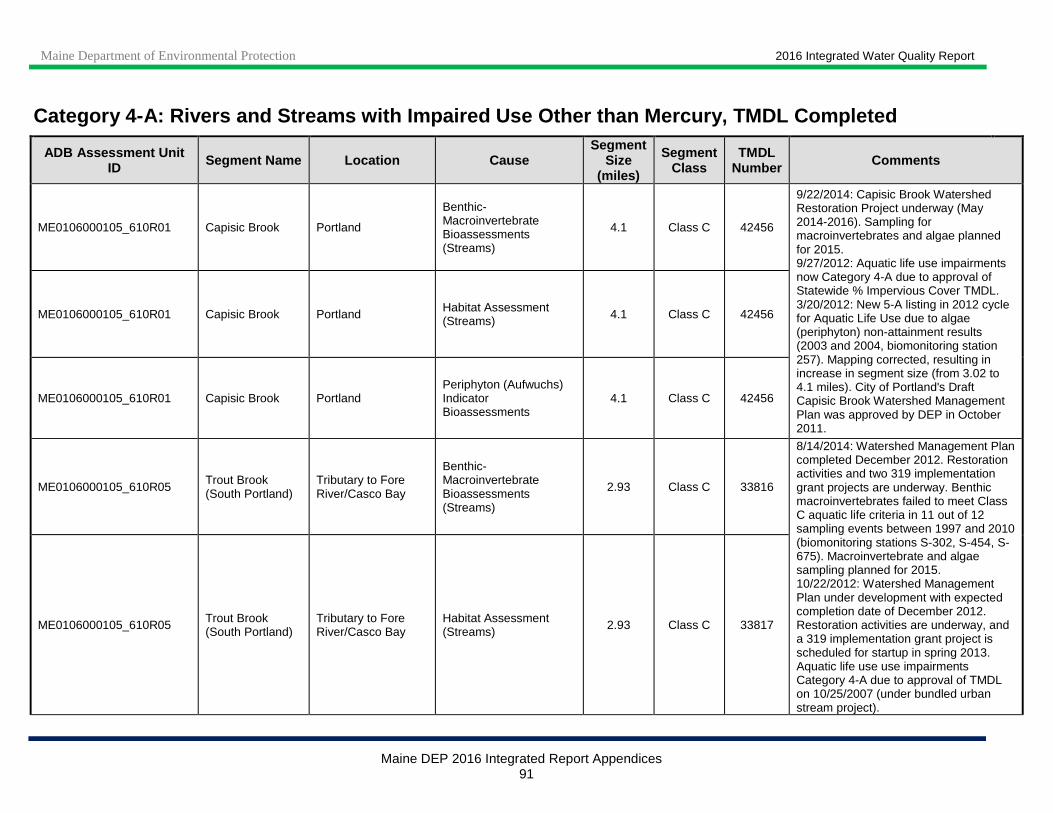
Maine Department of Environmental Protection 2016 Integrated Water Quality Report
Maine DEP 2016 Integrated Report Appendices 91
Category 4-A: Rivers and Streams with Impaired Use Other than Mercury, TMDL Completed
ADB Assessment Unit ID Segment Name Location Cause
Segment Size
(miles)
Segment Class
TMDL Number Comments
ME0106000105_610R01 Capisic Brook Portland
Benthic-Macroinvertebrate Bioassessments (Streams)
4.1 Class C 42456
9/22/2014: Capisic Brook Watershed Restoration Project underway (May 2014-2016). Sampling for macroinvertebrates and algae planned for 2015. 9/27/2012: Aquatic life use impairments now Category 4-A due to approval of Statewide % Impervious Cover TMDL. 3/20/2012: New 5-A listing in 2012 cycle for Aquatic Life Use due to algae (periphyton) non-attainment results (2003 and 2004, biomonitoring station 257). Mapping corrected, resulting in increase in segment size (from 3.02 to 4.1 miles). City of Portland's Draft Capisic Brook Watershed Management Plan was approved by DEP in October 2011.
ME0106000105_610R01 Capisic Brook Portland Habitat Assessment (Streams) 4.1 Class C 42456
ME0106000105_610R01 Capisic Brook Portland Periphyton (Aufwuchs) Indicator Bioassessments
4.1 Class C 42456
ME0106000105_610R05 Trout Brook (South Portland)
Tributary to Fore River/Casco Bay
Benthic-Macroinvertebrate Bioassessments (Streams)
2.93 Class C 33816
8/14/2014: Watershed Management Plan completed December 2012. Restoration activities and two 319 implementation grant projects are underway. Benthic macroinvertebrates failed to meet Class C aquatic life criteria in 11 out of 12 sampling events between 1997 and 2010 (biomonitoring stations S-302, S-454, S-675). Macroinvertebrate and algae sampling planned for 2015. 10/22/2012: Watershed Management Plan under development with expected completion date of December 2012. Restoration activities are underway, and a 319 implementation grant project is scheduled for startup in spring 2013. Aquatic life use use impairments Category 4-A due to approval of TMDL on 10/25/2007 (under bundled urban stream project).
ME0106000105_610R05 Trout Brook (South Portland)
Tributary to Fore River/Casco Bay
Habitat Assessment (Streams) 2.93 Class C 33817
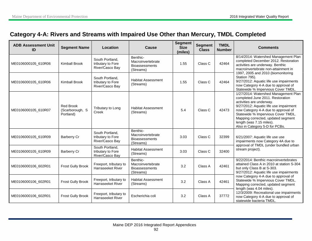
Maine Department of Environmental Protection 2016 Integrated Water Quality Report
Maine DEP 2016 Integrated Report Appendices 92
Category 4-A: Rivers and Streams with Impaired Use Other than Mercury, TMDL Completed
ADB Assessment Unit ID Segment Name Location Cause
Segment Size
(miles)
Segment Class
TMDL Number Comments
ME0106000105_610R06 Kimball Brook South Portland, tributary to Fore River/Casco Bay
Benthic-Macroinvertebrate Bioassessments (Streams)
1.55 Class C 42464
8/14/2014: Watershed Management Plan completed December 2012. Restoration activities are underway. Benthic macroinvertebrate non-attainment in 1997, 2005 and 2010 (biomonitoring Station 795). 9/27/2012: Aquatic life use impairments now Category 4-A due to approval of Statewide % Impervious Cover TMDL.
ME0106000105_610R06 Kimball Brook South Portland, tributary to Fore River/Casco Bay
Habitat Assessment (Streams) 1.55 Class C 42464
ME0106000105_610R07 Red Brook (Scarborough, S Portland)
Tributary to Long Creek
Habitat Assessment (Streams) 5.4 Class C 42473
1/27/2014: Watershed Management Plan completed June 2011. Restoration activities are underway. 9/27/2012: Aquatic life use impairment now Category 4-A due to approval of Statewide % Impervious Cover TMDL. Mapping corrected, updated segment length (was 7.15 miles). Also in Category 5-D for PCBs.
ME0106000105_610R09 Barberry Cr South Portland, tributary to Fore River/Casco Bay
Benthic-Macroinvertebrate Bioassessments (Streams)
3.03 Class C 32399 6/21/2007: Aquatic life use use impairments now Category 4A due to approval of TMDL (under bundled urban stream project).
ME0106000105_610R09 Barberry Cr South Portland, tributary to Fore River/Casco Bay
Habitat Assessment (Streams)
3.03 Class C 32400
ME0106000106_602R01 Frost Gully Brook Freeport, tributary to Harraseeket River
Benthic-Macroinvertebrate Bioassessments (Streams)
3.2 Class A 42461
9/22/2014: Benthic macroinvertebrates attained Class A in 2010 at station S-304 but only Class B at S-303. 9/27/2012: Aquatic life use impairments now Category 4-A due to approval of Statewide % Impervious Cover TMDL. Mapping corrected, updated segment length (was 4.04 miles). 12/3/2009: Recreational use impairments now Category 4-A due to approval of statewide bacteria TMDL.
ME0106000106_602R01 Frost Gully Brook Freeport, tributary to Harraseeket River
Habitat Assessment (Streams) 3.2 Class A 42461
ME0106000106_602R01 Frost Gully Brook Freeport, tributary to Harraseeket River Escherichia coli 3.2 Class A 37772

Maine Department of Environmental Protection 2016 Integrated Water Quality Report
Maine DEP 2016 Integrated Report Appendices 93
Category 4-A: Rivers and Streams with Impaired Use Other than Mercury, TMDL Completed
ADB Assessment Unit ID Segment Name Location Cause
Segment Size
(miles)
Segment Class
TMDL Number Comments
ME0106000106_602R02
Mare Brook (Brunswick) and selected tributaries
AU includes tributaries downstream of airport runway
Benthic-Macroinvertebrate Bioassessments (Streams)
8 Class B 42466
5/12/2015: Macroinvertebrate sampling planned for 2015. 9/27/2012: Aquatic life use impairments now Category 4-A due to approval of Statewide % Impervious Cover TMDL. 6/5/2012: New 5-A listing for aquatic life use due to benthic macroinvertebrate non-attainment; corrected mapping and included tributaries downstream of airport runway (resulting in increase in segment size - was 4.9 miles); updated name from 'Mare Brook (Brunswick)' to 'Mare Brook (Brunswick) and selected tributaries'.
ME0106000106_602R02
Mare Brook (Brunswick) and selected tributaries
AU includes tributaries downstream of airport runway
Habitat Assessment (Streams) 8 Class B 42466
ME0106000106_602R03 Concord Gully (Freeport)
Tributary to Harraseeket River
Benthic-Macroinvertebrate Bioassessments (Streams)
2.47 Class B 42459
9/22/2014: AKA Concord Gully Brook. Benthic macroinvertebrates did not attain class in 2012 at biomonitoring stations S-496 to 498 due to habitat problems. DO levels in mainstem met criteria in 2010 and 2012, but levels in tributaries often did not. Watershed survey was conducted in 2011; watershed based management planned is being prepared with expected completion date of April 2015. 9/27/2012: Aquatic life use impairments now Category 4-A due to approval of Statewide % Impervious Cover TMDL. 12/2/2011: New 5-A listing for Aquatic Life Use due to algae (periphyton) non-attainment results (2001 and 2010, biomonitoring station 498). Also in Category 5-A for bacteria.
ME0106000106_602R03 Concord Gully (Freeport)
Tributary to Harraseeket River
Habitat Assessment (Streams) 2.47 Class B 42459
ME0106000106_602R03 Concord Gully (Freeport)
Tributary to Harraseeket River Oxygen, Dissolved 2.47 Class B 42459
ME0106000106_602R03 Concord Gully (Freeport)
Tributary to Harraseeket River
Periphyton (Aufwuchs) Indicator Bioassessments
2.47 Class B 42459

Maine Department of Environmental Protection 2016 Integrated Water Quality Report
Maine DEP 2016 Integrated Report Appendices 94
Category 4-A: Rivers and Streams with Impaired Use Other than Mercury, TMDL Completed
ADB Assessment Unit ID Segment Name Location Cause
Segment Size
(miles)
Segment Class
TMDL Number Comments
ME0106000106_612R01 Goosefare Brook above I-95
Goosefare Brook, Saco
Escherichia coli 0.6 Class B
10/23/2014: Recreational use impairment moved to Category 4-A in 2014 cycle due to TMDL approval (9/22/2014). Watershed Management Plan is being developed with expected completion in 2016. 2/16/2012: New 5-A listing for primary/secondary contact recreation due to E. coli exceedance (2011 monitoring data); will be included in future update to statewide bacteria TMDL (approved 9/28/09).
ME0106000106_612R01_01 Goosefare Brook below I-95
Saco, Old Orchard Beach
Escherichia coli 5.54 Class B 61021 10/23/2014: Recreational use impairment moved to Category 4-A in 2014 cycle due to TMDL approval (9/22/2014). Watershed Management Plan is being developed with expected completion in 2016. Sampling for macroinvertebrates planned for 2015. 9/27/2012: Aquatic life use impairment now Category 4-A due to approval of Statewide % Impervious Cover TMDL. 2/22/2012: New 5-A listings in 2012 cycle for aquatic life use due to benthic macroinvertebrate non-attainment and for primary/secondary contact recreation (will be included in future update to statewide bacteria TMDL, approved 9/28/09) due to E. coli exceedance (2011 monitoring data). AU extent was corrected to begin below I-95, resulting in a shortening of this AU from 6.14 miles to 5.54. Also Category 4-A for metals due EPA approved TMDL (9/29/2003). 9/23/2003: Aquatic life use use impairments (metals) now Category 4-A due to approval of TMDL.
ME0106000106_612R01_01 Goosefare Brook below I-95
Saco, Old Orchard Beach
Benthic-Macroinvertebrate Bioassessments (Streams)
5.54 Class B 42494
ME0106000106_612R01_01 Goosefare Brook below I-95
Saco, Old Orchard Beach Cadmium 5.54 Class B 9765
ME0106000106_612R01_01 Goosefare Brook below I-95
Saco, Old Orchard Beach Chromium (total) 5.54 Class B 9765
ME0106000106_612R01_01 Goosefare Brook below I-95
Saco, Old Orchard Beach Copper 5.54 Class B 9765
ME0106000106_612R01_01 Goosefare Brook below I-95
Saco, Old Orchard Beach Iron 5.54 Class B 9765
ME0106000106_612R01_01 Goosefare Brook below I-95
Saco, Old Orchard Beach Lead 5.54 Class B 9765
ME0106000106_612R01_01 Goosefare Brook below I-95
Saco, Old Orchard Beach
Nickel 5.54 Class B 9765
ME0106000106_612R01_01 Goosefare Brook below I-95
Saco, Old Orchard Beach Zinc 5.54 Class B 9765
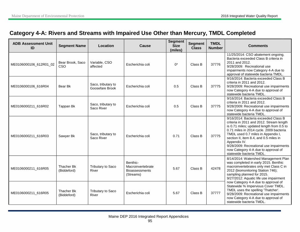
Maine Department of Environmental Protection 2016 Integrated Water Quality Report
Maine DEP 2016 Integrated Report Appendices 95
Category 4-A: Rivers and Streams with Impaired Use Other than Mercury, TMDL Completed
ADB Assessment Unit ID Segment Name Location Cause
Segment Size
(miles)
Segment Class
TMDL Number Comments
ME0106000106_612R01_02 Bear Brook, Saco CSO
Variable, CSO affected Escherichia coli 0* Class B 37776
11/25/2014: CSO abatement ongoing. Bacteria exceeded Class B criteria in 2011 and 2012. 9/28/2009: Recreational use impairments now Category 4-A due to approval of statewide bacteria TMDL.
ME0106000106_616R04 Bear Bk Saco, tributary to Goosefare Brook Escherichia coli 0.5 Class B 37775
9/16/2014: Bacteria exceeded Class B criteria in 2011 and 2012. 9/28/2009: Recreational use impairments now Category 4-A due to approval of statewide bacteria TMDL.
ME0106000211_616R02 Tappan Bk Saco, tributary to Saco River Escherichia coli 0.5 Class B 37775
9/16/2014: Bacteria exceeded Class B criteria in 2011 and 2012. 9/28/2009: Recreational use impairments now Category 4-A due to approval of statewide bacteria TMDL.
ME0106000211_616R03 Sawyer Bk Saco, tributary to Saco River Escherichia coli 0.71 Class B 37775
9/16/2014: Bacteria exceeded Class B criteria in 2011 and 2012. Stream length is 0.71 miles; updated length from 0.5 to 0.71 miles in 2014 cycle. 2009 bacteria TMDL used 0.7 miles in Appendix I, section II, item 8.4, and 0.5 miles in Appendix IV. 9/28/2009: Recreational use impairments now Category 4-A due to approval of statewide bacteria TMDL.
ME0106000211_616R05 Thacher Bk (Biddeford)
Tributary to Saco River
Benthic-Macroinvertebrate Bioassessments (Streams)
5.67 Class B 42478
8/14/2014: Watershed Management Plan was completed in early 2015. Benthic macroinvertebrates only met Class C in 2012 (biomonitoring Station 746); sampling planned for 2015. 9/27/2012: Aquatic life use impairment now Category 4-A due to approval of Statewide % Impervious Cover TMDL. TMDL uses the spelling 'Thatcher'. 9/28/2009: Recreational use impairments now Category 4-A due to approval of statewide bacteria TMDL.
ME0106000211_616R05 Thacher Bk (Biddeford)
Tributary to Saco River
Escherichia coli 5.67 Class B 37777

Maine Department of Environmental Protection 2016 Integrated Water Quality Report
Maine DEP 2016 Integrated Report Appendices 96
Category 4-A: Rivers and Streams with Impaired Use Other than Mercury, TMDL Completed
ADB Assessment Unit ID Segment Name Location Cause
Segment Size
(miles)
Segment Class
TMDL Number Comments
ME0106000211_616R06 Swan Pond Brook at South Street (Biddeford)
Tributary to Saco River
Escherichia coli 1 Class B 37777 9/28/2009: Recreational use impairments now Category 4-A due to approval of statewide bacteria TMDL.
ME0106000211_619R01 Saco River at Biddeford-Saco
Variable, CSO affected
Escherichia coli 0* Class B 37776
11/25/2014: CSO abatement ongoing. 9/28/2009: Recreational use impairments now Category 4-A due to approval of statewide bacteria TMDL.
ME0106000301_622R01 Kennebunk River Kennebunk Landing to Goochs Beach Escherichia coli 3.07 Class B 37775
9/28/2009: Recreational use impairments now Category 4-A due to approval of statewide bacteria TMDL. Also in Category 5-A for DO.
ME0106000301_622R03 Duck Brook and tributaries Arundel Escherichia coli 8.6 Class B 61000
10/23/2014: Recreational use impairment moved to Category 4-A in 2014 cycle due to TMDL approval (9/22/2014). 4/5/2012: New 5-A listing in 2012 cycle for primary/secondary contact recreation due to E. coli exceedance (2011 monitoring data); will be included in future update to statewide bacteria TMDL (approved 9/28/09). Assessment unit does not include small tributary entering Duck Brook from the northwest (attained criteria).
ME0106000302_628R01 Mousam R,
Main stem, Rt. 224 (Bridge St.) bridge in Sanford to Estes Lake
Arsenic 9.9 Class C 2530
3/5/2015: Corrected segment class from B to C in 2014 cycle. Aluminum, Ammonia, BOD, Copper and Total Phosphorus moved to Category 4-B because 6/12/2013 permit established limits for these pollutants. Other toxics (Arsenic, Lead, Selenium, Silver, Zinc) were not included in the permit and will remain in Category 4-A. Since 2012, several stormwater BMPs have been installed in Sanford and Alfred to treat urban, industrial and agricultural runoff draining to Number One Pond and Estes Lake. Remediation activities at Sanford landfill adjacent to river were completed
ME0106000302_628R01 Mousam R,
Main stem, Rt. 224 (Bridge St.) bridge in Sanford to Estes Lake
Lead 9.9 Class C 2530
ME0106000302_628R01 Mousam R,
Main stem, Rt. 224 (Bridge St.) bridge in Sanford to Estes Lake
Selenium 9.9 Class C 2530
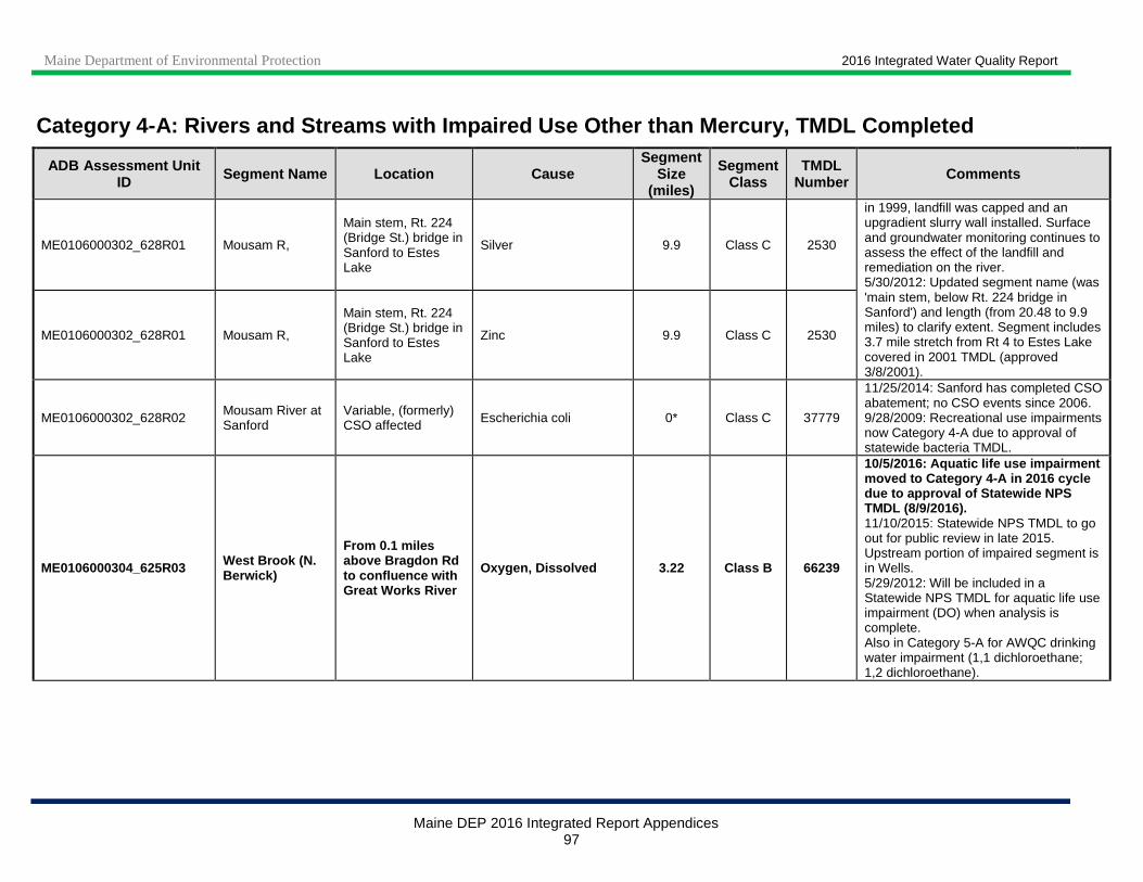
Maine Department of Environmental Protection 2016 Integrated Water Quality Report
Maine DEP 2016 Integrated Report Appendices 97
Category 4-A: Rivers and Streams with Impaired Use Other than Mercury, TMDL Completed
ADB Assessment Unit ID Segment Name Location Cause
Segment Size
(miles)
Segment Class
TMDL Number Comments
ME0106000302_628R01 Mousam R,
Main stem, Rt. 224 (Bridge St.) bridge in Sanford to Estes Lake
Silver 9.9 Class C 2530
in 1999, landfill was capped and an upgradient slurry wall installed. Surface and groundwater monitoring continues to assess the effect of the landfill and remediation on the river. 5/30/2012: Updated segment name (was 'main stem, below Rt. 224 bridge in Sanford') and length (from 20.48 to 9.9 miles) to clarify extent. Segment includes 3.7 mile stretch from Rt 4 to Estes Lake covered in 2001 TMDL (approved 3/8/2001).
ME0106000302_628R01 Mousam R,
Main stem, Rt. 224 (Bridge St.) bridge in Sanford to Estes Lake
Zinc 9.9 Class C 2530
ME0106000302_628R02 Mousam River at Sanford
Variable, (formerly) CSO affected Escherichia coli 0* Class C 37779
11/25/2014: Sanford has completed CSO abatement; no CSO events since 2006. 9/28/2009: Recreational use impairments now Category 4-A due to approval of statewide bacteria TMDL.
ME0106000304_625R03 West Brook (N. Berwick)
From 0.1 miles above Bragdon Rd to confluence with Great Works River
Oxygen, Dissolved 3.22 Class B 66239
10/5/2016: Aquatic life use impairment moved to Category 4-A in 2016 cycle due to approval of Statewide NPS TMDL (8/9/2016). 11/10/2015: Statewide NPS TMDL to go out for public review in late 2015. Upstream portion of impaired segment is in Wells. 5/29/2012: Will be included in a Statewide NPS TMDL for aquatic life use impairment (DO) when analysis is complete. Also in Category 5-A for AWQC drinking water impairment (1,1 dichloroethane; 1,2 dichloroethane).
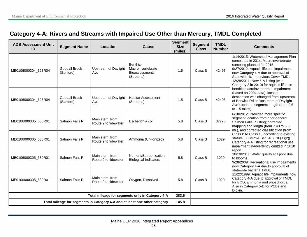
Maine Department of Environmental Protection 2016 Integrated Water Quality Report
Maine DEP 2016 Integrated Report Appendices 98
Category 4-A: Rivers and Streams with Impaired Use Other than Mercury, TMDL Completed
ADB Assessment Unit ID Segment Name Location Cause
Segment Size
(miles)
Segment Class
TMDL Number Comments
ME0106000304_625R04 Goodall Brook (Sanford)
Upstream of Daylight Ave
Benthic-Macroinvertebrate Bioassessments (Streams)
1.5 Class B 42493
1/14/2015: Watershed Management Plan completed in 2014. Macroinvertebrate sampling planned for 2015. 9/27/2012: Aquatic life use impairments now Category 4-A due to approval of Statewide % Impervious Cover TMDL. 12/29/2011: New 5-A listing (was Category 3 in 2010) for aquatic life use - benthic macroinvertebrate impairment (based on 2004 data); location description was changed from 'upstream of Berwick Rd' to 'upstream of Daylight Ave'; updated segment length (from 2.5 to 1.5 miles).
ME0106000304_625R04 Goodall Brook (Sanford)
Upstream of Daylight Ave
Habitat Assessment (Streams) 1.5 Class B 42493
ME0106000305_630R01 Salmon Falls R Main stem, from Route 9 to tidewater Escherichia coli 5.8 Class B 37776
6/18/2012: Provided more specific segment location from prior general Salmon Falls R listing; corrected mapping and length (from 7.43 to 5.8 mi.), and corrected classification (from Class B to Class C) according to existing statute [38 MRSA Sec. 467, 16(A)(2)]. Category 4-A listing for recreational use impairment inadvertently omitted in 2010 report. 10/19/2011: Water quality still poor due to blooms. 9/28/2009: Recreational use impairments now Category 4-A due to approval of statewide bacteria TMDL. 11/22/1999: Aquatic life impairments now Category 4-A due to approval of TMDL for BOD, ammonia and phosphorus. Also in Category 5-D for PCBs and Dioxin.
ME0106000305_630R01 Salmon Falls R Main stem, from Route 9 to tidewater Ammonia (Un-ionized) 5.8 Class B 1029
ME0106000305_630R01 Salmon Falls R Main stem, from Route 9 to tidewater
Nutrient/Eutrophication Biological Indicators 5.8 Class B 1029
ME0106000305_630R01 Salmon Falls R Main stem, from Route 9 to tidewater Oxygen, Dissolved 5.8 Class B 1029
Total mileage for segments only in Category 4-A 283.6
Total mileage for segments in Category 4-A and at l east one other category 145.8
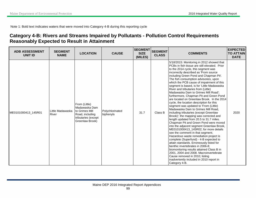
Maine Department of Environmental Protection 2016 Integrated Water Quality Report
Maine DEP 2016 Integrated Report Appendices 99
Note 1: Bold text indicates waters that were moved into Category 4-B during this reporting cycle
Category 4 -B: Rivers and Streams Impaired by Pollutants - Pollution Control Requirements Reasonably Expected to Result in Attainment
ADB ASSESSMENT UNIT ID
SEGMENT NAME LOCATION CAUSE
SEGMENT SIZE
(MILES)
SEGMENT CLASS COMMENTS
EXPECTED TO ATTAIN
DATE
ME0101000413_145R01 Little Madawaska River
From (Little) Madawaska Dam to Grimes Mill Road, including tributaries (except Greenlaw Brook)
Polychlorinated biphenyls 31.7 Class B
5/18/2015: Monitoring in 2012 showed that PCBs in fish tissue are still elevated. Prior to the 2014 cycle, this segment was incorrectly described as 'From source including Green Pond and Chapman Pit'. The fish consumption advisories, upon which the PCB cause of impairment of this segment is based, is for 'Little Madawaska River and tributaries from (Little) Madawaska Dam to Grimes Mill Road'; furthermore, Chapman Pit and Green Pond are located on Greenlaw Brook. In the 2014 cycle, the location description for this segment was updated to 'From (Little) Madawaska Dam to Grimes Mill Road, including tributaries (except Greenlaw Brook)'; the mapping was corrected and length updated from 20.5 to 31.7 miles. Chapman Pit and Green Pond were moved into the adjacent segment Greenlaw Brook, ME0101000413_145R02; for more details see the comment in that segment. Hazardous waste remediation project is complete (Superfund) - 4-B expected to attain standards. Erroneously listed for benthic invertebrates in 2006-8; biomonitoring results attained Class B in 2001, 2004 and 2008. Macroinvertebrate Cause removed in 2010; listing inadvertently included in 2010 report in Category 4-B.
2020

Maine Department of Environmental Protection 2016 Integrated Water Quality Report
Maine DEP 2016 Integrated Report Appendices 100
Category 4 -B: Rivers and Streams Impaired by Pollutants - Pollution Control Requirements Reasonably Expected to Result in Attainment
ADB ASSESSMENT UNIT ID
SEGMENT NAME LOCATION CAUSE
SEGMENT SIZE
(MILES)
SEGMENT CLASS COMMENTS
EXPECTED TO ATTAIN
DATE
ME0101000413_145R02 Greenlaw Brook
Including tributaries, Green Pond and Chapman Pit; tributary to Little Madawaska River
Polychlorinated biphenyls
12.8 Class B
5/18/2015: Monitoring in 2012 showed that PCBs in fish tissue are still elevated. Prior to the 2014 cycle, this segment was incorrectly mapped on Greenlaw Stream and was limited to the mainstem. Fish consumption advisories, upon which the PCB cause of impairment of this segment is based, are for Greenlaw Brook as well as Chapman Pit and Green Pond, which are located on Greenlaw Brook. Chapman Pit and Green Pond were previously erroneously inclulded in the adjacent segment Little Madawaska River, ME0101000413_145R01; for more details see the comment in that segment. In the 2014 cycle, the location description for this segment was updated from 'Tributary to Little Madawaska River' to 'Including tributaries, Green Pond and Chapman Pit; tributary to Little Madawaska River' and the length was corrected from 17.12 to 12.8 miles. 9/6/2012: Corrected name, was Greenlaw Stream. Hazardous waste remediation project is complete (Superfund) - 4-B expected to attain standards.
2020
ME0102000109_205R01
West Branch Penobscot R, including Dolby Pd
Main stem, below confluence with Millinocket Str
Nutrient/Eutrophication Biological Indicators 4.25 Class C
3/4/2015: Recent data from this reach has shown continued attainment. Both Katahdin Mills have now been shut down and are being decommissioned. There is no reason
2016
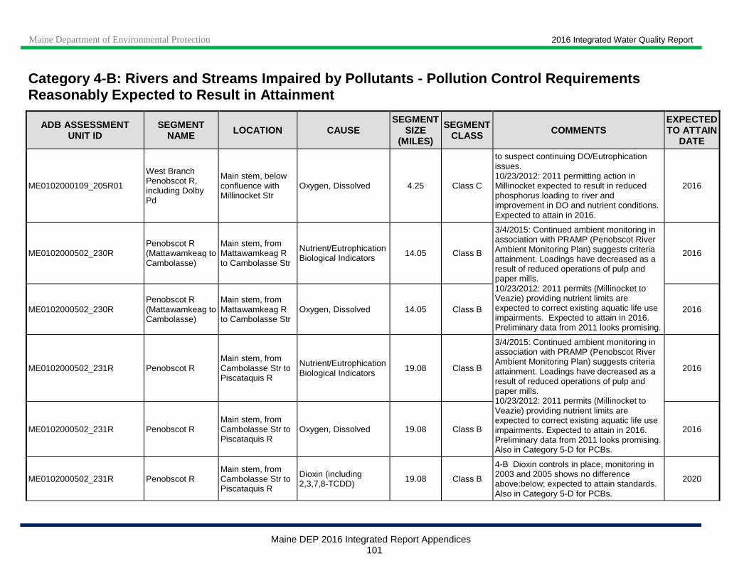
Maine Department of Environmental Protection 2016 Integrated Water Quality Report
Maine DEP 2016 Integrated Report Appendices 101
Category 4 -B: Rivers and Streams Impaired by Pollutants - Pollution Control Requirements Reasonably Expected to Result in Attainment
ADB ASSESSMENT UNIT ID
SEGMENT NAME LOCATION CAUSE
SEGMENT SIZE
(MILES)
SEGMENT CLASS COMMENTS
EXPECTED TO ATTAIN
DATE
ME0102000109_205R01
West Branch Penobscot R, including Dolby Pd
Main stem, below confluence with Millinocket Str
Oxygen, Dissolved 4.25 Class C
to suspect continuing DO/Eutrophication issues. 10/23/2012: 2011 permitting action in Millinocket expected to result in reduced phosphorus loading to river and improvement in DO and nutrient conditions. Expected to attain in 2016.
2016
ME0102000502_230R Penobscot R (Mattawamkeag to Cambolasse)
Main stem, from Mattawamkeag R to Cambolasse Str
Nutrient/Eutrophication Biological Indicators 14.05 Class B
3/4/2015: Continued ambient monitoring in association with PRAMP (Penobscot River Ambient Monitoring Plan) suggests criteria attainment. Loadings have decreased as a result of reduced operations of pulp and paper mills. 10/23/2012: 2011 permits (Millinocket to Veazie) providing nutrient limits are expected to correct existing aquatic life use impairments. Expected to attain in 2016. Preliminary data from 2011 looks promising.
2016
ME0102000502_230R Penobscot R (Mattawamkeag to Cambolasse)
Main stem, from Mattawamkeag R to Cambolasse Str
Oxygen, Dissolved 14.05 Class B 2016
ME0102000502_231R Penobscot R Main stem, from Cambolasse Str to Piscataquis R
Nutrient/Eutrophication Biological Indicators 19.08 Class B
3/4/2015: Continued ambient monitoring in association with PRAMP (Penobscot River Ambient Monitoring Plan) suggests criteria attainment. Loadings have decreased as a result of reduced operations of pulp and paper mills. 10/23/2012: 2011 permits (Millinocket to Veazie) providing nutrient limits are expected to correct existing aquatic life use impairments. Expected to attain in 2016. Preliminary data from 2011 looks promising. Also in Category 5-D for PCBs.
2016
ME0102000502_231R Penobscot R Main stem, from Cambolasse Str to Piscataquis R
Oxygen, Dissolved 19.08 Class B 2016
ME0102000502_231R Penobscot R Main stem, from Cambolasse Str to Piscataquis R
Dioxin (including 2,3,7,8-TCDD) 19.08 Class B
4-B Dioxin controls in place, monitoring in 2003 and 2005 shows no difference above:below; expected to attain standards. Also in Category 5-D for PCBs.
2020
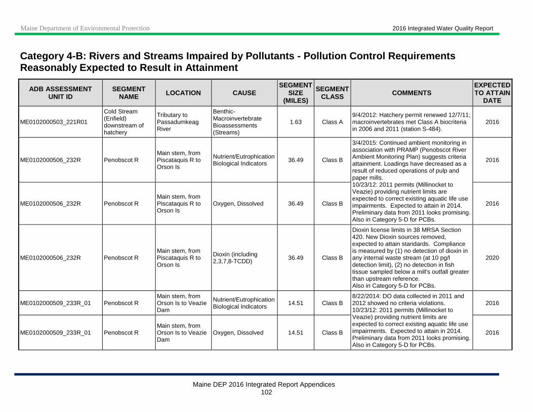
Maine Department of Environmental Protection 2016 Integrated Water Quality Report
Maine DEP 2016 Integrated Report Appendices 102
Category 4 -B: Rivers and Streams Impaired by Pollutants - Pollution Control Requirements Reasonably Expected to Result in Attainment
ADB ASSESSMENT UNIT ID
SEGMENT NAME LOCATION CAUSE
SEGMENT SIZE
(MILES)
SEGMENT CLASS COMMENTS
EXPECTED TO ATTAIN
DATE
ME0102000503_221R01
Cold Stream (Enfield) downstream of hatchery
Tributary to Passadumkeag River
Benthic-Macroinvertebrate Bioassessments (Streams)
1.63 Class A 9/4/2012: Hatchery permit renewed 12/7/11; macroinvertebrates met Class A biocriteria in 2006 and 2011 (station S-484).
2016
ME0102000506_232R Penobscot R Main stem, from Piscataquis R to Orson Is
Nutrient/Eutrophication Biological Indicators 36.49 Class B
3/4/2015: Continued ambient monitoring in association with PRAMP (Penobscot River Ambient Monitoring Plan) suggests criteria attainment. Loadings have decreased as a result of reduced operations of pulp and paper mills. 10/23/12: 2011 permits (Millinocket to Veazie) providing nutrient limits are expected to correct existing aquatic life use impairments. Expected to attain in 2014. Preliminary data from 2011 looks promising. Also in Category 5-D for PCBs.
2016
ME0102000506_232R Penobscot R Main stem, from Piscataquis R to Orson Is
Oxygen, Dissolved 36.49 Class B 2016
ME0102000506_232R Penobscot R Main stem, from Piscataquis R to Orson Is
Dioxin (including 2,3,7,8-TCDD) 36.49 Class B
Dioxin license limits in 38 MRSA Section 420. New Dioxin sources removed, expected to attain standards. Compliance is measured by (1) no detection of dioxin in any internal waste stream (at 10 pg/l detection limit), (2) no detection in fish tissue sampled below a mill's outfall greater than upstream reference. Also in Category 5-D for PCBs.
2020
ME0102000509_233R_01 Penobscot R Main stem, from Orson Is to Veazie Dam
Nutrient/Eutrophication Biological Indicators 14.51 Class B
8/22/2014: DO data collected in 2011 and 2012 showed no criteria violations. 10/23/12: 2011 permits (Millinocket to Veazie) providing nutrient limits are expected to correct existing aquatic life use impairments. Expected to attain in 2014. Preliminary data from 2011 looks promising. Also in Category 5-D for PCBs.
2016
ME0102000509_233R_01 Penobscot R Main stem, from Orson Is to Veazie Dam
Oxygen, Dissolved 14.51 Class B 2016

Maine Department of Environmental Protection 2016 Integrated Water Quality Report
Maine DEP 2016 Integrated Report Appendices 103
Category 4 -B: Rivers and Streams Impaired by Pollutants - Pollution Control Requirements Reasonably Expected to Result in Attainment
ADB ASSESSMENT UNIT ID
SEGMENT NAME LOCATION CAUSE
SEGMENT SIZE
(MILES)
SEGMENT CLASS COMMENTS
EXPECTED TO ATTAIN
DATE
ME0102000509_233R_01 Penobscot R Main stem, from Orson Is to Veazie Dam
Dioxin (including 2,3,7,8-TCDD) 14.51 Class B
Dioxin license limits in 38 MRSA Section 420. New Dioxin sources removed, expected to attain standards. Compliance is measured by (1) no detection of dioxin in any internal waste stream (at 10 pg/l detection limit), (2) no detection in fish tissue sampled below a mill's outfall greater than upstream reference. Also in Category 5-D for PCBs.
2020
ME0102000512_229R Penobscot R Main stem, above confluence of Mattawamkeag R
Nutrient/Eutrophication Biological Indicators 13.03 Class C
8/22/2014: DO data collected in 2011 and 2012 showed no criteria violations. 10/23/2012: 2011 permits (Millinocket) providing nutrient limits are expected to correct existing aquatic life use impairments. Expected to attain in 2016. Preliminary data from 2011 looks promising.
2016
ME0102000512_229R Penobscot R Main stem, above confluence of Mattawamkeag R
Oxygen, Dissolved 13.03 Class C 2016
ME0102000513_234R02 Penobscot Main stem, Veazie Dam to Reeds Bk
Nutrient/Eutrophication Biological Indicators
10.1 Class B
3/4/2015: No recent monitoring but upstream results suggest criteria attainment. 10/23/12: 2011 permits (Millinocket to Veazie) providing nutrient limits are expected to correct existing aquatic life use impairments. Expected to attain in 2016. Preliminary data from 2011 looks promising. Also in Category 5-D for legacy PCBs.
2016
ME0102000513_234R02 Penobscot Main stem, Veazie Dam to Reeds Bk Oxygen, Dissolved 10.1 Class B 2016
ME0102000513_234R02 Penobscot Main stem, Veazie Dam to Reeds Bk
Dioxin (including 2,3,7,8-TCDD)
10.1 Class B
4-B Dioxin license limits in 38 MRSA Section 420. Compliance is measured by (1) no detection of dioxin in any internal waste stream (at 10 pg/l detection limit), (2) no detection in fish tissue sampled below a mill's outfall greater than upstream reference. Also in Category 5-D for legacy PCBs.
2020
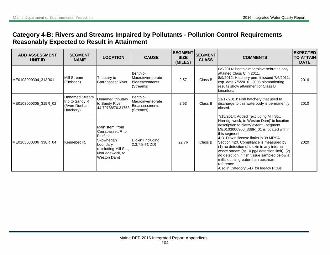
Maine Department of Environmental Protection 2016 Integrated Water Quality Report
Maine DEP 2016 Integrated Report Appendices 104
Category 4 -B: Rivers and Streams Impaired by Pollutants - Pollution Control Requirements Reasonably Expected to Result in Attainment
ADB ASSESSMENT UNIT ID
SEGMENT NAME LOCATION CAUSE
SEGMENT SIZE
(MILES)
SEGMENT CLASS COMMENTS
EXPECTED TO ATTAIN
DATE
ME0103000304_313R01 Mill Stream (Embden)
Tributary to Carrabasset River
Benthic-Macroinvertebrate Bioassessments (Streams)
2.57 Class B
6/9/2014: Benthic macroinvertebrates only attained Class C in 2011. 8/9/2012: Hatchery permit issued 7/6/2011; exp. date 7/5/2016. 2006 biomonitoring results show attainment of Class B biocriteria.
2016
ME0103000305_315R_02
Unnamed Stream trib to Sandy R (Avon-Dunham Hatchery)
Unnamed tributary to Sandy River 44.79788/70.31753
Benthic-Macroinvertebrate Bioassessments (Streams)
2.63 Class B 11/17/2010: Fish hatchery that used to discharge to this waterbody is permanently closed.
2010
ME0103000306_338R_04 Kennebec R,
Main stem, from Carrabassett R to Fairfield-Skowhegan boundary (excluding Mill Str., Norridgewock, to Weston Dam)
Dioxin (including 2,3,7,8-TCDD) 22.76 Class B
7/15/2014: Added '(excluding Mill Str., Norridgewock, to Weston Dam)' to location description to clarify extent - segment ME0103000306_338R_01 is located within this segment. 4-B Dioxin license limits in 38 MRSA Section 420. Compliance is measured by (1) no detection of dioxin in any internal waste stream (at 10 pg/l detection limit), (2) no detection in fish tissue sampled below a mill's outfall greater than upstream reference. Also in Category 5-D for legacy PCBs.
2020

Maine Department of Environmental Protection 2016 Integrated Water Quality Report
Maine DEP 2016 Integrated Report Appendices 105
Category 4 -B: Rivers and Streams Impaired by Pollutants - Pollution Control Requirements Reasonably Expected to Result in Attainment
ADB ASSESSMENT UNIT ID
SEGMENT NAME LOCATION CAUSE
SEGMENT SIZE
(MILES)
SEGMENT CLASS COMMENTS
EXPECTED TO ATTAIN
DATE
ME0103000306_339R_01 Kennebec R, Shawmut Dam Dioxin (including 2,3,7,8-TCDD) 5.5 Class C
5/15/2015: The Kennebec River above and below this segment is in Category 4-B for legacy dioxin and 5-D for legacy PCBs. These impairments were previously inadvertently omitted from this segment; they were added in the 2014 cycle. 4-B Dioxin license limits in 38 MRSA Section 420. Compliance is measured by (1) no detection of dioxin in any internal waste stream (at 10 pg/l detection limit), (2) no detection in fish tissue sampled below a mill's outfall greater than upstream reference. Also in Category 5-D for legacy PCBs and Category 3 for potential aquatic life use impairment.
2020
ME0103000306_339R_02 Kennebec R,
Main stem, from Fairfield-Skowhegan boundary to Sebasticook R
Dioxin (including 2,3,7,8-TCDD) 7.7 Class C
5/15/2015: Corrected mapping to exclude Kennebec R, Shawmut Dam segment (ME0103000306_339R_01); updated length from 14.65 to 7.7 miles. Mixed Class B and C segment. 4-B Dioxin license limits in 38 MRSA Section 420. Compliance is measured by (1) no detection of dioxin in any internal waste stream (at 10 pg/l detection limit), (2) no detection in fish tissue sampled below a mill's outfall greater than upstream reference. Also in Category 5-D for legacy PCBs.
2020
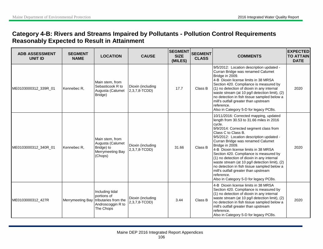
Maine Department of Environmental Protection 2016 Integrated Water Quality Report
Maine DEP 2016 Integrated Report Appendices 106
Category 4 -B: Rivers and Streams Impaired by Pollutants - Pollution Control Requirements Reasonably Expected to Result in Attainment
ADB ASSESSMENT UNIT ID
SEGMENT NAME LOCATION CAUSE
SEGMENT SIZE
(MILES)
SEGMENT CLASS COMMENTS
EXPECTED TO ATTAIN
DATE
ME0103000312_339R_01 Kennebec R,
Main stem, from Sebasticook R to Augusta (Calumet Bridge)
Dioxin (including 2,3,7,8-TCDD)
17.7 Class B
9/5/2012: Location description updated - Curran Bridge was renamed Calumet Bridge in 2009. 4-B Dioxin license limits in 38 MRSA Section 420. Compliance is measured by (1) no detection of dioxin in any internal waste stream (at 10 pg/l detection limit), (2) no detection in fish tissue sampled below a mill's outfall greater than upstream reference. Also in Category 5-D for legacy PCBs.
2020
ME0103000312_340R_01 Kennebec R,
Main stem, from Augusta (Calumet Bridge) to Merrymeeting Bay (Chops)
Dioxin (including 2,3,7,8-TCDD) 31.66 Class B
10/11/2016: Corrected mapping, updated length from 30.53 to 31.66 miles in 2016 cycle. 9/9/2014: Corrected segment class from Class C to Class B. 9/5/2012: Location description updated - Curran Bridge was renamed Calumet Bridge in 2009. 4-B Dioxin license limits in 38 MRSA Section 420. Compliance is measured by (1) no detection of dioxin in any internal waste stream (at 10 pg/l detection limit), (2) no detection in fish tissue sampled below a mill's outfall greater than upstream reference. Also in Category 5-D for legacy PCBs.
2020
ME0103000312_427R Merrymeeting Bay
Including tidal portions of tributaries from the Androscoggin R to The Chops
Dioxin (including 2,3,7,8-TCDD) 3.44 Class B
4-B Dioxin license limits in 38 MRSA Section 420. Compliance is measured by (1) no detection of dioxin in any internal waste stream (at 10 pg/l detection limit), (2) no detection in fish tissue sampled below a mill's outfall greater than upstream reference. Also in Category 5-D for legacy PCBs.
2020
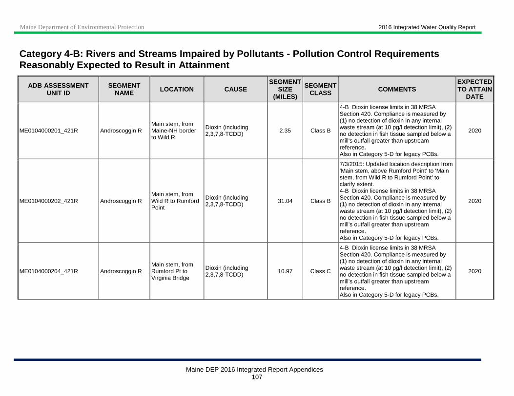
Maine Department of Environmental Protection 2016 Integrated Water Quality Report
Maine DEP 2016 Integrated Report Appendices 107
Category 4 -B: Rivers and Streams Impaired by Pollutants - Pollution Control Requirements Reasonably Expected to Result in Attainment
ADB ASSESSMENT UNIT ID
SEGMENT NAME LOCATION CAUSE
SEGMENT SIZE
(MILES)
SEGMENT CLASS COMMENTS
EXPECTED TO ATTAIN
DATE
ME0104000201_421R Androscoggin R Main stem, from Maine-NH border to Wild R
Dioxin (including 2,3,7,8-TCDD) 2.35 Class B
4-B Dioxin license limits in 38 MRSA Section 420. Compliance is measured by (1) no detection of dioxin in any internal waste stream (at 10 pg/l detection limit), (2) no detection in fish tissue sampled below a mill's outfall greater than upstream reference. Also in Category 5-D for legacy PCBs.
2020
ME0104000202_421R Androscoggin R Main stem, from Wild R to Rumford Point
Dioxin (including 2,3,7,8-TCDD) 31.04 Class B
7/3/2015: Updated location description from 'Main stem, above Rumford Point' to 'Main stem, from Wild R to Rumford Point' to clarify extent. 4-B Dioxin license limits in 38 MRSA Section 420. Compliance is measured by (1) no detection of dioxin in any internal waste stream (at 10 pg/l detection limit), (2) no detection in fish tissue sampled below a mill's outfall greater than upstream reference. Also in Category 5-D for legacy PCBs.
2020
ME0104000204_421R Androscoggin R Main stem, from Rumford Pt to Virginia Bridge
Dioxin (including 2,3,7,8-TCDD) 10.97 Class C
4-B Dioxin license limits in 38 MRSA Section 420. Compliance is measured by (1) no detection of dioxin in any internal waste stream (at 10 pg/l detection limit), (2) no detection in fish tissue sampled below a mill's outfall greater than upstream reference. Also in Category 5-D for legacy PCBs.
2020
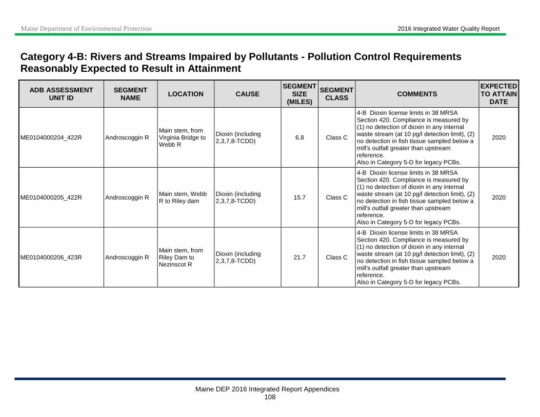
Maine Department of Environmental Protection 2016 Integrated Water Quality Report
Maine DEP 2016 Integrated Report Appendices 108
Category 4 -B: Rivers and Streams Impaired by Pollutants - Pollution Control Requirements Reasonably Expected to Result in Attainment
ADB ASSESSMENT UNIT ID
SEGMENT NAME LOCATION CAUSE
SEGMENT SIZE
(MILES)
SEGMENT CLASS COMMENTS
EXPECTED TO ATTAIN
DATE
ME0104000204_422R Androscoggin R Main stem, from Virginia Bridge to Webb R
Dioxin (including 2,3,7,8-TCDD) 6.8 Class C
4-B Dioxin license limits in 38 MRSA Section 420. Compliance is measured by (1) no detection of dioxin in any internal waste stream (at 10 pg/l detection limit), (2) no detection in fish tissue sampled below a mill's outfall greater than upstream reference. Also in Category 5-D for legacy PCBs.
2020
ME0104000205_422R Androscoggin R Main stem, Webb R to Riley dam
Dioxin (including 2,3,7,8-TCDD) 15.7 Class C
4-B Dioxin license limits in 38 MRSA Section 420. Compliance is measured by (1) no detection of dioxin in any internal waste stream (at 10 pg/l detection limit), (2) no detection in fish tissue sampled below a mill's outfall greater than upstream reference. Also in Category 5-D for legacy PCBs.
2020
ME0104000206_423R Androscoggin R Main stem, from Riley Dam to Nezinscot R
Dioxin (including 2,3,7,8-TCDD) 21.7 Class C
4-B Dioxin license limits in 38 MRSA Section 420. Compliance is measured by (1) no detection of dioxin in any internal waste stream (at 10 pg/l detection limit), (2) no detection in fish tissue sampled below a mill's outfall greater than upstream reference. Also in Category 5-D for legacy PCBs.
2020

Maine Department of Environmental Protection 2016 Integrated Water Quality Report
Maine DEP 2016 Integrated Report Appendices 109
Category 4 -B: Rivers and Streams Impaired by Pollutants - Pollution Control Requirements Reasonably Expected to Result in Attainment
ADB ASSESSMENT UNIT ID
SEGMENT NAME LOCATION CAUSE
SEGMENT SIZE
(MILES)
SEGMENT CLASS COMMENTS
EXPECTED TO ATTAIN
DATE
ME0104000206_423R01 Androscoggin R Main stem, Livermore impoundment
Dioxin (including 2,3,7,8-TCDD) 1 Class C
4-B Dioxin license limits in 38 MRSA Section 420. Compliance is measured by (1) no detection of dioxin in any internal waste stream (at 10 pg/l detection limit), (2) no detection in fish tissue sampled below a mill's outfall greater than upstream reference. Also in Category 5-D for legacy PCBs and Category 2 for benthic macroinvertebrates and TSS (delisted in 2008 cycle; biomonitoring station S-244 attained Class C biocriteria in 2003, and Class B biocriteria in 2004-2010).
2020
ME0104000207_412R02 House/Lively Brook
Turner, tributaries to Martin Stream Nitrogen (Total) 3.53 Class B
12/4/2014: Manure disposal system has been improved and several contamination sources have been eliminated. Total nitrogen levels in streams have declined significantly (especially since 2010) and are expected to continue to decline further over time. Waste (manure) removal (Agric NPS) by Consent Order and Site Permit-expected to attain standards; needs addtional monitoring to confirm attainment.
2013

Maine Department of Environmental Protection 2016 Integrated Water Quality Report
Maine DEP 2016 Integrated Report Appendices 110
Category 4 -B: Rivers and Streams Impaired by Pollutants - Pollution Control Requirements Reasonably Expected to Result in Attainment
ADB ASSESSMENT UNIT ID
SEGMENT NAME LOCATION CAUSE
SEGMENT SIZE
(MILES)
SEGMENT CLASS COMMENTS
EXPECTED TO ATTAIN
DATE
ME0104000208_424R Androscoggin R,
Main stem, from confluence of Nezinscot R to confluence with Little Androscoggin R, except Gulf Island Pond
Dioxin (including 2,3,7,8-TCDD) 7.25 Class C
5/4/2012: Corrected length (to 7.25 miles) to exclude GIP impoundment (8.19 miles) from 15.45-mile general "Androscoggin R" segment listed in 2010 for this AU. 4-B Dioxin license limits in 38 MRSA Section 420. Compliance is measured by (1) no detection of dioxin in any internal waste stream (at 10 pg/l detection limit), (2) no detection in fish tissue sampled below a mill's outfall greater than upstream reference. Also in Category 5-D for PCBs.
2020
ME0104000208_424R_01 Androscoggin R, GIP
Main stem, upstream of the Gulf Island Dam
Algae blooms (Chl a) 8.19 Class C 11/18/2015: DO problems persist in deep portions of impoundment. Recent data analysis showed that discharge levels and/or concentrations in the impoundment for BOD, TSS, TP and Chlorophyll a have decreased significantly since 2004. However, high-flow conditions combined with reduced discharge levels did not allow an assessment whether WQS would be attained during critical conditions of low flow, high water temperature and point-source inputs at maximum permit levels. Therefore the segment remains in Category 4-B. 8/28/13: New Category 4-B listing (previously 4-A) based on new permits issued in December 2012. Expected to attain in 2017. Also in Category 5-D for legacy PCBs.
2017
ME0104000208_424R_01 Androscoggin R, GIP
Main stem, upstream of the Gulf Island Dam
BOD, Biochemical oxygen demand 8.19 Class C 2017
ME0104000208_424R_01 Androscoggin R, GIP
Main stem, upstream of the Gulf Island Dam
Oxygen, Dissolved 8.19 Class C 2017
ME0104000208_424R_01 Androscoggin R, GIP
Main stem, upstream of the Gulf Island Dam
Phosphorus (Total) 8.19 Class C 2017
ME0104000208_424R_01 Androscoggin R, GIP
Main stem, upstream of the Gulf Island Dam
Total Suspended Solids 8.19 Class C 2017

Maine Department of Environmental Protection 2016 Integrated Water Quality Report
Maine DEP 2016 Integrated Report Appendices 111
Category 4 -B: Rivers and Streams Impaired by Pollutants - Pollution Control Requirements Reasonably Expected to Result in Attainment
ADB ASSESSMENT UNIT ID
SEGMENT NAME LOCATION CAUSE
SEGMENT SIZE
(MILES)
SEGMENT CLASS COMMENTS
EXPECTED TO ATTAIN
DATE
ME0104000208_424R_01 Androscoggin R, GIP
Main stem, upstream of the Gulf Island Dam
Dioxin (including 2,3,7,8-TCDD) 8.19 Class C
8/28/2012: Corrected length (to 8.19 miles) to reflect resegmentation of the 15.45-mile general "Androscoggin R" segment (ME0104000208_424R) listed in 2010. 4-B New dioxin permit expected in fiscal year 2013. Dioxin license limits in 38 MRSA Section 420. Compliance is measured by (1) no detection of dioxin in any internal waste stream (at 10 pg/l detection limit), (2) no detection in fish tissue sampled below a mill's outfall greater than upstream reference. Dioxin listing was included in 15.45 mile length of ME0104000208_424R in 2010 report. Also in Category 5-D for legacy PCBs.
2020
ME0104000210_425R_01 Androscoggin R, Main stem, from L Androscoggin R to Pejepscot Dam
Dioxin (including 2,3,7,8-TCDD) 17.65 Class C
9/5/2012: Corrected length (was 22.15 miles) to exclude newly (2010) created segment between Pejepscot Dam and Brunswick Dam (ME0104000210_425R_01_01, 4.5 miles). Updated AU name (was 'Main stem, from L Androscoggin R to Brunswick Dam') to reflect correct extent. 4-B Dioxin license limits in 38 MRSA Section 420. Compliance is measured by (1) no detection of dioxin in any internal waste stream (at 10 pg/l detection limit), (2) no detection in fish tissue sampled below a mill's outfall greater than upstream reference. Also in Category 5-D for legacy PCBs.
2020
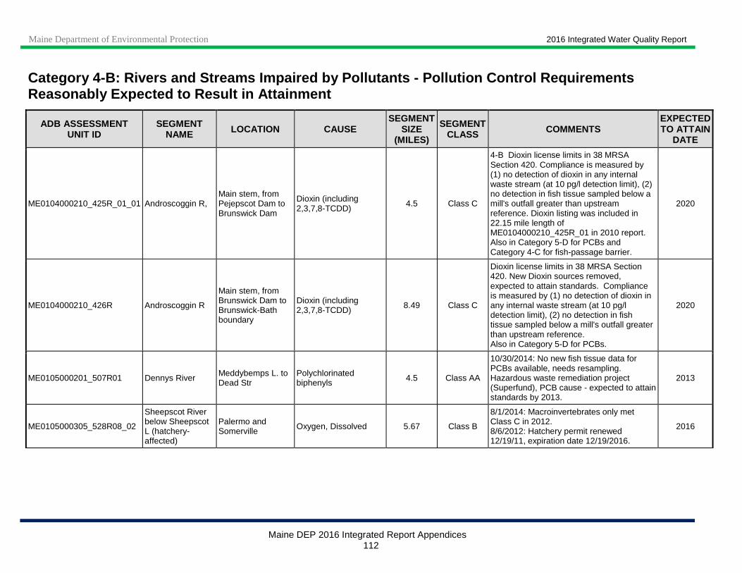
Maine Department of Environmental Protection 2016 Integrated Water Quality Report
Maine DEP 2016 Integrated Report Appendices 112
Category 4 -B: Rivers and Streams Impaired by Pollutants - Pollution Control Requirements Reasonably Expected to Result in Attainment
ADB ASSESSMENT UNIT ID
SEGMENT NAME LOCATION CAUSE
SEGMENT SIZE
(MILES)
SEGMENT CLASS COMMENTS
EXPECTED TO ATTAIN
DATE
ME0104000210_425R_01_01 Androscoggin R, Main stem, from Pejepscot Dam to Brunswick Dam
Dioxin (including 2,3,7,8-TCDD)
4.5 Class C
4-B Dioxin license limits in 38 MRSA Section 420. Compliance is measured by (1) no detection of dioxin in any internal waste stream (at 10 pg/l detection limit), (2) no detection in fish tissue sampled below a mill's outfall greater than upstream reference. Dioxin listing was included in 22.15 mile length of ME0104000210_425R_01 in 2010 report. Also in Category 5-D for PCBs and Category 4-C for fish-passage barrier.
2020
ME0104000210_426R Androscoggin R
Main stem, from Brunswick Dam to Brunswick-Bath boundary
Dioxin (including 2,3,7,8-TCDD) 8.49 Class C
Dioxin license limits in 38 MRSA Section 420. New Dioxin sources removed, expected to attain standards. Compliance is measured by (1) no detection of dioxin in any internal waste stream (at 10 pg/l detection limit), (2) no detection in fish tissue sampled below a mill's outfall greater than upstream reference. Also in Category 5-D for PCBs.
2020
ME0105000201_507R01 Dennys River Meddybemps L. to Dead Str
Polychlorinated biphenyls 4.5 Class AA
10/30/2014: No new fish tissue data for PCBs available, needs resampling. Hazardous waste remediation project (Superfund), PCB cause - expected to attain standards by 2013.
2013
ME0105000305_528R08_02
Sheepscot River below Sheepscot L (hatchery-affected)
Palermo and Somerville Oxygen, Dissolved 5.67 Class B
8/1/2014: Macroinvertebrates only met Class C in 2012. 8/6/2012: Hatchery permit renewed 12/19/11, expiration date 12/19/2016.
2016
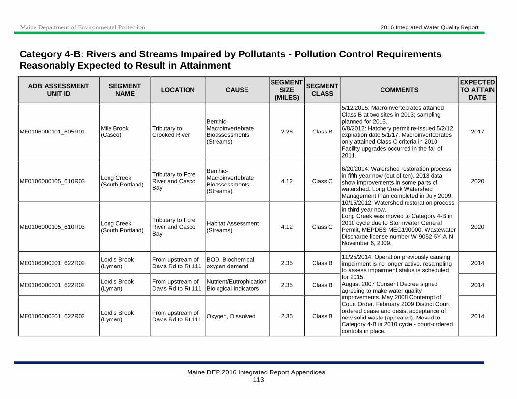
Maine Department of Environmental Protection 2016 Integrated Water Quality Report
Maine DEP 2016 Integrated Report Appendices 113
Category 4 -B: Rivers and Streams Impaired by Pollutants - Pollution Control Requirements Reasonably Expected to Result in Attainment
ADB ASSESSMENT UNIT ID
SEGMENT NAME LOCATION CAUSE
SEGMENT SIZE
(MILES)
SEGMENT CLASS COMMENTS
EXPECTED TO ATTAIN
DATE
ME0106000101_605R01 Mile Brook (Casco)
Tributary to Crooked River
Benthic-Macroinvertebrate Bioassessments (Streams)
2.28 Class B
5/12/2015: Macroinvertebrates attained Class B at two sites in 2013; sampling planned for 2015. 6/8/2012: Hatchery permit re-issued 5/2/12, expiration date 5/1/17. Macroinvertebrates only attained Class C criteria in 2010. Facility upgrades occurred in the fall of 2011.
2017
ME0106000105_610R03 Long Creek (South Portland)
Tributary to Fore River and Casco Bay
Benthic-Macroinvertebrate Bioassessments (Streams)
4.12 Class C
6/20/2014: Watershed restoration process in fifth year now (out of ten). 2013 data show improvements in some parts of watershed. Long Creek Watershed Management Plan completed in July 2009. 10/15/2012: Watershed restoration process in third year now. Long Creek was moved to Category 4-B in 2010 cycle due to Stormwater General Permit, MEPDES MEG190000. Wastewater Discharge license number W-9052-5Y-A-N November 6, 2009.
2020
ME0106000105_610R03 Long Creek (South Portland)
Tributary to Fore River and Casco Bay
Habitat Assessment (Streams) 4.12 Class C 2020
ME0106000301_622R02 Lord's Brook (Lyman)
From upstream of Davis Rd to Rt 111
BOD, Biochemical oxygen demand 2.35 Class B
11/25/2014: Operation previously causing impairment is no longer active, resampling to assess impairment status is scheduled for 2015. August 2007 Consent Decree signed agreeing to make water quality improvements. May 2008 Contempt of Court Order. February 2009 District Court ordered cease and desist acceptance of new solid waste (appealed). Moved to Category 4-B in 2010 cycle - court-ordered controls in place.
2014
ME0106000301_622R02 Lord's Brook (Lyman)
From upstream of Davis Rd to Rt 111
Nutrient/Eutrophication Biological Indicators 2.35 Class B 2014
ME0106000301_622R02 Lord's Brook (Lyman)
From upstream of Davis Rd to Rt 111 Oxygen, Dissolved 2.35 Class B 2014
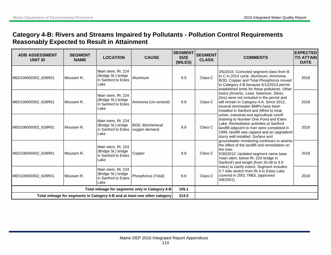
Maine Department of Environmental Protection 2016 Integrated Water Quality Report
Maine DEP 2016 Integrated Report Appendices 114
Category 4 -B: Rivers and Streams Impaired by Pollutants - Pollution Control Requirements Reasonably Expected to Result in Attainment
ADB ASSESSMENT UNIT ID
SEGMENT NAME LOCATION CAUSE
SEGMENT SIZE
(MILES)
SEGMENT CLASS COMMENTS
EXPECTED TO ATTAIN
DATE
ME0106000302_628R01 Mousam R,
Main stem, Rt. 224 (Bridge St.) bridge in Sanford to Estes Lake
Aluminum 9.9 Class C
3/5/2015: Corrected segment class from B to C in 2014 cycle. Aluminum, Ammonia, BOD, Copper and Total Phosphorus moved to Category 4-B because 6/12/2013 permit established limits for these pollutants. Other toxics (Arsenic, Lead, Selenium, Silver, Zinc) were not included in the permit and will remain in Category 4-A. Since 2012, several stormwater BMPs have been installed in Sanford and Alfred to treat urban, industrial and agricultural runoff draining to Number One Pond and Estes Lake. Remediation activities at Sanford landfill adjacent to river were completed in 1999, landfill was capped and an upgradient slurry wall installed. Surface and groundwater monitoring continues to assess the effect of the landfill and remediation on the river. 5/30/2012: Updated segment name (was 'main stem, below Rt. 22A bridge in Sanford') and length (from 20.48 to 9.9 miles) to clarify extent. Segment includes 3.7 mile stretch from Rt 4 to Estes Lake covered in 2001 TMDL (approved 3/8/2001).
2018
ME0106000302_628R01 Mousam R,
Main stem, Rt. 224 (Bridge St.) bridge in Sanford to Estes Lake
Ammonia (Un-ionized) 9.9 Class C 2018
ME0106000302_628R01 Mousam R,
Main stem, Rt. 224 (Bridge St.) bridge in Sanford to Estes Lake
BOD, Biochemical oxygen demand 9.9 Class C 2018
ME0106000302_628R01 Mousam R,
Main stem, Rt. 224 (Bridge St.) bridge in Sanford to Estes Lake
Copper 9.9 Class C 2018
ME0106000302_628R01 Mousam R,
Main stem, Rt. 224 (Bridge St.) bridge in Sanford to Estes Lake
Phosphorus (Total) 9.9 Class C 2018
Total mileage for segments only in Category 4- B 105.1
Total mileage for segments in Category 4-B and at l east one other category 314.5
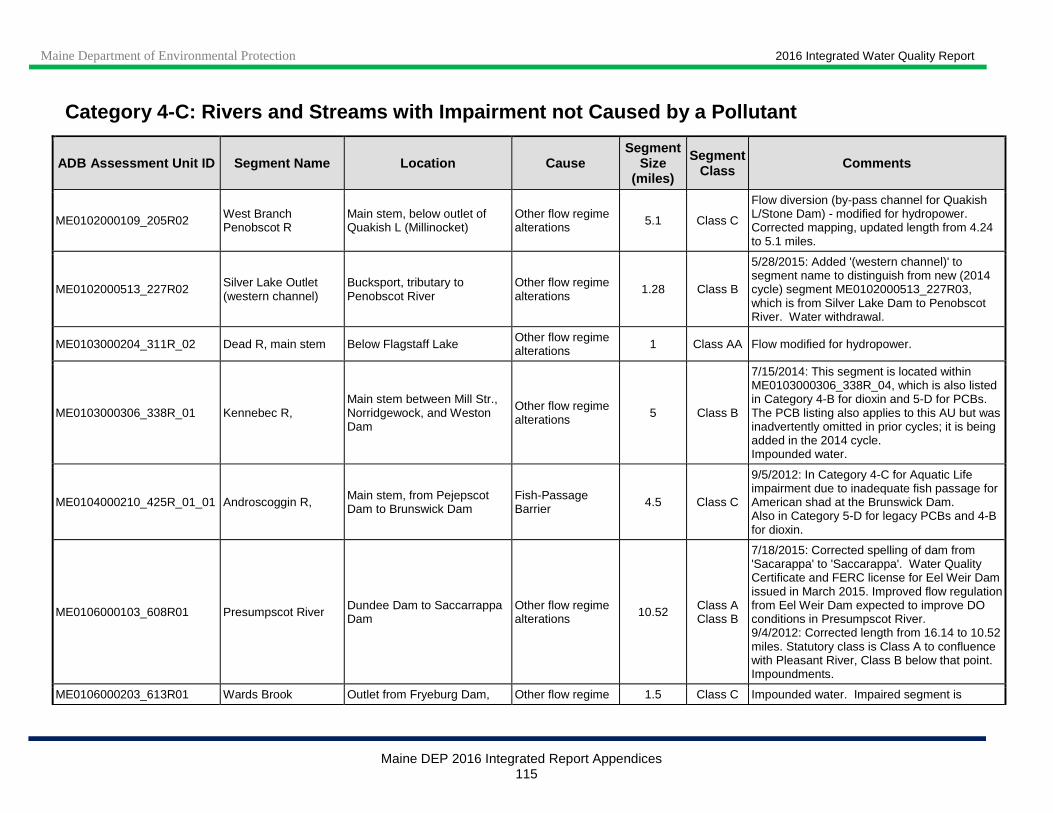
Maine Department of Environmental Protection 2016 Integrated Water Quality Report
Maine DEP 2016 Integrated Report Appendices 115
Category 4-C: Rivers and Streams with Impairment no t Caused by a Pollutant
ADB Assessment Unit ID Segment Name Location Cause Segment
Size (miles)
Segment Class Comments
ME0102000109_205R02 West Branch Penobscot R
Main stem, below outlet of Quakish L (Millinocket)
Other flow regime alterations 5.1 Class C
Flow diversion (by-pass channel for Quakish L/Stone Dam) - modified for hydropower. Corrected mapping, updated length from 4.24 to 5.1 miles.
ME0102000513_227R02 Silver Lake Outlet (western channel)
Bucksport, tributary to Penobscot River
Other flow regime alterations
1.28 Class B
5/28/2015: Added '(western channel)' to segment name to distinguish from new (2014 cycle) segment ME0102000513_227R03, which is from Silver Lake Dam to Penobscot River. Water withdrawal.
ME0103000204_311R_02 Dead R, main stem Below Flagstaff Lake Other flow regime alterations 1 Class AA Flow modified for hydropower.
ME0103000306_338R_01 Kennebec R, Main stem between Mill Str., Norridgewock, and Weston Dam
Other flow regime alterations 5 Class B
7/15/2014: This segment is located within ME0103000306_338R_04, which is also listed in Category 4-B for dioxin and 5-D for PCBs. The PCB listing also applies to this AU but was inadvertently omitted in prior cycles; it is being added in the 2014 cycle. Impounded water.
ME0104000210_425R_01_01 Androscoggin R, Main stem, from Pejepscot Dam to Brunswick Dam
Fish-Passage Barrier 4.5 Class C
9/5/2012: In Category 4-C for Aquatic Life impairment due to inadequate fish passage for American shad at the Brunswick Dam. Also in Category 5-D for legacy PCBs and 4-B for dioxin.
ME0106000103_608R01 Presumpscot River Dundee Dam to Saccarrappa Dam
Other flow regime alterations 10.52 Class A
Class B
7/18/2015: Corrected spelling of dam from 'Sacarappa' to 'Saccarappa'. Water Quality Certificate and FERC license for Eel Weir Dam issued in March 2015. Improved flow regulation from Eel Weir Dam expected to improve DO conditions in Presumpscot River. 9/4/2012: Corrected length from 16.14 to 10.52 miles. Statutory class is Class A to confluence with Pleasant River, Class B below that point. Impoundments.
ME0106000203_613R01 Wards Brook Outlet from Fryeburg Dam, Other flow regime 1.5 Class C Impounded water. Impaired segment is

Maine Department of Environmental Protection 2016 Integrated Water Quality Report
Maine DEP 2016 Integrated Report Appendices 116
Category 4-C: Rivers and Streams with Impairment no t Caused by a Pollutant
ADB Assessment Unit ID Segment Name Location Cause Segment
Size (miles)
Segment Class Comments
(Fryeburg) trib to Lovewell Pond alterations between railroad and Lovewell Pond.
ME0106000302_628R01_01 Mousam River below Old Falls Dam
From Old Falls Dam to Cold Water Brook in Kennebunk
Fish-Passage Barrier 1 Class B
7/24/2015: New Category 4-C listing for fish passage barrier in 2014 cycle: three dams in next downstream segment (ME0106000302_628R03) lack fish passage, thus excluding most anadromous species from accessing natural habitat up to Old Falls Dam. Low DO caused by flow regime alterations (bottom release). Data collection for DO scheduled for 2015.
ME0106000302_628R01_01 Mousam River below Old Falls Dam
From Old Falls Dam to Cold Water Brook in Kennebunk
Other flow regime alterations 1 Class B
ME0106000302_628R03 Mousam River mainstem below Cold Water Brook
From Cold Water Brook to Kesslen Dam
Fish-Passage Barrier
7.97 Class B
7/24/2015: New Category 4-C listing in 2014 cycle: three dams in this segment (Dane Perkins, Twine Mill, Kesslen) all lack fish passage, thus excluding most anadromous species from accessing natural habitat up to Old Falls Dam. The three dams are due for FERC licensing in 2022. Segment was split out from existing Category 2 segment ME0106000302_628R.
Total mileage for segments only in Category 4 -C 28.4
Total mileage for segments in Category 4 -C and at least one other category 9.5

Maine Department of Environmental Protection 2016 Integrated Water Quality Report
Maine DEP 2016 Integrated Report Appendices 117
Note 1: Bold text indicates waters that were moved into Category 5-A during this reporting cycle
Note 2: Waters that are included in Maine’s implementation of EPA’s 303(d) Vision are indicated in italics.
Category 5 -A: Rivers and Streams Impaired by Pollutants Other Than Those Listed in 5-B Through 5-D (TMDL Required)
ADB Assessment Unit ID Segment Name Location Cause
Segment Size
(miles)
Segment Class
TMDL Priority Comments
ME0101000105_103R01 Shields Branch of Big Black R Mainstem Oxygen, Dissolved 9.4 Class A L
11/10/2014: Unclear whether Canadian POTW is causing, or contributing to DO and bacteria impairments, local livestock operations are more likely sources. Data collection planned for 2015. Corrected segment class from AA to A. 10/19/2011: St. Pamphile Canada POTW discharge is probable source of DO non-attainment (Category 5-A); PI office of DEP tracking questions of inadequate sewage treatment. Mapping corrected, length updated (was 8.16 miles). Also in Category 4-A for bacteria.
ME0101000412_140R04
Unnamed Stream (P.I. airport) - 'Hanson Brook, BioSta 743'
Tributary to Presque Isle Stream, draining the airport
Benthic-Macroinvertebrate Bioassessments (Streams) 2.5 Class B 2016 / M
11/20/2014: "Unnamed Stream (P.I. airport)" (BioSta 743) was erroneously renamed to "Hanson Brook" in 2008 cycle. Hanson Brook is the stream immediately to the west of Unnamed Stream (P.I. airport); returning to original name in 2014 cycle. 5/24/2012: New Category 5-A listing in 2012 cycle for Aquatic Life Use - algae (periphyton) impairment; biomonitoring at station 743 showed Class C in 2004 and non-attainment in 2009. Consider for future % impervious cover TMDL, need additional information on airport runoff. This AU is a.k.a. Skanky Brook and Unnamed Str. Presque Isle.
ME0101000412_140R04
Unnamed Stream (P.I. airport) - 'Hanson Brook, BioSta 743'
Tributary to Presque Isle Stream, draining the airport
Periphyton (Aufwuchs) Indicator Bioassessments 2.5 Class B 2016 / M
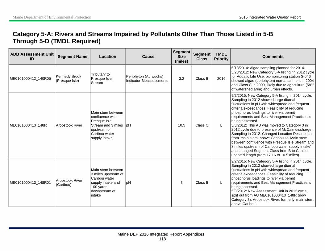
Maine Department of Environmental Protection 2016 Integrated Water Quality Report
Maine DEP 2016 Integrated Report Appendices 118
Category 5 -A: Rivers and Streams Impaired by Pollutants Other Than Those Listed in 5-B Through 5-D (TMDL Required)
ADB Assessment Unit ID Segment Name Location Cause
Segment Size
(miles)
Segment Class
TMDL Priority Comments
ME0101000412_140R05 Kennedy Brook (Presque Isle)
Tributary to Presque Isle Stream
Periphyton (Aufwuchs) Indicator Bioassessments 3.2 Class B 2016
6/13/2014: Algae sampling planned for 2014. 5/23/2012: New Category 5-A listing fin 2012 cycle for Aquatic Life Use: biomonitoring station S-646 showed algae (periphyton) non-attainment in 2004 and Class C in 2009, likely due to agriculture (58% of watershed area) and urban effects.
ME0101000413_148R Aroostook River
Main stem between confluence with Presque Isle Stream and 3 miles upstream of Caribou water supply intake
pH 10.5 Class C L
9/2/2015: New Category 5-A listing in 2014 cycle. Sampling in 2012 showed large diurnal fluctuations in pH with widespread and frequent criteria exceedances. Feasibility of reducing phosphorus loadings to river via permit requirements and Best Management Practices is being assessed. 5/3/2012: This AU was moved to Category 3 in 2012 cycle due to presence of McCain discharge. Sampling in 2012. Changed Location Description from 'main stem, above Caribou' to 'Main stem between confluence with Presque Isle Stream and 3 miles upstream of Caribou water supply intake' and changed Segment Class from B to C; also updated length (from 17.16 to 10.5 miles).
ME0101000413_148R01 Aroostook River (Caribou)
Main stem between 3 miles upstream of Caribou water supply intake and 100 yards downstream of intake
pH 3 Class B L
9/2/2015: New Category 5-A listing in 2014 cycle. Sampling in 2012 showed large diurnal fluctuations in pH with widespread and frequent criteria exceedances. Feasibility of reducing phosphorus loadings to river via permit requirements and Best Management Practices is being assessed. 5/3/2012: New Assessment Unit in 2012 cycle, split out from AU ME0101000413_148R (now Category 3), Aroostook River, formerly 'main stem, above Caribou'.

Maine Department of Environmental Protection 2016 Integrated Water Quality Report
Maine DEP 2016 Integrated Report Appendices 119
Category 5 -A: Rivers and Streams Impaired by Pollutants Other Than Those Listed in 5-B Through 5-D (TMDL Required)
ADB Assessment Unit ID Segment Name Location Cause
Segment Size
(miles)
Segment Class
TMDL Priority Comments
ME0101000413_148R02 Aroostook River
Main stem between 100 yards downstream of Caribou water supply intake and international boundary
pH 16.6 Class C L
9/2/2015: New Category 5-A listing in 2014 cycle. Sampling in 2012 showed large diurnal fluctuations in pH with widespread and frequent criteria exceedances. Feasibility of reducing phosphorus loadings to river via permit requirements and Best Management Practices is being assessed. 5/3/2012: New Assessment Unit in 2012 cycle, split out from AU ME0101000413_148R, Aroostook River, formerly 'main stem, above Caribou'.
ME0101000504_152R01_03 Meduxnekeag River
From biomonitoring station S-364 to border
Periphyton (Aufwuchs) Indicator Bioassessments 7.2 Class B
6/2/2015: Watershed-based management plan completed in March 2015. New 5-A listing in 2014 cycle for Aquatic Life Use - algae (periphyton) did not attain class at biomonitoring station S-1 in 2002, 2004 and 2011. Algae attained class at S-364 in 2011 and 2014. This segment was split out from ME0101000504_152R01_01. Also in Category 4-A for TP and 5-D for DDT.
ME0102000402_219R01 Piscataquis R
Main stem, Dover-Foxcroft POTW outfalls to about 4 miles upstream of confluence with Sebec River
Oxygen, Dissolved 13.44 Class B H
10/13/2016: 2016 low flow data for DO is expected to be used to define nutrient waste load allocations in future permitting action. Biomonitoring at station S-152 in Dover-Foxcroft in 2011 and 2014 showed benthic macroinvertebrates met Class B; algae (periphyton) met Class B in 2006 and 2014. 10/16/2015: Sampling was scheduled for 2015 but flow conditions were not suitable; sampling will be attempted in 2016. New permit with Total Phosphorus discharge limit issued in May 2015. Updated location description from 'Main stem, below Dover Foxcroft' to 'Main stem, Dover-Foxcroft POTW outfalls to about 4 miles upstream of confluence with Sebec River' to clarify extent. 10/19/2011: Monitoring for DO in 2010 still showing impairment; probably algae problems.
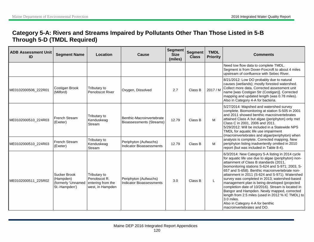
Maine Department of Environmental Protection 2016 Integrated Water Quality Report
Maine DEP 2016 Integrated Report Appendices 120
Category 5 -A: Rivers and Streams Impaired by Pollutants Other Than Those Listed in 5-B Through 5-D (TMDL Required)
ADB Assessment Unit ID Segment Name Location Cause
Segment Size
(miles)
Segment Class
TMDL Priority Comments
Need low flow data to complete TMDL. Segment is from Dover-Foxcroft to about 4 miles upstream of confluence with Sebec River.
ME0102000506_222R01 Costigan Brook (Milford)
Tributary to Penobscot River Oxygen, Dissolved 2.7 Class B 2017 / M
8/21/2012: Low DO probably due to natural causes (wetlands); mostly forested watershed. Collect more data. Corrected assessment unit name [was Costigan Str (Costigan)]. Corrected mapping and updated length (was 0.78 miles). Also in Category 4-A for bacteria.
ME0102000510_224R03 French Stream (Exeter)
Tributary to Kenduskeag Stream
Benthic-Macroinvertebrate Bioassessments (Streams) 12.79 Class B M
5/27/2014: Mapshed and watershed survey complete. Biomonitoring at station S-505 in 2001 and 2011 showed benthic macroinvertebrates attained Class A but algae (periphyton) only met Class C in 2001, 2006 and 2011. 5/29/2012: Will be included in a Statewide NPS TMDL for aquatic life use impairment (macroinvertebrates and algae/periphyton) when analysis is complete. Corrected mapping. New periphyton listing inadvertently omitted in 2010 report (but was included in Table 8-4).
ME0102000510_224R03 French Stream (Exeter)
Tributary to Kenduskeag Stream
Periphyton (Aufwuchs) Indicator Bioassessments 12.79 Class B M
ME0102000511_225R02
Sucker Brook (Hampden) (formerly 'Unnamed St.-Hampden')
Tributary to Penobscot R. entering from the west, in Hampden
Periphyton (Aufwuchs) Indicator Bioassessments 3.0 Class B L
6/3/2014: New Category 5-A listing in 2014 cycle for aquatic life use due to algae (periphyton) non-attainment of Class B standards (2011, biomonitoring stations S-624 and S-971; 2003, S-657 and S-658). Benthic macroinvertebrate non-attainment in 2011 (S-624 and S-971). Watershed survey was completed in 2013; watershed-based management plan is being developed (projected completion date of 10/2016). Stream is located in Bangor and Hampden. Newly mapped, corrected length from 2.5 miles (used in 2012 % IC TMDL) to 3.0 miles. Also in Category 4-A for benthic macroinvertebrates and DO.
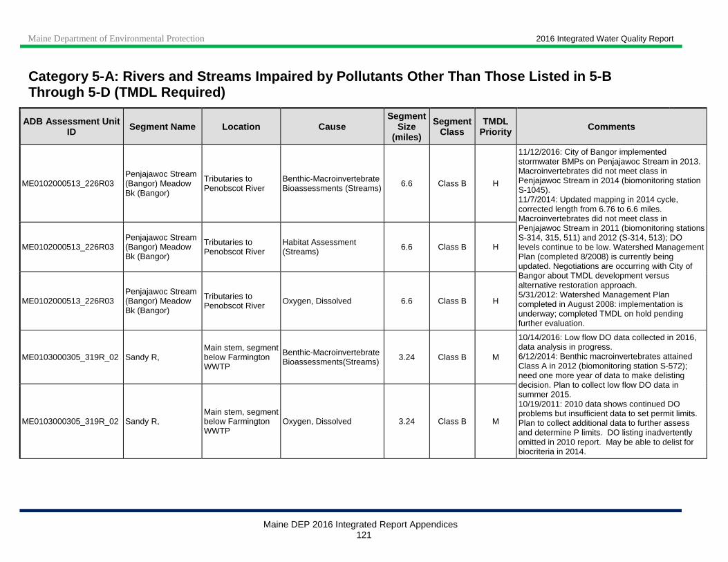
Maine Department of Environmental Protection 2016 Integrated Water Quality Report
Maine DEP 2016 Integrated Report Appendices 121
Category 5 -A: Rivers and Streams Impaired by Pollutants Other Than Those Listed in 5-B Through 5-D (TMDL Required)
ADB Assessment Unit ID Segment Name Location Cause
Segment Size
(miles)
Segment Class
TMDL Priority Comments
ME0102000513_226R03 Penjajawoc Stream (Bangor) Meadow Bk (Bangor)
Tributaries to Penobscot River
Benthic-Macroinvertebrate Bioassessments (Streams) 6.6 Class B H
11/12/2016: City of Bangor implemented stormwater BMPs on Penjajawoc Stream in 2013. Macroinvertebrates did not meet class in Penjajawoc Stream in 2014 (biomonitoring station S-1045). 11/7/2014: Updated mapping in 2014 cycle, corrected length from 6.76 to 6.6 miles. Macroinvertebrates did not meet class in Penjajawoc Stream in 2011 (biomonitoring stations S-314, 315, 511) and 2012 (S-314, 513); DO levels continue to be low. Watershed Management Plan (completed 8/2008) is currently being updated. Negotiations are occurring with City of Bangor about TMDL development versus alternative restoration approach. 5/31/2012: Watershed Management Plan completed in August 2008: implementation is underway; completed TMDL on hold pending further evaluation.
ME0102000513_226R03 Penjajawoc Stream (Bangor) Meadow Bk (Bangor)
Tributaries to Penobscot River
Habitat Assessment (Streams) 6.6 Class B H
ME0102000513_226R03 Penjajawoc Stream (Bangor) Meadow Bk (Bangor)
Tributaries to Penobscot River Oxygen, Dissolved 6.6 Class B H
ME0103000305_319R_02 Sandy R, Main stem, segment below Farmington WWTP
Benthic-Macroinvertebrate Bioassessments(Streams) 3.24 Class B M
10/14/2016: Low flow DO data collected in 2016, data analysis in progress. 6/12/2014: Benthic macroinvertebrates attained Class A in 2012 (biomonitoring station S-572); need one more year of data to make delisting decision. Plan to collect low flow DO data in summer 2015. 10/19/2011: 2010 data shows continued DO problems but insufficient data to set permit limits. Plan to collect additional data to further assess and determine P limits. DO listing inadvertently omitted in 2010 report. May be able to delist for biocriteria in 2014.
ME0103000305_319R_02 Sandy R, Main stem, segment below Farmington WWTP
Oxygen, Dissolved 3.24 Class B M

Maine Department of Environmental Protection 2016 Integrated Water Quality Report
Maine DEP 2016 Integrated Report Appendices 122
Category 5 -A: Rivers and Streams Impaired by Pollutants Other Than Those Listed in 5-B Through 5-D (TMDL Required)
ADB Assessment Unit ID Segment Name Location Cause
Segment Size
(miles)
Segment Class
TMDL Priority Comments
ME0103000305_322R01 Perkins Stream (Waterville)
Tributary to Messalonskee Stream
Benthic -Macroinvertebrate Bioassessments (Streams)
2.7 Class B L
11/1/2016: New Category 5 -A listing in 2016 cycle for Aquatic Life Use: biomonitoring station S-977 showed macroinvertebrate and algae (periphyton) non-attainment in 2014. 12/17/2014: New Category 3 listing in 2014 cycle for Aquatic Life Use: biomonitoring station S-977 showed macroinvertebrate and algae (periphyton) non-attainment in 2012. Stream has very high specific conductance. Resampling needed to confirm whether impairment exists.
ME0103000305_322R01 Perkins Stream (Waterville)
Tributary to Messalonskee Stream
Periphyton (Aufwuchs) Indicator Bioassessments
2.7 Class B L
ME0103000306_314R02 Cold Brook (Skowhegan)
Tributary to Wesserunsett Stream
Benthic-Macroinvertebrate Bioassessments (Streams) 5.6 Class B 2017 / L
3/10/2014: Corrected stream name (was Cold Stream), added location description. Corrected mapping and updated length from 5.73 to 5.6 miles. Monitoring in 2006; TMDL not started.
ME0103000306_320R04 Mill Stream (Norridgewock)
Tributary to Kennebec River
Benthic-Macroinvertebrate Bioassessments 8.17 Class B 2017 / M Low priority for TMDL.
ME0103000307_330R W Branch of Sebasticook R
Main stem, below Rt. 23 bridge in Hartland
Dioxin (including 2,3,7,8-TCDD) 12.5 Class C L TMDL not started.
Also in Category 5-D for PCBs.
ME0103000308_331R E Branch of Sebasticook R
Main stem, below Sebasticook Lake Oxygen, Dissolved 10.25 Class C L
11/7/2014: Eutrophic lake source. Trend of generally improving water quality in Sebasticook Lake continued in 2012, expect TP and DO situation in river to improve over time. No new river data. 6/11/2012: Eutrophic lake source. In the past decade (since approval of lake TMDL in 2001) Total Phosphorus and Chl a levels in the lake have decreased, Secchi disk transparency has increased; expect TP and DO situation in river to improve over time. Also in Category 5-D for PCBs and Dioxin.
ME0103000308_331R E Branch of Sebasticook R
Main stem, below Sebasticook Lake Phosphorus (Total) 10.25 Class C L

Maine Department of Environmental Protection 2016 Integrated Water Quality Report
Maine DEP 2016 Integrated Report Appendices 123
Category 5 -A: Rivers and Streams Impaired by Pollutants Other Than Those Listed in 5-B Through 5-D (TMDL Required)
ADB Assessment Unit ID Segment Name Location Cause
Segment Size
(miles)
Segment Class
TMDL Priority Comments
ME0103000308_331R01 Martin Stream (Dixmont)
Tributary to East Branch Sebasticook
Ammonia (Un-ionized) 0.5 Class A L
11/1/2016: Macroinvertebrates only attained Class B in 2016. Permit expired, segment moved from Category 4-B to 5-A in 2016 cycle for all impairment causes. 8/12/2014: Benthic macroinvertebrates attained Class A in 2012. New Category 5-A listing in 2014 cycle for Aquatic Life Use: algae (periphyton) only met Class B in 2006 (biomonitoring stations S-756 and S-679) and 2012 (S-756 only). Impairment covered under existing permit and cause delisted to Category 4-B. CAFO ceased operation in late 2013; permit expired. 10/23/2012: CAFO permit transferred to new farm (2009), expiration date January 13, 2014; expected to attain. Monitoring in 2012 to determine WQS attainment status. Segment length is from fields draining manure storage piles to downstream of Rt 7.
ME0103000308_331R01 Martin Stream (Dixmont)
Tributary to East Branch Sebasticook
Benthic-Macroinvertebrate Bioassessments (Streams)
0.5 Class A L
ME0103000308_331R01 Martin Stream (Dixmont)
Tributary to East Branch Sebasticook
Periphyton (Aufwuchs) Indicator Bioassessments
0.5 Class A L
ME0103000308_331R02 Martin Stream (Dixmont)
Tributary to East Br. Sebasticook R, below Mitchell Rd
Benthic -Macroinvertebrate Bioassessments (Streams)
1.65 Class A L
11/1/2016: New 5-A listing in 2016 cycle for Aquatic Life Use - benthic macroinvertebrates at biomonitoring station S-755 did not attain Class in 2004, 2005, 2007 or 2016; algae (periphyton) did not attain Class in 2006. Segment length is from Mitchell Road (below Cates Meadows wetland) to 600 feet above Rt. 7.
ME0103000308_331R02 Martin Stream (Dixmont)
Tributary to East Br. Sebasticook R, below Mitchell Rd
Periphyton (Aufwuchs) Indicator Bioassessments
1.65 Class A L
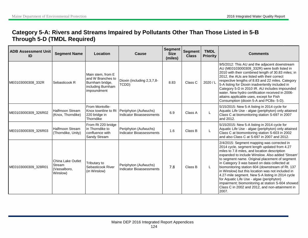
Maine Department of Environmental Protection 2016 Integrated Water Quality Report
Maine DEP 2016 Integrated Report Appendices 124
Category 5 -A: Rivers and Streams Impaired by Pollutants Other Than Those Listed in 5-B Through 5-D (TMDL Required)
ADB Assessment Unit ID Segment Name Location Cause
Segment Size
(miles)
Segment Class
TMDL Priority Comments
ME0103000308_332R Sebasticook R
Main stem, from E and W Branches to Burnham bridge, including Burnham impoundment
Dioxin (including 2,3,7,8-TCDD) 8.83 Class C 2020 / L
9/5/2012: This AU and the adjacent downstream AU (ME0103000309_332R) were both listed in 2010 with their combined length of 30.83 miles; in 2012, the AUs are listed with their correct respective lengths of 8.83 and 22 miles. Category 5-A listing for Dioxin inadvertently included in Category 5-D in 2010 IR. AU includes impounded water. New hydro certification received in 2006- attains applicable uses, except for Fish Consumption (dioxin 5-A and PCBs- 5-D).
ME0103000309_326R02 Halfmoon Stream (Knox, Thorndike)
From Montville-Knox townline to Rt 220 bridge in Thorndike
Periphyton (Aufwuchs) Indicator Bioassessments 6.9 Class A L
5/15/2015: New 5-A listing in 2014 cycle for Aquatic Life Use - algae (periphyton) only attained Class C at biomonitoring station S-697 in 2007 and 2012.
ME0103000309_326R03 Halfmoon Stream (Thorndike, Unity)
From Rt 220 bridge in Thorndike to confluence with Sandy Stream
Periphyton (Aufwuchs) Indicator Bioassessments 1.6 Class B L
5/15/2015: New 5-A listing in 2014 cycle for Aquatic Life Use - algae (periphyton) only attained Class C at biomonitoring station S-603 in 2002 and also Class C at S-697 in 2007 and 2012.
ME0103000309_328R01
China Lake Outlet Stream (Vassalboro, Winslow)
Tributary to Sebasticook River (in Winslow)
Periphyton (Aufwuchs) Indicator Bioassessments 7.8 Class B L
2/4/2015: Segment mapping was corrected in 2014 cycle, segment length updated from 4.27 miles to 7.8 miles, and location description expanded to include Winslow. Also added 'Stream' to segment name. Original placement of segment in Category 3 was based on data collected at biomonitoring station 604 (downstream of Rt. 137 in Winslow) but this location was not included in 4.27-mile segment. New 5-A listing in 2014 cycle for Aquatic Life Use - algae (periphyton) impairment; biomonitoring at station S-604 showed Class C in 2002 and 2012, and non-attainment in 2007.

Maine Department of Environmental Protection 2016 Integrated Water Quality Report
Maine DEP 2016 Integrated Report Appendices 125
Category 5 -A: Rivers and Streams Impaired by Pollutants Other Than Those Listed in 5-B Through 5-D (TMDL Required)
ADB Assessment Unit ID Segment Name Location Cause
Segment Size
(miles)
Segment Class
TMDL Priority Comments
ME0103000309_332R Sebasticook River
Main stem, from Burnham bridge to Kennebec R (excluding site of former Halifax Impd)
Dioxin (including 2,3,7,8-TCDD) 22 Class C L
10/2/2012: Nutrient/Eutrophication Biological Indicators cause of Aquatic Life Use impairment delisted to Category 2 due to new data showing removal of cause of impairment. Updated AU name [was "main stem, below confluence of E and W Branches (excluding the Halifax Impd)"] to clarify extent.This AU and the adjacent upstream AU (ME0103000308_332R) were both listed in 2010 with their combined length of 30.83 miles; in 2012, the AUs are listed with their correct respective lengths of 22 and 8.83 miles. 10/19/2011: DO impairment likely due to Benton impoundment; good candidate for monitoring to confirm or reject continued DO impairment. No recent monitoring data. Also in Category 4-A for bacteria and 5-D for legacy PCBs.
ME0103000309_332R Sebasticook River
Main stem, from Burnham bridge to Kennebec R (excluding site of former Halifax Impd)
Oxygen, Dissolved 22 Class C 2018 / L
ME0103000309_332R01
Sebasticook River (site of former Halifax impoundment)
Tributary to Kennebec River
Dioxin (including 2,3,7,8-TCDD) 2 Class C L
9/25/2012: Updated AU name [was "Sebasticook River (Halifax impoundment)"] to better describe the segment after removal of the Halifax Dam (July 17, 2008). Fish Consumption 5-A (dioxin) and 5-D (PCBs) fish tissue contamination from upstream sources. Segment was delisted in 2010 to Category 2 for Aquatic Life Use Impairment - dam removal eliminated the cause of ALU impairment.
ME0103000311_334R04 Mill Stream (Winthrop)
Between Maranacook and Annabessacook Lakes
Benthic-Macroinvertebrate Bioassessments (Streams) 0.63 Class B 2017 / M 6/11/2012: TMDL monitoring in 2005 & 2010, EPA
assistance monitoring 2010; biomonitoring in 2004 (macroinvertebrate non-attainment); toxic spill probable source. BRWM Remediation completed (underground storage tank - #6 fuel oil). ME0103000311_334R04 Mill Stream
(Winthrop)
Between Maranacook and Annabessacook Lakes
Cause Unknown 0.63 Class B 2017 / M
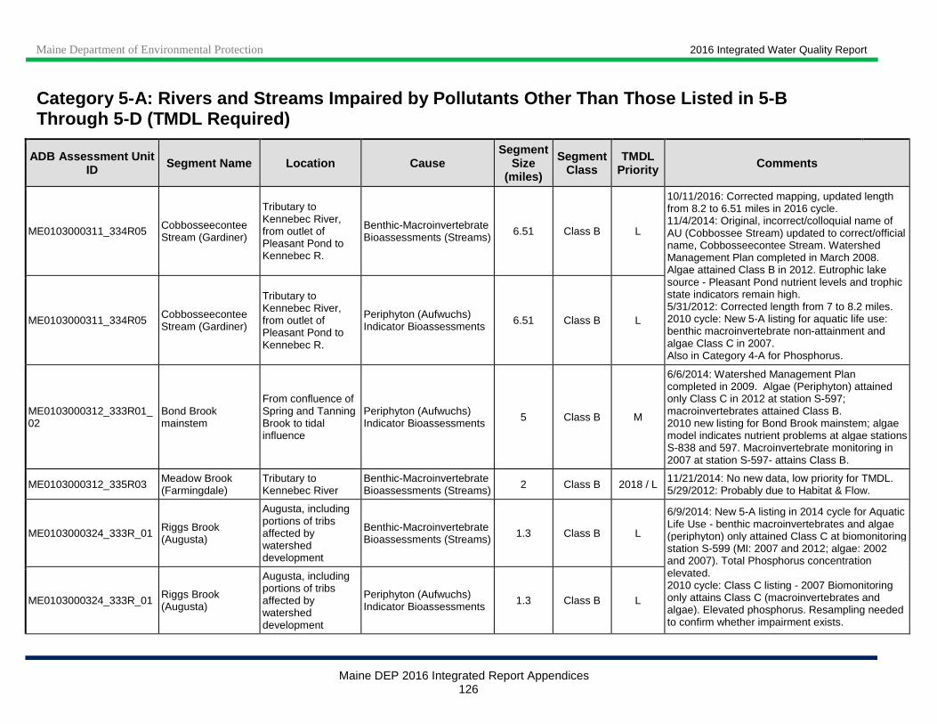
Maine Department of Environmental Protection 2016 Integrated Water Quality Report
Maine DEP 2016 Integrated Report Appendices 126
Category 5 -A: Rivers and Streams Impaired by Pollutants Other Than Those Listed in 5-B Through 5-D (TMDL Required)
ADB Assessment Unit ID Segment Name Location Cause
Segment Size
(miles)
Segment Class
TMDL Priority Comments
ME0103000311_334R05 Cobbosseecontee Stream (Gardiner)
Tributary to Kennebec River, from outlet of Pleasant Pond to Kennebec R.
Benthic-Macroinvertebrate Bioassessments (Streams) 6.51 Class B L
10/11/2016: Corrected mapping, updated length from 8.2 to 6.51 miles in 2016 cycle. 11/4/2014: Original, incorrect/colloquial name of AU (Cobbossee Stream) updated to correct/official name, Cobbosseecontee Stream. Watershed Management Plan completed in March 2008. Algae attained Class B in 2012. Eutrophic lake source - Pleasant Pond nutrient levels and trophic state indicators remain high. 5/31/2012: Corrected length from 7 to 8.2 miles. 2010 cycle: New 5-A listing for aquatic life use: benthic macroinvertebrate non-attainment and algae Class C in 2007. Also in Category 4-A for Phosphorus.
ME0103000311_334R05 Cobbosseecontee Stream (Gardiner)
Tributary to Kennebec River, from outlet of Pleasant Pond to Kennebec R.
Periphyton (Aufwuchs) Indicator Bioassessments 6.51 Class B L
ME0103000312_333R01_02
Bond Brook mainstem
From confluence of Spring and Tanning Brook to tidal influence
Periphyton (Aufwuchs) Indicator Bioassessments 5 Class B M
6/6/2014: Watershed Management Plan completed in 2009. Algae (Periphyton) attained only Class C in 2012 at station S-597; macroinvertebrates attained Class B. 2010 new listing for Bond Brook mainstem; algae model indicates nutrient problems at algae stations S-838 and 597. Macroinvertebrate monitoring in 2007 at station S-597- attains Class B.
ME0103000312_335R03 Meadow Brook (Farmingdale)
Tributary to Kennebec River
Benthic-Macroinvertebrate Bioassessments (Streams) 2 Class B 2018 / L 11/21/2014: No new data, low priority for TMDL.
5/29/2012: Probably due to Habitat & Flow.
ME0103000324_333R_01 Riggs Brook (Augusta)
Augusta, including portions of tribs affected by watershed development
Benthic-Macroinvertebrate Bioassessments (Streams) 1.3 Class B L
6/9/2014: New 5-A listing in 2014 cycle for Aquatic Life Use - benthic macroinvertebrates and algae (periphyton) only attained Class C at biomonitoring station S-599 (MI: 2007 and 2012; algae: 2002 and 2007). Total Phosphorus concentration elevated. 2010 cycle: Class C listing - 2007 Biomonitoring only attains Class C (macroinvertebrates and algae). Elevated phosphorus. Resampling needed to confirm whether impairment exists.
ME0103000324_333R_01 Riggs Brook (Augusta)
Augusta, including portions of tribs affected by watershed development
Periphyton (Aufwuchs) Indicator Bioassessments 1.3 Class B L
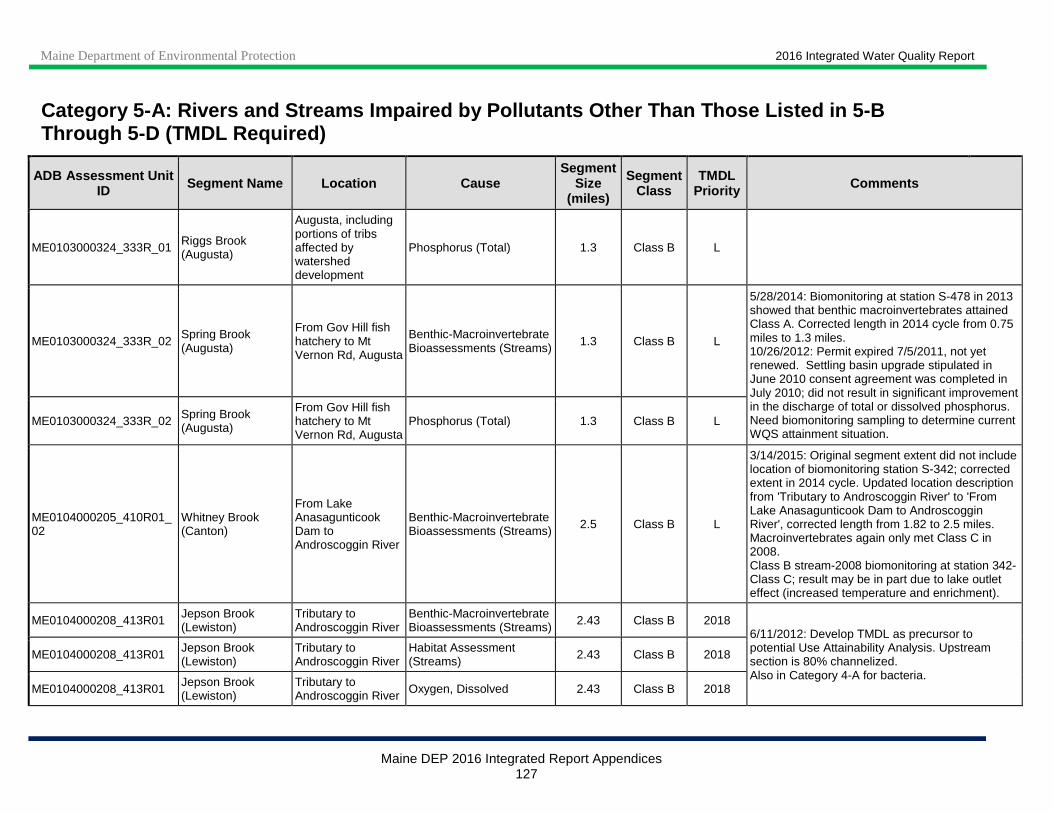
Maine Department of Environmental Protection 2016 Integrated Water Quality Report
Maine DEP 2016 Integrated Report Appendices 127
Category 5 -A: Rivers and Streams Impaired by Pollutants Other Than Those Listed in 5-B Through 5-D (TMDL Required)
ADB Assessment Unit ID Segment Name Location Cause
Segment Size
(miles)
Segment Class
TMDL Priority Comments
ME0103000324_333R_01 Riggs Brook (Augusta)
Augusta, including portions of tribs affected by watershed development
Phosphorus (Total) 1.3 Class B L
ME0103000324_333R_02 Spring Brook (Augusta)
From Gov Hill fish hatchery to Mt Vernon Rd, Augusta
Benthic-Macroinvertebrate Bioassessments (Streams) 1.3 Class B L
5/28/2014: Biomonitoring at station S-478 in 2013 showed that benthic macroinvertebrates attained Class A. Corrected length in 2014 cycle from 0.75 miles to 1.3 miles. 10/26/2012: Permit expired 7/5/2011, not yet renewed. Settling basin upgrade stipulated in June 2010 consent agreement was completed in July 2010; did not result in significant improvement in the discharge of total or dissolved phosphorus. Need biomonitoring sampling to determine current WQS attainment situation.
ME0103000324_333R_02 Spring Brook (Augusta)
From Gov Hill fish hatchery to Mt Vernon Rd, Augusta
Phosphorus (Total) 1.3 Class B L
ME0104000205_410R01_02
Whitney Brook (Canton)
From Lake Anasagunticook Dam to Androscoggin River
Benthic-Macroinvertebrate Bioassessments (Streams) 2.5 Class B L
3/14/2015: Original segment extent did not include location of biomonitoring station S-342; corrected extent in 2014 cycle. Updated location description from 'Tributary to Androscoggin River' to 'From Lake Anasagunticook Dam to Androscoggin River', corrected length from 1.82 to 2.5 miles. Macroinvertebrates again only met Class C in 2008. Class B stream-2008 biomonitoring at station 342- Class C; result may be in part due to lake outlet effect (increased temperature and enrichment).
ME0104000208_413R01 Jepson Brook (Lewiston)
Tributary to Androscoggin River
Benthic-Macroinvertebrate Bioassessments (Streams) 2.43 Class B 2018
6/11/2012: Develop TMDL as precursor to potential Use Attainability Analysis. Upstream section is 80% channelized. Also in Category 4-A for bacteria.
ME0104000208_413R01 Jepson Brook (Lewiston)
Tributary to Androscoggin River
Habitat Assessment (Streams) 2.43 Class B 2018
ME0104000208_413R01 Jepson Brook (Lewiston)
Tributary to Androscoggin River Oxygen, Dissolved 2.43 Class B 2018

Maine Department of Environmental Protection 2016 Integrated Water Quality Report
Maine DEP 2016 Integrated Report Appendices 128
Category 5 -A: Rivers and Streams Impaired by Pollutants Other Than Those Listed in 5-B Through 5-D (TMDL Required)
ADB Assessment Unit ID Segment Name Location Cause
Segment Size
(miles)
Segment Class
TMDL Priority Comments
ME0104000208_413R03 Stetson Brook (Lewiston)
Tributary to Androscoggin River Oxygen, Dissolved 6.82 Class B 2017
10/7/2016: Dissolved oxygen impairment excluded from Statewide NPS TMDL (approved 8/9/2016); DEP expects to include this impairment in a future update to this TMDL. 11/10/2015: Statewide NPS TMDL to go out for public review in late 2015. 5/29/2012: Will be included in a Statewide NPS TMDL when analysis is complete. Also in Category 4-A for bacteria.
ME0104000208_413R07 Gully Brook (Auburn) Oxygen, Dissolved 1.91 Class B 2017 / L
5/29/2012: Mostly urban: include in future % Impervious Cover TMDL for aquatic life use impairment (dissolved oxygen). Also in Category 4-A for bacteria.
ME0104000210_418R01
Sabattus River between Sabattus P and Androscoggin R
From Sabattus Pond to limits of Lisbon urban area
Nutrient/Eutrophication Biological Indicators
9.1 Class C 2017 / L
11/4/2014: Sabattus Pond Watershed Project Phase III completed (January 2010-September 2012). Pond continues to have high nutrient levels; no new river data available. 5/1/2012: Sabattus Pond eutrophic and source of SOD in river; lake TMDL complete 2004; slow recovery is expected. This AU was split into upper, Class C segment and lower, Class B segment (ME0104000210_418R03) in 2012 cycle, location description was updated and length was reduced from 11.4 to 9.1 miles; aquatic life use impairment (Benthic-Macroinvertebrate Bioassessments) was delisted to Category 2 due to classification attainment at 3 biomonitoring stations (S-359, S-629, S-630) on 2-3 occasions. Aquatic life use impairment due to DO and nutrient/eutrophication biological indicators continues.
ME0104000210_418R01
Sabattus River between Sabattus P and Androscoggin R
From Sabattus Pond to limits of Lisbon urban area
Oxygen, Dissolved 9.1 Class C 2017 / L

Maine Department of Environmental Protection 2016 Integrated Water Quality Report
Maine DEP 2016 Integrated Report Appendices 129
Category 5 -A: Rivers and Streams Impaired by Pollutants Other Than Those Listed in 5-B Through 5-D (TMDL Required)
ADB Assessment Unit ID Segment Name Location Cause
Segment Size
(miles)
Segment Class
TMDL Priority Comments
ME0104000210_418R02 No Name Brook (Lewiston)
Tributary to Sabattus River Oxygen, Dissolved 10.02 Class C 2017
10/7/2016: Dissolved oxygen impairment excluded from Statewide NPS TMDL (approved 8/9/2016); DEP expects to include this impairment in a future update to this TMDL. 11/10/2015: Statewide NPS TMDL to go out for public review in late 2015. 2010 and 2011 data indicate continued low dissolved oxygen levels. Low DO may be natural - stream flows through large wetland area and is slow-flowing throughout its course. 5/29/2012: Will be included in a Statewide NPS TMDL when analysis is complete. Also in Category 4-A for bacteria.
ME0104000210_418R03
Sabattus River between Sabattus P and Androscoggin R
From limits of Lisbon urban area to Androscoggin R
Benthic-Macroinvertebrate Bioassessments (Streams) 2.3 Class B 2017 / L
11/4/2014: Sabattus Pond Watershed Project Phase III completed (January 2010-September 2012). Pond continues to have high nutrient levels; no new river data available. 5/1/2012: This AU was split off from existing mixed Class C and B segment (ME0104000210_418R01); macroinvertebrates at biomonitoring station S-170 affected by legacy pollutants, habitat and development. Sabattus Pond eutrophic and source of SOD in river; lake TMDL complete 2004; slow recovery is expected.
ME0104000210_418R03
Sabattus River between Sabattus P and Androscoggin R
From limits of Lisbon urban area to Androscoggin R
Nutrient/Eutrophication Biological Indicators 2.3 Class B 2017 / L
ME0104000210_418R03
Sabattus River between Sabattus P and Androscoggin R
From limits of Lisbon urban area to Androscoggin R
Oxygen, Dissolved 2.3 Class B 2017 / L
ME0104000210_419R03 Unnamed Stream (Lewiston Municipal Landfill)
Biomon Sta 857 affected by Lewiston Municipal Landfill near Plourde Pky
Benthic-Macroinvertebrate Bioassessments (Streams) 0.8 Class B L
2010 new listing-Biomonitoring station 857 showed non-attainment in 2008 below Lewiston Municipal landfill; upstream station 856 is on watch list.
Maine Department of Environmental Protection 2016 Integrated Water Quality Report
Maine DEP 2016 Integrated Report Appendices 130
Category 5 -A: Rivers and Streams Impaired by Pollutants Other Than Those Listed in 5-B Through 5-D (TMDL Required)
ADB Assessment Unit ID Segment Name Location Cause
Segment Size
(miles)
Segment Class
TMDL Priority Comments
ME0105000209_512R_02 McCoy Brook (Deblois)
Tributary to Narraguagus River
Benthic-Macroinvertebrate Bioassessments (Streams) 1.6 Class B L
10/29/2014: Ongoing (since 1960s) peat mining operation on Denbo Heath, assessment unit moved from Category 5-D to Category 5-A in 2014 cycle. No new macroinvertebrate data since 1993, resampling to occur in 2016. Facility monitoring data show mean pH of 4.8 in stream between 1998 and 2013. Length corrected from 1 mile to 1.6 miles.
ME0105000209_512R_02 McCoy Brook (Deblois)
Tributary to Narraguagus River pH 1.6 Class B L
ME0105000209_512R_03 Great Falls Branch, Schoodic Stream (Deblois)
Tributary to Narraguagus River
Benthic-Macroinvertebrate Bioassessments (Streams) 1.33 Class A L
5/27/2014: In 2004 listed as 'ME0105000209_512R_02', 'ME0105000209_512R_03' thereafter. Biocriteria (benthic macroinvertebrates) non-attainment in 2001, 2006 and 2011 (biomonitoring station S-504). Existing problems (accumulated blueberry waste) have been addressed, expect improvement in the future, resample in 2016.
ME0105000305_528R02 West Branch Sheepscot River
Below Halls Corner, Rt 17/32
Periphyton (Aufwuchs) Indicator Bioassessments 2.29 Class AA 2018 / M
6/13/2014: Algae (periphyton) met Class A in 2012 and 2013 (biomonitoring station S-550). 2010 Category 3 listing for potential benthic macroinvertebrate impairment was removed in 2012 cycle because of the absence of any macroinvertebrate data in this segment; cause removal was inadvertently omitted in 2012 report (Table 8-9). Also in Category 4-A for bacteria.
ME0106000102_603R06 Cole Brook (Gray) Tributary to Collyer Brook and Royal River
Benthic-Macroinvertebrate Bioassessments (Streams) 2.49 Class B M 6/13/2014: Resampling scheduled for 2015.
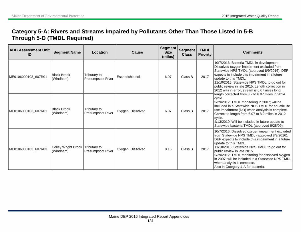
Maine Department of Environmental Protection 2016 Integrated Water Quality Report
Maine DEP 2016 Integrated Report Appendices 131
Category 5 -A: Rivers and Streams Impaired by Pollutants Other Than Those Listed in 5-B Through 5-D (TMDL Required)
ADB Assessment Unit ID Segment Name Location Cause
Segment Size
(miles)
Segment Class
TMDL Priority Comments
ME0106000103_607R01 Black Brook (Windham)
Tributary to Presumpscot River Escherichia coli 6.07 Class B 2017
10/7/2016: Bacteria TMDL in development. Dissolved oxygen impairment excluded from Statewide NPS TMDL (approved 8/9/2016); DEP expects to include this impairment in a future update to this TMDL. 11/10/2015: Statewide NPS TMDL to go out for public review in late 2015. Length correction in 2012 was in error, stream is 6.07 miles long; length corrected from 8.2 to 6.07 miles in 2014 cycle. 5/29/2012: TMDL monitoring in 2007; will be included in a Statewide NPS TMDL for aquatic life use impairment (DO) when analysis is complete. Corrected length from 6.07 to 8.2 miles in 2012 cycle. 4/13/2010: Will be included in future update to Statewide bacteria TMDL (approved 9/28/09).
ME0106000103_607R01 Black Brook (Windham)
Tributary to Presumpscot River Oxygen, Dissolved 6.07 Class B 2017
ME0106000103_607R03 Colley Wright Brook (Windham)
Tributary to Presumpscot River Oxygen, Dissolved 8.16 Class B 2017
10/7/2016: Dissolved oxygen impairment excluded from Statewide NPS TMDL (approved 8/9/2016); DEP expects to include this impairment in a future update to this TMDL. 11/10/2015: Statewide NPS TMDL to go out for public review in late 2015. 5/29/2012: TMDL monitoring for dissolved oxygen in 2007; will be included in a Statewide NPS TMDL when analysis is complete. Also in Category 4-A for bacteria.
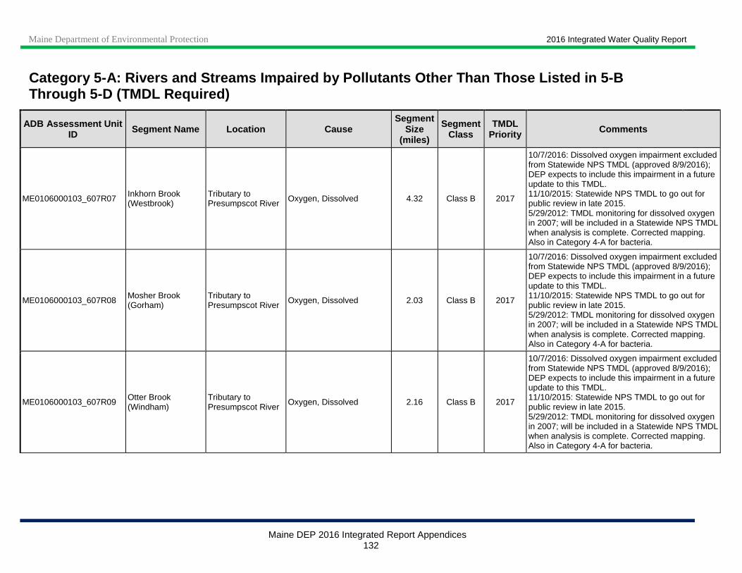
Maine Department of Environmental Protection 2016 Integrated Water Quality Report
Maine DEP 2016 Integrated Report Appendices 132
Category 5 -A: Rivers and Streams Impaired by Pollutants Other Than Those Listed in 5-B Through 5-D (TMDL Required)
ADB Assessment Unit ID Segment Name Location Cause
Segment Size
(miles)
Segment Class
TMDL Priority Comments
ME0106000103_607R07 Inkhorn Brook (Westbrook)
Tributary to Presumpscot River Oxygen, Dissolved 4.32 Class B 2017
10/7/2016: Dissolved oxygen impairment excluded from Statewide NPS TMDL (approved 8/9/2016); DEP expects to include this impairment in a future update to this TMDL. 11/10/2015: Statewide NPS TMDL to go out for public review in late 2015. 5/29/2012: TMDL monitoring for dissolved oxygen in 2007; will be included in a Statewide NPS TMDL when analysis is complete. Corrected mapping. Also in Category 4-A for bacteria.
ME0106000103_607R08 Mosher Brook (Gorham)
Tributary to Presumpscot River Oxygen, Dissolved 2.03 Class B 2017
10/7/2016: Dissolved oxygen impairment excluded from Statewide NPS TMDL (approved 8/9/2016); DEP expects to include this impairment in a future update to this TMDL. 11/10/2015: Statewide NPS TMDL to go out for public review in late 2015. 5/29/2012: TMDL monitoring for dissolved oxygen in 2007; will be included in a Statewide NPS TMDL when analysis is complete. Corrected mapping. Also in Category 4-A for bacteria.
ME0106000103_607R09 Otter Brook (Windham)
Tributary to Presumpscot River
Oxygen, Dissolved 2.16 Class B 2017
10/7/2016: Dissolved oxygen impairment excluded from Statewide NPS TMDL (approved 8/9/2016); DEP expects to include this impairment in a future update to this TMDL. 11/10/2015: Statewide NPS TMDL to go out for public review in late 2015. 5/29/2012: TMDL monitoring for dissolved oxygen in 2007; will be included in a Statewide NPS TMDL when analysis is complete. Corrected mapping. Also in Category 4-A for bacteria.

Maine Department of Environmental Protection 2016 Integrated Water Quality Report
Maine DEP 2016 Integrated Report Appendices 133
Category 5 -A: Rivers and Streams Impaired by Pollutants Other Than Those Listed in 5-B Through 5-D (TMDL Required)
ADB Assessment Unit ID Segment Name Location Cause
Segment Size
(miles)
Segment Class
TMDL Priority Comments
ME0106000103_607R12 Pleasant River (Windham)
Mainstem of Pleasant River from Thayer Brook to confluence with Presumpscot R
Oxygen, Dissolved 11.2 Class B 2017
10/7/2016: Dissolved oxygen impairment excluded from Statewide NPS TMDL (approved 8/9/2016); DEP expects to include this impairment in a future update to this TMDL. 11/10/2015: Statewide NPS TMDL to go out for public review in late 2015. Watershed Management Plan completed in June 2011; Watershed Restoration Project, Phase I completed in September 2013. The upper portion of this segment is in Gray. 5/29/2012: Will be included in a Statewide NPS TMDL when analysis is complete. Corrected length from 8.8 to 11.2 miles. Presumpscot Riverwatch (VRMP) monitoring showed occasional low DO values in 2009 and 2010 at one location. Also in Category 4-A for bacteria.
ME0106000105_610R02 Clark Brook (Westbrook)
Tributary to Stroudwater River Oxygen, Dissolved 1.23 Class C 2017 / L 11/20/2014: Needs more assessment.
ME0106000105_610R04 Stroudwater River (Portland, Westbrook)
Tributary to Fore River and Casco Bay
Oxygen, Dissolved 6.2 Class B L
2/26/2015: Monitoring for dissolved oxygen in 2013 showed criteria attainment. Remapped, corrected length from 8.4 to 6.2 miles. 10/19/2011: Candidate for monitoring to re-confirm or refute dissolved oxygen non-attainment. Previously erroneously identified as being in South Portland - is in Portland; length corrected from 15.71 to 8.4 miles.
ME0106000105_610R08 Fall Bk (Portland) Tributary to Back Cove and Casco Bay
Habitat Assessment (Streams) 2.54 Class C L 6/11/2012: Develop TMDL as precursor to
potential Use Attainability Analysis.

Maine Department of Environmental Protection 2016 Integrated Water Quality Report
Maine DEP 2016 Integrated Report Appendices 134
Category 5 -A: Rivers and Streams Impaired by Pollutants Other Than Those Listed in 5-B Through 5-D (TMDL Required)
ADB Assessment Unit ID Segment Name Location Cause
Segment Size
(miles)
Segment Class
TMDL Priority Comments
ME0106000106_602R03 Concord Gully (Freeport)
Tributary to Harraseeket River Escherichia coli 2.47 Class B 2017
10/7/2016: Watershed based management plan completed in April 2015. Bacteria TMDL in development. 9/22/2014: AKA Concord Gully Brook. Bacteria exceeded criteria in 2012 and 2013. Watershed survey was conducted in 2011; watershed based management plan is being prepared with expected completion date of April 2015. 2/16/2012: Will be included in future update to statewide bacteria TMDL (approved 9/28/09). Also in Category 4-A for macroinvertebrates, algae, habitat and DO.
ME0106000210_615R01 Little Ossipee R
Segment from Lake Arrowhead (Ledgemere) Dam to Saco River
Benthic-Macroinvertebrate Bioassessments (Streams) 12.49 Class B L
11/25/2014: Macroinvertebrates attained Class A in 2012 below dam (biomonitoring station S-993) but only Class C at station S-446 (~4 miles below dam); sampling scheduled for 2015. DO problems below dam persist. Corrected river name in 2014 cycle from 'Little Ossippee R' to 'Little Ossipee R'. 5/31/2012: Class B stream, Biomonitoring Station 446, macroinvertebrates attained Class C in 2000 and 2005, Class B in 2010.
ME0106000210_615R01 Little Ossipee R
Segment from Lake Arrowhead (Ledgemere) Dam to Saco River
Oxygen, Dissolved 12.49 Class B L
ME0106000210_615R02 Brown Brook (Limerick)
Sokokis Lake to Lake Arrowhead
Benthic-Macroinvertebrate Bioassessments (Streams) 2.44 Class B 2017 / M
5/12/2015: Macroinvertebrate sampling planned for 2015. 6/11/2012: TMDL monitoring in 2005 & 2010, EPA assistance for monitoring in 2010; biomonitoring at station S-445 in 2005 (Class C) and 2010 (Class B); toxic spill probable source. 2005 Biomon Station 445- Class B stream only at attains Class C.
ME0106000210_615R02 Brown Brook (Limerick)
Sokokis Lake to Lake Arrowhead
Habitat Assessment (Streams) 2.44 Class B 2017 / M
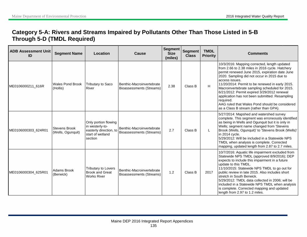
Maine Department of Environmental Protection 2016 Integrated Water Quality Report
Maine DEP 2016 Integrated Report Appendices 135
Category 5 -A: Rivers and Streams Impaired by Pollutants Other Than Those Listed in 5-B Through 5-D (TMDL Required)
ADB Assessment Unit ID Segment Name Location Cause
Segment Size
(miles)
Segment Class
TMDL Priority Comments
ME0106000211_616R Wales Pond Brook (Hollis)
Tributary to Saco River
Benthic-Macroinvertebrate Bioassessments (Streams) 2.38 Class B H
10/3/2016: Mapping corrected, length updated from 2.66 to 2.38 miles in 2016 cycle. Hatchery permit renewed June 2015, expiration date June 2020. Sampling did not occur in 2015 due to access issues. 11/20/2014: Permit to be renewed in early 2015. Macroinvertebrate sampling scheduled for 2015. 6/21/2012: Permit expired 3/29/2012 renewal application has not been submitted. Resampling required. AAG ruled that Wales Pond should be considered as a Class B stream (rather than GPA).
ME0106000303_624R01 Stevens Brook (Wells, Ogunquit)
Only portion flowing in westerly-to-easterly direction, to start of wetland section
Benthic-Macroinvertebrate Bioassessments (Streams) 2.7 Class B L
5/27/2014: Mapshed and watershed survey complete. This segment was erroneously identified as being in Wells and Ogunquit but it is only in Wells; segment name changed from 'Stevens Brook (Wells, Ogunquit)' to 'Stevens Brook (Wells)' in 2014 cycle. 5/29/2012: Will be included in a Statewide NPS TMDL when analysis is complete. Corrected mapping, updated length from 2.87 to 2.7 miles.
ME0106000304_625R01 Adams Brook (Berwick)
Tributary to Lovers Brook and Great Works River
Benthic-Macroinvertebrate Bioassessments (Streams) 1.2 Class B 2017
10/7/2016: Aquatic life impairment excluded from Statewide NPS TMDL (approved 8/9/2016); DEP expects to include this impairment in a future update to this TMDL. 11/10/2015: Statewide NPS TMDL to go out for public review in late 2015. Also includes short stretch in South Berwick. 5/29/2012: TMDL data collected in 2006; will be included in a Statewide NPS TMDL when analysis is complete. Corrected mapping and updated length from 2.97 to 1.2 miles.
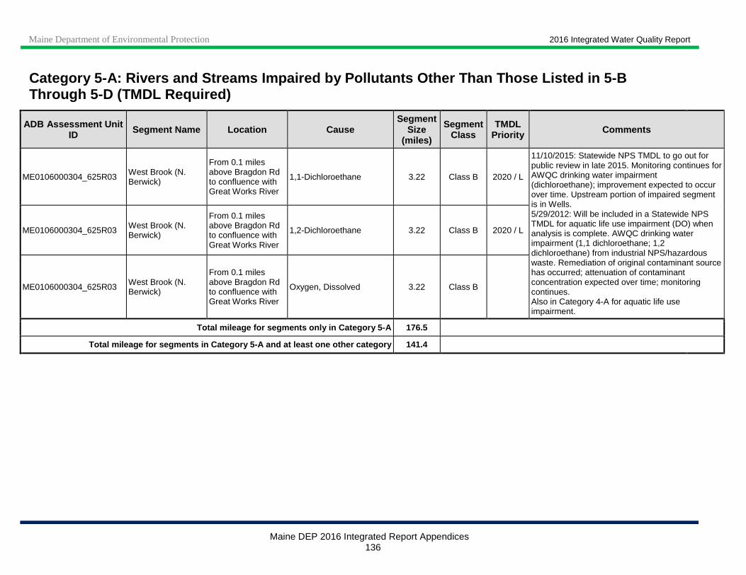
Maine Department of Environmental Protection 2016 Integrated Water Quality Report
Maine DEP 2016 Integrated Report Appendices 136
Category 5 -A: Rivers and Streams Impaired by Pollutants Other Than Those Listed in 5-B Through 5-D (TMDL Required)
ADB Assessment Unit ID Segment Name Location Cause
Segment Size
(miles)
Segment Class
TMDL Priority Comments
ME0106000304_625R03 West Brook (N. Berwick)
From 0.1 miles above Bragdon Rd to confluence with Great Works River
1,1-Dichloroethane 3.22 Class B 2020 / L
11/10/2015: Statewide NPS TMDL to go out for public review in late 2015. Monitoring continues for AWQC drinking water impairment (dichloroethane); improvement expected to occur over time. Upstream portion of impaired segment is in Wells. 5/29/2012: Will be included in a Statewide NPS TMDL for aquatic life use impairment (DO) when analysis is complete. AWQC drinking water impairment (1,1 dichloroethane; 1,2 dichloroethane) from industrial NPS/hazardous waste. Remediation of original contaminant source has occurred; attenuation of contaminant concentration expected over time; monitoring continues. Also in Category 4-A for aquatic life use impairment.
ME0106000304_625R03 West Brook (N. Berwick)
From 0.1 miles above Bragdon Rd to confluence with Great Works River
1,2-Dichloroethane 3.22 Class B 2020 / L
ME0106000304_625R03 West Brook (N. Berwick)
From 0.1 miles above Bragdon Rd to confluence with Great Works River
Oxygen, Dissolved 3.22 Class B
Total mileage for segments only in Category 5-A 176.5
Total mileage for segments in Category 5-A and at l east one other category 141.4

Maine Department of Environmental Protection 2016 Integrated Water Quality Report
Maine DEP 2016 Integrated Report Appendices 137
Category 5-B: Rivers and Streams Impaired for Bacte ria Only, TMDL Required
In September 2009 EPA approved a Statewide Maine Bacteria Total Maximum Daily Load (TMDL) that resulted in the removal of 34 bacteria-impaired segments from Category 5-B-1 and 5-B-2 to Category 4-A. (Subsequently, EPA has approved site-specific TMDL documentation for additional bacteria-impaired waters now listed in Category 4-A.) The TMDL addresses bacteria impairments caused by Escherichia coli in freshwaters. In the 2016 reporting cycle, no waters are in Category 5-B.
Category 5-C: Waters Impaired by Atmospheric Deposi tion of Mercury
All freshwaters formerly listed in Category 5-C were moved to Category 4-A in the 2008 cycle due to EPA approval of a Regional Mercury TMDL in December 2007. Maine has a fish consumption advisory due to mercury for fish taken from all freshwaters. Many waters, and many fish from any given water, do not exceed the action level for mercury. However, because it is impossible for someone consuming a fish to know whether the mercury level exceeds the action level, the Maine Department of Health and Human Services decided to establish a statewide advisory that recommends limits on consumption for all freshwater fish. Maine has already instituted statewide programs for removal and reduction of mercury sources.
Category 5 -D: Rivers and Streams Impaired by Legacy Pollutants
ADB Assessment Unit ID Segment Name Location Cause Segment
Size (miles) Segment
Class Comments
ME0101000412_140R01
No. Br. Presque Isle Stream between Mapleton and Presque Isle
From Mapleton Sewer District outfall to confluence with Presque Isle Stream
DDT 5.2 Class B
3/5/2015: The legacy DDT listing of this segment was previously included in 14.68-mile assessment unit ME0101000412_140R03_02, N Br Presque Isle Stream. In the 2014 cycle, the 5-D listing was added to this AU and ME0101000412_140R03_02 was shortened to exclude this segment (to avoid overlapping listings). This segment was also newly mapped and the length was corrected from 11.49 to 5.2 miles. Segment was delisted in 2006 cycle to Category 2 for Aquatic Life Use.
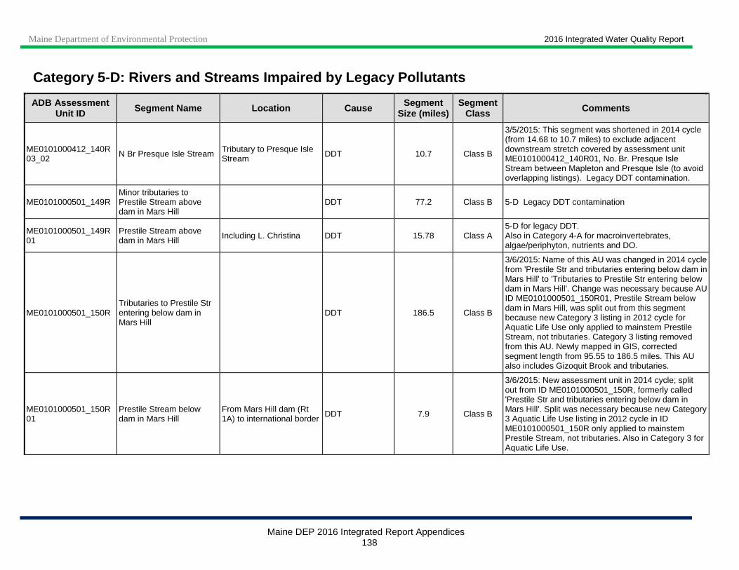
Maine Department of Environmental Protection 2016 Integrated Water Quality Report
Maine DEP 2016 Integrated Report Appendices 138
Category 5 -D: Rivers and Streams Impaired by Legacy Pollutants
ADB Assessment Unit ID Segment Name Location Cause Segment
Size (miles) Segment
Class Comments
ME0101000412_140R03_02 N Br Presque Isle Stream Tributary to Presque Isle
Stream DDT 10.7 Class B
3/5/2015: This segment was shortened in 2014 cycle (from 14.68 to 10.7 miles) to exclude adjacent downstream stretch covered by assessment unit ME0101000412_140R01, No. Br. Presque Isle Stream between Mapleton and Presque Isle (to avoid overlapping listings). Legacy DDT contamination.
ME0101000501_149R Minor tributaries to Prestile Stream above dam in Mars Hill
DDT 77.2 Class B 5-D Legacy DDT contamination
ME0101000501_149R01
Prestile Stream above dam in Mars Hill Including L. Christina DDT 15.78 Class A
5-D for legacy DDT. Also in Category 4-A for macroinvertebrates, algae/periphyton, nutrients and DO.
ME0101000501_150R Tributaries to Prestile Str entering below dam in Mars Hill
DDT 186.5 Class B
3/6/2015: Name of this AU was changed in 2014 cycle from 'Prestile Str and tributaries entering below dam in Mars Hill' to 'Tributaries to Prestile Str entering below dam in Mars Hill'. Change was necessary because AU ID ME0101000501_150R01, Prestile Stream below dam in Mars Hill, was split out from this segment because new Category 3 listing in 2012 cycle for Aquatic Life Use only applied to mainstem Prestile Stream, not tributaries. Category 3 listing removed from this AU. Newly mapped in GIS, corrected segment length from 95.55 to 186.5 miles. This AU also includes Gizoquit Brook and tributaries.
ME0101000501_150R01
Prestile Stream below dam in Mars Hill
From Mars Hill dam (Rt 1A) to international border DDT 7.9 Class B
3/6/2015: New assessment unit in 2014 cycle; split out from ID ME0101000501_150R, formerly called 'Prestile Str and tributaries entering below dam in Mars Hill'. Split was necessary because new Category 3 Aquatic Life Use listing in 2012 cycle in ID ME0101000501_150R only applied to mainstem Prestile Stream, not tributaries. Also in Category 3 for Aquatic Life Use.

Maine Department of Environmental Protection 2016 Integrated Water Quality Report
Maine DEP 2016 Integrated Report Appendices 139
Category 5 -D: Rivers and Streams Impaired by Legacy Pollutants
ADB Assessment Unit ID Segment Name Location Cause Segment
Size (miles) Segment
Class Comments
ME0101000504_152R01_01 Meduxnekeag River Below confluence with S
Branch DDT 5 Class B
6/2/2015: In 2014 cycle, this segment was split into two when ME0101000504_152R01_03 was created for new algae (periphyton) impairment (Category 5-A). New length after split is 5.0 miles (was 11 miles); description was updated from 'Below confluence with S Branch' to 'From confluence with S Branch to biomonitoring station S-364'. Also in Category 4-A for Total Phosphorus.
ME0102000404_216R01_01
W. Br. Pleasant R (KIW Twp)
Below Silver Lake Iron 1 Class AA 10/19/2011: Data collection underway to determine if iron source of impairment is natural or due to legacy iron mine contamination.
ME0102000404_216R01_02 Blood Bk (KIW Twp) Tributary to West Branch
Pleasant River Iron 1 Class A 10/19/2011: Monitoring indicates potentially natural condition; consider future delisting.
ME0102000502_231R Penobscot R Main stem, from Cambolasse Str to Piscataquis R
Polychlorinated biphenyls 19.08 Class B
Fish tissue monitoring revealed legacy PCBs. Also in Category 4-B for Dioxin, DO and Nutrient/ Eutrophication Biological Indicators.
ME0102000506_232R Penobscot R Mainstem, Piscataquis to Orson Is.
Polychlorinated biphenyls 36.49 Class B
Fish tissue monitoring revealed legacy PCBs. Also in Category 4-B for Dioxin, DO and Nutrient/ Eutrophication Biological Indicators.
ME0102000509_233R_01
Penobscot R Main stem, from Orson Is to Veazie Dam
Polychlorinated biphenyls
14.51 Class B Fish tissue monitoring revealed legacy PCBs. Also in Category 4-B for Dioxin, DO and Nutrient/ Eutrophication Biological Indicators.
ME0102000513_234R02 Penobscot Main stem, Veazie Dam to
Reeds Bk Polychlorinated biphenyls 10.1 Class B
Fish tissue monitoring revealed legacy PCBs. Also in Category 4-B for Dioxin, DO and Nutrient/ Eutrophication Biological Indicators.
ME0103000306_338R_01 Kennebec R,
Main stem between Mill Str., Norridgewock, and Weston Dam
PCBs 5 Class B
7/15/2014: This segment is located within ME0103000306_338R_04, which is also listed in Category 4-B for dioxin and 5-D for PCBs. The PCB listing also applies to this AU but was inadvertently omitted in prior cycles; it is being added in the 2014 cycle. Also in Category 4-C for flow regime alterations.

Maine Department of Environmental Protection 2016 Integrated Water Quality Report
Maine DEP 2016 Integrated Report Appendices 140
Category 5 -D: Rivers and Streams Impaired by Legacy Pollutants
ADB Assessment Unit ID Segment Name Location Cause Segment
Size (miles) Segment
Class Comments
ME0103000306_338R_04 Kennebec R,
Main stem, from Carrabassett R to Fairfield-Skowhegan boundary (excluding Mill Str., Norridgewock, to Weston Dam)
Polychlorinated biphenyls 22.76 Class B
7/15/2014: Added '(excluding Mill Str., Norridgewock, to Weston Dam)' to location description to clarify extent - segment ME0103000306_338R_01 is located within this segment. Recent fish tissue monitoring has revealed legacy PCBs. Also in Category 4-B for dioxin.
ME0103000306_339R_01 Kennebec R, Shawmut Dam Polychlorinated
biphenyls 5.5 Class C
5/15/2015: The Kennebec River above and below this segment is in Category 4-B for legacy dioxin and 5-D for legacy PCBs. These impairments were previously inadvertently omitted from this segment; they were added in the 2014 cycle. Recent fish tissue monitoring has revealed legacy PCBs. Also in Category 4-B for legacy dioxin and Category 3 for potential aquatic life use impairment.
ME0103000306_339R_02 Kennebec R,
Main stem, from Fairfield-Skowhegan boundary to Sebasticook R
Polychlorinated biphenyls 7.7 Class C
5/15/2015: Corrected mapping to exclude Kennebec R, Shawmut Dam segment (ME0103000306_339R_01); updated length from 14.65 to 7.7 miles. Mixed Class B and C segment. Also in Category 4-B for dioxin.
ME0103000307_330R W Branch of Sebasticook R
Main stem, below Rt. 23 bridge in Hartland
Polychlorinated biphenyls 12.5 Class C
10/29/12: No current sources of contamination, remaining PCBs are legacy pollutants – AU moved from Category 5-A to 5-D in 2012 cycle. Also in Category 5-A for dioxin.
ME0103000308_325R01
East Branch Sebasticook River Corundel L to Sebasticook L
Corinna Superfund site Dioxin (including 2,3,7,8-TCDD) 4.51 Class C
9/15/2014: Fish sampling in 2010-2013 for dioxins and coplanar PCBs confirmed exceedance of the threshold used for the current Fish Consumption Advisory. Aquatic Life Use impairment (benthic macroinvertebrates) and Fish Consumption impairment (Benzene) delisted to Category 2 in 2014 cycle due to long-term monitoring data showing criteria attainment.
ME0103000308_325R01
East Branch Sebasticook River Corundel L to Sebasticook L
Corinna Superfund site Polychlorinated biphenyls 4.51 Class C
ME0103000308_331R E Branch of Sebasticook R
Main stem, below Sebasticook Lake
Dioxin (including 2,3,7,8-TCDD) 10.25 Class C Legacy dioxin and PCBs.
Also in Category 5-A for DO and Total Phosphorus.
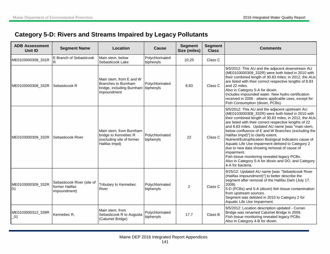
Maine Department of Environmental Protection 2016 Integrated Water Quality Report
Maine DEP 2016 Integrated Report Appendices 141
Category 5 -D: Rivers and Streams Impaired by Legacy Pollutants
ADB Assessment Unit ID Segment Name Location Cause Segment
Size (miles) Segment
Class Comments
ME0103000308_331R E Branch of Sebasticook R
Main stem, below Sebasticook Lake
Polychlorinated biphenyls 10.25 Class C
ME0103000308_332R Sebasticook R
Main stem, from E and W Branches to Burnham bridge, including Burnham impoundment
Polychlorinated biphenyls 8.83 Class C
9/5/2012: This AU and the adjacent downstream AU (ME0103000309_332R) were both listed in 2010 with their combined length of 30.83 miles; in 2012, the AUs are listed with their correct respective lengths of 8.83 and 22 miles. Also in Category 5-A for dioxin. Includes impounded water. New hydro certification received in 2006 - attains applicable uses, except for Fish Consumption (dioxin, PCBs).
ME0103000309_332R Sebasticook River
Main stem, from Burnham bridge to Kennebec R (excluding site of former Halifax Impd)
Polychlorinated biphenyls 22 Class C
9/5/2012: This AU and the adjacent upstream AU (ME0103000308_332R) were both listed in 2010 with their combined length of 30.83 miles; in 2012, the AUs are listed with their correct respective lengths of 22 and 8.83 miles. Updated AU name [was "main stem, below confluence of E and W Branches (excluding the Halifax Impd)"] to clarify extent. Nutrient/Eutrophication Biological Indicators cause of Aquatic Life Use impairment delisted to Category 2 due to new data showing removal of cause of impairment. Fish tissue monitoring revealed legacy PCBs. Also in Category 5-A for dioxin and DO, and Category 4-A for bacteria.
ME0103000309_332R01
Sebasticook River (site of former Halifax impoundment)
Tributary to Kennebec River
Polychlorinated biphenyls 2 Class C
9/25/12: Updated AU name [was "Sebasticook River (Halifax impoundment)"] to better describe the segment after removal of the Halifax Dam (July 17, 2008). 5-D (PCBs) and 5-A (dioxin) fish tissue contamination from upstream sources. Segment was delisted in 2010 to Category 2 for Aquatic Life Use Impairment.
ME0103000312_339R_01 Kennebec R,
Main stem, from Sebasticook R to Augusta (Calumet Bridge)
Polychlorinated biphenyls 17.7 Class B
9/5/2012: Location description updated - Curran Bridge was renamed Calumet Bridge in 2009. Fish tissue monitoring revealed legacy PCBs. Also in Category 4-B for dioxin.

Maine Department of Environmental Protection 2016 Integrated Water Quality Report
Maine DEP 2016 Integrated Report Appendices 142
Category 5 -D: Rivers and Streams Impaired by Legacy Pollutants
ADB Assessment Unit ID Segment Name Location Cause Segment
Size (miles) Segment
Class Comments
ME0103000312_340R_01 Kennebec R,
Main stem, from Augusta (Calumet Bridge) to Merrymeeting Bay (Chops)
Polychlorinated biphenyls 31.66 Class B
10/11/2016: Corrected mapping, updated length from 30.53 to 31.66 miles in 2016 cycle. 9/9/2014: Corrected segment class from Class C to Class B. 9/5/2012: Location description updated - Curran Bridge was renamed Calumet Bridge in 2009. Fish tissue monitoring revealed legacy PCBs. Also in Category 4-B for dioxin.
ME0103000312_427R Merrymeeting Bay
Including tidal portions of tributaries from the Androscoggin R to The Chops
Polychlorinated biphenyls 3.44 Class B
Fish tissue monitoring revealed legacy PCBs. Also in Category 4-B for dioxin.
ME0104000201_421R Androscoggin R Main stem, from Maine-NH border to Wild R
Polychlorinated biphenyls 2.35 Class B Fish tissue monitoring revealed legacy PCBs.
Also in Category 4-B for dioxin.
ME0104000202_421R Androscoggin R Main stem, from Wild R to Rumford Point
Polychlorinated biphenyls 31.04 Class B
7/3/2015: Updated location description from 'Main stem, above Rumford Point' to 'Main stem, from Wild R to Rumford Point' to clarify extent. Fish tissue monitoring revealed legacy PCBs. Also in Category 4-B for dioxin.
ME0104000204_421R Androscoggin R Main stem, from Rumford Pt to Virginia Bridge
Polychlorinated biphenyls 10.97 Class C Fish tissue monitoring revealed legacy PCBs.
Also in Category 4-B for dioxin.
ME0104000204_422R Androscoggin R Main stem, from Virginia Bridge to Webb R
Polychlorinated biphenyls 6.8 Class C Fish tissue monitoring revealed legacy PCBs.
Also in Category 4-B for dioxin.
ME0104000205_422R Androscoggin R Main stem, Webb R to Riley dam
Polychlorinated biphenyls 15.7 Class C Fish tissue monitoring revealed legacy PCBs.
Also in Category 4-B for dioxin.
ME0104000206_423R Androscoggin R Main stem, from Riley Dam to Nezinscot R
Polychlorinated biphenyls 21.7 Class C Fish tissue monitoring revealed legacy PCBs.
Also in Category 4-B for dioxin.
ME0104000206_423R01 Androscoggin R Main stem, Livermore
impoundment Polychlorinated biphenyls 1 Class C
Fish tissue monitoring revealed legacy PCBs. Also in Category 4-B for dioxin and Category 2 for benthic macroinvertebrates and TSS (delisted in 2008 cycle; biomonitoring station S-244 attained Class C biocriteria in 2003, and Class B biocriteria in 2004-2010).
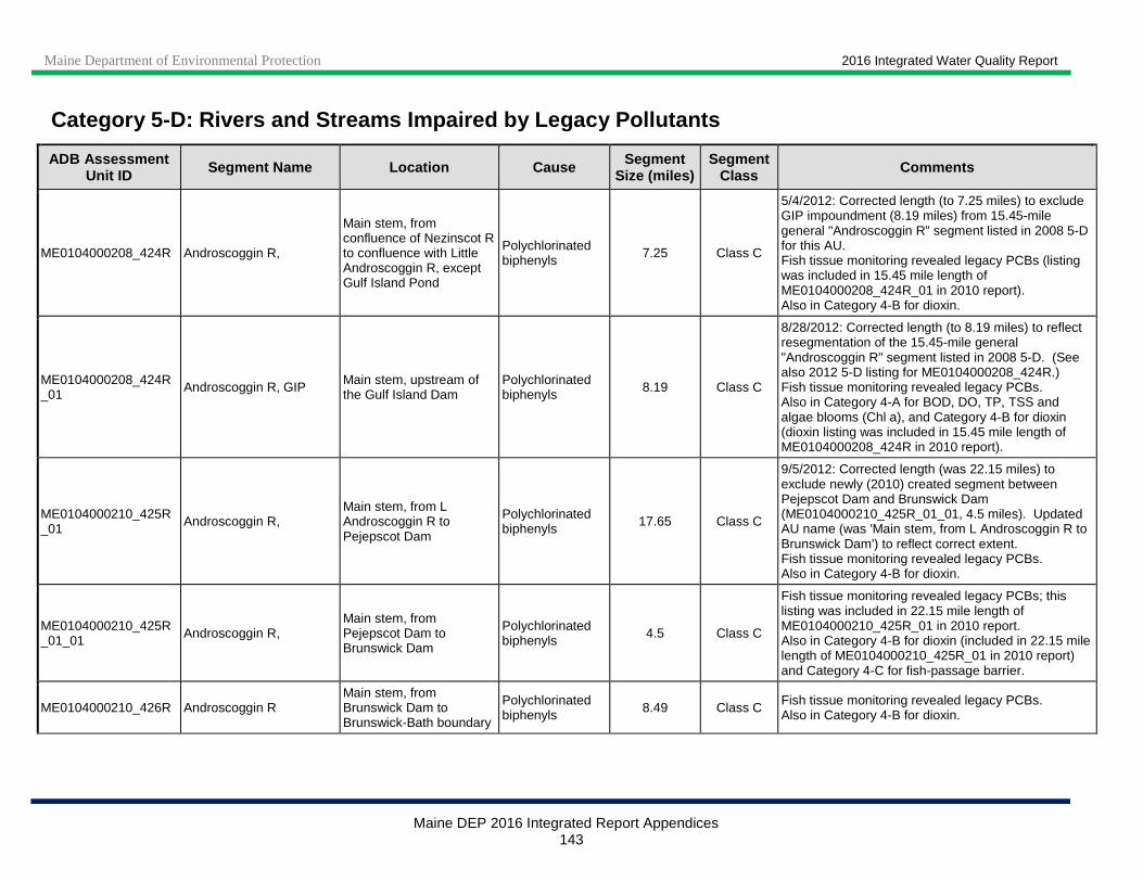
Maine Department of Environmental Protection 2016 Integrated Water Quality Report
Maine DEP 2016 Integrated Report Appendices 143
Category 5 -D: Rivers and Streams Impaired by Legacy Pollutants
ADB Assessment Unit ID Segment Name Location Cause Segment
Size (miles) Segment
Class Comments
ME0104000208_424R Androscoggin R,
Main stem, from confluence of Nezinscot R to confluence with Little Androscoggin R, except Gulf Island Pond
Polychlorinated biphenyls 7.25 Class C
5/4/2012: Corrected length (to 7.25 miles) to exclude GIP impoundment (8.19 miles) from 15.45-mile general "Androscoggin R" segment listed in 2008 5-D for this AU. Fish tissue monitoring revealed legacy PCBs (listing was included in 15.45 mile length of ME0104000208_424R_01 in 2010 report). Also in Category 4-B for dioxin.
ME0104000208_424R_01 Androscoggin R, GIP Main stem, upstream of
the Gulf Island Dam Polychlorinated biphenyls 8.19 Class C
8/28/2012: Corrected length (to 8.19 miles) to reflect resegmentation of the 15.45-mile general "Androscoggin R" segment listed in 2008 5-D. (See also 2012 5-D listing for ME0104000208_424R.) Fish tissue monitoring revealed legacy PCBs. Also in Category 4-A for BOD, DO, TP, TSS and algae blooms (Chl a), and Category 4-B for dioxin (dioxin listing was included in 15.45 mile length of ME0104000208_424R in 2010 report).
ME0104000210_425R_01 Androscoggin R,
Main stem, from L Androscoggin R to Pejepscot Dam
Polychlorinated biphenyls 17.65 Class C
9/5/2012: Corrected length (was 22.15 miles) to exclude newly (2010) created segment between Pejepscot Dam and Brunswick Dam (ME0104000210_425R_01_01, 4.5 miles). Updated AU name (was 'Main stem, from L Androscoggin R to Brunswick Dam') to reflect correct extent. Fish tissue monitoring revealed legacy PCBs. Also in Category 4-B for dioxin.
ME0104000210_425R_01_01 Androscoggin R,
Main stem, from Pejepscot Dam to Brunswick Dam
Polychlorinated biphenyls 4.5 Class C
Fish tissue monitoring revealed legacy PCBs; this listing was included in 22.15 mile length of ME0104000210_425R_01 in 2010 report. Also in Category 4-B for dioxin (included in 22.15 mile length of ME0104000210_425R_01 in 2010 report) and Category 4-C for fish-passage barrier.
ME0104000210_426R Androscoggin R Main stem, from Brunswick Dam to Brunswick-Bath boundary
Polychlorinated biphenyls 8.49 Class C Fish tissue monitoring revealed legacy PCBs.
Also in Category 4-B for dioxin.
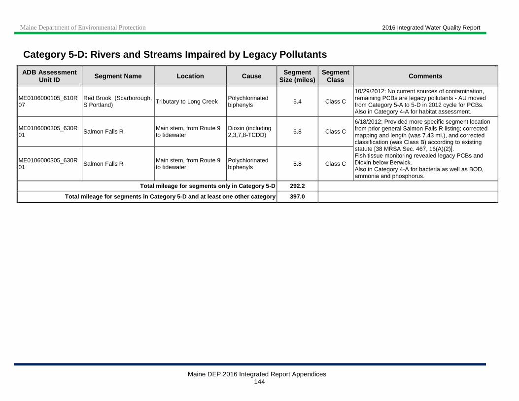
Maine Department of Environmental Protection 2016 Integrated Water Quality Report
Maine DEP 2016 Integrated Report Appendices 144
Category 5 -D: Rivers and Streams Impaired by Legacy Pollutants
ADB Assessment Unit ID Segment Name Location Cause Segment
Size (miles) Segment
Class Comments
ME0106000105_610R07
Red Brook (Scarborough, S Portland) Tributary to Long Creek
Polychlorinated biphenyls 5.4 Class C
10/29/2012: No current sources of contamination, remaining PCBs are legacy pollutants - AU moved from Category 5-A to 5-D in 2012 cycle for PCBs. Also in Category 4-A for habitat assessment.
ME0106000305_630R01 Salmon Falls R Main stem, from Route 9
to tidewater Dioxin (including 2,3,7,8-TCDD) 5.8 Class C
6/18/2012: Provided more specific segment location from prior general Salmon Falls R listing; corrected mapping and length (was 7.43 mi.), and corrected classification (was Class B) according to existing statute [38 MRSA Sec. 467, 16(A)(2)]. Fish tissue monitoring revealed legacy PCBs and Dioxin below Berwick. Also in Category 4-A for bacteria as well as BOD, ammonia and phosphorus.
ME0106000305_630R01 Salmon Falls R Main stem, from Route 9
to tidewater Polychlorinated biphenyls 5.8 Class C
Total mileage for segments only in Category 5 -D 292.2
Total mileage for segments in Category 5-D and at l east one other category 397.0

Maine Department of Environmental Protection 2016 Integrated Water Quality Report
Maine DEP 2016 Integrated Report Appendices 145
APPENDIX III: LAKES
Category 1: Lake Waters Fully Attaining All Designa ted Uses
HUC HUC Name Total HUC
Area (Sq. Miles)
Lake Area within the HUC listed in
Category 1 (Acres)
# of Lakes within the HUC listed in
Category 1
Other listing categories having lakes within this
HUC ME 0101000101 * Baker Branch St. John River 355.24 3383 89
ME 0101000102 * Southwest Branch St. John River 354.42 191 30
ME 0101000103 * Northwest Branch St. John River 504.67 333 5
ME 0101000104 * St. John River (1) at Gauging Station 127.53 211 25
ME 0101000105 * Shields Branch Big Black River 162.98 2 1
ME 0101000106 * Big Black River 466.4 1178 14
ME 0101000107 * St. John River at Oullette Brook 384.74 2866 10
ME 0101000108 * Little Black River 261.73 38 4 2
ME 0101000109 * St. John River above St. Francis 176.48 298 17 2
ME 0101000110 * St. Francis River 228.41 3289 9 2
ME 0101000114 * St. John River at Van Buren 64.98 8 1 2
ME 0101000201 * Eagle Lake 169.18 11806 30
ME 0101000202 * Heron Lake (Churchill) 129 5875 21
ME 0101000203 * Chemquasabamticook Stream 214.54 3293 9
ME 0101000204 * Long Lake 143.4 2436 10
ME 0101000205 * Musquacook Stream 155.53 3889 20
ME 0101000206 * Big Brook 100.88 708 11
ME 0101000207 * Allagash River 320.93 2134 15 2
ME 0101000301 * Fish River Lake 128.98 3601 15
ME 0101000302 * St. Froid Lake 273.95 1238 43 2
ME 0101000303 * Eagle Lake 353.06 1067 9 2,4a
ME 0101000304 * Fish River 133.44 107 4 2
ME 0101000401 * Millimagasset Stream 108.59 5215 35
ME 0101000402 * Munsungan Stream 120.15 2668 37
ME 0101000403 * Mooseleuk Stream 168.76 1600 24
ME 0101000404 * Umcolcus Stream 82.6 1244 10 2
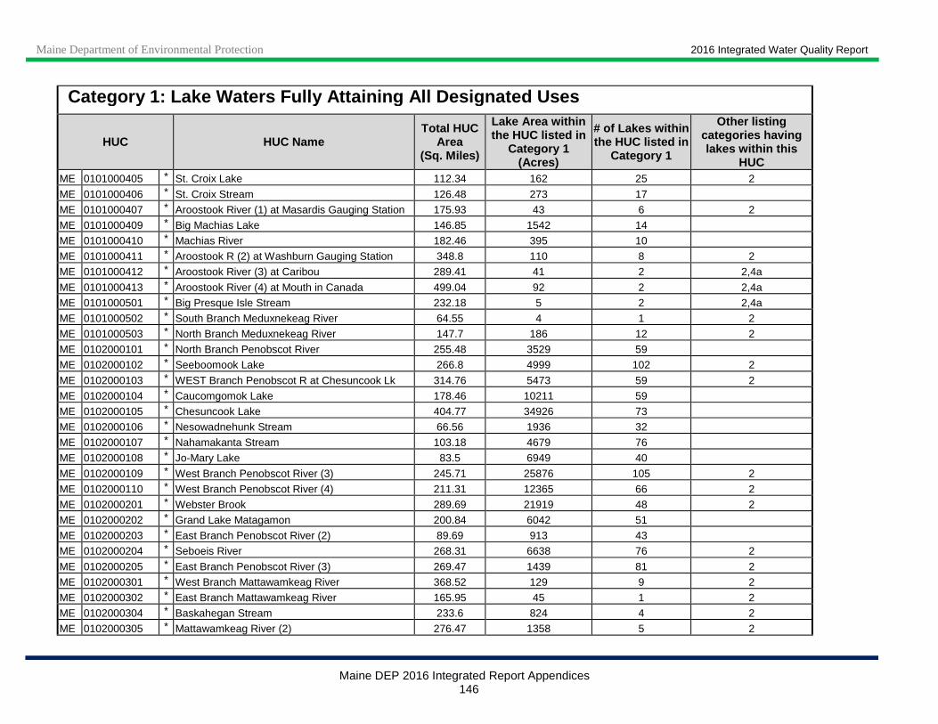
Maine Department of Environmental Protection 2016 Integrated Water Quality Report
Maine DEP 2016 Integrated Report Appendices 146
Category 1: Lake Waters Fully Attaining All Designa ted Uses
HUC HUC Name Total HUC
Area (Sq. Miles)
Lake Area within the HUC listed in
Category 1 (Acres)
# of Lakes within the HUC listed in
Category 1
Other listing categories having lakes within this
HUC ME 0101000405 * St. Croix Lake 112.34 162 25 2
ME 0101000406 * St. Croix Stream 126.48 273 17
ME 0101000407 * Aroostook River (1) at Masardis Gauging Station 175.93 43 6 2
ME 0101000409 * Big Machias Lake 146.85 1542 14
ME 0101000410 * Machias River 182.46 395 10
ME 0101000411 * Aroostook R (2) at Washburn Gauging Station 348.8 110 8 2
ME 0101000412 * Aroostook River (3) at Caribou 289.41 41 2 2,4a
ME 0101000413 * Aroostook River (4) at Mouth in Canada 499.04 92 2 2,4a
ME 0101000501 * Big Presque Isle Stream 232.18 5 2 2,4a
ME 0101000502 * South Branch Meduxnekeag River 64.55 4 1 2
ME 0101000503 * North Branch Meduxnekeag River 147.7 186 12 2
ME 0102000101 * North Branch Penobscot River 255.48 3529 59
ME 0102000102 * Seeboomook Lake 266.8 4999 102 2
ME 0102000103 * WEST Branch Penobscot R at Chesuncook Lk 314.76 5473 59 2
ME 0102000104 * Caucomgomok Lake 178.46 10211 59
ME 0102000105 * Chesuncook Lake 404.77 34926 73
ME 0102000106 * Nesowadnehunk Stream 66.56 1936 32
ME 0102000107 * Nahamakanta Stream 103.18 4679 76
ME 0102000108 * Jo-Mary Lake 83.5 6949 40
ME 0102000109 * West Branch Penobscot River (3) 245.71 25876 105 2
ME 0102000110 * West Branch Penobscot River (4) 211.31 12365 66 2
ME 0102000201 * Webster Brook 289.69 21919 48 2
ME 0102000202 * Grand Lake Matagamon 200.84 6042 51
ME 0102000203 * East Branch Penobscot River (2) 89.69 913 43
ME 0102000204 * Seboeis River 268.31 6638 76 2
ME 0102000205 * East Branch Penobscot River (3) 269.47 1439 81 2
ME 0102000301 * West Branch Mattawamkeag River 368.52 129 9 2
ME 0102000302 * East Branch Mattawamkeag River 165.95 45 1 2
ME 0102000304 * Baskahegan Stream 233.6 824 4 2
ME 0102000305 * Mattawamkeag River (2) 276.47 1358 5 2

Maine Department of Environmental Protection 2016 Integrated Water Quality Report
Maine DEP 2016 Integrated Report Appendices 147
Category 1: Lake Waters Fully Attaining All Designa ted Uses
HUC HUC Name Total HUC
Area (Sq. Miles)
Lake Area within the HUC listed in
Category 1 (Acres)
# of Lakes within the HUC listed in
Category 1
Other listing categories having lakes within this
HUC ME 0102000306 * Molunkus Stream 233.59 766 8 2
ME 0102000401 * Piscataquis River (1) 264.05 282 16 2
ME 0102000403 * Sebec River 351.1 1372 37 2
ME 0102000404 * Pleasant River 339.32 4354 81 2
ME 0102000405 * Seboeis Stream 161.16 3812 24 2
ME 0102000501 * Penobscot River (1) at Mattawamkeag 161.07 941 6 2
ME 0102000502 * Penobscot River (2) at West Enfield 298.2 1115 5 2
ME 0102000503 * Passadumkeag River 398.81 10851 27 2
ME 0102000504 * Olamon Stream 53.88 9 1 2
ME 0102000505 * Sunkhaze Stream 94.65 68 13 2
ME 0102000508 * Pushaw Stream 238.53 1014 2 2
ME 0103000101 * South Branch Moose River 68.34 171 14
ME 0103000102 * Moose River (2) above Attean Pond 180.94 2207 56 2
ME 0103000103 * Moose River (3) at Long Pond 307.3 1643 35 2
ME 0103000104 * Brassua Lake 157.53 473 27 4c
ME 0103000105 * Moosehead Lake 549 4116 92 2
ME 0103000106 * Kennebec River (2) above The Forks 323.12 6404 120 2
ME 0103000201 * North Branch Dead River 200.89 2348 50 2
ME 0103000202 * South Branch Dead River 147.96 73 4 2
ME 0103000203 * Flagstaff Lake 173.02 825 18 2,4c
ME 0103000204 * Dead River 357.53 5691 190 2
ME 0103000301 * Kennebec River (4) at Wyman Dam 158.85 2344 22 2
ME 0103000302 * Austin Stream 89.87 297 11 2
ME 0103000303 * Kennebec River (6) 110.29 87 9 2
ME 0103000304 * Carrabassett River 396.83 398 19 2
ME 0103000305 * Sandy River 592.92 86 6 2,4c
ME 0103000312 * Kennebec River at Merrymeeting Bay 314.46 3 1 2,4a
ME 0104000101 * Mooselookmeguntic Lake 473.72 3283 36 2
ME 0104000102 * Umbagog Lake Drainage 122.05 759 7 2
ME 0104000103 * Aziscohos Lake Drainage 245.91 1606 33 4c
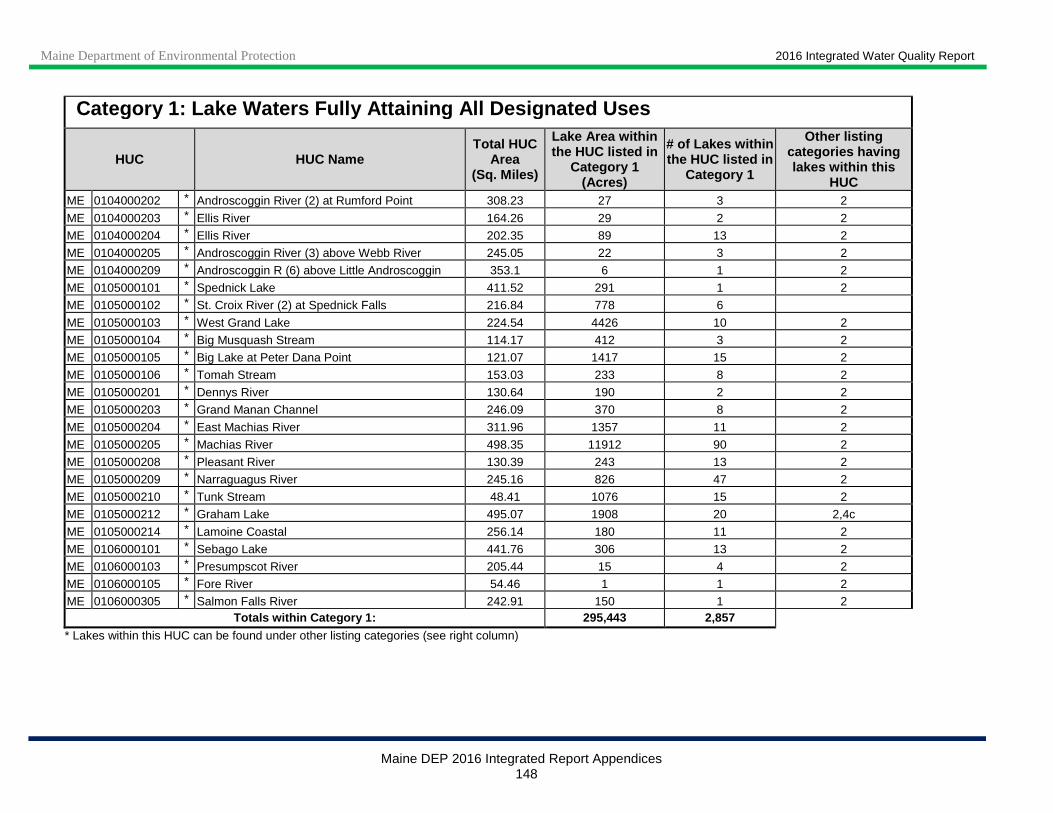
Maine Department of Environmental Protection 2016 Integrated Water Quality Report
Maine DEP 2016 Integrated Report Appendices 148
Category 1: Lake Waters Fully Attaining All Designa ted Uses
HUC HUC Name Total HUC
Area (Sq. Miles)
Lake Area within the HUC listed in
Category 1 (Acres)
# of Lakes within the HUC listed in
Category 1
Other listing categories having lakes within this
HUC ME 0104000202 * Androscoggin River (2) at Rumford Point 308.23 27 3 2
ME 0104000203 * Ellis River 164.26 29 2 2
ME 0104000204 * Ellis River 202.35 89 13 2
ME 0104000205 * Androscoggin River (3) above Webb River 245.05 22 3 2
ME 0104000209 * Androscoggin R (6) above Little Androscoggin 353.1 6 1 2
ME 0105000101 * Spednick Lake 411.52 291 1 2
ME 0105000102 * St. Croix River (2) at Spednick Falls 216.84 778 6
ME 0105000103 * West Grand Lake 224.54 4426 10 2
ME 0105000104 * Big Musquash Stream 114.17 412 3 2
ME 0105000105 * Big Lake at Peter Dana Point 121.07 1417 15 2
ME 0105000106 * Tomah Stream 153.03 233 8 2
ME 0105000201 * Dennys River 130.64 190 2 2
ME 0105000203 * Grand Manan Channel 246.09 370 8 2
ME 0105000204 * East Machias River 311.96 1357 11 2
ME 0105000205 * Machias River 498.35 11912 90 2
ME 0105000208 * Pleasant River 130.39 243 13 2
ME 0105000209 * Narraguagus River 245.16 826 47 2
ME 0105000210 * Tunk Stream 48.41 1076 15 2
ME 0105000212 * Graham Lake 495.07 1908 20 2,4c
ME 0105000214 * Lamoine Coastal 256.14 180 11 2
ME 0106000101 * Sebago Lake 441.76 306 13 2
ME 0106000103 * Presumpscot River 205.44 15 4 2
ME 0106000105 * Fore River 54.46 1 1 2
ME 0106000305 * Salmon Falls River 242.91 150 1 2 Totals within Category 1: 295,443 2,857
* Lakes within this HUC can be found under other listing categories (see right column)

Maine Department of Environmental Protection 2016 Integrated Water Quality Report
Maine DEP 2016 Integrated Report Appendices 149
Category 2: Lake Waters w ithin Hydrologic Unit Attaining Some Designated Use s - Insufficient Information for Other Uses (HUCs with lakes added are in bold)
HUC HUC Name Total HUC
Area (Sq. Miles)
Lake Area within the HUC listed in
Category 2 (Acres)
# of Lakes within the HUC listed in
Category 2
Other listing categories having
lakes within this HUC
ME 0101000108 * Little Black River 261.73 3 1 1
ME 0101000109 * St. John River above St. Francis 176.48 41 4 1
ME 0101000110 * St. Francis River 228.41 330 2 1
ME 0101000111 * St. John River at Fort Kent 184.38 266 7
ME 0101000112 * St. John River at Madawaska 310.29 3 1
ME 0101000113 * St. John River at Grand Isle 16.18 16 1
ME 0101000114 * St. John River at Van Buren 64.98 4 3 1
ME 0101000115 * St. John River (11) at Hamlin 102.19 41 7
ME 0101000116 * St. John River (12) at Tobique River 0.41 19 1
ME 0101000117 * St. John River (13) at Woodstock NB 40.37 28 6
ME 0101000121 * Green and Big Rivers at Van Buren 948.13 11 6
ME 0101000207 * Allagash River 320.93 1 1 1
ME 0101000302 * St. Froid Lake 273.95 4874 2 1
ME 0101000303 * Eagle Lake 353.06 20281 15 1,4a
ME 0101000304 * Fish River 133.44 792 18 1
ME 0101000404 * Umcolcus Stream 82.6 2 2 1
ME 0101000405 * St. Croix Lake 112.34 416 1 1
ME 0101000407 * Aroostook R (1) at Masardis Gauging Station 175.93 338 21 1
ME 0101000408 * Squa Pan Stream 81.21 17 1 4c
ME 0101000411 * Aroostook R (2) at Washburn Gauging Station 348.8 340 4 1 ME 0101000412 * Aroostook River (3) at Caribou 289.41 442 16 1,4a ME 0101000413 * Aroostook River (4) at Mouth in Canada 499.04 1948 34 1,4a
ME 0101000501 * Big Presque Isle Stream 232.18 214 24 1,4a
ME 0101000502 * South Branch Meduxnekeag River 64.55 290 7 1
ME 0101000503 * North Branch Meduxnekeag River 147.7 138 10 1
ME 0101000504 * Meduxnekeag River at Woodstock NB 300.02 1868 45
ME 0102000102 * Seeboomook Lake 266.8 6460 3 1
ME 0102000103 * WEST Branch Penobscot R at Chesuncook Lk 314.76 22 1 1
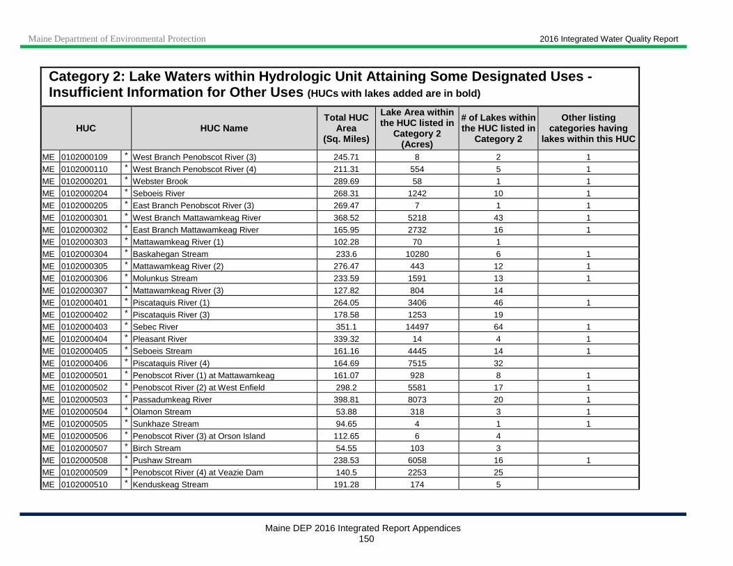
Maine Department of Environmental Protection 2016 Integrated Water Quality Report
Maine DEP 2016 Integrated Report Appendices 150
Category 2: Lake Waters w ithin Hydrologic Unit Attaining Some Designated Use s - Insufficient Information for Other Uses (HUCs with lakes added are in bold)
HUC HUC Name Total HUC
Area (Sq. Miles)
Lake Area within the HUC listed in
Category 2 (Acres)
# of Lakes within the HUC listed in
Category 2
Other listing categories having
lakes within this HUC
ME 0102000109 * West Branch Penobscot River (3) 245.71 8 2 1
ME 0102000110 * West Branch Penobscot River (4) 211.31 554 5 1
ME 0102000201 * Webster Brook 289.69 58 1 1
ME 0102000204 * Seboeis River 268.31 1242 10 1
ME 0102000205 * East Branch Penobscot River (3) 269.47 7 1 1
ME 0102000301 * West Branch Mattawamkeag River 368.52 5218 43 1
ME 0102000302 * East Branch Mattawamkeag River 165.95 2732 16 1
ME 0102000303 * Mattawamkeag River (1) 102.28 70 1
ME 0102000304 * Baskahegan Stream 233.6 10280 6 1
ME 0102000305 * Mattawamkeag River (2) 276.47 443 12 1
ME 0102000306 * Molunkus Stream 233.59 1591 13 1
ME 0102000307 * Mattawamkeag River (3) 127.82 804 14
ME 0102000401 * Piscataquis River (1) 264.05 3406 46 1
ME 0102000402 * Piscataquis River (3) 178.58 1253 19
ME 0102000403 * Sebec River 351.1 14497 64 1
ME 0102000404 * Pleasant River 339.32 14 4 1
ME 0102000405 * Seboeis Stream 161.16 4445 14 1
ME 0102000406 * Piscataquis River (4) 164.69 7515 32
ME 0102000501 * Penobscot River (1) at Mattawamkeag 161.07 928 8 1
ME 0102000502 * Penobscot River (2) at West Enfield 298.2 5581 17 1
ME 0102000503 * Passadumkeag River 398.81 8073 20 1
ME 0102000504 * Olamon Stream 53.88 318 3 1
ME 0102000505 * Sunkhaze Stream 94.65 4 1 1
ME 0102000506 * Penobscot River (3) at Orson Island 112.65 6 4
ME 0102000507 * Birch Stream 54.55 103 3
ME 0102000508 * Pushaw Stream 238.53 6058 16 1
ME 0102000509 * Penobscot River (4) at Veazie Dam 140.5 2253 25
ME 0102000510 * Kenduskeag Stream 191.28 174 5
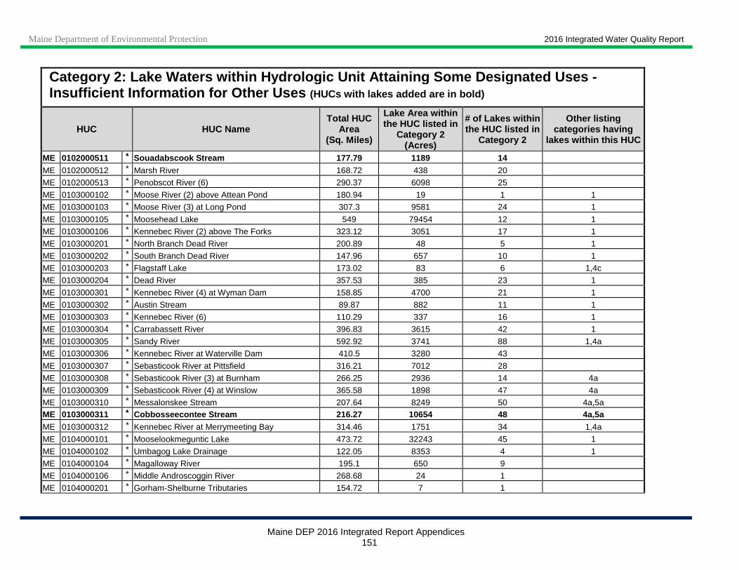
Maine Department of Environmental Protection 2016 Integrated Water Quality Report
Maine DEP 2016 Integrated Report Appendices 151
Category 2: Lake Waters w ithin Hydrologic Unit Attaining Some Designated Use s - Insufficient Information for Other Uses (HUCs with lakes added are in bold)
HUC HUC Name Total HUC
Area (Sq. Miles)
Lake Area within the HUC listed in
Category 2 (Acres)
# of Lakes within the HUC listed in
Category 2
Other listing categories having
lakes within this HUC
ME 0102000511 * Souadabscook Stream 177.79 1189 14 ME 0102000512 * Marsh River 168.72 438 20
ME 0102000513 * Penobscot River (6) 290.37 6098 25
ME 0103000102 * Moose River (2) above Attean Pond 180.94 19 1 1
ME 0103000103 * Moose River (3) at Long Pond 307.3 9581 24 1
ME 0103000105 * Moosehead Lake 549 79454 12 1
ME 0103000106 * Kennebec River (2) above The Forks 323.12 3051 17 1
ME 0103000201 * North Branch Dead River 200.89 48 5 1
ME 0103000202 * South Branch Dead River 147.96 657 10 1
ME 0103000203 * Flagstaff Lake 173.02 83 6 1,4c
ME 0103000204 * Dead River 357.53 385 23 1
ME 0103000301 * Kennebec River (4) at Wyman Dam 158.85 4700 21 1
ME 0103000302 * Austin Stream 89.87 882 11 1
ME 0103000303 * Kennebec River (6) 110.29 337 16 1
ME 0103000304 * Carrabassett River 396.83 3615 42 1
ME 0103000305 * Sandy River 592.92 3741 88 1,4a
ME 0103000306 * Kennebec River at Waterville Dam 410.5 3280 43
ME 0103000307 * Sebasticook River at Pittsfield 316.21 7012 28
ME 0103000308 * Sebasticook River (3) at Burnham 266.25 2936 14 4a
ME 0103000309 * Sebasticook River (4) at Winslow 365.58 1898 47 4a
ME 0103000310 * Messalonskee Stream 207.64 8249 50 4a,5a ME 0103000311 * Cobbosseecontee Stream 216.27 10654 48 4a,5a ME 0103000312 * Kennebec River at Merrymeeting Bay 314.46 1751 34 1,4a
ME 0104000101 * Mooselookmeguntic Lake 473.72 32243 45 1
ME 0104000102 * Umbagog Lake Drainage 122.05 8353 4 1
ME 0104000104 * Magalloway River 195.1 650 9
ME 0104000106 * Middle Androscoggin River 268.68 24 1
ME 0104000201 * Gorham-Shelburne Tributaries 154.72 7 1
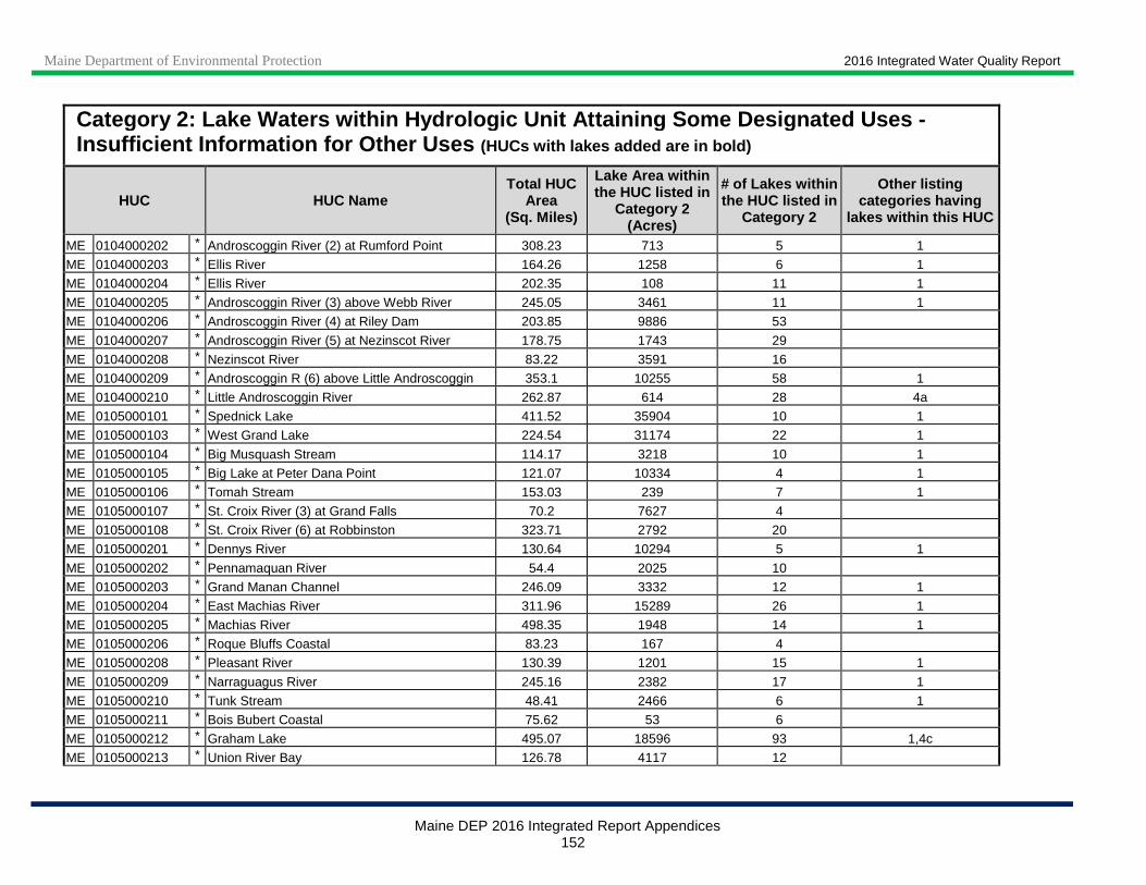
Maine Department of Environmental Protection 2016 Integrated Water Quality Report
Maine DEP 2016 Integrated Report Appendices 152
Category 2: Lake Waters w ithin Hydrologic Unit Attaining Some Designated Use s - Insufficient Information for Other Uses (HUCs with lakes added are in bold)
HUC HUC Name Total HUC
Area (Sq. Miles)
Lake Area within the HUC listed in
Category 2 (Acres)
# of Lakes within the HUC listed in
Category 2
Other listing categories having
lakes within this HUC
ME 0104000202 * Androscoggin River (2) at Rumford Point 308.23 713 5 1
ME 0104000203 * Ellis River 164.26 1258 6 1
ME 0104000204 * Ellis River 202.35 108 11 1
ME 0104000205 * Androscoggin River (3) above Webb River 245.05 3461 11 1
ME 0104000206 * Androscoggin River (4) at Riley Dam 203.85 9886 53
ME 0104000207 * Androscoggin River (5) at Nezinscot River 178.75 1743 29
ME 0104000208 * Nezinscot River 83.22 3591 16
ME 0104000209 * Androscoggin R (6) above Little Androscoggin 353.1 10255 58 1
ME 0104000210 * Little Androscoggin River 262.87 614 28 4a
ME 0105000101 * Spednick Lake 411.52 35904 10 1
ME 0105000103 * West Grand Lake 224.54 31174 22 1
ME 0105000104 * Big Musquash Stream 114.17 3218 10 1
ME 0105000105 * Big Lake at Peter Dana Point 121.07 10334 4 1
ME 0105000106 * Tomah Stream 153.03 239 7 1
ME 0105000107 * St. Croix River (3) at Grand Falls 70.2 7627 4
ME 0105000108 * St. Croix River (6) at Robbinston 323.71 2792 20
ME 0105000201 * Dennys River 130.64 10294 5 1
ME 0105000202 * Pennamaquan River 54.4 2025 10
ME 0105000203 * Grand Manan Channel 246.09 3332 12 1
ME 0105000204 * East Machias River 311.96 15289 26 1
ME 0105000205 * Machias River 498.35 1948 14 1
ME 0105000206 * Roque Bluffs Coastal 83.23 167 4
ME 0105000208 * Pleasant River 130.39 1201 15 1
ME 0105000209 * Narraguagus River 245.16 2382 17 1
ME 0105000210 * Tunk Stream 48.41 2466 6 1
ME 0105000211 * Bois Bubert Coastal 75.62 53 6
ME 0105000212 * Graham Lake 495.07 18596 93 1,4c
ME 0105000213 * Union River Bay 126.78 4117 12
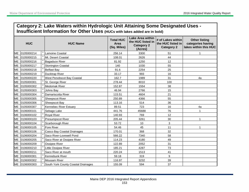
Maine Department of Environmental Protection 2016 Integrated Water Quality Report
Maine DEP 2016 Integrated Report Appendices 153
Category 2: Lake Waters w ithin Hydrologic Unit Attaining Some Designated Use s - Insufficient Information for Other Uses (HUCs with lakes added are in bold)
HUC HUC Name Total HUC
Area (Sq. Miles)
Lake Area within the HUC listed in
Category 2 (Acres)
# of Lakes within the HUC listed in
Category 2
Other listing categories having
lakes within this HUC
ME 0105000214 * Lamoine Coastal 256.14 3300 51 1
ME 0105000215 * Mt. Desert Coastal 108.01 2626 44
ME 0105000216 * Bagaduce River 81.92 1250 12
ME 0105000217 * Stonington Coastal 140 1030 55
ME 0105000218 * Belfast Bay 91.6 2254 25
ME 0105000219 * Ducktrap River 33.17 993 16
ME 0105000220 * West Penobscot Bay Coastal 162.7 1989 31 4a
ME 0105000301 * St. George River 278.44 8010 100
ME 0105000302 * Medomak River 152.87 1554 38
ME 0105000303 * Johns Bay 46.94 2766 15
ME 0105000304 * Damariscotta River 115.51 4604 21
ME 0105000305 * Sheepscot River 250.89 4366 55
ME 0105000306 * Sheepscot Bay 113.16 514 36
ME 0105000307 * Kennebec River Estuary 89.51 723 16 4a
ME 0106000101 * Sebago Lake 441.76 45688 76 1
ME 0106000102 * Royal River 140.93 769 12
ME 0106000103 * Presumpscot River 205.44 3261 30 1
ME 0106000104 * Scarborough River 53.72 10 3
ME 0106000105 * Fore River 54.46 45 11 1
ME 0106000106 * Casco Bay Coastal Drainages 170.01 368 32
ME 0106000204 * Saco River-Lovewell Pond 566.22 7340 58
ME 0106000205 * Saco River at Ossipee River 114.23 4180 49
ME 0106000209 * Ossipee River 122.89 2052 31
ME 0106000210 * Little Ossipee River 185.21 4287 73
ME 0106000211 * Saco River at mouth 220.24 1513 41
ME 0106000301 * Kennebunk River 59.18 319 9
ME 0106000302 * Mousam River 116.97 3232 39
ME 0106000303 * South York County Coastal Drainages 155.09 594 37
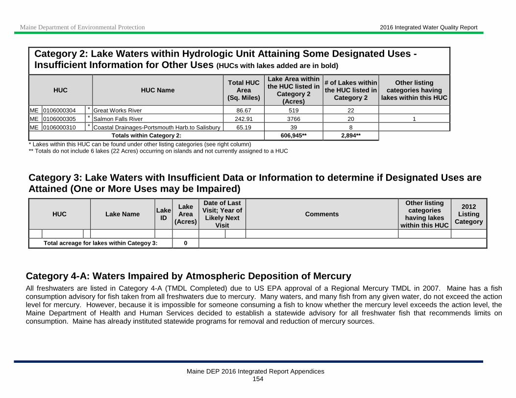
Maine Department of Environmental Protection 2016 Integrated Water Quality Report
Maine DEP 2016 Integrated Report Appendices 154
Category 2: Lake Waters w ithin Hydrologic Unit Attaining Some Designated Use s - Insufficient Information for Other Uses (HUCs with lakes added are in bold)
HUC HUC Name Total HUC
Area (Sq. Miles)
Lake Area within the HUC listed in
Category 2 (Acres)
# of Lakes within the HUC listed in
Category 2
Other listing categories having
lakes within this HUC
ME 0106000304 * Great Works River 86.67 519 22
ME 0106000305 * Salmon Falls River 242.91 3766 20 1
ME 0106000310 * Coastal Drainages-Portsmouth Harb.to Salisbury 65.19 39 8 Totals within Category 2: 606,945** 2,894**
* Lakes within this HUC can be found under other listing categories (see right column) ** Totals do not include 6 lakes (22 Acres) occurring on islands and not currently assigned to a HUC
Category 3: Lake Waters with Insufficient Data or I nformation to determine if Designated Uses are Attained (One or More Uses may be Impaired)
HUC Lake Name Lake ID
Lake Area
(Acres)
Date of Last Visit; Year of Likely Next
Visit
Comments
Other listing categories
having lakes within this HUC
2012 Listing
Category
Total acreage for lakes within Categoy 3: 0
Category 4-A: Waters Impaired by Atmospheric Deposi tion of Mercury All freshwaters are listed in Category 4-A (TMDL Completed) due to US EPA approval of a Regional Mercury TMDL in 2007. Maine has a fish consumption advisory for fish taken from all freshwaters due to mercury. Many waters, and many fish from any given water, do not exceed the action level for mercury. However, because it is impossible for someone consuming a fish to know whether the mercury level exceeds the action level, the Maine Department of Health and Human Services decided to establish a statewide advisory for all freshwater fish that recommends limits on consumption. Maine has already instituted statewide programs for removal and reduction of mercury sources.
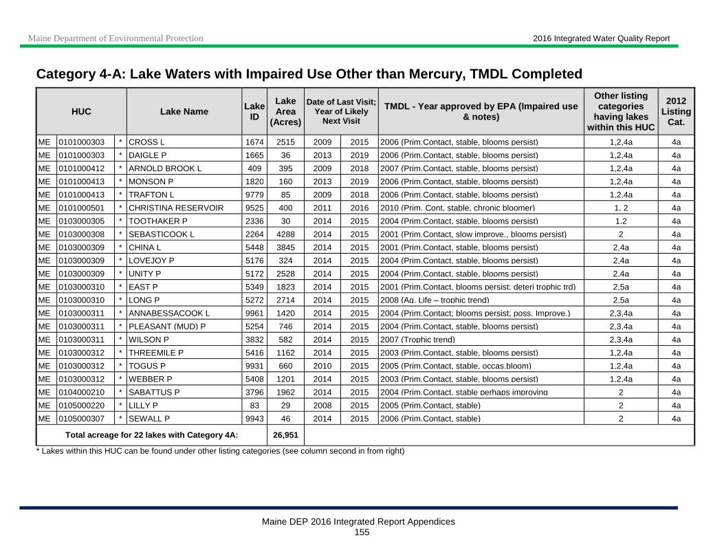
Maine Department of Environmental Protection 2016 Integrated Water Quality Report
Maine DEP 2016 Integrated Report Appendices 155
Category 4-A: Lake Waters with Impaired Use Other t han Mercury, TMDL Completed
HUC Lake Name Lake ID
Lake Area
(Acres)
Date of Last Visit; Year of Likely
Next Visit
TMDL - Year approved by EPA (Impaired use & notes)
Other listing categories
having lakes within this HUC
2012 Listing
Cat.
ME 0101000303 * CROSS L 1674 2515 2009 2015 2006 (Prim.Contact, stable, blooms persist) 1,2,4a 4a
ME 0101000303 * DAIGLE P 1665 36 2013 2019 2006 (Prim.Contact, stable, blooms persist) 1,2,4a 4a
ME 0101000412 * ARNOLD BROOK L 409 395 2009 2018 2007 (Prim.Contact, stable, blooms persist) 1,2,4a 4a
ME 0101000413 * MONSON P 1820 160 2013 2019 2006 (Prim.Contact, stable, blooms persist) 1,2,4a 4a
ME 0101000413 * TRAFTON L 9779 85 2009 2018 2006 (Prim.Contact, stable, blooms persist) 1,2,4a 4a
ME 0101000501 * CHRISTINA RESERVOIR 9525 400 2011 2016 2010 (Prim. Cont, stable, chronic bloomer) 1, 2 4a
ME 0103000305 * TOOTHAKER P 2336 30 2014 2015 2004 (Prim.Contact, stable, blooms persist) 1,2 4a
ME 0103000308 * SEBASTICOOK L 2264 4288 2014 2015 2001 (Prim.Contact, slow improve., blooms persist) 2 4a
ME 0103000309 * CHINA L 5448 3845 2014 2015 2001 (Prim.Contact, stable, blooms persist) 2,4a 4a
ME 0103000309 * LOVEJOY P 5176 324 2014 2015 2004 (Prim.Contact, stable, blooms persist) 2,4a 4a
ME 0103000309 * UNITY P 5172 2528 2014 2015 2004 (Prim.Contact, stable, blooms persist) 2,4a 4a
ME 0103000310 * EAST P 5349 1823 2014 2015 2001 (Prim.Contact, blooms persist; deteri trophic trd) 2,5a 4a
ME 0103000310 * LONG P 5272 2714 2014 2015 2008 (Aq. Life – trophic trend) 2,5a 4a
ME 0103000311 * ANNABESSACOOK L 9961 1420 2014 2015 2004 (Prim.Contact; blooms persist; poss. Improve.) 2,3,4a 4a
ME 0103000311 * PLEASANT (MUD) P 5254 746 2014 2015 2004 (Prim.Contact, stable, blooms persist) 2,3,4a 4a
ME 0103000311 * WILSON P 3832 582 2014 2015 2007 (Trophic trend) 2,3,4a 4a
ME 0103000312 * THREEMILE P 5416 1162 2014 2015 2003 (Prim.Contact, stable, blooms persist) 1,2,4a 4a
ME 0103000312 * TOGUS P 9931 660 2010 2015 2005 (Prim.Contact, stable, occas.bloom) 1,2,4a 4a
ME 0103000312 * WEBBER P 5408 1201 2014 2015 2003 (Prim.Contact, stable, blooms persist) 1,2,4a 4a
ME 0104000210 * SABATTUS P 3796 1962 2014 2015 2004 (Prim.Contact, stable perhaps improving 2 4a
ME 0105000220 * LILLY P 83 29 2008 2015 2005 (Prim.Contact, stable) 2 4a
ME 0105000307 * SEWALL P 9943 46 2014 2015 2006 (Prim.Contact, stable) 2 4a
Total acreage for 22 lakes with Category 4A: 26,95 1
* Lakes within this HUC can be found under other listing categories (see column second in from right)
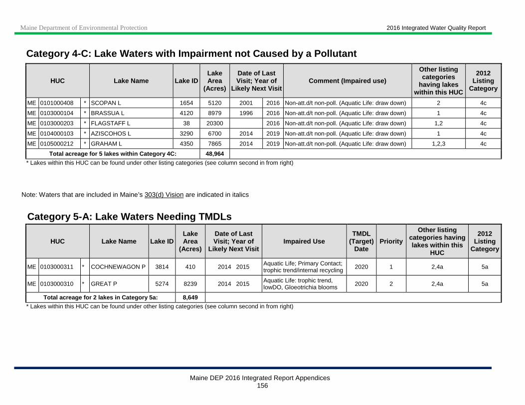
Maine Department of Environmental Protection 2016 Integrated Water Quality Report
Maine DEP 2016 Integrated Report Appendices 156
Category 4-C: Lake Waters with Impairment not Cause d by a Pollutant
HUC Lake Name Lake ID Lake Area
(Acres)
Date of Last Visit; Year of
Likely Next Visit Comment (Impaired use)
Other listing categories
having lakes within this HUC
2012 Listing
Category
ME 0101000408 * SCOPAN L 1654 5120 2001 2016 Non-att.d/t non-poll. (Aquatic Life: draw down) 2 4c
ME 0103000104 * BRASSUA L 4120 8979 1996 2016 Non-att.d/t non-poll. (Aquatic Life: draw down) 1 4c
ME 0103000203 * FLAGSTAFF L 38 20300 2016 Non-att.d/t non-poll. (Aquatic Life: draw down) 1,2 4c
ME 0104000103 * AZISCOHOS L 3290 6700 2014 2019 Non-att.d/t non-poll. (Aquatic Life: draw down) 1 4c
ME 0105000212 * GRAHAM L 4350 7865 2014 2019 Non-att.d/t non-poll. (Aquatic Life: draw down) 1,2,3 4c
Total acreage for 5 lakes within Category 4C: 48,964
* Lakes within this HUC can be found under other listing categories (see column second in from right)
Note: Waters that are included in Maine’s 303(d) Vision are indicated in italics
Category 5 -A: Lake Waters Needing TMDLs
HUC Lake Name Lake ID Lake Area
(Acres)
Date of Last Visit; Year of
Likely Next Visit Impaired Use
TMDL (Target)
Date Priority
Other listing categories having lakes within this
HUC
2012 Listing
Category
ME 0103000311 * COCHNEWAGON P 3814 410 2014 2015 Aquatic Life; Primary Contact; trophic trend/internal recycling 2020 1 2,4a 5a
ME 0103000310 * GREAT P 5274 8239 2014 2015 Aquatic Life: trophic trend, lowDO, Gloeotrichia blooms 2020 2 2,4a 5a
Total acreage for 2 lakes in Category 5a: 8,649
* Lakes within this HUC can be found under other listing categories (see column second in from right)

Maine Department of Environmental Protection 2016 Integrated Water Quality Report
Maine DEP 2016 Integrated Report Appendices 157
Category Listing Change Summary: 20 14 to 2016 (0 Lakes) HUC Lake Name Lake
ID Acres 2014 ListCat
2016 ListCat* Notes
Total acreage
* Lakes currently listed in Categories 1 or 2 do not appear individually in their respective Appendix III tables but rather are included in the overall lake summary for the HUC.
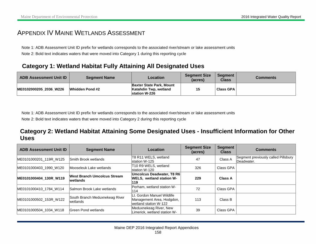
Maine Department of Environmental Protection 2016 Integrated Water Quality Report
Maine DEP 2016 Integrated Report Appendices 158
APPENDIX IV MAINE WETLANDS ASSESSMENT
Note 1: ADB Assessment Unit ID prefix for wetlands corresponds to the associated river/stream or lake assessment units
Note 2: Bold text indicates waters that were moved into Category 1 during this reporting cycle
Category 1: Wetland Habitat Fully Attaining All Des ignated Uses ADB Assessment Unit ID Segment Name Location Segment Size
(acres) Segment
Class Comments
ME0102000205_2036_W226 Whidden Pond #2 Baxter State Park, Mount Katahdin Twp, wetland station W-226
15 Class GPA
Note 1: ADB Assessment Unit ID prefix for wetlands corresponds to the associated river/stream or lake assessment units
Note 2: Bold text indicates waters that were moved into Category 2 during this reporting cycle
Category 2: Wetland Habitat Attaining Some Designat ed Uses - Insufficient Information for Other Uses
ADB Assessment Unit ID Segment Name Location Segment Size (acres)
Segment Class Comments
ME0101000201_119R_W125 Smith Brook wetlands T8 R11 WELS, wetland station W-125 47 Class A Segment previously called Pillsbury
Deadwater.
ME0101000403_1990_W120 Mooseleuk Lake wetlands T10 R9 WELS, wetland station W-120 326 Class GPA
ME0101000404_130R_W119 West Branch Umcolcus Stream wetlands
Umcolcus Deadwater, T8 R6 WELS, wetland station W-119
229 Class A
ME0101000410_1784_W114 Salmon Brook Lake wetlands Perham, wetland station W-114 72 Class GPA
ME0101000502_153R_W122 South Branch Meduxnekeag River wetlands
Lt. Gordon Manuel Wildlife Management Area, Hodgdon, wetland station W-122
113 Class B
ME0101000504_1034_W118 Green Pond wetlands Meduxnekeag River, New Limerick, wetland station W- 39 Class GPA
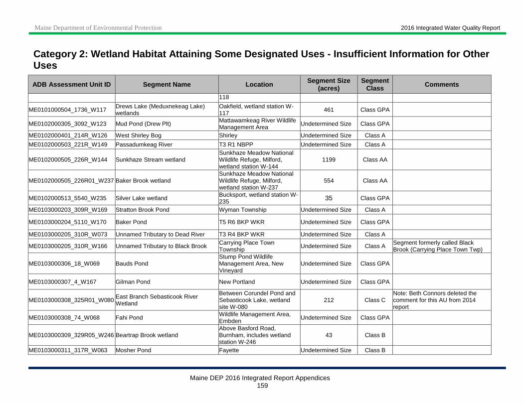
Maine Department of Environmental Protection 2016 Integrated Water Quality Report
Maine DEP 2016 Integrated Report Appendices 159
Category 2: Wetland Habitat Attaining Some Designat ed Uses - Insufficient Information for Other Uses
ADB Assessment Unit ID Segment Name Location Segment Size (acres)
Segment Class Comments
118
ME0101000504_1736_W117 Drews Lake (Meduxnekeag Lake) wetlands
Oakfield, wetland station W-117 461 Class GPA
ME0102000305_3092_W123 Mud Pond (Drew Plt) Mattawamkeag River Wildlife Management Area Undetermined Size Class GPA
ME0102000401_214R_W126 West Shirley Bog Shirley Undetermined Size Class A
ME0102000503_221R_W149 Passadumkeag River T3 R1 NBPP Undetermined Size Class A
ME0102000505_226R_W144 Sunkhaze Stream wetland Sunkhaze Meadow National Wildlife Refuge, Milford, wetland station W-144
1199 Class AA
ME0102000505_226R01_W237 Baker Brook wetland Sunkhaze Meadow National Wildlife Refuge, Milford, wetland station W-237
554 Class AA
ME0102000513_5540_W235 Silver Lake wetland Bucksport, wetland station W-235 35 Class GPA
ME0103000203_309R_W169 Stratton Brook Pond Wyman Township Undetermined Size Class A
ME0103000204_5110_W170 Baker Pond T5 R6 BKP WKR Undetermined Size Class GPA
ME0103000205_310R_W073 Unnamed Tributary to Dead River T3 R4 BKP WKR Undetermined Size Class A
ME0103000205_310R_W166 Unnamed Tributary to Black Brook Carrying Place Town Township Undetermined Size Class A Segment formerly called Black
Brook (Carrying Place Town Twp)
ME0103000306_18_W069 Bauds Pond Stump Pond Wildlife Management Area, New Vineyard
Undetermined Size Class GPA
ME0103000307_4_W167 Gilman Pond New Portland Undetermined Size Class GPA
ME0103000308_325R01_W080 East Branch Sebasticook River Wetland
Between Corundel Pond and Sebasticook Lake, wetland site W-080
212 Class C Note: Beth Connors deleted the comment for this AU from 2014 report
ME0103000308_74_W068 Fahi Pond Wildlife Management Area, Embden Undetermined Size Class GPA
ME0103000309_329R05_W246 Beartrap Brook wetland Above Basford Road, Burnham, includes wetland station W-246
43 Class B
ME0103000311_317R_W063 Mosher Pond Fayette Undetermined Size Class B
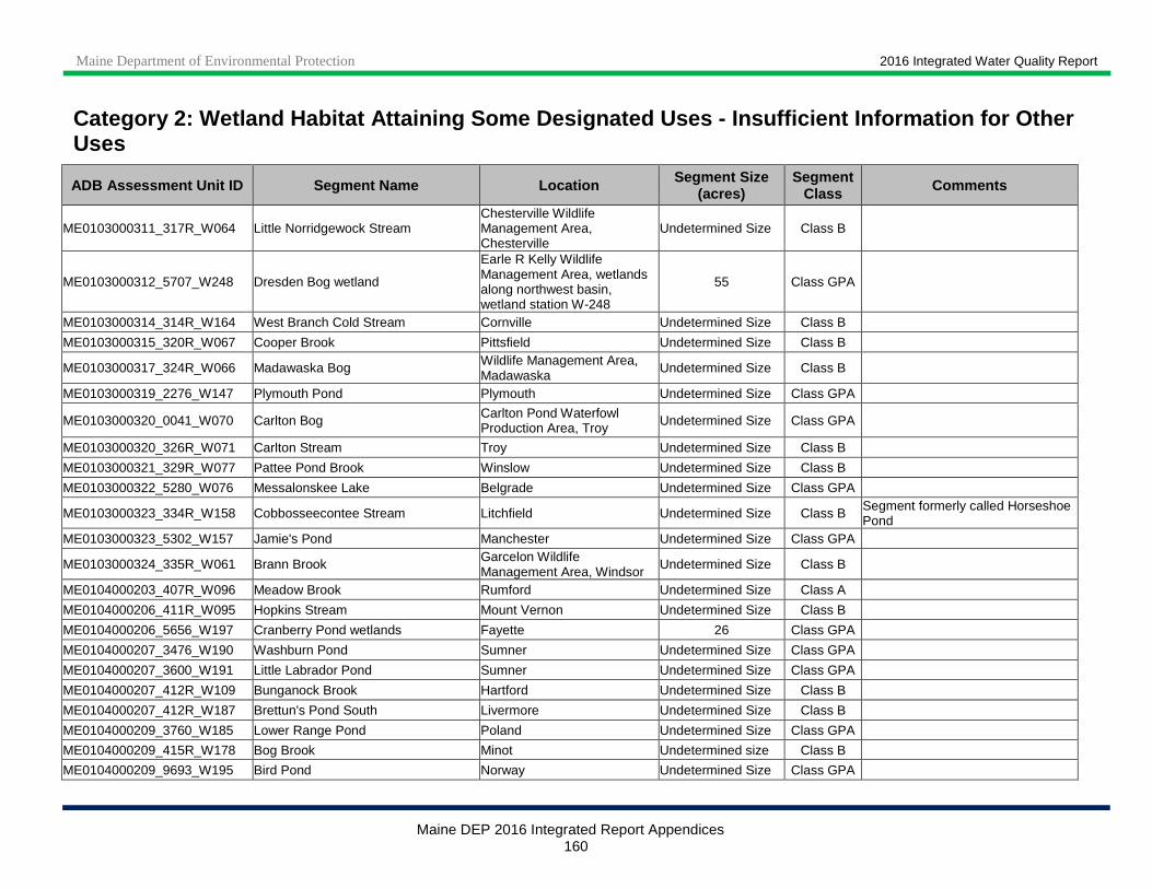
Maine Department of Environmental Protection 2016 Integrated Water Quality Report
Maine DEP 2016 Integrated Report Appendices 160
Category 2: Wetland Habitat Attaining Some Designat ed Uses - Insufficient Information for Other Uses
ADB Assessment Unit ID Segment Name Location Segment Size (acres)
Segment Class Comments
ME0103000311_317R_W064 Little Norridgewock Stream Chesterville Wildlife Management Area, Chesterville
Undetermined Size Class B
ME0103000312_5707_W248 Dresden Bog wetland
Earle R Kelly Wildlife Management Area, wetlands along northwest basin, wetland station W-248
55 Class GPA
ME0103000314_314R_W164 West Branch Cold Stream Cornville Undetermined Size Class B
ME0103000315_320R_W067 Cooper Brook Pittsfield Undetermined Size Class B
ME0103000317_324R_W066 Madawaska Bog Wildlife Management Area, Madawaska
Undetermined Size Class B
ME0103000319_2276_W147 Plymouth Pond Plymouth Undetermined Size Class GPA
ME0103000320_0041_W070 Carlton Bog Carlton Pond Waterfowl Production Area, Troy Undetermined Size Class GPA
ME0103000320_326R_W071 Carlton Stream Troy Undetermined Size Class B
ME0103000321_329R_W077 Pattee Pond Brook Winslow Undetermined Size Class B
ME0103000322_5280_W076 Messalonskee Lake Belgrade Undetermined Size Class GPA
ME0103000323_334R_W158 Cobbosseecontee Stream Litchfield Undetermined Size Class B Segment formerly called Horseshoe Pond
ME0103000323_5302_W157 Jamie's Pond Manchester Undetermined Size Class GPA
ME0103000324_335R_W061 Brann Brook Garcelon Wildlife Management Area, Windsor
Undetermined Size Class B
ME0104000203_407R_W096 Meadow Brook Rumford Undetermined Size Class A
ME0104000206_411R_W095 Hopkins Stream Mount Vernon Undetermined Size Class B
ME0104000206_5656_W197 Cranberry Pond wetlands Fayette 26 Class GPA
ME0104000207_3476_W190 Washburn Pond Sumner Undetermined Size Class GPA
ME0104000207_3600_W191 Little Labrador Pond Sumner Undetermined Size Class GPA
ME0104000207_412R_W109 Bunganock Brook Hartford Undetermined Size Class B
ME0104000207_412R_W187 Brettun's Pond South Livermore Undetermined Size Class B
ME0104000209_3760_W185 Lower Range Pond Poland Undetermined Size Class GPA
ME0104000209_415R_W178 Bog Brook Minot Undetermined size Class B
ME0104000209_9693_W195 Bird Pond Norway Undetermined Size Class GPA
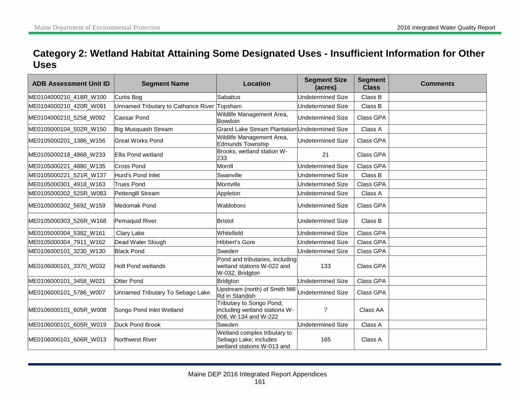
Maine Department of Environmental Protection 2016 Integrated Water Quality Report
Maine DEP 2016 Integrated Report Appendices 161
Category 2: Wetland Habitat Attaining Some Designat ed Uses - Insufficient Information for Other Uses
ADB Assessment Unit ID Segment Name Location Segment Size (acres)
Segment Class Comments
ME0104000210_418R_W100 Curtis Bog Sabattus Undetermined Size Class B
ME0104000210_420R_W091 Unnamed Tributary to Cathance River Topsham Undetermined Size Class B
ME0104000210_5258_W092 Caesar Pond Wildlife Management Area, Bowdoin Undetermined Size Class GPA
ME0105000104_502R_W150 Big Musquash Stream Grand Lake Stream Plantation Undetermined Size Class A
ME0105000201_1386_W156 Great Works Pond Wildlife Management Area, Edmunds Township Undetermined Size Class GPA
ME0105000218_4868_W233 Ellis Pond wetland Brooks, wetland station W-233 21 Class GPA
ME0105000221_4880_W135 Cross Pond Morrill Undetermined Size Class GPA
ME0105000221_521R_W137 Hurd's Pond Inlet Swanville Undetermined Size Class B
ME0105000301_4918_W163 Trues Pond Montville Undetermined Size Class GPA
ME0105000302_525R_W083 Pettengill Stream Appleton Undetermined Size Class A
ME0105000302_5692_W159 Medomak Pond Waldoboro Undetermined Size Class GPA
ME0105000303_526R_W168 Pemaquid River Bristol Undetermined Size Class B
ME0105000304_5382_W161 Clary Lake Whitefield Undetermined Size Class GPA
ME0105000304_7911_W162 Dead Water Slough Hibbert’s Gore Undetermined Size Class GPA
ME0106000101_3230_W130 Black Pond Sweden Undetermined Size Class GPA
ME0106000101_3370_W032 Holt Pond wetlands Pond and tributaries, including wetland stations W-022 and W-032, Bridgton
133 Class GPA
ME0106000101_3458_W021 Otter Pond Bridgton Undetermined Size Class GPA
ME0106000101_5786_W007 Unnamed Tributary To Sebago Lake Upstream (north) of Smith Mill Rd in Standish Undetermined Size Class GPA
ME0106000101_605R_W008 Songo Pond Inlet Wetland Tributary to Songo Pond; including wetland stations W-008, W-134 and W-222
7 Class AA
ME0106000101_605R_W019 Duck Pond Brook Sweden Undetermined Size Class A
ME0106000101_606R_W013 Northwest River Wetland complex tributary to Sebago Lake; includes wetland stations W-013 and
165 Class A
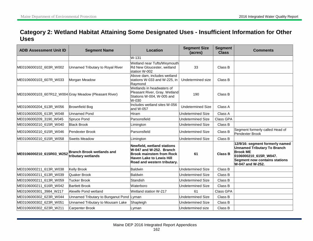
Maine Department of Environmental Protection 2016 Integrated Water Quality Report
Maine DEP 2016 Integrated Report Appendices 162
Category 2: Wetland Habitat Attaining Some Designat ed Uses - Insufficient Information for Other Uses
ADB Assessment Unit ID Segment Name Location Segment Size (acres)
Segment Class Comments
W-131
ME0106000102_603R_W002 Unnamed Tributary to Royal River Wetland near Tufts/Weymouth Rd New Gloucester, wetland station W-002
33 Class B
ME0106000103_607R_W033 Morgan Meadow Above dam, includes wetland stations W-033 and W-225, in Raymond
Undetermined size Class B
ME0106000103_607R12_W004 Gray Meadow (Pleasant River)
Wetlands in headwaters of Pleasant River, Gray. Wetland Stations W-004, W-005 and W-030
190 Class B
ME0106000204_613R_W056 Brownfield Bog Includes wetland sites W-056 and W-057 Undetermined Size Class A
ME0106000205_613R_W048 Unnamed Pond Hiram Undetermined Size Class A
ME0106000209_3190_W045 Spruce Pond Parsonsfield Undetermined Size Class GPA
ME0106000210_615R_W040 Black Brook Limington Undetermined Size Class B
ME0106000210_615R_W046 Pendexter Brook Parsonsfield Undetermined Size Class B Segment formerly called Head of Pendexter Brook
ME0106000210_615R_W058 Swetts Meadow Limington Undetermined Size Class B
ME0106000210_615R03_W252 Branch Brook wetlands and tributary wetlands
Newfield, wetland stations W-047 and W-252. Branch Brook mainstem from Rock Haven Lake to Lewis Hill Road and western tributary.
61 Class B
12/9/16: segment formerly named Unnamed Tributary To Branch Brook ME 0106000210_615R_W047. Segment now contains stations W-047 and W-252.
ME0106000211_613R_W038 Kelly Brook Baldwin Undetermined Size Class B
ME0106000211_613R_W039 Quaker Brook Baldwin Undetermined Size Class B
ME0106000211_613R_W059 Tucker Brook Standish Undetermined Size Class B
ME0106000211_616R_W042 Bartlett Brook Waterboro Undetermined Size Class B
ME0106000301_3984_W217 Alewife Pond wetland Wetland station W-217 61 Class GPA
ME0106000302_623R_W044 Unnamed Tributary to Bunganut Pond Lyman Undetermined Size Class B
ME0106000302_623R_W051 Unnamed Tributary to Mousam Lake Shapleigh Undetermined Size Class B
ME0106000302_623R_W211 Carpenter Brook Lyman Undetermined size Class B
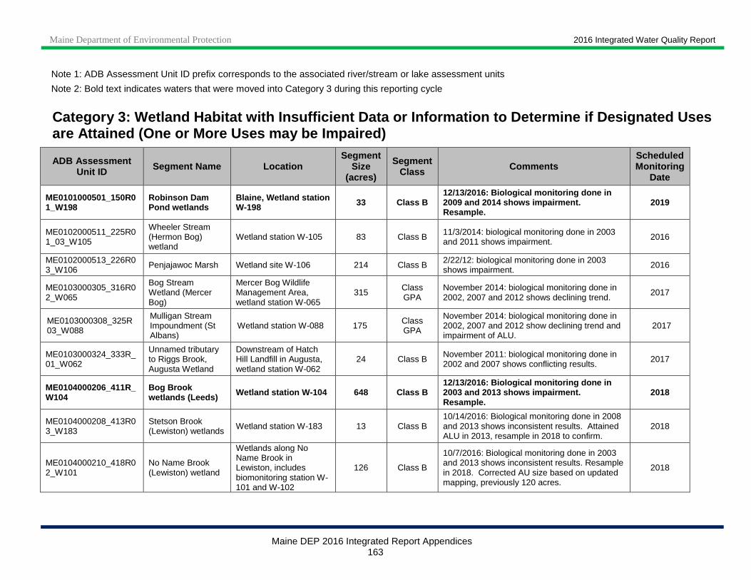
Maine Department of Environmental Protection 2016 Integrated Water Quality Report
Maine DEP 2016 Integrated Report Appendices 163
Note 1: ADB Assessment Unit ID prefix corresponds to the associated river/stream or lake assessment units
Note 2: Bold text indicates waters that were moved into Category 3 during this reporting cycle
Category 3: Wetland Habitat with Insufficient Data or Information to De termine if Designated Uses are Attained (One or More Uses may be Impaired)
ADB Assessment Unit ID Segment Name Location
Segment Size
(acres)
Segment Class Comments
Scheduled Monitoring
Date
ME0101000501_150R01_W198
Robinson Dam Pond wetlands
Blaine, Wetland station W-198 33 Class B
12/13/2016: Biological monitoring done in 2009 and 2014 shows impairment. Resample.
2019
ME0102000511_225R01_03_W105
Wheeler Stream (Hermon Bog) wetland
Wetland station W-105 83 Class B 11/3/2014: biological monitoring done in 2003 and 2011 shows impairment. 2016
ME0102000513_226R03_W106 Penjajawoc Marsh Wetland site W-106 214 Class B 2/22/12: biological monitoring done in 2003
shows impairment. 2016
ME0103000305_316R02_W065
Bog Stream Wetland (Mercer Bog)
Mercer Bog Wildlife Management Area, wetland station W-065
315 Class GPA
November 2014: biological monitoring done in 2002, 2007 and 2012 shows declining trend.
2017
ME0103000308_325R03_W088
Mulligan Stream Impoundment (St Albans)
Wetland station W-088 175 Class GPA
November 2014: biological monitoring done in 2002, 2007 and 2012 show declining trend and impairment of ALU.
2017
ME0103000324_333R_01_W062
Unnamed tributary to Riggs Brook, Augusta Wetland
Downstream of Hatch Hill Landfill in Augusta, wetland station W-062
24 Class B November 2011: biological monitoring done in 2002 and 2007 shows conflicting results. 2017
ME0104000206_411R_W104
Bog Brook wetlands (Leeds) Wetland station W-104 648 Class B
12/13/2016: Biological monitoring done in 2003 and 2013 shows impairment. Resample.
2018
ME0104000208_413R03_W183
Stetson Brook (Lewiston) wetlands Wetland station W-183 13 Class B
10/14/2016: Biological monitoring done in 2008 and 2013 shows inconsistent results. Attained ALU in 2013, resample in 2018 to confirm.
2018
ME0104000210_418R02_W101
No Name Brook (Lewiston) wetland
Wetlands along No Name Brook in Lewiston, includes biomonitoring station W-101 and W-102
126 Class B
10/7/2016: Biological monitoring done in 2003 and 2013 shows inconsistent results. Resample in 2018. Corrected AU size based on updated mapping, previously 120 acres.
2018
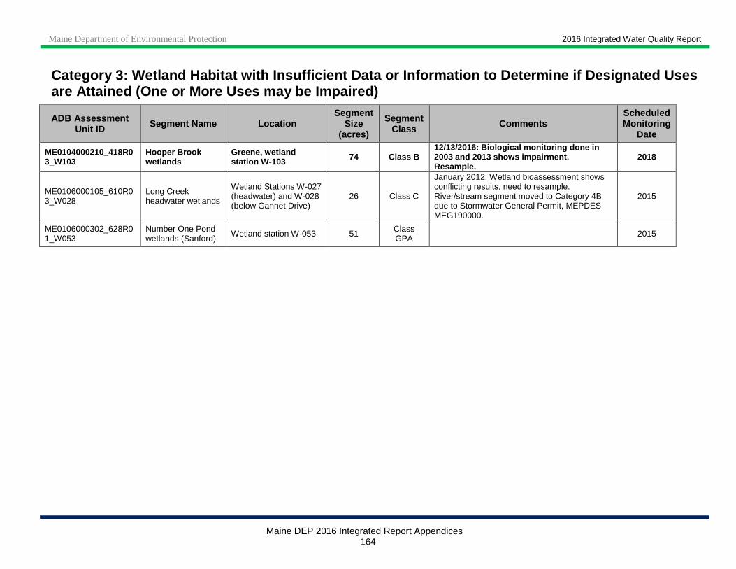
Maine Department of Environmental Protection 2016 Integrated Water Quality Report
Maine DEP 2016 Integrated Report Appendices 164
Category 3: Wetland Habitat with Insufficient Data or Information to De termine if Designated Uses are Attained (One or More Uses may be Impaired)
ADB Assessment Unit ID Segment Name Location
Segment Size
(acres)
Segment Class Comments
Scheduled Monitoring
Date
ME0104000210_418R03_W103
Hooper Brook wetlands
Greene, wetland station W-103 74 Class B
12/13/2016: Biological monitoring done in 2003 and 2013 shows impairment. Resample.
2018
ME0106000105_610R03_W028
Long Creek headwater wetlands
Wetland Stations W-027 (headwater) and W-028 (below Gannet Drive)
26 Class C
January 2012: Wetland bioassessment shows conflicting results, need to resample. River/stream segment moved to Category 4B due to Stormwater General Permit, MEPDES MEG190000.
2015
ME0106000302_628R01_W053
Number One Pond wetlands (Sanford) Wetland station W-053 51 Class
GPA 2015

Maine Department of Environmental Protection 2016 Integrated Water Quality Report
Maine DEP 2016 Integrated Report Appendices 165
Note 1: ADB Assessment Unit ID prefix corresponds to the associated river/stream or lake assessment units
Note 2: Bold text indicates waters that were moved into Category 4-A during this reporting cycle
Category 4 -A: Wetland Habitat with Impaired Use, TMDL Completed ADB Assessment
Unit ID Segment Name Location Cause
Segment Size (acres)
Segment Class
TMDL Number
Comments
ME0101000303_1665L_W208
Daigle Pond west wetlands
New Canada, wetland station W-208
Benthic - Macroinvertebrate Bioassessments (Wetlands)
22 Class GPA 30690
December 2016: Biological Monitoring done in 2009 and 2014 show impairment of Aquatic Life Use. Impairment delisted to Category 4-A - impairment covered under approved Daigle Pond TMDL, 9/28/2006. Segment also listed as 4-C for Other flow regime alterations.
ME0101000501_149R_W200
Tributary wetlands to Prestile Stream above dam in Mars Hill
Includes site W-200
Benthic - Macroinvertebrate Bioassessments (Wetlands)
2 Class B 38544- 38546
March 2015: delisted to Category 4A - impairment covered under approved Prestile Stream TMDLs, 5/10/2010. Segment also listed as 5-D for legacy DDT sources.
ME0101000501_149R01_W203
Prestile Stream wetlands above dam in Mars Hill
Outlet of Christina Reservoir to dam in Mars Hill, including sites W-203 and W-204
Benthic - Macroinvertebrate Bioassessments (Wetlands)
135 Class A 38544- 38546
March 2015: delisted to Category 4A - impairment covered under approved Prestile Stream TMDLs, 5/10/2010. 12/22/2014: segment size corrected based on Arcmap polygons, previous size listed as 125 acres. Segment also listed as 5-D for legacy DDT sources.
ME0101000501_9525_W115
Christina Reservoir wetlands
Wetland station W-115
Benthic - Macroinvertebrate Bioassessments (Wetlands)
149 Class GPA 38544- 38546
March 2015: delisted to Category 4A - impairment covered under approved Prestile Stream TMDLs, 38544- 38546, 5/10/2010. 12/22/2014: wetland biomonitoring done in 2014 shows impairment of ALU. Segment size corrected based on Arcmap polygon, previous size listed as 127 acres.
ME0104000210_3796_W099
Sabattus Pond wetlands
Wetlands at lake inlet (north end of lake), wetland site W-099
Benthic - Macroinvertebrate Bioassessments (Wetlands)
155 Class GPA 10793
11/28/2016: biological monitoring done in 2013 confirms impairment of aquatic life use. Impairment delisted to Category 4-A - covered under approval Sabattus Lake TMDL, 8/12/2004. Corrected AU size, previously 89 acres.
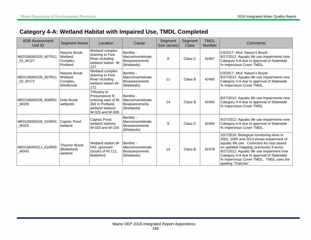
Maine Department of Environmental Protection 2016 Integrated Water Quality Report
Maine DEP 2016 Integrated Report Appendices 166
Category 4 -A: Wetland Habitat with Impaired Use, TMDL Completed ADB Assessment
Unit ID Segment Name Location Cause
Segment Size (acres)
Segment Class
TMDL Number
Comments
ME0106000105_607R11_01_W127
Nasons Brook Wetland Complex, Portland
Wetland complex draining to Fore River including wetland station W-127
Benthic - Macroinvertebrate Bioassessments (Wetlands)
8 Class C 42467
1/3/2017: AKA ‘Nason’s Brook’. 9/27/2012: Aquatic life use impairments now Category 4-A due to approval of Statewide % Impervious Cover TMDL.
ME0106000105_607R11_02_W172
Nasons Brook Wetland Complex, Westbrook
Wetland complex draining to Fore River including wetland station W-172
Benthic - Macroinvertebrate Bioassessments (Wetlands)
11 Class B 42495
1/3/2017: AKA ‘Nason’s Brook’. 9/27/2012: Aquatic life use impairments now Category 4-A due to approval of Statewide % Impervious Cover TMDL.
ME0106000105_609R01_W026
Dole Brook wetlands
Tributary to Presumpscot R, entering east of Rt. 302 in Portland, wetland stations W-025 and W-026
Benthic - Macroinvertebrate Bioassessments (Wetlands)
14 Class B 42460 9/27/2012: Aquatic life use impairments now Category 4-A due to approval of Statewide % Impervious Cover TMDL
ME0106000105_610R01_W023
Capisic Pond wetland
Capisic Pond wetland stations W-023 and W-224
Benthic - Macroinvertebrate Bioassessments (Wetlands)
9 Class C 42456 9/27/2012: Aquatic life use impairments now Category 4-A due to approval of Statewide % Impervious Cover TMDL.
ME0106000211_616R05_W043
Thacher Brook (Biddeford) wetland
Wetland station W-043, upstream (south) of Rt 111, Biddeford
Benthic - Macroinvertebrate Bioassessments (Wetlands)
14 Class B 42478
10/7/2016: Biological monitoring done in 2001, 2005 and 2013 shows impairment of aquatic life use. Corrected AU size based on updated mapping, previously 9 acres. 9/27/2012: Aquatic life use impairment now Category 4-A due to approval of Statewide % Impervious Cover TMDL. TMDL uses the spelling 'Thatcher'.

Maine Department of Environmental Protection 2016 Integrated Water Quality Report
Maine DEP 2016 Integrated Report Appendices 167
Note: ADB Assessment Unit ID prefix corresponds to the associated river/stream or lake assessment units
Category 4 -B: Wetland Habitat Impaired by Pollutants - Pollution Control Requirements Reasonably Expected to Result in Attainment
ADB Assessment Unit ID Segment Name Location Cause
Segment Size
(acres)
Segment Class Comments Expected to
Attain Date
ME0106000301_622R02_W176
Lord's Brook Pond wetland
Wetland station W-176, pond downstream of Winterwood Farm
Benthic - Macroinvertebrate Bioassessments (Wetlands)
6 Class B
11/25/2014: Operation previously causing impairment is no longer active, resampling to assess impairment status is scheduled for 2015.
2014
Note 1: ADB Assessment Unit ID prefix corresponds to the associated river/stream or lake assessment units
Note 2: Bold text indicates waters that were moved into Category 4-A during this reporting cycle
Category 4-C: Wetland Habitat with Impairment not C aused by a Pollutant
ADB Assessment Unit ID Segment Name Location Cause Segment
Size (miles)
Segment Class Comments
ME0101000303_1665L_W208 Daigle Pond west wetlands
New Canada, wetland station W-208
Other flow regime alterations 22 Class
GPA
Also listed in Category 4 -A for Benthic-Macroinvertebrate Bioassessments (Wetlands).
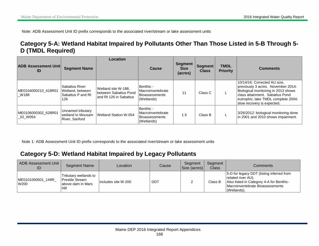
Maine Department of Environmental Protection 2016 Integrated Water Quality Report
Maine DEP 2016 Integrated Report Appendices 168
Note: ADB Assessment Unit ID prefix corresponds to the associated river/stream or lake assessment units
Category 5 -A: Wetland Habitat Impaired by Pollutants Other Tha n Those Listed in 5 -B Through 5 -D (TMDL Required)
ADB Assessment Unit ID Segment Name
Location
Cause Segment
Size (acres)
Segment Class
TMDL Priority Comments
ME0104000210_418R01_W188
Sabattus River Wetland, between Sabattus P and Rt 126
Wetland site W-188, between Sabattus Pond and Rt 126 in Sabattus
Benthic - Macroinvertebrate Bioassessments (Wetlands)
11 Class C L
10/14/16: Corrected AU size, previously 3 acres. November 2014: Biological monitoring in 2013 shows class attainment. Sabattus Pond eutrophic; lake TMDL complete 2004; slow recovery is expected.
ME0106000302_628R01_02_W054
Unnamed tributary wetland to Mousam River, Sanford
Wetland Station W-054
Benthic - Macroinvertebrate Bioassessments (Wetlands)
1.5 Class B L 3/26/2012: biological monitoring done in 2001 and 2010 shows impairment.
Note 1: ADB Assessment Unit ID prefix corresponds to the associated river/stream or lake assessment units
Category 5 -D: Wetland Habitat Impaired by Legacy Pollutants
ADB Assessment Unit ID
Segment Name Location Cause Segment
Size (acres) Segment
Class Comments
ME0101000501_149R_W200
Tributary wetlands to Prestile Stream above dam in Mars Hill
includes site W-200 DDT 2 Class B
5-D for legacy DDT (listing inferred from related river AU). Also listed in Category 4-A for Benthic-Macroinvertebrate Bioassessments (Wetlands).
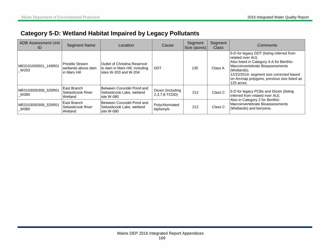
Maine Department of Environmental Protection 2016 Integrated Water Quality Report
Maine DEP 2016 Integrated Report Appendices 169
Category 5 -D: Wetland Habitat Impaired by Legacy Pollutants
ADB Assessment Unit ID
Segment Name Location Cause Segment
Size (acres) Segment
Class Comments
ME0101000501_149R01_W203
Prestile Stream wetlands above dam in Mars Hill
Outlet of Christina Reservoir to dam in Mars Hill, including sites W-203 and W-204
DDT 135 Class A
5-D for legacy DDT (listing inferred from related river AU). Also listed in Category 4-A for Benthic-Macroinvertebrate Bioassessments (Wetlands). 12/22/2014: segment size corrected based on Arcmap polygons, previous size listed as 125 acres.
ME0103000308_325R01_W080
East Branch Sebasticook River Wetland
Between Corundel Pond and Sebasticook Lake, wetland site W-080
Dioxin (including 2,3,7,8-TCDD) 212 Class C 5-D for legacy PCBs and Dioxin (listing
inferred from related river AU). Also in Category 2 for Benthic-Macroinvertebrate Bioassessments (Wetlands) and benzene.
ME0103000308_325R01_W080
East Branch Sebasticook River Wetland
Between Corundel Pond and Sebasticook Lake, wetland site W-080
Polychlorinated biphenyls 212 Class C
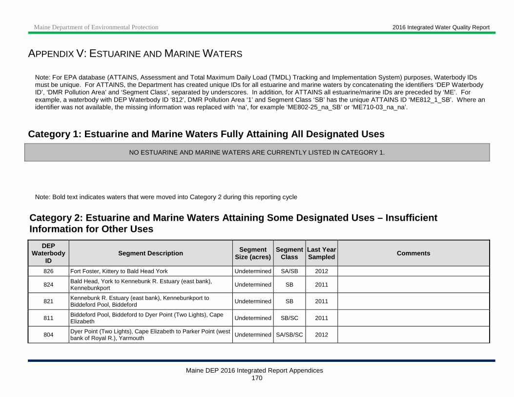
Maine Department of Environmental Protection 2016 Integrated Water Quality Report
Maine DEP 2016 Integrated Report Appendices 170
APPENDIX V: ESTUARINE AND MARINE WATERS
Note: For EPA database (ATTAINS, Assessment and Total Maximum Daily Load (TMDL) Tracking and Implementation System) purposes, Waterbody IDs must be unique. For ATTAINS, the Department has created unique IDs for all estuarine and marine waters by concatenating the identifiers ‘DEP Waterbody ID’, ‘DMR Pollution Area’ and ‘Segment Class’, separated by underscores. In addition, for ATTAINS all estuarine/marine IDs are preceded by ‘ME’. For example, a waterbody with DEP Waterbody ID ‘812’, DMR Pollution Area ‘1’ and Segment Class ‘SB’ has the unique ATTAINS ID ‘ME812_1_SB’. Where an identifier was not available, the missing information was replaced with ‘na’, for example ‘ME802-25_na_SB’ or ‘ME710-03_na_na’.
Category 1: Estuarine and Marine Waters Fully Attai ning All Designated Uses
NO ESTUARINE AND MARINE WATERS ARE CURRENTLY LISTED IN CATEGORY 1.
Note: Bold text indicates waters that were moved into Category 2 during this reporting cycle
Category 2: Estuarine and Marine Waters Attaining S ome Designated Uses – Insufficient Information for Other Uses
DEP Waterbody
ID Segment Description Segment
Size (acres) Segment
Class Last Year Sampled Comments
826 Fort Foster, Kittery to Bald Head York Undetermined SA/SB 2012
824 Bald Head, York to Kennebunk R. Estuary (east bank), Kennebunkport Undetermined SB 2011
821 Kennebunk R. Estuary (east bank), Kennebunkport to Biddeford Pool, Biddeford Undetermined SB 2011
811 Biddeford Pool, Biddeford to Dyer Point (Two Lights), Cape Elizabeth Undetermined SB/SC 2011
804 Dyer Point (Two Lights), Cape Elizabeth to Parker Point (west bank of Royal R.), Yarmouth Undetermined SA/SB/SC 2012

Maine Department of Environmental Protection 2016 Integrated Water Quality Report
Maine DEP 2016 Integrated Report Appendices 171
Category 2: Estuarine and Marine Waters Attaining S ome Designated Uses – Insufficient Information for Other Uses
DEP Waterbody
ID Segment Description Segment
Size (acres) Segment
Class Last Year Sampled Comments
802 Parker Point (west Bank of Royal R.), Yarmouth to south end of Butler Cove (Merrymeeting Bay), Bath
Undetermined SA/SB 2012
710 South end of Butler Cove (Merrymeeting Bay), Bath to east point of Sagadahoc Bay, Georgetown Undetermined SA/SB 2010
730 East point of Sagadahoc Bay, Georgetown to Ocean Point, Boothbay Undetermined SA/SB 2010
729 Ocean Point, Boothbay to Pemaquid Point, Bristol Undetermined SB 2010
726 Pemaquid Point, Bristol to middle north side of Back River Cove, Waldoboro
Undetermined SB 2010
724 Middle north side of Back River Cove, Waldoboro to Marshall Point, St. George Undetermined SB 2012
722 Marshall Point, St. George to Naskeag Point, Brooklin Undetermined SA/SB/SC 2012
722-25B Penobscot River estuary (Reeds Brook to Marsh River) 3,329 SC 1992
Initially included in coastwide 5-D shellfish consumption impairment due to lobster tomalley contamination. Determination was not specific to this location. 1992 survey and 2011 DMR personal communication suggests occurrence of harvestable lobster unlikely in this segment.
722-45 Penobscot R. Estuary 7,624 SC Segment delisted from Cat. 4-B-1 (Fish Consumption Advisory #174) due to erroneous listing in estuarine portion of river.
707 Naskeag Point, Brooklin to Bass Harbor Head, Tremont Undetermined SA/SB 2010
714 Bass Harbor Head, Tremont to Schoodic Point, Winter Harbor Undetermined SA/SB 2010
706 Schoodic Point, Winter Harbor to Petit Manan Point, Steuben Undetermined SA/SB Unknown
705 Petit Manan Point, Steuben to Ray Point, Milbridge Undetermined SA/SB 2010
704 Ray Point, Milbridge to south end of Cape Split, Addison Undetermined SB 2010
703 South end of Cape Split, Addison to Kelley Point, Jonesport Undetermined SA/SB 2010
713 Kelley Point, Jonesport to Point of Maine, Machiasport Undetermined SB 2010

Maine Department of Environmental Protection 2016 Integrated Water Quality Report
Maine DEP 2016 Integrated Report Appendices 172
Category 2: Estuarine and Marine Waters Attaining S ome Designated Uses – Insufficient Information for Other Uses
DEP Waterbody
ID Segment Description Segment
Size (acres) Segment
Class Last Year Sampled Comments
709 Point of Maine, Machiasport to Thornton Point, Cutler Undetermined SA/SB 2010
708 Thornton Point, Cutler to Todd Head, Eastport Undetermined SA/SB/SC 2010
701 Cobscook Bay Undetermined SA/SB 2010
702 Todd Head, Eastport to Whitlocks Mill, Calais Undetermined SB/SC 2002

Maine Department of Environmental Protection 2016 Integrated Water Quality Report
Maine DEP 2016 Integrated Report Appendices 173
Category 3: Estuarine and Marine Waters with Insuff icient Data or Information to Determine if Designated Uses are Attained (One or More Uses may be Impaired)
DEP Waterbody
ID
DMR Pollution
Area Segment Description Segment
Size (acres) Segment
Class Last Year Sampled
Projected Sample Date Comments
722-10 29-B Matinicus Island & Ragged Island 2,203 SB Unknown Undetermined No historic or anticipated fecal indicator bacteria sampling due to remoteness (DMR 2015 pers. comm.)
702-3 59 Little River (Perry) 29 SB 2012 2013 Non-point source pollution. Fecal indicator bacteria possibly of wildlife origin (DMR 2015 pers. comm.).
Total = 2,232
Category 4-A(a): Estuarine and Marine Waters with I mpaired Use - TMDL Completed
DEP Waterbody ID Segment Description Segment
Size (acres) Segment
Class Last Year Sampled TMDL Approved Cause
812-1 Salmon Falls R. / Piscataqua R. Estuary (Eliot, S. Berwick) 615 SB 2012 1999 Dissolved Oxygen
Total = 615
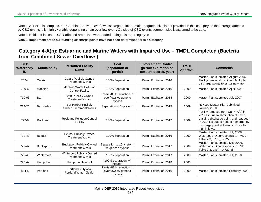
Maine Department of Environmental Protection 2016 Integrated Water Quality Report
Maine DEP 2016 Integrated Report Appendices 174
Note 1: A TMDL is complete, but Combined Sewer Overflow discharge points remain. Segment size is not provided in this category as the acreage affected by CSO events is is highly variable depending on an overflow event. Outside of CSO events segment size is assumed to be zero.
Note 2: Bold text indicates CSO-affected areas that were added during this reporting cycle
Note 3: Impairment areas surrounding discharge points have not been determined for this Category
Category 4-A(b): Estuarine and Marine Waters with I mpaired Use – TMDL Completed (Bacteria from Combined Sewer Overflows)
DEP Waterbody
ID Municipality Permitted Facility
Name
Goal (separation or
partial)
Enforcement Control (permit expiration or
consent decree, year)
TMDL Approval Comments
702-4 Calais Calais Publicly Owned Treatment Works 100% Separation Permit Expiration 2016
Master Plan submitted August 2006. Facility previously omitted. Multiple discharge points to estuarine water.
709-6 Machias Machias Water Pollution Control Facility 100% Separation Permit Expiration 2016 2009 Master Plan submitted April 2008
710-03 Bath Bath Publicly Owned Treatment Works
Partial-85% reduction in overflows w/ generic
bypass Permit Expiration 2014 2009 Master Plan submitted July 2007
714-21 Bar Harbor Bar Harbor Publicly Owned Treatment Works Separation to 1-yr storm Permit Expiration 2015 2009 Revised Master Plan submitted
January 2010
722-8 Rockland Rockland Pollution Control Facility 100% Separation Permit Expiration 2012 2009
Facility removed from Cat. 4-A(b) in 2012 list due to elimination of Town Landing discharge point, and readded in 2014 list due to need for emergency discharge point at Lermond Cove for high inflows.
722-41 Belfast Belfast Publicly Owned
Treatment Works 100% Separation Permit Expiration 2016 2009 Master Plan submitted July 2008. Waterbody ID corresponds to TMDL Table 2.3, LIST_ID 722-23.
722-42 Bucksport Bucksport Publicly Owned Treatment Works
Separation to 10-yr storm w/ generic bypass
Permit Expiration 2017 2009 Master Plan submitted May 2006. Waterbody ID corresponds to TMDL Table 2.3, LIST_ID 722-25.
722-43 Winterport Winterport Publicly Owned Treatment Works 100% Separation Permit Expiration 2017 2009 Master Plan submitted July 2010
722-44 Hampden Hampden, Town of 100% separation w/ storage
Permit Expiration 2013 2009
804-5 Portland Portland, City of & Portland Water District
Partial-88% reduction in overflows w/ generic
bypass Permit Expiration 2016 2009 Master Plan submitted February 2003
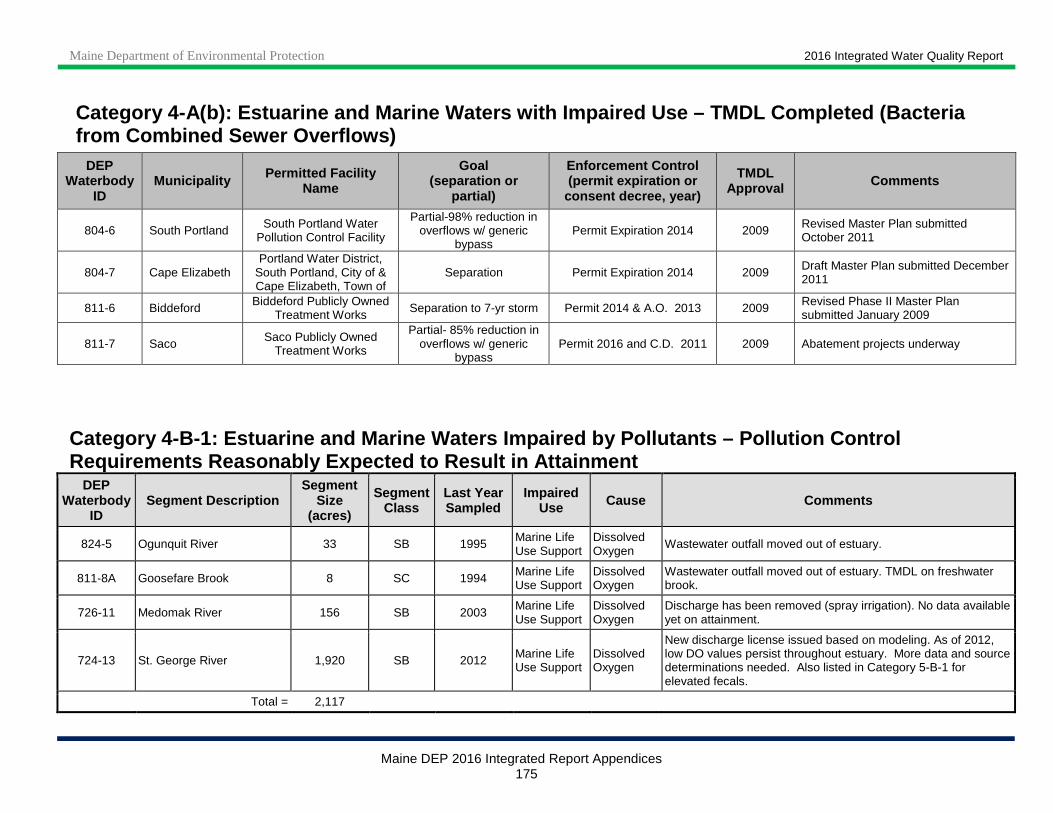
Maine Department of Environmental Protection 2016 Integrated Water Quality Report
Maine DEP 2016 Integrated Report Appendices 175
Category 4-A(b): Estuarine and Marine Waters with I mpaired Use – TMDL Completed (Bacteria from Combined Sewer Overflows)
DEP Waterbody
ID Municipality Permitted Facility
Name
Goal (separation or
partial)
Enforcement Control (permit expiration or
consent decree, year)
TMDL Approval Comments
804-6 South Portland South Portland Water Pollution Control Facility
Partial-98% reduction in overflows w/ generic
bypass Permit Expiration 2014 2009 Revised Master Plan submitted
October 2011
804-7 Cape Elizabeth Portland Water District,
South Portland, City of & Cape Elizabeth, Town of
Separation Permit Expiration 2014 2009 Draft Master Plan submitted December 2011
811-6 Biddeford Biddeford Publicly Owned Treatment Works Separation to 7-yr storm Permit 2014 & A.O. 2013 2009 Revised Phase II Master Plan
submitted January 2009
811-7 Saco Saco Publicly Owned Treatment Works
Partial- 85% reduction in overflows w/ generic
bypass Permit 2016 and C.D. 2011 2009 Abatement projects underway
Category 4-B-1: Estuarine and Marine Waters Impaire d by Pollutants – Pollution Control Requirements Reasonably Expected to Result in Attai nment
DEP Waterbody
ID Segment Description
Segment Size
(acres)
Segment Class
Last Year Sampled
Impaired Use Cause Comments
824-5 Ogunquit River 33 SB 1995 Marine Life Use Support
Dissolved Oxygen
Wastewater outfall moved out of estuary.
811-8A Goosefare Brook 8 SC 1994 Marine Life Use Support
Dissolved Oxygen
Wastewater outfall moved out of estuary. TMDL on freshwater brook.
726-11 Medomak River 156 SB 2003 Marine Life Use Support
Dissolved Oxygen
Discharge has been removed (spray irrigation). No data available yet on attainment.
724-13 St. George River 1,920 SB 2012 Marine Life Use Support
Dissolved Oxygen
New discharge license issued based on modeling. As of 2012, low DO values persist throughout estuary. More data and source determinations needed. Also listed in Category 5-B-1 for elevated fecals.
Total = 2,117
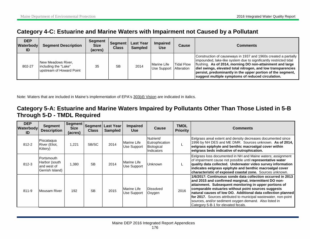
Maine Department of Environmental Protection 2016 Integrated Water Quality Report
Maine DEP 2016 Integrated Report Appendices 176
Category 4-C: Estuarine and Marine Waters with Impa irment not Caused by a Pollutant
DEP Waterbody
ID Segment Description
Segment Size
(acres)
Segment Class
Last Year Sampled
Impaired Use Cause Comments
802-27 New Meadows River, including the "Lake" upstream of Howard Point
35 SB 2014 Marine Life Use Support
Tidal Flow Alteration
Construction of causeways in 1937 and 1960s created a partially impounded, lake-like system due to significantly restricted tidal flushing. As of 2014, morning DO non-attainment and large diel swings, elevated total nitrogen, and low trans parencies persist, predominantly in the upper portion of the segment, suggest multiple symptoms of reduced circulation.
Note: Waters that are included in Maine’s implementation of EPA’s 303(d) Vision are indicated in italics.
Category 5-A: Estuarine and Marine Waters Impaired by Pollutants Other Than Those Listed in 5-B Through 5-D - TMDL Required
DEP Waterbody
ID
Segment Description
Segment Size
(acres)
Segment Class
Last Year Sampled
Impaired Use Cause TMDL
Priority Comments
812-2 Piscataqua River (Eliot, Kittery)
1,221 SB/SC 2014 Marine Life Use Support
Nutrient/ Eutrophication Biological Indicators
L
Eelgrass areal extent and density decreases documented since 1996 by NH DES and ME DMR. Sources unknown. As of 2014, eelgrass epiphyte and benthic macroalgal cover with in eelgrass beds indicative of eutrophication.
812-3
Portsmouth Harbor (south and west of Gerrish Island)
1,380 SB 2014 Marine Life Use Support Unknown L
Eelgrass loss documented in NH and Maine waters; assignment of impairment cause not possible until representative water quality data collected. Underwater video survey informatio n indicates eelgrass epiphyte and benthic macroalgal cover characteristic of exposed coastal zone. Sources unknown.
811-9 Mousam River 192 SB 2015 Marine Life Use Support
Dissolved Oxygen 2016
1/6/2017: Continuous sonde data collection occurred in 2013 and 2015 and confirmed marginal, intermittent DO no n-attainment. Subsequent monitoring in upper portion s of comparable estuaries without point sources suggests natural causes of low DO. Addition al data collection planned for 2017. Sources attributed to municipal wastewater, non-point sources, and/or sediment oxygen demand. Also listed in Category 5-B-1 for elevated fecals.
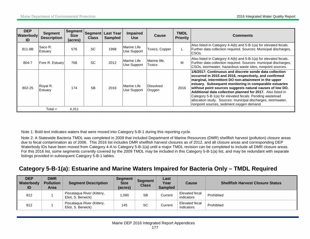
Maine Department of Environmental Protection 2016 Integrated Water Quality Report
Maine DEP 2016 Integrated Report Appendices 177
DEP Waterbody
ID
Segment Description
Segment Size
(acres)
Segment Class
Last Year Sampled
Impaired Use Cause TMDL
Priority Comments
811-8B Saco R. Estuary
576 SC 1998 Marine Life Use Support
Toxics, Copper L Also listed in Category 4-A(b) and 5-B-1(a) for elevated fecals. Further data collection required. Sources: Municipal discharges, CSOs.
804-7 Fore R. Estuary 768 SC 2012 Marine Life Use Support
Marine life, Toxics M
Also listed in Category 4-A(b) and 5-B-1(a) for elevated fecals. Further data collection required. Sources: municipal discharges, CSOs, stormwater, hazardous waste sites, nonpoint sources.
802-25 Royal R. Estuary 174 SB 2016 Marine Life
Use Support Dissolved Oxygen 2016
1/6/2017: Continuous and discrete sonde data collection occurred in 2015 and 2016, respectively, and confir med marginal, intermittent DO non-attainment in the upp er estuary. Subsequent monitoring in comparable estua ries without point sources suggests natural causes of lo w DO. Additional data collection planned for 2017. Also listed in Category 5-B-1(a) for elevated fecals. Pending wasteload allocation study. Sources: municipal discharges, stormwater, nonpoint sources, sediment oxygen demand.
Total = 4,311
Note 1: Bold text indicates waters that were moved into Category 5-B-1 during this reporting cycle.
Note 2: A Statewide Bacteria TMDL was completed in 2009 that included Department of Marine Resources (DMR) shellfish harvest (pollution) closure areas due to fecal contamination as of 2006. This 2016 list includes DMR shellfish harvest closures as of 2012, and all closure areas and corresponding DEP Waterbody IDs have been moved from Category 4-A to Category 5-B-1(a) until a major TMDL revision can be completed to include all DMR closure areas. For this 2016 list, some segments currently covered by the 2009 TMDL may be included in this Category 5-B-1(a) list, and may be redundant with separate listings provided in subsequent Category 5-B-1 tables.
Category 5-B-1(a): Estuarine and Marine Waters Impa ired for Bacteria Only – TMDL Required
DEP Waterbody
ID
DMR Pollution
Area Segment Description
Segment Size
(acres)
Segment Class
Last Year
Sampled Cause Shellfish Harvest Closure Status
812 1 Piscataqua River (Kittery, Eliot, S. Berwick)
1,090 SB Current Elevated fecal indicators
Prohibited
812 1 Piscataqua River (Kittery, Eliot, S. Berwick) 145 SC Current Elevated fecal
indicators Prohibited
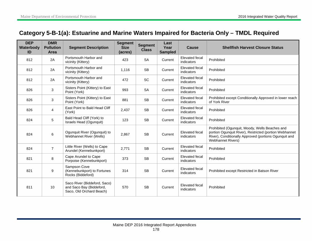
Maine Department of Environmental Protection 2016 Integrated Water Quality Report
Maine DEP 2016 Integrated Report Appendices 178
Category 5-B-1(a): Estuarine and Marine Waters Impa ired for Bacteria Only – TMDL Required
DEP Waterbody
ID
DMR Pollution
Area Segment Description
Segment Size
(acres)
Segment Class
Last Year
Sampled Cause Shellfish Harvest Closure Status
812 2A Portsmouth Harbor and vicinity (Kittery) 423 SA Current Elevated fecal
indicators Prohibited
812 2A Portsmouth Harbor and vicinity (Kittery) 1,116 SB Current Elevated fecal
indicators Prohibited
812 2A Portsmouth Harbor and vicinity (Kittery) 472 SC Current Elevated fecal
indicators Prohibited
826 3 Sisters Point (Kittery) to East Point (York) 993 SA Current Elevated fecal
indicators Prohibited
826 3 Sisters Point (Kittery) to East Point (York) 881 SB Current Elevated fecal
indicators Prohibited except Conditionally Approved in lower reach of York River
826 4 East Point to Bald Head Cliff (York) 2,437 SB Current Elevated fecal
indicators Prohibited
824 5 Bald Head Cliff (York) to Israels Head (Ogunquit)
123 SB Current Elevated fecal indicators
Prohibited
824 6 Ogunquit River (Ogunquit) to Webhannet River (Wells) 2,867 SB Current Elevated fecal
indicators
Prohibited (Ogunquit, Moody, Wells Beaches and portion Ogunquit River), Restricted (portion Webhannet River), Conditionally Approved (portions Ogunquit and Webhannet Rivers)
824 7 Little River (Wells) to Cape Arundel (Kennebunkport) 2,771 SB Current Elevated fecal
indicators Prohibited
821 8 Cape Arundel to Cape Porpoise (Kennebunkport) 373 SB Current Elevated fecal
indicators Prohibited
821 9 Sampson Cove (Kennebunkport) to Fortunes Rocks (Biddeford)
314 SB Current Elevated fecal indicators Prohibited except Restricted in Batson River
811 10 Saco River (Biddeford, Saco) and Saco Bay (Biddeford, Saco, Old Orchard Beach)
570 SB Current Elevated fecal indicators Prohibited

Maine Department of Environmental Protection 2016 Integrated Water Quality Report
Maine DEP 2016 Integrated Report Appendices 179
Category 5-B-1(a): Estuarine and Marine Waters Impa ired for Bacteria Only – TMDL Required
DEP Waterbody
ID
DMR Pollution
Area Segment Description
Segment Size
(acres)
Segment Class
Last Year
Sampled Cause Shellfish Harvest Closure Status
811 10 Saco River (Biddeford, Saco) and Saco Bay (Biddeford, Saco, Old Orchard Beach)
10,833 SC Current Elevated fecal indicators Prohibited except Restricted at Hills Beach
811 11 Scarborough River (Scarborough) 298 SA Current Elevated fecal
indicators
Prohibited (Libby River), Restricted (upper Scarborough River, Mill Brook, upper Nonesuch River), Conditionally Approved (lower Scarborough and lower Nonesuch Rivers)
811 11 Scarborough River (Scarborough) 11 SB Current Elevated fecal
indicators Prohibited (Libby River), Restricted (Doc’s Creek)
811 12
Spurwink River, Prouts Neck (Old Orchard Beach, Scarborough, Cape Elizabeth)
85 SA Current Elevated fecal indicators Conditionally Approved
811 12
Spurwink River, Prouts Neck (Old Orchard Beach, Scarborough, Cape Elizabeth)
5,231 SB Current Elevated fecal indicators
Prohibited except Conditionally Approved from Prouts Neck to McKenney Point
804 13
Western Casco Bay and islands (Cape Elizabeth, South Portland, Portland, Falmouth, Long Island, Great Chebeague Island)
841 SA Current Elevated fecal indicators
Prohibited
804 13
Western Casco Bay and islands (Cape Elizabeth, South Portland, Portland, Falmouth, Long Island, Great Chebeague Island)
34,467 SB Current Elevated fecal indicators
Prohibited except Conditionally Approved from Waites Landing (Falmouth) to Falmouth Landing, incl. The Brothers
804 13
Western Casco Bay and islands (Cape Elizabeth, South Portland, Portland, Falmouth, Long Island, Great Chebeague Island)
3,984 SC Current Elevated fecal indicators Prohibited
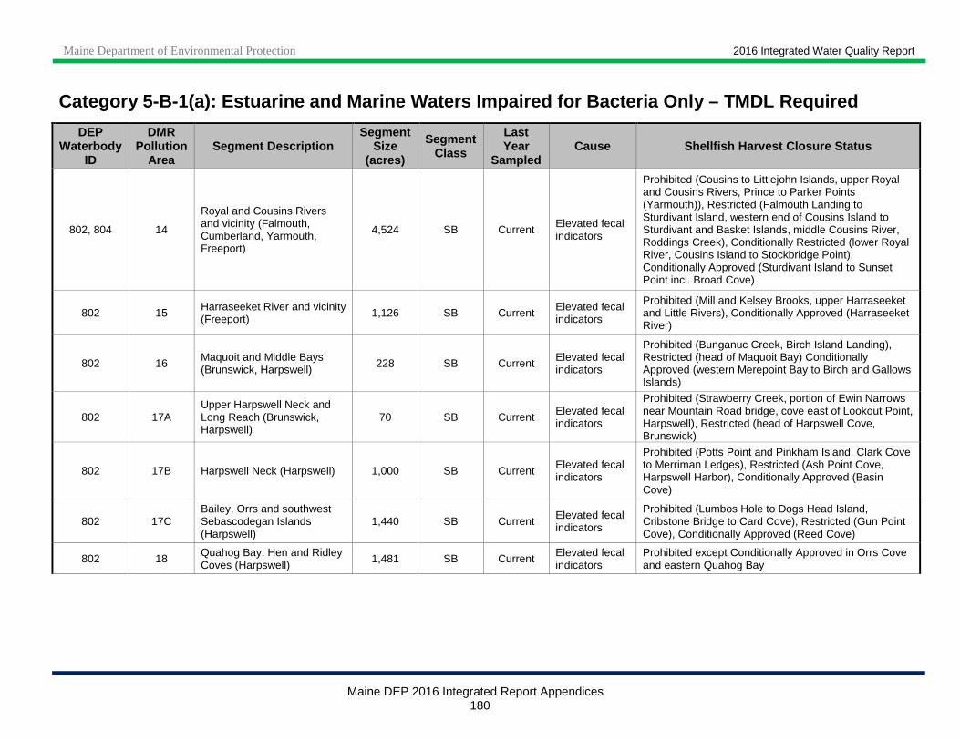
Maine Department of Environmental Protection 2016 Integrated Water Quality Report
Maine DEP 2016 Integrated Report Appendices 180
Category 5-B-1(a): Estuarine and Marine Waters Impa ired for Bacteria Only – TMDL Required
DEP Waterbody
ID
DMR Pollution
Area Segment Description
Segment Size
(acres)
Segment Class
Last Year
Sampled Cause Shellfish Harvest Closure Status
802, 804 14
Royal and Cousins Rivers and vicinity (Falmouth, Cumberland, Yarmouth, Freeport)
4,524 SB Current Elevated fecal indicators
Prohibited (Cousins to Littlejohn Islands, upper Royal and Cousins Rivers, Prince to Parker Points (Yarmouth)), Restricted (Falmouth Landing to Sturdivant Island, western end of Cousins Island to Sturdivant and Basket Islands, middle Cousins River, Roddings Creek), Conditionally Restricted (lower Royal River, Cousins Island to Stockbridge Point), Conditionally Approved (Sturdivant Island to Sunset Point incl. Broad Cove)
802 15 Harraseeket River and vicinity (Freeport) 1,126 SB Current Elevated fecal
indicators
Prohibited (Mill and Kelsey Brooks, upper Harraseeket and Little Rivers), Conditionally Approved (Harraseeket River)
802 16 Maquoit and Middle Bays (Brunswick, Harpswell) 228 SB Current Elevated fecal
indicators
Prohibited (Bunganuc Creek, Birch Island Landing), Restricted (head of Maquoit Bay) Conditionally Approved (western Merepoint Bay to Birch and Gallows Islands)
802 17A Upper Harpswell Neck and Long Reach (Brunswick, Harpswell)
70 SB Current Elevated fecal indicators
Prohibited (Strawberry Creek, portion of Ewin Narrows near Mountain Road bridge, cove east of Lookout Point, Harpswell), Restricted (head of Harpswell Cove, Brunswick)
802 17B Harpswell Neck (Harpswell) 1,000 SB Current Elevated fecal indicators
Prohibited (Potts Point and Pinkham Island, Clark Cove to Merriman Ledges), Restricted (Ash Point Cove, Harpswell Harbor), Conditionally Approved (Basin Cove)
802 17C Bailey, Orrs and southwest Sebascodegan Islands (Harpswell)
1,440 SB Current Elevated fecal indicators
Prohibited (Lumbos Hole to Dogs Head Island, Cribstone Bridge to Card Cove), Restricted (Gun Point Cove), Conditionally Approved (Reed Cove)
802 18 Quahog Bay, Hen and Ridley Coves (Harpswell)
1,481 SB Current Elevated fecal indicators
Prohibited except Conditionally Approved in Orrs Cove and eastern Quahog Bay

Maine Department of Environmental Protection 2016 Integrated Water Quality Report
Maine DEP 2016 Integrated Report Appendices 181
Category 5-B-1(a): Estuarine and Marine Waters Impa ired for Bacteria Only – TMDL Required
DEP Waterbody
ID
DMR Pollution
Area Segment Description
Segment Size
(acres)
Segment Class
Last Year
Sampled Cause Shellfish Harvest Closure Status
802 19A Upper New Meadows River (Brunswick, West Bath, Harpswell)
234 SB Current Elevated fecal indicators
Prohibited (Indian Rest Cove, Rosedale Point, upper New Meadows Lake Marsh, portion of Long Cove), Restricted (southern portion of New Meadows River segment), Conditionally Approved (northern portion of New Meadows River segment and New Meadows Lake, portion of Long Cove)
802 19B Middle New Meadows River (West Bath, Harpswell, Phippsburg)
139 SB Current Elevated fecal indicators
Prohibited (west of Long Island, Dingley Island cove, upper Dam Cove, Bringham’s Cove), Restricted (Merritt Island to lower Dam Cove, southeast of Hen Island)
802 19C Lower New Meadows River (Harpswell, Phippsburg) 740 SB Current Elevated fecal
indicators
Prohibited (Sheep Island to Sandy Cove, Bear Island cove, Malaga Island to western edge of Round Cove, Burnt Coat Island to Newbury Pt., Eastern Cape Small Harbor), Restricted (Round Cove), Conditionally Approved (Tottmann Cove)
710 20 Upper Kennebec River and Tributaries 17,294 SB Current Elevated fecal
indicators Approved. This waterbody ID was inadvertently omitted from this category in the 2014 cycle.
710 20G Middle Kennebec River 1,146 SB Current Elevated fecal indicators
Approved. This waterbody ID was inadvertently omitted from this category in the 2014 cycle.
710 20H Lower Kennebec, Phippsburg/Georgetown 1,865 SB Current Elevated fecal
indicators Approved. This waterbody ID was inadvertently omitted from this category in the 2014 cycle.
710 21A Upper Sheepscot River and tributaries (Wiscasset, Alna, Newcastle)
1,058 SB Current Elevated fecal indicators
Prohibited (Dyer River, Sherman Lake), Restricted (upper Sheepscot River, Deer Meadow Brook), Conditionally Approved (Polly Clark Cove)
730 21B Sheepscot River (Wiscasset, Edgecomb, Westport Island) 966 SB Current Elevated fecal
indicators Prohibited

Maine Department of Environmental Protection 2016 Integrated Water Quality Report
Maine DEP 2016 Integrated Report Appendices 182
Category 5-B-1(a): Estuarine and Marine Waters Impa ired for Bacteria Only – TMDL Required
DEP Waterbody
ID
DMR Pollution
Area Segment Description
Segment Size
(acres)
Segment Class
Last Year
Sampled Cause Shellfish Harvest Closure Status
710 21C Back River and Montsweag Bay (Woolwich, Wiscasset, Westport Island)
1,551 SB Current Elevated fecal indicators
Prohibited (portion Brookings Bay, upper Montsweag Brook, upper Chewonki Stream, Bailey Cove, upper Back River), Restricted (lower Back River, Montsweag Bay), Conditionally Approved (portion Brookings Bay, lower Montsweag Brook, lower Chewonki Stream)
730 21D
Sheepscot River (Georgetown, Westport Island, Boothbay, Boothbay Harbor, Southport, Edgecomb)
2,856 SB Current Elevated fecal indicators
Prohibited (Parsons Creek, portion Cross River, southern portion Sheepscot River, Barters Island), Conditionally Approved (Sherman Creek, portion Cross River)
710, 730 21E
Hockomock Bay to Robinhood Cove (Arrowsic, Georgetown, Woolwich, Westport Island)
1,934 SB Current Elevated fecal indicators
Prohibited (Sasanoa and Back Rivers, Robinhood, Bailey and Tarbox Coves, the Knubble), Restricted (Hockomok Bay)
730 21F Lower Sheepscot River and Sheepscot Bay (Georgetown, Southport, Boothbay Harbor)
28 SA Current Elevated fecal indicators Prohibited
730 21F Lower Sheepscot River and Sheepscot Bay (Georgetown, Southport, Boothbay Harbor)
2,400 SB Current Elevated fecal indicators Prohibited
730 22 Boothbay and vicinity (Southport, Boothbay Harbor, Boothbay)
314 SA Current Elevated fecal indicators
Prohibited
730 22 Boothbay and vicinity (Southport, Boothbay Harbor, Boothbay)
5,534 SB Current Elevated fecal indicators
Prohibited
729 23A Upper Damariscotta River (Newcastle, Nobleboro, Damariscotta)
824 SB Current Elevated fecal indicators
Prohibited (Great Salt Bay, Damariscotta River), Restricted (Days and Huston Coves), Conditionally Approved (upper Damariscotta River)
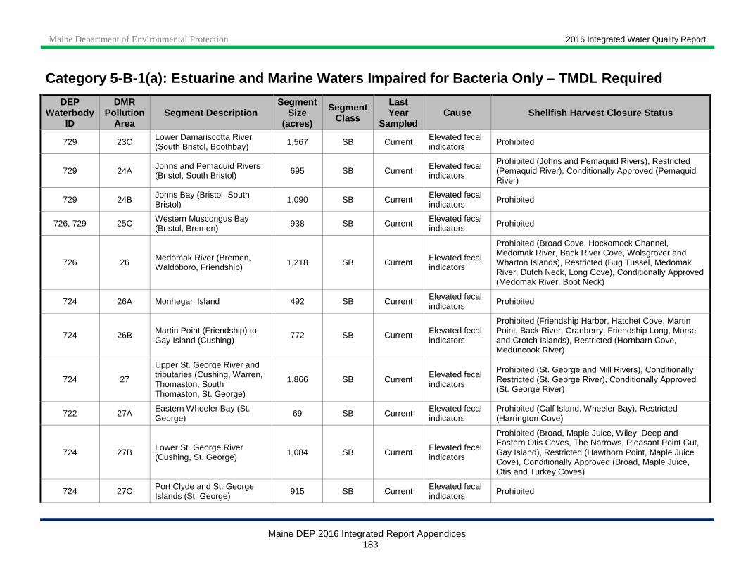
Maine Department of Environmental Protection 2016 Integrated Water Quality Report
Maine DEP 2016 Integrated Report Appendices 183
Category 5-B-1(a): Estuarine and Marine Waters Impa ired for Bacteria Only – TMDL Required
DEP Waterbody
ID
DMR Pollution
Area Segment Description
Segment Size
(acres)
Segment Class
Last Year
Sampled Cause Shellfish Harvest Closure Status
729 23C Lower Damariscotta River (South Bristol, Boothbay) 1,567 SB Current Elevated fecal
indicators Prohibited
729 24A Johns and Pemaquid Rivers (Bristol, South Bristol) 695 SB Current Elevated fecal
indicators
Prohibited (Johns and Pemaquid Rivers), Restricted (Pemaquid River), Conditionally Approved (Pemaquid River)
729 24B Johns Bay (Bristol, South Bristol) 1,090 SB Current Elevated fecal
indicators Prohibited
726, 729 25C Western Muscongus Bay (Bristol, Bremen) 938 SB Current Elevated fecal
indicators Prohibited
726 26 Medomak River (Bremen, Waldoboro, Friendship) 1,218 SB Current Elevated fecal
indicators
Prohibited (Broad Cove, Hockomock Channel, Medomak River, Back River Cove, Wolsgrover and Wharton Islands), Restricted (Bug Tussel, Medomak River, Dutch Neck, Long Cove), Conditionally Approved (Medomak River, Boot Neck)
724 26A Monhegan Island 492 SB Current Elevated fecal indicators Prohibited
724 26B Martin Point (Friendship) to Gay Island (Cushing)
772 SB Current Elevated fecal indicators
Prohibited (Friendship Harbor, Hatchet Cove, Martin Point, Back River, Cranberry, Friendship Long, Morse and Crotch Islands), Restricted (Hornbarn Cove, Meduncook River)
724 27
Upper St. George River and tributaries (Cushing, Warren, Thomaston, South Thomaston, St. George)
1,866 SB Current Elevated fecal indicators
Prohibited (St. George and Mill Rivers), Conditionally Restricted (St. George River), Conditionally Approved (St. George River)
722 27A Eastern Wheeler Bay (St. George) 69 SB Current Elevated fecal
indicators Prohibited (Calf Island, Wheeler Bay), Restricted (Harrington Cove)
724 27B Lower St. George River (Cushing, St. George) 1,084 SB Current Elevated fecal
indicators
Prohibited (Broad, Maple Juice, Wiley, Deep and Eastern Otis Coves, The Narrows, Pleasant Point Gut, Gay Island), Restricted (Hawthorn Point, Maple Juice Cove), Conditionally Approved (Broad, Maple Juice, Otis and Turkey Coves)
724 27C Port Clyde and St. George Islands (St. George) 915 SB Current Elevated fecal
indicators Prohibited

Maine Department of Environmental Protection 2016 Integrated Water Quality Report
Maine DEP 2016 Integrated Report Appendices 184
Category 5-B-1(a): Estuarine and Marine Waters Impa ired for Bacteria Only – TMDL Required
DEP Waterbody
ID
DMR Pollution
Area Segment Description
Segment Size
(acres)
Segment Class
Last Year
Sampled Cause Shellfish Harvest Closure Status
722 28 Marshall Point to Clark Cove (St. George) 863 SB Current Elevated fecal
indicators Prohibited (Marshall Point, Tenants Harbor, Seavey and Clark Coves), Restricted (Mosquito Harbor, Long Cove)
722 28A Weskeag River (South Thomaston, Owls Head) 363 SB Current Elevated fecal
indicators
Prohibited (Nabby and Upper Ballyhac Coves, Cushing Point), Restricted (Upper and Middle Weskeag River, Sharkeyville Creek), Conditionally Approved (Lower Weskeag River)
722 28B Patten Point (St. George) to Thorndike Point (South Thomaston)
510 SB Current Elevated fecal indicators Prohibited
722 28C Rackliff Island (St. George) 107 SB Current Elevated fecal indicators
Prohibited (Rackliff Island), Restricted (unnamed cove between Calf and Rackliff Islands)
722 29 Rockland Harbor (Rockland and Owls Head), Broad and Deep Coves (Owls Head)
590 SB Current Elevated fecal indicators Prohibited
722 29 Rockland Harbor (Rockland and Owls Head), Broad and Deep Coves (Owls Head)
1,732 SC Current Elevated fecal indicators
Prohibited
722 29A Otter Point to Owls Head (Owls Head)
706 SB Current Elevated fecal indicators
Prohibited
722 29B Matinicus Island (Matinicus Island and Criehaven Townships)
2,128 SB Current Elevated fecal indicators Prohibited
722 29C Metinic, Little Green and Large Green Islands (Knox County Islands)
3,044 SB Current Elevated fecal indicators Prohibited
722 30 Jameson to Deadman Points (Rockport) 1,819 SB Current Elevated fecal
indicators Prohibited
722 30I North Haven Island (North Haven) and Fox Islands Thorofare (Vinalhaven)
2,044 SB Current Elevated fecal indicators
Prohibited (Pulpit, Bartlett and Southern Harbors, Deacon Browns and Indian Points, Kent Cove and Burnt Island, Fox Islands Thorofare), Restricted (Ames Creek, Cox Cove), Conditionally Approved (Salt Pond)
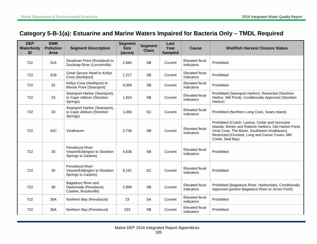
Maine Department of Environmental Protection 2016 Integrated Water Quality Report
Maine DEP 2016 Integrated Report Appendices 185
Category 5-B-1(a): Estuarine and Marine Waters Impa ired for Bacteria Only – TMDL Required
DEP Waterbody
ID
DMR Pollution
Area Segment Description
Segment Size
(acres)
Segment Class
Last Year
Sampled Cause Shellfish Harvest Closure Status
722 31A Deadman Point (Rockland) to Ducktrap River (Lincolnville) 2,980 SB Current Elevated fecal
indicators Prohibited
722 31B Great Spruce Head to Kellys Cove (Northport) 1,217 SB Current Elevated fecal
indicators Prohibited
722 32 Kellys Cove (Northport) to Moose Point (Searsport) 4,089 SB Current Elevated fecal
indicators Prohibited
722 33 Searsport Harbor (Searsport), to Cape Jellison (Stockton Springs)
1,924 SB Current Elevated fecal indicators
Prohibited (Searsport Harbor), Restricted (Stockton Harbor, Mill Pond), Conditionally Approved (Stockton Harbor)
722 33 Searsport Harbor (Searsport), to Cape Jellison (Stockton Springs)
1,060 SC Current Elevated fecal indicators Prohibited (Northern Long Cove, Sears Island)
722 34C Vinalhaven 2,736 SB Current Elevated fecal indicators
Prohibited (Crotch, Lawrys, Cedar and Hurricane Islands, Winter and Roberts Harbors, Old Harbor Pond, Vinal Cove, The Basin, Southwest Vinalhaven), Restricted (Crockett, Long and Carver Coves, Mill Creek, Seal Bay)
722 35 Penobscot River Veazie/Eddington to Stockton Springs to Castine)
4,636 SB Current Elevated fecal indicators
Prohibited
722 35 Penobscot River Veazie/Eddington to Stockton Springs to Castine)
8,191 SC Current Elevated fecal indicators Prohibited
722 36 Bagaduce River and Harborside (Penobscot, Castine, Brooksville)
2,890 SB Current Elevated fecal indicators
Prohibited (Bagaduce River, Harborside), Conditionally Approved (portion Bagaduce River to Jones Point)
722 36A Northern Bay (Penobscot) 23 SA Current Elevated fecal indicators Prohibited
722 36A Northern Bay (Penobscot) 233 SB Current Elevated fecal indicators Prohibited

Maine Department of Environmental Protection 2016 Integrated Water Quality Report
Maine DEP 2016 Integrated Report Appendices 186
Category 5-B-1(a): Estuarine and Marine Waters Impa ired for Bacteria Only – TMDL Required
DEP Waterbody
ID
DMR Pollution
Area Segment Description
Segment Size
(acres)
Segment Class
Last Year
Sampled Cause Shellfish Harvest Closure Status
722 36B Upper Bagaduce River (Brooksville, Sedgwick) 170 SA Current Elevated fecal
indicators Prohibited (unnamed cove), Restricted (Camp Stream, Snow and unnamed Coves, Bluff Head)
722 36F Islesboro 2,218 SB Current Elevated fecal indicators
Prohibited (Sabbathday Harbor, Islesboro Harbor to Flat Island, Seven Hundred Acre Island), Restricted (Seal Harbor)
722 37 Condon Point to The Herricks and Orcutt Harbor (Brooksville)
873 SB Current Elevated fecal indicators
Prohibited (Condon Point to The Herricks), Conditionally Approved (Orcutt Harbor)
722 38 Deer Isle, Stonington and Merchants Row 561 SB Current Elevated fecal
indicators
Prohibited (Pumpkin Island to Eggemoggin, Heart Island, Northwest and Inner Harbors, Mill and Holt Ponds, Burnt and Burnt Hill Coves, Stonington Harbor, St. Helena and Devil Islands), Restricted (Blastow, Burnt, Crockett and Western Coves)
722 38B Benjamin River (Sedgwick, Brooklin) and Center Harbor (Brooklin)
487 SB Current Elevated fecal indicators
Restricted (upper Benjamin River), Conditionally Approved (middle, lower portions Benjamin River, Center Harbor)
707 39 Blue Hill Harbor and vicinity (Sedgwick, Blue Hill, Brooklin)
1,224 SB Current Elevated fecal indicators
Prohibited (Blue Hill Harbor, McHeard Cove, western Blue Hill Bay), Restricted (Bragdon Brook cove), Conditionally Restricted (inner Blue Hill Harbor), Conditionally Approved (portions Salt Pond and Blue Hill Harbor)
707, 722 39C Herrick Bay and Flye Point (Brooklin)
57 SB Current Elevated fecal indicators
Restricted (upper Herrick Bay, eastern Flye Point)
707 40
Northern Morgan, Union River, and Patten Bays, Heath Brook (Surry, Ellsworth, Trenton), Goose Cove (Trenton)
8,635 SB Current Elevated fecal indicators
Prohibited (Northern Morgan Bay, Patten Bay, Union River, Heath Brook Cove), Conditionally Approved (Union River and Patten Bays, Goose Cove)
707 42 Western Mount Desert Island (Tremont, Bar Harbor) 802 SB Current Elevated fecal
indicators Prohibited (Duck Cove, Bass Harbor), Restricted (Northwest Cove)
707 42B Swan’s Island 555 SB Current Elevated fecal indicators
Prohibited (Cottles Cove, Red Point), Restricted (Toothacher Cove, Mill Pond)
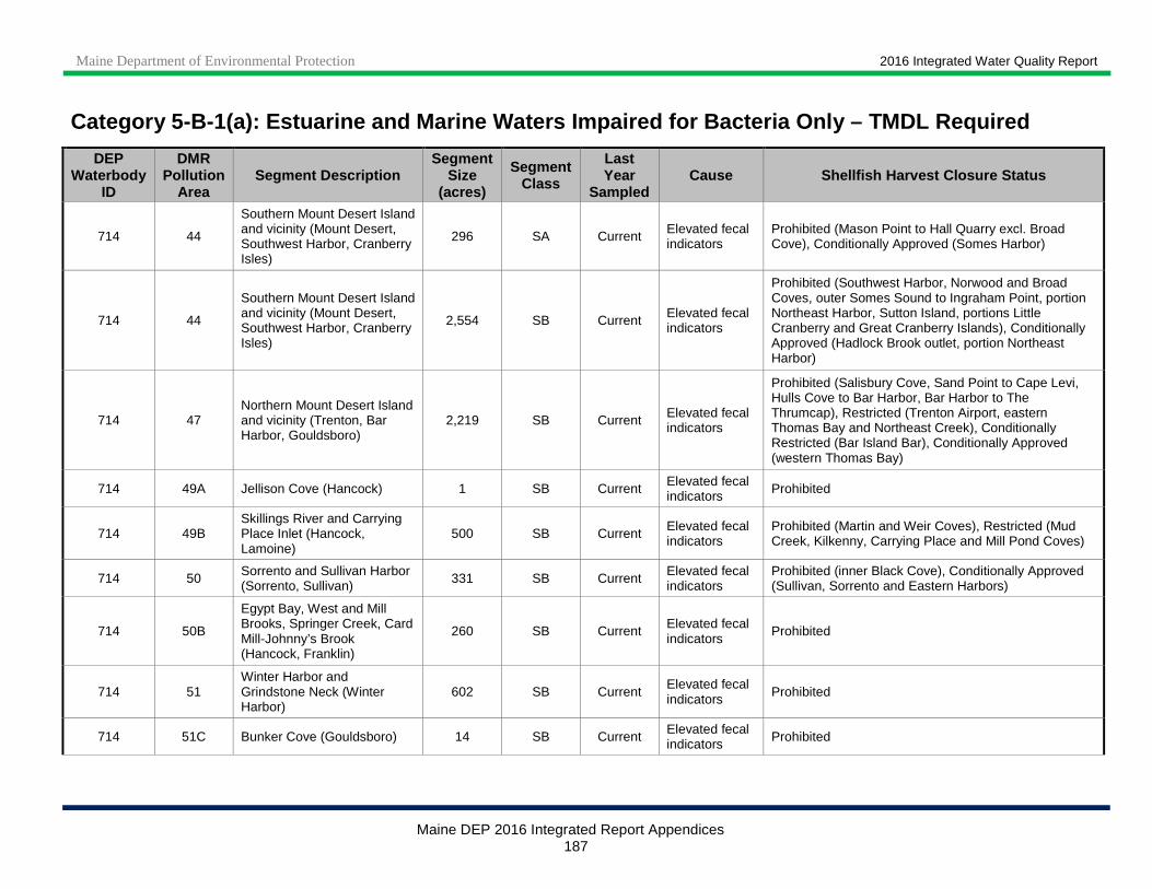
Maine Department of Environmental Protection 2016 Integrated Water Quality Report
Maine DEP 2016 Integrated Report Appendices 187
Category 5-B-1(a): Estuarine and Marine Waters Impa ired for Bacteria Only – TMDL Required
DEP Waterbody
ID
DMR Pollution
Area Segment Description
Segment Size
(acres)
Segment Class
Last Year
Sampled Cause Shellfish Harvest Closure Status
714 44
Southern Mount Desert Island and vicinity (Mount Desert, Southwest Harbor, Cranberry Isles)
296 SA Current Elevated fecal indicators
Prohibited (Mason Point to Hall Quarry excl. Broad Cove), Conditionally Approved (Somes Harbor)
714 44
Southern Mount Desert Island and vicinity (Mount Desert, Southwest Harbor, Cranberry Isles)
2,554 SB Current Elevated fecal indicators
Prohibited (Southwest Harbor, Norwood and Broad Coves, outer Somes Sound to Ingraham Point, portion Northeast Harbor, Sutton Island, portions Little Cranberry and Great Cranberry Islands), Conditionally Approved (Hadlock Brook outlet, portion Northeast Harbor)
714 47 Northern Mount Desert Island and vicinity (Trenton, Bar Harbor, Gouldsboro)
2,219 SB Current Elevated fecal indicators
Prohibited (Salisbury Cove, Sand Point to Cape Levi, Hulls Cove to Bar Harbor, Bar Harbor to The Thrumcap), Restricted (Trenton Airport, eastern Thomas Bay and Northeast Creek), Conditionally Restricted (Bar Island Bar), Conditionally Approved (western Thomas Bay)
714 49A Jellison Cove (Hancock) 1 SB Current Elevated fecal indicators Prohibited
714 49B Skillings River and Carrying Place Inlet (Hancock, Lamoine)
500 SB Current Elevated fecal indicators
Prohibited (Martin and Weir Coves), Restricted (Mud Creek, Kilkenny, Carrying Place and Mill Pond Coves)
714 50 Sorrento and Sullivan Harbor (Sorrento, Sullivan) 331 SB Current Elevated fecal
indicators Prohibited (inner Black Cove), Conditionally Approved (Sullivan, Sorrento and Eastern Harbors)
714 50B
Egypt Bay, West and Mill Brooks, Springer Creek, Card Mill-Johnny’s Brook (Hancock, Franklin)
260 SB Current Elevated fecal indicators
Prohibited
714 51 Winter Harbor and Grindstone Neck (Winter Harbor)
602 SB Current Elevated fecal indicators Prohibited
714 51C Bunker Cove (Gouldsboro) 14 SB Current Elevated fecal indicators Prohibited

Maine Department of Environmental Protection 2016 Integrated Water Quality Report
Maine DEP 2016 Integrated Report Appendices 188
Category 5-B-1(a): Estuarine and Marine Waters Impa ired for Bacteria Only – TMDL Required
DEP Waterbody
ID
DMR Pollution
Area Segment Description
Segment Size
(acres)
Segment Class
Last Year
Sampled Cause Shellfish Harvest Closure Status
706, 714 52 Schoodic Point to Corea (Gouldsboro, Steuben) 788 SB Current Elevated fecal
indicators
Prohibited (Arey, Shark and Sand Coves, inner Birch and Bunkers Harbors, portion Inner Harbor, Corea Harbor), Restricted (portion Inner Harbor), Conditionally Approved (portion Birch Harbor)
706 52E Dyer and Pigeon Hill Bays (Steuben) 47 SA Current Elevated fecal
indicators Prohibited (western shore of Petit Manan Point from Yellow Birch Head to southern tip)
706 52E Dyer and Pigeon Hill Bays (Steuben) 60 SB Current Elevated fecal
indicators
Prohibited (western shore of Petit Manan Point from western prominence to Yellow Birch Head), Restricted (inner Dyer Harbor)
706 52G West and Joy Bays (Gouldsboro, Steuben) 523 SB Current Elevated fecal
indicators Prohibited (inner West Bay), Restricted (Tucker Creek, Joy, Baker and Parrit Coves, Steuben Harbor)
704, 705 53 Narraguagus River to Harrington River (Cherryfield, Milbridge, Harrington)
1,143 SB Current Elevated fecal indicators
Prohibited (Smith to Stover Cove, Narraguagus River to Turner Cove, Lily Cove, upper Harrington River), Restricted (Curtis Creek)
704 53A Pleasant River (Addison, Columbia Falls)
708 SB Current Elevated fecal indicators
Prohibited (upper Pleasant River), Restricted (Dyer Cove, Batson Brook)
704 53H Mash Harbor (Addison) 12 SB Current Elevated fecal indicators
Restricted
703 54 Moosabec Reach to Kelley Point, Beals and Great Wass Islands (Jonesport, Beals)
589 SB Current Elevated fecal indicators
Prohibited (Moosabec Reach, north end of Beals Island, Alley Bay to Pig Island Gut), Restricted (Station Harbor)
703 54B West and Indian Rivers (Addison, Jonesport) 308 SB Current Elevated fecal
indicators
Prohibited (Indian River), Restricted (western bank West River), Conditionally Approved (portion West River)
713 54D East & West Branches, Little Kennebec Bay, Machias and Machiasport
125 SB Current Elevated fecal indicators
Prohibited (West Branch), Approved (East Branch; this item was inadvertently omitted from this segment in the 2014 cycle).
713 54G White Creek, Masons Bay, (Jonesboro, Jonesport) 47 SB Current Elevated fecal
indicators Approved. This waterbody ID was inadvertently omitted from this category in the 2014 cycle.

Maine Department of Environmental Protection 2016 Integrated Water Quality Report
Maine DEP 2016 Integrated Report Appendices 189
Category 5-B-1(a): Estuarine and Marine Waters Impa ired for Bacteria Only – TMDL Required
DEP Waterbody
ID
DMR Pollution
Area Segment Description
Segment Size
(acres)
Segment Class
Last Year
Sampled Cause Shellfish Harvest Closure Status
713 54H Chandler River to Deep Hole Point (Jonesboro) 294 SB Current Elevated fecal
indicators Prohibited
709 55 Machias Bay and vicinity (Machias, East Machias, Machiasport)
2,092 SB Current Elevated fecal indicators
Prohibited (Machias and East Machias Rivers), Restricted (Larrabee Cove), Conditionally Restricted (portion Sanborn Cove), Conditionally Approved (portion Sanborn Cove, Randall Point Flats)
709 55A Holmes Bay (Whiting, Cutler) 171 SB Current Elevated fecal indicators Prohibited
709 55B Starboard and Howard Coves (Machiasport) 114 SB Current Elevated fecal
indicators Prohibited
708 55D Little Machias Bay to Haycock Harbor (Cutler, Trescott Township)
311 SA Current Elevated fecal indicators
Prohibited (Money Cove, Bog Brook Cove to Moose Cove), Restricted (Haycock Harbor)
708 55D Little Machias Bay to Haycock Harbor (Cutler, Trescott Township)
111 SB Current Elevated fecal indicators
Restricted (portion Little Machias Bay)
701 56
Northwestern Cobscook Bay (Edmunds Township, Dennysville, Pembroke, Perry)
733 SA Current Elevated fecal indicators
Restricted (Dennys River, Burnt Island), Conditionally Approved (Hobart Stream)
701 56
Northwestern Cobscook Bay (Edmunds Township, Dennysville, Pembroke, Perry)
378 SB Current Elevated fecal indicators
Prohibited (upper Pennamaquan River), Restricted (Hardscrabble River, Sipp Bay, Leighton Neck)
701, 708 57 Whiting and Straight Bays (Edmunds and Trescott Townships)
128 SA Current Elevated fecal indicators
Prohibited (East Stream), Restricted (Crane Mill Brook to Leighton Point), Conditionally Approved (inner Timber Cove, portion Carlos Cove)
701, 708 58 Lubec 382 SB Current Elevated fecal indicators
Prohibited (portion Johnson Bay and Lubec Narrows), Restricted (Pirates Creek, portion Lubec Channel)
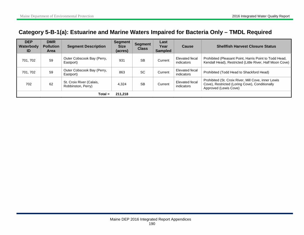
Maine Department of Environmental Protection 2016 Integrated Water Quality Report
Maine DEP 2016 Integrated Report Appendices 190
Category 5-B-1(a): Estuarine and Marine Waters Impa ired for Bacteria Only – TMDL Required
DEP Waterbody
ID
DMR Pollution
Area Segment Description
Segment Size
(acres)
Segment Class
Last Year
Sampled Cause Shellfish Harvest Closure Status
701, 702 59 Outer Cobscook Bay (Perry, Eastport) 931 SB Current Elevated fecal
indicators Prohibited (Pleasant Point, Harris Point to Todd Head, Kendall Head), Restricted (Little River, Half Moon Cove)
701, 702 59 Outer Cobscook Bay (Perry, Eastport) 863 SC Current Elevated fecal
indicators Prohibited (Todd Head to Shackford Head)
702 62 St. Croix River (Calais, Robbinston, Perry) 4,324 SB Current Elevated fecal
indicators
Prohibited (St. Croix River, Mill Cove, inner Lewis Cove), Restricted (Loring Cove), Conditionally Approved (Lewis Cove)
Total = 211,218
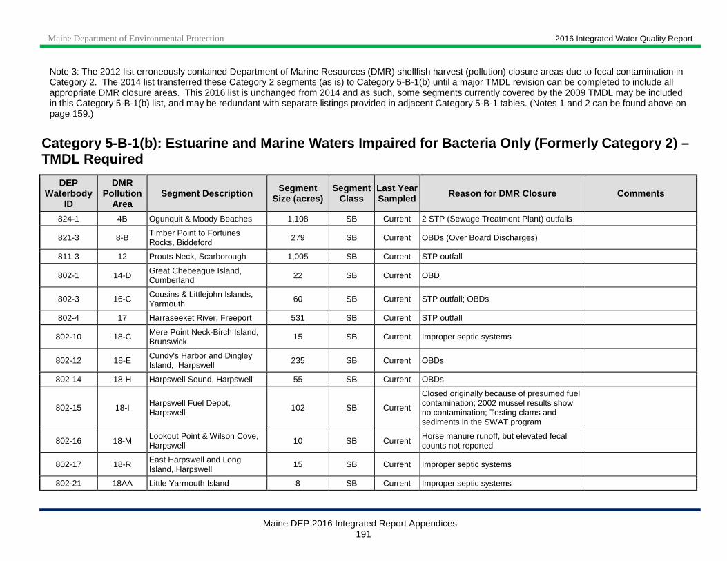
Maine Department of Environmental Protection 2016 Integrated Water Quality Report
Maine DEP 2016 Integrated Report Appendices 191
Note 3: The 2012 list erroneously contained Department of Marine Resources (DMR) shellfish harvest (pollution) closure areas due to fecal contamination in Category 2. The 2014 list transferred these Category 2 segments (as is) to Category 5-B-1(b) until a major TMDL revision can be completed to include all appropriate DMR closure areas. This 2016 list is unchanged from 2014 and as such, some segments currently covered by the 2009 TMDL may be included in this Category 5-B-1(b) list, and may be redundant with separate listings provided in adjacent Category 5-B-1 tables. (Notes 1 and 2 can be found above on page 159.)
Category 5 -B-1(b): Estuarine and Marine Waters Impaired for Bacteria Only (Formerly Category 2) – TMDL Required
DEP Waterbody
ID
DMR Pollution
Area Segment Description Segment
Size (acres) Segment
Class Last Year Sampled Reason for DMR Closure Comments
824-1 4B Ogunquit & Moody Beaches 1,108 SB Current 2 STP (Sewage Treatment Plant) outfalls
821-3 8-B Timber Point to Fortunes Rocks, Biddeford 279 SB Current OBDs (Over Board Discharges)
811-3 12 Prouts Neck, Scarborough 1,005 SB Current STP outfall
802-1 14-D Great Chebeague Island, Cumberland 22 SB Current OBD
802-3 16-C Cousins & Littlejohn Islands, Yarmouth
60 SB Current STP outfall; OBDs
802-4 17 Harraseeket River, Freeport 531 SB Current STP outfall
802-10 18-C Mere Point Neck-Birch Island, Brunswick 15 SB Current Improper septic systems
802-12 18-E Cundy's Harbor and Dingley Island, Harpswell 235 SB Current OBDs
802-14 18-H Harpswell Sound, Harpswell 55 SB Current OBDs
802-15 18-I Harpswell Fuel Depot, Harpswell 102 SB Current
Closed originally because of presumed fuel contamination; 2002 mussel results show no contamination; Testing clams and sediments in the SWAT program
802-16 18-M Lookout Point & Wilson Cove, Harpswell 10 SB Current Horse manure runoff, but elevated fecal
counts not reported
802-17 18-R East Harpswell and Long Island, Harpswell
15 SB Current Improper septic systems
802-21 18AA Little Yarmouth Island 8 SB Current Improper septic systems

Maine Department of Environmental Protection 2016 Integrated Water Quality Report
Maine DEP 2016 Integrated Report Appendices 192
Category 5 -B-1(b): Estuarine and Marine Waters Impaired for Bacteria Only (Formerly Category 2) – TMDL Required
DEP Waterbody
ID
DMR Pollution
Area Segment Description Segment
Size (acres) Segment
Class Last Year Sampled Reason for DMR Closure Comments
18-P Bombazine Is. And Foster Pt. 30 SB Current DMR Area open as of 12/31/10 All OBDs removed
802-22 19 Wood Island - Malaga Island, Phippsburg 350 SB
Current/ incomplete
survey Improper septic systems
Moved from Category 5 (incorrect placement in 2004?)
802-23 19-A Birch Point, West Bath - Bear Island, Phippsburg 107 SB Current OBDs; septic system malfunction
All OBDs removed except for Bear Island
802-22 19B N. Cape Small Hbr. 7 SB Current Septic system problems
802-24 19-C Dam Cove - Birch Point, West Bath
292 SB Current Septic system malfunction All OBDs removed
730-2 20-E N.Robinhood Cove, So. Robinhood Cove, & Knubble Bay, Georgetown/Westport
674 SB Current OBDs, marina Moved from Category 3
730-3 21 Indian Point, Georgetown, to Fowle Pt., Westport 2,425 SB Current OBDs, incomplete survey
730-4 22 Sheepscot River 1,432 SB Current OBDs
730-5 22-B Hodgdon Island, Boothbay 249 SB Current OBD Knickercane Cove - Merrow Island, Boothbay
730-5 22-C Cameron Point. Southport 207 SB Current OBD, gray water discharges Back River, Boothbay
730-7 22-F Ovens Mouth - Sherman Creek, Boothbay – Edgecomb 162 SB Current OBD; NPS
All OBDs removed. Moved from Category 5, elevated fecals in 2004
730-8 22-G Upper Sheepscot River 299 SB Current Restricted: possible NPS No prohibited areas - 7/2/1997
730-9 23 Boothbay Harbor - Damariscove Island 7,338 SB/SA Mainland
is current OBDs; Boats
730-11 23-B Southwestern Southport Island 393 SB Current OBDs
729-1 24 Damariscotta River - Boothbay 693 SB Current OBDs; Boats
729-3 25-A South Bristol 550 SB Current OBDs; Boats

Maine Department of Environmental Protection 2016 Integrated Water Quality Report
Maine DEP 2016 Integrated Report Appendices 193
Category 5 -B-1(b): Estuarine and Marine Waters Impaired for Bacteria Only (Formerly Category 2) – TMDL Required
DEP Waterbody
ID
DMR Pollution
Area Segment Description Segment
Size (acres) Segment
Class Last Year Sampled Reason for DMR Closure Comments
729-4 25-B Pemaquid River, Bristol 325 SB Current OBDs; Boats
726-1 25-C New Harbor, Bristol 162 SB Current OBDs; Boats
729-5 25-E Inner Heron Island 11 SB no station No station; Septic system problems
729-6 25-F Pemaquid Neck, Bristol 580 SB Current OBDs
726-2 25-D Long Cove Point to Muscongus Harbor, Bristol 556 SB Current OBDs
726-4 25-G Soldiers Cove, Bristol 19 SB Current OBDs, improper septics
726-5 25-H Keene Narrows, Medomak - Bremen 70 SB Current Marina; Septic system problems
726-6 25-I Muscongus Harbor, Bristol-Bremen 12 SB Current OBD; Boats, Septic system problems
726-7 25-J Eastern Farmers Island, South Bristol 13 SB Current OBD
726-8 25-N High Island to McFarlands Cove, South Bristol 173 SB Current Improper septic systems OBD in 2004
724-3 26-B Friendship Harbor 509 SB Current OBDs
724-5 26-H Broad Cove, Cushing 26 SB Current Restricted: wildlife
724-6 26-K Upper Meduncook Rive - Crotch Island, Cushing 27 SB Current Septic system problems - Crotch Island
724-7 26-M Pleasant Point Gut - Davis Cove, Cushing 25 SB Current Septic system problems
724-9 26-0 Friendship Long Island & Vicinity, Friendship 168 SB
Current but more
samples needed
Septic system problems Moved from Category 3
724-10 27 St. George River 1,046 SB Current STP; seasonal closure Moved from Category 5, elevated fecals in 2004
27-C Upper Bay, St. George 469 SB Current Conditional on STP
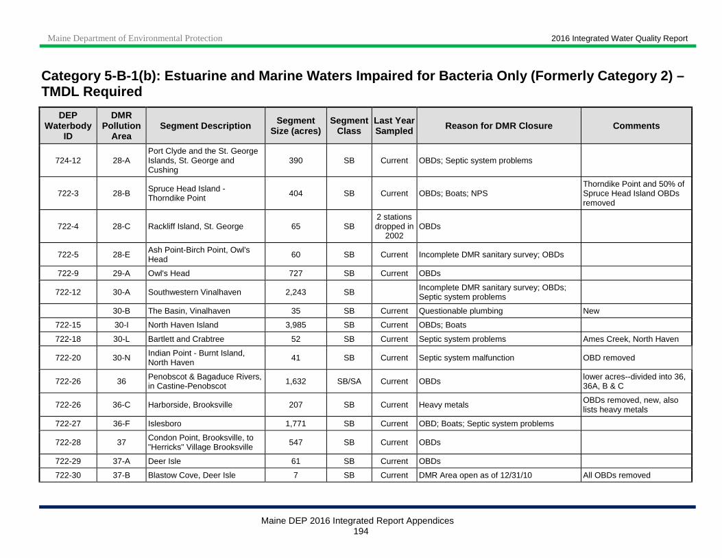
Maine Department of Environmental Protection 2016 Integrated Water Quality Report
Maine DEP 2016 Integrated Report Appendices 194
Category 5 -B-1(b): Estuarine and Marine Waters Impaired for Bacteria Only (Formerly Category 2) – TMDL Required
DEP Waterbody
ID
DMR Pollution
Area Segment Description Segment
Size (acres) Segment
Class Last Year Sampled Reason for DMR Closure Comments
724-12 28-A Port Clyde and the St. George Islands, St. George and Cushing
390 SB Current OBDs; Septic system problems
722-3 28-B Spruce Head Island - Thorndike Point 404 SB Current OBDs; Boats; NPS
Thorndike Point and 50% of Spruce Head Island OBDs removed
722-4 28-C Rackliff Island, St. George 65 SB 2 stations dropped in
2002 OBDs
722-5 28-E Ash Point-Birch Point, Owl's Head 60 SB Current Incomplete DMR sanitary survey; OBDs
722-9 29-A Owl's Head 727 SB Current OBDs
722-12 30-A Southwestern Vinalhaven 2,243 SB Incomplete DMR sanitary survey; OBDs; Septic system problems
30-B The Basin, Vinalhaven 35 SB Current Questionable plumbing New
722-15 30-I North Haven Island 3,985 SB Current OBDs; Boats
722-18 30-L Bartlett and Crabtree 52 SB Current Septic system problems Ames Creek, North Haven
722-20 30-N Indian Point - Burnt Island, North Haven 41 SB Current Septic system malfunction OBD removed
722-26 36 Penobscot & Bagaduce Rivers, in Castine-Penobscot 1,632 SB/SA Current OBDs lower acres--divided into 36,
36A, B & C
722-26 36-C Harborside, Brooksville 207 SB Current Heavy metals OBDs removed, new, also lists heavy metals
722-27 36-F Islesboro 1,771 SB Current OBD; Boats; Septic system problems
722-28 37 Condon Point, Brooksville, to "Herricks" Village Brooksville 547 SB Current OBDs
722-29 37-A Deer Isle 61 SB Current OBDs
722-30 37-B Blastow Cove, Deer Isle 7 SB Current DMR Area open as of 12/31/10 All OBDs removed
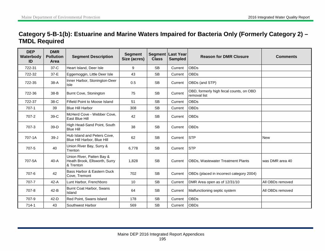
Maine Department of Environmental Protection 2016 Integrated Water Quality Report
Maine DEP 2016 Integrated Report Appendices 195
Category 5 -B-1(b): Estuarine and Marine Waters Impaired for Bacteria Only (Formerly Category 2) – TMDL Required
DEP Waterbody
ID
DMR Pollution
Area Segment Description Segment
Size (acres) Segment
Class Last Year Sampled Reason for DMR Closure Comments
722-31 37-C Heart Island, Deer Isle 9 SB Current OBDs
722-32 37-E Eggemoggin, Little Deer Isle 43 SB Current OBDs
722-35 38-A Inner Harbor, Stonington-Deer Isle 0.5 SB Current OBDs (and STP)
722-36 38-B Burnt Cove, Stonington 75 SB Current OBD, formerly high fecal counts, on OBD removal list
722-37 38-C Fifield Point to Moose Island 51 SB Current OBDs
707-1 39 Blue Hill Harbor 308 SB Current OBDs
707-2 39-C McHerd Cove - Webber Cove, East Blue Hill 42 SB Current OBDs
707-3 39-D High Head-Sand Point, South Blue Hill
38 SB Current OBDs
707-1A 39-J Hub Island and Peters Cove, Blue Hill Harbor, Blue Hill 62 SB Current STP New
707-5 40 Union River Bay, Surry & Trenton 6,778 SB Current STP
707-5A 40-A Union River, Patten Bay & Heath Brook, Ellsworth, Surry & Trenton
1,828 SB Current OBDs, Wastewater Treatment Plants was DMR area 40
707-6 42 Bass Harbor & Eastern Duck Cove, Tremont 702 SB Current OBDs (placed in incorrect category 2004)
707-7 42-A Lunt Harbor, Frenchboro 10 SB Current DMR Area open as of 12/31/10 All OBDs removed
707-8 42-B Burnt Coat Harbor, Swans Island 64 SB Current Malfunctioning septic system All OBDs removed
707-9 42-D Red Point, Swans Island 178 SB Current OBDs
714-1 43 Southwest Harbor 569 SB Current OBDs
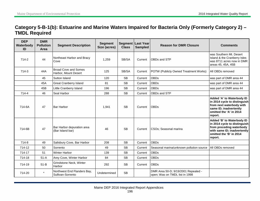
Maine Department of Environmental Protection 2016 Integrated Water Quality Report
Maine DEP 2016 Integrated Report Appendices 196
Category 5 -B-1(b): Estuarine and Marine Waters Impaired for Bacteria Only (Formerly Category 2) – TMDL Required
DEP Waterbody
ID
DMR Pollution
Area Segment Description Segment
Size (acres) Segment
Class Last Year Sampled Reason for DMR Closure Comments
714-2 44 Northeast Harbor and Bracy Cove 1,259 SB/SA Current OBDs and STP
was Southern Mt. Desert Island & the Cranberry Isles was 8711 acres now in DMR areas 45, 45A, 45B
714-3 44A Broad Cove and Somes Harbor, Mount Desert
125 SB/SA Current POTW (Publicly Owned Treatment Works) All OBDs removed
45 Sutton Island 120 SB Current OBDs was part of DMR area 44
45A Great Cranberry Island 81 SB Current OBDs was part of DMR area 44
45B Little Cranberry Island 196 SB Current OBDs was part of DMR area 44
714-4 46 Seal Harbor 288 SB Current OBDs and STP
714-6A 47 Bar Harbor 1,941 SB Current OBDs
Added ‘A’ to Waterbody ID in 2014 cycle to distinguish from next waterbody with same ID; inadvertently omitted the ‘A’ in 2014 report.
714-6B 47 Bar Harbor depuration area (Bar Island bar) 46 SB Current CSOs; Seasonal marina
Added ‘B’ to Waterbody ID in 2014 cycle to distinguish from preceding waterbody with same ID; inadvertently omitted the ‘B’ in 2014 report.
714-8 49 Salisbury Cove, Bar Harbor 208 SB Current OBDs
714-12 50 Sorrento 49 SB Current Seasonal marina/unknown pollution source All OBDs removed
714-17 51 Winter Harbor 139 SB Current OBDs
714-18 51-A Arey Cove, Winter Harbor 84 SB Current OBDs
714-19 51-B Grindstone Neck, Winter Harbor 292 SB Current OBDs
714-20 * Northwest End Flanders Bay, Sullivan-Sorrento Undetermined SB DMR Area 50-D; 9/19/2001 Repealed -
open; Was on TMDL list in 1998
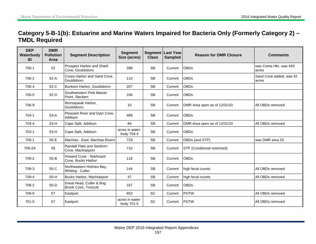
Maine Department of Environmental Protection 2016 Integrated Water Quality Report
Maine DEP 2016 Integrated Report Appendices 197
Category 5 -B-1(b): Estuarine and Marine Waters Impaired for Bacteria Only (Formerly Category 2) – TMDL Required
DEP Waterbody
ID
DMR Pollution
Area Segment Description Segment
Size (acres) Segment
Class Last Year Sampled Reason for DMR Closure Comments
706-1 52 Prospect Harbor and Shark Cove, Gouldsboro
288 SB Current OBDs was Corea Hbr, was 443 acres
706-2 52-A Corea Harbor and Sand Cove, Gouldsboro 110 SB Current OBDs Sand Cove added, was 42
acres
706-4 52-C Bunkers Harbor, Gouldsboro 207 SB Current OBDs
706-5 52-D Southwestern Petit Manan Point, Steuben 106 SB Current OBDs
706-9 Wonsqueak Harbor, Gouldsboro
10 SB Current DMR Area open as of 12/31/10 All OBDs removed
704-1 53-A Pleasant River and Dyer Cove, Addison 489 SB Current OBDs
704-4 53-H Cape Split, Addison 84 SB Current DMR Area open as of 12/31/10 All OBDs removed
703-1 53-H Cape Split, Addison acres in water-body 704-4 SB Current OBDs
709-1 55-E Machias - East. Machias Rivers 729 SB Current OBDs (and STP) was DMR area 55
709-2A 55 Randall Flats and Sanborn Cove, Machiasport 710 SB Current STP (Conditional restricted)
709-2 55-B Howard Cove - Starboard Cove, Bucks Harbor 118 SB Current OBDs
709-3 55-C Northeastern Holmes Bay, Whiting - Cutler 144 SB Current high fecal counts All OBDs removed
709-4 55-H Bucks Harbor, Machiasport 47 SB Current high fecal counts All OBDs removed
708-2 55-D Great Head, Cutler & Bog Brook Cove, Trescott 167 SB Current OBDs
708-5 57 Eastport 653 SC Current POTW All OBDs removed
701-5 57 Eastport acres in water-body 701-5 SC Current POTW All OBDs removed
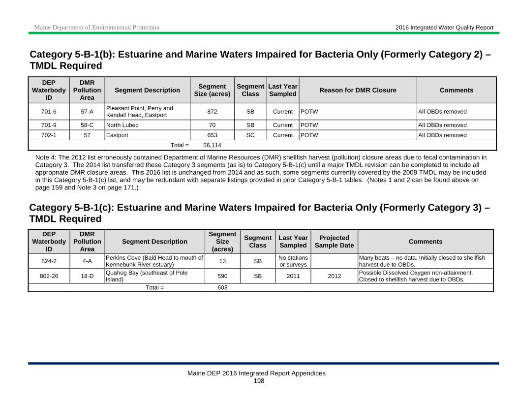
Maine Department of Environmental Protection 2016 Integrated Water Quality Report
Maine DEP 2016 Integrated Report Appendices 198
Category 5 -B-1(b): Estuarine and Marine Waters Impaired for Bacteria Only (Formerly Category 2) – TMDL Required
DEP Waterbody
ID
DMR Pollution
Area Segment Description Segment
Size (acres) Segment
Class Last Year Sampled Reason for DMR Closure Comments
701-6 57-A Pleasant Point, Perry and Kendall Head, Eastport
872 SB Current POTW All OBDs removed
701-9 58-C North Lubec 70 SB Current POTW All OBDs removed
702-1 57 Eastport 653 SC Current POTW All OBDs removed
Total = 56,114
Note 4: The 2012 list erroneously contained Department of Marine Resources (DMR) shellfish harvest (pollution) closure areas due to fecal contamination in Category 3. The 2014 list transferred these Category 3 segments (as is) to Category 5-B-1(c) until a major TMDL revision can be completed to include all appropriate DMR closure areas. This 2016 list is unchanged from 2014 and as such, some segments currently covered by the 2009 TMDL may be included in this Category 5-B-1(c) list, and may be redundant with separate listings provided in prior Category 5-B-1 tables. (Notes 1 and 2 can be found above on page 159 and Note 3 on page 171.)
Category 5 -B-1(c): Estuarine and Marine Waters Impaired for Bact eria Only (Formerly Category 3) – TMDL Required
DEP Waterbody
ID
DMR Pollution
Area Segment Description
Segment Size
(acres)
Segment Class
Last Year Sampled
Projected Sample Date Comments
824-2 4-A Perkins Cove (Bald Head to mouth of Kennebunk River estuary)
13 SB No stations or surveys
Many boats – no data. Initially closed to shellfish harvest due to OBDs.
802-26 18-D Quahog Bay (southeast of Pole Island) 590 SB 2011 2012 Possible Dissolved Oxygen non-attainment.
Closed to shellfish harvest due to OBDs. Total = 603

Maine Department of Environmental Protection 2016 Integrated Water Quality Report
Maine DEP 2016 Integrated Report Appendices 199
Category 5-D: Estuarine and Marine Waters Impaired by Legacy Pollutants All estuarine and marine waters capable of supporting American lobster are listed in Category 5-D for shellfish consumption due to elevated levels of PCBs and other persistent, bioaccumulating substances in tomalley. Also included in a statewide marine consumption advisory is a variety of saltwater finfish and shellfish based on elevated mercury, PCB and dioxin levels. Safe e ating guidelines for sensitive populations are presented at the following website: www.maine.gov/dhhs/mecdc/environmental-health/eohp/fish/saltwater.htm .
200
APPENDIX VI: MAINE’S IMPLEMENTATION OF EPA’S 303(D) VISION
Vision for Assessment, Restoration, and
Protection of Maine’s Water Resources Under the Clean Water Act, Section 303(d) Program
May 2016
MAINE DEPARTMENT OF ENVIRONMENTAL PROTECTION 17 State House Station | Augusta, Maine 04333-0017
www.maine.gov/dep
Contact: Don Witherill, Director, Division of Environmental Assessment Susanne Meidel, Biologist
Phone: (207) 287-7688
Maine Department of Environmental Protection 2016 Integrated Water Quality Report Vision for Maine’s Water Resources
Maine DEP 2016 Integrated Report Appendices
190
Vision Background
The Clean Water Act (CWA) Section 303(d) Program provides a mechanism to integrate and implement water quality efforts for the restoration and protection of the nation’s aquatic resources. This program systematically assesses waters and prioritizes restoration objectives that reduce pollutants through Total Maximum Daily Loads assessments, prescriptive permits and implementing alternative approaches to achieve water quality goals. In 2013 the U.S. Environmental Protection Agency (USEPA) announced a new program framework to identify and prioritize water bodies for restoration and protection, entitled A Long-Term Vision for Assessment, Restoration, and Protection under the Clean Water Act Section 303(d) Program (the Vision). The new Vision will be addressed in stages from 2016 to 2022 and includes the following elements: prioritization, assessment, protection, alternatives, engagement, and integration. The Vision recommends that each State identify priority waters for restoration and/or protection plans by 2016, with the goal of completing those plans by 2022. This document provides Maine DEP’s approach to achieve the Vision’s prioritization goal and identifies waters that are high priority for water quality planning efforts. This list may be periodically revised as plans progress and new information emerges.
Maine’s Approach to TMDLs and Aquatic Restoration Maine, like all states, is focused on finding the most effective tools to restore impaired waters and protect non-impaired waters from degradation. The pathway to accomplish this task is constantly evolving and Maine will continue to employ innovative methods that promise to result in water quality standards attainment by addressing pollutant sources. This path is challenging and Maine will choose adaptive approaches that include: TMDLs, Watershed Management Plans, Protection Plans, Alternative Plans, plus MEPDES Permits, and Source Elimination which both lead to direct Delisting of Impaired Waters. In the spirit of Maine, the Department of Environmental Protection (DEP) will do what works within the constraints of our resources to keep our waters safe. Past Approaches to TMDLs Nonpoint Source TMDLs & the Statewide Approach Nonpoint Source (NPS) TMDLs provide a partial solution to attaining water quality standards within the continuum/cycle of aquatic restoration. The TMDL enables the transition from sitting on a list of impaired waters to the next stage of active watershed management planning where stakeholders can move on to the challenges of implementation.
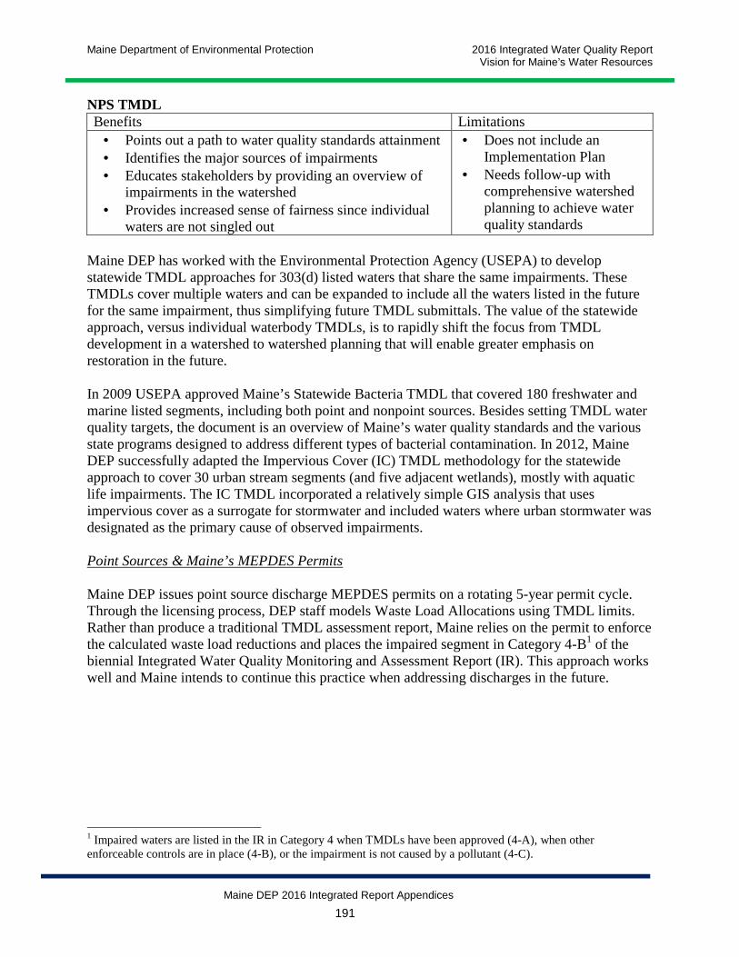
Maine Department of Environmental Protection 2016 Integrated Water Quality Report Vision for Maine’s Water Resources
Maine DEP 2016 Integrated Report Appendices
191
NPS TMDL Benefits Limitations
• Points out a path to water quality standards attainment • Identifies the major sources of impairments • Educates stakeholders by providing an overview of
impairments in the watershed • Provides increased sense of fairness since individual
waters are not singled out
• Does not include an Implementation Plan
• Needs follow-up with comprehensive watershed planning to achieve water quality standards
Maine DEP has worked with the Environmental Protection Agency (USEPA) to develop statewide TMDL approaches for 303(d) listed waters that share the same impairments. These TMDLs cover multiple waters and can be expanded to include all the waters listed in the future for the same impairment, thus simplifying future TMDL submittals. The value of the statewide approach, versus individual waterbody TMDLs, is to rapidly shift the focus from TMDL development in a watershed to watershed planning that will enable greater emphasis on restoration in the future. In 2009 USEPA approved Maine’s Statewide Bacteria TMDL that covered 180 freshwater and marine listed segments, including both point and nonpoint sources. Besides setting TMDL water quality targets, the document is an overview of Maine’s water quality standards and the various state programs designed to address different types of bacterial contamination. In 2012, Maine DEP successfully adapted the Impervious Cover (IC) TMDL methodology for the statewide approach to cover 30 urban stream segments (and five adjacent wetlands), mostly with aquatic life impairments. The IC TMDL incorporated a relatively simple GIS analysis that uses impervious cover as a surrogate for stormwater and included waters where urban stormwater was designated as the primary cause of observed impairments. Point Sources & Maine’s MEPDES Permits Maine DEP issues point source discharge MEPDES permits on a rotating 5-year permit cycle. Through the licensing process, DEP staff models Waste Load Allocations using TMDL limits. Rather than produce a traditional TMDL assessment report, Maine relies on the permit to enforce the calculated waste load reductions and places the impaired segment in Category 4-B1 of the biennial Integrated Water Quality Monitoring and Assessment Report (IR). This approach works well and Maine intends to continue this practice when addressing discharges in the future.
1 Impaired waters are listed in the IR in Category 4 when TMDLs have been approved (4-A), when other enforceable controls are in place (4-B), or the impairment is not caused by a pollutant (4-C).
Maine Department of Environmental Protection 2016 Integrated Water Quality Report Vision for Maine’s Water Resources
Maine DEP 2016 Integrated Report Appendices
192
Status of Maine’s List of Impaired Waters Impaired waters, i.e. those on the Clean Water Act (CWA) 303(d) list, are identified in the IR in Category 5 (impaired; TMDL required). Maine places waters into three different types of Category 5: 5-A waters are impaired by pollutants not covered by the other two categories; 5-B waters are impaired for bacteria contamination only; and 5-D waters are impaired by legacy pollutants. Maine’s 2012 IR Category 5 lists include-
• ~130 river and stream listings (92 in Category 5-A, 2 in 5-B, 37 in 5-D), • Two lakes (5-A), • Four wetlands (2 each in 5-A and 5-D) and • Six marine/estuarine waters (5-A).
Maine has selected proposed waters in Table 1 to comply with USEPA’s A Long-Term Vision for Assessment, Restoration, and Protection under the Clean Water Act Section 303(d) Program. Elements of CWA Vision Priorities Prioritization Goal Maine DEP reviewed Category 5 of Maine’s 2012 IR to determine what action or next step is suitable for each of the waters listed. The review process incorporated a systematic approach following these steps: 1. Legacy pollutant impairments (Category 5-D) were deemed low priority for the foreseeable
future. 2. Rivers and streams
a. Two streams with bacteria-only impairments (Category 5-B) have meanwhile been addressed by TMDLs and moved to Category 4-A.
b. 30 nutrient impairment waters (accounting for 32 impairment listings in Category 5-A) that were recently assessed in the field and modeled using MapShed, and which have an NPS TMDL assessment report, were deemed high priority for completion in 2016. These waters were formerly proposed to be covered under a draft NPS TMDL.
i. One, additional, nutrient impaired water (French Stream) that needs a major MapShed modelling revision before submittal as part of the NPS TMDL.
c. The 61 remaining rivers and stream impairment listings in Category 5-A were reviewed individually to determine if the water is suitable for-
i. A TMDL; ii. Placement in a Category 4-B due to an enforceable control; or iii. An Alternative Restoration Approach2 (placement in a new Category 5-Alt) using
watershed planning methods that will result in attainment of water quality standards.
2 In accordance with EPA’s national guidance, an alternative restoration approach is a plan and/or set of actions pursued in near term (other than a TMDL) that in their totality are designed to attain water quality standards. EPA’s proposed national program measure WQ-27 allows States to include alternative restoration approaches in reporting progress for their priority waters. (During the time an alternative is being developed, States have the opportunity to track progress using national program measure WQ-28.)
Maine Department of Environmental Protection 2016 Integrated Water Quality Report Vision for Maine’s Water Resources
Maine DEP 2016 Integrated Report Appendices
193
d. Out of those 61, eight were deemed high priority in 2016 for development of either a TMDL, an Alternative Restoration Approach or a Waste Load Allocation model.
3. Lakes – Only 2 lakes are in Category 5 (5-A) and both were deemed high priority in 2016 for development of either a TMDL or an Alternative Restoration Approach.
4. Wetlands – The two impaired wetlands in Category 5-A were deemed low priority due to the particular nature of the impairments.
5. Marine/estuarine waters – Two Category 5-A waters with dissolved oxygen impairments were deemed high priority in 2016 for development of either a TMDL or an Alternative Restoration Approach.
The priority-setting process engaged multiple staff members with direct knowledge of the impaired segments. Staff reviewed existing data, landuse maps and applied best professional judgment to determine the most logical next step for the waterbody. The waters selected as high priorities have received substantial investments in sampling and planning efforts, which raised their priority profile. The results of this process are the waters submitted under the 303(d) Measures, WQ-27, in Table 1. These are DEP’s priority waters under the 2016-2022 priorities planning horizon, but a subset of these waters will be used to set TMDL goals that are routinely negotiated under DEP’s Performance Partnership Agreement with USEPA. Assessment Goal As part of its ongoing approach to monitoring the status of its surface waters, Maine will continue to assess waters in accordance with its up-to-date Consolidated Assessment and Listing Methodology (CALM), Comprehensive State Monitoring and Assessment Strategy, applicable criteria and water quality standards, with appropriate sampling, data analysis and assessment techniques for all water resource types, as required by the CWA and other federal and state statutes, to determine the extent of healthy and impaired waters in the priority watersheds. The objective of monitoring is to 1) provide environmental data and other environmental information that is able to be used, at times in combination with program activity outcomes, to document conditions of designated waters, and 2) assist in identifying and discerning influences of potential stressors, key restoration factors, and informing protection approaches. Protection Goal Maine has engaged in protection activities through our 319 Watershed Planning Grant and intends to identify waters slated for protection in future updates to the CWA Vision Priorities, WQ-27. Maine is doing protection work, but it is difficult to predict these waters in advance. Protection plans are developed through the Request For Proposals process of Maine’s NPS 319 program, which has a broad priorities list designed to encourage local watershed interests. Maine will continue to invest in protection, but the broad NPS priority approach means it is challenging to specify waters for future protection under the current WQ-27 commitment scenario. Maine has a number of recent Protection Plans in lake or river/stream watersheds (see here: http://www.maine.gov/dep/water/grants/319-documents/accepted-wbp-6-11-15.pdf ) to prevent
Maine Department of Environmental Protection 2016 Integrated Water Quality Report Vision for Maine’s Water Resources
Maine DEP 2016 Integrated Report Appendices
194
degradation of water quality and has developed specific guidance for development of these plans (see here: http://www.maine.gov/dep/water/grants/319-documents/guidance_lake_watershed-based_protection%20_plans.pdf ). Alternatives Goal Maine intends to explore alternative restoration approaches and has identified a few waters in Table 1 with the potential to use Watershed Based Plans to achieve water quality standards and be placed in Category 5-Alt (in accordance with EPA guidance). Additionally, Maine has consistently used Category 4-B as an alternative to a traditional TMDL for point source discharges requiring a permit. Maine DEP has developed waste load allocations for point source discharges and then used the enforceable mechanisms in the MEPDES permit to place the segment in 4-B. Table 1 has a few waters listed as eligible for this type of 4-B alternative. Engagement Goal Maine DEP published a Draft Vision document for public comment between December 22, 2015 and January 29, 2016. A meeting where interested parties were able to present comments in person was held on January 19, 2016. DEP did not receive any written or verbal comments on the draft document. After further internal review, DEP accepted the document as final without changes3 on May 11, 2016. For future updates to Maine’s 303(d) Vision, DEP will inform and solicit review and comment from the public and interested stakeholders through several potential avenues:
1. A web page dedicated to Maine’s Vision. 2. E-mail notifications to stakeholders identified as interested in the Integrated Report,
TMDLs and permits; and/or 3. Presentations at upcoming workshops and conferences that focus on water quality
initiatives. Integration Goal Maine DEP will continue to attempt to integrate and coordinate our aquatic restoration efforts with other Bureaus within DEP and outside agencies. DEP will pursue collaboration and outreach where there are clear benefits to our ultimate goal of watershed restoration. TMDL Assessment Reports and Watershed Based Plans will document the results and actions of those collaborative ventures.
3 Except that the section ‘Engagement Goal’ was updated in the final document to include information on the public comment opportunities provided between December 2015 and January 2016 and their outcome.

Maine Department of Environmental Protection 2016 Integrated Water Quality Report Vision for Maine’s Water Resources
Maine DEP 2016 Integrated Report Appendices
195
Table 1. Maine Priority Waters from the 2012 303(d) List, Category 5-A
ADB ASSESSMENT UNIT ID SEGMENT NAME LOCATION IMPAIRMENT CAUSE
SEG-MENT CLASS
PLAN STATUS CATE-
GORY 5-A TO:
ME0106000304_625R01 Adams Brook Berwick Benthic-Macroinvertebrate Bioassessments
B NPS TMDL using MapShed Model
TMDL in Public Review Phase 4-A
ME0106000103_607R01 Black Brook4 Windham Oxygen, Dissolved B NPS TMDL using MapShed Model
TMDL in Public Review Phase 4-A
ME0103000308_325R02 Brackett Brook Palmyra Oxygen, Dissolved B NPS TMDL using MapShed Model
TMDL in Public Review Phase 4-A
ME0102000510_224R01 Burnham Brook Garland Oxygen, Dissolved B NPS TMDL using MapShed Model
TMDL in Public Review Phase 4-A
ME0105000305_528R06 Carlton Brook Whitefield Oxygen, Dissolved B NPS TMDL using MapShed Model
TMDL in Public Review Phase 4-A
ME0105000305_528R08_01
Chamberlain Brook Whitefield Oxygen, Dissolved B NPS TMDL using MapShed Model
TMDL in Public Review Phase 4-A
ME0106000102_603R02 Chandler River Pownal Oxygen, Dissolved B NPS TMDL using MapShed Model
TMDL in Public Review Phase 4-A
ME0105000305_528R07 Choate Brook Windsor Oxygen, Dissolved A NPS TMDL using MapShed Model
TMDL in Public Review Phase 4-A
ME0106000103_607R03 Colley Wright Brook Windham Oxygen, Dissolved B NPS TMDL using
MapShed Model TMDL in Public Review
Phase 4-A
ME0101000413_146R02 Coloney Brook Fort Fairfield Benthic-Macroinvertebrate Bioassessments
B NPS TMDL using MapShed Model
TMDL in Public Review Phase 4-A
ME0101000413_146R02 Coloney Brook Fort Fairfield Periphyton (Aufwuchs) Indicator Bioassessments
B NPS TMDL using MapShed Model
TMDL in Public Review Phase 4-A
ME0102000510_224R07 Crooked Brook Corinth Periphyton (Aufwuchs) Indicator Bioassessments
B NPS TMDL using MapShed Model
TMDL in Public Review Phase 4-A
ME0105000305_528R03 Dyer River Newcastle Oxygen, Dissolved B NPS TMDL using MapShed Model
TMDL in Public Review Phase 4-A
ME0101000412_143R01 Everett Brook Fort Fairfield Oxygen, Dissolved B NPS TMDL using MapShed Model
TMDL in Public Review Phase 4-A
4 Black Brook is also in Category 5-A for the impairment cause ‘E. coli’ but this cause is not included in Maine’s Vision.
Maine Department of Environmental Protection 2016 Integrated Water Quality Report Vision for Maine’s Water Resources
Maine DEP 2016 Integrated Report Appendices
196
ADB ASSESSMENT UNIT ID SEGMENT NAME LOCATION IMPAIRMENT CAUSE
SEG-MENT CLASS
PLAN STATUS CATE-
GORY 5-A TO:
ME0106000103_607R06 Hobbs Brook Cumberland Oxygen, Dissolved B NPS TMDL using MapShed Model
TMDL in Public Review Phase 4-A
ME0106000103_607R07 Inkhorn Brook Westbrook Oxygen, Dissolved B NPS TMDL using MapShed Model
TMDL in Public Review Phase 4-A
ME0103000311_334R03 Jock Stream Wales Oxygen, Dissolved B NPS TMDL using MapShed Model
TMDL in Public Review Phase 4-A
ME0103000311_334R03 Jock Stream Wales Nutrient/Eutrophication Biological Indicators
B NPS TMDL using MapShed Model
TMDL in Public Review Phase 4-A
ME0105000305_528R05 Meadow Brook Whitefield Oxygen, Dissolved B NPS TMDL using MapShed Model
TMDL in Public Review Phase 4-A
ME0101000412_143R02 Merritt Brook Presque Isle Benthic-Macroinvertebrate Bioassessments
B NPS TMDL using MapShed Model
TMDL in Public Review Phase 4-A
ME0101000412_143R02 Merritt Brook Presque Isle Periphyton (Aufwuchs) Indicator Bioassessments
B NPS TMDL using MapShed Model
TMDL in Public Review Phase 4-A
ME0103000309_327R01 Mill Stream Albion Oxygen, Dissolved B NPS TMDL using MapShed Model
TMDL in Public Review Phase 4-A
ME0106000103_607R08 Mosher Brook Gorham Oxygen, Dissolved B NPS TMDL using MapShed Model
TMDL in Public Review Phase 4-A
ME0103000308_325R03 Mulligan Stream St. Albans Oxygen, Dissolved B NPS TMDL using MapShed Model
TMDL in Public Review Phase 4-A
ME0104000210_418R02 No Name Brook Lewiston Oxygen, Dissolved C NPS TMDL using MapShed Model
TMDL in Public Review Phase 4-A
ME0106000103_607R09 Otter Brook Windham Oxygen, Dissolved B NPS TMDL using MapShed Model
TMDL in Public Review Phase 4-A
ME0104000210_413R02 Penley Brook Auburn Oxygen, Dissolved B NPS TMDL using MapShed Model
TMDL in Public Review Phase 4-A
ME0106000103_607R12 Pleasant River Windham Oxygen, Dissolved B NPS TMDL using MapShed Model
TMDL in Public Review Phase 4-A
ME0104000208_413R03 Stetson Brook Lewiston Oxygen, Dissolved B NPS TMDL using MapShed Model
TMDL in Public Review Phase 4-A
ME0106000103_607R10 Thayer Brook Gray Oxygen, Dissolved B NPS TMDL using MapShed Model
TMDL in Public Review Phase 4-A

Maine Department of Environmental Protection 2016 Integrated Water Quality Report Vision for Maine’s Water Resources
Maine DEP 2016 Integrated Report Appendices
197
ADB ASSESSMENT UNIT ID SEGMENT NAME LOCATION IMPAIRMENT CAUSE
SEG-MENT CLASS
PLAN STATUS CATE-
GORY 5-A TO:
ME0105000305_528R04 Trout Brook Alna Oxygen, Dissolved A NPS TMDL using MapShed Model
TMDL in Public Review Phase 4-A
ME0105000218_521R01 Warren Brook Belfast Oxygen, Dissolved B NPS TMDL using MapShed Model
TMDL in Public Review Phase 4-A
ME0106000304_625R03 West Brook North Berwick Oxygen, Dissolved B NPS TMDL using
MapShed Model TMDL in Public Review
Phase 4-A
ME0102000510_224R03 French Stream Exeter Benthic-Macroinvertebrate Bioassessments
B NPS TMDL using MapShed Model
Modelling & Report Revisions Phase 4-A
ME0102000510_224R03 French Stream Exeter Periphyton (Aufwuchs) Indicator Bioassessments
B NPS TMDL using MapShed Model
Modelling & Report Revisions Phase 4-A
ME0106000106_602R03 Concord Gully Brook Freeport Escherichia coli B
Add to Statewide Bacteria TMDL
Data Collected, Need to Create Addendum
Report 4-A
ME0102000513_226R03 Penjajawoc Stream/ Meadow Brook
Bangor Benthic-Macroinvertebrate Bioassessments
B Add to Statewide IC TMDL
or Develop Alternative Restoration Approach
Create IC TMDL Addendum or use 2015
Watershed Plan for Alternative TMDL Report
4-A or 5-Alt5
ME0102000513_226R03 Penjajawoc Stream/ Meadow Brook
Bangor Habitat Assessment B Add to Statewide IC TMDL
or Develop Alternative Restoration Approach
Create IC TMDL Addendum or use 2015
Watershed Plan for Alternative TMDL Report
4-A or 5-Alt5
ME0102000513_226R03 Penjajawoc Stream/ Meadow Brook
Bangor Oxygen, Dissolved B Add to Statewide IC TMDL
or Develop Alternative Restoration Approach
Create IC TMDL Addendum or use 2015
Watershed Plan for Alternative TMDL Report
4-A or 5-Alt5
ME0102000402_219R01 Piscataquis River Dover Foxcroft Oxygen, Dissolved B Model Waste Load
Allocations
Collect Critical Flow Data, Run Model, Adjust
MEPDES Permits 4-B
ME0103000305_319R_02 Sandy River Farmington Benthic-Macroinvertebrate Bioassessments
B Model Waste Load Allocations
Collect Critical Flow Data, Run Model, Adjust
MEPDES Permits 4-B
ME0103000305_319R_02 Sandy River Farmington Oxygen, Dissolved B Model Waste Load Allocations
Collect Critical Flow Data, Run Model, Adjust
MEPDES Permits 4-B
5 Waters will be placed in a new Category 5-Alt if an Alternative Restoration Approach has been developed.

Maine Department of Environmental Protection 2016 Integrated Water Quality Report Vision for Maine’s Water Resources
Maine DEP 2016 Integrated Report Appendices
198
ADB ASSESSMENT UNIT ID SEGMENT NAME LOCATION IMPAIRMENT CAUSE
SEG-MENT CLASS
PLAN STATUS CATE-
GORY 5-A TO:
ME0106000211_616R Wales Pond Brook Hollis Benthic-Macroinvertebrate Bioassessments
B Waste Load Allocations Completed
MEPDES issued, Create a Report to move to
Category 4-B 4-B
ME0103000311_3814L Cochnewagon Pond Monmouth Total Phosphorus GPA
Develop TMDL or Alternative Restoration
Approach Data Collection Phase 4-A or
5-Alt5
ME0103000311_3814L Cochnewagon Pond Monmouth Secchi Disk
Transparency GPA Develop TMDL or
Alternative Restoration Approach
Data Collection Phase 4-A or 5-Alt5
ME0103000310_5274L Great Pond Belgrade Total Phosphorus GPA Develop TMDL or
Alternative Restoration Approach
Data Collection Phase 4-A or 5-Alt5
ME0103000310_5274L Great Pond Belgrade Secchi Disk Transparency GPA
Develop TMDL or Alternative Restoration
Approach Data Collection Phase 4-A or
5-Alt5
811-9 Mousam River Estuary Kennebunk Oxygen, Dissolved SB Model Waste Load
Allocations
Collect Critical Flow Data, Run Model, Adjust
MEPDES Permits 4-B
802-25 Royal River Estuary Yarmouth Oxygen, Dissolved SB Model Waste Load
Allocations
Collect Critical Flow Data, Run Model, Adjust
MEPDES Permits 4-B