2012 oregon sport fish regs
TRANSCRIPT

Turn in your Combined Angling Tag for a chance to WIN aFish Rite custom aluminum boat
(See Page 22 for details.)
2012 OregOn SPOrT FISHIng regulaTIOnSwww.dfw.state.or.us
For ODFW Online License Sales go to:www.dfw.state.or.us/online_license_sales/index.asp
Check out the NEW scanable QR codes on page 45 that take you to our Regulations Update webpages!
Oregon Department of Fish and Wildlife 1
Text highlighted in blue is new or changed from 2011
TABLE OF CONTENTS STA
TEW
IDE
Pages 4 - 23
WILLA
ME
TTEP
ages 46 - 59C
EN
TRA
LP
ages 60 - 66N
OR
THE
AS
TP
ages 68 - 73S
OU
THE
AS
TP
ages 74 - 83S
NA
KE
RIV
ER
Pages 84 - 87
CO
LUM
BIA
Pages 90 - 97
PLEASE HELP US IMPROVE THE NEXT EDITIONEvery year we try to make the contents and layout of this booklet as clear and user friendly as possible. If you have any suggestions to help us improve the presentation of information, please send them to:
Oregon Department of Fish and WildlifeFish Division - Angling Regulations Coordinator
3406 Cherry Avenue NESalem, OR 97303
MA
RIN
EP
ages 99 - 105N
OR
THW
ES
TP
ages 24 - 33S
OU
THW
ES
TP
ages 36 - 45
REGULATIONS MAY CHANGECall the Department of Fish and Wildlife at 503-947-6000 for up-to-date information about fishing and regulations changes or visit us on the Internet at: www.dfw.state.or.us. This Internet site also features a weekly recreation report, the latest Department news releases and much more.
Page How To Use This Guide .................................................... 4 General Regulations Licenses, Tags and Permits ............................................... 5 Catch and Possession Limits ............................................. 8 Definitions .......................................................................... 8 Gear and Bait Restrictions ................................................. 9 General Restrictions ........................................................ 10 Hook and Weight Regulations ......................................... 10 Angling and Harvest Methods, Hours and Restrictions ... 11 Northwest Zone Maps .................................................................................24 Zone and Special Regulations ..........................................26 Southwest Zone Maps .................................................................................36 Zone and Special Regulations ..........................................38 Willamette Zone Maps .................................................................................46 Zone and Special Regulations ..........................................48 Central Zone Maps .................................................................................58 Zone and Special Regulations ..........................................60 Northeast Zone Maps .................................................................................66 Zone and Special Regulations ..........................................68 Southeast Zone Maps .................................................................................72 Zone and Special Regulations ..........................................77 Snake River Zone Maps .................................................................................82 Zone and Special Regulations ..........................................84
Page Columbia Zone Maps .................................................................................88 Zone and Special Regulations ..........................................92 Marine Zone Maps (including Marine Gardens) .....................................97 Zone and Special Regulations ........................................100 Other Information Angler Rights and Access Information .............................15 Angling Mail Order Application ........................................105 Angling Zones Map ...........................................................16 Bail Schedules ..................................................................99 Brook and Bull Trout Identification ....................................71 Clam and Crab Identification .............................................96 Disabilities Hunting and Fishing Permit Information .........87 Easy Angling Oregon ........................................................ Ethics, Freshwater Angling ...............................................85 Fin-clip and Salmon Identification .....................................17 Fish Measurements ..........................................................21 Free Fishing Weekend ......................................................86 Harvest Card Instructions .................................................22 Health Advisories ..............................................................20 Introduced Fish Species Identification ..............................19 Invasive Species Alert .......................................................65 Native Fish Species Identification .....................................18 Rockfish Species Identification .......................................104 Scanable QR Codes for Zone Regulations Updates On ODFW’s Website ......................................................45 Stream Location and Species Codes ................................23 Tiger Trout Description .....................................................45 Transfer Record Form .......................................................21 Wildlife Area Parking Permit Program Info .......................13
English This book includes important information about Oregon fishing laws. You can be fined or jailed if you violate these laws. Please have an English reader who fully understands this information and can accurately interpret the legal meaning of the regulations in this book explain them to you.
Russian .
. , , , .
SpanishEste libro incluye información importante sobre las leyes de pesca de Oregon. Puede recibir multas o ir a la cárcel si infringe esas leyes. Haga que un lector angloparlante que entienda cabalmente esta información y pueda interpretar con exactitud el alcance legal de las leyes expresadas en este libro, se las explique.
Ukrainian
. , . , , ,
.
Traditional Chinese Vietnamese Quy n sách này bao g m nh ng thông tin quan tr ng v lu t i s n c a Oregon. Quý v có th b ph t ti n ho c ph t tù n u vi ph m nh ng lu t này. Hãy nh m t ng i th o ti ng Anh, ng i có th hoàn toàn hi u nh ng thông tin này và có th gi i thích chính xác ý ngh a lu t pháp c a các quy ch nêu trong sách, gi i thích cho quý v .
86
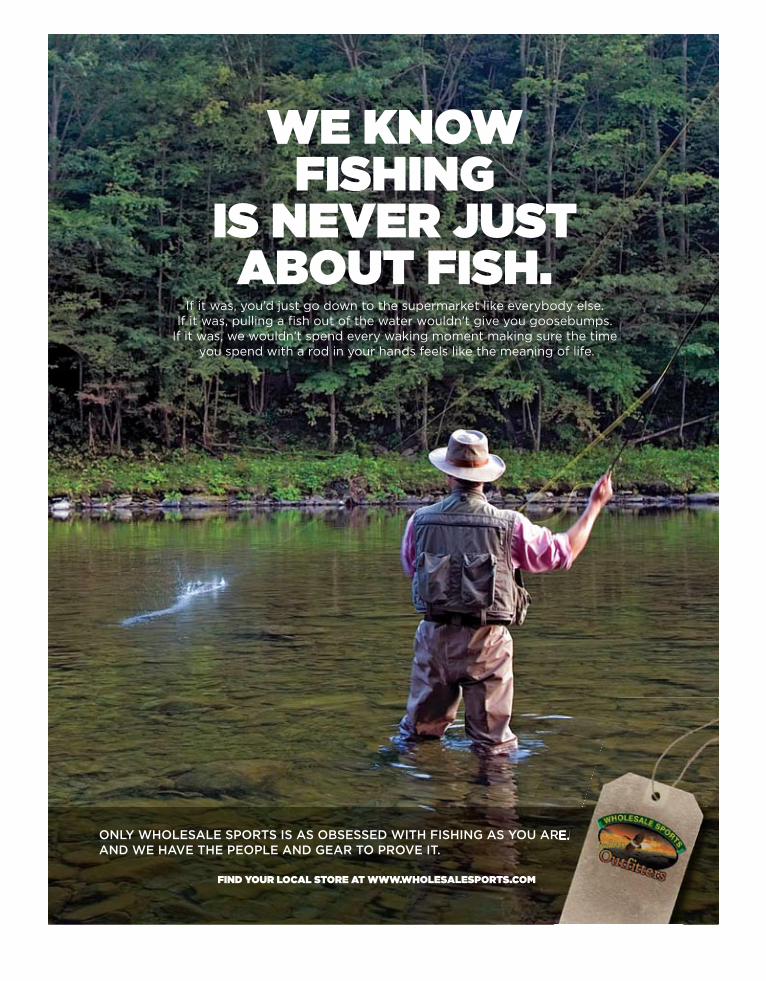
We knoW fishing
is never just about fish.
If it was, you’d just go down to the supermarket like everybody else.If it was, pulling a fish out of the water wouldn’t give you goosebumps.
If it was, we wouldn’t spend every waking moment making sure the time you spend with a rod in your hands feels like the meaning of life.
Only WhOlesale spOrts is as Obsessed With fishing as yOu are.and We have the peOple and gear tO prOve it.
find your local store at WWW.Wholesalesports.com
u are.
Oregon Department of Fish and Wildlife 1
Text highlighted in blue is new or changed from 2011
TABLE OF CONTENTS STA
TEW
IDE
Pages 4 - 23
WILLA
ME
TTEP
ages 46 - 59C
EN
TRA
LP
ages 60 - 66N
OR
THE
AS
TP
ages 68 - 73S
OU
THE
AS
TP
ages 74 - 83S
NA
KE
RIV
ER
Pages 84 - 87
CO
LUM
BIA
Pages 90 - 97
PLEASE HELP US IMPROVE THE NEXT EDITIONEvery year we try to make the contents and layout of this booklet as clear and user friendly as possible. If you have any suggestions to help us improve the presentation of information, please send them to:
Oregon Department of Fish and WildlifeFish Division - Angling Regulations Coordinator
3406 Cherry Avenue NESalem, OR 97303
MA
RIN
EP
ages 99 - 105N
OR
THW
ES
TP
ages 24 - 33S
OU
THW
ES
TP
ages 36 - 45
REGULATIONS MAY CHANGECall the Department of Fish and Wildlife at 503-947-6000 for up-to-date information about fishing and regulations changes or visit us on the Internet at: www.dfw.state.or.us. This Internet site also features a weekly recreation report, the latest Department news releases and much more.
Page How To Use This Guide .................................................... 4 General Regulations Licenses, Tags and Permits ............................................... 5 Catch and Possession Limits ............................................. 8 Definitions .......................................................................... 8 Gear and Bait Restrictions ................................................. 9 General Restrictions ........................................................ 10 Hook and Weight Regulations ......................................... 10 Angling and Harvest Methods, Hours and Restrictions ... 11 Northwest Zone Maps .................................................................................24 Zone and Special Regulations ..........................................26 Southwest Zone Maps .................................................................................36 Zone and Special Regulations ..........................................38 Willamette Zone Maps .................................................................................46 Zone and Special Regulations ..........................................48 Central Zone Maps .................................................................................58 Zone and Special Regulations ..........................................60 Northeast Zone Maps .................................................................................66 Zone and Special Regulations ..........................................68 Southeast Zone Maps .................................................................................72 Zone and Special Regulations ..........................................77 Snake River Zone Maps .................................................................................82 Zone and Special Regulations ..........................................84
Page Columbia Zone Maps .................................................................................88 Zone and Special Regulations ..........................................92 Marine Zone Maps (including Marine Gardens) .....................................97 Zone and Special Regulations ........................................100 Other Information Angler Rights and Access Information .............................15 Angling Mail Order Application ........................................105 Angling Zones Map ...........................................................16 Bail Schedules ..................................................................99 Brook and Bull Trout Identification ....................................71 Clam and Crab Identification .............................................96 Disabilities Hunting and Fishing Permit Information .........87 Easy Angling Oregon ........................................................86 Ethics, Freshwater Angling ...............................................85 Fin-clip and Salmon Identification .....................................17 Fish Measurements ..........................................................21 Free Fishing Weekend ......................................................86 Harvest Card Instructions .................................................22 Health Advisories ..............................................................20 Introduced Fish Species Identification ..............................19 Invasive Species Alert .......................................................65 Native Fish Species Identification .....................................18 Rockfish Species Identification .......................................104 Scanable QR Codes for Zone Regulations Updates On ODFW’s Website ......................................................45 Stream Location and Species Codes ................................23 Tiger Trout Description .....................................................45 Transfer Record Form .......................................................21 Wildlife Area Parking Permit Program Info .......................13
English This book includes important information about Oregon fishing laws. You can be fined or jailed if you violate these laws. Please have an English reader who fully understands this information and can accurately interpret the legal meaning of the regulations in this book explain them to you.
RussianДанная книга содержит важную информацию о законах штата Орегон о рыбной ловле. За нарушение этих законов Вы можете быть оштрафованы или осуждены. Пожалуйста, убедитесь, что Вы полностью понимаете информацию правового характера, изложенную в этой книге.
SpanishEste libro incluye información importante sobre las leyes de pesca de Oregon. Puede recibir multas o ir a la cárcel si infringe esas leyes. Haga que un lector angloparlante que entienda cabalmente esta información y pueda interpretar con exactitud el alcance legal de las leyes expresadas en este libro, se las explique.
Ukrainian Ця книга містить важливу інформацію про закони про риболовлю в штаті Орегон. Якщо Ви порушите ці закони, з Вас можуть стягнути штраф або посадити у вязницю.Будь ласка, попросіть людину, яка добре розуміє англійську і може точно передати юридичне значення цієї книги, прочитати і пояснити Вам ці правила.
Traditional Chinese 本書包括有關俄勒岡州漁業法的重要資訊。如果違反這些法律,將會被處以罰款或監禁。請讓完全瞭解這些資訊並能夠準確詮釋本書條例法律含義的英文讀者為你解釋這些資訊。
Vietnamese Quyển sách này bao gồm những thông tin quan trọng về luật đi săn của Oregon. Quý vị có thể bị phạt tiền hoặc phạt tù nếu vi phạm những luật này. Hãy nhờ một người thạo tiếng Anh, người có thể hoàn toàn hiểu những thông tin này và có thể giải thích chính xác ý nghĩa luật pháp của các quy chế nêu trong sách, giải thích cho quý vị.

Oregon Department of Fish and Wildlife2
Fishing Is Big Business In Oregon Sport fishing is big business in Oregon. In 2008 anglers in Oregon (resident and non-resident) spent over $782 million dollars on tackle, equipment and fishing-related travel. This positive economic impact is felt state-wide but is particularly powerful in many rural counties where up to 40 percent of all travel dollars are related to fishing, hunting or wildlife viewing activities. While the economic impact is
significant, for most Oregon anglers fishing is about more than dollars – it’s about sport, tradition, and time on the water with family and friends. In 2011 Oregon anglers experienced some memorable fisheries: This year we opened 10 coastal rivers to wild coho fish-ing – the largest wild coho season in 15 years. Coastal coho remain listed under the federal Endangered Species Act, but 10 years of protection and restoration under the Oregon Plan for Salmon and Watersheds are paying off with big returns. With conservative quotas and careful management, anglers have been able to harvest wild fish while still protecting native populations. Trout fishing at places like Diamond Lake and Crane Prairie has rebounded in the last few years and anglers are once more catching the trophy-sized trout these lakes were well known for. In 2011, anglers caught a record number of summer steelhead (over 42,600 fish) on the Columbia River. To help promote this often-overlooked fishery, ODFW partnered with Travel Oregon and the Northwest Sportfishing Industry Association to encourage anglers to take advantage of this easily-accessible, world class fishery. The centerpiece of this effort was a website dedicated to summer steelhead fishing, with advice on tackle, techniques and river access. Finally, this summer’s ocean salmon season included some of the most significant Chinook salmon fishing since 2007 as well as some opportunity to harvest wild coho. As good as fishing was in 2011, we want it to be even better in the future. That’s why we continue to restore trout fisheries in waters overrun with illegally-introduced or invasive fish. In the past few years water bodies including Mann and Walton lakes and Antelope Flat Reservoir have been treated to eliminate illegally introduced fish and re-establish productive trout fisheries. Most recently, we’ve treated South Twin Lake and Stateline Reservoir in order to restore trout fisheries there and we expect excellent trout fishing in years to come. The 25-Year Angling Enhancement Plan calls for on-going efforts to enhance our trout and warmwater fisheries and make them more accessible to anglers. In 2011, projects (many of them funded by the Fish Restoration and Enhancement Program) ranged from
restoration of Sauvie Island ADA Fishing Piers to ensure long-term access, to recreational warmwater fishing opportunities for families and individuals in the Portland Metropolitan area, to access and facility improvements to many local valley trout and warmwater fishing ponds, to construction of a new youth fishing pond in Madras. Our hatchery programs will continue to play a big part in providing fishing opportunity. And we will continue to fine-tune our hatchery programs as scientists learn more about the impact hatchery fish can have on native fish populations. If you have fished in Oregon for a while, you already know that our hatchery releases have changed over the years as new information became available. We will continue to evaluate our hatchery programs, and make changes when necessary, to reflect new scientific findings. Hatchery strategies also will be considered as we develop a multi-species plan for coastal streams and rivers from Elk River north. This new initiative will consider several species of salmon and steelhead and develop a comprehensive coast-wide strategy for managing fish populations. We also may be able to identify wild fish populations upon which new or additional harvest opportunities exist. Oregon anglers enjoy some of the most diverse fishing opportunities in the country: trout and bass, ocean rockfish and halibut, salmon and steelhead, clams and crabs. We offer lots of resources to help you find your place to fish. Our website continues to offer updated fishing reports, how-to’s and other information to help you plan an afternoon getaway or week-long trek. And one final note: Beginning this year, parking permits will be required at some ODFW wildlife areas (Sauvie Island, EE Wilson, Denman, Ladd Marsh and Summer Lake). Non-hunters will need to purchase a $7 daily or $22 annual parking permit to park in the areas. The funds will be used for facilities upkeep and to develop wildlife viewing opportunities, an activity growing in popularity. Anglers who purchase a combination fishing and hunting license or Sports Pac will receive a free annual parking permit as hunting license dollars already go to support wildlife areas.
I hope you enjoy many days on the water in 2012. We have appreciated your support in the past and hope we can continue to earn it in the future. With every fishing license and fishing rod you buy, you are supporting our mission of providing and promoting fishing opportunity while conserving Oregon’s fish and wildlife resources. Thank you,
Roy Elicker, Director

Oregon Department of Fish and Wildlife 3
StevensMarine_FishingRegs_2012.indd 1 10/20/11 10:17 AM
™
Tires • WHeels • BaTTeries • alignmenT • sHocks • Brakes
For over 58 years Les Schwab Tire Centers have been committed to providing the best products and services to our customers.
Oregon Department of Fish and Wildlife4
Text highlighted in blue is new or changed from 2011
ODFW on the Internet: www.dfw.state.or.us
E-mail us at: [email protected]
ODFW Headquarters: 503-947-6000
orIn-state toll-free:
800-720-6339
Information & Education: 503-947-6002
Fish Division: 503-947-6201
Licensing Services: 503-947-6100
Marine Programs: 541-867-4741
Wildlife Violations: 1-800-452-7888
The information in this booklet will be furnished in alternate format for people with disabilities, if needed. Please call 503-947-6002
or e-mail to: [email protected] to
request an alternate format.
ODFW prohibits discrimination on the basis of race, color, national origin, age, sex or disability. If you believe you
have been discriminated against in any ODFW program,
activity or facility, or if you desire further information,
please contact: Deputy Director, Fish & Wildlife Programs, ODFW, 3406
Cherry Ave. NE, Salem, OR 97303-4924, or call 503-947-
6000, or write to the Civil Rights Coordinator for Public
Access, U.S. Fish and Wildlife Service
at: Mail Stop: WSFR-40204401 N. Fairfax Drive, Arlington, VA 22203.
ODFW allows appropriate advertising in this booklet to
help offset the cost of printing.
ODFW neither endorses products or services listed nor
accepts any liability arising from the use of products or
services listed.
Front Cover:
Fly-fishing for trout on Drift Creek.
This guide contains information you need to legally fish throughout Oregon.
NOTE: Regulations may change on short notice during the year or season. If you want the latest on regulations or other fish-ing information, you may call the Oregon Department of Fish and Wildlife at 503-947-6000 during normal businss hours or visit us at our Internet site: www.dfw.state.or.us.
Oregon has three types of regulations for all fishing waters:•General Regulations – Include infor-
mation on licenses, tags/harvest cards, permits, catch and possession limits, defini-tions, gear and bait restrictions, and harvest methods and hours.
•Zone Regulations – Apply to entire geo-graphical areas. There are nine zones in Oregon.
•Special Regulations – Apply to specific bodies of water or portions of water within a zone. If a body of water or specific refer-ences to species, catch limits, length limits, seasons, or other specifications are not made in the Special Regulations for the zone, then Zone Regulations apply.
Before you fish any body of water, always:Check the 1. Special Regulations first. If the waterbody you intend to fish is listed, then follow the Special Regulations but also check in the Zone Regulations for addi-tional regulations which apply.If a body of water is not listed in the 2. Special Regulations for the zone, check the Zone Regulations.Regardless of where you fish, be certain to 3. review the General Regulations.
Let’s try an example. You want to go fishing at Crescent Lake in Central Oregon.
First, determine the zone where Crescent 1. Lake is located. You locate the lake on the Central Zone map on page 59.Next, determine if there are any special 2. fishing regulations for Crescent Lake.
You find Crescent Lake listed on• page 61.Crescent Lake has a trout daily• catch limit that may include only one lake trout that must be at least 30 inches in length.You then turn back to • page 60 and review the Zone Regulations for the Central Zone.By reading the • Zone Regulations, you learn you may catch and keep only five trout per day with a minimum size limit of 8 inches, of which only one may be over 20 inches.Thus, if you catch and keep one• lake trout that is at least 30 inches in length, you may still catch four other trout in Crescent Lake that are 20 inches or less.
Can you fish Crescent Lake 3. all year?On page • 60, you note that the season column states lakes in the Central Zone are open to fishing for trout all year.
What do you need to legally catch a4. trout in Crescent Lake?
You note that there are no other • re-strictions listed in the Special or Zone Regulations.So you turn to • pages 5-12 to review the General Regulations.
In the 5. General Regulations you learn:You need an angling license;•You may not use live fish to catch • fish in Crescent Lake; andYou may only use one fishing rod, except •by permit.
(continued on next page)
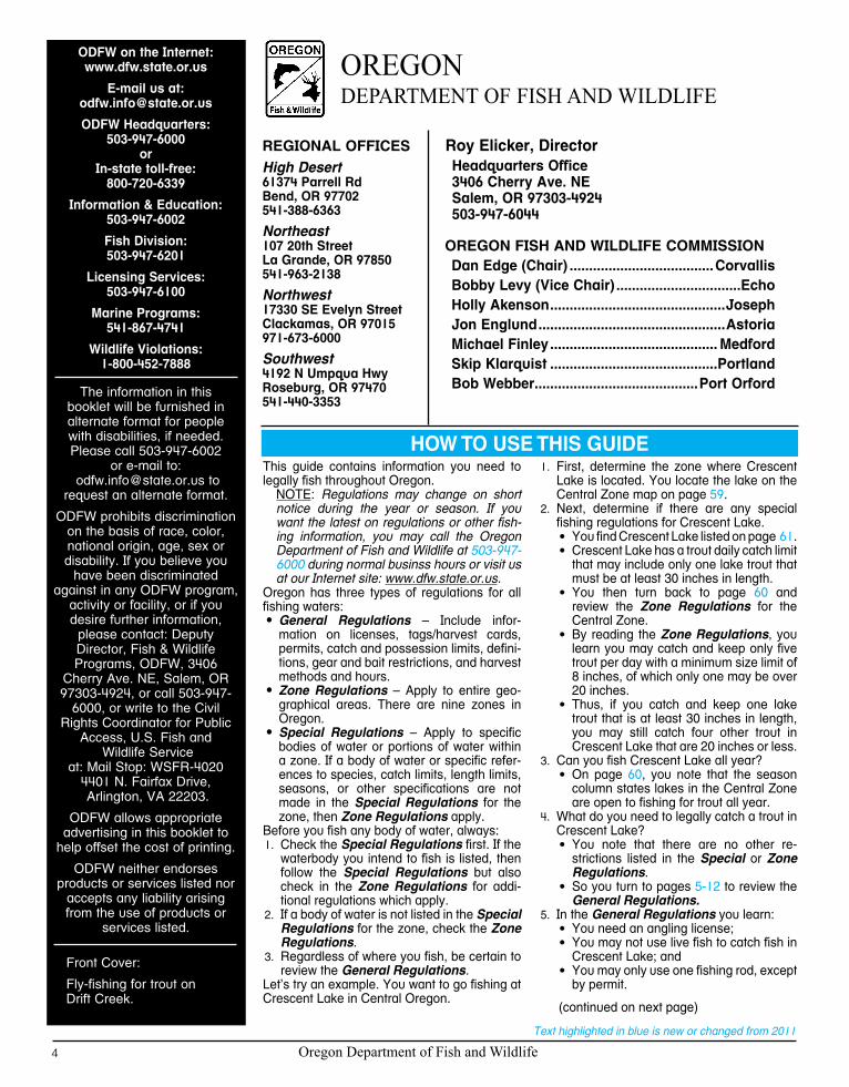
HOW TO USE THIS GUIDE
OregOn Department OF Fish anD WilDliFe
OREGON FISH AND WILDLIFE COMMISSIONDan Edge (Chair) .....................................CorvallisBobby Levy (Vice Chair) ................................EchoHolly Akenson .............................................JosephJon Englund ................................................AstoriaMichael Finley ........................................... MedfordSkip Klarquist ...........................................PortlandBob Webber ..........................................Port Orford
REGIONAL OFFICESHigh Desert 61374 Parrell Rd Bend, OR 97702 541-388-6363
Northeast 107 20th Street La Grande, OR 97850 541-963-2138
Northwest 17330 SE Evelyn Street Clackamas, OR 97015 971-673-6000
Southwest 4192 N Umpqua Hwy Roseburg, OR 97470 541-440-3353
Roy Elicker, DirectorHeadquarters Office 3406 Cherry Ave. NE Salem, OR 97303-4924 503-947-6044

Oregon Department of Fish and Wildlife 5
Text highlighted in blue is new or changed from 2011 * To obtain mail order licenses and/or tags see page 105.
Instructions:Read the 1. Special Regulations for the zone in which you will be fishing. Special Regulations apply to specific bodies of water or portions of water within a zone. If specific references to a body of water, species, catch limits, length limits, seasons, or other speci-fications are not made in the Special Regulations for this zone, then Zone Regulations apply.Read the section entitled 2. Regulations for this zone for the zone in which you will be fishing.Always read the following 3. General Regulations, which apply to all zones, for information about licenses; tags/harvest cards, and permits; definitions; catch and possession limits; gear and bait restrictions; and harvest methods and hours, before going fishing.Emergency or permanent rules adopted since 4. these rules were printed may supersede these regulations. Anglers may call ODFW headquarters or regional offices at the numbers on page 4 of these regulations, or check the ODFW web site, www.dfw.state.or.us for these rules.
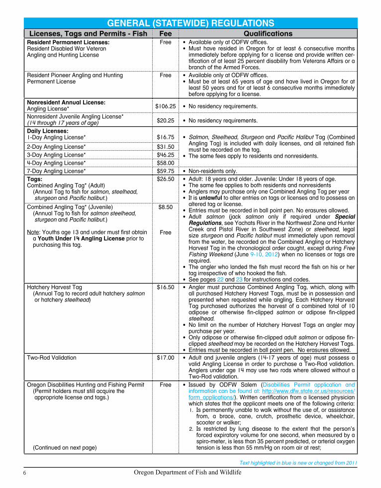
Licenses, Tags and Permits:Licenses, tags and permits can be obtained at license agents throughout the state of Oregon, via the Internet (www.dfw.state.or.us/1. online_license_sales/index.asp), or through the headquarters office in Salem by mail, fax, or in person. Licenses and tags may be purchased for you by a family member or friend.State and federal laws require a Social Security Number to obtain most hunting and fishing licenses.2. All persons 14 years or older must have in possession a valid Oregon angling license to angle for or take or assist another in angling 3. for or taking of any fish for personal use, except:
During “Free Fishing Weekend” (June• 9-10, 2012) when no license or tag is required;When taking • smelt, crayfish, or bullfrogs;Oregon resident landowners and members of their immediate family may angle for fish on land they own and reside upon;•When angling in the Pacific Ocean within 3 miles of shore between Cape Falcon, Oregon and Leadbetter Point, Washington •either a resident Washington license or an Oregon license is valid. Persons other than Washington residents must have a valid Oregon license to land fish in Oregon which were caught in the ocean.
All persons 14 years or older must have in possession a valid Oregon 4. shellfish license to take any shellfish for personal use, except:During “Free Fishing Weekend” (• June 9-10, 2012) when no license is required;When taking • crayfish;Oregon resident landowners and members of their immediate family may take • shellfish on land they own and reside upon.
All anglers, 5. regardless of age, need in possession a valid Combined Angling Tag to angle for salmon, steelhead, sturgeon or Pacific halibut. Anglers may purchase only one Combined Angling Tag (authorizing harvest of 20 salmon or steelhead) per year. Any salmon or steelhead may be recorded on the Combined Angling Tag.Anglers may purchase multiple Hatchery Harvest Tags to record adipose or otherwise fin-clipped 6. salmon or adipose fin-clipped steelhead harvested, in lieu of recording those fish on the Combined Angling Tag. Only adipose or otherwise fin-clipped salmon or adipose fin-clipped steelhead may be recorded on the Hatchery Harvest Tag.
Licenses, Tags and Permits - Fish Fee QualificationsResident Annual Licenses:Angling License* $33.00 •See also, definition of “Resident” at top of page 9.
•A person who has resided in Oregon for at least 6 consecutive months immediately prior to the date of making application for a license, tag or permit.
Combination Angling/Hunting License* $58.00Juvenile Angling License*(14 through 17 years of age) $9.00
Youth Under 14 Angling License FreeSenior Citizen Combination Angling/Hunting License* $25.50 •Must be at least 70 years of age and have lived in Oregon for more
than 5 years and for at least 6 consecutive months immediately before buying a license.
•Available from license agents.Senior Citizen Angling License* $15.00
Sports Pac License $164.75 • Includes: combination angling/hunting license; shellfish license; salmon, steelhead, sturgeon, Pacific halibut, spring turkey, cougar, fall black bear, elk and deer tags; upland bird and waterfowl validations.
Juvenile Sports Pac License(resident only age 12 through 17)
$52.00 • Includes: combination angling/hunting license; shellfish license; salmon, steelhead, sturgeon, Pacific halibut, spring turkey, cougar, fall black bear, elk and deer tags; upland bird and waterfowl validations.
Duplicate License or Tag $17.00 • Duplicate tags available only at ODFW offices.
GENERAL (STATEWIDE) REGULATIONS
Continue to thoroughly read the General Regulations for other information regard-ing harvest methods and hours.Note: Text highlighted in blue is new or changed from last year’s guide.Other Information - Boats and Motors:Only those boating regulations restricting sport fishing are listed in this booklet.
General Boating Regulations:Information on general boating regulations can be obtained from the web at: www.boatoregon.com or Oregon State Marine Board, 435 Commercial Street NE, Salem, OR 97301, 503-378-8587, and Marine Board agents.
Guides and Packers: Information on guides and packers can be obtained from Oregon State Marine Board, 435 Commercial Street NE, Salem, OR 97301, 503-378-8587.Travel Information: Oregon Tourism, Telephone: 1-800-547-7842.
HOW TO USE THIS GUIDE (continued)
Oregon Department of Fish and Wildlife6
Text highlighted in blue is new or changed from 2011
Licenses, Tags and Permits - Fish Fee QualificationsResident Permanent Licenses:Resident Disabled War Veteran Angling and Hunting License
Free • Available only at ODFW offices.• Must have resided in Oregon for at least 6 consecutive months
immediately before applying for a license and provide written cer-tification of at least 25 percent disability from Veterans Affairs or a branch of the Armed Forces.
Resident Pioneer Angling and Hunting Permanent License
Free • Available only at ODFW offices.• Must be at least 65 years of age and have lived in Oregon for at
least 50 years and for at least 6 consecutive months immediately before applying for a license.
Nonresident Annual License:Angling License* $106.25 • No residency requirements.
Nonresident Juvenile Angling License*(14 through 17 years of age) $20.25 • No residency requirements.
Daily Licenses:1-Day Angling License* $16.75 • Salmon, Steelhead, Sturgeon and Pacific Halibut Tag (Combined
Angling Tag) is included with daily licenses, and all retained fish must be recorded on the tag.
• The same fees apply to residents and nonresidents.
2-Day Angling License* $31.503-Day Angling License* $46.254-Day Angling License* $58.007-Day Angling License* $59.75 • Non-resid ents only.Tags:Combined Angling Tag* (Adult)
(Annual Tag to fish for salmon, steelhead, sturgeon and Pacific halibut.)
$26.50 • Adult: 18 years and older. Juvenile: Under 18 years of age.• The same fee applies to both residents and nonresidents• Anglers may purchase only one Combined Angling Tag per year• It is unlawful to alter entries on tags or licenses and to possess an
altered tag or license.• Entries must be recorded in ball point pen. No erasures allowed.• Adult salmon (jack salmon only if required under Special
Regulations, see Yachats River in the Northwest Zone and Hunter Creek and Pistol River in Southwest Zone) or steelhead, legal size sturgeon and Pacific halibut must immediately upon removal from the water, be recorded on the Combined Angling or Hatchery Harvest Tag in the chronological order caught, except during Free Fishing Weekend (June 9-10, 2012) when no licenses or tags are required.
• The angler who landed the fish must record the fish on his or her tag irrespective of who hooked the fish.
• See pages 22 and 23 for instructions and codes.
Combined Angling Tag* (Juvenile)(Annual Tag to fish for salmon steelhead, sturgeon and Pacific halibut.)
Note: Youths age 13 and under must first obtaina Youth Under 14 Angling License prior topurchasing this tag.
$8.50
Free
Hatchery Harvest Tag(Annual Tag to record adult hatchery salmon or hatchery steelhead)
$16.50 • Angler must purchase Combined Angling Tag, which, along with all purchased Hatchery Harvest Tags, must be in possession and presented when requested while angling. Each Hatchery Harvest Tag purchased authorizes the harvest of a combined total of 10 adipose or otherwise fin-clipped salmon or adipose fin-clipped steelhead.
• No limit on the number of Hatchery Harvest Tags an angler may purchase per year.
• Only adipose or otherwise fin-clipped adult salmon or adipose fin-clipped steelhead may be recorded on the Hatchery Harvest Tags.
• Entries must be recorded in ball point pen. No erasures allowed.Two-Rod Validation $17.00 • Adult and juvenile anglers (14-17 years of age) must possess a
valid Angling License in order to purchase a Two-Rod validation. Anglers under age 14 may use two rods where allowed without a Two-Rod validation.
Oregon Disabilities Hunting and Fishing Permit(Permit holders must still acquire the appropriate license and tags.)
(Continued on next page)
Free • Issued by ODFW Salem (Disabilities Permit application and information can be found at: http://www.dfw.state.or.us/resources/form_applications/). Written certification from a licensed physician which states that the applicant meets one of the following criteria:
Is permanently unable to walk without the use of, or assistance 1. from, a brace, cane, crutch, prosthetic device, wheelchair, scooter or walker;Is restricted by lung disease to the extent that the person’s 2. forced expiratory volume for one second, when measured by a spiro-meter, is less than 35 percent predicted, or arterial oxygen tension is less than 55 mm/Hg on room air at rest;
GENERAL (STATEWIDE) REGULATIONS

Oregon Department of Fish and Wildlife 7
Text highlighted in blue is new or changed from 2011
GENERAL (STATEWIDE) REGULATIONSS
TATE
WID
EP
ages 4 - 23
Licenses, Tags and Permits - Fish Fee QualificationsOregon Disabilities Hunting and Fishing Permit
(Permit holders must still acquire the appropriate license and tags.)
(Continued from previous page.)
Free Has a cardiac condition to the extent that the person’s functional 3. limitations are classified in severity as Class III or Class IV, accord-ing to standards established by the American Heart Association;Has a permanent, physical impairment that prevents the person 4. from holding or shooting a firearm or bow or from holding a fish-ing rod in hand; orHas central visual acuity that permanently does not exceed 5. 20/200 in the better eye with corrective lenses, or the widest diameter of the visual field is no greater than 20 degrees; or
•Written proof that the last official certification of record by the United States Department of Veterans Affairs or any branch of the Armed Forces of the United States shows the person to be at least 65 percent disabled (ORS 496.018).
•Holders of a Oregon Disabilities Hunting and Fishing Permit; a Permanent Wheel-chair Angling License or a Permanent Blind Angler License (issued prior to 2000); or a Walking Disability Permit (issued prior to 1988) may angle from an anchored craft in waters where angling from a floating device is prohibited by ODFW. This allowance does not supersede safety or security regulations enacted by other agencies.
•A person may assist a disabled angler provided:The person assisting the disabled angler has the appropriate 1. license and tags in possession and a copy of the disabled angler’s Permanent Disabilities Permit while providing assistance.The Permanent Disabilities Permit holder is present and partici-2. pating in the angling activities.Fish harvested while providing assistance to the Permanent 3. Disabilities Permit holder become part of the Disabled Permit holder’s bag and possession limit.The disabled angler and their assistant(s) may only use one 4. fishing rod while being assisted or providing assistance, except in Two-Rod waters when disabled angler and assistant(s) have Two-Rod validations.The person(s) assisting the disabled angler may be in posses-5. sion of their daily bag limit and still assist the disabled angler.
Licenses and Permits - Shellfish Fee Qualifications
Resident Annual Shellfish License $7.00 • Same as Resident Annual Angling License (see page 5 under Licenses, Tags and Permits).
Nonresident Annual Shellfish License $20.50 • No residency requirements.Disabled Veteran Shellfish License Free •Available only at ODFW offices.
•Must have resided in Oregon for at least 6 consecutive months immediately before applying for a license and provide written certification of at least 25 percent disability from Veterans Affairs or a branch of the Armed Forces.
Nonresident 3-day Shellfish License $11.50 •No residency requirements.Disabled Clam Digger Permit•A person may assist a disabled clam digger,
provided:Both diggers have their own containers for1. clams; andThe disabled clam digger is within 100 2. feet of the assistant while the assistant is digging; andThe disabled clam digger has one of the3. permits or licenses listed in possession on the clam beds; andThe person assisting the clam digger4. holding one of the permits or licenses listed has a copy of said permit or license in possession on the clam beds.
Free • Issued by ODFW Newport, Charleston or Astoria offices.•Written certification from a licensed physician that the applicant
meets one of the following criteria:Severely limited mobility because of paralysis or loss of use of 1. some or all of a person’s legs or arms;Loss of vision or substantial loss of visual acuity or visual field 2. beyond correction; orUnable to walk without an assistive device or unable to walk 3. more than 200 feet.
•The doctor’s certification must state whether the condition is permanent or temporary and, if temporary, the date when assistance would no longer be required.
•A Disabled Veterans License, a Oregon Disabilities Hunting and Fishing Permit, Wheelchair Angler License, or a Blind Angler License, issued by ODFW, may be used instead of the Disabled Clam Digger Permit.
•A shellfish license is required in addition to this permit.Abalone Harvest Permit Free • Issued by ODFW Newport, Charleston or Astoria offices.

Oregon Department of Fish and Wildlife8
Text highlighted in blue is new or changed from 2011
Catch and Possession Limits:Catch and Possession Limits:
Catch and possession limits apply to all waters and across Zone boundaries and apply to all fish and shellfish in possession regardless of condition. This includes fish and shellfish which are fresh, and when lawful, frozen, canned, smoked or otherwise processed.
Daily Limit: Maximum number of fish or shellfish which may be legally caught and reduced to possession in one day. An angler may take daily limits of several types of fish per day.
Annual Limit: Applies to abalone, Pacific halibut, salmon, steelhead and sturgeon only. The annual catch limits are: abalone 5; sturgeon 5; Pacific halibut 6; and 20 for salmon and steelhead, in any combination, when recorded on the Combined Angling Tag. Adipose or otherwise fin-clipped salmon or adipose fin-clipped steelhead legally recorded on a Hatchery Harvest Tag do not count toward this annual limit.
Possession Limit: Maximum number or amount of a type of fish or shellfish that a person may lawfully possess in the field or forest, or in transit to the place of permanent residence. The possession limit is: 2 daily limits for all species, including jack salmon except 1 daily limit for abalone, 1 daily limit on the vessel or three daily limits on land for Pacific halibut, and no possession limit for adult salmon, steelhead, or sturgeon. Anglers are restricted to 1 daily catch limit and 1 annual catch limit for all fish species from the Columbia River, even if licensed in Oregon and Washington.
Size Limit: It is unlawful to take or have in possession any fish or shellfish that are smaller than the minimum size or larger than the maximum size limits. All undersized, oversized, prohibited species or unwanted fish or shellfish taken must be immediately released unharmed and should not be removed from the water.
Definitions:Adipose Fin-Clipped Fish
A hatchery salmon, steelhead or trout with a clipped adipose fin and having a healed scar at the location of the fin. The adipose fin is the small fatty fin on salmon, steelhead, and trout located between the dorsal fin and the tail (see page 17).
Aggregate The total sum or number; as in 15 fish in aggregate. Generally used where several species make up a combined daily catch limit.
Angling To take or attempt to take fish for personal use by hook and line.Artificial Fly A fly is a hook, dressed with conventional fly tying materials. The affixed materials may be natural or synthetic.
Tied in conjunction with other materials, the following items may be part of the fly: wire (lead or other metal) used for weighting the fly, dumbbell eyes or beads (metal, glass or plastic). A fly is not a hook to which sinkers, molded weights, spinners, spoons or similar attractors are attached.
Bait Any item used to attract fish which is not an artificial fly or a lure. Molded soft plastic or rubber imitation worms, eggs, or other imitation baits are considered bait. Scent is not considered bait.
Bank Angling Angling from the mainland or island shore or from docks physically attached to the shore.Barbless Hook A hook manufactured without barbs or a hook with the point barb removed or bent down to the shank.Chumming Depositing in the water any substance, not attached to a hook, which may attract fish.Fin Clip A healed scar where a fish fin has been clipped.Fly Angling Angling with a fly rod, fly reel, (no spinning or fixed spool reel(s)), floating or sinking fly line, leader, any type of
backing line, and an artificial fly. In waters restricted to “Fly Angling Only” no additional weights or attractors shall be attached to the hook, leader, or line, and no metal core lines may be used.
Game Fish Are defined as follows: Trout, salmon when taken by angling, steelhead, largemouth bass, smallmouth bass, blue-gill, crappie, other sunfish, catfish, walleye, yellow perch, hybrid bass (white x striped cross), whitefish, sturgeon and shad when taken by angling, mullet, grayling and striped bass.
Groundfish Group Includes: lingcod, rockfish, greenling, cabezon, skates, flatfish other than Pacific halibut on page 100.Herring Jig A series of single point hooks that are no larger than 3/8 inch gap between point and shank. Herring jigs are typi-
cally used to catch species such as herring, sardine, and anchovy. A herring jig may have any number of hooks.Immediate Family A landowner’s immediate family is the landowner’s spouse, domestic partner, children and parents who reside on
the landowner’s property.In the Field, Forest or Transit
Anywhere other than a permanent residence.
Lake The slack water portion of all lakes, ponds and reservoirs; excluding beaver ponds and tide-gate sloughs.Length The length of any fish (except halibut and sturgeon) is the shortest distance measured in a straight line between
the tip of the tail and the tip of the snout while the fish is lying on its side, on a flat surface, with its tail in a normal position (see sketch, page 21). The length of a Pacific halibut is measured in a straight line from the tip of the lower jaw with the mouth closed to the extreme end of the middle of the tail (see sketch, page 21). The fork length of a sturgeon is measured in a straight line from the tip of the nose to the fork in the caudal fin (tail), with the fish laying on its side, on a flat surface (see sketch, page 21).
Lure An artificial device, complete with hooks, intended to attract and entice fish; excluding molded soft plastic or rubber imitation baits and artificial flies. Corkies, spin-n-glos, go-glos, birdy drifters, lead-head jigs, etc., are con-sidered lures. Molded soft plastic or rubber imitation worms, eggs, or other imitation baits are considered bait.
Metal Core Line Line which when bent sharply and then released remains bent.
GENERAL (STATEWIDE) REGULATIONS

Oregon Department of Fish and Wildlife 9
Text highlighted in blue is new or changed from 2011
Nongame Fish Are defined as all fish except those which are defined as Game Fish. See species listed as Nongame in the Harvest Methods, Hours and Restrictions table on page 11.
Offshore Pelagic Species
Includes all species of tuna and mackerel (family Scombridae), swordfish, all species of bill fish (family Istiophoridae), all species of the family jacks (family Carangidae), opah, dorado, Pacific pomfret, and all species of shark except leopard shark, spiny dogfish, white shark, soupfin shark, and basking shark.
Permanent Residence
A residential dwelling where a person normally lives, with associated features such as address, telephone number, utility account, etc.
Resident A person who has resided in Oregon for at least 6 consecutive months immediately prior to the date of making application for a license, tag or permit. Resident license and tags may also be purchased by:
Members of the Armed Forces of the United States who:1. • Are permanently assigned to active duty in this state, and their spouse and dependent children.• Reside in this state while assigned to duty at any base, station, shore establishment or other facility in this state.• Reside in this state while serving as members of the crew of a ship that has an Oregon port or shore
establishment as its home port or permanent station.• Armed Forces includes Army, Navy, Air Force, Marine Corps and Coast Guard, or their reserve components;
the National Guard or Oregon National Guard.2. Aliens attending school in Oregon under a foreign student exchange program.
Rockfish All genera and species of the family Scorpaenidae which include Sebastes, Sebastolobus, and that occur in Oregon. Refer to ODFW’s website or contact ODFW’s Marine Program at the Newport office for a listing of Oregon’s Rockfish species, descriptions and photographs.
Salmon Includes 5 species: Chinook, coho, chum, sockeye and pink. Adult salmon are coho over 20 inches in length and any other salmon species over 24 inches in length, except in the ocean where all legal size salmon are considered to be adults. Jack salmon are coho between 15 and 20 inches in length and any other salmon species between 15 and 24 inches in length when in fresh-water or bays. Jack salmon are not a separate species of salmon, but a life-history stage of various species of salmon that return to fresh-water and become sexually mature after only a short period in the ocean. Thus, there are jack coho and jack Chinook salmon, for example. See exception to salmon minimum length limits for Sections 2-4 of the Columbia River and the Umatilla River.
Shellfish Abalone, clams, crabs, crayfish, mussels, oysters, piddocks, scallops, shrimp and other marine invertebrates with shells.
Snagging Hooking or attempting to hook fish other than inside the mouth.Steelhead Sea-run rainbow trout over 20 inches in length except in Northwest and Southwest Zone streams where rainbow
trout over 16 inches in length are defined as steelhead.Stream The free-flowing portion of all rivers and creeks, including beaver ponds and tide-gated sloughs.Strike Indicator A hookless, unscented floating device attached to the line or leader for the purpose of signaling a strike at the fly.
The point of attachment must be at least 18 inches from the fly. Strike indicators are not considered an “attach-ment” or an “attractor” and are therefore permitted in fly angling and artificial fly waters, except the North Umpqua.
Sunfish Largemouth and smallmouth bass; bluegill; crappie; green sunfish; redear sunfish; Sacramento perch; pumpkin-seed; warmouth and all hybrids of these species.
Take To kill, reduce to possession or control.Tidewaters Stream or estuary waters affected by daily ebb and flow of tides.Tributary A stream flowing into a larger stream or a lake.Trout All rainbow (except steelhead); cutthroat; brook; brown; bull; golden and lake trout; Atlantic salmon and kokanee.
Coho salmon are always considered salmon regardless of size and Chinook salmon are considered trout in some areas (see Special and Zone regulations).
Two-Rod Validation
A validation which allows an angler with a current resident or non-resident fishing license to angle with two rods or lines when angling on standing water bodies which include lakes, ponds, and reservoirs including Snake River impoundments above Hell’s Canyon Dam but excludes the Columbia River and its impoundments. Seasonal or permanent backwaters and sloughs of rivers, streams or creeks and bays, estuaries and ocean waters are also excluded from the Two-Rod Validation. See exceptions in Special Regulations which prohibit Two-Rod angling in coastal lakes during wild coho salmon seasons.
Gear and Bait Restrictions:Use of Fish for Bait
It is 1. unlawful to: transport live fish into, within or out of this state; hold any live fish in the waters of this state; or release or attempt to release any live fish into the waters of this state; except as provided by OAR 635-007-0600(3)(a) for aquaria fish intended for aquaria use and those holding a valid Fish Transport Permit.Live fish may not be used or held for use as bait, except live nongame fish may be used in the ocean, bays and tidewaters when taken 2. from the waterbody in which they will be used.Dead fish, preserved fish, or parts of fish, 3. shellfish and fish eggs may be used as bait. Goldfish may not be used as bait or in angler’s possession while angling.It is 4. unlawful to use lamprey as bait in any recreational fishery.Live 5. crayfish may not be used as bait and live crayfish taken for bait may not be released into Oregon waters except in the waterbody in which they were taken.Live 6. leeches may not be used as bait or in angler’s possession while angling.
GENERAL (STATEWIDE) REGULATIONS
(Continued on next page)
STA
TEW
IDE
Pages 4 - 23

Oregon Department of Fish and Wildlife10
Text highlighted in blue is new or changed from 2011
General Restrictions:The following activities are unlawful:
Use of more than one rod or one line when angling for any fish except:1. a. A person with a current Two-Rod Validation may use two rods or lines when angling on standing water bodies which include lakes,
ponds, and reservoirs but exclude reservoirs on the Columbia River and the Snake River below Hells Canyon Dam. Seasonal or permanent backwaters and sloughs of rivers, streams or creeks and bays, estuaries and ocean waters are also excluded from the Two-Rod Validation. See exceptions in Special Regulations which prohibit Two-Rod angling in coastal lakes during wild coho salmon seasons.
b. Any number of rods or lines are allowed outside of three miles from shore when angling for offshore pelagic species and only if no species other than offshore pelagic species have been retained.
c. Rods or lines must be closely attended.Use of gurdies, winches or reels affixed to a boat to land fish (rod or line must be held in hand) except when used for retrieving crab 2. rings or pots.Sale or purchase of fish or 3. shellfish, or parts thereof, which have been taken for personal use. Except the skeletal remains of ocean food fish may be sold; and eggs from ocean-caught salmon may be sold to a licensed wholesale fish or bait dealer.Catching all or part of another person’s catch limit, except as provided for by a Oregon Disabilities Hunting and Fishing Permit. 4. See page 7.Trespassing on a fishway, weir or fish trap; and angling within 200 feet above and 200 feet below a weir or the entrance or exit of a 5. fishway or fish trap either public or private.Taking or attempting to take fish from state or federal hatchery facilities.6. Removal, alteration or possession of ODFW signs.7. Angling through a human-made ice hole larger than 12 inches diameter or length.8. Transporting live fish or live eggs from one waterbody to another or into the state without a permit from ODFW.9. Wasting fish, 10. shellfish or marine intertidal invertebrates.Angling on private land without permission.11. Denying ODFW employees, peace officers or landowners opportunity to inspect license, catch and gear. It is also unlawful for any 12. person licensed by ODFW to fail to comply with the directions of authorized Department personnel related to the collection of sampling data or material from salmon or other fish. It is also unlawful for any such person to fail to relinquish to the Department any part of a salmon or other fish containing coded-wire tags, including but not limited to, the snouts of those salmon that are marked by having clipped adipose fins.Taking or attempting to take any fish by means of chumming, or knowingly angle with the aid of chum, except chumming is13. allowed when fishing for offshore pelagic species outside of three miles from shore and only if no species other than offshore pelagic species have been retained.Continuing to angle for the same type of fish after taking and retaining a catch or possession limit. Exceptions are provided for in 14. bass fishing tournament regulations and while anglers are providing assistance to a disabled angler (see page 7). Anglers may continue to angle for sturgeon provided all subsequent fish are released.Dispose of dead animal (fish) carcasses, or parts thereof, in Oregon waters15. .To attach a tag or physically mark any fish in Oregon waters without a scientific taking permit except that adipose or otherwise16. fin-clipped fish may be tagged as part of angling tournament activities authorized under Department tournament permits. Contact ODFW in Salem for an application.Take a fish which has had a radio tag inserted (a fish with an antenna trailing from its mouth or body) except radio-tagged fish17. may be retained, when otherwise legal, (consistent with all other existing regulations and applicable laws) in the mainstem Columbia River and its tributaries.Unless authorized by a specific permit issued by the Oregon Fish and Wildlife Commission, no person may angle for or possess18. any of the following species of fish: Goose Lake lamprey; Pacific lamprey; River lamprey; Western brook lamprey; Miller Lake lamprey; Klamath lamprey; Pit-Klamath lamprey; Klamath Basin lamprey; Goose Lake tui chub; Warner Basin tui chub; Alvord chub; Catlow tui chub; Oregon lakes tui chub; Sheldon tui chub; Summer Lake Basin tui chub; Borax Lake chub; Oregon tui chub of Hutton Spring; Oregon chub (Willamette Basin); California roach; Millicoma dace; Foskett Springs speckled dace; Lahonton redside shiner; Goose Lake sucker; Modoc sucker; Tahoe sucker; Lost River sucker; short nose sucker (mullet) of Klamath County; Jenny Creek sucker; Warner sucker; Malheur mottled sculpin; margined sculpin; pit sculpin; grass carp; caribe or piranha; walking catfish; Snake River Spring/Summer Chinook Salmon; Snake River Fall Chinook Salmon; Columbia River Coho Salmon. Note: fish listed under state or federal endangered species acts may be harvested under “incidental take permits,” which are considered annually. Check regulations to see under what circumstances these fish may be taken.Snag or attempt to snag gamefish.19. Take, possess, or remove from streams 20. salmon and steelhead carcasses or parts thereof not legally taken.
Hook and Weight Regulations:No more than two hooks may be used while angling for 1. Pacific halibut and no more than three hooks may be used while angling for other species except herring jigs may be used for marine food fish species (defined on pages 11 and 12) other than Pacific halibut. A double or treble point hook is classified as one hook. When angling with two rods (where allowed and with a current Two-Rod Angling Validation), the general hook rule applies to each rod.Measure hook gap from point to shank (see sketches at right).2. When angling for 3. sturgeon, anglers are restricted to one single-point barbless hook in all Oregon waters.When angling for 4. salmon or steelhead, (except in the ocean or as listed under Special Regulations for specific bodies of water) the following regulations apply:
GENERAL (STATEWIDE) REGULATIONS
(Continued on next page)
Oregon Department of Fish and Wildlife 11
Text highlighted in blue is new or changed from 2011
Hook and Weight Regulations: (continued from previous page)Single-point hooks larger than 1-inch and multiple-point hooks larger than 9/16-inch gap are prohibited.•All weight, if not part of a conventional lure, must be attached above the hooks. When using single-point hooks larger than 5/8-inch •gap or multiple-point hooks, the attachment of the weight must be 18 inches or more above uppermost hook.
When angling for 5. salmon or steelhead in the ocean, anglers must refer to Marine Zone Regulations for Salmon and Steelhead, page 101, and the Northwest Zone Special Regulations for Tillamook Bay, page 32.Barbless hooks are advised for fisheries where the release of fish is anticipated, unless specifically required.6.
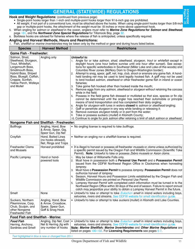
Angling and Harvest Methods, Hours and Restrictions:1. Fish, shellfish or marine invertebrates may be taken only by the method or gear and during hours listed below.
Species Harvest Method RestrictionsGame Fish - Freshwater:Salmon, Shad, Steelhead, Sturgeon, Trout, Whitefish, Largemouth Bass, Smallmouth Bass, Hybrid Bass, Striped Bass, Bluegill, Catfish, Crappie, Sunfish, Yellow Perch, Walleye and Mullet
Angling only Unlawful to:Angle for or take 1. salmon, shad, steelhead, sturgeon, trout or whitefish except in daylight hours (one hour before sunrise until one hour after sunset). See excep-tions for specific waterbodies in Southeast (Miller Lake and Lake-of-the-woods) and Columbia River zones (McNary Dam to Oregon-Washington border);
2. Attempt to snag, spear, gaff, net, trap, club, shoot or ensnare any game fish. A hand-held landing net may be used to land legally hooked fish. A gaff may not be used to land hooked salmon, steelhead or other freshwater game fish in inland or ocean fisheries;Take game fish hooked other than hooked inside the mouth;3. Remove eggs from any 4. salmon, steelhead or sturgeon without retaining the carcass while in the field;Possess in the field game fish dressed or mutilated so that size, species or fin clip 5. cannot be determined until the angler has reached their automobile or principle means of land transportation and has completed their daily angling;Angle for 6. sturgeon with lures in waters closed to salmon or steelhead angling;Gaff or penetrate 7. sturgeon in any way while landing or releasing it;
8. Remove oversize sturgeon totally or in part from the water;9. Take or possess suckers (mullet) in Klamath County;10. Continue to angle for jack salmon after retaining a limit of adult salmon or steelhead.
Nongame Fish and Shellfish - Freshwater:Bullfrogs Angling, Hand, Bow
& Arrow, Spear, Gig, Spear Gun, Dip Net
• No angling license is required to take bullfrogs.
Crayfish Hand, Baited Lines (no hooks allowed), Net, Rings and Traps
Neither an angling nor a • shellfish license is required.
Freshwater Clams and Mussels
Harvest prohibited It is illegal to harvest or possess all freshwater • mussels or clams unless authorized by a specific permit issued by the Oregon Fish and Wildlife Commission (Scientific Take Permit). Note: Unlawful to take or possess Zebra mussels or Asian clams.
Pacific Lamprey Hand or hand-powered tools
May be taken at Willamette Falls only.1. Must have in possession both a 2. Personal Use Permit and a Possession Permit issued from the ODFW Northwest Region Office in Clackamas when harvesting lamprey.Must have a 3. Possession Permit to possess lamprey. Possession Permit does not authorize harvest of lamprey.Season, Harvest Hours and Possession Limits established by the Oregon Fish and 4. Wildlife Commission are printed on Personal Use Permit.Lamprey Harvest Permit with completed catch information must be turned in to the 5. Northwest Region Office within 30 days of the end of season. Failure to report annual catch may jeopardize your ability to obtain a Lamprey Harvest Permit in the future.
Smelt None Unlawful• to take or attempt to take Eulachon smelt in inland waters including bays, estuaries, rivers and streams. See ODFW website for smelt identification guide.
Suckers, Northern Pikeminnow, Carp, Chub, Sculpin, and other Nongame Freshwater Fish
Angling, Hand, Bow & Arrow, Crossbow, Spear, Spear Gun, Gaff & Snag Hook
Unlawful• to take or attempt to take suckers (mullet) in Klamath and Lake Counties.
Food Fish and Shellfish - Marine:Food FishHerring, Anchovy, Sardines and Smelt
Angling, Dip Net, Cast Net & Herring Jig with any number of hooks
Unlawful• to take or attempt to take Eulachon smelt in inland waters including bays, estuaries, rivers and streams. See ODFW website for smelt identification guide.
Note: Marine Shellfish; Marine Invertebrates and Other Marine Regulations are listed on pages 100-102. For Licensing Requirements see pages 5-7.
GENERAL (STATEWIDE) REGULATIONSS
TATE
WID
EP
ages 4 - 23

Oregon Department of Fish and Wildlife12
Text highlighted in blue is new or changed from 2011
Species Harvest Method RestrictionsFood Fish and Shellfish - Marine: (continued from previous page)Lingcod, Rockfish, Cabezon, Greenling, Flounder, Sole, Perch, other Nongame Marine Fish and Off-shore Pelagic species
Angling, Hand, Bow & Arrow, Spear, Spear Gun, Gaff & Snag Hook and Herring Jig
Unlawful• to mutilate fish so that size or species cannot be determined prior to landing or to transport mutilated fish across state water.
Pacific Halibut Single Line, no more than 2 hooks; Spears
Marine Shellfish and Marine Invertebrates
See Marine Zone See • Marine Zone (page 101), and License Requirements (pages 5-7).
SoutheastShannon Hurn
541-573-6582
John DayJeff Neal
541-575-1167
UmatillaBill Duke
541-276-2344
DeschutesBrett Hodgson541-388-6363
UmpquaLaura Jackson541-440-3353
La GrandeTim Bailey
541-963-2138
Upper RogueDan VanDyke541-826-8774
WallowaJeff Yanke
541-426-3279
Mid-ColumbiaRod French
541-296-4628Mid WillametteSteve Mamoyac541-757-4186
UpperWillamette
Jeff Ziller541-726-3515
Mid-CoastBob Buckman541-265-8306
North CoastChris Knutsen503-842-2741
NWWD -Cascade UnitTodd Alsbury971-673-6000
Coos-CoquilleMike Gray
541-888-5515
NWWD - Coast Range
Tom Murtagh(971)673-6000
South Coast
Todd Confer541-247-7605
UNION
CROOK
BAKER
LINN
KLAMATH
GRANT
LANE
MALHEURHARNEY
LAKE
BENTON
SHERMANYAMHILL
CLATSOP
LINCOLN
POLK
GILLIAM
MARION
JEFFERSON WHEELER
MORROW
DESCHUTES
COOS
JACKSON
WASCO
HOODRIVER
WASH.
TILLAMOOK
JOSEPHINE
CURRY
WALLOWA
UMATILLA
DOUGLAS
COLUMBIA
J o h n D a yJ o h n D a yW a t e r s h e dW a t e r s h e d
G r a n d e R o n d eG r a n d e R o n d eW a t e r s h e dW a t e r s h e d
M a l h e u r W a t e r s h e dM a l h e u r W a t e r s h e d
K l a m a t h W a t e r s h e dK l a m a t h W a t e r s h e d
R o g u e W a t e r s h e dR o g u e W a t e r s h e d
U m p q u aU m p q u aW a t e r s h e dW a t e r s h e d
N o r t hN o r t hC o a s tC o a s t
W a t e r -W a t e r -s h e ds h e d
D e s c h u t e sD e s c h u t e sW a t e r s h e dW a t e r s h e d
S . W i l l a m e t t eS . W i l l a m e t t eW a t e r s h e dW a t e r s h e d
N . W i l l a m e t t eN . W i l l a m e t t eW a t e r s h e dW a t e r s h e d
KlamathRoger Smith541-883-5732
Fish District Boundaries and ContactsFish Districts Watershed Districts Counties
ODFW Outdoors connects people with Oregon’s fish and wildlife – through Aquatic and Angler, Hunter and Outdoor Skills Education Programs. These hands-on programs teach skills that help you enjoy fishing, hunting, and wildlife viewing as lifelong activities.
Check us out on Facebook at www.facebook.com/odfwoutdoors or visit the ODFW Outdoors section of our website at www.dfw.state.or.us

Oregon Department of Fish and Wildlife 13
Text highlighted in blue is new or changed from 2011
attention angling Public!now’s your chance to contribute to the development of the
2013 Oregon Sport Fishing regulationsevery four years the Oregon Department of Fish and Wildlife conducts a major public process which provides opportunities for the public to submit proposals for new or modified angling regulations and provide comments on staff and public proposals at public meetings throughout the state. several major revisions have been made to the public process to more effectively developand review public proposals. the focus of the new Five-step public process will be on regulation proposals shaping the “social” aspects of angling regulations.
You can participate in this process by developing an angling regulation proposal, come to a public meeting and comment on staff and public proposals, submit your written comments for Commission consideration, or testify at the august or september Commission meetings. an overview of the Five-step public process and public participation will be included in the 2012 Five-step public process packet which will be available January 1, 2012. to receive a package of materials, visit the ODFW web site at [email protected] or write us at angling regulations, 3406 Cherry avenue ne, salem, Or 97303.
public angling regulation meetings will be held during the month of may, 2012. meetings will be held from 7 p.m. to 10 p.m. in the following locations: see the ODFW web site for any updates on meeting schedules.
location Date location Datelagrande may 7, 2012 Bend may 8, 2012Klamath Falls may 9, 2012 Central point may 10, 2012roseburg may 14, 2012 Coos Bay may 15, 2012newport may 16, 2012 tillamook may 17, 2012eugene may 21, 2012 salem may 22 2012portland may 23, 2012
STA
TEW
IDE
Pages 4 - 23

Oregon Department of Fish and Wildlife14
Text highlighted in blue is new or changed from 2011
Warmwater Fishing in Oregon...
North CoastSouth CoastNorth WillametteSouth WillametteSouthwestCentralKlamath-LakeJohn Day-UmatillaNortheastSoutheast
Drawings and descriptions to help you identify your catch.
Information on how, when, and where to go fishing including boat and bank access, and what you can catch.
Pamphlets are available at most ODFW offices and can be viewed and downloaded at the ODFW web site www.dfw.state.or.us
Check out our 10 pamphlets!
Invest with usName______________________________
Address ____________________________
City________________________________
State _______________ Zip____________
Phone______________________________
Email _____________________________
I want to help ensure that future generations can continue to enjoy Oregon’s fish and wildlifeby becoming a member of the Foundation. Enclosed is my tax-deductible gift of:
___ $500 ___ $250 ___ $100 ___ $50
___ Check enclosed
___ Mastercard ___ Visa ___ Discover
___________________________________Card Number Exp. Date
___________________________________ Signature
Mail toOregon Wildlife Heritage Foundation, P. O. Box 30406, Portland, OR 97204-3406Fax a copy to 503.255.6467
Beginning with the lower Deschutes River purchases, the Oregon Wildlife Heritage Foundation has championed projects throughout Oregon that benefit fish, wildlife, habitat...and people like you! If you enjoy Oregon as much as we do, help us restore and protect it - join the Oregon Wildlife Heritage Foundation with your tax-deductible gift of $50 or more. Join online today at www.owhf.org...or use the form to the right.
Investing in Oregon’s FISH AND WILDLIFE...

Oregon Department of Fish and Wildlife 15
Text highlighted in blue is new or changed from 2011
All trout, salmon and steelhead that are released must be unharmed and should not be removed from the water.

Oregon Department of Fish and Wildlife16
Text highlighted in blue is new or changed from 2011
LAKE HARNEYMALHEUR
GRANT
KLAMATH
DOUGLAS
LINN
BAKER
CROOK
JACKSON
COOS
DESCHUTES
CURRY
WHEELER
JEFFERSON
JOSEPHINE
LIN
CO
LN
UMATILLA
UNION
WASCO
WALLOWA
GILLIAM
MARION
CLACKAMAS
TILLAMOOK
SHERMAN
COLUMBIA
WASHINGTON MULTNOMAHMORROW
LANE
CLATSOP
YAMHILL
POLK
HOODRIVER
§̈¦84§̈¦5
§̈¦205
£¤395
£¤95
£¤20
£¤97
£¤26
£¤30
£¤101
£¤197
£¤730
£¤199
£¤30
£¤395
£¤97
£¤97
£¤395
£¤95
QR78
§̈¦5
£¤101
£¤101
§̈¦5
£¤26
§̈¦84
§̈¦84
£¤20
£¤20
£¤26
£¤26
§̈¦84
S o u t h e a s t
N o r t h e a s t
C e n t r a l
S o u t h w e s t
W i l l a m e t t e
No
r th
we
st
C o l u m b i a
Sn
ak
e
Ma
rin
e Z
on
e
Portland
BendEugene
Medford
CoosBay
KlamathFalls
Roseburg
Burns
Salem
Astoria
Newport
Pendleton
La Grande
Gold Beach
Angling Zones
>
>
>
>Do your part for Oregon’s Salmon and Trout...
Volunteer with the Salmon and Trout Enhancement Program (STEP)!
As a STEP volunteeryou can:l Improve and restore fish habitatl Educate fellow Oregonians about salmon
and trout and how to fish for theml Assist with research and monitoringl Help raise fish in a STEP or other ODFW hatchery
To learn more or become a STEP volunteer, visit the ODFW web site at: www.dfw.state.or.us/STEP or contact your local ODFW office.
Keep Oregon’s Rivers Clean
Do your part for Oregon’s Salmon and Trout…
Volunteer with the Salmon and Trout Enhancement Program (STEP)!
As a STEP volunteer you can: • Improve and restore fish habitat • Educate fellow Oregonians about salmon
and trout and how to fish for them • Assist with research and monitoring• Help raise fish in a STEP or other
ODFW hatchery
To learn more or become a STEP volunteer, visit the ODFW web site at www.dfw.state.or.us/STEP or contact you local ODFW office.
Keep Oregon’s Rivers Clean
Discarded fishing line and tackle can be dangerous to fish and wildlife and spoil the scenery.
Please discard of these items properly. The ODFW and STEP have established collection stations at fishing areas across the state. Conservation and sporting groups maintain the sites through volunteer effort. Materials collected are reused, recycled, or properly disposed.
For additional information about the program, to volunteer, or to find out about placing a collection station in your area, call 503-947-6232.
Look for a collection station at boat ramps and streambank access sites and help Keep Oregon’s Rivers Clean.
Discarded fishing line and tackle can be dangerous to fish and wildlife and spoil the scenery.
Please discard these items properly. The ODFW and STEP have established collection stations at fishing areas across the state. Conservation and sporting groups maintain the
sites through volunteer effort. Materials collected are reused, recycled, or properly disposed.
For additional information about the program, to volunteer, or to find out about placing a collection station in your area, call 503-947-6232
Look for a collection station at boat ramps and streambank access sites and help keep
Oregon’s Rivers Clean.

Oregon Department of Fish and Wildlife 17
Text highlighted in blue is new or changed from 2011
STA
TEW
IDE
Pages 4 - 23
All trout, salmon and steelhead that are released must be unharmed and should not be removed from the water.
Oregon Department of Fish and Wildlife18
Text highlighted in blue is new or changed from 2011
Redband Trout
Northern Pikeminnow
White Sturgeon
Coho Salmon (Silver)
Coastal Cutthroat Trout
Rainbow Trout
Bull TroutSteelhead
Kokanee/Sockeye spawning colors
Chinook Salmon (King, Blackmouth)
Westslope Cutthroat Trout
Green Sturgeon
Kokanee/Sockeye pre-spawning colors
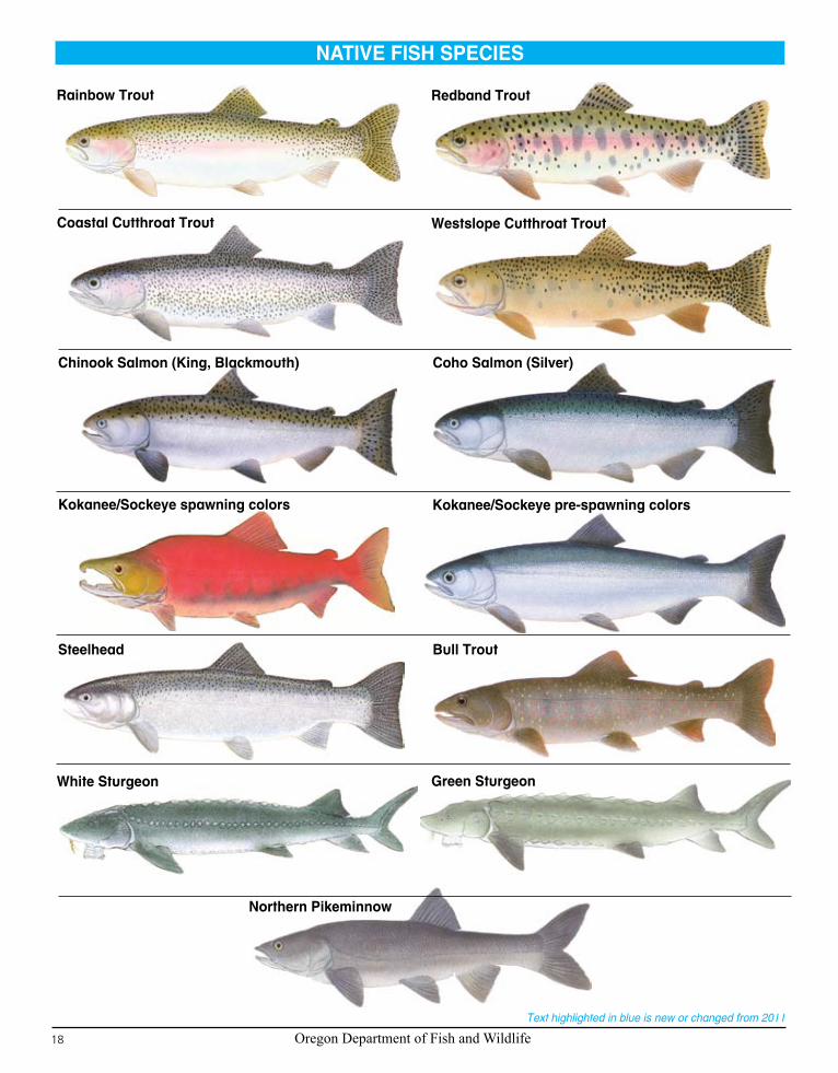
NATIVE FISH SPECIES

Oregon Department of Fish and Wildlife 19
Text highlighted in blue is new or changed from 2011
Yellow Perch Walleye
Channel Catfish
Striped Bass
Black Crappie Bluegill
Brook Trout Brown Trout
Lake Trout Atlantic Salmon
Largemouth Bass
Illustrations this and previous page are taken from Game Fish Identification Charts, by Oregon artist Ron Pittard, published and copyrighted by Windsor Nature Discovery, LLC. See their web site www.nature-discovery.com or call 1-800-635-4194. Or visit 1000 S. Bertelsen Rd. #13, Eugene, OR.
American Shad
Smallmouth Bass
INTRODUCED FISH SPECIESS
TATE
WID
EP
ages 4 - 23

Oregon Department of Fish and Wildlife20
Text highlighted in blue is new or changed from 2011
Antelope Reservoir(SE Zone)
Columbia River - from Bonneville Dam upstream to Ruckel Creek(Columbia River Zone)
Columbia Slough(Willamette Zone)
Cooper Creek Reservoir(SW Zone)
Cottage Grove Reservoir(Willamette Zone)
Dorena Reservoir(Willamette Zone)
East Lake (Central Zone)
Emigrant Reservoir(SW Zone)
Galesville Reservoir(SW Zone)
Jordan Creek(SE Zone)
Lower Columbia River(Columbia River Zone)
Owyhee Reservoir and Owyhee River- upstream to Three Forks (SE Zone)
Plat 1 Reservoir(SW Zone)
Portland Harbor (Lower Willamette River)(Willamette Zone)Avoid eating carp, bass and catfish
Snake River including Brownlee Reservoir (Snake River Zone)
Willamette River and Coast Fork Willamette to Cottage Grove Reservoir(Willamette Zone)
OREGON FISH ADVISORIESFish are a nutritious, low-fat source of protein. However, fish in some Oregon waters have contaminants that may be harmful to you and your family. Please consult the recommendations below for fish consumption guidelines. For more information call the Oregon Department of Human Services at (971) 673-0440 or visit their Web site at http://www.oregon.gov/DHS/ph/entox. Please note: Not all of Oregon’s waters have been sampled for contaminants in fish.
WATERBODY CONTAMINANT CONSUMPTION RECOMMENDATIONS
VERY HIGH MERCURY LEVELSn Women of childbearing age, children
under 6, and people with liver and kidney damage should avoid eating fish from these waters.
n Healthy adults should eat no more than one 8-ounce serving per month
HIGH MERCURY LEVELSn Children under 6 should eat no more
than one 4-ounce serving every two months.
n Women of childbearing age should eat no more than one 8-ounce serving every month.
n Healthy adults should eat no more than one 8-ounce serving every two weeks.
MODERATE MERCURY LEVELSn Children under 6 should eat no more
than one 4-ounce serving every month.n Women of childbearing age should eat
no more than one 8-ounce serving every two weeks.
n Healthy adults should eat no more than one 8-ounce serving every week.
PCBs, DIOXINS & PESTICIDESn All persons should reduce or avoid
eating fatty parts of fish. Exposure can be reduced by removing the skin and all fat, eggs and internal organs. See diagram below.
Very high mercury levelsAll species
PCB levelsSmallmouth bass
(no more than one 8-ounce serving per month)
PCB levels All resident species
(no more than two 8-ounce servings per month)
High mercury levelsAll species
Very high mercury levelsAll species
Moderate mercury levelsAll species
High mercury levelsAll species
Very high mercury levelsAll species except rainbow trout
High mercury levelsAll species
Very high mercury levelsAll species
PCBs, dioxins & pesticidesAll resident species
Very high mercury levelsAll species
Moderate mercury levelsAll species
PCBs, dioxins & pesticidesAll resident species
Moderate mercury levelsAll species
High mercury levels and PCBs, dioxins & pesticides
All resident species
ONE 8-OUNCE SERVINGis about the size and thicknessof your hand.
Remove skin
Cut away back fat
Cut away fatty area alongthe side of the fish Trim off belly fat

Oregon Department of Fish and Wildlife 21
Text highlighted in blue is new or changed from 2011
FISH MEASUREMENTSS
TATE
WID
EP
ages 4 - 23
*
TRANSFER OF FISH AND SHELLFISH TO ANOTHER PERSON
Fish and shellfish (whole or parts, including fish eggs) which have been taken for personal use and then given or shipped to another person must be accompanied by the following information or you may complete the Fish and Wildlife Transfer Record below: 1. Kind and number of fish or shellfish transferred; 2. Date fish or shellfish were caught; 3. Name, address, Angling License or Shellfish License number, and Combined Harvest or Hatchery
Harvest tag number (if applicable) of the person who caught the fish or shellfish. The above information must also be provided to the wholesale fish or bait dealer when eggs from ocean-caught salmon are sold.
FISH AND WILDLIFE TRANSFER RECORD Person transferring fish or wildlifeName: Phone: Address: License: #: Tag #:Location & Date:
Fish species transferred Wildlife species transferredCoho salmon DeerChinook salmon ElkSteelhead BearTrout CougarOther Other
Species condition Entire carcass Parts
Transferred to
Name: Phone:
Address:
Sturgeon length measurements are taken by fork length. Fork length is measured in a straight line from the tip of the nose to the fork in the caudal fin (tail), with the fish laying on its side, on a flat surface.
Legal Measurement
Sturgeon

Oregon Department of Fish and Wildlife22
Text highlighted in blue is new or changed from 2011
One Grand Prize !
16’ x 54” Drift Boat Package
Includes: Anchor, Oars & Galvanized Trailer
72 Stores in the NW • www.bimart.com
Drawing to be held June 8, 2012For more info, call your local ODFW office or
ODFW Headquarters (503) 947-6200
You’ll be entered into a drawing for outdoor equipment donated by Bi-Mart! Over 100
chances to win name brand gear from:
Berkley • Abu Garcia • Pfluger • LamiglasOkuma • Bushnell • Streamlight
Plano • Kershaw • Igloo • Humminbird Garmin • Magellan • Point of View • Smoke Hollow
For a full list of prizes: www.dfw.state.or.us
Turn InYour 2011 Salmon/Steelhead/Sturgeon/Halibut Harvest Card
To Win!SALMON, STEELHEAD, STURGEON & HALIBUT ANGLERS: Upon landing and keeping an adult salmon, steelhead, legal size sturgeon, or halibut, the angler must IMMEDIATELY enter the codes for the species caught (ocean port or stream) and the month and day of catch. Record fish in consecutive order. (Southwest Zone Regulations: jack salmon landed and kept from Hunter Creek and Pistol River are required to be tagged and recorded). Use only 1 line per fish. Sturgeon and halibut anglers must record the fish length in inches.
ENTRIES MUST BE RECORDED IN BALL POINT PEN !
NO ERASURES ALLOWED !
HANDLE WITH CARE: When you catch and release fish, you are preserving a valuable resource for other anglers to enjoy in the future. Use barbless hooks in order to easily release your catch. Land fish as carefully as possible. Remove the hook quickly and gently, keeping the fish underwater. See page 33 for Catch and Release guidelines. Carefully released fish may also be counted on spawning grounds, ensuring adequate escapement for conser-vation and management of fish populations.
Codes Species of Fish1 Chinook Fin-Clipped (Hatchery) (king or blackmouth)
- has black lower gum line1W Chinook Unmarked (Wild) (king or blackmouth) - has
black lower gum line2 Coho Fin-Clipped (Hatchery) (silver) - has white lower
gum line2W Coho Unmarked (Wild) (silver) - has white lower gum
line3 Other Salmon - Pink (humpy); Chum (dog); or Sockeye4 Jack Salmon6 Steelhead Fin-Clipped (Hatchery)
6W Steelhead Unmarked (Wild)7 White Sturgeon - gray with uniform pale belly8 Green Sturgeon - olive green with dark stripe on belly9 Halibut
Example of a coded entry w hile fishing on the Lower Rogue River on January 25, a fin-clipped Chinook then an unmarked Steelhead are taken. On Tahkenitch Lk. Nov. 30 a wild Coho is taken.
Species Location Length (inches)
Month Day
1 225 36 1 25
6W 225 28 1 25
2W 93 30 11 30
Return expired Harvest Card (tags) to qualify for prizes and help ODFW manage the fisheries and estimate total harvest.Return to:
ODFW 3406 Cherry Ave NESalem OR 97303-4924
or:Deposit with any ODFW License Agent
Instructions for Completing Salmon,Steelhead, Sturgeon, and Halibut
Harvest Card (Tag)
1-800-575-2243 or www.fish-rite.com
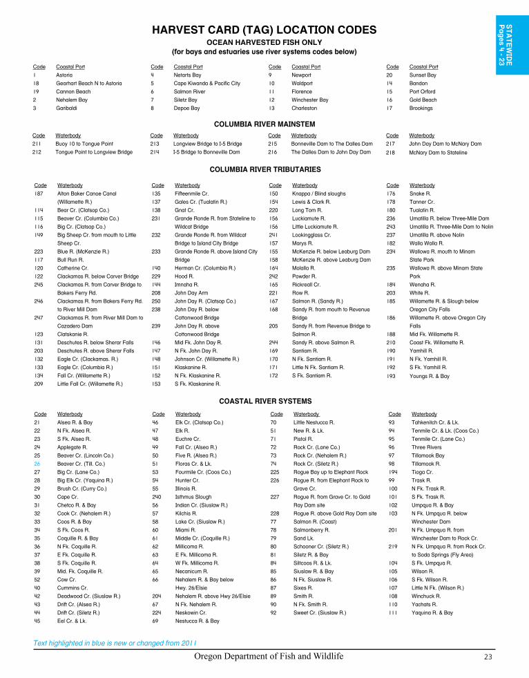
Oregon Department of Fish and Wildlife 23
Text highlighted in blue is new or changed from 2011
HARVEST CARD (TAG) LOCATION CODESOCEAN HARVESTED FISH ONLY
(for bays and estuaries use river systems codes below)
Code Coastal Port
1 Astoria
18 Gearhart Beach N to Astoria
19 Cannon Beach
2 Nehalem Bay
3 Garibaldi
Code Coastal Port
4 Netarts Bay
5 Cape Kiwanda & Pacific City
6 Salmon River
7 Siletz Bay
8 Depoe Bay
Code Coastal Port
9 Newport
10 Waldport
11 Florence
12 Winchester Bay
13 Charleston
Code Coastal Port
20 Sunset Bay
14 Bandon
15 Port Orford
16 Gold Beach
17 Brookings
Code Waterbody
187 Alton Baker Canoe Canal
(Willamette R.)
114 Bear Cr. (Clatsop Co.)
115 Beaver Cr. (Columbia Co.)
116 Big Cr. (Clatsop Co.)
149 Big Sheep Cr. from mouth to Little
Sheep Cr.
223 Blue R. (McKenzie R.)
117 Bull Run R.
120 Catherine Cr.
122 Clackamas R. below Carver Bridge
245 Clackamas R. from Carver Bridge to
Bakers Ferry Rd.
246 Clackamas R. from Bakers Ferry Rd.
to River Mill Dam
247 Clackamas R. from River Mill Dam to
Cazadero Dam
123 Clatskanie R.
131 Deschutes R. below Sherar Falls
203 Deschutes R. above Sherar Falls
132 Eagle Cr. (Clackamas. R.)
133 Eagle Cr. (Columbia R.)
134 Fall Cr. (Willamette R.)
209 Little Fall Cr. (Willamette R.)
Code Waterbody
135 Fifteenmile Cr.
137 Gales Cr. (Tualatin R.)
138 Gnat Cr.
231 Grande Ronde R. from Stateline to
Wildcat Bridge
232 Grande Ronde R. from Wildcat
Bridge to Island City Bridge
233 Grande Ronde R. above Island City
Bridge
140 Herman Cr. (Columbia R.)
229 Hood R.
144 Imnaha R.
208 John Day Arm
250 John Day R. (Clatsop Co.)
238 John Day R. below
Cottonwood Bridge
239 John Day R. above
Cottonwood Bridge
146 Mid Fk. John Day R.
147 N Fk. John Day R.
148 Johnson Cr. (Willamette R.)
151 Klaskanine R.
152 N Fk. Klaskanine R.
153 S Fk. Klaskanine R.
Code Waterbody
150 Knappa / Blind sloughs
154 Lewis & Clark R.
220 Long Tom R.
156 Luckiamute R.
156 Little Luckiamute R.
241 Lookingglass Cr.
157 Marys R.
155 McKenzie R. below Leaburg Dam
158 McKenzie R. above Leaburg Dam
164 Molalla R.
242 Powder R.
165 Rickreall Cr.
221 Row R.
167 Salmon R. (Sandy R.)
168 Sandy R. from mouth to Revenue
Bridge
205 Sandy R. from Revenue Bridge to
Salmon R.
244 Sandy R. above Salmon R.
169 Santiam R.
170 N Fk. Santiam R.
171 Little N Fk. Santiam R.
172 S Fk. Santiam R.
Code Waterbody
176 Snake R.
178 Tanner Cr.
180 Tualatin R.
236 Umatilla R. below Three-Mile Dam
243 Umatilla R. Three-Mile Dam to Nolin
237 Umatilla R. above Nolin
182 Walla Walla R.
234 Wallowa R. mouth to Minam
State Park
235 Wallowa R. above Minam State
Park
184 Wenaha R.
203 White R.
185 Willamette R. & Slough below
Oregon City Falls
186 Willamette R. above Oregon City
Falls
188 Mid Fk. Willamette R.
210 Coast Fk. Willamette R.
190 Yamhill R.
191 N Fk. Yamhill R.
192 S Fk. Yamhill R.
193 Youngs R. & Bay
Code Waterbody
211 Buoy 10 to Tongue Point
212 Tongue Point to Longview Bridge
Code Waterbody
213 Longview Bridge to I-5 Bridge
214 I-5 Bridge to Bonneville Dam
Code Waterbody
215 Bonneville Dam to The Dalles Dam
216 The Dalles Dam to John Day Dam
Code Waterbody
217 John Day Dam to McNary Dam
218 McNary Dam to Stateline
COLUMBIA RIVER MAINSTEM
COLUMBIA RIVER TRIBUTARIES
Code Waterbody
21 Alsea R. & Bay
22 N Fk. Alsea R.
23 S Fk. Alsea R.
24 Applegate R.
25 Beaver Cr. (Lincoln Co.)
26 Beaver Cr. (Till. Co.)
27 Big Cr. (Lane Co.)
28 Big Elk Cr. (Yaquina R.)
29 Brush Cr. (Curry Co.)
30 Cape Cr.
31 Chetco R. & Bay
32 Cook Cr. (Nehalem R.)
33 Coos R. & Bay
34 S Fk. Coos R.
35 Coquille R. & Bay
36 N Fk. Coquille R.
37 E Fk. Coquille R.
38 S Fk. Coquille R.
39 Mid. Fk. Coquille R.
52 Cow Cr.
40 Cummins Cr.
42 Deadwood Cr. (Siuslaw R.)
43 Drift Cr. (Alsea R.)
44 Drift Cr. (Siletz R.)
45 Eel Cr. & Lk.
Code Waterbody
46 Elk Cr. (Clatsop Co.)
47 Elk R.
48 Euchre Cr.
49 Fall Cr. (Alsea R.)
50 Five R. (Alsea R.)
51 Floras Cr. & Lk.
53 Fourmile Cr. (Coos Co.)
54 Hunter Cr.
55 Illinois R.
240 Isthmus Slough
56 Indian Cr. (Siuslaw R.)
57 Kilchis R.
58 Lake Cr. (Siuslaw R.)
60 Miami R.
61 Middle Cr. (Coquille R.)
62 Millicoma R.
63 E Fk. Millicoma R.
64 W Fk. Millicoma R.
65 Necanicum R.
66 Nehalem R. & Bay below
Hwy. 26/Elsie
204 Nehalem R. above Hwy 26/Elsie
67 N Fk. Nehalem R.
224 Neskowin Cr.
69 Nestucca R. & Bay
Code Waterbody
70 Little Nestucca R.
51 New R. & Lk.
71 Pistol R.
72 Rock Cr. (Lane Co.)
73 Rock Cr. (Nehalem R.)
74 Rock Cr. (Siletz R.)
225 Rogue Bay up to Elephant Rock
226 Rogue R. from Elephant Rock to
Grave Cr.
227 Rogue R. from Grave Cr. to Gold
Ray Dam site
228 Rogue R. above Gold Ray Dam site
77 Salmon R. (Coast)
78 Salmonberry R.
79 Sand Lk.
80 Schooner Cr. (Siletz R.)
81 Siletz R. & Bay
84 Siltcoos R. & Lk.
85 Siuslaw R. & Bay
86 N Fk. Siuslaw R.
87 Sixes R.
89 Smith R.
90 N Fk. Smith R.
92 Sweet Cr. (Siuslaw R.)
Code Waterbody
93 Tahkenitch Cr. & Lk.
94 Tenmile Cr. & Lk. (Coos Co.)
95 Tenmile Cr. (Lane Co.)
96 Three Rivers
97 Tillamook Bay
98 Tillamook R.
194 Tioga Cr.
99 Trask R.
100 N Fk. Trask R.
101 S Fk. Trask R.
102 Umpqua R. & Bay
103 N Fk. Umpqua R. below
Winchester Dam
201 N Fk. Umpqua R. from
Winchester Dam to Rock Cr.
219 N Fk. Umpqua R. from Rock Cr.
to Soda Springs (Fly Area)
104 S Fk. Umpqua R.
105 Wilson R.
106 S Fk. Wilson R.
107 Little N Fk. (Wilson R.)
108 Winchuck R.
110 Yachats R.
111 Yaquina R. & Bay
COASTAL RIVER SYSTEMS
STA
TEW
IDE
Pages 4 - 23

Oregon Department of Fish and Wildlife24
Text highlighted in blue is new or changed from 2011
Portland
Salem
Hillsboro
Beaverton
Warrenton
Newport
Astoria
McMinnville
Rainier
St. Helens
Lincoln City
Seaside
Toledo
Vernonia
DepoeBay
Tillamook
Siletz
Clatskanie
Garibaldi
CannonBeach
TRASK
NEHALEM
BIG CREEK
GNATCREEK
CEDAR CREEK
SALMONRIVER
KLASKANINE
SILETZ
KeaseyDam
Siletz Falls
BeaverFalls
Youngs RFalls
Valsetz Lake Sills Dam
Warrenton Res. Dam
SandLake
BarneyRes.
SunsetLake
TownLake
FishhawkLake
Devils Lake
CapeFalcon
Columb ia River
Washington State
Hagg Lake
LakeLytle
Head of Tide
Head of Tide
Head of Tide
Nestucca
RiverElk Creek
Devils Lake Fk
South Fork Siletz River
Edw
ards C
r
No rth Fk
Siletz
River
Moo
n
Cr
Slick Rock CrBear Cr
Gold Cr
N Fk
Wils
on R
South Fk
Bark Shan ty Cr
W B
eaver Cr
Far mer Cr
E Beaver Cr
Blue R
idge
Cr
Dolph
Elsie
Timber
Blaine
NashvilleEddyville
Pacific City
4th Br
USFS Br
Hwy 53 Br
Hwy 26 Br
RR Bridge
RR Bridge
Hwy101Br
12th Ave Br
Old 101 Br
Miami-Foley Br
Alt Hwy101 Br
Aldrich PtRd Br
CloverdaleBr
RR Br
Burton Br
Headof
Tide
SwedetownRoad Bridge
CountyPark
Bewley Cr Br
Olney Ln Br
Hwy 101 Br
101 Br
MP 9 Br
MP 11 Br
205
405
30
101
226
6
211
214
18
47
202
213
99W
53
99E
219
240
229 223
10
51
43
233
212210
213
47
219
99W
224
47
214
214
8 217
99E
22
99E
22
224
26
101
101
101
26
101
18
30
TillamookBay
NetartsBay
Yaquina Bay
NehalemBay
SiletzBay
NestuccaBay
Scappoose Bay
PA
CI F
I C
OC
EA
N
MARION
CLACKAMAS
POLK
LINCOLN
TILLAMOOK
CLATSOP
YAMHILL
COLUMBIA
WASHINGTON
MULTNOMAH
Nestuc ca River
Yaquina River
Wils
on R
iver
Nehalem River
Rock Creek
Siletz
Riv
erClatskanie R
iver
Youngs R
Big Cr eek
Drif t Creek
Necanicum Ri ver
Salmonberry River
Cook Creek
Tillamook R
Ceda
r C
reek
Big
Roc
k C
reek
N Fk Klaskanine R
S Fk K
laskanine R
John D
a y R
Bear Cr
Gnat Cr
Plym
pton
Cr
Beaver Cr
N Fk
Neh
alem
R
Lewis and Clark R
Neaw
a nna Cr
N Fk Ecola Cr
West Fk
Miami River
Kilc
his
R
Little
N Fk W
ilson
Trask RN Fk Trask R
S Fk Tra
sk R E Fk Trask R
Beaver Cr
Three
Rivers
Little Nestucca RNeskowin Cr
Salmon R
Schooner Cr
S Fk Wilson R
Northwest ZoneLegend
Bridges
Dams
Falls
Other Landmarks
Hatcheries
Zone Boundary
Closed All Year
County boundaries
Railroad
0 10 205Miles
Columbia River Not Included In This Zone

Oregon Department of Fish and Wildlife 25
Text highlighted in blue is new or changed from 2011
5
Salem
Eugene
AlbanyCorvallis
Newport
McMinnville
Florence
Lincoln City
Toledo
Waldport
Reedsport
DepoeBay
Siletz
Yachats
Siuslaw River
Alsea Rive r
Nestucca River
Yaquina River
Lake Creek
Big Elk Creek
Sil etz River
Drift Creek
Salmon Ri ver
Five Rivers
Creek
Lobster Cr
Wildcat Cr
Yachats R
Little Nestucca River
Fa
ll Creek
Tenmile Cr
North
Fork Siuslaw R
iver
S Fk Alsea R
Three R iver s
Cape Cr
Sw
eet Cr
Neskowin Creek
Fish Cr
N F k Alsea R
Li ttle Rock C r
Big
Roc
k Cr
Mill C
r
Farmer Cr
Lyndon Cr
Dr ift Cree
k
Rock Cr
Beaver Cr
Dea
dwoo
d
Schooner Cr
Cummins Cr
Gra
nt C
r
Erick
son Cr
Siltco os R
Sampson Cr
N Fk Yachats R
Carns Cr
Rock Cr
Big Cr
Whit
taker
Cr
PA
CI F
I C O
CE
AN
Ce
dar Cr
Casca d e Cr
ALSEA
CEDAR CREEK
SALMONRIVER
SILETZ
Siletz Falls
Lake CrFalls
Sweet CreekFalls
OldValsetz
Dam
Bohannon Falls
SiltcoosLake
TahkenitchLake
Sand Lake
LilyLake
TownLake
TriangleLake
DevilsLake
FernRidgeReservoir
Head of Tide
Head of Tide
Head of Tide
Head of Tide
Head of Tide
Head ofTide
MoonshinePark
FarnhamLanding
Five R
iver
s
Bob Creek
S Fk Siletz R
N Fk Siletz R
Lobster Creek
Buck
Cre
ek
Slick Rock C rBear C
r
Little Lobster Cr
Scott C
r
Creek
West Fk
West Fk
Indian
Ona
Dolph
Blaine
NashvilleEddyville
Pacific City
USFS Br
Hwy 101 Br
Cloverdale Br
MeadowsBridge
5
5
38
126
36
58
138
226
228
214
18
99W
99
99E
219
221
229 223
51
233
99
219
99E99W
214
126
214
34
34
99E
99
22
22
Siusl aw River
YaquinaBay
Alsea Bay
SiletzBay
Nestucca Bay
LANE
DOUGLAS
MARION
CLACKAMAS
POLK
LINCOLN
YAMHILL
BENTON
Northwest ZoneLegend
Bridges
Dams
Falls
Other Landmarks
Hatcheries
Zone Boundary
Closed All Year
County boundaries
Railroad
0 10 205Miles
101
101
NO
RTH
WE
ST
Pages 24 - 33
Oregon Department of Fish and Wildlife26
Text highlighted in blue is new or changed from 2011
Description:The Northwest Zone is all waters north of the Umpqua River to the Columbia River that drain directly to the Pacific Ocean, but not including the Umpqua River drainage, and tributaries of the Columbia River entering downstream of the City of St. Helens. Portions of Columbia River tributaries upstream of the railroad bridge (near the mouth) are included in the Northwest Zone and those portions of the tributaries below the railroad bridge (near the mouth) are included in the Columbia River Zone (pages 92-95). Regulations for marine fish, marine shellfish and marine invertebrates are listed under the Marine Zone (pages 100-103).Instructions:
Read the 1. Special Regulations for this zone. Special Regulations apply to specific bodies of water or portions of water within a zone. If specific references to a body of water, species, catch limits, length limits, seasons, or other specifications are not made in the Special Regulations for this zone, then Zone Regulations apply.Read the following 2. Regulations for this zone.Always read the 3. General Regulations, pages 5-12, which apply to all zones, for information about licenses; tags and permits; defi-nitions; catch and possession limits; gear and bait restrictions; and harvest methods and hours, before going fishing.Emergency or permanent rules adopted since these rules were printed4. may supersede these regulations. Anglers may call ODFW headquarters or regional offices at the numbers on page 4 of these regulations, or check the ODFW web site, www.dfw.state.or.us for these rules, or call 503-947-6000 during normal business hours.
Regulations for this zone:Angling for all species in streams above tidewater is restricted to artificial flies and lures May 1. 26-Aug. 31. See exceptions for use of bait in Siletz, Nestucca, Trask, Wilson, John Day, Lewis and Clark, Youngs and Klaskanine rivers, Big and Gnat creeks, and Three Rivers.Use of bait allowed in bays and tidewaters year round.2. Anglers may not continue to angle for jack 3. salmon or trout after retaining a limit of adult salmon or steelhead.
Species Name Catch Limits Length Limits and Other Specifications SeasonTrout Lakes: 5 per day,
2 daily limits in possession.Streams: ( including tidewaters and bays):
2 per day, 2 •daily limits in possession.Lower Columbia •River tributaries catch and release only.
• 8-inch minimum length.• Only 1 trout over 20 inches in length may be taken per day.• Rainbow trout over 16 inches are considered steelhead in streams.• Salmon under 15 inches are considered trout, except coho salmon,
which are always considered salmon regardless of size.• Angling restricted to artificial flies and lures in streams above tide-
water, May 26-Aug. 31. See exceptions under Special Regulations where use of bait is allowed.
Lakes: Open all yearStreams: (including tidewaters and bays): Open May 26-Oct. 31
Salmon and Steelhead
In the aggregate: 2 adult salmon or steelhead per day, 20 per year. 5 jack salmon per day, 2 daily jack limits in possession.
• See exceptions to the Chinook salmon catch limit under Nehalem, Nestucca and Tillamook bays and tributaries, and Yachats River.
• Pink salmon, sockeye salmon and adipose fin-clipped coho salmon may be retained as part of the adult and jack salmon daily bag limit in all waters that are currently open to angling for Chinook salmon or steelhead, except as specified in Special Regulations.
• Hatchery releases of coho salmon occur in the Trask River, North Fork Nehalem River, Big Creek, Klaskanine River and Youngs Bay.
• Closed to chum salmon (including jacks) angling unless noted under Special Regulations.
• Note: Changes to salmon regulations for the ocean, are printed in the spring and are available at ODFW offices or from license agents. Regulation changes for other water bodies may occur throughout the year and are posted on the ODFW website: http://www.dfw.state.or.us/resources/fishing/. Check for new regulations before you fish.
• See Special Regulations in NW Zone to determine where harvest of any Chinook salmon is allowed. Harvest of nonadipose fin-clipped steelhead and nonadipose fin-clipped coho salmon is prohibited in the NW Zone except as allowed under Special Regulations for Siltcoos and Tahkenitch lakes. There is no annual limit on adipose or otherwise fin-clipped salmon or adipose fin-clipped steelhead as long as the appropriate number of Hatchery Harvest Tags have been purchased to record the catch.
• Angling restricted to artificial flies and lures in streams above tidewater May 26-Aug. 31. See exceptions under Special Regulations where use of bait is allowed.
Closed in all watersunless noted byspecies underSpecial Regulations.
NORTHWEST ZONE
(continue on next page)

Oregon Department of Fish and Wildlife 27
Text highlighted in blue is new or changed from 2011
Species Name Catch Limits Length Limits and Other Specifications SeasonSturgeon 1 per day, 5 per
year.• Closed to the retention of green sturgeon.• Minimum fork length 38 inches, maximum fork length 54 inches.• All oversize, undersize, and unwanted legal size sturgeon must be
immediately released unharmed into the water.• Oversize sturgeon cannot be removed totally or in part from water.• Only one single-point barbless hook may be used for sturgeon.• Angling restricted to artificial flies and lures in streams above tide-
water May 26-Aug. 31. See exceptions under Special Regulations where use of bait is allowed.
Note: Tidewater portions of Columbia River tributaries are managed per Columbia River regulations. Columbia River sturgeon fisheries are managed on a quota basis. Anglers should check the status of regula-tions prior to fishing as modifications will be made in-season if neces-sary to remain within catch guidelines.
Lakes: Open all yearStreams: (including tidewaters and bays): Open during trout, salmon or steelhead seasons, except tide-water areas of Columbia River tributaries down-stream from the city of St. Helens are open all year.
Warmwater Game Fish: Largemouth and Smallmouth Bass
5 per day, 2 daily limits in possession.
• No more than 3 over 15 inches in length.• Angling restricted to artificial flies and lures in streams above tide-
water, May 26-Aug. 31. See exceptions under Special Regulations where use of bait is allowed.
Bluegill, Catfish, Crappie, Other Sunfish, Walleye and Yellow Perch
No limit. • No minimum length.• Angling restricted to artificial flies and lures in streams above tide-
water, May 26-Aug. 31. See exceptions under Special Regulations where use of bait is allowed.
Other Fish: Striped Bass
2 per 24 con-secutive hours; 2 daily limits in possession.
• 24-inch minimum length.• Angling restricted to artificial flies and lures in streams above tide-
water, May 26-Aug. 31. See exceptions under Special Regulations where use of bait is allowed.
Sucker, Northern Pikeminnow, Carp, Chub, Sculpin and other Nongame Fish and Shad
No limit. • Angling restricted to artificial flies and lures in streams above tide-water, May 26-Aug. 31. See exceptions under Special Regulations where use of bait is allowed.
Bullfrogs No limit. • An angling license is not required. Open all year.Crayfish 100 per day,
2 daily limits in possession.
• Neither an angling nor a shellfish license is required.• All streams are open to crayfish harvest including streams listed as
closed under Special Regulations.Freshwater Clams and Mussels
Harvest prohibited • It is illegal to harvest or possess any freshwater mussels or clams unless authorized by a specific permit issued by the Oregon Fish and Wildlife Commission (Scientific Take Permit).
Closed.
Marine Fish and Marine Shellfish
See Marine Zone (pages 100-103).
Smelt None. • Unlawful to take or attempt to take Eulachon smelt in inland waters including bays, estuaries, rivers and streams. See ODFW website for smelt identification guide.
Closed in all NW Zone waters.
Special Regulations for this zone:Water Special RegulationsAlsea River (Lincoln Co.):
Mainstem, including tidewater 1. upstream to Fall Creek
• Open for adipose fin-clipped steelhead Jan. 1-April 30 and Aug. 1-Dec. 31.• Open for Chinook salmon Aug. 1-Dec. 31.• Open for marine fish and other fish entire year in Alsea Bay.
2. Upstream from Fall Creek • Open for adipose fin-clipped steelhead Jan. 1-April 30 and Dec. 1-31.• No angling from a floating device upstream from Mill Creek.
North Fork Alsea from the mouth 3. upstream to 100 feet below the Alsea Hatchery fishway, and from 100 feet above the Alsea Hatchery fishway upstream 600 feet to the angling deadline marker
• Open for adipose fin-clipped steelhead Jan. 1- April 30 and Dec. 1-31.• No angling from a floating device.
South Fork Alsea upstream to bridge4. located 200 feet upstream from Peak Creek at McBee Park
• Open for adipose fin-clipped steelhead Jan. 1-Mar. 31 and Dec. 1-31.• No angling from a floating device.
Barney Reservoir (Washington Co.) • Catch and release only for trout.• Restricted to artificial flies and lures.
(continue on next page)
NO
RTH
WE
ST
Pages 24 - 33

Oregon Department of Fish and Wildlife28
Text highlighted in blue is new or changed from 2011
Water Special RegulationsBear Creek and tributaries (Salmon River Basin, Lincoln Co.)
• Closed.
Bear Creek (Clatsop Co.) • Open for adipose fin-clipped steelhead Jan. 1-March 31, May 26-Aug. 31 and Oct. 1-Dec. 31.
• Open for adipose fin-clipped spring Chinook salmon May 26-July 31.• Open for fall Chinook salmon Aug. 1-Aug. 31 and Oct. 1-Dec. 31.• Closed Sept. 1-30.
Beaver Creek (Columbia Co.)upstream to 200 feet below lower falls
• Open for adipose fin-clipped steelhead Jan. 1-March 31 and May 26-Dec. 31.• Open for adipose fin-clipped spring Chinook salmon May 26-July 31.• Open for fall Chinook salmon Aug. 1-Oct. 31.
Beaver Creek (Lincoln Co.) upstream to county bridge located at Ona, including tidewater
• Open for adipose fin-clipped steelhead Jan. 1-March 31 and May 26-Dec. 31.
Beaver Creek(Nestucca Basin, Tillamook Co.)
• Open for adipose fin-clipped steelhead Jan. 1-March 31 and Dec. 1-31.• Closed upstream from West Beaver Creek.
Big Creek (Clatsop Co.)Downstream from hatchery weir 1. deadline.
• Closed Sept. 1-30.• Open for adipose fin-clipped steelhead Jan. 1-Aug. 31 and Oct. 1-Dec. 31.• Open for adipose fin-clipped spring Chinook salmon Jan. 1- July 31.• Open for fall Chinook salmon Aug. 1-31 and Oct. 1-Dec. 31.• Angling from Big Creek railroad trestle bridge near mouth closed Sept. 1-30.• Use of bait allowed.
2. Upstream from hatchery weir • Closed to all species except open to catch and release trout angling above the hatchery weir May 26-Oct. 31.
• Restricted to artificial flies and lures May 26-Aug. 31.Big Creek including tidewater (Lane Co.) • Open for adipose fin-clipped steelhead Jan. 1-March 31 and Nov. 1-Dec. 31.
• Closed April 1-Oct. 31.Big Elk Creek including tidewater (Yaquina Basin, Lincoln Co.) upstream to first bridge located downstream from Grant Creek
• Open for adipose fin-clipped steelhead Jan. 1-March 31 and May 26-Dec. 31.• Open for Chinook salmon May 26-Dec. 31.
Bob Creek (Lane Co.) • Closed.Cape Creek including tidewater (Lane Co.)
• Open for adipose fin-clipped steelhead Jan. 1-March 31 and Nov. 1-Dec. 31.• Closed April 1-Oct. 31.
Cape Meares Lake (Tillamook Co.) • Limit 1 bass per day, any size, 2 daily limits in possession.Clatskanie River (Columbia Co.)upstream to Swedetown Road Bridge crossing near Swedetown
• Open for adipose fin-clipped steelhead Jan. 1-March 31 and May 26-Dec. 31.• Open for adipose fin-clipped spring Chinook salmon May 26-July 31.• Open for fall Chinook salmon Aug. 1-Oct. 31.
Cook Creek upstream to South Fork (Nehalem Basin, Tillamook Co.)
• Open for adipose fin-clipped steelhead Jan. 1-March 31 and May 26-Dec. 31.
Cummins Creek including tidewater (Lane Co.)
• Open for adipose fin-clipped steelhead Jan. 1-March 31 and Nov. 1-Dec. 31.• Closed April 1-Oct. 31.
Deadwood Creek (Siuslaw Basin, Lane Co.):
Mainstem1.
• Open for adipose fin-clipped steelhead Jan. 1-March 31.• Open to trout angling May 26-Sept. 30 below the confluence with the West Fork
Deadwood Creek.• Trout angling restricted to artificial flies and lures, 8-inch minimum length, 2 fish per day.• Closed April 1-May 25 and Oct. 1-Dec. 31.
2. Tributaries • Closed.Devils Lake (Lincoln Co.) • Closed to take of grass carp.
• Only adipose fin-clipped trout may be taken.Drift Creek (Alsea Basin, Lincoln Co.):
Mouth upstream to Lyndon Creek 1. (near head of tidewater)
• Open for adipose fin-clipped steelhead Jan. 1-March 31 and Aug. 1-Dec. 31.• Open for Chinook salmon Aug. 1-Dec. 31.
2. Lyndon Creek upstream to 200 feet below Bohanon Falls located at Rivermile 25
• Open for adipose fin-clipped steelhead Jan. 1-March 31 and Oct. 16-Dec. 31.• Open for Chinook salmon Oct. 16-Dec. 31.
Tributaries not listed and mainstem 3. and tributares above Bohanon Falls
• Closed.
Drift Creek (Siletz Basin, Lincoln Co.):Upstream to Sampson Creek1.
• Open for adipose fin-clipped steelhead Jan. 1-March 31 and May 26-Dec. 31.• Open for Chinook salmon May 26-Dec. 31.
Ecola (Elk) Creek including tide-water upstream to forks located 1 mile upstream from Hwy 101 bridge (Clatsop Co.)
• Open for adipose fin-clipped steelhead Jan. 1-March 31 and Nov. 1-Dec. 31.• Closed April 1-Oct. 31.
(Continued on next page)

Oregon Department of Fish and Wildlife 29
Text highlighted in blue is new or changed from 2011
Water Special RegulationsFall Creek upstream to Carns Creek (Alsea Basin, Lincoln Co.)
• Open for adipose fin-clipped steelhead Jan. 1-March 31 and Dec. 1-31.
Five Rivers (Alsea Basin, Lincoln, Lane, and Benton Co.)
Upstream to Buck Creek1.
• Open for adipose fin-clipped steelhead Jan. 1-March 31 and Aug. 1-Dec. 31.• Open for Chinook salmon Aug. 1-Dec. 31, except closed for Chinook salmon upstream
from Cascade Creek.2. Tributaries not listed and mainstem
and tributaries upstream from Buck Creek.
• Closed. (See Lobster Creek for available trout angling.)
Fishhawk Lake (near Birkenfeld on the Nehalem River, Columbia Co.)
• Open for trout May 26-Oct. 31, 2 trout per day, 8-inch minimum length.• Angling restricted to artificial flies and lures only May 26-Aug. 31.
Gnat Creek (Clatsop Co.): Upstream from railroad bridge to the 1. Aldrich Pt. Road Bridge
• Open for adipose fin-clipped steelhead the entire year.• Open for adipose fin-clipped spring Chinook salmon Jan. 1-Jul. 31.• Open for fall Chinook salmon Aug. 1-Dec. 31.• See Special Regulations for Blind Slough/Knappa Slough, page 95.
2. Upstream from Aldrich Pt. Road Bridge to Barrier Falls which is located 1/4 mile upstream from Hwy 30.
• Open for adipose fin-clipped steelhead Jan. 1-Aug. 31 and Oct. 1-Dec. 31.• Open for adipose fin-clipped spring Chinook salmon Jan. 1-July. 31.• Open for fall Chinook salmon Aug. 1-Aug. 31 and Oct. 1-Dec. 31.• Use of bait allowed. • Closed Sept. 1-30.
Indian Creek (Siuslaw Basin, Lane Co.):Mainstem1.
• Open for adipose fin-clipped steelhead Jan. 1-March 31.• Open to trout angling May 26-Sept. 30 below the confluence with the West Fork Indian
Creek.• Trout angling restricted to artificial flies and lures, 8-inch minimum length, 2 fish per day.• Closed April 1-May 25 and Oct. 1-Dec. 31.
2. Tributaries • Closed.John Day River (Clatsop Co.) • Open for adipose fin-clipped steelhead entire year.
• Open for adipose fin-clipped spring Chinook salmon Jan. 1-July 31.• Open for fall Chinook salmon Aug. 1-Dec. 31.• Use of bait allowed.
Kilchis River (Tillamook Co.)Upstream to North Fork, including 1. tidewater
• Open for adipose fin-clipped steelhead entire year.• Open for adipose fin-clipped spring Chinook salmon April 1-July 31. • Open for fall Chinook salmon Aug. 1-Dec. 31; except closed for Chinook salmon
upstream from old Hwy 101 bridge Aug. 1-Sept. 15; 2 adult Chinook salmon per day, 4 in any 7 consecutive days, 10 per season in aggregate from all Nehalem, Tillamook, and Nestucca bays and streams.
• Catch and release only for chum salmon Sept. 16-Nov. 15.2. Upstream from North Fork and all
tributaries including North Fork and South Fork
• Closed.
Klaskanine River upstream from marker immediately above the confluence with Youngs River, North Fork upstream to Klaskanine Hatchery angling deadline and South Fork upstream to the first falls (approximately Rivermile 4.7) (Clatsop Co.)
• Open for adipose fin-clipped steelhead entire year.• Open for fin-clipped spring Chinook salmon Jan. 1-July 31.• Open for fall Chinook salmon Aug. 1-Dec. 31.• Closed on the North Fork from 200 feet below hatchery holding pond fishway upstream
to hatchery dam.• North Fork Klaskanine is closed to salmon and steelhead angling upstream of Olney
Lane Bridge (near fire station) from Sept. 1-Oct. 15.• South Fork Klaskanine is closed to salmon and steelhead angling from Sept. 1-Oct. 15.• Use of bait allowed.
Lake Creek (Lane Co.):Upstream to Deadwood Creek1.
• Open for adipose fin-clipped steelhead Jan. 1-March 31 and May 26-Dec. 31.• Open for Chinook salmon May 26-Dec. 31
2. From Deadwood Creek upstream to the mouth of Fish Creek
• Open for adipose fin-clipped steelhead Jan. 1-March 31 and Dec. 1-31.• Closed Oct. 1-Nov. 30.
Tributaries not listed3. • Closed.Lake Lytle (Tillamook Co.) • Limit 1 bass per day, any size, 2 daily limits in possession.Lewis and Clark River upstream to fish ladder located 200 feet downstream from Warrenton Reservoir Dam (Clatsop Co.)
• Open for adipose fin-clipped steelhead entire year.• Open for fin-clipped spring Chinook salmon Jan. 1-July 31.• Open for fall Chinook salmon Aug. 1-Dec. 31.• Use of bait allowed.
Lily Lake (Lane Co.) • Catch and release only for all fish.• Restricted to artificial flies and lures.
Lobster Creek (Alsea Basin, Benton and Lincoln Co.)
Mouth upstream to confluence with 1. Little Lobster Creek
• Open to trout angling May 26-Sept. 30.• Angling restricted to artificial flies and lures, 8-inch minimum length, 2 fish per day.
NO
RTH
WE
ST
Pages 24 - 33
(Continued on next page)

Oregon Department of Fish and Wildlife30
Text highlighted in blue is new or changed from 2011
Water Special RegulationsLobster Creek (Alsea Basin, Benton and Lincoln Co.) (Continued from page 29)2. Above confluence with Little Lobster
Creek and tributaries
• Closed.
Miami River (Tillamook Co.):Mainstem only, including tidewater1.
• Open for adipose fin-clipped steelhead Jan. 1-March 31 and May 26-Dec. 31.• Open for adipose fin-clipped spring Chinook salmon May 26-July 31.• Open for fall Chinook salmon Aug. 1-Dec. 31; 2 adult Chinook salmon per day, 4 in
any 7 consecutive days, 10 per season in aggregate from all Nehalem, Tillamook, and Nestucca bays and streams.
• Catch and release only for chum salmon Sept. 16-Nov. 15.2. Tributaries • Closed.Necanicum River (Clatsop Co.) down-stream of Hwy 53 bridge at Necanicum Jct., including Neawanna Creek tide-water downstream of 12th Avenue bridge
• Open for adipose fin-clipped steelhead Jan. 1-March 31 and Sept. 1-Dec. 31.• Open for Chinook salmon Sept. 1-Dec. 31.• Open for marine fish and other fish entire year below the 12th Avenue bridge located in
Seaside. See Marine Zone (pages 100-103).Nehalem Bay up to Miami River-Foley Creek Road bridge (Tillamook Co.)
• Open for adipose fin-clipped steelhead entire year• Open for spring Chinook salmon April 1-July 31.• Open for fall Chinook salmon Aug. 1-Dec. 31; 2 adult Chinook salmon per day, 4 in
any 7 consecutive days, 10 per season in aggregate from all Nehalem, Tillamook, and Nestucca bays and streams.
Nehalem River:Mainstem upstream from Miami River-1. Foley Creek Road bridge including tidewater
• Restricted to artificial flies and lures May 26-Aug. 31 above tidewater (at upstream end of Mohler Sand and Gravel).
• Closed upstream from Hwy 26 bridge located at Elsie Sept. 1-Oct. 31.• Open for adipose fin-clipped steelhead upstream to Hwy 26 bridge at Elsie entire year.• Open for adipose fin-clipped steelhead upstream from Hwy 26 bridge at Elsie Jan.
1-March 31, May 26-Aug. 31 and Nov. 1-Dec. 31.• Open for spring Chinook salmon May 26-July 31.• Open for fall Chinook salmon Aug. 1-Dec. 31; 2 adult Chinook salmon per day, 4 in
any 7 consecutive days, 10 per season in aggregate from all Nehalem, Tillamook, and Nestucca bays and streams.
• Closed to angling for Chinook salmon above the railroad bridge (RM 22.3) located at the mouth of the Salmonberry River the entire year.
2. North Fork up to 4th bridge on Hamlet Road located near Milepost 6
• Open for adipose fin-clipped steelhead Jan. 1-March 31 and May 26-Dec. 31.• Open for spring Chinook salmon May 26-July 31.• Open for fall Chinook salmon Aug. 1-Dec. 31; 2 adult Chinook salmon per day, 4 in
any 7 consecutive days, 10 per season in aggregate from all Nehalem, Tillamook, and Nestucca bays and streams.
• Fishing is authorized during open fishing seasons from the Nehalem Hatchery Barrier Free Fishing Platform by those individuals who possess one of the following Department-issued licenses: Blind Angler License; Wheelchair Angling License; Disabled War Veteran Angling License, or Oregon Disabilities Hunting and Fishing Permit. A person may assist a Oregon Disabilities Hunting and Fishing Permit holder in angling, provided that conditions of the permit are followed (see page 7).
• Closed to angling for Chinook salmon above Highway 53 Bridge the entire year.Neskowin Creek (Tillamook Co.):
Mainstem including tidewater1. • Open for adipose fin-clipped steelhead Jan. 1-March 31 and Nov. 1-Dec. 31.• Closed April 1-Oct. 31.
2. Tributaries • Closed.Nestucca River and Bay (Tillamook Co.):
Mainstem upstream to Farmer Creek 1. and entire bay including upstream to Hwy 101 bridge on Little Nestucca River
• Open for adipose fin-clipped steelhead entire year.• Open for adipose fin-clipped spring Chinook salmon April 1-July 31.• Open for fall Chinook salmon mouth to Cloverdale Bridge, including upstream to Hwy
101 bridge on Little Nestucca River, Aug. 1-Dec. 31; 2 adult Chinook salmon per day, 4 in any 7 consecutive days, 10 per season in aggregate from all Nehalem, Tillamook, and Nestucca bays and streams.
• Open for fall Chinook salmon Cloverdale Bridge to Farmer Creek Sept. 16-Dec. 31; 2 adult Chinook per day, 4 in any 7 consecutive days, 10 per season in aggregate from all Nehalem, Tillamook, and Nestucca bays and streams.
• Use of bait allowed.2. From Farmer Creek to Moon Creek
located at Blaine• Open for adipose fin-clipped steelhead entire year.• Open for adipose fin-clipped spring Chinook salmon April 1-July 31.• Open for fall Chinook salmon Sept. 16-Dec. 31; 2 adult Chinook salmon per day, 4 in
any 7 consecutive days, 10 per season in aggregate from all Nehalem, Tillamook, and Nestucca bays and streams.
• Use of bait allowed.From Moon Creek located at Blaine to 3. Elk Creek
•Open for adipose fin-clipped steelhead Jan. 1-March 31 and May 26-Dec. 31.•Restricted to artificial flies and lures only.•Closed to all salmon angling year round.
(Continued on next page)
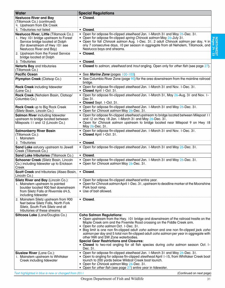
Oregon Department of Fish and Wildlife 31
Text highlighted in blue is new or changed from 2011
Water Special RegulationsNestucca River and Bay (Tillamook Co.) (continued)
Upstream from Elk Creek4.
•Closed.
Tributaries not listed5. • Closed.Nestucca River, Little (Tillamook Co.):
Hwy 101 bridge upstream to Forest 1. Service bridge located at Dolph (for downstream of Hwy 101 see Nestucca River and Bay)
• Open for adipose fin-clipped steelhead Jan. 1-March 31 and May 26-Dec. 31.• Open for adipose fin-clipped spring Chinook salmon May 26-July 31.• Open for fall Chinook salmon Aug. 1-Dec. 31; 2 adult Chinook salmon per day, 4 in
any 7 consecutive days, 10 per season in aggregate from all Nehalem, Tillamook, and Nestucca bays and streams.
2. Upstream from the Forest Service bridge located at Dolph
• Closed.
Tributaries3. • Closed.Netarts Bay and tributaries (Tillamook Co.)
• Closed to salmon, steelhead and trout angling. Open only for other fish (see page 27).
Pacific Ocean • See Marine Zone (pages 100-103)Plympton Creek (Clatsop Co.) • See Columbia River Zone (page 95) for the area downstream from the mainline railroad
bridge.Rock Creek including tidewater (Lane Co.)
• Open for adipose fin-clipped steelhead Jan. 1-March 31 and Nov. 1-Dec. 31.• Closed April 1-Oct. 31.
Rock Creek (Nehalem Basin, Clatsop/Columbia Co.)
• Open for adipose fin-clipped steelhead Jan. 1-March 31, May 26-Aug. 31 and Nov. 1-Dec 31.
• Closed Sept. 1-Oct. 31.Rock Creek up to Big Rock Creek (Siletz Basin, Lincoln Co.)
• Open for adipose fin-clipped steelhead Jan. 1-March 31 and May 26-Dec. 31.• Open for Chinook salmon May 26-Dec. 31.
Salmon River including tidewater upstream to bridge located between Mileposts 11 and 12 (Lincoln Co.)
• Open for adipose fin-clipped steelhead upstream to bridge located between Milepost 11 and 12 on Hwy 18 Jan. 1-March 31 and May 26-Dec. 31.
• Open for Chinook salmon upstream to bridge located near Milepost 9 on Hwy 18 May 26-Dec. 31.
Salmonberry River Basin (Tillamook Co.):
Mainstem1.
• Open for adipose fin-clipped steelhead Jan. 1-March 31 and Nov. 1-Dec. 31.• Closed April 1-Oct. 31.
2. Tributaries • Closed.Sand Lake estuary upstream to Jewell Creek (Tillamook Co.)
• Open for adipose fin-clipped steelhead Jan. 1-March 31 and May 26-Dec. 31.
Sand Lake tributaries (Tillamook Co.) • Closed.Schooner Creek (Siletz Basin, Lincoln Co.) including tidewater up to Erickson Creek
• Open for adipose fin-clipped steelhead Jan. 1-March 31 and May 26-Dec. 31.• Open for Chinook salmon May 26-Dec. 31.
Scott Creek and tributaries (Alsea Basin, Lincoln Co.)
• Closed.
Siletz River and Bay (Lincoln Co.):Mainstem upstream to painted 1. boulder located 900 feet downstream from Siletz Falls at Rivermile 64.5, including tidewater
• Open for adipose fin-clipped steelhead entire year.• Open for Chinook salmon April 1-Dec. 31, upstream to deadline marker at the Moonshine
Park boat ramp.• Use of bait allowed.
2. Mainstem Siletz upstream from 900 feet below Siletz Falls, North Fork Siletz, South Fork Siletz and all tributaries of these streams
• Closed.
Siltcoos Lake (Lane/Douglas Co.) Coho Salmon Regulations:• Open upstream from the Hwy. 101 bridge and downstream of the railroad trestle on the
Maple Creek arm and the Fivemile Road crossing on the Fiddle Creek arm.• Open for coho salmon Oct. 1-Dec. 31.• Bag limit is one non fin-clipped adult coho salmon and one non fin-clipped jack coho
salmon per day and 5 total non fin-clipped adult coho salmon per year in aggregate with other NW and SW Zone waterbodies.
Special Gear Restrictions and Closures:• Closed to two-rod angling for all fish species during coho salmon season Oct. 1-
Dec. 31.Siuslaw River (Lane Co.):
Mainstem upstream to Whittaker1. Creek including tidewater
• Open for adipose fin-clipped steelhead Jan. 1-March 31 and May 26-Dec. 31.• Open to angling for adipose fin-clipped steelhead April 1-15, from Whittaker Creek boat
launch to 200 yards below Wildcat Creek boat launch.• Open for Chinook salmon May 26-Dec. 31.• Open for other fish (see page 27) entire year in tidewater.
NO
RTH
WE
ST
Pages 24 - 33
(Continued on next page)

Oregon Department of Fish and Wildlife32
Text highlighted in blue is new or changed from 2011
Water Special RegulationsSiuslaw River (Lane Co.):(continued from previous page)2. Mainstem upstream from Whittaker
Creek• Open for adipose fin-clipped steelhead Jan. 1-March 31 and Dec. 1-31.• Closed Oct. 1-Nov. 30.
North Fork including tidewater3. a. Mainstem
• Open for adipose fin-clipped steelhead Jan. 1-March 31.• Open for Chinook salmon May 26-Dec 31 up to Meadows Bridge at Milepost 11.• Open to trout angling above Meadows Bridge May 26-Sept. 30.
b. Tributaries • Closed.Slick Rock Creek and tributaries (Salmon River Basin, Lincoln Co.)
• Closed.
Sunset Lake (Clatsop Co.) • Limit 1 bass per day, any size, 2 daily limits in possession.Sweet Creek (Siuslaw Basin, Lane Co.):
Tidewater1. • Open for adipose fin-clipped steelhead Jan. 1-March 31 and May 26-Dec. 31.• Open for Chinook salmon May 26-Dec. 31.• Open for other fish entire year (see page 27).
2. From head of tidewater upstream to 200 feet below falls located near Milepost 10.
• Open for adipose fin-clipped steelhead Jan. 1-March 31 and Dec. 1-31.• Closed Oct. 1-Nov. 30.
Tahkenitch Lake (Douglas Co.) Coho Salmon Regulations:• Open upstream from the Hwy. 101 bridge and downstream of the first road crossing on
the Leitel Creek arm and the ODFW marker at the bridge on the 059 Road just west of the Douglas County Road 49.
• Open for coho salmon Oct. 1-Dec. 31.• Bag limit is one non fin-clipped adult coho salmon and one non fin-clipped jack coho
salmon per day; and total of 5 non fin-clipped adult coho salmon per year in aggregate with other NW and SW Zone waterbodies.
Special Gear Restrictions and Closures:• Closed to two-rod angling for all fish species during coho salmon season Oct. 1-
Dec. 31.Tenmile Creek including tidewater (Lane Co.)
• Open for adipose fin-clipped steelhead Jan. 1-March 31 and Nov. 1-Dec. 31.• Closed April 1-Oct. 31.
Three Rivers (Nestucca Basin, Tillamook/Yamhill Co):
Mainstem1.
• Open for adipose fin-clipped steelhead entire year.• Open for adipose fin-clipped spring Chinook salmon April 1-June 30.• Open for fall Chinook salmon Oct. 1-Dec. 31; 2 adult Chinook salmon per day, 4 in
any 7 consecutive days, 10 per season in aggregate from all Nehalem, Tillamook, and Nestucca bays and streams.
• Closed from mouth upstream to hatchery weir deadline July 1-Sept. 30.• Use of bait allowed.• No angling from a floating device.
2. Tributaries • Closed.Tillamook Bay (Tillamook Co.) • Open for adipose fin-clipped steelhead entire year.
• Open for adipose fin-clipped spring Chinook salmon during any authorized ocean Chinook salmon seasons prior to August 1 in the Tillamook Spring Chinook Terminal Area (ocean) from the jetty tips seaward to the 15 fathom line offshore from Twin Rocks (45* 35’ 54” N. lat.) to Pyramid Rock (45* 29’ 48” N. lat.).
• Open for adipose fin-clipped spring Chinook salmon April 1-July 31 in Tillamook Bay inside the jetty tips.
• Open for fall Chinook salmon Aug. 1-Dec. 31; 2 adult Chinook salmon per day, 4 in any 7 consecutive days, 10 per season in aggregate from all Nehalem, Tillamook, and Nestucca bays and streams.
NOTE: Changes to salmon regulations in the Tillamook Fall Terminal Area are adopted by June of each year and are posted on the ODFW website: http://www.dfw.state.or.us/resources/fishing/. Check for new regulations before you fish.
Tillamook Bay tributaries not listed • Closed.Tillamook River (Tillamook Co.):
Tidewater1. • Open for adipose fin-clipped steelhead entire year.• Open for adipose fin-clipped spring Chinook salmon April 1-July 31.• Open for fall Chinook salmon Aug. 1-Dec. 31; 2 adult Chinook salmon per day, 4 in
any 7 consecutive days, 10 per season in aggregate from all Nehalem, Tillamook, and Nestucca bays and streams.
2. Mainstem, upstream from tidewater • Open for adipose fin-clipped steelhead Jan. 1-March 31 and May 26-Dec. 31.• Open for adipose fin-clipped spring Chinook salmon May 26-July 31.• Open for fall Chinook salmon Aug. 1-Dec. 31; 2 adult Chinook salmon per day, 4 in
any 7 consecutive days, 10 per season in aggregate from all Nehalem, Tillamook, and Nestucca bays and streams.
Tributaries3. • Closed.
(Continued on next page)
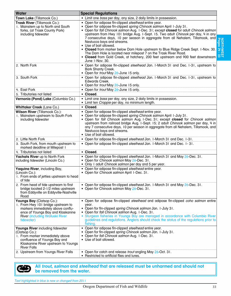
Oregon Department of Fish and Wildlife 33
Text highlighted in blue is new or changed from 2011
Water Special RegulationsTown Lake (Tillamook Co.) • Limit one bass per day, any size, 2 daily limits in possession.Trask River (Tillamook Co.):
Mainstem up to North and South 1. forks, (at Trask County Park) including tidewater
• Open for adipose fin-clipped steelhead entire year.• Open for adipose fin-clipped spring Chinook salmon April 1-July 31.• Open for fall Chinook salmon Aug. 1-Dec. 31; except closed for adult Chinook salmon
upstream from Hwy 101 bridge Aug. 1-Sept. 15. Two adult Chinook per day, 4 in any 7 consecutive days, 10 per season in aggregate from all Nehalem, Tillamook, and Nestucca bays and streams.
• Use of bait allowed.• Closed from marker below Dam Hole upstream to Blue Ridge Creek Sept. 1-Nov. 30.
The Dam Hole is located near milepost 7 on the Trask River Road.• Closed from Gold Creek, at hatchery, 200 feet upstream and 900 feet downstream
June 1-Nov. 30.2. North Fork • Open for adipose fin-clipped steelhead Jan. 1-March 31 and Dec. 1-31, upstream to
Bark Shanty Creek.• Open for trout May 26-June 15 only.
South Fork3. • Open for adipose fin-clipped steelhead Jan. 1-March 31 and Dec. 1-31, upstream to Edwards Creek.
• Open for trout May 26-June 15 only.East Fork4. • Open for trout May 26-June 15 only.Tributaries not listed5. • Closed.
Vernonia (Pond) Lake (Columbia Co.) • Limit one bass per day, any size, 2 daily limits in possession.• Limit ten Crappie per day, no minimum length.
Whittaker Creek (Lane Co.) • Closed.Wilson River (Tillamook Co.):
Mainstem upstream to South Fork 1. including tidewater
• Open for adipose fin-clipped steelhead entire year.• Open for adipose fin-clipped spring Chinook salmon April 1-July 31.• Open for fall Chinook salmon Aug. 1-Dec. 31; except closed for Chinook salmon
upstream from railroad bridge Aug. 1-Sept. 15; 2 adult Chinook salmon per day, 4 in any 7 consecutive days, 10 per season in aggregate from all Nehalem, Tillamook, and Nestucca bays and streams.
• Use of bait allowed. 2. Little North Fork • Open for adipose fin-clipped steelhead Jan. 1-March 31 and Dec. 1-31.
South Fork, from mouth upstream to 3. marked deadline at Milepost 1
• Open for adipose fin-clipped steelhead Jan. 1-March 31 and Dec. 1- 31.
Tributaries not listed4. • Closed.Yachats River up to North Fork including tidewater (Lincoln Co.)
• Open for adipose fin-clipped steelhead Jan. 1-March 31 and May 26-Dec. 31.• Open for Chinook salmon May 26-Dec. 31.• Only 1 adult Chinook salmon per day and 5 per year.
Yaquina River, including Bay, (Lincoln Co.):
From ends of jetties upstream to head 1. of tide
• Open for adipose fin-clipped steelhead entire year.• Open for Chinook salmon April 1-Dec. 31.
2. From head of tide upstream to first bridge located 2-1/2 miles upstream from Eddyville on Eddyville-Nashville Road
• Open for adipose fin-clipped steelhead Jan. 1-March 31 and May 26-Dec. 31.• Open for Chinook salmon May 26-Dec. 31.
Youngs Bay (Clatsop Co.):From Hwy 101 bridge upstream to 1. markers immediately above conflu-ence of Youngs Bay and Klaskanine River (including Walluski River tidewater)
• Open for adipose fin-clipped steelhead and adipose fin-clipped coho salmon entire year.
• Open for fin-clipped spring Chinook salmon Jan. 1-July 31.• Open for fall Chinook salmon Aug. 1-Dec. 31.• Sturgeon fisheries in Youngs Bay are managed in accordance with Columbia River
guidelines and regulations. Anglers should check the status of the regulations prior to fishing.
Youngs River including tidewater (Clatsop Co.):
From marker immediately above 1. confluence of Youngs Bay and Klaskanine River upstream to Youngs River Falls
• Open for adipose fin-clipped steelhead entire year.• Open for fin-clipped spring Chinook salmon Jan. 1-July 31.• Open for fall Chinook salmon Aug. 1-Dec. 31.• Use of bait allowed.
2. Upstream from Youngs River Falls • Open for catch and release trout angling May 26-Oct. 31.• Restricted to artificial flies and lures.
NO
RTH
WE
ST
Pages 24 - 33
All trout, salmon and steelhead that are released must be unharmed and should not be removed from the water.
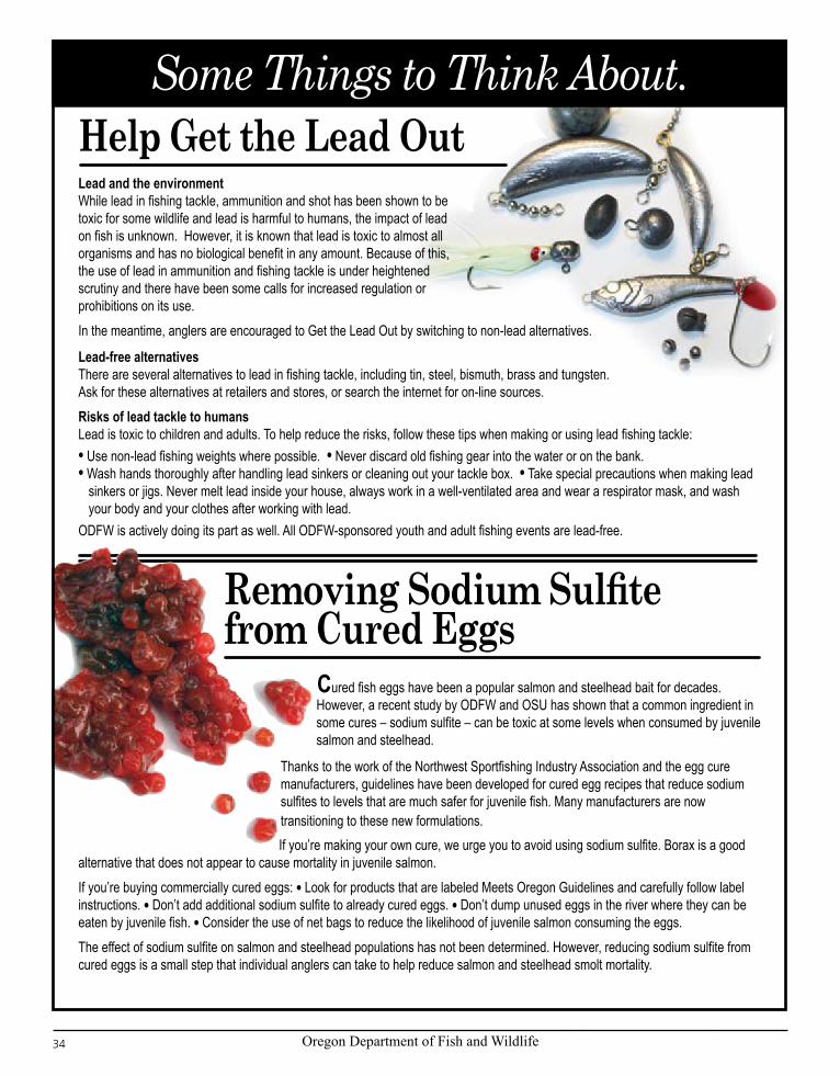
Oregon Department of Fish and Wildlife34
Text highlighted in blue is new or changed from 2011
Some Things to Think About.Help Get the Lead OutLead and the environmentWhile lead in fishing tackle, ammunition and shot has been shown to be toxic for some wildlife and lead is harmful to humans, the impact of lead on fish is unknown. However, it is known that lead is toxic to almost all organisms and has no biological benefit in any amount. Because of this, the use of lead in ammunition and fishing tackle is under heightened scrutiny and there have been some calls for increased regulation or prohibitions on its use.
In the meantime, anglers are encouraged to Get the Lead Out by switching to non-lead alternatives.
Lead-free alternativesThere are several alternatives to lead in fishing tackle, including tin, steel, bismuth, brass and tungsten. Ask for these alternatives at retailers and stores, or search the internet for on-line sources.
Risks of lead tackle to humansLead is toxic to children and adults. To help reduce the risks, follow these tips when making or using lead fishing tackle:l Use non-lead fishing weights where possible. l Never discard old fishing gear into the water or on the bank.l Wash hands thoroughly after handling lead sinkers or cleaning out your tackle box. l Take special precautions when making lead
sinkers or jigs. Never melt lead inside your house, always work in a well-ventilated area and wear a respirator mask, and wash your body and your clothes after working with lead.
ODFW is actively doing its part as well. All ODFW-sponsored youth and adult fishing events are lead-free.
Removing Sodium Sulfite from Cured Eggs
Thanks to the work of the Northwest Sportfishing Industry Association and the egg cure manufacturers, guidelines have been developed for cured egg recipes that reduce sodium sulfites to levels that are much safer for juvenile fish. Many manufacturers are now transitioning to these new formulations.
Cured fish eggs have been a popular salmon and steelhead bait for decades. However, a recent study by ODFW and OSU has shown that a common ingredient in some cures – sodium sulfite – can be toxic at some levels when consumed by juvenile salmon and steelhead.
If you’re making your own cure, we urge you to avoid using sodium sulfite. Borax is a good alternative that does not appear to cause mortality in juvenile salmon.
If you’re buying commercially cured eggs: l Look for products that are labeled Meets Oregon Guidelines and carefully follow label instructions. l Don’t add additional sodium sulfite to already cured eggs. l Don’t dump unused eggs in the river where they can be eaten by juvenile fish. l Consider the use of net bags to reduce the likelihood of juvenile salmon consuming the eggs.
The effect of sodium sulfite on salmon and steelhead populations has not been determined. However, reducing sodium sulfite from cured eggs is a small step that individual anglers can take to help reduce salmon and steelhead smolt mortality.

Oregon Department of Fish and Wildlife 35
Text highlighted in blue is new or changed from 2011
Since it opened in 2005, scientists at the Oregon Hatchery Research Center have been studying
the ways hatchery fish are reared or used in fishery management. Researchers at the center are now focusing their efforts on finding ways to minimize the effect hatchery salmon and steelhead can have on wild fish populations while still providing for healthy fisheries.
To help find some of these answers, research at OHRC is focusing on:Can we prevent hatchery fish from spawning
with wild fish? If the number of hatchery fish on spawning grounds can be reduced ODFW can provide more opportunity for anglers to harvest these fish in the lower rivers and estuaries.
Should hatchery fish be as similar, or as different as possible from wild fish? For years, scientists and managers have debated whether wild fish should be used in hatchery broodstocks. It is also believed that selecting the right breeding pairs (fish that would have spawned together in the wild) at the hatchery may produce offspring that would have less impact on wild fish. While the answers to these questions may vary depending on the fishery, the OHRC will be focused on research that will help fishery managers make these choices.
How can we establish healthy wild populations of salmon above barriers such as dams? ODFW and partner agencies are beginning to reintroduce salmon into several areas from which they had disappeared due to dams or
poor habitat. OHRC research efforts will help managers understand how hatcheries can help rebuild healthy salmon runs in these areas.
A trout is a trout, right? ODFW currently rears and releases several types of trout around the state. The OHRC is focused on evaluating the trout stocking program to balance the quality of the fish with the harvest opportunity while minimizing the effects on wild fish, amphibians, and other animals in the areas they are released.
The Oregon Hatchery Research Center is a cooperative effort between the Oregon Department of Fish and Wildlife and the Oregon State University.
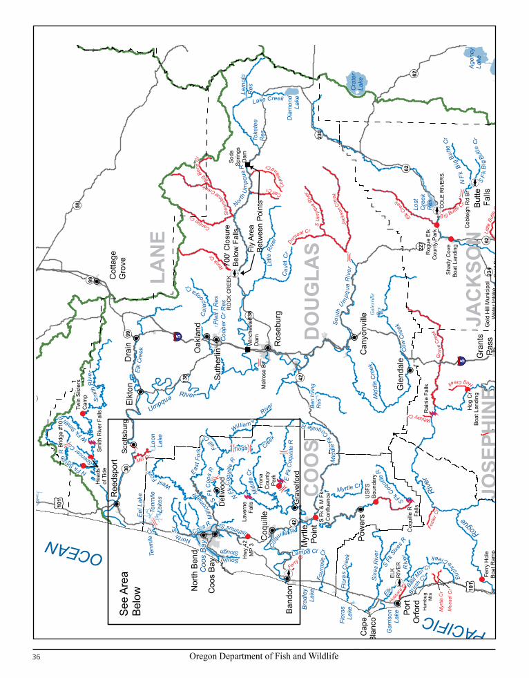
Oregon Department of Fish and Wildlife36
Text highlighted in blue is new or changed from 2011
See
Area
Belo
w
Gal
esvi
lleRe
s
Ben
Irvin
g R
es
CA
LIFO
RN
I A
S
TATE
LIN
E
105
97
199
38
126
36
58
138
230
62
238
66
42
39
234
99
46
227
140
99
138
126
140
99
42
Hum
bug
Mtn
5
5
62
5
140
62
Coo
s B
ay
Med
ford
Coo
s B
ay
Klam
ath
Falls
Ros
ebur
g
Ashl
and
Gra
nts
Pass
Suth
erlin
Nor
th B
end
Band
on
Broo
king
s
Coq
uille
Cen
tral P
ointCot
tage
Gro
veR
eeds
port
Gol
dBe
ach
Port
Orfo
rd
Myr
tlePo
int
Cav
e Ju
nctio
n
Dra
in Oak
land
Pow
ers
Can
yonv
ille
Gle
ndal
e
Butte
Falls
Elkt
on
Upp
erKl
amat
hLa
ke
Cra
ter
Lake
Agen
cyLa
ke
Lost
Cre
ekR
es
Dia
mon
dLa
ke
Tenm
ileLa
kes
How
ard
Prai
rieLa
ke
Hya
tt R
es
Eel L
ake
Lem
olo
Res
Emig
rant
Res
Flor
asLa
ke
Loon
Lake
Gar
rison
Lake
Coo
per C
r Res
Toke
tee
Res
Ree
der R
es
Plat
t I R
es
Brad
ley
Lake
USF
SBo
unda
ry
Fron
a C
ount
yPa
rk
Twin
Sis
ters
Cam
p
Hog
Cr
Boat
Lan
ding
Ferr
y H
ole
Boat
Ram
p
Rog
ue E
lkC
ount
y Pa
rk
Gol
d H
illBo
at L
andi
ng
Shad
y C
ove
Boat
Lan
ding
Cap
eBl
anco
Fly
Area
Betw
een
Poin
ts
700'
Clo
sure
Belo
w F
alls
Hea
dsof
Tid
e
Hw
y 42
MP
3
S Fk
& M
Fk
Con
fluen
ce
LAN
E
KLAMATH
DO
UG
LAS
JAC
KSO
N
CO
OS
CU
RRY
JOSE
PHIN
ER
ogue
R
iver
North
Um
pqua
R
Umpqua River
Sm
ith R
iver
Illin
ois R
iver
Elk
Cre
e k
Sou
th U
mpq
ua R
i ver
Apple
gate
Rive
rCow
Cre
ek
Littl
e R
iver
Elk
Riv
er
Six
es R
iver
Che
tco
River
Cal
apooya Cr
Jenny CrPi
sto
l
R
iverCo
qu
ille R
Mid
dle
Cr
William s Rive
r
Mid
dle
Fk C
oquille R
S Fk C
oq
uille
R
Ca
vitt
Cr
Lake Creek
Hun
ter C
r
Emigrant Cr
N Fk
Coq
uille
R
Myrtle Cr
Tioga Cre
ek
S Fk
Litt
l e B
utte
Cr
Flor
as C
reek
S Fk
Coo
s R
Euch
re
Creek
N Fk Smith
R
Fall C
r
Glade Cr
N Fk
Li tt
le B
utte
Cr
Four
mil e
Cr
Eas
t For
k
Whe
el
er Cr
Coos R
Brus
h Cr
N F
k B
ig Bu
tte C
r
South Winc
huck
R
North Sl
Spencer C
r
S F
k B
ig B
utte
Cr
Mid
dle
Cre
ek
E Fk Winchuck
R
S Fk
Sixe
s R
W Fk Smith
R
E Fk
Coq
uille
R
Tenm
ile C
r
Ke ene
Cr
Isthmus Sl
West Fork
Mill
icom
a R
W Fk
E Fk
Rogue
Rive
r
Bald
Mtn Cr
Deep Cr
Lampa CrSlough
N FkELK
RIV
ER
RO
CK
CR
EEK
CO
LE R
IVER
S
Pom
eroy
Dam
Rai
nie
Falls
Gol
d R
ay D
am S
ite
Appl
egat
eD
am
Lave
rne
Falls
Win
ches
ter
Dam
Illin
ois
RFa
lls
Smith
Riv
er F
alls
Soda
Sprin
gsD
am
Coq
uille
R
Falls
Gol
d H
ill M
unic
ipal
W
ater
Inta
ke
Bear Cr
Gra
ve C
reek
Elk Cre
ek
Jack
son
Creek
Rock C
r
Stea
mbo
at Creek
S U
mpq
ua R
iver
Canton Cr
Littl
e Bu
tte C
r
Little
App
lega
te R
Calf Cr
Du
mont Cr
Big Ben
d C
r
Fall CrM
usse
l Cr M
yers
Cr
Hubba
rd C
r
Th
omas Cr
Whisky Cr
W Fk Illin
ois R
E Fk Illinois R
B ig Butte Cr
Hog Creek
Mill Cr
Ashland Cr
Ferry Cr
Emig
ra
nt Cr
Myr
tle C
r
Fost
er C
r
Cope
land Cr
Briggs C
r
Brid
ge #
10
Mel
rose
Br
Cob
leig
h R
d Br
FS 2
030
Gra
velfo
rd
Scot
tsbu
rg
Del
lwoo
d
OCEAN
Sout
hwes
t Zon
e
020
4010
Mile
s
PACIFIC
101
101
Ben
Irvi
ng
Res
38
138
42
Coo
s B
ayC
oos
Bay
Nor
th B
end
Band
on
Coq
uille
Ree
dspo
rt
Myr
tlePo
int
Elkt
on
Tenm
ileLa
kes
Eel
Lak
e
Loon
Lake
Brad
ley
Lake
Fron
a C
ount
yPa
rk
Twin
Sis
ters
Cam
p
Brew
ster
Gor
ge
Hea
dsof
Tid
e
Hw
y 42
MP
3
CO
OS
Umpqua River
Smith
Riv
er
Coqu
ille R
Mid
dle
Cr
William s
River
Mid
dle
For
k Coquille River
N Fk C
oqui
lle R
Tioga Cree
k
S Fk
Coo
s R
N Fk Smith R
Fall C
r
Fourm
ile Cr
eek
Eas t F
ork
Palo
use
Cr
Coos R
South Slough
Kent
uck
Cr
North Sl
Moon
Cr
Spencer Cr
Catching Sl
Burn
t Cr
W Fk Smith
R
E Fk
Coq
uille
R
Te
nmile
Cr
Coalb
ank S
l
Shing
lehou
se S
lSull i
v an
Cr
Lars
on C
r
Isthmus Sl
West Fork
Milli
coma R
Davis
Sl
Lampa Cr
Shut
tpel
zLa
ke
Lave
rne
Falls
Smith
Riv
er F
alls
MP
21Fa
lls
Mill Cr
Ferry C
r
Mel
rose
Br
Gay
lord
Br
Cam
as C
r Br
Hillt
op Br
7 M
i Br
Con
cret
e Br
Con
cret
eBr
Gra
velfo
rd
Scot
tsbu
rg
Del
lwoo
d
Lege
ndO
ther
Lan
dmar
ks
Dam
s
Falls
Brid
ges
Hat
cher
ies
Cou
nty
boun
darie
s
Clo
sed
All
Year
Zone
Bou
ndar
y
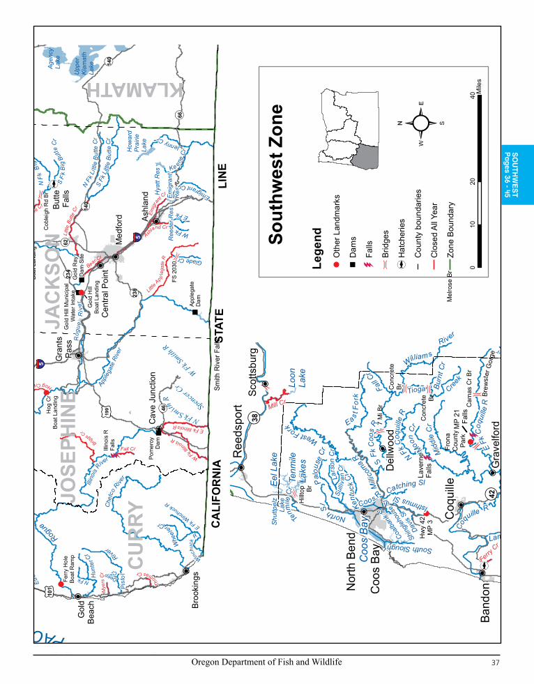
Oregon Department of Fish and Wildlife 37
Text highlighted in blue is new or changed from 2011
SO
UTH
WE
ST
Pages 36 - 45
See
Area
Belo
w
Gal
esvi
lleRe
s
Ben
Irvin
g R
es
CA
LIFO
RN
I A
S
TATE
LIN
E
105
97
199
38
126
36
58
138
230
62
238
66
42
39
234
99
46
227
140
99
138
126
140
99
42
Hum
bug
Mtn
5
5
62
5
140
62
Coo
s B
ay
Med
ford
Coo
s B
ay
Klam
ath
Falls
Ros
ebur
g
Ashl
and
Gra
nts
Pass
Suth
erlin
Nor
th B
end
Band
on
Broo
king
s
Coq
uille
Cen
tral P
ointCot
tage
Gro
veR
eeds
port
Gol
dBe
ach
Port
Orfo
rd
Myr
tlePo
int
Cav
e Ju
nctio
n
Dra
in Oak
land
Pow
ers
Can
yonv
ille
Gle
ndal
e
Butte
Falls
Elkt
on
Upp
erKl
amat
hLa
ke
Cra
ter
Lake
Agen
cyLa
ke
Lost
Cre
ekR
es
Dia
mon
dLa
ke
Tenm
ileLa
kes
How
ard
Prai
rieLa
ke
Hya
tt R
es
Eel L
ake
Lem
olo
Res
Emig
rant
Res
Flor
asLa
ke
Loon
Lake
Gar
rison
Lake
Coo
per C
r Res
Toke
tee
Res
Ree
der R
es
Plat
t I R
es
Brad
ley
Lake
USF
SBo
unda
ry
Fron
a C
ount
yPa
rk
Twin
Sis
ters
Cam
p
Hog
Cr
Boat
Lan
ding
Ferr
y H
ole
Boat
Ram
p
Rog
ue E
lkC
ount
y Pa
rk
Gol
d H
illBo
at L
andi
ng
Shad
y C
ove
Boat
Lan
ding
Cap
eBl
anco
Fly
Area
Betw
een
Poin
ts
700'
Clo
sure
Belo
w F
alls
Hea
dsof
Tid
e
Hw
y 42
MP
3
S Fk
& M
Fk
Con
fluen
ce
LAN
E
KLAMATH
DO
UG
LAS
JAC
KSO
N
CO
OS
CU
RRY
JOSE
PHIN
ER
ogue
R
iver
North
Um
pqua
R
Umpqua River
Sm
ith R
iver
Illin
ois R
iver
Elk
Cre
e k
Sou
th U
mpq
ua R
i ver
Apple
gate
Rive
rCow
Cre
ek
Littl
e R
iver
Elk
Riv
er
Six
es R
iver
Che
tco
River
Cal
apooya Cr
Jenny Cr
Pist
ol
Rive
rCoqu
ille R
Mid
dle
Cr
William s
River
Mid
dle
Fk C
oquille R
S Fk C
oq
uille
R
Ca
vitt
Cr
Lake CreekH
unte
r Cr
Emigrant Cr
N Fk
Coq
uille
R
Myrtle Cr
Tioga Cre
ek
S Fk
Litt
l e B
utte
Cr
Flor
as C
reek
S Fk
Coo
s R
Euch
re
Creek
N Fk Smith
R
Fall C
r
Glade Cr
N Fk
Li tt
le B
utte
Cr
Four
mil e
Cr
Eas
t For
k
Whe
el
er Cr
Coos R
Brus
h Cr
N F
k B
ig Bu
tte C
r
South Winc
huck
R
North Sl
Spencer C
r
S F
k B
ig B
utte
Cr
Mid
dle
Cre
ek
E Fk Winchuck
R
S Fk
Sixe
s R
W Fk Smith
R
E Fk
Coq
uille
R
Tenm
ile C
r
Ke ene
Cr
Isthmus Sl
West Fork
Mill
icom
a R
W Fk
E Fk
Rogue
Rive
r
Bald
Mtn Cr
Deep Cr
Lampa CrSlough
N FkELK
RIV
ER
RO
CK
CR
EEK
CO
LE R
IVER
S
Pom
eroy
Dam
Rai
nie
Falls
Gol
d R
ay D
am S
ite
Appl
egat
eD
am
Lave
rne
Falls
Win
ches
ter
Dam
Illin
ois
RFa
lls
Smith
Riv
er F
alls
Soda
Sprin
gsD
am
Coq
uille
R
Falls
Gol
d H
ill M
unic
ipal
W
ater
Inta
ke
Bear Cr
Gra
ve C
reek
Elk Cre
ek
Jack
son
Creek
Rock C
r
Stea
mbo
at Creek
S U
mpq
ua R
iver
Canton Cr
Littl
e Bu
tte C
r
Little
App
lega
te R
Calf Cr
Du
mont Cr
Big Ben
d C
r
Fall Cr
Mus
sel C
r Mye
rs C
r
Hubba
rd C
r
Th
omas Cr
Whisky Cr
W Fk Illin
ois R
E Fk Illinois R
B ig Butte Cr
Hog Creek
Mill Cr
Ashland Cr
Ferry Cr
Emig
ra
nt Cr
Myr
tle C
r
Fost
er C
r
Cope
land Cr
Briggs C
r
Brid
ge #
10
Mel
rose
Br
Cob
leig
h R
d Br
FS 2
030
Gra
velfo
rd
Scot
tsbu
rg
Del
lwoo
d
OCEAN
Sout
hwes
t Zon
e
020
4010
Mile
s
PACIFIC10
1
101
Ben
Irvi
ng
Res
38
138
42
Coo
s B
ayC
oos
Bay
Nor
th B
end
Band
on
Coq
uille
Ree
dspo
rt
Myr
tlePo
int
Elkt
on
Tenm
ileLa
kes
Eel
Lak
e
Loon
Lake
Brad
ley
Lake
Fron
a C
ount
yPa
rk
Twin
Sis
ters
Cam
p
Brew
ster
Gor
ge
Hea
dsof
Tid
e
Hw
y 42
MP
3
CO
OS
Umpqua River
Smith
Riv
er
Coqu
ille R
Mid
dle
Cr
William s
River
Mid
dle
For
k Coquille River
N Fk C
oqui
lle R
Tioga Cree
k
S Fk
Coo
s R
N Fk Smith R
Fall C
r
Fourm
ile Cr
eek
Eas t F
ork
Palo
use
Cr
Coos R
South Slough
Kent
uck
Cr
North Sl
Moon
Cr
Spencer Cr
Catching Sl
Burn
t Cr
W Fk Smith
R
E Fk
Coq
uille
R
Te
nmile
Cr
Coalb
ank S
l
Shing
lehou
se S
lSull i
v an
Cr
Lars
on C
r
Isthmus Sl
West Fork
Milli
coma R
Davis
Sl
Lampa Cr
Shut
tpel
zLa
ke
Lave
rne
Falls
Smith
Riv
er F
alls
MP
21Fa
lls
Mill Cr
Ferry C
r
Mel
rose
Br
Gay
lord
Br
Cam
as C
r Br
Hillt
op Br
7 M
i Br
Con
cret
e Br
Con
cret
eBr
Gra
velfo
rd
Scot
tsbu
rg
Del
lwoo
d
Lege
ndO
ther
Lan
dmar
ks
Dam
s
Falls
Brid
ges
Hat
cher
ies
Cou
nty
boun
darie
s
Clo
sed
All
Year
Zone
Bou
ndar
y

Oregon Department of Fish and Wildlife38
Text highlighted in blue is new or changed from 2011
Description:The Southwest Zone is all waters draining directly to the Pacific Ocean from the Umpqua River south to the Oregon-California border, and including, the Umpqua River drainage; and those portions of Klamath River drainage in Jackson County. Regulations for marine fish, marine shellfish and marine invertebrates are listed under the Marine Zone (pages 100-103).Instructions:
Read the 1. Special Regulations for this zone. Special Regulations apply to specific bodies of water or portions of water within a zone. If specific references to a body of water, species, catch limits, length limits, seasons, or other specifications are not made in the Special Regulations for this zone, then Zone Regulations apply.Read the following 2. Regulations for this zone.Always read the 3. General Regulations, pages 5-12, which apply to all zones, for information about licenses; tags and permits; definitions; catch and possession limits; gear and bait restrictions; and harvest methods and hours, before going fishing.Emergency or permanent rules adopted since 4. these rules were printed may supersede these regulations. Anglers may call ODFW headquarters or regional offices at the numbers on page 4 of these regulations, or check the ODFW web site, www.dfw.state.or.us for these rules, or call 503-947-6000 during normal business hours.
Regulations for this zone:Rogue River tributaries below Lost Creek Dam, Applegate River tributaries below Applegate Dam, all Illinois River tributaries, and 1. the Illinois River above Pomeroy Dam are closed to all angling, except as noted under Special Regulations.Angling in streams above tidewater for all species during May 2. 26-Aug. 31 is restricted to artificial flies and lures. See exceptions for use of bait in Rogue, Applegate and Umpqua river basins.Use of bait allowed in bays and tidewaters year round. 3. Anglers may not continue to angle for jack 4. salmon or trout after retaining limit of adult salmon or steelhead.
Species Name Catch Limits Length Limits and Other Specifications SeasonTrout Lakes: 5 per day,
2 daily limits in possession.Streams: (includ-ing tidewaters and bays); 2 per day, 2 daily catch limits in possession.
• 8-inch minimum length.• Only 1 trout over 20 inches in length may be taken per day.• Rainbow trout over 16 inches are considered steelhead in streams.• Salmon under 15 inches are considered trout, except coho salmon,
which are always considered salmon regardless of size.• Angling restricted to artificial flies and lures in streams above tide-
water, May 26-Aug. 31. See exceptions under Special Regulations where use of bait is allowed.
Lakes: Open all yearStreams: (including tidewaters and bays): Open May 26-Oct. 31 unless noted under Special Regulations.
Salmon and Steelhead
In the aggregate: 2 adult salmon or steelhead per day, 20 per year. 5 jack salmon per day, 2 daily jack limits in possession.
• See Special Regulations in SW Zone to determine where harvest of any Chinook salmon is allowed. There is no annual limit on adipose or otherwise fin-clipped salmon or adipose fin-clipped steelhead as long as the appropriate number of Hatchery Harvest Tags have been purchased to record the catch.
• See exceptions to the Chinook salmon catch limit under Hunter Creek and Pistol River.
• Pink salmon, sockeye salmon and adipose fin-clipped coho salmon may be retained as part of the adult and jack salmon daily bag limit in all waters that are currently open to angling for Chinook salmon or steelhead.
• Hatchery releases of coho salmon occur in the Rogue River and South Fork Umpqua River.
• Only adipose fin-clipped steelhead may be kept, except as noted under Special Regulations for the mainstem Illinois, Chetco, Elk, Pistol, Rogue, Sixes and Winchuck rivers and Hunter and Euchre creeks.
• Where allowed, no more than a total of 1 per day and 5 per year nonadipose fin-clipped steelhead may be taken per year statewide.
• Angling restricted to artificial flies and lures in streams above tide-water, May 26-Aug. 31. See exceptions under Special Regulations where use of bait is allowed.
Note: Changes to salmon regulations for the ocean, bays, coastal riv-ers and the Columbia River system (page 94) are printed in May and are available at ODFW offices or from license agents. Check for new regulations before you fish.
Closed in all waters unless noted by species under Special Regulations.
Sturgeon 1 per day, 5 per year.
• Closed to the retention of green sturgeon.• Minimum fork length 38 inches, maximum fork length 54 inches.• All oversize, undersize, and unwanted legal size sturgeon must be
immediately released unharmed into the water.• Oversize sturgeon cannot be removed totally or in part from water.• Only one single-point barbless hook may be used for sturgeon.• Angling restricted to artificial flies and lures in streams above tide-
water May 26-Aug. 31. See exceptions under Special Regulations where use of bait is allowed.
Lakes: Open all yearunless noted underSpecial RegulationsStreams: (including tidewaters and bays): Open during trout, salmon or steelhead seasons.
SOUTHWEST ZONE
(Continued on next page)
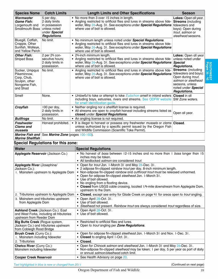
Oregon Department of Fish and Wildlife 39
SO
UTH
WE
ST
Pages 36 - 45
Text highlighted in blue is new or changed from 2011
Species Name Catch Limits Length Limits and Other Specifications SeasonWarmwater Game Fish: Largemouth and Smallmouth Bass
5 per day, 2 daily limits in possession unless noted under Special Regulations.
• No more than 3 over 15 inches in length.• Angling restricted to artificial flies and lures in streams above tide-
water, May 26-Aug. 31. See exceptions under Special Regulations where use of bait is allowed.
Lakes: Open all year.Streams (including tidewaters and bays): Open during trout, salmon or steelhead seasons.
Bluegill, Catfish, Crappie, Other Sunfish, Walleye, and Yellow Perch
No limit. • No minimum length unless noted under Special Regulations.• Angling restricted to artificial flies and lures in streams above tide-
water, May 26-Aug. 31. See exceptions under Special Regulations where use of bait is allowed.
Other Fish:Striped Bass
2 per 24 con-secutive hours; 2 daily limits in possession.
• 24-inch minimum length.• Angling restricted to artificial flies and lures in streams above tide-
water, May 26-Aug. 31. See exceptions under Special Regulations where use of bait is allowed.
Lakes: Open all yearunless noted underSpecial Regulations.Streams: (including tidewaters and bays): Open during trout, salmon or steelhead seasons, unless noted under Special Regulations.
Sucker, Umpqua Pikeminnow, Carp, Chub, Sculpin, other Nongame Fish, and Shad
No limit. • Angling restricted to artificial flies and lures in streams above tide-water, May 26-Aug. 31. See exceptions under Special Regulations where use of bait is allowed.
Smelt None. • Unlawful to take or attempt to take Eulachon smelt in inland waters including bays, estuaries, rivers and streams. See ODFW website for smelt identification guide.
Closed in all SW Zone waters.
Crayfish 100 per day, 2 daily limits in possession.
• Neither angling nor a shellfish license is required.• All streams are open to crayfish harvest including streams listed as
closed under Special Regulations. Open all year.
Bullfrogs No limit. • An angling license is not required.Freshwater Clams and mussels
Harvest prohibited. • It is illegal to harvest or possess any freshwater mussels or clams unless authorized by a specific permit issued by the Oregon Fish and Wildlife Commission (Scientific Take Permit).
Closed.
Marine Fish and Marine Shellfish
See Marine Zone (pages 100-103).
Special Regulations for this zone:Water Special RegulationsApplegate Reservoir (Jackson Co.) • No harvest of bass between 12-15 inches and no more than 1 bass longer than 15
inches may be taken.• All landlocked salmon are considered trout.
Applegate River (Josephine/Jackson Co.):
Mainstem upstream to 1. Applegate Dam
• Open for trout Jan. 1-March 31 and May 26-Dec. 31.• 2 adipose fin-clipped rainbow trout per day, 8-inch minimum length.• Non-adipose fin-clipped rainbow and cutthroat trout must be released unharmed.• Open for adipose fin-clipped steelhead Jan. 1-March 31.• Use of bait allowed.• No angling from a floating device.• Closed from USGS cable crossing, located 1/4-mile downstream from Applegate Dam,
upstream to the Dam.2. Tributaries upstream to Applegate Dam • Closed, except see entry for Glade Creek on page 41 for areas open to trout angling.
Mainstem and tributaries 3. upstream from Applegate Dam
• Open April 28-Oct. 31.• Use of bait allowed.• Steelhead not present. Rainbow trout are always considered trout regardless of size.
Ashland Creek (Jackson Co.): East and West Forks, including all tributaries upstream from Reeder Dam
• Open April 28-Oct. 31.• Use of bait allowed.
Big Butte Creek (Rogue system, Jackson Co.) and tributaries upstream from Cobleigh Road Bridge
• Restricted to artificial flies and lures.• Open to trout angling per Zone Regulations.
Brush Creek (Curry Co.):Mainstem including tidewater1.
• Open for adipose fin-clipped steelhead Jan. 1-March 31 and Nov. 1-Dec. 31.• Closed to angling April 1-Oct. 31.
2. Tributaries • Closed.Chetco River (Curry Co.):Mainstem including tidewater
• Open for Chinook salmon and steelhead Jan. 1-March 31 and May 26-Dec. 31.• Non-adipose fin-clipped steelhead may be taken; 1 per day, 5 per year as part of daily
or annual salmon/steelhead catch limit.Cooper Creek Reservoir • See Health Advisory on page 20.
(Continued on next page)

Oregon Department of Fish and Wildlife40
Text highlighted in blue is new or changed from 2011
Water Special RegulationsCoos Bay from the tips of jetties up-stream to head of tide including: Kentuck Slough (Creek) upstream to tide gate, Larson Slough (Creek) upstream to Sullivan Creek, North Slough upstream to tide gate, Palouse Slough (Creek) upstream to Elliott State Forest Boundary located about 6 miles upstream from highway, Catching Slough upstream to Sumner Road Bridge, Isthmus Slough, Coal Bank and Davis Sloughs upstream to their tidegates, Shinglehouse Slough, and Pony Slough (Creek) upstream to Newmark Avenue in tidewater (Coos Co.)
• Open for adipose fin-clipped steelhead entire year.• Open for Chinook salmon entire year.• Isthmus Slough open year-round for Chinook salmon, adipose fin-clipped coho salmon
and adipose fin-marked steelhead up to a point on the slough adjacent to Milepost 3 on Highway 42. Open to youth anglers (age 17 and under) and Disabled Anglers with a Oregon Disabilities Hunting and Fishing Permit (see pages 6-7), from Milepost 3 on Highway 42 to the tidegate.
Coos River (Coos Co.):Mainstem and South Fork up to head1. of tide located at Dellwood
• Open for Chinook salmon and adipose fin-clipped steelhead the entire year.
2. South Fork from head of tide up-stream to concrete bridge located near Tioga Creek
• Open for Chinook salmon and adipose fin-clipped steelhead Jan. 1-April 30 and May 26-Dec. 31, except closed for salmon upstream from Seven-Mile Bridge.
Coquille River (Coos Co.):Inland from the tips of the jetties 1. upstream to the South Fork
• Open for Chinook salmon and adipose fin-clipped steelhead entire year.
2. East Fork up to marker at lower end of Brewster Gorge
• Open for adipose fin-clipped steelhead Jan. 1-April 30 and Dec. 1-Dec. 31.• Closed 200 feet upstream from and 200 feet downstream from falls above Milepost 21
(above Dora).Middle Fork3. • Open for Chinook salmon and adipose fin-clipped steelhead Jan. 1-April 30 and
Oct. 1-Dec. 31.• Closed upstream from Myrtle Creek Sept. 16-Nov. 30.
North Fork4. • Open for Chinook salmon from confluence with South Fork upstream to the confluence with the East Fork Jan. 1-April 30 and Oct. 1-Dec. 31.
• Open for adipose fin-clipped steelhead Jan. 1-April 30 and Oct. 1-Dec. 31.• Closed 200 feet upstream from and 200 feet downstream of LaVerne Falls.
South Fork5. • Open for Chinook salmon from confluence with North Fork upstream to the confluence with the Middle Fork Jan. 1-April 30 and Oct. 1-Dec. 31.
• Open for adipose fin-clipped steelhead from confluence with North Fork upstream to the USFS Boundary near Powers Jan. 1-April 30 and Oct. 1-Dec. 31.
• Closed to all angling year-round from U.S. Forest Service boundary near Powers (Milepost 4 Powers-Agness Road) upstream to Coquille River Falls (approximately 12 miles) including tributaries.
• Closed for salmon upstream from the confluence of the South Fork and the Middle Fork of the Coquille River.
Cow Creek (Umpqua Basin) • See Umpqua River Basin.Diamond Lake (Douglas Co.) • Open April 28-Oct. 31.
• Trout catch limits: 8 trout per day, 8-inch minimum length, only 1 trout over 20 inches per day. 2 daily limits in possession.
Eel Creek (below Eel Lake) (Coos Co.) • Open for adipose fin-clipped steelhead from Jan. 1-April 30.Eel Lake (Coos/Douglas Co.) • Open for adipose fin-clipped steelhead entire year.
• Rainbow trout over 20 inches are considered steelheadElk River (Curry Co.) Mainstem inland from the mouth of the river upstream to Bald Mountain Creek, including tidewater
• Open for trout May 26-Oct. 31, 2 per day, 8-inch minimum; and open for adipose fin-clipped rainbow trout (half pounders), 2 per day, 8-inch minimum length, Jan. 1-March 31 and Nov. 1-Dec. 31.
• Open for Chinook salmon and steelhead Jan. 1-March 31 and May 26-Dec. 31.• Nonadipose fin-clipped steelhead may be taken; 1 per day, 5 per year as part of daily
or annual salmon/steelhead catch limit.Emigrant Creek and tributaries upstream from Emigrant Dam (Jackson Co.)
• Open year round.• Use of bait allowed.• Steelhead not present. Rainbow trout are always considered trout regardless of size.
Emigrant Reservoir (Jackson Co.) • 8-inch minimum length for crappie.• All landlocked salmon are considered trout.• See Health Advisory on page 20.
Euchre Creek (Curry Co.) Mainstem including tidewater
• Open for steelhead Jan. 1-March 31 and May 26-Dec. 31.• Nonadipose fin-clipped steelhead may be taken; 1 per day, 5 per year as part of daily
or annual salmon/steelhead catch limit.Ferry Creek (Coquille Basin, Coos Co.) • Closed above Fillmore Street bridge near mouth including tributaries.
(Continued on next page)
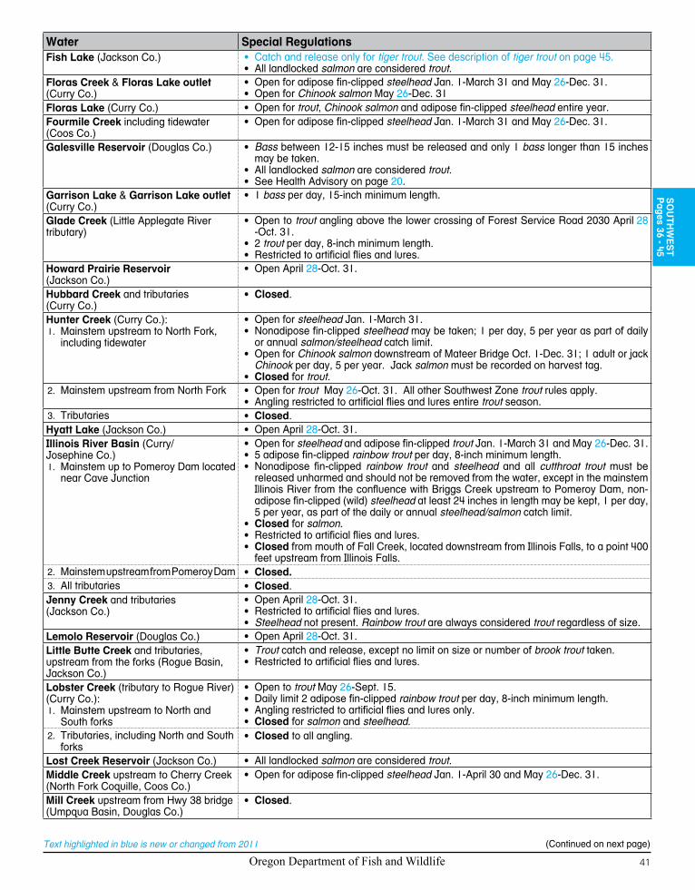
Oregon Department of Fish and Wildlife 41
SO
UTH
WE
ST
Pages 36 - 45
Text highlighted in blue is new or changed from 2011
Water Special RegulationsFish Lake (Jackson Co.) • Catch and release only for tiger trout. See description of tiger trout on page 45.
• All landlocked salmon are considered trout.Floras Creek & Floras Lake outlet (Curry Co.)
• Open for adipose fin-clipped steelhead Jan. 1-March 31 and May 26-Dec. 31.• Open for Chinook salmon May 26-Dec. 31
Floras Lake (Curry Co.) • Open for trout, Chinook salmon and adipose fin-clipped steelhead entire year.Fourmile Creek including tidewater (Coos Co.)
• Open for adipose fin-clipped steelhead Jan. 1-March 31 and May 26-Dec. 31.
Galesville Reservoir (Douglas Co.) • Bass between 12-15 inches must be released and only 1 bass longer than 15 inches may be taken.
• All landlocked salmon are considered trout.• See Health Advisory on page 20.
Garrison Lake & Garrison Lake outlet (Curry Co.)
• 1 bass per day, 15-inch minimum length.
Glade Creek (Little Applegate River tributary)
• Open to trout angling above the lower crossing of Forest Service Road 2030 April 28 -Oct. 31.
• 2 trout per day, 8-inch minimum length.• Restricted to artificial flies and lures.
Howard Prairie Reservoir (Jackson Co.)
• Open April 28-Oct. 31.
Hubbard Creek and tributaries (Curry Co.)
• Closed.
Hunter Creek (Curry Co.):Mainstem upstream to North Fork, 1. including tidewater
• Open for steelhead Jan. 1-March 31.• Nonadipose fin-clipped steelhead may be taken; 1 per day, 5 per year as part of daily
or annual salmon/steelhead catch limit.• Open for Chinook salmon downstream of Mateer Bridge Oct. 1-Dec. 31; 1 adult or jack
Chinook per day, 5 per year. Jack salmon must be recorded on harvest tag.• Closed for trout.
Mainstem upstream from North Fork2. • Open for trout May 26-Oct. 31. All other Southwest Zone trout rules apply.• Angling restricted to artificial flies and lures entire trout season.
Tributaries3. • Closed.Hyatt Lake (Jackson Co.) • Open April 28-Oct. 31.Illinois River Basin (Curry/Josephine Co.)
Mainstem up to Pomeroy Dam located 1. near Cave Junction
• Open for steelhead and adipose fin-clipped trout Jan. 1-March 31 and May 26-Dec. 31.• 5 adipose fin-clipped rainbow trout per day, 8-inch minimum length.• Nonadipose fin-clipped rainbow trout and steelhead and all cutthroat trout must be
released unharmed and should not be removed from the water, except in the mainstem Illinois River from the confluence with Briggs Creek upstream to Pomeroy Dam, non-adipose fin-clipped (wild) steelhead at least 24 inches in length may be kept, 1 per day, 5 per year, as part of the daily or annual steelhead/salmon catch limit.
• Closed for salmon.• Restricted to artificial flies and lures.• Closed from mouth of Fall Creek, located downstream from Illinois Falls, to a point 400
feet upstream from Illinois Falls.2. Mainstem upstream from Pomeroy Dam • Closed.
All tributaries3. • Closed.Jenny Creek and tributaries(Jackson Co.)
• Open April 28-Oct. 31.• Restricted to artificial flies and lures.• Steelhead not present. Rainbow trout are always considered trout regardless of size.
Lemolo Reservoir (Douglas Co.) • Open April 28-Oct. 31.Little Butte Creek and tributaries, upstream from the forks (Rogue Basin, Jackson Co.)
• Trout catch and release, except no limit on size or number of brook trout taken.• Restricted to artificial flies and lures.
Lobster Creek (tributary to Rogue River)(Curry Co.):
Mainstem upstream to North and 1. South forks
• Open to trout May 26-Sept. 15.• Daily limit 2 adipose fin-clipped rainbow trout per day, 8-inch minimum length.• Angling restricted to artificial flies and lures only.• Closed for salmon and steelhead.
2. Tributaries, including North and South forks
• Closed to all angling.
Lost Creek Reservoir (Jackson Co.) • All landlocked salmon are considered trout.Middle Creek upstream to Cherry Creek (North Fork Coquille, Coos Co.)
• Open for adipose fin-clipped steelhead Jan. 1-April 30 and May 26-Dec. 31.
Mill Creek upstream from Hwy 38 bridge (Umpqua Basin, Douglas Co.)
• Closed.
(Continued on next page)

Oregon Department of Fish and Wildlife42
Text highlighted in blue is new or changed from 2011
Water Special RegulationsMillicoma River (Coos Co.):
Mainstem, including tidewater1. • Open for Chinook salmon and adipose fin-clipped steelhead entire year.
2. East and West forks • Open for adipose fin-clipped steelhead Jan. 1-April 30 and May 26-Dec. 31.Mussel/Myrtle creeks and tributaries (Curry Co.)
• Closed.
Myers Creek (Curry Co.) • Closed.New Lake (Coos/Curry Co.) • Open for trout and adipose fin-clipped steelhead Jan. 1-March 31 and May 26-Dec. 31.
• Open for Chinook salmon May 26-Dec. 31.New River including tidewater (Coos/Curry Co.)
• Open for steelhead Jan. 1-March 31 and May 26-Dec. 31.• Open for Chinook salmon May 26-Dec. 31.
Pacific Ocean • See Marine Zone (pages 100-103).Pistol River (Curry Co.)Mainstem including tidewater
• Open for trout May 26-Oct. 31, 2 per day, 8-inch minimum length and open for adipose fin-clipped rainbow trout (half pounders), 2 per day, 8-inch minimum length, Jan. 1-March 31 and Nov. 1-Dec. 31.
• Open for steelhead Jan. 1-March 31 and May 26-Dec. 31.• Nonadipose fin-clipped steelhead may be taken; 1 per day, 5 per year as part of daily
or annual salmon/steelhead catch limit.• Open for Chinook salmon downstream of Deep Creek Oct. 1-Dec. 31; 1 adult or jack
Chinook per day, 5 per year. Jack salmon must be recorded on harvest tag.Plat I Reservoir (Umpqua Basin, Douglas Co.)
• Catch and release for bass Jan. 1-Feb. 28 and Nov. 1-Dec. 31.• See Health Advisory on page 20.
Rogue River (Curry/Josephine/Jackson Co.):
Mainstem upstream to 1. Hog Creek boat landing, including tidewater
Trout Regulations:• Open for trout Jan. 1-March 31 and May 26-Dec. 31.• 5 adipose fin-clipped rainbow trout per day, 8-inch minimum length.• Nonadipose fin-clipped rainbow and cutthroat trout must be released unharmed.Salmon Regulations:• Open for Chinook salmon:
1. Jan. 1-May 31 per Zone Regulations except closed to harvest of nonadipose fin-clipped Chinook salmon.
2. June 1-Dec. 31 per Zone Regulations.• Open for adipose fin-clipped coho salmon as per Zone Regulations.Steelhead Regulations:• Open for adipose fin-clipped steelhead entire year.• Jan. 1-April 30 nonadipose fin-clipped steelhead at least 24 inches in length may be
kept; 1 per day, 5 per year, as part of daily or annual salmon/steelhead catch limit.Special Gear Restrictions and Closures:• Use of bait allowed in mainstem Rogue River except from Foster Creek upstream to
Whiskey Creek, where all angling is restricted to artificial flies and lures Sept. 1 to Oct. 31.
• In addition to the hook and weight regulations on page 10, any attached weight may be no more than six feet above the lowermost hook.
• Closed to all angling from Rainie Falls downstream 400 feet (Rivermile 66).2. Hog Creek boat landing to Gold Ray
damsiteTrout Regulations:• Open for trout Jan. 1-March 31 and May 26-Dec. 31.• 5 adipose fin-clipped rainbow trout per day, 8-inch minimum length.• Nonadipose fin-clipped rainbow and cutthroat trout must be released unharmed.Salmon Regulations:• Open for Chinook salmon:
1. Jan. 1-May 31 per Zone Regulations except closed to harvest of nonadipose fin-clipped Chinook salmon.
2. June 1-Sept. 30 per Zone Regulations.3. Closed for Chinook salmon Oct. 1-Dec. 31.
• Open for adipose fin-clipped coho salmon as per Zone Regulations.Steelhead Regulations:• Open for adipose fin-clipped steelhead entire year.• Feb. 1-April 30 nonadipose fin-clipped steelhead at least 24 inches in length may be
kept; 1 per day, 5 per year, as part of daily or annual salmon/steelhead catch limit.Special Gear Restrictions and Closures:• Use of bait allowed in mainstem Rogue River.• In addition to the hook and weight regulations on page 10, any attached weight may be
no more than six feet above the lowermost hook.• Closed to all angling from the Gold Hill municipal water intake downstream to Gold Hill
boat landing (Rivermile 121).From Gold Ray d3. amsite to Cole Rivers Hatchery Diversion Dam
(Continued on next page.)
Trout Regulations• Open for trout Jan. 1-March 31 and May 26-Dec. 31.• 5 adipose fin-clipped rainbow trout per day, 8-inch minimum length.• Nonadipose fin-clipped rainbow and cutthroat trout must be released unharmed.
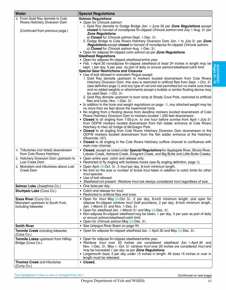
Oregon Department of Fish and Wildlife 43
SO
UTH
WE
ST
Pages 36 - 45
Text highlighted in blue is new or changed from 2011
Water Special RegulationsFrom Gold Ray d3. amsite to Cole Rivers Hatchery Diversion Dam
(Continued from previous page.)
Salmon Regulations• Open for Chinook salmon:
1. Gold Ray damsite to Dodge Bridge Jan. 1-June 30 per Zone Regulations except closed to harvest of nonadipose fin-clipped Chinook salmon and July 1-Aug. 31 per Zone Regulations.a) Closed for Chinook salmon Sept. 1-Dec. 31.
2. Dodge Bridge to Cole Rivers Hatchery Diversion Dam Jan. 1 to July 31 per Zone Regulations except closed to harvest of nonadipose fin-clipped Chinook salmon.a) Closed for Chinook salmon Aug. 1-Dec. 31.
• Open for adipose fin-clipped coho salmon as per Zone Regulations.Steelhead Regulations• Open for adipose fin-clipped steelhead entire year.• Feb. 1-April 30 nonadipose fin-clipped steelhead at least 24 inches in length may be
kept; 1 per day, 5 per year, as part of daily or annual salmon/steelhead catch limit.Special Gear Restrictions and Closures• Use of bait allowed in mainstem Rogue except:
1. Gold Ray damsite upstream to markers located downstream from Cole Rivers Hatchery Diversion Dam, this area is restricted to artificial flies from Sept. 1-Oct. 31 (see definition page 8) and any type of rod and reel permitted but no metal core lines and no added weights or attachments except a bubble or similar floating device may be used Sept. 1-Oct. 31.
2. Gold Ray damsite upstream to boat ramp at Shady Cove Park, restricted to artificial flies and lures, Nov. 1-Dec. 31.
• In addition to the hook and weight regulations on page 10, any attached weight may be no more than six feet above the lowermost hook.
• No angling from a floating device from deadline markers located downstream of Cole Rivers Hatchery Diversion Dam to markers located 1,200 feet downstream.
• Closed to all angling from 7:00 p.m. to one hour before sunrise from April 1-July 31 from ODFW markers located downstream from fish ladder entrance at Cole Rivers Hatchery to Hwy 62 bridge at McGregor Park.
• Closed to all angling from Cole Rivers Hatchery Diversion Dam downstream to the ODFW markers located downstream from the fish ladder entrance at the Hatchery (Rivermile 157).
• Closed to all angling in the Cole Rivers Hatchery outflow channel to confluence with main river channel.
Tributaries (not listed) downstream 4. from Cole Rivers Hatchery
• Closed, except as noted under Special Regulations for Applegate River, Illinois River, Lobster Creek, Ashland Creek, Emigrant Creek, and Big Butte and Little Butte Creeks.
Hatchery Diversion Dam upstream to 5. Lost Creek Dam
• Open entire year, catch and release only.• Restricted to fly angling with barbless hooks (see fly angling definition, page 8).
Mainstem and tributaries above Lost 6. Creek Dam
• Open April 28-Oct. 31, 5 trout per day, 8-inch minimum length.• No limit on the size or number of brook trout taken in addition to catch limits for other
trout species.• Use of bait allowed.• Steelhead not present. Rainbow trout are always considered trout regardless of size.
Selmac Lake (Josephine Co.) • One bass per day.Shuttpelz Lake (Coos Co.) • Catch and release for trout.
• Restricted to artificial flies and lures.Sixes River (Curry Co.)Mainstem upstream to South Fork, including tidewater
• Open for trout May 26-Oct. 31, 2 per day, 8-inch minimum length; and open for adipose fin-clipped rainbow trout (half pounders), 2 per day, 8-inch minimum length, Jan. 1-March 31 and Nov. 1-Dec. 31.
• Open for steelhead Jan. 1-March 31 and May 26-Dec. 31.• Non-adipose fin-clipped steelhead may be taken; 1 per day, 5 per year as part of daily
or annual salmon/steelhead catch limit.• Open for Chinook salmon May 26-Dec. 31.
Smith River • See Umpqua River Basin on page 44.Tenmile Creek including tidewater (Coos Co.)
• Open for adipose fin-clipped steelhead Jan. 1-April 30 and May 26-Dec. 31.
Tenmile Lakes upstream from Hilltop Bridge (Coos Co.)
• Open for adipose fin-clipped steelhead entire year.• Rainbow trout over 20 inches are considered steelhead Jan. 1-April 30 and
Nov. 1-Dec. 31. May 1- Oct. 31 rainbow trout over 20 inches are considered trout and may be harvested 1 per day as per Zone Regulations.
• Largemouth bass, 5 per day under 15 inches in length. All bass 15 inches or over in length must be released.
Thomas Creek and tributaries (Curry Co.)
• Closed.
(Continued on next page)

Oregon Department of Fish and Wildlife44
Text highlighted in blue is new or changed from 2010
Water Special RegulationsTioga Creek up to concrete bridge located 1/2 mile downstream from Burnt Creek (Coos Co.)
• Open for adipose fin-clipped steelhead Jan. 1-April 30 and May 26-Dec. 31.
Umpqua River Basin (Douglas Co.): includes Umpqua River, Smith River, North Umpqua River, South Umpqua River and their tributaries
• 10 smallmouth bass per day of any size, 2 daily limits in possession.
Umpqua River mainstem, including 1. tidewater, from the tips of the jetties upstream to confluence with North and South Forks (includes Winchester Bay)
• Catch and release for trout, open May 26-Oct. 31 per Zone Regulations.• Open for adipose fin-clipped steelhead entire year.• Open for Chinook salmon entire year.• Open for adipose fin-clipped coho salmon as per Zone Regulations.• Use of bait allowed.• 2 fish per 24 consecutive hours, 24-inch minimum size for striped bass.
2. Tributaries to mainstem Umpqua River, including tidewater portions, from mouth upstream to confluence with North and South Forks
• Open for trout May 26-Sept. 15.• Angling restricted to artificial flies and lures for all tributaries, except tidewater areas
where bait is allowed.• Open for striped bass entire year in tidewater areas.• Mill Creek below Loon Lake, not including Camp Creek, closed to angling entire year.• 2 fish per 24 consecutive hours limit, 24-inch minimum size for striped bass.
Smith River mainstem from mouth 3. upstream to Spencer Creek and North Fork from mouth upstream to Johnson Creek, including tidewater
• Open for Chinook salmon and adipose fin-clipped steelhead Jan. 1-March 31 and May 26-Dec. 31.
• Catch and release for trout, Open May 26-Sept. 15.• Open for striped bass entire year.• Use of bait allowed in tidewater areas.• 2 fish per 24 consecutive hours limit, 24-inch minimum size for striped bass.
Smith River mainstem from Spencer 4. Creek upstream to Sisters Creek and North Fork from Johnson Creek upstream to Bridge 10
• Open for adipose fin-clipped steelhead Jan. 1-April 30 and Dec. 1-31.• Catch and release for trout, open May 26-Sept. 15, • Restricted to artificial flies and lures May 26- Sept. 15.
Smith River tributaries, including tide-5. water portions, Smith River mainstem upstream from Sisters Creek, and North Fork and tributaries upstream from Bridge 10
• Open for trout May 26-Sept. 15.• Angling restricted to artificial flies and lures, except tidewater areas where use of bait is
allowed.• Open for striped bass entire year in tidewater areas.• 2 fish per 24 consecutive hours limit, 24-inch minimum size for striped bass.
North Umpqua River from mouth 6. upstream to fly area boundary above Rock Creek
• Catch and release for trout, open May 26-Oct. 31 per Zone Regulations.• Open for adipose fin-clipped steelhead entire year.• Open for Chinook salmon Jan. 1-July 31.• Open for adipose fin-clipped coho salmon as per Zone Regulations.• Closed between old Hwy 99 bridge and Winchester Dam.• Use of bait allowed.• No angling from a floating device upstream from BLM recreation site (Lone Rock ramp)
which is located 0.5 miles above the Lone Rock Bridge (Hwy 138).• Closed from markers located upstream from Rock Creek, upstream 700 feet to the fly
area boundary.North Umpqua River from fly 7. area boundary above Rock Creek, upstream to Soda Springs Dam (31 miles)
• Catch and release for trout, open May 26-Oct. 31 per Zone Regulations.• Open for adipose fin-clipped steelhead entire year.• Open for adipose fin-clipped coho salmon as per Zone Regulations.Special Gear Restrictions and Closures:• July 1-Sept. 30 all angling restricted to use of single barbless unweighted artificial fly.
For the purposes of this rule, an unweighted artificial fly is defined as: “a conventional hook that is dressed with natural or artificial materials, and to which no molded weight (such as split shot, jig heads or dumbbell eyes), metal wire, metal beads, bead chain eyes, or plastic body are affixed, and to which no added weight, spinning or attractor device, or natural bait is attached.”
• Jan. 1-June 30 and Oct. 1-Dec. 31 restricted to fly angling only with single barbless hook (see fly angling and artificial fly definitions on page 8).
• Any type rod or reel permitted, but no metal core lines and no added weights or attachments to line, leader or fly (including, but not limited to, strike indicators) except non-fly monofilament lines may have a casting bubble or similar floating device.
• Closed from Soda Springs Dam downstream about 1/2 mile to marker located down-stream from power plant enclosure.
• No angling from a floating device.8. North Umpqua River tributaries from
mouth upstream to Soda Springs Dam
• Open for trout in tributaries below fly area boundary, except Rock Creek May 26- Sept. 15.
• Restricted to artificial flies and lures.• Rock Creek and all tributaries above fly area boundary are closed to angling.
(Continued on next page)

Oregon Department of Fish and Wildlife 45
Water Special Regulations9. North Umpqua River mainstem and
tributaries upstream from Soda Springs Reservoir
• Open for trout April 28-Oct. 31.• No limit on size or number of brook trout taken in addition to catch limits for other trout
species.• Use of bait allowed.
South Umpqua River from mouth 10. upstream to Jackson Creek Bridge
• Open for adipose fin-clipped steelhead Jan. 1-April 30 and Dec. 1-31.• Open for trout May 26-Sept. 15.• Closed to all angling May 1- May 25 and Sept. 16-Nov. 30.• Use of bait allowed.
11. South Umpqua River and tributaries upstream from Jackson Creek Bridge
• Closed.
12. South Umpqua River tributaries below Jackson Creek Bridge
• Open for trout May 26-Sept. 15.• Jackson Creek closed to all angling.• Restricted to artificial flies and lures.
13. Cow Creek mainstem (South Umpqua) from mouth upstream to Middle Creek Bridge
• Open for adipose fin-clipped steelhead Jan. 1-April 30 and Dec. 1-31.• Open for trout May 26-Sept. 15.• Restricted to artificial flies and lures, May 26-Sept. 15.• Use of bait is allowed Jan. 1-April 30 and Dec. 1-31.
14. Tributaries to Cow Creek and mainstem Cow Creek upstream from Middle Creek Bridge
• Open for trout May 26-Sept. 15.• Restricted to flies and lures.
Winchuck River Mainstem up to Wheeler Creek, including tidewater (Curry Co.)
• Open for adipose fin-clipped steelhead Jan. 1-March 31 and May 26-Dec. 31.• Nonadipose fin-clipped steelhead may be taken; 1 per day, 5 per year as part of daily
or annual salmon/steelhead catch limit.• Open for Chinook salmon May 26-Dec. 31.• No angling from a floating device.
SO
UTH
WE
ST
Pages 36 - 45
attention anglers: Tiger trout now available in Oregon!in 2011 the Oregon Department of Fish and Wildlife initiated tiger trout stocking programs in Fish lake (sW Zone, page 41) and in phillips reservoir (ne Zone, page 70) to evaluate the fisheries enhancement potential and provide additional diversity in Oregon’s trout fisheries. tiger trout are highly piscivorous (fish eaters) from an early age and prey in shallow margins of lakes. predation on illegally introduced fish species such as the tui chub and yellow perch may help to increase survival and growth of stocked fingerling trout and reestablish productive trout fisheries. tiger trout are being managed under catch-and-release regulations to evaluate their fishery and management potential.please carefully release all tiger trout to ensure their survival.
Tiger trout description:tiger trout are produced from a cross between a male brown trout and a female brook trout. these sterile hybrids have a distinctive, dark maze-like pattern all over a brownish, gray body. the under-belly is yellowish orange as are the pectoral, pelvic and anal fins. the tail fin is square. Coloration patterns may vary between males and females, and seasonally.
Scan with smartphone
QR code reader for regulation
updates by zone
Northeast Southeast
Northwest
Snake
Southwest
Columbia
Willamette
Marine
Central
Oregon Department of Fish and Wildlife46
Text highlighted in blue is new or changed from 2011
Fall
Cre
ek R
es.
5
205
105
30
30
97
197
30
101
38
126
36
58
22
216
138
35
226
6
211
228
214
18
47
213
99W
53
99
224
99E
219
240
242
223
10
51
43
233
212
210
47
99
126
99E
99W
224
47
214
13812
6
214
34
34
821
7
126
9922
35
99E
22
42
26
5
219
26
20
20
58
97
5
99W
Portl
and
Sale
m
Euge
ne
Hill
sbor
o
Alba
ny
Gre
sham
Beav
erto
n
Cor
valli
s
Sprin
gfie
ld
McM
innv
ille
Ore
gon
City
Dal
las
Leba
non
Wils
onvi
lleN
ewbe
rg
Swee
t Hom
e
Fore
stG
rove
St. H
elen
s
Cot
tage
Gro
veO
akrid
ge
Sher
idan
Mill
City
Har
risbu
rg
Sauv
ieIs
land
Col
umbi
a
R
iver
Was
hing
ton
Sta
te
Stay
ton
Willamette Rive
r
McK
enzi
e R
iver
Clac
kam
as R
iver
Sand
y R
iver
Cal
apoo
ia R
iver
North
San
tiam
Riv
er
Tual
atin
Riv
er
Fall
Cre
ek
Mola
lla
River
Muddy Creek
Bu
tte Creek Th
omas
Cre
ekSou
th S
antia
m River
Midd le F
ork
Will
amet
te R
ive
r
Sa
lt C
reek
Pudding River
Abiqua C
reek
Mil l
Cr
Horse Creek
Cra
btre
e C
reek
Clear Creek
Eag
l e C
reek
Row River
Gales
Cre
ek
Ric
krea
ll C
r
Sou
th Y
am
hill
R
iver
Bull
Run
R
Mosby Creek
Marys R
iver
Salm
on C
reek
M
ohawk
Ri
ver
Blue R
iver
Salmon
Ri v
er
Wi le
y Cre
ek
Lucki
amute
R
Lost Cr
Bric
e Cr
eek
Qua
rtzvi
lle C
reek
Hills C
reek
Mid
dle
Santi
am R
iver
Long Tom R
Littl
e Fa
ll Cre
ek
Ced
ar
Cr
Sou th For
k M
cKen
zie
Riv
er
Big
Rive
r
Dee
p C
r
Silver Creek
Coyo
te C
reek
Sharps Cree
k
Nor
th Y
amhi
ll R
iver
Zigz
ag R
iver
N F
k M
iddl
e F
k W
illam
ette
R
Littl
e Lu
ckia
mut
e R
Littl
e N
San
tiam
R
Layi
ng C
reek
Drift Cr
Milton Cre
ek
Creek
Sant
iam
Rive
rBr
eite
nbus
h R
Oak
Gro
ve F
k C
lack
amas
R
Yam
hill
R
Tee
ter C
r
Marion Cre
ek
Win
berr
y C
r
Tanner Cr
Sodom
Ditch
N F
ork
Colu
mbi
a S
loug
h
S Sca
ppoo
se C
r
Frazier C
r
Mill
Cre
ek
Mill
Cre
ek
John
son
Cre
ek
Coast Fk Willamette R
Scogg
ins Cr
Multnomah
Channel
Aber
nethy C
r
Cheha lem
Cr
Rat CrShotgun Cr
N S
capp
oose
Cr
Nor
th F
ork
Sout
h Fo
rk
S Fo
rk
Butte
Cre
ek
Willamette River
Cla
ckam
as River
Wal
terv
ille
Can
alStay
ton
Pow
er C
anal
Rock
Cr
Wal
doLa
ke
Fern
Rid
ge
Res
.
Det
roit
Lake
Look
out
Poin
t La
ke
Gre
en P
eter
Lak
e
Dor
ena
Lake
Hill
s C
reek
R
eser
voir
Tim
othy
Lake
Cou
gar
Res
ervo
ir
Hen
ry H
agg
Lake
Smith
Lak
e
Blue
Riv
er R
es.
Cot
tage
Gro
veR
es
Bull
Run
Lake
Mar
ion
Lake
Bybe
e La
ke
Nor
th F
ork
Res
.
Smith
Res
ervo
ir
Gol
d La
ke
Lost
Lak
e
Fish
Lak
e
Erm
aBe
llLa
kes
St L
ouis
Pond
s
Moo
se L
ake
Woo
dbur
nPo
nd
E. E
. Wils
onPo
nd
Hal
dem
anPo
nd
Fost
er L
ake
Cle
ar L
ake
Lava
Lak
e
Est
acad
aLa
ke
Leab
urg
Lake
Fara
day
Lake
Silv
erto
nR
es
Car
men
Res
ervo
ir
Har
riet
Lake
Abiq
ua F
alls
Big
Clif
f Dam
Riv
er M
ill D
am
Bonn
evill
e D
am
Hill
s C
reek
Dam
Trai
lBr
idge
Dam
Cot
tage
Gro
ve D
am
Butte
Cre
ek F
alls
Leab
urg
Pow
erho
use
Fina
l Fal
ls
Leba
non
Dam
Silv
erto
n W
ater
Supp
ly D
am
Silv
erto
n D
am
Willa
met
te F
alls
Nor
thFo
rkD
am
Caz
ader
o D
am
Leab
urg
Dam
Dex
ter D
am
Dor
ena
Dam
Fost
er D
am
Falls
at F
all C
ity
Det
roit
Dam
Dam
Tam
olitc
h Fa
lls
Oxb
ow P
ark
Vict
or P
t Rd
PGE
Pow
erho
use
Pac
ksad
dle
Par
k
Wild
woo
d R
ec S
ite
Wat
ersh
ed b
ound
ary
Fore
st G
len
Boa
t Ram
p
Thre
e Ly
nxP
ower
hous
e
Gilb
ert R
iver
Bo
at R
amp
Mt H
ood
Fish
Lad
der
Sal
mon
Rm
outh
Har
riet L
kM
arke
rs
LAN
E
KLA
MAT
HD
OU
GLA
S
LIN
N
DES
CH
UTE
S
JEFF
ERSO
N
LINCOLN
BEN
TON
WA
SCO
MA
RIO
N
CLA
CK
AM
AS
POLK
TILL
AM
OO
K
YAM
HIL
L
CO
LUM
BIA
WA
SHIN
GTO
N
HO
OD
RIV
ERM
ULT
NO
MA
H
I-5 B
ridge
I-5B
ridge
Hay
den
Brid
ge
Rai
lroad
Brid
ge
Mill
Cr
Par
k B
ridge
Pin
e C
r B
ridge
Hw
y 99
B
ridge
Hw
y 20
Brid
ge
Foot
Brid
ge
Hw
y 47
Br
Hw
y 21
0B
r
Fish Creek
Canyo
n Cree
k
Dog Cr
Balc
h C
r
Moo
se
Look
out C
r
Horn Cr
SA
ND
Y
MC
KE
NZI
E
WIL
LAM
ETT
E
MA
RIO
NFO
RK
SR
OA
RIN
G
RIV
ER SO
UTH
SA
NTI
AM
Eag
le C
reek
NFH
CLA
CK
AM
AS
LEA
BU
RG
Sal
mon
Wei
r
Gal
esC
reek
Will
amin
a
Will
amet
te Z
one
010
205
Mile
s
Trou
t Sea
son
in S
tream
s
4th
Sat.
in M
ay -
Oct
. 31
4th
Sat
. in
Apr
il - O
ct. 3
1
Lege
ndB
ridge
sD
ams
Falls
Oth
er L
andm
arks
Hat
cher
ies
Zone
Bou
ndar
yC
lose
d A
ll Ye
arC
ount
y bo
unda
ries

Oregon Department of Fish and Wildlife 47
Text highlighted in blue is new or changed from 2011
Fall
Cre
ek R
es.
5
205
105
30
30
97
197
30
101
38
126
36
58
22
216
138
35
226
6
211
228
214
18
47
213
99W
53
99
224
99E
219
240
242
223
10
51
43
233
212
210
47
99
126
99E
99W
224
47
214
13812
6
214
34
34
821
7
126
9922
35
99E
22
42
26
5
219
26
20
20
58
97
5
99W
Portl
and
Sale
m
Euge
ne
Hill
sbor
o
Alba
ny
Gre
sham
Beav
erto
n
Cor
valli
s
Sprin
gfie
ld
McM
innv
ille
Ore
gon
City
Dal
las
Leba
non
Wils
onvi
lleN
ewbe
rg
Swee
t Hom
e
Fore
stG
rove
St. H
elen
s
Cot
tage
Gro
veO
akrid
ge
Sher
idan
Mill
City
Har
risbu
rg
Sauv
ieIs
land
Col
umbi
a
R
iver
Was
hing
ton
Sta
te
Stay
ton
Willamette Rive
r
McK
enzi
e R
iver
Clac
kam
as R
iver
Sand
y R
iver
Cal
apoo
ia R
iver
North
San
tiam
Riv
er
Tual
atin
Riv
er
Fall
Cre
ek
Mola
lla
River
Muddy Creek
Bu
tte Creek Th
omas
Cre
ekSou
th S
antia
m River
Midd le F
ork
Will
amet
te R
ive
r
Sa
lt C
reek
Pudding River
Abiqua C
reek
Mil l
Cr
Horse Creek
Cra
btre
e C
reek
Clear Creek
Eag
l e C
reek
Row River
Gales
Cre
ek
Ric
krea
ll C
r
Sou
th Y
am
hill
R
iver
Bull
Run
R
Mosby Creek
Marys R
iver
Salm
on C
reek
M
ohawk
Ri
ver
Blue R
iver
Salmon
Ri v
er
Wi le
y Cre
ek
Lucki
amute
R
Lost Cr
Bric
e Cr
eek
Qua
rtzvi
lle C
reek
Hills C
reek
Mid
dle
Santi
am R
iver
Long Tom R
Littl
e Fa
ll Cre
ek
Ced
ar
Cr
Sou th For
k M
cKen
zie
Riv
er
Big
Rive
r
Dee
p
C
r
Silver Creek
Coyo
te C
reek
Sharps Cree
k
Nor
th Y
amhi
ll R
iver
Zigz
ag R
iver
N F
k M
iddl
e F
k W
illam
ette
R
Littl
e Lu
ckia
mut
e R
Littl
e N
San
tiam
R
Layi
ng C
reek
Drift Cr
Milton Cre
ek
Creek
Sant
iam
Rive
rBr
eite
nbus
h R
Oak
Gro
ve F
k C
lack
amas
R
Yam
hill
R
Tee
ter C
r
Marion Cre
ek
Win
berr
y C
r
Tanner Cr
Sodom
Ditch
N F
ork
Colu
mbi
a S
loug
h
S Sca
ppoo
se C
r
Frazier C
r
Mill
Cre
ek
Mill
Cre
ek
John
son
Cre
ek
Coast Fk Willamette R
Scogg
ins Cr
Multnomah
Channel
Aber
nethy C
r
Cheha lem
Cr
Rat CrShotgun Cr
N S
capp
oose
Cr
Nor
th F
ork
Sout
h Fo
rk
S Fo
rk
Butte
Cre
ek
Willamette River
Cla
ckam
as River
Wal
terv
ille
Can
alStay
ton
Pow
er C
anal
Rock
Cr
Wal
doLa
ke
Fern
Rid
ge
Res
.
Det
roit
Lake
Look
out
Poin
t La
ke
Gre
en P
eter
Lak
e
Dor
ena
Lake
Hill
s C
reek
R
eser
voir
Tim
othy
Lake
Cou
gar
Res
ervo
ir
Hen
ry H
agg
Lake
Smith
Lak
e
Blue
Riv
er R
es.
Cot
tage
Gro
veR
es
Bull
Run
Lake
Mar
ion
Lake
Bybe
e La
ke
Nor
th F
ork
Res
.
Smith
Res
ervo
ir
Gol
d La
ke
Lost
Lak
e
Fish
Lak
e
Erm
aBe
llLa
kes
St L
ouis
Pond
s
Moo
se L
ake
Woo
dbur
nPo
nd
E. E
. Wils
onPo
nd
Hal
dem
anPo
nd
Fost
er L
ake
Cle
ar L
ake
Lava
Lak
e
Est
acad
aLa
ke
Leab
urg
Lake
Fara
day
Lake
Silv
erto
nR
es
Car
men
Res
ervo
ir
Har
riet
Lake
Abiq
ua F
alls
Big
Clif
f Dam
Riv
er M
ill D
am
Bonn
evill
e D
am
Hill
s C
reek
Dam
Trai
lBr
idge
Dam
Cot
tage
Gro
ve D
am
Butte
Cre
ek F
alls
Leab
urg
Pow
erho
use
Fina
l Fal
ls
Leba
non
Dam
Silv
erto
n W
ater
Supp
ly D
am
Silv
erto
n D
am
Willa
met
te F
alls
Nor
thFo
rkD
am
Caz
ader
o D
am
Leab
urg
Dam
Dex
ter D
am
Dor
ena
Dam
Fost
er D
am
Falls
at F
all C
ity
Det
roit
Dam
Dam
Tam
olitc
h Fa
lls
Oxb
ow P
ark
Vict
or P
t Rd
PGE
Pow
erho
use
Pac
ksad
dle
Par
k
Wild
woo
d R
ec S
ite
Wat
ersh
ed b
ound
ary
Fore
st G
len
Boa
t Ram
p
Thre
e Ly
nxP
ower
hous
e
Gilb
ert R
iver
Bo
at R
amp
Mt H
ood
Fish
Lad
der
Sal
mon
Rm
outh
Har
riet L
kM
arke
rs
LAN
E
KLA
MAT
HD
OU
GLA
S
LIN
N
DES
CH
UTE
S
JEFF
ERSO
NLINCOLN
BEN
TON
WA
SCO
MA
RIO
N
CLA
CK
AM
AS
POLK
TILL
AM
OO
K
YAM
HIL
L
CO
LUM
BIA
WA
SHIN
GTO
N
HO
OD
RIV
ERM
ULT
NO
MA
H
I-5 B
ridge
I-5B
ridge
Hay
den
Brid
ge
Rai
lroad
Brid
ge
Mill
Cr
Par
k B
ridge
Pin
e C
r B
ridge
Hw
y 99
B
ridge
Hw
y 20
Brid
ge
Foot
Brid
ge
Hw
y 47
Br
Hw
y 21
0B
r
Fish Creek
Canyo
n Cree
k
Dog Cr
Balc
h C
r
Moo
se
Look
out C
r
Horn Cr
SA
ND
Y
MC
KE
NZI
E
WIL
LAM
ETT
E
MA
RIO
NFO
RK
SR
OA
RIN
G
RIV
ER SO
UTH
SA
NTI
AM
Eag
le C
reek
NFH
CLA
CK
AM
AS
LEA
BU
RG
Sal
mon
Wei
r
Gal
esC
reek
Will
amin
a
Will
amet
te Z
one
010
205
Mile
s
Trou
t Sea
son
in S
tream
s
4th
Sat.
in M
ay -
Oct
. 31
4th
Sat
. in
Apr
il - O
ct. 3
1
Lege
ndB
ridge
sD
ams
Falls
Oth
er L
andm
arks
Hat
cher
ies
Zone
Bou
ndar
yC
lose
d A
ll Ye
arC
ount
y bo
unda
ries W
ILLAM
ETTE
Pages 46 - 59

Oregon Department of Fish and Wildlife48
Text highlighted in blue is new or changed from 2011
Description:The Willamette Zone is all waters draining to the Columbia River between the city of St. Helens and Bonneville Dam, except for those portions of tributaries east of the Sandy River that are downstream from the Union Pacific Railroad line (see Columbia Zone pages 92-95, for more details). Includes all waters on Sauvie Island except the Columbia River.Instructions:
Read the 1. Special Regulations for this zone. Special Regulations apply to specific bodies of water or portions of water within a zone. If specific references to a body of water, species, catch limits, length limits, seasons, or other specifications are not made in the Special Regulations for this zone, then Zone Regulations apply.Read the following 2. Regulations for this zone.Always read the 3. General Regulations, pages 5-12, which apply to all zones, for information about licenses; tags and permits; defi-nitions; catch and possession limits; gear and bait restrictions; and harvest methods and hours, before going fishing.Emergency or permanent rules adopted since 4. these rules were printed may supersede these regulations. Anglers may call ODFW headquarters or regional offices at the numbers on page 4 of these regulations, or check the ODFW web site, www.dfw.state.or.us for these rules, or call 503-947-6000 during normal business hours.
Regulations for this zone:Species Name Catch Limits Length Limits and Other Specifications SeasonTrout Lakes: 5 per day,
2 daily limits in possession.Streams: catch and release only, except as noted under Special Regulations.
• Angling restricted to artificial flies and lures in streams. See exceptions under Special Regulations where use of bait is allowed.
• 8-inch minimum length.• Only 1 trout over 20 inches in length may be taken per day.• Rainbow trout over 20 inches are considered steelhead in streams.• Closed to angling for bull trout.• Kokanee included in trout limits except as noted under Special
Regulations.
Lakes: Open all year.Streams: Open May 26-Oct. 31 see Special Regulations for this zone and Willamette Zone map on pages 46-47 for streams that are open April 28-Oct. 31.
Salmon and Steelhead
In the aggregate: 2 adult salmon or steelhead per day, 20 per year. 5 jacks per day, 2 daily jack limits in possession, with the exception that in the Willamette River and tributaries of the Willamette Basin above Willamette Falls, 1 additional adipose fin-clipped steelhead may be retained per day for a total aggre-gate of 3 adult fish harvested daily.
• Angling is restricted to artificial flies and lures in streams. See ex-ceptions under Special Regulations where use of bait is allowed.
• Note: Changes to salmon regulations for the Columbia River system including changes to the Willamette River system are printed in May and are available at ODFW offices or from license agents. Check for new regulations before you fish.
• Harvest of non-adipose fin-clipped salmon or steelhead is prohib-ited in the Willamette Zone with the exception of coho salmon and summer steelhead above Willamette Falls and Sandy River as noted under Special Regulations.
• Daily limit for unmarked summer steelhead is 2 fish per day, and annual limit 20 per year.
• There is no annual limit on adipose fin-clipped salmon or adipose fin-clipped steelhead as long as the appropriate number of Hatchery Harvest Tags have been purchased to record the catch.
Closed in all waters unless noted by species under Special Regulations.
Sturgeon 1 per day, 5 per year.
• Closed to retention of green sturgeon.• See page 86 for tag return information.• Minimum fork length 38 inches, maximum fork length 54 inches.• All oversize, undersize, and unwanted legal size sturgeon must be
immediately released unharmed into the water.• Only one single-point, barbless hook may be used for sturgeon.• Oversize sturgeon cannot be removed totally or in part from the
water.• Angling restricted to artificial flies and lures in streams. See exceptions
under Special Regulations where use of bait is allowed.
Note: Sturgeon fisheries are man-aged on a quota basis. Anglers should check the status of regulations prior to fishing as modifications will be made in-season if necessary to remain within catch guidelines.
WILLAMETTE ZONE
(Continued on next page)
All trout, salmon and steelhead that are released must be unharmed and should not be removed from the water.

Oregon Department of Fish and Wildlife 49
Text highlighted in blue is new or changed from 2011
Species Name Catch Limits Length Limits and Other Specifications SeasonWarmwater Game Fish:Largemouth and Smallmouth Bass
5 per day, 2 daily limits in possession.
• No more than 3 over 15 inches in length.• Willamette River mainstem above Hwy 20 Bridge at Albany, the
Santiam and Calapooia basins: no limit on size or number taken.• Angling restricted to artificial flies and lures in streams. See exceptions
under Special Regulations where use of bait is allowed.
Lakes: Open all year.Streams: Open during trout, salmon or steelhead seasons, except mainstem Willamette River and sloughs and tidewater areas of Columbia River tributaries downstream from Bonneville Dam are open all year.
Bluegill, Catfish, Crappie, Other Sunfish, Walleye, and Yellow Perch
No limit. • No minimum length.• Angling restricted to artificial flies and lures in streams. See exceptions
under Special Regulations where use of bait is allowed.
Other Fish:Pacific Lamprey
Refer to General (Statewide) Regulations on page 11 for regulations covering the harvest of Pacific lamprey.
Striped Bass 2 per 24 con-secutive hours, 2 daily limits in possession.
• 30-inch minimum length.• Angling restricted to artificial flies and lures in streams. See exceptions
under Special Regulations where use of bait is allowed.
Lakes: Open all year.Streams: Open during trout, salmon or steelhead seasons, except mainstem Willamette River and sloughs and tidewater areas of Columbia River tributaries downstream from Bonneville Dam are open all year.
Northern Pikeminnow, Carp, Sucker, Chub, Sculpin, Whitefish, Shad and other Non-game Fish
No limit. • No length limit.• Angling restricted to artificial flies and lures in streams. See exceptions
under Special Regulations where use of bait is allowed.
Smelt Closed. • Unlawful to take or attempt to take Eulachon smelt in inland waters including bays, estuaries, rivers and streams. See ODFW website for smelt identification guide.
All waters closed all year.
Freshwater Clams and Mussels
Harvest prohibited. • It is illegal to harvest or possess any freshwater mussels or clams unless authorized by a specific permit issued by the Oregon Fish and Wildlife Commission (Scientific Take Permit).
Closed.
Crayfish 100 per day, 2 daily limits in possession.
• Neither an angling nor a shellfish license is required.• All streams are open to crayfish harvest including streams listed as
closed under Special Regulations.
Open all year.
Bullfrogs No limit. • An angling license is not required.
Special Regulations for this zone:Water Special RegulationsAbiqua Creek upstream from Abiqua Falls near Rivermile 19 (Marion Co.)
• Open for trout April 28-Oct. 31, 2 trout per day, 8-inch minimum length.• Angling restricted to artificial flies and lures, as per Zone Regulations.
Airport Pond (Lane Co.) • Closed.Alton Baker Park Canoe Canal (Eugene)
• Open for trout and adipose fin-clipped steelhead entire year.• Open to harvest of non-adipose fin-clipped steelhead greater than 24 inches in length
entire year.• 5 trout per day, 8-inch minimum length.• Use of bait allowed.• Open to the use of two rods with a Two-Rod Validation.
Balch Creek and tributaries (Multnomah Co.)
• Closed.
Bear Creek (tributary to Pudding River) (Clackamas Co.) upstream from Shorty’s Pond which is located in Ivor Davies Park in the City of Molalla
• Open for adipose fin-clipped trout May 26-Oct. 31.• 5 adipose fin-clipped trout per day, no minimum length.• Use of Bait allowed.
Blue River (McKenzie Basin, Lane Co.):Mainstem and tributaries downstream 1. from Blue River Dam
• Open for adipose fin-clipped steelhead and adipose fin-clipped trout April 28-Oct. 31.• Open to harvest of non-adipose fin-clipped steelhead greater than 24 inches in length
April 28-Oct. 31.• 5 adipose fin-clipped trout per day, no minimum length.• Use of bait allowed.
2. Mainstem and tributaries upstream from Blue River Reservoir
• Open for trout April 28-Oct. 31.• 5 trout per day, 8-inch minimum length.• Use of bait allowed.
Breitenbush River (Marion Co.) • See Santiam River, item 4 on page 55.
WILLA
ME
TTEP
ages 46 - 57

Oregon Department of Fish and Wildlife50
Text highlighted in blue is new or changed from 2011
Water Special RegulationsBull of the Woods Wilderness Area Lakes (Mt. Hood National Forest, Clackamas Co.)
• NOTE: Applies to Beth Lake, Big Slide Lake, Lenore Lake, Pansy Lake, Lower Twin Lake and Upper Twin Lake.
• No limit on size or number of brook trout taken. Catch limits on other trout species do not apply to brook trout.
Bull Run River up to watershed boundary (Clackamas Co.)
• Open for adipose fin-clipped Chinook salmon, adipose fin-clipped coho salmon, and adipose fin-clipped steelhead entire year.
• Closed between markers 100 feet upstream from and 100 feet downstream from PGE powerhouse.
• Use of bait allowed.Butte Creek upstream from Butte Creek Falls near R.M. 25.5 (Marion/Clack. Co.)
• Open for trout April 28-Oct. 31, 2 trout per day, 8-inch minimum length.• Angling restricted to artificial flies and lures, as per Zone Regulations.
Canby Pond (Clackamas Co.) • Angling restricted to youth age 17 and under or holders of one of the Disabled Anglers permits.
Canyon Creek (S. Santiam/Linn Co.) • Closed.Carmen Reservoir • Open all year, 5 trout per day, 8 inch minimum length.
• Use of bait allowed per Zone Regulations.Note: Access may be restricted due to construction in 2012. Trout stocking may be tempo-rarily halted during the construction period.
Cascade Lakes, select lakes in the Willamette National Forest Portion (Lane Co.); Blue, Corner, Lower Eddeeleo, Upper Eddeeleo, Goose, Upper Horse, Linton, Nash, Penn, Porky, Upper Salmon, Separation, Spring, Spirit, Timpanogas and Lower Timpanogas (Douglas Co.); and Heart Lake (Linn Co.)
• No limit on size or number of brook trout taken. Catch limits on other trout species do not apply to brook trout.
• Use of bait allowed.
Cedar Creek (Sandy Basin, Clack. Co.) • Closed upstream to hatchery dam.Clackamas River (Clackamas Co.):
From mouth upstream to River Mill 1. Dam
• Open for adipose fin-clipped trout May 26-Oct. 31, 2 trout per day, and no minimum length.
• Open for adipose fin-clipped Chinook salmon, adipose fin-clipped coho salmon, and adipose fin-clipped steelhead entire year.
• Use of bait allowed.• No angling from a floating device between River Mill Dam and ODFW markers located
approximately 100 feet upstream of hatchery intake structure.2. River Mill Reservoir up to Cazadero
Dam• Open for adipose fin-clipped trout May 26-Oct. 31, 5 trout per day, 8-inch minimum
length.• Open for adipose fin-clipped Chinook salmon and adipose fin-clipped steelhead entire year.• Use of bait allowed.• Trout over 20 inches are considered steelhead.• Open for adipose fin-clipped coho salmon Aug. 1-Oct. 31.• No angling between markers 400 feet upstream and 100 feet downstream from Faraday
Powerhouse June 16-Oct. 31.• No angling from the entrance of the fishway/fish trap at Casadero Dam downstream to
yellow deadline markers (approximately 275 feet).Mainstem and tributaries not listed3. upstream from Cazadero Dam
• For the length of the Three Lynx Powerhouse (111 feet), no angling from a floating device or from the west shore.
• No limit on size or number of brook or brown trout taken. Catch limits on other trout species do not apply to brook or brown trout.
North Fork Reservoir upstream to4. Milepost 32 on Hwy. 224
• Open May 26-Oct. 31.• Only adipose fin-clipped rainbow trout may be taken, 5 per day except no limit on size or
number of brook or brown trout taken. Catch limits for adipose fin-clipped rainbow trout do not apply to brook or brown trout.
Oak Grove Fork and tributaries be-5. tween yellow markers at upstream end of Harriet Lake and Timothy Lake Dam
• 2 trout per day, 8-inch minimum length.• No limit on size or number of brook or brown trout taken. Catch limits on other trout
species do not apply to brook or brown trout. Clear Lake (upper McKenzie River/Linn Co.)
• No limit on size or number of brook trout taken. Catch limits on other trout species do not apply to brook trout.
Columbia Slough (Multnomah Co.) • See Health Advisory on page 20.Commonwealth Lake (Washington Co.) • Bass limit 1 per day, no minimum length.
• Crappie limit 10 per day, no minimum length.Cottage Grove Reservoir (Lane Co.) • Only bass less than 15 inches in length may be taken.
• See Health Advisory on page 20.Cougar Reservoir • Salmon less than 24 inches in length are considered trout.
• No limit on size or number of bass.
(Continued on next page)
Oregon Department of Fish and Wildlife 51
Text highlighted in blue is new or changed from 2011
Water Special RegulationsDetroit Reservoir • Salmon are considered trout.Dexter Reservoir • Salmon less than 24 inches in length are considered trout.Dog Creek (Mclver Park, Clack. Co.) • Closed.Dorena Reservoir (Lane Co.) • Only bass less than 15 inches in length may be taken.
• See Health Advisory page 20.Drift Creek upstream from Victor Point Road Crossing (Marion Co.)
• Open for trout April 28-Oct. 31, 2 trout per day, 8-inch minimum length.• Angling restricted to artificial flies and lures, as per Zone Regulations.
Eagle Creek (Clackamas Co.) up to markers 200 feet below hatchery ladder outlet (Clackamas Basin near Estacada)
• Open for adipose fin-clipped Chinook salmon and adipose fin-clipped coho salmon and adipose fin-clipped steelhead entire year.
• Closed from 200 feet upstream to 300 feet downstream from fish ladder located 1/2 mile below Eagle Fern Park.
• Use of bait allowed.E.E. Wilson Pond (Benton Co.) • Open Feb. 1-Sep. 30.East Salish Pond (Multnomah Co.) • Daily bass limit, 1 per day, no minimum length.
• Daily crappie liimit, 10 per day, no minimum length.Erma Bell Lakes (Lane Co.) and tributaries
• Open May 26-Oct. 31.• 2 rainbow trout per day, 8-inch minimum length.• No limit on size or number of brook trout taken. Catch limits on other trout species do
not apply to brook trout.Fall Creek (Middle Fork Willamette, Lane Co.)
Mainstem downstream 1. from Fall Creek Dam
• Open for adipose fin-clipped Chinook salmon and adipose fin-clipped steelhead entire year. Open to harvest of non-adipose fin-clipped steelhead greater than 24 inches entire year.
• Open Jan. 1-April 27 and Nov. 1-Dec. 31, catch and release for trout.• Open April 28-Oct. 31, 5 trout per day, 8-inch minimum length.• Use of bait allowed.
2. Mainstem and tributaries upstream from Fall Creek Reservoir
• Open for trout April 28-Oct. 31.• 5 trout per day, 8-inch minimum length.• Use of bait allowed.
Fall Creek Reservoir • Salmon less than 24 inches in length are considered trout.Faraday Lake (Clack. R., Clack. Co.) • All salmon are considered trout.
• Only adipose fin-clipped trout may be taken.Fish Creek (Clackamas R., Clack. Co.) • Closed.Fish Lake (Linn Co.) • Open Jan. 1-May 31.Foster Reservoir (S. Santiam/Linn Co.) • Only kokanee and adipose fin-clipped trout may be taken.
• No limits on size or number of bass.Frazier Creek (Benton Co.) • Open for trout April 28-Oct. 31.
• 5 trout per day, 8-inch minimum length.• Use of bait allowed.
Gales Creek (Tualatin River tributary, Washington Co.)1. From mouth upstream to NW
Clapshaw Hill Road in Gales Creek
• Open for trout May 26-Oct. 31, 2 trout per day, 8-inch minimum length.• Angling restricted to artificial flies and lures.• Open for coho salmon Aug. 1-Oct. 31.
2. Upstream of NW Clapshaw Hill Road and tributaries not listed
• Open for trout May 26-Oct. 31, 2 trout per day, 8-inch minimum length.• Angling restricted to artificial flies and lures.
Gold Lake (Lane Co.) • Open to angling May 26-Oct. 31.• Catch and release only for rainbow trout.• No limit on size or number of brook trout taken. Catch limits on other trout species do
not apply to brook trout.• Restricted to fly angling only with barbless hooks (see fly angling definition, page 8).• Closed to angling from Gold Lake boat ramp down Salt Creek 100 yards to markers
Jan. 1-June 30 and Nov. 1-Dec. 31.Green Peter Reservoir (Linn Co.) • 25 kokanee per day (no size limits) may be taken in addition to other trout species catch
limits.• Salmon may be retained as part of the kokanee bag limit.
Haldeman Pond (Sauvie Is., Columbia Co.)
• Closed Jan. 1-April 15 and Oct. 1-Dec. 31.
Henry Hagg Lake (Washington Co.) • Closed Jan. 1-Mar. 2 and Nov. 19-Dec. 31.• Open Mar. 3-Nov. 18.• One bass per day.
Hills Creek Reservoir (Lane Co.) • 5 adipose fin-clipped trout per day, 8-inch minimum length.• Adipose fin-clipped salmon less than 24 inches in length are considered trout.
WILLA
ME
TTEP
ages 46 - 57
(Continued on next page)
Oregon Department of Fish and Wildlife52
Text highlighted in blue is new or changed from 2011
Water Special RegulationsHills Creek and tributaries upstream from Hills Creek Reservoir (Lane Co.)
• Open for trout April 28-Oct. 31.• 5 trout per day, 8-inch minimum length.• Use of bait allowed.
Horn Creek (Linn Co.) • Closed.Lava Lake and tributaries (Linn Co.) • Open for trout April 28-Oct. 31.
• 5 trout per day, 8-inch minimum length.• Use of bait allowed.• No catch limit or size limit on brook trout.
Leaburg Canal and tributaries (Lane Co.) Leaburg Dam to Leaburg Powerhouse
• Closed within the Leaburg powerhouse tailrace and from Leaburg Dam to below fish screens (approx. 600 ft.).
• Open for trout entire year, catch and release only.• Angling restricted to artificial flies and lures, as per Zone Regulations.
Leaburg Lake (Lane Co.) • See McKenzie River, Section 3.Little Fall Creek (Lane Co.) • Open for adipose fin-clipped Chinook salmon; adipose fin-clipped steelhead; and non-
adipose fin-clipped steelhead greater than 24 inches entire year (mainstem from the mouth upstream to 200 feet below the concrete fish ladder, approximately 12 miles).
• Open Jan. 1-April 27 and Nov. 1-Dec. 31, catch and release for trout.• Open April 28-Oct. 31, 5 trout per day, 8-inch minimum length.• Use of bait allowed.
Long Tom River (Benton/Lane Co.):Mainstem upstream 1. to Fern Ridge Reservoir
• Open Jan. 1-April 27 and Nov. 1-Dec. 31, catch and release for trout.• Open April 28-Oct. 31, 5 trout per day, 8-inch minimum length.• Use of bait allowed.
2. All tributaries above and below Fern Ridge Reservoir, and mainstem above Fern Ridge Reservoir
• Open Jan. 1-April 27 and Nov. 1-Dec. 31, catch and release for trout.• Angling restricted to artificial flies and lures Jan. 1-Apr. 27 and Nov. 1-Dec. 31.• Open April 28-Oct. 31, 5 trout per day, 8-inch minimum length.• Use of bait allowed April 28-Oct. 31.
Lookout Creek and tributaries (Lane Co.) • Closed, U.S. Forest Service Research Area.Lookout Point Reservoir • Salmon less than 24 inches in length are considered trout.Lost Creek and tributaries (Middle Fork Willamette, Lane Co.)
• Open for trout April 28-Oct. 31, 5 trout per day, 8-inch minimum length.• Use of bait allowed.
Lost Lake (Santiam Pass, Linn Co.) • Catch and release for trout.• Restricted to artificial flies and lures.
Luckiamute River (Polk/Benton Co.)Mainstem and tributaries not listed1.
• Open for trout May 26-Oct. 31, 2 trout per day, 8-inch minimum length.• Angling restricted to artificial flies and lures only.
Little Luckiamute River (Polk Co.)2. above falls at Falls City
• Open for trout April 28-Oct. 31, 2 trout per day, 8-inch minimum length.• Angling restricted to artificial flies and lures only.
Marion Lake (Linn Co.) • Outlet closed between markers and bridge.Marys River and tributaries (Benton Co.) • Open Jan. 1-April 27 and Nov. 1-Dec. 31, catch and release for trout.
• Angling restricted to artificial flies and lures Jan. 1-Apr. 27 and Nov. 1-Dec. 31.• Open April 28-Oct. 31, 5 trout per day, 8-inch minimum length.• Use of bait allowed April 28-Oct. 31.
McKenzie River (Lane/Linn Co.):Mouth upstream to Hayden Bridge1.
• Open for trout entire year, catch and release only as per Zone Regulations.• Angling restricted to artificial flies and lures, as per Zone Regulations.• Open for adipose fin-clipped Chinook salmon; adipose fin-clipped steelhead; and non-
adipose fin-clipped steelhead greater than 24 inches entire year.2. Hayden Bridge upstream to Leaburg
Dam (see separate entries for Walterville Canal and Leaburg Canal)
Trout Regulations:• Open for trout Jan. 1-April 27, catch and release only with angling restricted to artificial
flies and lures.• Open for trout April 28-Dec. 31, 5 adipose fin-clipped trout per day, no minimum length.• Non-adipose fin-clipped trout must be released unharmed.Note: Not stocked below Hendricks Bridge; adipose fin-clipped trout originate from
stocked areas upstream.Salmon and Steelhead Regulations:• Open for adipose fin-clipped steelhead entire year.• Open for non-adipose fin-clipped steelhead greater than 24 inches entire year.• Open for adipose fin-clipped Chinook salmon entire year from Hayden Bridge to the
ODFW markers, approximately 200 feet below the fishways at Leaburg Dam.Special Regulations and Closures:• Angling restricted to artificial flies and lures Jan. 1-April 27.• Use of bait allowed April 28-Dec. 31.• Closed:
Within the Leaburg powerhouse tailrace.1. Within 200 feet downstream of Leaburg Dam.2. Downstream from 3. salmon weir (Walterville Canal).Within the Walterville bypass canal from 4. salmon weir upstream to McKenzie River.(Continued on next page)

Oregon Department of Fish and Wildlife 53
Text highlighted in blue is new or changed from 2011
Water Special RegulationsMcKenzie River (Lane/Linn Co.):
(continued from previous page)
Leaburg Dam upstream to Forest 3. Glen boat ramp near Blue River, including Leaburg Lake
• Open for trout April 28-Oct. 31, 5 adipose fin-clipped trout per day, no minimum length.• Non-adipose fin-clipped trout must be released unharmed.• Use of bait allowed.• Two-rod angling allowed in Leaburg Lake with a Two-Rod Validation.• Open for adipose fin-clipped steelhead and non-adipose fin-clipped steelhead greater
than 24 inches April 28-Oct. 31.• Closed within 200 feet upstream of Leaburg Dam.
Forest Glen boat ramp near Blue 4. River upstream to Trail Bridge Dam
• Open for trout April 28-Oct. 31, catch and release only for trout, as per Zone Regulations.• Open for adipose fin-clipped steelhead and non-adipose fin-clipped steelhead greater
than 24 inches April 28-Oct. 31.• Angling restricted to artificial flies and lures, as per Zone Regulations.• Closed to angling within the Carmen Spawning Channel and in the McKenzie River from
Trail Bridge Dam to 200 feet downstream from the Carmen Spawning channel entrance.South Fork McKenzie5. • Open for trout April 28-Oct. 31, catch and release only for trout, as per Zone Regulations.
• Angling restricted to artificial flies and lures, as per Zone Regulations.• Closed to angling from Cougar Dam downstream 700 feet (to concrete supports of the
old adult fish trap).McKenzie River from bridge at up-6. stream end of Trail Bridge Reservoir to Tamolitch Falls (approx. 2.2 miles upstream)
• Open for trout April 28-Oct. 31, catch and release only for trout, as per Zone Regulations.• Angling restricted to artificial flies and lures, as per Zone Regulations.
Tamolitch Falls to Clear Lake7. (See Carmen Reservoir, page 50)
• Open for trout April 28-Oct. 31, 5 trout per day, 8-inch minimum length.• Use of bait allowed.• No limit on size or number of brook trout taken. Catch limits on other trout species do
not apply to brook trout.Tributaries not listed upstream to 8. Clear Lake
• Open for trout April 28-Oct. 31, catch and release only for trout, as per Zone Regulations.• Angling restricted to artificial flies and lures, as per Zone Regulations.
Mill Creek (Mohawk River System, Lane Co.)
• Open for trout April 28-Oct. 31.• 5 trout per day, 8-inch minimum length.• Use of bait allowed.
Mill Creek upstream of Mill Creek Park bridge (Polk Co.)
• Open for trout April 28-Oct. 31, 2 trout per day, 8-inch minimum length.• Angling restricted to artificial flies and lures, as per Zone Regulations.
Mohawk River (Lane Co.) • Open for trout April 28-Oct. 31.• 5 trout per day, 8-inch minimum length.• Use of bait allowed.
Molalla River (Clackamas Co.):1. Upstream to Pine Creek Bridge
• Open for adipose fin-clipped Chinook salmon and adipose fin-clipped steelhead entire year.
• Open to harvest of non-adipose fin-clipped steelhead July 1-Aug. 31.• Use of bait allowed May 15-July 15.• Open for coho salmon entire year.• Use of single barbless hooks encouraged.• No limit on size or number of bass taken.
Mosby Creek (Lane Co.) • See Row River.Moose Creek upstream to Moose Lake (South Santiam Basin, Linn Co.)
• Closed.
Mt. Hood Pond (Multnomah Co.) • Angling restricted to youths age 17 and under or holders of one of the Disabled Anglers permits from April 1-Aug. 31.
Muddy Creek and tributaries (Linn Co.) • Open for trout April 28-Oct. 31.• Use of bait allowed.• 5 trout per day, 8-inch minimum length.
North Fork Reservoir (Clackamas Co.) • See Clackamas River, item 4 on page 50.Pamelia Lake (Linn Co.) • Bag limit 15 cutthroat trout per day, no minimum size.
• No limit on size or number of brook trout taken.Quartzville Creek (Linn Co.) • See Santiam River, item 6 on page 55.Rainbow Lake (Charles Metzger Co. Park, Yamhill River)
• 5 adipose fin-clipped trout per day, 8-inch minimum length.
Rickreall Creek and tributaries (Polk Co.)
• Open for trout May 26-Oct. 31, 2 trout per day, 8-inch minimum length.• Angling restricted to artificial flies and lures only.
Round Lake (Collawash River, Marion Co.)
• 2 trout per day, 8-inch minimum length.• Restricted to artificial flies and lures.
WILLA
ME
TTEP
ages 46 - 57
All trout, salmon and steelhead that are released must be unharmed and should not be removed from the water.
(Continued on next page)

Oregon Department of Fish and Wildlife54
Text highlighted in blue is new or changed from 2011
Water Special RegulationsRow River and tributaries, including: Sharps Creek, Brice Creek, Layng Creek, Mosby Creek, Rat Creek and Teeter Creek (Lane Co.)
• Open Jan. 1-April 27 and Nov. 1-Dec. 31, catch and release for trout.• Restricted to artificial flies and lures Jan. 1-April 27 and Nov. 1-Dec. 31.• Open April 28-Oct. 31, 5 trout per day, 8-inch minimum length.• Use of bait allowed April 28-Oct. 31.• Open the entire year for adipose fin-clipped Chinook salmon and adipose fin-clipped
steelhead in the mainstem from the mouth upstream to Dorena Dam (tributaries are closed to angling for salmon and steelhead).
• Open to harvest of non-adipose fin-clipped steelhead greater than 24 inches the entire year in the mainstem from the mouth upstream to Dorena Dam.
St. Louis Ponds (Marion Co.) • One bass per day.•Ten crappie per day•Two channel catfish per day.• Unlawful to use any floating craft on any pond.• Closed from 1 hour after sunset until 1 hour before sunrise.
Salmon Creek and tributaries (Lane Co.) • Catch and release for trout Jan. 1-April 27 and Nov. 1-Dec. 31, artificial flies and lures only.
• Open for trout April 28-Oct. 31, 5 trout per day, 8-inch minimum length.• Use of bait allowed April 28-Oct. 31.• No limit on size or number of brook trout taken between April 28-Oct. 31. Catch limits
on other trout species do not apply to brook trout.Salt Creek and tributaries (Lane Co.) • Catch and release for trout Jan. 1-April 27 and Nov. 1-Dec. 31, artificial flies and lures
only.• Open for trout April 28-Oct. 31, 5 trout per day, 8-inch minimum length.• Use of bait allowed April 28-Oct. 31.• No limit on size or number of brook trout taken between April 28-Oct. 31. Catch limits
on other trout species do not apply to brook trout.• Closed to angling from Gold Lake boat ramp down Salt Creek 100 yards to markers
Jan. 1-June 30 and Nov. 1-Dec. 31.Sandy River (Multnomah/Clack. Co.):
Mainstem and tributaries upstream 1. to ODFW markers at the mouth of Salmon River
• Open for adipose fin-clipped steelhead entire year.• Open for adipose fin-clipped Chinook salmon Feb. 1-Oct. 31.• Open for adipose fin-clipped coho salmon entire year.• Closed within 200 feet of Chinook salmon spawning areas located in Oxbow Park
where posted by ODFW markers Sept. 16-Nov. 15.• No angling from a floating device upstream from a point that is 200 feet below the
Oxbow Park boat ramp.• Use of bait allowed.
2. Mainstem and tributaries upstream from ODFW markers at the mouth of Salmon River, including the Salmon River
• Open for adipose fin-clipped steelhead and non-adipose fin-clipped steelhead July 1-Aug. 31.
• Angling restricted to artificial flies and lures with a single point hook no larger than 1/2 inch gap (size 1) and multiple point hook no larger than 3/8 inch gap (size 4).
• No limit on size or number of brook trout taken. Catch limits on other trout species do not apply to brook trout.
Santiam River (Marion Co.):Mainstem1.
• Open for adipose fin-clipped steelhead entire year and non-adipose fin-clipped steelhead may be retained July 1-Aug. 31.
• Open for adipose fin-clipped Chinook salmon Jan. 1-Aug. 15 and Nov. 1-Dec. 31.• Open for coho salmon entire year.• Open for trout May 26-Oct. 31, 2 adipose fin-clipped trout per day, no minimum length.• Use of bait allowed.
2. Little North Fork • Open for adipose fin-clipped steelhead entire year and non-adipose fin-clipped steelhead may be retained July 1-Aug. 31.
• Angling restricted to artificial flies and lures only.North Fork up to Big Cliff Dam3. • Open for adipose fin-clipped steelhead entire year and non-adipose fin-clipped
steelhead may be retained July 1-Aug. 31.• Open for adipose fin-clipped Chinook salmon Jan. 1-Aug. 15 and Nov. 1-Dec. 31.• Open for trout May 26-Oct. 31, 2 adipose fin-clipped trout per day, no minimum length.Coho Salmon Seasons• Mouth up to Stayton-Scio bridge in Stayton: Open for coho salmon entire year.• Stayton-Scio bridge in Stayton up to Big Cliff Dam: Open for coho salmon Jan. 1-Aug. 15
and Nov. 1-Dec. 31.• Closed:
From the ODFW markers located near1. foot bridge upstream to the falls located upstream from the highway bridge in Mill City;
2. From the markers at Packsaddle Park (located about 200 feet above the boat ramp) upstream to 400 feet upstream from the dam and fish trap which is located near Niagara; andWithin Stayton Power Canal.3.
• Use of bait allowed.(Continued on next page)

Oregon Department of Fish and Wildlife 55
Text highlighted in blue is new or changed from 2011
Water Special RegulationsSantiam River (Marion Co.):
(continued from previous page)North Fork and tributaries4. upstream of Big Cliff Dam, including Breitenbush River
• Open April 28-Oct. 31, 5 trout per day, 8-inch minimum length.• No limit on size or number of brook trout taken. Catch limits on other trout species do
not apply to brook trout.• Use of bait allowed.• NOTE: Willamette Zone Regulations apply to Big Cliff Reservoir (the area between
Big Cliff Dam and Detroit Dam).South Fork 5. (S. Santiam River) to Foster Dam
• Open for adipose fin-clipped steelhead entire year and non-adipose fin-clipped steelhead may be retained July 1-Aug. 31.
• Open for adipose fin-clipped Chinook salmon Jan. 1-Aug. 15 and Nov. 1-Dec. 31.• Open for trout May 26-Oct. 31, 2 adipose fin-clipped trout per day, no minimum length.Coho Salmon Seasons• Mouth up to Grant Street bridge in Lebanon: Open for coho salmon entire year.• Grant Street bridge in Lebanon up to Foster Dam: Open for coho salmon Jan. 1-Aug. 15
and Nov. 1-Dec. 31.• Closed from Foster Dam downstream about 1/4 mile to ODFW markers.• Use of bait allowed.
Middle Fork and tributaries6. upstream of Green Peter Reservoir, including Quartzville Creek
• Open April 28-Oct.31, 5 trout per day, 8-inch minimum length.• No limit on size or number of brook trout taken. Catch limits on other trout species do
not apply to brook trout.• Use of bait allowed.
Sauvie Island Wildlife Area(Columbia/Multnomah Co.)
• Closed from 10:00 p.m. until 4:00 a.m. daily.• Closed all areas Jan.1-April15 and Oct.1-Dec.31, except Columbia River beaches,
the Gilbert River boat ramp, and the Disabled Person fishing pier that are open all year.Shotgun Creek (Mohawk River System, Linn Co.)
• Open for trout April 28-Oct.31.• 5 trout per day, 8-inch minimum length.• Use of bait allowed.
Silver Creek upstream from Silverton Reservoir to the confluence of the North and South Forks of Silver Creek (Marion Co.)
• Open for trout April 28-Oct.31, 2 trout per day, 8-inch minimum length.• Angling restricted to artificial flies and lures, as per Zone Regulations.
Small Fry Lake (Clackamas Co.) • Angling restricted to youths age 17 and under.• Open all year for trout angling, 2 trout per day with no minimum length.
Smith and Bybee Lakes and Canals (Multnomah Co.)
• No more than 1 bass over 15 inches in length.
Smith River and tributaries above Smith Reservoir (Linn Co.)
• Open for trout April 28-Oct. 31.• 5 trout per day, 8-inch minimum length.• Use of bait allowed.
Spring Creek Pond (a.k.a. Maxwell Pond) (Eugene)
• Closed.
Sturgeon Lake (Columbia Co.) • Closed for sturgeon.Tanner Creek (Columbia River) up-stream from the mainline railroad bridge
• Open for adipose fin-clipped steelhead Jan. 1-March 31 and Dec. 1-31.
Timothy Lake (Clackamas Co.) • 25 kokanee per day (no size limits) may be taken in addition to other trout species catch limits.
• No catch limit or size limit on brook trout.Trail Bridge Reservoir (Linn Co.) • Only adipose fin-clipped rainbow trout may be taken, 5 per day, no minimum length.
• Angling restricted to artificial flies and lures.Tualatin River (Clack./Washington Co.)
From mouth upstream to Hwy 210 1. bridge at Scholls
• Open for trout May 26-Oct. 31, 2 trout per day, 8-inch minimum length.• Use of bait allowed May 26-Oct. 31.• Open for coho salmon Aug. 1-Oct. 31.
2. From Hwy 210 bridge at Scholls upstream to Hwy 47 bridge at Gaston
• Open for trout May 26-Oct. 31, 2 trout per day, 8-inch minimum length.• Angling restricted to artificial flies and lures.• Open for coho salmon Aug. 1-Oct. 31.
Mainstem and Tributaries upstream 3. from Hwy 47 bridge, and Tualatin River Basin tributaries not listed
• Open for trout May 26-Oct. 31, 2 trout per day, 8-inch minimum length.• Angling restricted to artificial flies and lures.
Walterville Canal (McKenzie River) • Open for trout entire year, catch and release only.• Angling restricted to artificial flies and lures, as per Zone Regulations.• Closed:
Between the 1. salmon weir and the downstream confluence with the McKenzie River (the salmon weir is approximately 1/3 mile up the canal from the McKenzie River); andWithin the Walterville bypass canal from the 2. salmon weir upstream to the McKenzie River.
WILLA
ME
TTEP
ages 46 - 57
(Continued on next page)

Oregon Department of Fish and Wildlife56
Text highlighted in blue is new or changed from 2011
Water Special RegulationsWillamette River:
Mouth upstream to Willamette Falls1. (including Multnomah Channel/Willamette Slough and Gilbert River)
• See Health Advisory on page 20.• Open for adipose fin-clipped coho salmon Aug. 1-Oct. 31.• Open for adipose fin-clipped Chinook salmon and adipose fin-clipped steelhead entire
year.• 10 walleye per day, no more than 5 per day over 18 inches and only one may be over
24 inches, 2 daily limits in possession.• Use of bait allowed.• Bank angling is prohibited from the east shore of the Willamette River the entire year
at the “Oregon City Wall” defined as the area beginning west of Highway 99E, at the northern-most extent of the parking area near the intersection of 8th Street and Hwy 99E in Oregon City, approximately 290 feet downstream of the Oregon City/West Linn bridge (Hwy 43) and extending upstream approximately 1,715 feet to the retaining wall extending into the Willamette River at the NW corner of the Blue Heron Paper Mill.
NOTE: Sturgeon fisheries are managed on a quota basis. Anglers should check the status of regulations prior to fishing as modifications will be made in-season if necessary to remain within catch guidelines.
• Angling for sturgeon (including catch-and-release) is prohibited seven days per week from May 1-Aug. 31 from Willamette Falls downstream to the I-205 Bridge.
• Anglers are restricted to one annual limit of white sturgeon from the Columbia River and the lower Willamette River including Multnomah Channel and the Gilbert River, even if licensed in Oregon and Washington.
• Closed from 200 feet upstream from the fishway at Oregon City Falls to an imaginary line downstream from fishway described as follows:
Beginning 54 feet below the southwesterly corner of the electric plant on Black Point; 1. then
2. To the northeasterly corner of Mill A grinder room on the west side of river; thenStraight downstream 20 feet below the grinder room arches; then3. West to the bank of the river.4. No angling from a boat while any part of the boat is inside this 5. closed area.
• Closed in the tailrace of the West Linn Paper Company and described as follows:Beginning at the south of the tailrace on the south bank; then1. Extending across the tailrace following the line established by the bridge across the 2. tailrace to the north bank; then.In a westerly, southerly and easterly direction around the bank of the tailrace to the 3. place of beginning.No angling from a boat while any part of the boat is inside the closed area.4.
• Refer to General (Statewide) Regulations on page 11 for regulations covering the harvest of Pacific lamprey.
2. Willamette Falls upstream to Hwy 20 bridge located at Albany
• See Health Advisory on page 20• Open for adipose fin-clipped Chinook salmon and adipose fin-clipped steelhead entire
year.• Open for coho salmon entire year.• Retention of white sturgeon allowed all year.• Use of bait allowed.
Hwy 20 bridge located at Albany 3. upstream to Hwy 99 bridge at Harrisburg and tributaries except for the Calapooia system. (See listings for the Marys, Long Tom, Frazier and Muddy Creek systems.)
• See Health Advisory on page 20.• Open for adipose fin-clipped Chinook salmon, coho salmon and adipose fin-clipped
steelhead entire year in the mainstem.• Tributaries are closed to angling for salmon and steelhead.• Open Jan. 1-April 27 and Nov. 1-Dec. 31, catch and release for trout.• Jan. 1-Apr. 27 and Nov. 1-Dec. 31 bait allowed on single point hooks 3/4” or larger
when angling for sturgeon in the mainstem Willamette River.• Open April 28-Oct. 31, 5 trout per day, 8-inch minimum length.• Use of bait allowed April 28-Oct. 31.• Retention of white sturgeon allowed all year.
Hwy 99 bridge located at Harrisburg4. upstream to McKenzie River mouth and tributaries
• See Health Advisory on page 20.• Open for trout (catch & release only), adipose fin-clipped Chinook salmon and adipose
fin-clipped steelhead entire year.• Angling restricted to artificial flies and lures, as per Zone Regulations.
Mouth of McKenzie River upstream5. to Coast Fork and tributaries except see listing for Alton Baker Canoe Canal
• See Health Advisory on page 20Trout Regulations:• Open Jan. 1-April 27 and Nov. 1-Dec. 31, catch and release for trout.• Open April 28-Oct. 31, 5 trout per day, 8-inch minimum length.Salmon and Steelhead Regulations:• Open for adipose fin-clipped Chinook salmon the entire year.• Open entire year for adipose fin-clipped steelhead and for non-adipose fin-clipped
steelhead greater than 24 inches in length.Special Gear Restrictions and Closures:• Use of bait allowed.
(Continued on next page)

Oregon Department of Fish and Wildlife 57
Text highlighted in blue is new or changed from 2011
Water Special RegulationsWillamette River (continued):
Coast Fork and tributaries 6. (except Row River and tributaries - see separate entry)
• See Health Advisory on page 20.Trout Regulations:• Open Jan. 1-April 27 and Nov. 1-Dec. 31, catch and release for trout.• Open April 28-Oct. 31, 5 trout per day, 8-inch minimum length.Salmon and Steelhead Regulations:• Open entire year for adipose fin-clipped steelhead and for non-adipose fin-clipped
steelhead greater than 24 inches in length in the mainstem from the mouth upstream to Cottage Grove Dam.
• Open entire year for adipose fin-clipped Chinook salmon from the mouth upstream to Cottage Grove Dam.
Special Gear Restrictions and Closures:• Angling restricted to artificial flies and lures Jan. 1-Apr. 27 and Nov. 1-Dec. 31.• Use of bait allowed April 28-Oct. 31.• Tributaries are closed to angling for Chinook salmon and steelhead.
Middle Fork upstream to7. Dexter Dam Trout Regulations:• Open Jan. 1-April 27 and Nov. 1-Dec. 31, catch and release for trout.• Open April 28-Oct. 31, 5 trout per day, 8-inch minimum length.Salmon and Steelhead Regulations:• Open for adipose fin-clipped steelhead, non-adipose fin-clipped steelhead greater than
24 inches in length, and adipose fin-clipped Chinook salmon the entire year.Special Gear Restrictions and Closures:• From Dexter Dam downstream 400 feet to markers:
Only 1 single-point hook 5/8-inch gap or smaller may be used; and1. No angling from the north shore, from a floating device (US Army Corps of Engineers 2. Boat Restricted Zone), or while wading.
• Use of bait allowed.8. Middle Fork from Lookout Point
Reservoir to Hills Creek Dam• Open for trout entire year.• Catch and release only, except anglers may harvest 5 adipose fin-clipped trout per day,
no minimum length (this area not stocked, clipped trout originating from stocked areas upstream).
• Angling restricted to artificial flies and lures, as per Zone Regulations.9. North Fork of Middle Fork and
tributaries• Open Jan. 1-April 27 and Nov. 1-Dec. 31, catch and release for trout.• Open April 28-Oct. 31, 2 trout per day, 8-inch minimum length.• Restricted to fly angling only with barbless hooks (see fly angling definition, page 8).• No limits on the size or number of brook trout taken. Catch limits for other trout species
do not apply to brook trout.10. Middle Fork upstream from Hills
Creek Reservoir• Open for trout April 28-Oct. 31.• Angling restricted to artificial flies and lures, as per Zone Regulations.• 5 adipose fin-clipped trout per day, no minimum length.
11. Tributaries of the Middle Fork up-stream from Hills Creek Reservoir
• Open for trout April 28-Oct. 31, catch and release only.• Angling restricted to artificial flies and lures, as per Zone Regulations.
Winberry Creek and tributaries (Lane Co.)
• Catch and release for trout Jan. 1-April 27 and Nov. 1-Dec. 31, artificial flies and lures only.• Open for trout April 28-Oct. 31, 5 trout per day, 8-inch minimum length.• Use of bait allowed April 28-Oct. 31.
Woodburn Pond (Marion Co.) • Closed from 1 hour after sunset until 1 hour before sunrise.Yamhill River (Yamhill Co.)
From mouth upstream to confluence 1. of North and South forks of Yamhill River
• Open to angling for warmwater game fish March 1-Oct. 31.• Open for trout May 26-Oct. 31, 2 trout per day, 8-inch minimum length.• Use of bait allowed March 1-Oct. 31.• Open for coho salmon Aug. 1-Oct. 31.
2. South Yamhill from confluence with North Yamhill upstream to mouth of Rock Creek near the town of Grand Ronde
• Open for trout May 26-Oct. 31, 5 trout per day, of which no more than 2 may be non fin-clipped trout, 8-inch minimum length for all trout.
• Angling restricted to artificial flies and lures.• Open for coho salmon Aug. 1-Oct. 31.
South Yamhill River above Rock 3. Creek and South Fork tributaries not listed, North Fork Yamhill River and tributaries not listed
• Open for trout May 26-Oct. 31, 2 trout per day, 8-inch minimum length.• Angling restricted to artificial flies and lures.
WILLA
ME
TTEP
ages 46 - 57
All trout, salmon and steelhead that are released must be unharmed and should not be removed from the water.

Oregon Department of Fish and Wildlife58
Text highlighted in blue is new or changed from 2011
Candle
Cr
Can
yon
Cr
84
82
395
20
197
730
730
97
97
197
395
206
31
207
22
216
230
74
35
19
211
27
224
242
218
212
207
126
224
216
206
207
207
WA
RM
SP
RIN
GS
IND
IAN
RE
SE
RVA
TIO
N 26
97
20
20
84
HA
RN
EYGR
AN
T
KLA
MAT
H
CR
OO
K
DES
CH
UTE
S
WH
EELE
R
JEFF
ERSO
N
WA
SCO
GIL
LIA
M
CLA
CK
AM
AS
SHERMAN
HOOD RIVER
MU
LTN
OM
AH
Ben
d
Red
mon
dP
rinev
ille
Mad
ras
The
Dal
les
Hoo
d R
iver
Sis
ters
Cas
cade
Lock
s
Mau
pin
Ant
elop
e
Tygh
Valle
y
Cam
p S
herm
an
Des
chutes River
Cro
oked
Riv
er
Trout Creek
White
Riv
er
Why
chus
C
reek
Little
Deschutes
R
iver
Och
oco
Creek
Will
ow
Cr
Eigh
tmile
Cre
ek
Fifte
enm
ile C
reek
Beave
r Cre
ek
Five
mile
Cre
ek
Hood R
iver
Tum
alo
Cre
ek
Odell C
r
E Fk Hood R
Cultus C
r
Whi
tew
ater
Rive
r
Mill
Cree
k
Fall R
S Fk
Coe Br
Che
now
eth
Cr
North For
k Crooked R
South Fork Crooked River
Metolius R
Dry Creek
Cre
scen
t Cre
ek
Eagle Cr
Cult
us R
W Fk Hood R
Herman Cr
N F
k
Middle Fk
Dee
r Cr
N F
k
S Fk
Spring
R
Met
o liu
s S
prin
g
Deschutes R
Col
umbi
a R
iver
Col
umbi
a R
iver
Not
In
clud
ed In
Thi
s Zo
ne
Jef f
erso
n Cr
26
Big Marsh Cr
Thre
eC
reek
Lake
s
Deschu
tes
River
Deschutes River
Deschutes
River
Brid
ge 9
9
Rai
lroad
Brid
ges
Allin
gham
Br
Cam
p S
herm
an B
r
Wic
kiup
Res
ervi
or
Cra
neP
rairi
e R
es.
Cre
scen
tLa
keOde
llLa
ke
Dav
is L
ake
Lake
Bill
y C
hino
ok
Prin
evill
eR
eser
voir
Pau
lina
Lake
Cul
tus
Lake
Eas
t Lak
e
Och
oco
Res
ervo
ir
Sum
mit
Lake
Lake
Sim
tust
us
Elk
Lake
Cle
ar L
ake
Lava
Lak
e
Hos
mer
Lak
e
Lost
La
ke
Spar
ks L
ake
Pin
e H
ollo
wR
es.
Ola
llie
Lake
Littl
eC
ultu
sLa
ke
Littl
e La
va L
ake
Mirr
or
Pon
d
No.
Tw
in L
kSo
. Tw
in L
kLaur
ance
Lake
Roc
k C
reek
Res
.
Bak
er P
ond
She
vlin
Pon
d
Kin
gsle
yR
eser
voir
Ant
elop
e Fl
atR
eser
voirW
alto
nLa
ke
Buck
Ho l
low
Cre
ek
Bak
eove
n Cr
eek
Brow
ns C
r
Trapper Cr
Cry
stal
Cr
Clear B
ranc
h
Pinnac
le Cr
Lake
Cr
Ben
ham
Fal
ls
Seuf
ert F
alls
Sher
ars
Falls
Fall
Riv
erFa
lls
Pelto
n R
egul
atin
g D
am
Bow
man
Dam
Firs
tFa
lls
Rou
ndBu
tte D
am
Pun
chbo
wl
Falls
Och
oco
Dam
Mt H
ood
Dry
Cre
ek
Two
Spr
ings
Ran
ch
Nat
iona
lG
rass
land
s
CA
SC
AD
E
WIZ
AR
D F
ALL
S
War
m S
prin
gs N
FH
OX
BO
W
OA
KS
PR
ING
S
Cen
tral
Zon
e
020
4010
Mile
s
Lege
nd Brid
ges
Dam
s
Falls
Oth
er L
andm
arks
Hat
cher
ies
Zone
Bou
ndar
y
Clo
sed
All Y
ear
Cou
nty
boun
darie
s
Rai
lroad
Can
yon
Cr
Jack
Cr
22
242
Sist
ers
Cam
p S
herm
an
Deschutes River
Whych
us
Cree
k
Lake
Cr
Metolius River
Met
oliu
s S
pri n
g
Sprin
g C
r
Brid
ge 9
9
Alli
ngha
m B
ridge
Cam
p S
herm
an B
ridge
Lake
Bill
y C
hino
ok
Blu
e La
keS
uttle
Lak
eLi
nk C
r
WIZ
AR
DFA
LLS Inse
t
See
Inse
t
TRIB
AL P
ER
MIT
RE
QU
IRED
FO
R A
NG
LIN
G O
N T
HE
MET
OLI
US
ARM
OF
LAKE
BIL
LY C
HIN
OO
K, L
AKE
SIM
TUS
TUS
AN
D R
ESE
RVA
TIO
N P
OR
TIO
NS
OF
THE
DES
CH
UTE
S R
IVE
R. T
HE
RES
ERVA
TIO
N B
OR
DE
RS
THE
DES
CH
UTE
S R
IVER
FO
R A
PPR
OX
IMAT
ELY
31
MIL
ES
FRO
M T
WO
SP
RIN
GS
RA
NC
H U
PSTR
EAM
TO
PELT
ON
REG
ULA
TIN
G D
AM
. AN
GLE
RS
ARE
R
ESTR
ICTE
D T
O T
HE
EAS
TER
N H
ALF
OF
THE
RIV
ER
WH
ER
E IT
BO
RD
ER
S TH
E R
ESE
RVA
TIO
N.
FOR
EXC
EPT
ION
S, C
ALL
TH
E R
ESE
RVA
TIO
N A
T(5
41) 5
53-2
002.
Hw
y 58
Cut
off
Oregon Department of Fish and Wildlife 59
Text highlighted in blue is new or changed from 2011
Candle
Cr
Can
yon
Cr
84
82
395
20
197
730
730
97
97
197
395
206
31
207
22
216
230
74
35
19
211
27
224
242
218
212
207
126
224
216
206
207
207
WA
RM
SP
RIN
GS
IND
IAN
RE
SE
RVA
TIO
N 26
97
20
20
84
HA
RN
EYGR
AN
T
KLA
MAT
H
CR
OO
K
DES
CH
UTE
S
WH
EELE
R
JEFF
ERSO
N
WA
SCO
GIL
LIA
M
CLA
CK
AM
AS
SHERMAN
HOOD RIVER
MU
LTN
OM
AH
Ben
d
Red
mon
dP
rinev
ille
Mad
ras
The
Dal
les
Hoo
d R
iver
Sis
ters
Cas
cade
Lock
s
Mau
pin
Ant
elop
e
Tygh
Valle
y
Cam
p S
herm
an
Des
chutes River
Cro
oked
Riv
er
Trout Creek
White
Riv
er
Why
chus
C
reek
Little
Deschutes
R
iver
Och
oco
Creek
Will
ow
Cr
Eigh
tmile
Cre
ek
Fifte
enm
ile C
reek
Beave
r Cre
ek
Five
mile
Cre
ek
Hood R
iver
Tum
alo
Cre
ek
Odell C
r
E Fk Hood R
Cultus C
r
Whi
tew
ater
Rive
r
Mill
Cree
k
Fall R
S Fk
Coe Br
Che
now
eth
Cr
North For
k Crooked R
South Fork Crooked River
Metolius R
Dry Creek
Cre
scen
t Cre
ek
Eagle Cr
Cult
us R
W Fk Hood R
Herman Cr
N F
k
Middle Fk
Dee
r Cr
N F
k
S Fk
Spring
R
Met
o liu
s S
prin
g
Deschutes R
Col
umbi
a R
iver
Col
umbi
a R
iver
Not
In
clud
ed In
Thi
s Zo
ne
Jef f
erso
n Cr
26
Big Marsh Cr
Thre
eC
reek
Lake
s
Deschu
tes
River
Deschutes River
Deschutes
River
Brid
ge 9
9
Rai
lroad
Brid
ges
Allin
gham
Br
Cam
p S
herm
an B
r
Wic
kiup
Res
ervi
or
Cra
neP
rairi
e R
es.
Cre
scen
tLa
keOde
llLa
ke
Dav
is L
ake
Lake
Bill
y C
hino
ok
Prin
evill
eR
eser
voir
Pau
lina
Lake
Cul
tus
Lake
Eas
t Lak
e
Och
oco
Res
ervo
ir
Sum
mit
Lake
Lake
Sim
tust
us
Elk
Lake
Cle
ar L
ake
Lava
Lak
e
Hos
mer
Lak
e
Lost
La
ke
Spar
ks L
ake
Pin
e H
ollo
wR
es.
Ola
llie
Lake
Littl
eC
ultu
sLa
ke
Littl
e La
va L
ake
Mirr
or
Pon
d
No.
Tw
in L
kSo
. Tw
in L
kLaur
ance
Lake
Roc
k C
reek
Res
.
Bak
er P
ond
She
vlin
Pon
d
Kin
gsle
yR
eser
voir
Ant
elop
e Fl
atR
eser
voirW
alto
nLa
ke
Buck
Ho l
low
Cre
ek
Bak
eove
n Cr
eek
Brow
ns C
r
Trapper Cr
Cry
stal
Cr
Clear B
ranc
h
Pinnac
le Cr
Lake
Cr
Ben
ham
Fal
ls
Seuf
ert F
alls
Sher
ars
Falls
Fall
Riv
erFa
lls
Pelto
n R
egul
atin
g D
am
Bow
man
Dam
Firs
tFa
lls
Rou
ndBu
tte D
am
Pun
chbo
wl
Falls
Och
oco
Dam
Mt H
ood
Dry
Cre
ek
Two
Spr
ings
Ran
ch
Nat
iona
lG
rass
land
s
CA
SC
AD
E
WIZ
AR
D F
ALL
S
War
m S
prin
gs N
FH
OX
BO
W
OA
KS
PR
ING
S
Cen
tral
Zon
e
020
4010
Mile
s
Lege
nd Brid
ges
Dam
s
Falls
Oth
er L
andm
arks
Hat
cher
ies
Zone
Bou
ndar
y
Clo
sed
All Y
ear
Cou
nty
boun
darie
s
Rai
lroad
Can
yon
Cr
Jack
Cr
22
242
Sist
ers
Cam
p S
herm
an
Deschutes River
Whych
us
Cree
k
Lake
Cr
Metolius River
Met
oliu
s S
pri n
g
Sprin
g C
r
Brid
ge 9
9
Alli
ngha
m B
ridge
Cam
p S
herm
an B
ridge
Lake
Bill
y C
hino
ok
Blu
e La
keS
uttle
Lak
eLi
nk C
r
WIZ
AR
DFA
LLS Inse
t
See
Inse
t
TRIB
AL P
ER
MIT
RE
QU
IRED
FO
R A
NG
LIN
G O
N T
HE
MET
OLI
US
ARM
OF
LAKE
BIL
LY C
HIN
OO
K, L
AKE
SIM
TUS
TUS
AN
D R
ESE
RVA
TIO
N P
OR
TIO
NS
OF
THE
DES
CH
UTE
S R
IVE
R. T
HE
RES
ERVA
TIO
N B
OR
DE
RS
THE
DES
CH
UTE
S R
IVER
FO
R A
PPR
OX
IMAT
ELY
31
MIL
ES
FRO
M T
WO
SP
RIN
GS
RA
NC
H U
PSTR
EAM
TO
PELT
ON
REG
ULA
TIN
G D
AM
. AN
GLE
RS
ARE
R
ESTR
ICTE
D T
O T
HE
EAS
TER
N H
ALF
OF
THE
RIV
ER
WH
ER
E IT
BO
RD
ER
S TH
E R
ESE
RVA
TIO
N.
FOR
EXC
EPT
ION
S, C
ALL
TH
E R
ESE
RVA
TIO
N A
T(5
41) 5
53-2
002.
Hw
y 58
Cut
off
CE
NTR
AL
Pages 58 - 64

Oregon Department of Fish and Wildlife60
Text highlighted in blue is new or changed from 2011
Description: The Central Zone is all waters draining into the Columbia River from Bonneville Dam up to and including the Deschutes River.Instructions:
Read the 1. Special Regulations for this zone. Special Regulations apply to specific bodies of water or portions of water within a zone. If specific references to a body of water, species, catch limits, length limits, seasons, or other specifications are not made in the Special Regulations for this zone, then Zone Regulations apply.Read the following 2. Regulations for this zone.Always read the 3. General Regulations, pages 5-12, which apply to all zones, for information about licenses; tags and permits; definitions; catch and possession limits; gear and bait restrictions; and harvest methods and hours, before going fishing.Emergency or permanent rules adopted since these rules were printed4. may supersede these regulations. Anglers may call ODFW headquarters or regional offices at the numbers on page 4 of these regulations, or check the ODFW web site, www.dfw.state.or.us for these rules, or call 503-947-6000 during normal business hours.
Regulations for this zone:Angling for all species is restricted to artificial flies and lures in streams. See exceptions under Special Regulations where use of bait is allowed.
Species Name Catch Limits Length Limits and Other Specifications SeasonTrout Lakes: 5 per day,
2 daily limits in possession.Streams: 2 per day, 2 daily limits in possession.
• 8-inch minimum length.• Only 1 trout over 20 inches in length may be taken per day.• No limit on size or number of brook trout from streams.• Rainbow trout over 20 inches are considered steelhead in streams
that have a harvestable fishery on steelhead which include: the lower Deschutes River, Hood River, Herman Creek and Eagle Creek.
• Salmon under 15 inches are considered trout, except coho salmon, which are always considered salmon regardless of size.
• Closed to angling for bull trout except as noted under Special Regulations.
• Kokanee included in trout limits except as noted under Special Regulations.
• Angling restricted to artificial flies and lures in streams. See exceptions under Special Regulations where use of bait is allowed.
Lakes: Open all year.Streams: Open May 26-Oct. 31
Salmon and Steelhead
In the aggregate: 2 adult salmon or steelhead per day, 20 per year. 5 jack salmon per day, 2 daily jack limits in possession, with the exception that one additional adipose fin-clipped steelhead may be retained per day for a total aggregate of 3 adult fish harvested daily.
• Closed for coho salmon, except for coho salmon as listed under the Deschutes River (Sections 1 and 2) and adipose fin-marked coho salmon as listed under Eagle Creek, Herman Creek and Hood River.
• Only adipose fin-clipped steelhead may be taken.• See Special Regulations in Central Zone under Deschutes or
Hood River basins to determine where harvest of any Chinook and unmarked or adipose fin-marked coho salmon is allowed. Harvest of nonadipose fin-clipped steelhead is not permitted in the Central Zone. There is no annual limit on adipose or otherwise fin-clipped salmon or adipose fin-clipped steelhead so long as the appropriate number of Hatchery Harvest Tags have been purchased to record the catch.
• Angling restricted to artificial flies and lures in streams. See exceptions under Special Regulations where use of bait is allowed.
NOTE: Changes to salmon regulations for the Columbia River system are printed in May and are available at ODFW offices or from license agents. Check for new regulations before you fish.
Closed in all waters unless noted by species under Special Regulations.
Sturgeon Catch and release only.
• Angling restricted to one single-point, barbless hook for sturgeon.• Sturgeon may not be removed from the water and must be immedi-
ately released unharmed.• Angling restricted to artificial flies and lures in streams. See exceptions
under Special Regulations where use of bait is allowed.
Lakes: Open all year.Streams: Open during trout, salmon or steehead seasons.
Warmwater Game Fish: Largemouth and Smallmouth Bass
5 per day, 2 daily limits in possession.
• No more than 3 over 15 inches in length.• Angling restricted to artificial flies and lures in streams. See exceptions
under Special Regulations where use of bait is allowed.
Lakes: Open all year.Streams: Open during trout, salmon or steelhead seasons only, except portions of Columbia River tributaries flooded by Bonneville and The Dalles dams are open all year.
Bluegill, Catfish, Crappie, Other Sunfish, Walleye, and Yellow Perch
No limit. • Angling restricted to artificial flies and lures in streams. See exceptions under Special Regulations where use of bait is allowed.
CENTRAL ZONE
(Continued on next page)
All trout, salmon and steelhead that are released must be unharmed and should not be removed from the water.
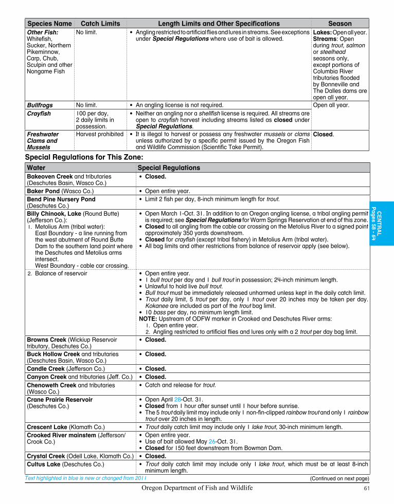
Oregon Department of Fish and Wildlife 61
Text highlighted in blue is new or changed from 2011
Special Regulations for This Zone:Water Special RegulationsBakeoven Creek and tributaries(Deschutes Basin, Wasco Co.)
• Closed.
Baker Pond (Wasco Co.) • Open entire year.Bend Pine Nursery Pond (Deschutes Co.)
• Limit 2 fish per day, 8-inch minimum length for trout.
Billy Chinook, Lake (Round Butte)(Jefferson Co.):
Metolius Arm (tribal water):1. East Boundary - a line running from the west abutment of Round Butte Dam to the southern land point where the Deschutes and Metolius arms intersect.West Boundary - cable car crossing.
• Open March 1-Oct. 31. In addition to an Oregon angling license, a tribal angling permit is required; see Special Regulations for Warm Springs Reservation at end of this zone.
• Closed to all angling from the cable car crossing on the Metolius River to a signed point approximately 350 yards downstream.
• Closed for crayfish (except tribal fishery) in Metolius Arm (tribal water).• All bag limits and other restrictions from balance of reservoir apply (see below).
2. Balance of reservoir • Open entire year.• 1 bull trout per day and 1 bull trout in possession; 24-inch minimum length.• Unlawful to hold live bull trout.• Bull trout must be immediately released unharmed unless kept in the daily catch limit.• Trout daily limit, 5 trout per day, only 1 trout over 20 inches may be taken per day.
Kokanee are included as part of the trout bag limit.• 10 bass per day, no minimum length limit.NOTE: Upstream of ODFW marker in Crooked and Deschutes River arms:
Open entire year.1. 2. Angling restricted to artificial flies and lures only with a 2 trout per day bag limit.
Browns Creek (Wickiup Reservoir tributary, Deschutes Co.)
• Closed.
Buck Hollow Creek and tributaries (Deschutes Basin, Wasco Co.)
• Closed.
Candle Creek (Jefferson Co.) • Closed.Canyon Creek and tributaries (Jeff. Co.) • Closed.Chenoweth Creek and tributaries (Wasco Co.)
• Catch and release for trout.
Crane Prairie Reservoir (Deschutes Co.)
• Open April 28-Oct. 31.• Closed from 1 hour after sunset until 1 hour before sunrise.• The 5 trout daily limit may include only 1 non-fin-clipped rainbow trout and only 1 rainbow
trout over 20 inches in length.Crescent Lake (Klamath Co.) • Trout daily catch limit may include only 1 lake trout, 30-inch minimum length.Crooked River mainstem (Jefferson/Crook Co.)
• Open entire year.• Use of bait allowed May 26-Oct. 31.• Closed for 150 feet downstream from Bowman Dam.
Crystal Creek (Odell Lake, Klamath Co.) • Closed.Cultus Lake (Deschutes Co.) • Trout daily catch limit may include only 1 lake trout, which must be at least 8-inch
minimum length.
Species Name Catch Limits Length Limits and Other Specifications SeasonOther Fish:Whitefish, Sucker, Northern Pikeminnow, Carp, Chub, Sculpin and other Nongame Fish
No limit. • Angling restricted to artificial flies and lures in streams. See exceptions under Special Regulations where use of bait is allowed.
Lakes: Open all year.Streams: Open during trout, salmon or steelhead seasons only, except portions of Columbia River tributaries flooded by Bonneville and The Dalles dams are open all year.
Bullfrogs No limit. • An angling license is not required. Open all year.Crayfish 100 per day,
2 daily limits in possession.
• Neither an angling nor a shellfish license is required. All streams are open to crayfish harvest including streams listed as closed under Special Regulations.
Freshwater Clams and Mussels
Harvest prohibited • It is illegal to harvest or possess any freshwater mussels or clams unless authorized by a specific permit issued by the Oregon Fish and Wildlife Commission (Scientific Take Permit).
Closed.
CE
NTR
AL
Pages 58 - 64
(Continued on next page)

Oregon Department of Fish and Wildlife62
Text highlighted in blue is new or changed from 2011
Water Special RegulationsDavis Lake and Odell Creek Channel up to boat ramp at West Davis Lake campground (Klamath Co.)
• 2 trout per day, 10-inch minimum length and 13-inch maximum length.• No limit on size or number of warmwater game fish.• Restricted to fly angling only with barbless hooks (see fly angling definition, page 8).• Closed from 1 hour after sunset until 1 hour before sunrise.
Deschutes River:Mouth (North side of I-84 bridge) 1. upstream to the northern boundary of the Warm Springs Reservation (including White River upstream to first falls) (Wasco Co.)
NOTE: Chinook salmon angling closed entire river. Emergency regulations opening Chinook angling may be adopted after the printing of these regulations. Up-to-date changes can be obtained by calling 1-503-947-6000 or at our internet site: www.dfw.state.or.us.• Open for coho salmon Aug. 1-Dec. 31.• Open for trout entire year.• 2 rainbow trout per day, 10-inch minimum and 13-inch maximum length.• Open for adipose fin-clipped steelhead entire year.• Restricted to artificial flies and lures, except bait may be used from Sherars Falls
downstream to upper trestle (about 3 miles).• No angling from a floating device.• Sherars Falls downstream to Buck Hollow Creek (about 1 mile) closed to angling
April 1-July 31.2. Northern boundary of the Warm
Springs Reservation upstream to Pelton Regulating Dam (Wasco/Jefferson Co.)
• See Special Regulations for Warm Springs Reservation at end of this zone.• Open for coho salmon Aug. 1-Dec. 31.• Open to trout April 28-Oct. 31.• 2 rainbow trout per day, 10-inch minimum and 13-inch maximum length.• Open for adipose fin-clipped steelhead April 28-Dec. 31.• No angling from a floating device.• Restricted to artificial flies and lures.• Closed from Pelton Regulating Dam downstream about 600 feet to ODFW markers.
3. a. Lake Billy Chinook upstream to Benham Falls (Jefferson/Deschutes Co.)
• Open for trout entire year.• 2 trout per day, which may include 1 bull trout, 24-inch minimum length.• Restricted to artificial flies and lures.
3. b. Mirror Pond (Deschutes River in Bend) from North Canal Dam to Colorado Street Bridge
• Open entire year.• 2 trout per day.• Use of bait allowed.
Benham Falls upstream to Wickiup 4. Reservoir (Deschutes Co.)
• Open for trout May 26-Oct. 31, 5 trout per day, which may include 2 non fin-clipped rainbow trout.
• Use of bait allowed.Wickiup Reservoir upstream to 5. Crane Prairie Dam (Deschutes Co.)
• Open May 26-Aug. 31.
Crane Prairie Reservoir upstream to 6. Little Lava Lake (Deschutes Co.)
• Open May 26-Sept. 30.• Catch and release only for rainbow trout, 5 brook trout per day.
Eagle Creek upstream from the mainline railroad bridge (Columbia River near Bonneville Dam, Hood River Co.)
• Catch and release only for trout May 26-Oct. 31.• Open for Chinook and adipose fin-clipped coho salmon May 26-Aug. 15.• Open for adipose fin-clipped steelhead Jan. 1-March 31, May 26-Aug. 15, and
Dec. 1-31. • Use of bait allowed.• See Columbia River Zone (page 95) for regulations concerning the area down stream
from the mainline railroad bridge.East Lake (Deschutes Co.) • Open April 28-Oct. 31.
• 16-inch maximum length on brown trout. All brown trout over 16 inches must be released unharmed.
• See Health Advisory on page 20.Elk Lake (Deschutes Co.) • 25 kokanee per day (no size limits) in addition to other trout species catch limit.Fall River (Deschutes Co.):
Downstream from the falls1. • Open May 26-Sept. 30.• Restricted to fly angling only with barbless hooks (see fly angling definition, page 8).
2. Upstream from the falls • Open entire year.• Restricted to fly angling only with barbless hooks (see fly angling definition, page 8).
Fifteenmile Creek and tributaries (Wasco Co.)
• Catch and release for trout May 26-Oct. 31.• Closed from head of slackwater located at the mouth to 200 feet upstream from fishway
located at Seufert Falls.Herman Creek upstream from the main-line railroad bridge (Hood River Co.)
• Catch and release for trout May 26-Aug. 15.• Open for Chinook, adipose fin-clipped coho salmon and adipose fin-clipped steelhead
Jan 1- March 31, May 26-Aug 15 and Dec. 1-31.• Use of bait is allowed.• Closed downstream from hatchery dam Aug. 16-Nov. 30.• See Columbia River Zone (page 95) for regulations concerning the area downstream
from mainline railroad bridge.
(Continued on next page)

Oregon Department of Fish and Wildlife 63
Text highlighted in blue is new or changed from 2011
Water Special RegulationsHood River Basin (Hood River Co.):
Mainstem and tributaries 1. not listedNote: Chinook salmon angling closed entire river. Emergency regulations opening Chinook angling may be adopted after the printing of these regulations. Up-to-date changes can be obtained by calling 1-503-947-6000 or at our internet site: www.dfw.state.or.us.• Open for adipose fin-clipped coho salmon and adipose fin-clipped steelhead entire year,
from mouth to mainstem confluence with the East Fork and the West Fork from the confluence with the mainstem upstream to the angling deadline 200 feet downstreem of Punchbowl Falls.
• Catch and release only for trout, May 26-Oct. 31.• Restricted to artificial flies and lures when angling for trout in all tributaries and in
mainstem Hood River upstream from the confluence with the West Fork.• Use of bait allowed for salmon and steelhead.
2. West Fork Hood River upstream of Punchbowl Falls and tributaries
• Closed.
Clear Branch3. • Closed.Pinnacle Creek4. • Closed.
Hosmer Lake (Deschutes Co.) • Catch and release only for Atlantic salmon.• Restricted to fly angling only with barbless hooks (see fly angling definition, page 8).• No angling from motor-propelled craft while motor is operating.
Jack Creek (Jefferson Co.) • Closed.Jefferson Creek (Jefferson Co.) • Closed.Jefferson County Pond (Jefferson Co.) • Restricted to juvenile anglers age 17 and under or holders of one of the Disabled
Anglers permits.• Limit 2 fish per day, 8-inch minimum for trout.
Laurance Lake (Hood River Co.) • Open April 28-Oct. 31.• Only fin-clipped trout may be kept.• Restricted to artificial flies and lures.• No limits on smallmouth bass.
Lava Lake, Big (Deschutes Co.) • April 28-Oct. 31.Link Creek (tributary to Suttle Lake, Jefferson Co.)
• Closed.
Little Deschutes River including Gilchrist Mill Pond (Klamath/Deschutes Co.)
• Use of bait allowed.
Metolius River (Jefferson Co.)Mainstem, mouth upstream to 1. Allingham Bridge
• Open entire year.• Catch and release for all fish, including bull trout.• All bull trout must be released unharmed.• Restricted to artificial flies and lures downstream from Bridge 99.• Restricted to fly angling only with barbless hooks upstream from Bridge 99 (see fly
angling definition, page 8).• No angling from a floating device.
2. Mainstem upstream from Allingham Bridge, Spring and Abbot creeks
• Open May 26-Oct. 31.• Catch and release for all fish, including bull trout.• Restricted to fly angling only with barbless hooks (see fly angling definition, page 8).• Closed within 100 feet of Camp Sherman Bridge.• No angling from a floating device.
Mill Creek and tributaries (Wasco Co.) • Catch and release for trout.Ochoco Creek upstream to Ochoco Dam (Crook Co.)
• Open entire year, 2 trout per day, 8-inch minimum length.• Angling restricted to artificial flies and lures.
Odell Creek from boat ramp located at West Davis Lake campground up to Odell Lake (Klamath Co.)
• Open May 26-Oct. 31.• Catch and release for trout.
Odell Lake (Klamath Co.) • Open April 28-Oct. 31.• 25 kokanee per day (no size limits) in addition to other trout species catch limit.• Trout daily catch limit may include only 1 lake trout, 30-inch minimum length.• Closed within 200 feet of the mouth of Trapper Creek.• Closed to angling for bull trout. Any incidentally caught bull trout must be immediately
released unharmed.Odell Lake tributaries (Klamath Co.) • Closed.Paulina Lake (Deschutes Co.) • Open April 28-Oct. 31.Pelton Regulating Reservoir (Jeff. Co.) • Closed.Prineville Reservoir (Crook Co.) • Largemouth and smallmouth bass, 15-inch maximum length, 5 per day, only one of
which may be a largemouth bass.Prineville Youth Pond (Crook Co.) • Anglingrestrictedtojuvenileanglersage17yearsandyounger.
• Limit 2 fish per day, 8-inch minimum length for trout.
CE
NTR
AL
Pages 58 - 64
(Continued on next page)

Oregon Department of Fish and Wildlife64
Text highlighted in blue is new or changed from 2011
Water Special RegulationsShevlin Pond (Deschutes Co.) • 2 trout per day, 8-inch minimum length.
• Restricted to juvenile anglers 17 years old and younger.Simtustus, Lake (Pelton, Jefferson Co.) • Open April 28-Oct. 31.
• Trout daily catch limit may include only one bull trout, 24-inch minimum length.• Bull trout must be immediately released unharmed unless kept in the daily catch limit.• Tribal angling permit required, see Special Regulations for Warm Springs Reservation
at end of this zone.Sparks Lake and tributaries upstream to Cascade Lake Hwy (Deschutes Co.)
• Restricted to fly angling only with barbless hooks (see fly angling definition, page 8).
Spring River (Deschutes Co.) • Open May 26-Sept. 30.Suttle Lake (Jefferson Co.) • 25 kokanee per day (no size limits) in addition to other trout species catch limit.Trapper Creek (Odell Lake tributary, Klamath Co.)
• Closed.
Trout Creek and tributaries (Deschutes Basin, Jefferson Co.)
• Catch and release for trout.
Tumalo Creek and tributaries (Deschutes Co.)
• Open entire year.
Twin Lake, South (Deschutes Co.) • Open April 28-Oct. 31.Warm Springs Indian Reservation
Telephone number: (541) 553-2002
• In addition to an Oregon angling license, tribal permits are required on the Metolius Arm of Lake Billy Chinook, Lake Simtustus and Reservation portions of Deschutes River.
• The Reservation borders the Deschutes River for approximately 31 miles from Two Springs Ranch (4 miles downstream from the North Junction railroad bridge) upstream to Pelton Regulating Dam.
• Anglers are restricted to the eastern half of the river where it borders the Reservation. For exceptions, call the Reservation at (541) 553-2002. For information and to purchase your Tribal fishing permits visit www.tribalpermit.com. Taking crayfish from Reservation waters is prohibited, except for Tribal use.
White River mainstem and tributaries upstream from first falls (Wasco Co.)
• Open for trout entire year.• See Deschutes River, Section 1, for regulations downstream from first falls.
Whychus Creek and tributaries (Jefferson/Deschutes Co.)
• Open entire year.
Wickiup Reservoir (Deschutes Co.) • Open April 28-Oct. 31.• Deschutes River Arm, upstream of ODFW marker located near West South Twin boat
ramp, restricted to artificial flies and lures only with a 2 trout per day bag limit from July 15-Aug. 31.
• Closed upstream of ODFW marker Sept. 1-Oct. 31.• 25 kokanee (no size limits) in addition to other trout species catch limit.• Closed from 1 hour after sunset until 1 hour before sunrise.• No limit on size or number of warmwater game fish.
Willow Creek (Jefferson Co.) • Catch and release for trout and restricted to artificial flies and lures within National Grasslands.
BULL RUN LAKE
LOST LAKE
BULL RUN RESERVOIR #2
BULL RUN RESERVOIR #1
ROSLYN LAKE
BENSON LAKE
BLUE LAKE
HICKMAN LAKE
PALMER LAKE
GOODFELLOW LAKES
BOODY LAKE
Bull Run River
Cedar Creek
Little Sandy River
Gordon Creek
Fir Creek
Big Creek
Lost Creek
Clear Fork
S. Fork Bull Run River
Clear Creek
Blazed Alder Creek
Falls
Creek
Hackett Creek
Deer Creek
N. Fork
Bull Run Rive
r
Wildcat Creek
W. Branch Falls Creek
Clear Creek
Horseshoe Creek
N. Boulder Creek
Cougar Creek
Cast Creek
Cedar Creek
Bull Run WatershedManagement Unit
84
26
Anglers in the northeastern portion of the Willamette Zone should be advised that the Bull Run Watershed Management Unit (BRWMU) is closed to public entry. The Bull Run boundary — primarily its southern boundary — was expanded by Congress in 2001.
Attention Anglers in Willamette Zone
The Bull Run watershed is the primary water supply for over 800,000 persons in the Portland metropolitan area and has been protected by special Congressional legislation since 1904.
Trespassers are subject to fines up to $5,000. The closure boundary is clearly signed and gated on all roads leading into the closure area, but please be advised that the current editions of the Mt. Hood National Forest recreation map and Zigzag Ranger District map do not show the correct boundary. Anglers in this area who are uncertain of the BRWMU boundary are advised to view correct versions of maps on display at the Mt. Hood Na-tional Forest Headquarters in Sandy or at the Zigzag Ranger Station in Zigzag. Boundary Expansion
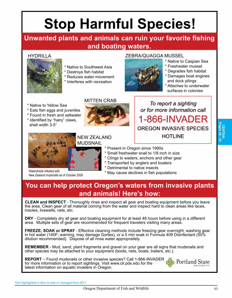
Oregon Department of Fish and Wildlife 65
Text highlighted in blue is new or changed from 2011
Stop Harmful Species!Unwanted plants and animals can ruin your favorite fishing
and boating waters. Unwanted plants and animals can ruin your favorite fishing
and boating waters.
You can help protect Oregon’s waters from invasive plants and animals! Here's how:
* Native to Southwest Asia * Destroys fish habitat * Reduces water movement * Interferes with recreation
HYDRILLA * Native to Caspian Sea * Freshwater mussel * Degrades fish habitat * Damages boat engines and dock pilings * Attaches to underwater surfaces in colonies
ZEBRA/QUAGGA MUSSEL
* Native to Yellow Sea * Eats fish eggs and juveniles * Found in fresh and saltwater * Identified by “hairy” claws, shell width 3-5”
MITTEN CRAB To report a sighting or for more information call
1-866-INVADEROREGON INVASIVE SPECIES
HOTLINE
To report a sighting or for more information call
1-866-INVADEROREGON INVASIVE SPECIES
HOTLINENEW ZEALAND MUDSNAIL
Watersheds infested withNew Zealand mudsnails as of October 2009
* Present in Oregon since 1990s * Small freshwater snail to 1/8 inch in size * Clings to waders, anchors and other gear * Transported by anglers and boaters * Detrimental to native insects * May cause declines in fish populations
CLEAN and INSPECT - Thoroughly rinse and inspect all gear and boating equipment before you leave the area. Clean gear of all material coming from the water and inspect hard to clean areas like laces, insoles, livewells, nets, etc.
DRY - Completely dry all gear and boating equipment for at least 48 hours before using in a different area. Multiple sets of gear are recommended for frequent travelers visiting many areas.
FREEZE, SOAK or SPRAY - Effective cleaning methods include freezing gear overnight, washing gear in hot water (140F; warning, may damage Gortex), or a 5 min soak in Formula 409 Disinfectant (50% dilution recommended). Dispose of all rinse water appropraitely.
REMEMBER - Mud, sand, plant fragments and gravel on your gear are all signs that mudsnails and other species may be attached to your equipment (boots, nets, boats, trailers, etc.).
REPORT – Found mudsnails or other invasive species? Call 1-866-INVADER for more information or to report sightings. Visit www.clr.pdx.edu for the latest information on aquatic invaders in Oregon.
CE
NTR
AL
Pages 58 - 64

Oregon Department of Fish and Wildlife66
Text highlighted in blue is new or changed from 2011
Oregon Department of Fish and Wildlife66
$
$
$
$
$
$
$
¡ ¡
¡
#
#
¡
#
!
!
!
!
!
!
!
!
ÿ
"
"
P
P
P
P
P
P
P
P
P
P
P
P
P
P
P
P
P
P
P
P
P
P
P
P
P P
P
P
P P
John
D
ay
Riv
er
§̈¦84
£¤26
£¤30
£¤197
£¤730
£¤395
£¤30
£¤97
£¤30
£¤395
£¤95
£¤395
QR206
QR207QR82
QR74
QR19
QR86
QR27
QR244
QR3
QR204
QR237
QR37
QR7
QR203
QR11
QR245
QR218
QR7
QR207
QR126
QR216
QR206
QR207
QR207
QR201
QR201
§̈¦84§̈¦84
§̈¦84
£¤26
£¤26
GRANTBAKER
CROOK
WHEELER
JEFFERSON
UMATILLA
UNION
WALLOWA
GILLIAM
SHERMAN
MORROW Pendleton
Hermiston
Umatilla
La Grande
Union
Boardman
ArlingtonRufus
John Day
Elgin
Mitchell
Heppner
Enterprise
Fossil
Ione
Joseph
Canyon City
Milton-Freewater
Condon
Wallowa
Shaniko
Dayville
MonumentSpray
Ukiah
IDAHO
WASHINGTON
Imnaha
Clarno
Rondowa
ServiceCreek
Nolin
Cold Springs Reservoir
WallowaLake
McKayRes.
Magone Lake
Kinney Res.
Bull Prairie Reservoir
MorganLake
Canyon Mdw Res.
La GrandeRes.
John Day Arm
Grande R
onde R
iver
Rock Creek
Willow
Cre
ek
Umatill a River
Imna
ha
Riv
er
Butte
r Cr
Wal lowa R
Minam
River
Rhea Creek
North
For
k
J
ohn
Day River
Mill C
r
McKay Cr
Lostine River
Jose
ph C
r
Bear C
reek
Big Sheep
Cr
Walla Walla River
Middle Fork John Day River
Deer C
r
South F
ork John Day River
Crow
Creek
Little
Sheep Cr
Lit tle Butter Cr
Wenaha River
Beaver Creek
Meacham
Cr
Meadow Creek
Canyon C
r
El k
Cr
Catherine Cr
Indian Cr
Cottonwood Cr
Jarboe Cr
N Fork
Beech Cr
Chesnimnus C
r
Crooked Cr
Joh
nson Cr
Summit Cr
S Fork
Rock C
r
E F
k Wallow
a RNor
th F
k
South Fk
Wes
t Fk
Spring
Cr
N Fk
East Fk
North Fork
Sou th ForkLoo kingglass Cr
Hur
rican
e C
rTr
out C
reek
Sw
amp
Cr
Snake River
Grande Ro nde
Rive
r
John Day River
Gra
nde
R
onde
Rive
r
Imna
ha R
iver
Columbia
River
Tumwater Falls
HellsCanyonDam
ThreemileDam
Bull Run Cr
Clea
r Cr
M Fk
Beaver Cr
Granit e Cr
Hwy 11 Bridge
Hwy 203Bridge
Hwy 730 Bridge
Hwy 395 Bridge
Hwy 395 Bridge
Railroad Bridge
CottonwoodBridge
LOOKINGGLASSHATCHERY
WALLOWAHATCHERY
Umatilla
Willow CreekWildlife Area
North Fork Campground
Spring Cr Rd
Hells
Can
yon
Irrigon
UmatilaIndian
Reservation
North Fork
Indian Cr
Northeast Zone
0 20 4010Miles
²
Legend$ Bridges
" Dam
ÿ Falls
! Other Landmarks
¡ Hatcheries
# Weirs
Zone Boundary
Closed All Year
County boundaries
TRIBAL PERMIT REQUIRED FOR ANGLING ON THE RESERVATION
PORTION OF THE UMATILLA RIVER. FOR INFORMATION CALL THE UMATILLAINDIAN RESERVATION AT 541-276-4109.
COLUMBIA AND SNAKE RIVERS NOT INCLUDED IN THIS ZONE.

Oregon Department of Fish and Wildlife 67
Text highlighted in blue is new or changed from 2011
67
$
$
$
$
$
$
$
¡ ¡
¡
#
#
¡
#
!
!
!
!
!
!
!
!
ÿ
"
"
P
P
P
P
P
P
P
P
P
P
P
P
P
P
P
P
P
P
P
P
P
P
P
P
P P
P
P
P P
John
D
ay
Riv
er
§̈¦84
£¤26
£¤30
£¤197
£¤730
£¤395
£¤30
£¤97
£¤30
£¤395
£¤95
£¤395
QR206
QR207QR82
QR74
QR19
QR86
QR27
QR244
QR3
QR204
QR237
QR37
QR7
QR203
QR11
QR245
QR218
QR7
QR207
QR126
QR216
QR206
QR207
QR207
QR201
QR201
§̈¦84§̈¦84
§̈¦84
£¤26
£¤26
GRANTBAKER
CROOK
WHEELER
JEFFERSON
UMATILLA
UNION
WALLOWA
GILLIAM
SHERMAN
MORROW Pendleton
Hermiston
Umatilla
La Grande
Union
Boardman
ArlingtonRufus
John Day
Elgin
Mitchell
Heppner
Enterprise
Fossil
Ione
Joseph
Canyon City
Milton-Freewater
Condon
Wallowa
Shaniko
Dayville
MonumentSpray
Ukiah
IDAHO
WASHINGTON
Imnaha
Clarno
Rondowa
ServiceCreek
Nolin
Cold Springs Reservoir
WallowaLake
McKayRes.
Magone Lake
Kinney Res.
Bull Prairie Reservoir
MorganLake
Canyon Mdw Res.
La GrandeRes.
John Day Arm
Grande R
onde R
iver
Rock Creek
Willow
Cre
ek
Umatill a River
Imna
ha
Riv
er
Butte
r Cr
Wal lowa R
Minam
RiverRhea Creek
North
For
k
J
ohn
Day River
Mill C
r
McKay Cr
Lostine River
Jose
ph C
r
Bear C
reek
Big Sheep
Cr
Walla Walla River
Middle Fork John Day River
Deer C
r
South F
ork John Day River
Crow
Creek
Little
Sheep Cr
Lit tle Butter Cr
Wenaha River
Beaver Creek
Meacham
Cr
Meadow Creek
Canyon C
r
El k
Cr
Catherine Cr
Indian Cr
Cottonwood Cr
Jarboe Cr
N Fork
Beech Cr
Chesnimnus C
r
Crooked Cr
Joh
nson Cr
Summit Cr
S Fork
Rock C
r
E F
k Wallow
a RNor
th F
k
South Fk
Wes
t Fk
Spring
Cr
N Fk
East Fk
North Fork
Sou th ForkLoo kingglass Cr
Hur
rican
e C
rTr
out C
reek
Sw
amp
Cr
Snake River
Grande Ro nde
Rive
r
John Day River
Gra
nde
R
onde
Rive
r
Imna
ha R
iver
Columbia
River
Tumwater Falls
HellsCanyonDam
ThreemileDam
Bull Run Cr
Clea
r Cr
M Fk
Beaver Cr
Granit e Cr
Hwy 11 Bridge
Hwy 203Bridge
Hwy 730 Bridge
Hwy 395 Bridge
Hwy 395 Bridge
Railroad Bridge
CottonwoodBridge
LOOKINGGLASSHATCHERY
WALLOWAHATCHERY
Umatilla
Willow CreekWildlife Area
North Fork Campground
Spring Cr Rd
Hells
Can
yon
Irrigon
UmatilaIndian
Reservation
North Fork
Indian Cr
Northeast Zone
0 20 4010Miles
²
Legend$ Bridges
" Dam
ÿ Falls
! Other Landmarks
¡ Hatcheries
# Weirs
Zone Boundary
Closed All Year
County boundaries
TRIBAL PERMIT REQUIRED FOR ANGLING ON THE RESERVATION
PORTION OF THE UMATILLA RIVER. FOR INFORMATION CALL THE UMATILLAINDIAN RESERVATION AT 541-276-4109.
COLUMBIA AND SNAKE RIVERS NOT INCLUDED IN THIS ZONE.
NO
RTH
EA
ST
Pages 66 - 71
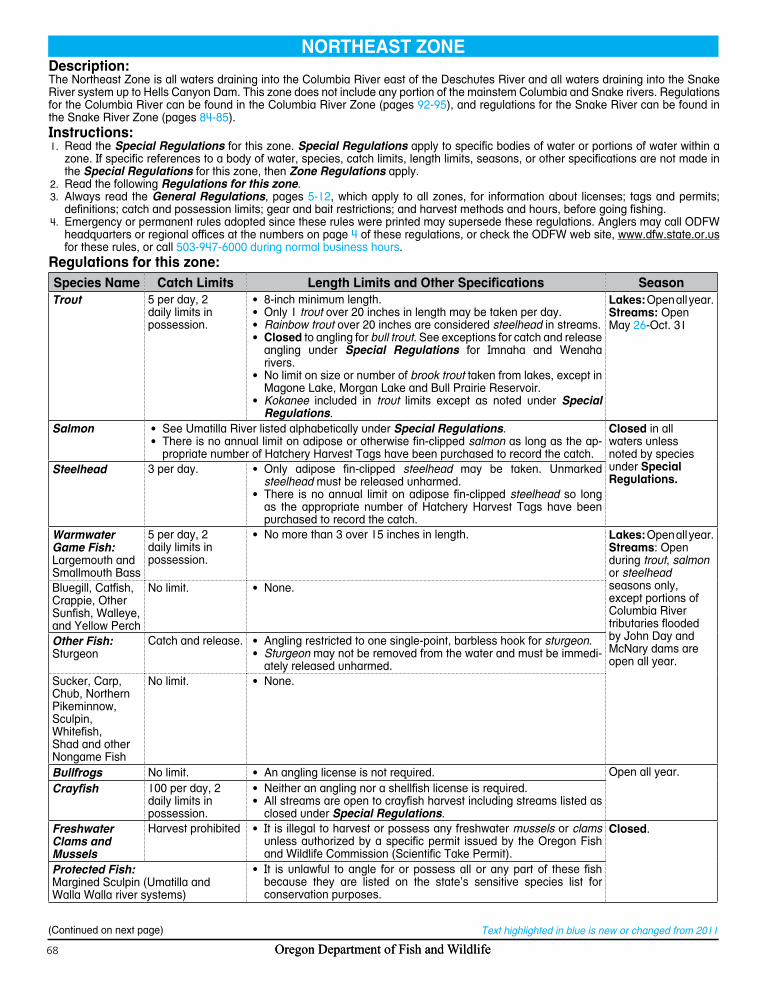
Oregon Department of Fish and Wildlife68 Oregon Department of Fish and Wildlife68
Text highlighted in blue is new or changed from 2011
Description: The Northeast Zone is all waters draining into the Columbia River east of the Deschutes River and all waters draining into the Snake River system up to Hells Canyon Dam. This zone does not include any portion of the mainstem Columbia and Snake rivers. Regulations for the Columbia River can be found in the Columbia River Zone (pages 92-95), and regulations for the Snake River can be found in the Snake River Zone (pages 84-85).Instructions:
Read the 1. Special Regulations for this zone. Special Regulations apply to specific bodies of water or portions of water within a zone. If specific references to a body of water, species, catch limits, length limits, seasons, or other specifications are not made in the Special Regulations for this zone, then Zone Regulations apply.Read the following 2. Regulations for this zone.Always read the 3. General Regulations, pages 5-12, which apply to all zones, for information about licenses; tags and permits; definitions; catch and possession limits; gear and bait restrictions; and harvest methods and hours, before going fishing.Emergency or permanent rules adopted since 4. these rules were printed may supersede these regulations. Anglers may call ODFW headquarters or regional offices at the numbers on page 4 of these regulations, or check the ODFW web site, www.dfw.state.or.us for these rules, or call 503-947-6000 during normal business hours.
Regulations for this zone:Species Name Catch Limits Length Limits and Other Specifications SeasonTrout 5 per day, 2
daily limits in possession.
• 8-inch minimum length.• Only 1 trout over 20 inches in length may be taken per day.• Rainbow trout over 20 inches are considered steelhead in streams.• Closed to angling for bull trout. See exceptions for catch and release
angling under Special Regulations for Imnaha and Wenaha rivers.
• No limit on size or number of brook trout taken from lakes, except in Magone Lake, Morgan Lake and Bull Prairie Reservoir.
• Kokanee included in trout limits except as noted under Special Regulations.
Lakes: Open all year.Streams: Open May 26-Oct. 31
Salmon • See Umatilla River listed alphabetically under Special Regulations.• There is no annual limit on adipose or otherwise fin-clipped salmon as long as the ap-
propriate number of Hatchery Harvest Tags have been purchased to record the catch.
Closed in all waters unless noted by species under Special Regulations.
Steelhead 3 per day. • Only adipose fin-clipped steelhead may be taken. Unmarked steelhead must be released unharmed.
• There is no annual limit on adipose fin-clipped steelhead so long as the appropriate number of Hatchery Harvest Tags have been purchased to record the catch.
Warmwater Game Fish: Largemouth and Smallmouth Bass
5 per day, 2 daily limits in possession.
• No more than 3 over 15 inches in length. Lakes: Open all year.Streams: Open during trout, salmon or steelhead seasons only, except portions of Columbia River tributaries flooded by John Day and McNary dams are open all year.
Bluegill, Catfish, Crappie, Other Sunfish, Walleye, and Yellow Perch
No limit. • None.
Other Fish:Sturgeon
Catch and release. • Angling restricted to one single-point, barbless hook for sturgeon.• Sturgeon may not be removed from the water and must be immedi-
ately released unharmed.Sucker, Carp, Chub, Northern Pikeminnow, Sculpin, Whitefish, Shad and other Nongame Fish
No limit. • None.
Bullfrogs No limit. • An angling license is not required. Open all year.Crayfish 100 per day, 2
daily limits in possession.
• Neither an angling nor a shellfish license is required.• All streams are open to crayfish harvest including streams listed as
closed under Special Regulations.Freshwater Clams and Mussels
Harvest prohibited • It is illegal to harvest or possess any freshwater mussels or clams unless authorized by a specific permit issued by the Oregon Fish and Wildlife Commission (Scientific Take Permit).
Closed.
Protected Fish:Margined Sculpin (Umatilla and Walla Walla river systems)
• It is unlawful to angle for or possess all or any part of these fish because they are listed on the state’s sensitive species list for conservation purposes.
NORTHEAST ZONE
(Continued on next page)

Oregon Department of Fish and Wildlife 69 69
Text highlighted in blue is new or changed from 2011
Special Regulations for This Zone:
Water Special RegulationsAldrich Ponds (Grant Co.) • Open May 26-Oct. 31.
• 2 trout per day.Bear Creek and tributaries (Wallowa Co.) • Restricted to artificial flies and lures.Big Sheep Creek (Wallowa County) Mouth upstream to the mouth of Little Sheep Creek
• Open for adipose fin-clipped steelhead Jan. 1-April 15 and Sept. 1-Dec. 31.• Only adipose fin-clipped trout may be kept.
Bull Prairie Reservoir (Grant Co.) • No more than 5 brook trout per day as part of the general trout catch limits.• No size limit on brook trout.
Butter Creek and tributaries (Umatilla/Morrow Co.)
• Open April 28-Oct. 31.
Catherine Creek up to Hwy 203 Bridge located upstream from Catherine Creek State Park (Union Co.)
• Open for adipose fin-clipped steelhead Jan. 1-April 15 and Sept. 1-Dec. 31.
Cold Springs Reservoir (Umatilla Co.) • Portions of refuge are closed to angling and use of motors at times.• For information on federal refuge regulations call 509-546-8300.
Deer Creek (Wallowa Co.) • Closed from the mouth upstream to the marker 380 feet upstream from the water intake structure (0.2 mile).
Grande Ronde River (Wallowa/Union Co.):Stateline upstream to Rondowa1.
• Open for adipose fin-clipped steelhead Jan. 1-April 15 and Sept. 1-Dec. 31.• Only adipose fin-clipped trout may be kept.
2. Rondowa upstream to Meadow Creek • Open for adipose fin-clipped steelhead Jan. 1-April 15 and Sept. 1-Dec. 31.Hurricane Creek from forest boundary upstream to Slick Rock Creek (Wallowa Co.)
• Restricted to artificial flies and lures.
Imnaha River (Wallowa Co.):Upstream to Big Sheep Creek1.
• Open for adipose fin-clipped steelhead Jan. 1-April 15 and Sept. 1-Dec. 31.• Only adipose fin-clipped trout may be kept.• Catch and release for bull trout.• Angling restricted to single-point hook no larger than 3/8 inch gap or multiple-point hook
no larger than 1/4 inch gap May 26-Aug. 31 unless open by emergency rule for spring Chinook salmon angling.
2. Upstream from Big Sheep Creek • Closed between 200 feet downstream from the fish weir and the water intake located 1/2 mile downstream from Gumboot Creek (0.3 mile).
• Catch and release for bull trout.• Angling restricted to single-point hook no larger than 3/8 inch gap or multiple-point hook
no larger than 1/4 inch gap May 26-Aug. 31 unless open by emergency rule for spring Chinook salmon angling.
John Day River (Numerous Eastern Oregon Counties):
John Day Arm and River from main 1. line railroad bridge near mouth up-stream to Tumwater Falls
• Open for adipose fin-clipped steelhead Jan. 1-March 31 and June 16-Dec. 31.• Open for Warmwater Game Fish entire year except as noted below.• Closed from ODFW marker 1/4-mile downstream from Tumwater Falls to 200 feet
above the falls, which are located near the head of John Day Arm, except open for species other than salmon and steelhead April 1-Aug. 31.
2. Mainstem from Tumwater Falls:a. Upstream past Cottonwood Bridge
(Rivermile 39.5) to Hwy 207 Bridge at Service Creek
• Smallmouth bass, 5 per day, no more than 1 over 16 inches.• Smallmouth bass between 12 and 16 inches must be released unharmed.• Open for adipose fin-clipped steelhead the entire year.
b. Hwy 207 Bridge at Service Creek to North Fork
• Smallmouth bass, 5 per day, no more than 3 over 15 inches.• Open for adipose fin-clipped steelhead the entire year.
c. From North Fork upstream to Indian Creek
• Open for adipose fin-clipped steelhead Jan. 1-April 15 and Sept. 1-Dec. 31.
Middle Fork:3. a. Upstream to Hwy 395 bridge
• Open for adipose fin-clipped steelhead Jan. 1-April 15 and Sept. 1-Dec. 31.
b. Hwy 395 bridge upstream to Hwy 7 • Restricted to artificial flies and bait with a single-point hook no larger than 1/4 inch gap.• Lures prohibited.
c. Hwy 7 upstream to Summit Creek • Closed.North Fork:4. a. Upstream to Hwy 395 bridge
• Open for adipose fin-clipped steelhead Jan. 1-April 15 and Sept. 1-Dec. 31.
b. Hwy 395 bridge upstream to bridge located at USFS North Fork Campground
• Restricted to artificial flies and bait with a single-point hook no larger than 1/4 inch gap.• Lures prohibited.
c. Granite Creek and tributaries • Closed.Kinney Reservoir (Wallowa Co.) • Open May 26-Oct. 31.
• No angling from a floating device.
NO
RTH
EA
ST
Pages 66 - 71
(Continued on next page)
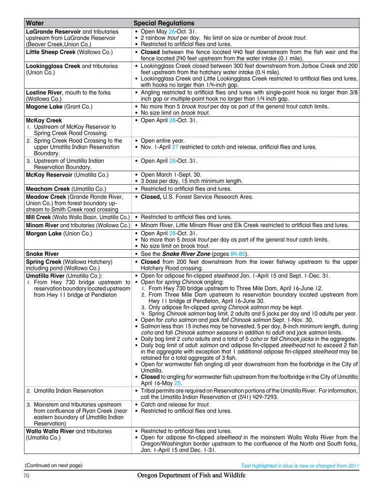
Oregon Department of Fish and Wildlife70 Oregon Department of Fish and Wildlife70
Text highlighted in blue is new or changed from 2011
Water Special RegulationsLaGrande Reservoir and tributaries upstream from LaGrande Reservoir (Beaver Creek,Union Co.)
• Open May 26-Oct. 31.• 2 rainbow trout per day. No limit on size or number of brook trout.• Restricted to artificial flies and lures.
Little Sheep Creek (Wallowa Co.) • Closed between the fence located 440 feet downstream from the fish weir and the fence located 240 feet upstream from the water intake (0.1 mile).
Lookingglass Creek and tributaries (Union Co.)
• Lookingglass Creek closed between 300 feet downstream from Jarboe Creek and 200 feet upstream from the hatchery water intake (0.4 mile).
• Lookingglass Creek and Little Lookingglass Creek restricted to artificial flies and lures, with hooks no larger than 1/4-inch gap.
Lostine River, mouth to the forks (Wallowa Co.)
• Angling restricted to artificial flies and lures with single-point hook no larger than 3/8 inch gap or multiple-point hook no larger than 1/4 inch gap.
Magone Lake (Grant Co.) • No more than 5 brook trout per day as part of the general trout catch limits.• No size limit on brook trout.
McKay CreekUpstream of McKay Reservoir to 1. Spring Creek Road Crossing.
• Open April 28-Oct. 31.
2. Spring Creek Road Crossing to the upper Umatilla Indian Reservation Boundary.
• Open entire year.• Nov. 1-April 27 restricted to catch and release, artificial flies and lures.
Upstream of Umatilla Indian 3. Reservation Boundary.
• Open April 28-Oct. 31.
McKay Reservoir (Umatilla Co.) • Open March 1-Sept. 30.• 3 bass per day, 15 inch minimum length.
Meacham Creek (Umatilla Co.) • Restricted to artificial flies and lures.Meadow Creek (Grande Ronde River, Union Co.) from forest boundary up-stream to Smith Creek road crossing
• Closed, U.S. Forest Service Research Area.
Mill Creek (Walla Walla Basin, Umatilla Co.) • Restricted to artificial flies and lures.Minam River and tributaries (Wallowa Co.) • Minam River, Little Minam River and Elk Creek restricted to artificial flies and lures.Morgan Lake (Union Co.) • Open April 28-Oct. 31.
• No more than 5 brook trout per day as part of the general trout catch limits.• No size limit on brook trout.
Snake River • See the Snake River Zone (pages 84-85).Spring Creek (Wallowa Hatchery) including pond (Wallowa Co.)
• Closed from 200 feet downstream from the lower fishway upstream to the upper Hatchery Road crossing.
Umatilla River (Umatilla Co.):From Hwy 730 bridge upstream to 1. reservation boundary located upstream from Hwy 11 bridge at Pendleton
• Open for adipose fin-clipped steelhead Jan. 1-April 15 and Sept. 1-Dec. 31.• Open for spring Chinook angling:
From Hwy 730 bridge upstream to Three Mile Dam, April 16-June 121. .From Three Mile Dam upstream to reservation boundary located upstream from 2. Hwy 11 bridge at Pendleton, April 16-June 30.Only adipose fin-clipped 3. spring Chinook salmon may be kept.Spring 4. Chinook salmon bag limit, 2 adults and 5 jacks per day and 10 adults per year.
• Open for coho salmon and jack fall Chinook salmon Sept. 1-Nov. 30.• Salmon less than 15 inches may be harvested, 5 per day, 8-inch minimum length, during
coho and fall Chinook salmon seasons in addition to adult and jack salmon limits.• Daily bag limit 2 coho adults and a total of 5 coho or fall Chinook jacks in the aggregate.• Daily bag limit of adult salmon and adipose fin-clipped steelhead not to exceed 2 fish
in the aggregate with exception that 1 additional adipose fin-clipped steelhead may be retained for a total aggregate of 3 fish.
• Open for warmwater fish angling all year downstream from the footbridge in the City of Umatilla.
• Closed to angling for warmwater fish upstream from the footbridge in the City of Umatilla April 16-May 25.
2. Umatilla Indian Reservation • Tribal permits are required on Reservation portions of the Umatilla River. For information, call the Umatilla Indian Reservation at (541) 429-7293.
Mainstem and tributaries 3. upstream from confluence of Ryan Creek (near eastern boundary of Umatilla Indian Reservation)
• Catch and release for trout.• Restricted to artificial flies and lures.
Walla Walla River and tributaries (Umatilla Co.)
• Restricted to artificial flies and lures.• Open for adipose fin-clipped steelhead in the mainstem Walla Walla River from the
Oregon/Washington border upstream to the confluence of the North and South forks, Jan. 1-April 15 and Dec. 1-31.
(Continued on next page)

Oregon Department of Fish and Wildlife 71 71
NO
RTH
EA
ST
Pages 66 - 71
Water Special RegulationsWallowa Lake (Wallowa Co.) • 5 trout per day, including rainbow and lake trout, with no size limits.
• 10 kokanee per day, no minimum length and no more than 5 over 12 inches in length.• All bull trout must be released unharmed.
Wallowa River (Wallowa Co.):Mouth upstream to Rock Creek1.
• Open for adipose fin-clipped steelhead Jan. 1-April 15 and Sept. 1-Dec. 31.• Only adipose fin-clipped trout may be kept.
2. Rock Creek upstream to Trout Creek • Open for adipose fin-clipped steelhead Jan. 1-April 15 and Sept. 1-Dec. 31.Upstream from Wallowa Lake to falls 3. on West Fork and PPL intake on East Fork
• Open May 26-Aug. 31.• Restricted to artificial flies and lures.
Wenaha River (Wallowa Co.):Upstream to Crooked Creek1.
• Open for adipose fin-clipped steelhead Jan. 1-April 15 and Sept. 1-Dec. 31.• Two trout per day, 8 inch minimum length.• Catch and release for bull trout.
2. From Crooked Creek to confluence of North and South Forks.
• Two trout per day, 8 inch minimum length.• Catch and release for bull trout.
Remainder of Wenaha River Basin 3. (Upper South Fork and all tributaries).
• Two trout per day, 8 inch minimum length.• Closed to angling for bull trout.
Willow Creek Reservoir (Morrow Co.): • Catch and release only for largemouth bass.• Smallmouth bass per Zone Regulations, 5 per day, no more than 3 over 15 inches.• Crappie, 8-inch minimum length, daily bag limit of 25 fish.
Willow Creek System (Morrow Co.):Slackwater at wildlife area1.
• Open entire year.
2. Upstream from the wildlife area at the mouth
• Open April 28-Oct. 31.
Native Bull TroutNo dark marks on dorsal fin
No red on paired fins
Introduced Brook TroutDark marks on dorsal fin
Red on paired fins
Worm-like markings on back
Attention Anglers !Bull trout, one of Oregon’s native species, is listed as Threatened under the Endangered Species Act. Harvest of bull trout is severely restricted in Oregon as part of conservation efforts to recover this species and rebuild the fishery. Please refer to regulations for the Willamette, Central, Northeast, and Southeast Zone regarding Bull trout.Research has shown that most anglers, experienced as well as inexperienced, have difficulty distinguishing between bull trout and brook trout, an introduced species in Oregon. This Fish Identification is provided to help you distinguished between native bull trout and introduced brook trout.
Please help recover bull trout and restore the fishery by taking the time to learn the characteristics. Your help is essential!Brook trout and bull trout both have light spots on a dark grey or olive-green background. In general, bull trout have a clear dorsal fin, although in some fish light marks may be seen on the dorsal fin. Bull trout lack the worm-like markings on their backs and the red on their paired fins that characterize brook trout.Brook trout may be identified by light colored worm-like marking on their back, dark wavy lines on the dorsal fin, and red on the paired fins.
Good Fishing Depends on Clean WaterMany of our rivers, lakes, and coastal areas are experiencing algae blooms that cover our favorite fishing spots with green slime and cause fish kills and “dead zones” where no aquatic life can survive. The cause is usually nitrogen and phosphorus pollution that comes from farm and lawn fertilizers, septic systems, animal waste, and sewage treatment plants. Everyone can do their part for clean water by reducing fertilizer use, preserving plants along shorelines, and picking up pet waste.Supporting water quality protection supports great fishing! Learn more at:www.epa.gov/nutrientpollution/.

Oregon Department of Fish and Wildlife72
Text highlighted in blue is new or changed from 2011
84
5
205
105
395
95
20
97
26
30
197
199
395
30
97
97
395
95
197101
395
78
205
140
38
126
206
36
31
207
58
22
216
82
138
230
74
35
19
226
62
6
238
201
211
86
27
66
228
214
3
18
204
237
37
203
213
99W
39
234
53
99
224
99E
46
219
11
240
227
229
245
218
223
10
51
43
233
212
70
210
7
140
47
99
207
126
99
99E
224216
47
214
138
126
206
99
207
99
214
140
140
34
8 217
99E
207
99
22 99E
22
42
26
5
26
97
20
20
84 84
84
26
26
97
395
5
LAKE
HARNEY
MALHEUR
LANE
GRANT
KLAMATHDOUGLAS
LINNBAKER
CROOK
JACKSON
DESCHUTES
WHEELER
JEFFERSON
JOSEPHINE
LIN
CO
LN
UMATILLA
UNION
WASCO
WALLOWA
GILLIAM
MARION
CLACKAMAS
TILLAMOOK
SHERMAN
WASHINGTON
MULTNOMAH
Morrow
LANEBurns
Owyhee
Basque
Fields
Chemult
Silvies
Richland
McDermitt
Chiloquin
Frenchglen
Huntington
FortKlamath
Jordan Valley
KlamathFalls
Christmas Valley
Weiser, Idaho
Lakeview
Ontario
MalheurNationalWildlifeRefuge
Bend
BakerCity
RedmondPrineville
Madras
Medford
Ashland
John Day
Whitehorse
Paisley
National
Park
Snake River
Malheur River
Owyh
ee R
iver
Burnt River
Powder River
Klam
ath R
Sprague R
Rock CrSycan River
Jordan CreekDe
ep Cr
Eagle Creek
William
son R
Buck C
reek
Silv
er C
r
N Fk M
alheur R
Lost River
Honey Creek
Trou t C r
Guano CrSpencer Cr
Chewaucan R
Twentym ile Cr
Wood R
Ana R
N Fk Sprague R
Blitzen River
S Fk M
alhe
ur R
Snak
e
Riv
er
B luebuc ket C
r
Page Dam
KenoDam
OwyheeDam
HellsCanyonDam
Thief ValleyDam
J. C. BoyleDam
Oxbow Dam
Brownlee Dam
Oxbow Bridge
Kirk RdBridge
Saddle Mtn Pitt Rd Br
Godowa SpgsRd Bridge
NicholsonRd Br
SycanMarsh
PaulinaMarsh
KlamathMarsh
CALIFORNIA NEVADA
IDA
HO
LakeAbert
SummerLake
GooseLake
CraterLake
AgencyLake
Upper Klamath Lake
HarneyLake
MalheurLake
BrownleeRes.
OwyheeReservoir
SilverLake
CrumpLake
HartLake
DrewsReservoir
WarmSprings
Res.
AspenLake
AlvordLake
GerberReservoir
AntelopeRes.
Coyote Lake
PhillipsRes.
ThompsonReservoir
BeulahReservoir
Lake ofthe Woods
UnityRes.
Bully CrRes.
MillerLake
ChickahominyReservoir
Mann Lake
Krumbo Reservoir
See SouthwestCorner Inset
See SoutheastCorner Inset
See NortheastCorner InsetSoutheast Zone
0 25 5012.5Miles
LegendBridges
Dams
Falls
Hacheries
Zone Boundary
Closed All Year
County boundaries
Marshes
SNAKE RIVER NOT INCLUDED IN THIS ZONE. (SEE SNAKE RIVER ZONE)

Oregon Department of Fish and Wildlife 73
Text highlighted in blue is new or changed from 2011
84
5
205
105
395
95
20
97
26
30
197
199
395
30
97
97
395
95
197101
395
78
205
140
38
126
206
36
31
207
58
22
216
82
138
230
74
35
19
226
62
6
238
201
211
86
27
66
228
214
3
18
204
237
37
203
213
99W
39
234
53
99
224
99E
46
219
11
240
227
229
245
218
223
10
51
43
233
212
70
210
7
140
47
99
207
126
99
99E
224216
47
214
138
126
206
99
207
99
214
140
140
34
8 217
99E
207
99
22 99E
22
42
26
5
26
97
20
20
84 84
84
26
26
97
395
5
LAKE
HARNEY
MALHEUR
LANE
GRANT
KLAMATHDOUGLAS
LINNBAKER
CROOK
JACKSON
DESCHUTES
WHEELER
JEFFERSON
JOSEPHINE
LIN
CO
LN
UMATILLA
UNION
WASCO
WALLOWA
GILLIAM
MARION
CLACKAMAS
TILLAMOOK
SHERMAN
WASHINGTON
MULTNOMAH
Morrow
LANEBurns
Owyhee
Basque
Fields
Chemult
Silvies
Richland
McDermitt
Chiloquin
Frenchglen
Huntington
FortKlamath
Jordan Valley
KlamathFalls
Christmas Valley
Weiser, Idaho
Lakeview
Ontario
MalheurNationalWildlifeRefuge
Bend
BakerCity
RedmondPrineville
Madras
Medford
Ashland
John Day
Whitehorse
Paisley
National
Park
Snake River
Malheur River
Owyh
ee R
iver
Burnt River
Powder River
Klam
ath R
Sprague R
Rock CrSycan River
Jordan Creek
Deep
Cr
Eagle Creek
William
son R
Buck C
reek
Silv
er C
r
N Fk M
alheur R
Lost River
Honey Creek
Trou t C r
Guano CrSpencer Cr
Chewaucan R
Twentym ile Cr
Wood R
Ana R
N Fk Sprague R
Blitzen River
S Fk M
alhe
ur R
Snak
e
Riv
er
B luebuc ket C
r
Page Dam
KenoDam
OwyheeDam
HellsCanyonDam
Thief ValleyDam
J. C. BoyleDam
Oxbow Dam
Brownlee Dam
Oxbow Bridge
Kirk RdBridge
Saddle Mtn Pitt Rd Br
Godowa SpgsRd Bridge
NicholsonRd Br
SycanMarsh
PaulinaMarsh
KlamathMarsh
CALIFORNIA NEVADA
IDA
HO
LakeAbert
SummerLake
GooseLake
CraterLake
AgencyLake
Upper Klamath Lake
HarneyLake
MalheurLake
BrownleeRes.
OwyheeReservoir
SilverLake
CrumpLake
HartLake
DrewsReservoir
WarmSprings
Res.
AspenLake
AlvordLake
GerberReservoir
AntelopeRes.
Coyote Lake
PhillipsRes.
ThompsonReservoir
BeulahReservoir
Lake ofthe Woods
UnityRes.
Bully CrRes.
MillerLake
ChickahominyReservoir
Mann Lake
Krumbo Reservoir
See SouthwestCorner Inset
See SoutheastCorner Inset
See NortheastCorner InsetSoutheast Zone
0 25 5012.5Miles
LegendBridges
Dams
Falls
Hacheries
Zone Boundary
Closed All Year
County boundaries
Marshes
SNAKE RIVER NOT INCLUDED IN THIS ZONE. (SEE SNAKE RIVER ZONE)
SO
UTH
EA
ST
Pages 72 - 81

Oregon Department of Fish and Wildlife74
Text highlighted in blue is new or changed from 2011
"
"
"
"
$
$
$¡
P
P
P
P
P
P
£ ¤30
£ ¤30
Q R86
Q R237
Q R203
Q R245
Q R7
§̈ ¦84
£ ¤26
BA
KER
Wal
low
aU
nion
Mal
heur
Gra
ntR
ichl
and
Hun
tingt
on
Wei
ser,
Idah
o
Bake
rC
itySu
mpt
er Uni
ty
Hel
lsC
anyo
nD
am
Thie
f Va
lley
Dam
Oxb
owD
am
Brow
nlee
Dam
Oxb
owB
ridge
Ric
hlan
d - H
untin
gton
Roa
d B
ridge
Ric
hlan
d - H
untin
gton
Roa
d B
ridge
Bro
wnl
eeR
es.
Phi
llips
Res
.
Uni
tyR
es.
Thie
fVa
lley
Res
.
Balm
Cr R
es.
Hig
gins
Res
.M
urra
yR
es.
Oxb
ow H
atch
ery
Bur
nt
R
iver
Pow
der
River
Eagle
Creek
N Fk Malheur R
Pine
C
reek
Wolf
Cre
ek
Big Cr
Fi
sh Creek
Clear Cr
Balm Creek
Sutton Creek
North Powder R
Deer Creek
Elk
Cr
North Pine Cr
Alde
r Cre
ek
Jimmy Cr
Lawrence
Cr
East Fk
Cracker Creek
Anth
ony C
reek
Pole
Cr
Rock Creek Camp Cr
Big Creek
Chanc
e Cr
Last
S Fk Burnt
R
West Fk
North Fork
Mid
dle
Fk
Wes
t Fk
Ebell CreekBeagle Cr
Powde
r
R
iver
Ea st P
ine
Snake River
Durkee C
r
Pri tc
hard Cr
Dix
ie C
r
North
For
k
Sout
h Fk
Durb
in Cr
²
Nor
thea
st C
orne
r of S
outh
east
Zon
e
IDAHO
Lege
nd$
Brid
ges
"D
ams
ÿFa
lls
¡H
ache
ries
Zone
Bou
ndar
y
Clo
sed
All
Year
Cou
nty
boun
darie
s
Mile
s0
510
15

Oregon Department of Fish and Wildlife 75
Text highlighted in blue is new or changed from 2011
"
P
P
P
P
P
QR78
QR205
£¤95HARNEY
MALHEUR
Basque
Fields
Frenchglen
MalheurNationalWildlifeRefuge
Whitehorse
Trout Creek
Donner und Bl itzen River
S Fk
Mal
heur
R
Creek
Bridge CrMud Cr
F ish CrCold Spr
Little Blitzen R
Indian CrBig Indian CrLil Indian
Home Cr
Cottonwood CrPueb
lo S
l.
Antelope Cr
Whitehorse Cr
Willow
Creek
Oregon Canyon Cr
Rock Cr
Mud C
r
An kle C
r Wi ldhorse C
rPageDam
NEVADA
HarneyLake Malheur
Lake
AlvordLake
CoyoteLake
MannLake
KrumboRes.
WildhorseLake
Southeast Corner of Southeast Zone
Donner und B
li tzen River
Skull Cre
ek
Thre
em
ile Creek
Mosquito Cr
Indian CrDenio Cr Sage Cr
Van H
o rn Cr
Big Alvord Cr
House Cr
Pike Cr
Little McCoy Cr
Little Alvord Cr
Willow Cr
War
m S
prin
gs C
anal
Krumbo
Cottonwood Cr
²
Legend$ Bridges
" Dams
ÿ Falls
¡ Hacheries
Zone Boundary
Closed All Year
County boundaries
Marshes
Miles0 5 10 15
SO
UTH
EA
ST
Pages 72 - 81

Oregon Department of Fish and Wildlife76
Text highlighted in blue is new or changed from 2011
395
20
97
140
31
230
62
66
39
70
140
140
140
97
395
5
Modoc Pt Rd
138
31
LAK
E
HA
RN
EYK
LAM
ATH
DO
UG
LAS
JAC
KSO
N
Che
mul
t
Chi
loqu
in
Fort
Klam
ath
Klam
ath
Falls
Chr
istm
as V
alle
y Lake
view
Med
ford
Ashl
and
Pais
ley
Nat
iona
l
Park Klamath
R
iver
Spragu
e R
iver
Rock Cr e
ek
Syca
n
R
ive
r
Dee
p Cr
Williamson River
Buck C
r
Silver Cr
Lost
River
Honey
Cre
ek
G u a n o C
r ee k
Spen
cer C
r
Chewaucan R
Twen
tym
ile Cr
Wood R
Ana R
N F
k S
pr
ague
R
Spring Cr
Four
mile
CrCrystal CrThomason Cr
Rec
reat
ion
Cr
Crooked Cr
Fort Cr Link
Riv
er
Bridge Cr
Dem
min
g Cr
S Fk
Spr
ag
ue RDr
ews
Cr
Antelop
e Cr
Dry C
r
Cot
tonw
ood C
r
Thom
as C
r
Cog
swel
l Cr
Cra
ne Cr
Kel
ly C
r
Seve
nm
ile Cr
Ode
ssa
Cr
Keno
Dam
Dam
Kirk
Rd
Brid
geN
icho
lson
Rd
Brid
ge
Sadd
le M
tnPi
tt R
d B
r
God
owa
Spg
sR
d B
ridgeSy
can
Mar
sh
Paul
ina
Mar
sh
Klam
ath
Mar
sh
CA
LIFO
RN
IA
Lake
Aber
t
Sum
mer
Lake
Goo
seLa
ke
Cra
ter
Lake
Age
ncy
Lake
Upp
erKl
amat
hLa
ke
Silv
erLa
ke
Cru
mp
LakeHar
tLa
ke
Dre
ws
Res
ervo
ir
Aspe
nLa
ke
Ger
ber
Res
ervo
ir
Thom
pson
Res
ervo
ir
Lake
of
the
Woo
ds
Mill
erLa
ke
Chic
kaho
min
yRe
serv
oir
J.C
. Boy
leR
es.
Lake
Ew
auna
Cam
pbel
lR
es.
Flag
staf
fLa
ke
Riv
ers
End
Res
ervo
ir
Sout
hwes
t Cor
ner o
f Sou
thea
st Z
one
Thre
emile
CrKl
amat
h
Riv
er m
outh
L
egen
dH
ache
ries
Brid
ges
Dam
s
Falls
Oth
er L
andm
arks
Cou
nty
boun
darie
s
Clo
sed
All
Year
Mar
shes
Zone
Bou
ndar
y
Mile
s0
510
15

Oregon Department of Fish and Wildlife 77
Text highlighted in blue is new or changed from 2011
Description:The Southeast Zone is all tributaries (including their impoundments) of the Snake River system above Hells Canyon Dam; the Silvies River drainage in Grant County; all waters in Malheur and Lake counties; all waters in Harney County except South Fork John Day drainage; and all waters of the Klamath Basin in Klamath and Lake counties. This zone does not include any portion of the mainstem Snake River. The Klamath River Basin is all streams and their tributaries that drain toward Upper Klamath Lake or Klamath River. Regulations for the Snake River can be found in the Snake River Zone (pages 84-85).Instructions:
Read the 1. Special Regulations for this zone. Special Regulations apply to specific bodies of water or portions of water within a zone. If specific references to a body of water, species, catch limits, length limits, seasons, or other specifications are not made in the Special Regulations for this zone, then Zone Regulations apply.Read the following 2. Regulations for this zone.Always read the 3. General Regulations, pages 5-12, which apply to all zones, for information about licenses; tags and permits; defi-nitions; catch and possession limits; gear and bait restrictions; and harvest methods and hours, before going fishing.Emergency or permanent rules adopted since these rules were printed4. may supersede these regulations. Anglers may call ODFW headquarters or regional offices at the numbers on page 4 of these regulations, or check the ODFW web site, www.dfw.state.or.us for these rules, or call 503-947-6000 during normal business hours.All waters of Malheur National Wildlife Refuge are closed to angling unless listed under 5. Special Regulations.
Regulations for this zone:Angling restricted to artificial flies and lures in streams. See exceptions under Special Regulations where use of bait is allowed.
Species Name Catch Limits Length Limits and Other Specifications SeasonTrout Lakes: 5 per day,
2 daily limits in possession.Streams: 2 per day, 2 daily limits in possession.
• 8-inch minimum length.• Only 1 trout over 20 inches in length may be taken per day. • No limit on size or number of brook trout taken from lakes and
streams, except lakes in the Winema National Forest and streams in the Pine Creek and Powder River systems where the limit is 5 trout per day.
• Closed to angling for bull trout.• Kokanee included in trout limits and seasons unless noted under
Special Regulations.• Angling restricted to artificial flies and lures in streams. See exceptions
under Special Regulations where use of bait is allowed.
Open all year, except Klamath River Basin streams not listed are open April 28-Oct. 31.
Warmwater Game Fish: Largemouth and Smallmouth Bass
5 per day, 2 daily limits in posses-sion, except no limits in Klamath Basin, Lost River, Warner Basin Lakes, Abert Lake Basin (includes Summer Lake and Chewaucan basins) and Thompson Valley Reservoir.
• No more than 3 over 15 inches in length, except no length limit in Klamath Basin, Lost River, Warner Basin Lakes, Abert Lake Basin (includes Summer Lake and Chewaucan Basins), and Thompson Valley Reservoir.
• Angling restricted to artificial flies and lures in streams. See exceptions under Special Regulations where use of bait is allowed.
Lakes and Reservoirs: Open all year.Streams: Open during trout season.
Bluegill, Catfish, Crappie, Other Sunfish, Walleye, and Yellow Perch
No limit. • Angling restricted to artificial flies and lures in streams. See exceptions under Special Regulations where use of bait is allowed.
Other Fish:Whitefish, Sucker, Northern Pikeminnow, Carp, Chub, Sculpin, and other Nongame Fish
No limit. • Closed for suckers and mullet in Klamath County and Warner Basin.
• Closed to take and possession of Protected Fish (see item 18 in General Regulations on page 10).
• Angling restricted to artificial flies and lures in streams. See exceptions under Special Regulations where use of bait is allowed.
Hybrid Bass No limit. • See Ana Reservoir under Special Regulations.Sturgeon Catch and release
only.• Sturgeon may not be removed from the water and must be
immediately released unharmed.• Only one single-point, barbless hook may be used for sturgeon.• Angling restricted to artificial flies and lures in streams. See exceptions
under Special Regulations where use of bait is allowed.Bullfrogs No limit. • An angling license is not required. Open all year.
SOUTHEAST ZONES
OU
THE
AS
TP
ages 72 - 81
(Continued on next page)
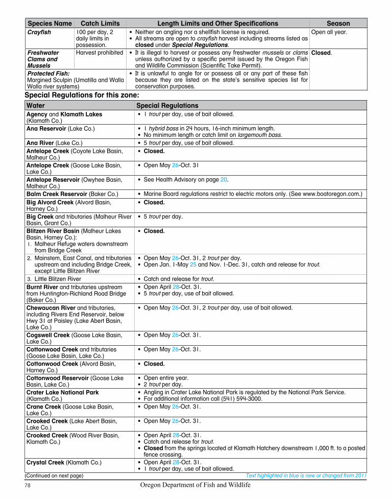
Oregon Department of Fish and Wildlife78
Text highlighted in blue is new or changed from 2011
Species Name Catch Limits Length Limits and Other Specifications SeasonCrayfish 100 per day, 2
daily limits in possession.
• Neither an angling nor a shellfish license is required.• All streams are open to crayfish harvest including streams listed as
closed under Special Regulations.
Open all year.
Freshwater Clams and Mussels
Harvest prohibited • It is illegal to harvest or possess any freshwater mussels or clams unless authorized by a specific permit issued by the Oregon Fish and Wildlife Commission (Scientific Take Permit).
Closed.
Protected Fish:Margined Sculpin (Umatilla and Walla Walla river systems)
• It is unlawful to angle for or possess all or any part of these fish because they are listed on the state’s sensitive species list for conservation purposes.
Special Regulations for this zone:Water Special RegulationsAgency and Klamath Lakes (Klamath Co.)
• 1 trout per day, use of bait allowed.
Ana Reservoir (Lake Co.) • 1 hybrid bass in 24 hours, 16-inch minimum length.• No minimum length or catch limit on largemouth bass.
Ana River (Lake Co.) • 5 trout per day, use of bait allowed.Antelope Creek (Coyote Lake Basin, Malheur Co.)
• Closed.
Antelope Creek (Goose Lake Basin, Lake Co.)
• Open May 26-Oct. 31
Antelope Reservoir (Owyhee Basin, Malheur Co.)
• See Health Advisory on page 20.
Balm Creek Reservoir (Baker Co.) • Marine Board regulations restrict to electric motors only. (See www.boatoregon.com.)Big Alvord Creek (Alvord Basin, Harney Co.)
• Closed.
Big Creek and tributaries (Malheur River Basin, Grant Co.)
• 5 trout per day.
Blitzen River Basin (Malheur Lakes Basin, Harney Co.):
Malheur Refuge waters downstream 1. from Bridge Creek
• Closed.
2. Mainstem, East Canal, and tributaries upstream and including Bridge Creek, except Little Blitzen River
• Open May 26-Oct. 31, 2 trout per day.• Open Jan. 1-May 25 and Nov. 1-Dec. 31, catch and release for trout.
Little Blitzen River3. • Catch and release for trout.Burnt River and tributaries upstream from Huntington-Richland Road Bridge (Baker Co.)
• Open April 28-Oct. 31.• 5 trout per day, use of bait allowed.
Chewaucan River and tributaries, including Rivers End Reservoir, below Hwy 31 at Paisley (Lake Abert Basin, Lake Co.)
• Open May 26-Oct. 31, 2 trout per day, use of bait allowed.
Cogswell Creek (Goose Lake Basin, Lake Co.)
• Open May 26-Oct. 31.
Cottonwood Creek and tributaries (Goose Lake Basin, Lake Co.)
• Open May 26-Oct. 31.
Cottonwood Creek (Alvord Basin, Harney Co.)
• Closed.
Cottonwood Reservoir (Goose Lake Basin, Lake Co.)
• Open entire year.• 2 trout per day.
Crater Lake National Park (Klamath Co.)
• Angling in Crater Lake National Park is regulated by the National Park Service.• For additional information call (541) 594-3000.
Crane Creek (Goose Lake Basin, Lake Co.)
• Open May 26-Oct. 31.
Crooked Creek (Lake Abert Basin, Lake Co.)
• Open May 26-Oct. 31.
Crooked Creek (Wood River Basin, Klamath Co.)
• Open April 28-Oct. 31.• Catch and release for trout.• Closed from the springs located at Klamath Hatchery downstream 1,000 ft. to a posted
fence crossing.Crystal Creek (Klamath Co.) • Open April 28-Oct. 31.
• 1 trout per day, use of bait allowed.(Continued on next page)

Oregon Department of Fish and Wildlife 79
Text highlighted in blue is new or changed from 2011
Water Special RegulationsDeming Creek including Campbell Reservoir diversion (Sprague Basin, Klamath Co.)
• Open May 26-Oct. 31.
Denio Creek (Alvord Basin, Harney Co.) • Closed.Dog Lake (Goose Lake Basin, Lake Co.) • Closed for trout.
• 3 bass per day, 15-inch minimum length.Drews Creek and tributaries (Goose Lake Basin, Lake Co.)
• Open May 26-Oct. 31.
Drews Reservoir (Goose Lake Basin, Lake Co.)
• 2 trout per day.
Dry Creek and tributaries (Goose Lake Basin, Lake Co.)
• Open May 26-Oct. 31.
Eagle Creek and tributaries (Powder River Basin, Baker/Union Co.)
• Open April 28-Oct. 31.• 5 trout per day, use of bait allowed.
Fort Creek (Wood River Basin, Klamath Co.)
• Open April 28-Oct. 31.• Catch and release for trout.
Fourmile Creek (Agency Lake Basin, Klamath Co.)
• Open entire year.• 1 trout per day, use of bait allowed.
Fourmile Lake (Klamath Co.) • 25 kokanee per day (no size limits) in addition to other trout species catch limit.Goose Lake (Goose Lake Basin, Lake Co.)
• Open May 26-Oct. 31.• 2 trout per day, artificial flies and lures.
Harriman Creek (Klamath Co.) • Open entire year.• 1 trout per day, use of bait allowed.
Higgins Reservoir (Baker Co.) • Open April 28-Oct. 31.• 2 trout per day, angling restricted to artificial flies and lures.• Marine Board regulations restrict to electric motors only. (See www.boatoregon.com.)
Indian Creek (Quinn Basin, Malheur Co.)
• Closed.
Jordan Creek (Owyhee Basin, Malheur Co.)
• See Health Advisory on page 20.• 5 trout per day, use of bait allowed.
Kelley Creek (Goose Lake Basin, Lake Co.)
• Open May 26-Oct. 31.
Kiger Creek and tributaries (Malheur Lakes Basin, Harney Co.)
• 5 trout per day, use of bait allowed.
Klamath Lake and Agency Lakes (Klamath Co.)
• 1 trout per day. Bait allowed as per Zone Regulations.
Klamath River (Klamath Co.): Lake Ewauna downstream to Keno 1. Dam
• Open entire year.• 1 trout per day, use of bait allowed.
2. Keno Dam downstream to JC Boyle Reservoir
• Open Jan. 1-June 15 and Oct. 1-Dec. 31.• 1 trout per day.
Boyle Dam downstream to Oregon/3. California border
• Open entire year.• 1 trout per day.• Catch and release for trout June 16-Sept. 30.• Closed from Boyle Dam to downstream side of bridge at flume crossing.
Krumbo Creek (Malheur Lakes Basin Harney Co.),
Above Krumbo Reservoir1.
• 5 trout per day, use of bait allowed.
2. Below Krumbo Reservoir • Closed.Krumbo Reservoir (Harney Co.) • Open April 28-Oct. 31Lake Creek and tributaries (Malheur River Basin, Grant Co.)
• 5 trout per day.
Lake of the Woods (Klamath Co.) • 25 kokanee per day (no size limits) in addition to other trout species catch limit.• No more than 1 bass over 15 inches, as part of daily limit.• Angling allowed 24 hours per day.
Larkin Creek (Klamath Co.) • Open to angling May 26-Oct. 31.Link River (Klamath Co.) • Open entire year.
• 1 trout per day• Use of bait allowed.
Little Alvord Creek (Alvord Basin, Harney Co.)
• Closed.
SO
UTH
EA
ST
Pages 72 - 81
(Continued on next page)

Oregon Department of Fish and Wildlife80
Text highlighted in blue is new or changed from 2011
Water Special RegulationsLost River and tributaries (Klamath Co.) • Open entire year.
• Use of bait allowed.Malheur River (Harney/Grant/Malheur Co.)
Mouth of Bluebucket Creek to Big 1. Creek.
• 5 trout per day.
2. Remainder of basin. • 5 trout per day, use of bait allowed.Malheur River, North Fork(Malheur/Harney/Grant/Baker Co.)
Mainstem and tributaries upstream of 1. Beulah Reservoir.
• 5 trout per day.
2. Mainstem downstream of Beulah Reservoir.
• 5 trout per day, use of bait allowed.
Mann Lake (Harney Co.) • 2 trout per day, 16-inch minimum length.• Restricted to artificial flies and lures.
Mann Lake tributaries (Harney Co.) • Closed.McCoy Creek, Little (Alvord Basin, Harney Co.)
• Closed.
Miller Creek (Outlet of Miller Lake, Klamath Co.)
• 5 trout per day, use of bait allowed.
Miller Creek (tributary to Lost River) • Open entire year.• Use of bait allowed.
Miller Lake (Klamath Co.) • 25 kokanee per day (no size limits) in addition to other trout species catch limit.• Angling allowed 24 hours per day.
Mosquito Creek (Alvord Basin, Harney Co.)
• Closed.
Odessa Creek (Klamath Co.) • Open entire year.• 1 trout per day, use of bait allowed.
Owyhee Reservoir and tributaries (Malheur Co.)
• See Health Advisory on page 20.• 5 trout per day, use of bait allowed.
Owyhee River from the mouth upstream to Owyhee Dam (Malheur Co.)
• 5 trout per day, use of bait allowed.• Catch and release for brown trout.
Phillips Reservoir (Baker Co.) • Catch and release only for tiger trout. See description of tiger trout on page 45.Pike Creek (Alvord Basin, Harney Co.) • Closed.Pine Creek (Goose Lake Basin, Lake Co.) • Open May 26-Oct. 31.Pine Creek and tributaries upstream from Oxbow Bridge (Baker Co.)
• Open April 28-Oct. 31.• Brook trout are part of the standard 5 trout per day over 8-inch bag limit.• 5 trout per day, use of bait allowed
Pilcher Creek Reservoir (Union Co.) • Open April 28-Oct. 31.Poison Creek Reservoir (Silvies Basin, Grant Co.)
• 2 trout per day, 8-inch minimum.• Use of bait allowed.
Powder River (Baker/Union Co.)Mainstem and tributaries upstream 1. from Huntington-Richland Road Bridge
• Open April 28-Oct. 31.• 5 trout per day, use of bait allowed.• Brook trout are part of the standard 5 trout per day over 8-inch bag limit.
2. Upstream from Hughes Lane Bridge near Baker City to Phillips Reservoir
• Open Jan. 1-April 27 and Nov. 1-Dec. 31, catch and release for trout, restricted to artificial flies and lures.
• Open April 28-Oct. 31, 5 trout per day, use of bait allowed.Rattlesnake Creek and tributaries (Malheur Lakes Basin, Harney Co.)
• 5 trout per day, use of bait allowed.
Recreation Creek (Klamath Co.) • Open entire year.• 1 trout per day, use of bait allowed.
Riddle Creek and tributaries (Malheur Lakes Basin, Harney Co.)
• 5 trout per day, use of bait allowed.
Sage Creek (Quinn Basin, Malheur Co.) • Closed.Sand Creek (Klamath Co.) • Open entire year.
• 5 trout per day, use of bait allowed.Scott Creek (Klamath Co.) • Open entire year.
• 5 trout per day, use of bait allowed.Sevenmile Creek downstream from Nicholson Road (Klamath Co.)
• Open April 28-Oct. 31.• Catch and release for trout.
Short Creek (Klamath Co.) • Open entire year; 1 trout per day; use of bait allowed.
(Continued on next page)

Oregon Department of Fish and Wildlife 81
Text highlighted in blue is new or changed from 2011
Water Special RegulationsSilvies River and tributaries (Malheur Lakes Basin, Grant/Harney Co.)
• 5 trout per day, use of bait allowed.
Silver Creek and tributaries (Malheur Lakes Basin, Crook/Harney Co.)
• 5 trout per day, use of bait allowed.
Skull Creek (Catlow Basin, Harney Co.) • Closed.Snake River and impoundments • See Snake River Zone (pages 84-85).Spencer Creek (Klamath Co.) • Open May 26-Oct. 31.Sprague River and tributaries (Klamath Co.):
Mouth upstream to Saddle Mountain 1. Pitt Road Bridge.
• Open May 26-Oct. 31.• 1 trout per day.• Angling restricted to artificial flies and lures only as per Zone Regulations.
2. Saddle Mountain Pitt Road Bridge (USFS Road 5850) upstream to Godowa Springs Road Bridge.
• Open April 28-Oct. 31.• Use of bait allowed.
Mainstem upstream from 3. Godowa Springs Road Bridge and tributaries not listed.
• Open April 28-Oct. 31.• 2 trout per day, 8-inch minimum length.• Angling restricted to artificial flies and lures only.
Spring Creek (Klamath Co.) • Open May 26-Oct. 31.• 2 rainbow trout per day, 8-inch minimum length, only 1 trout over 20 inches per day.• Angling restricted to artificial flies and lures only.• No limit on size or number of brook trout.
Tandy Creek (Goose Lake Basin, Lake Co.)
• Open May 26-Oct. 31.
Thomas Creek and tributaries (Goose Lake Basin, Lake Co.)
• Open May 26-Oct. 31.
Thomason Creek (Klamath Co.) • Open entire year; 1 trout per day; use of bait allowed.Threemile Creek (Catlow Basin, Harney Co.)
• Closed.
Threemile Creek (Klamath Co.) • Closed upstream of Westside Road.Unity Reservoir (Baker Co.) • Closed within 200 feet of Dam Jan. 1-March 31 and Dec. 1-31.Van Horn Creek (Alvord Basin, Harney Co.) • Closed.Whitehorse Creek Drainage (Coyote Lake Basin, Harney/Malheur Co.)
• Catch and release angling for Lahontan cutthroat trout.
Williamson River (Klamath Co.):Mouth upstream to Modoc Point Road 1. Bridge. (The mouth of the Williamson River is located by marker buoys and the river channel extends upstream within the vegetation lined banks through Klamath Lake at high lake levels)
• Open May 26-Oct. 31.• 1 trout per day.
2. Modoc Point Road Bridge upstream to Chiloquin Bridge.
• Open May 26-Oct. 31.• 1 trout per day May 26-July 31.• Catch and release for trout Aug. 1-Oct. 31.• No angling from motor-propelled craft while motor is operating.
Chiloquin Bridge to Kirk Bridge.3. • Open May 26-Oct. 31.• 1 trout per day May 26-July 31.• Catch and release for trout Aug. 1-Oct. 31.• No angling from a floating device.
Kirk Bridge upstream to 4. headwaters. • Open April 28-Oct. 31.• 2 trout per day, except no limit on size or number of brook trout.• No angling from a floating device.
Willow Creek (Alvord Basin, Harney Co.) • Closed.Willow Creek Drainage (Coyote Lakes Basin, Harney/Malheur Co.)
• Catch and release angling for Lahontan cutthroat trout.
Willow Valley Reservoir (Klamath Co.) • Bass catch limits 1 per day, 15 inches minimum length.Wood River (Klamath Co.) from mouth (mouth of Wood River extends through the Wood River Delta to emergent veg-etation line in Agency Lake) upstream including tributaries, except Annie Creek
• Open April 28-Oct. 31.• Catch and release for trout.
SO
UTH
EA
ST
Pages 72 - 81

Oregon Department of Fish and Wildlife82
Text highlighted in blue is new or changed from 2011
Brownlee Reservoir
Oxbow Reservoir
Hells Canyon Reservoir
W A L L O W A
B A K E R
86
SU
MM
I T
RI D
GE
I D A H O
WallowaLake
Oxbow Bridge
Richland -Huntington
Road Bridge
I D A H O
Snak
e R
iver
Imnaha River
Eagl
e Cre
ek
Lostine River
Powder River
Big S he
ep C
re
ek
Pine Cr
Wallowa River Lit
tle S
heep Creek
03
203
86
413
129
350
82
71
Promise Reservoir Dam
Somers Point
Cactus Mountain
Lookout Mountain
Carson
Joseph
Imnaha
Pondosa
Wallowa
Lostine
Halfway
Richland
Homestead
Enterprise
Snake River Zone
0 5 10 15 20Miles
LegendDams
Falls
Boat Ramp
Other Landmarks
County boundaries
Bridges

Oregon Department of Fish and Wildlife 83
Text highlighted in blue is new or changed from 2011
Brownlee Reservoir86
84
Burnt River Bridge
Weiser Bridge
Payette Bridge
Ontario Spur Bridge
Nyssa Bridge
Sugarloaf Mountain
Richland -Huntington Road Bridge
Pow der River86
71
203
245
201
07
451
52
20
26
95
95
30
84
Snake River
Malheur River
Burnt River
Bully Creek
Willow Creek
Owy
hee
Rive
r
Pine Creek
Snak
e Ri
ver
B A K E R
I D A H O
M A L H E U R
Vale
Nyssa
Baker
Owyhee
Adrian
Brogan
Durkee
Ontario
Kingman
Halfway
Jamieson
Richland
Huntington
Willowcreek
Brownlee Reservoir Dam
Snake River Zone
0 5 10 15 20Miles
Legend
Boat Ramp
Other Landmarks
Dams
Falls
County boundaries
Bridges
SN
AK
E R
IVE
RP
ages 82 - 85

Oregon Department of Fish and Wildlife84
Text highlighted in blue is new or changed from 2011
Description:The Snake River Zone is all the waters of the Snake River from the Oregon-Washington border upstream to the Oregon-Idaho border. The boundary between the Snake River and its tributaries is defined as a straight line across the mouths of all rivers. The Snake River Zone includes the portions of the Burnt and Powder rivers downstream of the Huntington-Richland Road near their mouths and includes the portion of Pine Creek downstream of the Oxbow Bridge.Instructions:
Read the 1. Special Regulations for this zone. Special Regulations apply to specific bodies of water or portions of water within a zone. If specific references to a body of water, species, catch limits, length limits, seasons, or other specifications are not made in the Special Regulations for this zone, then Zone Regulations apply.Read the following 2. Regulations for this zone.Always read the 3. General Regulations, pages 5-12, which apply to all zones, for information about licenses; tags and permits; definitions; catch and possession limits; gear and bait restrictions; and harvest methods and hours, before going fishing.Emergency or permanent rules adopted since 4. these rules were printed may supersede these regulations. Anglers may call ODFW headquarters or regional offices at the numbers on page 4 of these regulations, or check the ODFW web site, www.dfw.state.or.us for these rules, or call 503-947-6000 during normal business hours.
Regulations for this zone:Where the Snake River forms the boundary between Oregon and Idaho, the following rules apply:1. a. License of either state is valid in the Snake River when angling from a floating device. However, when fishing tributaries, sloughs or
from sloughs or from lands within either state, the angler must be licensed by the state where the waters (or land) are located.b. Anglers must follow the rules of the licensing state.c. Anglers are restricted to one daily catch limit, even if licensed by both states.d. Anglers may launch and take out their boats from either state, regardless of licensing state.
2. See health advisories on page 20.
Species Name Catch Limits Length Limits and Other Specifications SeasonTrout 6 per day,
2 daily limits in possession.
• No minimum length limit.• Only 1 trout over 20 inches in length may be taken per day, upstream
of Hells Canyon Dam.• Closed to angling for bull trout.• Rainbow trout over 20 inches are considered steelhead downstream
of Hells Canyon Dam.
Open all year.
Salmon • Closed. Closed.Steelhead 3 per day. • See Snake River entry from Oregon-Washington border upstream
to Hells Canyon Dam.• Only adipose fin-clipped steelhead may be kept.• Restricted to barbless hooks for adipose fin-clipped steelhead.• No annual limit on adipose fin-clipped steelhead as long as the
appropriate number of Hatchery Harvest Tags has been purchased to record the fish.
Closed in all waters unless noted by species under Special Regulations.
Warmwater Game Fish:Largemouth and Smallmouth Bass
6 per day, 2 daily limits in possession.
• No more than 3 over 15 inches in length. Open all year.
Bluegill, Catfish, Crappie, Other Sunfish, Walleye, and Yellow Perch
No limit. • None.
Other Fish:Sucker, Carp, Chub, Northern Pikeminnow, Sculpin, Whitefish, Shad and other Nongame Fish
No limit. • None.
Sturgeon Catch and release only.
• Angling restricted to one single-point, barbless hook for sturgeon.• Sturgeon may not be removed from the water and must be immedi-
ately released unharmed.Bullfrogs No limit. • An angling license is not required.Crayfish 100 per day,
2 daily limits in possession.
• Neither an angling nor a shellfish license is required.
Freshwater Clams and Mussels
Harvest prohibited • It is illegal to harvest or possess any freshwater mussels or clams unless authorized by a specific permit issued by the Oregon Fish and Wildlife Commission (Scientific Take Permit).
Closed.
SNAKE RIVER ZONE
(Continued on next page)
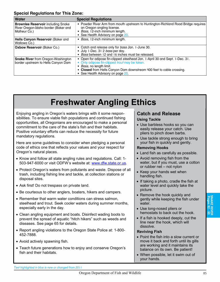
Oregon Department of Fish and Wildlife 85
Text highlighted in blue is new or changed from 2011
SN
AK
E R
IVE
RP
ages 82 - 85Special Regulations for This Zone:Water Special RegulationsBrownlee Reservoir including Snake River Oregon-Idaho border (Baker and Malheur Co.)
• Powder River Arm from mouth upstream to Huntington-Richland Road Bridge requires an Oregon angling license.
• Bass, 12-inch minimum length.• See Health Advisory on page 20.
Hells Canyon Reservoir (Baker and Wallowa Co.)
• Bass, 12-inch minimum length.
Oxbow Reservoir (Baker Co.) • Catch and release only for bass Jan. 1-June 30.• July 1-Dec. 31 2 bass per day.• Bass between 12 and 16 inches must be released.
Snake River from Oregon-Washington border upstream to Hells Canyon Dam
• Open for adipose fin-clipped steelhead Jan. 1-April 30 and Sept. 1-Dec. 31.• Only adipose fin-clipped trout may be taken.• Bass, no length limit.• Closed from Hells Canyon Dam downstream 400 feet to cable crossing.• See Health Advisory on page 20.
Freshwater Angling EthicsEnjoying angling in Oregon’s waters brings with it some respon-sibilities. To ensure viable fish populations and continued fishing opportunities, all Oregonians are encouraged to make a personal commitment to the care of the state’s fish and their habitats. Positive voluntary efforts can reduce the necessity for future mandatory regulations.
Here are some guidelines to consider when pledging a personal code of ethics one that reflects your values and your respect for Oregon’s natural places.
• Know and follow all state angling rules and regulations. Call: 1-503-947-6000 or visit ODFW’s website at: www.dfw.state.or.us.
• Protect Oregon’s waters from pollutants and waste. Dispose of all trash, including fishing line and tackle, at collection stations or disposal sites.
• Ask first! Do not trespass on private land.
• Be courteous to other anglers, boaters, hikers and campers.
• Remember that warm water conditions can stress salmon, steelhead and trout. Seek cooler waters during summer months, especially early in the day.
• Clean angling equipment and boats. Disinfect wading boots to prevent the spread of aquatic “hitch hikers” such as weeds and diseases. See page 65 for details.
• Report angling violations to the Oregon State Police at: 1-800-452-7888.
• Avoid actively spawning fish.
• Teach future generations how to enjoy and conserve Oregon’s fish and their habitats.
Catch and ReleaseUsing Tackle• Use barbless hooks so you can
easily release your catch. Use pliers to pinch down barbs.
• Use tackle strong enough to bring your fish in quickly and gently.
Removing Hooks• Land fish as carefully as possible.• Avoid removing fish from the
water, but if you must, use a cotton or rubber net – not nylon
• Keep your hands wet when handling fish.
• If taking a photo, cradle the fish at water level and quickly take the picture.
• Remove the hook quickly and gently while keeping the fish under water.
• Use long-nosed pliers or hemostats to back out the hook.
• If a fish is hooked deeply, cut the line near the hook, which will dissolve.
Reviving Fish• Point the fish into a slow current or
move it back and forth until its gills are working and it maintains its balance on its own. Be patient!
• When possible, let it swim out of your hands.
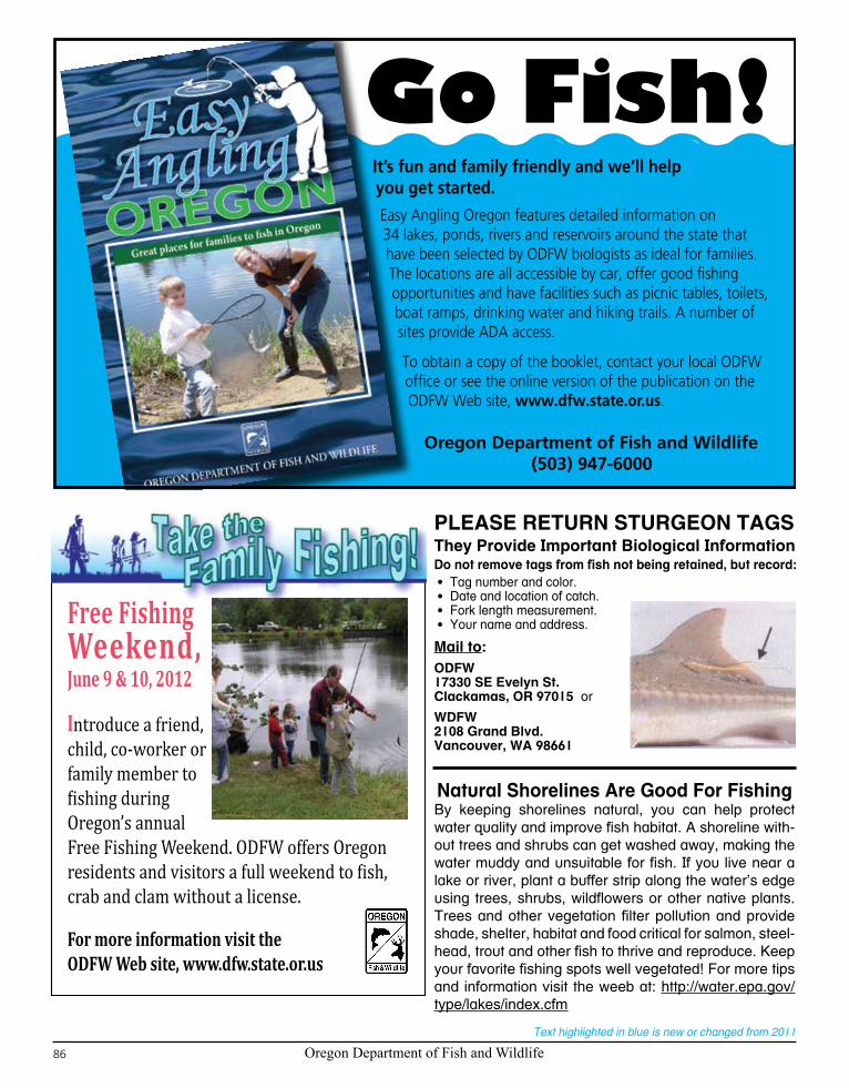
Oregon Department of Fish and Wildlife86
Text highlighted in blue is new or changed from 2011
It’s fun and family friendly and we’ll help you get started.
Easy Angling Oregon features detailed information on 34 lakes, ponds, rivers and reservoirs around the state that have been selected by ODFW biologists as ideal for families. The locations are all accessible by car, offer good fishing opportunities and have facilities such as picnic tables, toilets, boat ramps, drinking water and hiking trails. A number of sites provide ADA access. To obtain a copy of the booklet, contact your local ODFW office or see the online version of the publication on the ODFW Web site, www.dfw.state.or.us.
Oregon Department of Fish and Wildlife(503) 947-6000
Go Fish!
Free Fishing Weekend, June 9 & 10, 2012
Introduce a friend, child, co-worker or family member to fishing during Oregon’s annual Free Fishing Weekend. ODFW offers Oregon residents and visitors a full weekend to fish, crab and clam without a license.
For more information visit the ODFW Web site, www.dfw.state.or.us
PLEASE RETURN STURGEON TAGSThey Provide Important Biological InformationDo not remove tags from fish not being retained, but record:• Tag number and color.• Date and location of catch.• Fork length measurement.• Your name and address.
Mail to:ODFW17330 SE Evelyn St.Clackamas, OR 97015 or
WDFW2108 Grand Blvd.Vancouver, WA 98661
Natural Shorelines Are Good For FishingBy keeping shorelines natural, you can help protect water quality and improve fish habitat. A shoreline with-out trees and shrubs can get washed away, making the water muddy and unsuitable for fish. If you live near a lake or river, plant a buffer strip along the water’s edge using trees, shrubs, wildflowers or other native plants. Trees and other vegetation filter pollution and provide shade, shelter, habitat and food critical for salmon, steel-head, trout and other fish to thrive and reproduce. Keep your favorite fishing spots well vegetated! For more tips and information visit the weeb at: http://water.epa.gov/type/lakes/index.cfm
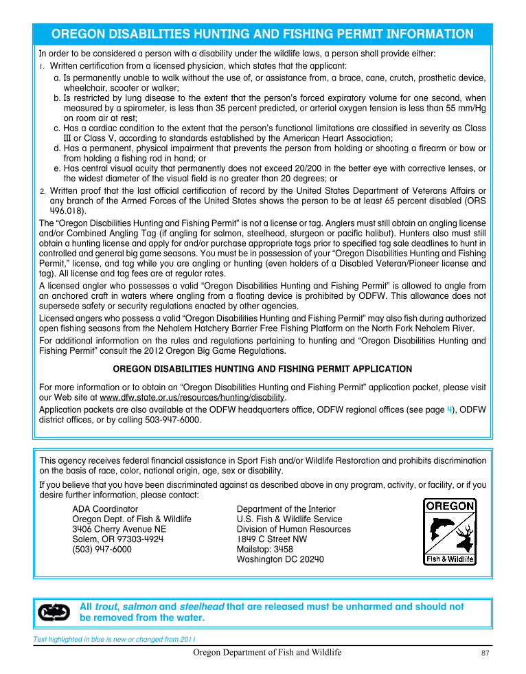
Oregon Department of Fish and Wildlife 87
Text highlighted in blue is new or changed from 2011
OREGON DISABILITIES HUNTING AND FISHING PERMIT INFORMATIONIn order to be considered a person with a disability under the wildlife laws, a person shall provide either:
Written certification from a licensed physician, which states that the applicant:1.
a. Is permanently unable to walk without the use of, or assistance from, a brace, cane, crutch, prosthetic device, wheelchair, scooter or walker;
b. Is restricted by lung disease to the extent that the person’s forced expiratory volume for one second, when measured by a spirometer, is less than 35 percent predicted, or arterial oxygen tension is less than 55 mm/Hg on room air at rest;
c. Has a cardiac condition to the extent that the person’s functional limitations are classified in severity as Class III or Class V, according to standards established by the American Heart Association;
d. Has a permanent, physical impairment that prevents the person from holding or shooting a firearm or bow or from holding a fishing rod in hand; or
e. Has central visual acuity that permanently does not exceed 20/200 in the better eye with corrective lenses, or the widest diameter of the visual field is no greater than 20 degrees; or
2. Written proof that the last official certification of record by the United States Department of Veterans Affairs or any branch of the Armed Forces of the United States shows the person to be at least 65 percent disabled (ORS 496.018).
The “Oregon Disabilities Hunting and Fishing Permit” is not a license or tag. Anglers must still obtain an angling license and/or Combined Angling Tag (if angling for salmon, steelhead, sturgeon or pacific halibut). Hunters also must still obtain a hunting license and apply for and/or purchase appropriate tags prior to specified tag sale deadlines to hunt in controlled and general big game seasons. You must be in possession of your “Oregon Disabilities Hunting and Fishing Permit,” license, and tag while you are angling or hunting (even holders of a Disabled Veteran/Pioneer license and tag). All license and tag fees are at regular rates.A licensed angler who possesses a valid “Oregon Disabilities Hunting and Fishing Permit” is allowed to angle from an anchored craft in waters where angling from a floating device is prohibited by ODFW. This allowance does not supersede safety or security regulations enacted by other agencies.Licensed angers who possess a valid “Oregon Disabilities Hunting and Fishing Permit” may also fish during authorized open fishing seasons from the Nehalem Hatchery Barrier Free Fishing Platform on the North Fork Nehalem River.For additional information on the rules and regulations pertaining to hunting and “Oregon Disabilities Hunting and Fishing Permit” consult the 2012 Oregon Big Game Regulations.
OREGON DISABILITIES HUNTING AND FISHING PERMIT APPLICATION
For more information or to obtain an “Oregon Disabilities Hunting and Fishing Permit” application packet, please visit our Web site at www.dfw.state.or.us/resources/hunting/disability.Application packets are also available at the ODFW headquarters office, ODFW regional offices (see page 4), ODFW district offices, or by calling 503-947-6000.
This agency receives federal financial assistance in Sport Fish and/or Wildlife Restoration and prohibits discrimination on the basis of race, color, national origin, age, sex or disability.
If you believe that you have been discriminated against as described above in any program, activity, or facility, or if you desire further information, please contact:
ADA Coordinator Department of the Interior Oregon Dept. of Fish & Wildlife U.S. Fish & Wildlife Service 3406 Cherry Avenue NE Division of Human Resources Salem, OR 97303-4924 1849 C Street NW (503) 947-6000 Mailstop: 3458 Washington DC 20240
All trout, salmon and steelhead that are released must be unharmed and should not be removed from the water.
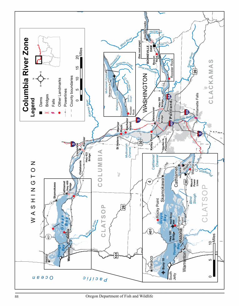
Oregon Department of Fish and Wildlife88
Text highlighted in blue is new or changed from 2011
(See
nex
t pag
e)
Will
amet
te F
alls
Hay
den
Is.
Pow
erlin
es
War
rior
Roc
k
Bac
helo
rIs
land
4
35
14
101
26
5
205
405
5
84
5
526
Youn
gs
Gr
ay
s
Ba
yB
ay
Hw
y 43
3B
ridge
I-5
Brid
geH
wy
205
Brid
ge
Yo
ungs R
iver
Kal
ama
Riv
er
WA
SH
IN
GT
ON
WA
SH
ING
TON
Sand
y R
iver
Mul
tnom
ahC
hann
el
Willamette River
Washougal River
Wind River
Tanner CrEagle Cr
Herman Cr
BO
NN
EVIL
LED
AM
401
30
PacificOcean
Bea
con
Roc
k
Roo
ster
Roc
k
Kel
ley
Poin
t
War
rent
onA
stor
ia
St H
elen
s
Cla
tska
nie
Cas
cade
Loc
ks
Po
rtla
nd
Rai
nier
Cat
hlam
et
Long
view
Vanc
ouve
r
IIwac
o
Skam
okaw
a
Hw
y 40
9B
ridge
WA
SCO
CL
AC
KA
MA
S
TILL
AM
OO
K
CL
AT
SO
P
YAM
HIL
L
CO
LU
MB
IA
WA
SHIN
GTO
N
Col
umbi
a R
iver
Zon
e
30Pu
get I
s.
Cat
hlam
etC
hann
el
Blin
dS
loug
h
POW
ERLIN
ER
ed B
uoy
#44
Roc
ky P
oint
Hw
y 40
9 B
r.
Buo
y 10
CLA
TS
OPW
auna
Pow
erLi
nes4
401
Youn
gs Bay
Gra
ys
Bay
Hw
y 10
1B
ridge
Plympton CrW
ASH
ING
TON
STA
TE
Sou
thJe
ttyTo
ngue
Po
int
Wau
na
War
rent
onAs
toria
Cla
tska
nie
Cat
hlam
et
IIwac
o
Skam
okaw
a
05
10M
iles
05
1015
20M
iles
Horseta
il Cr
Oneonta Creek
Brid
al V
eil C
r
Wah
keen
a C
reekM
ultn
omah
Cre
ek
Roo
ster
Roc
k
Skam
ania
Is.
Sand
Is.
Slou
gh
Mar
ker 8
2
Lege
nd Dam
s
Brid
ges
Oth
er L
andm
arks
Falls
Pow
erlin
esC
ount
y bo
unda
ries

Oregon Department of Fish and Wildlife 89
Text highlighted in blue is new or changed from 2011
WA
SH
IN
GT
ON
Hood Rive
r
White Salmo n River
Deschute
s Riv
er
John Day River
Umat
illa
Riv
er
Sandy
Riv
er
Wind Rive
r
Cas
cade
Lock
sH
ood
Riv
er
The
Dal
les
Bigg
s
Arlin
gton
Um
atill
aU
mat
illa
Irrig
on
TOW
ER IS
LAND
POW
ERLINES
She
rars
Fal
ls
Ruf
us
OR
/WA
Bor
der
14
197
30
197
84
26
Hw
y 20
5 B
ridge
Kal
ama
Riv
er
Washougal River
26
35
14
14
9719
74
395
395
84
Roo
ster
Roc
k
Lyle
Mar
yhill
Roo
seve
lt
UM
ATIL
LA
WA
SC
O
MO
RR
OW
WH
EELE
R
GIL
LIA
M
CLA
CK
AM
AS
SHER
MA
N
HO
OD
RIV
ER
MC
NA
RY
DA
M
THE
DA
LLES
DA
M
JOH
N D
AYD
AM
Col
umbi
a R
iver
Zon
e
09
1827
36M
iles
Bea
con
Roc
k
Cas
cade
Loc
ks
BO
NN
EVIL
LE D
AM
Rob
ins
Isla
nd
Brad
ford
Isla
nd
14
Ham
ilton
Isla
nd
Bon
nevi
lleCas
cade
Oxb
ow
Stev
enso
n84 Herman Creek
Eagle Creek
Tanner Creek
HO
OD
RIV
ER
01
23
4 Mile
s
Lege
nd Dam
sBr
idge
sH
atch
erie
sO
ther
Lan
dmar
ks
Cou
nty
boun
darie
sPo
wer
lines
CO
LUM
BIA
Pages 88 - 95

Oregon Department of Fish and Wildlife90
Text highlighted in blue is new or changed from 2011
Oregon
Washington
Youngs Bay
Blind Slough/Knappa Slough
5
10 15
2025 30
35
40
45
Walluski River
Lewis and Clark River
Old 101Bridge
HWY 101Bridge
Alternate HWY 101Bridge
Tucker Slough
Youngs River
KlaskanineRiver
South Fork
North Fork
Klaskanine Hatchery
CEDC Hatchery
CEDC Net Pen Site
Battle Creek
Slough
Youngs River Falls
1st Falls
Olney Bridge
ASTORIA
0 5 10Miles
0 1 2Miles

Oregon Department of Fish and Wildlife 91
Text highlighted in blue is new or changed from 2011
McKenzie Head
Cape Disappointment
PACIFIC OCEAN
North Jetty
South Jetty
Columbia RiverColumbia Recreational
Control Z
one
Sand Is.
46° 15’ 48” N/124° 05’ 20” W
Buoy 746° 15’ 09” N/124° 06’ 18” W
Buoy 446° 13’ 35” N/124° 06’ 50” W
Buoy 10Eastern boundary of CZformed by n/s line bearing357 degrees true from:46° 14’ 00” N/124° 03’ 07” W
Clatsop Spit
46° 14’ 03” N/124° 04’ 05” W
ColumbiaControlZone
Prai
rie C
hann
elKarlson Island
Minaker Island
Big C
reek
O r e g o n
Knappa
Slou
gh
Prairie Channel
Gnat Creek
Aldrich PointRoad Bridge
Net Pen SiteBlind Slough
0 1 2Miles
CO
LUM
BIA
Pages 88 - 95

Oregon Department of Fish and Wildlife92
Text highlighted in blue is new or changed from 2011
Description:The Columbia River Zone is all waters of the Columbia River upstream from a north-south line through Buoy 10 at the river mouth and includes those portions of tributaries (including lakes) downstream from the mainline railroad bridges near the tributaries’ mouths except for the Willamette (including Multnomah Channel), Sandy, Hood, Deschutes and Umatilla river systems. The Columbia River Zone includes downstream from Hwy 730 on the Umatilla River and from Interstate 84 on the Deschutes River. The boundary is a straight line across the mouths of the Willamette (including Multnomah Channel), Sandy and Hood rivers.Oregon and Washington state waters are defined by the state line which lies within the waters of the Columbia River. In the area from the mouth upstream to Altoona, WA (Rivermile 24), the state line is near the Washington shore. In the area from Altoona, WA upstream to above McNary Dam (except near mainstem dams) the state line is in the middle of the ship channel.Instructions:
Read the 1. Special Regulations for this zone. Special Regulations apply to specific bodies of water or portions of water within a zone. If specific references to a body of water, species, catch limits, length limits, seasons, or other specifications are not made in the Special Regulations for this zone, then Zone Regulations apply.Read the following 2. Regulations for this zone.Always read the 3. General Regulations, pages 5-12, which apply to all zones, for information about licenses; tags and permits; defi-nitions; catch and possession limits; gear and bait restrictions; and harvest methods and hours, before going fishing.Emergency or permanent rules adopted since 4. these rules were printed may supersede these regulations. Anglers may call ODFW headquarters or regional offices at the numbers on page 4 of these regulations, or check the ODFW web site, www.dfw.state.or.us for these rules, or call 503-947-6000 during normal business hours.
Regulations for this zone:In the Columbia River where it forms the state boundary line, not including tributaries, sloughs and lands, the following rules apply:1. a. License and tags of either state are valid except when the other state’s season is closed;b. Anglers must follow the rules of the state in which they are fishing;c. Anglers are restricted to one daily catch limit for all fish species from the Columbia River, even if licensed in Oregon and Washington;d. Anglers are restricted to one annual catch limit of white sturgeon from the Columbia River and the lower Willamette River
including Multnomah Channel and the Gilbert River, even if licensed in Oregon and Washington;e. Anglers with a valid resident or non-resident license issued by either Oregon or Washington may launch or take out their boats
from either shore.2. When fishing on tributaries, sloughs or from the land of a state, the angler must be licensed by that state and obey all angling
regulations of that state.For the mainstem Columbia River 3. salmon and steelhead fishery upstream of the Rocky Point-Tongue Point line to McNary Dam from February 15 through June 15, it is unlawful when fishing from vessels which are less than 30 feet in length, substantiated by U.S. Coast Guard documentation or Marine Board registration, to totally remove from the water any salmon or steelhead required to be released.
Note: Mainstem Columbia River fisheries for salmon, steelhead and sturgeon are co-managed by the Oregon and Washington Departments of Fish and Wildlife and the four Treaty Tribes, represented by the Columbia River Inter-Tribal Fish Commission. Based on discussions among the co-management agencies, Oregon may adopt in-season changes to sport fishery regulations in the Columbia River. Regulation changes can occur on short notice and will be made available to ODFW field offices, the news media and license agents. Anglers can check the status of regulations prior to fishing the Columbia River by checking the ODFW web site: www.dfw.state.or.us for these rules, or calling 503-947-6000 during normal business hours.
Species Name Catch Limits Length Limits and Other Specifications SeasonTrout 2 per day, 2
daily limits in possession.
• 12-inch minimum length.• Only cutthroat trout may be kept. All cutthroat trout must be fin-
clipped.• Closed to angling for bull trout.
Open Jan. 1- March 31 and May 26-Dec. 31.
Salmon and Steelhead
In the aggregate: 2 adult salmon or steelhead per day, 20 per year. 5 jack salmon per day, 2 daily jack limits in possession.
• Only adipose fin-clipped steelhead may be kept.• Closed for sockeye and chum salmon.• See Special Regulations in Columbia River Zone to determine
where harvest of any Chinook or coho salmon is allowed. Harvest of nonadipose fin-clipped steelhead is not permitted in the Columbia River Zone.
• There is no annual limit on adipose or otherwise fin-clipped salmon or adipose fin-clipped steelhead so long as the appropriate number of Hatchery Harvest Tags have been purchased to record the catch.
NOTE: Changes to salmon regulations for the Columbia River system are printed in May and are available at ODFW offices or from license agents. Check for new regulations before you fish.
Closed in all waters unless noted by species under Special Regulations.
Warmwater Game Fish:Largemouth and Smallmouth Bass
5 per day, 2 daily limits in possession.
• No more than 3 bass over 15 inches in length.
Note: See Special Regulations for bass above McNary Dam.
Open all year.
Striped Bass 2 per 24 hours; 2 daily limits in possession.
• 24-inch minimum length.
COLUMBIA RIVER ZONE

Oregon Department of Fish and Wildlife 93
Text highlighted in blue is new or changed from 2011
Species Name Catch Limits Length Limits and Other Specifications SeasonWarmwater Game Fish:Bluegill, Catfish, Crappie, other Sunfish, and Yellow Perch
No limit. • None. Open all year.
Walleye 10 per day, 2 daily limits in posession
• No more than 5 per day over 18 inches and only one may be over 24 inches.
Other Fish:Shad
No limit. • Shad angling closed from Buoy 10 line upstream to Bonneville Dam April 1-May 15.
Open all year except as listed under Other Specifications.
Sturgeon 1 per day, 5 per year.
• Closed to retention of green sturgeon.• See page 86 for tag return information.• 38-inch minimum and 54-inch maximum fork length from river mouth
upstream to The Dalles Dam except the minimum length down-stream of Wauna power lines is 41-inch fork length effective May 1.
• 43-inch minimum and 54-inch maximum fork length from The Dalles Dam upstream to the Oregon-Washington border
• All oversized, undersized, and unwanted legal size white sturgeon must be immediately released unharmed into the water.
• Oversize sturgeon cannot be removed totally or in part from the water.• Only one single-point, barbless hook may be used for sturgeon.• Catch and release of sturgeon may continue after taking the daily or
annual limit or when quota is reached.
NOTE: Sturgeon fisheries are managed on a quota basis. Anglers should check the status of regulations prior to fishing.Catch and Release: Open all year, except as noted under Special Regulations.
Northern Pikeminnow, Carp, Sucker, Chub, Sculpin, Whitefish and other Nongame Fish
No limit. • None. Open all year.
Smelt Closed. • Unlawful to take or attempt to take Eulachon smelt in inland waters including bays, estuaries, rivers and streams. See ODFW website for smelt identification guide.
Closed all year.
Crayfish 100 per day, 2 daily limits in possession.
• Neither an angling nor a shellfish license is required. Open all year.
Freshwater Clams and Mussels
Harvest prohibited • It is illegal to harvest or possess any freshwater mussels or clams unless authorized by a specific permit issued by the Oregon Fish and Wildlife Commission (Scientific Take Permit).
Closed all year.
Bullfrogs No limit. • An angling license is not required. Open all year.Marine Fish and Marine Shellfish (other than Eulachon Smelt)
See Marine Zone pages 100-103. (Marine Zone regulations for marine fish and marine shellfish only apply to Columbia River downstream of Tongue Point/Rocky Point line at the mouth of the Columbia River.)
Special Regulations for this zone:Water Special RegulationsColumbia River:
Buoy 10 line upstream to a line 1. projected from Rocky Point on the Washington bank through red buoy 44 to the navigation light at Tongue Point on the Oregon bank
See Health Advisory on page 20.
(Continued on next page)
• Closed for trout.• Open for adipose fin-clipped steelhead Jan. 1-March 31 and Aug. 1-Dec. 31.• Open for adipose fin-clipped Chinook salmon and adipose fin-clipped coho salmon
Jan. 1-March 31.• Open for Chinook salmon and adipose fin-clipped coho Aug. 1-Dec. 31, except only adult
Chinook salmon and adult adipose fin-clipped coho salmon may be kept Aug. 1-Sept. 30.• Minimum sizes for adult salmon are 24 inches for Chinook salmon and 16 inches for
coho salmon.• The Columbia River South Jetty is open to salmon fishing seven days a week when the
fall Buoy 10 or adjacent ocean salmon fishery is open. Before Aug. 1 barbless hooks are required.
• In the waters of the Pacific Ocean and in the Columbia River upstream to a line projected from Rocky Point on the Washington bank through Red Buoy 44 to the navigation light at Tongue Point on the Oregon bank, each angler aboard a vessel may continue to use angling gear until the daily limit of fish for all legally licensed and juvenile anglers aboard has been achieved. However, no individual angler may exceed any personal daily bag limit.
CO
LUM
BIA
Pages 88 - 95

Oregon Department of Fish and Wildlife94
Text highlighted in blue is new or changed from 2011
Water Special RegulationsColumbia River (continued):2. A line projected from Rocky Point on
the Washington bank through Red Buoy 44 to the navigation light at Tongue Point on the Oregon bank upstream to I-5 Bridge
• Open for adipose fin-clipped Chinook salmon, adipose fin-clipped coho salmon and adipose fin-clipped steelhead Jan. 1-March 31.
• Open for adipose fin-clipped jack Chinook salmon and adipose fin-clipped steelhead May 16-July 31.
• Open for Chinook salmon, adipose fin-clipped coho salmon and adipose fin-clipped steelhead Aug. 1-Dec. 31.
• Minimum length for jack salmon is 12 inches.• Angling from Big Creek railroad trestle bridge near mouth closed Sept. 1-30.• See Health Advisory on page 20.
I-5 Bridge upstream to Bonneville Dam3. • Closed for trout.• Open for adipose fin-clipped steelhead Jan. 1-March 31 and June 16-Dec. 31.• Open for adipose fin-clipped jack Chinook salmon June 16-July 31.• Open for Chinook and adipose fin-clipped coho salmon Aug. 1-Dec. 31.• Minimum length for jack salmon is 12 inches.• Closed:
1. Between markers located 150 feet upstream and 450 feet downstream from the mouth of Tanner Creek out to center of the Columbia River Aug. 16-Oct. 15;
2. Inside the south navigation lock at Bonneville Dam from a marker on the western-most point of Robins Island to a marker on the Oregon mainland shore.
• Bank angling prohibited:1. From Bradford Island below Bonneville Dam from south shore between the dam and
a line perpendicular to the shoreline marker at west end of riprap and from north shore between fishway entrance and a line perpendicular to the shoreline marker 850 feet downstream;
2. From Robins Island below Bonneville Dam downstream to a line perpendicular to the shoreline marker on mooring cell.
• Angling from a floating device or using a floating device to set lines is prohibited in the area between Bonneville Dam and a line crossing the river downstream from the dam marked by the boat-restricted zone sign on the Oregon shore at the western-most tip of Robins Island to the boat-restricted zone sign approximately 50 feet upstream of the Hamilton Island boat ramp on the Washington shore (USACE Boat Restricted Zone).
• Angling for sturgeon is prohibited from May 1 through Aug. 31 from Bonneville Dam downstream to a line crossing the Columbia River from Navigation Marker 82 on the Oregon shore through the upstream exposed end of Skamania Island, continuing to a sign on the Washington shore.
• Angling for salmon from a floating device is prohibited from Beacon Rock upstream to Bonneville Dam Nov. 1-Dec. 31.
Bonneville Dam upstream to Oregon/4. Washington border located upstream of McNary Dam
• See Health Advisory on page 20.• Closed for trout.• Open for adipose fin-clipped steelhead Jan. 1-March 31 and June 16-Dec. 31.• Open for adipose fin-clipped jack Chinook salmon June 16-July 31.• Open for Chinook and coho salmon Aug. 1-Dec. 31. Only adipose fin-marked coho
salmon may be retained between Bonneville Dam and the Hood River bridge at Rivermile 169.
• Minimum length for jack salmon is 12 inches.• Open for sturgeon retention Jan. 1-until quota reached, catch and release may continue
after quota reached.• Angling for sturgeon is prohibited from the west end of the grain silo at Rufus upstream
to John Day Dam May 1-July 31.• Angling for sturgeon is prohibited from Highway 82 Bridge (Highway 395) near Umatilla
upstream to McNary Dam May 1-July 31.• Retention of white sturgeon only allowed Feb. 1 through July 31 from McNary Dam
upstream to the Oregon/Washington border.• When angling for salmon and adipose fin-clipped steelhead, a single-point hook with
a gap size no larger than 3/4 inch is required for all non-buoyant lures Aug. 1-Dec. 31 from Bonneville Dam to the Oregon/Washington border. Non-buoyant lures sink in freshwater.
• Angling for salmon (June 16-Dec. 31) and adipose fin-clipped steelhead (Jan. 1- March 31 and June 16-Dec. 31) is allowed 24 hours/day in open waters from McNary Dam upstream to the OR/WA border.
• When angling for bass above McNary Dam:1. Largemouth bass: 5 fish per day, no minimum size limit. Only Largemouth bass less
than 12 inches may be retained, except 1 over 17 inches may be retained as part of the daily limit.
2. Smallmouth bass: 10 fish per day, only 1 over 14 inches in length may be retained.• Closed:
1. Bonneville Dam upstream to a line across the river 1,000 feet from the dam as indicated by USACE signs;
(Continued on next page)

Oregon Department of Fish and Wildlife 95
Text highlighted in blue is new or changed from 2011
Water Special RegulationsColumbia River:
Bonneville Dam upstream to Oregon/4. Washington border located upstream of McNary Dam
(Continued from previous page.)
2. Interstate Hwy 197 bridge at The Dalles upstream to the upper line of The Dalles Dam, except bank angling is permitted upstream from the highway bridge for 1,100 feet to the cyclone fence;
3. John Day Dam downstream about 3,000 feet except that bank angling is permitted up to 600 feet below the fishway entrance;
4. From a floating device in USACE designated hazard zones above and below McNary Dam.
Benson Lake (Multnomah Co.) • Open for trout, warmwater game fish and other fish the entire year.• Only adipose fin-clipped trout may be kept.• 5 trout per day, 8-inch minimum length.
Blind Slough/Knappa Slough Select Area (Clatsop Co.) (see map on page 90) including Gnat Creek from railroad bridge up to Aldrich Pt. Road Bridge
• Open for adipose fin-clipped steelhead and adipose fin-clipped coho salmon entire year.
• Open for adipose fin-clipped spring Chinook salmon Jan. 1-July 31.• Open for fall Chinook salmon Aug. 1-Dec. 31.
Bridal Veil, Wahkeena, Multnomah, Horsetail, Oneonta and Tanner creeks upstream to the mainline railroad bridge (Multnomah Co.)
• Open for Chinook salmon, adipose fin-clipped coho salmon, and adipose fin-clipped steelhead consistent with regulations for the Columbia River from I-5 Bridge upstream to Bonneville Dam except closed Aug. 16-Nov. 30.
• See Willamette Zone (pages 48-57) for the areas upstream from the mainline railroad bridge.
Eagle Creek upstream to mainline rail-road bridge (Hood River Co.)
• Open for Chinook, adipose fin-clipped coho salmon, and adipose fin-clipped steelhead consistent with regulations for the Columbia River from Bonneville Dam upstream to Oregon/Washington border.
• See Central Zone (page 62) for the area upstream from the mainline railroad bridge.Hartman Pond (formerly Wahkeena Pond) (Multnomah Co.)
• Open for trout, warmwater game fish and other fish the entire year.• 5 trout per day, 8-inch minimum length
Herman Creek upstream to mainline railroad bridge (Hood River Co.)
• Open for Chinook, adipose fin-clipped coho salmon, and adipose fin-clipped steelhead consistent with regulations for the Columbia River from Bonneville Dam upstream to Oregon/Washington border; except closed Aug. 16-Nov. 30.
• The area west of the peninsula up to the Lower Herman Creek Pond structure is closed to all anglers except that fishing is authorized the entire year for youths age 17 and under and those individuals who possess one of the following ODFW issued licenses: Blind Angler License; Wheelchair Angling License; Disabled War Veteran Angling License, or Oregon Disabilities Hunting and Fishing Permit. A person may assist a holder of one of the above permits in angling in this area provided that conditions of the permit (see page 7) are followed.
• An Oregon license and tag are required when angling in an area defined by a line running from the northwest corner of the jetty due south to a marker on the south shore and east into the lagoon.
• See Central Zone (page 62) for the area upstream from the mainline railroad bridge.Multnomah Creek from Benson Lake downstream to the culvert under Hwy 84
• Open for trout, warmwater game fish and other fish the entire year.• 5 adipose fin-clipped trout per day, 8-inch minimum length.
Plympton Creek upstream to mainline railroad bridge (Clatsop Co.)
• Open for Chinook salmon, adipose fin-clipped coho salmon and adipose fin-clipped steelhead consistent with regulations for the Columbia River from the Rocky Point-Tongue Point line upstream to I-5 Bridge, except closed Sept. 1-30.
• See Northwest Zone (page 31) for the area upstream from the mainline railroad bridge.
Wahkeena Pond • See Hartman Pond above.Youngs Bay Select Area (Clatsop Co.)(see map on page 90)
• Open for adipose fin-clipped steelhead and adipose fin-clipped coho salmon entire year.
• Open for fin-clipped spring Chinook salmon Jan. 1-July 31.• Open for fall Chinook salmon Aug. 1-Dec. 31.
CO
LUM
BIA
Pages 88 - 95
State and Federal Law Requires Social Security Number Collection
Federal and state laws require ODFW to collect the Social Security number (SSN) of applicants for hunting and fishing licenses. These laws were enacted as part of a nation-wide effort to improve child support compliance.
Social Security numbers will not be displayed on licenses or disclosed except as required by state or federal law. Instead, a Hunter/Angler ID number is printed on all licenses, tags, permits, etc. This is your permanent identification number. It is the primary number for identifying you in our system and maintaining your license history.
Bring any 2011 license or tag to any Point-Of-Sale (POS) license agent when applying for 2012 licenses and tags. You will be quickly identified within the system and avoid delays.
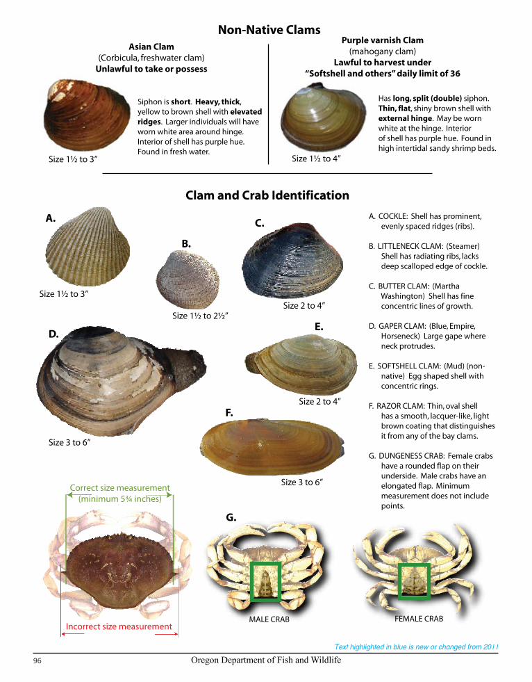
Oregon Department of Fish and Wildlife96
Text highlighted in blue is new or changed from 2011
Non-Native ClamsAsian Clam
(Corbicula, freshwater clam)Unlawful to take or possess
Purple varnish Clam(mahogany clam)
Lawful to harvest under“Softshell and others” daily limit of 36
Siphon is short. Heavy, thick, yellow to brown shell with elevated ridges. Larger individuals will have worn white area around hinge. Interior of shell has purple hue. Found in fresh water.
Has long, split (double) siphon. Thin, flat, shiny brown shell with external hinge. May be worn white at the hinge. Interior of shell has purple hue. Found in high intertidal sandy shrimp beds.
Clam and Crab Identification
A. COCKLE: Shell has prominent, evenly spaced ridges (ribs).
B. LITTLENECK CLAM: (Steamer) Shell has radiating ribs, lacks deep scalloped edge of cockle.
C. BUTTER CLAM: (Martha Washington) Shell has fine concentric lines of growth.
D. GAPER CLAM: (Blue, Empire, Horseneck) Large gape where neck protrudes.
E. SOFTSHELL CLAM: (Mud) (non- native) Egg shaped shell with concentric rings.
F. RAZOR CLAM: Thin, oval shell has a smooth, lacquer-like, light brown coating that distinguishes it from any of the bay clams.
G. DUNGENESS CRAB: Female crabs have a rounded flap on their underside. Male crabs have an elongated flap. Minimum measurement does not include points.
Correct size measurement(minimum 5¾ inches)
Incorrect size measurementMALE CRAB FEMALE CRAB
A.
B.
C.
D.E.
F.
G.
Size 1½ to 3”
Size 1½ to 2½”Size 2 to 4”
Size 2 to 4”
Size 3 to 6”
Size 3 to 6”
Size 1½ to 3” Size 1½ to 4”
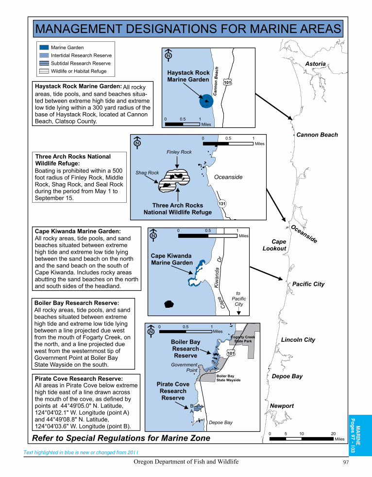
Oregon Department of Fish and Wildlife 97
Text highlighted in blue is new or changed from 2011
Astoria
Cannon Beach
Oceanside
Pacific City
CapeLookout
Lincoln City
Depoe Bay
Newport
Refer to Special Regulations for Marine Zone
MANAGEMENT DESIGNATIONS FOR MARINE AREAS
Can
non
Bea
ch
101
Haystack RockMarine Garden
Oceanside
131Three Arch RocksNational Wildlife Refuge
Finley Rock
Shag Rock
0 0.5 1Miles
Cape
Kiw
anda
Dr
to Pacific
City
Cape Kiwanda Marine Garden
0 0.5 1Miles
101
Boiler BayResearchReserve
GovernmentPoint
Pirate CoveResearchReserve
BA
Boiler Bay State Wayside
Fogarty CreekState Park
Depoe Bay
0 0.5 1Miles
0 10 205Miles
Marine GardenIntertidal Research ReserveSubtidal Research ReserveWildlife or Habitat Refuge
0 0.5 1Miles
All rocky areas, tide pools, and sand beaches situa-ted between extreme high tide and extremelow tide lying within a 300 yard radius of thebase of Haystack Rock, located at CannonBeach, Clatsop County.
Haystack Rock Marine Garden:
Three Arch Rocks NationalWildlife Refuge:Boating is prohibited within a 500 foot radius of Finley Rock, MiddleRock, Shag Rock, and Seal Rockduring the period from May 1 toSeptember 15.
Cape Kiwanda Marine Garden:All rocky areas, tide pools, and sandbeaches situated between extremehigh tide and extreme low tide lyingbetween the sand beach on the northand the sand beach on the south ofCape Kiwanda. Includes rocky areasabutting the sand beaches on the northand south sides of the headland.
Boiler Bay Research Reserve:All rocky areas, tide pools, and sand beaches situated between extremehigh tide and extreme low tide lyingbetween a line projected due westfrom the mouth of Fogarty Creek, onthe north, and a line projected duewest from the westernmost tip ofGovernment Point at Boiler Bay State Wayside on the south.
Pirate Cove Research Reserve:All areas in Pirate Cove below extremehigh tide east of a line drawn acrossthe mouth of the cove, as defined bypoints at 44°49'05.0" N. Latitude, 124°04'02.1" W. Longitude (point A)and 44°49'08.8" N. Latitude, 124°04'03.6" W. Longitude (point B). M
AR
INE
Pages 97 - 103
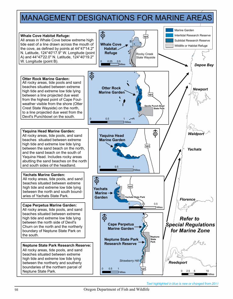
Oregon Department of Fish and Wildlife98
Text highlighted in blue is new or changed from 2011
Depoe Bay
Newport
Waldport
Yachats
Florence
Reedsport
Refer to Special Regulations
for Marine Zone
MANAGEMENT DESIGNATIONS FOR MARINE AREAS
101
Whale CoveHabitat Refuge Rocky Creek
State Wayside
A
B
Otter Rock Marine Garden
101
Devils Punch BowlState Park
0 0.25 0.5Miles
0 0.5 1Miles
101
Yaquina Head Marine Garden
0 0.5 1Miles
NeptuneStatePark
101
Strawberry Hill
Neptune State ParkResearch Reserve
Cape Perpetua Marine Garden
0 0.5 1Miles 0 5 102.5
Miles
101Yachats MarineGarden Yachats State Park
0 0.25 0.5Miles
Marine Garden
Intertidal Research Reserve
Subtidal Research Reserve
Wildlife or Habitat Refuge
Whale Cove Habitat Refuge:All areas in Whale Cove below extreme hightide east of a line drawn across the mouth ofthe cove, as defined by points at 44°47'14.2"N. Latitude, 124°40'17.9" W. Longitude (pointA) and 44°47'22.0" N. Latitude, 124°40'19.2"W. Longitude (point B).
Otter Rock Marine Garden:All rocky areas, tide pools and sand beaches situated between extremehigh tide and extreme low tide lyingbetween a line projected due westfrom the highest point of Cape Foul-weather visible from the shore (OtterCrest State Wayside) on the north, to a line projected due west from theDevil's Punchbowl on the south.
Yaquina Head Marine Garden:All rocky areas, tide pools, and sandbeaches situated between extremehigh tide and extreme low tide lyingbetween the sand beach on the north,and the sand beach on the south of Yaquina Head. Includes rocky areasabutting the sand beaches on the northand south sides of the headland.
Yachats Marine Garden:All rocky areas, tide pools, and sandbeaches situated between extremehigh tide and extreme low tide lyingbetween the north and south bound-aries of Yachats State Park.
Cape Perpetua Marine Garden:All rocky areas, tide pools, and sand beaches situated between extremehigh tide and extreme low tide lyingbetween the north side of Devil's Churn on the north and the northerlyboundary of Neptune State Park onthe south.
Neptune State Park Research Reserve:All rocky areas, tide pools, and sandbeaches situated between extremehigh tide and extreme low tide lyingbetween the northerly and southerlyboundaries of the northern parcel ofNeptune State Park.

Oregon Department of Fish and Wildlife 99
Text highlighted in blue is new or changed from 2011
BAIL SCHEDULES Most violations of the wildlife and commercial fishing laws and regulations are Class A Misdemeanors, punishable by a maximum $6,250 fine and a maximum sentence of confinement to the county jail of one (1) year. There is no scheduled bail and mandatory court appearance is required if charged as a Class A misdemeanor.
Violations of the wildlife and commercial fishing laws and regulations charged as violations rather than Class A Misdemeanors due to the absence of culpable mental state, or at the direction of the district attorney, have the following bail schedules:
$110 – Violations that do not involve the "taking" of wildlife.
$160 – Violations that involve the "taking" of non-game mammals or game birds, and violations relating to the size or quantity limits for fish or shellfish, other than size and quantity limits for salmon, steelhead trout and sturgeon.
$435 – Violations that involve the "taking" of wildlife other than non-game mammals and game birds, and violations relating to the size or quantity limits for salmon, steelhead trout and sturgeon. Also, violations of the non-resident licensing requirement and obstructing the taking of wildlife.
CapeBlanco
Coos Bay
Port Orford
Gold Beach
Brookings
Refer to Special Regulations
for Marine Zone
MANAGEMENT DESIGNATIONS FOR MARINE AREASGregory Point
Research Reserve
A
B C
D
Cape AragoResearch Reserve
Area B
Area A
Area C
Shore AcresState Park
Cape A
rago
Hwy
Cape AragoState Park
Sunset BayState Park
101
BrookingsResearch
Reserve
Harris BeachMarine Garden
Brookings ResearchReserve Brookings
Harris Beach State Park
0 10 205Miles
0 0.25 0.5Miles
0 10 205Miles
Marine GardenIntertidal Research ReserveSubtidal Research ReserveWildlife or Habitat Refuge
Cape Arago Research Reserve:Area A: All rocky areas, tide pools, and sand beaches situated between extreme high tide andextreme low tide lying between a line projecteddue west from the Cape Arago lighthouse and the southern tip of Norton Gulch. Area B: Allrocky areas, tide pools, and sand beaches situated between extreme high tide and extremelow tide lying between the southern tip of NortonGulch and Simpson Reef overlook. Area C: Allrocky areas, tide pools, and sand beachessituated between extreme high tide and extremelow tide lying between SimpsonReef overlook and a point ¾ of a mile southof Cape Arago State Park.
Harris Beach Marine Garden:All rocky areas, tide pools, and sandbeaches situated between extremehigh tide and extreme low tide lyingbetween a line projecting perpendic-ular to shore from the Harris BeachState Park beach access parkingarea on the north, and a line project-ing perpendicular to shore from theroad entrance to Harris Beach StatePark off of Highway 101 on the south.
Brookings Research Reserve:All rocky areas, tide pools, andsand beaches situated betweenextreme high tide and extremelow tide lying between a point ½mile north of Harris Beach StatePark on the north, and the mouthof the Chetco River on the south(except that portion of the areawithin the Harris Beach MarineGarden).
Gregory Point Research Reserve:All areas seaward of extreme low tide in the area defined by the points making lines from 43°20'18.7"N. Latitude, 124°22'50.3" W. Longitude (point A)to 43°20'35.9" N. Latitude, 124°22'53.7" W. Long-itude (point B), and seaward of extreme low tidefrom 43°20'24.1" N. Latitude, 124°22'32.7" W.Longitude (point D) to 43°20'39.0" N. Latitude, 124°22'38.2" W. Longitude (point C).
MA
RIN
EP
ages 97 - 103

Oregon Department of Fish and Wildlife100
Text highlighted in blue is new or changed from 2011
Description:The Marine Zone consists of the Pacific Ocean, coastal bays, and beaches.Instructions:
Read the 1. Special Regulations for this zone. Special Regulations apply to specific bodies of water or portions of water within a zone. If specific references to a body of water, species, catch limits, length limits, seasons, or other specifications are not made in the Special Regulations for this zone, then Zone Regulations apply.Read the following 2. Regulations for this zone.Always read the 3. General Regulations, pages 5-12, which apply to all zones, for information about licenses; tags and permits; defi-nitions; catch and possession limits; gear and bait restrictions; and harvest methods and hours, before going fishing.Emergency or permanent rules adopted since 4. these rules were printed may supersede these regulations. Anglers may call ODFW headquarters or regional offices at the numbers on page 4 of these regulations, or check the ODFW web site, www.dfw.state.or.us for these rules, or call 503-947-6000 during normal business hours. Marine regulations will also be included in the 2012 Oregon Sport Ocean Regulations for Salmon, Halibut, and Other Marine Species which will be available in Summer 2012.
Regulations for this zone:The ocean is separated from rivers and bays by:1. a. Normal high tide lines along coastal beaches, where there are no jetties;b. The ends of the jetties, where they exist, except for the Columbia River;c. A north-south line running through Buoy 10 in the Columbia River.
2. License requirements for those 14 years or older for this zone are:a. An Oregon angling license is required to angle for or land any fish species except smelt;b. A license is required to harvest shellfish. Permits are required as listed under abalone, clams, mud and ghost shrimp, and inter-
tidal invertebrates in the following table. Contact ODFW in Newport 541-867-4741, Charleston 541-888-5515, or Astoria 503-325-2462 for information.
Persons coming ashore in Oregon with ocean caught fish or shellfish are subject to all Oregon sport fishing and licensing regulations3. .All areas are open except those areas listed under 4. Season, Special Regulations or closed by a Public Health Advisory.Oregon Dept. of Agriculture Public Health Advisory for 5. shellfish:a. Any estuary or beach with a health advisory will be closed immediately until the advisory is removed;b. For current information concerning shellfish health advisories, call 503-986-4728 or 1-800-448-2474.Barbed hooks are allowed when angling for marine fish except as noted for salmon and steelhead.6. In the waters of the Pacific Ocean and in the Columbia River upstream to a line projected from Rocky Point on the Washington bank 7. through red buoy 44 to the navigation light at Tongue Point on the Oregon bank, each angler aboard a vessel may continue to use angling gear until the daily limit of fish for all legally licensed and juvenile anglers aboard has been achieved. However, no individual angler may exceed any personal daily bag limit or land fish that contribute to another angler’s limit (anglers who have retained a species limit must pass their rod to an angler who has not reached a limit prior to the fish being landed (netted or boated), or they must release the fish).
8. It is unlawful for any person to fish for, or take and retain any species of salmon, Pacific halibut or Marine Fish while possessing on board any species not allowed to be taken in the area at the time.
9. These angling regulations apply within the state’s Fisheries Conservation Zone, which extends 50 miles from shore. In addition, some fisheries are co-managed with the federal government, so the regulations may apply out to 200 miles from shore.
10. It is unlawful: for anglers fishing from a boat to mutilate fish so the size or species cannot be determined prior to landing; to transport mutilated fish across state waters; and for anglers fishing from shore to mutilate fish so that size or species cannot be determined prior to reaching their automobile or principle means of land transportation, and having completed their daily angling. This does not apply to herring, anchovy, smelt and sardine.
Harvest Caps and In-Season Changes:Annual state and federal harvest caps are set for sport fisheries including black rockfish, yelloweye rockfish, canary rockfish, cabezon, greenlings and others. When a species’ harvest cap is reached or is being approached, an in-season regulation change may be implemented to stop or slow the harvest of that species. In-season changes may include (but are not limited to) reduced bag limits, a change in size limits, non-retention of a particular species, area closures and season closures.
Species Name Daily Catch Limits Harvest Methods and Other Specifications SeasonMarine Fish:Groundfish Group:1. Lingcod (including green
colored lingcod)
2 fish. • 22-inch minimum length for lingcod.• 16-inch minimum length for cabezon.• 10-inch minimum length for greenling.• May be taken by angling, hand, bow and arrow, spear,
gaff hook, snag hook and herring jigs.• When Pacific halibut are onboard the fishing vessel, see
Special Regulations for possession restrictions.
Waters open all year, 24 hours per day, unless noted under Special Regulations. In addition, ocean closed April 1-Sept. 30 outside of the 40-fath-om curve (defined by latitude and longitude) for these species. Stonewall Bank Yellow Rockfish Conservation Area closed for these species and Pacific halibut at all times. (See page 103 for waypoints.)
2. Rockfish (“sea bass,” “snapper”), Greenling (“sea trout”), Pacific Cod, Cabezon, Skates and other marine species not listed on pages 100-101
7 fish in aggregate. Retention of yelloweye rockfish and canary rockish is prohibited.
3. Flatfish (flounder, soles, sanddabs, turbots and halibuts except Pacific halibut)
25 fish in aggregate.
MARINE ZONE
(Continued on next page)

Oregon Department of Fish and Wildlife 101
Text highlighted in blue is new or changed from 2011
Species Name Daily Catch Limits Harvest Methods and Other Specifications SeasonMarine Fish (continued):Surfperch (includes all marine perch species)
15 fish in aggregate.
• May be taken by angling, hand, bow and arrow, spear, gaff hook, snag hook and herring jigs.
Waters open all year, 24 hours per day, unless noted under Special Regulations.Striped Bass and/or
Hybrid Bass2 fish in 24 consecutive hours.
• May be taken by angling.• 24-inch minimum length for striped/hybrid bass.
Herring, Anchovy, Smelt and Sardine
25 pounds in aggregate.
• May be taken by dip net, cast net, angling and herring jigs.• Herring jigs may have any number of hooks.• Unlawful to take or attempt to take Eulachon smelt in
inland waters including: bays, estuaries, rivers, and streams. See ODFW website for smelt identification.
Offshore Pelagic species (see definition page 9)
25 fish in aggregate. White sharks and basking sharks are prohibited and must be immediately released unharmed.
• May be taken by angling, hand, bow and arrow, spear, gaff hook, snag hook and herring jigs.
• Methods as described below are only allowed when fishing outside of three miles from shore for offshore pelagic species. Only offshore pelagic species may be in possession, and any other species caught must be immediately released while using these methods.
• Use of chum is allowed. Chum may be live, dead, or cut up squid, herring, sardine, anchovy, smelt or Pacific mackerel. No restrictions on the number of rods or lines fished per angler.
Sturgeon 1 per day, 5 per year.
• Closed for retention of green sturgeon.• Angling restricted to one single-point, barbless hook for
white sturgeon.• Minimum fork length 38 inches, maximum fork length
54 inches.
Open all year.
Salmon andSteelhead
• Ocean salmon and steelhead seasons and restrictions are set each April by the Pacific Fishery Man-agement Council (PFMC). Regulations are published each May and are available from license agents.
• See Northwest Zone, Tillamook Bay for description of control zone off Tillamook Bay.• Single-point, barbless hooks required, except in coastal bays.Note: Regulations may change on short notice during the season. Changes are available from ODFW offices, license agents, the Internet at www.dfw.state.or.us/mrp and news media. Changes to salmon regulations for the Columbia River system are printed in May and are available at ODFW offices or from license agents. Check for new regulations before you fish.
Pacific Halibut • May be taken by angling with single line, no more than 2 hooks; and by spear.• Catch limits and seasons are set in March and published in May but may change on short notice.
In-season changes to regulations are available from ODFW offices, license agents, the Internet at www.dfw.state.or.us/mrp, or by calling 1-800-662-9825; press 5. Check regulations before you fish.
Marine Shellfish and Marine Invertebrates:Abalone
1 abalone per day, 5 abalone per year.
• 8-inch minimum length.• May be taken by abalone iron only.• Special permit required, see Regulations for this
Zone, item 2. For permit renewals, previous year’s catch record must be submitted to ODFW before next year’s permit will be issued.
• Abalone brought ashore shall be whole and in such a condition that the size can be determined.
• Abalone must not be removed from their shell in the field, except when being prepared for immediate consumption.
• Every person while taking abalone shall carry a caliper-measuring gauge with fixed opposing arms capable of accurately measuring eight inches by placing the gauge over the shell.
Waters open all year, 24 hours per day unless noted under Other Specifications (this table) or Special Regulations.
Clams:Razor Clams
Bay Clams:Butter, Littleneck,Cockle, Geoduck and Gaper
Softshell, purple varnish clams, and Others:
First 15 taken.
20 clams, of which only 12 in aggregate may be gaper clams or Geoduck clams.
First 36 taken.
• Razor clams may be taken by hand, shovel, or cylindrical gun or tube. The opening of the gun/tube must be either circular or elliptical with the circular gun/tube having a minimum outside dimension of 4 inches and the elliptical gun/tube having a minimum dimension of 4 inches long and 3 inches wide outside diameter.
• All other clams may be taken by hand or hand-powered tools.• Unlawful to remove clams from the shell before leaving
the clamming area.• Each digger must have own container, dig own clams,
and may not possess more than one limit of clams while in clamming area except under a Disabled Clam Digger Permit. See Licenses, Tags and Permits, page 7.
Waters open all year, 24 hours per day except as noted under Special Regulations, and Clatsop County beaches north of Tillamook Head are closed to razor clams July 15-Sept. 30.
MA
RIN
EP
ages 97 - 103
(Continued on next page)
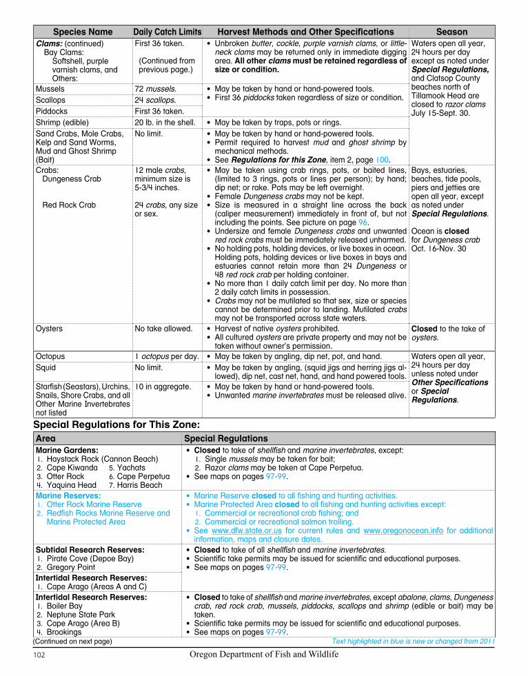
Oregon Department of Fish and Wildlife102
Text highlighted in blue is new or changed from 2011
Species Name Daily Catch Limits Harvest Methods and Other Specifications SeasonClams: (continued)
Bay Clams:Softshell, purple varnish clams, and Others:
First 36 taken.
(Continued from previous page.)
• Unbroken butter, cockle, purple varnish clams, or little-neck clams may be returned only in immediate digging area. All other clams must be retained regardless of size or condition.
Waters open all year, 24 hours per day except as noted under Special Regulations, and Clatsop County beaches north of Tillamook Head are closed to razor clams July 15-Sept. 30.
Mussels 72 mussels. • May be taken by hand or hand-powered tools.• First 36 piddocks taken regardless of size or condition.Scallops 24 scallops.
Piddocks First 36 taken.Shrimp (edible) 20 lb. in the shell. • May be taken by traps, pots or rings.Sand Crabs, Mole Crabs, Kelp and Sand Worms, Mud and Ghost Shrimp (Bait)
No limit. • May be taken by hand or hand-powered tools.• Permit required to harvest mud and ghost shrimp by
mechanical methods.• See Regulations for this Zone, item 2, page 100.
Crabs:Dungeness Crab
Red Rock Crab
12 male crabs, minimum size is 5 -3/4 inches.
24 crabs, any size or sex.
• May be taken using crab rings, pots, or baited lines, (limited to 3 rings, pots or lines per person); by hand; dip net; or rake. Pots may be left overnight.
• Female Dungeness crabs may not be kept.• Size is measured in a straight line across the back
(caliper measurement) immediately in front of, but not including the points. See picture on page 96.
• Undersize and female Dungeness crabs and unwanted red rock crabs must be immediately released unharmed.
• No holding pots, holding devices, or live boxes in ocean. Holding pots, holding devices or live boxes in bays and estuaries cannot retain more than 24 Dungeness or 48 red rock crab per holding container.
• No more than 1 daily catch limit per day. No more than 2 daily catch limits in possession.
• Crabs may not be mutilated so that sex, size or species cannot be determined prior to landing. Mutilated crabs may not be transported across state waters.
Bays, estuaries, beaches, tide pools, piers and jetties are open all year, except as noted under Special Regulations.
Ocean is closed for Dungeness crab Oct. 16-Nov. 30
Oysters No take allowed. • Harvest of native oysters prohibited.• All cultured oysters are private property and may not be
taken without owner’s permission.
Closed to the take of oysters.
Octopus 1 octopus per day. • May be taken by angling, dip net, pot, and hand. Waters open all year, 24 hours per day unless noted under Other Specifications or Special Regulations.
Squid No limit. • May be taken by angling, (squid jigs and herring jigs al-lowed), dip net, cast net, hand, and hand powered tools.
Starfish (Seastars), Urchins, Snails, Shore Crabs, and all Other Marine Invertebrates not listed
10 in aggregate. • May be taken by hand or hand-powered tools.• Unwanted marine invertebrates must be released alive.
Special Regulations for This Zone:Area Special RegulationsMarine Gardens:
Haystack Rock (Cannon Beach)1. 2. Cape Kiwanda 5. Yachats
Otter Rock 3. 6. Cape PerpetuaYaquina Head 4. 7. Harris Beach
• Closed to take of shellfish and marine invertebrates, except:Single 1. mussels may be taken for bait;Razor2. clams may be taken at Cape Perpetua.
• See maps on pages 97-99.
Marine Reserves:Otter Rock Marine Reserve1. Redfish Rocks Marine Reserve and 2. Marine Protected Area
• Marine Reserve closed to all fishing and hunting activities.• Marine Protected Area closed to all fishing and hunting activities except:
Commercial or recreational crab fishing; and1. Commercial or recreational salmon trolling2. .
• See www.dfw.state.or.us for current rules and www.oregonocean.info for additional information, maps and closure dates.
Subtidal Research Reserves:Pirate Cove (Depoe Bay)1. Gregory Point2.
• Closed to take of all shellfish and marine invertebrates.• Scientific take permits may be issued for scientific and educational purposes.• See maps on pages 97-99.
Intertidal Research Reserves:Cape Arago (Areas A and C)1.
Intertidal Research Reserves:Boiler Bay1.
2. Neptune State ParkCape Arago (Area B)3. Brookings4.
• Closed to take of shellfish and marine invertebrates, except abalone, clams, Dungeness crab, red rock crab, mussels, piddocks, scallops and shrimp (edible or bait) may be taken.
• Scientific take permits may be issued for scientific and educational purposes.• See maps on pages 97-99.
(Continued on next page)
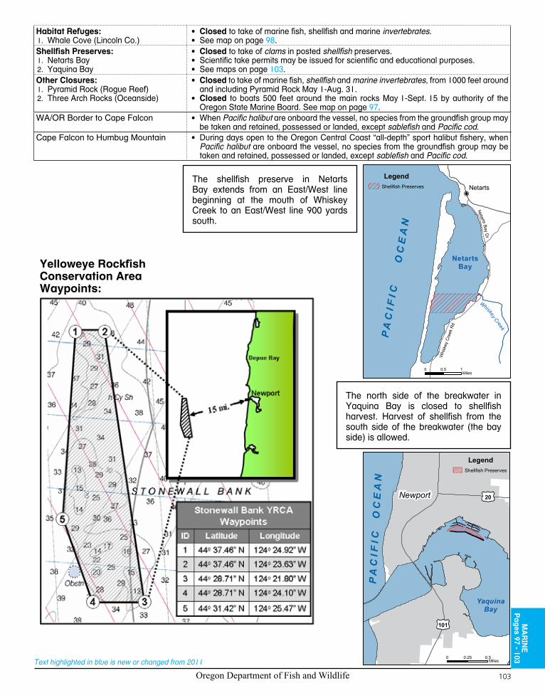
Oregon Department of Fish and Wildlife 103
Text highlighted in blue is new or changed from 2011
Habitat Refuges:Whale Cove (Lincoln Co.)1.
• Closed to take of marine fish, shellfish and marine invertebrates.• See map on page 98.
Shellfish Preserves:Netarts Bay1. Yaquina Bay2.
• Closed to take of clams in posted shellfish preserves.• Scientific take permits may be issued for scientific and educational purposes.• See maps on page 103.
Other Closures:Pyramid Rock (Rogue Reef)1.
2. Three Arch Rocks (Oceanside)
• Closed to take of marine fish, shellfish and marine invertebrates, from 1000 feet around and including Pyramid Rock May 1-Aug. 31.
• Closed to boats 500 feet around the main rocks May 1-Sept. 15 by authority of the Oregon State Marine Board. See map on page 97.
WA/OR Border to Cape Falcon • When Pacific halibut are onboard the vessel, no species from the groundfish group may be taken and retained, possessed or landed, except sablefish and Pacific cod.
Cape Falcon to Humbug Mountain • During days open to the Oregon Central Coast “all-depth” sport halibut fishery, when Pacific halibut are onboard the vessel, no species from the groundfish group may be taken and retained, possessed or landed, except sablefish and Pacific cod.
MA
RIN
EP
ages 97 - 103
YaquinaBay
PA
CI F
I C
OC
EA
N
Newport
101
20
LegendShellfish Preserves
0 0.25 0.5Miles
P
Whiskey Creek
Whi
skey
Cre
ek R
d
Netarts Bay Dr
Netarts
PA
CI F
I C
O
CE
AN
NetartsBay
LegendShellfish Preserves
0 0.5 1Miles
The shellfish preserve in Netarts Bay extends from an East/West line beginning at the mouth of Whiskey Creek to an East/West line 900 yards south.
The north side of the breakwater in Yaquina Bay is closed to shellfish harvest. Harvest of shellfish from the south side of the breakwater (the bay side) is allowed.
Yelloweye RockfishConservation AreaWaypoints:

Oregon Department of Fish and Wildlife104
Text highlighted in blue is new or changed from 2011
Yelloweye Rockfish
Body orange fading to light orange or yellow on belly. Rough pair of ridges above bright yellow eyes. Tail not indented. Fins pinkish, commonly with black edges. Small fish may have one or two white lines on sides (not shown). To 36 inches.
Body reddish with gray marbling. Fins red (may be dark-edged in small fish). Lower jaw with scales. Tail slightly indented. To 30 inches.
Vermilion Rockfish
Smooth skin without scales. Small flap of skin on snout and above each eye. Body may be marbled brown, red or green. To 39 inches.
Cabezon
Large mouth with large, sharp teeth. Upper jaw extends past middle of eye. Body may be marbled brown, blue or green. To 60 inches.
Lingcod
The rockfish species in this box, sometimes referred to as "red sna China
Rockfishpper," can be easily confused:
Small mouth with small teeth. Upper jaw does not extend past middle of eye. Males with blue spots around head (shown); females lighter with orange spots and yellow fins. To 24 inches.
Kelp Greenling ("sea trout")
Copper Rockfish
Broad, light stripe along side toward tail. Fins coppery. To 23 inches.
lateral line
Body with bright orange and gray blotches. Narrow, light gray zone along side. Tail indented with two distinct tips. Fins bright orange. To 30 inches.
Canary Rockfish
Yellow band begins on fin and continues to tail. Yellow speckles on black body. To 17 inches.
Quillback Rockfish
Forward fin deeply notched. Front of body light brown and yellow; rear darker. To 24 inches.
Select Groundfish Species

Oregon Department of Fish and Wildlife 105
Text highlighted in blue is new or changed from 2011REV. 12/19/2011:Lt
Mail To:ODFW - License Services3406 Cherry Avenue NESalem, OR 97303-4924(503) 947-6100
Angling LicenseMail OrderApplicat ion
Issue Date: _______________
Initials: ___________________
ODFW USE ONLY
Resident Non-Resident Driver's License #: State:
--LAST NAME FIRST NAME M.I. SOCIAL SECURITY # (required)
MAILING ADDRESS ODFW HUNTER / ANGLER ID
--CITY STATE ZIPCODE DATE OF BIRTH (MM-DD-YYY)
MALE FEMALEDAYTIME PHONE # EVENING PHONE #
Mark your An g l i ng L i c en s es an d Ta gschoices Fees License Types
Annual Licenses: $58.00 annual resident Combination angling/hunting $164.75 sports pac license (18 years & older) $33.00 annual resident angling license $106.25 annual non-resident angling license $52.00 Juvenile sports pac license (12 to 17 years) $9.00 annual resident Juvenile angling license (14 to 17 years) $20.25 annual non-resident Juvenile angling license (14 to 17 years) FREE annual Youth Under 14 angling license (13 years & younger, both resident & non-resident) $26.50 annual adult Combined angling harvest tag (18 years & older) $8.50 annual Juvenile Combined angling harvest tag (14 to 17 years) $16.50 hatchery harvest tag $25.50 annual resident sr. Citizen Combination angling/hunting (70 years & older and 5 years in Oregon) $15.00 annual resident sr. Citizen angling (70 years & older and 5 years in Oregon) $17.00 two-rod angling license
Daily Licenses: (salmon-steelhead-sturgeon-halibut tags included) Starting Dates for Daily Licenses: $16.75 1 – day angler $31.50 2 - day angler $46.25 3 - day angler $58.00 4 - day angler $59.75 7 - day angler (non-residents only)
Shellfish Licenses: $7.00 annual resident shellfish license $20.50 annual non-resident shellfish license $11.50 3 - day non-resident shellfish license
Other Charges: $ 2.00 shipping and handling
Total Fees: $ Note: To purchase licenses "on line" see our home page @ http://www.dfw.state.or.us
Oregon Residents (read & sign) Seniors Citizens (read & sign) PAYMENT METHOD (DO NOT SEND CASH)i, the undersigned, hereby certify and declare that the information i provided to obtain this license/tag is true and correct. to acquire an Oregon resident license, i certify that i have resided continuously within Oregon no less than 6 months immediately prior to applying for this license/tag.
Signature (required for Oregon residents)
i, the undersigned, hereby certify and declare that the information i provided to obtain this license/tag is true and correct. to acquire a senior citizen license, i hereby certify that i have reached the age of 70 and have resided in Oregon no less than 5 years. i further certify that i have resided continuously within Oregon no less than 6 months immediately prior to applying for this license.
Signature (required for Oregon residents)
i've enclosed a Check or money Order payable to ODFW.
Visa® master Card®Credit Card number:
expiration Date:
Signature (required for all credit card purchases)
Charge orders may be faxed to: (503) 947-6117 or 947-6113. We are unable to accept telephone orders.Certification of resident status is required for Oregon residents. please read and sign in the box below
Oregon Department of Fish and Wildlife106
Text highlighted in blue is new or changed from 2011
SPONSORED BY
Oregon Hunters Association and Leupold & Stevens, Inc.
In Cooperation with Oregon State Police and Oregon Department of Fish and Wildlife
Report Wildlife and Habitat Violations
TIPs Can Remain Anonymous
1-800-452-7888
Oregon State Police
Fish and Wildlife Division
We Are the Guardians of Oregon’s Fish and Wildlife
Ensure compliance with fish, wildlife, and commercial fishing laws and regulations
Protect and enhance long term health and equitable utilization of natural resources
Enforce traffic, criminal, boating, and livestock laws and respond to emergency situations
Oregon Department of Fish and Wildlife 107
Text highlighted in blue is new or changed from 2011
Oregon Department of Fish and Wildlife106
Text highlighted in blue is new or changed from 2011
SPONSORED BY
Oregon Hunters Association and Leupold & Stevens, Inc.
In Cooperation with Oregon State Police and Oregon Department of Fish and Wildlife
Report Wildlife and Habitat Violations
TIPs Can Remain Anonymous
1-800-452-7888
Oregon State Police
Fish and Wildlife Division
We Are the Guardians of Oregon’s Fish and Wildlife
Ensure compliance with fish, wildlife, and commercial fishing laws and regulations
Protect and enhance long term health and equitable utilization of natural resources
Enforce traffic, criminal, boating, and livestock laws and respond to emergency situations
www.huntandfi shregs.com
Reach Every Hunter or Fisherman in Oregon for an entire season by placing an ad in the
offi cial Oregon Department of Fish and Wildlife Hunting and Fishing Regulations.
Call-1-800-296-6402 For Advertising Information
Reach Every Hunter or Fisherman in Oregon for an entire season by placing an ad in the
Turn in your Combined Angling Tag for a chance to WIN a Willie’s Drift Boat with trailer!
(See Page 22 for details.)
2011 OregOn SPOrT FISHIng regulaTIOnS
www.dfw.state.or.us
For ODFW Online License Sales go to:
www.dfw.state.or.us/online_license_sales/index.asp
FOR THE TOUGHEST JOBS ON PLANET EARTH®
1-800-966-3458 Made in USA
FOR THE TOUGHEST JOBS ON PLANET EARTH
© 2011 Gorilla Glue Company
For The Toughest Jobson Planet Earth®
• Up to 3 HD Receivers for FREE
• FREE Upgrade to HD DVR $6/mo DVR Service fee applies.
• Over 200 HD Channels Available
• Premium Movie Channels
• FREE Professional Installation
Restrictions apply. Call for Details.
DISH Network Is The LOWEST Satellite TV Price In America!
Call:1-866-940-7309
According to the 2010 ACSI. Survey results for the U.S. largest cable and satellite TV providers. The claim excludes fi ber optic carriers.
i-DISH - An Authorized DISH Network Retailer
Special Offers Are Available In Your Area.

CLEAN, DRAIN, DRYHello Fish,
Invasives Goodbye!
•Theestimateddamagefrominvasivesworldwidetotals$1.4trillion—5percentoftheglobaleconomy.
• Invasivespeciescanbetransportedbyboats,vehicles,andYOU!
HOW YOU CAN HELP!
•Learntoidentifyinvasivespeciesinyourarea.
•Clean,drain,anddryallequipmentbeforeleavinghome.
•Fishindesignatedwatersandtravelonestablishedroadsandtrails.
•Neverreleaseplantsoranimals,includingbait.
•Thoroughlyinspectallboats,vehicles,animals,clothing,andequipment,includingwaders,beforeleavingyourfishinglocation.
Invasive speciesreplace native speciesand destroy habitat for native sport fish.
REPORT IT!Bureau of Land ManagementOregon State Office:503-808-6001
Oregon Invasive Species Hotline:1-866-INVADER
www.blm.gov/weeds
Rainbow trout, Canyon Creek Ranch, Oregon
New Zealand mudsnail (top), quagga mussels (center), and hydrilla (bottom)
Davi
d J.
Moo
rhea
d,
Uni
vers
ity o
f Geo
rgia
, Bug
woo
d.or
gU.
S. B
urea
u of
Rec
lam
atio
nAm
y J.
Bens
on, U
.S. G
eolo
gica
l Sur
vey
Fishing Equipment
Education/Instruction
Service DirectoryGuides & Outfitters
Year 'round fishing in Oregonfor Salmon,Trout,Sturgeon,Steelhead& Bass
Bill Kremers(541) 754-6411
CELL (541) 602-0881' [email protected] NE Pheasant ' Corvallis, OR 97333
www.oregonrivertrails.com
To advertise, call: Liberty Press Publications
800-296-6402 www.huntandfi shregs.com
For more information on the OR
Fishing rules visit:
dfw.state.or.usYour Sporting Life Begins at Mazama!
289 Valley River CenterEugene, OR 97401541-484-9993
900 McKinley St.Eugene, OR 97402541-357-4419
mazamasportinggoods.com
mhcc.edu
learn skills for a career in Fisheries Technology
MHCC offers a two-year degree program leading to employment
as a fish culturist or fish technician with state or
federal agencies
CA15
78
[email protected] Call: 503-491-7163
The Worlds BEST Compact Fishing Rod! Strong, Flexible, Adaptable, Portable, Spinning, Casting,
Backpacking. Casts like a 6 to 7 foot pole!
509.216.8589
Atherton Enterprises Inc
MyCompactFishing.com
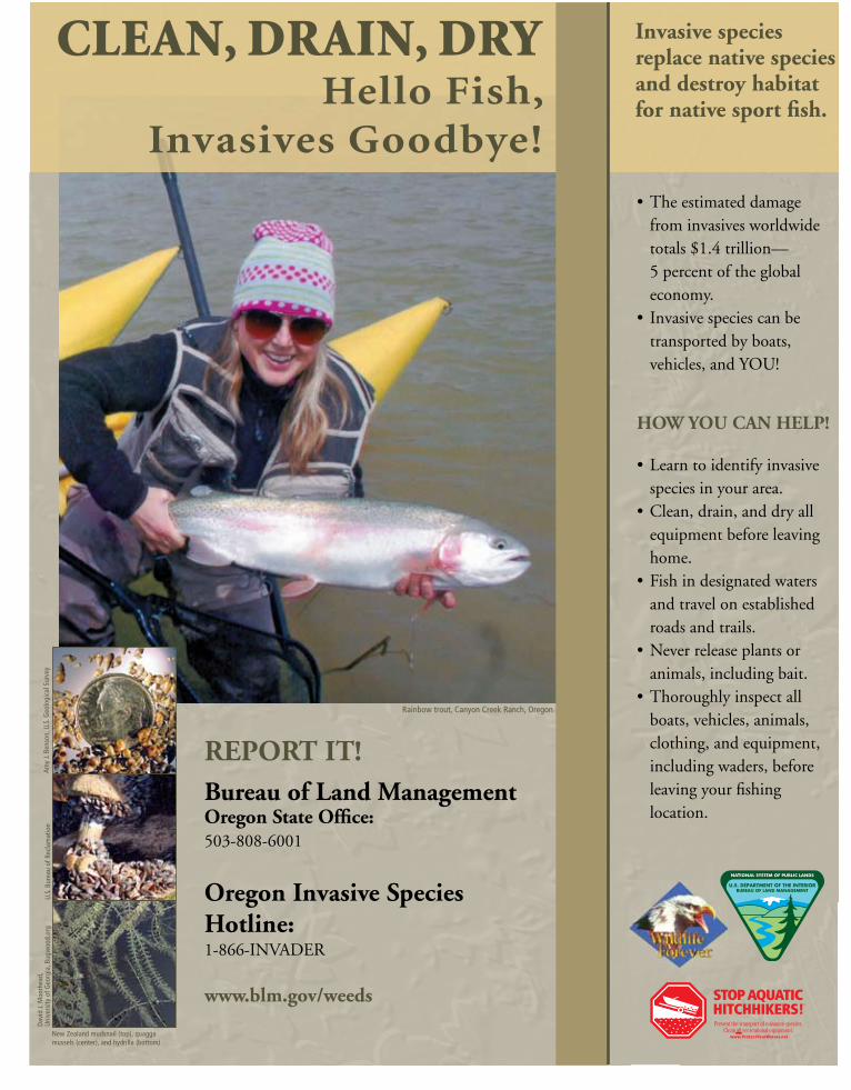
Fishing Equipment
Service Directory
To advertise, call: Liberty Press Publications800-296-6402 • www.huntandfi shregs.com
Your Sporting Life Begins at Mazama!
289 Valley River CenterEugene, OR 97401541-484-9993
900 McKinley St.Eugene, OR 97402541-357-4419
mazamasportinggoods.com
• Up to 3 HD Receivers for FREE
• FREE Upgrade to HD DVR $6/mo DVR Service fee applies.
• Over 200 HD Channels Available
• Premium Movie Channels
• FREE Professional Installation
Restrictions apply. Call for Details.
DISH Network Is The LOWEST Satellite TV Price In America!
Call:1-866-940-7309
According to the 2010 ACSI. Survey results for the U.S. largest cable and satellite TV providers. The claim excludes fi ber optic carriers.
i-DISH - An Authorized DISH Network Retailer
Special Offers Are Available In Your Area.
CLEAN, DRAIN, DRYHello Fish,
Invasives Goodbye!
•Theestimateddamagefrominvasivesworldwidetotals$1.4trillion—5percentoftheglobaleconomy.
• Invasivespeciescanbetransportedbyboats,vehicles,andYOU!
HOW YOU CAN HELP!
•Learntoidentifyinvasivespeciesinyourarea.
•Clean,drain,anddryallequipmentbeforeleavinghome.
•Fishindesignatedwatersandtravelonestablishedroadsandtrails.
•Neverreleaseplantsoranimals,includingbait.
•Thoroughlyinspectallboats,vehicles,animals,clothing,andequipment,includingwaders,beforeleavingyourfishinglocation.
Invasive speciesreplace native speciesand destroy habitat for native sport fish.
REPORT IT!Bureau of Land ManagementOregon State Office:503-808-6001
Oregon Invasive Species Hotline:1-866-INVADER
www.blm.gov/weeds
Rainbow trout, Canyon Creek Ranch, Oregon
New Zealand mudsnail (top), quagga mussels (center), and hydrilla (bottom)
Davi
d J.
Moo
rhea
d,
Uni
vers
ity o
f Geo
rgia
, Bug
woo
d.or
gU.
S. B
urea
u of
Rec
lam
atio
nAm
y J.
Bens
on, U
.S. G
eolo
gica
l Sur
vey

VISIT YOUR LOCAL DICK’S SPORTING GOODS
FOR ALL OF YOUR HUNTING AND FISHING SERVICES
OFFTAKE
$10 YOUR HUNTING, FISHING AND CAMPING PURCHASE OF $75 OR MORE
Limit one coupon per customer. Minimum purchase of $75 before sales tax. Total amount of coupon must be redeemed at one time. Cannot be combined with any other offers, coupons, team discounts or Guaranteed In-Stock markdown, or used for licenses or previously purchased merchandise. Coupon valid on in-store purchases only. Not redeemable for cash, gift cards or store credit. No reproductions or rain checks accepted. Returns or exchanges where a ScoreCard Rewards Certificate or other discount was applied may result in an adjusted refund amount. Excludes Shimano, St. Croix, G. Loomis, fishing electronics, trolling motors, outboard motors, Diamondback, Jansport, Under Armour, Polar, The North Face, Columbia, Merrell and boots. Some additional exclusions may apply. See store for details. Valid 11/15/11 through 5/15/12.
Valid through 5/15/12
P00004870