2011 western region meeting of the spe and the ps-aapg
TRANSCRIPT


1
CONTENTS
SCHEDULE OF EVENTS ................................................................................................................................................... 2
SPONSORS .......................................................................................................................................................................... 4
GREETINGS ........................................................................................................................................................................ 6
GENERAL INFORMATION ............................................................................................................................................ 10
The Venue ................................................................................................................................................................ 10
Hotel Map ................................................................................................................................................................. 12
Exhibitor List ............................................................................................................................................................. 13
SPECIAL EVENTS ............................................................................................................................................................ 15
Opening Session, Exhibits, Icebreaker, Ken Bird Symposium ................................................................................ 15
Special Presentation: Oil Spills, Ethics, and Society .............................................................................................. 17
Business Meetings and Luncheons ......................................................................................................................... 19
FIELD TRIPS ..................................................................................................................................................................... 21
Field Trip 1: Turnagain Arm and Resurrection Bay ................................................................................................ 21
Field Trip 2: Tertiary and Holocene Deposits, Nenana Basin ................................................................................. 21
Field Trip 3: Wishbone Hill ...................................................................................................................................... 22
Field Trip 4: Upper Cook Inlet ................................................................................................................................. 22
AAPG SHORT COURSES AND WORKSHOPS ........................................................................................................... 24
AAPG Short Course 1: Core Workshop .................................................................................................................. 24
AAPG Short Course 2 Tectonic Evolution of Arctic Alaska .................................................................................... 24
AAPG Short Course 3: Managing Your Business Using PRMS ............................................................................. 25
SPE SHORT COURSES .................................................................................................................................................... 26
SPE Short Course 1: Multiphase Metering ............................................................................................................. 26
SPE Short Course 2: Introduction to Well Logging ................................................................................................. 27
SPE Short Course 3: Thermal Recovery ................................................................................................................ 27
SPE Short Course 4: Drilling and Completions for the PE Exam ........................................................................... 28
SPE Short Course 5: Production and Reservoir Engineering for the PE Exam ..................................................... 29
SPE Short Course 6: Unconventional Shale Resources ........................................................................................ 29
TECHNICAL PROGRAM ................................................................................................................................................. 30
PSAAPG TECHNICAL PROGRAM .............................................................................................................................. 31
SPE TECHNICAL PROGRAM ........................................................................................................................................ 38
PSAAPG ABSTRACTS ................................................................................................................................................... 44

2
SCHEDULE OF EVENTS
Schedule as of April 12, 2011. Times and locations are subject to change. For updates, visit www.psaapg.org, www.spe.org/events/wrm, and http://www.pttcwestcoast.org/. Friday, May 6, 2011 0700 – 1900 Committee Office and Storage Open – Second Floor Boardroom 0730 AAPG Field Trip No. 1 Begins (Turnagain Arm – Resurrection Bay) 0900 – 1600 AAPG Short Course No. 1 (Core Workshop) – Bayview Core Facility
Saturday, May 7, 2011 0700 – 1900 Committee Office and Storage Open – Second Floor Boardroom 0800 – 1700 AAPG Short Course No. 2 (NS Tectonic Evolution) – Howard Rock Ballroom A 0800 – 1700 Committee Meetings – Room 301 0900 – 1700 Exhibits Hall Setup – Kuskokwim, Yukon, Foyer, Atrium 1000 – 1400 Registration Set Up – Second Floor Break Area6 1500 – 1800 Registration Open – Second Floor Break Area 1900 AAPG Field Trip No. 1 Ends (Turnagain Arm – Resurrection Bay)
Sunday, May 8, 2011 0700 – 1900 Committee Office and Storage Open – Second Floor Boardroom 0700 – 1700 Committee Meetings – Room 301 0800 – 1500 Exhibits and Posters Set-up – Kuskokwim, Yukon, Foyer, Atrium 0800 – 1800 Registration – Second Floor Break Area 0800 – 2000 SPE Student Paper Contest – Preliminaries 0800–1700 in Rooms 305, 308,
and 311; Final 1800–2000 in Yukon 1000 – 1700 Speaker and Judges Room – Susitna 1400 – 1700 Spouse Hospitality – Suite 1315 1600 – 1800 Opening Session – Howard Rock Ballrooms A, B, and C 1800 – 2000 Exhibits and Posters Open – Kuskokwim, Yukon, Foyer, Atrium 1800 – 2000 Icebreaker in Exhibits and Posters Hall – Kuskokwim, Yukon, Foyer, Atrium Monday, May 9, 2011 0700 – 1900 Committee Office and Storage Open – Second Floor Boardroom 0700 – 0745 Speakers and Judges Breakfast – The Summit 0700 – 0900 AAPG-House of Delegates Breakfast – Room 311 0700 – 1700 Speaker and Judges Room – Room 308 0700 – 1700 Committee Meetings – Room 301 0730 – 1000 Spouse Hospitality – Suite 1315 0730 – 1700 Registration – Second Floor Break Area 0800 – 1100 AAPG Technical Sessions (NS Geology & Potential) – Howard Rock B and C 0800 – 1130 SPE Technical Sessions (Efficient Waterflooding) – Howard Rock A 0800 – 1130 SPE Technical Sessions (Regulatory and HSE) – Susitna 0800 – 1630 AAPG Poster Sessions (Tectonics, Sedimentation, Resource) – Yukon 0800 – 1830 Exhibits and Posters – Kuskokwim, Yukon, Foyer, Atrium 0930 – 1430 Spouse Tour to Alyeska 1130 – 1315 PS-AAPG Awards Luncheon – Howard Rock Ballrooms B and C 1200 – 1300 WNAR Council Meeting – Room 301 1330 – 1700 SPE Technical Sessions (Prod. Operations & Stimulation) – Howard Rock A 1330 – 1700 SPE Technical Sessions (Heavy Oil I) – Susitna 1330 – 1710 AAPG Technical Sessions (NS Geology & Potential) – Howard Rock B and C 1500 – 1700 Spouse Hospitality – Suite 1315

3
Tuesday, May 10, 2011 0700 – 0745 Speakers and Judges Breakfast – The Summit 0700 – 1700 Committee Meetings – Room 301 0730 – 1500 Spouse Hospitality – Suite 1315 0730 – 1600 Registration – Second Floor Break Area 0730 – 1700 Speaker and Judges Room – Room 308 0800 – 0930 AAPG Technical Sessions (Reservoir Quality / Prediction) – Howard Rock B 0800 – 1010 AAPG Technical Sessions (Cook Inlet Oil &Gas Fields) – Howard Rock C 0800 – 1130 SPE Technical Sessions – Howard Rock A and Susitna 0800 – 1630 AAPG Poster Sessions (NS Geology & Hydrocarbon Potential) – Yukon 0800 – 1700 Exhibits and Posters – Kuskokwim, Yukon, Foyer, Atrium 0930 – 1430 Spouse Tour of Anchorage 1130 – 1300 AAPG Division of Professional Affairs Luncheon – The Summit 1130 – 1315 SPE Awards Luncheon – Howard Rock Ballrooms B and C 1330 – 1700 SPE Technical Sessions (Heavy Oil II) – Susitna 1330 – 1700 AAPG Technical Sessions (Exploration, Ethics, Tectonics) – Howard Rock A, C 1330 – 1700 SPE Technical Sessions (Smart Fields & Field Management) – Howard Rock B 1845 – 2200 Tuesday Night Entertainment – Alaska Native Heritage Center Wednesday, May 11, 2011 0700 – 0745 Speakers and Judges Breakfast – The Summit 0700 – 1700 Committee Meetings – Room 301 0730 – 1200 Registration – Second Floor Break Area 0730 – 1400 Spouse Hospitality – Suite 1315 0730 – 1730 Speaker and Judges Room – Room 308 0800 – 1110 AAPG Technical Sessions (Petroleum Systems) – Howard Rock B and C 0800 – 1130 SPE Technical Sessions (Adv. Reservoir Modeling / Matching) – Howard Rock A 0800 – 1130 SPE: Best of Student Papers Contest – Susitna 0800 – 1400 Exhibits and Posters – Kuskokwim, Yukon, Foyer, Atrium 0800 – 1630 AAPG Poster Sessions (Paleozoic - Mesozoic Geology) –Yukon 1300 AAPG Field Trip No. 2 Begins (Tertiary & Holocene Deposits, Nenana Basin) 1330 – 1640 AAPG Technical Sessions (Technology / Alt. Energy ) – Howard Rock B and C 1400 – 2000 Exhibits and Posters Tear Down – Kuskokwim, Yukon, Foyer, Atrium 1700 – 1800 PS-AAPG Executive Committee Meeting – Room 301 1700 – 1900 Committee Reception – Suite 1315 Thursday, May 12, 2011 0800 – 1200 SPE Short Course No. 1 (Multiphase Metering) – Howard Rock C 0800 – 1430 AAPG Short Course No. 3 (Managing Your Business) – Kuskokwim East 0800 – 1700 SPE Short Courses No. 3 (Thermal Recovery) – Howard Rock A 0800 – 1700 SPE Short Courses No. 4 (Drilling/Completions for PE Exam) – Howard Rock B 0800 – 1700 AAPG Field Trip No. 3 (Wishbone Hill ) 0830 AAPG Field Trip No. 4 Begins (Sedimentology/Tectonics of Upper Cook Inlet) 1300 – 1700 SPE Short Course No. 2 (Introduction to Well Logging) – Howard Rock C All Day AAPG Field Trip No. 2 Continues (Tertiary & Holocene Deposits, Nenana Basin) Friday, May 13, 2011 0800 – 1200 SPE Short Course No. 6 (Unconventional Shale Resources) – Howard Rock C 0800 – 1700 SPE Short Course No. 5 (Prod, Res Engineering, PE Exam) – Howard Rock B 2000 AAPG Field Trip No. 2 Ends (Tertiary Coal & Holocene Deposits, Nenana Basin) All Day AAPG Field Trip No. 4 Continues (Sedimentology/Tectonics of Upper Cook Inlet) Saturday, May 14, 2011 1800 AAPG Field Trip No. 4 Ends (Sedimentology/Tectonics of Upper Cook Inlet)

4
SPONSORS
Thank you to the following companies for their generous contributions and support!
Platinum Level ($10,000+)
Aera Energy
BP Alaska, Inc.
ConocoPhillips Alaska, Inc.
ExxonMobil Corporation
Gold Level – $5000 - $9,999
Apache Corporation
Occidental Petroleum
Silver Level – ($2,500 - $4,999)
Baker Hughes
Halliburton | Sperry Drilling
Petrotechnical Resources of Alaska
Shell Oil Company

5
SPONSORS
Copper Level – up to $2,500
Brooks Range Petroleum
Bristol Bay Native Corporation
Marathon Oil Corporation
Udelhoven
Cook Inlet Regional Incorporated
Doyon, Limited
Tiorco
Short Course Sponsors
Petroleum Technology Transfer Council
Schlumberger Testing Services
Multi Phase Meters, Inc
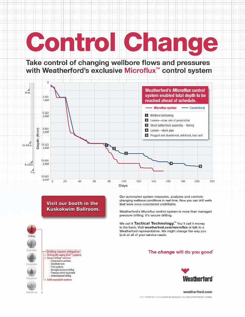
Weatherford International Ltd
In Kind Donations
Petroleum News

6
GREETINGS
Letter from the PSAAPG President, Cynthia Huggins
I want to invite you all to join us in Anchorage, gateway to one of the “Last Frontiers” for oil exploration, development, and production. The Pacific Section AAPG, SEPM, the Pacific Coast Section of the SEG, will be participating along with the host society, the Alaska Geological Society, and the Western Region of the SPE. David Hite and his team have worked tirelessly to ensure that these organizations provide a cross-discipline environment offering attendees a wide variety of technical presentations, poster sessions, short courses, and field trips.
The theme of the conference is Arctic to the Cordillera: Unlocking the Potential. You will have the opportunity to see how much potential is left to be realized, how much work has been done to characterize it, and how much work is yet to be completed. A wide array of oral and poster sessions have been compiled by Sandy Phillips and Steve Wright. There will be fourteen oral and five poster sessions to peak and keep your interest during the conference. On a regional scale there are sessions on Geology and Hydrocarbon Potential of the North Slope, Offshore Beaufort and Chukchi Seas, Geology and Tectonics of North Alaska, Petroleum Systems in Alaska and the Western Cordillera, and Paleozoic and Proterozoic Geology of Alaska. On the development side there are sessions covering North Slope fields and the Cook Inlet. There are a wide range of sessions related to oil field production and modeling, including Reservoir Modeling, Reservoir Quality, and Case Histories with the application of geophysical data and seismic. There are sessions focusing on technology advances and applications, as well as advances in seismic data acquisition and processing.
For those of you who want to get out and touch the rocks, there will be four field trips, one before and three after the conference. Before the conference, Sue Karl and Rod Combellick are leading the Turnagain Arm-Resurrection Bay Field Trip that traverses the Mesozoic accretionary complex and a portion of the 1964 megathrust deformation zone in south-central Alaska. Don’t forget your calf-high rubber boots and good rain-wind gear!
After the conference, Dave LePain, Ken Helmold, Bill Morris, Greg Wilson, Bob Gillis and Marwan Wartes will be leading folks down to the Cook Inlet to study sedimentology, reservoir quality, and tectonic setting of Late Miocene-Early Pliocene gas-bearing formations, in Upper Cook Inlet, Alaska. Mike Belowich and Anne Pasch will be leading a trip to the Wishbone Hill. This daylong excursion in four-wheel drive vans from Anchorage into south-central Alaska’s lower Matanuska Valley will expose participants to bituminous coal fields, the old Evan Jones coal mine and strip pits that are still open.
The final field trip will take participants to the Tertiary (coal bearing) and Holocene deposits of the Nenana Basin, Alaska. Jerry Siok and Steve Wilbur will lead the traverse up the Susitna River Valley through the central Alaska Range to Tertiary interior basins. If the weather permits we will have classic views of Denali, the highest peak in North America. The drive north will be a general tour of central Alaska geology and will include stops overlooking the Alaska Range with discussions and displays illustrating the tectonics of south-central Alaska. Along the way, you have the opportunity to observe large scale fluvial depositional systems and be able to relate stream processes to outcrop scale features.
In addition to the technical sessions and field trips, there will be short courses and a core workshop focusing on the reservoirs of the North Slope oil fields. The core workshop will address sedimentology, depositional environment, and the reservoir character and factors controlling porosity and permeability. Planned short courses include a one day short course on the Tectonic Evolution of Arctic Alaska and its influence on North Slope Basin Evolution and Petroleum Systems taught by David Houseknecht and Wes Wallace. The course will address the regional impact on subsidence deposition and deformation within the basin.
So please take advantage of all this hard work by the volunteers of the participating organizations and make plans to attend the convention. Alaska and its oil patch experience will be rolled out for you in a stimulating technical program and great field trips. Come see the latest technology and avail yourself of the opportunity to see old friends and meet new ones. I hope to see you in Anchorage this May!
Cheers,
Cynthia Huggins - President Pacific Section AAPG

7
Message from the Western Region SPE Director, A.M. Sam Sarem
On behalf of SPE and the Western North America Region, I warmly welcome you to the 2011 SPE Western Regional/AAPG Pacific Section Cordilleran Joint Meeting. Such meetings and conferences are at the heart of SPE’s mission to disseminate technology and support the professional development of current and future engineers in the oil industry. Your enthusiastic participation as attendees and/or authors is critical to the meeting’s success as well as SPE’s. This is also true for sponsors and exhibitors that support the development resources in this region of western North America.
Due to the enthusiastic and outstanding leadership of Michael Husband, General Meeting Chair; Matthew Mower, the Alaska section Chair and its hard-working Section BOD, generous support of sponsors and participation by the exhibitors, and efficient assistance of SPE staff, we are positioned to have another memorable SPE Event.
Holding the 2011 joint Western Regional Meeting in Anchorage, Alaska provides the ideal setting for bringing together the technical and professional industry leaders for exciting discussions. Also, for exchange of ideas regarding this industry’s challenges and innovative technologies for the development of oil and gas resources.
To facilitate sharing experiences and networking, this meeting offers a comprehensive technical program that covers a variety of subjects including challenges of heavy oil to low permeability fractured reservoirs, simulation to stimulation, regulatory and HSE issues to field management and smart field technologies. The proximity to the massive Prudhoe Bay should result in a stimulating discussion on Efficient Waterflooding Processes. Additionally, we will have an excellent set of exhibits of the latest technologies for your perusal and learning. And, the registration fee will be waived for the Legion of Honor SPE Members (those who have been a member of SPE in good standing for 50 or more years).
The SPE Western North America Region student paper contest will also be held just prior to the conference. The top presentations will be highlighted in a “Best of WRM 2011 Student Paper” session where attendees will hear and share topics with newest generation of engineers entering this industry.
We welcome also those from other US and international regions that share the need for the same kinds of technology mentioned above.
I thank you for your participation in the 2011 SPE WNAR/AAPG Pacific Section Cordilleran Joint Meeting and for supporting your professional society. I am confident that this will be a great learning experience for you. All the best, A.M. Sam Sarem, SPEI Director Western North American Region

8
Message from the 2011 Convention CoChairs We are pleased to announce the 2011 joint meeting of the Pacific Section of the American Association of Petroleum Geologists and the Western North America Region of the Society of Petroleum Engineers. The theme of the meeting is “Arctic to the Cordillera: Unlocking the Potential.” The theme is appropriate because Alaska is one of the primary areas of North America in which large reserves of conventional and unconventional oil and gas remain to be discovered and produced. In addition, Anchorage is the ideal setting for such a discussion as it is the business hub where most of the plans are made about the exploration and development of Alaska’s oil and gas resources. Past success in Alaska provides an excellent example of what new forward thinking and risk taking can achieve. The joint AAPG and SPE conference provides the framework for discussions about the potential that still lies before us, the hurdles to be overcome in an increasingly difficult operating environment, and the technologies which have and will make for successful outcomes. The diverse program of field trips, short courses, oral technical sessions, and poster sessions will provide ample opportunities for stimulating discussions on topics that have had little exposure outside of the state. That said, many of these problems are not unique to Alaska, nor are the problem solving approaches. Ultimately, this conference is intended to bring together experiences from mature and frontier provinces for sharing and discussion. We hope that the meeting will serve to provide some new insights and demonstrate the continued validity of many existing applications. With those thoughts in mind, we extend to all a warm welcome to Anchorage.
Pacific Section AAPG Western Region SPE David M. Hite Michael Husband Consultant BP Alaska Exploration
Denali

9
86th Annual Meeting of the Pacific Section, American Association Petroleum Geologists and
81st Annual Meeting of the Western Region, Society of Petroleum Engineers
with Pacific Section, Society for Sedimentary Geology (SEPM)
Pacific Coast Section, Society of Exploration Geophysicists Alaska Geological Society
Pacific Section AAPG Officers President Cynthia Huggins President-Elect John Minch Vice President Jeff Gartland Secretary Tony Reid Treasurer Cheryl Blume Treasurer-Elect Jana McIntyre Past President Scott Hector Editor In Chief Ed Washburn
Alaska Geological Society Officers President Tom Morahan President-Elect Ken Helmold Vice-President Ken Helmold Treasurer Al Hunter Secretary Chad Hults Past President Tom Homza
Alaska Section SPE Officers Section Chairperson Matthew Mower Program Chairperson Forest Bommarito Membership Chairperson Dan Young Treasurer Jenny Cronlund Secretary Olivia Bommarito SPEI Director, W North America Sam Sarem
Local Committee AAPG Co-chair David Hite SPE Co-chair Michael Husband Oral Program Co-chairs Sandy Phillips, Gordon Pospisil, Randy Roadifer, Jack Hartz Poster Session Co-chairs Reed Boeger, Maggie Orlando, Steve Wright Exhibits Igbokwe Chidiebere, Tom Walsh Field Trips Tom Plawman Short Courses and Workshops Jerry Anderson, Pat Collins, Robert Morse, Jane Williamson Registration Heather Heusser, Julie Houle, Dan Young Finance Olivia Bommarito, Jenny Cronlund, Al Hunter Corporate Sponsorship/Advertising Jenny Jemison, Doug Waters Planning and Logistics Tom Morahan Judging Peter Barker, Reed Boeger, Abhijit Dandekar, Maggie Orlando Publications / Website Joe Anders, Steve Davies, Esther Fueg, Jan Hazen, Heather
Heussar, Peter Johnson, Taylor West

10
GENERAL INFORMATION Find up to the minute information at http://www.psaapg.org or http://www.alaskageology.org. Please contact the general meeting co-chairs: David Hite, [email protected] (AAPG) or Michael Husband, [email protected] (SPE) if you have questions. Local hosts are the Alaska Geological Society and Alaska Section Society of Petroleum Engineers. Registration For the conference, registration and payment will be online only. Early registration deadline: April 15, 2011 Cancellation deadline: April 21, 2011 Register at http://www.psaapg.org/convention.aspx. SPE Short Course registration is separate (register at http://www.pttcwestcoast.org). All meeting badges will be distributed on-site. ● Early registration rates; (before April 15, 2011) Professional SPE and AAPG Members: Full meeting = $250; One day = $100 Professional Nonmembers: Full meeting = $300; One day = $125 Student: Full meeting = $65; One day = $35 Guest or Spouse*: $60 K-12 Professional: $60 Field Trip or Short Course only: $35 Joint Proceedings CD-ROM (includes SPE papers): available for purchase onsite at the conference ● Late or on-site registration rates Professional Members: Full meeting = $300; One day = $125 Professional Nonmembers: Full meeting = $350; One day = $140 Student: Full meeting = $90; One day = $45 Guest or Spouse*: $75 K-12 Professional: $75 AAPG Field Trip or Short Course only: $45 SPE Short Course: $100 - $200 (Register @ http://www.pttcwestcoast.org/ ) Joint Proceedings CD-ROM (includes SPE papers): available for purchase onsite at the conference
* Guest or Spouse registration fee does not allow access to technical sessions. OnSite Registration and Badge Pickup Schedule Registration for the conference will be in the main lobby of the hotel on Saturday afternoon and Sunday through Wednesday. On-site registration for the PTTC/AK SPE Short Courses is separate from the conference and will be 30 minutes prior to the start of the course. ● Saturday, May 7 3:00 PM – 6:00 PM ● Sunday, May 8 8:00 AM – 6:00 PM ● Monday, May 9 7:30 AM – 5:00 PM ● Tuesday, May 10 7:30 AM – 4:00 PM ● Wednesday, May 11 7:30 AM – 12:00 PM
The Venue The meeting is being held in downtown Anchorage. Temperatures are cool to mild in early May (30-50°F), with a possibility of rain showers.
Convention Hotel – Anchorage Sheraton Hotel 401 East 6th Avenue Anchorage, Alaska 99501 Phone: 1-907-276-8700 Fax: 1-907-276-7561

11
Hotel Accommodations A block of rooms has been reserved at a discounted rate at the meeting venue hotel, the Anchorage Sheraton Hotel at 401 East 6th Avenue, Anchorage, Alaska 99501. The deadline for the hotel reservation at the discounted rate of USD$105 + tax/standard room is April 21, 2011. Rates for other rooms are Club Level = $135/night, Suites = $400-$600/night and 3rd and 4th persons/room are $10/night each. Any reservation requests received after the deadline date will be available on a space and rate available basis. To make hotel reservations proceed to the PS-AAPG website http://www.psaapg.org and click on the “reserve a room at convention hotel” link.
Parking Meeting attendees can park on-site in the self parking areas of the Sheraton for $10/day, with in and out privileges. Attendees will need to go to the front desk and tell them that you are attending the conference.
Dining There are numerous restaurants at the Sheraton and within 8-10 blocks of the hotel. Most of these can be reached by a 10-15 minute walk west along 5th or 6th Avenues.
Getting Around the Area Most local attractions and abundant restaurants are within walking distance of the conference hotel. The other options are cabs and rental cars. The local mass transit (bus system) is not conducive to easy access and spot-to-spot travel in the downtown area.
Internet Access at the Meeting Overnight Guests: Internet Locations and Charges
● In Room (Wi-Fi): $9.95/day (each calendar day) ● The Link by Sheraton-Lobby Level: 4 internet PC’s with complimentary access for overnight guests ● Lobby (Wi-Fi): Complimentary Wi-Fi access for overnight guests
Non-Overnight Guests: Locations and Charges ● Available in the Link by Sheraton or Lobby at a charge ($5.95 for 15 minutes)
Accessibility AAPG and SPE are committed to making its meetings accessible to all.
Cancellations, Changes, and Refunds Requests for additions, changes, and cancellations must be received by April 21, 2011. No refunds will be made on cancellation notices received after this date. Refunds will be mailed after the meeting; refunds for fees paid by credit card will be credited to the card identified on the registration form. The meeting cannot provide refunds for on-site registration, Abstracts with Programs, or event ticket sales.
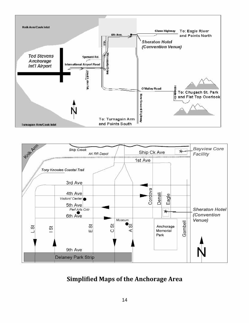
Directions From Ted Stevens Anchorage International Airport The Anchorage Sheraton Hotel is located about 6 miles northeast of the Ted Stevens Anchorage International Airport.
Driving Directions ● Head south to W. International Airport Road ● Continue straight onto W. International Airport Road ● Turn left at the Spenard Rd/Jewel lake Rd. Intersection ● Turn left at Minnesota Dr. and drive north ● Continue on I St. (Minnesota becomes I St.) ● Turn right on W. 6th Avenue. ● Continue east to 401 East 6th Avenue (at the northeast corner of 6th Avenue and Denali St.)
12
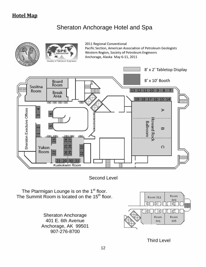
Hotel Map
Sheraton Anchorage Hotel and Spa
The Ptarmigan Lounge is on the 1st floor. The Summit Room is located on the 15th floor.
Second Level
Third Level
Sheraton Anchorage 401 E. 6th Avenue
Anchorage, AK 99501 907-276-8700
13
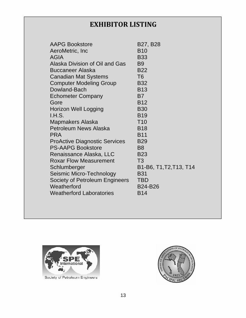
EXHIBITOR LISTING
AAPG Bookstore B27, B28 AeroMetric, Inc B10 AGIA B33 Alaska Division of Oil and Gas B9 Buccaneer Alaska B22 Canadian Mat Systems T6 Computer Modeling Group B32 Dowland-Bach B13 Echometer Company B7 Gore B12 Horizon Well Logging B30 I.H.S. B19 Mapmakers Alaska T10 Petroleum News Alaska B18 PRA B11 ProActive Diagnostic Services B29 PS-AAPG Bookstore B8 Renaissance Alaska, LLC B23 Roxar Flow Measurement T3 Schlumberger B1-B6, T1,T2,T13, T14 Seismic Micro-Technology B31 Society of Petroleum Engineers TBD Weatherford B24-B26 Weatherford Laboratories B14
14
Simplified Maps of the Anchorage Area

15
SPECIAL EVENTS
Opening Session: Sunday, May 8, 4:00 – 6:00 PM Howard Rock Ballrooms A, B and C • Welcoming Remarks – Dave Hite and Mike Husband • Introduction of Head Table and Notables – Mike Husband • General Overview of Convention and Events – David Hite • Introduction of Guest Speakers – Mike Husband
Kevin Banks, Director of the Department of Natural Resources, Division of Oil and Gas Janet L Weiss, Subsurface Vice President for BP Alaska David Rensink, AAPG President
• Introduction of Keynote Speaker – David Hite Fran Ulmer, Chancellor of the University of Alaska Anchorage
• Closing Remarks – Mike Husband
Guest Speakers
KEVIN BANKS –
Kevin Banks has served as the Director of the Alaska Department of Natural Resources, Division of Oil and Gas since 2007. Kevin moved to Alaska in 1982 and worked for the Minerals Management Service as an economist in the Social and Economic Studies Program. In this position, he led the agency’s economic research program and directed several engineering assessments of the technologies required to develop the oil and gas resources of the Alaska Outer Continental Shelf. In 1991, Mr. Banks came to the Division of Oil and Gas as its sole petroleum economist. He presided over the establishment of the Commercial Section and was responsible for managing the State of Alaska’s royalty in-kind program, implementing the royalty modification statutes and other oil and gas incentives, and administrating the many royalty settlement agreements between the state and its lessees. Mr. Banks has a B.S. in economics/philosophy from Loyola University Los Angeles, and an M.A. in economics from Washington State University.
JANET L. WEISS – Janet currently serves as the Subsurface Vice President for BP Alaska. Janet was appointed to this position in October, 2010. In this role, she is accountable for resource progression and subsurface activities, including base reservoir management, reservoir management, new well delivery, renewal and appraisal activity, technology and seismic activity, subsurface organization capability, and IT for BP Alaska. Prior to this appointment, Janet was Vice President for Special Projects for BP Exploration & Production, and prior to that, North America Gas Technical Director for Operations and HSSE. Janet has served as Vice President for BP’s Unconventional Gas Technology efforts and Exploration & Production Director of Organization Capability for Operations and HSSE. Janet also served as the Performance Unit Leader for BP’s Western Wyoming businesses and also for
BP’s Base Operations for the Gulf of Mexico Shelf. Earlier in her career, Janet held various roles all in Alaska, including process engineer, reservoir engineer, petroleum engineer, reservoir engineering advisor, and various subsurface leadership positions. She has over 25 years industry experience and holds a BS in Chemical Engineering from Oklahoma State University. Janet and her husband, Troy, are very pleased to be back in Alaska, and they have a daughter and a son attending universities.

16
DAVID G. RENSINK – World Energy and the Future of Petroleum Geology David Rensink has over forty years of experience in the oil and gas business in technical, supervisory and executive management positions with major oil companies and independents of various sizes. His work experience has been in the exploration for and the development of oil and gas, primarily on the continental shelf of the Gulf of Mexico. David has direct experience in geology and geophysics, and a strong working knowledge of reservoir engineering. He is the current president of the American Association of Petroleum Geologists and past president of AIPG – Texas Section, Houston Geological Society. He is a member of the American Association of Petroleum Geologists (AAPG), the Society of Exploration Geophysicists (SEG), the American Institute of Professional Geologists (AIPG), the Association of Environmental and Engineering Geologists (AEG), the Society of Independent Professional Earth Scientists (SIPES), the Houston Geological Society (HGS), and the Geophysical Society of Houston (GSH). David is licensed in Texas (#62), and is a Certified Petroleum Geologist #6031 (AAPG - DPA). He received a
BS-Geology from the University of Minnesota in 1968 and an MS-Geology from the University of Oklahoma in 1971.
Keynote Speaker
CHANCELLOR FRAN ULMER – Lessons Learned from the BP Deepwater Horizon Oil Spill: findings from President Obama's Oil Spill Commission and its implications for Alaska
Fran Ulmer is chancellor of Alaska’s largest public university, the University of Alaska Anchorage (UAA). In addition to serving as UAA’s Chancellor, Ms. Ulmer was appointed by President Barack Obama in June 2010 to the National Commission on the BP Deepwater Horizon Oil Spill and Offshore Drilling. The commission is charged with investigating the causes of the explosion and oil spill, and recommending changes to prevent future disasters from occurring. Prior to her appointment to the oil spill commission, Ms. Ulmer was a member of the Aspen Institute's Commission on Arctic Climate Change and held Board positions with the Alaska Nature Conservancy, the National Parks Conservation Association and the Union of Concerned Scientists. Appointed Chancellor in 2007, Ms. Ulmer previously was a Distinguished Visiting Professor of Public Policy and Director of the Institute of Social and Economic Research at UAA. During her more than 30 years of work in public service on the local, state and national level, Ms. Ulmer has helped to shape both public and environmental policy. As a state legislator, Ms. Ulmer served on the Special Committee on the Exxon Valdez Oil Spill Claims Settlement. In addition, she
was the first Chair of the Alaska Coastal Policy Council and served for more than 10 years on the North Pacific Anadromous Fish Commission. Ms. Ulmer served as an elected official for 18 years as the mayor of Juneau, a state representative and as Lieutenant Governor of Alaska. As Director of Policy Development for the State of Alaska, Ms. Ulmer managed diverse programs, including coastal management, intergovernmental coordination, and public participation initiatives. At the national level, Ms. Ulmer served as a member of the Federal Communications Commission's State and Local Advisory Committee, the Federal Elections Commission's State Advisory Committee and co-chaired the National Academies of Science’s Committee on State Voter Registration Databases. Ms. Ulmer earned a J.D. cum laude from the University of Wisconsin Law School, and has been a Fellow at the Institute of Politics at the Kennedy School of Government.
Exhibit Opening: Sunday, May 8, 6:00 PM, Kuskokwim and Yukon Rooms, Foyer, and Atrium
Ice Breaker: Sunday, May 8, 6:00 – 8:00 PM Kuskokwim and Yukon Rooms, Foyer and Atrium. Come enjoy hors d’oeuvres with the exhibitors.
• SPE Student Paper Winners – Abhijit Dandekar

17
Symposium In Honor of Ken Bird: Geology and Hydrocarbon Potential of the North Slope, Offshore Beaufort and Chukchi Seas: several sessions beginning Monday, May 9, 8:00 AM and ending Tuesday, May 10, 4:30 PM, Howard Rock Ballrooms B and C (Oral Sessions), Yukon Room (Poster Session)
KEN BIRD Ken Bird joined the USGS in 1974 following the completion of geology degrees at Oregon State University (B.S. 1961) and the University of Wisconsin (M.S. 1964, Ph.D. 1967), and seven years in the petroleum industry, mostly with Shell Oil Company. During more than 35 years of work for the USGS, Ken established a distinguished record of research, with emphasis on the regional geology, stratigraphy, paleogeography, and petroleum systems of the Alaska North Slope and the broader Arctic. His numerous published papers on the region represent a fundamental body of work that is essential reference material for novice and veteran geologists alike. Throughout his USGS career, Ken’s demeanor and authoritative knowledge of North Slope petroleum systems provided a calm, assured, and unfailingly reliable scientific perspective to volatile policy issues during many briefings and hearings in Washington D.C. And, beyond his many scientific accomplishments, Ken is held in high esteem as a gentleman and friend to associates throughout the USGS, other Federal and State agencies, academia, and
the petroleum industry. Although he retired in 2010, Ken continues to pursue his passion for the geology and petroleum systems of Arctic Alaska as a distinguished USGS Scientist Emeritus.
Speakers Breakfasts: Monday May 9 through Wednesday May 11, 7:00 AM – 7:45 AM, The Summit Special Presentation: Tuesday, May 10, 3:30 PM – 5:00 PM, Howard Rock Ballroom A
DR. W.C. RUSTY RIESE – Oil Spills, Ethics, and Society: How Do They Intersect and Where are the Responsibilities? (This special ethics presentation can be utilized for one PDH Professional Development hour)
“Who has ethical responsibility in times of an oil spill and what are those responsibilities?” The initial response to this question always identifies the operating companies, or those responsible for a spill, as the ones having ethical responsibilities to discharge: “You made the mess, so you clean it up and make us whole.” However, many other constituencies also have some responsibilities to discharge. Operating companies, investors, regulators, and the general public all have interests; and the press and elected government officials are not immune to interjecting their opinions and judgments on this topic when given the opportunity. Overarching all is the professionally and ethically driven requirement that the professionals charged with the cleanup and root-cause analysis conduct their work responsibly and with integrity, allowing all the clamoring around them to have no inappropriate influence. But the business drivers which the other groups impose, the definitions they choose to place on ethical behavior, and the responsibilities they
have for ethical discharge of their own duties tend to be lost in the emotional environment which attends an accident. This brief presentation and discussion will explore some of these areas of potential conflict and prepare the participants to engage non-scientists in useful discussion of the broader societal context within an oil spill resides.
18
Dr. W.C. Rusty Riese is a geoscientist based in Houston, Texas. He is widely experienced having worked in both minerals and petroleum as a geologist, geochemist, and manager during more than 39 years in industry. He participated in the National Petroleum Council evaluation of natural gas supply and demand for North America which was conducted at the request of the Secretary of Energy; in the more recent analysis of global supply and demand requested by the same agency; and in the National Research Council study of coalbed produced water use in the western states. He is currently a member of the American Association of Petroleum Geologists Committee on Resource Evaluations, and a member of the House of Delegates. Rusty has written extensively and lectured on various topics in economic geology including biogeochemistry, isotope geochemistry, uranium ore deposits, sequence stratigraphy, and coalbed methane petroleum systems; and he holds numerous domestic and international patents. He has forty years of teaching experience including twenty six years at Rice University where he is an Adjunct Professor and where he developed the curricula in petroleum geology and industry risk and economic evaluation. He also holds Adjunct Professor appointments at Colorado State University and the University of New Mexico, where he sits on the Caswell Silver Endowment advisory board. He is a Fellow in the Geological Society of America and the Society of Economic Geologists; and a member of the American Association of Petroleum Geologists and several other professional organizations. He earned his PhD from the University of New Mexico in 1980; his M.S. in geology from the same university in 1977; and his B.S. in geology from the New Mexico Institute of Mining and Technology in 1973. He is a Certified Professional Geologist, a Certified Petroleum Geologist, and is a Registered Geologist in the states of Texas and South Carolina.
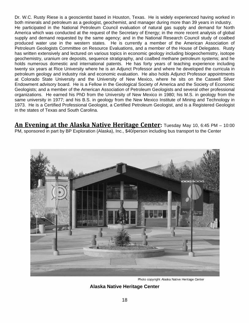
An Evening at the Alaska Native Heritage Center: Tuesday May 10, 6:45 PM – 10:00 PM, sponsored in part by BP Exploration (Alaska), Inc., $40/person including bus transport to the Center
Photo copyright Alaska Native Heritage Center
Alaska Native Heritage Center

19
Business Meetings and Luncheons AAPG House of Delegates Breakfast: Monday, May 9, 7:00 – 9:00 AM, Room 311
Pacific Section AAPG Awards Luncheon: Monday May 9, 11:30 AM – 1:15 PM; Howard Rock Ballroom B, $45/person
• Introduction of Head Table and Notables – David Hite • Welcoming Remarks – Tom Morahan, AGS president • Comments and Presentation of the Teacher of the Year Award – Cynthia Huggins, PS-AAPG President • Introduction of Bob Lindblom • Awards Presentation – Bob Lindblom
Honorary Life Member – Charles G. (Gil) Mull and E. Eugene Fritsche Distinguished Educator – Kristine J. Crossen, Ph.D. Distinguished Service – Gregory C. Wilson, Ph.D., Curtis P. Henderson, and David Miner J. Levorsen Award – Grant Garvin H. Victor Church Award – Meng He
Society of Petroleum Engineers Awards Luncheon: Tuesday May 10, 11:30 AM – 1:15 PM; Howard Rock Ballroom B, $45/person
• Introduction of Head Table and Notables – Mike Husband, General Chair • WNAR Awards Presentation – Sam Sarem, WNAR Director
Outstanding Corporate Sponsor– Chevron Drilling – Scott Myers Outstanding Faculty – Kristian Jessen Mgt & Info – Andrei Popa Prod & Ops – William Minner Proj, Fac & Const – Craig Pauley Reservoir – Fred Aminzadeh Service Award – Young Kirkwood Outstanding Young Professionals – Jenny D. Cronlund, Cynthia Lynch
• Introduction of Guest Speaker, Lance Cole – Forest Bommarito • Presentation: E. Lance Cole, Petroleum Technology Transfer Council; Topic – Staying Current in a
Technical/Business World That Changes at Warp Speed E. Lance Cole, Operations Manager, an Oklahoma resident since 1978 and a registered professional engineer in Oklahoma, has served PTTC since 1996, beginning as Project Manager and then as Executive Director until AAPG assumed PTTC management responsibility. As National Project Manager, he was responsible for technical oversight of PTTC's regional lead organizations and contract reporting for the national office, and served as a technical adviser on all aspects of the program. As Executive Director, he had primary staff responsibility for the overall PTTC organization. Mr. Cole received a B.S. in chemical engineering from South Dakota School of Mines and an M.S. in management from Southern Nazarene University. His professional experience encompasses reservoir and corrosion engineering, as well as reserve estimation and appraisal. He has worked with a major oil and gas company, a large integrated independent, and in engineering-oriented consulting companies. Mr. Cole is a member of SPE, AAPG, SEG and SIPES and, in the past, has been involved with the SPE/DOE IOR Symposium in Tulsa for several years.
• Questions • Closing Comments – Mike Husband
AAPG Division of Professional Affairs Luncheon: Tuesday May 10, 11:30 AM – 1:00 PM, The Summit, $45/person
Speaker: Dr. Mark Myers, Vice Chancellor for Research at the University of Alaska Fairbanks; Topic – The North Slope of Alaska 43 years after Prudhoe Bay State No. 1 – Opportunities and Challenges

20
Pacific Section AAPG Executive Committee Meeting: Wednesday, May 11, 5:00 – 6:00 PM, Room 301
Volunteers Needed Volunteers are desperately needed, especially for judging the AAPG oral and poster sessions, if you are interested please contact Sandy Phillips at [email protected] or Steve Wright at [email protected].
Guest Activities Two optional spouse or guest tours are offered for those not attending the technical sessions during the active convention hours. One is the Highlights of Anchorage Tour and the other is the Alyeska Tour – a first class ski resort.
Alyeska Tour: Monday, May 9, 2011 Just 40 miles outside of the Anchorage city limits awaits a true beauty of the most magnificent kind at the Alyeska Resort. A short, scenic drive along the Turnagain Arm provides many photo opportunities. Once into Girdwood, the old road will take you past downtown Girdwood and into the heart of Alaska’s first class ski resort. Nestled among the Chugach Mountains, Alyeska Resort offers up the great outdoors, lush green forests, majestic mountains, fresh air, and tons of history. An aerial tram ride to the top of Mount Alyeska will provide you with many more photo opportunities and breath-taking views. Once you have reached the summit, you will enjoy lunch at Seven Glaciers Restaurant, Alaska’s only AAA four diamond eatery offering signature Alaskan entrees in an elegant atmosphere. After lunch, you will have a chance to peruse the mountain top museum and learn about the early beginnings of this mining town turned ski resort. Roundtrip time 4-5 hours. Date: May 9, 2011; departs Sheraton Hotel at 9:30 AM and returns about 2:30 PM
Cost: USD $75 per person (includes roundtrip transportation, narrated tour, tram fee, lunch at Seven Glaciers Restaurant, and ADS escort)
Minimum required: 30
Highlights of Anchorage Tour: Tuesday, May 10, 2011 This city adventure starts with a pick up from the Sheraton Hotel. The tour will begin at the Port of Anchorage and Ship Creek. Take in the views of the city from the port as your tour guide explains the history of the Port of Anchorage and the Ship Creek area. Next we travel to Earthquake Park and the busiest seaplane base in the world, Lake Hood! Follow your tour guide through Earthquake Park to see the site of the memorial of the 1964 Earthquake. See what happened to the land as it broke apart and slid into the Cook Inlet. Cook Inlet views and pictures from here are a favorite for guests! Down the street, visit the historic original site of the David Green Master Furrier Showroom, which offers a selection of furs not found anywhere else in the world! Lunch will be at the Sourdough Mining Company, where you will be taken back to the mining days of our great city at this family-owned Alaskan restaurant. After lunch visit the largest chocolate fountain in the world at the Alaska Wild Berry Products gift store and souvenir shop. This small family-owned shop boasts the finest Alaska made chocolates, jellies, jams, and other treats. Walk through the park at your leisure and see a replica of a rustic, old-time Alaskan town. After lunch and a walk in the park, guests will travel to Potter’s Marsh for an opportunity to see wildlife, and a view of Cook Inlet. Roundtrip Time: 4-5 hours. Date: May 10, 2011; departs Sheraton Hotel at 9:30 AM and returns about 2:30 PM
Cost: USD $70 per person (includes roundtrip transportation, narrated Anchorage tour, lunch at Sourdough Mining Company and Wild Berry Alaska products, stop at David Green Master Furriers, stop at Potter’s Marsh, and ADS escort) Minimum required: 30

21
FIELD TRIPS
Field Trip 1 Title: Turnagain Arm-Resurrection Bay Field Trip Dates: May 6-7, 2011 (Depart Sheraton Hotel 7:30 AM Friday, May 6. Return to Sheraton Hotel 7:00 PM
Saturday, May 7) Field Trip Leaders: Susan Karl (USGS) and Rod Combellick (Alaska DGGS)
For more information contact Susan Karl at [email protected]. Cost: USD $551 double occupancy, $591 single occupancy - includes transportation and admissions, 1
dinner, 1 breakfast, 2 box lunches, and snacks. Minimum Number of Participants: 25 Maximum Number of Participants: 35
Requirements: Calf-high rubber boots will be needed for approaching some exposures on this trip. We will hope for sunny weather but good rain-wind gear and cool-weather clothing are also advised. Description: This 2-day field trip will traverse the Mesozoic accretionary complex and a portion of the 1964 megathrust deformation zone in South Central Alaska. Day 1 will be a transect across the accretionary complex as it is exposed along Turnagain Arm. We will also observe the consequences of Paleocene to Eocene spreading ridge subduction and late Holocene Pacific plate subduction as manifested by the 1964 M9.2 earthquake, including evidence of great paleoearthquakes as recorded in coastal marsh deposits. On Day 2 we will visit the Alaska Sea Life Center, view Seward Harbor (the location of one of the 1964 tsunamis that were responsible for 106 of the 115 deaths related to the 1964 earthquake), and we'll take a boat tour to look at the Resurrection Peninsula ophiolite, part of the active spreading center that was subducted in the early Eocene. The boat tour will include opportunities to see coastal birds and marine life, as well as spectacular scenery.
Field Trip 2 Title: Tertiary Coal Bearing and Holocene Deposits, Nenana Basin, Alaska Dates: May 11-13, 2011 (Depart Sheraton Hotel 1:00 PM Wednesday, May 11. Return to Sheraton Hotel
8:00 PM Friday, May 13) Field Trip Leaders: Jerry Siok (BP Exploration (Alaska), Inc.) and Steve Wilbur, Ph.D.
For more information contact Jerry Siok at [email protected].
Cost: USD $600 double occupancy, $700 single occupancy - Cost includes all transportation (from & return to the Sheraton), two nights lodging, breakfasts, box lunches in the field and snacks along the way. Participants are responsible for their own dinners.
Minimum Number of Participants: 20 Maximum Number of Participants: 27
Requirements: This trip departs Anchorage at 1 PM on day 1 and returns to Anchorage by 8 PM on day 3. Trip participants must be physically able to walk 1 mile roundtrip up Suntrana Creek, ascend alluvial fans and walk on braided gravel bars. Typical weather in early May can range from warm and clear to wet, cold and snow. Rain gear and cool-weather clothing are recommended. Suitable waterproof footwear with ankle supports or rubber boots are required for the walk up the Suntrana type section on day 2. This time of year should afford good visibility of outcrops, but weather is very unpredictable – so be prepared. Description: This trip will depart Anchorage and traverse up the Susitna River Valley through the central Alaska Range to Tertiary Interior basins. The drive north will be a general tour of central Alaska geology and include stops overlooking the Alaska Range with discussions and displays illustrating the tectonics of

22
south-central Alaska. Weather permitting, we will have classic views of Denali, the highest peak in North America. Along the way we will observe large scale fluvial depositional systems and be able to relate stream processes to subsequent outcrop scale features. Two (2) nights will be spent in Healy, 250 miles North of Anchorage. We will examine in detail outcrop examples of Tertiary to Holocene fluvial and alluvial sequences in the Nenana Basin. Recent oil and gas exploration drilling has targeted these systems further north in the basin. We will walk up the type section of the Tertiary Coal Bearing Usibelli Group and Nenana Gravels with world class badland outcrop exposures. Usibelli Coal Mine Inc. is the only operating coal mine in Alaska. They will show us their state of the art engineering, modern mining equipment, active mine operations and reclamation activities.
Field Trip 3 Title: Wishbone Hill Field Trip Dates: May 12 (Depart Sheraton Hotel 8:00 AM, Thursday May 12. Return to Sheraton 5:00 PM, May 12) Field Trip Leaders: Mike Belowich (Alaska Earth Sciences), Anne Pasch, (University of Alaska Anchorage)
For more information contact Mike Belowich at [email protected]. Cost: USD $60 - includes box lunch and drinks.
Minimum Number of Participants: 8 Maximum Number of Participants: 22
Requirements: Weather in May can be variable. Participants for the Wishbone Hill field trip should come prepared for the elements with proper hiking footwear, warm clothing, and raingear. Description: The Wishbone Hill Field Trip is a daylong excursion by four-wheel drive vans from Anchorage into south-central Alaska’s lower Matanuska Valley and its bituminous coal field, to see the old Evan Jones coal mine and still open strip pits. Leaders will meet field trip participants in the lobby of the Sheraton Hotel in downtown Anchorage at 8:00 AM on May 12th to give a brief overview of the field trip prior to boarding. A bedrock geologic road log and other materials on the area will be provided to participants. The field trip area to be visited is very important in Alaska’s early coal mining industry. The U.S. Navy’s interest in high quality bituminous steaming coal for use in its early 20th Century Pacific Fleet was the driving force behind the initial construction of the Alaska Railroad to reach the Chickaloon coal field, located about 20 miles east of Wishbone Hill. Also around this time period (1914 – 1920), spur railroad lines were built to the Wishbone Hill area by the Alaska Engineering Commission to access the coal resources there. Interestingly, Anchorage was initially founded in 1915 as a tent camp for workers building the railroad to these coal fields. There is currently renewed interest by companies looking to reestablish the coal mines for export purposes as a result of the increasing global demand for high quality bituminous coal which the area possesses. Wishbone Hill is also a world class paleontological site for Early Tertiary fossils. The first stop on the tour will be an overlook of Usibelli Coal Mine’s new proposed Wishbone Hill strip mine that will be described by Rob Brown, Usibelli Project Manager for Wishbone Hill coal development. The group will then move on to the old Evan Jones Mine located near Sutton, at which point Mike and Anne will lead the tour.
Field Trip 4 Title: Sedimentology, Reservoir Quality, and Tectonic Setting of Late Miocene-Early
Pliocene Gas-Bearing Formations, Upper Cook Inlet, Alaska Dates: May 12-14 (Depart Sheraton Hotel 8:30 AM Thursday, May 12. Return to Sheraton Hotel 6:00 PM
Saturday, May 14)

23
Field Trip Leaders: Dave LePain (Alaska DGGS), Ken Helmold (Alaska DOG), Bill Morris (Conoco-Phillips), Greg Wilson (Conoco-Phillips), Bob Gillis (Alaska DGGS), Marwan Wartes (Alaska DGGS) For more information contact Dave LePain at [email protected].
Cost: USD $565 double occupancy, $675 single occupancy - includes all transportation (start and finish at the Sheraton Hotel), all meals, two nights lodging, and field guide. Dinners in Soldotna and Homer will include a no host bar. A limited number of single occupancy rooms will be reserved for participants on a first come, first served basis.
Minimum Number of Participants: 21 Maximum Number of Participants: 35
Requirements: Trip participants must be physically able to walk up to 1 ½ to 2 miles roundtrip on each beach walk, which will include descending/ascending steep gravel beach access roads and walking on soft sand and gravel. Typical weather in early May can range from warm and mild to wet, cool, and windy. Lightweight rain gear and warm wind-blocking clothing are recommended. Suitable footwear, such as lightweight hiking boots or rubber boots, is highly recommended.
Description: The Cook Inlet forearc basin is a long-lived feature that extends from Shelikof Strait in the southwest through the east-west length of the Matanuska Valley in the northeast. The stratigraphic record of this basin includes a thick Mesozoic succession overlain by nearly 26,000 feet of Tertiary non-marine coal-bearing strata. All significant petroleum production to date has come from Tertiary age reservoirs in upper Cook Inlet. This field trip examines the sedimentology, sand body geometries, and reservoir quality of gas-bearing late Miocene and early Pliocene strata (Beluga and Sterling Formations) exposed in coastal bluffs between Soldotna and Homer on the Kenai Peninsula. The tectonic context of the forearc basin is explored during the first day through several stops in Mesozoic age rocks of the accretionary complex bordering the eastern basin margin. The sedimentology and sand body geometries of the upper Sterling Formation are examined the second day through two beach walks, the first at Clam Gulch south of Soldotna and the second at a location near Ninilchik. Exposures of the Beluga Formation are examined the third day through a beach walk northwest of Homer. Brief sedimentologic, petrologic, and tectonic overviews will be presented prior to the start of each beach walk. Participants will return to Anchorage by 6 PM the third day.
24
AAPG SHORT COURSES AND WORKSHOPS
AAPG Short Course 1 Title: Core Workshop: Reservoir Potential of the Western North Slope Dates: May 6, 2011 9:00 AM to 4:00 PM Course Leaders: Dick Garrard (FEX), David LePain (Alaska Division of Geological and Geophysical
Surveys), Ken Helmold (Alaska Division of Oil and Gas), Paul Decker (Alaska Division of Oil and Gas), Greg Wilson (Conoco-Phillips), Dave Houseknecht (US Geological Survey), Ken Papp (Alaska Department of Natural Resources) For more information contact Dick Garrard at [email protected].
Location: Bayview Core Facility (ConocoPhillips) Anchorage Cost: USD $100 – lunch/refreshments provided Maximum Number of Participants: 45
Description: Reservoir quality and continuity is a significant concern for exploration and development opportunities across the Western North Slope. Hydrocarbon bearing reservoirs are present throughout the stratigraphic interval ranging from the early Ellesmerian (Mississippian) through to the mid-Brookian (Upper Cretaceous). The associated sedimentary facies include non-marine fluvial, deltaic, shallow marine and deep water turbidite clastics. Carbonate reservoir are more limited and are restricted to the Lisburne (Mississippian to Pennsylvanian) and Shublik (Triassic). The Western North Slope Core Workshop will include a number of representative cores provided by Industry and the GMC covering the key reservoirs. Apart from core descriptions, other information will include facies analysis, porosity and permeability determinations, and petrology. If possible this information will also be related to outcrop and subsurface data such as seismic.
AAPG Short Course 2 Title: Tectonic Evolution of Arctic Alaska and Its Influence on North Slope Basin Evolution
and Petroleum Systems Dates: May 7, 2011 8:00 AM to 5:00 PM Course Leader: David Houseknecht (US Geological Survey), Wes Wallace (University of Alaska,
Fairbanks) For more information contact David Houseknecht at [email protected].
Location: Sheraton Hotel, Howard Rock Ballroom A Cost: USD $50 Maximum Number of Participants: 45
Description: David Houseknecht and Wes Wallace will present a one-day short course on how the tectonic history of Arctic Alaska has influenced the evolution of the North Slope sedimentary basin. The Brooks Range, its Siberian extension, and the Arctic Ocean basin provide the regional framework for the basin. We will summarize the major events in their evolution and then address the regional impact of those events on subsidence, deposition, and deformation within the basin. Our objective is to provide a regional context in which to place the deposition of source and reservoir rocks, generation and migration of hydrocarbons, and formation of stratigraphic and structural traps. We will emphasize the history from Jurassic to present, but will review how earlier events have influenced that later history.

25
AAPG Short Course 3 Title: Managing Your Business using PRMS (1-day) Dates: May 12, 2011 8:00 AM to 2:30 PM Course Leaders: John Etherington (PRA International Ltd.)
For more information contact John Etherington at [email protected]. Location: Sheraton Hotel, Kuskokwim Room Cost: USD $135 Minimum Number of Participants: 35 Maximum Number of Participants: 50
Description: In March 2007, the Society of Petroleum Engineers (SPE) released new guidelines to for the classification of petroleum reserves and resources. This Petroleum Resources Management System (PRMS) is co-sponsored by the World Petroleum Council (WPC), the American Association of Petroleum Geologists (AAPG), and the Society of Petroleum Evaluation Engineers (SPEE). These same sponsors have formed a Joint Committee for Reserves Evaluator Training (JCORET) to review and endorse training courses in the area of resources assessment and reporting. This course is the first endorsed by JCORET and discusses how companies are implementing PRMS to better manage their business. JCORET provides 0.8 continuing education credits (CEU’s) for this course.
Topics include: background to the revision project basic principles and key guidelines in PRMS support of resources project and portfolio management integration with regulatory reserves disclosures (includes a comparison of PRMS guidelines to SEC
and other disclosure rules) hybrid deterministic/probabilistic assessments accommodating unconventional resources improving quality assurance/quality control in resource evaluations interface with mineral classifications and evolving accounting standards
Course Leader: John Etherington is Managing Director of PRA International Ltd., a Calgary-based consulting firm advising industry on resources assessment, reserves disclosures, and portfolio management processes. He previously spent over 32 years with Mobil Oil in Canada, USA, and international Exploration and Producing assignments including five years in Mobil’s central resources audit group. John served on the SPE Oil and Gas Reserves Committee with primary responsibility for the 2006 mapping of major international petroleum resources classification systems and the 2007 PRMS project. He also coordinated SPE’s interface with the United Nations Framework Classification and the International Accounting Standards Board’s Extractive Activities projects. He was an SPE Distinguished lecturer in 2005/6, has presented papers on resources evaluation issues at AAPG, EAGE, and SPE conferences, and conducted training for over 900 geoscientists and engineers from 40 countries.

26
SPE SHORT COURSES These short courses are provided jointly by Petroleum Technology Transfer Council (PTTC) and Alaska SPE. Thanks to Schlumberger Testing Services, FMC Multi Phase Meters, Inc., Weatherford International Ltd and Halliburton for their donations to these workshops. Registration and Payment: SPE Short course registrations and payments are being handled separately from the Joint Meeting payments. Registration includes workshop, materials, refreshments, and lunch. The workshops costs are $100 for a half day workshop and $200 for a full day workshop. Advance registration required and seating is limited and based on when payment received. The easiest way to reserve a seat is registering online at http://www.pttcwestcoast.org/. Payment can be made online using PayPal, or made by check to “PTTC”, or you can contact us by phone with your Visa or MasterCard only. PTTC West Coast, 5100 California Ave Suite 200, Bakersfield, CA 93309-0726; Phone: PTTC West Coast at (661) 635-0559; Email: [email protected]:
SPE Short Course 1 Title: Multiphase Metering Dates: May 12, 2011 8:00 AM to 12:00 PM Course Leader: Parviz Mehdizadeh (Production Technology, Inc.) Location: Sheraton Hotel, Howard Rock Ballroom C Cost: USD $100 Description: Multiphase meter is a replacement for the traditional test separator and a new way to conduct production measurements and well testing. Some 3000 multiphase meters have been installed worldwide. The technology has been recognized as “enabling technology" for developing satellite reservoirs in GOM and North Slope. The objective of this workshop is to familiarize the production and facility engineers with the operating principle of multiphase and wet gas metering and their application in production operations. Examples of field installations and operating experience will be provided to demonstrate the application and benefits of this technology.
Topics include: Production Measurements – Well Testing, Why MP meters Multiphase/wet gas measurement techniques Poor Well Test Data - Single phase Devices used in MP measurements Alaska Regulatory Requirements, MP meters used in NS operations Vendor 1 - Principle, Capability /Limitation, Example of Field installation Vendor 2 - Principle, Capability /Limitation, Example of Field installation Vendor 3 - Principle, Capability /Limitation, Example of Field installation Operators comments on current installations, Q&A
Course Leader: Parviz Mehdizadeh holds a B.S. (1960) degree in Physics, an M.S. (1962) and a Ph.D. (1969) in Chemical Engineering and Material Science, all from The University of Oklahoma. He worked at ConocoPhillips from 1962-1993. During this time he was involved in numerous technology development and application projects related to production operations. He directed the Conoco-Norwegian Government technology development programs during the 1979-84, which included projects dealing with offshore structural design and processing of fluids offshore. During the next 5 years, he worked on the Subsea wellhead and production hardware for marginal field developments. From 1989 to 1993, Parviz directed the development and testing of the multiphase and water cut meters for production measurements in new asset developments. He also managed the construction and operation of the Conoco multiphase field test facility in Lafayette, LA. Since 1993 Parviz has been in the consulting practice. He has been involved in the development and field installation of multiphase meters in various locations around the world. He has provided technical advice on selection and specification of multiphase meters for well testing. He has also worked with companies who are involved in the development of novel water cut and multiphase metering systems. Dr. Mehdizadeh is a

27
founding member of the Texas A&M Multiphase Metering Users Roundtable and has presented numerous workshops and training seminars on multiphase metering. He has served on the SPE 2004 Well Operations Program Subcommittee, the SPE Committee on Facilities and Construction, and ASME Sub-Committee 19 on Wet Gas Metering. Parviz has worked with the American Petroleum Institute - Committee on Petroleum Measurements, to develop the API Technical Report 2566 on multiphase metering systems and with Alaska Oil &Gas Conservation Commission to write guidelines for qualification of multiphase metering for well testing.
SPE Short Course 2 Title: Introduction to Well Logging Dates: May 12, 2011 1:00 PM to 5:00 PM Course Leader: Todd Sidoti (Schlumberger) Location: Sheraton Hotel, Room – Howard Rock Ballroom C Cost: USD $100 Description: This course is for those who are interested in learning how to read and do simple interpretations with basic open hole wireline logs. Emphasis will be on older logs that are common in mature Alaska basins. The types of logs covered are resistivity, spontaneous potential (SP), sonic, gamma, density and neutron. Interpretations include:
Recognizing the presence of gas, oil and salt water Using quick look analysis to identify potential producing zones Estimating reservoir quality Estimating water/oil saturation using a simple Archie Equation Short exercises will be included as part of the course so be sure to bring a calculator that does
exponents (for Archie's Equation). Course Outline
Borehole environment and log header and scales Electrical logs-Resistivity and SP Radioactive logs-GR, Neutron, Density Water saturations using Archie’s equation Final exercises
SPE Short Course 3 Title: Thermal Recovery Dates: May 12, 2011 8:00 AM to 5:00 PM Course Leader: Anthony R. Kovscek (Stanford University) and Louis Castanier (Stanford University) Location: Sheraton Hotel, Room – Howard Rock Ballroom A Cost: USD $200 Description: Steam injection, and thermal recovery in particular, is the most popular enhanced oil recovery method. This one-day course is intended to cover thermal recovery principles and practice from analytical models for vertical wells to field-scale simulation. Both steam injection and in-situ combustion methods are examined. The course consists of lecture, examples, and case studies. Course Outline:
Heavy-oil overview: physical properties and thermal recovery processes/potential Fundamentals of thermal recovery: viscosity versus temperature functions, and thermal expansivity of
oil and rock Fundamentals of thermal recovery: viscosity versus temperature Analytical and semi-analytical models for evaluation of cyclic steam and steam-drive recovery
efficiency. Wellbore heat losses
28
Case studies of field implementation Overview of steam assisted gravity drainage In-situ combustion from laboratory tests to field studies
Who Should Attend: This course is intended for engineers and geologists who wish to expand their knowledge of thermal recovery methods and heavy oil. Primarily a reservoir engineering viewpoint is taken. Prior experience with steam injection, in-situ combustion, and heat and mass transfer in porous media is not assumed. Course Leaders: Dr. Tony Kovscek is an Associate Professor of Energy Resources Engineering and Director of the SUPRI-A project on Thermal and Unconventional Hydrocarbon Recovery. He holds PhD and BS degrees from the University of California, Berkeley and the University of Washington, respectively. Louis Castanier is Technical Manager of SUPRI-A. He holds PhD, ME, and BS degrees from Toulouse University. Collectively, the SUPRI-A group has contributed over 250 reports and papers on thermal and heavy oil recovery to the literature.
SPE Short Course 4 Title: Drilling and Completions for the PE Exam Dates: May 12, 2011 8:00 AM to 5:00 PM Course Leader: Bing Wines (Winrock Engineering Inc) Location: Sheraton Hotel, Room – Howard Rock Ballroom B Cost: USD $200 Description: This course is designed to be an introduction to the Drilling and Completion Engineering Technical Specialty Areas for the Professional Exam. Drilling topics covered include Drilling Operations, Rig Designs, Mud, Cementing, Drilling Hydrostatics, Drill String, Well Control, Bits and Casing Designs. Completion topics covered include Tubing String, Packers and Acid/Frac Designs. BE SURE TO BRING A CALCULATOR TO CLASS.
Course Outline: Drilling Completion Rig Power, Pumps, Design Tubing String Drilling Line Pressures Piston Effect
Mud Design Buckling Effect Cement Design Ballooning Effect Cementing Placement Temperature Effect Hydrostatics
Drill String Design Acid/Frac Design Well Control Treating Pressures
Bit and Bit Hydraulics Perforations Casing Design Dual Fracs Well Design Limited Entry Fracs
Course Leader: Gary Bing Wines graduated from the University of Oklahoma in 1962 with a B.S. Degree in Petroleum Engineering and worked for Cities Service Oil Company in Odessa, Texas, and Great Bend, Kansas. He moved to Oklahoma City and worked for Tenneco and Lear Petroleum before getting into the Consulting business in 1976 as Winrock Engineering, Inc. He was a member of the SPE Engineering Registration Committee from 1973 to 1989 (16 years) and was chairman for two terms in 1975 and 1976. He prepared and scored Petroleum Professional Exams for SPE and NCEES in the mid 1970's and helped to prepare and score exams through 1986. He was the primary author of the first edition of the SPE book, "A Guide to Professional Registration for Petroleum Engineers" in 1979 and helped re-edit it through its fifth edition in 1985. He helped set up and co-instructed the first Professional Registration Review Course for Petroleum Engineers in 1979 for SPE and continued to co-instruct the Course through 1988 for SPE. Since 1989, he has continued to instruct similar P.E. Review Courses throughout the U.S. He has authored several papers on

29
Professional Registration. He is currently a licensed Professional Engineer in Oklahoma. He became a SPE Distinguished Member in 1987, received a SPE Regional Service Award in 1989 and became a forty-five year SPE member in 2010.
SPE Short Course 5 Title: Production and Reservoir Engineering for the PE Exam Dates: May 13, 2011 8:00 AM to 5:00 PM Course Leader: Bing Wines (Winrock Engineering Inc) Location: Sheraton Hotel, Room – Howard Rock Ballroom B Cost: USD $200 Description: This course is designed to be an introduction to the Production and Reservoir Engineering Technical Specialty Areas for the Professional Exam. Production topics covered include Rod Pump Design, Pumping Unit Design, Dynamometer and Submersible Pump Designs. Reservoir topics covered include Fluids, Volumetrics, Dry Gas, General Oil and Material Balance Equations. BE SURE TO BRING A CALCULATOR TO CLASS.
Course Outline: Production Reservoir Rod String Design Fluids Dynamometer Loads Volumetrics
Pumping Unit Design Sizing Rules Submersible Pump Design Dry Gas Equations Generalized Oil Equations Material Balance
Typing Reservoirs Indices
Course Leader: Gary Bing Wines (see the description for SPE Short Course 4)
SPE Short Course 6 Title: Unconventional Shale Resources - Drill, Evaluate, Frac, Completion Methods Dates: May 13, 2011 8:00 AM to 12:00 PM Course Leaders: Barry Gaston, Chris Schafer, Neil Stegent Location: Sheraton Hotel, Room – Howard Rock Ballroom C Cost: USD $100 Description: This seminar will cover methodology and approaches for Unconventional Shale reservoir exploitation for drilling, formation evaluation, fracturing, and completions considerations. Participants will learn that the methodology and approach for a specific shale play may not be applicable to the entire shale play regionally. We will explore how each regional shale has mineralogical, depositional, and maturity considerations that require considerations for successful exploitation. Course Leaders: Barry Gaston is a Drilling Engineer for Project Management (a Halliburton service) in Denver, Colorado. He has worked over 15 years for Halliburton in various roles including operations, customer sales and support. He has a vast amount of field experience which includes logging while drilling and directional services. He has worked in the Rocky Mountain region the past 4 years, including the Bakken Shale (Unconventional shale formation) and has worked globally to provide solutions and commercialize new technologies. He has been working with the Project Management group for the last year and is involved with well construction for customers in the Bakken Shale Formation. Barry graduated from Colorado School of Mines in 1995 with a degree in Geological Engineering.
30
Chris Schafer is a Senior Account Leader for Halliburton in Anchorage, AK, and has 14 years of operational, safety, and sales experience. Prior to his Anchorage posting, Chris was an Account Representative in Houston, TX providing formation evaluation solutions in Unconventional Shales. Chris graduated from the University of Missouri — Rolla with a degree in Geological Engineering. Neil Stegent is a Technology Manager for Pinnacle (a Halliburton service) in Houston, Texas. He has worked over 30 years for Halliburton in various roles including engineering, customer sales, management, and marketing. He has a vast amount of field experience which involves the implementation of theory into practice: real-time fracture evaluation, pre-frac and post-frac diagnostics, fracture production evaluation, and completion optimization are his expertise. He has worked in numerous tight gas basins across North America, and has worked globally to provide solutions and commercialize new technologies. Neil has taught numerous courses in completion optimization and has worked most of his career focused on Fracture Stimulation and Completions of tight gas reservoirs. He has been working with the Pinnacle group for the last year and is involved with integrating the frac mapping technologies with real-time on-site fracture decision making and frac design alteration. Neil graduated Cum Laude from Texas A&M in 1980 with a degree in Agricultural Engineering. He is a member of SPE and a registered Professional Engineer in the State of Texas. He has written many technical papers and holds multiple patents.
TECHNICAL PROGRAM
Organization of the Oral Sessions Most of the AAPG oral theme sessions will consist of 20-minute presentations (roughly 15 minutes for talk and 5 minutes for questions/discussion). Most SPE talks will be in 30-minute time slots. For both the AAPG and the SPE sessions, this may not be the final program. Please refer to the program addendum in your registration packet or at the registration booth for the final SPE presentation listing.
Presentation Hardware and Software In all sessions, only one laptop computer (PC) running Windows 7 operating system with PowerPoint 2007 software, one LCD projector, and one screen will be provided. Speakers will not be able to use their own computer for presentations. All speakers should double-check their presentations, especially speakers who built their talks on another platform (e.g., Mac), by loading and running it on the computers in the Speaker Ready Room (Room 308) to ensure it runs properly.
Uploading your presentations Plan to upload your presentations via a USB drive or CD in the Speaker Ready Room (Room 308). For morning sessions, please have your presentations loaded by no later than 7:15 AM on the morning of the talk, but loading the presentation the afternoon before the talk is preferred. Speaker Ready Room will open at 10:00 AM on Sunday. For afternoon sessions, please have your presentations loaded by 12 noon on the day of the talk. Speaker Ready Room volunteers will be available to help with uploading your talk.
Poster sessions AAPG poster presentations will take place in the Yukon Room on the 2nd floor adjacent to the Howard Rock Ballroom. Each poster session will run from 8:00 am to 4:30 pm. Presenters should be present from 9:30 to 11:45 am. All posters must fit on 8 ft. x 4 ft. display board using push pins or Velcro (provided). Electrical connections and internet service are not available in the designated poster areas.
For general information about the technical sessions and symposia, contact the Oral Session Co-Chairs Sandra Phillips (AAPG) [email protected] or Jack Hartz (SPE) [email protected] and for Poster Sessions contact Steve Wright (AAPG) [email protected].

31
PSAAPG TECHNICAL PROGRAM
Monday, May 9th, 2011 – Morning 8:00 – 11:00 am
AAPG Oral Session SYMPOSIUM: Geology and Hydrocarbon Potential of the North Slope, Offshore Beaufort and Chukchi Seas: In Honor of Ken Bird Howard Rock Ballrooms B&C
Co-Chairs: G. Mull and M. Wartes 8:00 Introductory Remarks
8:10 A Review of the Age of Rifting in the Alaskan Beaufort Sea and the Nature of the Lower Cretaceous Unconformity (LCU): T. Homza*, S. C. Bergman, D. M. Worrall, G. Jaeger, R. C. Scheidemann, P. Winefield, G. S. Steffens, M. DiMarco, C. Van Oosterhout, E. Hafkenscheid
8:30 Contrast in Style and Evolution of Structures Between the Central and Eastern Foothills of the Brooks Range: W. K. Wallace*, M. A. Wartes, P. L. Decker, P. Delaney, A. Duncan, R. J. Gillis, T. M. Herriott, A. Loveland, S. Polkowski, R. R. Reifenstuhl, C. M. Sanders, G. Speeter, R. Swenson
8:50 Short-wavelength Gravity and Magnetic Anomalies Related to Shallow Sedimentary Structures, North Slope, Alaska (Examples from USGS Work Under Overall Direction of Ken Bird): R. Saltus*, J. D. Phillips
9:10 Wedge-tip Relations of the Early Cretaceous Brooks Range Deformation Front near the Dalton Highway: T. E. Moore*, C. J. Potter
9:30 Break
9:40 Structural Geometry of the Big Bend Anticline, Brooks Range Foothills, Alaska: C. M. Sanders*, W. Wallace
10:00 Early Cretaceous Syntectonic Sedimentation along the Southern Margin of the Colville Foredeep - Stratigraphy and Depositional Facies in the Lower Fortress Mountain Formation: D. W. Houseknecht*, C. J. Schenk, M. Wartes, G. Mull, W. A. Rouse
10:20 Implications of Tectonic Reorganization for Cretaceous Turbidite-Reservoir Architecture in the Brookian Sequence, North Slope, AK: D. W. Houseknecht, J. A. Covault*, K. P. Helmold, W. Craddock:
10:40 Improving the Nomenclature of the Brookian Depositional System in Northern Alaska: the Role of Sequence Stratigraphy: M. A. Wartes*, P. L. Decker, R. J. Gillis:
Monday, May 9th, 2011 – Afternoon
1:30 – 5:10 pm AAPG Oral Session SYMPOSIUM: Geology and Hydrocarbon Potential of the North Slope, Offshore Beaufort and Chukchi Seas: In Honor of Ken Bird Howard Rock Ballrooms B&C Co-Chairs: G. Mull and M. Wartes
1:30 Regional Geology and Reservoir Potential of the Schrader Bluff, Prince Creek, and Sagwon Member of the Sagavanirktok Formation (Late Cretaceous-Early Tertiary), Sagavanirktok Quadrangle, North Slope, Alaska: P. Flaig*, R. Garrard, D. van der Kolk
1:50 Seeing the Forest but not, until recently, the Trees: Understanding Marine Snow as a Building Block of Organic Carbon Rich Mudstones: M. A. Keller*

32
2:10 The Offshore Arctic, National Assessment Results for the Beaufort and Chukchi Seas: R. H. Peterson*, J. Craig, K. Sherwood, M. Lu, L. Aleshire
2:30 An Overview of Exploration Activities in the National Petroleum Reserve-Alaska; 2000-2010: A. Banet*
2:50 Imaging Giant Stratigraphic Traps Using 3D Seismic Data in Brookian Lower Cretaceous Rocks, NPR-A: L. Niglio*, M. D. Mabry, A. C. Banet
3:10 Break 3:30 The Brookian Foredeep: World Class Source Rocks with World Class Unconventional
Resource Potential: E. A. Duncan* 3:50 Gas Potential of the Torok Formation in the Foothills of the Brooks Range - Alaska North
Slope (Part A): J. Bever*, R. Slotboom, W. Rancier 4:10 Gas Potential of the Torok Formation in the Foothills of the Brooks Range - Alaska North
Slope (Part B): J. Bever, R. Slotboom*, W. Rancier 4:30 Tertiary Uplift in the Northern National Petroleum Reserve in Alaska (NPRA) - Geology,
Timing, and Influence on Petroleum Systems: D. W. Houseknecht*, K. J. Bird, R. C. Burruss, P. O'Sullivan, C. Connors
Monday, May 9th, 2011 – Morning & Afternoon 8:00 am – 4:30 pm
AAPG Poster Session Tectonics, Sedimentation and Energy Resource Potential of South & Central Alaska and California Yukon Room
Co-Chairs: D. LePain and R. J. Gillis • Why Cook Inlet is so Special (Geophysically): R. Saltus, P. J. Haeussler • Shallow Sedimentary Features of Cook Inlet, Alaska and Surroundings Revealed by
Aeromagnetic Data: A. K. Shah, K. A. Lewis, R. Saltus, R. G. Stanley • A 3D Magnetic Property Model of the Cook Inlet Basin, South-Central Alaska -- Imaging
Tertiary Structural Traps and Mesozoic Sedimentary Thickness: J. D. Phillips, R. G. Stanley • Sand Body Geometries in Miocene-Pliocene Nonmarine Deposits, Cook Inlet Forearc
Basin, South-Central Alaska: J. Mongrain, P. McCarthy, D. L. LePain, J. Mongrain • Preliminary Findings from Reconnaissance Structural Studies Along the Bruin Bay Fault
System and Adjacent Areas, South-Central Alaska: R. J. Gillis, M. A. Wartes, P. O'Sullivan • MPS (Multiple Point Statistics) Modeling of a Complex Fluvial System, Ninilchik Field, Cook
Inlet, Alaska: M. R. Longden, T. Gladczenko, B. Bracken, E. Luzietti. • Seismic Attribute Modeling and Inversion for Ninilchik Field, Cook Inlet, Alaska: Q. Sun, I.
R. Meades, J. E. DeSantis, J. A. Best, E. A. Luzietti, M. R. Longden • New Insights on Tertiary Coals of Southeast Alaska: J. Clough, R. B. Blodgett, A. C. Banet • Basement Depth and Stratigraphic Thickness Solutions from Modeled Gravity Data for the
Tanana and Nenana Basins and Implications for CO2 Sequestration: C. S. Tomsich, C. L. Hanks, B. J. Coakley
• Preliminary Interpretation of Rock-Eval Pyrolysis and Vitrinite Reflectance Results From the Nunivak 1 Well in the Nenana Basin, Central Alaska: R. G. Stanley, P. G. Lillis
• Miocene Uplift and Unconformities at Wheeler Ridge, Kern County, California: G. Henley, R. Negrini, S. Gordon, B. Hirst

33
• The Belridge Giant Oil Field - 100 Years of History and a Look to the Future: M. E. Allan, J. J. Lalicata
Tuesday, May 10th, 2011 – Morning 8:00 – 10:10 am
AAPG/SEPM Oral Session Reservoir Quality: Analysis and Prediction Howard Rock Ballroom B
Chair: K. Helmold 8:00 Introductory Remarks
8:10 An Integrated Approach to Estimate Reservoir Diagenesis: J. M. Morantes*, T. Matava, M. Ryer, K. McInerney
8:30 Tectonic Signatures in Sandstone Compaction Curves from Western North America: Implications for Porosity Prediction in Frontier Basins: W. Craddock*, J. Covault, D. W. Houseknecht
8:50 Using Geophysical Logs to Estimate Relative Uplift in Upper Cook Inlet Basin, Alaska: C. Peterson*, K. P. Helmold, D. P. Shellenbaum, D. L. LePain
9:10 Reservoir Potential of Tertiary and Mesozoic Sandstones, Cook Inlet, Alaska: K. P. Helmold*, D. L. LePain, M. A. Wartes, R. G. Stanley, R. J. Gillis, C. Peterson, T. M. Herriott
AAPG Oral Session Cook Inlet Oil and Gas Fields Howard Rock Ballroom C
Co-Chairs: D. Hite and D. Stone 8:00 Introductory Remarks
8:10 Exploration Strategies in the Cook Inlet Basin, Alaska: D. M. Stone* 8:30 The Granite Point Field, Cook Inlet, Alaska: M. J. Frankforter, J. C. Waugaman*
8:50 Reservoir Geology and Development History of the Grayling Gas Sands Reservoir, McArthur River Field, Trading Bay Unit, Cook Inlet, Alaska: B. J. Voorhees*, D. A. Schmitt
9:10 Break
9:30 Beluga River Gas Field, Cook Inlet, Alaska: R. A. Levinson* 9:50 Assessment of Undiscovered Oil and Gas Potential, Cook Inlet Basin, Alaska: R. G. Stanley*,
C. J. Potter, D. W. Houseknecht, P. G. Lillis, K. A. Lewis, P. A. Nelson, W. A. Rouse, C. J. Schenk, R. Saltus, J. D. Phillips, A. K. Shah, Z. C. Valin

34
Tuesday, May 10th, 2011 – Afternoon 1:30 – 4:40 pm
AAPG Oral Session Tectonics, Sedimentation and Energy Resources Potential of Southern Alaska Howard Rock Ballroom C
Co-Chairs: D. LePain and R. J. Gillis 1:30 Introductory Remarks
1:40 Focusing of Pliocene and Younger Deformation in the Cook Inlet Basin, Alaska, Caused by Mantle Dynamics Related to Subduction and Collision of the Yakutat Microplate: P. J. Haeussler, R. Saltus
2:00 The Topographically Asymmetrical Alaska Range: Multiple Tectonic Drivers through Space and Time: J. Benowitz, P. Fitzgerald, P. J. Haeussler, S. Herreid, P. W. Layer, P. O'Sullivan, S. Perry, S. Roeske
2:20 Structural and Stratigraphic Evidence for Transtensional Control of Paleogene Syn-tectonic Deposition along the Northwestern Periphery of the Cook Inlet Forearc Basin: R. J. Gillis, D. L. LePain, P. L. Decker, T. M. Herriott, M. A. Wartes, P. O'Sullivan
2:40 Geothermal Resource Definition at Mt. Spurr, Alaska: B. A. Martini, C. Lide, P. Walsh, A. Payne, B. Delwiche, L. Owens
3:00 Break
3:20 Deposition of Paleocene(?)-Eocene West Foreland Formation, Northwest Margin Cook Inlet Basin: Record of Coeval Faulting and Explosive Volcanism: D. L. LePain, R. G. Stanley, K. P. Helmold, C. S. Peterson, R. J. Gillis, M. A. Wartes, T. M. Herriott
3:40 Sedimentology, Age, and Geologic Context of a Pleistocene Volcaniclastic succession near Spurr Volcano, Alaska: T. M. Herriott, C. J. Nye, R. D. Reger, M. A. Wartes, D. L. LePain, R. J. Gillis
4:00 Deposition of Middle Jurassic Tuxedni Group, Lower Cook Inlet, Alaska: Initial Exhumation of an Early Jurassic Island Arc and Incipient Motion on the Bruin Bay Fault Zone: D. L. LePain, R. G. Stanley, R. J. Gillis, K. P. Helmold, C. S. Peterson, M. A. Wartes
4: 20 Stratigraphic Evidence for Late Jurassic Activity on the Bruin Bay Fault, Iniskin Peninsula, Lower Cook Inlet, Alaska: M. A. Wartes, T. M. Herriott, K. P. Helmold, R. J. Gillis, D. L. LePain, R. G. Stanley
AAPG Oral Session Recent Advances in Exploration and Development on the North Slope Howard Rock Ballroom A
Co-Chairs: P. Cerveny and B. Burns 1:30 Introductory Remarks
1:40 Offshore Alaska: Prospect Maturation Techniques in Challenging Arctic Environments: G. Jaeger*, T. X. Homza, R. L. Rosenbladt, D. Prusak, C. Hurst, T. P. Buerkert
2:00 Jones Island: Charming Aspects of an Unsuccessful 700 MMBO Prospect and What May Have Gone Wrong: W. A. Huckabay*, W. Wardlaw

35
2:20 Implications of the Pore-Scale Distribution of Frozen Water for the Production of Hydrocarbon Reservoirs Located in the Permafrost: K. K. Venepalli*, J. Mongrain, C. L. Hanks
2:40 The Arctic Regulatory and Stakeholder Experience: G. Pavia*, S. Blue, L. Renkert, J. E. Burkhart 3:00 Evolution of Coil Tubing Drilling (CTD) Unlocks Additional Resources at the Kuparuk Field,
North Slope, Alaska: B. Clark*, L. Little, D. Van Nostrand, J. Head, A. Hinkle, M. Braun, D. Venhaus, L. Gantt
3:20 Talk Deleted
AAPG Special Session Howard Rock Ballroom A Presenter: Dr. W.C. Rusty Riese 3:30 Oil Spills, Ethics and Society: How do they intersect and where are the responsibilities? (This special ethics presentation is available for one PDH Professional Development hour)
Tuesday, May 10th, 2011 – Morning & Afternoon 8:00 am – 4:30 pm
AAPG Poster Session Geology and Hydrocarbon Potential of the North Slope, Offshore Beaufort and Chukchi Seas: In Honor of Ken Bird Yukon Room
Co-Chairs: T. Homza and R. Swenson • Lithofacies, Age, and Geochemistry of the Otuk Formation (Triassic) in the Red Dog District,
Northwest Alaska: J. A. Dumoulin, R. C. Burruss, C. D. Blome • Core-based Interpretation of Parasequence Stratigraphy within the Cretaceous Nanushuk
Formation, Umiat, Alaska: G. Shimer, P. McCarthy, C. Hanks • Fracture Distribution and Character in Exposed Cretaceous Rocks Near the Umiat Anticline,
North Slope of Alaska: R. Wentz, C. Hanks, W. Wallace, P. McCarthy • Structural and Stratigraphic Implications of Detailed Geologic Mapping of Ellesmerian and
Brookian Units in the Echooka and Ivishak Rivers Region, East-central North Slope, Alaska: T. M. Herriott, M. A. Wartes, P. L. Decker, W. Wallace, R. J. Gillis, R. R. Reifenstuhl, G. Speeter
• Petrologic and Geochemical Controls on Diagenesis for the Nanushuk Formation, North Slope, Alaska: J. M. Davis, P. McCarthy, C. Hanks
• Integrated Facies Analysis, LiDAR-Enhanced Architectural Analysis, and Petrography of a Potential Paleocene Reservoir: The Prince Creek Formation at Sagwon Bluffs, North Slope, Alaska: P. Flaig, D. van der Kolk, R. Garrard, L. J. Wood
• Geology and Source Rock Potential of the Lower Cretaceous Pebble Shale Unit, Northeastern Alaska: D. A. van der Kolk, M. T. Whalen, M. A. Wartes, R. J. Newberry, P. McCarthy
• Interplay between Sequence Stratigraphy and Structure in the Eastern Colville Basin, North Slope, Alaska: J. M. Stockmeyer, A. N. Frierson, D. W. Houseknecht, C. Connors

36
• Detailed Geologic Mapping in the Kavik River Area, Eastern North Slope, Alaska: New Constraints on Stratigraphy and Structural Style: A. M. Loveland, W. K. Wallace, M. A. Wartes, R. J. Gillis, P. L. Decker, R. R. Reifenstuhl, P. Delaney
• Insights from Recent Geologic Mapping of the South-central Sagavanirktok Quadrangle, North Slope, Alaska: R. J. Gillis, P. L. Decker, M. A. Wartes, A. Loveland
• Regional Geologic Framework for Appraising Continuous Petroleum Resources in Source-Rock Systems of Arctic Alaska: W. A. Rouse, D. W. Houseknecht, K. J. Bird, C. P. Garrity
Wednesday Morning OralWednesday, May 11th, 2011 – Morning
Wednesday, May 11th, 2011 – Morning 8:00 – 11:10 am
AAPG/SEPM Oral Session Petroleum Systems in Alaska and the Western Cordillera Howard Rock Ballrooms B&C Co-Chairs: K. Peters and L. B. Magoon 8:00 Introductory Remarks 8:10 Two Dimensional Burial History Model and Geochemical Evidence Shed Light on Petroleum
Systems and Mixed Oil in the Vallecitos Area and Oil Field, San Joaquin Basin, California: M. He*, S. Graham, M. Moldowan, C. Lampe, A. Scheirer, K. E. Peters, L. B. Magoon
8:30 Tectonic Influences on Thermal Maturation History of Arctic Alaska and the Southern Part of the Canada Basin: D. W. Houseknecht*, K. J. Bird
8:50 Could 4D Petroleum System Modeling Have Predicted Failure of the Mukluk Wildcat Well, North Slope, Alaska?: K. E. Peters*, O. Schenk, K. J. Bird, L. B. Magoon
9:10 Geology and Hydrocarbon Potential of the Kotzebue Basin, Northwest Alaska: T. B. Eschner*, L. Miller
9:30 Preliminary Report on the Trace Fossils in a Shoreface to Coastal-Plain Transition: Schrader Bluff and Prince Creek Formations at Shivugak Bluff, North Slope, Alaska: S. T. Hasiotis*, D. van der Kolk, P. Flaig, L. J. Wood
9:50 Break 10:10 Petroleum Generation Modeling for Cook Inlet Basin, Alaska: P. G. Lillis*, R. G. Stanley 10:30 Geochemical Insights into the Paleoceanography of Triassic Arctic Alaska, Shublik and Otuk
Formations: M. T. Whalen*, M. Katz, L. Godfrey, A. J. Milligan, L. N. Kelly 10:50 Integration of Geophysical Data with Amplified Geochemical Data To Reduce Risk of Reservoir
Seal and Charge: A. Brown*, A. Silliman
Wednesday, May 11th, 2011 – Afternoon 1:30 – 4:40 pm
AAPG Oral Session Technology and Alternative Energy: Progressing the Future Howard Rock Ballroom B&C
Chair: C. Hanks 1:30 Introductory Remarks 1:40 Emerging Energy Technology: Alaskan Innovation for Global Solutions: J. Meyer*

37
2:00 Can We Decrease the Amount of Sound in the Ocean? A Review of Alternative Technologies for Oil and Gas Exploration: J. DaSilva Lage*, P. Sloan
2:20 Development and Project Utilization of Heater Cable in ESP Production Systems: C. Chung*, D. Cox, L. Dalrymple, B. Yingst, J. Russell
2:40 Assessment of CO2 Sequestration Potential through Enhanced Oil Recovery in the North Slope of Alaska Oil Fields: M. Umekwe*
3:00 Break 3:20 Potential of Airborne Remote Sensing for Geothermal Resource Exploration: A Case Study of
Pilgrim Hot Springs, Alaska: A. Prakash*, C. Haselwimmer, G. Holdman 3:40 Short-rotation Woody Biomass as Alternative Energy Source for Interior and Southcentral
Alaska: S. D. Sparrow*, A. Byrd, W. E. Schnabel, G. Holdmann 4:00 Small Scale Modular Nuclear Power: An Option for Alaska?: G. Holdmann*, G. Fay 4:20 Practical Assessment of Advanced Battery Storage Technology for Power Systems in Alaska:
B. Muhando*, G. Holdmann, K. Keith, T. Johnson
Wednesday, May 11th, 2011 – Morning & Afternoon
8:00 am – 4:30 pm AAPG Poster Session Paleozoic-Mesozoic Geology of Alaska and Adjacent Regions Yukon Room
Co-Chairs: R. Blodgett and J. Clough • Integrated Paleoenvironmental Reconstruction of the Late Cretaceous (Maastrichtian) Lower
Cantwell Formation near Sable Mountain, Denali National Park, Alaska: C. S. Tomsich, P. McCarthy, A. R. Fiorillo
• Correlation of Lower Devonian Strata of the Soda Creek Limestone, Medfra Quadrangle, West-Central Alaska and the Arctic Areas of Eastern Siberia on the Basis of Rhynchonellid Brachiopods: V. V. Baranov, R. B. Blodgett
• Upper Silurian Facies and Fauna of Northeast Chichagof Island, Southeast Alaska: D. M. Rohr, R. B. Blodgett, A. J. Boucot, J. Skaflestad
• High-Latitude Shoreface to Coastal-Plain Transitions: The Schrader Bluff and Prince Creek Formations at Shivugak Bluff, North Slope, Alaska: D. A. van der Kolk, P. Flaig, S. T. Hasiotis, L. J. Wood
• The Siberian Origin of the Alexander Terrane of Southeast Alaska: R. B. Blodgett, D. M. Rohr, A. J. Boucot
• Mesozoic Brachiopods from Alaska as Paleogeographic, Paleoecological and Tectonic Tools in Terrane Analysis, Including Additional Western Cordillera Localities: M. Sandy, R. B. Blodgett:
• Invertebrate and Vertebrate Ichnofossils from the Lower Part of the Upper Cretaceous Cantwell Formation, Denali National Park and Preserve, Alaska: Insights into the Paleoenvironments, Paleohydrology, and Paleoclimate of High Latitude Continental Paleoecosystems: S. T. Hasiotis, A. Fiorillo, Y. Kobahyashi
• A New Dinosaur Ichnofauna from the Late Cretaceous of Wrangell-St. Elias National Park and Preserve, Alaska: A. Fiorillo, T. Adams, Y. Kobahyashi
• A Step Back in Time: Oldest Record of Alaskan Dinosaurs from the Upper Jurassic Naknek Formation, Peninsular Terrane: P. Druckenmiller, K. May, R. B. Blodgett, P. McCarthy, S. Fowell

38
SPE TECHNICAL PROGRAM (SPE Abstracts and Papers available separately on CD-ROM for a fee at registration)
Monday, May 9th, 2011 – Morning
8:00 – 11:30 am SPE Oral Session Regulatory and HSE Room – Susitna
Session Chairpersons: Joseph Anders, BP; Michael Bill, ASRC Energy Services; John D. Hartz, Consultant
This session is dedicated to the regulations in the oil and gas industry and how those regulations (current, new and proposed) impact the development of oil and gas. Also included in this session are papers related to CO2 sequestration. 0800 Keynote Speaker Cathy Foerster, Alaska Oil and Gas Conservation Commission.
“AOGCC’s Response to Macondo.” 0830 144011 Offshore Accidents, Regulations and Industry Standards
R.C. Visser, Belmar Engineering 0900 144613 Strategies to Maximize Entrapment of CO2 into Saline Aquifers
M. Javaheri, K. Jessen, University of Southern California 1000 144493 Applying Fractional Flow Theory to Determine the CO2 Storage Capacity of a
Geological Formation R. Moghanloo, L.W. Lake, University of Texas at Austin
1030 144582 Simulation Study of 2-D SAGD Experiment and Sensitivity Analysis of Laboratory Parameters M. Ashrafi, Y. Souraki, H. Karimaie, O. Torsaeter, J. Kleppe, Norwegian University of Science and Technology
1100 144552 Experimental Investigation and Numerical Simulation of Steamflooding in Heavy Oil Fractured Reservoir Y. Souraki, M. Ashrafi, H. Karimaie, O. Torsaeter, Norwegian University of Science and Technology
SPE Oral Session Efficient Waterflooding Processes Room - Howard Rock A Session Chairpersons: Henry Bensmiller, ExxonMobil; Abhijit Dandekar, University of
Alaska
This technical paper session focuses on physical and analytical processes to improve waterflooding efficiency. Session provides diverse topics from technical progress in modeling, lab work and field trials. 0800 Keynote Speaker: Joe Versteeg, ConocoPhillips.
“Kuparuk Waterflood Management by Integrating Analytical and Modeling Techniques.” 0830 129692 Demonstration of Low-Salinity EOR at Interwell Scale, Endicott Field, Alaska
F.A. Paskvan, J.C. Seccombe, A. Lager, G.R. Jerauld, B.S. Jhaveri, T.A. Buikema, J.R. Denis, S. Bassler, K.J. Webb, A.P. Cockin, E. Fueg, BP
0900 144602 Efficiency of Oil Recovery by Low Salinity Water Flooding in Sandstone Reservoirs

39
R.M. Azmy, H.A. Nasr-El-Din, Texas A&M University 1000 121761 Incremental Oil Success from Waterflood Sweep Improvement in Alaska
D.S. Ohms, J.D. McLeod, C.J. Graff, H. Frampton, BP; J. Morgan, Jimtech; S. Cheung, K. Chang, Nalco Energy Services
1030 129967 Results of a Three-Well Waterflood Sweep Improvement Trial in the Prudhoe Bay Field Using a Thermally Activated Particle System M.E. Husband, D.S. Ohms, H. Frampton, S.R. Carhart, B.H. Carlson, BP; K. Chang, Nalco Energy Services; J. Morgan, Jimtech
1100 144580 Reservoir Management Using Streamline-Assisted Well Connectivity Map and Application to Rate Optimization A. Datta-gupta, H. Park, Texas A&M University
Monday, May 9th, 2011 – Afternoon 1:30 – 5:00 pm
SPE Oral Session Heavy Oil - 1 Room - Susitna Session Chairpersons: Andrei Popa, Chevron; Chris West, BP
Comprehensive planning, testing, evaluating and modeling of thermal, chemical and miscible recovery processes in heavy oil reservoirs. 1330 144599 A Combined Experimental and Simulation Workflow to Improve Predictability
of In Situ Combustion M. Bazargan, B. Chen, M. Cinar, G. Glatz, A. Lapene, Z. Zhu, L. Castanier, M.G. Gerritsen, A.R. Kovscek, Stanford University
1400 144546 Mechanics of Heavy Oil and Bitumen Recovery by Hot Solvent Injection T. Babadagli, V. Pathak, University of Alberta; N. Edmunds, Laricina Energy
1430 144358 Viscosity Reduction EOR with CO2 and Enriched CO2 to Improve Recovery of Alaska North Slope Viscous Oils S.X. Ning, B.S. Jhaveri, BP; N. Jia, Schlumberger; B. Chambers, BP; J. Gao, Schlumberger
1530 144541 New Experimental Model Design for Systematic Investigation of Capillarity and Drainage Height Roles in the Vapor Extraction Process F. Ahmadloo, K. Asghari, A. Henni, University of Regina; N.P. Freitag, Saskatchewan Research Council
1600 144554 Upscaling for Field Scale In-situ Combustion Simulation Z. Zhu, M. Bazargan, A. Lapene, A.R. Kovscek, M.G. Gerritsen, L.M. Castanier, Stanford University
1630 144517 Experimental Investigation of In-situ Combustion at Low Air A. Alamatsaz, R.G. Moore, S.A. Mehta, M.G. Ursenbach, University of Calgary

40
SPE Oral Session Production Operations and Stimulation Room – Howard Rock A Session Chairpersons: Andrew Bond, Pioneer Natural Resources; Shirish Patil, University of
Alaska As reservoir developments around the world become more challenging, the use of cutting edge technology to reduce the cost of operations becomes critical. This session highlights several of these important technologies in the production and stimulation arena.
1330 144618 Geochemical Allocation of Commingled Oil Production From 2-6 Pay Zones
M.A. McCaffrey, Weatherford; D.S. Ohms, BP; M. Werner, ConocoPhillips; C.L. Stone, BP; D.K. Baskin, B.A. Patterson, Weatherford
1400 144573 World's Deepest Thru-Tubing Conveyed Electric Submersible Pumps J.Y. Julian, BP; J.C. Patterson, ConocoPhillips; B.E. Yingst, W.R. Dinkins, Baker Hughes; C.G. Igbokwe, BP
1430 144071 The Effects of Wall Slip in a Couette Rheometer When Measuring and Comparing Hydraulic Fracturing Fluids S.J. Churchill, University of Saskatchewan
1530 144615 Tapered-Bean Steam Chokes Revisited S. Griston-Castrup, Integrated Sciences Group; F. Latif, Vintage Production California; A. Al Kalbani, Occidental Petroleum
1600 143942 Sandstone Reservoir Stimulation Using High-Temperature Deep-Penetrating Acid M.J. Economides, University of Houston; P. Feng, D. Wang, C. Wang, H. Wang, China Oilfield Services
1630 143943 Studying the Breaking Mechanism of Polymer-Based In-Situ Gelled Acids A.M. Gomaa, H. Nasr-El-Din, Texas A&M University
Tuesday, May 10th, 2011 – Morning 8:00 – 11:30 am
SPE Oral Session Innovative Drilling and Completion Techniques / Unconventional Reservoir Analysis Room - Howard Rock A Session Chairpersons: Jennifer Julian, BP; Brian Noel, ConocoPhillips
Advanced drilling and completion technologies and testing methods.
0800 144535 Comparing the Results of a Full-Scale Buckling Test Program to Actual Well
Data: A New Semi-Emprical Buckling Model and Methods of Reducing Buckling Effects S.B. Mitchell, N.B. Moore, WWT International; V. Hazzard, J. Franks, Pioneer Natural Resources; G. Liu, Pegasus Vertex
0830 144575 Outer Concentric String Casing Damage Evaluation: Advancements in Electromagnetic Inspection Data Interpretation for Common North Slope Well Completions J.P. Burton, Proactive Diagnostic Services
0900 144471 Application of Case-Based Reasoning for Well Fracturing Planning and Execution A.S. Popa, W.D. Wood, S.D. Cassidy, Chevron

41
1000 144583 A Semi-Analytic Method for History Matching Fractured Shale Gas Reservoirs R.A. Wattenbarger, O. Samandarli, Texas A&M University; H.A. Al Ahmadi, Saudi Aramco
1030 144612 Application of Potential Theory to Modeling of ECBM Recovery H. Shojaei, K. Jessen, University of Southern California
1100 144590 Petrophysics of Triple Porosity Tight Gas Reservoirs with a Link to Gas Productivity R. Aguilera, H. Deng, J. Leguizamon, University of Calgary
SPE Oral Session Low Permeability Fractured Reservoirs Room – Susitna Session Chairpersons: Todd Hoffman, Golder Associates; Jack Walker, ConocoPhillips
Unconventional reservoirs are a large part of domestic production, and these types of reservoirs require more sophisticated engineering analysis. This diverse session examines a number of different techniques to improve understanding and recovery from low permeability fractured reservoirs including papers on production, stimulation, EOR, economics, field applications, experimental work and modeling.
0800 Keynote Speaker Ed Duncan, President, Great Bear Petroleum, LLC.
“Not Any Shale Will Do: Unconventional Resources and New Ventures Screening Methods.”
0830 144128 Innovative Use of Open-Hole Formation Pressure Testing in Waterflood Optimization of an Ultra-Tight, Light Oil Reservoir P.J. Zannitto, Shell; M. Rahman, M.E. Allan, Aera Energy
0900 144525 Thermally Induced Fracture Reconsolidation of Diatomite Under No Flow Conditions A.R. Kovscek, Stanford University; G. Tang, Chevron
1000 144462 Experimental and Numerical Study of Steam flooding in Fractured Porous Media M. Ashrafi, Y. Souraki, H. Karimaie, O. Torsaeter, Norwegian University of Science and Technology
1030 144526 Is there a "Silver Bullet Technique" to Stimulating California's Monterey Shale? N.A. El Shaari, BJ Services; W.A. Minner, StrataGen Engineering
1100 144560 A New Approach in Dual Porosity Model for Naturally Fractured Reservoirs H. Jabbari, Z. Zeng, University of North Dakota
Tuesday, May 10th, 2011 – Afternoon 1:30 – 5:00 pm
SPE Oral Session Heavy Oil - II Room – Susitna Session Chairpersons: Reza Rastegar, Chevron; Jalal Torabzadeh, California State
University Comprehensive planning, testing, evaluating and modeling of thermal, chemical and miscible recovery processes in heavy oil reservoirs.
1330 144470 A Data Mining Approach to Unlock Potential from an Old Heavy Oil Field
A.S. Popa, S.D. Cassidy, Chevron

42
1400 144598 Experimental Study of Coinjection of Potential Solvents with Steam to Enhance SAGD Process M. Ardali, D. Mamora, M.A. Barrufet, Texas A&M University
1430 144558 Experimental Study of Hot Fluid Injection into Athabasca Oil Sand Reservoir R. Hashemi, P. Pereira-Almao, University of Calgary
1530 144543 Numerical Optimization of Clearwater Formation's Response to SAGD Under New Well Configurations M. Tavallali, B.B. Maini, T.G. Harding, University of Calgary
1600 144524 Recovery Mechanism of Steam Injection in Heavy Oil Carbonate Reservoir G. Tang, A. Inouye, D. Lowry, V. Lee, W. Lin, Chevron
1630 144570 Polymer Screening Criteria for EOR Application - A Rheological Characterization Approach J.J. Trivedi, University of Alberta; T. Urbissinova, Buzachi Operating; E. Kuru, University of Alberta
SPE Oral Session Smart Fields and Field Management Room – Howard Rock B Session Chairpersons: Michael Husband, BP; Danielle Ohms, BP; Tom Tang, Chevron
This session primarily covers implementation of smart technologies in wells and fields for reservoir management.
1330 144576 Ranking the Resource Potential of the Woodford Shale in New Mexico
V.S. Bammidi, New Mexico Institute of Mining and Technology; R.S. Balch, Petroleum Recovery Research Center; T.W. Engler, New Mexico Institute of Mining and Technology
1400 144596 Acoustic Wave Testing System for Monitoring the Vapor chamber in Vapor Extraction Process W. Zhou, R. Paranjape, University of Regina
1430 144468 Implementing Intelligent Field Integrated Solutions for Reservoir Management, San Joaquin Valley Case Study A.S. Popa, K.L. Horner, S.D. Cassidy, S.J. Opsal, Chevron
1530 144469 Intelligent Field Programs Enable Operational Excellence in a Challenging Environment. Pushing the Limits of Large Data Transfer For Real-time Monitoring and Surveillance Operations in San Joaquin Valley A.S. Popa, M.A. Barrett, S.D. Cassidy, Chevron
1600 Plenary Session
Pros and Cons of Enabling Intelligent Well and Reservoir Capability in Onshore Mature Fields Panelists: Taylor West, BP; Andrei Popa, Chevron; Randahl Roadifer, ConocoPhillips; Ahmed Usman, Baker Hughes, Inc.

43
Wednesday, May 11th, 2011 – Morning 8:00 – 11:30 am
SPE Oral Session Advanced Reservoir Modeling and History Matching Room – Howard Rock A Session Chairpersons: Iraj Ershaghi, University of Southern California; Anthony Kovscek,
Stanford University This session presents state-of-the-art application of reservoir simulation and history-matching techniques to infer reservoir performance and the presence of reservoir heterogeneity.
0800 144577 Analyzing Wellbore Temperature Distributions Using Nonisothermal
Multiphase Flow Simulation Z. Wang, R.N. Horne, Stanford University
0830 144579 Use of Phase Streamlines for Covariance Localization in Ensemble Kalman Filter for Three-Phase History Matching A. Datta-gupta, S. Watanabe, Texas A&M University
0900 144057 Modeling Fractured Horizontal Wells As Dual Porosity Composite Reservoirs - Application To Tight Gas, Shale Gas And Tight Oil Cases I.G. Brohi, M. Pooladi-darvish, Fekete; R. Aguilera, University of Calgary
1000 144578 Improving Characterization and History Matching Using Entropy Weighted Ensemble Kalman Filter for Non-Gaussian Distributions J.J. Trivedi, S. Nejadi, J.Y. Leung, University of Alberta
1030 144547 Field Scale Modeling of Tracer Injection in Naturally Fractured Reservoirs Using the Random-Walk Simulation T. Babadagli, E. Stalgorova, University of Alberta
1100 144515 A High Resolution Approach in Predicting Reservoir Performance from Diatomite Reservoirs N. Akhimiona, Chevron; P.W. Corbett, K.A. Lewis, Heriot-Watt University
SPE Oral Session Best of the SPE Western Region Student Papers Room – Susitna Session Chairpersons: Gordon Pospisil, BP; Randahl D. Roadifer,
ConocoPhillips Alaska, Inc. This session will cover the selected best of the student papers from the student paper contests.
0800-1130
TBD

44
PSAAPG ABSTRACTS
Allan, Malcolm E*1; Lalicata, Joseph J1 (1) Belridge Asset, Aera Energy LLC, Bakersfield, CA.
The Belridge Giant Oil Field - 100 Years of History and a Look to the Future April 2011 marks the 100th anniversary of the well that discovered the Belridge giant oil field in the San Joaquin Valley of California. During the 100 years the field has produced 1.6 billion of the approximately 6 billion barrels of the estimated original oil in place. The field is 45 miles WNW of Bakersfield and covers an area roughly 22 miles long and 2.5 miles wide. It has three totally separate and distinctly different producing zones: shallow Pleistocene fluviodeltaic sands producing heavy oil via steamflood; Miocene deepwater diatomite layers producing light oil via hydraulic fractures and with water injection pressure maintenance; and deep Oligocene to lower Miocene marine sandstones producing gas and light oil via gas expansion. Each zone was developed and reached maximum production rate at different times and using different completion strategies. The produced oil is sold at the field and pipelined to refineries in northern and southern California for processing. Although down from its peak of 175,000 BOE per day in 1986, the field currently produces 80,500 BOE per day which makes it one of the largest onshore fields in the USA. Since discovery, over 15,000 wells have been drilled although only 6,000 producers and 2,400 injectors are still active. In each of the past few years, about 600 new wells have been drilled and completed. Even though production is in decline, the field has significant remaining oil in place and remains a very attractive target for continued development of known resources as well as for exploration below current production and around the periphery of the field. In recent years 3D earth models coupled with an emphasis on optimizing the placement and retention of injected water and steam have helped improve recovery. Over 300 horizontal wells have been drilled in the fluviodeltaic sands and the diatomite. In the 1930s the field had the deepest well drilled in North America. In the 1990s the field had the closest well spacing of any field in the world: vertical and horizontal wells drilled 37.5 ft apart and completed with sand-propped fracs. At the start of the 21st century the field is gearing up for many more years of activity with installation of a
microseismic array, distributed temperature sensing in water injection wells, regular InSAR surveys, as well as ongoing interpretation of a 3D seismic survey covering the entire field for targets below the current producing zones.
Banet, Arthur C*1 (1) Department of the Interior, Bureau of Land Management, Anchorage, AK
An Overview of Exploration Activities in the National Petroleum Reserve-Alaska; 2000 through 2010 The National Petroleum Reserve-Alaska (NPR-A) is the largest management unit in BLM’s inventory. Recent leasing and exploration began in 2000 and there have been six lease sales in the Reserve through 2010. About 4.6 million acres have been leased with bid revenues of about $255 million. Exploration results from 29 additional industry wells on federal tracts are mixed. Some wells have been prolific with DST’s yielding up to 2400 bcpd and up to 26 MMcfd from the upper Jurassic. Two Exploration Units have been formed. Also there are additional oil and gas shows in both the Beaufortian and Brookian sections.
Exploration drilling by five operators has tested the resource potential of several Geologic Plays across the Reserve. The volumes and distribution of gas discoveries has resulted in an updated assessment of undiscovered resources in NPR-A. Leases on about 1.6 million leased acres have been relinquished or expired at the end of their 10 year terms. The lease activities reflect evolving exploration strategies for the NPR-A. Prevailing interpretations suggest that gas appears to be the major undeveloped resource in the Reserve.
Baranov, Valeryi V.1; Blodgett, Robert B.*2 (1) Institute of Diamond and Precious Metals Geology, Yakutsk Research Center, Siberian Division, Russian Academy of Sciences, Yakutsk, Russian Federation. (2) Consulting Geologist, Anchorage, AK.
Correlation of Lower Devonian Strata of the Soda Creek Limestone, Medfra Quadrangle, West-Central Alaska and the Arctic Areas of Eastern Siberia on the Basis of Rhynchonellid Brachiopods A shallow-water benthic association of rhynchonellids is found in the Soda Creek Limestone of the Farewell terrane of west-central Alaska. The rhynchonellids are represented by seven genera and nine species, which are part of

45
two superfamilies, Uncinuloidea and Camarotoechioidea, representing four families: Eatoniidae (New genus A, new species), Hebetoechiidae with the three subfamilies: Hebetoechiinae (genus Dubovikovia Baranov, 1995 with three species: D. kuzmini (Cherkesova), D. varia (Cherkesova) and D. tarejaensis (Cherkesova)); Sphaerirhynchinae (New genus B, new species) and Glossinunilinae (New genus C, new species); Innaechiidae with the subfamilies Innaechiinae Baranov, 1980 (genus Innaechia Baranov, 1980 with the type species I. retracta Baranov) and Camarotoechiidae with two subfamilies: Linguopugnoidinae (genus Astutorhyncha Havliček, 1961 with the species A.? reesidei (Kirk & Amsden, 1952)) and Leiorhynchinae (New genus D, new species). From the above mentioned nine species of rhynchonellids, Dubovikovia kuzmini and D. varia were described by Cherkesova (1968) from the upper part of the Ust’tareiskay horizon, and D. tarejaensis was described from the lowermost Daksanskay layers of the Zlobinskay horizon of Taimyr. The Ust’tareiskay horizon and Daksanskay layers by the Zlobinskay horizon were dated as Lochkovian and early Pragian (Cherkesova et al., 1994). In addition, D. kuzmini is found in the Lower Sagyrskay Subformation (early Pragian) of Northeast Asia. The upper part of the Ust’tareiskay horizon of Baranov (2009) was later assigned to the Pragian. Innaechia retracta occurs in the Lower Sagyrskay Subformation (early Pragian) of Northeast Asia (Al’khovik & Baranov, 2001). Originally, Astutorhyncha? reesidei was described by Kirk & Amsden (1952) from the early Pragian of the Heceta Island. This species also occurs in the Lower Sagyrskay Subformation (early Pragian) of Northeast Asia. Four other species: New genus A, n. sp., New genus B, n sp., New genus C, n. sp., and New genus D, n. sp. are endemic.
Thus, the analysis of the rhynchonellid brachiopod complex of the Soda Creek Limestone, in which more than 50% consist of species widely distributed in the early Pragian of Arctic areas of Eastern Siberia (Taimyr and Northeast Asia), testify to the early Pragian age of the formation, which is correlative with the upper part of the Ust’tareiskay horizon and the lowermost Daksanskay layers of Taimyr, as well as with the Lower Sagyrskay Subformation of Northeast Asia.
Benowitz, Jeff*1; Fitzgerald, Paul2; Haeussler, Peter J.5; Herreid, Sam1; Layer, Paul W.6; O'Sullivan, Paul4; Perry, Stephanie 2; Roeske, Sarah 3 (1) Geology and Geophysics, University of Fairbanks, Fairbanks, AK. (2) Earth Sciences, Syracuse University, Syracuse, NY. (3) Geology, UC Davis, Davis, CA. (4) Apatite to Zircon, Viola, ID. (5) USGS, Anchorage, AK. (6) CNSM, University of Fairbanks, Fairbanks, AK.
The Topographically Asymmetrical Alaska Range: Multiple Tectonic Drivers Through Space and Time
The topographically segmented ~700 km long Alaska Range has evolved over the last 50 m.y. in response to both far-field driving mechanisms and near-field boundary conditions. To the east, the eastern Alaska Range follows the curve of the Denali Fault strike-slip system forming a large arc of high topography across southern Alaska. Interestingly, the majority of the topography in the eastern Alaska Range lies north of the Fault. A large gap of low topography (Broad Pass: 750 m), separates the eastern Alaska Range from the central Alaska Range where the majority of high topography lies to the south of the Denali Fault. To the west, there is a restraining bend in the Fault; and ~6,000 m Mount McKinley lies within the south side of the bend. Southwest of the bend the main topography of the western Alaska Range takes an abrupt 90 degree turn away from the master strand of the Denali Fault. This striking north-south limb of the Alaska Range is known as the Western Alaska Range.
Paleocene-Eocene ridge subduction and an associated slab window, Neogene flat-slab subduction of the Yakutat microplate, plate motion change (e.g., ~6 Ma), block rotation/migration, and fault reorganization along the Denali Fault are all likely responsible in varying degrees for periods of mountain building within the Alaska Range. However, it is clear from basin, petrological and thermochronological constraints that not all of the far-field driving mechanisms affected every segment of the Alaska Range to the same degree or at the same time. Alaska Range tectonic reconstruction is also complicated by near-field structural controls on both the timing and extent of deformation. Fault geometry affects both the amount of exhumation (e.g., ~14 km Susitna Glacier region in the eastern Alaska Range) and location of topographic development (e.g., north or south of the Denali Fault). Lithology
46
also plays a role in where topographic highs exist (e.g., Denali; monolithic granite).
The average elevation within the eastern, central, and western segments of the Alaska Range is only ~1300 m. Along the whole range front, high topographic regions are only ~2500 m. Conversely the relief and verticality of the range from the tundra (~700 m) to glacier capped peaks (up to ~6000 m) is quite dramatic over a short horizontal distance (<20 km). It is quite possible that the topographic signature we see today is the result of a pre-existing landscape modified by Plio-Quaternary surface processes.
Deconvolving the orogenic and exhumation history of the Alaska Range has been a multi-party, multi-decade, multi-discipline project. We will present a summary of our understanding of the topograhic history of the Alaska Range from the Eocene to the present. We will also present a short overview of the big questions still unanswered. Bever, Jeff*1; Slotboom, R.1; Rancier, Wayne1 (1) Suncor Energy, Calgary, AB, Canada.
Gas Potential of the Torok Formation in the Foothills of the Brooks Range - Alaska North Slope (Part A & B)
Natural gas in the Torok Formation in the foothills of the Brooks Range of Alaska’s North Slope has enormous potential as an economically exploitable resource and future gas supply for Alaska, North American and international markets. The Cretaceous age Torok Formation is an interbedded sequence of shale, siltstones and sandstones that is thousands of feet thick. The sequence is regionally extensive and contains vertically connected, laterally continuous, base-of-slope deposited or “bottomset” sandstone reservoirs. The Torok Formation within the foothills is interpreted to be extensively gas charged with gas-in-place estimates in the tens of TCF’s. North and up dip of the foothills trend, oil is being commercially produced from the Torok in the Tarn and Meltwater fields.
The exploration well density in the outer foothills region is low, with fewer than ten wells penetrating the lower part of the Torok Formation. The wells
have strong gas shows and calculated net gas pay; however, none have extensively tested the gas flow potential of the “bottomset” reservoirs.
More specifically, the available well control and regional 2D seismic grid provide clear evidence of a combined conventional and unconventional gas resource play, as indicated below: ●Source rock analyses and mud logs support the presence of a large, contiguous, gas-saturated reservoir; ●Thick succession of vertically connected, sandstone reservoirs (hundreds of feet); ●Area-wide seismic reflectors imply laterally continuous and regionally extensive sandstone reservoirs; ●Porous sandstone (commonly >10%) and observed rock permeability > 0.1 mD; ●Wire-line log pay (using standard, conventional log analyses); ●Thick shale seals; ●Thrust-faulted, relatively uncomplicated structural traps (tens of miles long); ●High formation pressure (in some cases greater than 6,000 psi); ●Calculated gas in place estimates greater than 60 BCF per section.
The single geological risk for this Torok play is reservoir quality. Overall, sandstone matrix permeability is low, between sub-millidarcy (mD) and low single digit mD values, with occasional >5 mD streaks. However, fractured rock permeability is interpreted to be prevalent and is expected to provide substantial uplift to the reservoir’s production capability.
Reservoir modelling and production simulations using horizontal drilling and modern completion methods support sustainable gas flow rate estimates of greater than 5 MMcf/d and cumulative production potential greater than 10 BCF per well. These gas deliverability projections can be supported with analogue examples from producing Western Canadian gas fields.
Based on reasonable demand, price and fiscal assumptions, natural gas from the Torok Formation presents a resource opportunity which should attract continued attention from industry, government and Alaskan stakeholders.

47
Blodgett, Robert B.*1; Rohr, David M.2; Boucot, Arthur J.3 (1) Consulting Geologist, Anchorage, AK. (2) Department of Geology, Sul Ross State University, Alpine, TX. (3) Department of Zoology, Oregon State University, Corvallis, OR. The Siberian Origin of the Alexander Terrane of Southeast Alaska
Our on-going studies of the paleontology and stratigraphy of the Alexander terrane of Southeast Alaska have focused on Silurian-Devonian faunas of this region in order to further resolve the paleobiogeographic affinities and origin of this well-known allochthonous terrane. Shelly faunal groups such as brachiopods, gastropods, bivalves, rugose corals, and sphinctozoan sponges have proven to be very useful in this regard. Upper Silurian (mostly Ludlow) brachiopods and gastropods from the Heceta Limestone on western Prince of Wales Island and neighboring smaller islands as well as from the Willoughby Limestone to the north in Glacier Bay are strictly non-Laurentian (non-North American) in character. The brachiopods, dominated by large pentameroid genera such as Brooksina, Cymbidium, Kirkidium, and Harpidium, are similar at the genus level with faunas of Siberia, the Urals, and central Asia. At the species level, however, the ties are clearly indicative of very close alliance with those of Northeast Russia (Omulevka terrane of the Kolyma region). Gastropods are less clear as to their affinities, but show closest affinities to Eurasian taxa. The Upper Silurian bivalves are dominated by the genus Pycinodesma in the carbonate platform facies. This genus to date is known only from the Alexander terrane. Aphrosalpingid sponges are abundant in the Upper Silurian microbial reef buildups of the Alexander terrane (as well as the Farewell terrane of SW Alaska), and are known elsewhere only from the Urals and the Salair region of Siberia.
Lower and Middle Devonian brachiopod faunas of the Alexander terrane (from both the Wadleigh Limestone on Prince of Wales Island and the Black Cap Limestone of Glacier Bay) consistently show their strongest affinities with those of Siberia (especially to Northeast Russia (i.e. Kolyma region), Taimyr, and the Salair region), as well as with the Farewell terrane of Southwest Alaska. Lower Devonian (Emsian) gastropods from the Alexander terrane are known primarily from Kasaan Island (east side of Prince of Wales
Island) and show close affinities with similar age faunas of the Barrandian of the Czech Republic and the Carnic Alps (Austria-Italy border). Lower Middle Devonian (Eifelian) gastropods from the Wadleigh Limestone and Black Cap Limestone at the species level are nearly all identical with species known from the Cheeneetnuk Limestone of the Farewell terrane of Southwest Alaska (but unknown in Laurentian rocks of this age). Typical genera include the genera Cheeneetnukia, Astralites, Kitakamispira, Paffrathopsis, and Euryzone. Also present in association with these gastropod-rich collections is the dasyclad alga genus Coelotrochium, found in great abundance in Eifelian age strata of the Farewell and Livengood terranes of interior Alaska, but unknown in Laurentian rocks.
In summary, the paleobiogeographic affinities of Alexander terrane faunas of Silurian and Devonian age clearly point to a non-Laurentian origin. Their closely similar character with those of Siberia, especially with Northeast Russia (Kolyma region), clearly indicate that the Alexander terrane, as well as the faunally allied Farewell terrane of Southwest Alaska, originated as blocks rifted from this region, probably during an major rifting event which occurred during Late Devonian time. Brown, Andre*1; Silliman, Alan2 (1) Survey Products Group, W.L. GORE & Associates, Inc., San Francisco, CA. (2) Survey products Group, W.L. GORE & Associates, Inc., Elkton, MD.
Integration of Geophysical Data with Amplified Geochemical Data to Reduce Risk of Reservoir Seal and Charge
Exploration risk evaluation involves analysis of reservoir, trap, seal and charge. Historically,as seismic techniques have evolved in recent years, the emphasis has been placed on reservoir and trap. Arguably, a significant part of exploration failure can be attributed to inadequate knowledge of reservoir seal and charge conditions. Through integration of geophysical data and the amplified geochemical signal that occurs from microseepage, a more advanced understanding of the actual reservoir conditions and a more reliable geophysical interpretation may be achieved. This integration of data becomes increasingly more important as challenging geological conditions

48
such as evaporites and volcanics are encountered in the subsurface. It also provides confidence in geophysical interpretation in areas of relatively flat reflectors. Previous efforts to characterize trapped subsurface accumulations using surface methods have relied on measuring and interpreting gaseous flux (continued rate of flow) or concentration. These measurements are short-term (often only C1-C6 saturated compounds) and transitory in nature and subject to considerable unaccounted variability affecting quantification and interpretation.
A methodology which delineates the time-integrated geochemical signature ( up to iC20 phytane) through the stratigraphic column and measured over a survey area provides an adequate broad range data set which allows delineation between areas of charge and areas exhibiting background signature . Geochemical survey signatures are correlated with known geochemical signatures of the stratigraphic column at selected productive and dry wells, which respectively characterize reservoir geochemistry and background geochemical signal (fingerprint). Chemical signatures composed of ~90 organic compounds provide compound-rich data, which surmounts the variability of flux/concentration measurements. A dataset is obtained that allows differentiation between the productive geochemical signature and background hydrocarbon signature (source rock and other organics).
This data collection methodology , typically not inhibited by weather or climatic variations , is in worldwide use in permafrost, desert, temperate, and tropical conditions. Data acquisition and interpretation are not limited by difficult lithology (e.g., massive salt, volcanic and fracture sequence stratigraphy).
Survey results are typically incorporated with geophysical data to locate prospective areas within a concession, high grade prospects, identify basin-centered “sweet-spots”, and define accumulation margins. Risk reduction case studies highlighting surface geochemical integration with traditional geophysical results are presented.
Chung, Cameron2; Cox, Don2; Dalrymple, Larry2; Yingst, Brad2; Russell, James*1 (1) BP Exploration Alaska, Anchorage, AK. (2) Baker Hughes, Anchorage, AK.
Development and Project Utilization of Heater Cable in ESP Production Systems It has been more than a decade since heater cables were first introduced to facilitate oil production at the North Slope, in Alaska. Since then, the product has spread to acquire a global presence with successful project implementation in a number of countries. There has been increasing interest expressed in using heater cable products in heavy-oil applications given that such products offer significant benefits in reducing fluid viscosity and, consequently, increases the yield rate of horizontal laterals. This paper focuses on the implementation of heater cables, in both technical and project management perspectives. The theories behind the product including electrical and thermal principles in relation to electrical submersible pump (ESP) production systems will be discussed. In addition, project management data such as equipment requirements and field performance through various case histories are presented.
Clark, Bryn*1; Little, Laird1; Van Nostrand, Dominique1; Head, Jennifer1; Hinkle, Amy1; Braun, Michael1; Venhaus, Dan1; Gantt, Lamar1 (1) ConocoPhillips Alaska, Anchorage, AK.
Evolution of Coil Tubing Drilling (CTD) Unlocks Additional Resources at the Kuparuk Field, North Slope, Alaska Kuparuk Field is a combination structural-stratigraphic trap with over 6 BSTB of original oil-in-place that produces from two main reservoir zones (Kuparuk A and C). Reservoir properties differ between the two zones with the Kuparuk C being generally thicker and having higher porosities and permeabilities, but production has been co-mingled since field start-up in 1981. Both zones are highly faulted with over 6000 mapped faults in the field and many isolated fault blocks, often with high differential pressures. Compartmentalization, coupled with hydraulic competition between the A and C, has limited the effectiveness of the original line-drive water flood design, particularly in the A sand, and led to the

49
need for a targeted infill development campaign. Despite a steep learning curve, Coil Tubing Drilling (CTD) has now been proven to be a successful infill technique at Kuparuk Field. A combination of factors including solutions to early drilling challenges, new steering and formation evaluation tools, and the acquisition of 4D seismic data has improved our ability to deliver effective infill wells with CTD. We are now able to drill laterals up to 3500’ long, wells with up to 5 contributing laterals, and to target multiple isolated fault blocks from a single “parent” rotary well. These advancements have led to a full-time, purpose-built CTD rig at Kuparuk and delivery of an infill program able to access poorly-drained or un-swept areas at much lower development costs than conventional rotary sidetracks.
Clough, James*1; Blodgett, Robert B.2; Banet, Arthur C.3 (1) Alaska Div. of Geological & Geophysical Surveys, Fairbanks, AK. (2) Consulting Geologist, Anchorage, AK. (3) Bureau of Land Management-Alaska, Anchorage, AK.
New Insights on Tertiary Coals of Southeast Alaska In Southeast Alaska, nonmarine Tertiary coal-bearing sediments were deposited on eroded Mesozoic and Paleozoic marine basement rocks that were uplifted in early Tertiary time. The most abundant exposures of coal are present in the Angoon and Kuiu coal districts. Lignite crops out in the Kootznahoo Inlet area on Admiralty Island, Southeast Alaska where the Tertiary age Kootznahoo Formation derives its name. The Kootznahoo Formation is a 5,000-ft-thick Tertiary nonmarine clastic rock succession found in localized faulted basins in the central part of the Alexander Archipelago. The Stepphagen Mine, located on Kootznahoo Inlet produced the first coal mined in southeast Alaska and some of the first coal mined in Alaska in 1862. The U.S. Navy explored the inlet for coal deposits in 1868, later extracting coal for use by the USS Saginaw in 1869. Coal seams here range in thickness from less than 1 foot to 4 feet, with the thickest and only commercial-grade coals present near the top of the section in Miocene age strata. Lignite is also present in the Keku Strait area, immediately to the southeast on Kupreanof and Kuiu islands, and appears to be part of the same Tertiary basin. The Harkrader Mine located in Kanalku Bay of the Kootznahoo Inlet, owned and operated by the Admiralty Island Coal Company, had a total production of less than 1,000 short tons in the 1920’s. Although relatively small in size, it was the
most extensive coal mining effort in southeastern Alaska, and the mine closed in 1929. Coal from this mine was shipped to Juneau. Coal was historically mined at Murder Cove at the southern tip of Admiralty Island as well. The only record of coal production in the region around Kake comes from 1867, when Commander Mitchell of the U.S.S. Saginaw reports recovering about 4 tons of coal from an 18 inch seam on the beach of Hamilton Bay. Our analyses of coal samples collected during the course of field studies indicate Medium-volatile Bituminous and High-volatile Bituminous A and B coals are present in the Angoon area.
Study of the fossil floras from the basal Kootznahoo Formation confirms a latest Eocene to early Oligocene age for the base of the formation. Similarities are also noted with coeval floral assemblages from the Pacific Northwest (Washington and Oregon). The paleoclimate appears to have been wet, temperate in character, and the paleoenvironment is seemingly that of a low-land. A diverse flora in the slightly older Tertiary strata of the Keku Strait area, also included in the Kootznahoo Formation, is recognized to be of tropical to subtropical aspect, as indicated by a number of taxa including cycads and fan palms. The flora of the basal beds appears to be contemporaneous with that of the Chickaloon Formation (late Paleocene and/or early Eocene) of Southcentral Alaska. Based on the strong floral similarity, the basal beds of the Kootznahoo Formation of Hamilton Bay on western Kupreanof Island are likewise suggested to be of late Paleocene and/or early Eocene age. It should be noted that the lower stratigraphic age of the Kootznahoo Formation on Kupreanof and Kuiu islands is considerably older (Paleocene), and it is highly likely that future stratigraphic investigations will assign these beds (especially those exposed on Hamilton Bay, Kupreanof Island) to an older, separate stratigraphic unit. Craddock, William*1; Covault, Jacob1; Houseknecht, David W.1 (1) Energy Resources Program, U.S. Geological Survey, Reston, VA.
Tectonic Signatures in Sandstone Compaction Curves from Western North America: Implications for Porosity Prediction in Frontier Basins
Predictive tools for subsurface rock properties, such as porosity, are critical for hydrocarbon exploration in frontier basins and for planning

50
geologic carbon sequestration projects in saline aquifers. Key processes that govern sandstone porosity during burial through geologic time include mechanical compaction, pressure solution, cementation, and possibly other chemical reactions, such as mineral dissolution and alteration. Commonly, burial depth is used as a proxy for a suite of geologic variables that drive these processes. To a first approximation, sandstones in basins from around the world exhibit a diverse range of exponential decline curves relating porosity to increasing burial depth. However, existing analog databases of porosity versus burial depth tend to group data by age and neglect the tectonic setting of a sedimentary basin, possibly obscuring trends that are specific to certain basin types.
Herein, we exploit a proprietary petroleum production database, published by Nehring Associates, which contains 3580 measurements of average porosity for sandstone petroleum reservoirs in western North American basins. Porosity measurements in each basin extend from near the surface to current burial depths of 3-5 km. The basins span a number of different tectonic settings, and for each basin, we fit exponential compaction curves in order to explore the importance of the tectonic setting of a basin. We show that basins characterized by similar rates of tectonic subsidence, but sourced by disparate geologic terranes, including volcanic arcs, recycled sedimentary deposits, and crystalline basement rocks, exhibit a range of compaction curves. In basins characterized by lithic-rich sandstones, porosity decays rapidly with increasing burial depth relative to basins characterized by more quartz-rich sandstones. We also show that slowly subsiding passive margins appear to experience a relatively small reduction in porosity at a given burial depth relative to basins with a rapid component of tectonic subsidence. It appears that variations in sandstone composition, which is in turn influenced by tectonic setting, may set the relative importance of various diagenetic mechanisms. We attribute the relatively small reductions in porosity during slow burial to a) the temperature dependence of quartz cement precipitation, and to b) the prolonged formation of other cements such as carbonate and clay at shallow depths. Shallow cementation preserves porosity by stabilizing framework grains and inhibiting compaction. Although tectonic signatures in compaction curves appear to be subtle and superimposed by many competing mechanisms that influence porosity,
the tectonic setting of a basin may facilitate first-order predictions about subsurface rock properties in frontier basins for hydrocarbon exploration and CO2 sequestration.
DaSilva Lage, Jana*1; Sloan, Pete1 (1) Resource Evaluation, Alaska Region, Bureau of Ocean Energy Management, Regulation and Enforcement, Anchorage, AK.
Can We Decrease the Amount of Sound in the Ocean? A Review of Alternative Technologies for Oil and Gas Exploration The Arctic is poised for an expansion in oil and gas operations, as demonstrated by the number of leases held in the Chukchi and Beaufort Seas and the exploration seismic activities conducted in the last few years. Some stakeholders are happy to see this expansion; others have expressed concern that there is too much sound going into the ocean from airguns.
The airgun is an impulsive sound source that has been the standard for marine oil and gas exploration since the 1970s. Ironically, the airgun was introduced in the 1960s as a more environmentally friendly source for seismic exploration, replacing explosives such as dynamite, C4 and Seis-Gel. However, it has been under scrutiny recently as a sound source for seismic exploration due to the belief that the propagated sound waves may harm marine life during survey operations, despite protective measures taken by operators that are required by government regulators to ensure compliance with the Endangered Species Act and the Marine Mammal Protection Act.
This concern over airgun noise has prompted industry and academia to investigate alternative technologies to replace, or at least supplement, the airgun as a source for marine seismic exploration. This paper will review the current state of alternative technologies, methodologies, and mitigation measures; as well as discuss the steps needed to advance these technologies. The covered technologies will include active seismic (marine vibrators, low-level acoustic combustion source, deep-towed acoustics/geophysics system), passive seismic, and non-seismic (gravity, controlled source electromagnetic) methods.

51
Davis, Jeremy M.*1; McCarthy, Paul1; Hanks, Cathy1 (1) Geology and Geophysics, University of Alaska Fairbanks, Fairbanks, AK.
Petrologic and Geochemical Controls on Diagenesis for the Nanushuk Formation, North Slope, Alaska Fine grained sandstone units within the Nanushuk Formation (Cretaceous) from Umiat, Alaska informally known as the upper and lower “Grandstand” occur as two distinct bodies. Detailed petrographic observations from Umiat wells 9 and 11 provide insight into the compositional variations, cement types, evidence of early diagenetic processes, and evidence of pore-filling authigenic clay minerals. Photomicrographs show features characteristic of compaction, such as flexible grain deformation and sutured grain boundaries formed as a result of pressure solution. Silica overgrowths are observed on quartz sand grains and represent a majority of the cement in the Grandstand. Detrital and authigenic clay minerals are distinguished based on birefringence and in situ dissolution of feldspar grains. There is evidence that these clay minerals have infiltrated much of the original pore space of the sandstone. This provides important information about the porosity and permeability of the Nanushuk Formation. Scanning electron microscope (SEM) imaging provides a higher degree of detail of the petrographic observations. These images show the morphology of the detrital and authigenic clay minerals at the micron level. Feldspar dissolution has also been imaged in order to see if albitization is a key process in the diagenesis of the Nanushuk formation. Electron microprobe data provide compositional variations of the feldspar grains, cements, as well as detrital and authigenic clay minerals of the upper and lower “Grandstand”.
Druckenmiller, Patrick1; May, Kevin1; Blodgett, Robert B.*3; McCarthy, Paul2; Fowell, Sarah2 (1) University of Alaska Museum, University of Alaska Fairbanks, Fairbanks, AK. (2) Department of Geology and Geophysics, University of Alaska Fairbanks, Fairbanks, AK. (3) Consulting Geologist, Anchorage, AK.
A Step Back in Time: Oldest Record of Alaskan Dinosaurs from the Upper Jurassic Naknek Formation, Peninsular Terrane Geological mapping by petroleum geologists in the 1970s resulted in the serendipitous discovery
of a dinosaur tracksite on the Alaska Peninsula near Black Lake. Although the site has been known for over 35 years and represents one of the first documented dinosaur finds in the state, a formal study of the site has never been conducted, in part due to its remote location. Fieldwork in 2010 led to the rediscovery of the Black Lake tracksite, thereby permitting detailed paleontological and geological data to be collected for the first time. The track-bearing unit occurs in the Indecision Creek Sandstone Member of the Upper Jurassic Naknek Formation in the Peninsular terrane of southern Alaska. The tracks occur at the upper surface of a 7.5 m thick, greenish-grey, medium-grained, trough cross-bedded sandstone package. This package occurs at the top of a series of coarsening-upward successions that are interpreted as shallow marine offshore to upper shoreface successions.
Overlying the track-bearing sandstone is a succession of coastal plain deposits consisting of fine- to medium-grained sandstones, siltstones, mudstones and coals that transition upward into shallow marine deposits. The Indecision Creek Member is temporally constrained by the presence of Buchia mosquensis (Buch) in both of the under- and overlying shallow marine strata, indicating a late Kimmeridgian-middle Tithonian age. Estimates of paleolatitude for the Peninsular terrane in the Late Jurassic vary from middle to high latitudes; however, marine invertebrate assemblages found in the upper Naknek Formation indicate relatively cool settings consistent with a high paleolatitude.
The prints are exposed in outcrop as true tracks on a near-vertically inclined bedding surface. At least 18 individual prints were visible at the time of discovery, but approximately one-third of the track-bearing surface has subsequently been lost due to erosion. The prints are uniformly sized and have a maximum length of 17 cm. Complete prints are tridactyl, the digits are relatively long and narrow, and impressions of the digital pads and claws can be discerned. Based on overall size and morphology, the tracks are referred to a Carmelopodus-like ichnotaxon, attributable to a small- to medium-sized bipedal theropod dinosaur. The Black Lake tracksite is the first record of Jurassic dinosaurs in Alaska. It is also the oldest documented occurrence of this group in the state, predating by some 50 million years dinosaur tracks from the Nanushuk Formation of northern Alaska.
52
Dumoulin, Julie A.*1; Burruss, Robert C.2; Blome, Charles D.3 (1) U.S. Geological Survey, Anchorage, AK. (2) U.S. Geological Survey, Reston, VA. (3) U.S. Geological Survey, Denver, CO.
Lithofacies, Age, and Geochemistry of the Otuk Formation (Triassic) in the Red Dog District, Northwest Alaska
A complete penetration of the Otuk Fm. in continuous drill core (DH 927) from the Red Dog District illuminates the facies, age, source rock potential, and isotope stratigraphy of this unit in northwest Alaska. The section, in the Wolverine Creek plate of the Endicott Mountains Allochthon, is ~82 m thick. It gradationally overlies undated gray siliceous mudstone of the Siksikpuk Fm. and underlies undated black organic-rich mudstone of the Kingak(?) Shale. Shale, chert, and limestone members of the Otuk are recognized in DH 927 but the Blankenship Member is absent. The lower (shale) member consists of 28 m of variegated, silty shale with up to 6.9 wt % TOC; thin limy layers near the base contain bivalve fragments (Claraia sp.?) consistent with an Early Triassic (Griesbachian-early Smithian) age. Gray radiolarian chert dominates the middle member (25 m thick) and yields radiolarians of Middle Triassic (Anisian, Ladinian) and Late Triassic (Carnian-Norian) ages; a distinctive, ~2.5-m-thick interval of black shale and calcareous radiolarite ~6 m below the top has 9.8 wt % TOC. The upper (limestone) member (29 m thick) is lime mudstone with monotid bivalves and late Norian radiolarians, overlain by gray chert that contains the first Rhaetian (latest Triassic) radiolarians recognized in the Otuk. Rare black shale interbeds have up to 3.4 wt % TOC. Regional correlations indicate that Otuk lithofacies vary with both structural and geographic position.
A suite of δ13Corg isotope data (n=38) from the upper Siksikpuk Fm. through the Otuk Fm. and into the Kingak(?) Shale in DH 927 shows a pattern of positive and negative excursions similar to those reported elsewhere in Triassic strata. In particular, a distinct negative excursion at the base of the Otuk (from -23.8 to -31.3) likely correlates with a pronounced excursion that marks the Permian-Triassic boundary at many localities worldwide. Another feature of the Otuk δ13Corg record that may have a global correlative is a series of negative and positive excursions in the lower member. At the top of the Otuk in DH 927,
the δ13Corg isotopic compositions are extremely depleted and may correlate with a negative excursion widely observed at the Triassic-Jurassic boundary. Duncan, Edward A.*1 (1) President, Great Bear Petroleum, LLC, Anchorage, AK.
The Brookian Foredeep: World Class Source Rocks with World Class Unconventional Resource Potential
The Brookian Foredeep of North Alaska is one of the world's most prolific, oil producing petroleum basins. Great petroleum basins can be characterized and classified in a number of different constructions but all share a common characteristic in the presence and effectiveness of prolific petroleum source rocks. The Brookian Foredeep holds a number of high quality oil prone source rock units that share, in general, a common burial history. Though these source rock units vary in depositional environment and age, basin development and burial history have fortuitously matured and commonly focused migration of expelled products. The regionally extensive Triassic Shublik, Jurassic Kingak and Cretaceous HRZ/Pebble Shale/Hue have delivered more than one hundred billion barrels of oil and tens of trillions cubic feet of gas into conventional petroleum plays along the Barrow Arch. Recently developed drilling and completion technologies allow these prolific source rocks of the Brookian Foredeep to be evaluated as potential unconventional resource targets. All three source units, perhaps individually but certainly collectively, have the geological attributes to become a major, producing, unconventional resource province through application of modern drilling and completion technologies including lateral, multi-lateral and multi-stage fracture reservoir stimulations. The Shublik Formation has lithologic characteristics that are highly analogous to the Cretaceous Eagle Ford Formation of South Texas, which has set high standards for unconventional play development and productivity. Both the Shublik and the Eagle Ford have regionally extensive, oil prone, organic rich facies units with Total Organic Carbon values exceeding 3%. Both have similar gross lithologic successions including an upwelling margin associated, carbonate and

53
phosphate rich facies in the Shublik that may be particularly beneficial to fracture stimulation completions just as the "false Buda limestone" supports completions in the Eagle Ford.
Development of source rocks as unconventional reservoirs is the concluding punctuation mark in the exploration and development history of a petroleum basin. Fortunately, the global unconventional resource base is vast and technology sourced value drivers remain in early stage development, offering promise for further improvements and additional world class resources for development.
Eschner, Terence B.*1; Miller, Lance2 (1) NW Alaska, LLC, Englewood, CO. (2) NANA Regional Corporation, Anchorage, AK.
Geology and Hydrocarbon Potential of the Kotzebue Basin, Northwest Alaska The Kotzebue Basin, located offshore under the Chukchi Sea and onshore in northwest Alaska, may contain significant oil, gas and coalbed methane reserves and could become an important petroleum producing province. The Kotzebue (or Selawik) Basin is one of the major sedimentary basins of North America. Its dimensions are approximately 80 by 350 miles and it contains up to approximately 20,000 feet of Tertiary and probably Cretaceous basin-fill that unconformably overlie thick pre-Late Devonian strata. NANA, the Regional Corporation for Northwest Alaska, controls the onshore portion of the basin (mineral interests covering 2.2 million acres) and is working jointly with NW Alaska, LLC to advance an exploration and development project.
SOCAL in the 1970s acquired extensive seismic, gravity, aeromagnetic and other data, and identified approximately thirty prospects, some of which are potential giants. Prospects include anticlines, horst blocks and stratigraphic pinchouts. Impressive hydrocarbon potential is demonstrated. The Cape Espenberg Prospect, located near the cape, is a shallow anticlinal dome with approximately 70 square miles of structural closure. The Amaouk Creek Prospect, located north of the Kobuk Delta, is an anticline with approximately 30 square miles of structural closure. SOCAL drilled two stratigraphic test wells that encountered thick, highly-prospective sequences of interbedded sandstone,
conglomerate, mudstone and coal, with minor oil and gas shows. These stratigraphic test wells did not evaluate the prospective anticlines, but demonstrate that the components critical for hydrocarbon accumulations are present - highly porous and permeable reservoirs (sandstone and conglomerate), source (shale and coal), seal (shale), and trap (structural and stratigraphic). There is also potential in fractured and/or weathered basement reservoirs, and in shallow traps sealed by permafrost. Structural and maturation histories, and proximity of prospects to deep depocenters, appear favorable for charging prospects with hydrocarbons. The hydrocarbon system in the Cook Inlet Basin is considered a partial analogue for that of the Kotzebue Basin, which remains essentially unexplored.
Fiorillo, Anthony*1; Adams, Thomas2; Kobahyashi, Yoshitsugu3 (1) Museum of Nature and Science, Dallas, TX. (2) Southern Methodist University, Dallas, TX. (3) Hokkaido University Museum, Sapporo, Japan.
A New Dinosaur Ichnofauna from the Late Cretaceous of Wrangell-St. Elias National Park and Preserve, Alaska
An unnamed nonmarine sedimentary package of rocks in southeastern Alaska in Wrangell-St. Elias National Park and Preserve, the largest national park unit in the United States, has provided the first evidence of dinosaurs for this vast region. The rock unit is contained within the Wrangellia Terrane and exposures are of limited geographic extent. Sections are overwhelmingly dominated by intraformational conglomerates. Fine to medium grained light colored sandstones are common and medium gray shales occur as minor components to the sections. Field parties found evidence of small theropods and ornithopods. Theropod impression is approximately 12 cm long and 10 cm wide. Attribution to the theropoda was based on the sinusoidal shape of the impression of the middle digit. Ornithopod impressions, identified by clearly blunt and rounded digit impressions, are approximately 21-28 cm long and 23-30 cm wide. All impressions were undertracks. Pollen samples failed to produce diagnostic pollen but kerogen and charcoal were abundant. The abundance of charcoal suggests that fire was prevalent in this ancient ecosystem. The abundance of conglomerate and sandstone in the sections, combined with the abundance of charcoal suggest
54
that this area during deposition was tectonically dynamic and prone to ecological disturbance. Megafloral specimens indicate an abundance of horsetails, ferns and gymnosperm wood. The rock unit is mapped as Late Cretaceous in age, which ranges from approximately 99 Ma to 65 Ma. Structural relationships suggest that this rock unit is upper Campanian or lower Maastrichtian in age. The lack of angiosperm pollen and megafloral remains suggest that fossil flora composition is most consistent with the floral composition of the Campanian/Maastrichtian Prince Creek Formation of northern Alaska rather than the underlying, older Nanushuk Formation. The megafloral record also suggests that this unnamed rock unit may be of youngest Cretaceous age.
Flaig, Peter*1; Garrard, Richard2; van der Kolk, Dolores1 (1) Bureau of Economic Geology, University of Texas - Austin, Austin, TX. (2) FEX-Talisman Energy, Anchorage, AK.
Regional Geology and Reservoir Potential of the Schrader Bluff, Prince Creek, and Sagwon Member of the Sagavanirktok Formation (Late Cretaceous-Early Tertiary), Sagavanirktok Quadrangle, North Slope, Alaska
A collaborative project between FEX-Talisman and University of Alaska-Fairbanks graduate students investigated surface exposures of the Schrader Bluff (SB), Prince Creek (PC), and Sagavanirktok (SAG) formations along the Toolik, Ivishak and Sagavanirktok rivers, North Slope, Alaska. Goals included (i) defining the distribution and reservoir quality of Late Cretaceous to Early Tertiary Brookian sandstones, (ii) identifying sandbody/floodplain geometries, and (iii) assessing the hydrocarbon potential of the Brooks Range frontal foothills.
Results indicate that the shallow-marine SB along the Toolik and Ivishak Rivers contains repeated coarsening-upward successions (~5-20 m thick) composed of basal marine mudstone coarsening to hummocky or swaley cross-stratified sandstone at the top. Petrographic analyses of hydrocarbon-saturated samples from the Ivishak River show that porosities/permeabilities are reduced by compaction and cementation, resulting in poor reservoir potential in this region.
In contrast, a structurally complex succession of the continental PC along the Ivishak River south
of the Echooka #1 well fines-upward from a basal sandy conglomerate to fine-grained sandstone, siltstone, carbonaceous shale, and coal at the top. Additional exposures of the PC along the Sagavanirktok River at Sagwon Bluffs (~200 m thick) and along the east side of the Toolik River (~175 m thick ) are remarkably similar to each other. At both localities the PC is composed of course-to fine-grained sandstone, organic siltstone, organic mudstone, carbonaceous shale, and coal. Meandering sheet sandstones up to 6 m thick and hundreds of meters wide and ribbon-form sandbodies up to 15 m thick and hundreds of meters wide are isolated from each other by organic floodplain facies and display a low degree of channel interconnectedness. The reservoir characteristics of PC sandstones at all localities are exceptional with porosities of 18%-30% and permeabilities locally in excess of 1 darcy.
A regional unconformity at the base of the Sagwon Member of the SAG at Sagwon bluffs and along the Ivishak River signals a change from water-saturated deltas dominated by meandering rivers, crevasse splays, lakes, swamps, and mires during PC time to that of an extensive conglomerate-rich braidplain during SAG time. The Sagwon Member of the SAG contains medium-to coarse-grained sandbodies encased in pebble-to-boulder conglomerate along with infrequently exposed finer-grained floodplain deposits. Due to the conglomeratic nature of the Sagwon Member and friability of the sandstones, representative core plugs were difficult to extract from field samples. Based on typical facies and thin section analyses the Sagwon Member of the SAG is believed to be an excellent reservoir.
Outcrops at Sagwon Bluffs and along the Ivishak River are extensively oil stained. Geochemical analyses of oil-saturated samples from the SB along the Ivishak River, from the SB from the Ivishak #1 and Susie #1 well cores and from the PC at Sagwon Bluffs indicate that all oils are related and that reservoirs were charged from marine source rocks. Oils are typed to the Pebble Shale/Hue Shale/HRZ, have early-mid oil window maturities, low sulfur, high gravity, and are not biodegraded (with the exception of the Sagwon Bluffs samples). The combination of pervasive light oil charge and good porosities/permeabilities in several reservoir intervals suggests that this lightly-drilled area may warrant future hydrocarbon exploration.

55
Flaig, Peter*1; van der Kolk, Dolores1; Garrard, Richard 2; Wood, Lesli J.1 (1) University of Texas - Austin, Austin, TX. (2) FEX-Talisman Energy, Anchorage, AK.
Integrated Facies Analysis, LiDAR-enhanced Architectural Analysis, and Petrography of a Potential Paleocene Reservoir: The Prince Creek Formation at Sagwon Bluffs, North Slope, Alaska
An extensive river-cut along the Sagavanirktok River adjacent to the Dalton Highway (mile 359) exposes 40-120 m-high bluffs (Sagwon Bluffs) that contain the most complete and laterally continuous succession of the Paleocene Prince Creek Formation (PC) found on the North Slope of Alaska. Rare North Slope outcrops such as this located near known oil and gas accumulations offer a glimpse into facies, alluvial architecture, sandbody interconnectivity, and stacking pattern that is difficult to resolve from seismic and core alone. The succession at Sagwon Bluffs includes numerous oil stained intervals making this outcrop belt a probable analogue for nearby oil and gas reservoirs. An integrated facies-architectural-petrographic analysis is used to (1) reconstruct Paleocene depositional environments and (2) determine the reservoir potential of the succession. A ground based LiDAR survey is incorporated into our study to enhance quantitative measurements and improve net-to-gross calculations.
The PC records alluviation on a series of clastic wedges that filled the east-west trending Colville Basin from the west along the axis of the basin and transversely from the south in the direction of the evolving Brooks Range orogenic belt. Fine-to coarse-grained conglomeratic sandstones, organic-rich siltstones, carbonaceous shale, organic mudstone, coal, and bentonite were deposited at Sagwon Bluffs on a Paleocene coastal plain containing meandering streams, levees, crevasse splays, lakes, swamps, organic-rich floodplains, and soil-forming environments. Sagwon Bluffs are comprised of isolated medium-to coarse-grained meandering sheet sandstones up to 6 m thick and thousands(?) of meters wide and ribbon-form sandbodies up to 15 m thick and 600 m wide. Paleoflow measurements recorded from trough cross-stratification in channel thalwegs (n=40) indicate paleoflow to the northeast (74°). Sandbodies are encased in organic-rich floodplain facies that include thick
lacustrine deposits (some > 12 m thick) and thick coals (up to 5 m thick). This alluvial architecture dominated by isolated sandbodies encased in thick organic-rich floodplain facies suggests a high subsidence rate and high accommodation during the Paleocene, possibly resulting from lithospheric response to orogenic loading and proximity to the basin access.
Quartz and chert rich PC sandstones are saturated with biodegraded hydrocarbons in many horizons along the outcrop belt. High gravity low sulfur oils are typed to the Pebble Shale/Hue Shale/HRZ. Porosities (n=10) range from 19% to 29% averaging 22%. Permeabilities (n=9) range from 4 millidarcies (md) to 3650 md averaging 715 md. These porosity and permeability values imply that most sandbodies could function as excellent reservoirs. Thick packages of fine-grained facies encasing these sandbodies could serve as seals for sedimentary traps. The combination of facies analysis, LiDAR enhanced architectural analysis, and petrography is a highly effective method to reconstruct ancient paleoenvironments and determine the reservoir potential of laterally extensive North Slope outcrop belts that may serve as outcrop analogues for oil and gas reservoirs. Frankforter, Matthew J.1; Waugaman, James C.*2 (1) Chevron Australia, Chevron, Perth, WA, Australia. (2) Chevron North America Exploration & Production, Chevron, Anchorage, AK.
The Granite Point Field, Cook Inlet, Alaska The Granite Point Field was discovered by the Pan American Tyonek State 18742-1 well in July of 1965. The well tested oil from the Tyonek formation between 8,000 to 9,000 ft. TVD. Pan American drilled and completed an additional four wells over the next 14 months to appraise and define the limits of the field. Within a month of the initial discovery Mobil oil completed their Granite Point 1 well to extend the Tyonek accumulation to the south. In addition, the well tested oil from the Hemlock formation. Shallow gas has been detected in the Beluga Formation and produced from the Tyonek for use in providing fuel to the field facilities.
The Granite Point Field is located on the west flank of the Cook Inlet Basin, a forearc basin associated with the subduction of the Pacific plate

56
beneath the accreted terranes of Alaska. The field is characterized by a NNE-SSW elongated sharp asymmetric fold bounded on the west by a reverse fault that is interpreted to extend into the basement. A number of seismically defined normal faults cross cut the field. The main phase of structural development occurred in the Middle to Late Miocene as the Cook Inlet Basin underwent a period of increased transpression.
Source rock analysis and oil geochemistry studies have identified the Jurassic Tuxedni marine shales as the source for the oil. Basin modeling and source rock maturity studies indicate that the oil was generated to the east in the deeper portion of the basin and migrated up faults and along laterally continuous sands in the lower Tertiary. The gas accumulation in the shallow interval is considered biogenic, sourced from the numerous interbedded, laterally continuous sub-bituminous coals found throughout the Tyonek and Beluga. Original oil in place is estimated to be greater than 600 MMBO.
The oldest rocks penetrated in the field are the moderately metamorphosed marine clastics of the Lower Jurassic. A significant erosional unconformity developed at the end of the Mesozoic followed by deposition of a thin Eocene West Foreland, Oligocene Hemlock and the Oligo-Miocene Tyonek formations. The Beluga Formation overlies the Tyonek with Holocene glacial deposits extending up to the seafloor. The entire Tertiary section is characterized by fluvial deposits of conglomerate, sand and silt separated by overbank claystones and coal. The deep gravel-bed braided to sandy meandering depositional environments have created reservoirs of poor to fair quality and fair to moderate lateral continuity.
Field development began with the setting of three oil production platforms by early 1967. Production peaked at close to 50,000 BOPD then began a rapid decline until a continuous water injection program was instituted first on the Granite Point Platform in 1970 followed by the Anna and Bruce platforms in 1972. The field has gone through phases of redrilling and suspensions of water injection maintaining a modest decline into the late 1990’s. Since that time the field has been on roughly a 10% decline having produced over 145 MMBO with a current rate of over 2,000 BOPD.
Gillis, Robert J.*1; LePain, David L.1; Decker, Paul L.2; Herriott, Trystan M.1; Wartes, Marwan A.1; O'Sullivan, Paul3 (1) Natural Resources, Alaska Division of Geological & Geophysical Surveys, Fairbanks, AK. (2) Natural Resources, Alaska Division of Oil and Gas, Anchorage, AK. (3) Apatite to Zircon, Inc., Viola, ID.
Structural and Stratigraphic Evidence for Transtensional Control of Paleogene Syntectonic Deposition along the Northwestern Periphery of the Cook Inlet Forearc Basin
The boundary between the modern Cook Inlet forearc basin (CIFB) and the active magmatic arc to the NW is delimited by a system of NE-trending faults with slip histories widely believed to have been governed by dextral oblique transpression throughout most of Cenozoic time. New 1:63,360-scale geologic mapping of Cenozoic sedimentary strata and granitic rocks exposed along the NW periphery of the CIFB near the base of Mt. Spurr reveal that deformation during early Tertiary time was, at least locally, transtensional. A system of well-exposed high-angle faults in the area consists of a NE-striking master fault (Capps Glacier fault, or CGF), sub-parallel subsidiary faults, and several SE-striking faults with relative orientations consistent with synthetic riedel shears in a dextral setting. New zircon U-Pb analyses of footwall granitic rocks and volcanoclastic beds intercalated with syntectonic West Foreland Formation hanging wall strata help constrain the timing and sequence of deformation in the area. Fault kinematics and cross-cutting relationships indicate that oblique-normal deformation occurred primarily along NE-striking faults after ~59 and prior to ~ 45 Ma, whereas the same slip sense favored mostly SE-striking faults after ~45 Ma. Minor reverse reactivation may have occurred along NE-striking faults after transtensional deformation ceased. Consequently, the documented potential for polyphase, bi-directional, non-plane strain deformation near the basin periphery warrants extra caution when interpreting subsurface information from near the NW CIFB margin.
The only known surface expression of the CGF occurs for ~4 km in this area, yet it likely continues in the subsurface to the NE ~40 km toward the margin of the Susitna basin, and possibly extends even farther to the SW through granitic rocks.

57
Vertical throw accommodated by the CGF is probably less than ~4.5 km based on AFT results with near-intrusive cooling ages from exhumed footwall granite. Lack of reliable piercing points along the fault hamper an estimate of horizontal displacement, but it is conceivably as great as 15 km. The CGF may therefore represent the NW-most forearc-bounding fault in the region that was active chiefly during Paleogene time. The mechanism for transtensional deformation in the area is unclear, but may be related to communication between the CGF and the dextral Castle Mountain fault (CMF) to the east. The right-stepping relationship and relative motion between the faults would have been conducive to pull-apart basin formation between their termini. Transpressional deformation may have resumed in the area after inception of the Lake Clark fault, and its eventual linking with the CMF, after Late Oligocene time. Thus, the structural and stratigraphic relationships observed in Tertiary exposures near Mt. Spurr potentially shed light on the early Cenozoic kinematic evolution of the northwestern CIFB margin.
Gillis, Robert J.*1; Decker, Paul L.2; Wartes, Marwan A.1; Loveland, Andrea1 (1) Natural Resources, Alaska Division of Geological & Geophysical Surveys, Fairbanks, AK. (2) Alaska Division of Oil and Gas, Anchorage, AK.
Insights from Recent Geologic Mapping of the South-central Sagavanirktok Quad- rangle, North Slope, Alaska
For over two decades, the Alaska Division of Geological & Geophysical Surveys (DGGS) has integrated detailed 1:63,360-scale geologic mapping with a variety of topical studies in northern Alaska, all aimed at improving our understanding of the regional geology and petroleum system. However, these efforts have generally been restricted to the better exposed southern periphery of the Colville basin, often limiting our interpretations of Brookian stratigraphy to only the more proximal facies belts. More recently we’ve extended our mapping and related studies into the east-central North Slope where nearly the entire Brookian megasequence is intermittently exposed between the Ivishak and Toolik rivers. In collaboration with the Alaska Division of Oil and Gas, we were able to integrate
our surface mapping with available subsurface data, greatly improving our understanding of the stratigraphic and structural evolution of the region.
The stratigraphy in the map area, in ascending order, includes: 1) Albian-Turonian slope and basinal facies of the Torok and Seabee formations, 2) Santonian-Campanian slope deposits of the Canning Formation, 3) Campanian-Maastrichtian shelfal facies of the Schrader Bluff Formation, and 4) Maastrichtian-Paleocene fluvial and associated overbank facies of the Prince Creek and Sagavanirktok formations. Considered together, these units elegantly demonstrate the time-transgressive northeastward progradation of facies tracts that filled this sector of the Colville basin during mid to Late Cretaceous time.
Major sequence stratigraphic surfaces separate many of the units within the map area. For example, the Seabee Formation terminates at an abrupt transgressive flooding surface recorded by a thin tongue of condense Hue Shale facies. Similarly, the middle and upper members of the Schrader Bluff Formation are separated by a regional Campanian flooding surface marked by a recessive mudstone interval recognized across the map area. In addition, the contact between the Prince Creek and Sagavanirktok formations appears to be a sequence bounding unconformity, likely reflecting a major Paleocene tectonic reorganization of the basin.
Shortening of the Brookian megasequence throughout most of the map area progressed and decayed northward, although NE-trending structures deforming Paleocene and younger stratigraphy in the northernmost regions may suggest a shift in the regional stress field at that time. The principal detachment horizon occurs well within Kingak Formation shales toward the hinterland, and appears to shallow basinward to the base of the Kemik Sandstone. Consequently the structural relief decreases basinward as well. Deformation was chiefly accommodated by co-axial, singly- and doubly-plunging fault bend and fault propagation folding- some with beaching thrusts, and thus exhibit geometries conducive to hydrocarbon accumulation.

58
Gillis, Robert J.*1; Wartes, Marwan A.1; O'Sullivan, Paul 2 (1) Natural Resources, Alaska Division of Geological & Geophysical Surveys, Fairbanks, AK. (2) Apatite to Zircon, Inc., Viola, ID.
Preliminary Findings from Recon- naissance Structural Studies along the Bruin Bay Fault System and Adjacent Areas, South-Central Alaska
The Bruin Bay fault (BBF) in south-central Alaska extends ~500 km from the upper Alaska Peninsula northeastward to near the Susitna Basin and is the principal boundary separating Late Jurassic and younger forearc basin stratigraphy from Early Jurassic and younger volcanic and plutonic arc rocks, and thus constitutes one of the primary structural features in the region. However, difficult access to few exposures of the fault has long hindered more than a basic understanding of its geometry, magnitude, and deformational history.
Recent reconnaissance-level structural investigations, together with new thermo-chronological results shed additional light on the structural evolution of the arc-forearc margin. The BBF is often expressed in outcrop as a system of sub-parallel faults up to 6 km in breadth containing zones of intense brittle deformation up to 1.5 km wide. Previous mapping of equivocal piercing points along the BBF suggests net sinistral-reverse motion prior to Late Oligocene time. However, ~425 structural attitudes and 80 kinematic measurements and cross cutting relationships recorded at several locations along the BBF system from the Katmai area northeastward toward Tuxedni Bay tentatively document polyphase deformation most recently occurring in a SE-directed dextral transpressional setting.
Deformed dikes and a poly-deformed fold attest to at least two episodes of deformation, yet their significance and relative timing remain uncertain. Well-developed outcrop- and meso-scale SE-directed fold-thrust structures are observed in association with the basinward-most fault strand at one location, but more commonly faults are intermediate to high-angle with orientations that define discreet domains in locations with sufficient data. Domains may delineate, in part, transfer zones between major synthetic and antithetic fault strands. Stratigraphic relationships, folding associated with faults, and bi- and uni-directional
slip indicators most commonly demonstrate dextral reverse oblique-slip along fault planes, but normal oblique-slip is locally common, possibly suggesting a period of overprinted transtension.
Forty-eight high- and low-temperature thermo-chronological analyses were performed on samples collected across the BBF to illuminate its kinematic history. Tentatively, results indicate a general northeastward younging of most thermochronometer systems, possibly reflecting three phases of cooling during Late Jurassic-Early Cretaceous, Paleocene-Eocene, and Oligocene times. However, the distribution of the ages in many cases requires mechanisms other than simply exhumation of the upthrown block to reconcile. Additionally, two prominent, uniformly-distributed, mutually cross-cutting fracture sets occur in upper Jurassic Naknek Fm. strata basinward of the BBF. The consistent orientation of the restored results may suggest that fracture development occurred prior to post-Eocene folding and hydrocarbon migration into upper Cook Inlet Cenozoic strata. Haeussler, Peter J.*1; Saltus, Richard2 (1) U.S. Geological Survey, Anchorage, AK. (2) U.S. Geological Survey, Denver, CO.
Focusing of Pliocene and Younger Deformation in the Cook Inlet Basin, Alaska, Caused by Mantle Dynamics Related to Subduction and Collision of the Yakutat Microplate
The Cook Inlet basin is a forearc basin above the southern Alaska subduction zone, and has been for roughly 200 million years. We present a new compilation of faults and folds in the Cook Inlet basin, which shows that young deformation is focused in the northern part of the basin. Data sources are previously published maps, well locations, published and proprietary seismic reflection and aeromagnetic data. Some structures are remarkably well displayed on frequency-filtered aeromagnetic maps, which are a useful tool for constraining the length of some structures. Most anticlines in the basin have at least shows of oil or gas, and some are considered to be seismically active. The new map better displays the pattern of faulting and folding. Shortening in Pliocene to recent time is greatest in upper Cook Inlet, where structures are oriented
59
slightly counterclockwise of the major basin bounding faults. Also, the north end of these structures bend to the northeast, which gives a pattern consistent with right-transpressional deformation.
Subduction and collision of the buoyant Yakutat microplate likely caused deformation to be preferentially focussed in upper Cook Inlet due to both crustal shortening and mantle dynamics. The upper Cook Inlet region has both the highest degree of shortening and the deepest part of the Neogene basin. This forearc region has a long wavelength magnetic high, a large isostatic gravity low, high conductivity in the lower mantle, and low p-wave velocity (Vp) and high p-wave to shear-wave velocity ratio (Vp/Vs). These data indicate fluids in the mantle wedge caused serpentinization of mafic rocks, which may, at least in part, contribute to the long-wavelength magnetic anomaly. This area lies adjacent to the subducting and buoyant Yakutat microplate slab. We suggest the buoyant Yakutat slab acts as a squeegee to focus mantle wedge fluid flow at the margins of the buoyant slab. Such lateral flow is consistent with observed shear-wave splitting directions and a recent numerical model. The additional fluid in the adjacent hydrated mantle wedge then reduces its viscosity and allows greater corner flow. This results in focussed subsidence, deformation, and gravity anomalies in the forearc region.
Hasiotis, Stephen T.*1; van der Kolk, Dolores2; Flaig, Peter 2; Wood, Lesli J.2 (1) Department of Geology, University of Kansas, Lawrence, KS. (2) Bureau of Economic Geology, University of Texas, Austin, TX.
Preliminary Report on the Trace Fossils in a Shoreface to Coastal-Plain Transition: Schrader Bluff and Prince Creek Formations at Shivugak Bluff, North Slope, Alaska
Trace fossils are described from outcrops of Upper Cretaceous shallow-marine strata of the Schrader Bluff Formation and coastal plain strata of the Prince Creek Formation. The outcrop known as Shivugak Bluff is found along the Colville River of northern Alaska and forms the eastern margin of the National Petroleum Reserve. Two sections, 54 and 124 m thick, were measured through the portion of the Schrader Bluff and Prince Creek Formations that interfinger.
Common sedimentary structures in the Schrader Bluff Formation include flaser, wavy, and lenticular bedding, symmetric ripples, herringbone cross-stratification, planar lamination, scour and fill structures, and up to 4 m-wide hummocky cross-stratification. Pelecypods and inoceramids are common, whereas rhizoliths, and rhizocretions are present in some foreshore deposits, indicating longer term subaerial exposure. Animal trace fossils in the Schrader Bluff Formation include Asterosoma, Conichnus, Diplocriteron, Helmin-thopsis, Macaronichnus, Ophiomorpha, Palaeophycus, Phycosiphon, Planolites, Rhizo-corallium, Sagittichnus, Schaub-cylindrichnus, Skolithos, Taenidium, Teichichnus, Zoophycus, and escape structures. Lower shoreface environments have Conichnus, Ophiomorpha, Phycosiphon, Taenidium, Rhizocorallium, Zoo-phycus, and rare Sagittichnus. Upper shoreface environments have Conichnus, Diplocriteron, Helminthopsis, Macaronichnus, Ophiomorpha, Skolithos, Schaubcylindrichnus, and escape structures. Foreshore environments have Schaubcylindrichnus. Estuary, back barrier, and interdistributary bay environments have Helminthopsis, Ophiomorpha, Palaeophycus, Phycosiphon, Rhizocorallium, Schaub-cylindrichnus, Skolithos, Taenidium, and Teichichnus. The Prince Creek Formation contains fluvial sandstones and related finer grained floodplain deposits. Sedimentary structures in sandstones include trough cross-stratification and asymmetric ripple cross-lamination, with both downstream and lateral accretion evident in sandbodies. Most mudstones are massive or contain weakly preserved parallel laminations. Logs, wood, plant fragments, and siderite concretions are common. Amber and pelecypods are rare. The Prince Creek Formation trace fossil assemblage includes dinosaur footprints, Planolites, Naktodemasis, and rhizoliths. Trace fossils in the Prince Creek Formation are most abundant in floodplain paleosols and swamp deposits; they are least abundant in channels, splays, and lakes. Trace fossil assemblages in the Schrader Bluff and Prince Creek Formations prove extremely useful for (1) delineating between marine, brackish, freshwater, and terrestrial depositional environments; (2) tracking the position of the shifting paleoshoreline; and (3) distinguishing between the marine Schrader Bluff and continental Prince Creek Formations.

60
Hasiotis, Stephen T.*1; Fiorillo, Anthony2; Kobahyashi, Yoshitsugu3 (1) Department of Geology, University of Kansas, Lawrence, KS. (2) Museum of Nature and Science, Dallas, TX. (3) Hokkaido University Museum, Sapporo, Japan.
Invertebrate and Vertebrate Ichnofossils from the Lower Part of the Upper Cretaceous Cantwell Formation, Denali National Park and Preserve, Alaska: Insights into the Paleoenvironments, Paleohydrology, and Paleoclimate of High Latitude Continental Paleoecosystems
The fluvially dominated lower part of the Upper Cretaceous Cantwell Formation, Denali National Park, has produced invertebrate and vertebrate ichnofossils, including insect trails and trackways, beetle and soil bug backfilled burrows, crayfish burrows, fish swimming trails, and footprints and trackways of pterosaurs, theropods, ornithopods, birds, and possible mammal burrows. Ichnofossil are paramount to understand better Late Cretaceous high latitude paleoenvironments because trace fossils serve as proxies for body fossils, paleohydrology, incipient soil develop-ment, and paleoclimate indicators. Invertebrate ichnofossils are analogous to traces produced by: (1) extant nematodes (Animalia: Nematoda) = thin-diameter Cochlichnus and Unisulcus; (2) aquatic oligochaetes (Annelida: Oligochaeta) = large-diameter Cochlichnus; (3) mud-loving beetles (Coleoptera: Heteroceridae) = Steinichnus; (4) midge fly larvae (Diptera: Chironomidae) = short U-shaped, small-diameter burrows rarely with a bottom; (5) tubificid worms (Oligochaeta: Tubificidae) = short, thin vertical burrows similar to Trichichnus; (6) mayflies (Insecta: Ephemeroptera) = short, U-shape, large diameter burrows similar to Arenicolites; (7) biting midge larvae (Diptera: Ceratopogonidae) = irregular surface trails similar to Haplotichnus; (8) grasshoppers or crickets (Orthoptera: Gryllidae, Acrididae) = hopping traces as cm-scale cf. Saltator; (9) crayfish burrows as subvertical, large diameter, 20-50 cm deep burrows = Camborygma; (10) clam resting burrows as large-diameter, crescent-shaped, shallow burrows = Lockeia; and (11) backfilled meniscate burrows and backfilled burrows produced by beetles and soil bugs = Naktodemasis and Beaconites, respectively. Most potential tracemakers are known from Cretaceous amber and compression fossils. Swimming trails produced by ray-finned and lobe-finned fishes assinged to Undichna
occur in black siltstone and shale and interbedded sandstone-mudstone. Small mammals likely produced subhorizontal burrows 12-15 cm in diameter with longitudinal scratch marks. Bird footprints preserved as six morphotypes record various behaviors and sizes of birds. A megatracksite records hundreds of hadrosaur footprints in four different sizes, suggesting postnatal supervision and social behavior. Ichnofossils suggest that organism activity was occurred in fluvial sediments during the summer months when aquatic and terrestrial communities were much more active. The Late Cretaceous climate was similar to the present-day area of the U.S.-Canada border.
He, Meng*1; Graham, Stephan1; Moldowan, Mike1; Lampe, Carolyn1; Scheirer, Allegra1; Peters, Kenneth E.1; Magoon, Leslie B.1 (1) GES, Stanford University, Stanford, CA.
Two Dimensional Burial History Model and Geochemical Evidence Shed Light on Petroleum Systems and Mixed Oil in the Vallecitos Area and Oil Field, San Joaquin Basin, California The Vallecitos Syncline is a westerly structural extension of the western San Joaquin basin. The Vallecitos field, comprised of eight separate producing areas in Cretaceous and Paleogene reservoirs, accounted for 5.4 MMB oil and 3.9 BCF gas through 2007. However, dispersed oil accumulations in the Vallecitos area make oil and gas exploration challenging. Our earlier 1D model indicated that there could be two active source rocks in the syncline: one is Eocene Kreyenhagen Formation and the other one is Cretaceous Moreno Formation. The results differ from early interpretations that the Kreyenhagen Formation was the only source rock in the Vallecitos Syncline. To better understand petroleum systems in the area, 2D burial histories through the deepest part of syncline were generated for the Vallecitos Syncline. Conventional and unconventional geochemical methods were used to infer the active source rocks in the syncline and to identify the mixed oils and deep source rocks which have been ignored in the past decade. Conventional biomarker analysis has been conducted on the 15 oil samples from the syncline. Source-related and depositional-related biomarkers show two genetic groups, which may

61
be sourced separately by two different source rocks. Diamondoids analysis results of those oil samples indicate mixed oils including oil window maturity and high maturity oils. A deep, high-maturity source in this area was strongly suggested based on the geochemical features of the samples.
A 2D line along a published cross-section through the deepest part of the syncline was selected to conduct thermal history, basin evolution, and migration analyses. Stratigraphic evidence and modeling suggest that several recent episodes of erosion are required due to the folding that removed significant overburden on its flanks. Thick (about 2km) overburden rock in the syncline pushed the shallow Eocene Kreyenhagen source rock into the oil window around 14 Ma. In contrast, the Cretaceous Moreno source rock reached an extremely high maturity (dry gas window) at same time.
Results suggest that in the Vallecitos Syncline the bottom and the top of the Cretaceous Moreno Formation reached thermal maturity at 37 Ma and 18 Ma, respectively. The synclinal Eocene Kreyenhagen Formation became thermally mature at 14 Ma. The 2D model results indicate that the Kreyenhagen Formation has a maximum transformation ratio (TR) of 50% at its base, whereas the Moreno Formation has TR~100% on present day cross-section. These results are supported by biomarker and diamondoid geochemistry, which indicate that the Kreyenhagen oils contain a high-maturity component that could originate from the Moreno Formation. The Moreno Formation could be a deep, previously undetected source rock contributing high-maturity components to most of the mixed oil samples in the syncline. The results are consistent with our earlier 1D burial history model results in the Vallecitos Syncline. Migration analysis on our 2D profile indicates a hydrocarbon loss at both flanks of the cross-section. Effective traps are absent in the cross-section and most of the generated hydrocarbons probably migrated out of the model along-strike or perpendicular to it. A future 3D model could better explain the main migration pathways, if additional structural data at depth become available. Helmold, Kenneth P.*1; LePain, David L.2; Wartes, Marwan A.2; Stanley, Richard G.3; Gillis, Robert J.2; Peterson, C. Shaun1; Herriott, Trystan M.2 (1) Alaska Division of Oil & Gas, Anchorage, AK. (2) Alaska Division of Geological & Geophysical
Surveys, Fairbanks, AK. (3) U.S. Geological Survey, Menlo Park, CA. Reservoir Potential of Tertiary and Mesozoic Sandstones, Cook Inlet, Alaska The Cook Inlet province of southern Alaska is a forearc basin resulting from subduction of the Pacific plate under continental North America. The basin is filled with up to 25,000 feet of Tertiary nonmarine detritus and 30,000 feet of Mesozoic marine and nonmarine deposits. Sediments are sourced from a mixed provenance consisting of a magmatic arc complex to the northwest, sedimentary-metasedimentary accretionary complex to the southeast and through going axial-fluvial system originating to the northeast. Tertiary sandstones consist of fine-grained to conglomeratic, poorly- to moderately-sorted litharenites, feldspathic litharenites and sublitharenites. They have a diverse mineralogy that is controlled by provenance. The Sterling and West Foreland sandstones are volcanogenic, Tyonek and Hemlock sandstones are quartzo-feldspathic, while Beluga sands consist largely of argillaceous sedimentary and metasedimentary rock fragments. The pore system is mainly primary with core porosities ranging from 5-40% and permeabilities from 0.1 to 5,000 md. Secondary intragranular porosity due to feldspar dissolution is a minor component of the pore network. Pore-filling kaolinite resulting from feldspar alteration is common in feldspathic rocks. Pore-lining mixed-layer clays, the product of VRF alteration and dissolution, are sporadically distributed but have a detrimental effect on permeability where present in even modest amounts. Heulandite and clinoptilolite alterations of volcanic detritus are restricted to the West Foreland sandstones. Due to their young age, moderate burial depth and stable framework mineralogy, the Tertiary sandstones have high potential as conventional hydrocarbon reservoirs. Mesozoic sandstones consist of very fine- to coarse-grained, poorly- to moderately-sorted feldspathic litharenites, lithic arkoses and arkoses. Their framework mineralogy is also controlled largely by provenance. The Cretaceous Kaguyak sandstones are quartzo-feldspathic, Upper Jurassic Naknek sandstones are feldspathic and quartz-poor, while Middle Jurassic Tuxedni sandstones are volcanogenic. The pore system is typically residual primary with core porosities ranging from 2-15% and permeabilities less than 5
62
md. Secondary intragranular porosity resulting from dissolution of feldspar and heavy minerals is minor. Laumontite and heulandite, the by-products of plagioclase albitization, are ubiquitous in the Naknek and typically occlude all porosity. Minor fracture porosity is noted in some Naknek sandstones. Authigenic chlorite and mixed-layer clays are extensively developed in Tuxedni sandstones and have a pronounced detrimental effect on reservoir quality. Of all the Mesozoic units, Cretaceous sandstones have the best potential for serving as conventional reservoirs. Jurassic sandstones have low potential as conventional hydrocarbon reservoirs due to their old age, deep burial depth and labile framework mineralogy, but may have potential as unconventional reservoirs. Henley, Gary*1; Negrini, Robert1; Gordon, Stuart2; Hirst, Brian3 (1) California State University of Bakersfield, Bakersfield, CA. (2) Occidental Petroleum, Bakersfield, CA. (3) Pacific Geotechnical Associates, Bakersfield, CA.
Miocene Uplift and Unconformities at Wheeler Ridge, Kern County, CA
A stratigraphic and structural study from the late Miocene to the present at Wheeler Ridge oil field, Kern County, CA gives new insight into the formation of the Wheeler Ridge anticline and refines previous interpretations. Well log correlations of the lower Fruitvale, upper Fruitvale, and Santa Margarita formations show evidence of at least two late Miocene compressional events. Both of these late Miocene events are associated with unconformities and folding within the lower and upper Fruitvale and suggest southwest to northeast shortening. The lower Santa Margarita sands terminate near the edge of the late Miocene Wheeler Ridge anticline. The upper Santa Margarita sands and Etchegoin, San Joaquin, Tulare (undifferentiated) sands overtop the late Miocene Wheeler Ridge anticline and are continuous throughout the study area, thus suggesting no uplift during the Pliocene. Quaternary uplift resulted in the currently observed Wheeler Ridge thrust fault and Wheeler Ridge anticline. The Wheeler Ridge thrust fault accommodates north to south shortening, strikes roughly east to west, dips to the south at approximately 30 degrees, is approximately 30,000 feet in length, and has a maximum of 1,300 feet of throw.
A model of the late Miocene to recent uplift, deposition, and erosion is put forward to explain stratigraphic thickness variation observed in the lower Fruitvale, upper Fruitvale, and Santa Margarita formations. The model explains the erosion patterns observed in the lower Fruitvale and upper Fruitvale formations. The model also explains why the lower Santa Margarita sands are not continuous throughout the area, due to the late Miocene Wheeler Ridge anticline. This new model does not require a wedge thrust or back thrust solution, used in previous interpretations, to explain the faulting and folding in the Wheeler Ridge area.
Herriott, Trystan M.*1; Nye, Christopher J.1; Reger, Richard D.2; Wartes, Marwan A.1; LePain, David L.1; Gillis, Robert J.1 (1) Alaska Division of Geological & Geophysical Surveys, Fairbanks, AK. (2) Reger’s Geologic Consulting, Soldotna, AK. Sedimentology, Age, and Geologic Context of a Pleistocene Volcaniclastic Succession Near Spurr Volcano, Alaska A physiographically prominent ~40 km2 plateau (~850 m elevation) lies 20 km east of Spurr volcano, northwestern Cook Inlet region, Alaska, and constitutes the erosional remnant of a once larger—at least in areal extent—volcaniclastic succession herein designated Qvc. Although this readily mappable unit has been recognized by many workers during the past five decades, uncertainties regarding its age and origin persisted. Our study indicates Qvc generally comprises sub-horizontally ~north dipping, structureless, thick-bedded, moderately indurated, matrix- to clast-supported granule-boulder conglomerate, pebbly sandstone, and gravelly mudstone. Clasts (up to 4 m) and matrix are dense to vesicular intermediate(?) lava fragments and pumiceous to scoriaceous pyroclasts. The unit is thickest to the north where an ~275-m-thick section discontinuously crops out south of Capps Glacier. Field observations and the mapped surface trace of Qvc’s underlying angular unconformity suggest a paleovalley in the subjacent West Foreland and Tyonek formations (Eo-Miocene); however, the paleovalley’s orientation is not well constrained. The valley-fill succession is interpreted to largely record volcanogenic debris flows and hyperconcentrated flows (i.e., lahars); texturally and compositionally similar laharic strata are reported elsewhere within
63
several tens of kilometers of continental arc volcanoes, consistent with the plateau’s proximity to the modern volcanic arc of upper Cook Inlet. Several observed hectometer-scale exposures of chaotically folded and locally faulted Qvc strata are associated with sandstone dikes and are attributed to soft sediment deformation. These features may attest to liquefaction or fluidization of water-saturated sandy deposits of probable hyperconcentrated flow origin in an environment subject to high instantaneous sedimentation rates, unstable slopes, earthquake induced shaking, or any combination thereof. U-Pb detrital zircon results suggest an ~0.66-0.44 Ma maximum depositional age; 40Ar/39Ar results for juvenile clasts are pending. Moraines preliminarily assigned to MIS 4 (~70-55 ka) glaciation locally onlap the plateau’s eroded margins. These new age constraints largely limit Qvc sedimentation to Ionian time—a marked improvement over previous estimates that ranged widely from Miocene through Holocene time. Qvc evidently records a thick accumulation of Pleistocene lahar deposits within a volcano-proximal deposystem that was subsequently dismantled by extensive erosion prior to or during MIS 4. The remaining deposits persist as an isolated plateau with no recognized proximal or distal equivalents, although volcaniclastic detritus was likely sourced from the volcanic arc to the west. Further investigation of Qvc will consider a curious Eo-Miocene age gap in the detrital zircon “barcodes” and forthcoming 40Ar/39Ar results. Herriott, Trystan M.*1; Wartes, Marwan A.1; Decker, Paul L.2; Wallace, Wes3; Gillis, Robert J.1; Reifenstuhl, Rocky R.1; Speeter, Garrett3 (1) Alaska Division of Geological & Geophysical Surveys, Fairbanks, AK. (2) Alaska Division of Oil and Gas, Anchorage, AK. (3) Department of Geology and Geophysics, University of Alaska, Fairbanks, AK. Structural and Stratigraphic Implications of Detailed Geologic Mapping of Elles-merian and Brookian Units in the Echooka and Ivishak Rivers Region, East-central North Slope, Alaska The North Slope foothills belt provides a unique opportunity to examine surface exposures of stratigraphic intervals that bear on the region’s petroleum resources as well as local oil and gas prospectivity in the southern Colville basin. To this end, geologists from Alaska Division of Geological
& Geophysical Surveys (DGGS), Alaska Division of Oil and Gas, and University of Alaska Fairbanks in 2009 extended our understanding of the region’s geology by mapping ~5002 miles adjacent to other recent DGGS mapping in the foothills belt. The map area lies in a key structural position that spans the transition from higher-relief basement-involved structures in the east and south to thin-skinned deformation of Brookian strata in the west and north. Local structure is strongly influenced by mechanical stratigraphy and generally comprises: 1) detachment folds in the Ellesmerian sequence, which constitutes the basement-cored Echooka anticlinorium’s roof layer; and 2) a complex fold-and-thrust belt in the Brookian foreland basin deposits, which lie north of the prominent topographic range front. The Ivishak River’s southern extent within the fold-and-thrust belt marks an abrupt transition westward from open and upright folds to tight and strongly overturned folds northwest of the southwest-plunging Echooka anticlinorium. This may reflect strain partitioning between northwest-striking transverse faults or transfer of displacement to shallower detachments at a lateral ramp. Key stratigraphic observations include new insights into the mid-Cretaceous Gilead succession, a >850-m-thick sand-rich, locally petroliferous package comprising dominantly sediment gravity flow deposits. We interpret these facies to record deposition in toe-of-slope to basin-axial environments, a setting that may have prospective subsurface equivalents to the west. Gilead strata thin and fine markedly from south to north across the map area, condensing entirely into Cretaceous Hue Shale. Additionally, we recognize two mappable units within the distal Hue Shale that are regionally separated by an intervening tongue of sand-prone Upper Cretaceous Seabee Formation; the latter formation—stratigraphically encased by excellent Hue source-rock facies—commonly exhibits a strong hydrocarbon odor. Also highlighted by this study are rare occurrences of volcanic and hypabyssal(?) rocks within the Carboniferous Lisburne Group that crop out southeast of the mountain front near the Ivishak River. Pending analytical results, these igneous rocks may provide local absolute age control and yield insight into the tectonic setting of this vast carbonate platform.

64
Holdmann, Gwen*1; Fay, Ginny2 (1) Alaska Center for Energy and Power, University of Alaska Fairbanks, Fairbanks, AK. (2) Institute of Social & Economic Research, University of Alaska Anchorage, Anchorage, AK. Small Scale Modular Nuclear Power: An Option for Alaska? The rising cost of energy, especially in rural Alaska, is threatening the sustainability of rural communities and creates a hindrance to economic development. Solutions for reducing the cost of energy include renewable as well as nuclear power. A new generation of small modular reactors (SMRs) are being developed by national laboratories and private industry. SMRs may offer appropriately sized nuclear energy for small isolated electric grids and other energy demands such as mineral mining activities. Potential advantages include standardized design, manufacturing, and permitting; high quality control, shorter construction times; and reduced financing charges during construction. At the request of the Alaska Legislature, the Alaska Center for Energy and Power in collaboration with the Institute of Social and Economic Research investigated the current state of SMR technology and conducted a screening economic analysis of where in Alaska the technology could potentially reduce energy costs. We found that SMRs are in a “pre-commercial” phase and no small scale nuclear reactor technology for commercial power plants are currently approved or licensed for use in the US. No SMR systems are expected to be in service before 2020. All of the current SMR designs announced for development in the US are sized at 10 MW or larger, a size too large for most rural communities. Since SMR technology has not reached commercialization, our economic analysis is subject to significant cost uncertainties. In Fairbanks SMR technology becomes viable at mean crude prices above $90/bbl, in Bethel above $190/bbl, and in Anchorage at natural gas prices above $10/mcf. For all other locations analyzed, current SMR technologies require crude oil prices exceeding $300/bbl. Homza, Thomas*1; Bergman, Steven C.2; Worrall, Dan M.3; Jaeger, Guenter 4; Scheidemann, Robert C.4; Winefield, Peter5; Steffens, Gary S.4; DiMarco, Michael4; Van Oosterhout, Cees6; Hafkenscheid, Edith6 (1) Shell Exploration &
Production Co., Anchorage, AK. (2) Shell International Exploration & Production, Houston, TX. (3) Shell Research & Development (Retired), Houston, TX. (4) Shell Exploration & Production Co., Houston, TX. (5) Shell Petroleum Development Co. of Nigeria, London, United Kingdom. (6) Shell Global Solutions International, Rijswijk, Netherlands. A Review of the Age of Rifting in the Alaskan Beaufort Sea and the Nature of the Lower Cretaceous Unconformity (LCU) We present new data and integrate existing data to support three conclusions: (1) North Alaska continental rifting commenced at least as early as Early Jurassic, (2) the Lower Cretaceous Unconformity (LCU), a regional angular uncon-formity that records widespread Hauterivian (ca. 133 Ma) sub-aerial exposure and plays a crucial role in North Alaskan petroleum systems, is not the Canada Basin “breakup” unconformity, and (3) the term “breakup” unconformity should be discarded. Toward our first conclusion, we present several seismic-stratigraphic relationships from the Alaskan Beaufort Sea that demonstrate Early Jurassic rifting. For example, we document (a) Early Jurassic events onlapping south-dipping Triassic reflections on the south side of the Orion Rift Shoulder in the Central Beaufort Sea; (b) north-dipping Middle-Early Jurassic reflections sharply downlapping onto an Early Jurassic unconformity within a rotated fault block on the north side of the Orion Rift Shoulder in the Western Beaufort Sea; and (c) Early Jurassic reflections onlapping the tilted and faulted southern side of the Dinkum Plateau. Together, these observations strongly support rifting at least as old as Early Jurassic. In all examples, the LCU seismic marker clearly post-dates the formation of the rift structures. Similar observations have led many workers to reasonably conclude that the LCU is a classic “breakup” unconformity of Falvey (1974) associated with the onset of Canada Basin sea-floor spreading. We integrate potential fields interpretations (e.g., Grantz et al., 1998, Gurevich et al., 2006) and other data to support our second conclusion: the LCU is not a “breakup” uncon-formity since it formed +/- 20 Ma after spreading commenced in the Jurassic. Rather it is a post-rift feature that likely represents a response to

65
flexural uplift (involving rift-fault reactivation) associated with Brookian orogenesis. Similar interpretations have been made by other workers (e.g., Grantz and May, 1983; Coakley and Watts, 1991), but it currently seems underappreciated in the literature that North Alaska rifting is this old or that the LCU is not a rift-related unconformity. These interpretations have implications for hydrocarbon exploration in North Alaska and for reconstructions of the Canada Basin. For example, the Kuparuk River Formation (C member) is commonly referred to as “the” syn-rift reservoir even though that unit is not only post-rift, but very likely post-drift. True syn-rift reservoirs must be older than the onset of spreading (Jurassic) and have not yet been targeted in North Alaska as such. Regarding Canada Basin reconstructions, a conjugate “breakup” unconformity in Arctic Canada is not expected in our interpretation because that area was unaffected by Brookian orogenesis. Finally, as the understanding of rift systems evolves, the term “breakup” unconformity continues to cause confusion. We suggest the term be discarded because such features are not as universal (see also Peron-Pinvidic et al., 2006), as originally implied. Houseknecht, David W.*1; Bird, Ken J.2; Burruss, Robert C.1; O'Sullivan, Paul3; Connors, Christopher4 (1) USGS, Reston, VA. (2) USGS, Menlo Park, CA. (3) Apatite to Zircon, Inc., Viola, ID. (4) Geology, Washington and Lee University, Lexington, VA. Tertiary Uplift in the Northern National Petroleum Reserve in Alaska (NPRA) - Geology, Timing, and Influence on Petroleum Systems A broad, post-mid-Cretaceous uplift is defined in northern NPRA by truncation of Cretaceous strata beneath the Plio-Pleistocene “Gubik uncon-formity,” stratal dip, thermal maturity patterns, and amounts of exhumation. Progressively older strata are truncated westward beneath the unconformity, from the Paleogene Sagavanirktok Formation at the Colville River delta to the Albian uppermost Torok Formation at Point Barrow. The uplift extends westward beneath the Chukchi shelf along an axis that trends 290-295° and is more than 100 miles wide (south-north). Stratal dip and
the truncation pattern of topset seismic reflections in the Albian Nanushuk Formation indicate that the uplift is asymmetrical, with a steeper northern limb. Nanushuk beds dip 0.5-1° on the south flank (north of the foothills fold-thrust belt), 1-2° on the east flank, and 4-7° on the north flank, where a clearly defined angular unconformity between Plio-Pleistocene and Cretaceous-Paleogene strata is evident on seismic data just below the sea floor of the inner Beaufort shelf. Estimates of the amount of uplift and erosion range from less than 1,000 ft at the Colville River delta to perhaps more than 7,000 ft along the northwestern coast of NPRA, between Point Barrow and Peard Bay. These exhumation estimates are based on analysis of regional stratigraphy, compaction curves derived from sonic logs, vertical and lateral thermal maturity trends, and apatite fission-track (AFT) data. AFT analysis of samples from three wells (South Meade, Topagoruk, and Ikpikpuk) across the eastern flank of the uplift indicates Tertiary cooling in two pulses. Cooling was initiated at 75-65 Ma and continued through the Tertiary, with accelerated cooling starting at 35-15 Ma. The origin of the uplift is enigmatic. Although it overlaps older positive structural elements (Barrow high, Meade arch, Alaska rift shoulder, and Barrow arch), evidence of a genetic link is lacking. Nor is the geometry and magnitude of the uplift consistent with a flexural origin related to Brooks Range tectonic loading. The uplift appears to form the eastern end of a huge area of elevated basement and thin to absent Cretaceous-Tertiary strata extending west-northwestward to the North Chukchi High, and the timing of the uplift is coincident with right-lateral trans-tensional faulting in the Hanna wrench-fault zone. New marine seismic data north of NPRA reveal growth strata above basement-rooted faults north of the Beaufort shelf edge. Ongoing analysis of these data may provide insights on the origin of the uplift. The northern NPRA uplift, which post-dates oil generation in NPRA by >10-20 my, significantly influenced petroleum systems. The regional distribution of oil and gas in sub-LCU (Lower Cretaceous unconformity) and older reservoirs, gas isotopic composition, and oil seeps are spatially correlated with uplift magnitude. Uplift and erosion likely caused a decrease in confining pressure on subsurface fluids, resulting in expansion of free gas and degassing of oil in
66
reservoirs, and degassing of formation water. Moreover, the southeast part of the uplift may have provided northward migration pathways for voluminous gas originating in and beneath the foothills fold-thrust belt, resulting in a “gas flush” through the region of maximum uplift, likely displacing oil from sub-LCU reservoirs. Strata above the LCU do not appear to be influenced in a consistently similar manner, suggesting that shale overlying the LCU acted as a vertical barrier to the gas flush. Houseknecht, David W.1; Covault, Jacob A.1; Helmold, Kenneth P.2; Craddock, William*1 (1) USGS, Reston, VA. (2) Alaska Division of Oil and Gas, Anchorage, AK. Implications of Tectonic Reorganization for Cretaceous Turbidite-Reservoir Archi-tecture in the Brookian Sequence, North Slope, AK The sequence boundary separating Lower and Upper Cretaceous depositional sequences of the Alaskan North Slope marks an abrupt transition in paleo-sediment supply and sandstone framework grain composition. We infer that these changes reflect tectonic reorganization of the hinterland sediment source area, and are manifested in contrasts in key elements of Brookian reservoirs of the North Slope.
Early Cretaceous sediment supply to the Coleville foreland basin is estimated to be at least three times larger than during the Late Cretaceous. Sandstone composition is predominantly lithic to sublithic arenite throughout the Cretaceous succession, but Upper Cretaceous sandstone is significantly more lithic-rich than Lower Cretaceous sandstone. Moreover, lithic components in Lower Cretaceous sandstone are mostly sedimentary and metamorphic grains whereas Upper Cretaceous sandstone contains more volcanic grains.
Reconstructed sediment-routing and depositional patterns from integrated seismic-reflection and sandstone compositional analysis suggest that the Chukotka orogenic belt was the predominant provenance terrane during Early Cretaceous foreland basin development in Arctic Alaska. The ancestral Brooks Range also contributed sediment that was mostly accommodated by rapid subsidence along the southern foredeep margin. Heightened Early Cretaceous sediment supply and the predominance of metamorphic and
sedimentary lithics are consistent with inter-pretations of convergent tectonism along the South Anyui suture, which represents the plate boundary of Arctic Alaska and northern Asia. The abrupt decrease in sediment influx near the beginning of the Late Cretaceous, together with the increased proportion of volcanic lithics in sandstone and widespread tephra beds, are consistent with volcanic activity along the Okhotsk-Chukotka volcanic belt. Thus, we propose that significant and abrupt changes in the character of strata within the Colville foreland basin reflect these fundamental tectonic shifts in the Chukotka region.
Differences between Lower and Upper Cretaceous turbidite reservoirs are highlighted from seismic-stratigraphic, wireline-log, and drill-core analyses. Lower Cretaceous deep-water depositional systems include large basin-floor fans (<250 km^2 in area; >100 m thick) predominantly composed of fine-grained lithic arenite. Oil saturated depositional lobes have been discovered in the Lower Cretaceous succession, but development is inhibited by diminished permeability related to compaction of lithic grains. In contrast, a “bajada” of slope-apron deep-water depositional systems were deposited basinward of the Upper Cretaceous shelf edge. These systems are small (generally <20 km^2 in area and >70 m thick) and include a breadth of deep-water depositional lithofacies, from sand-rich turbidites to relatively heterolithic deposits from slurry and debris flows. The breadth of deep-water depositional facies and heterogeneity inherent to the slope aprons is at least partially a result of the Late Cretaceous influx of relatively fine-grained volcanic sediment. Sand-rich lobate and channelized deposits of high-density turbidity currents represent exceptional reservoirs in the slope aprons. Houseknecht, David W.*1; Bird, Ken J.2 (1) USGS, Reston, VA. (2) USGS, Menlo Park, CA. Tectonic Influences on Thermal Matu-ration History of Arctic Alaska and the Southern Part of the Canada Basin Burial and thermal history modeling of Arctic Alaska (including the Chukchi and Beaufort shelves) and the southern Canada Basin indicates that regional patterns of thermal maturity and timing of petroleum generation reflect geologic processes associated with rift-opening of the
67
Canada Basin and response of the Arctic Alaska foreland to tectonic events in the Chukotka and Brooks Range hinterlands during Jurassic-Tertiary. The base of the Cretaceous-Tertiary Brookian sequence provides a regional reference horizon because most oil generation occurred as the result of Brookian burial. In Arctic Alaska, basal Brookian strata on the Alaska (Beaufort) rift shoulder grade from immature in the west (Chukchi) to overmature in the east (Arctic National Wildlife Refuge). From the axis of the rift shoulder, thermal maturity of basal Brookian strata increases southward into the oil window on the north flank of the Colville foreland basin and into the gas window in the foredeep. A >200 mi-wide area of immature to mature strata beneath the Chukchi shelf narrows towards the eastern North Slope, where the Brooks Range tectonic front impinged upon the rift shoulder. These patterns reflect generally low Jurassic to Tertiary sediment accommodation on the rift shoulder, larger Cretaceous-Tertiary sediment accommodation in the Colville Basin, and northward impingement of the Brooks Range onto the eastern part of the rift shoulder during the Tertiary. Hinterland tectonics and their effect on sediment flux into the foreland are reflected in the timing of maturation across Arctic Alaska. Rapid maturation during the Early Cretaceous in most of the Colville foredeep and the western part of the northern flank of the foreland basin was controlled by rapid and voluminous sediment influx from tectonic highlands in Chukotka and the ancestral Brooks Range. Slow maturation in the central part of the foreland basin during the Late Cretaceous reflects reduced sediment influx due to tectonic reorganization in the hinterland. Rapid maturation in the eastern foreland basin and the Beaufort rifted margin during the Tertiary reflects rapid burial due to sediment influx from renewed uplift and northward migration of the Brooks Range. Limited geologic data in the Canada basin increases the uncertainty in thermal modeling. Projection of stratigraphy from the rift shoulder, reconstruction of regional sediment dispersal patterns, and consideration of source rocks in Arctic Alaska and Canada suggest the potential for four source rocks in Cretaceous and Paleogene strata. All four source rocks are modeled to be mature or overmature across much of the southern Canada basin. Highest thermal maturity occurs in depocenters immediately north of the rift shoulder and on the eastern margin of the study area, which is the distal Mackenzie
delta. Lowest thermal maturity occurs at the northern limit of the model, more than 200 mi north of the rift shoulder and on the western margin of the study area, adjacent to the Chukchi borderland, which was tectonically isolated from regional sediment dispersal systems. A potential source rock in the Lower Cretaceous likely matured during the Early Cretaceous in a western depocenter related to sediment by-pass of the Chukchi shelf. Maturation of all source rocks elsewhere occurred during the Paleogene when sediment dispersal systems from the Brooks Range and northern Cordilleran overstepped the inactive and subsiding rift shoulder to deliver large volumes of sediment to the passive margin. Houseknecht, David W.*1; Schenk, Christopher J.2; Wartes, Marwan3; Mull, Gil4; Rouse, William A.1 (1) USGS, Reston, VA. (2) USGS, Denver, CO. (3) Alaska Geological and Geophysical Surveys, Fairbanks, AK. (4) Mull Institute of Alaska Geology, Santa Fe, NM. Early Cretaceous Syntectonic Sedimen-tation along the Southern Margin of the Colville Foredeep - Stratigraphy and Depositional Facies in the lower Fortress Mountain Formation Field work along the Philip Smith Mountains and central Brooks Range front has produced a composite stratigraphy of the poorly known, Lower Cretaceous (mostly Aptian?) lower Fortress Mountain Formation (Kfml). Stratigraphic elements assembled from scattered outcrops of structurally dismembered strata include (1) basal olistostrome, (2) basin-floor fan system, (3) marine slope succession, and (4) upper slope - outer shelf facies that grade into shallow marine to nonmarine deposits of the upper Fortress Mountain Formation (Kfmu). Locally present olistostromes include chaotic deposits of gravity mass wasting (debris flows, slumps, and slides) in which olistoliths range from pebble-sized clasts of chert to building-sized (10s of meters) blocks of chert, shale, and coquinoid limestone in a matrix of silty mudstone to scaly argillite. These are locally interbedded with, or onlapped by, less chaotic sandstone and conglomerate sediment-gravity-flow deposits. Clasts and blocks in these deposits are similar in composition to lithologies present in nearby exposures of tectonic mélange. Thus, we infer
68
derivation from, and deposition on, an active tectonic wedge comprising slivers of the Endicott Mountains and higher allochthons.
The basin-floor fan system includes sediment-gravity-flow deposits comprising sandstone through cobble conglomerate of the Cobblestone Sandstone Member of the Fortress Mountain Formation (Kfmc). Outcrop observations and regional distribution of the Kfmc suggest that it onlaps and interfingers with the basal olistostrome, and that northward-bulging promontories of the underlying tectonic wedge may have formed western and eastern margins of a broad depocenter in which the Kfmc was accommodated.
The Kfml slope succession comprises a kilometer or more of silty mudstone, siltstone, and local sandstone. Various slope facies are distinguished based on the occurrence of outcrop-scale gravity-mass-failure features, including contractional folds in lower slope facies and rotated blocks of strata bounded by extensional faults in upper slope facies. The slope succession also includes incised channels containing sediment-gravity-flow deposits of sandstone and pebble to cobble conglomerate. Hand-specimen petrofacies of the incised slope-channel deposits include clast compositions and textures intermediate between those of Kfmc and Kfmu, suggesting that the slope channels were intermediate in the sediment-dispersal system between proximal non-marine environments (Kfmu) and distal basin-floor fans (Kfmc).
The Kfml-Kfmu transitional facies, where exposed in Atigun Gorge, comprise interfingering silty mudstone of the upper slope and overlying sandstone deposited by sediment-gravity flows. We interpret the sandstone as a series of event beds deposited near the shelf edge, perhaps as hyperpycnal flows during flooding of the fluvial feeder systems. These are overlain by stacked shoreface or delta-front parasequences of the Kfmu.
Many elements of the Kfml succession indicate deposition at the front of an active tectonic wedge and, in fact, southward onlap of the entire section onto that wedge. Moreover, the thickness and vertical succession of facies is typical of a progradational depositional system characterized by a shelf-slope-rise geometry and northward offlap into the deep Colville basin. In essence, this depositional succession defines the southern, tectonically active margin of the basin during the Early Cretaceous.
Huckabay, William A.*1; Wardlaw, Watt1 (1) Renaissance Alaska, Houston, TX. Jones Island: Charming Aspects of an Unsuccessful 700 MMBO Prospect and What May Have Gone Wrong The Jones Island Prospect was located offshore, in shallow water, northwest of Mine Point Oil Field. It was a 27,000 acre Sadlerochit structural closure inboard of the Seal Island-Sandpiper productive trend. It was identified, mapped, and leased by Amerada Hess during the Beaufort Sea exploration campaign in the 1980s. ARCO and Union Texas farmed-in from Amerada and drilled a dry hole at Jones Island in April of 1993.
Jones Island was a very impressive structural high on strike seismic lines but not on dip seismic lines. The problem on dip seismic lines was pull-up to the south caused by increasing permafrost thickness under the shallow Beaufort Sea islands. To get the correct dip structural picture, the affects of permafrost had to be removed. A structural nose in time became a large, four-way closure in depth. Besides its large four-way closure, Jones Island’s charms included an apparent Ivishak amplitude anomaly conforming to structure and light oil versus gas or water from fluid substitution modeling. The probability of success seemed high because reservoir quality, source, seal, trap, and time of migration were all positive in surrounding Ivishak oil accumulations.
Post-mortem analysis may have identified the culprit - a blocked migration pathway during Upper Cretaceous time. Jaeger, Guenter*1; Homza, Thomas X.2; Rosenbladt, Robert L.1; Prusak, Deanne 3; Hurst, Clive 3; Buerkert, Thomas P.4 (1) Shell Exploration & Production Company, Houston, TX. (2) Shell Exploration & Production Company, Anchorage, AK. (3) Eni Petroleum, Houston, TX. (4) Repsol E&P USA Inc., The Woodlands, TX. Offshore Alaska: Prospect Maturation Techniques in Challenging Arctic Environments Shell Exploration & Production Company is exploration phase operator for a joint venture with Eni Petroleum and Repsol E&P USA Inc. for acreage in the Beaufort Sea OCS just north of the
69
giant Prudhoe Bay and Kuparuk River fields. Hydrocarbon prospects were identified in this area of the Beaufort Sea using 2D seismic data in the 70’s and 80’s; some drilling resulted in successes (e.g. Tern Island, Seal Island) while others were “giant” failures (e.g. Mukluk). In light of these mixed results, the partnership agreed that it was necessary to apply a suite of modern geophysical techniques for maturing leads and prospects. The first improvement included the acquisition of 3D-data over identified promising areas. Given the shallow water, nearshore location, two options for 3D data acquisition were identified: a) on-ice acquisition on land-fast, floating ice and b) conventional marine streamer acquisition. Option (a) was deemed more desirable due to environmental and stakeholder considerations. To ensure that the on-ice option was technically feasible, a test survey was acquired and processed. Results were encouraging, but ice conditions did not allow commencing operations to acquire the full survey. Thus, a conventional streamer dataset was acquired instead. Planning and execution for a marine summer 3D acquisition program in the Beaufort Sea required addressing a number of constraints: 1) Arctic weather & ice conditions, 2) concurrent nearby 3D-OBC acquisition activity, and 3) avoidance of potential whaling activities in the area. Managing these complexities was an integral part of our program. During 3D acquisition, approaching sea-ice forced a decision to either a) continue with a regular 3D geometry over only part of the prospective area or b) enter a 2D-swath acquisition mode with the aspiration of covering the entire planned area. In light of the overall venture timeline and given relatively “benign” overburden geology, the JV partners decided on the latter; with the intent to conduct full 3D processing using pre/post migration interpolation. Initial results on a Post-stack interpolation of a Fastrack cube appeared promising. Final pre-stack interpolated 3D datasets showed that this approach, given these specific subsurface and acquisition geometries, produced acceptable results. PreSTM processing and subsequent interpretation of that dataset, however, revealed that the subsurface velocity field was not so “benign”: The presence of Upper Cretaceous submarine slides as well as velocity anisotropy in the Lower Brookian distorted the seismic image. The partnership thus decided to conduct an
anisotropic PreSDM to overcome time processing limitations. Results show a marked improvement in the resolution of the velocity field as well as the overall seismic image. Examples of these geophysical activities will be shown; the presented approach might be applicable in similar operations with limited windows of opportunity. Keller, Margaret A.*1 (1) Western Geology &Geophysics, US Geological Survey, Menlo Park, CA. Seeing the Forest but not, until recently, the Trees: Understanding Marine Snow as a Building Block of Organic Carbon Rich Mudstones -- A Presentation in Honor of Ken Bird Many contributions to understanding the petroleum systems of Alaska and adjacent areas have been made over the past 30+ years by the USGS Energy Program’s projects led by Ken Bird with multiple collaborators from the United States and abroad. In 1996, I began working with Ken on petroleum source rock characteristics and variation on the North Slope because the total amount of petroleum generated in the region was uncertain due to unknowns about the original endowment of source rocks -- both laterally and through time. This presentation covers two approaches used -- log analysis for the bigger picture, and petrography, geochemistry, and SEM for identifying the fundamental components and fabrics of these fine-grained rocks -- essential for understanding their origin and potential.
Using geophysical well logs and the algorithms of Passey and others (1990), our first project was regional analysis of organic carbon richness and thickness of major petroleum source rock intervals in siliciclastic systems of the Jurassic-lower Tertiary, including the Kingak Shale, pebble shale unit, and Hue Shale. The resulting log-based TOC profiles provided both organic richness and thickness estimates for individual potential source intervals throughout the North Slope. In turn, these contributed to better estimates of the amount and location of generated hydrocarbons in subsequent petroleum systems modeling.
Early in our studies, it became clear from new pioneering research on mudstones in England that we knew very little about the basic

70
composition and fabrics, and therefore origin of the petroleum source rocks in Alaska. Thus began field studies in the ANWR in 1997, and subsequent core collecting, petrographic, and geochemical analysis of the Lower Cretaceous, organic carbon-rich mudstone succession of the North Slope with J. Macquaker, K. Taylor, P. Lillis, and others - endeavors always greeted with enthusiasm by Ken Bird. These studies document diverse compositions and fabrics for abundant sub-mm organo-mineralic aggregates in this succession, which we propose are ancient equivalents of modern marine particle aggregates or marine snow -- the main mechanism for sediment delivery to the modern seafloor where sedimentation isn't dominated by siliciclastic inputs. Additional textural data indicated that much of this mudstone succession was deposited from melting, sediment-laden, seasonal sea-ice -- a new idea for its origin and for organic carbon-rich sedimentation for this, and probably other parts of the circum-Arctic region.
LePain, David L.*1; Stanley, Richard G.2; Helmold, Kenneth P.3; Peterson, C. S.3; Gillis, Robert J.1; Wartes, Marwan A.1; Herriott, Trystan M.1 (1) Alaska Division of Geological & Geophysical Surveys, Fairbanks, AK. (2) U.S. Geological Survey, Menlo Park, CA. (3) Alaska Division of Oil and Gas, Anchorage, AK.
Deposition of Paleocene(?)-Eocene West Foreland Formation, Northwest Margin Cook Inlet Basin: Record of Coeval Faulting and Explosive Volcanism
The West Foreland Formation along the northwest margin of Cook Inlet forearc basin, south-central Alaska, preserves the record of coeval faulting and explosive volcanism. West Foreland strata are exposed in the hangingwall of the Capps Glacier fault, a northeast-trending dextral oblique-slip fault (north side up) that bounded the west side of the basin during Paleogene time. Three units are recognized. The lower unit is exposed along a narrow strip in the hanging wall immediately east of Capps Glacier fault, rests unconformably on Mesozoic volcanogenic rocks, and consists of clast-supported cobble-boulder conglomerates and minor interbedded medium- to coarse-grained lenticular sandstones. Conglom-
erates have crudely developed horizontal bedding and disorganized clast fabrics. Altered Mesozoic volcanic clasts dominate and arc granitoids are common. This unit is gradationally overlain by thick interbedded clast-supported boulder-pebble-cobble conglomerates, poorly sorted coarse- to very-coarse-grained sandstones with discon-tinuous pumice granule stringers, and thick pumiceous pebble conglomerates (lapillistones?) comprising the middle unit. Clast fabrics in conglomerates are disorganized, and con-glomerates and sandstones are internally massive or display crude horizontal stratification. Pumiceous conglomerates are massive to hori-zontally stratified, include black lithic grains, and pumice clasts have euhedral biotite crystals. The upper unit gradationally overlies the middle unit, includes the same facies associations with the addition of poorly to moderately sorted, well-stratified medium- to very coarse-grained sandstones with locally developed cross-bedding, and locally prominent tuffaceous mudstones with trees in growth position. Stratified sandstones include features indicative of traction transport in sheet and channelized flows. Pumice-clast conglomerates in the middle and upper units are interpreted as reworked pyroclastic deposits proximal to an eruptive center; it is unclear if reworking was syn-eruptive or post-eruptive. Zircons from pumice clasts have yielded U-Pb dates between 44-41 Ma and are in general agreement with available pollen-based age control. Together, the three units form an upward- and basinward-fining succession at least 1,000 m thick comprised of proximal wet alluvial fan deposits (lower unit) characterized by hyperconcentrated flood flows, medial wet alluvial fan deposits (middle unit) characterized by gravelly and sandy hyperconcentrated flood flow deposits, and distal wet alluvial fan-proximal alluvial plain deposits (upper unit) that originated from hyper-concentrated flood flows, sheetflows, channelized flows, and overbank flows that inundated floodplains. Eastward diverging stratal surfaces in the lower and middle units suggest growth strata. These features are consistent with syndepo-sitional faulting and coeval volcanism. The absence of abundant volcanic detritus in lower Miocene fine-grained strata near the trace of Capps Glacier fault suggests motion on the structure and explosive volcanism had decreased by that time.

71
LePain, David L.*1; Stanley, Richard G.2; Gillis, Robert J.1; Helmold, Kenneth P.3; Peterson, C. S.3; Wartes, Marwan A.1 (1) Alaska Division of Geological & Geophysical Surveys, Fairbanks, AK. (2) U.S. Geological Survey, Menlo Park, CA. (3) Alaska Division of Oil and Gas, Anchorage, AK. Deposition of Middle Jurassic Tuxedni Group, Lower Cook Inlet, Alaska: Initial Exhumation of an Early Jurassic Island Arc and Incipient Motion on the Bruin Bay Fault Zone The Middle Jurassic Tuxedni Group in the Iniskin-Tuxedni region preserves the early record of Arc exhumation and motion along the Bruin Bay fault. The Tuxedni rests unconformably on Lower Jurassic volcanogenic strata of the Talkeetna Formation, which comprises the carapace of an early Jurassic oceanic island arc. The Tuxedni is over 2,500 m thick and consists of six formations arranged in an alternating succession of mudstone- and sandstone-dominated sedimentary units that define three regressive-transgressive packages. Sands in the lower half of the group consist entirely of volcanic rock fragments and plagioclase. Midway through the group (Cynthia Falls Formation - Bajocian), fine-grained, plutonic clasts (diorite?) appear in trace quantities. Rapid facies changes characterize much of the group. The basal Red Glacier Formation (Aelenian) is dominantly black shale and siltstone, but includes relatively thick sand bodies near its base that include features suggestive of deposition below storm wave base from sediment gravity flows. Stacked multi-decameter-scale sandier-upward successions characterize the upper half of this formation, and culminated in coarse-grained deltaic deposition of the Gaikema Sandstone. Along Gaikema Creek on the Insikin Peninsula, the Gaikema is close to its maximum thickness and includes thick beds of cobble-boulder conglomerate. The Fitz Creek Siltstone and Cynthia Falls Sandstone form the next transgressive-regressive succession above the Gaikema. Like the Gaikema Sandstone, these units achieve their maximum grainsize near Gaikema Creek, with thick conglomerate beds in both units that pinch out northeast and southwest of this area. At the south end of the Iniskin Peninsula, near the trace of the Bruin Bay fault, the Bowser Formation (Callovian)
at the top of the Tuxedni Group sits atop a prominent unconformity that cuts down-section into the Twist Creek Siltstone. In the pass between Right Arm (Iniskin Bay) and Oil Bay, the Twist Creek is missing and the Bowser rests on the Cynthia Falls Sandstone. Along Right Arm, the Bowser includes thick matrix- and clast-supported boulder conglomerates in the footwall of the Bruin Bay fault. Interbedded poorly sorted sandstones include flattened tree limbs on bedding planes. These beds are interpreted as subaerial debris flow deposits. Conglomerates grade laterally over a few hundred meters southward (and eastward?) to marine facies interpreted as coarse-grained deltas. Coarse-grained deposits in the footwall of the Bruin Bay fault near its trace, erosional truncation of the Twist Creek Siltstone, dramatic facies changes in the Bowser near the fault trace suggest the fault was active during Bowser deposition. Thick conglomerates in the vicinity of Gaikema Creek in underlying units define a major depocenter fed by a drainage basin where arc plutons were exposed locally. These features indicate rapid exhumation of the arc and possible pre-Bowser motion on the Bruin Bay fault. Levinson, Richard A.*1 (1) ConocoPhillips Alaska, Inc., Anchorage, AK. Beluga River Gas Field, Cook Inlet, Alaska The Beluga River Gas Field is a large shallow gas accumulation located approximately 40 miles (64 km) west of Anchorage, in the northern Cook Inlet Basin in south-central Alaska. ConocoPhillips Alaska, Inc. operates the Beluga River Gas Field for itself and its co-owners Union Oil Company of California and Municipality of Anchorage d/b/a Municipal Light and Power, with each owner having a 33.33% interest. The Beluga River Gas Field is a major gas supplier for local electric utilities and home and commercial gas usage in the greater Anchorage area. Commercial gas production commenced in March, 1968, and over 1.19 TCF has been produced.
The Beluga River field was discovered in 1962 while exploring for a deeper oil objective. The field is approximately 7.25 miles (11.7 km) long by 2.5 miles (4 km) wide. The Beluga River structure is a broad north-northeast-trending fault-propagation fold with a steeply dipping reverse fault along the

72
west side. Strata involved in the deformation are a thick sequence of fluvial dominated, non-marine, sediment deposited in a rapidly subsiding and deforming basin during Eocene to Pleistocene times. The gas field produces from two formations: the high net-to-gross, Pliocene-aged Sterling Formation, and the underlying low net-to-gross Miocene-aged Beluga Formation. The gross reservoir thickness is up to 3200 feet (975 m) and consists of dozens of stacked channel belt and crevasse splay sand bodies that are separated by laterally continuous, relatively impermeable flood basin siltstone, mudstone, and coal. The dominant reservoir sand facies are relatively small in size and have discontinuous channel belt form or fan-shaped geometries. Reservoir connectivity relates to net-to-gross, channel belt size and orientation relative to well spacing, and presence of thin, but widespread coal zones. Reservoir quality is variable, but relates to degree of compaction, and to sand composition, which varies from feldspathic litharenite to argillite-dominated litharenite. Produced gas is biogenic in origin, and is thought to be sourced from ubiquitous interbedded coals.
The field is at a mature state of development with much of the reservoir depleted to under 40% of original pressure, and most down-structure wells have seen water encroachment in some of the sands. Declining and differential pressures, water breakthroughs, and sand production present major operational problems. Pressure measure-ments indicate that much of the remaining gas resource resides in lower quality, low net-to-gross channel belt sand bodies in the lower portion of the reservoir.
Lillis, Paul G.*1; Stanley, Richard G.2 (1) U.S. Geological Survey, Denver, CO. (2) U.S. Geological Survey, Menlo Park, CA.
Petroleum Generation Modeling for Cook Inlet Basin, Alaska The oil fields in Cook Inlet Basin, Alaska, reside mainly in structural traps that formed during the late Tertiary and Quaternary and contain petroleum derived from Middle Jurassic Tuxedni Group source rocks. Previous studies, using one-dimensional (1-D) burial history models of the Tuxedni petroleum system in the upper Cook Inlet, have proposed Paleocene to Miocene oil generation, migration and entrapment, followed by remigration beginning in the late Miocene. In the lower Cook Inlet oils recovered from drill-stem tests migrated from Upper Triassic and Middle Jurassic source rocks during the Late Cretaceous
to early Tertiary. In our study, we modeled vitrinite reflectance maturation and the timing and extent of oil generation based on hydrous-pyrolysis Type-II kerogen kinetics using 1-D burial history software. Models were constructed using mixed lithology estimates for thermal conductivity calculations, and were calibrated to drill-stem test and petrophysical log temperatures and vitrinite reflectance data from several exploratory wells.
Our results show that the Cook Inlet Basin is relatively cool with heat flow values between 23 and 40 mW/m2 (geothermal gradient, 19 to 27°C/km). Peak oil generation (0.9% vitrinite reflectance in the Tuxedni interval) in the deepest part of the basin was reached about 15 Ma, whereas peak oil generation along the eastern and southern margins of the basin has yet to be reached. In contrast, the Upper Triassic Kamishak Formation source rock, if present in Cook Inlet Basin, would have passed through the oil window prior to the Late Cretaceous. Thus, a contribution of the previously proposed Triassic-sourced oil type in Late Cretaceous and younger reservoirs seems unlikely. The implications of our 1-D models are that in the deeper parts of the basin some of the Tuxedni oil charge may have been lost prior to trap formation, whereas the Tuxedni in much of the basin is currently at or near peak oil generation and the oil charge does not require remigration as suggested in earlier studies. Longden, Mark R.*1; Gladczenko, Tad2; Bracken, Bryan2; Luzietti, Eugene1 (1) Chevron North America Exploration and Production Company, Anchorage, AK. (2) Chevron Energy Technology Company, San Ramon, CA. MPS (Multiple Point Statistics) Modeling of a Complex Fluvial System, Ninilchik Field, Cook Inlet, Alaska The Ninilchik field has produced approximately 100 BCF of gas from a large, fault-partitioned, doubly-plunging anticline. The reservoir interval is comprised of greater than 6000’ of Miocene age inter-bedded sand, silt, mud, and coal deposited in a fluvial environment. No container-based volumetric estimate had previously been done due to the seemingly unpredictable nature of individual sands, and the multiplicity of vertically stacked and poorly constrained gas water contacts. In Fall 2009 a collaborative MPS model was constructed with input from Chevron’s Alaska business unit

73
(CNAEP-MCA), and Chevron Energy Technology Company (ETC) sedimentology and geomodeling experts.
Earlier modeling attempts at similar Cook Inlet fields using traditional variogram analysis and SIS facies modeling had been deemed unsatisfactory due to the discontinuous nature of the fluvial sand bodies, and the isolated clustering of well bores which are directionally drilled from separate pads. For these reasons, an MPS approach was taken for facies distributions. The technique is less rigid than object modeling and has predictive facies relationships via the training image(s).
Four litho-facies were defined using log cut-offs to differentiate “sand”, “silty sand”, “mudstone”, and “coal”. These litho-facies were then equated to the depositional facies of channel belt, levee, floodplain, and bog respectively.
Training images were constructed in GOCAD for several different combinations of channel belt and levee widths and orientations. The dimensional and orientation interpretations were derived from log correlation, FMI data, and the regional depositional setting and were estimated for each zone. FDM (Facies Distribution Modeling) cubes were built using vertical proportion curves derived from well data alone, as individual facies elements are generally below seismic resolution. Facies models were populated using MPS/FDM modeling in GOCAD. The resulting facies distributions appear geologically reasonable and honor the well constraints and defined facies relationships.
OGIP volumes were calculated incorporating uncertainty ranges on Sw, PHIE, and GWC’s in Petrel over two sets of MPS facies models. The dual MPS models represent amalgamated, and isolated, channel belt end members. The OGIP volumetric ranges will be utilized by the business unit to better quantify and partition the P1-P6 resource base, and as a guide for full-field development planning.
Loveland, Andrea M.*1; Wallace, Wesley K.2; Wartes, Marwan A.1; Gillis, Robert J.1; Decker, Paul L.3; Reifenstuhl, Rocky R.1; Delaney, Paige1 (1) Alaska Division of Geological & Geophysical Surveys, Fairbanks, AK. (2) Department of Geology and Geophysics, University of Alaska Fairbanks, Fairbanks, AK. (3) Alaska Division of Oil & Gas, Anchorage, AK.
Detailed Geologic Mapping in the Kavik River Area, Eastern North Slope, Alaska:
New Constraints on Stratigraphy and Structural Style The northeastern salient of the Brooks Range provides a unique opportunity to examine all three major depositional megasequences in northern Alaska. Recent detailed geologic mapping (1:63,360-scale) of >600 square miles in the Kavik River area, north and west of ANWR, have improved our understanding of the stratigraphic and structural evolution of the eastern North Slope. These results bear on the evolution of the petroleum system, including the region’s two undeveloped gas discoveries (Kemik and Kavik fields). Stratigraphic units with exploration significance were examined in more detail in concert with geologic mapping. The Jurassic - Lower Cretaceous Kingak Shale includes a distinctive coarsening upward succession near the top that commonly forms a conspicuous “shoulder” beneath the overlying resistant rib of Hauterivian Kemik Sandstone. This regressive character may presage the regionally significant Lower Cretaceous unconformity (LCU). The Kemik Sandstone exhibits several different facies associations: 1) bioturbated siltstone and very fine sandstone, 2) thick-bedded fine sandstone with higher energy sedimentary structures and ichnofauna (e.g. skolithos), and 3) a very thin (0-2 m) sandstone interval rich in shale rip-up clasts. Controls on the distribution of these facies are unclear, but likely reflect a more complex paleogeography than previously assumed. The southernmost Brookian rocks in the map area include an enigmatic mid(?) to Upper Cretaceous sandstone-rich succession, informally termed the “Juniper Creek sandstone”. This sequence may be correlative with other isolated deep-water sandstones that thin and fine abruptly to the north, including the Bathtub graywacke, Arctic Creek facies, and the Gilead sandstone. The youngest strata in the map area belong to the Sagavanirktok Formation and record as many as three distinct tongues of rapidly prograding shallow marine and nonmarine facies. These topset intervals were previously known largely from subsurface data and are interpreted to record major Late(?) Paleocene exhumation in the Brooks Range.
Three structural cross sections integrate surface observations with available 2-D seismic data to arrive at a robust characterization of Tertiary deformation in the map area. To the south, Ellesmerian rocks are deformed in large

74
detachment folds. Farther north, the deformation style is controlled by multiple detachment levels, above which complex smaller folds and faults locally develop. The competent Kemik Sandstone forms a series of duplexes that are clearly visible in seismic data; surface exposures indicate these commonly consist of low displacement “broken folds”. However, seismic data suggest as many as three thrust sheets may involve the Kemik, each with several kilometers of structural overlap. This shortening likely predates the steeper, basement-involved reverse faults, such as the Shublik Mountains and Kavik faults. Martini, Brigette A.*1; Lide, Chet2; Walsh, Patrick 1; Payne, Allison3; Delwiche, Benjamin1; Owens, Lara1 (1) Ormat Technologies, Inc., Reno, NV. (2) Zonge International Inc., Reno, NV. (3) Payne Geothermal, Anchorage, AK.
Geothermal Resource Definition at Mt. Spurr, Alaska The active, Aleutian-arc stratovolcano Mt. Spurr and its’ flank volcano, Crater Peak, are the target of current geothermal exploration in the western Cook Inlet. Lying just 80 miles west of Anchorage, AK, the Mt. Spurr complex serves as both a source of hazard and of potential energy. Recent eruptive episodes (’53 and ’92) make development here challenging - but the young nature of the volcanic system (all less than ~255ka), extensive, active faulting, advanced surface alteration suites and fluid chemistries consistent with a geothermal reservoir, also make Mt. Spurr very prospective.
Field reconnaissance in the summer of 2009 (including mapping and surface geochemical sampling) set the stage for a full-scale exploration program in the summer of 2010. The hazardous nature of Mt. Spurr has insured the existence of long-time monitoring and characterization of this volcanic complex (including basic geologic mapping, seismic monitoring and periodic geochemical sampling). In addition, limited geothermal exploration was completed here in the mid-1980’s by Wescott et al. (including SP, CSAMT, He & Hg sampling, ice depth surveys and liquid/gas geothermometry). However we still lack a basic understanding of the structural complexity in this region and the intense snow/ice and vegetation coverage in this area has made comprehensive geologic mapping extremely difficult. To remedy this, high resolution satellite imagery coupled with LiDAR kicked off the exploration program, providing base maps
(especially structure) of this poorly known edifice. Heli-bourne aeromagnetics and an aggressive ground-based geophysical suite of gravity and MT were completed over several months. The synthesis of these datasets with additional geologic mapping, geochemical sampling and two ~1000’ core holes have produced a working geothermal exploration model and served to elucidate large scale structural controls on this young volcanic edifice. We plan to target these major structures (where coincident with geophysical anomalies) with additional intermediate depth core holes in the summer of 2011, the goal of which is to define a viable geothermal reservoir (temperature, fluid and permeability). Meyer, Jason*1 (1) Alaska Center for Energy and Power, Institute of Northern Engineering, Anchorage, AK.
Emerging Energy Technology: Alaskan Innovation for Global Solutions Alaska is an ideal test bed for emerging energy technology. Given Alaska’s abundant energy resources, the high cost of energy, and vast variation in climate and landscape, Alaska is quickly becoming a leader in energy technology innovation and development, providing localized energy solutions and global expertise.
Energy technology has a development process: it moves from ideas, to the lab, to demonstration, then to commercialization. Emerging energy technology is a key phase in this process, linking research and development to commercialization of energy solutions, but has historically been underfunded and overlooked. In recent years, however, a new emphasis has been placed on this critical phase.
Emerging Technology Funds have helped states, provinces, and countries attract private investment, create jobs, and develop cutting-edge energy technologies. These funds serve as examples of how government investment in innovative research and development creates jobs, fosters entrepreneurship, and increases the quality of life for the community.
Alaska has recently developed two such funds, the Denali Commission’s Emerging Energy Technology Grant (EETG) and the State of Alaska’s Emerging Energy Technology Fund (EETF). EETG project examples include in-river hydrokinetics in Nenana and Eagle, wood biomass in Juneau, a sea water heat pump in
75
Seward, a high penetration wind-diesel hybrid system in Wales, psychrophiles for biogas digestors in Cordova, and even solar thermal technology in Kotzebue. Results and initial lessons learned from these projects and more will be presented, along with a discussion of the future role of the EETF.
Mongrain, Jacob*1; McCarthy, Paul1; LePain, David L.3; Mongrain, Joanna2 (1) Geology and Geo-physics, University of Alaska Fairbanks, Fairbanks, AK. (2) Petroleum Engineering, University of Alaska Fairbanks, Fairbanks, AK. (3) Alaska Division of Geological and Geophysical Surveys, Fairbanks, AK.
Sand Body Geometries in Miocene-Pliocene Nonmarine Deposits, Cook Inlet Forearc Basin, South-Central Alaska
Cook Inlet basin is a collisional forearc basin located along the north Pacific rim in south-central Alaska. The Tertiary history of the basin is dominated by nonmarine deposition, including basin margin alluvial fans and lower gradient fluvial and associated flood plain systems distal to the basin margins. The late Miocene to early Pliocene Beluga and Sterling Formations comprise part of the axial fluvial fill in the basin. Current published interpretations of depositional systems recorded in these formations are contradictory, which hinders detailed reconstruction of reservoir geometries.
Detailed facies and architectural analysis of Beluga and Sterling outcrops on the Kenai Peninsula demonstrate the presence of three fluvial facies associations. Fluvial facies associations (FA) include: 1) broadly lenticular, erosionally based fining-upward successions 8 to 15 m thick that define multistory channel-fills deposited in meandering river systems; 2) erosionally based fine- to medium-grained ribbon sand bodies 2 to 5 m thick comprised dominantly of vertical accretion deposits and, locally, lateral accretion deposits, that accumulated in anastomosing channels; 3) tabular, medium-grained, multistory sand bodies 8-40 m thick deposited in low-sinuosity sandy braided streams. The Beluga Formation includes associations 1 and 2 and the Sterling Formation association 3. Calculated average channel dimensions include: association 1 - channel widths of ~115-340 m and average width to thickness ratio of ~14-23;
association 2 - channel widths of ~11-40 m and average width to thickness ratios of ~5-10; association 3 - channel widths ranging from ~115m to ~2 km and average width to thickness ratios ranging of ~14-21.
The contact between the Beluga and Sterling Formations is a gradational contact where present in outcrop on the Kenai Peninsula. This gradational contact is evidenced by interstratification of facies associations 1, 2, and 3, recording the gradual change from lower gradient/lower sediment supply fluvial systems in the Beluga Formation to higher gradient/higher sediment supply systems typical of the Sterling Formation. A fluvial stochastic modeling study has been carried out in RMS-2010 using the detailed geologic description of the Sterling formation. This approach characterizes the expected inter-sand body connectivity and may also be used to assess the stratigraphic trap potential.
Moore, Thomas E.*1; Potter, Christopher J.2 (1) U.S. Geological Survey, Menlo Park, CA. (2) U.S. Geological Survey, Denver, CO.
Wedge-tip Relations of the Early Cretaceous Brooks Range Deformation Front Near the Dalton Highway
The wedge-tip for the main phase of Brookian deformation, characterized by emplacement of far-travelled allochthons in the latest Jurassic and Early Cretaceous, lies buried beneath younger deposits and deformed by younger structures in the central and western Brooks Range. East of the Dalton Highway, however, the Early Cretaceous wedge-tip is exhumed along the margin of the northeast Brooks Range by uplift of the younger northeastern salient of the range. Exposures in this area reveal the structural architecture of the frontal part of the lowermost Endicott Mountains allochthon (EMA) and its relation to the axial part of the adjacent Colville foreland basin and provide a framework for understanding the petroleum resources in the foothills belt of the Brooks Range.
Near the Ribdon River, the base of the EMA is exposed on the flank of the northwest-trending ridge west of Elusive Lake. There, the allochthon

76
consists largely of a thick sequence of moderately deformed slope and base-of-slope Brookian turbidites (Okpikruak Formation) that rest on a basal detachment in the Kingak Shale of the autochthon. Affiliation with EMA is demonstrated by local remnants of the Valanginian coquinoid limestone and associated clay shale and by fault slivers of the Triassic Otuk Formation near the base of the allochthon. To the northwest beneath a hanging wall syncline, the basal detachment cuts upsection in the footwall from the Kingak through a massive dark siltstone unit with floating chert pebbles that is inferred to be correlative to the Hauterivian-Barremian pebble shale unit on the Barrow Arch, and into a section of indurated sandstone-rich Brookian turbidites (probably Aptian) that are interpreted to compose the basal strata of the axial part of the Colville Basin. To the south and resting above the EMA are thin-bedded concretion-bearing siltstone turbidites of the lower part of the Aptian-Albian Fortress Mountain Formation. These strata are interpreted to depositionally onlap EMA at their northern limit of exposure. Down plunge to the west, they pass upwards into coarse-grained deposits of the upper Fortress Mountain exposed on the northern flank of Atigun syncline. This configuration suggests that the Fortress Mountain was deposited in a wedge-top basin formed by thrusting of the EMA onto the axial deposits of the Colville Basin in the Aptian or Albian. Subsequent thicker skinned northwest-directed Tertiary thrusts have beheaded the wedge-tip succession on the Atigun Gorge thrust to the south and back-rotated the entire deformation front on other thrusts on the north, forming the Atigun syncline
These relations suggest that the wedge-tip of the EMA in the subsurface to the west of the study area consists largely of deformed post-Valanginian Brookian turbidites of the Okpikruak Formation that are overlain by younger wedge-top deposits of the Fortress Mountain Formation. Stratigraphically lower units of EMA that may hold promise as petroleum reservoir units, such as the carbonate rocks of the Carboniferous Lisburne Group, are limited to more southerly areas of the foothills belt where the basal thrust cuts deeper into the hanging wall succession of EMA. The Early Cretaceous wedge-tip was subsequently buried by Colville basin deposits and imbricated by a younger system of thrusts and reverse faults in the early Tertiary.
Morantes, Julymar M.*1; Matava, Tim1; Ryer, Mihaela1; McInerney, Kim2 (1) SsT-BS&S, ConocoPhillips Company, Houston, TX. (2) E&P Australia, ConocoPhillips Australia, Perth, WA, Australia.
An Integrated Approach to Estimate Reservoir Diagenesis Reservoir quality prediction in siliciclastic reservoirs is commonly based on forward diagenetic modeling (TouchstoneTM) coupled with thermal and stress histories to estimate reservoir quality at a certain depth of interest (1D prediction). This project demonstrates an integrated approach among three software programs (PetroMod3DTM, DionisosTM and TmapTM) to better predict quartz cementation in a Jurassic clastic reservoir.
A regional scale basin model developed in PetroMod3DTM was calibrated with temperature, pressure and porosity data in addition to Fluorescence Alteration of Multiple Macerales (FAMM), and Fission Track (FT) data. This regional model provided the basis to sub-regional (field) scale model but with a greater resolution.
Processed-based stratigraphic forward modeling developed by IFP (DionisosTM) provided the framework for the three-dimensional architecture of the reservoir. Facies maps at key reservoir and source rock intervals were populated for the semi-regional scale basin model (214 km x 150 km). Well-log data, core, biostratigraphy and mapped seismic surfaces were key input data into the Stratigraphic Forward Modeling (SFM).
In order to quantify the amount of authigenic quartz cement, SEM-CL (Scanning Electron Microscopy - Cathodoluminiscence) based point count was conducted on selected samples, in addition to the conventional petrographic analysis, such as measurement of grain size and grain coating. The quartz diagenetic model was developed in TouchstoneTM and was calibrated with 22 samples from the 4 wells to derive one value for the quartz activation energy. Integration of TouchstoneTM TFC (Touchstone Configuration File) files in TmapTM (Reservoir Quality Mapping Tool) aimed to simulate reservoir quality variation in a 3D basin (thermal model + facies).
Through the integrated workflow approach and limited analysis, this study demonstrates that
77
temperature history is the fundamental control on the precipitation of quartz cement (long-term process) in the studied Jurassic reservoir. Early hydrocarbon migration to the traps did not contributed to the preservation of porosity. High poro-perm reservoir intervals are more likely related to depositional facies.
Muhando, Billy*1; Holdmann, Gwen1; Keith, Kat1; Johnson, Tom 1 (1) Alaska Center for Energy and Power, University of Alaska Fairbanks, Fairbanks, AK.
Practical Assessment of Advanced Battery Storage Technology for Power Systems in Alaska
The Alaska Center for Energy and Power (ACEP) is a research center within the University of Alaska whose mission in part is to invest in research projects that will develop transformational energy technologies for widespread deployment in Alaska. ACEP’s goal is twofold: 1) to address the high energy costs that exist in many parts of the state, including electric prices up to $1.50 per kW-hr and fuel prices as high as $9 per gallon, by facilitating economic development of locally available energy resources; and 2) address issues resulting from a fractured electric grid infrastructure, which currently consists of over 200 islanded grid networks scattered throughout the state serving a small population base. In working with utilities and communities to address these issues, ACEP initiated a research program in 2006 investigating next generation battery technology for stationary power applications, both for energy storage and to provide greater grid stability. Since then ACEP has worked with manufacturers to test and optimize components for vanadium redox flow batteries (a 10kW system from VRB, Inc., and a 5kW system from Prudent Energy). In addition, ACEP is working with an Alaska utility - Kotzebue Electric Association (KEA) - to test performance of a larger Premium Power Zinc-Bromide flow battery in conjunction with a wind farm in the rural Alaskan community of Kotzebue. The purpose of that project is to demonstrate the battery’s ability to stabilize the grid and permit operation in a high-penetration wind-diesel configuration.
The genesis of the testing by ACEP occurred when VRB Power Systems Inc. of Vancouver, Canada began promoting its battery for the Alaskan market in approximately 2002. ACEP was
able to purchase an early commercial version of this product, and tested it between August 2006 and mid-2009. After nearly 3 years of testing the 10 kW VRB battery, several issues of concern were identified, including stack failures, leaks (fittings and tanks), computer hardware problems, etc. Some of these issues could be resolved with better selection of components, but all these failures together show how difficult the “balance of plant” issues are for these systems.
A second 5kW vanadium redox flow battery was purchased from Prudent Energy, which had acquired the rights to the VRB Battery technology. Funding for this project comes from the Denali Commission - an independent federal agency based on an innovative federal-state partnership designed to provide critical utilities, infrastructure and support for economic development and training in Alaska. The battery has been performing well since its commissioning and performance tests are ongoing; the presentation will give a synopsis of our work to date.
In summary, the defining research needs for the flow battery testing have been 1) reduction in the cost of energy in Alaska especially for off-grid communities that heavily rely on diesel generators, 2) data collection for utilities with regard to performance of the storage systems in voltage and frequency control for wind-diesel systems and robustness to low temperatures, and 3) establish a fully functional research laboratory at ACEP for conducting educational and outreach activities related to the battery research program (to outlying campuses, distance learning, etc). The scope of the presentation will highlight ACEP’s experience with testing the flow battery technology: performance, materials, operations/ challenges, and supply issues.
Niglio, Louis*1, Mabry, Monte, D.2, Banet, Arthur C.1 (1) Department of the Interior, Bureau of Land Management, Anchorage, AK, (2) Department of the Interior, Bureau of Ocean Energy Management, Regulation, and Enforcement, Anchorage, AK
Imaging Giant Stratigraphic Traps Using 3D Seismic Data in Brookian Lower Cretaceous Rocks, NPR-A The Brookian sequence in the western Colville foreland basin records major subsidence followed by rapid sediment invasion. This rapid deposition is reflected by large >600 m (2,000 ft) clinoforms

78
generally filling the basin west to east. Sands within these clinoforms are fine to very fine grained and are compositionally immature, shed from a mostly distal marine provenance. Brookian reservoir quality is determined by facies, grain size, rock composition and maximum burial depth. Lithic rock fragments in Brookian sandstones make these rocks sensitive to destruction of reservoir quality with increasing burial depth.
Turbidite and shelf-edge delta stratigraphic traps can be directly imaged in these clinoforms using seismic amplitude attributes. 5,700 km^2 (2,200 mi^2) of 3D seismic data were processed and interpreted to image stratigraphic traps in the Brookian sequence. Far angle stacks (25°- 45°) are a robust sand indicator highlighting channel fill and lobe deposits on the slope and basin floor. Amplitude variation with offset (AVO) class volumes characterize seismic anomalies and can be indicative of reservoirs with porosity.
Extensive turbidite traps likely represent fine grained and somewhat compacted sandstones that will require significant fracture simulation to produce. The extensive size of these turbidite traps, >12,000 hectares (30,000 acres), may compensate for their challenged reservoir quality making them potential drilling targets for industry.
Shelf-edge delta prospects located in outer shelf edges represent the most prospective oil play fairway in the NPR-A. Being relatively shallow, <2,000 m (7,000 ft) total burial, they maintain good reservoir quality and are stratigraphically positioned to potentially trap light HRZ oil. These untested prospects potentially rival or exceed the size of the Alpine Field discovery of 15 years ago.
Pavia, Gene*1; Blue, Shannon1; Renkert, Lindsay1; Burkhart, James E.1 (1) UMIAQ, Anchorage, AK. The Arctic Regulatory and Stakeholder Experience UMIAQ is a subsidiary of Ukpeagvik Iñupiat Corporation, the Alaska Native village corporation of Barrow, Alaska. UIC provides social and economic benefits to its Iñupiat shareholders and incorporates the values of our ancestors into our business practices. This abstract is based on our successful navigation of the stringent regulatory environment Alaska’s oil and gas industry. Common issue management and stakeholder management tools have been applied to onshore and offshore state
and federal oil and gas lease activities in Alaska. Understanding the unique Social, Political, Operational, Regulatory, and Technical (SPORT) drivers that shape oil and gas exploration and development projects is imperative to working in Alaska’s Arctic. Increased regulatory and stakeholder scrutiny and efforts to increase transparency of approval processes after the Macondo Blowout will introduce additional delays and regulatory burdens. Alaska energy project approvals are negotiated with regulatory decision makers, driven by political and potentially impacted stakeholder influences. Laws, regulations, policies, and people dictate successful and timely project approval acquisitions. Changing laws, regulations, and policies to specifically reflect operational realities of Arctic onshore and offshore settings takes a long time, with focused and significant effort. To maintain most project schedules, operators are left working with people; land managers, regulators, and other stakeholders to secure imperfect, and sometime unusable project approvals. The absence of fit-for-purpose policies, regulations and laws results in few approvals. The long-lead nature of many key approvals contributes to frustrating permitting experiences and promotes the sentiment that the process restricts operations. Mapping stakeholders and issues can help gauge and manage expectations associated with each project. A regulatory road map that includes front-loading pre-application processes and active approval facilitation identifies project constraints early, and allows proactive issue management, including definition of baseline data requirements and ultimate project approval criteria, design basis, and appropriate construction standards. Projects driven by regulatory and stakeholder elements alone typically experience construction delays while project approvals are revised to reflect technical and operational drivers. Operators need to drive and steer projects to secure the approvals necessary to do their work by balancing each project’s approval mitigation framework to support technical and operational realities and regulatory compliance demon-strations and meet stakeholder expectations. When applied systematically, regulatory and stakeholder engagement approaches have proven to be successful in securing usable and operationally sound regulatory approvals for Alaska energy projects, while minimizing risk of delays from procedural appeals and litigation challenges.

79
Executing a robust regulatory plan that integrates SPORT drivers with proactive issue management and stakeholder outreach plays a key role in advancing energy projects in Alaska. Peters, Kenneth E.*1; Schenk, Oliver2; Bird, Ken J.3; Magoon, Leslie B.3 (1) Schlumberger, Mill Valley, CA. (2) Schlumberger, Aachen, Germany. (3) USGS Emeritus, Menlo Park, CA. Could 4D Petroleum System Modeling Have Predicted Failure of the Mukluk Wildcat Well, North Slope, Alaska? Debate persists over the reasons for failure of the Mukluk wildcat well, offshore North Slope, Alaska. The Mukluk structure was estimated to contain 1.5 billion bbl of recoverable oil in a structural-stratigraphic trap at the time of drilling in 1979. Although subsurface imaging was uncertain due to difficulty in assessing seismic velocities, play fairway maps along the Barrow Arch and close proximity of the structure to the prolific Prudhoe Bay field contributed to the decision to drill. The well was an economic failure, although drill cuttings showed extensive oil stain in the target formation. We created a three-dimensional (3D) petroleum system model through time (4D) to determine whether this new technology could have predicted the failure of the Mukluk well. Key features of the model include diachronous deposition of Brookian overburden from the southwest to the northeast across the North Slope, tilting of strata along the Barrow Arch due to episodes of uplift and burial, and mapped sandstone bodies deposited above the Lower Cretaceous Unconformity that served as thief zones for re-migrating petroleum . Our 4D petroleum system model shows that petroleum accumulated in a four-way closure, but spilled from the structure to the southeast through thin Kuparuk Sand layers toward the Kuparuk River field and to the northwest along the Orion High during Tertiary tilting. Loss of additional petroleum by leakage through the top seal may have occurred, but is not necessary to explain the failure. Our results emphasize that (1) play fairway maps are present-day snapshots that ignore the critical role played by the relative timing of petroleum system events and processes, and (2) dynamic basin and petroleum system modeling is a powerful tool that can be used to reduce exploration risk.
Peterson, C. Shaun*1; Helmold, Kenneth P.1; Shellenbaum, Diane P.1; LePain, David L.2 (1) Alaska Division of Oil and Gas, Anchorage, AK. (2) Alaska Division of Geological and Geophysical Surveys, Fairbanks, AK.
Using Geophysical Logs to Estimate Relative Uplift in Upper Cook Inlet Basin, Alaska Publically available estimates of relative intrabasinal Tertiary uplift within Cook Inlet Basin, Alaska have been difficult to obtain in the past. Although such studies have been conducted, they have remained either proprietary or available only by sale. This study is the first attempt we know of to make such data and preliminary conclusions available publically.
Semilogarithmic profiles of sonic travel time (DT) versus true vertical depth (TVD) for 64 wells in Upper Cook Inlet Basin, Alaska were considered in estimating relative magnitudes of intrabasinal Tertiary uplift. Bishop Creek Unit #11-11 (BCU 11-11) yielded the slowest extrapolated surface sonic transit time (DTo) of 210.8 µs/ft, which was within 5.5% of the widely accepted value of 200 µs/ft in basins considered to have undergone minimal erosion. All other wells in this study, when compared to BCU 11-11, registered minimum relative uplift estimates of up to 12,000 ft. Prior to creating DT versus TVD profiles, spontaneous potential (SP) curves for each well were baseline shifted to 100 millivolts (mv) to minimize inherent drift. Sonic travel time logs were edited to remove cycle skip, coal, conglomerate, and hard streak effects. Only sonic transit time (DT) and TVD values corresponding to SP baseline shifted values between 85-100 mv were included in an effort to limit analysis to mud-rich (shale) lithologies. Further editing removed DT and TVD values from over-pressured zones and unreliable data intervals.
An intrabasinal relative uplift contour map constructed from the data indicates the area immediately south and west of the North Fork Unit 41-35 (NFU 41-35) well has experienced the greatest amount of relative uplift when compared with BCU 11-11. Other areas of marked relative uplift include NE-SW trending swaths east and west of BCU 11-11 (basin center) and the area south of NFU 41-35 extending to the Seldovia Arch. These trends are in good agreement with structure and base Tertiary contour maps previously published. Strong regional trends

80
indicating shallower DT-TVD regression slopes on the edges of the basin and steeper slopes in the center of the basin may indicate differences in sediment source, lithology, or depositional histories.
Although site specific uplift histories can be variable and strongly influenced by local faulting, folding, and sediment deposition rates this study identifies BCU 11-11 as the most appropriate well against which relative uplift in other Upper Cook Inlet wells may be compared. Ongoing research will incorporate these uplift estimates into geohistory models for specific Upper Cook Inlet Basin wells in order to estimate petroleum migration pathways and reservoir potential. Peterson, Robert H. *1; Craig, James1; Sherwood, Kirk1; Lu, Michael1; Aleshire, Lynn1 (1) Alaska Region, Bureau of Ocean Energy Management, Regulation and Enforcement, Anchorage, AK.
The Offshore Arctic, National Assessment Results for the Beaufort and Chukchi Seas, Bureau of Ocean Energy Man-agement, Regulation and Enforcement Every five years the BOEMRE (Bureau of Ocean Energy Management, Regulation and Enforce-ment) completes a National Assessment of the nation’s undiscovered technically recoverable and economic resources on the Outer Continental Shelf (OCS). The technically recoverable resources are the undiscovered oil and gas that can be conventionally produced using existing or reasonably foreseeable technology, without any consideration of economic feasibility. BOEMRE also estimates the undiscovered economically recoverable resources that form a subset of the technically recoverable endowment. These results are a critical consideration in prioritizing areas for proposed lease sales for each 5-Year Program. The estimate of technically recoverable resources for the Arctic OCS has remained unchanged from our 2006 assessment. There have been no wells drilled in the OCS since the last assessment. None of the 694 blocks leased since 2005 have been tested. Only one well was drilled in the Beaufort Sea OCS since 1997 (since 1991 in the Chukchi Sea.) There is no new significant geologic data to warrant a change from our last assessment. This is in contrast to the recent
NPRA (National Petroleum Reserve Alaska) assessment where the drilling results of 30 new wells resulted in marked changes in the U.S. Geological Survey estimates for technically recoverable resources. The main area of change in the new assessment concerns assumptions about commodity prices and development costs. The BOEMRE engineering assumptions reflect our judgment about practical technological feasibilities in the foreseeable future. For Arctic Alaska, past and present assessments assume that overland pipelines would be the key components in transporting oil and gas to market. The necessity for large overland pipelines forms a major cost hurdle that in turn requires large volumes of new production. Cost increases in this area are very significant to assessment results. One significant methodological difference from previous assess-ments was that the mean geologic resource volume was assumed to be discovered and yet-to-spend project costs were those associated with development of this entire volume. Costs and commodity prices have clearly increased in the past several years. Hence, we observe a 33% reduction in economic BOE (barrels oil equivalent) when comparing the new assessment results at $60 oil/$6.41 thousand cubic feet gas (Mcfg) to the 2006 assessment at $60 oil and $9.07 Mcfg. However, there is a 139% increase in economic BOE at more current ($110 oil/$11.74 Mcfg) prices versus the ~$60 oil that prevailed in 2006. Despite these changes in details, the long-standing conclusion that the Arctic OCS contains very significant potential future reserves remains unchanged. Phillips, Jeffrey D.*1; Stanley, Richard G.2 (1) USGS, Denver, CO. (2) USGS, Menlo Park, CA. A 3D Magnetic Property Model of the Cook Inlet Basin, South-Central Alaska -- Imaging Tertiary Structural Traps and Mesozoic Sedimentary Thickness The Cook Inlet basin of south-central Alaska is the principal source of natural gas used for heating and electric power generation in the Anchorage metropolitan area. Oil is also produced in the basin. In preparation for a new oil and gas resource assessment of the Cook Inlet basin, the U.S. Geological Survey has reanalyzed

81
commercially available, medium- to high-resolution aeromagnetic data over the basin using separation filtering and experimental inversion software. The filtering was used to separate the magnetic field produced within the Tertiary sedimentary section of the basin from the field produced by the older sedimentary and basement rocks. Nearly all of the oil and gas in Cook Inlet is produced from structural traps within the Tertiary sedimentary section. Due to contrasts in the magnetic properties of the folded and faulted sedimentary beds, these structures are imaged quite well as short-wavelength aeromagnetic anomalies. The deeper Mesozoic sedimentary section contains some potential hydrocarbon reservoir rocks as well as the principal oil source rocks. The thickness of the Mesozoic sedimentary rocks is poorly known; only 5 wells penetrate both the top and bottom of this section. Separation filtering of the aeromagnetic data was facilitated by the recent publication of a Tertiary sedimentary thickness map based on interpretation of drillhole data and seismic reflection profiles by the State of Alaska. The Mesozoic sedimentary section is underlain by a thick section of strongly magnetic volcanic and volcaniclastic rocks of the Talkeetna formation. A linear magnetic high that follows much of the eastern side of the Cook Inlet basin is likely produced by steeply-dipping, normally magnetized Talkeetna. Data from 27 drillholes indicate that Talkeetna is present directly beneath the sedimentary section on both the eastern and western sides of the basin. Negative aeromagnetic anomalies suggest that much of this buried Talkeetna is characterized by reversed remanent magnetization. The interface between the non-magnetic or weakly magnetic Mesozoic sedimentary rocks and the underlying, strongly magnetic Talkeetna was the primary target of the magnetic inversion, which used experimental software developed by the Geological Survey of Canada. Because a full 3D inversion of the aeromagnetic data was impractical, 2D inversions were performed along the individual rows and columns of the filtered aeromagnetic data grid. 2D inversions assume that magnetic structures strike perpendicular to the plane of the section; if they do not, the source depths are overestimated. The 2D solutions for the rows and the columns were merged into a combined 3D solution by choosing
the magnetization at each location that had the maximum magnitude. This solution tended to compensate for overestimated source depths by minimizing the thickness of the sedimentary section, thus providing reasonable thickness estimates for the Mesozoic sedimentary section. Prakash, Anupma*1; Haselwimmer, Christian2; Holdman, Gwen2 (1) Geophysical Institute, Fairbanks, AK. (2) Alaska Center for Energy and Power, University of Alaska Fairbanks, Fairbanks, AK. Potential of Airborne Remote Sensing for Geothermal Resource Exploration: A Case Study of Pilgrim Hot Springs, Alaska In 1983, the Alaska Division of Geological and Geophysical Surveys published the first comprehensive map of the geothermal resources of Alaska. Pilgrim Springs in western Alaska were identified as a one of the promising geothermal resource. As a first phase of a project jointly funded by the Department of Energy (DOE) and the Alaska Energy Authority, in September 2010 we collected high resolution thermal infrared images (1.3m spatial resolution) and very high resolution optical images (< 20 cm spatial resolution) over the Pilgrim Hot Springs. The hot springs and pools showed up clearly on the thermal infrared images due to the high thermal contrast , which is some places was about 40 degrees Celsius for the pixel average temperature. Further analysis of the thermal infrared images revealed more subtle features such as upwelling hot waters within and areas of thermally anomalous ground. We used an adapted version of the Stefan-Boltzmann equation to calculate the thermal flux for the hot spots, that according to published literature can give a first order estimate of the production capacity of a geothermal system. Our remote sensing data and field investigations indicated that these estimated fluxes can vary seasonally. To better constrain these flux estimates, we plan to acquire additional airborne thermal images during winter, spring and summer as well. Additionally, to better understand the heat source of the geothermal system, the thermal infrared image analysis needs to be integrated with lithological and structural data for the area. We also plan to acquire high-resolution airborne geophysics data to composition of the basin and map the key structures controlling hydrothermal fluid flow in the regions. Our

82
preliminary analysis indicates that multisensor remote sensing data can provide a rapid and relatively low cost method for exploration and investigation of undeveloped geothermal systems in Alaska. Rohr, David M.1; Blodgett, Robert B.*2; Boucot, Arthur J.3; Skaflestad, Jeff 4 (1) Earth & Physical Sciences, Sul Ross State Univ, Alpine, TX. (2) Geological Consultant, Anchorage, AK. (3) Department of Zoology, Oregon State University, Corvallis, OR. (4) Consultant, Hoonah, AK. Upper Silurian Facies and Fauna of Northeast Chichagof Island, Southeast Alaska Paleozoic rocks of the Alexander terrane are exposed along the coastline, in quarries, and at higher elevations in the northeastern part of Chichagof Island, Southeast Alaska. Thick Silurian carbonate shelf facies have previously been mapped from Prince of Wales Island to the south to Glacier Bay to the north. The limestone lithosome was named the Heceta Limestone on Prince of Wales Island, the Kuiu Limestone on Kuiu Island, the Kennnel Creek Limestone on northeast Chichagof Island and the Willoughby Limestone in Glacier Bay. This north-south trend is offset by the Chatham Strait fault. A newly discovered fossil locality in siltstone and shale, closely associated with one of the limestone units, suggests that some of the limestone previously considered to be Devonian Cedar Cove Formation, are late Silurian (Ludlow) in age. The fossils include the brachiopods Isorthis (Arcualla), Mesoleptostrophia, Silurian-type Howellella, new family and genus of strophic atrypacean, Morinorhynchus, coarsely costate "Atrypa", a single specimen of Cyrtia, and a single specimen of an athyroid. Gastropods are less common and include Medfracaulus?, Bathmopterus, and small Loxonema. Carbonized plant fragments from a similar siltstone-shale unit in Hoonah has been identified as the H-branching system of a zosterophyll.
Although biostratigraphic control for many outcrops is still lacking, we speculate that the rocks exposed in the Hoonah area represent a Silurian shelf to basin transition with a relatively steep margin. The Kennel Creek Formation at its type area is composed of Amphipora and Pycinodesma,and was deposited in a shallow, shelf environment. One quarry exposes massive,
metamorphosed limestone with sparry calcite stromatactis structures. The fine detail of the texture has been destroyed, but the overall structure is very unusual, and looks identical to the late Silurian reefal rocks elsewhere in the Alexander and Farewell terranes of southern Alaska and the Urals.
Facies interpreted as fore-reef and slope deposits contain varying amounts of limestone. Several quarries expose thick-bedded to massive limestones with a brecciated texture, often with a yellowish matrix. Northeast of Hoonah are tabular limestone breccias, sedimentary folds and large, channel-like lenses. The dominance of limestone clasts suggests a proximal slope facies, close to the carbonate shelf.
Point Augusta Formation has previously been interpreted as a basinal, clastic turbidite fan deposit that grades into the Kennel Creek Formation. This same facies relationship extends northward into Glacier Bay, where late Silurian, shallow-water, shelfal carbonate rocks of the Willoughby Limestone grade eastward into deeper-water, fore-reef and slope deposits of the Tidal Formation.
Rouse, William A.*1; Houseknecht, David W.1; Bird, Ken J.2; Garrity, Christopher P.1 (1) USGS, Reston, VA. (2) USGS, Menlo Park, CA.
Regional Geologic Framework for Appraising Continuous Petroleum Resources in Source-Rock Systems of Arctic Alaska
The North Slope of Alaska is a prolific petroleum province due in part to the presence of world-class source rocks. The demonstrated viability of petroleum production from source-rock systems in the lower-48 suggests that similar potential may exist in Arctic Alaska. As a first step in con-structing a regional framework for appraising continuous (unconventional) petroleum resources, we have mapped geological parameters of two source-rock systems across Arctic Alaska (North Slope, Chukchi shelf, and Beaufort shelf) using seismic and exploration-well data. The “Brookian source-rock system” is defined to include the transgressive systems tract overlying the Lower Cretaceous unconformity (LCU) plus distal facies

83
of Cretaceous clinoform depositional sequences. This succession includes the Hauterivian-Barremian pebble shale unit and the Aptian-Campanian Hue Shale. The Triassic Shublik Formation is the second source-rock system we have mapped.
Based on the well documented relationship between total organic carbon (TOC) and total gamma-ray response in shale, and following a technique developed by the U.S. Geological Survey for use in lower-48 shale-gas assessments, we use digital gamma-ray logs to define two mapping parameters involving “high gamma-ray” (HGR; total gamma-ray response greater than 150 API units) response: (1) Gross HGR is the total thickness of strata between the top of the shallowest HGR response and the base of the deepest HGR response within each study interval. (2) Net HGR is the sum of thickness of beds displaying HGR response within the gross interval. These parameters have been shown in lower-48 basins to be reliable proxies for shale-reservoir thickness and shale-source-rock thickness, respectively. Well productivity in lower-48 shale-gas plays commonly is correlated positively with these parameters, particularly with net HGR. We also incorporate maps of structure, drilling depth, and thermal maturity into the analysis, as these factors influence fracture orientation and density, reservoir pressure, well productivity, and hydrocarbon phase (oil versus gas). Maps of the Brookian source-rock system reveal background patterns of both southward- and eastward thickening of gross HGR and mostly eastward thickening of net HGR. Significantly, a series of irregularly shaped pods of very thick HGR occurs beneath the northern part of the North Slope between Harrison Bay and the Canning River. Maximum thicknesses of 400-1,200 ft of gross HGR and 200-700 of net HGR occur in these pods, the localization of which appears to have been controlled by depositional and erosional processes within a sequence stratigraphic framework. These pods are located mostly within the oil window as defined by vitrinite reflectance, although they extend northward into an area where they are immature.
The HGR mapping technique is less effective in the carbonate-rich Shublik source-rock system. Throughout much of the Shublik succession, there is little or no correlation between HGR response and source-rock richness as defined by TOC,
hydrogen index (HI), and other geochemical parameters. An alternative approach for mapping areas of optimal continuous-resource potential may be provided by the observation that elevated values of TOC and HI occur within one or more transgressive systems tracts in the lower part of the Shublik Formation.
Saltus, Richard*1; Phillips, Jeffrey D.1 (1) U.S. Geological Survey, Denver, CO.
Short-wavelength Gravity and Magnetic Anomalies Related to Shallow Sedi-mentary Structures, North Slope, Alaska (Examples from USGS Work Under Overall Direction of Ken Bird)
The Tertiary stratigraphic section on the North Slope of Alaska is a complicated, “rumpled rug” of folded and faulted strata. Layered variations in density and magnetic properties of these strata produce short-wavelength gravity and magnetic anomalies that are related to the extent and geometry of structural disruption. We have examined medium to high resolution gravity and magnetic data for the ANWR 1002 area and for portions of the central State Lands and eastern NPRA as part of energy assessment work by the USGS. This work was conducted under the overall project leadership and with the strong support of Ken Bird. The results of these studies have helped to constrain the numbers and sizes of certain types of petroleum-prospective structures and have provided insights into the amount and extent of segmentation and faulting of possible structures. Our work has included interpretation of public-domain USGS data as well as some industry data (under limited licensing to the USGS). Our presentation focuses on examples from the Arctic National Wildlife Refuge 1002 area, from the central State Lands and from the eastern National Petroleum Reserve, Alaska foothills. Saltus, Richard*1; Haeussler, Peter J.2 (1) U.S. Geological Survey, Denver, CO. (2) U.S. Geological Survey, Anchorage, AK.
Why Cook Inlet is so Special (Geophysically) Geophysically speaking, Cook Inlet is a special place. It falls on a regional magnetic high with amplitude (regional values greater than 500 nT at

84
a compilation height of 1 km) among the largest on Earth. This magnetic high represents an extensive, deep and cold crust with substantial mafic content.
The complex gravity signature of Cook Inlet is overall anomalously low (complete Bouguer gravity lows to -150 mGal at sea-level elevations) although it overlies a generally thick and dense crust. The Bouguer gravity signature is a complex combination of (1) a basin-centered low from the Tertiary and other Cenozoic rocks in the Cook Inlet basin plus (2) a basement gravity high from the mafic Wrangellian crust and (3) a broad deep regional low from unusually thick crust. The thick crust indicates a departure from isostatic balance that is reflected in the complex geoid expression for Cook Inlet.
The Cook Inlet geoid consists of a distinctive 10 m depression superimposed on a broad, 15 m southern Alaska regional geoid high. The Cook Inlet geoid depression reflects apparent isostatic over compensation and probably relates to mantle dynamics, perhaps down-welling.
The broad southern Alaska regional geoid high reflects extensive apparent isostatic under compensation and may reflect topography supported by lateral forces, mantle dynamics (i.e., up-welling), or high flexural strength of the lithosphere. These geophysical characteristics and others constrain the regional crustal framework of Cook Inlet and provide a background for more detailed geophysical interpretation for structure and geodynamics. We have developed a series of 2-dimensional cross-section models to integrate, illustrate and explain the geophysical framework of Cook Inlet. These models depict physical property (density and magnetic susceptibility) blocks that relate to the tectonic history and on-going tectonic development of active faults and structures.
Sanders, Cheryl M.*1; Wallace, Wes 1 (1) Geology and Geophysics, University of Alaska, Fairbanks, Fairbanks, AK.
Structural Geometry of the Big Bend Anticline, Brooks Range Foothills, Alaska The Brooks Range foothills of northern Alaska extend from the northern mountain front far into the foreland basin deposits of the Colville basin. Detailed information on the geology of the foothills
is limited; however, they are of significant interest for oil and gas exploration. This project combines detailed surface mapping (1:25,000) with interpretation of aerial photos and satellite imagery of the Big Bend anticline in order to reconstruct its surface and subsurface geometry and interpret its kinematic evolution. This project has been done in conjunction with Alaska Division of Geological and Geophysical Surveys (DGGS) detailed mapping in the surrounding region and a study of the Umiat oilfield by the University of Alaska and Renaissance Alaska.
The project area surrounds the Big Bend of the Chandler River 33 km southeast of Umiat airstrip and covers approximately 10 km2. The structure of the foothills is a low-taper triangle zone or passive-roof duplex within Brooks Range foreland basin deposits. The dominant structures are detachment folds locally cut by thrust faults. The variable vergence of the folds and thrust faults is consistent with the gentle dip of the basal detachment and the low taper of the triangle zone. The mechanical stratigraphy of the area consists of a competent unit between two incompetent units. The Torok Formation includes incompetent distal shelf, slope and basin shale, mudstone and thin-bedded, fine-grained sandstone layers. The overlying competent Nanushuk Formation con-sists of nonmarine and proximal shelf sandstone and conglomerate. The overlying incompetent Seabee Formation is composed of shale, mud-stone, and fine-grained sandstone. The structure of the area consists of an east-trending anticline with a hinge that branches westward. A forward thrust has broken through the anticline along the hinge to the east and near the southern hinge west of the branch point. A backthrust in the northern forelimb is associated with the branch of the hinge and terminates eastward near the branch point. Multiple northwest-striking right-lateral faults are present in the anticline south limb as well as in the syncline between branches in the hinge and commonly define drainage patterns.
The 1:25,000-scale geologic map from this project will be combined with available surface, well, seismic and thermochronology data to project the structure into the subsurface in three dimensions. The results will provide an analog for other anticlines in the region that will be applicable for oil and gas exploration. The results of this project will also be used to test Remote Predictive Mapping (RPM) in cooperation with BLM.

85
Sandy, Michael1; Blodgett, Robert B.*2 (1) Geology, University of Dayton, Dayton, OH. (2) Consultant, Anchorage, AK.
Mesozoic Brachiopods from Alaska as Paleogeographic, Paleoecological and Tectonic Tools in Terrane Analysis, including Additional Western Cordillera Localities Brachiopods have been used extensively in the Paleozoic for paleobiogeographic, paleogeo-graphic and tectonic reconstructions. In the Mesozoic brachiopods are generally less diverse and less abundant than in the Paleozoic. However, at times especially during the Triassic and Jurassic they can be locally abundant in the Western Cordillera and we summarize here some recent work on these faunas to underscore their utility and potential in paleogeographic, paleo-ecological, and tectonic studies.
Triassic: In the Middle Triassic (Ladinian) of the Peace River, British Columbia, autochthonous brachiopod faunas are represented by the abundant terebratellid Aulacothyroides, a good Boreal indicator.
A diverse Late Triassic (Norian) brachiopod fauna from the Chulitna Terrane, Alaska (Stefanoff et al., 1999) shows Tethyan affinities and is considered to indicate a low latitude paleogeographic setting during the Late Triassic. Another Tethyan indicator is the athyrid Pexidella from the Late Triassic Hyd Group of Kuiu Island and adjacent Keku Strait, South-East Alaska (Alexander Terrane). The spiriferid Spondylospira lewesensis (Lees) is well-known in the Norian of the Western Cordillera and is restricted to the Eastern Pacific, while other spiriferids are endemic (Hoover, 1991). The Norian terebratulid Pseudorhaetina may also prove to be restricted to the Eastern Pacific.
Jurassic: The spiriferids Liospiriferina and Callospiriferina were recorded from the Early Jurassic of the Farewell and Peninsular terranes, Alaska (Sandy and Blodgett, 2000). These are considered to indicate a lower latitude placement for these terranes during the Early Jurassic. Brachiopods are known from the Early (Gibbirhynchia, Piarorhynchia, and Lobothyris) and Middle Jurassic (Kallirhynchia, Lobothyris?) of the Queen Charlotte Islands, British Columbia
(Wrangellia; Sandy et al., 1996). These all have links with low- to mid-latitude faunas from Europe. Jurassic brachiopods that have been reported to have associations with cold-seep hydrocarbon carbonates developed in chemosynthesis based environments include Anarhynchia (California, Oregon), Sulcirhynchia (Oregon), and Cooperrhynchia (California).
Cretaceous: The Early Cretaceous brachiopod Peregrinella was reported from the eastern Alaska Range, Wrangellia, by Sandy and Blodgett (1996). Other occurrences of this genus (e.g., California, France, Ukraine) have been considered to be associated with chemosynthesis-based environments in cold-seep carbonates. Given this association, the overriding control on the occurrence of Peregrinella would be appear to be controlled by the distribution of hydrocarbon seeps. Peregrinella has typically been considered a Tethyan indicator. However, in view of its strong association with hydrocarbon seeps it may be more a tracker of seep environments than a strong Tethyan indicator. Such constraints may be applicable to the other cold-seep associated brachiopods from the Jurassic.
Shah, Anjana K.*1; Lewis, Kristen A.1; Saltus, Richard 1; Stanley, Richard G.2 (1) USGS, Denver, CO. (2) USGS, Menlo Park, CA.
Shallow Sedimentary Features of Cook Inlet, AK and Surroundings Revealed by Aeromagnetic Data Bordered on the west by volcanoes and magnetite-bearing bedrock, the Cook Inlet basin continually receives an influx of magnetite-rich sediments. When heavily concentrated, these sediments can be traced and mapped using aeromagnetic data. Marine sediments are traditionally omitted from airborne and shipboard magnetic survey analyses because their contribution to the observed field is often weak and difficult to distinguish from survey noise; associated anomalies are often filtered out during gridding. We have developed a spectral filtering approach that works on flight line profiles to highlight such anomalies and distinguish them from responses to deeper, larger sources such as igneous intrusions.
Applying this approach to low-altitude aeromagnetic data collected over Cook Inlet shows both clusters of areas where such sediments are concentrated, as well as linear

86
features. Many of these clusters are associated with glacial moraines, with some focusing along rivers and other features. In some cases the anomalies extend for some distance offshore, most likely following glacial inputs. Noticeable differences in the magnitudes of anomalies in these clusters appears to be related to the source of the glacial sediments and the concentration of magnetic minerals within them: anomalies near the Alaska Range and nearby volcanoes show the greatest magnitude, those from the more distant Talkeetna Mountains are intermediate, and those from the metamorphic Chugach Mountains are low to negligible, except in some limited areas. Models incorporating susceptibility measurements are used to better quantify the amounts of magnetite-rich sediments.
Offshore, most short-wavelength anomalies form lineations that are parallel to known folds in sedimentary strata. These anomalies can be modeled by assuming that some stratigraphic layers have high enhanced magnetic properties (probably due to volcaniclastic concentrations). Most of these lineations are located on the northwestern side of Cook Inlet from Susitna to Trading Bay. South of West Foreland, they change direction from NE-SW to N-S, similar to changes in channels and other submarine topography in the Inlet, before gradually subsiding. We consider the relationship between these anomalies, sedimentary inputs to the Inlet, and the tectonic evolution of the region.
Shimer, Grant*1; McCarthy, Paul1; Hanks, Cathy2 (1) Geology and Geophysics, University of Alaska Fairbanks, Fairbanks, AK. (2) Petroleum Engineering, University of Alaska Fairbanks, Fairbanks, AK.
Core-based Interpretation of Para-sequence Stratigraphy within the Cretaceous Nanushuk Formation, Umiat, Alaska
The Umiat reservoir, located along Colville River on the southeastern boundary of the National Petroleum Reserve-Alaska, consists of shallow accumulations of light oil in folded sandstones of the Cretaceous Nanushuk Formation. A new facies analysis of cores from 11 wells led to the recognition of three distinct parasequences in the Umiat subsurface that roughly correspond to various informal units within the Nanushuk Fm.
This preliminary interpretation, based on the distribution of facies associations, stratal geometries, and stacking patterns, conforms to established sequence stratigraphic models and published regional sequence stratigraphic interpretations.
Beginning at the bottom of the Nanushuk Fm., the Lower Grandstand interval contains the top of the lowest parasequence, which is at least 300 ft thick and consists of upward coarsening shoreface and deltaic facies.
A thin flooding surface or correlative surface separates the lowest parasequence from a thinner 100 ft-thick parasequence also located within the Lower Grandstand. Both of the Lower Grandstand parasequences have upward coarsening, progradational stacking patterns with corresponding upward increases in horizontal permeability.
A major flooding surface associated with the informally named Shale Barrier follows a thin transgressive surface above the Lower Grandstand that forms the base of the third parasequence. This upper parasequence transitions from the marine mudstones of the Shale Barrier to distal shoreface and deltaic deposits of the Upper Grandstand and the marginal marine to non-marine Chandler interval. The largely aggradational parasequence is over 750 ft thick, and though there is insufficient evidence for a sequence boundary in the cores, it is possible that this "parasequence" actually represents a separate sequence. The significant change in parasequence thickness is related to a major increase in accommodation in the middle of the Nanushuk Fm., just above the Lower Grandstand interval at Umiat.
The top of the Nanushuk Fm. is poorly represented in the Umiat cores, but the sequence stratigraphic significance of the transgressive Ninuluk (upper Nanushuk Fm.) and overlying Seabee Formations is described in previous studies of the Umiat anticline. Observations at the Colville Incision outcrop to the west of Umiat confirm these trends. At Umiat there is minimal lateral variation within Nanushuk Fm. Para-sequences in the subsurface, though there is the potential for small stratigraphic traps within the Upper Grandstand and Chandler intervals. Variation between parasequences shows that the reservoir characteristics of Nanushuk Fm. topsets in the central North Slope are directly related to

87
accommodation and progradation, which affect unit thickness and upward coarsening in deltaic and shoreface depositional systems.
Sparrow, Stephen D.*1; Byrd, Amanda3; Schnabel, William E.2; Holdmann, Gwen3 (1) School of Natural Resources and Agricultural Sciences, University of Alaska Fairbanks, Fairbanks, AK. (2) Water and Environmental Research Center, University of Alaska Fairbanks, Fairbanks, AK. (3) Alaska Center for Energy and Power, University of Alaska Fairbanks, Fairbanks, AK.
Short-rotation Woody Biomass as Alternative Energy Source for Interior and Southcentral Alaska
Biomass may potentially be a key component of renewable energy source in Alaska’s future, and may have the advantage of being both cheaper than fossil fuels, especially in rural areas, and may result in net sequestration of carbon. However, there has been little study on management of biomass as an energy source in Alaska. We recently began several studies to determine the yield potential and overall carbon balance of willows and poplars under management intensities and practices, ranging from very limited management to intensive farming of biomass. We harvested willows and poplars from several low management areas in Alaska including willows in conservation reserve program (CRP) land near Delta Junction, willows in the Chena Flood Control Project spillway near North Pole, willows planted at the Trans-Alaska Pipeline spill site near Livengood, and poplars and willows on an experimental landfill cap at Joint Base Elmendorf-Richardson (JBER). Wood yields ranged from approximately 1/3 to 1 ton per acre per year (dry weight basis). These yields are equivalent to the energy content of about 0.2 to .5 tons coal and approximately 1 to 2.5 barrels of crude oil. Considering the cost of harvesting, hauling, drying, and processing wood for use as fuel, use of non-intensively managed poplars and willows in Interior and Southcentral Alaska for large-scale energy use is not likely to be economically feasible. However, intensive management such as short-rotation farming may produce much higher yields. We have established several studies at the Fairbanks Experiment Farm (FEF) to determine the feasibility of farming willows and poplars for energy. Rotation periods for farmed, woody biomass usually range from
three to ten years; our oldest plots are currently three years old. We plan to begin harvesting a portion of our FEF plots in fall 2011 to measure biomass production on intensively managed lands. At the same time, we will evaluate the plot at JBER to help determine water requirements, biomass production, and carbon sequestration potential of coppiced woody crops.
Stanley, Richard G. *1; Lillis, Paul G.2 (1) U.S. Geological Survey, Menlo Park, CA. (2) U.S. Geological Survey, Denver, CO.
Preliminary Interpretation of Rock-Eval Pyrolysis and Vitrinite Reflectance Results From the Nunivak 1 Well in the Nenana Basin, Central Alaska The Nunivak 1 well, located in the Nenana basin of central Alaska about 50 miles southwest of Fairbanks, was directionally drilled in 2009 to a total depth of 11,136 feet (corresponding to a true vertical depth of 11,094 feet). The well was drilled on the steep flank of a prominent gravity low and penetrated a thick sequence of coal-bearing strata that may be mostly or entirely of Tertiary age. Air-dried cuttings from the well were kindly provided by the well operators including Doyon, Limited, and its partners. A total of 23 samples of carbonaceous mudstone and coal from drilled depths of 7,600-10,450 feet were submitted to a commercial laboratory for analysis by Rock-Eval pyrolysis. Six samples from depths of 8,170-10,450 feet were examined for vitrinite reflectance in the laboratories of the U.S. Geological Survey (USGS), Denver, Colorado.
The Rock-Eval pyrolysis and vitrinite reflectance results show that coal and carbonaceous mudstone in the Nunivak 1 well are potential sources of oil and gas and are thermally immature to marginally mature with respect to the oil window. Total organic carbon (TOC) in the samples ranges from 11.55 to 61.65 weight percent and averages about 34.5 weight percent, indicating that these rocks have excellent hydrocarbon source potential. Values of S2 (range 21.29-145.09, average 80.41) also indicate excellent source potential. The kerogens in nearly all of the samples are intermediate between gas-prone (Type III) and oil-prone (Type II) kerogens, as shown by modified Van Krevelen plots and hydrogen index values (range 184-284, average 233). Vitrinite reflectance values range from 0.46 percent Ro at depths of 8,170-8,200 feet to 0.62 percent Ro at 10,420-10,450 feet. These results suggest that the top of the oil window (vitrinite

88
reflectance equal to 0.6 percent Ro) in the Nenana basin at the location of the Nunivak 1 well is at depths of about 10,400 feet.
From a regional viewpoint, the results from the Nunivak 1 well in the Nenana basin may be useful in evaluating the petroleum resource potential of other petroleum-prospective sedimentary basins in central Alaska, for example the undrilled Yukon Flats and Minchumina basins. For the Yukon Flats basin, the USGS estimated in 2004 that undiscovered oil resources range from zero to almost 600 million barrels (MMBO) with a mean of 173 MMBO and that undiscovered gas resources range from zero to almost 15 trillion cubic feet (TCF) with a mean of about 5.5 TCF. However, the USGS has not conducted assessments of undiscovered oil and gas resources in the Nenana or Minchumina basins.
Stanley, Richard G.*1; Potter, Christopher J.2; Houseknecht, David W.3; Lillis, Paul G.2; Lewis, Kristen A.2; Nelson, Philip A.2; Rouse, William A.3; Schenk, Christopher J.2; Saltus, Richard2; Phillips, Jeffrey D.2; Shah, Anjana K.2; Valin, Zenon C.1 (1) U.S. Geological Survey, Menlo Park, CA. (2) U.S. Geological Survey, Denver, CO. (3) U.S. Geological Survey, Reston, VA.
Assessment of Undiscovered Oil and Gas Potential, Cook Inlet Basin, Alaska
The U.S. Geological Survey (USGS) is reassessing the volumes of technically recoverable, undiscovered oil and gas in Cook Inlet basin, south-central Alaska. This effort is intended to provide an updated, scientifically-based estimate of petroleum potential at a time of increased concerns over possible shortages of natural gas supply in the Anchorage metropolitan area, where natural gas is the principal source of energy for heating and electric power generation. Since the previous USGS assessment in 1995, Cook Inlet basin has been the subject of increasing interest by smaller exploration companies and a modest renewal of exploration activity. Several exploratory wells have been drilled, resulting in new discoveries as well as some noteworthy failures. In addition, both industry and the USGS have acquired new seismic and other geophysical data, the USGS has completed a new digital geologic map of the Cook Inlet region, and both the USGS and the
State of Alaska have conducted research programs that have yielded much new, public information on Cook Inlet petroleum geology.
From the time when production was initiated in 1958, the Cook Inlet basin has produced more than 1,320 million barrels of oil and more than 7.6 trillion cubic feet of gas. Nearly all of this petroleum has come from conventional sandstone and conglomeratic reservoirs, mainly in structural traps on anticlines and faulted anticlines. Undiscovered conventional accumulations are thought to include additional structural traps as well as stratigraphic traps located off-structure. Large tracts within the Cook Inlet basin have potential for future discoveries, including undrilled and sparsely drilled areas on the Kenai Peninsula and offshore.
In addition to conventional oil and gas resources, the new USGS assessment also includes unconventional resources such as coalbed methane and tight-gas accumulations, which were not considered in the 1995 assessment and may play prominent roles in Alaska’s energy future.
The USGS re-evaluation of Cook Inlet undiscovered resources has been conducted in close cooperation with the State of Alaska and has benefited from new data arising from recent field-based studies of Tertiary and Mesozoic depositional systems, new surface and subsurface geologic mapping, new seismic reprocessing and interpretation, gravity and magnetics modeling, a comprehensive review of organic geochemical information from oils and source rocks, modeling of the timing of oil generation, and studies of sedimentary petrology and reservoir quality.
The new assessment, planned for completion in 2011, uses robust methodologies that are based on petroleum systems and assessment units and that have been applied to dozens of previous USGS assessments elsewhere in the United States. We report estimates of technically recoverable oil and gas in probabilistic terms; the assessment results, along with supporting data, will be published electronically on the Internet.

89
Stockmeyer, Joseph M.*1; Frierson, Allen N.1; Houseknecht, David W.2; Connors, Christopher1 (1) Washington and Lee University, Lexington, VA. (2) USGS, Reston, VA.
Interplay between Sequence Stratigraphy and Structure in the Eastern Colville Basin, North Slope, Alaska
Interpretation of seismic reflection and well data between central National Petroleum Reserve in Alaska (NPRA) and the Canning River reveals multiple Lower Cretaceous shelf-margins trending north-south that wrap around to a more west-east orientation beneath the south-central North Slope and Brooks Range foothills. This shelf-margin geometry was controlled by patterns of Early Cretaceous foreland-basin accommodation and sediment dispersal. The resulting Lower Cretaceous succession includes clinoform depositional sequences whose foreset dip, which indicates direction of progradation, is perpendicular to the shelf margins. In the lower part of the Lower Cretaceous succession, a wedge of strata displays northward thinning and pinch-out by onlap against the northern flank of the foredeep.
The boundary between Lower and Upper Cretaceous strata in the study area is marked by a pronounced backstepping and subsequent progradation of depositional sequences above the final Lower Cretaceous shelf-margin. Upper Cretaceous sequences thicken dramatically across that shelf margin, filling the accommodation space inherited from the terminal Lower Cretaceous strata geometry. Upper Cretaceous sequences display a range of slope-failure slumps and slides across the accommodation step. The extent of progradation of the Upper Cretaceous clinoforms within the Seabee Formation appears to be truncated by the Mid-Campanian Unconformity (MCU).
The study area shows evidence of significant interplay between structure and stratigraphy at regional to local scales. On a regional scale, the structural front of the foothills fold-thrust belt coincides in location with the northward pinchout of the Lower Cretaceous foredeep wedge. Because this pinchout occurs near the same location as the modern thrust front, we propose that the foredeep wedge geometry influenced the formation of the later developed frontal folds and associated thrusts.
Other folds in the area show a distinct decoupling from deeper structural features. Within the foothills of the fold-thrust belt, the Seabee Formation thickens significantly in the cores of tight anticlines from the primary thickness of the formation. We suggest that this may be due to the flow of the Seabee into the cores during deformation. In the west of the study area, a lateral ramp is interpreted to step up from east to west within the Seabee along a clinoform boundary. Displacement over this lateral ramp forms a subtle, open fold that trends perpendicular to the previously mentioned anticlines.
Further interplay between stratigraphy and structure is suggested where we observed normal faulting that is confined to the Seabee and the Tuluvak stratigraphic intervals. The offset increases and the strata are more chaotic just below the slump features where the MCU incises. This minor extension in the Seabee and Tuluvak formations may have caused collapse across a distinct paleoshelf margin where the MCU steps down. Stone, Denise M.*1 (1) Geological Consultant, Houston, TX.
Exploration Strategies in the Cook Inlet Basin, Alaska Relative to other hydrocarbon producing basins in North America the Cook Inlet Basin is underexplored. Although it contains several giant oil and gas fields, the basin has not been thoroughly evaluated. The estimated ultimate recovery from existing Cook Inlet gas fields is approximately 8.5 TCF, whereas a total of 35 TCF OGIP is postulated to exist. These resources are expected to be distributed in yet-to-be-found fields ranging in size from 100 BCF to 1TCF. Finding them will require more drilling, creative explorers, access to promising acreage, re-evaluation of existing data and acquisition of new data, mainly seismic. Cook Inlet exploration strategies have historically included surface and subsurface mapping to locate giant anticlines and structural highs, dryhole re-evaluation and application of new technology. While these strategies may still work, new ideas, new play types and fresh exploration thinking is needed. Data from producing and non-producing wells in the Cook Inlet point the way forward. Dry holes are teachers. Exploration strategies today need

90
greater emphasis on play types that have not yet been tested. Hydrocarbon bearing stratigraphic traps, unconformity traps and subtle anomalies need to be discovered and the production potential of shale needs to be understood. Sun, Qiang2; Meades, Ian R.2; DeSantis, John E.2; Best, John A.2; Luzietti, Eugene A.*1; Longden, Mark R.1 (1) Chevron, Anchorage, AK. (2) Chevron, Houston, TX. Seismic Attribute Modeling and Inversion for Ninilchik Field, Cook Inlet, Alaska The Ninilchik field has produced approximately 100 BCF of gas from a doubly-plunging, fault-partition anticline. The reservoir interval is comprised of Pliocene and Miocene age inter-bedded sand, silt, mud and coal deposited in a fluvial environment and often sub-seismic resolution. The objective of this study is to extract Direct Hydrocarbon Indicators (DHI) from seismic data to help the asset team to plan the infill wells. The workflow of this study includes: well log modeling, a seismic data quality assessment, angle gather generation, synthetic traces generation and analysis, AVO intercept and gradient analysis, seismic pre-stack and post-stack inversion Tomsich, Carla S.*1; McCarthy, Paul2; Fiorillo, Anthony R.3 (1) Geology and Geophysics, University of Alaska, Fairbanks, AK. (2) Geophysical Institute, University of Alaska, Fairbanks, AK. (3) Museum of Science and Nature, Dallas, TX. Integrated Paleoenvironmental Recon-struction of the Late Cretaceous (Maastrichtian) Lower Cantwell Formation near Sable Mountain, Denali National Park, Alaska The Lower Cantwell Formation in southcentral Alaska is a late Cretaceous (Campanian/ Maastrichtian), up to 4000m thick, non-marine to marginal marine sequence that was deposited along the suture zone during the final accretion of the Wrangellia Terrane to the North American continent. In the Sable Mountain area in Denali National Park, a rich fossil record consisting of vertebrate and invertebrate tracks and plant megafossils is presently evaluated for its
paleontological and paleoecological significance. Whereas previous studies have focused on the tectono-sedimentary history of the Cantwell Basin, this study aims to characterize the sedimentary subenvironments and evaluate the paleo-environmental conditions for this high-latitude basin. About 2500m of section, measured in detail, consist of numerous successions of conglomerate, sandstone, siltstone, mudstone and occasional thin coal seams. The predominantly tabular, coarser-grained beds exhibit low interconnectedness as grain size decreases laterally and vertically. Conglomerates are both massive and stratified and frequently interbedded with fine-grained sandstone. The fabric is matrix-dominated and consists of angular grains; clasts have a polymictic lithology, are poorly sorted and show varying degrees of abrasion suggesting a short transport distance from the source region and frequent reworking under hyperconcentrated streamflow and mass-wasting conditions. Finer-grained rocks make up the larger fraction in outcrop; beds are typically tabular and frequently interbedded. Many display relief at the boundaries and evidence of dinoturbation and weak pedogenic modification. Rocks have a dark grey to black color, are well-indurated, organic-rich and occasionally ferruginous. Facies are interpreted to represent a variety of alluvial subenvironments located in close proximity: braided channel, sandy channel, crevasse splay, sheetflood, floodplain, and lacustrine. The depositional setting is interpreted as a distal alluvial fan system with interlaced deposits of an axially braided river system. The fossils occur predominantly at depositional boundaries and often form assemblages within distinct facies associations. Vertebrate fossils comprise the tracks of several groups of dinosaurs, birds, and pterosaurs. Invertebrate tracks include freshwater bivalve shells, ostracode and gastropod trails, crayfish burrows, beetle and mole cricket tracks, wood borings and feeding traces on angiosperm leaves. Plant fossils consist of fern fronds, the shoots, cones and leaves of cupressaceous, taxodiaceous, and pinaceous conifers, and the leaves of a variety of monocots and dicot angiosperms of nymphaealean, menispermoid, trochodendroid, platanoid and higher hamamelid affinities. Taxa suggest a Maastrichtian age.

91
The sporadic fossil occurrences and the incipient paleosols indicate short-term post-depositional modification in a rapidly aggrading and generally wet floodplain. We attribute this to high accommodation in a rapidly subsiding basin. Tomsich, Carla S.*1; Hanks, Catherine L.1; Coakley, Bernard J.1 (1) Geophysical Institute, University of Alaska, Fairbanks, AK.
Basement Depth and Stratigraphic Thickness Solutions from Modeled Gravity Data for the Tanana and Nenana Basins and Implications for CO2 Sequestration Options for carbon sequestration are needed to support carbon-neutral power generation in Interior Alaska. One local option is storing CO2 in deep coal intervals of the Neogene Usibelli Group in the Tanana and Nenana basins. This fluvio-lacustrine sequence crops out on the flanks of the northern Alaska Range where it is mined for coal. However, the depth, thickness and subareal extent of the Usibelli Group in both basins are poorly constrained. Potential field data can be used to evaluate their utility as carbon reservoirs.
To begin this process, a series of profiles were constructed across both basins using State of Alaska (DNR) Complete Bouguer Gravity and Aeromagnetic anomaly maps. Basin stratigraphy was constrained with published and proprietary data from 3 test wells drilled into the Nenana Basin, residential water wells and limited seismic reflection data. The projected stratigraphy was converted into a density model with well log data. Magnetic susceptibility and density were measured from outcrop samples. The hypothetical gravity and magnetic response for the 2-D models of the density and magnetic properties were calculated using Geosoft GM-SYS. Assumptions were made for older basin fill in the Nenana Basin, sediments and sedimentary rocks underlying the Tanana Basin and local ophiolitic rocks within the crust.
Gravity and magnetic models consistent with the observed anomalies indicate the central Tanana Basin is a shallow topographic basin built on a crystalline basement with variable relief. Depth to basement (excluding local intra-basinal highs) ranges between 200m to 800m. Small, isolated, fault-bounded depressions no more than 7 km across reach a depth of up to 1200m. Gravity models of the southern Tanana Basin support
depths of up to 2000m in structural lows adjacent to the Alaska Range. Thickness estimates for Usibelli Group and possible remnants of older sedimentary rocks range between 300m and 800m in the middle Tanana Basin and between 800m to 1200m in the southern Tanana Basin.
In contrast, the Nenana Basin is depicted clearly by a large gravity low. This ~100 km long and up to 20 km wide basin, presently the target of natural gas exploration, is a narrow, fault-bound trough. Gravity models show two distinct depo-centers that are 4000m and 6000m deep respectively. Basin fill consists of five depositional sequences of low and medium densities. Using the gravity models, a maximum thickness estimate for the Usibelli Group in this basin is 1400m. Caliper, density and resistivity logs suggest significant amounts of coal.
Effective CO2 sequestration relies on thick, deeply buried coal sequences. Areawide Usibelli Group is overlain by a thick cover of poorly consolidated conglomerate, sand and silt (Nenana Gravels), glacial deposits, and recent alluvial fan and fluvial sediments. Given the variable depth estimates and poor stratigraphic constraints for the Tanana Basin, we conclude that the Nenana Basin has more assured CO2 sequestration potential.
Umekwe, Maduabuchi*1 (1) PETE, UAF Fairbanks, Fairbanks, AK.
Assessment of CO2 Sequestration Potential through Enhanced Oil Recovery in the North Slope of Alaska Oil Fields A US-DOE study in 2005 identified 21 major oil fields containing above 95% of oil in the North Slope of Alaska. This study investigates the storage of CO2 into these 21 fields while improving oil recovery.
These fields meet the criteria for application of miscible and immiscible CO2 enhanced oil recovery methods and contain about 40 billion barrels of oil after primary and secondary recovery (DOE, 2005). Volumetric calculations from this study illustrate that 3 billion metric tons of CO2 could be sequestered upon a complete recovery of the oil in all 21 fields. A ranking produced from this study, mainly controlled by field size and fracture gradient, identifies Prudhoe, Kuparuk and West Sak as possessing the largest storage capacities. This storage capacity includes a 20%
92
safety factor to ensure that the formations are not over-pressurized to create or extend fractures and result in gas leakage during the storage process.
Simulation studies were carried out via CO2-Prophet to find the amount of oil technically recoverable and CO2 gas storage possible during this process. Fields were categorized as miscible, partially miscible and immiscible based on the miscibility of CO2 with their crude. 7 sample pools were selected across these categories for simulation study. Water alternating gas (WAG) injection ratio and minimum miscibility pressure (MMP) were among the main inputs in these simulations. Ranking these fields showed most recovery and storage potential in miscible pools like Alpine and Tarn, then partially miscible pools like Prudhoe and Aurora and lastly immiscible pools like West Sak and Orion. The study concludes that 5 billion metric tons of CO2 can be stored while recovering 14.2 billion barrels of the remaining oil in the fields.
van der Kolk, Dolores A.*1; Flaig, Peter 1; Hasiotis, Stephen T.2; Wood, Lesli J.1 (1) Jackson School of Geosciences, UT Austin, Austin, TX. (2) Department of Geology, University of Kansas, Lawrence, KS.
High-Latitude Shoreface to Coastal-Plain Transitions: The Schrader Bluff and Prince Creek Formations at Shivugak Bluff, North Slope, Alaska Studies of shelf to coastal-plain-transitions are common in lower latitude settings; however, few studies address the nature of high-latitude systems. On the east margin of Alaska’s National Petroleum Reserve, Shivugak Bluff contains Upper Cretaceous strata of the shallow-marine Schrader Bluff Formation (Fm) and the continental Prince Creek Fm deposited at a high paleolatitude (> 70° N). A multiyear study to record facies, contacts, architecture, and ichnofacies was initiated at Shivugak Bluff, where two successions, 54 and 124 m thick, were measured through the interfingering Schrader Bluff and Prince Creek Fms. Lithologies include very fine- to coarse-grained sandstone, siltstone, mudstone, claystone, carbonaceous shale, coal, and bentonite. Common sedimentary structures in the Schrader Bluff Fm include hummocky cross-stratification (HCS; up to 4 m wide), symmetric and asymmetric
ripples, bidirectional (herringbone) cross-stratification, planar lamination, scour and fill structures, as well as flaser, wavy, and lenticular bedding. Very fine- to fine-grained sandstone with HCS and minor interbeds of symmetrical (wave) ripples are interpreted as proximal lower shoreface deposits. Medium-grained sandstone containing conglomeratic layers and symmetrical ripples associated with bidirectional cross beds are interpreted as upper shoreface deposits. Very fine- to medium-grained sandstone with low-angle planar cross lamination, symmetrical ripples, and rare asymmetrical ripples are interpreted as beach foreshore deposits. Intervals of interbedded very fine- to fine-grained sandstone, siltstone and mudstone with flaser, wavy, and lenticular bedding are tentatively interpreted as estuary, back bay, and or interdistributary bay deposits (pending micropaleontology results).
In contrast, the Prince Creek Fm primarily contains trough cross-stratified and current-rippled sandstones containing indicators of both downstream and lateral accretion. Fine-grained facies include thin (< 1m thick) sheet sandstone, carbonaceous siltstone, organic mudstone, carbonaceous shale, and coal (up to 1.5 m thick). Multistory fine- to coarse-grained channelized sandbodies (6 to 9 m thick) exhibiting primarily downstream accretion are interpreted as braided fluvial deposits. Sandbodies (6+ m thick) containing primarily lateral accretion are interpreted as meandering stream deposits. Finer grained facies record deposition on levees and splays and in floodplain, lakes and swamps.
Field observations indicate at least four shoaling upward cycles at Shivugak Bluff based on the interfingering of shoreface successions with facies containing rhizoliths in paleosols, dinosaur tracks, and fluvial channels. These world-class outcrops are analogs for North Slope, shallow, viscous-to-heavy oil reservoirs (West Sak and Ugnu sands) and can serve as a model for a high-latitude shoreface to coastal-plain transition during the Cretaceous greenhouse. van der Kolk, Dolores A.*1; Whalen, Michael T.1; Wartes, Marwan A.3; Newberry, Rainer J.2; McCarthy, Paul2 (1) Jackson School of Geosciences, UT Austin, Austin, TX. (2) Department of Geology & Geophysics, University of Alaska, Fairbanks, AK. (3) Energy Division,

93
Alaska's Division of Geological & Geophysical Surveys, Fairbanks, AK. Geology and Source Rock Potential of the Lower Cretaceous Pebble Shale Unit, Northeastern Alaska An organic-rich, marine mudstone informally known as the pebble shale unit (Kalubik Formation) was deposited during the Early Cretaceous in northern Alaska. The pebble shale unit is widely regarded as a hydrocarbon seal for the Ellesmerian petroleum system and an important hydrocarbon source rock on the North Slope. Deposition of the pebble shale unit occurred during later stages of rifting that led to the opening of the Canada Basin during the Barremian and early(?) Aptian. The pebble shale unit lies above the discontinuous, shallow marine Kemik Sandstone and stratigraphically below a radioactive shale known as the highly radioactive zone (HRZ) within the Hue Shale. A high-resolution study of surface exposures was conducted along the west side of the Canning River, an unnamed tributary east of the Katakturuk River, and Marsh Creek. Measured stratigraphic sections were enhanced with gamma-ray analyses in order to correlate outcrops with well logs. Samples were collected for biostratigraphy, petrography, mineralogy, X-ray Fluorescence, total organic carbon (TOC), Rock Eval II, and vitrinite reflectance. The pebble shale unit-HRZ contact is exposed along the Canning River where, except for a subtle facies change, the transition can only be recognized with a gamma-ray spectrometer in the field. The pebble shale unit and lower HRZ have very distinct geochemical signatures. The pebble shale unit is anomalously low in U relative to average black shale. Compared to average shale, the pebble shale unit is enriched in Ba, As, Zn, Cr, Y, and Pb though is depleted in Co, Cu, Ni, Mo, and S. The pebble shale unit is within the average for V, U, and Se in average shale. HRZ mud-stones stand out geochemically because they are enriched in metals, especially when compared to the pebble shale unit, which is so poor in trace metals relative to average shale compositions. The high radioactivity in the HRZ is caused by elevated concentrations of U as measured with a spectral gamma-ray spectrometer and confirmed with XRF results. Facies analysis of the pebble shale unit reveals hemipelagites that alternate with sediment gravity
flows, interpreted as dilute fine-grained turbidites. Consideration of grain size and facies suggests exposures along the Canning River were deposited basinward of the two localities north of the Sadlerochit Mountains. As implied by its name, a primary lithologic characteristic of the pebble shale unit is the occurrence of isolated, rounded, and frosted quartz sand grains as well as granules, pebbles, and cobbles floating in laminated mudstone (sometimes <1-mm). This out-sized detritus is generally interpreted as ice-rafted material. During reconnaissance, silicified glendonites were discovered in the pebble shale unit, suggesting near freezing temperatures and offering further evidence that this important stratigraphic interval was deposited in a cold water, high-latitude setting. TOC and Rock Eval analyses indicate that pebble shale unit has good to excellent source-rock quantity (2-6 wt. %TOC), but poor source-rock quality (Hydrogen Index [HI] <50mg Hydrocarbon [HC]/g TOC) resulting from thermal overmaturity (1.28 to 1.79 %Ro). The source-rock potential of the pebble shale unit assessed in this study is consistent with previous data indicating that the pebble shale unit originally had good source-rock potential; however, because of advanced thermal maturity of the study area, the parameters that correspond to source-rock quality indicate considerable degradation.
Venepalli, Kiran K.*1; Mongrain, Joanna 1; Hanks, Catherine L.1 (1) Petroleum Engineering, University of Alaska Fairbanks, Fairbanks, AK.
Implications of the Pore-Scale Distribution of Frozen Water for the Production of Hydrocarbon Reservoirs Located in the Permafrost Reduction of 23.3% and 35.1% was observed in relative permeability to oil by Baptist, 1960 between 75 0F to 26 0F over two Umiat core samples respectively.
The present study investigates the reasons behind reduction in relative permeability to oil and put forth the best production technique for permafrost grounds. The main reason investigated is freezing of interstitial water with in pores and its dependency on changes in temperature and water salinity.

94
Core flood experiments were performed on two clean Berea sandstone cores to determine the sensitivity of the relative permeability to oil (kro) over a temperature range of 740F to 140F and for connate water salinities ranging 0 to 6400 ppm. For core 01, from 740F to 140F, kro is reduced by 43.2% with deionized water and 33.3% with 6400ppm saline water. Similarly, as salinity drops from 6400ppm to 0ppm, kro is dropped by 10.3% at 740F and 10.6% at 140F. Similar results are observed for core 02.
An alternative Kozeney-Carman equation is used to find the radius of ice formed in the center of the pore by assuming the present system as a cube with ‘N’ identical parallel pipes embedded in it. With obtained values of kro as input to KC equation at 140F, Radius of ice is dropped from 0.16μm to o.o8μm when flooding water salinity increased to 6400ppm. From this, we can conclude that the presence of salt water in the pore space causes less reduction in relative permeability compared to the presence of pure water in frozen ground.
Deionized water, saline water and antifreeze (mixture of 60% of ethylene glycol or Propylene glycol with 40% of water) are tested to find the best flooding agent for frozen grounds. 9% more recovery is observed with antifreeze over saline water at 320F. Antifreeze has 48% recovery even at 140F where the rest have produced nothing. Voorhees, Brent J.*1; Schmitt, Dennis A.1 (1) Alaska Asset Development, Chevron North America Exploration and Production, Anchorage, AK.
Reservoir Geology and Development History of the Grayling Gas Sands Reservoir, McArthur River Field, Trading Bay Unit, Cook Inlet, Alaska
The Grayling Gas Sands (GGS) reservoir of the McArthur River Field (MRF) (Chevron 48.8%, operator, and Marathon 51.2%), is the third largest gas field in the Cook Inlet, Alaska with an OGIP of 1.35-1.80 TCF and a cumulative gas production of 1.14 TCF and 568 MBW.
The GGS, also referred to as the Middle Kenai Gas Pool, produces normally pressured, unassociated dry gas from a 7,000+ foot thick sequence of forearc basin stacked fluvial sands of
the Tertiary Tyonek Formation. The GGS overlies older Tertiary and middle Jurassic oil reservoirs of the MRF. The MRF was discovered in December 1965, and initial GGS gas production began in 1968, peaking at 225 MMSCFPD in November, 1997. Current production capacity is approximately 75 MMSCFGPD from 20 active sales gas wells on the Steelhead Platform, and two active fuel gas wells on the Grayling Platform.
The GGS is trapped by structural and stratigraphic components associated with a NNE-SSW fault propagated anticline. GGS gas is considered biogenetic, sourced from numerous interbedded, often laterally continuous sub-bituminous to bituminous coal beds. Drive mechanisms for the GGS are natural depletion and aquifer drive. Forty gas pay sands comprise the GGS, most of which have independent original gas-water-contacts. The originally normally pressured reservoir sands are differentially depleted due to over 40 years of production.
Seismic data across the main MRF structure is typically poor due to the presence of shallow gas charged unconsolidated sediments which slow and diffuse seismic energy. Over 200 gas and oil wells drilled from the four MRF offshore platforms provide for a varied, but relatively robust well data set. The feldspathic litharenite to litharenite sands and conglomeratic sands comprising the GGS reflect the influence of a magmatic arc to the west, and a complex of accreted mélange and turbidite metasediments to the east. Controls on reservoir quality include grain size, sorting, clay and detrital mud content, degree of cementation and dissolution, degree of compaction, and grain fracturing. Core porosity ranges from 15 to over 30%, and permeability from less than ten to hundreds of millidarcies. Fresh water sensitive authigenic montmorillonite (smectite), and potentially mobile kaolinite are common.
GGS reservoir lithofacies are highly cyclical, characterized by stacked fining upwards fluvial cycles tens of feet thick. A basal channel facies often rest with a sharp contact on underlying fine clastics or coal. On a field scale many of the GGS sands are laterally discontinuous, often thinning onto the crest of the field suggesting that the MRF structure was likely active during GGS deposition. The mature GGS reservoir is undergoing a renewed phase of development with drilling of high step wells to access isolated fluvial sands, infill wells targeting prematurely abandoned zones, and single-zone horizontal wells.

95
Wallace, Wesley K.*1; Wartes, Marwan A.2; Decker, P. L.3; Delaney, Paige 2; Duncan, Alec1; Gillis, Robert J.2; Herriott, Trystan M.2; Loveland, Andrea 2; Polkowski, Steve 1; Reifenstuhl, Rocky R.2; Sanders, Cheryl M.1; Speeter, Garrett1; Swenson, Robert2 (1) Department of Geology & Geophysics and Geophysical Institute, University of Alaska, Fairbanks, AK. (2) Alaska Division of Geological & Geophysical Surveys, Fairbanks, AK. (3) Alaska Division of Oil and Gas, Anchorage, AK.
Contrast in Style and Evolution of Structures Between the Central and Eastern Foothills of the Brooks Range
Structures differ significantly between the central and eastern foothills of the Brooks Range in their character, orientation, age, and origin, as does the stratigraphy involved in those structures. The transition corresponds with the boundary between the east-trending range front of the central Brooks Range and the northward salient of the northeastern Brooks Range (NEBR). Structural studies associated with the foothills mapping project of the Alaska Division of Geological & Geophysical Surveys have documented these differences, which have important implications for the character and timing of petroleum generation, migration, and trap formation in the foothills.
Early Cretaceous emplacement of the Endicott Mts. allochthon (EMA) as a wedge provided the framework for later deformation of the central foothills. Olistostromes (Okpikruak) were deposited on the wedge late during its emplacement, followed by more proximal deposits (Fortress Mt.). Paleocene reactivation of the wedge formed the present mountain front and caused breaching thrusts and folding in the wedge and its cover. A low-taper triangle zone formed to the north in the Brookian foreland basin deposits. Large anticlines formed above a detachment near the base of the Brookian and were cut locally by north- or south-dipping thrusts, favored by a mechanical stratigraphy with a thick competent unit (Nanushuk Fm.) overlying a thick incompetent unit (Torok Fm.). The back-thrust under the roof of this triangle zone is exposed to the south along the Tuktu escarpment, which overlies the tip of the EMA wedge.
Paleocene deformation formed E-trending structures along the full length of the Brooks Range and its foothills. To the east, the northward
salient of the NEBR formed north of the EMA wedge in Eocene and younger time. Mostly ENE-trending structures overprinted older foothills structures and deformation migrated northward into different stratigraphy. This deformation occurred in multiple phases, and structural style and orientation varied in time and space. Some differences reflect relative sequence but do not uniquely indicate absolute age of deformation. Folding and imbrication above detachments in Kingak Shale and higher incompetent units occurred before detachment of basement formed large hangingwall anticlines that continue upward through the entire section. Minor parasitic folds and thrust faults are present above several detachment intervals, but the eastward change in the mechanical stratigraphy of the foreland basin deposits does not favor formation of the large detachment folds characteristic of the central foothills. E-trending anticlines that formed to the north above unusually steep faults reflect reactivation of basement faults, perhaps with a right-lateral component.
Wartes, Marwan A. *1; Decker, Paul L.2; Gillis, Robert J.1 (1) Alaska Division of Geological & Geophysical Surveys, Fairbanks, AK. (2) Alaska Division of Oil & Gas, Anchorage, AK.
Improving the Nomenclature of the Brookian Depositional System in Northern Alaska: the Role of Sequence Stratigraphy The Brookian stratigraphic nomenclature largely evolved from outcrop-based studies, often in support of geologic mapping. In this context, the criteria for formation designation were principally lithostratigraphic in nature and favored easily recognizable characteristics such as color, grain size, bedding, etc. Recent sequence stratigraphic interpretations of seismic and well data have dramatically improved our understanding of the basins’ evolution, drawing attention to the time-transgressive nature of many stratigraphic units. In recognition of this complexity, revisions to the regional stratigraphic nomenclature should emphasize the importance of subdividing genetically related packages of rock on the basis of facies (e.g. nonmarine vs. marine) and position within the depositional profile (topset, foreset or bottomset).
Building on this framework we’ve continued to integrate subsurface and surface observations to
96
arrive at a regional sequence stratigraphic model for the Brookian. In particular, consideration of regionally significant stratal surfaces has allowed for an improved subdivision of Brookian units. In this contribution, we’d like to suggest three modest changes in stratigraphic nomenclature that emphasize the importance of widely recognizable sequence boundaries and more accurately capture significant changes in relative sea level.
1) The Schrader Bluff Formation should be restricted to topset facies; where it transitions into slope and basinal settings, the names Canning Formation and Hue Shale should be applied. The Schrader Bluff can be readily subdivided into three regional members (note: these do not coincide with the now abandoned Rogers Creek, Barrow Trail, and Sentinel Hill members found in the greater Umiat area). The lower member is largely confined to the region west of the terminal Nanushuk and Tuluvak shelf edges, beyond which it is eroded by a major Campanian lowstand unconformity (largely submarine). The middle member overlies this unconformity and records a prominent regressive phase during which the shoreline rapidly migrated eastward. The middle and upper members are separated by a major Campanian transgressive flooding surface that is recognized in both surface and subsurface data.
2) The middle member of the Schrader Bluff Formation locally grades upward into dominantly nonmarine facies that are typically excluded from definitions of the shallow marine Schrader Bluff. In the Toolik River area, we apply the name “lower tongue of the Prince Creek Formation” to this nonmarine tract, a distinction that better elucidates Campanian changes in relative sea level and paleogeography.
3) East of the Dalton Highway, many Brookian units condense into the distal Hue Shale. In the Echooka River area, we recognize a mappable lower and upper tongue of Hue Shale, separated by sandstone-bearing Seabee Formation. This distinction allows for more nuanced discussion of the distal record of major sequence stratigraphic events.
Wartes, Marwan A. *1; Herriott, Trystan M.1; Helmold, Kenneth P.2; Gillis, Robert J.1; LePain, David L.1; Stanley, Richard G.3 (1) Alaska Division of Geological & Geophysical Surveys, Fairbanks,
AK. (2) Alaska Division of Oil & Gas, Anchorage, AK. (3) U.S. Geological Survey, Menlo Park, CA.
Stratigraphic Evidence for Late Jurassic Activity on the Bruin Bay Fault, Iniskin Peninsula, Lower Cook Inlet, Alaska The NE-SW trending Bruin Bay fault is a major structure bounding the western side of Cook Inlet where it generally separates Early Jurassic plutonic and volcanic rocks of the Talkeetna arc (NW side) from Middle and Late Jurassic forearc sedimentary rocks (SE side). Despite the significance and size of this fault system (it can be traced for >500 km), its history remains poorly understood. To evaluate the possibility of Jurassic activity on the fault, we conducted stratigraphic studies of the Upper Jurassic Naknek Formation exposed on the southwestern Iniskin Peninsula, nearest the mapped trace of the fault system.
We measured detailed sections along the shores of Oil and Iniskin bays, focusing specifically on the Chisik Conglomerate Member (Jnc) and the Northeast Creek Sandstone Member (Jnn—formerly called the “lower sandstone member”). This work has led to an improved understanding of the map-scale distribution of the coarse grained Jnc, restricting the unit to exposures along Iniskin Bay where it is dominated by approximately 100 meters of poorly organized pebble, cobble and boulder conglomerate, interpreted as fan delta deposits. In sharp contrast, this conglomeratic package is not present just 7 km to the east in Oil Bay. Instead, it is replaced by >230 meters of age-equivalent Jnn characterized by bioturbated siltstone and arkosic fine-grained sandstone interpreted as a storm influenced shelfal assemblage. The eastward thickening and marked fining of the Jnc-Jnn interval between the two localities likely reflect the facing direction of this part of the basin margin and strongly suggests deposition was driven by activity on the nearby Bruin Bay fault. Similar observations from the Pomeroy Arkose Member (locally youngest Naknek Formation) indicate a comparable pattern of basin margin deposition persisted into the latest Jurassic. Volcanic and plutonic clast composition and detrital zircon ages indicate the hanging wall was principally composed of the Jurassic Talkeetna arc, although occasional sedimentary clasts suggest rocks of the Middle Jurassic Chinitna Formation and/or Tuxedni Group were also

97
unroofed. The observed relationship between the Naknek Formation and the Bruin Bay fault is remarkably similar to that described along the Little Oshetna fault in the Talkeetna Mountains, likely indicating syndepositional tectonism controlled the evolution of much of the Late Jurassic forearc basin margin.
Wentz, Raelene*1; Hanks, Cathy1; Wallace, Wes1; McCarthy, Paul1 (1) University of Alaska Fairbanks, Fairbanks, AK.
Fracture Distribution and Character in Exposed Cretaceous Rocks Near the Umiat Anticline, North Slope of Alaska
Umiat oil field in the southeast part of the National Petroleum Reserve - Alaska is one of the earliest discovered oil fields on the North Slope of Alaska. The anticline that hosts the field formed in Cretaceous foreland basin deposits during continued contraction of the Brooks Range during early Tertiary time. Shallow reservoir depths and sub-freezing reservoir temperatures have precluded development to date, but recent advances in drilling technology now make this large accumulation attractive. This study documents the orientation, distribution and character of fractures in exposed age-equivalent rocks in the vicinity of Umiat anticline in order to better understand how fractures at Umiat field may contribute to reservoir permeability. This is particularly important at Umiat field because the development scenario calls for several horizontal wells in order to access the shallow reservoir. Fractures were surveyed at four sites in anticlines similar to Umiat anticline. Two fracture sets were delineated at each site based on relative fracture timing, fracture length and height, the presence or absence of mineral fill, and orientation with respect to bedding strike. The east-trending Big Bend anticline is located ~30 km SSE of Umiat anticline. A site in its south limb near the base of the Nanushuk Formation displays a well-defined conjugate set of NE and SW-striking shear fractures that is bisected by the trend of the fold axis. The NW-striking set is consistent with right-lateral faults present in the area. A site in the north limb of Big Bend anticline also displays apparent conjugate shear fractures, but they vary much more in their orientation. This may reflect complex local folding associated with branching of
the main anticline hinge. The Fossil Creek site is located in the south limb of the Fossil Creek anticline ~24 km SSW of Umiat anticline. This site also displays apparent NE and NW conjugate shear fractures that are bisected by a south dipping bed direction. The site at Colville incision is in the upper Nanushuk in the north limb of an anticline ~22 km SW of Umiat anticline. It displays a very different pattern of two orthogonal sets of NS and EW striking extension fractures that are oriented normal and parallel to the host fold axis. This site is only 8 km from the Fossil Creek site, but is separated from it by an inferred left-lateral fault along the Colville River.
Both the shear and the extension fracture sets are interpreted to be fold-related, but represent different local stress regimes within the fold. Extension fractures similar to those identified at Colville incision may occur in the upper part of the Umiat anticline; shear fractures similar to those at Big Bend anticline and Fossil Creek may occur lower in the Umiat anticline, where confining stress is greater.
Whalen, Michael T.*1; Katz, Miriam2; Godfrey, Linda3; Milligan, Allen J.4; Kelly, Landon N.1 (1) Geology and Geophysics, University of Alaska Fairbanks, Fairbanks, AK. (2) Earth & Environmental Sciences, Rensselaer Polytechnic Institute, Troy, NY. (3) Institute of Marine and Coastal Sciences, Rutgers University, New Brunswick, NJ. (4) Department of Botany and Plant Pathology, Oregon State University, Corvallis, OR.
Geochemical Insights into the Paleoceanography of Triassic Arctic Alaska, Shublik and Otuk Formations
Major and trace element and stable isotopic data from the Shublik and Otuk formations provide insight into patterns of productivity and redox conditions along the Middle-Upper Triassic continental margin of northern Alaska. Micronutrients (Ba, Cu, Ni, P), total organic carbon (TOC) and stable isotopes of organic (δ13Corg) and carbonate (δ13Ccarb) carbon offer insight into variations in productivity. Elements common to silicate minerals (Al, K, Ti) are interpreted in terms of detrital input. Variations in redox proxies (Mo, U, V) provide a view of changes in bottom water oxygenation. Viewed within a sequence stratigraphic framework the

98
data contributes to our understanding of the relationship between detrital input, productivity, redox conditions, and relative sea level.
Three sequences in the Shublik and Otuk formations have transgressive systems tracts (TSTs) generally characterized by TOC and detrital, productivity and redox proxy enrichment. Lower highstand systems tracts (HSTs) record lower values of all proxies, whereas upper HSTs locally record enrichments. Lowermost TSTs are generally characterized by positive excursions in both δ13Corg and δ13Ccarb, and then record lower values in the upper TST and HST. All sequences display at least a small negative excursion in both δ13Corg and δ13Ccarb in the upper HST or falling stage just below the sequence boundary.
We interpret the multiproxy data to indicate productivity driven at least in part by detrital input as evidenced by the concurrence of TOC and detrital and productivity proxies. Enrichments of such proxies during TSTs and upper HSTs indicate detrital-driven productivity during generally low sea level stands. Coeval enrichment
in redox proxies indicates suboxic conditions related to organic decay. Positive δ13C excursions at sequence boundaries are interpreted to indicate carbon burial caused by detrital and nutrient driven productivity during LSTs and early TSTs. Negative δ13C excursions in upper HSTs are associated with generally low values but minor enrichments in productivity, detrital and redox proxies. We interpret these negative excursions as related either to the input of light terrestrially derived organics potentially from soils or due to marine microbial processes. The Shublik and Otuk formations are commonly interpreted as deposits from a paleo-upwelling center. Our data imply that if upwelling were important to high productivity along this margin, it most likely coincided with detrital and micronutrient input during sea level lowstand and early transgression. Upwelling and detrital input appear to generally decline during late transgression and highstand. This is consistent with observations of more recent upwelling systems that are more vigorous during low sea level due to higher pole to equator temperature gradients and higher wind stress, indicating that similar conditions may have existed even in the generally warm Triassic climate.
Photo courtesy of Desirae Husband
Glacier in October

99
Notes

100
Notes