2 the evolution of sendais city planning
TRANSCRIPT

SENDAI CITY PLANNING 2019 SENDAI CITY PLANNING 2019
4 5
Sendai City Comprehensive Plan
■Diagram of Sendai Castle Town in 1868
■Old City Planning Road Network (planned in 1927)
City Outline An Overview of Sendai
2
The Evolution of Sendai s City Planning
5An Overview of Sendai
Development before the City Planning Law
Sendai's city planning is based upon the gridlocked layout Date Masamune chose when he began to build Sendai Castle in 1960. The layout is based on two base lines. The Omachi line runs east-northeast from the Otemae area, located on a river terrace on the left bank of the Hirose-gawa River. The Kokubuncho-Minamimachi line runs perpendicular to the Omachi line, and the two lines intersect at the Basho no Tsuji crossroads.Until the middle of the Meiji Period, the Kokubuncho/Omachi area around the Basho no Tsuji crossroads prospered with many well-established merchants, government offices, companies, and as a post station. However, the Kokubuncho post station was abandoned in 1887, when a railway began operations between Ueno, Sendai, and Shiogama. New merchants began to prosper as stores opened along the Nakakecho/Shintenmachi and Mototerakoji streets, which connected Sendai Station with the city center.
Pre-war City Planning
In 1923, the national government named Sendai as a city that would be subject to the old City Planning Law. Sendai's city planning area, 53.88km2 wide, was determined in 1925. The city planning area included the Sendai City as a whole, and sprawled across one city, and three towns and villages. This was the first time that Sendai's development was based upon a city plan. Areas considered for development were located within 30 to 40 minutes from downtown, basically within a 3.5km circle centered at the Basho no Tsuji crossroads. The limits of urban development were areas such as Dianohara and Aramaki, and future industrial areas were to be developed in the east and south. Sendai continued to develop its city plans by planning 38 city planning roads in 1927, determining urban building law-related land use zones in 1929, and designating 8 scenic zones in 1933.
Postwar City Planning
○ The Postwar Reconstruction PlanDuring World War II, political and commercial centers located west of Sendai Station received heavy damage, along with surrounding residential areas. The Special City Planning Law was enacted in 1946, and became the basis for the reconstruction land readjustment area (291.1 ha), 25 city planning roads, and 13 city planning parks/greenery areas that were determined to start Sendai's postwar reconstruction. The reconstruction project created wide roads in Sendai, as a result, wide roads, such as Aobadori Avenue, Jozenjidori Avenue, and Higashi-nibanchodori Avenue, along with Kotodai Park, and Nishi Park were improved. Furthermore, downtown Sendai became a modernized urban area while keeping the traditional aspect of a castle town. During this period, trees were planted and utility poles were removed along major roads in the city, which lead to the basic look of present-day Sendai.○ Postwar Revisions to City PlanningPostwar changes to Japan's society and Sendai's growth made it necessary to revise land usage in the city. The Building Standard Law was introduced in 1950, which made it necessary to specify fire protection zones in 1953 (quasi-fire protection zones were specified in 1948 to comply with Ministry of Construction regulations). The city revised its land use zones in 1955, after examining its urban area distribution plan and land use plan.71 city planning roads, which total 193,177m, were proposed in a 1954 revision plan. This plan proposed a road network that combined grid and spoke road layouts (which are considered to be ideal road network forms) with ring roads.
■Diagram of Sendai Castle Town in 1868 ■Old City Planning Road Network (planned in 1927)
SENDAI CITY PLANNING 2010
Four Important Policies for Realizing the Ideal Vision as a City❶Create a city where learning leads to diverse energetic activities<Direction of the policy>- Promote—in cooperation with citizens—the development of a “museum city” and create diverse energies. A city where residents and visitors can enjoy learning through various, organically connected resources, facilities and events in Sendai and spend a fulfilling time in the city. - Further increase the accumulation of intellectual resources in this academic city, Sendai, and make the most of research results and human resources for a variety of purposes, including industrial development, urban development, and resolution of local issues. - Nurture children’s “power to live,” and create an environment that allows children to become aware of the significance and joy of learning, and experience the pleasure of learning in their local community.
❷Create a mutually supportive and mentally fulfilling society<Direction of the policy>- Aim to promote regional ties among individuals and households to prevent isolation, and create a regional society in which people respect each other and live together. In addition, proceeding to develop a system that allows everyone to continue to live energetically in a community they find comfortable to live in. - Develop an environment in which everyone who desires to give birth and raise a child can do so, in addition to encouraging the entire community to support child-rearing families and the growth of children. - Make Sendai City resilient against disasters, and further improve the crisis management system to control the spread of infections. Also, address issues such as crime and traffic accidents, all in order to assure the safety and peace of mind in citizens’ lives.
❸Create a sustainable city in harmony with nature<Direction of the policy>- Develop a mechanism to create a city with low-carbon and resource-recycling plans. - Promote the use of land that brings harmony between the natural environment and urban functions based on the proper division of land use which takes advantage of the topography of Sendai, the “City of Trees.” - Aim to enhance the integration of urban functions within the urban zone, while particularly in the suburbs, promoting the improvement of living environments according to the characteristics and issues of each community through community revitalization. - Develop a transport network centering on public transport that is friendly to the elderly and people with disabilities, while strengthening the city’s transport hub function to connect with the rest of the Tohoku region and the world. In addition, establish a transport infrastructure that reduces maintenance costs and environmental impact and will ensure the safety of people living in each region and the growth of the city.
❹Build on Sendai’s charm and vitality to attract people<Direction of the policy>- Support small and medium-sized enterprises in terms of management innovation and improvement of technological capabilities, in addition to improving and strengthening their management foundation in order to ensure stable employment as well as the growth and increased competitiveness of local industry. - Make effort to combine tourism, sport, culture and art, and various other areas in cooperation with the rest of the Tohoku region to strategically attract visitors to the region. -Aim to secure stable employment and ensure the independent and log-term development of this city’s regional economy by attracting and nurturing industries that are most likely to enhance the vitality of the city. -Establish strategic priority area along the Tozai Subway Line, a new transport axis in the city, and promote the development, functional concentration and vitalization of these areas in line with the characteristics of the region.
The Sendai City Basic Concept, made as part of “The City of Trees, where people can shine - Sendai Comprehensive Plan 2020” formulated in March 2011, presents four ideal visions as a city which should be achieved by the mid-21st century. The city also created the Basic Plan, which defines the basic direction of measures to be undertaken by the city to realize the visions for the next 10 years (by 2020). Sendai’s Ideal Vision as a City○ An academic city that creates a better future– An academic city that continues to create diverse values and individual qualities leading to a bright future○ A mutually supportive and healthy city of harmony.– A safe and healthy city that supports a peaceful and spiritually enriching life○ A sustainable city in harmony with nature and full of greenery – An attractive and comfortable City of Trees to live in, with low-carbon urban systems○ Dynamic city that supports the Tohoku region and actively expands its relations with the world– A city central to the region with charm and vigor, serving as a connection to the world
■Population Projection The population of Sendai City continues to rise. According to the city’s estimates, the
population will peak around 2020, which is the final year of the city’s basic plan, after which it is expected to shift to a moderate decline.
As for the population structure, the ratio of younger people is expected to drop further, while the proportion of the elderly population will rise, making it necessary to promote policies that will contribute to the maintenance and expansion of the population, including the non-resident population.
■Changes of Sendai City’s Three Population Groups
0
200
400
600
800
1000
1200
1990 1995 2000 2005 2010 2015 2020
Uncertain age
918
657
175
80
971
707
158
105
1,008
728
147
133
1,025
718
140
162
1,046
703
137
192
1,082
675
129
234
1,096
693
129
274
2025
1,095
682
122
292
2030
1,086
665
113
308
2035
1,068
636
106
326
Youth population Working age population Elderly population
In thousands
*2015 figures and earlier are based on the national census. 2020 figures and later are estimates.
As a result, the reconstruction project created wide roads in Sendai, such as Aoba-dori Avenue, Jozenji-dori Avenue, and Higashi-Nibancho-dori Avenue, along with improving Kotodai Park and Nishi Park. In this way, downtown Sendai became a modernized urban area while keeping the traditional aspect of a castle town. During this period, trees were planted and utility poles were removed along major roads in the city, which lead to the basic look of present-day Sendai.○ Postwar Revisions to City PlanningPostwar changes to Japan's society and Sendai's growth made it necessary to revise land usage in the city. The Building Standard Law was introduced in 1950, which made it necessary to specify fire protection zones in 1953 (quasi-fire protection zones were specified in 1948 to comply with Ministry of Construction regulations). The city revised its land use zones in 1955, after examining its urban area distribution plan and land use plan.71 city planning roads, which total 193,177m, were proposed in a 1954 revision plan. This plan proposed a road network that combined grid and spoke road layouts ( which are considered to be ideal road network forms) with ring roads.
Development before the City Planning Law
Pre-war City Planning
Post-war City Planning
Sendai's city planning is based upon the grid layout Date Masamune, the feudal lord, chose when he began to build Sendai Castle in 1600. The layout is based on two base lines. The Omachi line runs east-northeast from the Otemae area, located on a river terrace on the left bank of the Hirose River. The Kokubuncho-Minamimachi line runs perpendicular to the Omachi line, and the two lines intersect at the Basho no Tsuji crossroads.Until the middle of the Meiji Era, the Kokubuncho/Omachi area around the Basho no Tsuji crossroads prospered with many well-established merchants, government offices, companies, and as a station. However, the Kokubuncho station was abandoned in 1887, when a railway began operations between Ueno, Sendai, and Shiogama. New merchants began to prosper as stores opened along the Nakakecho/Shintenmachi and Motoderakoji streets, which connected Sendai Station with the city center.
In 1923, the national government named Sendai as a city that would be subject to the old City Planning Law. Sendai's city planning area, 52.88km2 in size, was determined in 1925. The city planning area included Sendai City as a whole, and sprawled across one city, and three towns and villages. This was the first time that Sendai's development was based upon a city plan. Areas considered for development were located within 30 to 40 minutes from downtown, basically within a 3.5km radius circle centered at the Basho no Tsuji crossroads. The limits of urban development were areas such as Dianohara and Aramaki, and future industrial areas were to be developed in the east and south. Sendai continued to develop its city plans by planning 38 city planning roads in 1927, determining urban building law-related land use zones in 1929, and designating 8 scenic zones in 1933.
○ The Postwar Reconstruction PlanDuring World War II, political and commercial centers located west of Sendai Station received heavy damage, along with surrounding residential areas. The Special City Planning Law was enacted in 1946, and became the basis for the reconstruction land readjustment area (291.1 ha), 25 city planning roads, and 13 city planning parks/greenery areas that were determined to start Sendai's postwar reconstruction.
SENDAI CITY PLANNING 2019 SENDAI CITY PLANNING 2019
6 7Evolution of Sendai City Planning Evolution of Sendai City Planning6 The Evolution of Sendai s City Planning
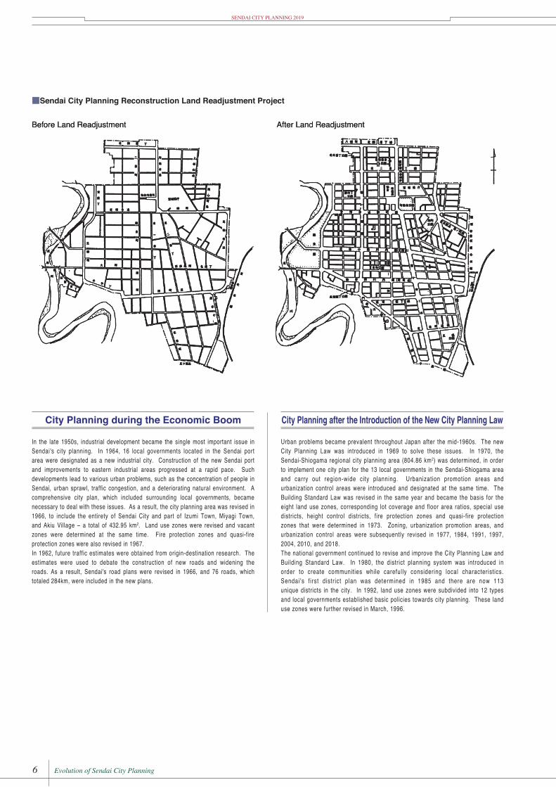
■Sendai City Planning Reconstruction Land Readjustment Project
Before Land Readjustment After Land Readjustment
City Planning during the Economic Boom
In the late 1950s, industrial development became the single most important issue in Sendai's city planning. In 1964, 16 local governments located in the Sendai port area were designated as a new industrial city. Construction of the new Sendai port and improvements to eastern industrial areas progressed at a rapid pace. Such developments lead to various urban problems, such as the concentration of people in Sendai, urban sprawl, traffic congestion, and a deteriorating natural environment. A comprehensive city plan, which included surrounding local governments, became necessary to deal with these issues. As a result, the city planning area was revised in 1966, to include the entire Sendai City and part of Izumi Town, Miyagi Town, and Akiu Village – a total of 432.95 km2. Land use zones were revised and vacant zones were determined at the same time. Fire protection zones and quasi-fire protection zones were also revised in 1967.In 1962, future traffic estimates were obtained from origin-destination research. The estimates were used to debate the construction of new roads and whether roads should be widened. As a result, Sendai's road plans were revised in 1966, and 76 roads, which totaled 284km, were included in the new plans.
City Planning after the Introduction of the New City Planning Law
Urban problems became prevalent throughout Japan after the mid-1960s. The new City Planning Law was introduced in 1969 to solve these issues. In 1970, the Sendai-Shiogama regional city planning area (804.06 km2) was determined, in order to implement one city plan for the 13 local governments in the Sendai-Shiogama area and carry out region-wide city planning. Urbanization promotion areas and urbanization control areas were introduced and designated at the same time. The Building Standard Law was revised in the same year and became the basis for the eight land use zones, corresponding lot coverage and floor area ratios, special use districts, height control districts, fire control zones and quasi-fire control zones that were determined in 1973. Zoning, urbanization promotion areas, and urbanization control areas were subsequently revised in 1977, 1984, 1991, 1997, and 2004.The national government continued to revise and improve the City Planning Law and Building Standard Law. In 1980, the district planning system was introduced in order to create communities while carefully considering local characteristics. Sendai's first district plan was determined in 1985 and there are now 77 unique districts in the city. In 1992, land use zones were subdivided into 12 types and local governments established basic policies towards city planning. These land use zones were further revised in 1996.
SENDAI CITY PLANNING 2010
6 The Evolution of Sendai s City Planning
■Sendai City Planning Reconstruction Land Readjustment Project
Before Land Readjustment After Land Readjustment
City Planning during the Economic Boom
In the late 1950s, industrial development became the single most important issue in Sendai's city planning. In 1964, 16 local governments located in the Sendai port area were designated as a new industrial city. Construction of the new Sendai port and improvements to eastern industrial areas progressed at a rapid pace. Such developments lead to various urban problems, such as the concentration of people in Sendai, urban sprawl, traffic congestion, and a deteriorating natural environment. A comprehensive city plan, which included surrounding local governments, became necessary to deal with these issues. As a result, the city planning area was revised in 1966, to include the entire Sendai City and part of Izumi Town, Miyagi Town, and Akiu Village – a total of 432.95 km2. Land use zones were revised and vacant zones were determined at the same time. Fire protection zones and quasi-fire protection zones were also revised in 1967.In 1962, future traffic estimates were obtained from origin-destination research. The estimates were used to debate the construction of new roads and whether roads should be widened. As a result, Sendai's road plans were revised in 1966, and 76 roads, which totaled 284km, were included in the new plans.
City Planning after the Introduction of the New City Planning Law
Urban problems became prevalent throughout Japan after the mid-1960s. The new City Planning Law was introduced in 1969 to solve these issues. In 1970, the Sendai-Shiogama regional city planning area (804.06 km2) was determined, in order to implement one city plan for the 13 local governments in the Sendai-Shiogama area and carry out region-wide city planning. Urbanization promotion areas and urbanization control areas were introduced and designated at the same time. The Building Standard Law was revised in the same year and became the basis for the eight land use zones, corresponding lot coverage and floor area ratios, special use districts, height control districts, fire control zones and quasi-fire control zones that were determined in 1973. Zoning, urbanization promotion areas, and urbanization control areas were subsequently revised in 1977, 1984, 1991, 1997, and 2004.The national government continued to revise and improve the City Planning Law and Building Standard Law. In 1980, the district planning system was introduced in order to create communities while carefully considering local characteristics. Sendai's first district plan was determined in 1985 and there are now 77 unique districts in the city. In 1992, land use zones were subdivided into 12 types and local governments established basic policies towards city planning. These land use zones were further revised in 1996.
SENDAI CITY PLANNING 2010
■Land Use Plan (1966) ■Structure of the Road Network (1966)
Residential Zone
Commercial Zone Industrial Zone Education and Culture Zone
Route 48
Education and Culture Zone
Residential Zone
Residential Zone
Residential Zone
Residential Zone
↑ Sendai City Limits
Residential Zone
Industrial Zone
Commercial Zone
Commercial Zone
Productive Green ZoneQuasi-Industrial Area
Distribution Center
Sendai Port
Route 45
Industrial ZoneRoute
4City Planning Area Boundary
Sendai Port
City Planning Area Boundary
Route 48
Tohoku Expressway
Route 4
Route 45
Senda
i Byp
ass
National Road or Major Prefectural RoadCity Planning Road (over 30m width)City Planning Road (over 20m width)
Route 286
■Sendai City Planning Reconstruction Land Readjustment Project
City Planning during the Economic Boom
In the late 1950s, industrial development became the single most important issue in Sendai's city planning. In 1964, 16 local governments located in the Sendai port area were designated as a new industrial city. Construction of the new Sendai port and improvements to eastern industrial areas progressed at a rapid pace. Such developments lead to various urban problems, such as the concentration of people in Sendai, urban sprawl, traffic congestion, and a deteriorating natural environment. A comprehensive city plan, which included surrounding local governments, became necessary to deal with these issues. As a result, the city planning area was revised in 1966, to include the entirety of Sendai City and part of Izumi Town, Miyagi Town, and Akiu Village – a total of 432.95 km2. Land use zones were revised and vacant zones were determined at the same time. Fire protection zones and quasi-fire protection zones were also revised in 1967.In 1962, future traffic estimates were obtained from origin-destination research. The estimates were used to debate the construction of new roads and widening the roads. As a result, Sendai's road plans were revised in 1966, and 76 roads, which totaled 284km, were included in the new plans.
City Planning after the Introduction of the New City Planning Law
Urban problems became prevalent throughout Japan after the mid-1960s. The new City Planning Law was introduced in 1969 to solve these issues. In 1970, the Sendai-Shiogama regional city planning area (804.86 km2) was determined, in order to implement one city plan for the 13 local governments in the Sendai-Shiogama area and carry out region-wide city planning. Urbanization promotion areas and urbanization control areas were introduced and designated at the same time. The Building Standard Law was revised in the same year and became the basis for the eight land use zones, corresponding lot coverage and floor area ratios, special use districts, height control districts, fire protection zones and quasi-fire protection zones that were determined in 1973. Zoning, urbanization promotion areas, and urbanization control areas were subsequently revised in 1977, 1984, 1991, 1997, 2004, 2010, and 2018.The national government continued to revise and improve the City Planning Law and Building Standard Law. In 1980, the district planning system was introduced in order to create communities while carefully considering local characteristics. Sendai 's f i rst distr ict plan was determined in 1985 and there are now 113 unique districts in the city. In 1992, land use zones were subdivided into 12 types and local governments established basic policies towards city planning. These land use zones were further revised in March, 1996.

SENDAI CITY PLANNING 2019 SENDAI CITY PLANNING 2019
6 7Evolution of Sendai City Planning Evolution of Sendai City Planning6 The Evolution of Sendai s City Planning
■Sendai City Planning Reconstruction Land Readjustment Project
Before Land Readjustment After Land Readjustment
City Planning during the Economic Boom
In the late 1950s, industrial development became the single most important issue in Sendai's city planning. In 1964, 16 local governments located in the Sendai port area were designated as a new industrial city. Construction of the new Sendai port and improvements to eastern industrial areas progressed at a rapid pace. Such developments lead to various urban problems, such as the concentration of people in Sendai, urban sprawl, traffic congestion, and a deteriorating natural environment. A comprehensive city plan, which included surrounding local governments, became necessary to deal with these issues. As a result, the city planning area was revised in 1966, to include the entire Sendai City and part of Izumi Town, Miyagi Town, and Akiu Village – a total of 432.95 km2. Land use zones were revised and vacant zones were determined at the same time. Fire protection zones and quasi-fire protection zones were also revised in 1967.In 1962, future traffic estimates were obtained from origin-destination research. The estimates were used to debate the construction of new roads and whether roads should be widened. As a result, Sendai's road plans were revised in 1966, and 76 roads, which totaled 284km, were included in the new plans.
City Planning after the Introduction of the New City Planning Law
Urban problems became prevalent throughout Japan after the mid-1960s. The new City Planning Law was introduced in 1969 to solve these issues. In 1970, the Sendai-Shiogama regional city planning area (804.06 km2) was determined, in order to implement one city plan for the 13 local governments in the Sendai-Shiogama area and carry out region-wide city planning. Urbanization promotion areas and urbanization control areas were introduced and designated at the same time. The Building Standard Law was revised in the same year and became the basis for the eight land use zones, corresponding lot coverage and floor area ratios, special use districts, height control districts, fire control zones and quasi-fire control zones that were determined in 1973. Zoning, urbanization promotion areas, and urbanization control areas were subsequently revised in 1977, 1984, 1991, 1997, and 2004.The national government continued to revise and improve the City Planning Law and Building Standard Law. In 1980, the district planning system was introduced in order to create communities while carefully considering local characteristics. Sendai's first district plan was determined in 1985 and there are now 77 unique districts in the city. In 1992, land use zones were subdivided into 12 types and local governments established basic policies towards city planning. These land use zones were further revised in 1996.
SENDAI CITY PLANNING 2010
6 The Evolution of Sendai s City Planning
■Sendai City Planning Reconstruction Land Readjustment Project
Before Land Readjustment After Land Readjustment
City Planning during the Economic Boom
In the late 1950s, industrial development became the single most important issue in Sendai's city planning. In 1964, 16 local governments located in the Sendai port area were designated as a new industrial city. Construction of the new Sendai port and improvements to eastern industrial areas progressed at a rapid pace. Such developments lead to various urban problems, such as the concentration of people in Sendai, urban sprawl, traffic congestion, and a deteriorating natural environment. A comprehensive city plan, which included surrounding local governments, became necessary to deal with these issues. As a result, the city planning area was revised in 1966, to include the entire Sendai City and part of Izumi Town, Miyagi Town, and Akiu Village – a total of 432.95 km2. Land use zones were revised and vacant zones were determined at the same time. Fire protection zones and quasi-fire protection zones were also revised in 1967.In 1962, future traffic estimates were obtained from origin-destination research. The estimates were used to debate the construction of new roads and whether roads should be widened. As a result, Sendai's road plans were revised in 1966, and 76 roads, which totaled 284km, were included in the new plans.
City Planning after the Introduction of the New City Planning Law
Urban problems became prevalent throughout Japan after the mid-1960s. The new City Planning Law was introduced in 1969 to solve these issues. In 1970, the Sendai-Shiogama regional city planning area (804.06 km2) was determined, in order to implement one city plan for the 13 local governments in the Sendai-Shiogama area and carry out region-wide city planning. Urbanization promotion areas and urbanization control areas were introduced and designated at the same time. The Building Standard Law was revised in the same year and became the basis for the eight land use zones, corresponding lot coverage and floor area ratios, special use districts, height control districts, fire control zones and quasi-fire control zones that were determined in 1973. Zoning, urbanization promotion areas, and urbanization control areas were subsequently revised in 1977, 1984, 1991, 1997, and 2004.The national government continued to revise and improve the City Planning Law and Building Standard Law. In 1980, the district planning system was introduced in order to create communities while carefully considering local characteristics. Sendai's first district plan was determined in 1985 and there are now 77 unique districts in the city. In 1992, land use zones were subdivided into 12 types and local governments established basic policies towards city planning. These land use zones were further revised in 1996.
SENDAI CITY PLANNING 2010
■Land Use Plan (1966) ■Structure of the Road Network (1966)
Residential Zone
Commercial Zone Industrial Zone Education and Culture Zone
Route 48
Education and Culture Zone
Residential Zone
Residential Zone
Residential Zone
Residential Zone
↑ Sendai City Limits
Residential Zone
Industrial Zone
Commercial Zone
Commercial Zone
Productive Green ZoneQuasi-Industrial Area
Distribution Center
Sendai Port
Route 45
Industrial ZoneRoute
4City Planning Area Boundary
Sendai Port
City Planning Area Boundary
Route 48Tohoku Expressway
Route 4
Route 45
Senda
i Byp
ass
National Road or Major Prefectural RoadCity Planning Road (over 30m width)City Planning Road (over 20m width)
Route 286
■Sendai City Planning Reconstruction Land Readjustment Project
City Planning during the Economic Boom
In the late 1950s, industrial development became the single most important issue in Sendai's city planning. In 1964, 16 local governments located in the Sendai port area were designated as a new industrial city. Construction of the new Sendai port and improvements to eastern industrial areas progressed at a rapid pace. Such developments lead to various urban problems, such as the concentration of people in Sendai, urban sprawl, traffic congestion, and a deteriorating natural environment. A comprehensive city plan, which included surrounding local governments, became necessary to deal with these issues. As a result, the city planning area was revised in 1966, to include the entirety of Sendai City and part of Izumi Town, Miyagi Town, and Akiu Village – a total of 432.95 km2. Land use zones were revised and vacant zones were determined at the same time. Fire protection zones and quasi-fire protection zones were also revised in 1967.In 1962, future traffic estimates were obtained from origin-destination research. The estimates were used to debate the construction of new roads and widening the roads. As a result, Sendai's road plans were revised in 1966, and 76 roads, which totaled 284km, were included in the new plans.
City Planning after the Introduction of the New City Planning Law
Urban problems became prevalent throughout Japan after the mid-1960s. The new City Planning Law was introduced in 1969 to solve these issues. In 1970, the Sendai-Shiogama regional city planning area (804.86 km2) was determined, in order to implement one city plan for the 13 local governments in the Sendai-Shiogama area and carry out region-wide city planning. Urbanization promotion areas and urbanization control areas were introduced and designated at the same time. The Building Standard Law was revised in the same year and became the basis for the eight land use zones, corresponding lot coverage and floor area ratios, special use districts, height control districts, fire protection zones and quasi-fire protection zones that were determined in 1973. Zoning, urbanization promotion areas, and urbanization control areas were subsequently revised in 1977, 1984, 1991, 1997, 2004, 2010, and 2018.The national government continued to revise and improve the City Planning Law and Building Standard Law. In 1980, the district planning system was introduced in order to create communities while carefully considering local characteristics. Sendai 's f i rst distr ict plan was determined in 1985 and there are now 113 unique districts in the city. In 1992, land use zones were subdivided into 12 types and local governments established basic policies towards city planning. These land use zones were further revised in March, 1996.
■ Changes to the City Planning Area and Land Use Zones (km2)Name of City Planning Area Sendai City Planning Area Sen-En (Sendai-Shiogama) Extensive City Planning Area
Date of Specification March 1925 April 1928 July 1929 September 1941 March 1955 March 1966 August 1970 December 1973 July 1977 January 1984 November 1987 March 1988 March 1991 March 1996 May 1997 May 2004 May 2010 September 2012 October 2013 May 2018
Total Planning Area 52.88 52.88 52.88 188.21 188.21 432.95 804.86 804.86 801.07 836.81 836.81 836.81 836.81 892.31 836.71 838.19 892.31 892.31 892.31 889.34
Planning Area in Sendai 17.62 50.64 50.64 185.03 185.03 236.85 236.88 236.88 237.05 237.05 347.21 440.84 440.84 442.93 440.84 442.84 442.93 442.93 442.93 442.96
Urbanization Promotion Area 116.78 116.78 118.37 118.44 131.86 169.13 171.04 179.61 175.03 180.01 178.92 179.61 180.35 180.06
Urbanization Control Area 120.10 120.10 118.68 118.61 215.35 271.71 269.80 263.32 265.81 262.83 264.01 263.32 262.58 262.90Land Use Zone Residential Zone Exclusive Residential Zone Category I Exclusive Residential Zone Category I Low-Rise Exclusive Residential Zone
9.11 — 25.88 28.14 29.83 25.88 25.85 24.71 30.79 50.21 51.33 51.48 53.54 56.72 54.33 55.05 55.79 54.63
Category II Low-Rise Exclusive Residential Zone
0.05 0.05 0.05 0.05 0.05 0.06 0.59
Category II Exclusive Residential Zone Category I Mid to High-Rise Exclusive Residential Zone
11.55 13.31 14.17 16.61 20.21 20.31 6.91 7.05 7.40 7.45 7.33 7.33 7.33
Category II Mid to High-Rise Exclusive Residential Zone
14.32 15.05 15.40 15.33 15.33 15.37 15.69
Residential Zone Residential Zone Category I Residential Zone
60.35 48.85 36.08 39.10 40.17 44.82 55.23 55.20 27.94 27.11 27.70 28.09 28.47 28.94 29.52
Category II Residential Zone
26.55 25.77 26.13 25.62 25.62 25.62 25.09
Quasi-Residential Zone
0.63 0.61 0.63 0.64 0.64 0.64 0.64
Commercial Zone Commercial Zone Neighborhood Commercial Zone Neighborhood Commercial Zone
5.02 — 5.50 14.08 14.08 7.80 7.91 5.03 8.23 9.31 9.38 10.60 9.12 9.36 9.50 9.58 9.73 9.73
Commercial Zone Commercial Zone
8.20 8.16 8.17 8.18 8.92 8.92 8.96 8.82 8.82 9.37 9.37 9.37 9.37
Quasi-Industrial Zone Quasi-Industrial Zone Quasi-Industrial Zone Quasi-Industrial Zone
— — 2.51 0.70 0.70 5.50 6.51 6.52 6.52 7.48 7.73 8.63 8.77 10.58 11.34 11.47 11.34 10.98
Industrial Zone Industrial Zone Industrial Zone Industrial Zone
1.43 — 7.24 10.13 6.33 4.90 4.16 3.40 3.40 3.40 3.40 5.45 5.06 4.96 4.18 4.18 4.17 4.59
Exclusive Industrial Zone Exclusive Industrial Zone Exclusive Industrial Zone
15.72 15.72 15.59 13.37 13.27 13.27 14.38 14.79 13.39 14.07 12.25 13.02 12.52 12.50 12.43
Non-Specif ied Area 0.78 1.28 1.28
Summary
DeterminedCity Planning
Area
DeterminedCity Planning
Projects
Introductionof the ZoningRe-evaluation
SystemAugust 31, 1970
1stRe-evaluation
2ndRe-evaluation
3rdRe-evaluation
4thRe-evaluation
5thRe-evaluation
6thRe-evaluation
7thRe-evaluation
SpecifiedCity Planning
Land UseZones
Changed LandUse forPostwar
Reconstruction
DeterminedVacant Areas
IncreasedTypes of Land
Use Zones from4 to 8
December 15, 1973
Merged withMiyagi Town
Merged withIzumi City
andAkiu Town
IncreasedTypes of Land
Use Zones from8 to 12
March 29, 1996
ExaminedTotal Area
Altered Revising the City
Planning Road Network
Altered Revising the City
Planning Road Network
* A Rural Residential Zone was newly established as a Land Use Zone on April 1, 2018. However, no areas in the city are designated as Rural Residential Zones at the present time.