150311 roadside ditch fact sheet
TRANSCRIPT
FACT SHEET
March 2015
WHERE RESTORATION MEETS THE ROAD: IMPROVING CHESAPEAKE BAY HEALTH WITH ROADSIDE DITCHES Talbot County is nearly completely surrounded by water, making it an attractive place to live, work and raise a family. But every major local river including the Miles, Wye, and Choptank is polluted, putting local economies and the quality of life of county residents at risk. Cost-effective, practical ways to filter pollution running off Talbot’s landscape are needed to restore local waterways to health. In a collaboration known as the Talbot Ditch Retrofit Partnership, The Nature Conservancy, CBF, Talbot County, and others are working to filter pollution from roadways and farm fields at targeted locations in roadside ditches, minimizing impacts to agriculture while maximizing benefits to water quality at low cost. Ditch Retrofits to Slow and Filter Polluted Runoff Roadside ditches may not look like much. But with a little gentle engineering, they can provide one significant answer to our water pollution problems. Talbot County has over 370 miles of county roads, many with roadside ditches. The ditches drain polluted runoff from farms, suburban landscapes and streets that goes straight into our local creeks and rivers. But ditches can be part of a solution, not just part of the runoff problem. At strategic points
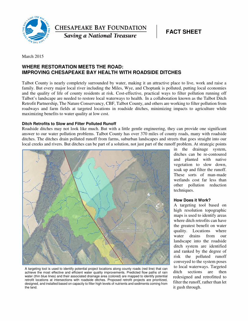
in the drainage system, ditches can be re-contoured and planted with native vegetation to slow down, soak up and filter the runoff. These sorts of man-made wetlands cost far less than other pollution reduction techniques. How Does it Work? A targeting tool based on high resolution topographic maps is used to identify areas where ditch retrofits can have the greatest benefit on water quality. Locations where water drains from our landscape into the roadside ditch system are identified and ranked by the degree of risk the polluted runoff conveyed to the system poses to local waterways. Targeted ditch sections are then redesigned and retrofitted to filter the runoff, rather than let it gush through.
A targeting tool is used to identify potential project locations along county roads (red line) that can achieve the most effective and efficient water quality improvements. Predicted flow paths of rain water (thin blue lines) and their associated drainage area (colored) are mapped to identify potential retrofit locations at intersections with roadside ditches. Proposed retrofit projects are prioritized, designed, and installed based on capacity to filter high levels of nutrients and sediments coming from the land.
Founded in 1967, the Chesapeake Bay Foundation is a nonprofit 501(c)(3) conservation organization dedicated to saving a national treasure—the Chesapeake Bay and its rivers and streams. Its motto, Save the Bay, defines the organization's mission and commitment. With headquarters in Annapolis, MD, offices in Maryland, Virginia, Pennsylvania, and the District of Columbia, and 17 field centers, CBF works throughout the Chesapeake Bay’s 64,000-square-mile watershed to build an informed citizenry, advocate pollution-reduction strategy, and enforce the law. CBF is supported by more than 200,000 active members and has a staff of 170 full-time employees. Approximately 80 percent of CBF's $23.6 million annual budget is privately raised.
CHESAPEAKE BAY FOUNDATION • Philip Merrill Environmental Center • 6 Herndon Avenue • Annapolis, MD 21403
410/268-8816 • 301/261-2350 (from D.C. metro) • cbf.org
A Win-Win for Both Farmers and the Bay Information such as runoff volume, local site conditions, and landowner interests helps determine exactly how to retrofit a ditch section. Working with owners of the properties adjacent to where projects are proposed, designers take care to minimize cropland loss. Where appropriate, funding is secured to help farmers install conservation measures as part of the project. A variety of restoration techniques are considered to integrate into the final site plan.
A Cost-Effective Solution for Talbot County
Counties such as Talbot with lots of roadside ditches may be able to meet many of their clean-water goals by using this approach. Maryland has asked counties to meet such goals for farms and for developed areas. The program reduces polluted runoff from both areas. Talbot County can achieve an estimated 17 percent of its urban pollution goals with just this program alone.
On a per-pound basis, ditch retrofits are more cost-effective at treating polluted runoff than traditional methods such as impoundments. Projects installed at 150 prioritized ditch locations can reduce nitrogen pollution entering local waterways by 8,000 pounds per year from developed land with a cost savings of over $1.5 million when compared to standard stormwater management. The same retrofits can reduce an additional 30,000 pounds per year of nitrogen from agricultural lands.
A pilot phase for the Talbot program already is funded. Dedicated financial resources are needed to fully support ditch retrofits and help Talbot County stay on track to restore clean water to the community.
This project was made possible through support provided by the State of Maryland Department of Natural Resources and The Nature Conservancy, under the
terms of Grant #14-14-1829TRF09. The content and opinions expressed herein are those of the author(s) and do not necessarily reflect the position or the
policy of the State of Maryland Department of Natural Resources or the Nature Conservancy, and no official endorsement should be inferred.
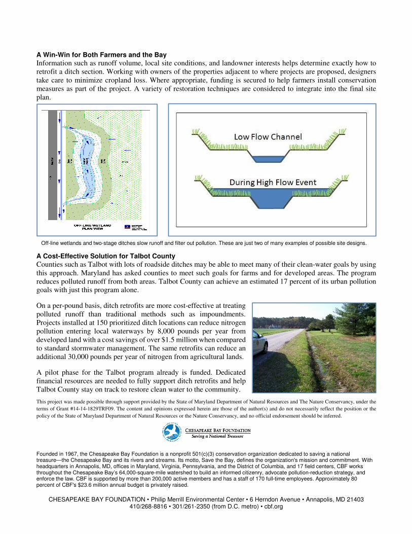
Off-line wetlands and two-stage ditches slow runoff and filter out pollution. These are just two of many examples of possible site designs.