15. fish and aquatic invertebrates...fish and aquatic invertebrates—bristol bay drainages november...
TRANSCRIPT
Fish and Aquatic Invertebrates—Bristol Bay Drainages
November 17, 2011 15.1-1
15. FISH AND AQUATIC INVERTEBRATES
15.1 Fish—Mine Study Area
15.1.1 Introduction
Fish studies were conducted to characterize aquatic habitat and fish assemblages and to support instream-flow modeling for the mine study area. The mine study area encompasses the North Fork Koktuli River (NFK), South Fork Koktuli River (SFK), and Upper Talarik Creek (UT) watersheds (or drainages; Figure 1-2a in Chapter 1), as well as the upper Koktuli River mainstem (KR) for a length of 29 miles (46 kilometers [km]). The NFK and SFK watersheds are relatively small and are within the Nushagak-Mulchatna River system, with the Nushagak River basin being one of eight major river basins (or regional drainages) draining southwest Alaska into Bristol Bay (Figure 15.1-1). The NFK and SFK rivers have mainstem lengths of 36 miles (58 kilometers [km]) and 40 miles (64 km), respectively. These rivers merge to form the KR, which flows for approximately 39 miles (62 km) before entering the Mulchatna River. From there, the Mulchatna River flows 44 miles (70 km) to the Nushagak River, which in turn flows approximately 109 miles (175 km) before discharging into Bristol Bay (Figure 1-1 in Chapter 1). UT flows for approximately 39 miles (62 km) before draining into Iliamna Lake, which ultimately discharges to Bristol Bay via the Kvichak River. The NFK, SFK, and UT watersheds each represent approximately 0.3 percent of the entire Bristol Bay drainage basin.
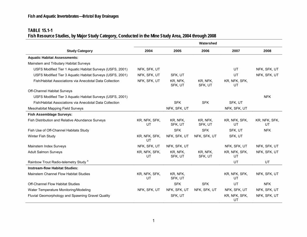
Thirteen fish resource studies were conducted in the mine study area from 2004 through 2008 (Table 15.1-1). Specific objectives of the fish resource studies were to characterize the following:
• Channel morphology and valley form in mainstem and tributary channels.
• Riverine habitat types (e.g., pools, riffles, and runs/glides) and their distribution throughout the river, as well as the amount of river and stream habitat available for fish.
• Locations of special habitat features (e.g., tributaries, springs, seeps, and possible barriers to upstream fish migration) that may influence fish distribution and abundance.
• Quality and quantity of off-channel habitat within representative off-channel habitat study areas.
• Patterns of fish distribution and relative abundance in mainstem, tributary, and off-channel habitats.
• Fish density among mainstem, tributary, and off-channel habitat types.
• Fish presence during winter months when ice conditions are present.
• Spatial and temporal distribution of adult anadromous salmon returning to and spawning in the mine study area.
Pebble Project Environmental Baseline Studies, 2004-2008, Technical Summary
15.1-2 November 17, 2011
• Annual abundance estimates of adult anadromous salmon.
• Relationships between streamflow and suitable fish habitat for target species at various life stages.
• The amount of fish habitat present under baseline flow conditions for target species at various life stages.
• Hydrologic relationships between mainstem channel flow conditions and off-channel habitats.
• Seasonal and longitudinal surface water-temperature regimes in mainstem channels.
• Flow-sensitive surface water-temperature models for mainstem channels.
• Fluvial geomorphic conditions in the study area, and to link potential changes in hydrology and drainage area through an evaluation of flow and channel-forming processes in mainstem channels.
• Spawning-gravel quality and other characteristics as influenced by flow and salmon-induced physical disturbance.
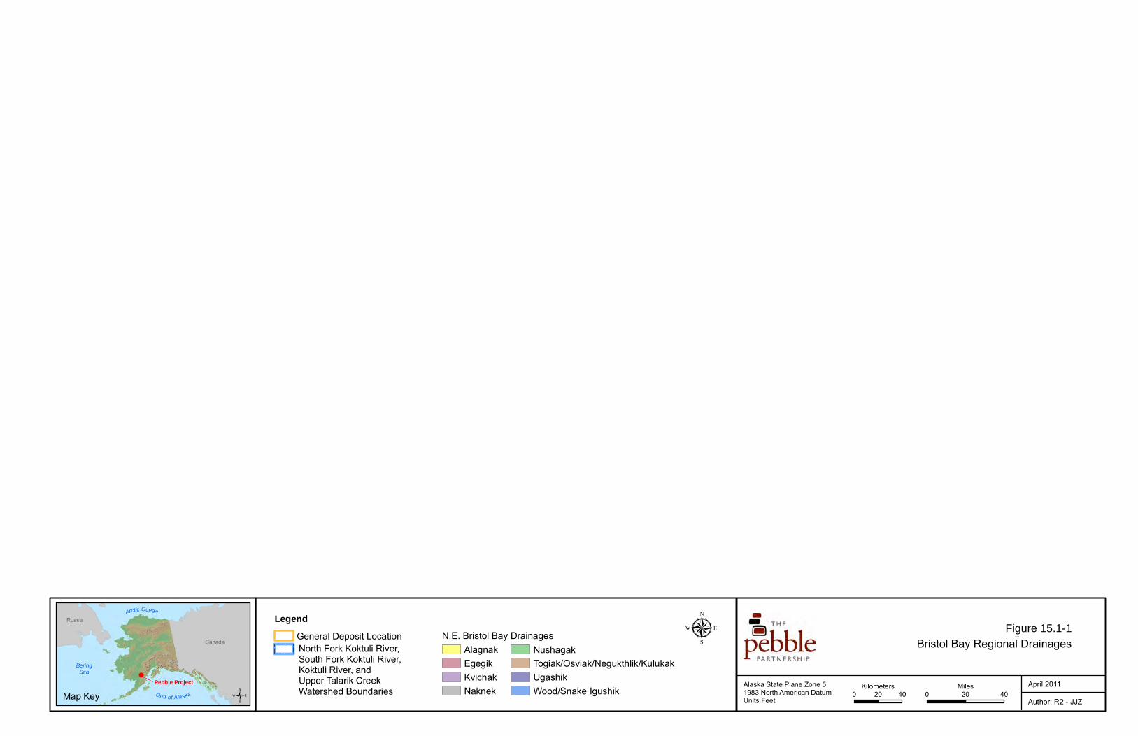
Aquatic-habitat data were collected primarily using survey protocols adapted from the U.S. Forest Service Aquatic Habitat Management Handbook (USFS, 2001). Supplemental habitat information was compiled from anecdotal field notes and remote-sensing data. The mesohabitat analysis was conducted using a combination of field surveys and remote-sensing analysis.
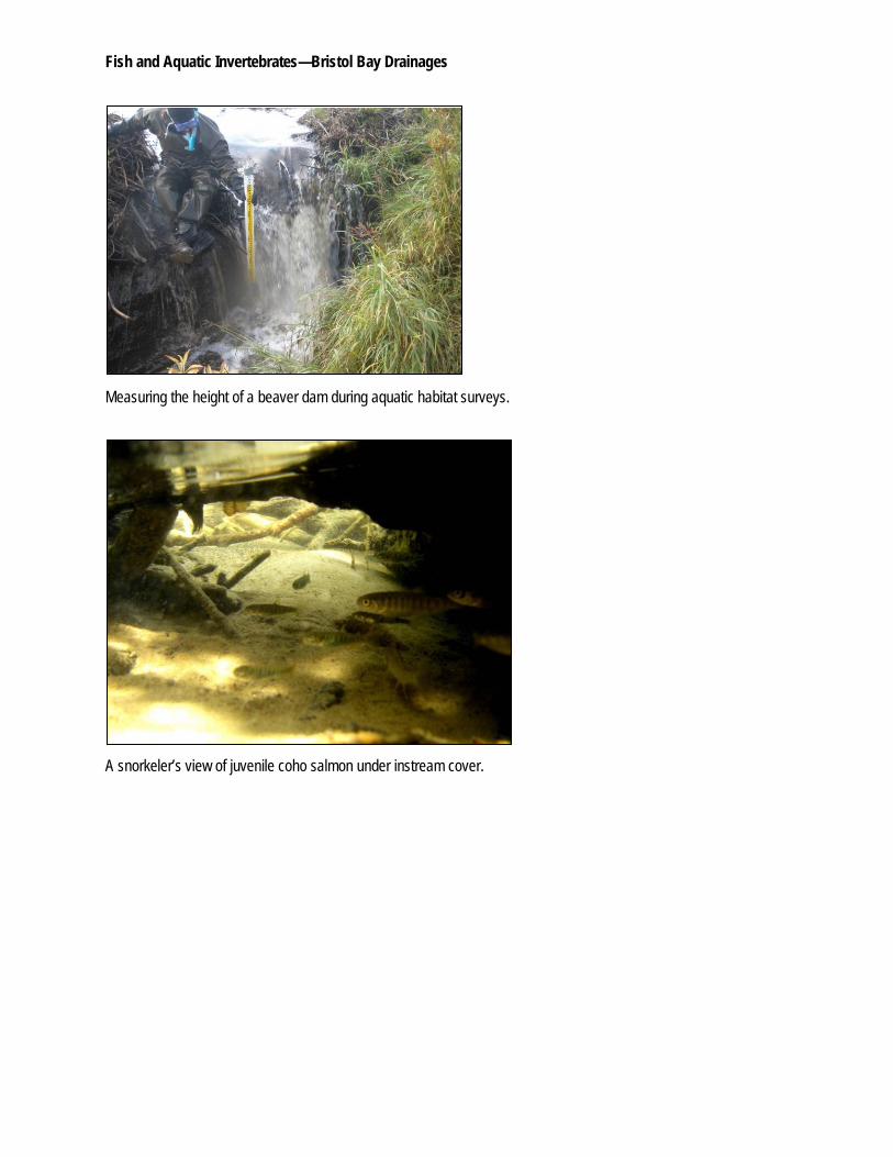
The fish distribution and relative abundance studies included extensive surveys to sample fish-bearing waterbodies within the mine study area, as well as several intensive studies to evaluate certain conditions (e.g., winter habitat use) or species behavioral patterns (e.g., the rainbow trout radiotelemetry study). In general, the fish distribution and abundance surveys were completed using similar sampling, species identification, and lifestage classification methods. The primary survey method for stream-dwelling fish was via direct underwater observation using snorkeling techniques. Other methods (e.g., electrofishing, minnow traps, beach seines, gill/tangle nets, angling, and dip netting) were used when sampling conditions were not conducive to snorkeling or when there was a need to physically capture certain fish for tagging and/or genetics/toxicity sampling.
Aerial helicopter surveys were used to quantify spawning salmon along the mainstem rivers and tributaries. Surveys were typically conducted from early July through October or November to capture the range of dates when adult Chinook, chum, coho, and sockeye salmon were present in the study area. The number of surveys conducted per year ranged from seven in 2004 to 26 in 2008. Annual mean index counts (Holt and Cox, 2008) were used to evaluate salmon abundance over the study period and among watersheds and to provide a first-order approximation of the relationship between counts in the NFK, SFK, and UT, and the Alaska Department of Fish and Game’s Bristol Bay fisheries statistics.
Methods used for the instream-flow studies varied among the four main study components: mainstem channel flow habitat studies, off-channel flow habitat studies, water-temperature modeling, and fluvial geomorphic analysis. The mainstem channel flow habitat studies were
Fish and Aquatic Invertebrates—Bristol Bay Drainages
November 17, 2011 15.1-3
conducted using the U.S. Fish and Wildlife Service’s Instream Flow Incremental Methodology (IFIM), along with the companion suite of computer programs, Physical Habitat Simulation (PHABSIM; Bovee, 1982; Bovee et al., 1998). Selected off-channel habitats were surveyed for valley profile and water-surface elevation data to assess off-channel habitat connectivity to the mainstem channel under varying flow conditions. Continuous surface water-temperature data were collected from hydrology gaging stations and from thermistors deployed at several locations throughout the study area. These data were subsequently used to develop flow-sensitive surface water-temperature models based on the U.S. Fish and Wildlife Service’s Stream Network Temperature Model (SNTEMP). Fluvial geomorphology studies included the collection of hydrologic, substrate, bank composition, and vegetation data. The fluvial geomorphology studies also included the collection of single bulk substrate samples at selected sites to assess fine sediment levels in the riverbed substrates and the monitoring of the movement of 19 radio-tagged rocks in the NFK from September 15 to 30, 2007.
In order to present the large volume of data collected in an ecologically meaningful framework, a reach analysis approach was used. The mainstem NFK, SFK, and UT were divided respectively into six, five, and seven reaches that were identified based on hydrology, geology, and channel morphology characteristics (Figure 15.1-2). Reach designations (NFK-A through NFK-F, SFK-A through SFK-E, and UT-A through UT-G) progress sequentially from downstream to upstream. Only a single reach was defined for the KR and was limited to the uppermost 29 miles (46.5 km) of the river. Because the KR reach is more than 31 miles (50 km) downstream from the Pebble Deposit, study efforts in the KR have been less intensive than those in the other three watersheds and have focused on instream-flow analysis and fish distribution. Each tributary to the mainstem NFK, SFK, or UT was assigned to a mainstem reach based on the location of the tributary’s confluence with the mainstem, while off-channel habitats were assigned based on their proximity to the mainstem channel.
15.1.2 Results and Discussion
15.1.2.1 Anadromous Waters Catalog Nominations
The fish studies conducted from 2004 through 2008 resulted in the expansion of the known distribution of anadromous fish species in the mine study area and provided supporting information for existing anadromous fish streams. Using the Alaska Department of Fish and Game’s 2009 anadromous waters catalog (ADF&G, 2010) as a baseline, 22 new anadromous fish streams (including eight, five, and nine streams in the NFK, SFK, and UT watersheds, respectively) were nominated to the catalog as a result of these study efforts. The known distribution of anadromous fishes was extended in an additional 14 streams, with five, two, and seven of those streams located in the NFK, SFK, and UT watersheds, respectively.
15.1.2.2 North Fork Koktuli River
Aquatic Habitat and Instream Flow
Analysis of the aquatic-habitat survey data indicates that the NFK mainstem was primarily a single-thread, gravel-bedded channel that was relatively straight in higher-gradient segments and meandered in lower-gradient segments. The three lowermost reaches (NFK-A, NFK-B, and
Pebble Project Environmental Baseline Studies, 2004-2008, Technical Summary
15.1-4 November 17, 2011
NFK-C) flowed through alluvial valley-bottom deposits consisting of abandoned stream terraces and deposits of reworked glacial outwash. Off-channel characteristics were indicative of past high-flow events that had overtopped the stream banks in NFK-A and extended flow into adjoining floodplains. In addition, riparian zones, wetland complexes, and off-channel habitats in NFK-A extended beyond the mainstem channel. For most of NFK-B, the channel flowed through a relatively narrow (approximately 1,525-foot long, 465-meter wide) valley bottom bordered by low hills. NFK-C flowed across glacial outwash and moraine deposits. NFK-D and NFK-E were generally lower gradient than the other reaches and flowed through a variety of different geologic types, including glacial outwash and a silt, ice-rich section. Coarse bedload from upstream did not appear to have been transported downstream of NFK-E, where the bed was composed predominantly of sand and silt. The uppermost reach, NFK-F flowed through alluvial and Brooks Lake drift deposits. The primary sources of sediment throughout the NFK were likely from undercut banks and lateral erosion that occurred during high flows and ice break-up processes. Tributaries were composed of both high- and moderate-gradient channels, as well as alluvial fan channels.
The hydrologic regime of the NFK has been dictated primarily by climate, geology, and groundwater influx, with streamflows driven by winter ice formation, runoff from spring snowmelt, and summer and fall rains. Except in losing reaches (reaches that lose water as the stream flows downstream), base flows tended to remain high because of deep soils and associated groundwater storage, as well as the large volume of water associated with lakes in the basin. Seasonal flows in the NFK had two peaks; the first peak occurred with spring snowmelt, and the second peak occurred with fall rains.
The mainstem NFK showed a pronounced interaction with groundwater. Upstream from NFK-C and in the upperstream portion of NFK-C, the river has been classified as a losing stream. In this area, the NFK flowed across unconsolidated outwash fan sediments with a high infiltration capacity, and the water generated by streamflow, precipitation, and snowmelt rapidly infiltrated into a shallow aquifer. The groundwater flowed down-valley and emerged at the downstream end of the glacial outwash deposits. The downstream third of NFK-C and a short stretch of NFK-B were gaining reaches (reaches that gain water as the stream flows downstream) that exhibited evidence of substantial groundwater upwelling. Similarly, the downstream portion of NFK-A received groundwater inflows, thus increasing the local surface water discharge at this location. There were no mainstem NFK reaches that exhibited seasonal cessation of surface water flow during the 2004 through 2008 study period. However, Tributary NFK 1.190.10, immediately upstream of its confluence with NFK 1.190, exhibited intermittent flow conditions in late summer. Such reduced flow conditions may potentially limit fish production on a local level. The hydrologic regime of the NFK has an influence on the functionality and usability of fish habitat and, in turn, the distribution and abundance of fish that use the watershed.
The annual water-temperature regime of the NFK was cold, restricting fish-rearing potential. Cold water restricts the active feeding of fish to a brief period (June through September) when water temperatures exceed 46ºF (8ºC); hence, fish productivity in the NFK may be limited as compared to watersheds where the active feeding period is longer (Campbell and Neuner, 1985). Notably, in this cold-water river, warm water temperatures documented during the summer sampling also may be limiting to fish health and productivity. The open riparian nature
Fish and Aquatic Invertebrates—Bristol Bay Drainages
November 17, 2011 15.1-5
of most of the streams in the NFK watershed has allowed water temperatures to warm quickly during the summer months, and at a number of monitoring stations, researchers documented water temperatures that naturally exceeded state thermal criteria for spawning, incubation, migration, and rearing habitat.
The longitudinal thermal regime of the NFK was characteristic of a surface water system influenced by groundwater and cold-water tributary inflow. During the warmer summer months, water temperatures in the uppermost reaches (NFK-D and NFK-E) were warmer than those in the downstream reaches (NFK-A, NFK-B, and NFK-C). Analysis of water temperatures, combined with flow records, indicated that the NFK receives groundwater inflow in NFK-C and in portions of NFK-B and NFK-A. Tributary NFK 1.190, which is also relatively cool as a result of groundwater influences, discharges into the mainstem NFK at the upstream end of NFK-C, and thus further contributes to the observed temperature patterns in the lower NFK reaches. Generally, groundwater input in the lower NFK keeps surface water temperatures relatively cool in the summer and relatively warm in the winter.
Habitat studies indicated that the NFK overall contained mostly riffle habitat, followed by varying degrees of run/glide habitat, relatively few beaver ponds (also referred to as beaver complexes), and pools. While beaver ponds were relatively scarce among the mainstem habitat surveys, they accounted for approximately 85 percent of the 32 acres of off-channel habitat surveyed in the NFK. Beaver ponds in the NFK provided habitat for adult spawning and juvenile overwintering for Pacific salmon.
Other off-channel habitat types with comparatively few occurrences in the NFK watershed included side channels, percolation channels, beaver pond outlet channels, alcoves, and isolated ponds. The off-channel habitat instream-flow analysis indicated that many of the off-channel habitats were hydrologically connected to the mainstem channel via surface inflows at less than bankfull flows. This indicated that these habitats may have been periodically connected to the mainstem channel throughout the year.
Naturally formed lakes and ponds are prevalent in the NFK watershed, consistent with the remnants of a glacial history. Most of the lakes and ponds in this watershed occur at relatively high elevations. The largest concentration of lakes and ponds is in the vicinity of the Big Wiggly Lake complex, adjacent and connected to NFK-D (Figure 15.1-2). Surface water impoundments in the NFK watershed may be valuable for anadromous salmon rearing and/or spawning and for their ability to store water and provide surface water runoff volumes late in the summer.
The quality of spawning gravels in the NFK was good. The levels of fine sediments in bulk substrate samples collected from the NFK were lower than levels found in either the SFK or UT. Overall, the concentrations of size fractions that were documented were below those shown to be harmful to embryo survival and fry emergence.
Within the NFK, instream cover for fish was provided primarily by undercut banks, overhanging vegetation, and sporadically distributed boulders and large cobbles. However, a general scarcity of mainstem channel pool habitat and instream cover features in the NFK resulted in a lack of velocity shelter for rearing fishes. This condition suggested that juvenile rearing may be largely relegated to off-channel habitats, especially for winter refuge when water temperatures and
Pebble Project Environmental Baseline Studies, 2004-2008, Technical Summary
15.1-6 November 17, 2011
streamflows become quite low. The lack of habitat for juvenile winter rearing in the mainstem NFK was evident in the instream-flow habitat study results.
The instream-flow habitat modeling and time series analyses were computed for various salmonid fish species within reaches. Results of the habitat and time series analyses for spawning and juvenile life stages were evaluated as the total habitat area versus river flow relationships, because this parameter provided reach-scale estimates of the total amount of habitat for a given species and life stage available under different flow conditions. The time series analysis revealed substantial variability in habitat amounts on a daily basis in response to changes in flow. This variation was most evident during flow transitional periods. For example, model predictions for the spring-summer periods when flows decline were for a general increase in juvenile habitat. Similarly, for the summer-fall periods when flows increase, the model predicted a general increase in spawning habitat.
Fish Distribution
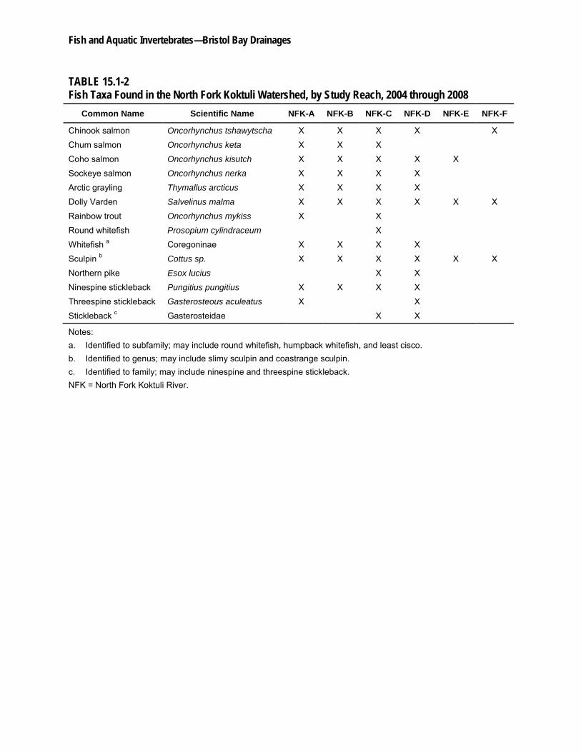
At least 13 different fish species were documented in the NFK (Table 15.1-2). The greatest number of fish species was found in NFK-C, and there was a general tendency for the number of species to decrease in reaches farther upstream.
Anadromous salmon spawn throughout the NFK; however, most of the spawning occurs from the lower to the middle mainstem river reaches (i.e., NFK-A, NFK-B, NFK-C). An assessment of spawning distributions for individual anadromous species indicates that Chinook and sockeye salmon spawn predominantly in the large river reaches low in the drainage basin. Conversely, coho salmon spawning was ubiquitous throughout the NFK mainstem and tributary reaches. Nevertheless, the greatest abundance of coho and chum salmon spawners was found in NFK-C. The instream-flow model predictions help explain these patterns, in part, because the highest amounts of available spawning habitat for Chinook salmon were in NFK-A, while the highest amounts of available spawning habitat for coho and chum salmon were in NFK-C. No similarity of pattern was evident for sockeye salmon. When considering the in-reach spawning distributions of sockeye salmon and, to a large extent, chum salmon, a direct association was evident between spawning areas and those areas identified as gaining reaches as a result of inflow from groundwater, seeps, or springs.
The NFK thermal regime also appeared to influence fish spawning distributions. The NFK exhibits a sharp temperature decline near the top of NFK-C where cooler waters from NFK 1.190 enter the mainstem channel. NFK reaches above NFK 1.190 were warmer, and instantaneous temperature measurements exceeding optimal temperatures for spawning and incubation have been documented.
Although little spawning was observed in NFK-D over the study period, this reach contains habitat that supported a distinct life-history strategy for sockeye salmon. Big Wiggly Lake in the NFK 1.240 drainage in NFK-D supported a population of lake-spawning sockeye salmon. The results of limited sampling around the lake perimeter did not document the presence of sockeye salmon juveniles in the lake, but rearing is assumed to occur in NFK-D and reaches downstream.
Fish and Aquatic Invertebrates—Bristol Bay Drainages
November 17, 2011 15.1-7
Based on mean index counts (multiple counts over time in the same approximate area), the NFK supported the largest run of Chinook and chum salmon among the three watersheds in the mine study area. Coho salmon mean index counts were similar in the NFK and SFK and were substantially less in the NFK than in the UT. The sockeye salmon run in the NFK was consistent year to year, yet it was the smallest run among the three watersheds.
The distributions of river-rearing, juvenile Pacific salmon follow similar patterns as the spawning distributions. Juvenile Chinook salmon were prominent in mainstem channel, fast-water habitats that dominated the lower three reaches of the NFK. Juvenile coho salmon, on the other hand, were widely dispersed throughout the mainstem NFK and in several tributaries. Juvenile coho salmon were found in numerous habitat types. Off-channel habitat appeared particularly important to coho salmon rearing, with coho salmon at their highest densities in off-channel backwater and alcove habitats. This wide distribution and broad habitat use for juvenile coho salmon is consistent with the fact that they were the most abundant juvenile fish species documented in the NFK. In contrast, the relatively few juvenile chum salmon were found only during winter fish surveys and only in NFK-C.
Patterns evident for juvenile sockeye salmon distribution were also noteworthy. Observations of juvenile sockeye salmon in the middle NFK in April were not surprising, given that this time period corresponds to the typical out-migration period for juvenile sockeye salmon. However, juvenile sockeye salmon also were documented in lower NFK reaches during summer sampling (as late as August), an indication that some sockeye salmon were rearing for at least several months in the mainstem NFK.
At least nine non-anadromous salmonid and non-salmonid fishes were present in the NFK (Table 15.1-2). In general, these stream-dwelling fishes were distributed in low numbers throughout the lower reaches. Arctic grayling, northern pike, and stickleback species also were found upstream in NFK-D. Dolly Varden and sculpin were the most widespread of non-anadromous fishes and were documented in all reaches, as well as in several tributaries. Relative abundance of these fishes was generally low, with the exception of Dolly Varden and sculpin in NFK-C. Although juvenile Chinook and coho salmon dominated mainstem habitats, Dolly Varden exhibited the highest relative abundance among all fishes within NFK-C tributaries.
Within the watershed, NFK-C and NFK-D had the most diverse species assemblages, and NFK-C and Tributary NFK 1.190 supported the highest relative abundance of the fishes documented over the study period. The abundance and diversity of fish in NFK-C did not appear to be driven by habitat availability. As predicted by the instream-flow model, NFK-B should provide much more habitat for all juvenile salmonids except rainbow trout, and the highest estimates of available spawning habitat for four out of seven salmonids was in NFK-A. The habitat quality in NFK-C may be a factor influencing the richness of fish species. NFK-C gains inflow from NFK 1.190, as well from numerous seeps and springs located along the mainstem channel margin. Tributary 1.190, which is also largely influenced by seeps and springs, contributed cooler water to NFK-C, thus providing an enhanced thermal regime to habitats downstream compared to those upstream in NFK-D, NFK-E, and NFK-F.
The data collected during the study period reveal that the preponderance of fish spawning and rearing in the NFK occurred in areas where there was an observable influence of groundwater
Pebble Project Environmental Baseline Studies, 2004-2008, Technical Summary
15.1-8 November 17, 2011
on the rivers surface, as evidenced by open water areas during winter. These areas of detectable groundwater influence were widespread throughout the lower three reaches, with areas of higher groundwater concentration noted in the upper portion of NFK-B, NFK-C, and NFK 1.190. In areas where groundwater influx was not prevalent, fish diversity and abundance were reduced.
15.1.2.3 South Fork Koktuli River
Aquatic Habitat and Instream Flow
Analysis of aquatic-habitat data from the SFK demonstrated that the SFK mainstem was primarily a single-thread, gravel-bedded channel with a tendency to meander throughout its floodplain. The lowermost reaches appeared to reflect adjustment to the post-glacial flow regime. Valley-bottom deposits in these reaches consisted of reworked glacial outwash material, including abandoned stream terraces and recent alluvial deposits, with the channel flanked by glacial moraine and drift deposits. High flows had overtopped the stream banks in these reaches, and large channels were bordered by floodplains and former stream terraces. Furthermore, the associated riparian zones, wetland complexes, and off-channel habitats extended well beyond the mainstem channel. SFK-C flowed through glacial lake deposits and was relatively low gradient compared to the rest of the mainstem. SFK-D flowed through primarily alluvial deposits but with a high percentage of sand-sized materials. Portions of the reach contained stratified layers of gravel and lake deposits in the banks. The uppermost reach, SFK-E, included a naturally impounded section of river that forms shallow Frying Pan Lake, which extended upstream in the mainstem SFK for 1.4 miles (2.3 km; Figure 15.1-2). Upstream of Frying Pan Lake, a riverine portion of SFK-E flowed across a former glacial lakebed, where fine sediments and organic materials were common and soils were less well drained. As a result, glacial lake deposits were prevalent in SFK-E upstream of Frying Pan Lake. The reach was represented by a palustrine channel type that typically contains more fine sediments than other channel types located elsewhere in the basin. Tributary channels that flowed from isolated mountain blocks into the middle of the SFK-E reach had high- and moderate-gradient, alluvial fan channels. Like the NFK, the primary sources of sediment in the SFK channel were from undercut banks and lateral erosion that occurs during high flows and ice break-up processes.
The hydrologic regime of the SFK has been influenced by climate, geology, and groundwater with streamflows driven by winter ice formation, runoff from spring snowmelt, and summer and fall rains. Seasonal flows in the SFK generally have shown two peaks, similar to other streams in southwestern Alaska and similar to the adjoining watersheds in the study area. The first peak occurred with spring snowmelt, while the second peak occurred with fall rains.
The mainstem SFK exhibited a pronounced interaction with groundwater aquifers. From the outlet of Frying Pan Lake downstream through SFK-C (Figure 15.1-2), the river flows generally decrease in a downstream direction as water infiltrated into permeable glacial outwash sediments. In SFK-C, a large and variable portion of the river exhibited intermittent flows during some summer and winter months and in some years. The river in this reach dried up from the upstream and downstream ends inward towards the middle, resulting in isolated pools that had the potential to strand fish and/or dewater incubating eggs. The extent and duration of low seasonal flow events varied by year. For example, according to flow records from gaging station
Fish and Aquatic Invertebrates—Bristol Bay Drainages
November 17, 2011 15.1-9
SK100C during 2007, there was no surface flow in SFK-C for a period of 40 days between early July and early September 2007. Conversely, the reach did not completely dry up in the summer of 2008. Ephemeral flows also were documented in three SFK tributaries: 1.260, 1.330, and 1.370. These periodically dry habitats have potentially limited fish production on a local level.
The hydrologic regime of the SFK has a substantial influence on the functionality and usability of fish habitat, and in turn, the distribution and abundance of fish that use the watershed. Streamflow in the SFK was augmented by groundwater in the lower portion of the mainstem channel, in reaches SFK-A and SFK-B. Springs, seeps, and upwelling groundwater were common, and these groundwater contributions influenced habitat conditions in this portion of the river year round. For example, the relatively warm groundwater contributed to ice-free winter conditions in these reaches. These conditions may, in turn, provide stable overwintering habitat and promote higher fish-embryo survival. Furthermore, during the summer, groundwater inputs create localized areas of more stable water supply and temperature for rearing.
The water-temperature regime of the SFK was cold and likely restrictive for fish rearing. Cold water restricts active fish feeding to a brief summer period when water temperatures exceed 46ºF (8ºC), and hence, fish productivity in the SFK is likely limited as compared to watersheds where the active feeding period is longer (Campbell and Neuner, 1985). Notably in this cold-water river, very warm water temperatures in the summer months also may be limiting to fish health and productivity. The open riparian nature of most SFK streams had allowed water temperatures to warm quickly during the summer months, and water temperatures that naturally exceeded state thermal criteria for spawning, incubation, migration, and rearing habitat were documented at several monitoring stations, especially upstream of reach SFK-B.
The longitudinal thermal regime of the SFK was characteristic of a surface water system influenced by groundwater inflow. There was a large concentration of seeps and springs in tributaries upstream of Frying Pan Lake and in the mainstem channel of the SFK throughout SFK-B. Frying Pan Lake is a large shallow lake, which may have provided some attenuation of flows to downstream reaches, but also has had a substantial warming effect on surface waters in SFK-D. In the summer months, warmer temperatures were observed in SFK-C and SFK-D than in the downstream reaches SFK-A and SFK-B. In addition to the warming that occurred in Frying Pan Lake, the river in SFK-C and SFK-D lost surface water flow to subsurface layers. As a result, the remaining shallower surface waters heated more rapidly than in stable and flow-gaining sections of the river. For example, summer water temperatures declined on the order of 41ºF (5ºC) in the mainstem between SFK-C and SFK-B, shortly downstream of the Tributary SFK1.190 confluence. Analysis of water-temperature and flow records indicated that the mainstem in SFK-B received groundwater inflow that was relatively cool in the summer and relatively warm in the winter. SFK-A and SFK-B generally remained ice-free, presumably a reflection of the warming influence of groundwater in the winter.
Habitat studies indicated that the SFK downstream of Frying Pan Lake was composed of mostly riffle and run/glide habitat with relatively few pools. Habitat mapping upstream of Frying Pan Lake demonstrated much greater heterogeneity in the mainstem channel habitat types, which included runs/glides, ponds/lakes, riffles, pools, beaver ponds, wetlands, and backwaters/sloughs.
Pebble Project Environmental Baseline Studies, 2004-2008, Technical Summary
15.1-10 November 17, 2011
While beaver ponds were relatively scarce in the SFK mainstem channel, there was a preponderance of beaver ponds in the off-channel habitats. Beaver ponds accounted for approximately 91 percent of the off-channel habitat surveyed. Beaver ponds in the SFK provide adult spawning and juvenile overwintering habitat for Pacific salmon.
Other representative off-channel habitat types included isolated ponds, beaver pond outlet channels, side channels, and alcoves. The off-channel habitat instream-flow analysis indicated that many of the off-channel habitats were hydrologically connected to the mainstem channel via surface inflow at less than bankfull flows.
Lakes and ponds were prevalent in the SFK watershed, consistent with the area’s glacial history. The largest named lakes in the basin were Frying Pan and Chiquita lakes. The greatest number of the lakes and ponds in this watershed were located relatively high in the watershed, upstream of Frying Pan Lake. Analysis of data indicated that the surface water impoundments in the SFK watershed provided habitat for several resident fish species and may have been valuable for their ability to store water and attenuate flow.
The quality of spawning gravels in the SFK was good. Although the levels of fine sediments in samples collected from the SFK were higher than levels found in samples from the NFK and UT, the concentrations of size fractions documented were below levels that have been shown to be harmful to embryo survival and fry emergence.
Within the SFK, instream cover for fish was largely provided by undercut banks and overhanging vegetation, along with scattered boulders and cobbles. Large woody debris was scarce because of a general lack of forest vegetation in the riparian zone. Mainstem channel pool habitat was also scarce. A general lack of winter rearing habitat for juveniles was evident from the instream-flow study results.
The instream-flow habitat modeling and time series analyses were computed for various salmonid fish species in SFK-A, SFK-B, SFK-C, and SFK 1.190. Results of the habitat and time series analyses for salmon spawning and juvenile life stages were evaluated as the total habitat area versus river flow relationships, because this parameter provided reach-scale estimates of the total amount of habitat for a given species and life stage available under different flow conditions. The time series analysis demonstrated that there can be substantial variability in habitat amounts on a daily basis, in response to changes in flow. This variation was most evident during flow transitional periods. For example, model predictions during the spring-summer periods, when flows decline, were for a general increase in juvenile habitat. Similarly, during the summer-fall period when flows increase, the prediction was for a general increase in spawning habitat. Juvenile habitat was absent in SFK-C from February through April, reflecting the ephemeral nature of this reach.
Fish Distribution
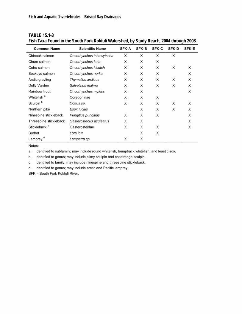
At least 14 different fish species were documented in the SFK during the 2004 through 2008 study period (Table 15.1-3), making the SFK fish assemblage the most species-rich in the mine study area. The ephemeral reach area in SFK-C marks the portion of the SFK where the habitat transitioned from supporting a Pacific salmon-dominated fish assemblage to supporting
Fish and Aquatic Invertebrates—Bristol Bay Drainages
November 17, 2011 15.1-11
populations of stream-rearing anadromous and resident non-anadromous fishes. SFK-B had the greatest number of fish species (14) observed in the watershed. This reach also supported the greatest amount of predicted available habitat for most species and life stages present. The reaches with the fewest fish species were SFK-D (six species) and SFK-E (nine species). The fish assemblages in the headwater areas were dominated by resident fish species.
In the SFK watershed, all anadromous salmon spawning occurred downstream of Frying Pan Lake, and the majority of the spawning occurred in the lowermost reaches SFK-A and SFK-B. Analysis of the spawning-reach analysis data showed that spawning Chinook salmon were more abundant in the large river reaches of SFK-A, whereas spawning chum, coho, and sockeye salmon were more abundant in SFK-B. These patterns for spawning distributions were somewhat in contrast with the instream-flow habitat results. The model indicated that substantially more anadromous spawning habitat should be available in SFK-A compared to SFK-B and SFK-C, yet only one anadromous salmon species was found spawning in greater abundance in SFK-A. Other factors, such as hydrology and temperature, appeared to influence spawning distributions. The species distributions of adult sockeye and chum salmon in these reaches showed a direct relationship between spawning and areas with inflow from groundwater, seeps, or springs. These salmon spawned only in the vicinity of groundwater both on a localized scale within a reach and among reaches. Furthermore, summertime surface water temperatures in the SFK increased in Frying Pan Lake and were relatively high from there to the upstream end of SFK-B, where Tributary SFK 1.190 enters the mainstem channel. As a result of cool water inflows from the SFK 1.190, as well as numerous springs and seeps, water temperatures began to decline at the upper end of SFK-B and continued to decline to the middle of that reach. This cold-water upwelling area and the area immediately downstream supported the majority of salmon spawners in the SFK.
The observation that anadromous fish spawning was largely limited to the lower three reaches of SFK reflected the unreliable habitat conditions associated with the large and variable ephemeral section of river in the middle of reach SFK-C. In low-flow years, such as 2007, a large portion of this ephemeral reach went dry. However, in higher-flow years, such as 2008, the ephemeral section remained fully wetted, and anadromous salmon had access to the entire length of SFK-C. Adult chum, coho, and sockeye salmon expanded their distributions upstream in 2008 with small numbers of fish spawning in the available habitat in SFK-C. While spawning locations for chum and sockeye salmon were limited to the downstream portion of SFK-C, coho salmon spawned sporadically throughout the entire reach.
Based on mean index counts, the SFK supported the second largest run of Chinook and chum salmon among the three watersheds in the study area, following closely behind the NFK. The mean index counts of coho salmon in the SFK and NFK were similar. Both were substantially less than the UT coho salmon index counts. The mean index counts for sockeye salmon in the SFK were consistently 2 to 3 times greater than those for the NFK. Still, in most years, SFK sockeye salmon counts were an order of magnitude less than the UT sockeye salmon counts. In 2006 and 2007, however, when the UT counts dropped dramatically, the SFK sockeye salmon counts were within an order of magnitude of the UT sockeye salmon counts.
Pebble Project Environmental Baseline Studies, 2004-2008, Technical Summary
15.1-12 November 17, 2011
The distributions of river-rearing juvenile Pacific salmon followed similar patterns as the adult spawning distributions. The highest abundance and diversity of juvenile salmon in the SFK were found in the lower two reaches. Juvenile chum salmon were observed in low numbers and only in SFK-A and SFK-B, and very few Chinook salmon were found upstream of SFK-C; however, during high-water years, small numbers of coho and sockeye salmon were documented in SFK-C and further upstream, including in habitats above Frying Pan Lake. This expansion in juvenile distribution was, in general, consistent with spawning further upstream during high-water years, but also implied that juvenile salmon may have redistributed upstream of SFK spawning areas for rearing purposes. The environmental conditions in Frying Pan Lake were suboptimal for juvenile salmonids and, as such, may have restricted fish passage and influenced the overall distribution of salmonid fishes throughout the SFK watershed.
Juvenile Chinook salmon were prominent in mainstem channel, fast-water habitats that dominate the lower reaches of the SFK. Juvenile coho salmon were more widely dispersed and found in a variety of habitat types. Given the lack of pools and slack-water habitat features observed in the mainstem channel, off-channel habitats may have offered more suitable conditions for both summer and winter rearing of fishes. This was apparent for juvenile coho salmon, which were observed at the highest densities among all salmonids in off-channel habitats. The wide distribution and broad habitat use for juvenile coho salmon were consistent with the finding that coho salmon were the most abundant juvenile salmon documented in SFK and that four age classes of juvenile coho salmon were identified in SFK habitats. Although no adult anadromous species have been recorded spawning along the shores of Frying Pan Lake, limited observations of juvenile coho and sockeye salmon indicate that the lake has some potential for rearing.
Ten non-anadromous salmonids and non-salmonid fish species were present in the SFK. Unlike the anadromous salmonids, the stream’s resident fish species were distributed in low numbers throughout the SFK. Arctic grayling and Dolly Varden were the most abundant and were broadly distributed species of the resident fishes. Frying Pan Lake provided habitat for a population of northern pike, an aggressive predator of smaller fishes including juvenile salmon and resident stream fishes. Another distinction of the SFK fish assemblage was the documentation of both burbot and lamprey species. These species were not present in any other watersheds, but were found within and downstream of SFK-C.
Overall, analysis of the data collected during the study period show that the preponderance of fish spawning and rearing in the SFK was associated with areas where there was an observable influence of groundwater on the rivers surface, as evidenced by open water areas during winter. These areas of detectable groundwater influence were widespread throughout the lower two reaches, with areas of higher groundwater influence noted in SFK-B. In areas where groundwater influx was not prevalent, fish diversity and abundance were reduced.
15.1.2.4 Upper Talarik Creek
Aquatic Habitat and Instream Flow
During baseline habitat surveys, the UT was characterized as primarily a single-thread, gravel-bedded channel that was relatively straight along much of its length, except where the river
Fish and Aquatic Invertebrates—Bristol Bay Drainages
November 17, 2011 15.1-13
valley and floodplain widened and multiple channels had formed. The channel slopes of the UT were generally steeper than those of both the NFK and SFK and ranged from 0.1 to 2.0 percent. Alluvial transport and deposition were common in the lower UT reaches (i.e., in most of UT-B and the entire length of UT-A). Within these areas, there was evidence that high flows had overtopped the stream banks, and the channels were bordered by relatively wide floodplains. In addition, the associated riparian zones, wetland complexes, and off-channel habitats extended well into the floodplains. In the upper third of UT-B and throughout UT-C, the river channel was low gradient, contained, and flowed through a relatively narrow valley bottom, bordered by low hills to the west and carved glacial deposits to the east. UT-D, UT-E, and the lower half of UT-F were classified as alluvial floodplain channels that formed by water reworking glacial outwash deposits. Multiple former stream terraces and colluvial slopes were evident where the present stream channel had downcut through glacial outwash and lacustrine deposits. Steep side slopes represented sediment sources where the channel impinged against the valley walls. Tributaries that flowed in from the isolated mountain blocks were varied and had a variety of channel types, including high gradient, contained, moderate gradient, mixed control, and alluvial fan. In the upper half of both UT-F and UT-G, the channel flowed across deep glacial lacustrine deposits. The stream there tended to contain higher levels of fine sediment than elsewhere in the basin. The downstream limits of the lacustrine deposits were in the same area as the downstream limit of beaver dam construction in the mainstem channel (i.e., at the lower end of UT-F).
Like the NFK and SFK watersheds, the baseline hydrology of the UT mainstem was strongly influenced by climate, geology, and groundwater influx. Streamflows were driven by runoff from spring snowmelt and summer and fall rains. Analysis of available data indicated that surface water flows generally declined from October through April, were highest in late April to late May as a result of snowmelt, and then reached a secondary peak in the late summer and early fall as a result of rainfall. Base flows tended to remain high in both winter and late summer because of groundwater storage.
The UT hydrograph showed a pronounced groundwater influence, which was largely due to a cross-basin transfer of groundwater from the SFK. Approximately 25 cubic feet per second (0.7 cubic meters per second) of flow entered the UT basin through this cross-basin transfer. The groundwater flowed eastward from SFK, likely along flow paths formed by former glacial meltwater channels, and emerged in Tributary UT 1.190, which flows into the mainstem UT at the upstream end of UT-C. Flow records indicated that the downstream portion of reach UT-F and reach UT-D also received groundwater inflow and that portions of these reaches remained ice-free during winter months. No mainstem UT reaches exhibited seasonal or temporary cessation of flow during the study period.
The annual water-temperature regime in the UT was cold. Cold water restricts active fish feeding to a brief summer period when water temperatures exceed 46ºF (8ºC); hence, fish productivity in the UT is likely limited as compared to watersheds where the active feeding period is longer (Campbell and Neuner, 1985). Notably, warm water temperatures in the summer months also may be limiting to fish health and productivity. The open riparian nature of most of the streams in the UT watershed has allowed water temperatures to warm quickly during the summer months, and at several monitoring stations researchers documented temperatures that naturally exceeded state thermal criteria for spawning, incubation, migration,
Pebble Project Environmental Baseline Studies, 2004-2008, Technical Summary
15.1-14 November 17, 2011
and rearing habitat. The maximum temperatures in the UT were less than those in the NFK and SFK, yet were still on the high end of recorded temperature maxima for other regional streams.
During the study period, the longitudinal thermal regime of the UT was characteristic of a surface water system influenced by groundwater and cold-water tributary inflow. In particular, there was a broad distribution of distinct groundwater effects in the middle reaches of the watershed and in Tributary UT 1.190. The middle mainstem reaches and UT 1.190 were relatively cool in summer and warm in the winter and may have provided thermal refuge for juvenile fish-rearing. Overall, the thermal regime of the UT was cooler than those of the Koktuli watersheds. This thermal difference may have been due, in part, to the prominent groundwater influence throughout the UT and the lack of lake-related warming effects in this watershed, in contrast to warming effects seen from Frying Pan Lake in SFK and Big Wiggly Lake in NFK. The north/south alignment in the upper UT also likely provided shade from the surrounding terrain and helped to insulate the water temperature.
The UT habitat studies indicated that the mainstem river was composed largely of riffle and run/glide habitats, similar to the SFK. Beaver ponds were present in the mainstem channel only in UT-F and accounted for 7 percent of the total habitat area in that reach. Habitat surveys indicated that riffle and run/glide habitat types dominated the morphology of the UT tributary channels as well.
While beaver ponds were relatively scarce in the mainstem UT, the off-channel habitat study revealed a preponderance of beaver ponds in the off-channel habitats. As in the SFK watershed, beaver ponds accounted for more than 90 percent of the off-channel habitat surveyed. Beaver ponds in the UT provided habitat for adult spawning and juvenile overwintering for Pacific salmon. The water temperature in beaver ponds in the UT was slightly warmer than in other habitat types and thus, beaver ponds may represent a more productive habitat as compared to other mainstem channel habitat types.
Other off-channel habitat types that were represented in very low proportions were side channels, beaver pond outlet channels, percolation channels, isolated ponds, and alcoves. The off-channel habitat instream-flow analysis indicated that many of the off-channel habitats were hydrologically connected to the mainstem channel via surface inflow at less than bankfull flows, thus indicating that these habitats were accessible to fish periodically throughout the year. However, a subsample of off-channel habitat units demonstrated that the flows at which off-channel habitats were connected to the mainstem varied within and among off-channel habitat types.
Lakes and ponds were prevalent in the UT watershed, particularly along the eastern boundary of the basin. The largest concentration was along the long unnamed ridge that separates the UT drainage from the Newhalen River to the east. A large lake was located east of the headwaters of UT 1.60 (First Creek), and a series of kettle ponds and lakes occurred east of UT-D and UT-E. Adult coho and sockeye spawning was observed in a small lake associated with Tributary UT 1.350.20, as well as in beaver ponds in the UT. In general, surface water impoundments of this nature also provide habitat for other stream-dwelling fish species and are valuable for their ability to store water and to provide extended surface water runoff volumes during low-flow periods as compared to basins without such storage.
Fish and Aquatic Invertebrates—Bristol Bay Drainages
November 17, 2011 15.1-15
The quality of spawning gravels in the UT was good. Overall, fine sediment levels in the UT were less than those in the SFK, but greater than those in the NFK. The concentrations of fine sediment size fractions observed were below levels that have been shown to be harmful to embryo survival and fry emergence.
There was a general lack of instream fish cover and mainstem channel pool habitat in the UT. As in the NFK and SFK, large woody debris was scarce in the upper portion of the UT because of a general lack of forest vegetation in the riparian zone. Thus, juveniles rearing in the upper UT may need to rely on off-channel habitats for rearing, especially for winter refuge when water temperatures and streamflows become low. While large woody debris was scarce throughout most of the basin, it was more prevalent in UT-A and UT-B because of large source trees from the riparian zone. The presence of large woody debris created fish cover and was responsible for creating and maintaining habitat diversity in this lower portion of the UT.
The instream-flow habitat modeling and time series analyses were computed for various salmonid fish species. Results of the habitat and time series analyses for salmon, as well as for rainbow trout spawning and juvenile life stages were evaluated as the total habitat area versus river flow relationships, because this parameter provided reach-scale estimates of the total amount of habitat for a given species and life stage available under different flow conditions. The time series analysis revealed substantial variability in habitat amounts on a daily basis in response to changes in flow. This variation was most evident during flow transitional periods. For example, the model predictions for the spring-summer period, when flows were declining, were for general increase in juvenile habitat. Similarly, predictions for the summer-fall period, when flows increased, were for a general increase in spawning habitat.
Fish Distribution
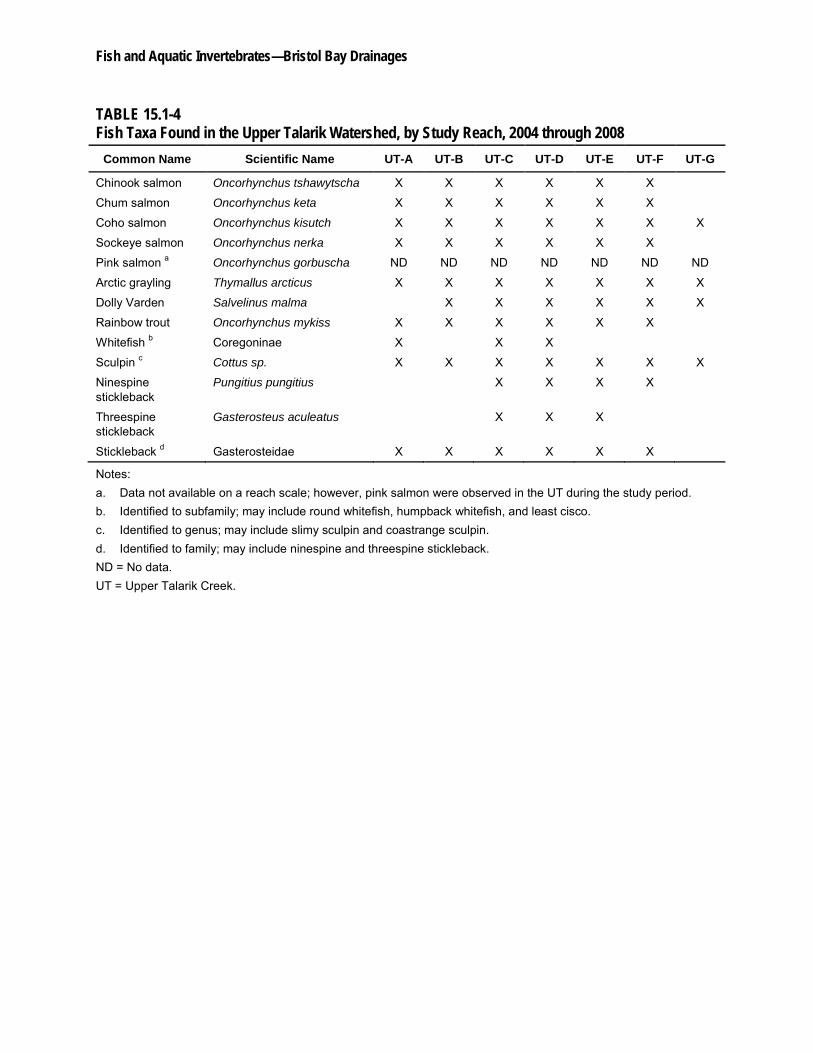
At least 12 different fish species were documented in the UT from 2004 through 2008 (Table 15.1-4). Overall, species numbers remained relatively constant in most reaches, with the greatest number of species (11) found in UT-C and UT-D. Only four species were found in the headwater reach UT-G.
Four anadromous salmon species spawned annually in habitats throughout the mainstem UT. Chinook, chum, coho, and sockeye salmon were documented spawning in reaches UT-A through UT-F, with the coho salmon spawning distribution extending into UT-G. In addition, what appeared to be exploratory runs of pink salmon were documented in the UT in 2006 and 2007. Chinook and chum salmon spawning abundance was consistently low (less than 60 spawning fish per reach) throughout their distributions. Spawning coho salmon were more abundant than Chinook and chum salmon spawners, but less abundant than spawning sockeye salmon. The abundance of spawning coho salmon was generally greatest in the middle and uppermost reaches (UT-D, UT-E, and UT-F). For sockeye salmon, the greatest abundance of spawners occurred in UT-A, with spawner abundance declining in each consecutive upstream reach.
The instream-flow habitat assessment results help to explain the spawning distribution pattern for coho salmon, as the greatest amount of available habitat was predicated in the middle spawning reaches. However, the results for sockeye salmon habitat availability do not explain
Pebble Project Environmental Baseline Studies, 2004-2008, Technical Summary
15.1-16 November 17, 2011
the sockeye salmon distribution. It is possible that the lack of predictive capability for sockeye salmon habitat is related to a limited number of instream-flow transects located in UT-A and UT-B, the reaches with the highest abundances of spawning sockeye. It is also interesting to note that, unlike in the NFK and SFK, a direct relationship between spawning distributions of sockeye and chum salmon and groundwater inflow areas was not apparent in the UT.
Five tributaries in the UT support spawning populations of anadromous salmonids. Most tributaries support small numbers of spawning sockeye and coho salmon, but large spawning populations were observed in UT 1.60 (First Creek). The mouth of UT 1.60 is located low in the watershed, and the tributary continues upstream to the east of the mainstem UT for approximately 20 miles (32 km). Analysis of aerial survey data indicated that this creek has supported as much as 43 percent of the total UT adult sockeye salmon run and 17 percent of the total UT coho salmon run in some years. The UT 1.60 and UT 1.350 subwatersheds also support a life-history variation for coho and sockeye salmon—small populations of lake-spawning sockeye and coho salmon were documented in several small lakes and ponds in these subwatersheds.
A comparison of index counts of mean adult salmon among watersheds shows that the UT sockeye salmon run was the largest run in the study area. The mean index counts for UT coho salmon were greater by one or two orders of magnitude than those for the NFK and SFK. In contrast, the runs of UT Chinook and chum salmon were less compared to mean index counts in the other two watersheds.
The overall distribution of river-rearing juvenile Pacific salmon was driven largely by juvenile coho salmon, which were the most abundant juvenile fishes in the UT. Peak abundances of juvenile coho salmon occurred in the middle to upper UT, including reaches UT-C through UT-F. The highest abundance estimates for Chinook salmon were also located in the middle watershed. Observations during winter surveys indicated that Chinook and coho salmon were present in UT-C through UT-F in November and again the following April, thus indicating that these reaches provide overwintering habitat in addition to summer rearing habitat. Limited numbers of juvenile sockeye salmon were found up through UT-F in early summer, and they appear to rear in lower UT reaches throughout the summer. Juvenile chum salmon were observed in limited numbers and only in UT-D. The only anadromous salmon documented in UT-G were coho salmon.
Juvenile Chinook salmon were found predominantly in fast-water habitats that were present throughout the UT mainstem channel. Juvenile coho salmon were widely dispersed throughout the mainstem channel and tributaries and occupied a variety of habitat types. High relative abundances and densities of coho salmon were found in the mainstem channel glides, riffles, pools, and beaver ponds and in tributary backwaters. Off-channel habitats were used for coho salmon rearing and to a limited extent for Chinook salmon; however, juvenile Chinook and coho salmon abundances in off-channel habitats were typically less than the corresponding mainstem channel abundances. This broad habitat use was consistent with the fact the coho salmon were the most abundant juvenile fishes in this watershed.
Patterns evident for sockeye salmon distribution also were noteworthy. Although sockeye salmon typically out-migrate in their first spring after emergence, some juvenile sockeye salmon
Fish and Aquatic Invertebrates—Bristol Bay Drainages
November 17, 2011 15.1-17
were found from April through September in the UT watershed. This information indicated that some sockeye salmon are rearing in the mainstem UT for several months.
At least seven non-anadromous salmonids and non-salmonid fish species were present in the UT. In general, these stream-dwelling fishes were distributed in low numbers throughout most of the watershed. Dolly Varden, sculpin, and one arctic grayling were the only resident fishes found in the headwater reach (UT-G). Arctic grayling and sculpin were the most widespread of the non-anadromous fishes and were documented in all reaches, as well as in several tributaries. Relative abundance of these fishes was generally low, with the exception of arctic grayling in UT-C, rainbow trout in UT-B, and sculpin in UT-C, UT-E, and UT-F. A separate rainbow trout radio-telemetry study revealed that adults using the UT for foraging and spawning left the UT to rear for extended periods in Iliamna Lake and other tributaries to Iliamna Lake.
Although some species-specific abundance patterns were evident, overall the freshwater fish assemblage in the UT was more consistent throughout the watershed and tributaries than the NFK and SFK assemblages. Large numbers of fish and similar species composition were documented from UT-B to UT-F. This distribution reflects the overall stable habitat conditions in the UT. No ephemeral areas were documented, and no warm-water lakes are present in the UT. Furthermore, areas of groundwater inflow were widely dispersed throughout the middle and upper portions of the watershed, and thus, a more stable flow regime was present. The relatively constant fish assemblage among reaches in the UT was consistent with similar levels of habitat availability in reaches UT-B through UT-F as predicted by the instream-flow model.
15.1.2.5 Koktuli River
Aquatic Habitat and Instream Flow
Although no habitat surveys were undertaken in the upper KR mainstem, instream-flow transect data provide some information on fish habitat. Similar to the NFK, SFK, and UT instream-flow analyses, the analyses for the upper KR mainstem indicated there can be substantial variability in habitat amounts on a daily and monthly basis in response to changes in flow. This variation was most evident during flow transitional periods. For example, model predictions for the spring-summer period when flows were declining were for a general increase in juvenile habitat. Similarly, the model predicted that during the late summer-fall period when flows increase there would be a general decrease in spawning habitat as a result of increased flow velocities that are slightly higher than optimal for most salmonid spawning. Conversely, for the spring spawning species, including arctic grayling and rainbow trout, the model showed a strong decrease in available spawning area when river flows decrease in the late May and June time frame.
Fish Distribution
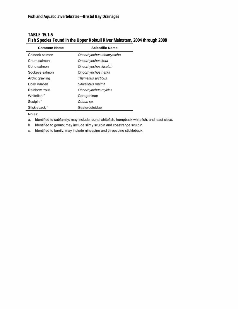
The fish community inhabiting the upper KR mainstem consists of at least 10 different species (Table 15.1-5), including four anadromous salmonids, four non-anadromous (resident) salmonids, and two non-salmonid fishes. Anadromous salmonids represent the most abundant fish taxa surveyed. The resident salmonids were the second most abundant species group, and non-salmonid fishes were observed in very low numbers.
Pebble Project Environmental Baseline Studies, 2004-2008, Technical Summary
15.1-18 November 17, 2011
Observations of Chinook, chum, coho, and sockeye salmon occurred in July and August. The most abundant species of Pacific salmon in the study reach in the upper KR mainstem were Chinook and coho salmon. Field surveys identified both juvenile and adult Chinook, coho, and sockeye salmon. For chum salmon, only adults were documented. The abbreviated riverine residence time of juvenile chum salmon prior to downstream migration likely explains the absence of juvenile observations in the upper KR mainstem during summer surveys. In addition to providing spawning, incubation, and rearing habitat, the KR is a migratory corridor for adult and juvenile Pacific salmon that use upstream habitats in the NFK and SFK watersheds.
At least six non-anadromous salmonid and non-salmonid fish species were present in the upper KR mainstem: arctic grayling, whitefish, Dolly Varden, rainbow trout, sculpin, and stickleback. Among these fishes, arctic grayling, whitefish, and Dolly Varden were the most abundant species groups observed. Arctic grayling and whitefish were more abundant than Dolly Varden in pool habitat, whereas Dolly Varden were more abundant in riffle habitat. Rainbow trout were observed in both pool and riffle habitats, although in very low numbers (approximately 2 fish per 328 feet [100 meters]). Non-salmonid fishes, including sculpin and stickleback, were observed in very low numbers. Only 13 stickleback and five sculpin were documented as occurring in the upper KR mainstem.
15.1.3 References
Alaska Department of Fish and Game (ADF&G). 2010. Catalog of Waters Important for the Spawning, Rearing or Migration of Anadromous Fishes.http://www.adfg.alaska.gov/sf/SARR/AWC/.
Bovee, K.D. 1982. A guide to stream habitat analysis using the Instream Flow Incremental Methodology. U.S. Fish and Wildlife Service Instream Flow Group, Information Paper No. 12 FWS/OBS-2/26. Fort Collins, CO.
Bovee, K.D., B.L. Lamb, J.M. Bartholow, C.D. Stalnaker, J. Taylor, and J. Henriksen. 1998. Stream habitat analysis using the Instream Flow Incremental Methodology. U.S. Geological Survey, Biological Resources Division, Information and Technical Report USGS/BRD-1998- 0004.
Campbell, R.F. and J.H. Neuner. 1985. Seasonal and Diurnal Shifts in Habitat Utilized by Resident Rainbow Trout (Salmo gairdneri) Observed in Western Washington Cascade Mountain Streams. Paper presented at the Symposium on Small Hydropower and Fisheries, Denver, CO May 1-3, 1985.
Holt, K.R, and S.P. Cox. 2008. Evaluation of visual survey methods for monitoring Pacific salmon (Oncorhynchus spp.) escapement in relation to conservation guidelines. Canadian Journal of Fisheries and Aquatic Sciences 65:212-226.
U.S. Forest Service (USFS). 2001. FSH 2090-Aquatic Habitat Management Handbook, R-10 Amendment 2090.21-2001-1. Chapter 20, Fish and Aquatic Stream Habitat Survey. U.S. Department of Agriculture, U.S. Forest Service.
Fish and Aquatic Invertebrates—Bristol Bay Drainages
1
TABLE 15.1-1 Fish Resource Studies, by Major Study Category, Conducted in the Mine Study Area, 2004 through 2008
Study Category
Watershed
2004 2005 2006 2007 2008
Aquatic Habitat Assessments:
Mainstem and Tributary Habitat Surveys
USFS Modified Tier 1 Aquatic Habitat Surveys (USFS, 2001) NFK, SFK, UT UT NFK, SFK, UT
USFS Modified Tier 3 Aquatic Habitat Surveys (USFS, 2001) NFK, SFK, UT SFK, UT UT NFK, SFK, UT
Fish/Habitat Associations via Anecdotal Data Collection NFK, SFK, UT KR, NFK, SFK, UT
KR, NFK, SFK, UT
KR, NFK, SFK, UT
Off-Channel Habitat Surveys
USFS Modified Tier 3 Aquatic Habitat Surveys (USFS, 2001) NFK
Fish/Habitat Associations via Anecdotal Data Collection SFK SFK SFK, UT
Mesohabitat Mapping Field Surveys NFK, SFK, UT NFK, SFK, UT
Fish Assemblage Surveys:
Fish Distribution and Relative Abundance Surveys KR, NFK, SFK, UT
KR, NFK, SFK, UT
KR, NFK, SFK, UT
KR, NFK, SFK, UT
KR, NFK, SFK, UT
Fish Use of Off-Channel Habitats Study SFK SFK SFK, UT NFK
Winter Fish Study KR, NFK, SFK, UT
NFK, SFK, UT NFK, SFK, UT SFK, UT
Mainstem Index Surveys NFK, SFK, UT NFK, SFK, UT NFK, SFK, UT NFK, SFK, UT
Adult Salmon Surveys KR, NFK, SFK, UT
KR, NFK, SFK, UT
KR, NFK, SFK, UT
KR, NFK, SFK, UT
NFK, SFK, UT
Rainbow Trout Radio-telemetry Study a UT UT
Instream-flow Habitat Studies:
Mainstem Channel Flow Habitat Studies KR, NFK, SFK, UT
KR, NFK, SFK, UT
KR, NFK, SFK, UT
NFK, SFK, UT
Off-Channel Flow Habitat Studies SFK SFK UT NFK
Water Temperature Monitoring/Modeling NFK, SFK, UT NFK, SFK, UT NFK, SFK, UT NFK, SFK, UT NFK, SFK, UT
Fluvial Geomorphology and Spawning Gravel Quality SFK, UT KR, NFK, SFK, UT
NFK, SFK, UT
Fish and Aquatic Invertebrates—Bristol Bay Drainages
Table 15.1-1 2
Notes: a. The rainbow trout radio-telemetry study was centered around Iliamna Lake downstream to the upper extent of tidal influence in the Kvichak River, with special
emphasis on the Lower Talarik Creek and the UT. KR = Koktuli River mainstem. NFK = North Fork Koktuli River. SFK = South Fork Koktuli River. USFS = U.S. Forest Service. UT = Upper Talarik Creek.
Fish and Aquatic Invertebrates—Bristol Bay Drainages
TABLE 15.1-2 Fish Taxa Found in the North Fork Koktuli Watershed, by Study Reach, 2004 through 2008
Common Name Scientific Name NFK-A NFK-B NFK-C NFK-D NFK-E NFK-F
Chinook salmon Oncorhynchus tshawytscha X X X X X
Chum salmon Oncorhynchus keta X X X
Coho salmon Oncorhynchus kisutch X X X X X
Sockeye salmon Oncorhynchus nerka X X X X
Arctic grayling Thymallus arcticus X X X X
Dolly Varden Salvelinus malma X X X X X X
Rainbow trout Oncorhynchus mykiss X X
Round whitefish Prosopium cylindraceum X
Whitefish a Coregoninae X X X X
Sculpin b Cottus sp. X X X X X X
Northern pike Esox lucius X X
Ninespine stickleback Pungitius pungitius X X X X
Threespine stickleback Gasterosteous aculeatus X X
Stickleback c Gasterosteidae X X
Notes: a. Identified to subfamily; may include round whitefish, humpback whitefish, and least cisco. b. Identified to genus; may include slimy sculpin and coastrange sculpin. c. Identified to family; may include ninespine and threespine stickleback. NFK = North Fork Koktuli River.
Fish and Aquatic Invertebrates—Bristol Bay Drainages
TABLE 15.1-3 Fish Taxa Found in the South Fork Koktuli Watershed, by Study Reach, 2004 through 2008
Common Name Scientific Name SFK-A SFK-B SFK-C SFK-D SFK-E
Chinook salmon Oncorhynchus tshawytscha X X X X
Chum salmon Oncorhynchus keta X X X
Coho salmon Oncorhynchus kisutch X X X X X
Sockeye salmon Oncorhynchus nerka X X X X
Arctic grayling Thymallus arcticus X X X X X
Dolly Varden Salvelinus malma X X X X X
Rainbow trout Oncorhynchus mykiss X X X
Whitefish a Coregoninae X X X
Sculpin b Cottus sp. X X X X X
Northern pike Esox lucius X X X X
Ninespine stickleback Pungitius pungitius X X X X
Threespine stickleback Gasterosteous aculeatus X X X
Stickleback c Gasterosteidae X X X X
Burbot Lota lota X X
Lamprey d Lampetra sp. X X
Notes: a. Identified to subfamily; may include round whitefish, humpback whitefish, and least cisco. b. Identified to genus; may include slimy sculpin and coastrange sculpin. c. Identified to family; may include ninespine and threespine stickleback. d. Identified to genus; may include arctic and Pacific lamprey. SFK = South Fork Koktuli River.
Fish and Aquatic Invertebrates—Bristol Bay Drainages
TABLE 15.1-4 Fish Taxa Found in the Upper Talarik Watershed, by Study Reach, 2004 through 2008
Common Name Scientific Name UT-A UT-B UT-C UT-D UT-E UT-F UT-G
Chinook salmon Oncorhynchus tshawytscha X X X X X X
Chum salmon Oncorhynchus keta X X X X X X
Coho salmon Oncorhynchus kisutch X X X X X X X
Sockeye salmon Oncorhynchus nerka X X X X X X
Pink salmon a Oncorhynchus gorbuscha ND ND ND ND ND ND ND
Arctic grayling Thymallus arcticus X X X X X X X
Dolly Varden Salvelinus malma X X X X X X
Rainbow trout Oncorhynchus mykiss X X X X X X
Whitefish b Coregoninae X X X
Sculpin c Cottus sp. X X X X X X X
Ninespine stickleback
Pungitius pungitius X X X X
Threespine stickleback
Gasterosteus aculeatus X X X
Stickleback d Gasterosteidae X X X X X X
Notes: a. Data not available on a reach scale; however, pink salmon were observed in the UT during the study period. b. Identified to subfamily; may include round whitefish, humpback whitefish, and least cisco. c. Identified to genus; may include slimy sculpin and coastrange sculpin. d. Identified to family; may include ninespine and threespine stickleback. ND = No data. UT = Upper Talarik Creek.
Fish and Aquatic Invertebrates—Bristol Bay Drainages
TABLE 15.1-5 Fish Species Found in the Upper Koktuli River Mainstem, 2004 through 2008
Common Name Scientific Name
Chinook salmon Oncorhynchus tshawytscha
Chum salmon Oncorhynchus keta
Coho salmon Oncorhynchus kisutch
Sockeye salmon Oncorhynchus nerka
Arctic grayling Thymallus arcticus
Dolly Varden Salvelinus malma
Rainbow trout Oncorhynchus mykiss
Whitefish a Coregoninae
Sculpin b Cottus sp.
Stickleback c Gasterosteidae
Notes: a. Identified to subfamily; may include round whitefish, humpback whitefish, and least cisco. b Identified to genus; may include slimy sculpin and coastrange sculpin. c. Identified to family; may include ninespine and threespine stickleback.
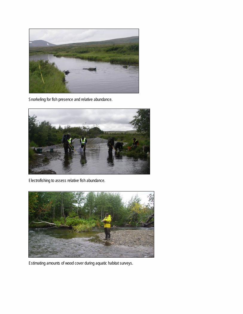
Snorkeling for fish presence and relative abundance.
Electrofishing to assess relative fish abundance.
Estimating amounts of wood cover during aquatic habitat surveys.
Fish and Aquatic Invertebrates—Bristol Bay Drainages
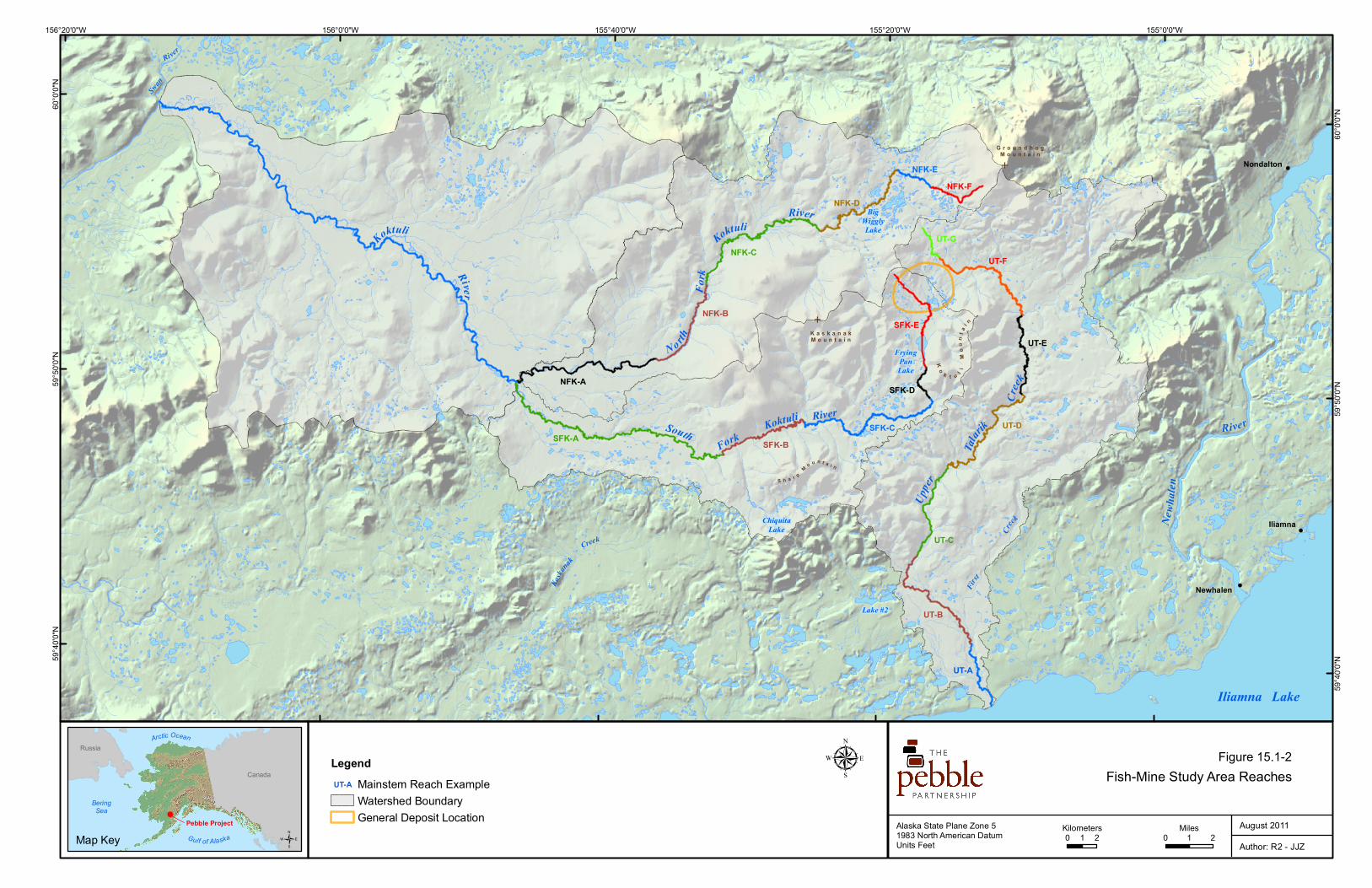
Measuring the height of a beaver dam during aquatic habitat surveys.
A snorkeler’s view of juvenile coho salmon under instream cover.
!(
!(
!(
!(
!(
!(
!(
!(
Naknek
Kodiak
Iliamna
BristolBay
Gulfof
Alaska
Cook
Inlet
AnchorPoint
KENAIPENINSULA
KODIAKISLAND
Dillingham
Shelikof S
trait
KuskokwimBay
Cape Newenham
Iliamna Lake
Becharof Lake
Naknek Lake
Togiak
Bethel
Williamsport
150°0'0"W155°0'0"W160°0'0"W165°0'0"W
60°0
'0"N
60°0
'0"N
58°0
'0"N
58°0
'0"N
µAlaska State Plane Zone 51983 North American DatumUnits Feet
Figure 15.1-5Bristol Bay Regional Drainages
April 2011
/ 0 4020Miles
0 4020Kilometers
Map Key Author: R2 - JJZ
BeringSea
Gulf of Alaska
Canada
Russia
Pebble Project
Arctic Ocean LegendN.E. Bristol Bay Drainages
AlagnakEgegikKvichakNaknek
General Deposit LocationNorth Fork Koktuli River,South Fork Koktuli River,Koktuli River, andUpper Talarik CreekWatershed Boundaries
NushagakTogiak/Osviak/Negukthlik/KulukakUgashikWood/Snake Igushik
Figure 15.1-1
!(
!(
!(E
E
K a s k a n a kM o u n t a i n
Ko
k t u l i M
ou
nt a
i n
S h a r p M o u n t a i n
G r o u n d h o gM o u n t a i n
BigWigglyLake
FryingPanLake
ChiquitaLake Iliamna
Newhalen
Iliamna Lake
Nondalton
Newh
alen
River
Lake #2
RiverKoktuli
Fork
N o rthFo
rk
River
Koktuli
Upper
Talar
ik
Creek
South
Kaska
nak
Creek
First
Creek
Koktuli
River
Swan
River
UT-A
UT-B
UT-C
UT-D
UT-E
UT-F
UT-G
SFK-A SFK-BSFK-C
SFK-D
SFK-E
NFK-A
NFK-B
NFK-C
NFK-D
NFK-ENFK-F
155°0'0"W155°20'0"W155°40'0"W156°0'0"W156°20'0"W
60°0
'0"N
60°0
'0"N
59°5
0'0"N
59°5
0'0"N
59°4
0'0"N
59°4
0'0"N
µAlaska State Plane Zone 51983 North American DatumUnits Feet
Figure 1-2Fish-Mine Study Area Reaches
August 2011/ 0 21
Miles0 21
KilometersMap Key Author: R2 - JJZ
BeringSea
Gulf of Alaska
Canada
Russia
Pebble Project
Arctic Ocean
LegendMainstem Reach ExampleWatershed BoundaryGeneral Deposit Location
UT-A
Figure 15.1-2
Fish and Aquatic Invertebrates—Bristol Bay Drainages
November 17, 2011 15.2-1
15.2 Aquatic Invertebrates —Mine Study Area
15.2.1 Introduction
The macroinvertebrate and periphyton studies in the vicinity of the Pebble Deposit are part of the overall program of baseline investigations to describe the current aquatic conditions in the mine study area (Figure 1-4 in Chapter 1). Baseline information on macroinvertebrate and periphyton community assemblages is valued because these creatures are essential components of the aquatic food web and their community structure, particularly with respect to the more sensitive taxa, is an indicator of habitat and water quality. The objective of the macroinvertebrate and periphyton field and laboratory program was to characterize the diversity, abundance, and density of macroinvertebrates and periphyton within freshwater habitats in the study area.
Macroinvertebrates are organisms without a backbone that are large enough to be seen without the aid of a microscope. Sampling of macroinvertebrates typically targets those organisms that live in or on the substrate of streams and lakes (usually in larval and pupal life stages). Periphyton, defined as micro-algae attached to rocks or other solid surfaces, has been sampled in order to describe the primary producers within freshwater habitats in the study area. As with macroinvertebrates, periphyton is also sensitive to changes in the aquatic environment and can be used as a monitoring tool for in situ primary productivity.
Macroinvertebrates and periphyton were sampled in the mine study area in 2004, 2005, and 2007 as part of the environmental baseline studies for the Pebble Project. In 2004, 20 sites in the mine study area were sampled for macroinvertebrates and periphyton. Of these, eight sites (five in the immediate vicinity of the deposit) were selected for continued sampling in 2005, and 10 were sampled in 2007.
A range of macroinvertebrate and periphyton sample-collection methods was employed during the beginning stages of this project to determine which methods would work best in these systems. Methods used to sample macroinvertebrates and periphyton differed slightly between 2004 and the subsequent sampling years of 2005 and 2007. Beginning in 2005, Surber sampling for macroinvertebrates replaced drift-net sampling in streams, and collection of periphyton samples for analysis of chlorophyll-a concentrations replaced sampling by the modified Environmental Protection Agency’s Rapid Bioassessment Protocol method. Alaska Stream Condition Index sampling was consistent throughout all 2004, 2005, and 2007 events. The variety of methods used contributes greatly to the robustness of the baseline data-collection program and offers a detailed set of project information for refinement of future sampling methods.
15.2.2 Results and Discussion
Macroinvertebrate and periphyton baseline studies were conducted in the mine study area in 2004, 2005 and 2007.
Pebble Project Environmental Baseline Studies, 2004-2008, Technical Summary
15.2-2 November 17, 2011
Two hundred thirty-five macroinvertebrate taxa, including 64 chironomid taxa, have been identified in the Bristol Bay drainages study areas (the Bristol Bay drainages study areas include both the mine and transportation-corridor study areas, the latter of which is discussed in Section 15.4.). During the course of the program, 132 primary macroinvertebrate samples, plus duplicates on a minimum frequency of 10 percent, were collected at the established biological monitoring sites in the mine study area. Analysis of data from 2004 indicated that benthic sampling using a kick net (Alaska Stream Condition Index method) was generally more successful at collecting a variety of macroinvertebrates than the drift-net method of sampling the water column. Macroinvertebrate metrics were calculated based on the 2004, 2005, and 2007 data for Alaska Stream Condition Index and Surber samples. Diptera, including the family Chironomidae, was generally the dominant taxon, and Ephemeroptera typically made up the bulk of Ephemeroptera, Plecoptera, and Trichoptera (EPT) taxa (sensitive taxa). Total taxa richness was lower in 2005 than in 2007. Average percent EPT was generally higher for samples collected using the Surber method (riffle/cobble habitat sampling) than percent EPT in Alaska Stream Condition Index-method samples (multi-habitat sampling) in the mine study area, despite the fact that riffle/cobble habitat composed the largest portion of habitats sampled by the Alaska Stream Condition Index method.
The results for measurements of habitat parameters at each site fell within ranges considered good to optimal for aquatic habitat. The sites sampled in this study are located in a pristine area with few to no human-caused effects. Water-quality results were comparable to typical results for Alaskan cold-water streams. Analysis of results for percent dissolved oxygen indicated frequent supersaturated conditions. In general, at the time of sampling, all three drainages in the study area provided good to optimal levels of dissolved oxygen, temperature, dissolved constituents (electrical conductivity), and pH, which are water-quality parameters that are important to diverse macroinvertebrate communities.
Thirty-six diatom genera and 188 diatom species were present in the 20 samples collected in 2004 in the Bristol Bay drainages study areas. During the course of the study, 115 primary periphyton samples were collected from the mine study area. Taxa richness and percent dominant taxon were calculated for periphyton collected in 2004. The metrics using the 2004 data were calculated from identifications of periphyton genera. Taxa richness was relatively uniform across the seasons among the sites sampled in 2004, with seasonal differences of four or fewer taxa at each site, except at one site in the South Fork Koktuli River (SK100B), which had a difference of seven taxa. The percent dominant taxon in periphyton samples in some instances equaled more than 50 percent. Periphyton samples collected in 2005 and 2007 were analyzed for chlorophyll-a concentration as a quantifiable measure of productivity. In 2005, samples were collected from six sites, and in 2007, samples were collected from 10 sites; 10 samples were collected from each site in each year. Average chlorophyll-a concentrations from samples collected in 2005 ranged from a low of 2.1 ±0.82 milligrams per square meter in a sample from Upper Talarik Creek (at UT100D) to a high of 17.0 milligrams per square meter in a sample from the South Fork Koktuli River (at SK100B). Variability among the five samples collected at each site was relatively high and was particularly notable at SK100B and at two sites on Upper Talarik Creek— UT100B and UT138A. Chlorophyll-a concentrations from samples collected in 2007 ranged from 2.3 milligrams per square meter at UT119A on Upper

Fish and Aquatic Invertebrates—Bristol Bay Drainages
November 17, 2011 15.2-3
Talarik Creek to a high of 30.2 milligrams per square meter at UT100D (also Upper Talarik Creek).

Fish and Aquatic Invertebrates—Bristol Bay Drainages
November 17, 2011 15.3-1
15.3 Fish—Transportation-corridor Study Area
15.3.1 Introduction
The transportation-corridor study area in the Bristol Bay drainages traverses multiple rivers, streams, and channels that eventually drain into Iliamna Lake (Figure 1-4 in Chapter 1). Fish and aquatic habitat surveys were conducted in the study area from July through October in 2004, 2005, 2007, and 2008 to characterize channel conditions, water quality, fish assemblages, and habitat use at possible stream-crossing locations along a representative road alignment. Fifty-five primary survey sites (stream-crossing sites on the representative road alignment) and 42 support survey sites (located upstream or downstream of primary survey sites or on nearby tributaries) were surveyed during the study period. To facilitate the characterization of the survey sites, sites were grouped into the following eight watershed groups:
• Upper Talarik Creek.
• Newhalen River.
• Isolated Watersheds.
• Roadhouse/Northeast Bay/Eagle Bay.
• Young/Chekok/Canyon Creeks.
• Knutson Bay/Pedro Bay.
• Pile Bay/Lonesome Bay.
• Iliamna River.
15.3.2 Results and Discussion
During fish and habitat surveys along the representative road alignment, a variety of stream channels were encountered. These channels ranged from small shallow channels of headwater reaches and tributaries to wider and deeper mainstem channels of Canyon Creek, Knutson Creek, and the Iliamna River. Channel-bed widths ranged from 2 to 51 meters. Stream gradients were also variable, ranging from 1 to 6 percent, and tended to be steepest in the Eagle Bay, Chekok Creek, and Pedro Bay watersheds.
Approximately 51 percent of primary survey sites were dry or had intermittent flow at the time of initial sampling. A second visit to dry channels showed that a few of these sites had flowing water after the fall rains had commenced. Forty-five percent of primary survey sites were never observed to have flowing water in the channel. All but two of these dry sites were located between Roadhouse Mountain and the Iliamna River, with a majority of them located in the Knutson Bay/Pedro Bay watershed group.
Where the channels contained flowing water, the sites consisted of predominantly fast-water riffle and/or glide habitats (greater than 70 percent), with cobble and gravel as the most prevalent substrates. Pools were present less frequently and accounted for approximately 10 to
Pebble Project Environmental Baseline Studies, 2004-2008, Technical Summary
15.3-2 November 17, 2011
30 percent of the habitat surveyed. Cascade habitat was encountered only at one primary survey site, at Chinkelyes Creek.
Water quality was generally good at all sites, with seasonally appropriate water temperatures and levels of saturated dissolved oxygen. High water-temperature measurements that exceeded the state water quality criteria for salmon were noted at four primary survey sites in late summer 2004. Overall, the pH was neutral, but there were many spot estimates that exceeded state criteria for pH. Measurements at nine sites indicated that the pH exceeded the state maximum criteria. These sites were located in Upper Talarik Creek (4 sites), the Newhalen River (3 sites), a tributary to Eagle Bay (1 site), and Chinkelyes Creek (1 site). Additionally, there were 17 sites where the spot measurement of pH was below the state minimum criteria. Low pH was documented in all eight watershed groups and in most streams surveyed. Specific conductivity was consistently low across all sites.
Ten fish species were documented in the study area. Dolly Varden and sculpin were the most common and were found at sites in seven watershed groups. Chinook salmon were documented only in primary survey sites in Upper Talarik Creek, but are known to be present in the Newhalen River based on the Alaska Department of Fish and Game’s 2009 anadromous waters catalog (ADF&G, 2010). Coho salmon were found at primary and support survey sites in the Upper Talarik Creek and Newhalen River watershed groups. In addition, the 2009 anadromous waters catalog indicates that coho salmon have a presence in Youngs, Chekok, and Canyon creeks. Adult sockeye salmon were documented at primary survey sites in Chekok, Canyon, and Knutson creeks and the Iliamna River, and at support survey sites in the Iliamna and Newhalen rivers watershed groups. Although not evident during these surveys, sockeye salmon have been observed spawning in Upper Talarik Creek in the vicinity of the farthest-downstream primary survey sites. According to the 2009 anadromous waters catalog, additional streams that support spawning sockeye include the Pile River and tributaries to Knutson and Pedro bays. No fish were observed at sites in the Isolated Watershed Group.
15.3.3 References
Alaska Department of Fish and Game (ADF&G). 2010. Catalog of Waters Important for the Spawning, Rearing or Migration of Anadromous Fishes. http://www.adfg.alaska.gov/sf/ SARR/AWC/
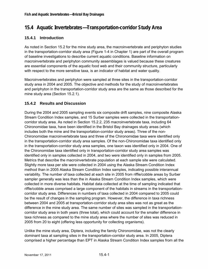
Fish and Aquatic Invertebrates—Bristol Bay Drainages
November 17, 2011 15.4-1
15.4 Aquatic Invertebrates—Transportation-corridor Study Area
15.4.1 Introduction
As noted in Section 15.2 for the mine study area, the macroinvertebrate and periphyton studies in the transportation-corridor study area (Figure 1-4 in Chapter 1) are part of the overall program of baseline investigations to describe current aquatic conditions. Baseline information on macroinvertebrate and periphyton community assemblages is valued because these creatures are essential components of the aquatic food web and their community structure, particularly with respect to the more sensitive taxa, is an indicator of habitat and water quality.
Macroinvertebrates and periphyton were sampled at three sites in the transportation-corridor study area in 2004 and 2005. The objective and methods for the study of macroinvertebrates and periphyton in the transportation-corridor study area are the same as those described for the mine study area (Section 15.2.1).
15.4.2 Results and Discussion
During the 2004 and 2005 sampling events six composite drift samples, nine composite Alaska Stream Condition Index samples, and 15 Surber samples were collected in the transportation-corridor study area. As noted in Section 15.2.2, 235 macroinvertebrate taxa, including 64 Chironomidae taxa, have been identified in the Bristol Bay drainages study areas (which includes both the mine and the transportation-corridor study areas). Three of the non-Chironomidae macroinvertebrate taxa and three of the Chironomidae taxa were identified only in the transportation-corridor study area samples. Of the non-Chironomidae taxa identified only in the transportation-corridor study area samples, one taxon was identified only in 2004. One of the Chironomidae taxa identified only in transportation-corridor study area samples was identified only in samples collected in 2004, and two were identified only in samples from 2005. Metrics that describe the macroinvertebrate population at each sample site were calculated. Slightly more taxa per site were collected in 2004 using the Alaska Stream Condition Index method than in 2005 Alaska Stream Condition Index samples, indicating possible interannual variability. The number of taxa collected at each site in 2005 from riffle/cobble areas by Surber sampler generally was less than the in Alaska Stream Condition Index samples, which were collected in more diverse habitats. Habitat data collected at the time of sampling indicated that riffle/cobble areas comprised a large component of the habitats in streams in the transportation-corridor study area. Differences in numbers of taxa collected in 2004 compared to 2005 could be the result of changes in the sampling program. However, the difference in taxa richness between 2004 and 2005 at transportation-corridor study area sites was not as great as the difference in the mine study area. The same number of sites was sampled in the transportation-corridor study area in both years (three total), which could account for the smaller difference in taxa richness as compared to the mine study area where the number of sites was reduced in 2005 from 20 to eight (offering less opportunity for collecting organisms).
Unlike the mine study area, Diptera, including the family Chironomidae, was not the clearly dominant taxa at sampling sites in the transportation-corridor study area. In 2005, Diptera comprised a higher percentage than EPT in Alaska Stream Condition Index samples from all the
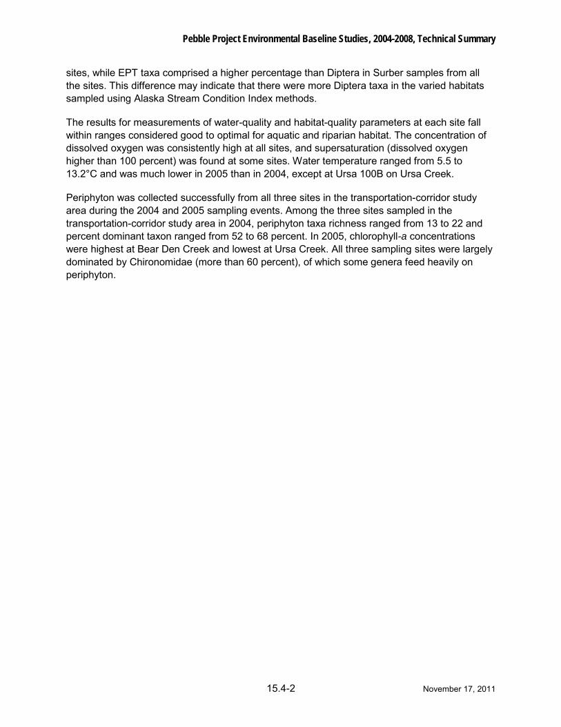
Pebble Project Environmental Baseline Studies, 2004-2008, Technical Summary
15.4-2 November 17, 2011
sites, while EPT taxa comprised a higher percentage than Diptera in Surber samples from all the sites. This difference may indicate that there were more Diptera taxa in the varied habitats sampled using Alaska Stream Condition Index methods.
The results for measurements of water-quality and habitat-quality parameters at each site fall within ranges considered good to optimal for aquatic and riparian habitat. The concentration of dissolved oxygen was consistently high at all sites, and supersaturation (dissolved oxygen higher than 100 percent) was found at some sites. Water temperature ranged from 5.5 to 13.2°C and was much lower in 2005 than in 2004, except at Ursa 100B on Ursa Creek.
Periphyton was collected successfully from all three sites in the transportation-corridor study area during the 2004 and 2005 sampling events. Among the three sites sampled in the transportation-corridor study area in 2004, periphyton taxa richness ranged from 13 to 22 and percent dominant taxon ranged from 52 to 68 percent. In 2005, chlorophyll-a concentrations were highest at Bear Den Creek and lowest at Ursa Creek. All three sampling sites were largely dominated by Chironomidae (more than 60 percent), of which some genera feed heavily on periphyton.
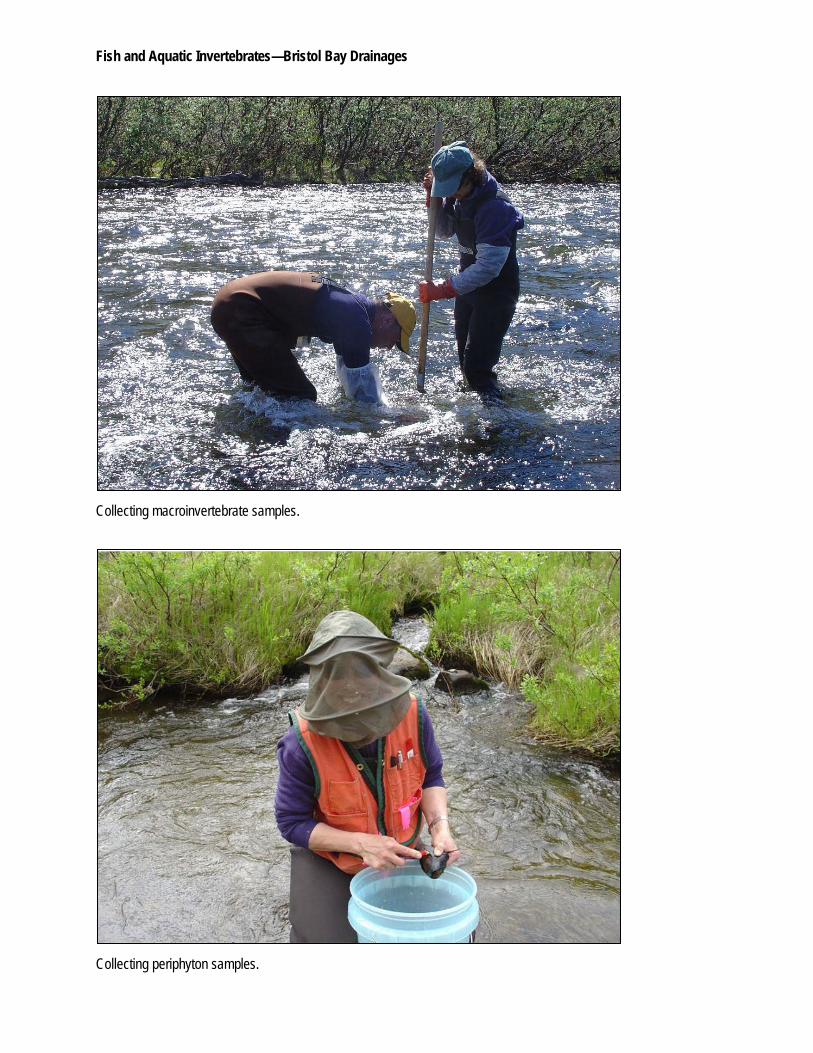
Fish and Aquatic Invertebrates—Bristol Bay Drainages
Collecting macroinvertebrate samples.
Collecting periphyton samples.
Fish and Aquatic Invertebrates—Bristol Bay Drainages
Identification of Chironomidae larvae using a dissecting microscope.