14 network utilities and designations 14-1 - auckland · pdf file · 2015-07-2814.3...
TRANSCRIPT
14 Network Utilities and Designations 14-1
14.1 Introduction.................................................................................................... 14-114.2 Network Utilities and Designations: Issues.................................................... 14-214.3 Network Utilities and Designations: Objectives and Policies......................... 14-2
14.3.1 Objectives ................................................................................... 14-214.3.2 Policies ....................................................................................... 14-314.3.3 Methods ...................................................................................... 14-414.3.4 Environmental Results Anticipated ............................................. 14-5
14.4 Rules: Network Utility Activities ..................................................................... 14-514.4.1 Underlying zoning ....................................................................... 14-5
14.4.1.1 Activities within road reserve .................................. 14-514.4.1.2 Zoning on road stopping ........................................ 14-5
14.4.2 Activity Status ............................................................................. 14-514.5 Further Rules and Development and Activity Controls................................ 14-17
14.5.1 Radio-frequency and Electric and Magnetic Fields .................. 14-1714.5.1.1 Radio-frequency fields ......................................... 14-1714.5.1.2 Electric and Magnetic Fields ................................ 14-17
14.5.2 Development Controls .............................................................. 14-1814.5.2.1 Reinstatement ...................................................... 14-1914.5.2.2 Landscaping ......................................................... 14-1914.5.2.3 Maintenance ......................................................... 14-1914.5.2.4 Height, Height to Boundary and Yard Controls .... 14-20
14.5.3 Additional Controls for Specific Activities .................................. 14-2014.5.3.1 Aerials .................................................................. 14-2014.5.3.2 Antennas attached to Buildings ............................ 14-2114.5.3.3 Height of masts and antennas attached to masts 14-2214.5.3.4 Activities of Licensed Amateur Radio Operators .. 14-2214.5.3.5 Location of minor utility structures ........................ 14-2314.5.3.6 Underground service/connection lines ................. 14-2314.5.3.7 Bus shelters ........................................................ 14-24
14.5.4 Activity Controls ........................................................................ 14-2514.6 Controlled Activities - Reservations and Assessment Criteria..................... 14-25
14.6.1 Reservations and Assessment Criteria for General Controlled Activities .................................................................................... 14-2514.6.1.1 Reservations for General Controlled Activities ..... 14-2514.6.1.2 General Assessment Criteria ............................... 14-26
14.6.2 Reservations and Assessment Criteria for Specific Controlled Activities .................................................................................... 14-2714.6.2.1 Replacement of Electricity Transmission Towers 14-2714.6.2.2 Gas Regulator Stations ........................................ 14-2814.6.2.3 Minor utility structures, public letterboxes and
telecommunication kiosks within the road reserve ................................................................. 14-28
14.6.2.4 Water Supply Reservoirs, Wastewater Storage Tanks and Pumping Stations .......................................... 14-28
14.6.2.5 Pipe Bridges ......................................................... 14-2914.6.2.6 Antenna and Masts .............................................. 14-29
14.7 Limited Discretionary Activities - Restrictions and Assessment Criteria...... 14-2914.7.1 Restrictions and Assessment Criteria for Specific Limited
Discretionary Activities .............................................................. 14-2914.7.1.1 Restrictions and Assessment criteria for minor utility
structures ............................................................. 14-29

14.7.1.2 Restrictions and Assessment criteria for public letterbox-es and telecommunication kiosks ........................ 14-29
14.7.1.3 Restrictions and Assessment criteria for above ground service/connection lines and above ground electricity and telecommunication lines ................................ 14-30
14.7.1.4 Restrictions and Assessment criteria for Replacement of Electricity Transmission Towers ...................... 14-30
14.7.1.5 Restrictions and Assessment criteria for Pipe Bridges ................................................................ 14-30
14.7.1.6 Restrictions and Assessment criteria for Aerials, Antennas, and Masts and replacement utility structures ............................................................. 14-30
14.8 Underlying Zoning of Roads........................................................................ 14-3114.9 Designations ............................................................................................... 14-31
14.9.1 Information to be Provided with a Requirement ....................... 14-3114.9.2 Conditions ................................................................................. 14-3214.9.3 Work to be Undertaken on Designated Land ........................... 14-3214.9.4 Activities Not in Accordance with Designation .......................... 14-3214.9.5 Schedule of Designations ......................................................... 14-32
14.10 Development Controls Relating to Specific Designations ........................... 14-3314.10.1 RNZAF Airbase Flight paths ..................................................... 14-33
14.10.1.1 Height Restriction Controls .................................. 14-3314.10.1.2 Proposals Which Exceed Height Restrictions ...... 14-34
14.11 Conditions Attached to the Designation of Auckland Prison ....................... 14-3414.12 Refuse Disposal .......................................................................................... 14-3414.13 Exclusion from the Resource Management Act .......................................... 14-35
Appendices
14A: Schedule of Designations ........................................................................................ 14-3614B: Approach and Take-Off Climb Surfaces and Transitional Surfaces ........................ 14-5314C: Horizontal and Conical Surfaces.............................................................................. 14-5414D: Proposed Service Lanes.......................................................................................... 14-5514E: Proposed Service Lane............................................................................................ 14-5614F: Proposed Service Lanes.......................................................................................... 14-5714G: Proposed Service Lane............................................................................................ 14-5814H: Development Plan For the Designation of Refuse Disposal Purposes at
Rosedale Road ........................................................................................................ 14-5914I: Possible End Use Proposal for the Refuse Disposal Site at Rosedale Road .......... 14-6214J: Schedule of Heritage Orders ................................................................................... 14-6614K: "Part A" Electricity Transmission Steel Tower Replacement as a Controlled Activity 14-6714L: Exclusion from the Resource Management Act....................................................... 14-6814M: Conditions Attached to the Designation of Auckland Prison (Designation 120) ...... 14-6914:N "Defence Purposes" Designation Definition............................................................. 14-7314:O: Clarification of Designation 184 (Pinehill Telecommunication Facility).................... 14-74

Section 14: Network Utilities and Designations
District Plan June 2002 Updated September 2009 14-1
14. Network Utilities and Designations
14.1 Introduction
The successful functioning of the city and its many services depends on a complexnetwork of utilities and designations including water and wastewater reticulation;electricity transmission, distribution networks; telecommunication networks (includingprivately owned aerials and antennas); gas networks; the wastewater treatment plant;landfills; defence; public hospitals; and schools. Some of these network utilities areimplemented by way of resource consent, and others by way of designation.
Network Utilities
1. Network utilities are provided for un-der the Act by way of Permitted activ-ity or by resource consent. The partof this Section 14 comprising objec-tives, policies, rules and assessmentcriteria apply where network utilityoperators do not intend, or are una-ble, to operate under the designation
procedures of the Act. Section 14 willalso be used by Council to help as-sess any outline plans submitted fornew network utilities or activities ondesignated sites, or where an area isdesignated but works are conductedwhich are not in accordance with thedesignation.
In managing the effects of network utilities, recognition should be given to the essentialrole that these networks play and the services they provide in the functioning of the city.It is also recognised however that the nature of some network utilities and works candetract from the amenity of an area and in some cases may impinge upon public healthand safety. In some circumstances, the effects of network utilities are addressed by otherinstruments (for example, health and safety provisions, statutory requirements andindustry standards and guidelines). Where environmental effects are not fully addressedby other instruments, the District Plan supplements these and establishes a resourcemanagement framework for balancing these competing demands and conflictingrequirements.
Designations
Public works and some private projects or works are provided for under the Act by wayof designation. Certain organisations are able to 'require' land for the purposes of adesignation. This is referred to as a 'requirement'. The organisation making therequirement is referred to as a 'requiring authority'. Organisations that are 'requiringauthorities' include Ministers of the Crown, local authorities and also private bodies whoare network utility operators and who have obtained status as a requiring authority underSection 167 of the Act. Status as a requiring authority provides the power to require land,including private land, to be set aside for designated activities for which the requiringauthority is financially responsible.
Following Council assessment of the requirement, the requirement is included in the Planand becomes a designation. The effect of designating land is to authorise the use of thatland for a particular work (e.g. school, police station, electricity substation). Once adesignation is in place it takes precedence over the zoning of the land, but it can only beused for the purpose for which it has been designated, unless a resource consent issought and obtained. Nor may other people, without the prior written consent of therequiring authority, do anything in relation to the designated land that would impede thedesignated activity. The zoning of the land that is covered by the designation is thencalled the underlying zoning, and this zoning applies for works that are not in accordancewith the designation or where a designation is removed. Any reference to 'networkutilities' in this Section therefore may also apply to designations.
The provisions of this Section 14 apply to network utilities and designations throughoutall parts of the city. Roads, as public works, have been addressed in this section but aredealt with further, and in more detail, in the Transportation Section.
Section 14: Network Utilities and Designations
14-2 Updated August 2011 District Plan June 2002
14.2 Network Utilities and Designations: Issues
The following resource management issues relating to network utilities and designationshave been identified:
14.2.1 Network utilities provide a network of services that are essential to the maintenance and enhancement of the quality of life of the community. Failure to facilitate the provision of an adequate network of network utilities, including facilitating the development, operation and maintenance of those network utilities, has the potential to undermine this quality of life.
Network utilities are fundamental to the operation of many activities throughoutthe city. Subject to the Act’s requirement to avoid remedy or mitigate any adverseeffects of network utilities, it is essential that these services be provided andmaintained in an efficient and effective manner and to a standard that isadequate to support the many activities that rely on them. This standard can beadversely affected by conflicts if sensitive uses are allowed to develop nearsignificant utility structures or if the network utility is inappropriately located.
14.2.2 The potential for adverse environmental effects and the degradation of landscape, streetscape and residential amenity values resulting from the construction, operation and maintenance of network utilities.
Many network utilities are part of a network system with operational requirementsand design features that can cause adverse effects. The location, size anddesign of some buildings and structures can have an adverse visual effect onlandscape, streetscape and residential and public amenity. Network utilites alsohave the potential to affect other amenity values through the emissions of noise,odour and vibrations.
14.2.3 The potential for adverse effects on the health and safety of the community resulting from the construction, operation and maintenance of network utilities.
There is potential for network utilities to adversely affect the health and safety ofthe community. Some network utilities in the road reserve present hazards tovehicles and pedestrians. There are risks associated with accidential spillage orleakage of hazardous substances. Electricity transmission and distributiongenerates the risk of electrocution and also electric and magnetic fields whichmay be a risk to health. Telecommunication facilities generate radio frequencyemissions which may, at levels above the New Zealand standard, havedetrimental effects on health.
14.3 Network Utilities and Designations: Objectives and Policies
The development of objectives and policies for networking utilities and designation hasbeen guided by the following resource management goals as set out in Section 6:Natural Environment, Built Environment, Employment and Economic Growth andManaging Change. These goals enable and promote the purpose of the ResourceManagement Act 1991.
14.3.1 Objectives1. The construction, operation and maintenance of an efficient and effective network
of utilities that meets the needs of the community, and recognises reverse sensitivityeffects of other uses locating in close proximity to utility structures.
2. To avoid, remedy or mitigate any adverse environmental effects of network utilities,including effects on amentity, landscape, streetscape and heritage values, arisingfrom the construction, operation, and maintenance of network utilities.
3. An environment where the health and safety of the community is not adverselyaffected by the construction, operation and maintenance of network utilities.

Section 14: Network Utilities and Designations
District Plan June 2002 Updated September 2009 14-3
14.3.2 Policies1. To have regard to the operational and technical requirements of network utilities in
the assessment of resource consent applications for network utilities.
2. By recognising that there are potential adverse effects on network utilities whensensitive uses are allowed to develop near utility structures, and that such sensitiveuses should be avoided, remedied or mitigated.
3. Network utilities shall be designed, sited, operated and maintained in such a waythat avoids, remedies or mitigates adverse effects on other network utilities.
4. Network utilities, shall be designed, sited, operated and maintained in such a wayas to avoid, remedy or mitigate adverse effects on the environment of emissions ofnoise, light, vibration, odour or hazardous substances.
5. Network utilities shall be designed, sited, operated and maintained so that theyavoid, remedy or mitigate any adverse effects on the area. This includes, but is notlimited to, any adverse effects on;
a) any site, building, place or area, and
b) the landscape or steetscape, and
c) any site, building, place or area of heritage and archaeological value, and
d) the amenity values of any of these places.
6. To recognise that reserve land, and land zoned Recreation 1 in particular, isintended to be open public space free from the adverse effects of buildings,structures and activities not linked to the purpose of the zone. Siting of networkutilities should avoid, remedy or mitigate adverse effects on;
a) The amenity of the reserve, and
b) Public use and enjoyment of the reserve, and
c) The potential for future development of the reserve.
7. To encourage the co-location of structures, the shared use of structures, and theuse of existing network utility corridors, subject to;
• Technical and operational feasibility, and
• Recognition that the positive effects can be outweighed by the adversecumulative effects.
• Avoiding, remedying or mitigating any adverse effects.
8. To encourage the location of aerials and antennas on buildings, and the location ofantennas on street lights, to reduce the need for masts and to avoid, remedy ormitigate the adverse visual effects of aerials and antennas.
9. To;
a) Require the undergrounding of electric and telecommunication lines in newlydeveloping areas and for infill and redevelopment in established areas, and
b) Encourage these outcomes in established areas, especially when other streetimprovement works make this aesthetically desirable, and
c) Encourage the undergrounding of above ground network utilities in the roadreserve.
10. Network utilities, and in particular those network utilities emitting radiofrequencyfields or generating electric and magnetic fields, should be designed, sited, operatedand maintained in such a way as to avoid, remedy or mitigate potential adverseeffects on the health, safety and wellbeing of people and communities.

Section 14: Network Utilities and Designations
14-4 Updated September 2009 District Plan June 2002
14.3.3 Methodsi) Policies 1-10 will be implemented by rules
ii) Policies 1-2 and 4-5 will be implemented by the Code of Practice for Workingin the Road
iii) Policy 9 will be implemented by Council initiatives
iv) Policy 10 will be implemented by using Industry Standards to guide theadministration of rules in the District Plan
v) Policies1-2, 4, 8 and 9 will be implemented using the North Shore City CouncilInfrastructure Design Standards to guide the administration of rules in theDistrict Plan.
Explanation and Reasons
The primary means of achieving the objectives and policies of Section 14 is through theoperation of the rules within the Plan. The rules are intended to ensure that networkutilities are provided for and established but at the least environmental and amenity costto the community. Development and Activity controls are baseline rules that apply to allnetwork utilities to ensure that amenity values and the quality of the environment in theCity are maintained. Development controls are specific controls that apply to networkutilities and activity controls provide a cross reference to controls in other sections of thePlan to ensure that network utilities adhere to the baseline standards set out in thosesections of the Plan. As well as these controls, the activity status of the various networkutility activities may vary in different zones of the City in recognition of the effects thateach activity has on areas of different character and sensitivity.
The Council supplements the use of rules by using tools that lie outside the District Plan.These include Road Opening Notices and the Code of Practice for Working in the Road.
Many network utilities are located within the road reserve because legislation (forexample the Telecommunications Act 2001, the Electricity Act 1992 and the Gas Act1992) allows network utility operators access to Council administered roads to install andmaintain the relevant network utilities. Any utility operator (or private individual) wishingto work in the road must submit to Council a Road Opening Notice. This provides Councilwith details of the planned work and enables Council to set `reasonable conditions’(according to the terms of the relevant legislation) of access to the road reserve. Theseconditions are primarily related to ’operational matters’ that concern the protection ofCouncil’s road asset and its primary function as a transport resource. Examples mightinclude conditions relating to reinstatement of the road and the safe and efficient flow oftraffic. Theoretically, such operational conditions should not directly addressenvironmental effects such as amenity considerations, as these should be imposedthrough resource consents or District Plan provisions. Such operational matters oftenhave the consequential effect of addressing amenity values, however. AlthoughPermitted activities in the road reserve are not heavily regulated in the District Plan -because they are judged to have few environmental effects - in the road reserve thisensures they are still subject to a process that minimises any negative environmentaleffects on the amenity of the City.
Council has also agreed with network utility operators on the provisions of the Code ofPractice for Working in the Road. This agreement is based on the concept of partnershipand prioritises co-operation and working together in a dependable and trustworthymanner. It also sets out the technical standards to which work in the road reserve is tobe carried out, including position of services, site construction and reinstatement. Theengineering specificaitons contained in Council’s Infrastructure Design Standards arealso relevant to network utility activities, particularly those concerning the water supply,wastewater and storm water, and those network utilities located in the road reserve.
Industry Codes and Standards can be useful tools for setting an acceptable benchmarkfor evaluating environmental effects. The rule relating to emissions of radio frequencyfields and extremely low frequency electric and magnetic fields is set in the District Planby reference to such Industry Standards. Another Industry Code to which the DistrictPlan has regard is NZECP 34: 2001, a Code of Practice for Electrically Safe Distances.

Section 14: Network Utilities and Designations
District Plan June 2002 Updated September 2009 14-5
14.3.4 Environmental Results AnticipatedThe anticipated environmental results from the implementation of the above objectives,policies and methods are;
• A city with network utilities that are provided in an efficient and effective mannerand to a standard that is adequate to support the activities that rely on them,without significant adverse environmental effects.
• Avoidance of the adverse effects of network utilities on the health and safety ofpeople, as measured by regional health assessments.
• Increasing the quantity of network utilities that are undergrounded. This will bemeasured by the length of electric and telephone lines and the numbers ofminor utility structures that are undergrounded.
14.4 Rules: Network Utility Activities
14.4.1 Underlying zoning14.4.1.1 Activities within road reserveIn the case of any activities within road reserve, including designated road that is not yetlegal road, the underlying zoning is deemed to be that of the immediately adjacent landextending to the mid point of the road.
14.4.1.2 Zoning on road stoppingWhere roads or access ways are stopped and the designation is uplifted, the subject landwill take on the underlying zoning that applied when the designation was in force.
Explanation and Reasons
Roads, proposed roads, road closures, access ways and service lanes are shown asdesignations on the District Plan maps, and accordingly, have underlying zonings.
14.4.2 Activity StatusThe activity statuses of network utilities are set out in Table 14.1.
An activity status set out in Table 14.1 may be changed by provisions elsewhere inChapter 14, and in other parts of the Plan identified in section 14.5.
Unless Structure Plan zones are separately referred to in this Section 14, all referencesto Residential zones include Structure Plan zones.
Explanation and Reasons
‘Network Utilities’ is defined in Section 21. This includes the works of network utilityoperators and for the purposes of this Plan also includes;
• those parts of the telecommunication networks that areprivately owned, including privately owned aerials andantennas.
• any activity emitting radio frequency fields, whether ownedprivately or by network utility operators.
The activity status of the different network utilities is set out in Table 14.1. This activitystatus may be changed by provisions in other parts of the Plan. For example, althoughan activity may be listed in Table 14.1 as being a Permitted activity, if it does not complywith rules elsewhere in the Plan (restricted to those sections identified in section 14.5),this activity status will change and a resource consent will be required.
The table is organised by the type of network utility activity (for example,Telecommunications, Electricity, Gas). There is also a Miscellaneous section thatapplies to those activities that do not fit under one of the types of network utility activity.Some activities which are generic in nature and apply across all types of network utilitiesare also contained in this section, including minor utility structures.

Section 14: Network Utilities and Designations
14-6 Updated September 2009 District Plan June 2002
For some activities the rules that apply in the road reserve differ from those applyingoutside the road reserve. In these cases the rules state whether it applies to areas withinthe road reserve (RR) or outside the road reserve (not RR). Where the road reserve isnot mentioned, the rule applies to areas both in and outside the road reserve.
Each activity is specified as being Permitted, Controlled, Limited Descretionary,Discretionary or Non complying, with the following abbreviations being used;
In the Activity Table, those terms that are defined in Section 21 of this Plan are written inuppercase text.
P Permitted activity
C Controlled activity
LD Limited Discretionary activity
D Discretionary activity
NC Non complying activity
Table 14.1 Activity Status
RR - Rules apply foractivity in the roadreserveNOT RR- Rules applyfor activity outside theroad reserveNo reference - Rulesapply for activity in allareas
P C LD D NC
Miscellaneous
1 The operation ofNETWORK UTILITIES inexistence on 17 October1994
All zones
2 UPGRADING of existingnetwork utilitiesexcluding HIGHVOLTAGETRANSMISSION LINESsupported by steel towerstructures and thereplacement of lowpressure gas lines withHIGH PRESSURE GASLINES
All zones
3 NOT RR - UndergroundNETWORK UTILITIESnot covered in othersections of this Table14.1
All zonesother thanRecreation 1
Recreation 1
4 RR - UndergroundNETWORK UTILITIESnot covered in sectionsof this Table 14.1
All zones

Section 14: Network Utilities and Designations
District Plan June 2002 Updated September 2009 14-7
5 RR - Any MINORUTILITY STRUCTURE,which has a total groundcoverage not exceeding
0.5m2 in area and has aheight not exceeding 1mabove NATURALGROUND LEVEL
All zonesother thanRecreation 1
Recreation 1
6 RR - Any MINORUTILITY STRUCTUREwhich
• does not exceed1.8m in heightabove NATURALGROUND LEVEL,and
• has a maximumlength of 2.5m anda maximum depthof 1.2m, and
• which in any casedoes not exceed3.5 cubic metres intotal volume
All otherzones
Recreation2-4 andResidential3
Recreation 1
7 RR - Any minor utilitystructure that complieswith the ResourceManagement (NationalEnvironmental Standardsfor TelecommunicationFacilities) Regulations2008
All zones
8 NOT RR - Any MINORUTILITY STRUCTUREwhich complies with Rule14.5.2-14.5.4, and
• does not exceed1.8m in heightabove NATURALGROUND LEVEL,and
• with a maximumlength of 2.5m andmaximum depth of1.2m, and
• which in any casedo not exceed 3.5cubic metres intotal volume
All otherzones
Residential3 zone
Recreationzones
Table 14.1 Activity Status
RR - Rules apply foractivity in the roadreserveNOT RR- Rules applyfor activity outside theroad reserveNo reference - Rulesapply for activity in allareas
P C LD D NC

Section 14: Network Utilities and Designations
14-8 Updated September 2009 District Plan June 2002
9 NOT RR - Any MINORUTILITY STRUCTUREwhich complies with Rule14.5.2-14.5.4 andexceeds any of theabove dimensions
Business2-11, Ruraland SpecialPurpose 1-4and 12zones
All otherzones
RecreationandResidential3 zones
10 Any MINOR UTILITYSTRUCTURE, which:
• exceeds the sizesfor Permitted orControlledactivities, or
• does not complywith any of theRules 14.5.2-14.5.4
All zonesother thanRecreation1
Recreation 1
11 Temporary above groundSERVICE/CONNECTION LINES toBUILDINGS and sites;
• for the period ofconstruction only,or
• in an emergency
All zones
12 RR - Street furniture andstreet landscaping whereapproved by Council
All zones
13 NOT RR - PUBLICLETTERBOX
All zonesother thanRecreationzones
Recreationzones
14 RR - PUBLICLETTERBOXES
All zones
15 NOT RR - POSTALHOLDING BOXES
All zonesother thanRecreationzones
Recreationzones
16 RR - POSTAL HOLDINGBOXES
All zones
17 Any NETWORK UTILITYwhich is a Permitted orControlled activity anddoes not comply with anyof the Rules 14.5.2-14.5.4, where thecircumstance is notspecifically provided for
All zones
Table 14.1 Activity Status
RR - Rules apply foractivity in the roadreserveNOT RR- Rules applyfor activity outside theroad reserveNo reference - Rulesapply for activity in allareas
P C LD D NC

Section 14: Network Utilities and Designations
District Plan June 2002 Updated September 2009 14-9
Transport
18 Parking areas associatedwith transportinfrastructure such asbus stops, transferstations and "park andride" facilities
AllBusinesszonesexceptBusinessLocal 1
All otherzonesincludingBusinessLocal 1
19 TRANSPORTEQUIPMENT
All zones
20 NOT RR - Bus shelters All zones
21 RR -Bus shelters All zonesprovidedactivitycomplieswith Rule14.5.3.8
All zoneswhereactivity doesnot complywith Rule14.5.3.8
Telecommunications
22 All ACTIVITY EMITTINGRADIO FREQUENCYFIELDS
All zonesprovidedactivitycomplieswith Rule14.5.1.1
All zoneswhereactivitydoes notcomply withRule14.5.1.1
23 NOT RR - UndergroundNETWORK UTILITIESfor Telecommunicationnetworks
All zonesother thanRecreation 1
Recreation 1
24 RR - UndergroundNETWORK UTILITIESforTELECOMMUNICATIONnetworks
All zones
25 NOT RR -TELECOMMUNICATIONKIOSKS
All zonesother thanRecreationzones
Recreationzones
26 RR -TELECOMMUNICATIONKIOSKS
All zones
27 AERIALS All zonesprovidedactivitycomplieswith Rule14.5.3.1
All zoneswhereactivitydoes notcomply withRule14.5.3.1
Table 14.1 Activity Status
RR - Rules apply foractivity in the roadreserveNOT RR- Rules applyfor activity outside theroad reserveNo reference - Rulesapply for activity in allareas
P C LD D NC

Section 14: Network Utilities and Designations
14-10 Updated September 2009 District Plan June 2002
28 The activities ofLICENSED AMATEURRADIO OPERATORSthat are soley for thepurposes of operating anamateur radio station
Where theactivitycomplieswith Rule14.5.3.4 andis located inResidentialor RuralZones only(excludingresidential 3)
Where theactivity doesnot complywith Rule14.5.3.4 oris located inany otherzone
29 A MOVING AERIAL ORANTENNA
All zones
30 An ANTENNA attachedto a BUILDING(excluding a MAST) that
does not exceed 1m2 inarea or 1.2m in diameter
All zones
31 An ANTENNA attachedto a BUILDING(excluding a MAST) that
does not exceed 1.5m2
in area or 1.4m indiameter
All otherzones
Residential,Recreation,Business 1and SpecialPurpose 3-11 and 13zones
32 An ANTENNA attachedto a BUILDING(excluding a MAST) that
does not exceed 2.5m2
in area or 2m in diameter
All otherzones
Residential,Recreation,Business 1and SpecialPurpose 3-11 and 13zones
33 ANTENNAS attached toa BUILDING (excluding aMAST), that arePermitted or Controlledactivities and do notcomply with Rule14.5.3.2
All zones
34 MASTS Businesszones 2-11up to thepermittedheight limitof the zoneor 15 metres(whicheveris lowest)
Businesszones 2 -11and SpecialPurpose1,2 and 12zones up to20 metres
All otherzones(includingBusiness 1where notadjacent toResidential3 zone) inaccordancewith theheight limitsin 14.5.3.3
Recreationzones
Business 1(whereadjacent toResidential3 zone) andResidential3 zone
Table 14.1 Activity Status
RR - Rules apply foractivity in the roadreserveNOT RR- Rules applyfor activity outside theroad reserveNo reference - Rulesapply for activity in allareas
P C LD D NC

Section 14: Network Utilities and Designations
District Plan June 2002 Updated September 2009 14-11
35 ANTENNAS attached toa MAST that do not
exceed 1m2 in area (or
1.2m2 when covered witha shroud) or 600mm indiameter
Businesszones 9-10,excludingthose partsin the BufferStrip
Businesszones 2-8,9-10 wherelocated inthe BufferStrip,Business11 andSpecialPurpose1,2 and 12zones
All otherzones
Residential3
36 ANTENNAS attached toa MAST, not exceeding
2.5m2 in area or 2m indiameter
Businesszones 9-10,excludingthose partsin theBuffer Strip
Businesszones 2-11(includingBusiness 9-10 wherelocated inthe bufferstrip),SpecialPurpose 1,2and 12zones
All otherzones
Residential3
37 Up to 8 ANTENNASattached to a MASTprovided that only twomay be dish ANTENNASand each may not have adiameter greater than600mm
Businesszones 9-10,excludingthose partsin the BufferStrip
Businesszones 2-8,9-10 wherelocated inthe BufferStrip,Business11 andSpecialPurpose1,2 and 12zones
All otherzones
Recreationzones
Residential3
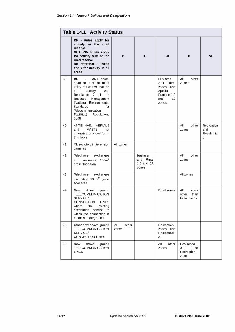
38 RR - ANTENNASattached to replacementutility structure thatcomply with Regulation 7of the ResourceManagement (NationalEnvironmental Standardsfor TelecommunciatonFacilities) Regulations2008
All zones
Table 14.1 Activity Status
RR - Rules apply foractivity in the roadreserveNOT RR- Rules applyfor activity outside theroad reserveNo reference - Rulesapply for activity in allareas
P C LD D NC
Section 14: Network Utilities and Designations
14-12 Updated September 2009 District Plan June 2002
39 RR - ANTENNASattached to replacementutility structures that donot comply withRegulation 7 of theResouce Management(National EnvironmentalStandards forTelecommunicationFacilities) Regulations2008
Business2-11, Ruralzones andSpecialPurpose 1,2and 12zones
All otherzones
40 ANTENNAS, AERIALSand MASTS nototherwise provided for inthis Table
All otherzones
RecreationandResidential3
41 Closed-circuit televisioncameras
All zones
42 Telephone exchanges
not exceeding 100m2
gross floor area
Businessand Rural1,3 and 3Azones
All otherzones
43 Telephone exchanges
exceeding 100m2 grossfloor area
All zones
44 New above groundTELECOMMUNICATIONSERVICE/CONNECTION LINESwhere the existingdistribution service towhich the connection ismade is underground.
Rural zones All zonesother thanRural zones
45 Other new above groundTELECOMMUNICATIONSERVICE/CONNECTION LINES
All otherzones
Recreationzones andResidential3
46 New above groundTELECOMMUNICATIONLINES
All otherzones
Residential3 andRecreationzones
Table 14.1 Activity Status
RR - Rules apply foractivity in the roadreserveNOT RR- Rules applyfor activity outside theroad reserveNo reference - Rulesapply for activity in allareas
P C LD D NC

Section 14: Network Utilities and Designations
District Plan June 2002 Updated September 2009 14-13
Electricity
47 All activities emittingextremely low frequencyelectric and magneticfields
All zonesprovidedactivitycomplieswith Rule14.5.1.2
All zoneswhereactivitydoes notcomply withRule14.5.1.2
48 NOT RR - UndergroundNETWORK UTILITIESfor Electricity networks
All zonesother thanRecreation 1
Recreation 1
49 RR - UndergroundNETWORK UTILITIESfor Electricity networks
All zones
50 NOT RR - ElectricitySUBSTATIONS. For thepurposes of this ruleSUBSTATION does notinclude MINOR UTILITYSTRUCTURES up to
1.8m high or 10m2
Business 9and 10, andRuralzones
All otherzones
51 NOT RR - ElectricitySUBSTATIONS which donot comply with Rule14.5.2-14.5.4. For thepurposes of this ruleSUBSTATION does notinclude MINOR UTILITYSTRUCTURES up to
1.8m high or 10m2
All zones
52 New above groundelectricity SERVICE/CONNECTION LINESwhere the existingdistribution service towhich the connection ismade is underground
Rural zones All zonesother thanRual zones
53 Other new above groundelectricity SERVICE/CONNECTION LINES
All otherzones
Recreationzones andResidential3
54 New above groundELECTRIC LINES,excluding HIGHVOLTAGETRANSMISSION LINES
All otherzones
Residential3 andRecreationzones
Table 14.1 Activity Status
RR - Rules apply foractivity in the roadreserveNOT RR- Rules applyfor activity outside theroad reserveNo reference - Rulesapply for activity in allareas
P C LD D NC

Section 14: Network Utilities and Designations
14-14 Updated September 2009 District Plan June 2002
55 Maintenance and/orMINOR UPGRADING ofexisting HIGH VOLTAGETRANSMISSION LINES,supported by steel towerstructures.
All zones
56 Tower replacement onexisting HIGH VOLTAGETRANSMISSION LINESsupported by steel towerstructures wherereplacement occurswholly within that areadefined in the diagramset out in Part A ofAppendix 14K, orincrease in tower heightaccording to Part B ofAppendix 14K
All zones
57 Tower replacement onexisting HIGH VOLTAGETRANSMISSION LINESsupported by steel towerstructures where any partof the replacement toweris outside that areadefined in the diagramset out in Appendix 14K
All zones
58 Changes to HIGHVOLTAGETRANSMISSION LINES,supported by steel towerstructures, not providedfor as Permitted,Controlled or LimitedDiscretionary Activities
All zones
59 New above ground HIGHVOLTAGETRANSMISSION LINES
All zones
Water Services,Wastewater,Stormwater
60 NOT RR - UndergroundNETWORK UTILITIESfor water networksexcept for all activitiesspecifically addressed inthis Water Servicessection of Table 14.1
All otherzones
Recreation 1andStructurePlan zones
Table 14.1 Activity Status
RR - Rules apply foractivity in the roadreserveNOT RR- Rules applyfor activity outside theroad reserveNo reference - Rulesapply for activity in allareas
P C LD D NC

Section 14: Network Utilities and Designations
District Plan June 2002 Updated June 2011 14-15
61 RR - UndergroundNETWORK UTILITIESfor water networksexcluding all activitiesspecifically addressed inthis Water Servicessection fo Table 14.1
All zonesother thanStructurePlan zones
StructurePlan zone
62 Pipe bridges All zonesother thanRecreation1
Recreaton 1
63 NOT RR - Pipe bridgeswhere attached to anexisting bridge orstructure
All zonesother thanRecreation1
Recreation 1
64 RR - Pipe bridges whereattached to an existingbridge or structure
All zones
65 Stormwater detentionponds
All zones
66 Sewage pumpingstations, water pumpingstations and wastewaterstorage tanks, providedthat;
i) they areunderground, and
ii) any abovegroundstructuredoes notexceed30m2 area
SpecialPurpose 1, 3
All otherzones
Recreation 1
67 Other sewage pumpingstations, water pumpingstations and wastewaterstorage tanks
SpecialPurpose 1, 3
All otherzones
68 WATER SUPPLYRESERVOIRS, providedthey are completelyunderground
All otherzones
Recreation 2and 3
Recreation1
69 Stormwater pumpingstations and otherWATER SUPPLYRESERVOIRS
All zonesother thanRecreation 1
Recreation1
Table 14.1 Activity Status
RR - Rules apply foractivity in the roadreserveNOT RR- Rules applyfor activity outside theroad reserveNo reference - Rulesapply for activity in allareas
P C LD D NC

Section 14: Network Utilities and Designations
14-16 Updated September 2009 District Plan June 2002
Gas
70 NOT RR - UndergroundNETWORK UTILITIESfor Gas networksexcluding HIGHPRESSURE GAS LINES
All otherzones
Recreation 1andStructurePlan zones
71 RR - UndergroundNETWORK UTILITIESfor Gas networksexcluding HIGHPRESSURE GAS LINES
All zonesother thanStructurePlan zones
StructurePlan zones
72 Gas gate stations Business 9and 10, andRuralzones
All otherzones
RecreationandResidential
73 Gas gate stations whichdo not comply with Rule14.5.2-14.5.4
All otherzones
RecreationandResidential
74 Gas regulator stations
not exceeding 20m2
gross floor area
All zonesother thanRecreation1
Recreation 1
75 Gas regulator stations
exceeding 20m2 grossfloor area
All zones
76 HIGH PRESSURE GASLINES, replacing lowpressure gas lines withHIGH PRESSURE GASLINES, and necessaryincidental equipment forall gas networks,including compressorstations
All zones
Table 14.1 Activity Status
RR - Rules apply foractivity in the roadreserveNOT RR- Rules applyfor activity outside theroad reserveNo reference - Rulesapply for activity in allareas
P C LD D NC

Section 14: Network Utilities and Designations
District Plan June 2002 Updated September 2009 14-17
14.5 Further Rules and Development and Activity Controls
14.5.1 Radio-frequency and Electric and Magnetic Fields14.5.1.1 Radio-frequency fieldsa) Compliance
Exposures to radio-frequency fields produced by any activity emitting radiofrequency fields shall not exceed the maximum exposure level for the general publicin the New Zealand Standard NZS 2772.1: 1999 Part 1 - Maximum Exposure Levels- 3 kHz to 300GHz measured at all places reasonably accessible to the generalpublic.
b) Reporting
Any proposal to undertake a new activity emitting radio-frequency fields which willresult in public exposure, or exisiting activity that proposes to increase existinglevels, should submit a report as required in Rule 3.10.7.1.6.
14.5.1.2 Electric and Magnetic Fieldsa) Compliance
Exposures to ELF electric and magnetic fields shall always comply with the
MeteorologicalActivities
77 Meteorological activitiesprovided that;
• the height oftheanemometermast doesnot exceed10 metres
• the height ofthe ancillarybuildingdoes notexceed 3metres
• the total floorarea doesnot exceed5m2, and
• the total sitearea ofoccupancydoes notexceed500m2
Rural andBusinesszones
Residentialand SpecialPurposezones1,2,3,4,8,10
All otherzones
Table 14.1 Activity Status
RR - Rules apply foractivity in the roadreserveNOT RR- Rules applyfor activity outside theroad reserveNo reference - Rulesapply for activity in allareas
P C LD D NC
Section 14: Network Utilities and Designations
14-18 Updated September 2009 District Plan June 2002
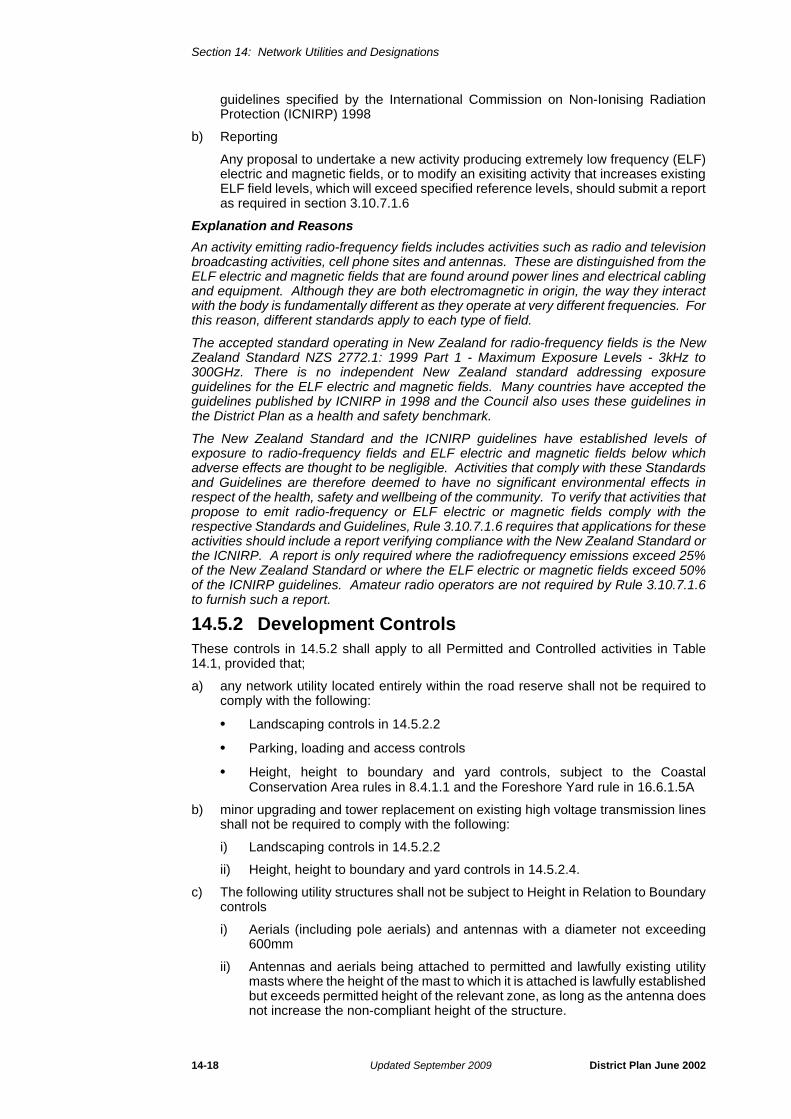
guidelines specified by the International Commission on Non-Ionising RadiationProtection (ICNIRP) 1998
b) Reporting
Any proposal to undertake a new activity producing extremely low frequency (ELF)electric and magnetic fields, or to modify an exisiting activity that increases existingELF field levels, which will exceed specified reference levels, should submit a reportas required in section 3.10.7.1.6
Explanation and Reasons
An activity emitting radio-frequency fields includes activities such as radio and televisionbroadcasting activities, cell phone sites and antennas. These are distinguished from theELF electric and magnetic fields that are found around power lines and electrical cablingand equipment. Although they are both electromagnetic in origin, the way they interactwith the body is fundamentally different as they operate at very different frequencies. Forthis reason, different standards apply to each type of field.
The accepted standard operating in New Zealand for radio-frequency fields is the NewZealand Standard NZS 2772.1: 1999 Part 1 - Maximum Exposure Levels - 3kHz to300GHz. There is no independent New Zealand standard addressing exposureguidelines for the ELF electric and magnetic fields. Many countries have accepted theguidelines published by ICNIRP in 1998 and the Council also uses these guidelines inthe District Plan as a health and safety benchmark.
The New Zealand Standard and the ICNIRP guidelines have established levels ofexposure to radio-frequency fields and ELF electric and magnetic fields below whichadverse effects are thought to be negligible. Activities that comply with these Standardsand Guidelines are therefore deemed to have no significant environmental effects inrespect of the health, safety and wellbeing of the community. To verify that activities thatpropose to emit radio-frequency or ELF electric or magnetic fields comply with therespective Standards and Guidelines, Rule 3.10.7.1.6 requires that applications for theseactivities should include a report verifying compliance with the New Zealand Standard orthe ICNIRP. A report is only required where the radiofrequency emissions exceed 25%of the New Zealand Standard or where the ELF electric or magnetic fields exceed 50%of the ICNIRP guidelines. Amateur radio operators are not required by Rule 3.10.7.1.6to furnish such a report.
14.5.2 Development ControlsThese controls in 14.5.2 shall apply to all Permitted and Controlled activities in Table14.1, provided that;
a) any network utility located entirely within the road reserve shall not be required tocomply with the following:
• Landscaping controls in 14.5.2.2
• Parking, loading and access controls
• Height, height to boundary and yard controls, subject to the CoastalConservation Area rules in 8.4.1.1 and the Foreshore Yard rule in 16.6.1.5A
b) minor upgrading and tower replacement on existing high voltage transmission linesshall not be required to comply with the following:
i) Landscaping controls in 14.5.2.2
ii) Height, height to boundary and yard controls in 14.5.2.4.
c) The following utility structures shall not be subject to Height in Relation to Boundarycontrols
i) Aerials (including pole aerials) and antennas with a diameter not exceeding600mm
ii) Antennas and aerials being attached to permitted and lawfully existing utilitymasts where the height of the mast to which it is attached is lawfully establishedbut exceeds permitted height of the relevant zone, as long as the antenna doesnot increase the non-compliant height of the structure.
Section 14: Network Utilities and Designations
District Plan June 2002 Updated September 2009 14-19
iii) Those aerials, masts and antennas provided for as permitted activities for thepurposes of Licensed Amateur Radio Operators as defined in Section 21
Explanation and Reasons
It is unnecessary for some of the following rules to apply to Permitted and Controlledactivities in certain situations. Landscaping requirements in the road reserve for belowground network utilities and minor utility structures are one example of this. It isconsidered that in some cases the coastal conservation area and foreshore yard controlsare also unnecessary, for example, where underground network utilities in the foreshoreyard are located under or immediately adjacent to the carriageway, as this area is alreadyheavily modified. A similar argument applies to above ground network utilities within thecoastal conservation area. It is not intended however that these coastal conservationarea and foreshore yard exclusions apply to the areas of road reserve that have noformed carriageway, for example near the coast where the formed road ceases but theroad reserve continues to the coastal edge. See Rule 8.4.1.1 and 16.6.1.5A for theserules.
Utility structures such as those listed in (c) above are likely to have minimal effect onamenity and making them subject to Height in Relation to Boundary controls isconsidered unduly onerous. The sizings given provide for normal sky dishes and smallerutility antennas and aerials. Normal yard controls and height controls where relevantcontinue to apply to protect the amenity of adjacent sites.
14.5.2.1 ReinstatementWhere the establishment or maintenance of a network utility involves the distrubance ofthe ground, the body responsible for that work must reinstate the ground to at least thecondition existing prior to commencement of the work taking place.
Explanation and Reasons
Reinstatement in the road reserve is an important goal of the Code of Practice forWorking in the Road. For work carried out in the road reserve Council uses the principlesof reinstatement as summarised in the Code as a standard to assess whetherreinstatement has been sufficiently completed.
14.5.2.2 LandscapingFor amenity purposes, where practicable the visual impact of above ground structuresshall be remedied or mitigated by landscaping, screening or similar remedial measures.
Explanation and Reasons
The visual appearance of the buildings and structures of network utilities can have adetrimental effect upon the amenity values of an area. This rule has the purpose ofenhancing the appearance of such buildings and structures as viewed from the road andneighbouring properties by requiring that landscaping be carried out. It is not alwaysconsidered practicable to landscape or screen the parts of utility structures that by theirdesign are elevated (for example antennas attached to masts and aerials attached tobuildings), although other remedial measures can still be taken, for example sensitiveplacement or painting.
14.5.2.3 MaintenanceNetwork utility operators shall maintain and regularly upkeep any above groundstructures so as to protect the amenity of an area and prevent any health and safetyissues arising. The operator must remove any graffiti or posters from the above groundstructure within five working days of notification by the Council. Where above groundstructures located in road reserve are redundant or obsolete they must be removed.Where underground structures located in the road reserve are redundant or obsolete, autility operator shall, when requested, supply details to Council concerning thoseredundent structures, to enable that space to be used.
Explanation and Reasons
Above ground network utilities are common activities and (particularly when located in aroad reserve), they are highly visible. This rule has the purpose of ensuring that theirappearance is maintained so that they do not detract from the amenity of an area. Thoseunderground network utilities that are located in the road reserve are allocated their own

Section 14: Network Utilities and Designations
14-20 Updated September 2009 District Plan June 2002
corridors according to the provisions of the Code of Practice for Working in the Road andthe Infrastructure Design Standard. Where a pipe or wire is being replaced, thereplacement should be located as near as practicable to the designated position in theNorth Shore City Council Infrastructure Design Standards.
14.5.2.4 Height, Height to Boundary and Yard ControlsAll activities in Table 14.1 shall comply with any relevant height, ground coverage ordimension controls specified in that Table with the exception of those listed in Rule 14.5.2(a)-(c). Where no such control is specified for an activity located outside the road reserveand above ground, all structures greater than 1.8m high or 10m2 shall comply with thedevelopment controls for the zone in which they are located.
14.5.3 Additional Controls for Specific Activities14.5.3.1 Aerials
14.5.3.1.1 Aerials attached to a Building
All aerials identified as Permitted Activities in Table 14.1 Activity Status shall comply withthe following;
i) Height
The aerial shall not exceed the height of the point of attachment to the building bymore than the following;
An aerial may exceed the permitted height limit of the zone.
ii) Numbers
In Residential zones;
a) Each residential unit in a single building that contains not more than 2residential units may have;
• not more than 6 aerials attached to it provided that the 5th and 6th aerialmay only be single wire aerials, and
• all aerials that are not single wire aerials must be co-located on not morethan 2 mountings that attach them to the building.
b) Each residential unit in a single building that contains 3 or more residential unitsmay have not more than 2 aerials attached to it, provided that the aerials mustbe co-located on the same mounting that attaches them to the building.
c) Other uses in residential zones such as schools, community buildings, localshops and other business uses (not including home occupantions) may have 2aerials per site (in addition to any aerials permitted for residential units).
iii) Dimensions
Any dimension of an aerial (excluding the mountings and excluding single wireaerials) shall not exceed 3m.
14.5.3.1.2 Aerials attached to a Mast
i) No more than two aerials are permitted per mast.
Zone Height
Residential and Recreation 3m
Rural 4m
Business 5m
Special Purpose 1,2 and 12 5m
Other Special Purpose zones 3m
Section 14: Network Utilities and Designations
District Plan June 2002 Updated September 2009 14-21
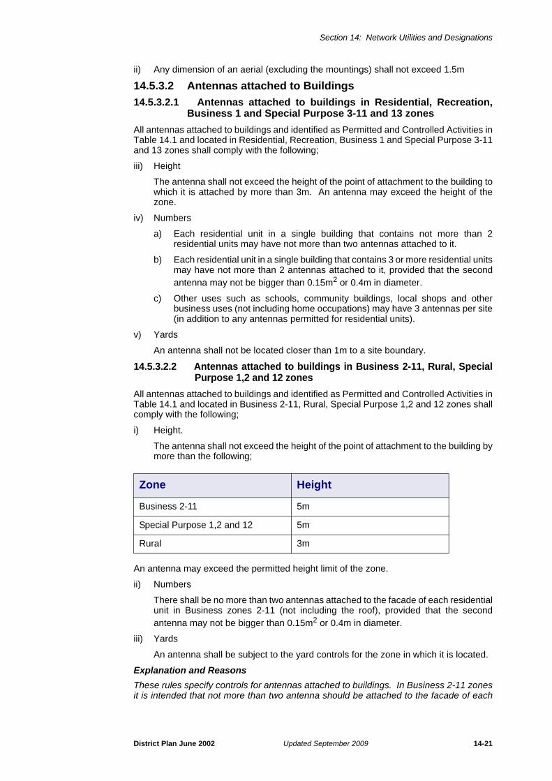
ii) Any dimension of an aerial (excluding the mountings) shall not exceed 1.5m
14.5.3.2 Antennas attached to Buildings
14.5.3.2.1 Antennas attached to buildings in Residential, Recreation,Business 1 and Special Purpose 3-11 and 13 zones
All antennas attached to buildings and identified as Permitted and Controlled Activities inTable 14.1 and located in Residential, Recreation, Business 1 and Special Purpose 3-11and 13 zones shall comply with the following;
iii) Height
The antenna shall not exceed the height of the point of attachment to the building towhich it is attached by more than 3m. An antenna may exceed the height of thezone.
iv) Numbers
a) Each residential unit in a single building that contains not more than 2residential units may have not more than two antennas attached to it.
b) Each residential unit in a single building that contains 3 or more residential unitsmay have not more than 2 antennas attached to it, provided that the secondantenna may not be bigger than 0.15m2 or 0.4m in diameter.
c) Other uses such as schools, community buildings, local shops and otherbusiness uses (not including home occupations) may have 3 antennas per site(in addition to any antennas permitted for residential units).
v) Yards
An antenna shall not be located closer than 1m to a site boundary.
14.5.3.2.2 Antennas attached to buildings in Business 2-11, Rural, SpecialPurpose 1,2 and 12 zones
All antennas attached to buildings and identified as Permitted and Controlled Activities inTable 14.1 and located in Business 2-11, Rural, Special Purpose 1,2 and 12 zones shallcomply with the following;
i) Height.
The antenna shall not exceed the height of the point of attachment to the building bymore than the following;
An antenna may exceed the permitted height limit of the zone.
ii) Numbers
There shall be no more than two antennas attached to the facade of each residentialunit in Business zones 2-11 (not including the roof), provided that the secondantenna may not be bigger than 0.15m2 or 0.4m in diameter.
iii) Yards
An antenna shall be subject to the yard controls for the zone in which it is located.
Explanation and Reasons
These rules specify controls for antennas attached to buildings. In Business 2-11 zonesit is intended that not more than two antenna should be attached to the facade of each
Zone Height
Business 2-11 5m
Special Purpose 1,2 and 12 5m
Rural 3m

Section 14: Network Utilities and Designations
14-22 Updated September 2009 District Plan June 2002
residential unit (not including the roof). However this does not limit the placement ofantennas on the roof, where the number is not restricted.
14.5.3.3 Height of masts and antennas attached to mastsMasts (including any antennas and aerials attached to masts but excluding lighteningrods) in Table 14.1 Activity Status shall comply with the following height limits:
14.5.3.4 Activities of Licensed Amateur Radio Operators
14.5.3.4.1 General Requirements
An amateur radio configuration must meet all of the following criteria;
a) The configuration must be owned and operated by a Licensed Amateur RadioOperator from their place of residence
b) the activity must be carried out on a site containing not more than two dwellings.
14.5.3.4.2 Aerials attached to buildings
a) An aerial (excluding single wire aerials) attached to a building (excluding a mast)may not exceed the height of the point of attachment to a building by more than 5metres but may exceed the permitted height limit of the zone.
b) Any dimension (other than height) of an aerial attached to a building (excluding amast) shall not exceed 5m (excluding the mountings and excluding single wireaerials).
c) Notwithstanding (b), one aerial attached to a building (excluding the mast) per sitemay have a dimension of up to 11 metres
d) Numbers of aerials may not exceed 6, with the exception of two whip style aerialswith a maximum length of 1.5m.
14.5.3.4.3 Antennas attached to buildings
a) One single antenna is permitted on a site with a dimension not exceeding 1.5m2 inarea or 1.4 m in diameter. This antenna is permitted in addition to any antennaspermitted under Rule 14.5.3.2 and all other development controls identified in Rule14.5.3.2 apply.
14.5.3.4.4 Pole aerials and supporting poles
a) A maximum of two supporting poles are permitted on a single site, and are called aprimary pole and a secondary pole. The diameter of any supporting pole shall notbe greater than 700mm up to 10m and 400mm above this. The pole may be asimple pole (with or without guys) or be of a lattice construction.
b) A primary pole;
i) Shall not exceed 15 m in height including any attached pole aerials
ii) Shall not have more than 3 pole aerials affixed to it
Zone Height
Business 1 10m
Rural 1 zone 15m
Rural 2-4 zone 10m
Residential zones Height of zone
Special Purpose zones 3-11, 13and 13a
10m

Section 14: Network Utilities and Designations
District Plan June 2002 Updated September 2009 14-23
iii) A pole aerial attached to a primary pole may be up to 11 m in length and allother dimensions must not exceed 5m, unless it is a single wire aerial, in whichcase the dimension by length is unlimited.
c) A secondary pole shall;
i) not exceed the permitted height limit of the zone
ii) not have more than one single wire aerial attached to it
iii) be joined by the single wire aerial to the primary pole
For the purpose of this section, a pole aerial means an aerial affixed to a pole that isaffixed to the ground and not on a building or structure, and is for private use by aLicensed Amateur Radio Operator for the purpose of licensed amateur radio activities.
14.5.3.4.5 Rotator
a) One rotating unit ("rotator") with not more than three devices (either aerials orantennas) co-located on it is allowed per site and may be attached to either abuilding or pole aerial. The rotator must comply with the revolution limit containedwithin the definition of Moving Aerial and Antenna (i.e. 2RPM)
Explanation and Reasons
Licensed Amateur Radio Operators have an important role in civil defence activities inNorth Shore City. In recognation of this, this section provides aerials and antennas usedby Licensed Amateur Radio Operators for the purpose of amateur radio activities with awider envelope of entitlements as a permitted activity than aerials and antennas used bypersons who are not licensed amateur radio operators.
14.5.3.5 Location of minor utility structures
14.5.3.5.1 Minor utility structures within the road reserve
All minor utility structures located in the road reserve and identified as Permitted orControlled activities in Table 14.1 Activity Status shall not be located more frequentlythan one structure every 30 metres on each side of the road reserve unless it isimpracticable to do so. This rule excludes;
i) Minor utility structures that have a ground converage not exceeding 0.5m2 inan area and a height not exceeding 1m above natural ground level
ii) Minor utility stuctures in Business zones 7-10
iii) Those minor utility structures located on Primary arterials as identified inAppendix 1 of the District Plan maps, regardless of the underlying zoning.
Explanation and Reasons
Where they are located in close proximity to each other minor utility structures can createat ‘wall’ of structures that is visually unattractive. When utility structures are located in theroad reserve, this rule requires that they are spaced apart where practicable. This ruledoes not apply in areas where amenity is of less importance, such as in Business 7-10zones on Primary arterials.
14.5.3.5.2 Minor utility structures that serve only one site
Where a minor utility structure (excluding Permitted activities that have ground coveragenot exceeding 0.5m2 in area and has a height not exceeding 1m above natural groundlevel) is designed to service only one site it must not be located in the road reserve.
Explanation and Reasons
For some industrial activities one minor utility structure may be required to service onlythe one site. In these situations the benefit of the minor utility structure is only for thatsite and should be located on the property rather than in the road reserve.
14.5.3.6 Underground service/connection linesFor all underground service/connection lines that are connected to above grounddistribution lines, the colour of the above ground portion of the service/connection lineshall be recessive (including the colours white and grey). The line may be tagged withcoloured markers to indicate the type of line.

Section 14: Network Utilities and Designations
14-24 Updated September 2009 District Plan June 2002
14.5.3.7 Bus sheltersAll bus shelters identified as Permitted Activities in Table 14.1 Activity Status shall complywith the following standards, terms and conditions:
a) Advertising and passenger information: Bus shelters must not contain any generalcommercial advertising. Display cases (or similar) containing timetables or otherpassenger transport services information may be electronic (variable message type)and may contain commerical symbols provided the display is only readable by usersof the shelter or pedestrians passing by (and not by motorists or occupiers ofproperties in the vinicity).
b) Bus shelter siting and design: Bus shelters must conform to the the following:
• Shelters shall be a maximum height of 2.7 metres and a maximum coverage
often (10) m2 measured one (1) metre above the pad;
• The shelter structure design, finishes and colour shall, when viewed as awhole, not generate any significant detraction from the visual amenities of theimmediate locality nor be a distraction to motorists, and no part of the structureshall have a reflectivity greater than 37% with the reflectivity of any glasscomponent of the shelter being measured at a normal angle of incidence;
• Shelters shall only contain or employ lighting sufficient for illuminatingpassenger transport services information and creating a sense of security forusers. The nature of lighting shall not detract from the existing amenity of thearea and must not compromise road safety. The downlit lighting standard shallbe up to a maximum of 40 lux as measured at the floor of the shelter, with nomore than 4 lux light spill at any private property boundary;
• Shelters shall be located so there is generally a maximum of 10 metresdistance between the shelter and the head (front) of the bus stop;
• Shelters shall have sufficient unobstructed space for safe and convenientpedestrian and passenger movement around the shelter. In general the busshelter should be located a minimum of 1.4 metres from any vehicle crossingor roadside kerb. However, in high density pedestrian or vehicular traffic areas,greater setbacks should be achieved to respond to the increased need forsafety and convenience. There should wherever practicable be a minimum of1.4 metres of unobstructed footpath and a continuous paved surface betweenthe shelter and the kerb at the head of the bus stop.
c) Prior bus stop approval: Bus shelters shall only be positioned adjacent to bus stopsauthorised by the Council acting as road controlling authority.
d) Bus shelter approval under other legislation: Bus shelters must have prior approvalunder the Local Government Act or such other legislation as may apply to theirestablishment.
Explanation and Reasons
Council has a bus shelter policy (Policy 4.2.9 Bus Shelters) that outlines an approvalprocess for bus shelters under local government legislation. Included in the policy is aprocess for consideration of any objections to proposed bus shelters. Council’s policyprovides for appeals to the relevant standing committee of Council by persons notsatisfied with the first decision on their objection. Policy 4.2.9 Bus Shelters also includescriteria for the siting and design of bus shelters and these will be upheld unless there areunusual circumstances.
The policy will be reviewed from time to time, through reports to committee meetings thatare open to the public, and specifically if Local Government legislation changes. Policy4.2.9 Bus Shelters can be found in the Council Policy Manual. Further information isavailable from Council’s Transportation and Roading Group.
The above rule has been written in a way which sets out the standards, terms andconditions which need to be achieved and two of these are complemented by technicalcontrols. This format has been followed to ensure both clarity and certainty of expectedenvironmental outcome. The technical controls are explained below.

Section 14: Network Utilities and Designations
District Plan June 2002 Updated September 2009 14-25
The reflectivity maximum of 37% is to ensure that the shelter is not a significant detractionfrom the visual amenity of the immediate locality nor be a distraction to motorists. A keyaspect of achieving this is to limit the amount of reflection from the shelter and thereforea reflectivity maximum of 37% has been set. The maximum of 37% reflectivity is, by wayof example, about the same reflection from a caucasian skin tone. Since part of theshelter may be glass and at certain acute angles the reflectivity may exceed 37% fromthe glass, the reflectivity for the glass will be measured at a normal angle of incidence.Normal incidence of entry is light entering at right angles to the surface it is entering andreflecting off. Light striking the glass at anything other than normal incidence of entrydoes not therefore have to meet the 37% reflectivity limit.
The rule also sets maximum lighting lux levels. The intention of the rule is to ensuresufficient lighting for illuminating passenger services information and creating a sense ofsecurity. In addition consideration must be had for the bus drivers being able to seewaiting passengers in the shelter and the level of lighting for waiting passengers whichmust not be too bright as this can create disorientation and limit visibility from within theshelter. In addition to the passenger considerations the lighting levels must notcompromise road safety and detract from the existing amenity of the area. To achievethis, maximum lighting levels (illuminance) in the shelter and at property boundaries havebeen set. This has been set at up to 40 lux as measured at the floor of the shelter andno more than 4 lux light spill at any private property boundary. Illuminance is the term forthe amount of light falling on something. Light levels are generally specified on ahorizontal plane usually at ground level. The unit for illuminance is Lux. By way ofcomparison a full moon has an illuminance of 0.1 lux, twilight an illuminance of 10 lux anddirect sunlight an illuminance of 100 000 lux.
14.5.4 Activity ControlsAll Permitted and Contolled activities shall comply with relevant rules specified in thefollowing General Sections. The rules contained in these Sections may change anyactivity status specified in Table 14.1.
Section 8: Natural Environment
Section 9: Subdivision and Development (including Soil and Water Protection)
Section 10: Pollution and Waste Management (including Noise, Hazardous Substances,Air Emmissions, Odour, Dust, Vibration, Lighting)
Section 11: Cultural Heritage
Section 12: Transportation
Section 13: Signs
14.6 Controlled Activities - Reservations and Assessment Criteria
Controlled activities must comply with all relevant controls of the Plan, including theDevelopment and Activity controls in 14.5. In addition, the Council may impose conditionsunder Section 108 of the RMA and for this purpose reserves control over the mattersspecified below for General and Specific Controlled activities.
14.6.1 Reservations and Assessment Criteria for General Controlled Activities
14.6.1.1 Reservations for General Controlled ActivitiesThe Council reserves control over the following matters for all Controlled activity resourceconsent applications;
i) Design and external appearance
ii) Siting
iii) Visual impact including landscaping and screening

Section 14: Network Utilities and Designations
14-26 Updated June 2012 District Plan June 2002
iv) Effects on streetscape and amenity
v) Natural and built heritage values
vi) Noise, vibration, odour, glare, dust, air emissions, lighting
vii) Vehicle movements, access and parking
viii) Risk of contamination or other hazards
ix) Effects on overland flow paths and/or water courses
x) Land stability and ground conditions
xi) Technical constraints and operational considerations
xii) Safety and convenience of road users
xiii) Appropriateness of activities within recreation zones
xiv) Effects on the natural character and integrity of flood plains and/or riparianmargins
14.6.1.2 General Assessment CriteriaThe Council shall assess applications using the following criteria;
i) The nature of the locality in which the activity is located. This includes considerationof the streetscape of the area, the character of the coastal or rural environment, anysignificant landscape values of the area (including the natural form and character ofvisually prominent ridgelines and landforms), and the amenity values of thesurrounding area.
ii) Whether the design and external appearance of buildings and structures for networkutilities are sympathetic to the character of the locality. This will include assessmentof the extent to which the network utility dominates, or is overbearing in relation toadjacent activities. In applying this criterion the Council will recognise that someutility structures need to be of certain forms or dimensions and there is limited abilityto alter those dimensions.
iii) Whether the proposed siting, landscape design, screening and site layout willinternalise or mitagate the effects of the network utility to the site as far aspracticable.
iv) The effect on any significant views (as defined in Appendix 8F) will be avoided ormitigated, including those from the Coastal Marine Area.
v) Whether the heritage values of any identified buildings or places would be adverselyaffected by the structure.
vi) All adverse effects on amenity values of an area from potential nuisance factorsincluding noise, vibration, odour, glare, dust, air emissions and lighting will beavoided, remedied or mitigated.
vii) Whether the effects on the overland flowpath and/or watercourse are more thanminor and whether and proposal may impede the flow of water in the 1% AEPStormwater Event.
viii) Whether the potential for contamination or hazards resulting from equipment failure,accidents or discharges have been addressed, including taking into account thenature of adjoining land use activities.
ix) Whether it is technically, economically and practically reasonable to co-locatestructures.
x) The extent to which these criteria are constrained by operational or technical issues.
xi) Whether structures located in the road reserve will be sited so that;
a) the potential for traffic and pedestrian safety problems is avoided andrecommended clearance distances for pedestrians thoroughfare is preserved(as detailed in North Shore City Councils Infrastructure Design Standards).This assessment must take account of any likely proposed upgrading orimprovements of the road

Section 14: Network Utilities and Designations
District Plan June 2002 Updated June 2012 14-27
b) there is sufficient space in the road reserve for planting and maintenance ofstreet trees, the provision of lighting, street furniture and parking, wherereasonably practicable.
c) access to the road reserve is preserved.
xii) For any activity that is proposed to take place on reserve land;
a) Whether the activity can readily be provided outside the reserve
b) Whether locating the network utility on recreation land is consistent with theobjectives and policies of the relevant Recreation zone
c) The anticipated impact on the amenity of the reserve, including natural andrecreational amenity
d) Whether the proposed location of the activity has potential to limit or preventoptions for the development of the reserve in the future
e) Any potential interference with the public use and enjoyment of the reserve
f) Recognising that land zoned Recreation 1 possesses high natural amenity andis regarded as suitable for the location of network utilities only in unusualcircumstances
g) Recognising that land in the road reserve that is zoned Recreation, especiallyin areas of natural amenity, provides a transition zone between the public openspace and the carriageway.
xiii) Whether the provision of stormwater detention ponds is in accordance with theobjectives of the relevant Catchment Management Plan, and recognition that pondsform part of a treatment train approach to stormwater management in combinationwith on-site stormwater management.
xiv) Where any activity is proposed within a flood plain and/or riparian margin, whetherany potential adverse effects on their natural function and integrity have beenconsidered.
14.6.2 Reservations and Assessment Criteria for Specific Controlled Activities
14.6.2.1 Replacement of Electricity Transmission TowersThe Council reserves control over the height, location and appearance of thereplacement tower.
The Council shall assess applications for tower replacement in terms of any additional orchanged effects using the following criteria;
i) the extent to which alternatives to a proposed tower replacement siting have beenevaluated and a comparison of each alternative undertaken, taking into account theoperational efficiency and technical requirements of the network utility and thefinancial implications to the applicant.
ii) the extent to which there are any significant mitigating factors or significant adverseeffects that can be avoided or remedied with an alternative tower siting proposal.
iii) the extent of which the streetscape of the area, the character of the coastal or ruralenvironment, the significant landscape values of the area (including the natural formand character of visually prominent ridgelines and landforms), or the amenity valuesof surrounding properties or public spaces, would be affected.
iv) the likely impacts on the security of North Shore’s electricity supply in the event ofthe applicant proceeding or not proceeding with the principal alternative towerrelocation proposal.
v) the extent to which a pole structure or a tower of an alternative design or colourwould have a lesser or greater environmental effect.
vi) the extent to which the location of tower structures will have adverse effects on thesafety of road users.
vii) whether the location would have adverse effects on conservation, cultural orarchaeological values.

Section 14: Network Utilities and Designations
14-28 Updated September 2009 District Plan June 2002
viii) whether there are native bush or wildlife habitats that could be adversely affected bythe proposal.
14.6.2.2 Gas Regulator StationsThe Council reserves control over the matters specified in 14.6.1.1.
The Council shall assess applications for those gas regulator stations identified asControlled activities in Table 14.1 using the criteria identified in 14.6.1.2, and thefollowing:
i) All such facilities shall be housed in a secure, enclosed building or compound andshould be of a colour that will minimise the visual intrusiveness of the building.
ii) The area surrounding the facility should be landscaped with the purpose ofscreening the facility from surrounding activities.
14.6.2.3 Minor utility structures, public letterboxes and telecommunication kiosks within the road reserve
The Council reserves control over the matters specified in 14.6.1.1 and the following;
a) The necessity for the structure to locate in the road reserve, depending on theuser or users that the structure will serve
b) Whether the structure can be located underground
c) With respect to public letterboxes and telecommunication kiosks, the height ofthe structures
The Council shall assess applications for minor utility structures, public letterboxes andtelelcommunication kiosks within the road reserve identified as Controlled activities inTable 14.1 using the criteria identified in 14.6.1.2, and the following;
i) Who the structure is designed to serve. Where the structure is designed toserve only one site it must not be located in the road reserve.
ii) The proposed location of the equipment or structure in relation to any plannedroad widening, or vertical and / or horizontal realignment of the road.
iii) Whether there are difficult ground conditions or technical constraints that makeplacement underground impracticable.
iv) Whether the proposed location of the structure has been considered in relationto any existing structure already in the vicinity.
14.6.2.4 Water Supply Reservoirs, Wastewater Storage Tanks and Pumping Stations
The Council reserves control over the matters specified in 14.6.1.1.
The Council shall assess applications for Water Supply Reservoirs, Wastewater StorageTanks and Pumping Stations identified as Controlled activities in Table 14.1 using thecriteria identified in 14.6.1.2 and the following;
i) Whether the structure will be located and designed to harmonise with thenatural or built features of the area in which it is situated by one or more of thefollowing means:
• Undergrounding the structure
• Partial or complete backfilling of reservoir walls
• Screening using earth mounding and planting
• Locating the reservoir so that it is not visible from a Residential orRecreation zone
ii) Where the above treatments are not possible for hydraulic, topographical orother reasons, visual impacts will be avoided, remedied or mitigated through:
• Appropriate screening and/or planting
• Colour treatment to reduce visual dominance; or

Section 14: Network Utilities and Designations
District Plan June 2002 Updated September 2009 14-29
• Design modifications such as domed roofs where reservoirs are situatedon hills
14.6.2.5 Pipe BridgesThe Council reserves control over the matters specified in 14.6.1.1 and also the locationof pipe bridges in respect of the risk of failure.
The Council shall assess applications for Pipe Bridges identified as Controlled activitiesin Table 14.1 using the criteria identified in 14.6.1.2, and the risk of failure of the pipebridge, including the risk of the footings of the pipe bridge, or the pipe bridge itself, beingundermined by flooding.
14.6.2.6 Antenna and Masts The Council reserves control over the matters specified in 14.6.1.1.
The Council shall assess applications for Antennas, and Masts identified as Controlledactivities in table 14.1 using the criteria identified in 14.6.1.2 and the following;
a) The extent to which any adverse visual effects of the mast or antenna can beavoided or mitigated by:
i) screening or landscaping
ii) alternative siting
iii) alternative colour or finish selection
b) Where antennas are proposed to be sited on a building, the extent to whichthey can be designed, screened or sited so that they form an integral part of thetotal building design.
c) The extent to which the mast or antenna can be co-located with similarstructures or other buildings to avoid, remedy or mitigate their visual impact,and the extent to which the potential for co-location has been addressed.
14.7 Limited Discretionary Activities - Restrictions and Assessment Criteria
14.7.1 Restrictions and Assessment Criteria for Specific Limited Discretionary Activities
Council may grant or refuse consent for Limited Discretionary activities, and if grantedmay impose conditions under Section 108 of the RMA. For the purpose of making thesedecisions Council has restricted the exercise of its discretion in respect of the activiitesidentified below.
14.7.1.1 Restrictions and Assessment criteria for minor utility structures
The Council restricts its descretion to the matters identified in 14.6.2.3 and to height,scale and cumulative effects.
The Council shall assess applications for minor uitility structures using the criteriaidentified in 14.6.2.3.
14.7.1.2 Restrictions and Assessment criteria for public letterboxes and telecommunication kiosks
The Council restricts its discretion to the matters identified in 14.6.1.1 and to height, scaleand cumulative effects.
The Council shall assess applications for public letterboxes, postal holding boxes andtelecommunication kiosks using the criteria identified in 14.6.1.2.

Section 14: Network Utilities and Designations
14-30 Updated September 2009 District Plan June 2002
14.7.1.3 Restrictions and Assessment criteria for above ground service/connection lines and above ground electricity and telecommunication lines
The Council restricts its discretion to the matters identified in 14.6.1.1 and to height andcumulative effects.
The Council shall assess all applications for above ground service/connection lines andabove ground electric and telecommunication lines using the criteria identified in 14.6.1.2and the following:
i) The adverse visual effect with respect to neighbouring dwellings primarily whenviewed from habitable rooms should be avoided, remedied or mitigated wherepracticable.
ii) Any potential for co-location, subject to technical limitations, should be pursuedso as to minimise the number of structures.
iii) The extent to which technical and physical constraints and their associatedcosts restrict the ability to undergound any line.
14.7.1.4 Restrictions and Assessment criteria for Replacement of Electricity Transmission Towers
The Council restricts it discretion to the height, location and appearance of thereplacement tower.
The Council shall assess applications for tower replacement using the criteria identifiedin 14.6.2.1.
14.7.1.5 Restrictions and Assessment criteria for Pipe BridgesThe Council restricts its discretion to the matters identified in 14.6.2.5 and to thefollowing;
• The availability of alternative locations and options to a pipe bridge, andamenity effects.
The Council shall assess applications for pipe bridges using the criteria identified in14.6.2.5 and the following;
i) The suitability of alternative locations for the pipe bridge
ii) The suitability of alternatives to a pipe bridge including locating the pipe bridgeunder the stream bed using trenchless technology, using other devices orpossible re-routing to avoid the need for a bridge
iii) The effect on the amenity of the surrounding area and the integration of thepipe bridge into the surrounding environment by the use of neutral colours,vegetation for screening, and the potential for co-location with existing orproposed bridges or other infrastructure.
14.7.1.6 Restrictions and Assessment criteria for Aerials, Antennas, and Masts and replacement utility structures
The Council restricts it descretion to the matter identified in 14.6.2.6 and to the following;
a) The maximum height of the mast, the area or diameter of any aerial or antenna, andthe numbers of antennas or aerials attached to masts, buildings or replacementutility structures.
The Council shall assess all applications for aerials, antennas, masts and replacementutility structures using the criteria identified in 14.6.2.6 and the following;
i) If the structure is likely to result in an adverse effect on the environment, whether thelocation and scale are appropriate having regard to alternative locations or otheroptions.
ii) These structures are discouraged on prominent ridgelines and hilltops. Where theproposed structure is so located and where significant adverse effects are likely,whether the structure can be placed elsewhere without a disproportionate lose infunctionality. Where it is considered necessary that the proposed structure be
Section 14: Network Utilities and Designations
District Plan June 2002 Updated September 2009 14-31
located on a ridgeline or hilltop, Council encourages the co-location of networkutilities to help reduce the effect on visual amenity.
14.8 Underlying Zoning of Roads
Where a public work or network utility is proposed to be located within the road reservethe underlying zoning shall be deemed to be that of the immediately adjacent landextending to the mid point of the road.
Explanation and Reasons
Roads, proposed roads, road closures, preferred roads, building line restrictions,accessways and service lanes are all indicated on the District Plan maps. All existingroads are designated.
14.9 Designations
14.9.1 Information to be Provided with a RequirementIn the case of any notice of requirement for a designation under Section 168 of the RMAor notice of requirement to alter a designation where information is required underSection 181 of the RMA, the following information shall be provided:
a) Information specified in the regulations of the RMA, as follows:
• A statement of reasons why the designation is needed
• A description of the site, the proposed work and any proposed restrictions
• A description of the effects the work will have on the environment and howthese are to be mitigated (refer to Appendix 3A:Schedule of Effects)
• A statement of any alternative sites, routes, or methods considered
• A statement of the consultation with affected persons
• A statement of resource consents required and if these have been applied for.
b) The following additional information:
• Where the requiring authority is a network utility operator as defined in Section166 of the RMA; a copy of the Gazette notice approving the applicant as arequiring authority, including any specified terms and conditions
• Sufficient information to be able to understand the nature of the proposedworks, that information showing the height, shape and bulk of the work, itslocation on the site, and vehicular access
• A statement as to how the work impacts on any relevant provisions of national,coastal and regional policy statements and regional and district plans
• In the case of designations for state highways, arterial or principal roads; aNoise Management Plan detailing any anticipated additional noise impacts andthe measures to be taken to avoid and/or mitigate unreasonable levels of trafficnoise. Transit New Zealand’s Guidelines for the Management of Road TrafficNoise should be used as the basis for assessing noise effects and determiningavoidance and/or mitigation measures
• The proposed sequence and timing of implementation of the work or projectshall be provided
• Proposals for the use and maintenance of those parts of the land which will notbe developed for five or more years.
Section 14: Network Utilities and Designations
14-32 Updated September 2009 District Plan June 2002
14.9.2 ConditionsAfter considering a requirement for a designation, the Council may recommend to therequiring authority such conditions as the Council considers appropriate to the work.
14.9.3 Work to be Undertaken on Designated Landa) Prior to commencing any work for which a requiring authority has financial
responsibility, the information detailed in Section 176A(3) of the RMA shall beprovided to the Council, except where:
• The work has been otherwise provided for under the RMA, or
• The details of the proposed work are incorporated into the designation, or
• The Council waives the requirement for an outline plan, provided that:
i) The requiring authority makes a written application for such a waiverexplaining the nature of the proposed work/s. In determining whether towaive the provision of an outline plan of works, Council will have regard tothe following assessment criteria:
• Whether the activity is a Permitted activity for the underlying zone ofthe designated site, and
• To what extent there is non-compliance with the provisions of the relevantunderlying zone, and
• Whether the effects resulting from the proposed activity, if any, can beconsidered to be minor.
ii) Any emergency work which the body or person responsible for itsconstruction considers is immediately necessary to meet an emergencysituation may be constructed without first advising the Council, if outlinedrawings of the work are submitted to the Council as soon as practicableafter the work has been commenced.
b) After considering the proposals detailed in the information and drawings, the Councilmay request the requiring authority to make changes to all or any of the proposalsthat will, in Council’s opinion, avoid, remedy or mitigate any adverse environmentaleffects.
14.9.4 Activities Not in Accordance with Designationa) In accordance with Section 176(1) of the RMA, no person may, without the prior
written consent of the requiring authority, do anything in relation to the land that isthe subject of the designation that would prevent or hinder the public work or projector work to which the designation relates.
b) In accordance with Section 176(2) of the RMA, where a proposed activity ondesignated land is not in accordance with the designated purposes, it shall complywith:
i) the Rules of the underlying zoning of the land; or
ii) be otherwise provided for within this Plan (e.g. as a Temporary activity).
14.9.5 Schedule of DesignationsAppendix 14A identifies the public work, project or work for which land in North Shore Cityhas been designated. The designations are also shown on the District Plan maps.
Section 14: Network Utilities and Designations
District Plan June 2002 Updated September 2009 14-33
14.10 Development Controls Relating to Specific Designations
14.10.1 RNZAF Airbase Flight paths14.10.1.1 Height Restriction ControlsThe following controls apply:
a) Notwithstanding any height controls specified elsewhere in this Plan, no building,structure, mast, pole or tree or other object in the areas identified in Appendix 3 tothe District Plan maps shall penetrate any of the surfaces specified in Appendix 14Band Appendix 14C to this Plan.
b) Where two or more height restrictions apply at the same place, the lowest heightrestriction shall prevail provided that the following shall be excepted from thesecontrols:
i) Where terrain penetrates any surface or where terrain is within eight metres ofany surface, an object is permitted with a maximum height of eight metresabove the ground level.
ii) The following additional exemptions apply in respect of electric lines:
• Nothing in these rules shall prevent the erection of electric lines to a heightof not more than 10 metres above ground level
• Nothing in these rules shall prevent the erection of electric lines to a heightof not more than 20 metres above ground level where the centreline of thoseelectric lines are within 5 metres of the centreline of existing electric lineswhich run between the Albany substation and Glenfield via Greenhithe. (Theapproximate alignment is indicated on Appendix 3 to the District Plan maps).Provided that, prior to the erection of any lines along this alignment, theRNZAF Operations Group shall be notified. Hazard lighting or marking maybe required.
Explanation and Reasons
Height Restrictions
To ensure that the continued operation of aircraft from the NZ Defence Force airfields atWhenuapai and Hobsonville will not be adversely affected by new development whichmay interfere with the airfield approach and take-off paths and horizontal surfaces,airfield protection measures are imposed on the use of land in the vicinity. The extent ofthe protection measures is described in Appendix 3 to the District Plan Maps. Themeasures involve restrictions on the height of buildings and other objects.
1. Need for Restrictions
Height controls are necessary to avoid impairment of the safe operation of aircraftby the penetration of objects or structures into the flight path. The controls areimposed on the height of buildings and objects above mean sea level (i.e. on theiraltitude).
2. Area Affected
Areas affected are beneath and within the imaginary surfaces shown on Appendix3 of the District Plan maps and are defined below.
3. Explanation of Imaginary Surfaces
i) Climb and Transitional Surfaces
Climb surfaces are wedge-shaped and rise at specified gradients from theirorigin at the end of the airfield. As a result, maximum permitted altitude ofbuildings and objects increases with distance from the airfield.
Transitional surfaces, which restrict altitudes of buildings and objects near theclimb surfaces, are imposed on either side of the climb surfaces.
The effect of these surfaces on maximum building altitude is illustrated inAppendix 14B.

Section 14: Network Utilities and Designations
14-34 Updated September 2009 District Plan June 2002
ii) Horizontal and Conical Surfaces
Whenuapai Airfield
The horizontal surface is a circular plane extending 4,000 metres out from thecentre of the airfield at an altitude of 71.01 metres above mean sea level(AMSL). A sloping plan extends outward to 6,000 metres from the centre of theairfield and upward to an altitude of 171.01 metres AMSL from the edge of thehorizontal surface. This is the conical surface.
Hobsonville Airfield
The conical surface is a sloping plane which extends outward and upward fromthe periphery of an inner circle which has a radius of 400 metres from the centreof the airfield and an altitude of 20 metres AMSL. This conical surface extends1,750 metres out from the centre of the airfield and to an altitude of 65 metresAMSL. Extending from the edge of the conical surface, a distance of 4,000metres from the airfield’s centre, is another circular plane, the horizontalsurface.
The effect of these surfaces on maximum permitted altitude of buildings andother objects is illustrated in Appendix 14C.
4. Detailed Specification
A more detailed specification outlining the layout of the runways, approach and take-off paths and surfaces, horizontal and conical surfaces and airfield reference points,has been lodged with the Council and is available for inspection.
Sub-Clause (ii) is intended to provide for the possible future upgrading of the line.
14.10.1.2 Proposals Which Exceed Height RestrictionsAny person who wishes to carry out any work which is contrary to Section 14.10.1.1above may make an application under Section 176 of the RMA to the Royal New ZealandAir Force (see below for procedure).
Explanation and Reasons
Underlying Zoning
It is important to note that these height restrictions are separate from and do not replacethe controls of the underlying zoning. Where necessary, a resource consent must besought from the North Shore City Council in the usual manner.
Applications for Consent
Consent under Section 176 of the RMA to carry out works which exceed height controlscan be requested through sending applications to the RNZAF Base at Whenuapai.
14.11 Conditions Attached to the Designation of Auckland Prison
Refer to Appendix 14M for the conditions attached to Designation 120, Auckland Prison.
Explanation and Reasons
The conditions seek to ensure that the penal institution development at Paremoremo iscompatible with the Council’s objectives for the rural area.
14.12 Refuse Disposal
Explanation and Reasons
There are three public facilities for refuse disposal, refuse transfer and recycling on theNorth Shore. These are the Devonport Transfer Station and Recycling Centre locatedalong Lake Road opposite the Waitemata Golf Club; the Rosedale Landfill locatedbetween Rosedale Road and Greville Road; and the Constellation Drive Refuse Transferand Recycling Station in Mairangi Bay.

Section 14: Network Utilities and Designations
District Plan June 2002 Updated September 2009 14-35
The Rosedale landfill and Constellation Drive Transfer Station are designated by theAuckland Regional Council pursuant to the powers given to it by Section 707AA of theLocal Government Act 1974. Operation and management of these facilities is vested inNorthern Disposal Systems Ltd, a LATE of the Auckland Regional Services Trust.
The Rosedale landfill currently receives all of the refuse from within the city, from withinthe North Shore and from various localities beyond the North Shore. The landfill hassufficient capacity to continue operations past the turn of the century. The Council haslong held the view that the Rosedale Landfill is not well located to serve as a regionalrefuse facility because of its impact on local residential properties, its likely effect uponthe planned development of the Greville Road area for housing and upon the Council’sdesire to achieve high urban environmental standards throughout the Albany Basin.Consequently, the Council has resisted proposals for major extensions to the Rosedalelandfill, and has instead given planning consent to two limited extensions only. Theseconsents recognised and sought to overcome the short-term difficulties facing theAuckland Regional Council in disposing of the North Shore’s refuse. The planningapproval given by the Council to the second extension stipulated that there was to be nofurther expansion of the Rosedale landfill beyond the limits of that consent and imposeda number of conditions on the establishment, operation and management of the landfill.
Issues relating to the landfill designation were again considered in 1996 during thehearing of submissions to the proposed District Plan. As a result, consent to dispose ofrefuse in the Rosedale landfill expires during the year 2005. The Development Plan forthe landfill, showing the finished landform, and the conditions attached to its operationand management are incorporated within the District Plan as Appendix 14H. AManagement Plan for the landfill is being prepared by Northern Disposal Systems Ltd inconsultation with the Council. This Plan will set out the approved guidelines for themanagement and operation of the landfill.
The Council’s longterm intention for the site as a reserve is indicated by a policy inSection 19.3.2. A possible end use proposal is shown in Appendix 14I. The Councildoes, however, reserve its right to develop and use the facility in a manner appropriateto the circumstances existing at the time in the future when development and use of thelandfill for urban type purposes is possible.
The Council’s approval to the second extension was also linked to the establishment ofa refuse transfer station at Constellation Drive. The site is suitable in terms of itsaccessibility and the opportunities it affords for alternative forms of refuse disposal,particularly for composting organic refuse in association with the Albany SewageTreatment Works. However, although alternative forms of refuse disposal are likely tohave a role in a future North Shore refuse strategy, no alternative process will entirelyremove the need for some disposal of refuse by landfill. It is necessary, therefore, thatthe ARC use its lead-time to establish a suitable northern refuse disposal site.
14.13 Exclusion from the Resource Management Act
Section 4(2)(b) of the Resource Management Act 1991 provides that this Act does notapply to any work or activity of the Crown which the Minister of Defence certifies isnecessary for reasons of national security.
A copy of a certificate received in relation to part of a Defence Area at Onetaunga Bay(known as the Royal New Zealand Naval Armament Depot Kauri Point) is included asAppendix 14L.

Section 14: Network Utilities and Designations
14-36 Updated September 2009 District Plan June 2002
Appendix 14A Schedule of Designations
The following summarises all of the designations of land identified on the planning maps.Information pertaining to each of the following designations is contained in files availablefrom the Council. Some designations may be subject to conditions relating to matterssuch as the bulk and location of structures, noise, or other matters to avoid, remedy ormitigate any adverse effects. Reference to the files is recommended in respect of anyproposals relating to the designated sites.
Reference Number
Purpose and Authority LocationUnderlying
ZoningMap
Reference
1 Sunnybrae Normal Primary SchoolMinister of Education
Sunnybrae Road
Residential 4A
25
2 Willow Park Primary SchoolMinister of Education
Eban Ave/Compton Street
Residential 4A
25
3 Onepoto Primary SchoolMinister of Education
Fraser Avenue
Residential 4A
25
4 Northcote Intermediate SchoolMinister of Education
Lake Road Residential 4A
25
5 Northcote Primary SchoolMinister of Education
Onewa/Lake Roads
Residential 4A
25
6 Northcote College - SchoolMinister of Education
Kauri Glen Road
Residential 4A
25
7 Vauxhall Primary SchoolMinister of Education
Morrison Avenue
Residential 3A
32
8 Devonport Primary SchoolMinister of Education
Kerr Street Recreation 2, Residential
3A
32A
9 Stanley Bay SchoolMinister of Education
Glen Road Residential 3A
31
10 Glamorgan Primary SchoolMinister of Education
Glamorgan Drive
Residential 4B
8
11 Torbay Primary SchoolMinister of Education
Deep Creek Road
Residential 4B
8
12 Northcross Intermediate SchoolMinister of Education
Sartors Avenue
Residential 4B
13
13 Sherwood Primary SchoolMinister of Education
Sartors Avenue
Residential 4B
13,14
14 Browns Bay Primary SchoolMinister of Education
Browns Bay Road
Residential 4B
14
15 Rangitoto CollegeMinister of Education
East Coast Road
Residential 4A
14

Section 14: Network Utilities and Designations
District Plan June 2002 Updated July 2015 14-37
16 Murrays Bay Primary School and
Murrays Bay Intermediate SchoolMinister of Education
Clematis AvenueSunrise Avenue
Residential 4B
14
17 Albany Senior High School Years 11-13
Minister of Education
536 & 546 Albany Highway
Residential 5 12
18 Mairangi Bay Primary SchoolMinister of Education
Agathis Avenue/Galaxy Drive
Residential 4B
14,20
19 Birkenhead Primary SchoolMinister of Education
Birkenhead Avenue/Highbury Bypass/Mokoia Road
Business 2 24A
20 Beach Haven Primary SchoolMinister of Education
Tramway Road/Rangatira Road
Residential 4B
23
21 Birkdale North Primary SchoolMinister of Education
Birkdale Road Residential 4B
23
22 Birkdale Intermediate SchoolMinister of Education
Tiri Tiri/Birkdale Roads
Residential 4B
23
23 Birkenhead CollegeMinister of Education
Birkdale Road Residential 4B
23
24 Birkdale Primary SchoolMinister of Education
Birkdale Road/Salisbury Road
Residential 4B
23
25 Kauri Park Primary SchoolMinister of Education
Kia Ora RoadRangatira Road
Residential 4B
23
26 Chelsea Primary SchoolMinister of Education
Onetaunga Road/Chelsea View Drive
Residential 4B
29
27 Education Purposes (years 0-8), Sports Field for Educational Purposes (years 0-13) and Early Childhood Education Centre
Minister of Education
Ralph Eagles Place
Long Bay 1B/Long Bay 2
8
28 Long Bay CollegeMinister of Education
Ashley Avenue
Long Bay 2 8
29 Albany Primary SchoolMinister of Education
Bass Road Residential 5 12
Reference Number
Purpose and Authority LocationUnderlying
ZoningMap
Reference

Section 14: Network Utilities and Designations
14-38 Updated December 2012 District Plan June 2002
30 Ridge View SchoolMinister of Education
Cutts Crescent
Rural 1 17
31 Greenhithe Primary SchoolMinister of Education
Isobel Road/Greenhithe Road
Residential 1 17,18
32 Designation removed as of 29 October 2012
33 Bay View Primary SchoolMinister of Education
Bayview Road
Residential 4A
19
34 Manuka Primary SchoolMinister of Education
Manuka Road Residential 4A
19
35 Glenfield Intermediate SchoolMinister of Education
Chivalry Road/Avalon Place
Residential 4A
19,20,2425
36 Sunnynook Primary SchoolMinister of Education
Lyford Crescent/Wylie Avenue
Residential 4A
20
37 Wairau Intermediate SchoolMinister of Education
Becroft Drive Residential 4A
20
38 Target Road Primary SchoolMinister of Education
Target Road/Sunnynook Road
Residential 4A
20
39 Wairau Valley Special School (IHC)Minister of Education
Hillside Road Residential 4A
20
40 Campbells Bay Primary SchoolMinister of Education
Aberdeen Road
Residential 4A
20,21
41 Forrest Hill Primary SchoolMinister of Education
Forrest Hill Road
Residential 4A
20
42 Westlake Boys High SchoolMinister of Education
Forrest Hill Road
Residential 4A
20,25
43 Milford Primary SchoolMinister of Education
Shakespeare Road
Residential 4A
21
44 Glenfield Primary SchoolMinister of Education
Chivalry Road Residential 4A
24
45 Marlborough Primary SchoolMinister of Education
Wykeham Place/Archers Road
Residential 4A
24, 25
46 Verran Road Primary SchoolMinister of Education
Verran Road Residential 4A
24
47 Windy Ridge Primary SchoolMinister of Education
Seaview Road
Residential 4A
24
Reference Number
Purpose and Authority LocationUnderlying
ZoningMap
Reference

Section 14: Network Utilities and Designations
District Plan June 2002 Updated June 2014 14-39
48 Glenfield CollegeMinister of Education
Kaipatiki Road
Residential 4A
24
49 Takapuna Normal Intermediate SchoolMinister of Education
Northcote Road
Residential 4A
25
50 Westlake Girls High SchoolMinister of Education
Wairau Road Residential 4A
25
51 Hauraki Primary SchoolMinister of Education
Jutland Road Residential 4A
26
52 Belmont Intermediate SchoolMinister of Education
Lake RoadWinscombe Street Belmont
Residential 4A
26,27
53 Bayswater Primary SchoolMinister of Education
Bayswater AvenueRoberts Avenue
Residential 4A
26,27
54 Takapuna Grammar SchoolMinister of Education
Lake RoadSt Leonards Road
Residential 4A
26,27
55 Takapuna Primary SchoolMinister of Education
Anzac Street/Killarney Street
Residential 4A
26A
56 Belmont Primary SchoolMinister of Education
Harrison Avenue/School Road
Residential 4A
27
57 Primary SchoolMinister of Education
Spencer Road
Residential 4A
13
58 Motorway Administration and Maintenance (TNZ, NZ Police), Transit New Zealand and Minister of Police
28 Sulphur Beach Road
Residential 7 30
59 Police PurposesCommunity Policing CentreMinister of Police
365 Glenfield Road
Residential 6A1
24
61 Police PurposesAlbany Police CentreMinister of Police
Library Lane Albany Centre
Expansion
12
62 Browns Bay Police StationMinister of Police
Clyde Road/Browns Bay
Business 2 14
63 Future SubstationUnited Networks Limited
Bush Road Business 10 19
64 Substation - Browns BayUnited Networks Limited
Andersons Road
Area D - Varied
Residential
13
Reference Number
Purpose and Authority LocationUnderlying
ZoningMap
Reference

Section 14: Network Utilities and Designations
14-40 Updated September 2009 District Plan June 2002
65 Substation -BelmontUnited Networks Limited
161/167 Bayswater Avenue
Residential 4A
26
66 Substation - BirkdaleUnited Networks Limited
Eskdale Road Recreation 1 24
67 Substation - Balmain RoadUnited Networks Limited
5A Balmain Road
Residential 2A
24
68 Substation - East Coast RoadUnited Networks Limited
497 East Coast Road
Residential 4B
14
69 Substation - James StreetUnited Networks Limited
James Street Residential 4A
19
70 SubstationUnited Networks Limited
Kyle RoadGreenhithe Road
Area D - Varied
Residential
18
71 Substation - HaurakiUnited Networks Limited
Jutland Road Residential 4A
26
72 Substation - HighburyUnited Networks Limited
Highbury By-Pass
Business 2 24A
73 Substation - MilfordUnited Networks Limited
East Coast Road
Residential 4A
21
74 Substation - NorthcoteUnited Networks Limited
Lake Road, Northcote
Recreation 2 25
75 Substation - Sunset RoadUnited Networks Limited
Sunset Road Business 9 19
76 Substation - HillcrestUnited Networks Limited
33/35 Northcote Road
Residential 2B
25
77 Substation - TorbayUnited Networks Limited
40A Glenvar Road
Residential 4B
8
78 Substation - Wairau RoadUnited Networks Limited
Wairau Road Recreation 4 25
79 Substation - WaiakeUnited Networks Limited
53 Carlisle Road
Residential 4B
8
80 Substation - Forrest HillUnited Networks Limited
248A East Coast Road
Residential 4A
20
81 Substation - TakapunaUnited Networks Limited
29 Huron Street
Residential 6A
26A
83 Communications Hut (Radio)United Networks Limited
State Highway 1
Rural 2 11
85 Electricity SubstationTranspower NZ Ltd
Bass Road Residential 5 12
Reference Number
Purpose and Authority LocationUnderlying
ZoningMap
Reference
Section 14: Network Utilities and Designations
District Plan June 2002 Updated September 2009 14-41
88 Defence Purposes (see Appendix 14N)Minister of Defence
Vauxhall Road
Residential 6C
Recreation 1
32
89 Defence Purposes (see Appendix 14N)Minister of Defence
Torpedo Bay Recreation 3 32
90 Defence Purposes(see Appendix 14N)Minister of Defence
Kauri Point Recreation 1 28,29
91 Defence Purposes (see Appendix 14N)Minister of Defence
South Yard/Calliope Road/Queens Parade
Residential 7Residential
3A,3CBusiness 9
31,32, 32A
92 Defence Purposes (see Appendix 14N)Minister of Defence
North Yard/Jim Tichener Parade
Residential 7Recreation 4Recreation 1
31,32, 32A
93 Buildings, masts, antennae, aerials and lines and other land uses for telecommunication and radiocommunication purposesTelecom New Zealand LimitedTelecom Mobile Limited
Mokoia Road Business 2 24A
94 Buildings, masts, antennae, aerials and lines and other land uses for telecommunication and radiocommunication purposesTelecom New Zealand LimitedTelecom Mobile Limited
5 Birkdale Road
Residential 4B
24
95 Buildings, masts, antennae, aerials and lines and other land uses for telecommunication and radiocommunication purposesTelecom New Zealand LimitedTelecom Mobile Limited
Lake Road/Mozeley Avenue
Residential 3A
32A
96 Water Supply Purposes - Reservoir and Pumping StationWatercare Services Limited
Corner Albany Highway and Sunset Road
Residential 5 19
97 Water Supply Purposes - Water Pumping Station and Future ReservoirsWatercare Services Limited
Schnapper Rock Road
Rural 3 18
98 Water Supply Purposes - Reservoir and Pumping StationWatercare Services Limited
106 Pupuke Road
Residential 4A
25
99 Water Supply Purposes - Pumping StationWatercare Services Limited
Killarney Street
Recreation 1 26
Reference Number
Purpose and Authority LocationUnderlying
ZoningMap
Reference

Section 14: Network Utilities and Designations
14-42 Updated September 2009 District Plan June 2002
100 Water Supply Purposes - ReservoirsWatercare Services Limited
Waipa Street/Verran Road
Recreation 4 24
101 Water Supply Purposes - ReservoirWatercare Services Limited
Corner of Albany Highway and Upper Harbour Drive
Rural 3A 19
102 Water Supply Purposes - Reservoir Watercare Services Limited
Corner Browns Bay Road and East Coast Road
Residential 4B
14
103 Water Supply Purposes - ReservoirWatercare Services Limited
Corner of Kowhai Road and East Coast Road
Residential 4B
20
104 Water Supply Purposes - Reservoir and Pumping StationWatercare Services Limited
Forrest Hill Road
Recreation 2 20
105 Water Supply Purposes - Proposed ReservoirWatercare Services Limited
Spencer Road
Recreation 2, Business 7C
13
107 Works Depot: Auckland Harbour BridgeTransit NZ Authority
Princes Street Residential 3C
30
108 North Anchorage: Auckland Harbour Bridge.
Transit NZ Authority
Princes Street Recreation 2 30
109 Works Access: Auckland Harbour BridgeTransit NZ Authority
Princes Street Residential 3C
30
110 Auckland-Waiwera Motorway (State Highway One), including planning, design, supervision, construction and maintenance in accordance with the Transit New Zealand Act 1989.
Transit NZ Authority
Various 13,19,20,25,26,30
111 Proposed Motorway (Auckland/Waiwera Motorway State Highway One), including planning, design, supervision, construction and maintenance in accordance with the Transit New Zealand Act 1989.
Transit NZ Authority
Area D - Varied
Residential, Albany Centre
Expansion, Business
6,7C, Residential 5
Area A - Environmental Protection
7,13
Reference Number
Purpose and Authority LocationUnderlying
ZoningMap
Reference

Section 14: Network Utilities and Designations
District Plan June 2002 Updated September 2009 14-43
112 State Highway One, including planning, design, supervision, construction and maintenance in accordance with the Transit New Zealand Act 1989.Transit NZ Authority
Various 11,12,13
113 State Highway 18: the control, management and improvement of the State Highway, including planning, design, research, construction, operation and maintenance relating to all land within the State Highway designation and in accordance with the Transit New Zealand Act 1989.
Transit NZ Authority
Various 19,20
114 State Highway 18: the control, management and improvement of the State Highway, including planning, design, research, construction, operation and maintenance relating to all land within the State Highway designation and in accordance with the Transit New Zealand Act 1989.
Transit NZ Authority
Various 18,19,22,23
115 Designation removed as at 6 June 2006
116 Refuse Disposal PurposesAuckland Regional Council
Rosedale Road/Greville Road
Residential 5Recreation 4
13
117 Regional ParkAuckland Regional Council
Long Bay Regional Park Management Plan
Beach Road/Long Bay
Recreation 1,2,3
4,8
119 Auckland Prison Reservoir
Minister of Corrections
Attwood Road/Paremoremo Road
Rural 1 17
120 Auckland PrisonMinister of Corrections
(see Appendix 14M)
Paremoremo Road
Rural 1 16,17
121 Proposed Service LaneNorth Shore City Council
Rothesay Bay Shopping Centre
Business 1 14
123 Proposed Service LaneNorth Shore City Council
Highbury Commercial Centre
Business 2 24A
Reference Number
Purpose and Authority LocationUnderlying
ZoningMap
Reference

Section 14: Network Utilities and Designations
14-44 Updated September 2009 District Plan June 2002
125 Proposed Service LaneNorth Shore City Council
Between Clarence Street and Fleet Street, Devonport
Business 2 32A
126 Proposed Service LaneNorth Shore City Council
Browns Bay Shopping Centre
Business 2 14
127 Proposed Service LaneNorth Shore City Council
Highbury Commercial Centre
Business 2 24A
128 State Highway 18: the control, management and improvement of the State Highway, including planning, design, research, construction, operation and maintenance relating to all land within the State Highway designation and in accordance with the Transit New Zealand Act 1989.
Transit NZ Authority
Various 18,19
129 Public Car ParksNorth Shore City Council
Highbury Commercial Centre
Business 2,Special
Purpose 9, Recreation 2
24A
130 Public Car ParkNorth Shore City Council
Beach Haven Shops
Business 1 23
131 Public Car ParkNorth Shore City Council
Anzac Road, Browns Bay
Business 2 14
132 Proposed Public Car ParkNorth Shore City Council
Anzac Road, Browns Bay
Business 2 14
133 Proposed Public Car ParkNorth Shore City Council
Bute Road, Browns Bay
Business 2 14
134 Public Car ParkNorth Shore City Council
Beach Road, Murrays Bay
Business 1 14
135 Public Car ParkNorth Shore City Council
Montrose Terrace, Mairangi Bay
Business 2 14
136 Public Car ParkNorth Shore City Council
Northcote Commercial Centre
Business 2 25
137 Public Car ParkNorth Shore City Council
Hauraki Corner
Business 2 26
138 Designation removed as at 6 June 2006
139 Public Car ParkNorth Shore City Council
Northcroft Street
Business 3 26A
Reference Number
Purpose and Authority LocationUnderlying
ZoningMap
Reference
Section 14: Network Utilities and Designations
District Plan June 2002 Updated November 2009 14-45
140 Public Car ParkNorth Shore City Council
Anzac Street, Lake Road
Business 3 26A
141 Public Car ParkNorth Shore City Council
Kitchener Road, Milford
Business 2 21
143 Pedestrian MallNorth Shore City Council
Northcote Commercial Centre
Road 25
144 Pedestrian MallNorth Shore City Council
Howard Road Road 25
145 Public Car ParkNorth Shore City Council
Fleet Street, Devonport
Business 2 32A
154 Proposed RoadNorth Shore City Council
Kaipatiki Bridge Link
Recreation 2 23,24
156 Proposed Road
North Shore City Council
Between Remu Place and Tauhinu Road, Greenhithe
Residential 1 22
157 Substation - Albany Centre
United Networks Ltd
Corner of Don McKinnon Drive and Civic Crescent, Albany
Special Purpose 11
13
158 Primary School
Ministry of Education
Oteha Valley Road
Area D - Varied
Residential
13
159 Junior High School (Years 7-10) [and for the 2009 academic year only]Albany Junior High School (Years 7-10) and Albany Senior High School (Year 11)
[and for the 2010 academic year only]
Albany Junior High School (Years 7-10) and Albany Senior High School (Year 11-12)Ministry of Education
Appleby Road Albany Highway
Residential 5, Area D -
Varied Residential
18
160 State Highway 18: the control, management and improvement of the State Highway, including planning, design, research, construction, operation and maintenance relating to all land within the State Highway designation and in accordance with the Transit New Zealand Act 1989.
Transit NZ Authority
Various 18, 19, 22, 23
Reference Number
Purpose and Authority LocationUnderlying
ZoningMap
Reference

Section 14: Network Utilities and Designations
14-46 Updated November 2009 District Plan June 2002
161 Constellation Bus Station: to construct, operate and maintain a busway station and park-and-ride facility.
North Shore City Council
Constellation Drive, Parkway Drive
Business 9 19
162 Albany Bus Station: The construction, operation and maintenance of a busway station, park-and-ride facility, public car-parking as a secondary purpose as long as it does not negatively affect the primary park-and-ride facility, and associated works.
Pt Lot 4 DP 10351, Pt Lots 2 and 3 DP 51023 and Pt Lot 4 DP 198079 in Albany between Oteha Valley Road, McClymonts Road and the Northern Motorway.
Business 11 (Albany Sub-
Regional)
13
163 Wastewater Treatment Plant Odour Buffer
Rosedale Park, and reserves, roads and motorway in the vicinity of the Wastewater Treatment Plant
Recreation 4, Recreation 2,
Special Purpose 3,
Road
19, 13, 20
164 Wastewater Treatment Plant Wastewater Treatment Plant and underground route of outfall to Mairangi Bay via various properties and roads including Maxwelton Drive, Ramsgate Terrace and Sidmouth Street
Special Purpose 3,
Recreation 2, Recreation 3, Recreation 4, Residential 4A and road
13, 14, 19, 20
166 To widen Esmonde Road between Lake Road and the Little Shoal Bay Bridge.
North Shore City Council
Esmonde Road between Lake Road and the Little Shoal Bay Bridge
Various 26
167 To widen Lake Road between Jutland Road and Esmonde Road
North Shore City Council
Lake Road between Jutland Road and Esmonde Road
Residential 4A
26
168 Primary School and Facilities for Early Childhood Education
Ministry of Education
140 Kyle Road Greenhithe
Area D
Varied Residential
18
Reference Number
Purpose and Authority LocationUnderlying
ZoningMap
Reference

Section 14: Network Utilities and Designations
District Plan June 2002 Updated September 2009 14-47
169 The North Shore Busway:
For the construction, operation and maintenance of a State highway with provision for bus and high occupancy vehicle rapid transit facilities.
Transit New Zealand
Land on the eastern side of the existing northern motorway, between the Auckland Harbour Bridge and Constellation Drive
Various 19, 20, 25, 26, 30
(Also Appendix 9
of the District Plan
Maps)
170 Constellation Drive Station: For the construction, operation and maintenance of roads, buildings, facilities and amenities and park and ride facilities (including a Busway control room and any ancillary structures, works and activities) for the purpose of providing a rapid transit facility for buses and high occupancy vehicles.
Transit New Zealand
Land adjacent to the Northern Motorway (East side) at Constellation Drive Interchange
Business 9 19
(Also Appendix 9
of the District Plan
Maps)
171 Onewa Rd/Sylvan Avenue Intersection: To enable modifications to be undertaken in the vicinity of the Onewa Rd/Sylvan Ave intersection, to provide priority access to the Busway for buses/high occupancy vehicles, and improving the safety and efficiency of the intersection and the Onewa Interchange.
North Shore City Council
The vicinity of the Onewa Rd/Sylvan Ave intersection
Residential 2B and
Residential 4A
30
(Also Appendix 9
of the District Plan
Maps)
172 Akoranga Station: for the construction, operation and maintenance of roads, buildings, facilities and amenities (including any ancillary structures, works, or activities) for the purpose of providing a rapid transit facility for buses and high occupancy vehicles.
North Shore City Council
Barrys Point Reserve, adjacent to the northern motorway
Recreation 1 26
(Also Appendix 9
of the District Plan
Maps)
173 Akoranga Station Link Rd: for the construction, operation and maintenance of a road.
North Shore City Council
Barrys Point Reserve, between Akoranga Bus Station and Fred Thomas Drive
Recreation 2 and
Recreation 1
26
(Also Appendix 9
of the District Plan
Maps)
174 Akoranga Pedestrian Overbridge: for the construction, operation and maintenance of a pedestrian overbridge.
North Shore City Council
Land and airspace next to and above the Northern Motorway, in the vicinity of the Esmonde Rd/Akoranga Drive Motorway Interchange
Special Purpose 2
and Recreation 1
25, 26
(Also Appendix 9
of the District Plan
Maps)
Reference Number
Purpose and Authority LocationUnderlying
ZoningMap
Reference

Section 14: Network Utilities and Designations
14-48 Updated April 2010 District Plan June 2002
175 Westlake Station: for the construction, operation and maintenance of roads, buildings, facilities and amenities (including any ancillary structures, works, or activities) for the purpose of providing a rapid transit facility for buses and high occupancy vehicles.
North Shore City Council
Smales Farm/Westlake Girls High School
Business 7A and
Residential 4A
25
(Also Appendix 9
of the District Plan
Maps)
176 Sunnynook Station: for the construction, operation and maintenance of roads, buildings, facilities and amenities (including any ancillary structures, works, or activities) for the purpose of providing a rapid transit facility for buses and high occupancy vehicles.
North Shore City Council
The eastern side of the Northern Motorway at Sunnynook Rd
Residential 4A and
Residential 6A
20
(Also Appendix 9
of the District Plan
Maps)
177 Constellation Drive Station: for the construction, operation and maintenance of roads, buildings, facilities and amenities and park and ride facilities (including a Busway control room and any ancillary structures, works and activities) for the purpose of providing a rapid transit facility for buses and high occupancy vehicles.
North Shore City Council
Next to the motorway, at the Constellation Drive Interchange
Business 9 19
(Also Appendix 9
of the District Plan
Maps)
178 Fred Thomas Drive Extension: for the construction, operation and maintenance of a road.
North Shore City Council
Barrys Point Reserve
Business 9 and
Recreation 2
26
(Also Appendix 9
of the District Plan
Maps)
179 The installation, maintenance, repair, replacement, inspection and operation of one 110kV underground electricity transmission line and associated telecommunication cables and the minor above ground structures associated therewith, within a corridor indicated on the District Plan maps.
Vector Limited
From Albany Highway (opposite substation) to Rosedale Road via George Pannill Reserve, across WWTP site and Rosedale Park North and South to northern motorway SH1 (at Constellation Drive); and along Currys Lane (south of Tristram Avenue)
Various 12, 13, 19, 20
Reference Number
Purpose and Authority LocationUnderlying
ZoningMap
Reference

Section 14: Network Utilities and Designations
District Plan June 2002 Updated January 2011 14-49
179A The installation, maintenance, repair, replacement, inspection and operation of two 220kV underground electricity transmission lines (two cable circuits comprising six single core cables) and associated telecommunication cables and the minor above ground structures associated therewith, within a corridor indicated on the District Plan maps
Transpower New Zealand Limited ("Transpower")
From Albany Highway (opposite substation) to Rosedale Road via George Pannill Reserve, across WWTP site and Rosedale Park North and South to northern motorway SH1 (at Constellation Drive)
Various 12, 13, 19
180 Regional Park Purposes
Auckland Regional Council
Beach Road/LongBay
Residential Expansion
Zone
8
181 Auckland University of Technology - Akoranga Campus
Educational and associated activities
Ministry of Education
Akoranga Drive
Special Purpose 2 - Education
25
182 Kohanga Reo and Composite School (Kura Kaupapa and Wharekura)
Ministry of Education
Ceres Court, Albany
Business 7B 14
183 Wairau Road/Taharoto Road/Transport Corridor widening and associated works
North Shore City Council
Forrest Hill Road Intesection/Wairau Road/Taharoto Road/Shakespeare Road intersection
Various 25
184 Broadcasting and Telecommunications Facility including ancillary and associated purposes.
KordiaTM Limited
Note: Designation 184 overlays Designation 102
192 Browns Bay Road, Browns Bay
Residential 4B
14
185 Substation - Glenvar Rd, Torbay
Vector Limited
Glenvar Rd Torbay
Rural 2 7
186 Library Purposes: To provide for the redevelopment, operation and maintenance of the Devonport Library and ancillary activities
Auckland Council
R2 Victoria Road, Devonport
Recreation 1 32A
Reference Number
Purpose and Authority LocationUnderlying
ZoningMap
Reference

Section 14: Network Utilities and Designations
14-50 Updated October 2014 District Plan June 2002
187 To amend existing road designation to provide for road widening to improve traffic flow at the Diana Drive/Chivalry Road/Chartwell Avenue Intersection, Glenfield
Auckland Council
Diana Drive/Chivalry Road/Chartwell Road Intersection, Glenfield
Residential 4A
24
188 To amend existing road designation to provide for road widening to improve traffic flow at the intersection of Kaipatiki Road and Glenfield Road, Glenfield
Auckland Council
2 Kaipatiki Road, Glenfield (portion of Lot 2 DP 45657)
Residential 7 24
189 Anzac Street Upgrading
Auckland Council
Between Auburn Street and Taharoto Road, Takapuna
Various 26
190 Road - to widen and upgrade Albany Highway between Schnapper Rock Road/Bush Road to State Highway 17 and all associated works.
Auckland Transport
Conditions apply to this designation. Refer to Auckland Council to view the conditions.
Albany Highway from Schnapper Rock Road/ Bush Road to State Highway 17, Albany
Various 12, 18
192 Torbay Kindergarten
Ministry of Education
Conditions apply to this designation. Refer to Auckland Council to view the conditions.
141 Deep Creek Road, Torbay
Residential 2B
8
194 Electrical Works (Substation)
Vector Limited
Conditions apply to this designation. Refer to Auckland Council to view the conditions.
115 Rosedale Road, Pinehill
Business 10 13
195 Chorus
(subject to secondary designation by Telecom)
356 Glenvar Road, Torbay
Residential 4B
7
196 Telecom
(secondary designation)
356 Glenvar Road, Torbay
Residential 4B
7
197 Chorus
(subject to secondary designation by Telecom)
634 Beach Road, Browns Bay
Residential 4A
14
198 Telecom
(secondary designation)
634 Beach Road, Browns Bay
Residential 4A
14
199 Telecom 69 Stredwick Drive, Torbay
Residential 4B
8
Reference Number
Purpose and Authority LocationUnderlying
ZoningMap
Reference

Section 14: Network Utilities and Designations
14-51 Updated July 2015 District Plan June 2002
200 Chorus
(subject to secondary designation by Telecom)
363 Albany Highway
Business 9 12
201 Telecom(secondary designation)
363 Albany Highway
Business 9 12
202 Telecom 9 Mayfield Road, Glenfield
Residential 4A
19
203 Telecom 1 Akoranga Drive, Northcote
Business 9 25
204 Chorus 161 Forrest Hill Road, Forrest Hill
Residential 4A
20
205 Chorus 43 Greenhithe Road, Greenhithe
Residential 1 18
206 Chorus 187 Hurtsmere Road, Takapuna
Residential 6a
26A
207 Wastewater Purposes- PumpStation and Storage Tank
37 Fred Thomas Drive, Takapuna
Business 9 26
208 The construction, operation andmaintenance of a new road andimprovements to the existingGills Road
Auckland Transport
Between Gills Road, Albany (south of Living Stream Road) to Oteha Valley Road (opposite Appian Way), from south of Living Stream Road along Gills Road to east of Lucas Creek bridge
Various 12, 13
209 Construction, operation andmaintenance of a new road linkand associated wetland andimprovements to the existingGlenvar Road
Auckland Transport
Glenvar Ridge Road
Long Bay 1B, Long Bay 2,
Long Bay 3A, Long Bay 6
7, 8
210 Construction for educationalpurposes
Minister of Education
Ashley Reserve
Recreation 4 8
Reference Number
Purpose and Authority LocationUnderlying
ZoningMap
Reference

Section 14: Network Utilities and Designations
District Plan June 2002 Updated September 2009 14-52
Refer to Legend of District Plan maps All existing roads, service lanes and accessways which arevested in Council but which are not indicated by adesignation number on the District Plan maps
Refer to Legend of District Plan maps All proposed roads to be closed where the road is vested inCouncil but which are not indicated by a designationnumber on the District Plan maps
Refer to Legend of District Plan maps All proposed reserves which are not indicated by adesignation number on the District Plan maps

Section 14: Network Utilities and Designations
14-53 Updated September 2009 District Plan June 2002
Appendix 14B: Approach and Take-Off Climb Surfaces and Transitional Surfaces

Section 14: Network Utilities and Designations
District Plan June 2002 Updated September 2009 14-54
Appendix 14C: Horizontal and Conical Surfaces
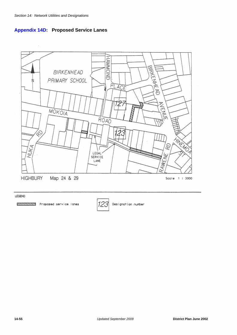
Section 14: Network Utilities and Designations
14-55 Updated September 2009 District Plan June 2002
Appendix 14D: Proposed Service Lanes

Section 14: Network Utilities and Designations
District Plan June 2002 Updated September 2009 14-56
Appendix 14E: Proposed Service Lane

Section 14: Network Utilities and Designations
14-57 Updated September 2009 District Plan June 2002
Appendix 14F: Proposed Service Lanes

Section 14: Network Utilities and Designations
District Plan June 2002 Updated September 2009 14-58
Appendix 14G: Proposed Service Lane

Section 14: Network Utilities and Designations
14-59 Updated September 2009 District Plan June 2002
Appendix 14H: Development Plan For the Designation of Refuse Disposal Purposes at Rosedale Road
i) Operation and Management Conditions Attached to the Designation.
1.0 Major Control Requirements
1.1 The development of the Rosedale Landfill (hereinafter referred to asthe ‘landfill’) shall proceed in accordance with the provisions of theDevelopment Plan included in Appendix 14H.
1.2 The landfill shall be operated in conjunction with a refuse transferstation and shall not be open to the general public except in anextreme emergency.
1.3 All vehicles shall enter and leave the landfill from Greville Road and novehicle access shall be permitted from Rosedale Road.
1.4 Except insofar as is necessary to construct vehicle access as soon aspractical from the Stage 1 extension to Greville Road, as required inCondition 4 of Major Control Requirements of the Consent Order forthe Rosedale Landfill Stage 1 Extension, the Auckland RegionalCouncil shall not commence landfill until both the present landfill andthe Stage 1 extension are full.
1.5 There shall be no consent given at any stage in the future to the furtherextension of refuse disposal facilities at or within the vicinity ofRosedale Road.
1.6 That refuse disposal on the landfill site shall cease in the year 2005.
1.7 The landfill shall be operated and developed so that the final levels ofrefuse landfill and restoration works shall comply with the levelsdepicted on the Development Plan, except insofar as any modificationmay be agreed between the ARC and the city Council. It isacknowledged that this obligation shall be satisfied as soon aspracticable after the refuse landfill is complete and followingsatisfaction of the obligation at that time, the ARC shall not have acontinuing obligation in this regard.
1.8 All works of an engineering nature shall require approval of the cityEngineer.
2.0 Establishment Works
2.1 The ARC shall obtain all necessary water rights from the RegionalWater Board for the collection and disposal of leachate and shallcomply with the terms and conditions of these rights.
2.2 The ARC shall obtain all necessary water right and engineeringapprovals from the city Council for sediment erosion and silt collection,and for the construction of the proposed culvert to carry the flow of thetributary to the Oteha Stream through the landfill site, as well as forsuch connecting pipes as are required for the tributary stream in theculvert beneath Greville Road, the runoff fromexisting landfill areas,natural seepage and the like.
2.3 The ARC shall place a seal of clay compacted to a minimum depth ofone metre over the top of the culvert. This clay seal shall be providedto the satisfaction of the Regional Water Board to ensure that leachateis directed to the leachate drain, and to the satisfaction of the cityCouncil to ensure that sound engineering practice is followed.
2.4 The ARC shall obtain engineering approval from the city Council for anoverland flow path for the tributary stream, this flow path beingmaintained at each stage in the operation of the landfill as well as inthe ultimate development of the land for recreational purposes.However, the ARC is advised that it may be necessary for the Council

Section 14: Network Utilities and Designations
District Plan June 2002 Updated September 2009 14-60
to obtain the approval of the Regional Water Board to a modification ofWater Right No. 833824 held by the Council.
2.5 The overland flow path shall be designed to come into operationimmediately the upstream detention pond has reached its design peaklevel.
2.6 The ARC shall construct drains for the collection of leachate. Thesedrains shall be provided to the satisfaction of the Regional WaterBoard to convey leachate from the landfill to a proposed leachaterecirculating system or to the existing 80mm leachate pumping mainto the North Shore Drainage Board treatment plant and to thesatisfaction of the city Council to ensure that sound engineeringpractice is followed.
2.7 The entrance and access road off Greville Road, including suchwidening of the carriageway as may be necessary, shall be designed,constructed and sealed to the satisfaction of the city Council.
2.8 The internal road giving access to the disposal site shall be sealedfrom Greville Road to the wheelwash.
2.9 The wheelwash facility shall be designed to the satisfaction of the cityCouncil and maintained in a manner that at all times ensures theeffective cleaning of vehicles leaving the landfill.
2.10 The excavation of cover material by earthmoving machinery shall onlyoccur between the hours of 7.00 am and 8.30 pm, Mondays toSaturdays. There shall be no excavation on Sundays.
2.11 The ARC shall ensure that all earthmoving machinery is equipped witheffective mufflers.
2.12 Screen planting along the Greville Road frontage and easternboundary of the landfill shall commence during the first plantingseason after the requirement is finally confirmed. In this regard aplanting plan shall be prepared by the ARC and approved by the cityCouncil prior to planting commencing. The planting plan shalldetermine which existing trees and vegetation shall be retained.
2.13 Such fire breaks shall be provided around the edge of the disposal siteas may be required by the New Zealand Fire Service.
2.14 All signage shall be the subject of separate planning approval.
3.0 Landfill Management and Operations
3.1 All landfill operations shall be under the direct supervision of the ARC.
3.2 At the end of each day refuse shall be covered either with soil or finemesh netting. The manner for dealing with refuse left overnight shallbe monitored and the Medical Officer of Health shall have the right todirect that it be covered with soil should he/she consider that thispractice is necessary.
3.3 The ARC shall deal with hazardous wastes in accordance with itsRefuse Disposal Baylaw 1976.
3.4 Immediate and effective action shall be taken to deal with refuse thatis particularly objectionable because of smell.
3.5 Immediate and effective action shall be taken to eliminate vermin orinsect infestation should this become evident. Where necessary, thisaction shall include an ongoing programme of eradication.
3.6 Should the ARC devise an acceptable technique for effectivelystopping seagulls from gathering at the landfill, it shall apply thistechnique immediately.

Section 14: Network Utilities and Designations
14-61 Updated September 2009 District Plan June 2002
3.7 Temporary contour drains shall be formed around the landfill to thesatisfaction of the city Council to intercept stormwater flowing fromhigher ground and areas of covered refuse.
3.8 Permanent stormwater drainage for the completed landfill shall beinstalled as required to the satisfaction of the city Council.
3.9 Landfill operations including earthworks associated with land-fillingshall be carried out under the supervision of an appropriately qualifiedperson who shall ensure that these works are undertaken in a mannerthat ensures the stability of the land and all pipelines contained therein.
3.10 Refuse shall be conveyed to the landfill in totally enclosed vehicles.The only exception to this shall be in the event that the landfill isopened to the general public in an extreme emergency. In this event,the ARC shall charge an additional fee for loads which, in the opinionof the ARC staff, are insecure.
3.11 Windblown litter shall be contained effectively within the landfill by theerection of nets and screens, and these shall be cleared of litter atweekly intervals or more frequently as necessary.
3.12 The ARC shall carry out patrols along the Greville Road and StateHighway 1 frontage of the landfill to pick up:
a) litter blown beyond the nets and screens at weekly intervals ormore frequently as necessary; and
b) refuse illegally deposited at the roadside as required.
3.13 The ARC shall ensure that all operating equipment used on the landfillis equipped with effective mufflers.
3.14 That the operation of the landfill shall comply with the rules of theproposed District Plan with regard to Odour (Rule 10.4.2), Dust (Rule10.4.3) and Noise (Rule 10.5).
4.0 Completion Works
4.1 The ARC shall place a minimum of 500mm of soil on the finishedsurfaces of the landfill as soon as practicable after refuse land-filling iscomplete and sow the area with grass.
4.2 The ARC shall have a continuing responsibility for leachate collectionand disposal beyond the life of the landfill as a disposal facility untilsuch time as the Regional Water Board gives written notice to theCouncil that this is no longer required.
4.3 Should sewerage reticulation be provided in the vicinity of the landfillprior to the Regional Water Board giving notice to the Council underClause 4.2 above, the Council may require the leachate drains to beconnected to this reticulation at the ARC’s cost.
4.4 The City Council is concerned as to the eventual ownership of thecompleted landfill and its further development (after proper completionof the landfill works) to a state suitable for recreational or associatedpublic use. Whilst these matters are affected by legal conditions whichimpose constraints on the ARC’s powers, the ARC shall continue toparticipate in discussions on these issues with the Council.

Section 14: Network Utilities and Designations
District Plan June 2002 Updated September 2009 14-62
Appendix 14I: Possible End Use Proposal for the Refuse Disposal Site at Rosedale Road

Section 14: Network Utilities and Designations
14-63 Updated September 2009 District Plan June 2002

Section 14: Network Utilities and Designations
District Plan June 2002 Updated September 2009 14-64

Section 14: Network Utilities and Designations
14-65 Updated September 2009 District Plan June 2002

Section 14: Network Utilities and Designations
District Plan June 2002 Updated September 2009 14-66
Appendix 14J Schedule of Heritage Orders
[No Heritage Orders as at 28 June 2002]

Section 14: Network Utilities and Designations
14-67 Updated September 2009 District Plan June 2002
Appendix 14K "Part A" Electricity Transmission Steel Tower Replacement as a Controlled Activity
(Refer Section 14: Table 14.1)
Part B Height Increase of Electricity Transmission Steel Tower as a Controlled Activity
An increase in tower height is a controlled activity where, due to encroachment caused by the action of a thirdparty (and not due to the consequences of actions such as uprating or resagging conductors), compliance withthe clearance distances specified in NZECP 34:2001 is required. The increase in tower height must not begreater than 2m or 10% of the initial height of the tower, whichever is lesser.

Section 14: Network Utilities and Designations
District Plan June 2002 Updated September 2009 14-68
Appendix 14L: Exclusion from the Resource Management Act

Section 14: Network Utilities and Designations
14-69 Updated September 2009 District Plan June 2002
Appendix 14M: Conditions Attached to the Designation of Auckland Prison (Designation 120)
1. The following condition (comprising parts a, b, c and d) applies to the whole ofDesignation No. 120 Auckland Prison.
a) Maximum Capacity
i) That a maximum of 681 prisoners be accommodated within the penalinstitution at Paremoremo.
ii) Under this designation, no new buildings or external alterations are to bemade to existing buildings to accommodate the extra 31 prisoners,additional to the previous maximum of 650 prisoners.
b) Landscaping
i) The requiring authority shall carry out landscaping on the site inaccordance with the landscape plan attached as Attachment A.
ii) All planting associated with the landscape plan shall be maintainedregularly until fully established and kept in a tidy condition, includingreplacement if any planting dies or is destroyed. The replacement of anyplanting shall be of the same type, grade and size as the one it replaces,unless otherwise approved in writing by Auckland Council, and shall beplanted no later than the next planting season (i.e. April to September)following discovery of the need for replacement.
c) Parking
To alleviate the apparent parking shortage associated with the eastern wing,the requiring authority shall construct a further eight (8) car parks within 100metres from the eastern wing.
d) Noise
The requiring authority shall ensure that the following maximum noise limitsshall be complied with at all times at the boundaries of the subject site(excluding the boundary of Lot 3 DP 64 525, which continues to be covered byCondition 2b)) as follows:
Noise will be measured in accordance with NZS 6802:1991, Assessment ofEnvironment Sound, and NZS 6803P:1984, the Measurement andAssessment of Noise from Construction, Maintenance and Demolition Work.Noise standards shall not apply to noise for emergency and warning purposes.
2. The following conditions (2a - 2g) relate only to Lot 3 DP 64525 situated on thecorner of Iona Avenue and Sanders Road:
a) Odour
No activity undertaken on Lot 3 DP 64525 shall create any intrusive odour thatis, or is likely to be, either objectionable or offensive in the opinion of anenforcement officer, and is able to be detected beyond the boundary of thePrison designation.
b) Noise
Prior to the establishment of any activity on Lot 3 DP 64525 that may generatenoise less than but within 5dBA of the noise standards specified in the tablebelow, an Acoustic Design Report shall be obtained from a suitably qualified
0700hrs - 2200hrs 2200hrs - 0700hrs
55 dBA L10 40 dBA L1075 dBA Lmax

Section 14: Network Utilities and Designations
District Plan June 2002 Updated March 2012 14-70
Acoustic Engineer confirming that the activity will not exceed the noise levelsspecified below:
Noise will be measured in accordance with NZS 6802:1991 Assessment ofEnvironmental Sound and NZS 6803P:1984 The Measurement and Assessmentof Noise from Construction, Maintenance and Demolition Work and noisestandards shall not apply to noise for emergency and warning purposes.
c) Outdoor Lighting
i) Outdoor lighting on Lot 3 DP 64525, shall be so selected, located, aimed,shielded, adjusted and screened as to ensure that glare resulting from thelighting complies with the standards specified in the table below.
ii) All outdoor lighting shall be directed downward and shielded from Lot 2 DP64525 subject to achieving necessary security requirements.
d) Vibration
No activity on Lot 3 DP 64525 shall be permitted to create vibration levels(acceleration in metres per second squared) relative to frequency which affectoccupants of adjacent buildings by exceeding the base curves of Figures 2a (zaxis), 3a (x and y axis), and 4a (combined xyz axis) of International Standard ISO2631-2:1989 - Evaluation of human exposure to whole-body vibration - Part 2:Continuous and shock-induced vibration in buildings (1 to 80 Hz).
Vibration will be measured in accordance with ISO 2631:1989, AS 2973: 1987and AS 2187.2:1993
e) Tree Planting
A buffer strip, to achieve a continuous visual screen of activities occurring on Lot3 DP 64525 as viewed from Lot 2 DP 64525, shall be planted on Lot 3 DP 64525alongside the boundary with Lot 2 DP 64525 ("the Rudd property") in accordancewith the diagrams entitled "Proposed Plan of Iona Avenue Boundary ShowingFences & Trees to Rudd Property with Corrections" (see the following 2 pages).The buffer strip is to be established no later than the planting season followingthe operative date of this District Plan.
The buffer strip planting is to be mulched and watered for a minimum period oftwo years following the initial planting and maintained continuously thereafter, bythe Requiring Authority. All newly planted trees that die or decline such that inthe opinion of the Council's Monitoring Officer they are or will be of no screeningvalue, must be replaced. The replacement trees should be of the same type,grade and size and planted no later than the following planting season (May toAugust), following instruction to do so by Council.
Maximum Permitted Noise Level measured at the boundary of Lot 3 DP 64525
Mon - Sat inclusive0700 hrs - 2000 hrs
Mon - Sat inclusive2000 hrs - 2300 hrs
Sun & Public Holidays0700 hrs - 2400 hrs
All Other Times
50 dBA L10 45 dBA L10 45 dBA L10 40 dBA L1075 dBA Lmax
Outdoor lighting measured horizontally or vertically at the boundary of Lot 2 DP 64525 (being the property owned by Mr P & Mrs M Rudd as at 4/2/02) shared with Lot 3 DP 64525
0700 and 2200 hrs added illuminance no more than 125 lux
2200 and 0700 hrs added illuminance no more than 20 lux

Section 14: Network Utilities and Designations
14-71 Updated September 2009 District Plan June 2002
At any time, the specified plant species may be altered if prior approval isprovided in writing by Auckland Council.
f) Access to Lot 3 DP 64525
Heavy vehicle access to Lot 3 DP 64525 will not be allowed from the roadfrontage of Iona Road.
g) Security Fencing
Security fencing will not be erected on the common boundary between Lots 2 &3 DP 64525.

Section 14: Network Utilities and Designations
District Plan June 2002 Updated September 2009 14-72

Section 14: Network Utilities and Designations
14-73 Updated September 2009 District Plan June 2002

Section 14: Network Utilities and Designations
District Plan June 2002 Updated September 2009 14-74
Appendix 14N: "Defence Purposes" Designation Definition
Full Description of the Purpose of the Designation(to explain the term "Defence Purposes")
The designation applies to the Defence areas (defined at Section 2 (1) of the DefenceAct that are included in the Schedule of Designations and the District Plan Maps forthe Devonport locality.
The Defence Areas are administered by the New Zealand Defence Force (NZDF) andare currently occupied by the Royal New Zealand Navy, its contractors and licensees.The Areas are a Defence Work and may be utitlised for any or every purpose requiredby Section 5 of the Defence Act 1990, which are as follows:
a The defence of New Zealand, and of any area for the defence of which NewZealand is responsible under any Act.
b The protection of the interests of New Zealand, whether in New Zealand orelsewhere.
c The contribution of forces under collective security treaties, agreements orarrangements.
d The contribution of forces to, or for any of the purposes of, the United Nations, orin association with other organisations or States and in accordance with theprinciples of the Charter of the United Nations.
e The provision of assistance to the civil power either in New Zealand or elsewherein time of emergency.
f The provision of any public service.
The Governor-General of New Zealand, continues to raise and maintain Armed Forceson behalf of Her Majesty the Queen. Given the obligations placed on the New ZealandDefence Force by the Crown to meet the Crown’s military defence needs, includingthose imposed by any enactment or by the policies of the government, the function ofthe Defence Areas include, at all times, to provide for the following functions of the NewZealand Defence Force (including visiting forces and third parties contracted to theNew Zealand Defence Force):
i) Defence Force command, land operations, sea operations, air operations,training, logistic support, ship berthing and docking, construction, repair,maintenance, munitions handling and storage, administration, andcommunication, and for the acquisition and improvement of the skills necessaryfor such functions;
ii) resources, accommodation and facilities for these functions;
iii) accommodation for members of the New Zealand Defence Force and any visitingforce, training, recreational, welfare and medical facilities for them;
iv) facilities for the storage of matériel, food and fuel, and the conservation anddisplay of historic material;
v) facilities for the construction, repair and maintenance of vessels, aircraft, vehiclesand other equipment, including the vessels, aircraft, vehicles and equipment offorces of other nations;
vi) to provide for the rapid and efficient deployment of the New Zealand DefenceForce.
vii) any other activity required in the delivery of New Zealand Defence Force outputsas described annually in the Departmental Forecast Report: New ZealandDefence Force.

Section 14: Network Utilities and Designations
District Plan June 2002 Updated June 2009 14-75
Appendix 14O Clarification of Designation 184 (Pinehill Telecommunication Facility)