12d: advanced mapbasicdl.mapinfogroup1.com/session-pdf/12d_jim_regan.pdf12d hands-on: advanced...
TRANSCRIPT

12D: Advanced MapBasic
Jim Regan
Senior Consultant
Pitney Bowes Software – Global Services

Who am I ?
• Jim Regan
• Senior Consultant, Pitney Bowes Software, Global Services
• 14+ years at MapInfo/Pitney Bowes Software
• Training
• Developer Services
• Professional Services
• Global Services

12D Hands-On: Advanced MapBasic
• As a developer, you can leverage the power of MapBasic to create custom-tailored applications that help the user perform tasks quickly and easily.
• By automating processes for the user, you can get your users to be productive with minimal training and spare end-users the tedium of doing time-consuming manual work.

12D Hands-On: Advanced MapBasic
• This session will touch on capabilities in MapBasic application development such as:
• Customizing the MapInfo user-interface
• Computing Weighted Average Location
• Automating routine and repetitive tasks, such as, search-at-point processing, thematic mapping, generating layout windows, workspaces
• Programming advanced SQL Queries.

MapBasic Applications
• Turn-key systems - Application designed as a complete solution for a specific job ie. Crime analysis
• Extensions - Applications that add new operations to the basic functionality of MapInfo. ie. Locate nearest point
• Utilities - Applications that are designed to automate routine or repetitive tasks. ie. Weekly reports

Data tables used in this session
• Workspaces
• 12D_Part1.WOR
• 12D_Part2.WOR
• Region Data
• STATES.TAB
• SALES_REGIONS.TAB
• US_COUNTIES.TAB
• US_ZIPS
• Point Data
• CUSTOMERS.TAB
• CITY_125.TAB
• Line Data
• SOMEHIWAYS.TAB
Agenda
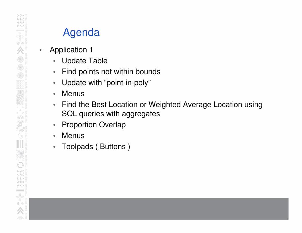
• Application 1
• Update Table
• Find points not within bounds
• Update with “point-in-poly”
• Menus
• Find the Best Location or Weighted Average Location using SQL queries with aggregates
• Proportion Overlap
• Menus
• Toolpads ( Buttons )
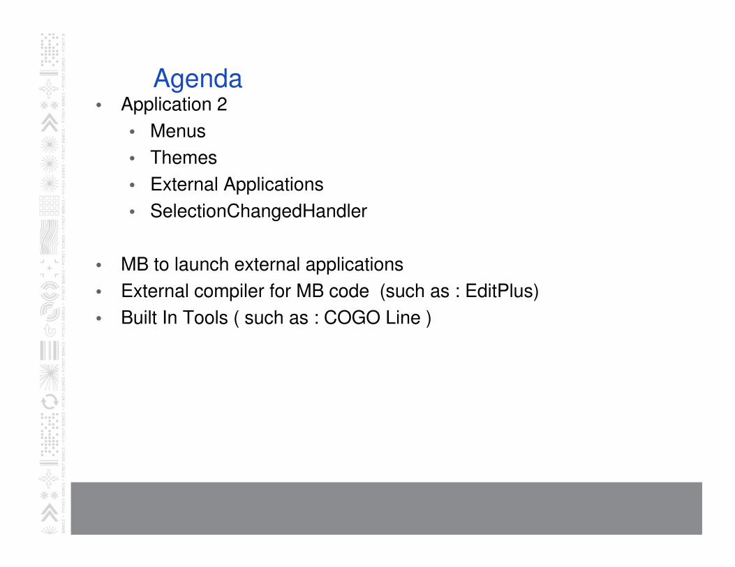
Agenda• Application 2
• Menus
• Themes
• External Applications
• SelectionChangedHandler
• MB to launch external applications
• External compiler for MB code (such as : EditPlus)
• Built In Tools ( such as : COGO Line )

Menu Statements to Know
• Create Menu Bar
• Alter Menu Bar
• Create Menu
• Menu Bar
• Context Menus

Toolbar Statements to Know
• Alter Button
• Alter ButtonPad
• Create ButtonPad
• Create ButtonPads As Default

Weighted Average

Find the Weighted Average Location
• The WtAvg aggregate function provides a easy way to calculate a weighted centroid.
• To calculate a weighted centroid, use SQL Select, choose the table containing points and weighting data, and use the following formula in the 'Select’ statement.
WtAvg(CentroidX(obj),{weightcolumn}),WtAvg(CentroidY(obj),{weight column})
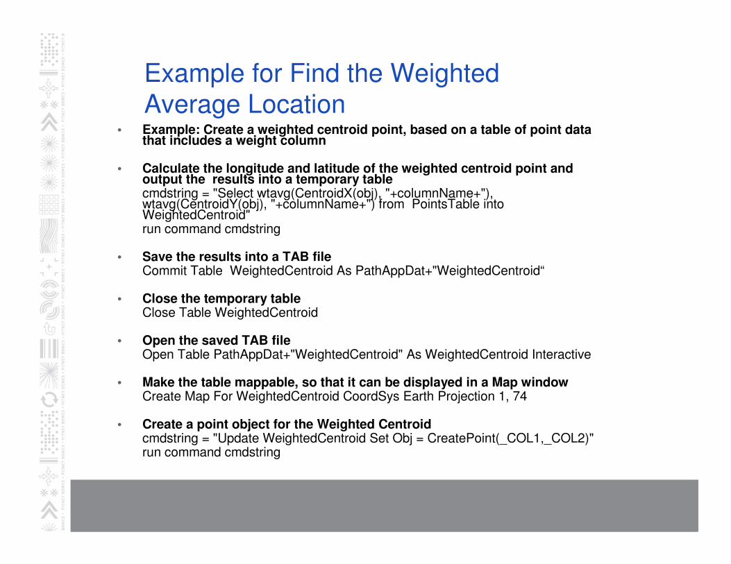
Example for Find the Weighted
Average Location• Example: Create a weighted centroid point, based on a table of point data
that includes a weight column
• Calculate the longitude and latitude of the weighted centroid point and output the results into a temporary tablecmdstring = "Select wtavg(CentroidX(obj), "+columnName+"), wtavg(CentroidY(obj), "+columnName+") from PointsTable into WeightedCentroid"run command cmdstring
• Save the results into a TAB fileCommit Table WeightedCentroid As PathAppDat+"WeightedCentroid“
• Close the temporary table Close Table WeightedCentroid
• Open the saved TAB fileOpen Table PathAppDat+"WeightedCentroid" As WeightedCentroid Interactive
• Make the table mappable, so that it can be displayed in a Map window Create Map For WeightedCentroid CoordSys Earth Projection 1, 74
• Create a point object for the Weighted Centroidcmdstring = "Update WeightedCentroid Set Obj = CreatePoint(_COL1,_COL2)"run command cmdstring

Update Columns•Update WeightedCentroid Set Obj = CreatePoint(_COL1,_COL2)
•Update CUSTOMERS Set County = "", SalesREgion="",SalesRep="“
•update sales_region set revenue=0
•Add Column "CUSTOMERS" (County) From US_county Set To County
Where contains
•Add Column "CUSTOMERS" (SalesRegion) From Sales_REGION Set To
REGION_ID Where contains
•Add Column "CUSTOMERS" (SalesRep) From SALES_REGION Set To
SalesRep Where COL9 = COL1

SQL

Useful SQL Functions
• Filter Information from a table• Select by tabular data (text, numbers, etc)• Select by geographic data length, color, size• Like statement
• SubSelects• Select Points Inside a Region• Select Bordering Boundaries
• Join Tables • Understand the Geographic Operators
• Derive Information from a Table• Proportion Overlap, AreaOverlap, ObjectLen, Weighted Average• Extract Latitude and Longitude From a Table of Points • CentroidX, CentroidY, ObjectLen, Round• Create Buffers and Find Distance
• Aggregate and Summarize Data• Count, Min, Max, Avg

Geographic relationships
• Geographic relationships two objects may have
• Within, Entirely Within, Contains, Contains Entire, and Intersects.
• The circle is within New York, since the circle's centroid is
inside the borders of New York.
• The square contains the circle, since circle's centroid is
inside the square.
• The triangle is entirely within New York since 100% of the
triangle is inside of New York.
• New York contains the square, circle and the triangle.
• New York contains entire for the triangle.
• Objects intersect if they touch at any point.

Some Sample SQL statements
• select "<option value=""" + fips_code + """>" + county + "</option>"from US_county where State="NV" order by
county into NV_HTML_TO_PASTE
• browse * from NV_HTML_TO_PASTE
• Select * from CUSTOMERS where not obj into
CUSTOMER_NO_MAP_OBJECT
• Browse * From CUSTOMER_NO_MAP_OBJECT

Some Sample SQL statements
• Select Name, Company, City + ", " + state , CentroidX(obj) "X", CentroidY(obj) "Y" from customers
where Sales2006 < 2500 into CustXY order by state, city
• Browse * From CustXY
• Select * from CUSTOMERS where rowid\2 = rowid/2 into
CUSTOMER_SUBSET
• Browse * From CUSTOMER_SUBSET

Some Sample SQL statements
• Select * from states where state not in ( select customers.state from states, customers where states.obj
contains customers.obj group by 1 ) into
States_Without_Customers
• browse * from States_Without_Customers

Launching External Applications
• Run Program "notepad.exe /p c:\test.txt“
• Prints C:\text.txt in notepad
• Run Program "C:\Program Files\Internet Explorer\iexplore.exewww.mapinfo.com“
• Runs Explorer and navigates to www.mapinfo.com
• Run Program "C:\Program Files\Microsoft Office\OFFICE11\EXCEL.EXE /p c:\temp" <folder>
• Forces Excel to use the path that you specify as the active path instead of the default path. Example: /p "C:\Windows"
• Run Program "C:\Program Files\Microsoft Office\OFFICE11\EXCEL.EXE c:\test.txt“
• Starts Excel and loads C:\text.txt

Using IDE’s other than MapBasic’s ID“e”
• You can use other code editors instead of the MapBasic editor.
• Any code/text editor will do. Some will let you compile the MapBasic code from within the editor.
• Codewright
• EditPlus
• UltraEdit
• Notepad
• Etc.

Using IDE’s other than MapBasic’s ID“e”
• Command switches for MB
• Compile
• C:\Program Files\MapInfo\MapBasic\mapbasic.exe –D MapBasicApp.MB
• Link
• C:\Program Files\MapInfo\MapBasic\mapbasic.exe –L MapBasicApp.MB
• Codewright support
• http://testdrive.mapinfo.com/techsupp/miprod.nsf/kbase_by_product/B537F99BA39DCCC7852566CD005A96E4

Example: EditPlus3

Tools In MapInfo Professional

Built In MapInfo Tools
• A groups of tools found under the “Tools” menu of MapInfo Professional

How to get my MapBasic application to display in the tool manager?
• http://testdrive.mapinfo.com/techsupp/miprod.nsf/kbase_by_product/CA59D8532996D297852565B000652052

Source code provided for the samples
• C:\Program Files\MapInfo\MapBasic\Samples\MAPBASIC\COGOLINE
• COGOLINE.DEF
• COGOLINE.MB
• COGOLINE.STR
• COGOLINE.MBP

Where Do I Find More Information on
MapBasic
• MapBasic Sample Applications• Source code for over 35 MapBasic extensions available
for use under the Tool Manager in MapInfo Professional.• Many good examples on how to accomplish specific
tasks using MapBasic• MapBasic Knowledgebase
• Search the knowledgebase for examples on how to accomplish specific tasks using MapBasic.
• http://testdrive.mapinfo.com• MapInfo Training Classes
• http://www.mapinfo.com/training• MapInfo Professional Services• MapInfo User Groups