125 high st, colliers wood, london, sw19 · 125 high st, colliers wood, london, sw19 ....
TRANSCRIPT

125 HIGH ST, COLLIERS WOOD, LONDON, SW19
ARCHAEOLOGICAL EVALUATION
Report Number: 1017 March 2013

© Britannia Archaeology Ltd 2013 all rights reserved Report Number 1017
125 HIGH ST, COLLIERS WOOD, LONDON, SW19
ARCHAEOLOGICAL EVALUATION
Prepared on behalf of: Mr James Hopkins MRICS
(acting for Sutherland House Ltd) Criterion Capital
13 Coventry Street London
W1D 7DH
By: Matthew Adams BA AIfA
Britannia Archaeology Ltd
4 The Mill, Clovers Court, Stowmarket, Suffolk,
IP14 1RB T: 01449 763034
[email protected] www.britannia-archaeology.com
Registered in England and Wales: 7874460
February 2013
Site Code
HSC13
NGR
526763 170281
Planning Ref.
10/P2784
OASIS
britanni1-143555
Approved By:
Tim Schofield
Date
16th March 2013

125 High Street, Colliers Wood, London, SW19 Archaeological Evaluation
1 ©Britannia Archaeology Ltd 2013 all rights reserved Report Number 1017
CONTENTS Abstract Page 2
1.0 Introduction Page 3 2.0 Site Description Page 3 3.0 Planning Policies Page 3 4.0 Archaeological Background Page 5 5.0 Project Aims Page 7 6.0 Project Objectives Page 8 7.0 Fieldwork Methodology Page 8 8.0 Presentation of Results Page 8 9.0 Deposit Model Page 10 10.0 Discussion & Conclusion Page 11 11.0 Project Archive & Deposition Page 12 12.0 Acknowledgments Page 12
Bibliography Page 13
Appendix 1 Deposit Tables and Feature Descriptions Page 14 Appendix 2 Specialist Reports Page 16 Appendix 3 Concordance of Finds Page 17 Appendix 4 OASIS Sheet Page 19
Figure 1 General Location Plan 1:500 Figure 2 Trench, Feature and Sample Location Plan 1:500 Figure 3 Trench 1 – Section and Photos 1:10 Figure 4 Test Pits 1 & 3 – Sections & Photos 1:10 & 1:20 Figure 5 Test Pit 2 – Plan, Section & Photos 1:10 & 1:20

125 High Street, Colliers Wood, London, SW19 Archaeological Evaluation
2 ©Britannia Archaeology Ltd 2013 all rights reserved Report Number 1017
Abstract In February 2013 Britannia Archaeology Ltd (BA) undertook an archaeological trial trench evaluation at Brown & Root Tower, 125 High Street, Colliers Wood, London, SW19 (NGR: 526763 170281) in advance of refurbishment and the construction of extensions to the existing tower. A desk-based assessment was produced by Mills Whipp Projects Ltd in 2010 which concluded there was a significant potential for surviving Roman and post-medieval remains to be present on site. MoLAS carried out work adjacent to the site in 1997 and this revealed evidence of prehistoric palaeochannels and the Roman Road (Stane Street). These were sealed by alluvial flood deposits which were overlaid by 18th and 19th century AD material. The current evaluation revealed three main phases of activity comprising modern development associated with the construction of the existing tower, 17th – 19th century AD activity including a partially surviving topsoil (1017) and a brick surface (1021) and the final phase was represented by two alluvial layers of indeterminate date. No finds or features dating to the medieval period or earlier were present and the overall results are consistent with the 1997 MoLAS excavation adjacent to the site. The site has suffered significant truncation from both 19th century and later 20th century development, however some isolated post-medieval remains have survived this process. The adjacent MoLAS excavation noted Roman remains below the alluvial deposits, however this was not evident during the evaluation where the alluvium overlay natural gravels. The absence of any layers or deposits below the alluvium is perhaps significant and may suggest an additional phase of even earlier truncation by natural or human processes.

125 High Street, Colliers Wood, London, SW19 Archaeological Evaluation
3 ©Britannia Archaeology Ltd 2013 all rights reserved Report Number 1017
1.0 INTRODUCTION In February 2013 Britannia Archaeology Ltd (BA) undertook an archaeological trial trench evaluation at Brown & Root Tower, 125 High Street, Colliers Wood, London, SW19 (NGR: 526763 170281) on behalf of Mr James Hopkins of Criterion Capital (on behalf of Sutherland House Ltd). The work was commissioned to comply with a condition of planning permission reference 10/P2784 in advance of refurbishment and the construction of extensions to the existing tower including residential, commercial and public buildings. This evaluation was the first phase of archaeological field work following a previous phase of desk-based research, required as a condition of planning permission on the advice of English Heritage Greater London Archaeological Advisory Service (EHGLAAS) to the London Borough of Merton (Decision notice dated 09/04/2008 and EH advice letter dated 07/03/2007, Stevenson). The works comprised the excavation of one trial trench measuring 12.6 x 1.80m and three test pits measuring approximately 3.00 x 1.00m (Figure 2). 2.0 SITE DESCRIPTION Colliers Wood is an area located in south west London in the Borough of Merton. It lies 12km south west of the City of London and around 1km north east of Merton. Colliers Wood is split by the former Roman Road known as Stane Street which now forms part of the modern High Street, the site is located immediately to the east of this road at its southern extent. The site lies within the former medieval parish of Merton which was in the county of Surrey before being absorbed into the London Borough of Merton. It sits at approximately 12m AOD on a roughly triangular parcel of land between Priory Road to the south, and Christchurch Road to the east . A 17-storey building known as the Brown & Root Tower currently occupies much of the area and the proposed development will refurbish and extend the Tower to the north and south. The site lies on the eastern side of the valley of the River Wandle floodplain which is a tributary of the Thames rising at the foot of the South Downs in Waddon and Carshalton. The River Wandle is located c. 50m to the west of the site where there is a confluence with its smaller tributary, the River Pickle. The valley floodplain consists of Wandle Gravel (elsewhere in London equated to the Hackney Gravel BGS 270) dating to c.10,0000 BC overlying Thames floodplain Taplow Gravel and sealed by later local alluvial deposits of brickearth (Mills Whipp, Nov 2010). 3.0 PLANNING POLICIES The archaeological investigation is to be carried out on the recommendation of the local planning authority, following guidance laid down by the National Planning and Policy Framework (NPPF, DCLD 2012) which replaces Planning Policy Statement 5: Planning for the Historic Environment (PPS5, DCLG 2010). Relevant regional planning policy for the

125 High Street, Colliers Wood, London, SW19 Archaeological Evaluation
4 ©Britannia Archaeology Ltd 2013 all rights reserved Report Number 1017
Colliers Wood area is the London Plan (2011): Policy 7.3 and the relevant local planning policies include the Merton Local Development Framework Core Strategy (MDFCS, 2011): Policy CS14. 3.1 National Planning Policy Framework (NPPF, DCLG March 2012) The NPPF recognises that ‘heritage assets’ are an irreplaceable resource and planning authorities should conserve them in a manner appropriate to their significance when considering development. It requires developers to record and advance understanding of the significance of any heritage assets to be lost (wholly or in part) in a manner proportionate to their importance and the impact, and to make this evidence (and any archive generated) publicly accessible. The key areas for consideration are:
• The significance of the heritage asset and its setting in relation to the proposed development;
• The level of detail should be proportionate to the assets’ importance and no more than is sufficient to understand the potential impact of the proposal on their significance;
• Significance (of the heritage asset) can be harmed or lost through alteration or destruction, or development within its setting. As heritage assets are irreplaceable, any harm or loss should require clear and convincing justification;
• Local planning authorities should not permit loss of the whole or part of a heritage asset without taking all reasonable steps to ensure the new development will proceed after the loss has occurred;
• Non-designated heritage assets of archaeological interest that are demonstrably of equivalent significance to scheduled monuments, should be considered subject to the policies for designated heritage assets.
3.2 The London Plan (2011) On 22 July 2011, the Mayor of London published the replacement of the spatial development strategy for Greater London. The relevant section on Heritage management is Policy 7.3: Strategic
• A. London’s historic environment, including natural landscapes, conservation areas, heritage assets, World Heritage Sites, Scheduled Ancient Monuments and memorials should be identified, preserved and restored.
• B. Development should incorporate measures that identify, record, interpret, protect and, where appropriate, present, the site’s archaeology.
Planning decisions
• C. Development should preserve, refurbish and incorporate heritage assets, where appropriate.
• D. New development in the setting of heritage assets, and conservation areas should be sympathetic to their form, scale, materials and architectural detail.

125 High Street, Colliers Wood, London, SW19 Archaeological Evaluation
5 ©Britannia Archaeology Ltd 2013 all rights reserved Report Number 1017
3.3 Merton Local Development Framework Core Strategy (July 2011) Merton Council’s current development plan was adopted in 2011 and replaced the UDP from 2003. Policy CS14 states the Council’s position on archaeology and the built environment and the relevant section is summarised as follows: Policy CS14 All development needs to be designed in order to respect, reinforce and enhance the local character of the area in which it is located and to contribute to Merton's sense of place and identity. We will achieve this by:
• Conserving and enhancing Merton's heritage assets and wider historic environment particularly the valued centres, suburban neighbourhoods, industrial heritage and iconic green spaces, through conservation areas, statutory and locally listed buildings, scheduled ancient monuments, historic parks and gardens and archaeological sites and other non-designated heritage assets.
3.4 Professional Standards All work carried out by Britannia Archaeology Ltd is strictly in accordance with the Code of Conduct (Nov 2012), of the Institute for Archaeologists. For the purpose of this evaluation the following guidance documents will also be consulted and their contents adhered to:
• Standard And Guidance For Archaeological Field Evaluation; Institute for Archaeologists 2009;
• Greater London Archaeology Advisory Service: Standards for Archaeological Work London Region; English Heritage External Consultation Draft July 2009 (Particularly Papers 3 & 4)
• Standards for Field Archaeology in the East of England; East Anglian Archaeology Occasional Paper 14. Gurney, D. 2003.
4.0 ARCHAEOLOGICAL BACKGROUND 4.1 Archaeological/Historical Sources The following archaeological background summarises the desk-based assessment (DBA) produced by Mills Whipp Projects Ltd in 2010 for this project. This DBA used sources from the Greater London Historic Environment Record Office, the London Metropolitan Archive, the Guildhall Library and the London Library. English Heritage PastScape (www.pastscape.org.uk), and the Archaeological Data Service (www.ads.ahds.ac.uk) (ADS) have also been consulted. The earliest evidence for human settlement in the Wandle valley comes from gravel pits. About 1.5km south at Miles Road a Lower Palaeolithic tool, pre 38,000 BC, was reported and a single flake has been recovered from Morden Hall Park (GLHER 020008, 030601). Three handaxes were found 1km to the west and flint artefacts have been found to the south of the site near Ravensbury Park (GLHER 030675, 030602). Upper Palaeolithic and Mesolithic artefacts are also rare (Wymer. 1968).
125 High Street, Colliers Wood, London, SW19 Archaeological Evaluation
6 ©Britannia Archaeology Ltd 2013 all rights reserved Report Number 1017
Neolithic pottery has been found at Kings College Sports Ground, although the finds may have been re-deposited. Three Bronze Age ditches were identified at Varley Way and prehistoric flints have been found at Merton Priory. No clear Iron Age occupation has been found in the area (Saxby, 2007). The main Roman road from London to Chichester, known by its Saxon name of Stane Street (i.e. Stone Street) ran along the present line of the High Street in Colliers Wood, immediately adjacent to the site on the western side. Excavations to the south of the site revealed two phases of Roman road construction using locally sourced gravels and flanked by ditches (Saxby, 2007). Phase one dates to the middle 1st century AD and was 12 – 16m wide between the ditches. Phase two identified reconstruction work on the road with new ditches excavated and a reduction in width to 8-9m. The road is thought to have declined in use during the 3rd century and fallen somewhat into disuse by the 4th century (Saxby, 2007). Several Roman finds have been found in the area. A coin hoard dating to the 4th century AD present further south on Stane Street along with Samian pottery. A Roman brooch and coin were also found near Stane Street (GLHER 030662, 030653) and Roman pottery was found in Merton Bus Garage (Mills Whipp 2010). Substantial evidence for Roman occupation has been excavated at Haslemere First School, about 1km south of the site, where three Roman burials and several ditches were found dating to the late 1st – 2nd century AD (Montague, 1992). Twelve more burials were found nearby on Varley Way (Saxby, 2007) and Roman ditches and features have been recorded at the Benedict Primary School, on allotments in the Wandle Valley and during the excavation at Merton Priory. Also a coin was found in Belgrave Road (GLHER 30659). These extensive features and finds suggest the possible location of a small Roman settlement about 1km to the south, however excavations close to the proposed site have shown little evidence of settlement activity. The primary settlement of Merton (OE settlement by the pool) may be 7th century in date (Saxby, 2007) but the first certain reference is in the late 10th century. The estate of Merton, granted in 967AD included a description of the landmarks which suggest the site lay on the edge of the Merton Estate. The stream of the Pickle, probably the original course of the Wandle, divided the site from Merton to Mitcham. The Roman road may have fallen out of use in the 7th to 9th century. The estate belonged to King Harold but was subsequently owned by William I and remained in Crown hands until granted to Gilbert the Norman in 1114AD. The Domesday Survey in 1086 records 56 villeins and 13 bordars with 18 ploughs. There were also 2 mills. This suggests the presence of a reasonably prosperous settlement centred on the village church, some 1km west of the site. The boundary of the estate lay close to the southern part of the proposed site. Excavations at the Merton Priory site have produced very few remnants of pre-Priory deposits suggesting that the area was open ground in the Saxon period (Saxby, 2007). In 1114AD Henry I granted the ‘vill’ of Merton to Gilbert the Norman. Gilbert built a church and wooden huts in Merton, probably near by the present church. In addition he founded Merton Priory, an Augustinian House, to the south of the site. The Priory became an important centre of learning during the medieval period and was demolished in 1538
125 High Street, Colliers Wood, London, SW19 Archaeological Evaluation
7 ©Britannia Archaeology Ltd 2013 all rights reserved Report Number 1017
during the Dissolution. It now lies beneath a modern shopping centre and Meretun Way. The proposed site lay beyond the Priory and the village and was probably open ground. Following the Dissolution most of the Priory buildings were demolished. However, as the Wandle has a strong current the area became a manufacturing centre from the 1660s, the water power being used to drive mills and looms. A copper mill was established to the west of the site and a backfilled mill pond was excavated to the north. 4.2 Cartographic Sources Map evidence from 1762 (John Rocque) indicates that the site was occupied by small houses where the road from Lower Mitcham joined the High Street at Collier’s Wood. Similarly, in 1786 (Cary) and 1815 (Ordnance Survey) houses are shown fronting the High Street with open ground to the rear. By 1829 houses were also lining Christchurch Road (Laurie). By 1869 (Ordnance Survey) the growth of terrace housing had expanded along the High Street. On the western side of the site a Sunday School had been established amidst the small houses. The remainder of the site was open ground with the south turned over to agriculture. By 1894 (Ordnance Survey) watercress beds had been established and houses with gardens occupied the remainder of the site. The L&SWR railway is shown to the south. The 1913 Ordnance Survey map shows that the area was becoming a suburban part of London. Trams ran down the High Street and the construction of school buildings and other infrastructure had taken place. The watercress beds shown on the 1894 map were being encroached upon for building and by 1935 Priory Road had been established. The site was still largely occupied by terraced houses in 1951, but by 1968, wholesale clearance had taken place. The present Tower and circular car park had been erected by 1976. The predominant potential for archaeology at this site was likely to be post-medieval and modern archaeology relating to 18th-19th century housing. There was also a potential for Roman remains, especially material relating to Stane Street. 4.4 Previous Archaeological Investigations No previous archaeological investigations have taken place on the site, however MoLAS carried out work adjacent to the site on land bounded by High Street, Christchurch Road and the River Pickle in 1997. This revealed evidence of prehistoric palaeochannels and the Roman Road (Stane Street). These were sealed by alluvial flood deposits which were overlaid by 18th and 19th century AD material. 5.0 PROJECT AIMS The aim of the investigation was to enable the archaeological resource, both in quality and extent, to be accurately quantified.

125 High Street, Colliers Wood, London, SW19 Archaeological Evaluation
8 ©Britannia Archaeology Ltd 2013 all rights reserved Report Number 1017
6.0 PROJECT OBJECTIVES The project will consider, but not be limited to, the following objectives:
• Identify the date, approximate form and purpose of any archaeological deposits, together with its likely extent, localised depth and quality of preservation;
• Evaluate the likely impact of past land uses, and the possible presence of masking colluvial/alluvial deposits;
• Establish the potential for the survival of environmental evidence; • Provide sufficient information to construct an archaeological conservation strategy,
dealing with preservation, the recording of archaeological deposits, working practices, timetables and orders of cost.
7.0 FIELDWORK METHODOLOGY A Leica Viva Smart Rover GS08 differential global positioning system (DGPS) was used to accurately set-out the evaluation trench and test pits. These were excavated employing a JCB 3CX 180˚ mechanical excavator fitted with a toothless ditching bucket under the control of a qualified professional archaeologist. Topsoil and subsoil layers were removed carefully down to the first archaeological horizon, thereafter all excavation was undertaken by hand (Figure 1). Topographic survey, trench edges, section locations and archaeological and natural feature survey points were accurately recorded employing the DGPS to produce a pre and post-excavation plan tied into the Ordnance Survey National Grid. The archaeology was preserved by record employing pro-forma sheets, plan and section drawings and appropriate photographic records were taken. All features, finds and samples were given unique context numbers assigned during the recording phases on site. 8.0 DESCRIPTION OF RESULTS Archaeological features and deposits are described below in trench order. Detailed information on all features and deposits can be found at Appendix 1. The trench and test pits varied in depth between 1.8 and 3.2m. Test Pit 2 was most shallow measuring 1.87m, but was not excavated to depth due to limited room for stepping the sides to comply with health and safety concerns. Exposure of the full stratigraphic sequence was achieved in the remaining trench and test pits with the deepest being recorded in Test Pit 1 at 3.20m. Trench 1 and Test Pit 3 were similar in depth at around 1.96m. These results suggest that the natural deposits slope to the east, away from High Street, although this is counter to expectations given the River Wandle lies to the west of site. The difference in depth is therefore likely due to irregular deposition of the terrace gravels rather than a general trend in slope. Evidence of 19th century AD building and 20th century AD demolition was present in all test pits and the trench. The demolition appeared more comprehensive in the north west of the site with no surviving, in-situ, remains present. Demolition in the east and south of
125 High Street, Colliers Wood, London, SW19 Archaeological Evaluation
9 ©Britannia Archaeology Ltd 2013 all rights reserved Report Number 1017
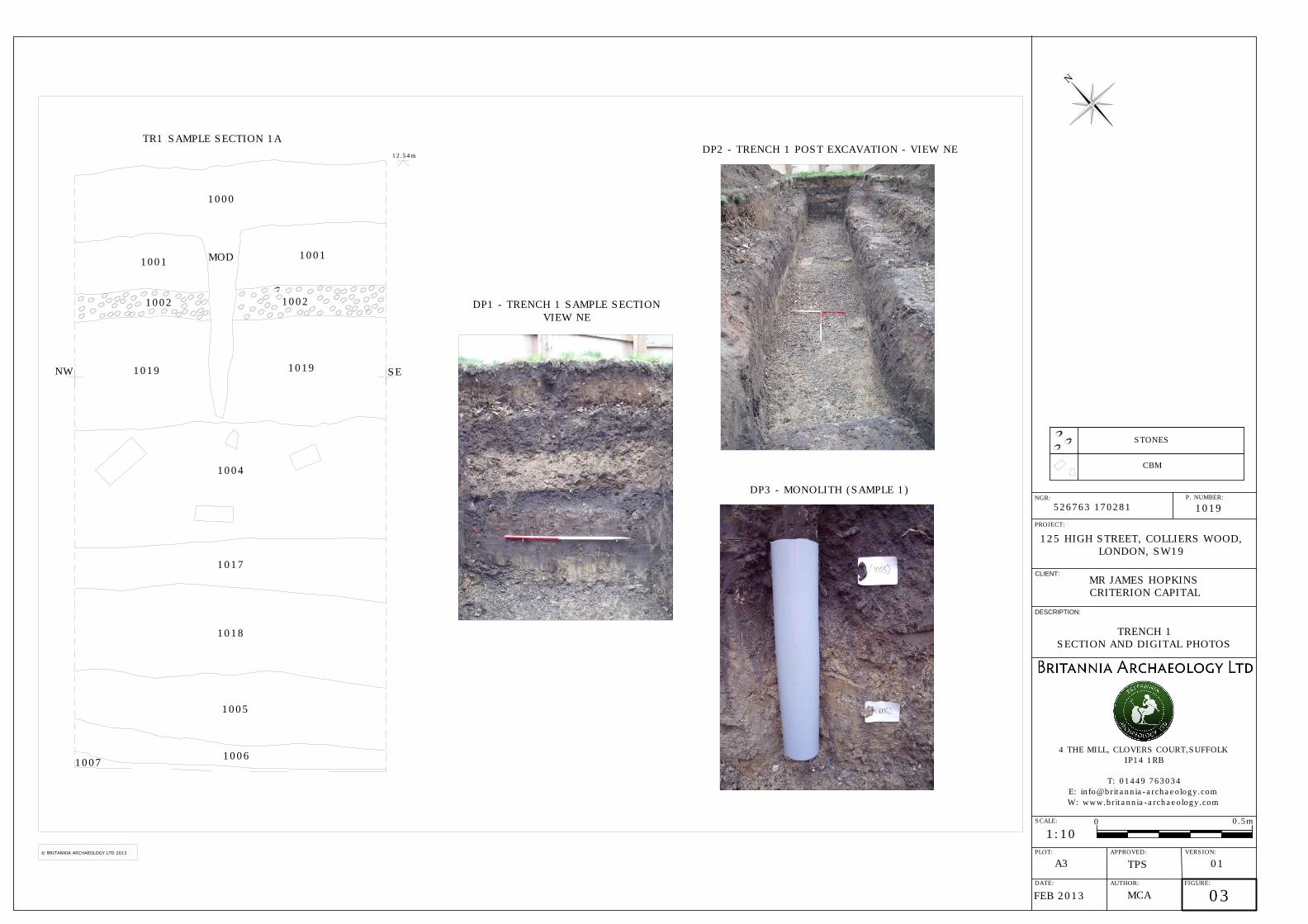
the site was less comprehensive with a small number of former services (mainly ceramic and brick sewers) and a brick surface (1021) surviving. 8.1 Trench 1 (Fig. 3) Trench 1 (Figures 2 & 3) was located in the north western area of the site, adjacent to the High Street and measured 12.6m x 1.80m. The natural geology was encountered at around 1.96m below the current ground surface. No archaeological features were present. Finds were recovered from buried topsoil layer 1017 to assist with dating. These comprise a single sherd of Green glazed Border ware (code: BORDG (1550-1700)) probably dating to the latter half of the 17th and into the 18th century, a fragment from the stem of a clay tobacco pipe from topsoil 1017 dating to the 17th to 19th century and fragment of a fully oxidised red-fired roofing tile dating from the late medieval to the post-medieval period (Goffin, R. see appendix 2). A monolith sample was taken from the two alluvial layers, 1005 and 1006, at the base of the stratigraphic sequence (Figure 3) for pollen analysis. All the pollen sub-samples proved to be barren with pollen concentrations being <1052 grains per ml and the very few palynomorphs seen were in very poor condition. This suggests that these sediments have been previously exposed to episodes of intense oxidation above the groundwater and it is likely that the recent higher groundwater levels caused perhaps by the wet summer of 2012 has reduced the redox potential of the sediment 8.2 Test Pit 1 (Fig. 4) Test Pit 1 (Figures 2 & 4) was located in the north eastern area of the site and measured 4.2m x 1m. The natural geology was encountered at around 3.2m below the current ground surface and the water table was noted at around 2.6m. No archaeological features were present. Fragments of 19th century CBM were present in the upper layers, but were not retained. 8.3 Test Pit 2 (Fig. 5) Test Pit 2 (Figures 2 & 5) was located in the eastern area of the site and measured 3m x 1m. It was excavated to 1.87m, but the natural was not encountered. A small surviving area of in-situ brick surface, 1021, was present at the base of the test pit. It was truncated to the north by a modern ceramic pipe and surviving 19th century sewer services. A brick was retained for dating which showed the surface dates broadly from the 16th to the 18th century.
125 High Street, Colliers Wood, London, SW19 Archaeological Evaluation
10 ©Britannia Archaeology Ltd 2013 all rights reserved Report Number 1017
8.4 Test Pit 3 (Fig. 4) Test Pit 3 (Figures 2 & 4) was located to the south of the existing Tower and on the west side of the site and measured 3m x 1m. The natural geology was encountered at a depth of 1.96m and the water table was noted at around 1.80m. No archaeological features were present. Fragments of 19th century CBM were present in the upper layers, but were not retained. 9.0 DEPOSIT MODEL The deposit model was broadly consistent across the site, but there was some slight variation between the northern area trench and test pits and Test Pit 3 located in the south (Figures 3 – 5). Topsoil 1000 formed the upper layer in the stratigraphic sequence in Trench 1 and Test Pits 1 and 2 and varied in depth between 0.17 and 0.21m. A tarmac surface, 1008, was the most recent layer in Test Pit 3 and was 0.13m deep. Both layers were recent deposits dating to approximately the last 20 years. A made ground or levelling layer, 1001, was present below the topsoil 1000 in the northern area and represented landscaping prior to the topsoil and grass being laid. In Test Pit 3 a former concrete car park surface, 1009, was present below the tarmac 1008 and is probably contemporary with the construction of the existing tower. Gravel layer 1002 was present below 1001 in the northern area and was probably the base layer also associated with recent landscaping. In Test Pit 2 there was a contemporary made ground layer 1010 which formed the base for the overlying concrete 1009 and tarmac 1008. Trench 1 contained a buried soil, 1019, below the gravel 1002 which is likely to date to from the1970’s construction of the Tower and formed an area to the north-west laid originally to grass. Test Pits 1 & 2 contained a concrete surface 1003, which was likely contemporary with 1019, and these layers formed the initial landscaping for the Tower. Test Pit 3 contained concrete layer 1011 which was also likely contemporary with a phase of landscaping after the Tower’s initial construction. Demolition layers 1004 (Trench 1 and Test Pit 2), 1020 (Test Pit 2 and 3), 1012 and 1013 (Test Pit 3) all relate to the demolition of the 19th century buildings and the levelling out of the rubble material during the Tower’s construction. In Trench 1 and Test Pits 2 and 3, the demolition layers contained larger quantities of building material, Layer 1020 appears to have been ‘turned’ during the demolition process to remove underground services. Buried topsoil 1017 was present below the demolition layers in the northern area of the site and represents a partially surviving topsoil dating from the 17th - 19th century AD.

125 High Street, Colliers Wood, London, SW19 Archaeological Evaluation
11 ©Britannia Archaeology Ltd 2013 all rights reserved Report Number 1017
Finds comprised a fragment of Green glazed Border ware (17th – 18th century AD), a fragment from the stem of a clay tobacco pipe (18th – 19th century AD) and a fragment of a fully oxidised red-fired roofing tile dating from the late medieval to post-medieval period. A subsoil, 1018, was present below the buried topsoil 1017 and is likely to be an earlier post-medieval soil layer, however no finds were present. Test Pit 3 had a significantly different sequence to that of the northern area below the demolition layers. A disturbed brick surface 1014 was present below demolition layer 1013 and contained later 19th century brick. This sealed a buried soil layer 1015 which was probably contemporary with the 19th century buried soil 1017, however no finds were recovered. This overlay another demolition layer/made ground layer 1016 which suggests some ground clearance/landscaping prior to the construction of the 19th century buildings. In Trench 1 and Test Pits 1 and 3, the next layer in the stratigraphic sequence was an organic, peat alluvial deposit 1005. No finds were present and the layer was very clean in terms of inclusions. This overlay another alluvial deposit comprising light silty clays, 1006, which was also sterile and free of finds. Both layers were sampled with a monolith tin for further analysis (see Appendix 2). Natural river terrace gravel, 1007, was the final layer in the stratigraphic sequence and was present in Trench 1 and Test Pits 1 and 3. Test Pit 2 was not excavated to depth. 10.0 DISCUSSION AND CONCLUSION The evaluation revealed three main phases of activity. The most recent phase was modern in origin and associated with the construction and subsequent landscaping of the existing tower. This included substantial demolition and damage to earlier 18th and 19th century buildings and deposits, evident in the extensive demolition layers. The second phase represented surviving 17th – 19th century AD layers including a partially surviving topsoil (1017) and a brick surface (1021). The third phase was represented by two layers of alluvial deposits of indeterminate date. No finds or features dating to the middle medieval period or earlier were present. The finds assemblage suggests that the surviving deposits (buried soil 1017 and brick surface 1021) date to the middle and later post-medieval period. These results are consistent with the 1997 MoLAS excavation adjacent to the site which found similar alluvial deposits overlain by 18th and 19th century layers. It is clear that much of the site has suffered significant truncation from both 19th century and later 20th century development, however some isolated post-medieval remains have survived this process as indicated by the brick surface 1021. The adjacent MoLAS excavation noted Roman remains below the alluvial deposits, however no evidence for this was present on the assessment site where the alluvium overlay natural gravels showing evidence of prolonged mineral leeching due to standing water. The absence of any layers

125 High Street, Colliers Wood, London, SW19 Archaeological Evaluation
12 ©Britannia Archaeology Ltd 2013 all rights reserved Report Number 1017
or deposits below the alluvium is perhaps significant and may suggest an additional phase of even earlier truncation by natural or human processes. Sampling of the alluvial deposits showed that preservation of pollen and plant material was poor due to intense oxidisation above the water table. The current development plans propose the use of piling foundations for the new extensions to the front and rear of the existing tower. Given the paucity of in-situ remains, it is likely that the damage to any significant underlying archaeological deposits will be minimal. 11.0 PROJECT ARCHIVE AND DEPOSITION A full archive will be prepared for all work undertaken in accordance with guidance from the Selection, Retention and Dispersion of Archaeological Collections, Archaeological Society for Museum Archaeologists, 1993. Deposition will be with the London Archaeological Archive and Research Centre, Museum of London and GLHER. Arrangements have been made for the archive to be deposited with the London Archaeological Archive and Research Centre, Museum of London subject to agreement with the legal landowner where finds are concerned and in accordance with General Standards for the Preparation of Archaeological Archives Deposited with the Museum of London, August 2009. The archive will be quantified, ordered, indexed, cross-referenced and checked for internal consistency. The material will be catalogued, labelled and packaged for transfer and storage in accordance with the guidelines set out in the United Kingdom Institute for Conservation's Conservation Guidelines No.2 and the Archaeological Archives Forum’s Archaeological Archives, A guide to best practice, compilation, transfer and curation (Brown, 2007). 12.0 ACKNOWLEDGEMENTS Britannia Archaeology would like to thanks Mr James Hopkins of Criterion Capital for commissioning and funding the project and David Rees and John Blackwell for their help and advice. We would also like to thank Diane Abrams at English Heritage Greater London Archaeological Advisory Service for her advice and assistance throughout the project and the GLHER team.

125 High Street, Colliers Wood, London, SW19 Archaeological Evaluation
13 ©Britannia Archaeology Ltd 2013 all rights reserved Report Number 1017
BIBLIOGRAPHY Brown, D.H. 2007. Archaeological Archives. A guide to best practice in creation, compilation, transfer and curation; Archaeological Archives Forum. Brown, N. And Glazebrook, J. 2000. Research and Archaeology: a Framework for the Eastern Counties, 2. research agenda and strategy; East Anglian Archaeol. Occ. Paper 8. English Heritage. July 2009. Greater London Archaeology Advisory Service: Standards for Archaeological Work London Region, External Consultation Draft Gurney, D. 2003. Standards for Field Archaeology in the East of England; East Anglian Archaeology Occasional Paper 14. Institute for Archaeologists. 2010. Code of Conduct. Institute for Archaeologists. October 2008. Standard and Guidance for Archaeological Field Evaluation. Mills, A. D. 2003. Oxford Dictionary of British Place Names. OUP Mills Whipp Ltd. 2010. The Tower (Brown & Root Tower), 125 High Street, Colliers Wood, London, SW19, Archaeological Desktop Report. Museum of London 2009. General Standards for the Preparation of Archaeological Archives Deposited with the Museum of London. Saxby, D. 2007. The Augustinian priory of St Mary Merton Surrey. MoLAS Monograph 34 United Kingdom Institute for Conservation, 1983. Packaging and Storage of Freshly-Excavated Artefacts from Archaeological Sites; Conservation Guidelines No. 2. Wymer, J. 1968. Lower Palaeolithic archaeology in Britain as represented in the Thames Valley. Websites: The British Geological Survey (Natural Environment Research Council) – Geology of Britain Viewer - www.bgs.ac.uk/opengeoscience/home.html?Accordion2=1#maps English Heritage PastScape www.pastscape.org.uk Archaeological Data Service (ADS) www.ads.ahds.ac.uk English Heritage National List for England www.english-heritage.org.uk/professional/protection/process/national-heritage-list-for-england DEFRA Magic http://magic.defra.gov.uk/website/magic

125 High Street, Colliers Wood, London, SW19 Archaeological Evaluation
14 ©Britannia Archaeology Ltd 2013 all rights reserved Report Number 1017
APPENDIX 1 DEPOSIT TABLES AND FEATURE DESCRIPTIONS TRENCH 1 Deposit Tables
Trench No
1 Orientation
NE-SW Height AOD
12.54m Shot No
DP1 Sample Section No
1A Location
NE Side Facing
SW Facing
Context No Depth Deposit Description 1000 0.00 – 0.21m Topsoil. Dark grey brown, loose sandy silt 1001 0.21 – 0.40m Made Ground. Light yellow brown, loose silty sand 1002 0.40 – 0.50m Gravel Layer. Light white grey, loose stone gravel 1019 0.50 – 0.83m Buried Soil. Dark grey brown, compact sandy silt 1004 0.83 – 1.21m Demolition Layer. Light yellow grey, compact CBM & cement 1017 1.21 – 1.42m Buried Topsoil 19C AD – Dark grey brown, friable sandy silt with
CBM & Clinker 1018 1.42 – 1.69m Buried Subsoil. Mid orange brown, compact clay silt 1005 1.69 – 1.89m Organic/Peat Alluvium. Dark brown grey, compact silty clay 1006 1.89 – 1.95m Alluvium. Light yellow grey, compact silty clay 1007 1.95m+ Natural Drift Geology. Light orange yellow, compact sand and
occasional gravel TEST PIT 1 Deposit Tables
Test Pit No
1 Orientation
NE-SW Height AOD
12.53m Shot No
DP4 Sample Section No
1A Location
NE Side Facing
SW Facing
Context No Depth Deposit Description 1000 0.00 – 0.20m Topsoil. Dark grey brown, loose sandy silt 1001 0.20 – 0.46m Made Ground. Light yellow brown, loose silty sand 1002 0.46 – 0.68m Gravel Layer. Light white grey, loose stone gravel 1003 0.68 – 0.79m Concrete Layer. Light grey, very hard concrete with CBM 1020 0.79 – 1.66m Demolition Layer. Mid to dark grey brown, friable sandy silt with
frequent CBM 1017 1.66 – 2.06m Buried Topsoil 19C AD – Dark grey brown, friable sandy silt with
CBM & Clinker 1018 2.06 – 2.44m Buried Subsoil. Mid orange brown, compact clay silt 1005 2.44 – 2.79m Organic/Peat Alluvium. Dark brown grey, compact silty clay 1006 2.79 – 3.19m Alluvium. Light yellow grey, compact silty clay 1007 3.19m+ Natural Drift Geology. Light orange yellow, compact sand and
occasional gravel TEST PIT 2 Deposit Tables
Test Pit No
2 Orientation
N-S Height AOD
12.53m Shot No
DP4 Sample Section No
1A Location
NE Side Facing
SW Facing
Context No Depth Deposit Description

125 High Street, Colliers Wood, London, SW19 Archaeological Evaluation
15 ©Britannia Archaeology Ltd 2013 all rights reserved Report Number 1017
1000 0.00 – 0.20m Topsoil. Dark grey brown, loose sandy silt 1001 0.20 – 0.46m Made Ground. Light yellow brown, loose silty sand 1002 0.46 – 0.68m Gravel Layer. Light white grey, loose stone gravel 1003 0.68 – 0.79m Concrete Layer. Light grey, very hard concrete with CBM 1020 0.79 – 1.66m Demolition Layer. Mid to dark grey brown, friable sandy silt with
frequent CBM 1017 1.66 – 2.06m Buried Topsoil 19C AD – Dark grey brown, friable sandy silt with
CBM & Clinker 1018 2.06 – 2.44m Buried Subsoil. Mid orange brown, compact clay silt 1005 2.44 – 2.79m Organic/Peat Alluvium. Dark brown grey, compact silty clay 1006 2.79 – 3.19m Alluvium. Light yellow grey, compact silty clay 1007 3.19m+ Natural Drift Geology. Light orange yellow, compact sand and
occasional gravel Context Descriptions
Feature Context
Feature Type & Description (m)
Composition Brick Description Spot Date
Finds /g (sherds or number)
Other
1021 Brick Surface (1.00+ x 0.50+ x 0.05m) Unknown extent of surface, however exposed area was rectangular in plan
Rough construction of 29+ bricks of 1 irregular course, bonded with soil
Fine sandy red-fired fabric, hard, well made and uniformly fired. Fabric code 3047 of the London type-series
16 – 18 century AD
Sample Brick 1005 (1)
TEST PIT 3 Deposit Tables
Test Pit No
3 Orientation
NE-SW Height AOD
12.04m Shot No
DP4 Sample Section No
1A Location
NE Side Facing
SW Facing
Context No Depth Deposit Description 1008 0.00 – 0.12m Tarmac Surface. Dark grey black, very hard tarmac 1009 0.12 – 0.16m Concrete. Light grey, very hard concrete 1010 0.16 – 0.24m Made Ground. Mid yellow brown, loose sandy silt with occasional
CBM inclusions 1011 0.24 – 0.30m Concrete. Light grey, very hard concrete 1012 0.30 – 0.53m Demolition Layer. Dark grey black, friable clay silt with CBM and
demolition material 1013 0.53 – 0.78m Demolition Layer. Mid grey brown, compact clay silt with CBM
demolition material 1014 0.78 – 0.88m Disturbed Brick Surface. Mixed light red brown and grey, firm
red brick and soil. Base of demolition above 1015 0.88 – 1.14m Buried Soil. Mid to dark brown grey, compact clay silt. Same As
1017 1016 1.14 – 1.24m Demolition/Mage Ground Layer. Mid grey brown, compact clay
silt with frequent CBM inclusions 1005 1.24 – 1.54m Organic/Peat Alluvium. Dark brown grey, compact silty clay 1006 1.54 – 1.90m Alluvium. Light yellow grey, compact silty clay 1007 1.90m+ Natural Drift Geology. Light orange yellow, compact sand and
occasional gravel

125 High Street, Colliers Wood, London, SW19 Archaeological Evaluation
16 ©Britannia Archaeology Ltd 2013 all rights reserved Report Number 1017
APPENDIX 2 SPECIALIST REPORTS 1. THE FINDS By Richenda Goffin Pottery A single sherd of pottery was recovered from the buried topsoil 1017. It was identified as a fragment of Green glazed Border ware (code: BORDG (1550-1700)). The vessel form is characterised by a small external cordon and in view of the glaze coverage it is likely to date to the later part of the period, probably to the late 17th century or even into the early years of the 18th century. The clay tobacco pipe A fragment from the stem of a clay tobacco pipe from topsoil 1017 cannot be dated more closely than the 17th-19th century. Ceramic building material A fragment of a fully oxidised red-fired roofing tile was present in topsoil deposit 1017 (wt 78g). It is made in a fine hard orange red fabric (fs) with occasional sparse voids and rare calcitic inclusions up to 1mm in diameter. The tile has some signs of mortar on its underside. It is dated from the late medieval to the post-medieval period. A single brick sample was taken from 1020 (wt 1005g). It is made in a fine sandy red-fired fabric, with two complete dimensions (width 117mm and height 46mm). The brick is hard, well made and uniformly fired. The fabric is similar to Fabric code 3047 of the London type-series. The surviving dimensions suggest that it dates from the 16th to 18th century. 2. THE ENVIRONMENTAL ANALYSIS By Dr Steve Boreham Pollen Analysis of River Wandle Floodplain Deposits at Colliers Wood (HSC13), London Steve Boreham BSc. PhD. Introduction This report presents the results of assessment pollen analyses of four sub-samples of sediment taken from floodplain deposits exposed in an excavation at Colliers Wood (HSC1), London. A single c.45cm-long monolith sample (HSC13 TR1 mono1) was provided for assessment. The basal sediments (0-10cm) comprised an orange-buff silty clay (ctx 1006) assessed as having a moderate-poor preservation potential. A sub-sample of sediment was taken at 5cm for assessment pollen analysis. The orange-buff mottling of this unit suggested some oxidation above the water table. However, the fine particle size hinted that oxidation may

125 High Street, Colliers Wood, London, SW19 Archaeological Evaluation
17 ©Britannia Archaeology Ltd 2013 all rights reserved Report Number 1017
not have reached the centre of the peds. Above this (10-20cm) was a unit of orange buff grey sandy silt (ctx 1006) assessed as having poor preservation potential. No pollen sub-sample was taken. The orange-buff mottling suggested oxidation above the water table and the coarser particle size indicated that oxidation was extensive. Above this was a unit (20-27cm) of grey-buff organic silty clay (ctx 1005) from which a pollen sub-sample was taken at 23cm. This unit did not seem to be highly oxidised and the fine particle size and somewhat elevated organic content suggested a moderate preservation potential. The upper-most unit (27-43cm) comprised a dark grey organic silty clay (ctx 1005). Pollen sub-samples were taken at 30cm and 40cm. The elevated organic content and fine particle size all hinted that this unit offered a good preservation potential. The four sub-samples were prepared using the standard hydrofluoric acid technique, and assessed for pollen using a high-power stereo microscope at x400 magnification. The percentage pollen data from these 4 samples is presented in Appendix 1. Pollen Analyses Unfortunately, all four of the sub-samples from HSC1 assessed for pollen proved to be effectively barren with pollen concentrations <1052 grains/ml. The few palynomorphs encountered were in very poor condition and were resistant types such as Asteraceae pollen or undifferentiated monolete Pteropsid spores. This is clearly disappointing because at least some of the material was originally judged to have good-moderate preservation potential. It would seem that these sediments have been previously exposed to episodes of intense oxidation above the groundwater. It is possible that recent higher groundwater levels, caused perhaps by the wet summer of 2012, have reduced the redox potential of the sediments so that they currently appear in a better preservation state than has been the case in the recent past. The attempt at pollen analysis from these deposits was entirely justified, but it is unfortunate that in this instance no useful palaeoenvironmental data could be obtained.

125 High Street, Colliers Wood, London, SW19 Archaeological Evaluation
18 ©Britannia Archaeology Ltd 2013 all rights reserved Report Number 1017
APPENDIX 3 CONCORDNACE OF FINDS
FEATURE FEATURE LAYER/FILL LAYER/FILL SPOT POTTERY CBM ANIMAL BONE HUMAN BONE STRUCK FLINT BURNT FLINT OTHERCONTEXT TYPE CONTEXT DESCRIPTION DATE /g(sherds) /g(number) /g(number) /g(number) /g(number) /g(number) /g(number)
1017 Buried Topsoil 18-19th C 10(1) 91(1) Clay Pipe Stem 10(1)1020 Brick Surface 18-19th C 1005(1)

125 High Street, Colliers Wood, London, SW19 Archaeological Evaluation
19 ©Britannia Archaeology Ltd 2013 all rights reserved Report Number 1017
APPENDIX 4 OASIS SHEET
OASIS DATA COLLECTION FORM: OASIS ID: britanni1-143555 Project details Project Name 125 High Street, Colliers Wood, London, SW19
Short description of the project
The works comprised the excavation of one trial trench measuring 12.6 x 1.80m and three test pits measuring approximately 3.00 x 1.00m. Post-medieval and modern material was present in demolition layers associated with the construction of the existing tower. Alluvial deposits associated with the River Wandle flood plain survived and were sampled for pollen analysis, however the samples were barren. A single 19C floor surface was recorded in TP 2 and no other archaeological features were present.
Project dates Start:05-02-2013 End: 08-02-2013 Previous/future work
Yes / Not known
Any associated project reference codes
HSC13 - Sitecode P1019 - Contracting Unit No.
Type of project Field evaluation Site status Local Authority Designated Archaeological Area Current Land use
Industry and Commerce 2 - Offices
Monument type BRICK SURFACE Post Medieval Significant Finds
CBM Post Medieval
Significant Finds
POTTERY Post Medieval
Methods & techniques
'''Sample Trenches'''
Development type
Large/ medium scale extensions to existing structures (e.g. church, school, hospitals, law courts, etc.)
Prompt Direction from Local Planning Authority - Direction 4
Position in the planning process
After full determination (eg. As a condition)
Project location Country England Site location GREATER LONDON MERTON WIMBLEDON AND MERTON 125 High Street,
Colliers Wood, London, SW19 2JG
Study area 0.52 Hectares
Site coordinates
TQ 26763 70281 51 0 51 25 00 N 000 10 36 W Point

125 High Street, Colliers Wood, London, SW19 Archaeological Evaluation
20 ©Britannia Archaeology Ltd 2013 all rights reserved Report Number 1017
Height OD / Depth
Min: 9.00m Max: 10.00m
Project creators Name of Organisation
Britannia Archaeology Ltd
Project brief originator
English Heritage/Department of Environment
Project design originator
Matthew Adams
Project director/manager
Matthew Adams
Project supervisor
Matthew Adams
Type of sponsor/funding body
Developer
Name of sponsor/funding body
Criterion Capital
Project archives Physical Archive recipient
LAARC
Physical Archive ID
HSC13
Physical Contents
''Ceramics''
Digital Archive recipient
LAARC
Digital Archive ID
HSC13
Digital Media available
''Images raster / digital photography'',''Text''
Paper Archive recipient
LAARC
Paper Archive ID
HSC13
Paper Media available
''Context sheet'',''Correspondence'',''Drawing'',''Map'',''Photograph'',''Report'',''Section'',''Unpublished Text''
Entered by Matt Adams ([email protected]) Entered on 15 March 2013
OASIS: Please e-mail English Heritage for OASIS help and advice © ADS 1996-2012 Created by Jo Gilham and Jen Mitcham, email Last modified Wednesday 9 May 2012

PROJECT:
1019
CLIENT:
125 HIGH STREET, COLLIERS WOOD,
LONDON, SW19
MR JAMES HOPKINS
CRITERION CAPITAL
DESCRIPTION:
4 THE MILL, CLOVERS COURT,SUFFOLK
IP14 1RB
T: 01449 763034
W: www.britannia-archaeology.com
SCALE:
1:500
DATE:
PLOT:
AUTHOR:
A3
JAN 2013
MCA
01
APPROVED: VERSION:
TPS
01
GENERAL LOCATION PLAN
N
0
25m
FIGURE:
NGR:
P. NUMBER:
526763 170281
SITE
Norfolk
Suffolk
Cambridgeshire
Essex
Lincolnshire
Greater
London
H
e
r
t
f
o
r
d
s
h
i
r
e
B
u
c
k
i
n
g
h
a
m
s
h
i
r
e
KentSurrey
Berks
Beds
N
o
r
t
h
a
m
p
t
o
n
s
h
i
r
e
Reproduced on plans supplied by the client
from the Ordnance Survey map with the
permission of the controller of Her Majesty’s
Stationery Office. Licence number:
100052663.
© CROWN COPYRIGHT.
SITE
SITE BOUNDARY
EXISTING BUILDING
PROPOSED DEVELOPMENT

SS 1A
SS
SS
SS
TR1
TP1
TP2
TP3
1
H
I
G
H
S
T
R
E
E
T
CH
RISTCH
URCH
RO
AD
PROJECT:
CLIENT:
DESCRIPTION:
4 THE MILL, CLOVERS COURT,SUFFOLK
IP14 1RB
T: 01449 763034
W: www.britannia-archaeology.com
SCALE:
1:500
DATE:
PLOT:
AUTHOR:
A3
FEB 2013
MCA
02
APPROVED: VERSION:
TPS
01
TRENCH, FEATURE & SAMPLE
LOCATION PLAN
N
0
25m
FIGURE:
NGR:
P. NUMBER:
SITE BOUNDARY
TRENCH/TEST PIT
SAMPLE SECTION
MONOLITH SAMPLE LOCATION
EXISTING BUILDING
Reproduced on plans supplied by the client
from the Ordnance Survey map with the
permission of the controller of Her Majesty’s
Stationery Office. Licence number:
100052663.
© CROWN COPYRIGHT.
1019
125 HIGH STREET, COLLIERS WOOD,
LONDON, SW19
MR JAMES HOPKINS
CRITERION CAPITAL
526763 170281
SS
1
NWSE
1000
1001
1001
MOD
1002
1002
1019
1019
1004
1017
1018
1005
1006
1007
TR1 SAMPLE SECTION 1A
DP3 - MONOLITH (SAMPLE 1)
DP1 - TRENCH 1 SAMPLE SECTION
VIEW NE
12.54m
DP2 - TRENCH 1 POST EXCAVATION - VIEW NE
PROJECT:
CLIENT:
DESCRIPTION:
4 THE MILL, CLOVERS COURT,SUFFOLK
IP14 1RB
T: 01449 763034
W: www.britannia-archaeology.com
SCALE:
1:10
DATE:
PLOT:
AUTHOR:
A3
FEB 2013
MCA
03
APPROVED: VERSION:
TPS
01
TRENCH 1
SECTION AND DIGITAL PHOTOS
N
0
0.5m
FIGURE:
NGR:
P. NUMBER:
CBM
STONES
© BRITANNIA ARCHAEOLOGY LTD 2013
1019
125 HIGH STREET, COLLIERS WOOD,
LONDON, SW19
MR JAMES HOPKINS
CRITERION CAPITAL
526763 170281

NWSE
SW NE
1008
1009
1010
1011
1012
1013
1014
1015
1016
1005
1006
1007
TP3 SAMPLE SECTION
1000
TP1 SAMPLE SECTION
Scale - 1:20
1001
1002
1003
1020
1017
1018
1005
1006
1007
12.53m
DP4 - TEST PIT 1 SAMPLE SECTION
VIEW NE
DP5 - TEST PIT 3 SAMPLE SECTION
VIEW NE
12.04m
PROJECT:
CLIENT:
DESCRIPTION:
4 THE MILL, CLOVERS COURT,SUFFOLK
IP14 1RB
T: 01449 763034
W: www.britannia-archaeology.com
SCALE:
1:10
DATE:
PLOT:
AUTHOR:
A3
FEB 2013
MCA
04
APPROVED: VERSION:
TPS
01
TEST PITS 1 & 3
SECTIONS AND DIGITAL PHOTOS
N
0
0.5m
FIGURE:
NGR:
P. NUMBER:
CBM
STONES
© BRITANNIA ARCHAEOLOGY LTD 2013
1019
125 HIGH STREET, COLLIERS WOOD,
LONDON, SW19
MR JAMES HOPKINS
CRITERION CAPITAL
526763 170281

E
W
1000
TP2 SAMPLE SECTION
1001
1020
1017
1021
1021
19C Sewer
Pipe
Modern Services
Brick & Concrete
TP2 PLAN
1004
1003
12.52m
DP6 - TEST PIT 2 SAMPLE SECTION
VIEW S
DP7 - BRICK SURFACE 1021 & POST
EXCAVATION OF TEST PIT 2 - VIEW S
PROJECT:
CLIENT:
DESCRIPTION:
4 THE MILL, CLOVERS COURT,SUFFOLK
IP14 1RB
T: 01449 763034
W: www.britannia-archaeology.com
SCALE:
SECTIONS 1:10
PLANS 1:20
DATE:
PLOT:
AUTHOR:
A3
FEB 2013
MCA
05
APPROVED: VERSION:
TPS
01
TEST PIT 2
SECTION, PLAN AND DIGITAL
PHOTOS
N
FIGURE:
NGR:
P. NUMBER:
CBM
STONES
© BRITANNIA ARCHAEOLOGY LTD 2013
1019
125 HIGH STREET, COLLIERS WOOD,
LONDON, SW19
MR JAMES HOPKINS
CRITERION CAPITAL
526763 170281