(04) 4.02 blh sedimentation - kb home
TRANSCRIPT
Sedimentation in the Bottomland Forest ♦ 159
Nutrient influx with sedimentation in a hydrologically restored bottomland hardwood forest in Midwestern USA
Li Zhang and William J. Mitsch
Olentangy River Wetland Research Park, School of Natural Resources, The Ohio State University
This paper was presented as a poster at the 2004 American Ecological Engineering Society annual meeting in Fayetteville, Arkansas on June 9-12, 2004.
AbstractExchanges of nutrients between a river and its floodplain
forest are enhanced by sedimentation processes during flood pulses at a 5-ha bottomland hardwood forest located at the Olentangy River Wetland Research Park (ORWRP) in central Ohio. In the spring of 2000, the forest was hydrologically restored by notching an artificial levee that had separated the Olentangy River and its floodplain forest for many years. Thirty-two flat sediment traps (30 x 30 cm2) were used to collect sediment samples during spring/summer flooding events in 2003. Nine flooding events occurred in 2003 with flood durations ranging from 7 to 110 hrs. Results showed that sediment deposition is determined by landscape variability during flooding events. Net sediment deposit in the wettest area was 134 ± 12 g-dry wt m-2. Total N and C sedimentation ranged from 0.55 to 0.84 mg-N m-2 for nitrogen and 6.4 to 11.0 mg-C m-2 for carbon. The increased flooding pulses also bring in other nutrients and plant propagules, all of which will eventually lead to enhanced forest productivity and biodiversity.
IntroductionFloodplain wetland ecosystems are supported by large
fluxes of energy and materials from upstream systems (Mitsch and Gosselink, 2000). Floods cause unrestricted nutrient flux between the riparian forest and surrounding ecosystems (NRC, 2002) and exchange of phosphorus, nitrogen and carbon from a river by sedimentation processes during flood pulses. As a result, bottomland forsts are uniquely characterized by the combination of high species diversity, densities and productivity (Mitsch and Jørgensen, 2004).
Restoration of a 5-ha (13-acre) bottomland forest in a cooperative project between the Ohio Department of Transportation (ODOT) and the Olentangy River Wetland Research Park (ORWRP) at Ohio State University was done for mitigation of a highway interchange project in downtown Columbus, Ohio. Major restoration began in 2000. Restoration/enhancement of this bottomland forest involves two major management approaches: hydrologic restoration and removal of alien honeysuckle (Lonicera
mackii). For the hydrologic restoration, four 6-m wide breeches were made in an artificial levee that runs most of the northern half length of the bottomland forest. The levee had been constructed to prevent floodwater from reaching the floodplain perhaps as long as 100 years ago. In June 2000 and again in April 2001, the levee was cut in 4 locations to allow floodwater to enter the site. Restored hydrology is expected to result in increased productivity of canopy trees in the forest in the long term and may result in some species shifts in the short term to more flood-tolerant species. The increased flooding is also expected to bring in nutrients and plant propagules, both of which will lead to enhanced forest productivity and biodiversity. Therefore, there is a need to understand the exchanges of nutrients between a river and its floodplain forest that occur with sedimentation processes during flood pulses. Short-term sedimentation has been measured by artificial horizons markers (eg., Cahoon and Turner, 1989; Reed, 1992; Kleiss, 1996; Harter and Mitsch, 2003), erosion pins (eg. Mitchell et al., 1999) and two types of sediment traps: a) cylinders and bottles (e.g., Mitsch et al., 1979; Fennessy et al., 1994); and b) flat devices (e.g., Brunet et al., 1994; Pinay et al.,1995; Steiger et al., 2003).
The objective of this study is to quantify nutrient influx with sedimentation in a hydrologically restored bottomland hardwood forest; to characterize nutrient influx with sedimentation with flooding pluses; and to better understand temporal and spatial variability of nutrient influx with sedimentation at landscape positions. Results for 2003 flooding are presented here.
MethodsThe natural hydrology of the 5-ha bottomland forest at
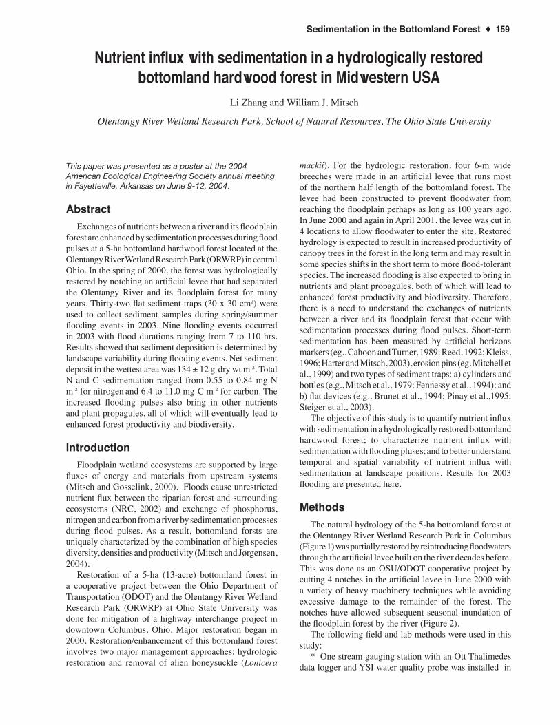
the Olentangy River Wetland Research Park in Columbus (Figure 1) was partially restored by reintroducing floodwaters through the artificial levee built on the river decades before. This was done as an OSU/ODOT cooperative project by cutting 4 notches in the artificial levee in June 2000 with a variety of heavy machinery techniques while avoiding excessive damage to the remainder of the forest. The notches have allowed subsequent seasonal inundation of the floodplain forest by the river (Figure 2).
The following field and lab methods were used in this study:
* One stream gauging station with an Ott Thalimedes data logger and YSI water quality probe was installed in
Nutrient influx with sedimentation in a hydrologically restored bottomland hardwood
160 ♦ The Olentangy River Wetland Research Park 2004
Figure 1. Study site with the bottomland forest area with elevations, Ott water level recorders locations, and sites of sediment sampling traps . The map also indicates locations of 4 “cuts” where artificial levee was breeched to allow bottomland flooding at Olentangy River Wetland Research Park.

Sedimentation in the Bottomland Forest ♦ 161
Figure 2. Bottomland flooding a) in April soon after the initial inflow cutting, and b) in April, 2004, indicating that understory vegetation cover had developed after two years of hydrologic restoration at the bottomland forest, Olentangy River Wetland Research Park.
Figure 3. Flat sampling traps used in this study (size = 0.09 m2)

162 ♦ The Olentangy River Wetland Research Park 2004
Figure 4. Olentangy River water level (ft above MSL), 1994-2003, showing existing levee, time of breech cutting, and current flooding at the bottomland forest
flooding events. Net sediment deposits in the wettest area averaged 134
± 12 g-dry wt m-2 in 2003. This rate is consistent with temporal and spatial variability of sedimentation processes during the flooding events in a number of other freshwater wetlands/riparian forests (eg. Mitsch et al., 1979; Fennessy et al., 1994; Steiger et al., 2003).
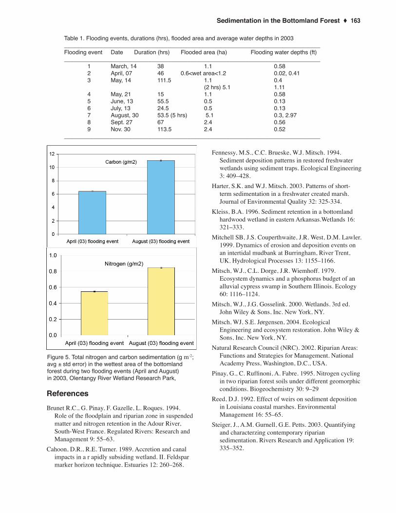
Total N and C in sediments deposited by floodwaters were higher in August flooding than in April floods (Figure 5) as the August flood was much greater water depth. Nitrogen flux ranged from 0.55 to 0.84 mg-N m-2 and carbon flux ranged from 6.4 to 11.0 mg-C m-2. Both flooding duration and growing season may impact quality and quantify of sedimentation. Increased flooding pulses also brings in other nutrients and plant propagules, all of which will eventually lead to enhanced forest productivity and biodiversity. Those influxes should be part of future studies at this site.
AcknowledgmentsSalaries and supplies for this project are supported by the
Ohio Department of Transportation, OARDC, and The Ohio State University. We appreciate the assistance of students and staff of the Olentangy River Wetland Research Park (ORWRP) for collecting flooding water samples, conducting lab analysis and assisting with restoration efforts.
the river at the northwestern corner of the ORWRP.* 33 rough surface, plastic, flat (0.3 m x 0.3 m) sediment
traps (Figure 3) were used to collect sediment deposits during the flooding events in 2003 (Table 1).
* Collected samples were weighted after air drying at 20oC in the Heffner Wetland Research and Education Building adjacent to the site;
* Total nitrogen and carbon were analyzed at STAR Lab (Wooster Campus, The Ohio State University) with Elementar Americas Vario Max Carbon / Nitrogen analyzer.
Results and discussionSubstantial flooding of Olentangy River water occurred
in the bottomland forest as a result of the cut notches (Figure 4). Nine flooding events occurred in 2003 and flooding durations ranged from 7 to 110 hrs (Table 1). Flooded areas ranged from 0.6 ha to 2.97 ha.
The flood events provided sediment deposits, nutrients, and undoubtedly introduced seeds and small organisms into bottomland forest. Exchanges of total N and C between the river and the floodplain forest were enhanced by sedimentation processes during flood pulses. The flooding river is characterized by pulses in turbidity, but sediment deposits were determined by landscape variability during
Sedimentation in the Bottomland Forest ♦ 163
Figure 5. Total nitrogen and carbon sedimentation (g m-2; avg ± std error) in the wettest area of the bottomland forest during two flooding events (April and August) in 2003, Olentangy River Wetland Research Park,
Table 1. Flooding events, durations (hrs), flooded area and average water depths in 2003_______________________________________________________________________________Flooding event Date Duration (hrs) Flooded area (ha) Flooding water depths (ft)_______________________________________________________________________________ 1 March, 14 38 1.1 0.58 2 April, 07 46 0.6<wet area<1.2 0.02, 0.41 3 May, 14 111.5 1.1 0.4 (2 hrs) 5.1 1.11 4 May, 21 15 1.1 0.58 5 June, 13 55.5 0.5 0.13 6 July, 13 24.5 0.5 0.13 7 August, 30 53.5 (5 hrs) 5.1 0.3, 2.97 8 Sept. 27 67 2.4 0.56 9 Nov. 30 113.5 2.4 0.52_______________________________________________________________________________
References
Brunet R.C., G. Pinay, F. Gazelle, L. Roques. 1994. Role of the floodplain and riparian zone in suspended matter and nitrogen retention in the Adour River, South-West France. Regulated Rivers: Research and Management 9: 55–63.
Cahoon, D.R., R.E. Turner. 1989. Accretion and canal impacts in a r apidly subsiding wetland. II. Feldspar marker horizon technique. Estuaries 12: 260–268.
Fennessy, M.S., C.C. Brueske, W.J. Mitsch. 1994. Sediment deposition patterns in restored freshwater wetlands using sediment traps. Ecological Engineering 3: 409–428.
Harter, S.K. and W.J. Mitsch. 2003. Patterns of short-term sedimentation in a freshwater created marsh. Journal of Environmental Quality 32: 325-334.
Kleiss, B.A. 1996. Sediment retention in a bottomland hardwood wetland in eastern Arkansas.Wetlands 16: 321–333.
Mitchell SB, J.S. Couperthwaite, J.R. West, D.M. Lawler. 1999. Dynamics of erosion and deposition events on an intertidal mudbank at Burringham, River Trent, UK. Hydrological Processes 13: 1155–1166.
Mitsch, W.J., C.L. Dorge, J.R. Wiemhoff. 1979. Ecosystem dynamics and a phosphorus budget of an alluvial cypress swamp in Southern Illinois. Ecology 60: 1116–1124.
Mitsch, W.J., J.G. Gosselink. 2000. Wetlands. 3rd ed. John Wiley & Sons, Inc. New York, NY.
Mitsch, WJ, S.E. Jørgensen, 2004. Ecological Engineering and ecosystem restoration. John Wiley & Sons, Inc. New York, NY.
Natural Research Council (NRC). 2002. Riparian Areas: Functions and Strategies for Management. National Academy Press, Washington, D.C., USA.
Pinay, G., C. Ruffinoni, A. Fabre. 1995. Nitrogen cycling in two riparian forest soils under different geomorphic conditions. Biogeochemistry 30: 9–29
Reed, D.J. 1992. Effect of weirs on sediment deposition in Louisiana coastal marshes. Environmental Management 16: 55–65.
Steiger, J., A.M. Gurnell, G.E. Petts. 2003. Quantifying and characterzing contemporary riparian sedimentation. Rivers Research and Application 19: 335–352.

164 ♦ The Olentangy River Wetland Research Park 2004