longgroveil.gov - village president... · web viewlonggroveil.gov
TRANSCRIPT

Route 53/120 Resolution & Summary Report Initial Draft Comment Log
This log includes comments and edits submitted by the IL Route 53/120 Blue Ribbon Advisory Council, project staff, and the public in preparation for the April 20th meeting. The Council Co-Chairs and Core Team will consult these comments when editing the draft, and will make note of responses and changes. The team may also make minor edits for clarity, not all of which are captured in this log. However, all significant changes between the April 13 draft and the following version will be noted. The page numbers refer to the initial draft dated April 13, 2012.
All comments have been addressed in one of three ways in preparation for today’s meeting.
– NO ACTION Items: recommend no change to plan
– CONSENT Items: recommended for acceptance (change document as suggested in comment)
– DISCUSSION Items: Council discuss and provide guidance
In addition to addressing the “DISCUSSION” items during the meeting, Council members may raise any of the items currently labeled “NO ACTION” and “CONSENT.”
Letters received:• Village of Grayslake (12/7/11)• Linda Soto, Village of Hainesville (4/17/12)• Howard Learner and Jacky Grimshaw (4/18/12)• David Stolman, Jeff Braimann, Maria Rodriguez (4/17)• Sierra Club• Mary Sue B
1

Route 53/120 Resolution & Summary Report Initial Draft Comment Log
NO ACTION ITEMS
# Date CommenterDoc/Page
Paragraph/Location
Comment Type Comment Response
COUNCIL COMMENTS
1 4/18Council
MemberRobert Israel
16 - 17 Design Speed NO ACTION
The roadway should be designed to a POSTED operational speed of 45 MPH - rather than to a maximum operational speed of 45 mph. This will add safety to the program.
Posted operational speed vs design speed. Refer to TJ comments on internal draft.
2 4/18Council
MemberJohn Nelson
66 P 2 NO ACTION
This sentence may provide for reducing the cost by cutting back on some of the enhancements to realize an affordable improvement. Good sentence.
3 4/17Council
MemberMike Sands
77The Liberty
Prairie Reserve
NO ACTION
....opportunities for land protection. The single largest certified organic farm in the County anchors the western edge of the Reserve. The only IDNR recovery program for 5 species of T&E fish species n the State lies less than 100 yards from the centerline of the proposed road. Several Illinois Nature Preserves are within the Reserve. Prairie Crossing, a well-known and highly regarded conservation subdivision, is on the western edge of the Reserve. The Liberty Prairie Reserve represents a unique public - private land management effort with a total Public and private investment of over $100 million over the past 25 years
[replaced by new text for this section, see Consent item]
4 4/18 John Nelson General NO ACTION Well written draft!
LOCAL GOVERNMENT
2

Route 53/120 Resolution & Summary Report Initial Draft Comment Log
# Date CommenterDoc/Page
Paragraph/Location
Comment Type Comment Response
5 4/16 Linda Soto, Mayor of Village of
Hainesville
NO ACTION Dear Fellow Elected Officials, Thank you for inviting me to the March 12, 2012 Public Officials Information Meeting. I appreciate your commitment to serve on this Blue Ribbon Advisory Council, and as a fellow public official in Lake County, I would like to share some concerns that I have that will not only affect the Village of Hainesville, but the greater Lake County area.Based on our Village’s review of the information presented, I noted some concerns with respect to the CMAP memorandum – Land Use Analysis and Impacts, dated Feb 10. The findings of the memo are that the municipalities in the area have over-planned for commercial in the corridor appears to be invalid due to some underlying assumptions by CMAP. CMAP’s analysis states that floor-area ratios (FAR) used to estimate development “were checked against average new construction FARs in Lake County for non-residential buildings constructed since 2000.” The resulting FAR used by CMAP to estimate commercial development was 0.30. As can be seen on the attached exhibit, the shopping center in our Village, which has been constructed since 2000 at the NE corner of Hainesville Rd and Route 120, provides for actual commercial development in the FAR range of 0.14 to 0.16 or approximately one half the level of intensity of the 0.3 FAR assumed by the CMAP memorandum. I have heard from some of the other villages in our area and they are finding similar FAR levels of approximately 0.15. Based on using these actual development
Important consideration for Corridor Plan
3

Route 53/120 Resolution & Summary Report Initial Draft Comment Log
# Date CommenterDoc/Page
Paragraph/Location
Comment Type Comment Response
levels, it is apparent that the assumptions of the intensity of commercial development by CMAP for our central Lake County area are significantly too high, and I would not want to see these inflated assumptions used as any sort of basis for planning the roadway design for this major highway in our area. I am of the opinion that this future roadway is needed without inflating the assumptions for commercial land use intensities in our area.
6 4/16 Linda Soto, Mayor of Village of
Hainesville
NO ACTION The proposed alignment of the interchange between Route 53 and Route 120, which is proposed to funnel traffic from the primarily north-south Route 53 to the Route 120 primarily east-west roadway, seems to transfer the current problem of ending Route 53 at Lake Cook Road with the north-oriented traffic at an east west road whereby adding congestion to the east-west road until it can find an acceptable north-south alternative road. In the Village of Hainesville Comprehensive Plan, we addressed the concept of a more balanced distribution of traffic for all directions (north, south, east, west) if the Route 53 roadway were to blend into existing roadways in our area. For the traffic to the east, there would be the new Route 120 alignment for through traffic as well as a connection to Allegany Road for more local eastbound or northeast bound traffic or local north-south destinations off Allegany Road. For traffic to the west, there is an opportunity to transition into existing Route 120 west of the existing at-grade Route 120 railroad crossing.
Important consideration for Corridor Plan
4

Route 53/120 Resolution & Summary Report Initial Draft Comment Log
# Date CommenterDoc/Page
Paragraph/Location
Comment Type Comment Response
For traffic that is north-oriented, our Comprehensive Plan present s the concept of an extension of existing north-south Hainesville Road south from its current terminus at Route 120 to go under the railroad tracks for a connection with the new Route 53 roadway. Hainesville Road provides connections to both Washington Street and Rollins Road that are both planned for improvements of existing at-grade railroad crossings to grade-separated underpasses. This concept of a more balanced distribution of traffic in all directions (north, south, east, west) through any alternative terminus of the Route 53 roadway in this area is critical not only for the Village of Hainesville, but also for the greater Lake County area.
I hope you will consider these comments at this time and also share them with the other members of the Council. Please contact me with any questions or comments. Thank you for your attention to this matter.
Sincerely, Linda Soto, MayorVillage of Hainesville
PUBLIC COMMENTS
7 4/16 Judi L Hendricks
1 NO ACTION As a homeowner who has lived in Grayslake for fifteen years now, I have only one comment to make: HOW MANY TIMES DO WE HAVE TO SAY THAT WE DON'T WANT THIS GODFORSAKEN MONSTROSITY RUNNING THROUGH OUR LIVING ROOMS?
5

Route 53/120 Resolution & Summary Report Initial Draft Comment Log
# Date CommenterDoc/Page
Paragraph/Location
Comment Type Comment Response
No! It means, NO. It has always meant no. It STILL means no. Don't WANT it. Don't care how many times you ask or how many panels you put together to "assess the need" -- we STILL don't want it. Subtle enough for you??? NO!
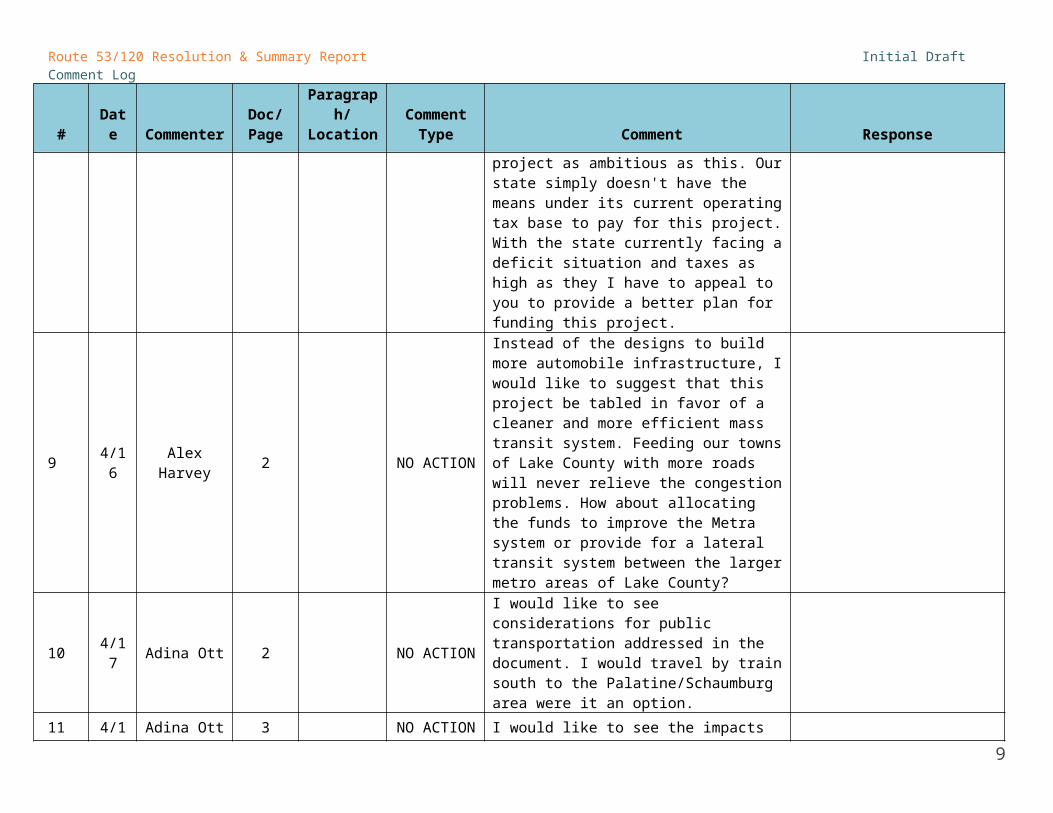
8 4/16 Alex Harvey 1 NO ACTION
My comments apply to this project as a whole. I am a tax-paying citizen of Grayslake, one of the communities to be forever changed by this project.It is unthinkable in this time of economic desperation to be so irresponsible with our state revenue as to spend it on a project as ambitious as this. Our state simply doesn't have the means under its current operating tax base to pay for this project. With the state currently facing a deficit situation and taxes as high as they I have to appeal to you to provide a better plan for funding this project.
9 4/16 Alex Harvey 2 NO ACTION
Instead of the designs to build more automobile infrastructure, I would like to suggest that this project be tabled in favor of a cleaner and more efficient mass transit system. Feeding our towns of Lake County with more roads will never relieve the congestion problems. How about allocating the funds to improve the Metra system or provide for a lateral transit system between the larger metro areas of Lake County?
10 4/17 Adina Ott 2 NO ACTION
I would like to see considerations for public transportation addressed in the document. I would travel by train south to the Palatine/Schaumburg area were it an option.
11 4/17 Adina Ott 3 NO ACTION I would like to see the impacts on neighborhoods, namely Prairie Crossing in
6

Route 53/120 Resolution & Summary Report Initial Draft Comment Log
# Date CommenterDoc/Page
Paragraph/Location
Comment Type Comment Response
Grayslake and Bradford Place in Round Lake, addressed in the document. Specifically, how would residents in these neighborhoods enter and exit the proposed highways?
12 4/18 John Wasik 3 Paragraph 1 NO ACTION
The project will not enhance mobility since it does nothing to widen and improve arterial and feeder roads. It will just result in more congestion. The entire concept is flawed for this reason.
13 4/17 Carol Shaffer 7 NO ACTIONI appreciate the choice of 45mph, 4-lane, use of design elements that are required and not optional, congestion pricing.
14 4/16 Bill Roberts 7 Guiding Principles NO ACTION
In the Guiding Principles, I would like to see as #1: Provide value at all levels to the taxpayers of Lake County and be accountable for the use of all public funds.
15 4/17 Jill Lawless 7 NO ACTION
Most of the people who live near the proposed road do not want it built. The referendum a few years ago was highly misleading. It did not ask people if they wanted a toll road & voter turn out in that election was very low. I think it was less than 20%. The state has many other more important projects to spend our limited resources on.
16 4/17 Jill Lawless 7 NO ACTION
The state should be using our precious tax dollars on public transportation not building more roads which only lead to more pollution & congestion.
17 4/18 Jane Hoppe 8 NO ACTION In the key to the map, I don't see roundabouts for Route 120. Wouldn't roundabout intersections move 120 traffic more efficiently?
I also have a general opinion about this whole
7

Route 53/120 Resolution & Summary Report Initial Draft Comment Log
# Date CommenterDoc/Page
Paragraph/Location
Comment Type Comment Response
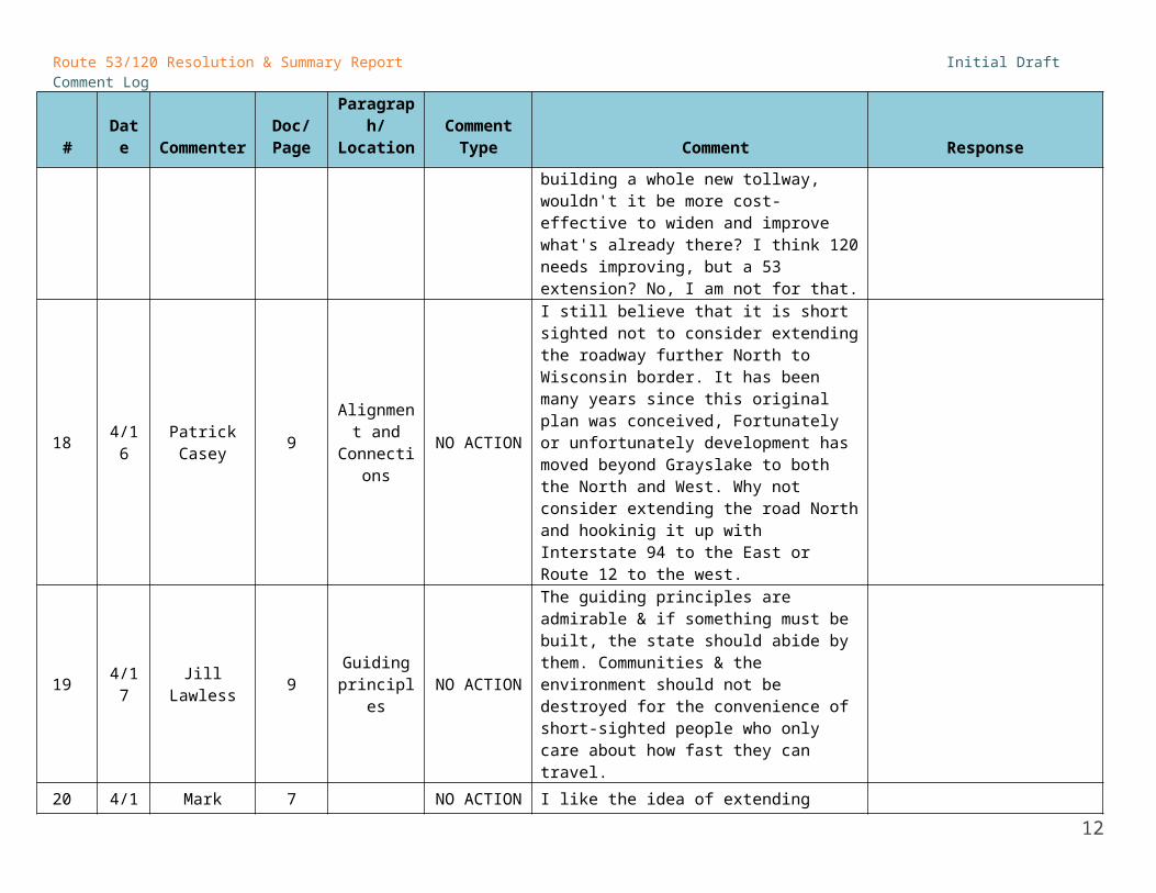
project. I would prefer to see existing main roads widened and improved with turn lanes. I frequently (2 to 5 times a week for the past 10 years) drive from Cook County up into Lake County. I have seen a huge difference in traffic flow after parts of 83 and 45, for example, were widened. Even rush hour is much smoother now. Instead of building a whole new tollway, wouldn't it be more cost-effective to widen and improve what's already there? I think 120 needs improving, but a 53 extension? No, I am not for that.
18 4/16 Patrick Casey 9Alignment
and Connections
NO ACTION
I still believe that it is short sighted not to consider extending the roadway further North to Wisconsin border. It has been many years since this original plan was conceived, Fortunately or unfortunately development has moved beyond Grayslake to both the North and West. Why not consider extending the road North and hookinig it up with Interstate 94 to the East or Route 12 to the west.
19 4/17 Jill Lawless 9 Guiding principles NO ACTION
The guiding principles are admirable & if something must be built, the state should abide by them. Communities & the environment should not be destroyed for the convenience of short-sighted people who only care about how fast they can travel.
20 4/18 Mark Jinga 7 NO ACTION I like the idea of extending Route 53 to the north. This MUST be done! I would gladly pay a toll to use the road. But please tell me what toll road in Illinois (or any other state) has a 45 mile per hour Maximum Speed Limit? You must be kidding? The local roads in the area have a higher speed limit then that. Come on extend
8
Route 53/120 Resolution & Summary Report Initial Draft Comment Log
# Date CommenterDoc/Page
Paragraph/Location
Comment Type Comment Response
Route 53 and don't cave in to limiting the speed limit to 45 miles per hour. You extended 355 and the speed limit on that is 65 MPH. Please don't do the wrong thing.
21 4/18 John Wasik 9 NO ACTION
This eastern leg is completely unacceptable because the alignment runs directly through a residential area and behind a hospital. It should be moved further north.
22 4/17 Steve Minsky all NO ACTION
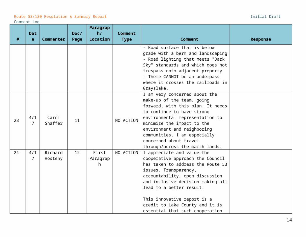
I support:- Boulevard, NOT high-speedexpressway/tollway- Max speed of 45mph- 4 lanes maximum- Use of congestion pricing- Integrated at-site stormwater management- Road surface that is below grade with a berm and landscaping- Road lighting that meets "Dark Sky" standards and which does not trespass onto adjacent property- There CANNOT be an underpass where it crosses the railroads in Grayslake.
23 4/17 Carol Shaffer 11 NO ACTION
I am very concerned about the make-up of the team, going forward, with this plan. It needs to continue to have strong environmental representation to minimize the impact to the environment and neighboring communities. I am especially concerned about travel through/across the marsh lands.
24 4/17 Richard Hosteny
12 First Paragraph
NO ACTION I appreciate and value the cooperative approach the Council has taken to address the Route 53 issues. Transparency, accountability, open discussion and inclusive decision making all lead to a better result.
9

Route 53/120 Resolution & Summary Report Initial Draft Comment Log
# Date CommenterDoc/Page
Paragraph/Location
Comment Type Comment Response
This innovative report is a credit to Lake County and it is essential that such cooperation and openess continue as the project moves forward. This Council should do all it can to ensure this happens.
25 4/18 Jane Hoppe 13 NO ACTION
You say you want to preserve environments, and you may be able to respect certain wetlands or forest preserves. But one thing this project would ruin forever is the air quality in neighborhoods 53/120 would pass through. In the area just south of 120, we already breathe proven carcinogenic fumes from 50+ trains a day, sulfur gasses from the Waste Management landfill in Grayslake, and who-knows-what from a nearby asphalt plant. It is bad enough that we have to breathe such polluted air, especially since we pay chokingly high taxes to live in Lake County near open spaces and protected land. Then we are careful not to put poisons on organic vegetables in our gardens. And you want to add carcinogenic pollution with increased traffic through our neighborhoods? Your plan may save a few frogs and prairies and deer, but the health risks to humans are too high!!!
26 4/18 John Wasik 13 NO ACTION
By its very nature, no road project of this size can ever be environmentally friendly. It will contribute to noise, water and air pollution because hundreds of thousands of vehicles will be traveling the corridor.
27 4/17 Richard Hosteny 17 3rd
paragraph NO ACTION I agree with and totally support a maximum posted speed limit of 45 mph.
28 4/17 Richard Hosteny 17 last
paragraph NO ACTION I agree with and fully support using "congestion pricing". Such a policy is long overdue.
29 4/17 Richard 18 last NO ACTION I totally support a road surface which is "below
10

Route 53/120 Resolution & Summary Report Initial Draft Comment Log
# Date CommenterDoc/Page
Paragraph/Location
Comment Type Comment Response
Hosteny paragraph
grade" with landscaped berms on either side. Such an approach will minimize the visual and noise impacts on surrounding areas. It will also make for a more relaxed and beautiful drive for the motorists - all to the credit of Lake County.
30 4/17 Richard Hosteny 19 first
paragraph NO ACTION
The use of innovative lighting strategies which put the light on the road and not on neighboring areas is long overdue. I fully support using lighting fixtures which direct light ONLY to the road surface.
31 4/17 Carol Shaffer 19 NO ACTION I applaud the use of "dark sky" lighting
32 4/17 Carol Shaffer 20 NO ACTIONUse more confident language for roundabouts - "seriously" considered - since these have been shown to move traffic more efficiently.
33 4/17 Carol Shaffer 22 NO ACTIONI think the performance standards are critical for this project and would like a guarantee that they would be implemented and followed.
34 4/17 Carol Shaffer 30 Alignment NO ACTION I support Alignment #1 and strongly oppose Alignment #3.
35 4/17 Carol Shaffer 35 RR crossing NO ACTION Feel strongly about requiring an UNDERPASS for RR crossings, not an overpass.
36 Richard Hosteny 30 NO ACTION I am in favor of Alignment #1 as it has the least
impact on the counties natural areas.37
38 4/17 Adina Ott Report NO ACTIONI am in favor of the "move people, not cars" model and would like to see consideration for a bike lane on 120.
39
40 4/17 Carol Shaffer All NO ACTION
Thanks to the Blue Ribbon Advisory Council for producing this Draft resolution and Summary Report. There is a lot of excellent information here from your use of a collaborative approach. It is a huge improvement over previous plans.
4142 4/18 John Wasik Inside cover NO ACTION I see that not one citizen or environmental
group was represented on this panel. This is not
11
Route 53/120 Resolution & Summary Report Initial Draft Comment Log
# Date CommenterDoc/Page
Paragraph/Location
Comment Type Comment Response
a legitimate document since it didn't involve the people directly living along the corridor. I am one of them and I reject this proposal.
43
44 4/18
James R. Dietz and Marc P. Huber,
Village of Round Lake
23-29 NO ACTION
It appears that the necessity to be environmentally responsible is not balanced and may be overly stringent which is contradictory to keeping the costs down. Aslo, it is not readily apparent that the indirect environmental impacts outside the direct impacts of the roadway were considered, but should be considered as they will result in a reduction of impacts outside the roadway corridor. The balance of indirect and direct environmental impacts could lead to reduced costs to build the roadway and still maintain a higher level of environmental stewardship.
4546 4/18 John Wasik 41 NO ACTION
You want to "respect and preserve the land?" Don't build this highway. It will degrade the environment well into the future.
47
48 4/18
James R. Dietz and Marc P. Huber,
Village of Round Lake
57 NO ACTION
Value adding to only the defined corridor does not account for the reduction of traffic on other roads outside the corridor and the overall benefit for the region.
CONSENT ITEMS
12

Route 53/120 Resolution & Summary Report Initial Draft Comment Log
# Date CommenterDoc/Page
Paragraph/Location
Comment Type Comment Response
COUNCIL COMMENTS
49 4/18 Peter Harmet Member List CONSENT Delete "acting" from Secretary Schneider's title
50 4/17 Mike Sands 1 CONSENT
Change the title to "The Challenge for a New Road"
This "The History of..." section needs a paragraph on the environmental context:
“Lake County has the greatest number of unique and threatened ecological resources in the state of Illinois. These include lakes and ponds, streams, extensive wetlands, native prairie remnants and significant acreages of restored ecosystems. Lake County has the largest number of state and federal threatened, endangered and special concern species of any county in Illinois. According to the Illinois DNR natural heritage data base, there over 54 populations of these species and their critical habitats are found within the zone of impact of the road scenarios. These critical ecosystems are represented in the xx number of INIA sites, again the highest number in any county of the state. The proposed right of way for any new road presents a huge challenge to these unique assets and for that reason has been historically opposed by environmental and conservation organizations.”
Add paragraph as suggested.
Ask Mike for # of INIA sites.
51 4/18 David Stolman 1 Moving
Forward CONSENT Add: Blue Ribbon Advisory Council was established by the Tollway in the fall of 2011.
52 4/18 Peter Harmet 1 CONSENT There is text that says that any corridor improvements "will" have significant secondary Change to “could”
13
Route 53/120 Resolution & Summary Report Initial Draft Comment Log
# Date CommenterDoc/Page
Paragraph/Location
Comment Type Comment Response
effects upon communities. I suggest that this language be modified to "could", as no in depth studies have been done to identify impacts.
53 4/18 David Stolman 7 Is there
consensus? CONSENTAdd text:“… should be constructed to enhance mobility, relieve congestion, promote…”
54 4/18 John Nelson 8 P 3, sentence 1 CONSENT Add after "million", "for new rights-of-way".
55 4/18 David Stolman 8-9 Legend, All
Maps CONSENT
Green colors for road treatment are too similar.
#3 interchange should be “intersection”
Add interchange locations to all maps
Extend Route 120 widening treatment to East of Route 12 on all maps
56 4/18 John Nelson 11 P 2, sentence 1 CONSENT Not sure what is intended by "...that the project
is fully scoped,"
Change text: “The Council recommends that the full scope of the corridor planning process is determined, and …”
57 4/18 Chris Geiselhart 11, 66 3rd from
bottom CONSENT
• Transfer of and land, rights or other property held by the State of Illinois for the purpose of constructing and operating this project...
Delete and??
58 4/17 Mike Sands 17
Design Roadway
for a maximum...
CONSENT
".....maximum design speed of 45 mph provides higher capacity and complements roadway designs that utilize curves and hills within the right of way."
Change text as suggested.
59 4/17 Mike Sands 19 CONSENT Start with what THIS PROJECT will do:
"As a four-lane parkway, the Route 53/120
Add text as first paragraph
14

Route 53/120 Resolution & Summary Report Initial Draft Comment Log
# Date CommenterDoc/Page
Paragraph/Location
Comment Type Comment Response
facility will only employ lighting at interchanges. This lighting will meet all “Dark Sky” requirements for new projects and will use full cut off roadway light fixtures to prevent light trespass and reduce sky glow, glare, and light clutter. In order to control light pollution, no-spillover luminaries including shielding on the fixtures will be required and in-roadway lighting.
“Currently, the Tollway only employs overhead lighting for roads that are at least eight lanes total, except at interchanges where lighting is required. Luminous paint is a standard application for all roadways. LED high efficiency lighting methods will be required where lights are used.”
60 4/18 John Nelson 19 P 1, sentence 5 CONSENT "luminaires" rather than "luminaries"
61 4/17 Jim LaBelle 19-20two
bike/ped sections
CONSENT Some redundancy between these two sections - perhaps combine
62 4/18 Robert Israel 19Innovative Roadway Lighting
CONSENT
Instead of stating that "LED high efficiency lighting methods will be required." State they should be evaluated. You have already set high performance requirments - don't lock in on a technology just because it's "the next thing".
Change to “consider”
63 4/18 David Stolman 20 Improve
connections CONSENT
First paragraph: Remove “along the length of the new”Last sentence of second paragraph: add “the County Bike Plan” to list.
64 4/17 Mike Sands 22 Performance Standards CONSENT
Third bullet:Avoid to extent possible, then compensate for all wetland impacts
Revise standard title.
65 4/18 Robert Israel 22, 25 Reduce CONSENT Too general - restate: reduce or mitigate for Re-title the section
15

Route 53/120 Resolution & Summary Report Initial Draft Comment Log
# Date CommenterDoc/Page
Paragraph/Location
Comment Type Comment Response
stormwater volume
stormwater runoff impacts from this project. This follows on P 25 as well
Also "Ensuring the Highest water quality" should be restated as mitigate or reduce water quality impacts from this project. this follows on P 25 as well
66 4/18 Chris Geiselhart 23 P 1 CONSENT
DOESN'T MAKE SENSE
“As part of the recommended approach for land preservation, sensitive lands will be protected and enhanced, new lands added to existing high-quality parcels and integrate bridged and underpassage opportunities for wildlife crossings.”
Change text:As part of the recommended approach for land preservation, sensitive lands will be protected and enhanced, new lands added to existing high-quality parcels. As well, the design will integrate opportunities for wildlife crossings.”
67 4/17 Mike Sands 24
Compensate for all other
impacts
CONSENT
Last sentence in paragraph, insert: train
“This includes any stormwater treatment train management areas...”
Add text.
68 4/17 Mike Sands 25Protect and
Enhance Streams
CONSENT
Second bullet:“Modeling of shear stress and hydraulic geometry changes for all streams crossing right of way.”
Add text.
69 4/17 Mike Sands 26Use
Alternatives to Road Salt
CONSENT
Bring "Elimination of chloride release" to the front of the performance standard....
"The Route 53/120 project shall create a project- specific de-icing plan that eliminates the release of chloride into the surrounding ecosystem. The deicing plan shall be customized as necessary to meet all performance standards set forth by the Council and should contain the following:
Move text.
70 4/17 Mike Sands 30 Alignment 1 CONSENT Add the following at the end of paragraph 1. Add text.
16

Route 53/120 Resolution & Summary Report Initial Draft Comment Log
# Date CommenterDoc/Page
Paragraph/Location
Comment Type Comment Response
"Route 120 would be widened to 4 lanes east and west of where the new road joins the historic Route 120"
71 4/17 Mike Sands 30 Alignment 2 CONSENT
Add the following at the end of paragraph 1.
"The portion over the Squaw Creek Wetland Complex would require a causeway on pylons. Route 120 would be widened to 4 lanes from where the new road joins the historic Route 120 at Sears Boulevard east to the existing 4 lanes at Almond Road".
Add text.
72 4/18 David Stolman 31 Alignments CONSENT Add previous names for alignments: B, Hybrid, C
73 4/18 Peter Harmet 33 CONSENT
In IL, we call it Context Sensitive Solutions (CSS), rather than context sensitive design. CSS places emphasis on process, which leads to a "design". CSS addresses all issues - safety, mobility, community and environment. Suggest reworking this section to be consistent with IL policy/terminology.
Modify terminology
74 4/17 Mike Sands 42Create a
Lands Inventory
CONSENT
"At the onset of the project, a comprehensive lands inventory including all land within a minimum of 2 miles from the center line will be completed."
Replace text.
75 4/18 John Nelson 43 bottom placeholder CONSENT What is a SMPA? Define abbreviation if used in
text or caption.Spell out: stormwater management polishing area
76 4/18 Chris Geiselhart
43 CONSENT P.43 THE WORLD’S LONGEST SENTENCE. READING 100+ PAGES IS CHALLENGING ENOUGH WITHOUT HAVING TO WADE THROUGH SENTENCES WITH SUCH VERBIAGE. THIS IS ONE EXAMPLE.
“In the right of way, Stormwater Treatment
Edit.
17

Route 53/120 Resolution & Summary Report Initial Draft Comment Log
# Date CommenterDoc/Page
Paragraph/Location
Comment Type Comment Response
Trains will be designed to pre-treat all stormwater by removal of suspended solids and contaminants, through long residence time and long flow path length swales, upland grass landscapes, and redundant restored landscape wetland features of varying depths through which the stormwater is passed, and subjected to aerobic and anaerobic treatment to strip and hold or metabolize and dissipate chemical constituents such as Nitrogen, oil and grease, and many combustion byproducts.”
77 4/17 Mike Sands 44 second bullet point CONSENT Arbor Vista should be capitalized
78 4/17 Mike Sands 44 The Surrey Marsh.... CONSENT
Start the paragraph with: "The Surrey Marsh area is proposed to be bridged by an elevated causeway road treatment. The wetlands are in serious ...."
79 4/17 Mike Sands 46 CONSENT Replace "Minimize ..." with "Minimize to the greatest possible extent..." Change throughout
80 4/17 Mike Sands 46
Long Grove, Surrey
Marsh to Route 22
CONSENT
Add the three following bullet points before the "Reduce Noise and visual impacts" bullet point.
Restore and enhance the existing upland buffers including removal of invasive buckthorn and restoration of oak savanna systems present.
Restore and enhance existing wetlands through invasive plant management, restoration of water levels and hydrological linkages.
Restore areas of hydric soils that are now dewatered by constructed ponds, tiles and/or ditches.
Add text
81 4/17 Mike Sands 46 Indian CONSENT Add the following bullet points before the Add text.
18

Route 53/120 Resolution & Summary Report Initial Draft Comment Log
# Date CommenterDoc/Page
Paragraph/Location
Comment Type Comment Response
Creek and Squaw Creek
"Restore and enhance the existing ..." bullet point
Minimize to the greatest possible extent impacts to slopes, oaks, and slope stability.
Minimize to the greatest possible extent impacts to wetlands.Minimize to the greatest possible extent direct and indirect impacts to preserves, rare species, hydrology, light, noise and stream channel instability.
Minimize to the greatest possible extent contaminant effects that will encourage invasive species and further deterioration of the natural resources in these areas.
Reduce to the greatest possible extent noise and visual impacts.
82 4/17 Jim LaBelle 46 CONSENTSeveral of the additional goals listed on this seem to already have been stated in other sections. Just list the ones that have not been.
Compare to Performance Standards and remove duplicate from p. 46 [add Mike Sands text for p. 46 first, and then edit down]
83 4/18 Chris Geiselhart
60 P 2 CONSENT NOT A SENTENCE--VIRTUALLY INCOMPREHENSIBLE. PLEASE CLARIFY.
Change to: “In addition, perpetual funding for the maintenance, monitoring and stewardship of the protected, restored and enhanced lands. These land areas include those within the right of way and external stormwater management areas, and in the restoration and management treatment areas that have been
19

Route 53/120 Resolution & Summary Report Initial Draft Comment Log
# Date CommenterDoc/Page
Paragraph/Location
Comment Type Comment Response
identified during preliminary assessment as well as those that will be identified as part of the Lands Inventory.”
84 4/18 John Nelson 60 P 2, sentence 2 CONSENT "$81,251,000" or "$81.3 million" rather than
"$81,251,000 million"
85 4/18 Chris Geiselhart 65 CONSENT
INCOMPLETE--PLEASE CLARIFYThe Council recommends that the project is fully scoped, and that as soon as possible a commitment is obtained local municipalities, Lake County, and CMAP to move forward.
Change to: “The Council recommends that the full scope of the corridor planning process is determined, and …”
86 4/18 Chris Geiselhart 65 Last
sentence CONSENT
WHY ARE WE INCLUDING “OTHER PROJECTS” IN THIS RESOLUTION? WE SHOULD STICK TO THE SUBJECT.
“The Council also requires identification of local revenue sources, and supports the use of Tollway system generated revenues to enable this project and others vital to the region’s mobility, economic development and quality of life.”
Remove reference to other projects
87 4/18 Peter Harmet 65 CONSENTThe State/Federal Regulatory agencies and the FHWA need to be engaged prior to developing any detailed scope for further studies.
Include as partners for planning
88 4/18 Chris Geiselhart 66 CONSENT
Transfer of and land, rights or other property held by the State of Illinois for the purpose of constructing and operating this project.
DELETE "and" BEFORE LAND??89 4/18 Chris
Geiselhart73 CONSENT Proposed capitalization:
Additionally, there are four Audubon Important Bird Areas, totaling over 2,200 acres, and 14
Capitalize
20

Route 53/120 Resolution & Summary Report Initial Draft Comment Log
# Date CommenterDoc/Page
Paragraph/Location
Comment Type Comment Response
Illinois Natural Areas inventory sites of nearly 1,700 total acres.
90 4/18 John Nelson 77 P 1, sentence 2 CONSENT eliminate "so-called". Define "ADID"
91 4/17 Mike Sands 77 Environmental Context
for Lake County
CONSENT The importance of this topic requires a more complete write up. A copy of a word doc with the figures has been sent to Nadine separately.
New text:The Environmental Context for Lake CountyLake County has the greatest diversity of unique habitat and species of concern in the State of Illinois. There is perhaps no location that presents a greater challenge for the construction of an environmentally sensitive roadway than the proposed right of way of Route 53/120. Figure 1 is a visual summary of the importance of looking at both distance and direction (stream gradient and wind gradients) in evaluating the potential impacts of a large project such as the proposed Route 53/120.Applied Ecological Services conducted a very preliminary inventory of the natural resource base that defines the extent and uniqueness of the Lake County environment. Figure 2 is a visual summary of the natural lands within 2 miles of the proposed centerline.Lake County has extensive wetlands and hydric soils. Figure 3 illustrates the wetlands and hydric soils along the ROW that would be potentially impacted. The corridor intersects six ADID wetlandswith “exceptionally high functional value,” meaning that they provide stormwater
Replace section with new text and images.
Spell out ADID
21

Route 53/120 Resolution & Summary Report Initial Draft Comment Log
# Date CommenterDoc/Page
Paragraph/Location
Comment Type Comment Response
storage, harbor rare species, or meet other criteria. In many cases, however, the wetlands in and around the right of way have been degraded and are also in poor ecological condition. At the same time a number of wetland complexes along the right of way, such as the marsh by Surrey Lane along Buffalo Creek and the marsh associated with Indian Creek, appear to be seriously degraded and good candidates for ecological restoration. Lake County and the ROW area include 16-20 lakes that would be receiving waters from runoff from any of the toll way scenarios. Water quality and changes in the amount and timing of water entering these lakes can have significant impacts on the lakes, shoreline stability, aquatic nuisance plant growths, water quality, fisheries, and the values of lake front real estate.In Lake County and within 2 miles of the right of way are many publically protected conservation lands, state dedicated nature preserves which contain the best remaining important examples of the healthiest ecosystems in Lake County and provide critical habitat. Lake County is home to the largest number of state and federal threatened, endangered and special concern species of any county in Illinois. According to the Illinois DNR natural heritage data base over 54 populations of these status species and their critical habitats are found within the zone of impact of the road scenarios. Many of these species are found in or immediately adjacent to the right of way. The long term survival of many of these species
22

Route 53/120 Resolution & Summary Report Initial Draft Comment Log
# Date CommenterDoc/Page
Paragraph/Location
Comment Type Comment Response
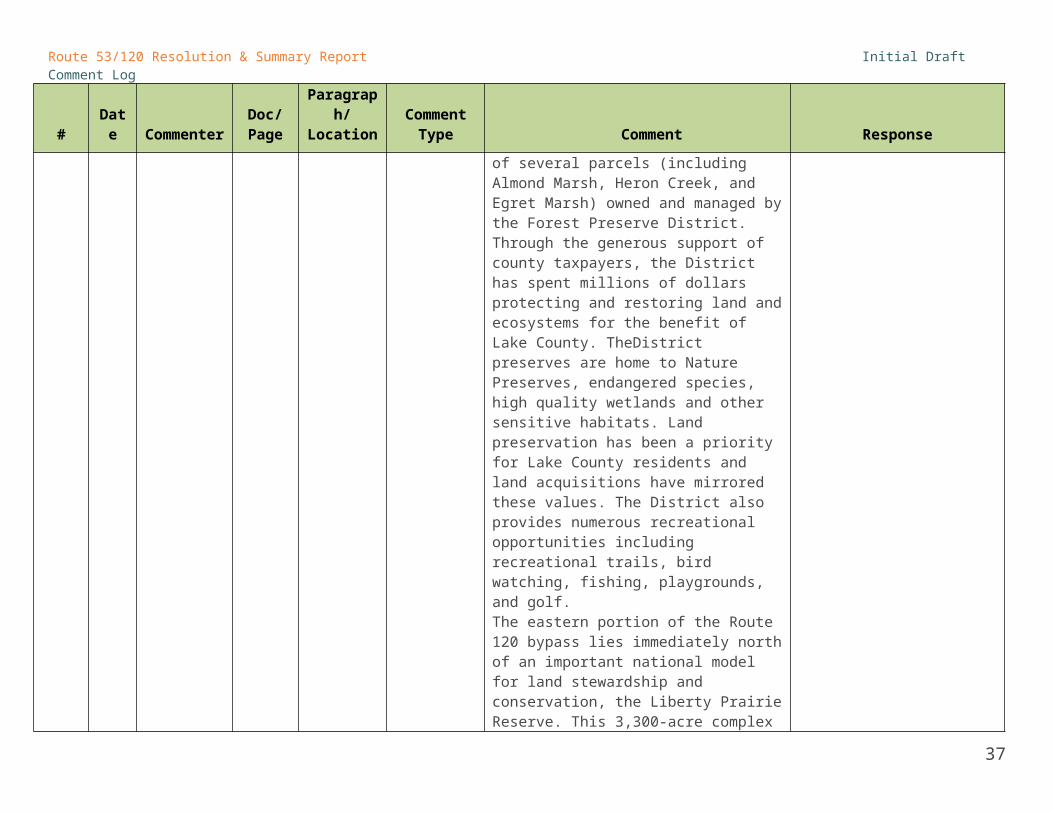
and ecosystems is dependent on maintaining minimally fragmented blocks of habitat. Figure 6 illustrates the huge challenge of existing and future habitat fragmentation along the ROW. Rare grassland, wetland and forest breeding birds also use many of these habitats (Figure 7). Lake County has a number of nationally important innovative efforts in land protection, stewardship and restoration including the lake County Forest Preserve District, Liberty Prairie Reserve, and Prairie Crossing conservation community.The Route 53/120 corridor traverses through the center of Lake County and along the borders of several parcels (including Almond Marsh, Heron Creek, and Egret Marsh) owned and managed by the Forest Preserve District. Through the generous support of county taxpayers, the District has spent millions of dollars protecting and restoring land and ecosystems for the benefit of Lake County. TheDistrict preserves are home to Nature Preserves, endangered species, high quality wetlands and other sensitive habitats. Land preservation has been a priority for Lake County residents and land acquisitions have mirrored these values. The District also provides numerous recreational opportunities including recreational trails, bird watching, fishing, playgrounds, and golf. The eastern portion of the Route 120 bypass lies immediately north of an important national model for land stewardship and conservation, the Liberty Prairie Reserve. This 3,300-acre complex of protected state, county, township,
23

Route 53/120 Resolution & Summary Report Initial Draft Comment Log
# Date CommenterDoc/Page
Paragraph/Location
Comment Type Comment Response
and private lands is within a 5,800-acre planning area with more opportunities for land protection. The Liberty Prairie Reserve is a unique private-public partnership that protects a working landscape including several high quality Illinois Nature Preserves, productive farmland and small communities. Prairie Crossing, a well-known and highly regarded conservation subdivision, is on the western edge of the Reserve. The largest single certified organic farm in the County (over 100 acres) sits immediately adjacent to the ROW. The only IDNR site for the recovery of 5 State Threatened & Endangered (T&E) fish species sits less than 200 yards south of the ROW. Over the past 25 years, there have been more than $100 million in public and private investments .in the Liberty Prairie Reserve.In summary, the uniqueness of the Lake County environment and the private-public investment to date in it’s protection and stewardship require that any future road project be designed, constructed and operated to the highest possible environmental standards.
92 4/18 Chris Geiselhart 90 CONSENT
Something is missing in"wide of effects."
“ROADS BRING CHANGE New roads can have a wide of effects on the surrounding neighborhoods and commercial areas.”
Add “range”
93 4/17 Mike Sands 95
Road sketches at the bottom of the page
CONSENT "MITIGATE AND COMPENSATE" mitigate missing an "I" Spelling.
94 4/17 Mike Sands 101 Appendix CONSENT Steve Barg's 12 page summary of the Liberty Add document to appendix.
24

Route 53/120 Resolution & Summary Report Initial Draft Comment Log
# Date CommenterDoc/Page
Paragraph/Location
Comment Type Comment Response
Prairie Reserve should be included. Ask Steve Barg for digital copy. Request from Steve.
STAFF COMMENTS
95 4/15 Staff Rocco Zucchero 1 CONSENT
A new section should be added to speak to the transportation needs and issues affecting Lake County and Northern Cook County. A paragraph from the "Longstanding Transportation Needs" section page 76 can be included in this section.
Add section to intro
96 4/15 Staff Rocco Zucchero 8
ROW and Corridor
DefinitionCONSENT the XXX' placeholder should be 100'
97 4/15 Staff Rocco Zucchero 9 CONSENT
The alignment on IL 120 should extend to I-94 on the east and a legend should be added to the map.
98 4/16 StaffJesse Elam 9 Map CONSENT
The map seems to imply that there are only three interchanges.
Where did the economic development areas come from?
Why is all of Prairie Crossing considered an area impacted by the road? Shouldn’t it just be the portion affected by noise?
Interchange/intersection locations added.
Ec dev: from CMAP’s future land use map
PC: reduce yellow area
99 4/17 Staff Nadine Appenbrink 9 Council
Map CONSENT Add interchange locations to the Council Resolution map.
100 4/17
Thomas Hahn,
Executive Director,
Lake County Forest
Preserves
9 CONSENT
Need to show on the map the Route 22 intersection in between Heron Creek and Egret Marsh Forest Preserves as a Priority sensitive lands category due to potential impacts and proposing a full intersection at that location.
101 4/16 Staff 10 CONSENT Shouldn’t they be “design recommendations” or Consider renaming #1: “Create a
25

Route 53/120 Resolution & Summary Report Initial Draft Comment Log
# Date CommenterDoc/Page
Paragraph/Location
Comment Type Comment Response
Jesse Elam
“guidelines” rather than “design standards?” I thought the performance requirements were the standards here.
The key recommendation headers still seem to overlap on environmental aspects. Maybe the first should just be “Create a modern, sustainable, and innovative transportation system.”
modern, sustainable, and innovative transportation system.”
102 4/15 Staff Rocco Zucchero 11
Secure Funding to Close the
Gap
CONSENTThe text in this section should more closely align with the text on page 7 in the "How should the project be financed?" section
103 4/13 StaffLiz Schuh 11
Initiate the Corridor
PlanCONSENT
We should emphasize that we need all the municipalities on board. Under “Initiate the Corridor Plan,” suggested rewording:
“The Council recommends that the project be fully scoped. Participation of municipalities on the corridor will be critical, and a commitment to the process should be obtained from CMAP, Lake County and affected municipalities as soon as possible.
104 4/13 StaffLiz Schuh
11, 59-61
Initiate the Corridor
PlanCONSENT
The second sentence notes that the Corridor Plan process will also be responsible for defining a preferred alignment. If this is the case, suggest adding the following at the end of the “Develop a Detailed Design Concept” step: “Work on the detailed design concept will build on the alignment chosen in the Corridor Plan.”
Additionally, this should be carried through to the corridor plan section on pages 59-61. It is a major additional task for that scope.
26

Route 53/120 Resolution & Summary Report Initial Draft Comment Log
# Date CommenterDoc/Page
Paragraph/Location
Comment Type Comment Response
105 4/13 StaffLiz Schuh 16 CONSENT
“Provide Accommodation for Transit” is a design standard but it is not listed in the performance standards summary.
Add to list
106 4/17 StaffRon Davis 17
Use Pricing for
Congestion Relief
CONSENT
On other facilities using congestion pricing a specific metric for determining when the toll rate should be increased to managed demand is normally given. CDM Smith would recommend including a sentence similar to the following to address this:
"Increases in toll rates to managed demand will be considered when the vehicle density on the facility is at least 35 passenger car equivalents per lane per mile (corresponding to a level of service D in the Highway Capacity Manual)."
107 4/15 Staff Rocco Zucchero 20
Consider Local Road
Roundabouts
CONSENT
Add a new paragraph to the end of this section that is the same as the last paragraph in the "Make Local Roadway Improvements For Safety and Congestion Relief".
"Toll revenues and project costs are based on improvements......"
108 4/17 StaffBrian Smith 21 2nd
Paragraph CONSENT In the last line the word "agency" is misspelled.
109 4/17 StaffBrian Smith
28-29 Reduce Traffic Noise
CONSENT Please replace the section with the following which Huff and Huff modified slightly last week but didn't get them to Mike in time.
“The Route 53/120 project shall implement noise abatement measures where feasible when project traffic noise levels exceed 60 dB(A) at adjacent receptors. The project shall not increase the overall noise level in the first year of roadway operation by more than 3 dB(A)
Clarify which version of standard to use.
27

Route 53/120 Resolution & Summary Report Initial Draft Comment Log
# Date CommenterDoc/Page
Paragraph/Location
Comment Type Comment Response
above measured values in the year of the engineering design.
A 3 dB(A) change in noise levels is generally accepted as the smallest perceptible change. This proposed standard is more stringent than the Federal Highway Administration standard of considering noise abatement when build noise levels approach 67 dB(A), which is defined as 66 dB(A) by the Illinois Department of Transportation.
The 45 mph speed limit is the primary method for reducing traffic noise. Depressing the roadway below grade when feasible as well as berming and landscaping the land between the roadway and the outer edge of the ROW will further reduce the traffic noise.
Traffic noise studies will be conducted utilizing the latest version of the FHWA approved Traffic Noise Model (TNM) for nearby receptors along the proposed Route 53/120. If the build traffic noise levels exceed the criteria, an abatement analyses will be conducted to determine appropriate barriers to reduce the traffic noise levels to meet the criteria where possible. These barriers may consist of berms, retaining walls or noise walls.”
110 4/15 Staff Rocco Zucchero
23 Mitigate 100% of Direct
Impacts
CONSENT This section needs more definition. Does this mean additional mitigation beyond what is already being proposed for stormwater, wetlands, open space, depressed road treatments, etc. Some of the impacts are caused
Clarify with Steve and Mike.
28

Route 53/120 Resolution & Summary Report Initial Draft Comment Log
# Date CommenterDoc/Page
Paragraph/Location
Comment Type Comment Response
by the suggested mitigation measures, such as a depressed roadway, berming and creating stormwater treatment trains which all consume land.
111 4/16 StaffJesse Elam 23 CONSENT
Direct and indirect impacts – the verbiage here remains clumsy and unclear.
Clarify that the amount of open space to be set aside is equal to the anticipated acreage of direct impact.
"Focus areas" for land preservation -- use consistent language. The map on p. 9 seems to call them "priority sensitive areas".
Change text: “The amount of open space to be set aside is equal to the anticipated acreage of direct impact.”
Use “Priority sensitive areas.” Change throughout.
112 4/16 StaffJesse Elam
24 CONSENT Recommend going back to earlier language on defining indirect impacts: “Indirect impacts will be defined by modeling, using the latest scientific evidence and studies to establish the magnitude of the potential indirect impacts, and secondly by studies to confirm the field conditions and impacts, during future study." Then say that indirect impacts will be mitigated as appropriate. The document seems to imply that the only way to mitigate indirect impacts is through land preservation, which isn't really the case.
Clarify the statement "This includes any stormwater treatment management areas that are unable to meet their water volume and quality performance standards." Shouldn't the design and performance standards be chosen so that they can be achieved? If anyone should be on the hook for this, it should
Change language back for clarity.
Clarify: suggest performance bond or other similar assurance for performance.
29

Route 53/120 Resolution & Summary Report Initial Draft Comment Log
# Date CommenterDoc/Page
Paragraph/Location
Comment Type Comment Response
be the designer/contractor, potentially through a performance bond.
113 4/15 Staff Rocco Zucchero 24
Compensate for All Other
Impacts
CONSENT
How will this be measured if it is indirect? Impacts should be attributed to a source.
Indirect development impacts not associated with roadway improvements should also assume some level of responsibility via a local environmental ordinance or some other means of local control.
Clarify with Steve and Mike.
114 4/16 StaffJesse Elam 25
Reduce stormwater
volumeCONSENT
I believe that the two sentences in this paragraph are describing two different standards. When the issue is stormwater volume, the object is usually to retain a fraction of runoff on site, and I don't think storing the 10 year event was the focus of this standard. Copying from another email, "Instead the proposal is to install storm water treatment trains that accomplish all of the [evaporating, infiltrating, lagging] water management functions simultaneously." I'd recommend eliminating the first sentence.
Eliminate first sentence.
115 4/16 StaffJesse Elam 26 CONSENT
The header isn’t a fair representation of the language in the paragraph. Say “Use alternative deicing approaches.”
116 4/16 StaffJesse Elam 28 CONSENT
The traffic noise standard now doesn’t make much sense. Either go with the 3 dBA over 2040 no-build requirement (my preference, since while aggressive it seems to be achievable) or with the actual measured values at the time of engineering (not my preference, since it doesn’t account for growth in other noise sources), but not the blend of both that is in the document now.
Clarify noise standard – multiple versions.
30

Route 53/120 Resolution & Summary Report Initial Draft Comment Log
# Date CommenterDoc/Page
Paragraph/Location
Comment Type Comment Response
117 4/16 StaffJesse Elam 42 CONSENT What is the Long Grove Open Space Group?
Never heard of it. Check on this.
118 4/16 StaffJesse Elam 42 CONSENT
Use consistent language on "hotspots," sensitive areas, focus areas, and enhancement areas. Match to the language used in the maps.
Use “priority sensitive areas”
119 4/15 Staff Rocco Zucchero 45 (map) CONSENT The limits along 120 should be extended to the
east linking up to I-94
120 4/13 StaffLiz Schuh 46 Items 1 and
2 CONSENT
I suggest changing the bold headings on 1 and 2 to have "(non-residential property only)" at the end. Then, remove the “W/O Existing Residential” heading in the Bonding Capacity column. I think this might make it a bit easier to understand.
121 4/15 Staff Rocco Zucchero 48 CONSENT The cost summary table will need to be updated
to include ROW costs.
122 4/17 StaffRon Davis 48-51 CONSENT
It may be helpful to include a discussion here of how scenarios B, Hybrid, and C relate to the alternative alignments (pg 30). Or include a discussion of the scenarios in the alternative alignments section (pg 30-31). I think it is confusing in its current form.
Re-title alignments
123 4/17 StaffRon Davis 54 CONSENT
Include write-up of tolling at the border revenue estimation assumptions and results (Part of Menu Option 13B on pg 49 and Funding Scenario 4 on pg 50). CDM Smith can provide this.
124 4/13 StaffLiz Schuh 59 Third Bullet CONSENT Change "Develop" to "Encourage."
125 4/13 StaffLiz Schuh
63 Corridor Plan
CONSENT Please see comments on page 11 (Also pasted below).
We should emphasize that we need all the municipalities on board. Under “Initiate the Corridor Plan,” suggested rewording:
31

Route 53/120 Resolution & Summary Report Initial Draft Comment Log
# Date CommenterDoc/Page
Paragraph/Location
Comment Type Comment Response
“The Council recommends that the project be fully scoped. Participation of municipalities on the corridor will be critical, and a commitment to the process should be obtained from CMAP, Lake County and affected municipalities as soon as possible.
The second sentence notes that the Corridor Plan process will also be responsible for defining a preferred alignment. If this is the case, suggest adding the following at the end of the “Develop a Detailed Design Concept” step: “Work on the detailed design concept will build on the alignment chosen in the Corridor Plan.”
Additionally, this should be carried through to the corridor plan section on pages 59-61. It is a major additional task for that scope.
126 4/13 StaffLiz Schuh 63 Second
paragraph CONSENT
To demonstrate the commitment of municipalities to the corridor plan and the potential for cross-corridor collaboration, the following rewording is suggested:
In order to make the corridor study official, Lake County and the corridor municipalities, with the cooperation of the Tollway, should apply for assistance through the CMAP’s Local Technical Assistance program (LTA).
PUBLIC COMMENTS
127 4/18 Mike EllisVillage of Grayslake
9 Map CONSENT Please note the land use information regarding the Village of Grayslake's approved development plans for the area adjacent to the
Add Cornerstone project to purple economic development areas on map.
32

Route 53/120 Resolution & Summary Report Initial Draft Comment Log
# Date CommenterDoc/Page
Paragraph/Location
Comment Type Comment Response
proposed roadway and Peterson Road. In finalizing this map's depiction of "potential new economic development areas" please take into account the approved Cornerstone project that meets the GO TO 2040 Plan objectives..
Please refer to the Village's land use submittal to the Council dated March 23, 2012 for more information on Grayslake's economic development plans for the area adjacent to the proposed road.
128 4/17
Thomas Hahn,
Executive Director,
Lake County Forest
Preserves
20 CONSENTLast sentence – Should be “Lake County Forest Preserve District” not “ Forest Preserve District of Lake County”
129 4/17
Thomas Hahn,
Executive Director,
Lake County Forest
Preserves
44, 45 Map CONSENT
Text and Map of Priority Sites for Restoration – The Heron Creek and Egret Marsh Forest Preserves at the intersection of Rt 22 should be shown as a priority restoration site as they contain significant natural resources and will be divided and impacted by the proposed full intersection at this location.
130 4/17
Thomas Hahn,
Executive Director,
Lake County Forest
Preserves
77 CONSENT
Heading should be “Lake County Forest Preserve District” not “ Forest Preserve District of Lake County”. All forest preserves that may be directly impacted need to be listed: Buffalo Creek, Heron Creek/Egret Marsh, Countryside, Almond Marsh, Kettle Grove, Nippersink and the Millennium Trail.
33

Route 53/120 Resolution & Summary Report Initial Draft Comment Log
DISCUSSION ITEMS
# Date CommenterDoc/Page
Paragraph/Location
Comment Type Comment Response
COUNCIL COMMENTS
131 4/18 Council MemberRoger L. Byrne,
Village of Vernon Hills
Resolution DISCUSSION We have had an opportunity to preliminarily review the Illinois Route 53/120 Project Draft dated April 13, 2012.
The Village of Vernon Hills has been a supporter of extending Route 53 into Lake County since the 1980’s. We have supported a limited access expressway that would provide improved traffic movement in the County.
The current proposal that is part of this Project Draft would significantly compromise a limited access expressway concept. While we appreciate and support the environmental concerns, some of the compromises that are part of the Draft reduce the highway benefits of the road and do not take into account the reduction of the negative air quality and water quality impacts of current traffic within this corridor.
Further it is not appropriate at this time to dictate the number of lanes of either Route 53 or Route 120 without the proper analysis of data by traffic engineers utilizing accepted professional studies.
34

Route 53/120 Resolution & Summary Report Initial Draft Comment Log
# Date CommenterDoc/Page
Paragraph/Location
Comment Type Comment Response
Again we support the proposed alignment of the Route 53/120 roadway, however, the road should be constructed as a limited access expressway with an allowable speed limit of 55 miles per hour.
Roger L. ByrneVillage PresidentVillage of Vernon Hills
132 4/18 Howard Learner;
Jacky Grimshaw
1-2 Project Need
DISCUSSION (3) The proposed stated “need” for the proposed Route 53 tollroad extension in Lake County (pages 1 – 2) is not supported, is not a consensus statement and should be deleted from the report. There is a “need” for better transportation management and land use solutions to reduce traffic congestion in the immediate Buffalo Grove area where Route 53 going north through Cook County ends at Lake Cook Road. There may also be other particular places in Central Lake County where there needs to be solutions to traffic congestion problems. The preferred approach for the Blue Ribbon Advisory Council is to scale and right-size the solutions to the particular problems and to fully and fairly consider and evaluate a range of transportation and land use alternatives to address the particular problems. That evaluation should consider cost, congestion relief, environmental impacts and mobility pros and cons of reasonable alternative approaches available to solve the more focused problems.
The Blue Ribbon Advisory Council should fully
35

Route 53/120 Resolution & Summary Report Initial Draft Comment Log
# Date CommenterDoc/Page
Paragraph/Location
Comment Type Comment Response
and fairly examine alternative ways of addressing particular problems with right-sized solutions that may be less expensive, better faster and cheaper, and more environmentally sensible than building the proposed new tollway. Accordingly, the corridor planning and implementation steps described at pages 10 – 11, 61-67 and in other related pages of the report are premature and should be deleted from the report.
133 4/18
Council MembersHoward Learner;
Jacky Grimshaw
7 Consensus statement DISCUSSION
There is not a consensus among the Blue Ribbon Advisory Council members, and the text stating a “consensus” in the Executive Summary at page 7 should be deleted.
134 4/18 John Nelson 16 3rd bullet DISCUSSION
Eliminate "Maximum". I recall there were areas within the corridor that may warrant higher posted limits. Also, additional revenue may be generated with higher posted speeds.
135 4/17Council
MemberJim LaBelle
23 - 24 Wetland Impacts DISCUSSION it is unclear who is expected to provide
compensation and how it is expected to be done
136 4/18Council
MemberPeter Harmet
27 Air Quality Standard DISCUSSION
At a micro/project level, air quality is "pass/fail", so exceeding the standard by 10% would not yield any measurable benefit. At a macro/regional level, conformity is based upon a collection of projects, rather than a single project. Suggest deleting this goal.
137 4/17Council
MemberJim LaBelle
28Maintain existing speeds
DISCUSSIONIs it meant to not reduce speeds on local roads, or not increase speeds? How will this be done and who would do it?
36
Route 53/120 Resolution & Summary Report Initial Draft Comment Log
# Date CommenterDoc/Page
Paragraph/Location
Comment Type Comment Response
138 4/17Council
MemberMike Sands
292nd
paragraph on Noise
DISCUSSION
Strike the qualifiers "feasible" and "where possible"
“If the build traffic noise levels exceed the criteria above, barrier analyses will be conducted to determine appropriate barriers to reduce traffic noise levels to meet the criteria. These barriers may consist of berms, retaining walls or noise walls.”
139 4/18Council
MemberJohn Nelson
29P 1 (cont'd
from pg 28), sentence 2
DISCUSSION
How will "physically feasible" be defined? If a pump station is necessary is that "physically feasible"? Perhaps better to add " and practical" or "and fiscally sustainable". I don't think the Council has seen projections of operating costs if pump stations are necessary.
“In addition, the roadway will be depressed below grade when physically feasible, andthe land between the roadway and the outer edge of the right of way will be bermed and landscaped to further reduce the traffic noise.”
140 4/18Council
MemberPeter Harmet
30 DISCUSSION
As noted in the 4/10/12 meeting, any option that maintains the existing arterial configuration east of US 45 would not be feasible. The ADT is expected to be approximately 70,000, which cannot be safely accommodated by a four lane arterial roadway with local access and signalized intersections. The eastern section must be an access controlled road, and part of the Tollway system.
141 4/17 Council Member
Jim LaBelle
42 Solutions for Land
Preservatio
DISCUSSION Who is expected to do the 3 things addressed on this page?
37

Route 53/120 Resolution & Summary Report Initial Draft Comment Log
# Date CommenterDoc/Page
Paragraph/Location
Comment Type Comment Response
n
142 4/18Council
MemberPeter Harmet
44 DISCUSSION
The workshops conducted earlier this year included exhibits showing the 1960's alignment for the "IL 53" portion of the project. Based upon studies in the 1990's, it was clear that the original alignment would not be acceptable to the permitting agencies at Surrey Marsh and Indian Creek. Alternate alignment were developed that crossed downstream of these areas.
143 4/17Council
MemberJim LaBelle
44 DISCUSSION Who is expected to prepare the stewardship plans?
144 4/18Council
MemberPeter Harmet
48 DISCUSSION
The "non tolled" costs for Alignments 2 and 3 are similar, yet alignment 2 has considerably less non tolled mileage. Revise costs accordingly. See also comment above about arterial sections - the eastern termini need to be an access controlled, tolled roadway.
What are the assumptions used to derive non tolled costs? it was my understanding that overhead bridges were part of that cost; as noted in the 4/10 meeting, the extension of a new roadway will require either the closure of intersecting roadways or a grade separation - these are costs that should be included as part of the base project cost.
Cost scenario is for Alignment 2 (B/C Hybrid)
145 4/18 Council Member
Robert Israel
48 Develop a funding plan that works
DISCUSSION I've got to say that the report is a beautiful document, and the program to get the people together to talk about the issues was executed very well. HOWEVER, one comes to this point in the document and views the funding gap as pretty wide, and then re-reads the document for
38

Route 53/120 Resolution & Summary Report Initial Draft Comment Log
# Date CommenterDoc/Page
Paragraph/Location
Comment Type Comment Response
all of the performance measures that are deliberately stated as "must dos" and non-negotiables such as the tunnels, depressed roadways, LED lighting and one realizes that this report effectively kills off the project. I've attended most of the meetings and did not come away with the non-negotiable positions that echo through this document, and believe that the region would benefit from a more realistic stance on these positions.
146 4/18Council
MemberPeter Harmet
49 DISCUSSION The costs for Tolling existing IL 53 should include the I-90 interchange.
147 4/17Council
MemberJim LaBelle
50 Funding scenarios DISCUSSION
As revisions are made, can additinal scenarios be listed that would include possible funds generated and provided through a) federal, b) state, c) local and d) Tollway system sources? Have all of the ideas raised at the last Finance & Mobility committee meeting been included?
148 4/17Council
MemberJim LaBelle
51 - 59Toll
Revenue Estimates
DISCUSSIONTable 2 is not clear. This section needs to be edited to make it easier for the reader to see how the analysis was used.
149 4/18Council
MemberPeter Harmet
53 DISCUSSIONBased upon the costs of the I-90 interchange, revisit the conclusions about tolling IL 53 as a financing source.
150 4/17Council
MemberJim LaBelle
60 DISCUSSION Unclear who is responsible for this. There is a redundant "million" in paragraph 2.
See above comment – proposes Tollway as responsible party.
151 4/17 Council Member
Mike Sands
60 Long-Term Funding for Conservatio
n
DISCUSSION This section needs to be re-written:
"The program will establish funding mechanisms and dedicate funds for meeting all obligations to achieve the ongoing environmental performance outcomes defined in this
39

Route 53/120 Resolution & Summary Report Initial Draft Comment Log
# Date CommenterDoc/Page
Paragraph/Location
Comment Type Comment Response
document. This must include funding for annual monitoring of operations to ensure the project continues to meet the defined performance standards.
In addition to the funds required for the environmental components included in the road construction, the Tollway will commit to putting in place funding mechanisms for:1) Required land protection;2) Long term stewardship, enhancement and monitoring of the newly protected landscapes addressing direct and indirect impacts.3) Unintended natural resource consequences of the road construction and/or its operations.
Over the 50 year lifespan of the road, the cost to address habitat management is initially estimated at $81,251,000. This figure will be updated as the project design, impacts and needs are defined.
Building on Illinois Tollway partnerships..... "
152 4/18Council
MemberJohn Nelson
65 P 3, sentence 3 DISCUSSION
Not sure the entire council supports tolling IL 53 from I-90 to Lake-Cook. I could agree that for sake of continuity, it may be justified.
153 4/17 Council Member
Mike Sands
65 Initiate the Corridor
Plan
DISCUSSION Second paragraph: Insert the following as second and third sentences:
“Recognizing the "environment" as a significant stakeholder, there will be a minimum of 25% of the seats on the Corridor Planning Committee for independent environmental organizations. The environmental agendas will be given
40

Route 53/120 Resolution & Summary Report Initial Draft Comment Log
# Date CommenterDoc/Page
Paragraph/Location
Comment Type Comment Response
sufficient resources to fully participate in a professional manner.”
154 4/18
Council Member
Chris Geiselhart
66 End of P 1 DISCUSSION
ARE THESE COMPROMISES THAT WE WILL HAVE TO MAKE BECAUSE OF THE HIGHER COSTS BROUGHT ABOUT BY ENVIRONMENTAL BENEFITS OF OUR ENDEAVORS? THIS DOESN’T SEEM IN KEEPING WITH THE EARLIER ASSURANCES ABOUT MAKING THIS A WORLD-CLASS MODEL.PLEASE ELABORATE.
“The design concept should also consider all potential trade-offs associated with modifying the project design in order to find the appropriate cost-benefit balance.”
155 4/18 Council MembersHoward Learner;
Jacky Grimshaw
47-50 Funding Plan
DISCUSSION (1) This proposed new Lake County Route 53 tollway extension cannot be financially justified and the presently proposed funding plan and funding scenarios (pages 47 – 60) are neither realistic, nor reasonable. Unless and until there is a realistic, reasonable and responsible plan for financing this proposed new tollway, there is no purpose served by moving forward with the proposed next steps. Since the financing and funding plan is just now being presented to the full Council it is premature at the very least, to claim consensus.
According to the Toll Highway Authority’s baseline IL Route 53/120 Funding and Financing Information, the projected toll revenues from this proposed new tollway extension cover only 18% of the costs. The close to $2 billion funding gap is a huge 82% of the costs. ($1.828 B - $2.062 B funding gap as a percentage of $2.228
41

Route 53/120 Resolution & Summary Report Initial Draft Comment Log
# Date CommenterDoc/Page
Paragraph/Location
Comment Type Comment Response
B - $2.502 B). When the Funding and Financing Information is corrected and adjusted for the reasons explained below, the funding gap is even larger, and the toll revenues cover an even smaller percentage (perhaps about 10% - 15%) of the tollway costs. Moreover, converting the proposed new Route 53 tollway extension from 4 lanes to 6 lanes actually widens the funding gap by $151 million - $249 million more according to the Toll Highway Authority’s Five Draft Funding Scenarios. That makes a very bad problem even worse.
The Illinois State Toll Highway Authority recently approved an 87% toll increase and authorized going forward with three major tollway projects including the Elgin-O’Hare, which will be a huge financial drain on the toll system. Not all members of the Toll Highway Authority Board nor tollway users agreed with the very large toll increases. The Toll Highway Authority chose to prioritize other tollway projects over the proposed new Lake County Route 53 extension. While some Lake County officials questioned the Toll Highway Authority’s prioritization decisions during that process, what they are really doing now is asking for yet another system-wide toll hike for another new tollway that doesn’t come within the proverbial country mile – indeed, more than $2 billion miles – of paying for itself. That is called financial irresponsibility. We have seen the pension funding messes across our state. We should not repeat that here.
42

Route 53/120 Resolution & Summary Report Initial Draft Comment Log
# Date CommenterDoc/Page
Paragraph/Location
Comment Type Comment Response
156 4/18 Council MembersHoward Learner;
Jacky Grimshaw
48-50 Funding Plan
DISCUSSION (2) The financial shortfalls are actually even larger than identified in the Summary Report because the Toll Highway Authority’s stated close to $2 billion funding gap is greatly understated for multiple reasons:
A. The baseline funding calculations (pages 48 - 50) apparently do not include right-of-way (ROW) acquisition costs, and thus treats them as $0. Why should the Illinois Department of Transportation – in these tight transportation project funding times – use public taxpayers’ money to acquire ROW land in Lake County for the proposed new Route 53 tollroad extension and then give away that land for free to the Toll Highway Authority? That suggested Illinois taxpayer subsidy is wrong, unfair and potentially illegal. The ROW costs are at least $200 million and, perhaps, as high as $500 million. The real cost figures of this proposed new tollway extension should be included in the financial modeling. This widens the funding gap.
B. The baseline funding calculations (pages 48 - 50) apparently do not include funds for land protection and endowment, and thus treats them as $0. The land protection and endowment measures have been a key part of the recommendations by one of the three committees of the Advisory Committee and
43

Route 53/120 Resolution & Summary Report Initial Draft Comment Log
# Date CommenterDoc/Page
Paragraph/Location
Comment Type Comment Response
a necessary part of potentially advancing the proposed new Lake County tollroad extension. The real cost figures of this proposed new Lake County Route 53/120 tollroad extension must be included in the financial modeling. This, too, widens the overall funding gap.
C. The baseline funding cost calculations (pages 48 - 50) apparently do not include the financing costs during the time period from when the bonds are issued (2016) to support the beginning of construction and when toll revenues begin to be received upon tollway completion (2022 – 2023). If, for example, the Toll Highway Authority issues $2 billion in bonds in 2016 at 5% interest rate, the financing costs will be about $150 million per year, or about $1 billion over the 6 to 7-year period between the start of construction and when toll revenues begin to be received upon completion. (The bond issuances could potentially be staggered, thus reducing the costs somewhat, but not fundamentally changing the overall problem.) This, too, widens the overall funding gap.
D. The baseline funding cost calculations (pages 48 - 50) and Five Draft Funding Scenarios mostly assume 1.5 debt coverage ratio (much lower than the more normal 2.0 debt coverage ratio). This will increase the financing costs because the bonds will
44

Route 53/120 Resolution & Summary Report Initial Draft Comment Log
# Date CommenterDoc/Page
Paragraph/Location
Comment Type Comment Response
be viewed as more risky by investors. On the other hand, using the 2.0 debt coverage ratio will reduce the bonding capacity as the Toll Highway Authority’s Menu of Funding and Financing Options recognizes. Either way, this, too, widens the overall funding gap.
E. There has not been an independent review of the construction cost calculations. The Toll Highway Authority staff has worked hard in rushing to assemble the baseline funding cost calculations (pages 48 - 50) and Five Draft Funding Scenarios. This multi-billion dollar proposed project requires more careful and thorough analysis, and prudence warrants an independent, outside review.
F. The traffic demand projections and modeling apparently used for the proposed baseline assessment of need and funding scenarios are, in turn, based on CMAP’s 2007 Lake County and McHenry County population forecasts, which are outdated and overstated; they do not reflect the “burst of the housing bubble” and Great Recession. As we are all painfully aware, these wrenching economic changes occurred in 2008 – 2010 and fundamentally affected the housing and development market in the CMAP region, including Lake and McHenry Counties, as well as the overall economy. In short, the population forecasts
45

Route 53/120 Resolution & Summary Report Initial Draft Comment Log
# Date CommenterDoc/Page
Paragraph/Location
Comment Type Comment Response
relied upon for the traffic demand projections exceed reality. (Please see the attached memo: “Comparing U.S. Census Bureau Actual Lake County and McHenry County Populations with CMAP Population Projections for Go To 2040 Transportation Modeling: Big Differences”) Therefore, the projected traffic demand is overstated and the toll revenues are correspondingly overstated. This, too, widens the overall funding gap.
G. The Five Draft Funding Scenarios (page 50) are based on a 600% - 700% increase over the 3 cents per mile toll charges that were in effect on the Tri-State Tollway in Lake County through 2011. A key to-be-addressed question: how will most of the public regard these super-high tolls of 20 cents per mile on the proposed new Lake County Route 53 tollway extension, which is a 600% - 700% increase over last year’s toll levels and a 300% - 400% increase over the newly-raised 5.6 cents per mile tolls on the Tri-State Tollway. Lake County residents recently voted down a referendum to increase the County’s gas tax. Lake County public officials on the Blue Ribbon Advisory Council have expressed opposition to a proposed 0.25% increase in the County’s sales tax.
Basic market economics indicate that such
46

Route 53/120 Resolution & Summary Report Initial Draft Comment Log
# Date CommenterDoc/Page
Paragraph/Location
Comment Type Comment Response
greatly increased tolls will also have some impact on drivers’ choices to use the new tollway or bypass it by either driving on arterial roads or choosing other alternatives (trains, transit, ride-sharing or skipping the trip altogether.) Activity-based model runs would give greater insight on traveler choices. That will have an impact on traffic projections and toll revenues. Indeed, if it doesn’t, then the Toll Highway Authority’s suggestions of using congestion pricing to alter traffic demand are not realistic. Apparently, this kind of attrition has not been fully incorporated into the traffic demand projections and, therefore, the toll revenue projections in the Summary Report. This, too, widens the overall funding gap.
H. This Lake County-focused Advisory Council should not recommend imposing tolls in Cook County and other counties that have not been specifically consulted and are not significantly participating in the process. The Summary Report states (page 65): “The Council supports tolling existing Route 53 from Lake Cook Road to I-90 . . . [and] adding tolls to existing un-tolled access points.” That recommendation cannot and should not be made without full and fair consultations with Cook County public officials and interest groups.
47

Route 53/120 Resolution & Summary Report Initial Draft Comment Log
# Date CommenterDoc/Page
Paragraph/Location
Comment Type Comment Response
I. Local Lake County funding options should be more fully explored. The Advisory Council’s guiding principles embrace environmental sensitivity and sustainability. These principles reflect local values, which many Lake County residents may deem worth paying for. The proposed design (45 mph and 4-lane parkway) would deliver much greater benefits to the sub-region than to the broader region. Economic benefits that would accrue sub-regionally are desirable and can potentially be captured. While not common practice in our region today, the deployment of congestion pricing and value capture tools have been and are being used elsewhere. There is much – some positive lessons, some cautionary – to be learned from these experiences.
J. There is also a fair question as to extent of the recommendation (page 65) in the Summary Report “for the use of Tollway system generated revenues to enable this project . . .”. The fact of the matter is that this proposed new Route 53 in Lake County is being designed more to serve local Lake County traffic than to meet regional transportation priorities. Proposing to rely on “other peoples’ money” by raising tolls in other counties who haven’t been consulted is just wrong and unfair.
48

Route 53/120 Resolution & Summary Report Initial Draft Comment Log
# Date CommenterDoc/Page
Paragraph/Location
Comment Type Comment Response
157 4/18
Council MembersHoward Learner;
Jacky Grimshaw
Funding DISCUSSION
At present, this proposed new Route 53/120 tollway extension is financially irresponsible and also unjustified for “need,” as explained below. The Blue Ribbon Advisory Council should not commit and spend the taxpayers’ money in financially irresponsible ways and kick the can down the proverbial road. We have seen that on state governmental finances and on pension funds around the state. Those mistakes should not be repeated here.
The Blue Ribbon Advisory Council should get more accurate cost data, traffic demand estimates and financial projections on which to base its important, practical and thoughtful decisions. What is the real funding gap, and are there financially and politically realistic, practical and reasonable ways of addressing that gap? Unless and until there is a realistic, reasonable and responsible plan for financing the proposed new tollway, there is no purpose served by moving forward with the other proposed next steps.
158 4/18 Council MembersHoward Learner;
Jacky Grimshaw
DISCUSSION (4) As explained above, the population forecasts relied upon for the traffic demand projections exceed reality, bringing into question whether the proposed new Route 53/120 tollroad extension is needed for this reason as well. Please see the attached memo: “Comparing U.S. Census Bureau Actual Lake County and McHenry County Populations with
49

Route 53/120 Resolution & Summary Report Initial Draft Comment Log
# Date CommenterDoc/Page
Paragraph/Location
Comment Type Comment Response
CMAP Population Projections for Go To 2040 Transportation Modeling: Big Differences.” Accordingly, the stated “Need for a New Road” (pages 1-2) “Advisory Council Consensus” paragraph in the Executive Summary (page 7) and the stated “consensus for the Tollway to move forward” (page 7) should be deleted. Likewise, the corridor planning and implementation steps described at pages 10 – 11, 61-67, and in other related pages of the report, are premature and should be changed or deleted from the report. Moreover, the baseline assessment of funding scenarios (pages 47 – 60) should be changed to reflect more realistic contemporary population forecast and traffic demand data.
159 4/18
Council MembersHoward Learner;
Jacky Grimshaw
DISCUSSION
(5) Each of the elements in the “Secure State Legislature Authorization” section of the Summary Report (page 66) might be reasonable to discuss, but we do not support recommending them at this point. Many of the proposed federal and state legislative recommendations have widespread implications beyond Lake County and involve transfers of taxpayers’ funds from outside of Lake County to subsidize tollway construction and financing, and bondholders. This section should be deleted from the Summary Report at this time.
160 4/18 Council MembersHoward Learner;
DISCUSSION (6) We support the Advisory Council’s guiding principles embracing environmental sensitivity and sustainability. Some elements of the Draft Resolution and Summary Report that seek to
50

Route 53/120 Resolution & Summary Report Initial Draft Comment Log
# Date CommenterDoc/Page
Paragraph/Location
Comment Type Comment Response
Jacky Grimshaw
mitigate environmental impacts are commendable. Lake County’s natural areas are of unusually high quality, and the Draft Resolution and Summary Report does not assure that adverse impacts will be avoided, rather than just mitigated. The specifics of the road design, coupled with a 1:1 direct and indirect impact acreage mitigation strategy are good, but will not begin to mitigate the effects of this proposed new tollroad, as Openlands and other groups have been explaining. Moreover, these strategies can be costly, and we have seen in the past that when finances get tight, environmental pledges may sometimes be set aside. There is a fair legal question of whether the Toll Highway Authority can, indeed, be firmly bound to environmental commitments made in this process.
161 4/18 Council MembersHoward Learner;
Jacky Grimshaw
DISCUSSION We began this process with open minds, but the need for this road is unproven and alternatives were not explored, the funding gap is very large and the financing approaches raised thus far do not achieve responsibility. The commitment of the Co-Chairs and many others to environmental sensitivity and sustainability are sincere, but the adverse impacts of the proposed new Route 53/120 tollroad extension through high-quality natural areas in Central Lake County have not been avoided. Accordingly, we cannot support the Draft Resolution and Summary Report. We look forward to working with other members of the Blue Ribbon Advisory Council to
51

Route 53/120 Resolution & Summary Report Initial Draft Comment Log
# Date CommenterDoc/Page
Paragraph/Location
Comment Type Comment Response
constructively address the opportunities and challenges explained above.
STAFF COMMENTS
162 4/13 StaffLiz Schuh 9 Map DISCUSSION
What is the source of the "economic development areas?" These appear to be separate from the areas with planned future land use change and/or approved major developments.
163 4/16 StaffJesse Elam 25 DISCUSSION
I don’t see the cost benefit working out on the water quality requirements. We’ll treat runoff to a very high standard, then release it into streams that aren’t especially clean (particularly after storms, when road runoff would be occurring). If meeting the standards really requires reverse osmosis, it’d be better to take the money that would be spent on that and use it to upgrade a couple of wastewater treatment plants. Or do stormwater retrofits in existing commercial parking lots. Or do more stream habitat restoration.
164 4/15 Staff Rocco Zucchero 17
Include Four Travel
LanesDISCUSSION Add a sentence: "Space will be reserved for
transit accommodations."
LOCAL GOV/ORG COMMENTS
165 4/17 Steve Barg 1-3 Intro: CONSENT There has been a tremendous investment in time, resources and expertise in developing the most innovative and strict environmental standards possible for this road. Yet there is no context for the reader to understand why. Please include a paragraph in the intro section that sets the context for the unique
Intro should have “env context” paragraph
52

Route 53/120 Resolution & Summary Report Initial Draft Comment Log
# Date CommenterDoc/Page
Paragraph/Location
Comment Type Comment Response
environmental resources found in Lake County. Lake County contains the richest biological resources in the entire state of Illinois. Let's tell the reader that Lake County has more Illinois Natural Area Inventory sites, more state designated nature preserves and more threatened and endangered species that any other county in the state. This is extraordinary and is part of the unique identity of Lake County. It is also why the conservation-minded people of Lake County desire a road that goes way beyond other roads in terms of protection and enhancements of environmental resources and services.
166 4/18
James R. Dietz and Marc P. Huber,
Village of Round Lake
13 DISCUSSION
RE: "are essential requirements and shall not be considered optional during the detailed design process."
It is readily apparent that there is a significant need to minimize the impacts. However, this is contradictory to minimizing the cost to complete the road. To suggest the features are not optional may unduly increase costs. Minimizing impacts should be a paramount consideration during the review but not be mandated as there may be alternate engineering solutions that would become apparent during the detailed studies during the design phase.
167 4/18 James R. Dietz and Marc P. Huber,
Village of Round Lake
13 DISCUSSION "The Council has developed proposed alignments for the configuration of Route 120, and all should be carried forward for further study during detailed design." The 120 Corridor Planning Council, which involved communities along the existing 120,
Consider inclusion of Route 120 Vision
53

Route 53/120 Resolution & Summary Report Initial Draft Comment Log
# Date CommenterDoc/Page
Paragraph/Location
Comment Type Comment Response
developed consensus on options for the 120 corridor that should be carried forward in the detailed design studies in addition to those developed here.
168 4/17
Thomas Hahn,
Executive Director,
Lake County Forest
Preserves
18 DISCUSSION
Design Standards – On-site and off-site Stormwater Management Techniques – With a proposed roadway cross-section depressed below grade and berms raised above grade how do you avoid piping water through storm sewers and have it flow naturally through swales and prairies before it leaves the right-of-way as is being as is being proposed?
169 4/17
Thomas Hahn,
Executive Director,
Lake County Forest
Preserves
30, 31 Alignment Map DISCUSSION
Proposed Rt. 120 Alignments – Alignment 3: Full Bypass – This option with a raised road section on piers is being proposed for Almond Marsh. This could have more impact than the previous approved plan as it appears to come off the existing Rt 120 ROW even further and come closer to the actual marsh. Not only that, it would be raised above the existing grade and appear to be much more visible and intrusive. There is no reference made to the Route 120 Corridor Planning Council’s Unified Vision Document (www.120now.com)
170 4/18 Mike EllisVillage of Grayslake
44-45 DISCUSSION The Village of Grayslake supports the report' s emphasis on environmental protection in the Almond Marsh area. The map on page 45 depicting the "priority sensitive lands" should be refined along the south side of Rte 120 as there is a significant amount of area that lacks any special environmental features and is planned for limited economic development in the Grayslake Comprehensive Plan 2005.
Extent of Almond Marsh area for conservation
54

Route 53/120 Resolution & Summary Report Initial Draft Comment Log
# Date CommenterDoc/Page
Paragraph/Location
Comment Type Comment Response
The Village's previously approved position on the road alignment during the earlier Rte 120 corridor planning efforts reflects a balance between environmental protection and economic development.
171 4/17
Thomas Hahn,
Executive Director,
Lake County Forest
Preserves
46 DISCUSSION
Additional Goals for the Priority Sites – Grayslake Bypass – Question on first bullet point part b): how can depressing the road into the shallow ground water table minimize aerosol, ground and surface water contamination?
172 4/17Robin
Helmerichs, FHA
Overall but 49 and 79
DISCUSSION
With a discussion of possibly tolling existing IL 53 from I-90 to Lake Cook Road, which is under IDOT's jurisdiction, the study logical termini southern limit should be I-90. This study should also address the problems at the interchange of IL 53/I-90/I-290.
173 4/18 James R. Dietz and Marc P. Huber,
Village of Round Lake
61 DISCUSSION We concur with comments from the Village of Hainesville regarding the estimates used to define the land use in the corridor. In addition, with the our tax structure, where there is a reliance on property taxes to support services and the need for commercial/retail to provide alternate revenue sources, it seems that in order to "Develop the corridor plan using a market-based feasibility approach, targeting both the likely economic development, and the housing mix that will be most likely based of futuremarkets" there would need to be revenue-sharing applied across the corridor, however, this was not addressed in the report. If this approach is to be supported, there should be consideration given to the feasibility of
55
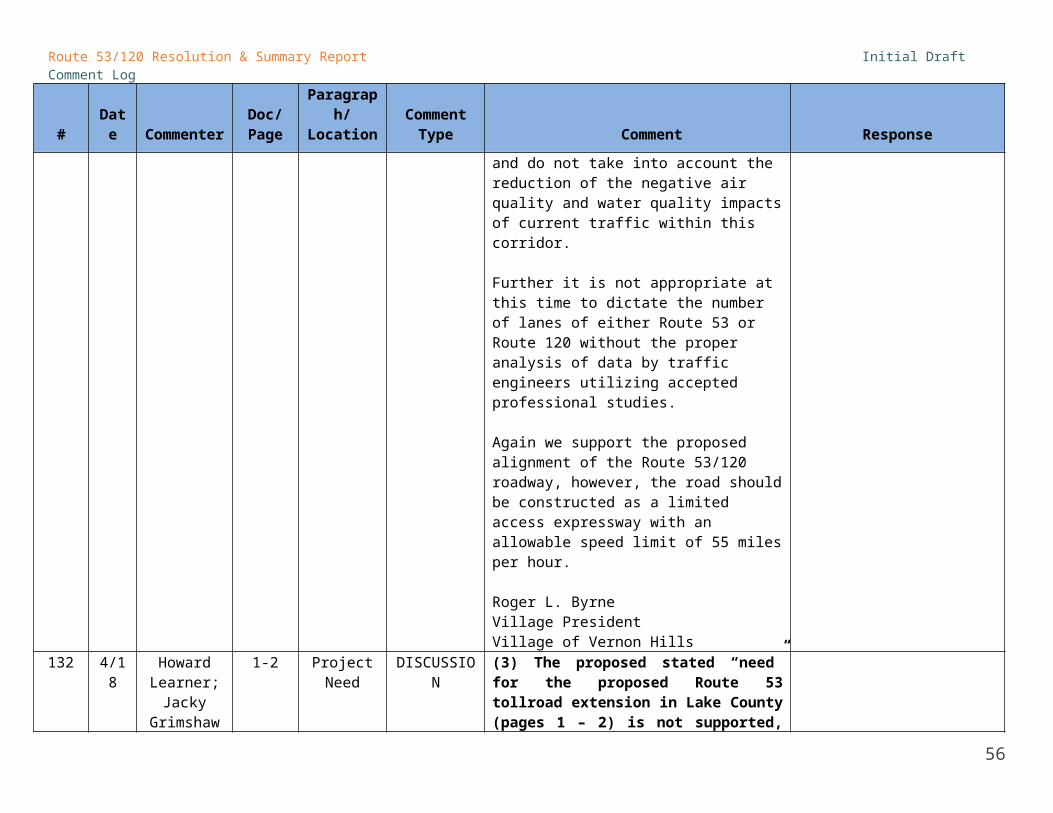
Route 53/120 Resolution & Summary Report Initial Draft Comment Log
# Date CommenterDoc/Page
Paragraph/Location
Comment Type Comment Response
approach, not simply stated as a goal.
174 4/18Mike EllisVillage of Grayslake
74-75 DISCUSSION
The Village agrees on the value of intergovernmental cooperation in land planning as included in the draft report. As noted in the Village's March 23, 2012 submittal to the Council concerning land use planning, the Village believes that there needs to be refinement of the map on page 75 in the area to the southwest of Rte 83 and Peterson Road to reflect less single family on parcels along Paterson Road per approved plans and due to land ownership of the Chicago Archdiocese for cemetery purposes.
Asd noted in the March 23 submittal to the Council, the Village believes, based on actual development experience in the area, that FAR levels will be much lower and open space and road network land consumption will further lower the total level of development in central Lake County from the projections shown on page 74.
Changes to CMAP future land use map.
PUBLIC COMMENTS
175 4/17 Carol Shaffer 16, 21 DISCUSSION
What is meant by "accommodation for transit" - last bullet item on this page. It should be a high priority to move people in ways other than via cars.
176 4/17 Carol Shaffer 66 DISCUSSIONWhere is a guarantee that, if built, the road would be done per this proposal and not otherwise?
56