• c h a p ter 99 both sudden and gradualaeckersberg.weebly.com/uploads/5/8/3/9/5839336/sp7...plate...
TRANSCRIPT
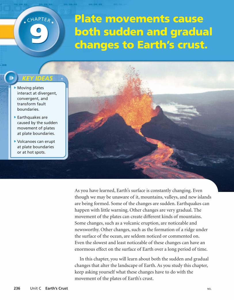
Plate movements causeboth sudden and gradualchanges to Earth’s crust.
Moving platesinteract at divergent,convergent, andtransform faultboundaries.
Earthquakes arecaused by the suddenmovement of platesat plate boundaries.
Volcanoes can eruptat plate boundariesor at hot spots.
KEY IDEAS
• CHAPTER •
99
As you have learned, Earth’s surface is constantly changing. Eventhough we may be unaware of it, mountains, valleys, and new islandsare being formed. Some of the changes are sudden. Earthquakes canhappen with little warning. Other changes are very gradual. Themovement of the plates can create different kinds of mountains.Some changes, such as a volcanic eruption, are noticeable andnewsworthy. Other changes, such as the formation of a ridge underthe surface of the ocean, are seldom noticed or commented on.Even the slowest and least noticeable of these changes can have anenormous effect on the surface of Earth over a long period of time.
In this chapter, you will learn about both the sudden and gradualchanges that alter the landscape of Earth. As you study this chapter,keep asking yourself what these changes have to do with themovement of the plates of Earth’s crust.
Unit C Earth’s Crust236 NEL

9.1 Plates on the Move 237NEL
Some of Earth’s plates are being pulled apart, some are colliding,some are being pulled under others, and some are sliding past eachother. The areas where plates meet are called plate boundaries. Thereare three types of plate boundaries:
1. divergent boundaries, where plates are being pulled apart
2. convergent boundaries, where plates are being pushed together
3. transform fault boundaries, where plates are sliding pasteach other
Divergent BoundariesThe boundaries between plates that are moving apart are called
As plates separate, hot molten magmarises to Earth’s surface to form new crust. On the ocean floor thisseparation of plates and production of new crust is called sea-floorspreading (Figure 1).
divergent boundaries.
Plates on the Move 9.19.1
LEARNING TIPPreview this section andlook at the headings. Thereare three main headings,one for each type of platemovement. Under one ofthe headings are threesubheadings. Use thisstructure for taking point-form notes as you read thesection. Your notes shouldalways answer twoquestions:• What is happening at
this type of boundary?• Where in the world is an
example of this type ofboundary?
Figure 1This photo of the sea floor was taken by the deep-sea submersible seen at the bottomof the photograph. As plates move apart and create a crack in the crust, seawater seepsinto the crack and becomes heated by the magma that is being pushed up from below.
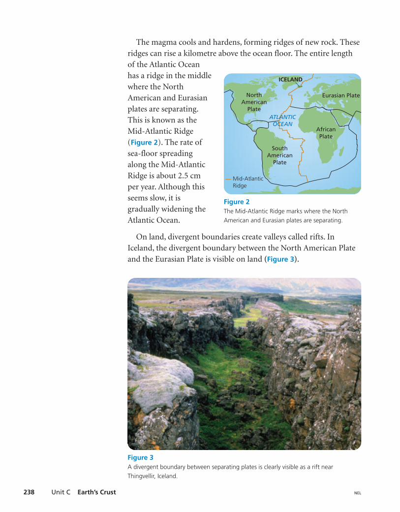
The magma cools and hardens, forming ridges of new rock. Theseridges can rise a kilometre above the ocean floor. The entire lengthof the Atlantic Oceanhas a ridge in the middlewhere the NorthAmerican and Eurasianplates are separating.This is known as theMid-Atlantic Ridge(Figure 2). The rate ofsea-floor spreadingalong the Mid-AtlanticRidge is about 2.5 cmper year. Although thisseems slow, it isgradually widening theAtlantic Ocean.
On land, divergent boundaries create valleys called rifts. InIceland, the divergent boundary between the North American Plateand the Eurasian Plate is visible on land (Figure 3).
Unit C Earth’s Crust238 NEL
NorthAmerican
Plate
ICELAND
Eurasian Plate
AfricanPlate
SouthAmerican
Plate
Mid-AtlanticRidge
ATLANTICOCEAN
Figure 2The Mid-Atlantic Ridge marks where the NorthAmerican and Eurasian plates are separating.
Figure 3A divergent boundary between separating plates is clearly visible as a rift nearThingvellir, Iceland.
9.1 Plates on the Move 239NEL
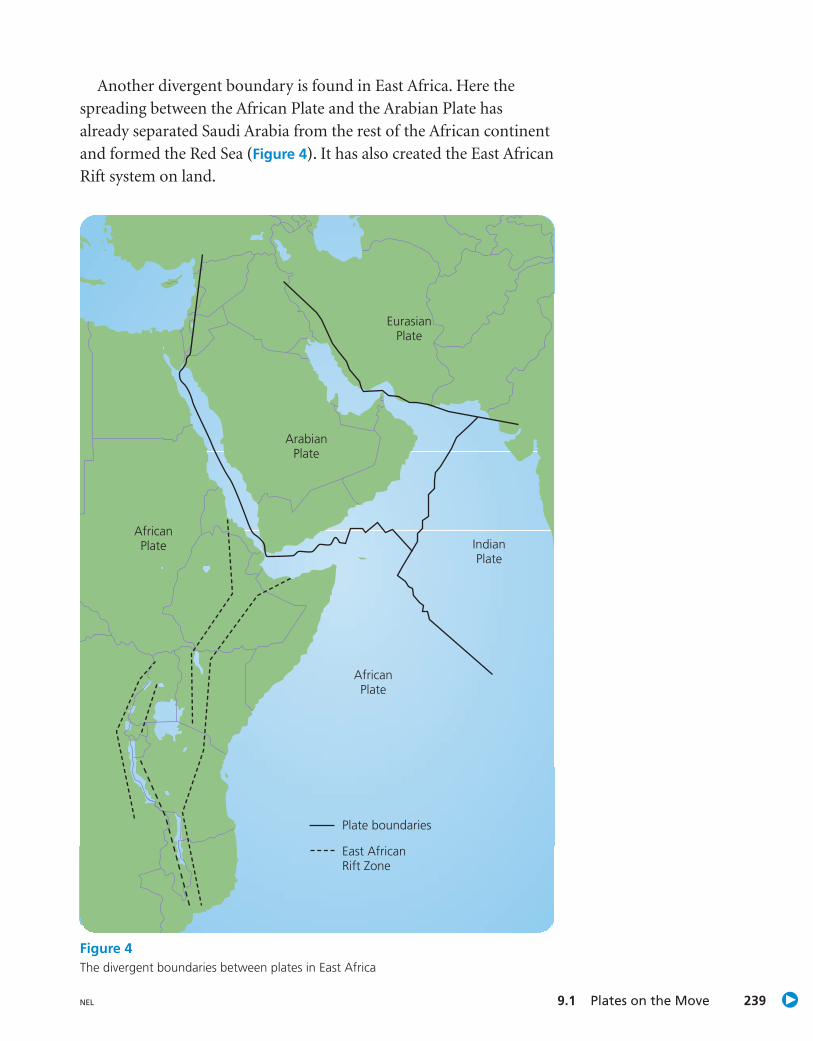
Another divergent boundary is found in East Africa. Here thespreading between the African Plate and the Arabian Plate hasalready separated Saudi Arabia from the rest of the African continentand formed the Red Sea (Figure 4). It has also created the East AfricanRift system on land.
AfricanPlate
Plate boundaries
East AfricanRift Zone
AfricanPlate
ArabianPlate
IndianPlate
EurasianPlate
Figure 4The divergent boundaries between plates in East Africa

sea floor
mantle
NorthAmerican
Plate
edge of plateJuan de Fuca Plate
British Columbia
Unit C Earth’s Crust240 NEL
Off the coast of South America, the oceanic Nazca Plate is beingsubducted under the continental South American Plate. The SouthAmerican Plate is being pushed up, creating the Andes Mountains.A is any landmass that rises significantly from thesurrounding level of Earth’s surface. This type of mountain building iscommon where an oceanic plate is converging with a continental plate.
mountain
Figure 5The Juan de Fuca Plate is beingsubducted under the NorthAmerican Plate, which ismoving west.
Convergent BoundariesSince there is no evidence that the size of Earth has changedsignificantly, old crust must be destroyed, or recycled, at the same ratethat new crust is being formed at divergent boundaries. The recyclingof old crust takes place at boundaries where plates move toward eachother. These boundaries are called
The collisions that occur when plates come together are very slowand can last millions of years. When plates come together, one platesinks below the other. The place where this occurs is called a
[sub-DUC-shun]. You can think of subductionas nature’s way of recycling Earth’s crust.
The landforms created at a convergent boundary depend onwhether an oceanic plate is converging with a continental plate, twooceanic plates are converging, or two continental plates are converging.
Oceanic Plate Converging with Continental PlateWhen an oceanic plate collides with a continental plate, the oceanicplate is subducted under the continental plate (Figure 5). Thiscreates deep ocean trenches along the edge of a continent. Along thecoast of British Columbia, this happens where the Juan de Fuca Plateis being subducted under the North American Plate.
subduction zone
convergent boundaries.
9.1 Plates on the Move 241NEL
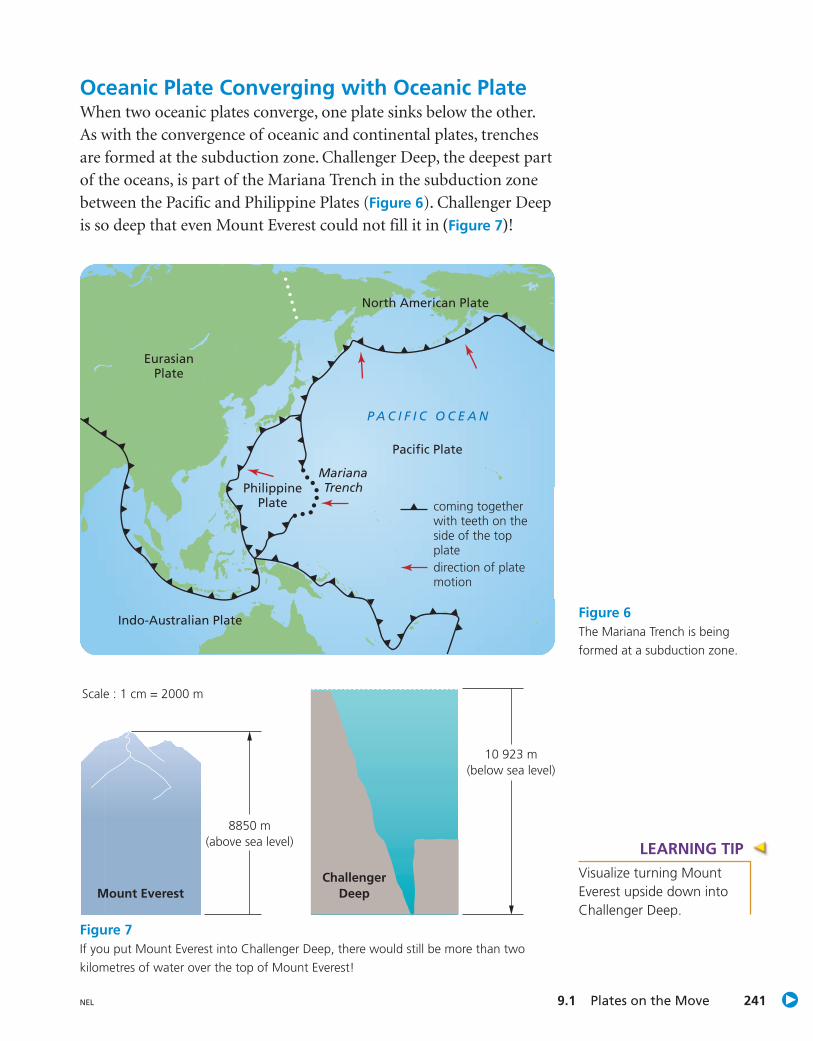
Oceanic Plate Converging with Oceanic PlateWhen two oceanic plates converge, one plate sinks below the other.As with the convergence of oceanic and continental plates, trenchesare formed at the subduction zone. Challenger Deep, the deepest partof the oceans, is part of the Mariana Trench in the subduction zonebetween the Pacific and Philippine Plates (Figure 6). Challenger Deepis so deep that even Mount Everest could not fill it in (Figure 7)!
Pacific Plate
Indo-Australian Plate
PhilippinePlate
North American Plate
EurasianPlate
Mariana Trench
direction of platemotion
P A C I F I C O C E A N
coming togetherwith teeth on theside of the topplate
Figure 6The Mariana Trench is beingformed at a subduction zone.
Mount EverestChallenger
Deep
8850 m(above sea level)
Scale : 1 cm = 2000 m
10 923 m(below sea level)
Figure 7If you put Mount Everest into Challenger Deep, there would still be more than twokilometres of water over the top of Mount Everest!
LEARNING TIPVisualize turning MountEverest upside down intoChallenger Deep.

Continental Plate Convergingwith Continental PlateWhen two continental plates meet, neither is subducted. Instead, thecrust buckles and crumbles, pushing up mountains or areas of highlevel ground called When the Indian Plate convergedwith the Eurasian Plate 50 million years ago, the slow uplift overmillions of years pushed up the highest continental mountains inthe world, the Himalayas (Figure 8). It also pushed up the TibetanPlateau. Although the Tibetan Plateau is fairly flat, it is higher thanthe Alps mountain range in Europe.
plateaus.
Unit C Earth’s Crust242 NEL
Figure 8The Himalayas

9.1 Plates on the Move 243NEL
Transform Fault BoundariesJ. Tuzo Wilson, a Canadian geophysicist, made models of plateboundaries with paper and scissors. He discovered a new kind of plateboundary, which he called a fault. A fault is an area where rocks arebeing broken by movement in the crust. Wilson also discovered thatdivergent and convergent plate boundaries could end abruptly and“transform” into faults. He therefore called the zone between platesthat are slipping past each other
Most transform fault boundaries are found on the ocean floor. Themost famous of the few on land is the San Andreas Fault (Figure 9) inCalifornia. At the San Andreas Fault, the Pacific Plate, which carriespart of California, is movingnorth past the North AmericanPlate, which carries the rest ofCalifornia. Shallow earthquakesare very common alongtransform fault boundaries,such as the San Andreas Fault.
transform fault boundaries.
Figure 9The San Andreas Fault is atransform fault boundary. Majorearthquakes have often occurredalong this fault.
CHECK YOUR UNDERSTANDING1. Copy and complete Table 1.
2. Where would you expect to find the newest rocks on the ocean floor?Where would you expect to find the oldest rocks?
Pacific Plate
North American Plate
Table 1 Types of Plate Boundaries
Type of plate Description of plate Places on Earth where this typeboundary movement of plate boundary is found
1.

SKILLS MENU
Questioning Observing
Predicting Measuring
Hypothesizing Classifying
Designing InferringExperiments
Controlling InterpretingVariables Data
Creating CommunicatingModels
Conduct an InvestigationConduct an Investigation
Unit C Earth’s Crust244 NEL
9.29.2
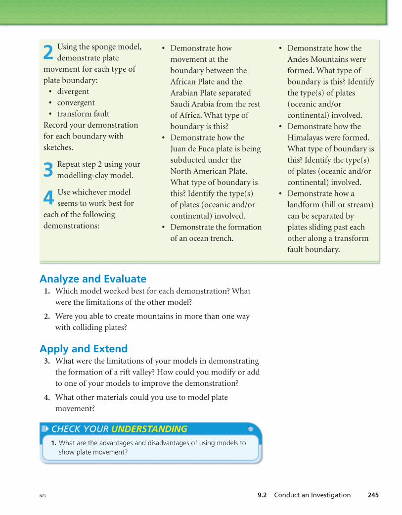
Creating Models of Plate MovementsThe movement of plates and the changes to Earth’s surface thatresult from this movement are too slow for you to observe directly.In this investigation, it will take you only a few minutes to usemodels to demonstrate the different ways that plates move overmillions and millions of years.
QuestionHow can you demonstrate plate movement at the three types ofplate boundaries?
Materials• modelling clay in 4 different
colours • rolling pin• dinner knife• 2 sponges of different colours
Procedure
Handle the knife carefully.Always cut away fromyourself and others whenusing a knife.
modelling clay model
sponge model
1 Use the rolling pin toflatten each colour of
modelling clay to about 1 cmthick. Stack the four layers ontop of each other and pressdown. Cut straight acrossthe slab so that you have twoequal pieces. These pieces willbe one of your models forplates. The two sponges willbe your other model.
modelling clay
rolling pin
dinner knife
sponges
9.2 Conduct an Investigation 245NEL
• Demonstrate how theAndes Mountains wereformed. What type ofboundary is this? Identifythe type(s) of plates(oceanic and/orcontinental) involved.
• Demonstrate how theHimalayas were formed.What type of boundary isthis? Identify the type(s)of plates (oceanic and/orcontinental) involved.
• Demonstrate how alandform (hill or stream)can be separated byplates sliding past eachother along a transformfault boundary.
2 Using the sponge model,demonstrate plate
movement for each type ofplate boundary:
• divergent• convergent• transform fault
Record your demonstrationfor each boundary withsketches.
3 Repeat step 2 using yourmodelling-clay model.
4 Use whichever modelseems to work best for
each of the followingdemonstrations:
• Demonstrate howmovement at theboundary between theAfrican Plate and theArabian Plate separatedSaudi Arabia from the restof Africa. What type ofboundary is this?
• Demonstrate how theJuan de Fuca plate is beingsubducted under theNorth American Plate.What type of boundary isthis? Identify the type(s)of plates (oceanic and/orcontinental) involved.
• Demonstrate the formationof an ocean trench.
CHECK YOUR UNDERSTANDING1. What are the advantages and disadvantages of using models to
show plate movement?
Analyze and Evaluate1. Which model worked best for each demonstration? What
were the limitations of the other model?
2. Were you able to create mountains in more than one waywith colliding plates?
Apply and Extend3. What were the limitations of your models in demonstrating
the formation of a rift valley? How could you modify or addto one of your models to improve the demonstration?
4. What other materials could you use to model platemovement?
As the plates that make up Earth’s crust move, the rough edges locktogether. Over time, pressure builds up until one or both of theplates suddenly move, releasing the energy stored in rocks. Thesudden release of energy causes vibrations of Earth’s crust called
Earthquakes can occur at all three types of plate boundaries:
1. divergent
2. convergent
3. transform fault.
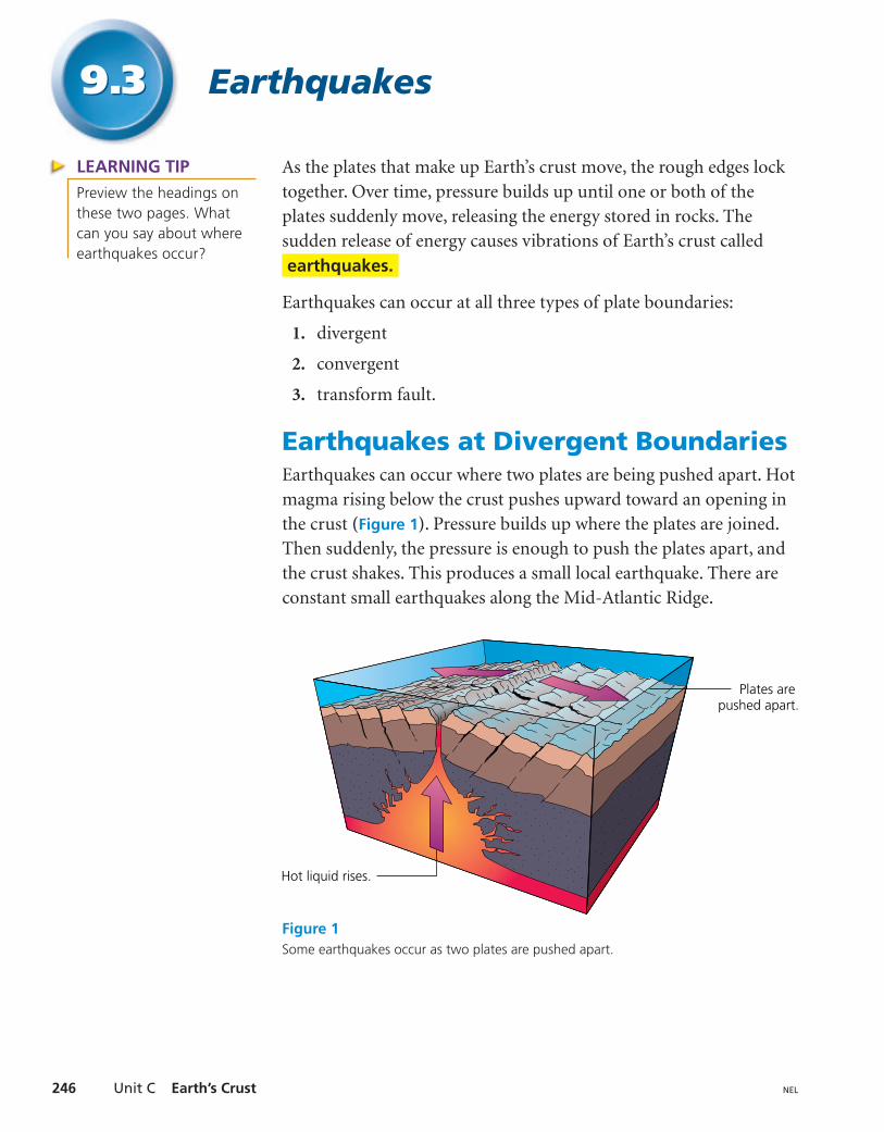
Earthquakes at Divergent BoundariesEarthquakes can occur where two plates are being pushed apart. Hotmagma rising below the crust pushes upward toward an opening inthe crust (Figure 1). Pressure builds up where the plates are joined.Then suddenly, the pressure is enough to push the plates apart, andthe crust shakes. This produces a small local earthquake. There areconstant small earthquakes along the Mid-Atlantic Ridge.
earthquakes.
Unit C Earth’s Crust246 NEL
Earthquakes9.39.3
Plates are pushed apart.
Hot liquid rises.
Figure 1Some earthquakes occur as two plates are pushed apart.
LEARNING TIPPreview the headings onthese two pages. Whatcan you say about whereearthquakes occur?
9.3 Earthquakes 247NEL
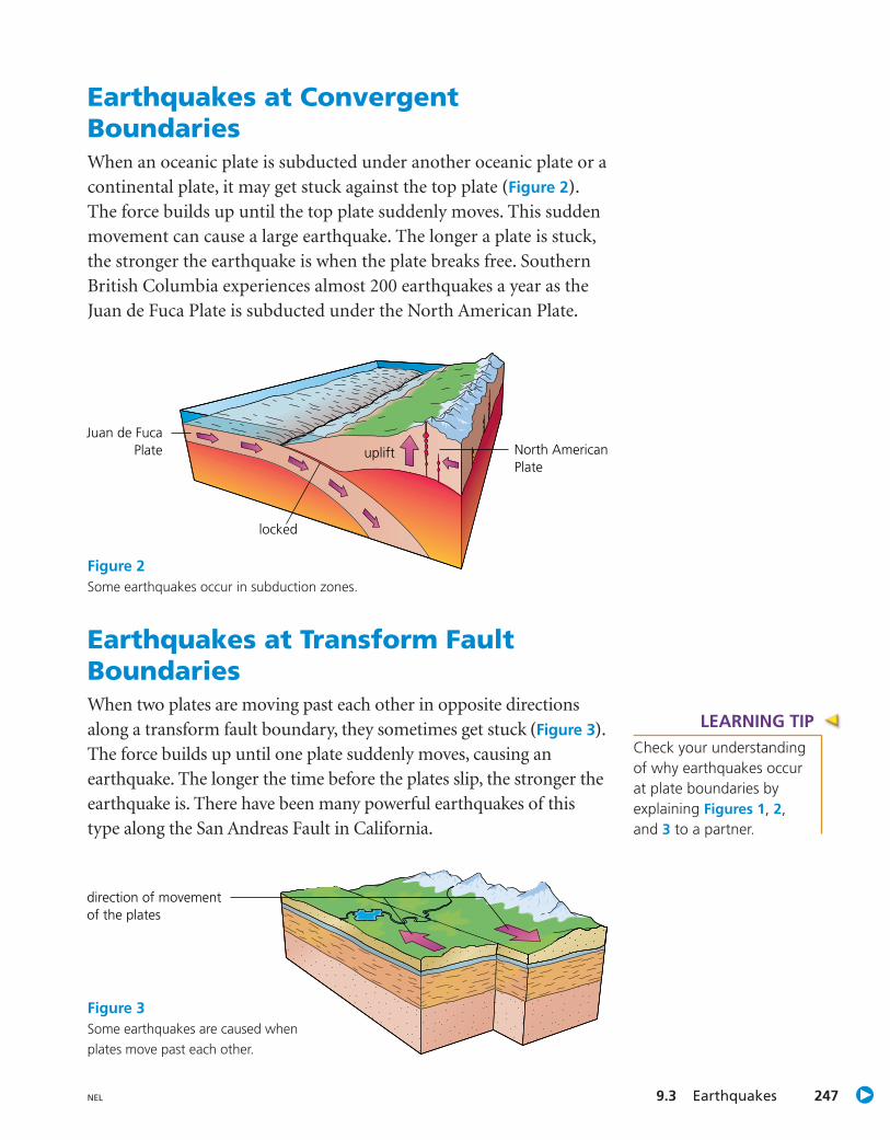
Earthquakes at ConvergentBoundariesWhen an oceanic plate is subducted under another oceanic plate or acontinental plate, it may get stuck against the top plate (Figure 2).The force builds up until the top plate suddenly moves. This suddenmovement can cause a large earthquake. The longer a plate is stuck,the stronger the earthquake is when the plate breaks free. SouthernBritish Columbia experiences almost 200 earthquakes a year as theJuan de Fuca Plate is subducted under the North American Plate.
uplift
locked
Juan de FucaPlate North American
Plate
direction of movementof the plates
Figure 3Some earthquakes are caused whenplates move past each other.
Earthquakes at Transform FaultBoundariesWhen two plates are moving past each other in opposite directionsalong a transform fault boundary, they sometimes get stuck (Figure 3).The force builds up until one plate suddenly moves, causing anearthquake. The longer the time before the plates slip, the stronger theearthquake is. There have been many powerful earthquakes of thistype along the San Andreas Fault in California.
Figure 2Some earthquakes occur in subduction zones.
LEARNING TIPCheck your understandingof why earthquakes occurat plate boundaries byexplaining Figures 1, 2,and 3 to a partner.

The Effects of EarthquakesNews reports and newspaper articles about earthquakes usuallyinclude large, dramatic photos of the damage that earthquakes cause(Figure 4). How does this damage occur?
Unit C Earth’s Crust248 NEL
The exact location within Earth at which an earthquake starts iscalled the focus (Figure 5). The focus is often deep within Earth’scrust. The point on the surface of Earth directly above the focus iscalled the epicentre of the earthquake. The shock waves that are sentout when an earthquake occurs are called Smallertremors can occur at any time for months after an earthquake as thepressure within Earth’s crust is gradually released. These tremors arecalled aftershocks.
seismic waves.
Figure 4Earthquake damage in Mexico City in 1985.
focus
epicentre
Shock wavestravel away from the focus.
fault
Figure 5Comparing the focus and epicentre of an earthquake.
both P and S waves
inner core (solid)
P waves only
earthquake focus
S wave
P wave
mantle (solid)
outer core (liquid)
9.3 Earthquakes 249NEL
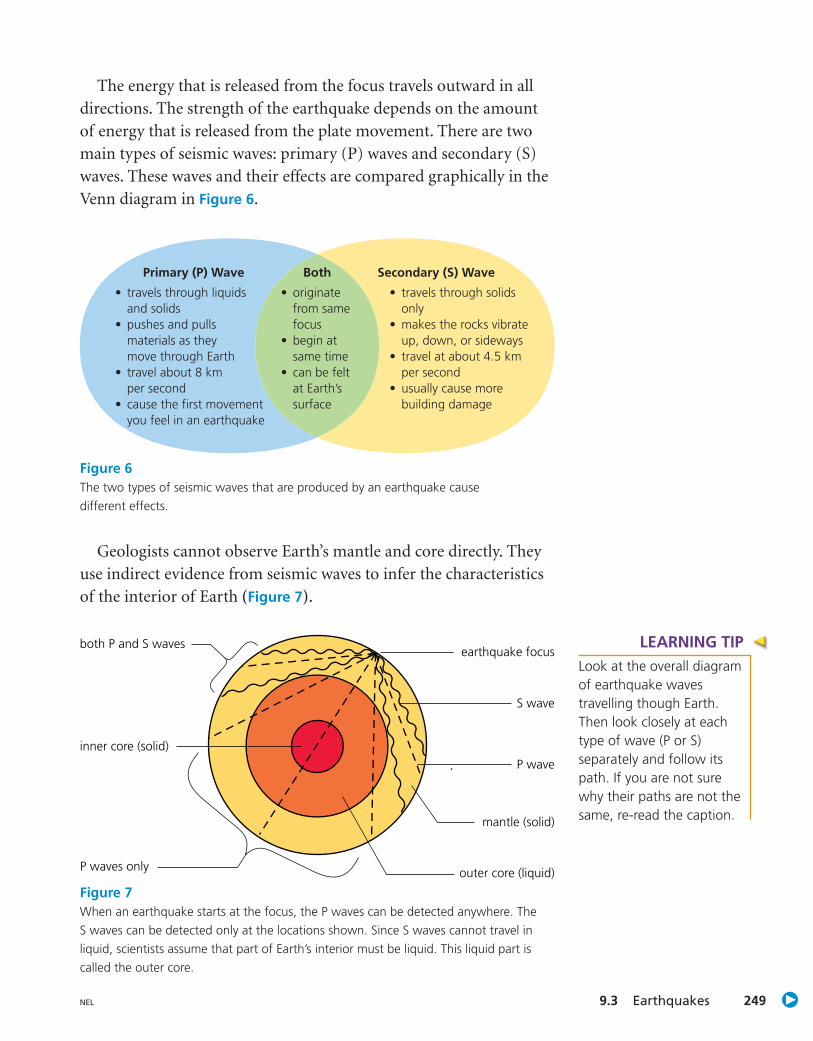
The energy that is released from the focus travels outward in alldirections. The strength of the earthquake depends on the amountof energy that is released from the plate movement. There are twomain types of seismic waves: primary (P) waves and secondary (S)waves. These waves and their effects are compared graphically in theVenn diagram in Figure 6.
Geologists cannot observe Earth’s mantle and core directly. Theyuse indirect evidence from seismic waves to infer the characteristicsof the interior of Earth (Figure 7).
Primary (P) Wave
• travels through liquids and solids
• pushes and pulls materials as theymove through Earth
• travel about 8 kmper second
• cause the first movement you feel in an earthquake
Both
• originate from same focus
• begin at same time
• can be felt at Earth’s surface
Secondary (S) Wave
• travels through solids only
• makes the rocks vibrate up, down, or sideways
• travel at about 4.5 km per second
• usually cause more building damage
Figure 6The two types of seismic waves that are produced by an earthquake causedifferent effects.
Figure 7When an earthquake starts at the focus, the P waves can be detected anywhere. TheS waves can be detected only at the locations shown. Since S waves cannot travel inliquid, scientists assume that part of Earth’s interior must be liquid. This liquid part iscalled the outer core.
LEARNING TIPLook at the overall diagramof earthquake wavestravelling though Earth.Then look closely at eachtype of wave (P or S)separately and follow itspath. If you are not surewhy their paths are not thesame, re-read the caption.

When an earthquake begins, the ground starts to shake, causingbuildings to sway back and forth. If this happens in a rural area,only a few people may be in danger. If this happens in a city or town,many people may be affected. In addition to damaging buildings androads, earthquakes can cause tunnels and overpasses to collapse.Fires can start when fuel tanks and gas lines break (Figure 8). Waterlines can also break, leaving people without drinking water or waterto fight fires.
Unit C Earth’s Crust250 NEL
If a large earthquake causes a section of the sea floor to move,a series of ocean waves is created. Ocean waves that are caused byan earthquake or an underwater volcano are called [tsu-NAH-mees].
In the open ocean, tsunamis are small and pass almost unnoticed,except that they travel much faster than normal ocean swells. Tsunamiscan travel at speeds of more than 800 km/h, as fast as a commercialjetliner, in deep water. When they approach shallower waters, theirspeed is reduced but they grow to surprising heights. In narrow inletsor shallow harbours, their height can increase to 30 m or more.Tsunamis can cause massive destruction and flooding in coastal areas.
tsunamis
Figure 8In 1995, an earthquake causedmassive damage when it hit thecity of Kobe, Japan. Over 300 fireswere started as a result.
LEARNING TIPThe name “tsunami” comesfrom the Japanese wordsfor harbour ( or tsu) andwave ( or nami ). Why isthis name a good choice?
9.3 Earthquakes 251NEL
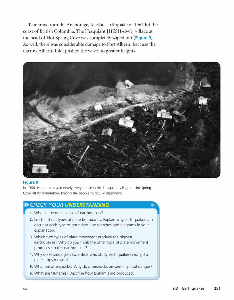
Tsunamis from the Anchorage, Alaska, earthquake of 1964 hit thecoast of British Columbia. The Hesquiaht [HESH-dwit] village atthe head of Hot Spring Cove was completely wiped out (Figure 9).As well, there was considerable damage to Port Alberni because thenarrow Alberni Inlet pushed the waves to greater heights.
Figure 9In 1964, tsunamis moved nearly every house in this Hesquiaht village at Hot SpringCove off its foundation, forcing the people to rebuild elsewhere.
CHECK YOUR UNDERSTANDING1. What is the main cause of earthquakes?
2. List the three types of plate boundaries. Explain why earthquakes canoccur at each type of boundary. Use sketches and diagrams in yourexplanation.
3. Which two types of plate movement produce the biggestearthquakes? Why do you think the other type of plate movementproduces smaller earthquakes?
4. Why do seismologists (scientists who study earthquakes) worry if aplate stops moving?
5. What are aftershocks? Why do aftershocks present a special danger?
6. What are tsunamis? Describe how tsunamis are produced.

Solve a ProblemSolve a Problem
Unit C Earth’s Crust252 NEL
9.49.4
Preparing for an EarthquakeProblemAre you prepared for the big one? Since many parts of BritishColumbia are in an earthquake zone, it is only a matter of time beforea major earthquake occurs. You need to be prepared for a majorearthquake, both at school and at home. What can you do before,during, and after an earthquake to keep yourself as safe as possible?
TaskCreate two Earthquake Preparedness Checklists—one for school andone for home.
CriteriaTo be successful, your checklists must
• provide details about the dangers during and after an earthquake
• describe precautions that you can take before, during, and afteran earthquake
• be thorough and accurate
• be clear and easy to understand
Plan and Test1. Research dangers that you might expect during a major
earthquake. What can you do now to prepare for these dangers?What can you do during an earthquake to keep yourself as safe aspossible from these dangers? Are the dangers at home differentfrom those at school? Take notes as you do your research.
LEARNING TIPTo review the steps insolving a problem orresearching see the SkillsHandbook sections“Solving a Problem”and “Researching.”
9.4 Solve a Problem 253NEL
2. Now research dangers that you might expect after anearthquake. What can you do now to prepare for these dangers?What can you do during and after an earthquake to keepyourself as safe as possible from these dangers? Are the dangersat home different from those at school? Take notes as you work.
CHECK YOUR UNDERSTANDING1. What resources did you use to create your checklists?
2. Are there organizations in your community that could provide youwith additional information? Compare your checklists with anyinformation that these organizations provide.
www.science.nelson.com GOGO
3. Use your notes to draft school and home EarthquakePreparedness Checklists. Use the following headings: Before anearthquake, During an earthquake, After an earthquake.
Evaluate4. Compare your draft school and home checklists with those of
other students. Is there anything that you think you should add?
5. Compare your school checklist with the school’s earthquakepreparedness plan, if there is one. Is there anything that youthink you should add to your checklist?
6. Show your home checklist to your parents. Is there anythingthat they think you should add or change?
Communicate7. Make final copies of your school and home checklists. You may
want to illustrate your checklists to emphasize important points.
8. Use your school checklist to teach a group of younger studentsabout how to be prepared for an earthquake.
9. Is there anything on your checklist, or your classmates’checklists, that you think should be added to your school’s plan?If so, get advice from your teacher about how to communicatethis to your principal.
10. Is there anything on your checklist that your family hasnot done? Talk to your family about why it is importantto do everything on your checklist.

Unit C Earth’s Crust254 NEL
Awesome SCIENCEAwesome SCIENCE
Indigenous Knowledge Sheds Light onBritish Columbia’s Geological Past
On a still midwinter night, long before Europeansfirst landed on Vancouver Island, native legendtells of a great disaster. The sea rose in a heavingwave, and landslides buried a sleeping village.
“They had practically no way or time to savethemselves. They simply had no time to get holdof canoes, no time to get awake,” the late Nuu-chah-nulth Chief Louie Clamhouse told AlanMcMillan, an anthropologist at Simon FraserUniversity. “I think a big wave slammed into thebeach. The Pachena Bay people were lost.”
Over time, storytellers began to speak of dwarfsin the mountains, mythic creatures who woulddance around their great wooden drum, causingEarth to shake and the waters to rise.
In 2003, government research proved thatan earthquake, the most intense Canada hasever seen, hit the sea floor off the BritishColumbia coast at 9:00 P.M. on January 26,1700. Earthquakes of that intensity causetsunamis, and Japanese written history tells of amassive tsunami striking fishing villages the nextday along the coast of Honshu, killing hundreds.Coupled with geological evidence of the level 9quake, the connection was clear.
Tim Paul, a Nuu-chah-nulth carver andsilkscreen artist, has recorded these earthquakelegends in his art. In one celebrated mask, he caststhe earthquake god Ta-gil as a terrifying, cave-dwelling “relative” of humanity. The other 10relatives—Sun, stars, Moon, and so on—nurtureus, but Ta-gil “puts us in our place” and with hisdestruction, he “reminds us that we are thesmallest part of nature,” Mr. Paul says.
In Mr. Paul’s silkscreens, Ta-gil is depicted withan enlarged foot, the “earthquake foot,” thatenables him to shake the ground. The Juan deFuca tectonic plate, whose motion is responsiblefor all these myths, is the smallest tectonic plateon Earth and thus the easiest to study.
Native carver Tim Paul depicts the earthquake god as afearsome relative of humanity. While humanity’s other10 relatives, such as Moon and stars, nurture us, theearthquake god humbles us.
9.5 Volcanoes 255NEL
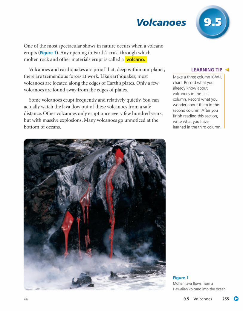
One of the most spectacular shows in nature occurs when a volcanoerupts (Figure 1). Any opening in Earth’s crust through whichmolten rock and other materials erupt is called a
Volcanoes and earthquakes are proof that, deep within our planet,there are tremendous forces at work. Like earthquakes, mostvolcanoes are located along the edges of Earth’s plates. Only a fewvolcanoes are found away from the edges of plates.
Some volcanoes erupt frequently and relatively quietly. You canactually watch the lava flow out of these volcanoes from a safedistance. Other volcanoes only erupt once every few hundred years,but with massive explosions. Many volcanoes go unnoticed at thebottom of oceans.
volcano.
Volcanoes 9.59.5
Figure 1Molten lava flows from aHawaiian volcano into the ocean.
LEARNING TIPMake a three column K-W-Lchart. Record what youalready know aboutvolcanoes in the firstcolumn. Record what youwonder about them in thesecond column. After youfinish reading this section,write what you havelearned in the third column.

Volcanoes at Divergent Boundaries When you hear the word “volcano,” you probably think of a volcanoon land. However, about three-quarters of all lava produced onEarth comes from eruptions at divergent boundaries on the oceanfloor. Magma pushes to the surface where plates are moving apart(Figure 2). The lava erupts and cools to form a ridge on each side ofthe crack on the ocean floor. Some of these ridges may rise highenough to reach the surface, creating islands. Iceland was formed,and continues to be formed, in this way.
Unit C Earth’s Crust256 NEL
magma beneath the plate edge
Figure 3The new island formed off the coast ofIceland was named Surtsey, after Surt, the lordof the land of fire giants in Norse mythology.
Figure 2The Mid-Atlantic Ridge wasformed by magma pushing twoplates apart.
In 1963, plumes of smokebillowed out of the ocean nearIceland (Figure 3). Soon a newisland appeared, as largeamounts of magma flowed outof the ocean rift between theEurasian and North AmericanPlates. Eventually, the islandgrew to 150 m above sea level.
Mount Edziza, HoodooMountain, Lava Fork, andCrow Lagoon are volcanoeson a divergent boundary inthe northwestern corner ofBritish Columbia, near theborder of Alaska. These arethe youngest volcanoes in theprovince. It has been 150 yearssince one erupted.
9.5 Volcanoes 257NEL
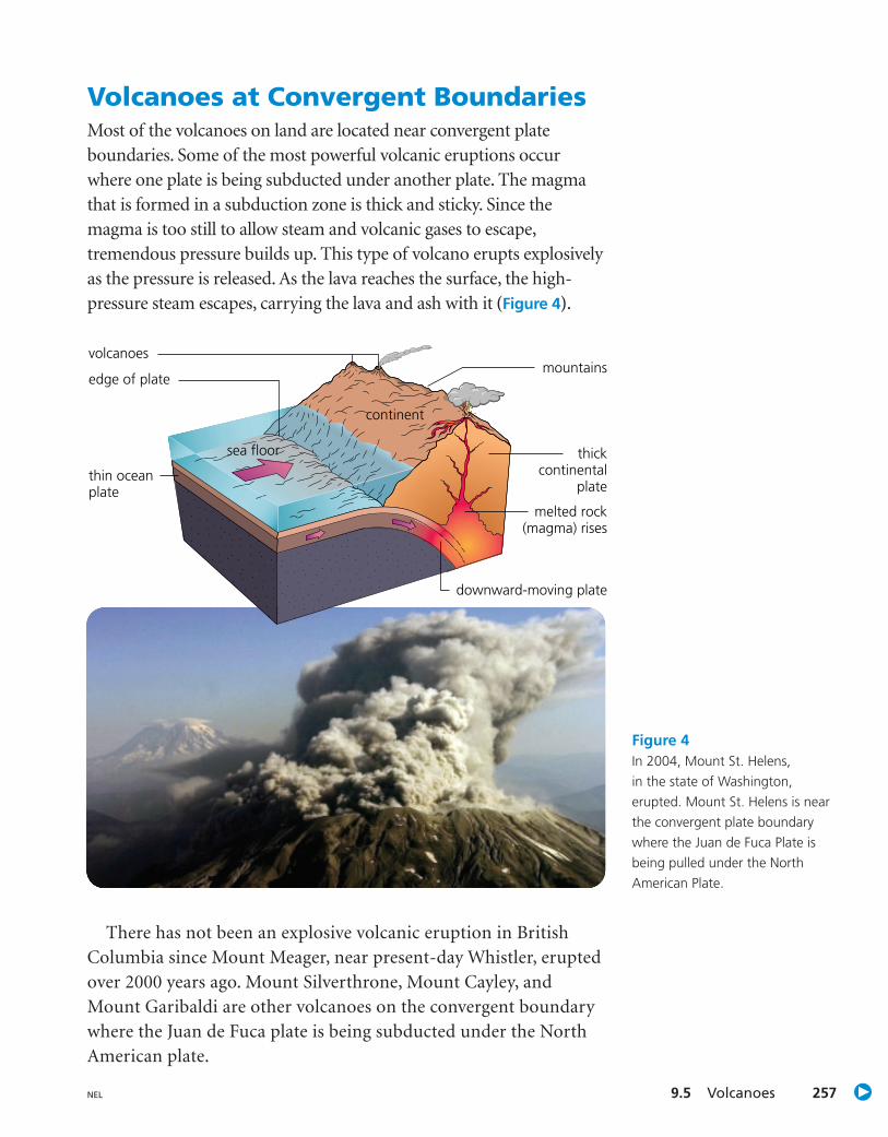
Volcanoes at Convergent BoundariesMost of the volcanoes on land are located near convergent plateboundaries. Some of the most powerful volcanic eruptions occurwhere one plate is being subducted under another plate. The magmathat is formed in a subduction zone is thick and sticky. Since themagma is too still to allow steam and volcanic gases to escape,tremendous pressure builds up. This type of volcano erupts explosivelyas the pressure is released. As the lava reaches the surface, the high-pressure steam escapes, carrying the lava and ash with it (Figure 4).
There has not been an explosive volcanic eruption in BritishColumbia since Mount Meager, near present-day Whistler, eruptedover 2000 years ago. Mount Silverthrone, Mount Cayley, andMount Garibaldi are other volcanoes on the convergent boundarywhere the Juan de Fuca plate is being subducted under the NorthAmerican plate.
Figure 4In 2004, Mount St. Helens,in the state of Washington,erupted. Mount St. Helens is nearthe convergent plate boundarywhere the Juan de Fuca Plate isbeing pulled under the NorthAmerican Plate.
continent
sea floor
edge of plate
volcanoes
downward-moving plate
melted rock(magma) rises
thickcontinental
plate
mountains
thin oceanplate

Volcanoes That Form at Hot Spots Although most of Earth’s volcanoes occur near plate boundaries,there are some exceptions. The Hawaiian Islands formed fromvolcanoes in the middle of the Pacific Ocean, over 3000 km from thenearest plate boundary. This puzzled scientists until J. Tuzo Wilsondiscovered evidence of hot spots. are parts of the mantlewhere the temperature is much higher than normal.
At a hot spot, magmacollects in enormous pools.The hot magma eventuallymelts a hole in the rockabove it and pours out ofthe hole onto Earth’ssurface as lava (Figure 5).The lava that is producedat a hot spot tends to berunny and so fluid that thevolcano does not eruptexplosively. The lava simplypours out of the volcanolike a river and hardens.
If this type of volcano forms on the ocean floor, the lava hardensmore quickly than it would on land. The hardened lava forms acone-shaped mountain that may eventually rise above sea level as anisland. This is how the Hawaiian Islands were formed (Figure 6).
Hot spots
Unit C Earth’s Crust258 NEL
ocean
volcanolava flow
hot spot
magma
Earth’s crust
Figure 5Volcanoes can form at a hot spot, where ahuge pool of hot magma has risen through themantle and melted a hole through the solidrock of Earth’s crust.
Figure 6Mauna Loa, on the island ofHawaii, is a volcano that formed ata hot spot. From its base at thebottom of the Pacific Ocean to itssummit, it rises 9750 m. This makesit taller than Mount Everest!
9.5 Volcanoes 259NEL
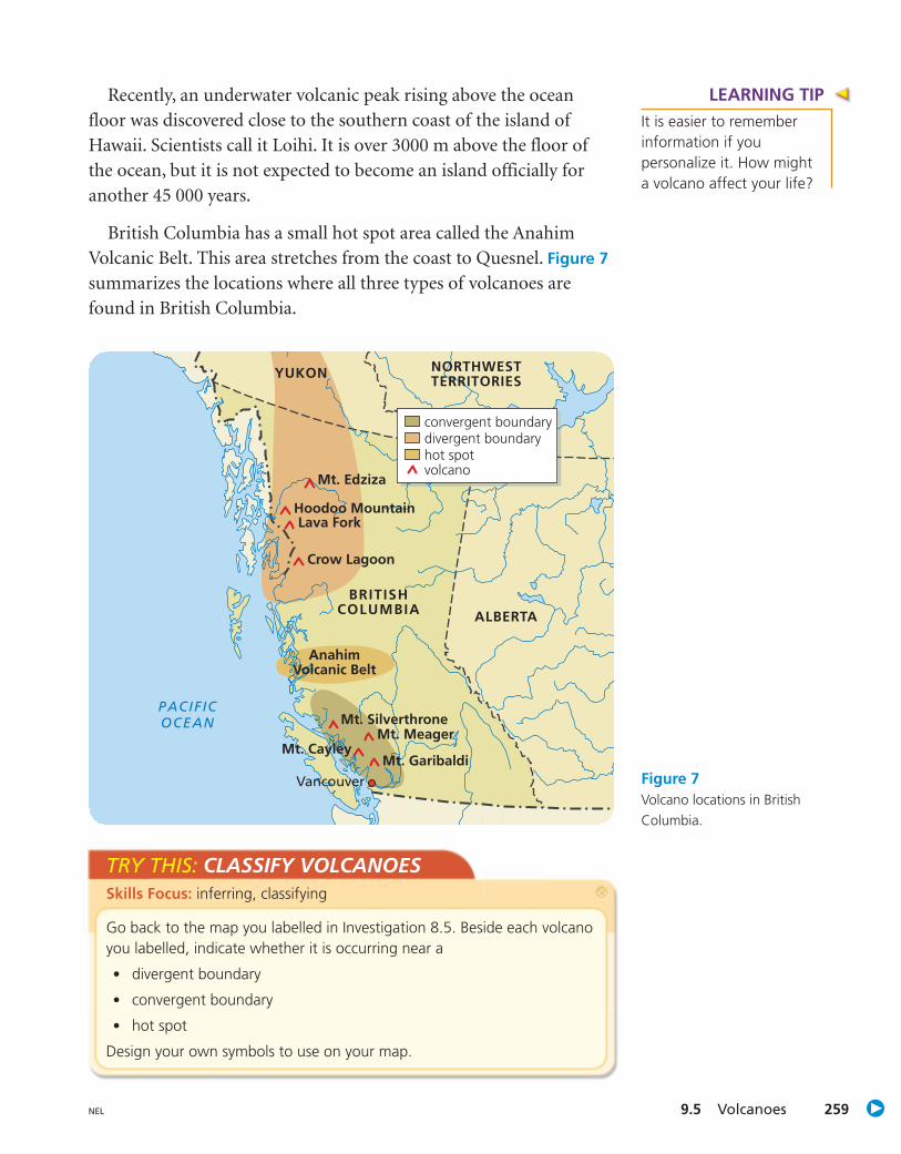
TRY THIS: CLASSIFY VOLCANOESSkills Focus: inferring, classifying
Go back to the map you labelled in Investigation 8.5. Beside each volcanoyou labelled, indicate whether it is occurring near a
• divergent boundary
• convergent boundary
• hot spot
Design your own symbols to use on your map.
BRITISHCOLUMBIA
YUKON NORTHWESTTERRITORIES
ALBERTA
PACIFICOCEAN
Mt. Edziza
Hoodoo MountainLava Fork
Crow Lagoon
Mt. Silverthrone
AnahimVolcanic Belt
Mt. MeagerMt. Cayley
Mt. GaribaldiVancouver
convergent boundarydivergent boundaryhot spotvolcano
Figure 7Volcano locations in BritishColumbia.
Recently, an underwater volcanic peak rising above the oceanfloor was discovered close to the southern coast of the island ofHawaii. Scientists call it Loihi. It is over 3000 m above the floor ofthe ocean, but it is not expected to become an island officially foranother 45 000 years.
British Columbia has a small hot spot area called the AnahimVolcanic Belt. This area stretches from the coast to Quesnel. Figure 7
summarizes the locations where all three types of volcanoes arefound in British Columbia.
LEARNING TIPIt is easier to rememberinformation if youpersonalize it. How mighta volcano affect your life?

The Effects of VolcanoesEarthquakes can be very destructive, killing people and destroyingproperty. People have been killed by clouds of hot ash andpoisonous gases, and buried by volcanic mudslides. People have diedof starvation because their crops, livestock, or other sources of foodwere destroyed. Whole villages and even cities have been destroyedby volcanoes. About 250 years ago, a lava flow in northern BritishColumbia destroyed two villages and killed about 2500 people(Figure 8). Scientists believe they were killed by carbon dioxide gas.
Unit C Earth’s Crust260 NEL
Not all the effects of a volcano are felt right away or only close tothe volcano. Ash from the 1980 eruption of Mount St. Helens fellon Vancouver. Large, explosive eruptions can send ash and gaseshigh into the atmosphere. Volcanic clouds from the eruptions ofTambora (Indonesia) in 1815 and Mount Pinatubo (Philippines)in 1991 drifted around Earth, blocking the Sun and coolingtemperatures for years.
Figure 8Lava beds at Anhluut’ukwsim Laxmihl Angwinga’asanskwhl Nisga’a: This is the firstprovincial park in British Columbia that has been established to combine theinterpretation of geological features and Aboriginal culture.
LEARNING TIPAsk yourself, “How couldcommunity planners makeuse of this information onthe effects of volcanoes?”
9.5 Volcanoes 261NEL
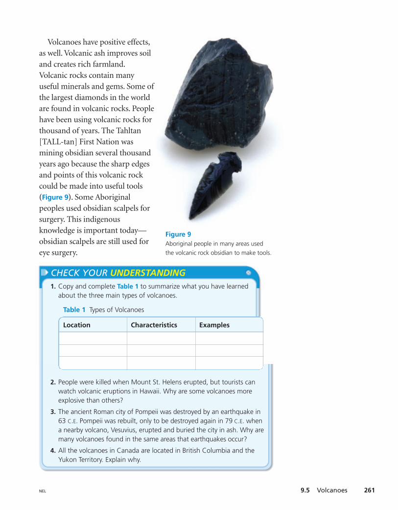
Figure 9Aboriginal people in many areas usedthe volcanic rock obsidian to make tools.
CHECK YOUR UNDERSTANDING1. Copy and complete Table 1 to summarize what you have learned
about the three main types of volcanoes.
2. People were killed when Mount St. Helens erupted, but tourists canwatch volcanic eruptions in Hawaii. Why are some volcanoes moreexplosive than others?
3. The ancient Roman city of Pompeii was destroyed by an earthquake in63 C.E. Pompeii was rebuilt, only to be destroyed again in 79 C.E. whena nearby volcano, Vesuvius, erupted and buried the city in ash. Why aremany volcanoes found in the same areas that earthquakes occur?
4. All the volcanoes in Canada are located in British Columbia and theYukon Territory. Explain why.
Table 1 Types of Volcanoes
Location Characteristics Examples
Volcanoes have positive effects,as well. Volcanic ash improves soiland creates rich farmland.Volcanic rocks contain manyuseful minerals and gems. Some ofthe largest diamonds in the worldare found in volcanic rocks. Peoplehave been using volcanic rocks forthousand of years. The Tahltan[TALL-tan] First Nation wasmining obsidian several thousandyears ago because the sharp edgesand points of this volcanic rockcould be made into useful tools(Figure 9). Some Aboriginalpeoples used obsidian scalpels forsurgery. This indigenousknowledge is important today—obsidian scalpels are still used foreye surgery.
Unit C Earth’s Crust262 NEL
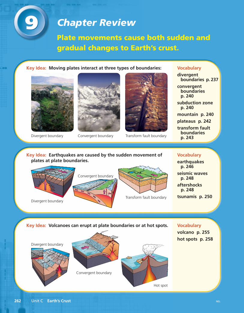
99Plate movements cause both sudden andgradual changes to Earth’s crust.
Chapter Review
Key Idea: Moving plates interact at three types of boundaries: Vocabularydivergent
boundaries p. 237convergent
boundariesp. 240
subduction zonep. 240
mountain p. 240plateaus p. 242transform fault
boundariesp. 243
Key Idea: Earthquakes are caused by the sudden movement ofplates at plate boundaries.
Vocabularyearthquakes
p. 246seismic waves
p. 248aftershocks
p. 248tsunamis p. 250
Key Idea: Volcanoes can erupt at plate boundaries or at hot spots. Vocabularyvolcano p. 255hot spots p. 258
Divergent boundary Convergent boundary Transform fault boundary
Convergent boundary
Convergent boundary
Transform fault boundary
Hot spot
Divergent boundary
Divergent boundary

Chapter 9 Review 263NEL
www.science.nelson.com GOGO
www.science.nelson.com GOGO
www.science.nelson.com GOGO
www.science.nelson.com GOGO
Review Key Ideas andVocabularyWhen answering the questions, remember touse vocabulary from the chapter.
1. What are the three types of plateboundaries? Sketch a diagram to explainplate movement at each.
2. What causes earthquakes? Where doearthquakes usually occur?
3. Where are volcanoes likely to be found?What type of volcano is found in eacharea, and why?
4. Why are earthquakes and volcanoes oftenfound in the same areas?
Use What You’ve Learned5. Many scientists believe that the Great Rift
Valley of Africa will be the location of thenext ocean as eastern Africa breaks awayfrom the rest of the continent. Researchwhat is known and predicted about themovement of plates in this area.
9. In Iceland, where hot magma is close toEarth’s surface, many people use its heat towarm their homes. This form of energy iscalled geothermal energy. Researchgeothermal energy. Would geothermalenergy be practical to use in yourcommunity? Prepare a report.
6. Why might frequent, smaller earthquakesbe desirable along a transform faultboundary?
7. If a small earthquake occurs in Ontario,should people be worried that it is a sign ofa bigger earthquake to come? Is this areasonable worry?
8. What is a seismograph? What doscientists use seismographs for? Researchseismographs and their use. Can youmake a simple seismograph fromeveryday materials?
10. Research and prepare a report on a volcaniceruption. You might consider Thera in2600 B.C.E., Mount Vesuvius in 79 C.E.,Krakatoa in 1883, Mount Pelee in 1902,Mount St. Helens in 1980 or 2004, or theNisga’a lava beds. Is there a volcanoerupting now somewhere in the world thatyou could research?
Think Critically11. Imagine that you had to live and work in
one of the following areas: an area whereearthquakes are common or an area wherevolcanic eruptions are common. Whicharea would you choose? Give reasons foryour choice.
12. Describe some of the social problems thatcould result if scientists predicted anearthquake near a city. What could be donein advance to minimize these problems?
Reflect on Your Learning13. Which hands-on activity in this chapter
was most helpful to your learning? Howdid it help you learn?
14. How have your ideas about Earth changedsince learning about plate movements?Will you look at the world differently sincestudying plate tectonics?

Making Connections
264 Unit C Earth’s Crust NEL
CC• UNIT •
Throughout the unit, you explored, created, andused models to help you learn about processesthat were too large or dangerous, or happenedtoo slowly, for classroom observations.
In this activity, you will work with a partner to develop a detailed presentation about asingle rock.
Looking BackIn this unit, you studied examples of bothsudden and gradual changes to Earth’s crust.You learned about rock and how rock from onefamily can change into rock from anotherfamily. You also learned that Earth’s crust ismade up of moving plates.
Writing the Life Story of a Rock

Unit C Making Connections 265NEL
ASSESSMENTCheck to make sure that your work providesevidence that you are able to
• identify and classify your rock
• describe how your rock was formed
• describe the possible effects of weathering,erosion, and plate movement on your rock
• create models to help you explain processesthat could have, or might in the future, affectyour rock
• use appropriate scientific language to describethese processes
Part 3: Describe a realistic futureTake notes as you brainstorm the possibilitiesfor the future of your rock. Consider thefollowing questions when describing yourrock’s future.
• What realistic predictions could you makeabout what will happen to your rock overthe next several million years?
• Could it travel far from where it is now?
• Could it be dramatically changed?
Create a model to demonstrate your rock’spossible future.
Part 4: Develop your presentationUse your notes to develop a presentation.Your presentation could be oral or written.It could be a book, a Web site, a skit, a comicstrip, or anything else you choose. Use yourcreativity to develop a presentation that willbe informative and interesting for yourclassmates. Use simple materials to makemodels that will help you explain someof the processes you describe.
www.science.nelson.com GOGO
Demonstrate Your LearningPart 1: Investigate the present.Select a rock from the samples provided by yourteacher. If you are interested in using a rock youfound, check with your teacher. Use physicalproperties to identify your rock. Make notes foryour presentation as you work. Consider thefollowing questions about your rock.
• What rock family does your rockbelong to?
• Where is it usually found?
• Are there ways in which people use thistype of rock?
• Is there anything especially interesting orunusual about this type of rock?
You might do Internet research to help you findout more about your rock.
Part 2: Describe a realistic pastTake notes as you discuss your ideas about arealistic past for your rock. Consider the followingquestions when describing your rock’s past.
• How and where do you think your rockwas formed?
• Could it once have been a different typeof rock?
• How could it have been changed since itwas formed?
• How could it have been moved from whereit was formed?
• What type of land feature could it havebeen part of?
Remember that your rock’s past may coverseveral million years. Create a model to explainyour rock’s past to your classmates.