· burscough to appley bridge or wigan along the leeds - liverpool canal distance: 9 km or 5½...
TRANSCRIPT

WWW.LancashireWalks.Com
Burscough to Appley Bridge or Wigan along the Leeds - Liverpool Canal
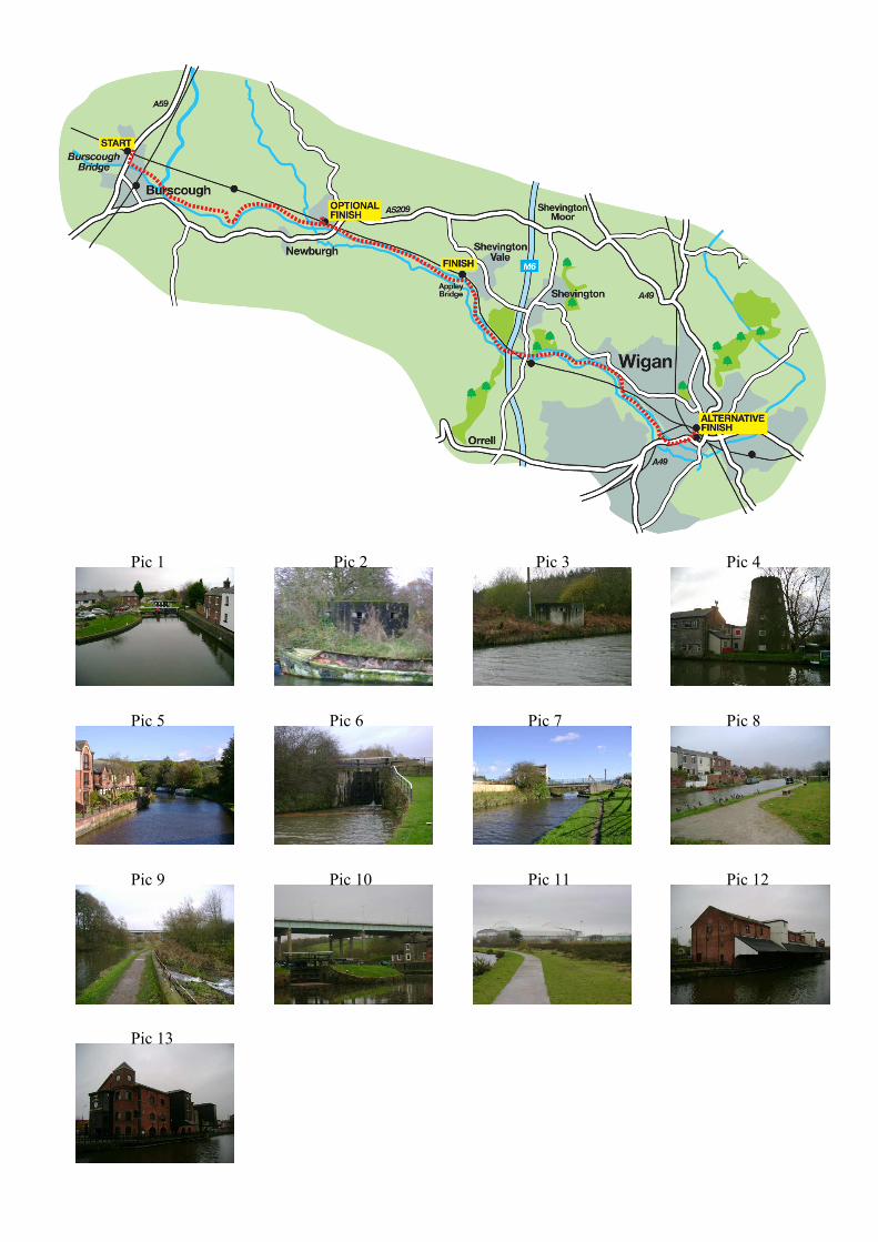
Distance: 9 Km or 5½ milesTime: 2 or 4 hoursTerrain: Very easy towpath walk.Map: OS Explorer 285 Southport and Chorley
For some 12 miles through the West Lancashire countryside the Wigan - Southport railway line and the Leeds-Liverpool canal follow a parallel course. This provides the walker with numerous opportunities to moreclosely acquaint themselves with this attractive district of the county.Option 1: Start at Wigan or Appley Bridge and walk to Burscough taking the train back.Option 2: Take the train from Wigan or Appley Bridge to Burscough and walk back. Option 3: Take the trainfrom Burscough Bridge and walk back from Wigan or Appley Bridge.Option 4: (as described below) Walk from Burscough to Appley Bridge and return by train. Furtherpermutations are possible from and to Parbold station, but please don't think about them too much or you'll geta headache! Clearly whatever option you take, judicious study of the railway timetable will reap its ownreward.
From the station walk up to the main A59 Liverpool Road and turn right. In 300m reach the canal bridge.Take the access road on the right to reach tow path. Turn left under bridge 32A. You are now walking towardsAppley Bridge. As you reach the open countryside views open out. Ahead to the left rises Parbold Hill.Though not of any great height at 157m, its position on the edge of the Lancashire Plain makes it a prominentlandmark. In a few minutes the tow path crosses the top lock of the Rufford arm of the canal.(Pic 1)This branch is 7 ¼ miles long and ends at Tarleton on the River Douglas close to its confluence with theRibble. The attractive settlement around Top Lock is a conservation area. Just after bridge number 35 a WorldWar 2 pillbox will be seen on the opposite side of the canal.(Pic 2) Then beyond a swing bridge (no. 36) asecond will be spotted.(Pic 3) Constructed hastily in the dark days of 1940 when German invasion was thoughtto be imminent these structures were part of a defensive arrangement known as the Leeds-Liverpool CanalStop Line.[For more information readers are recommended to check out www.pillboxesuk.co.uk.]At Parbold in 5 Km or 3 miles (1 hour) the towpath switches sides and so the village could be a natural breakfor refreshment. (It is also possible to finish the walk here by turning left into the village for the station.)(Pics4&5) Continuing along the towpath with the canal on the left, the village is quickly left behind. The sectionfrom Parbold to Appley Bridge is a particularly attractive reach. On the left the wooded slopes of Parbold Hillcome down to the water's edge, while on the right views open up to the south across the Douglas valleytowards Ashurst Beacon. Indeed the River Douglas is in close proximity to the canal for most of the waybetween Parbold and Wigan. Beyond an impressive lock you will come to bridge 42 at Appley Bridge.(Pics6&7)If you planned to finish the walk here walk up to the lane, turn left over the bridge and keep ahead to AppleyBridge station 200m on the right. For those pushing on or returning to Wigan, cross the road at Bridge 42 andreturn to the towpath.(Pic 8) Once again the scene becomes pleasantly rural but remember you're now on theroad to Wigan Pier. The change is heralded by the M6 motorway, which spans the valley on an impressiveviaduct.(Pic 9) Below it Dean Locks, the lock keeper's cottage and the canal seem dwarfed.(Pic 10) Beyond itWigan soon makes its presence felt and the tranquillity of the earlier part of the walk belongs to a differentage. Monolithic industrial units make their appearance on the skyline to the right. Before you reach the towncentre the JJB Stadium, home of Wigan Athletic comes into sight again on the right.(Pic 11) Passing through acommercial townscape you arrive opposite Wigan Pier.(Pic 12) Interestingly its bar/restaurant is named theOrwell after George Orwell whose 1937 book about the North during the Depression brought the town adegree of fame or notoriety.(Pic 13) At the next bridge leave the canal and turn left over it following signs forthe town centre and its stations. To return to Burscough Bridge you require a train from Wigan WallgateStation, which will return you to your starting point in about 20 minutes.
Copyright WWW.LancashireWalks.Com
Pic 1 Pic 2 Pic 3 Pic 4
Pic 5 Pic 6 Pic 7 Pic 8
Pic 9 Pic 10 Pic 11 Pic 12
Pic 13