- aeronautic optics - a proposal to build
TRANSCRIPT
Aeronautic Optics 1
A Proposal to Build a Landslide Analysis Drone to Evaluate the Landslide Risk of Communities
in and Around Guatemala City by Taking High Quality Aerial Photos
Team: Aeronautic Optics
Blake Standley, aspiring Mechanical Engineer
Hien Than, aspiring Chemical Engineer
Erin Winkler, aspiring Mathematician
Wassan Al Nakkash, aspiring Civil Engineer
Red Rocks Community College
March 8th, 2016

Aeronautic Optics 2
Introduction
The utilization of drones is growing and has a wide field of various applications. This
project aims to shed the light on one of these applications. Furnishing the drone with high-
tech camera could aid in studying, analyzing, and mapping the topography, demography, and
economy of communities to help at risk communities by potentially allowing them to avoid
catastrophes by analyzing the data obtained from the drone camera.
This project is to design a drone equipped with a high quality camera that is capable of
performing the duties required to collect the necessary data for the communities such as
“Santa Catarina Pinula” and “Los Angeles” community.
Summary
This is a proposal to precede construction on a drone what will be used to analyze
landslide risk in communities in Guatemala City by providing high quality aerial photos that
can be compiled into a 3-dimensional image and then used to analyze and map out the
topography surrounding communities. The expenditure of the drone is important to allow for
photos that would be otherwise difficult to obtain such as photos from high elevations, deep
crevasses, or in and around dangerous communities. The drone will be flown around and
above communities to take wide-view photos without a fisheye-effect or a jello-effect (which
would otherwise render the photos useless). The photos will then be processed through two
software programs—Agisoft Photoscan which will generate 3-dimensional composites of
photos, and Cloud Compare which will analyze the slope of the ground—and then used to
analyze the landslide risk of communities. The drone design creates a user-friendly drone
with a projected flight time of 20 minutes as well as being equipped with a camera that

Aeronautic Optics 3
provides the highest quality of photos available with gyroscopic stabilization software as well
as an anti-vibration camera stabilizing gimbal. The drone will not exceed 2000grams in
weight nor exceed 280mm in length and width nor cost more than $1100 in price. The drone
will contain a powerful and removable battery as well as a simple camera mount which will
allow for easy upgrades and additionally, the drone will be composed of high-quality but
inexpensive pieces that are easy to repair assuming a possible case requiring the need for
repairs. Our team is confident in this drone design and its ability to provide the client, Ethan
J. Faber, with exactly the tool he needs.
Statement of Problem
The sociodemographic make up of two specific communities in Guatemala City express
similar traits to the city as a whole will demonstrate the situation of those less fortunate living
in Guatemala City. The Los Angeles community consists of 395 people with an average
income of 30 GTQ per day—less than 4 American dollars per day. The community consists
of about 52% males and most males fall into the 19-64 year old age range while the majority
of females fall into the 13-18 year old age range. For those working, the major source of
income is through garbage collection and informal street sales. The majority of homes have
more than 5 members and those with little or no income tend to live on the slopes of the
mountains surrounding the city—these slopes are key to analyzing the risk of landslides in
these communities.
Guatemala City is prone to landslides and other natural disasters that cause or may cause
landslides including, but not limited to, earthquakes, heavy precipitation or monsoons,
hurricanes and so forth. With the local climate, the area sees heavy precipitation 6 months
Aeronautic Optics 4
out of the year as well as limited foliage and loose soil—the make up for landslides.
Guatemala City has also seen massive landslides that claim buildings, the lives of citizens,
and sometimes entire communities. Excessive downpours, like monsoons, are frequent
during the rainy season and lead to flash floods that have inundated the city as well as
landslides. One famous landslide was in October 2005 which buried and washed away the
Valle de la Ermita.
With the local topology and climate of Guatemala City, landslides are always a
possibility and that increases the possibility of the natural disaster to claim more victims.
Ergo the problem in question for this project is can a drone be a viable tool to aid in the
mapping and analysis of the topography to determine landslide risk? The drone can be used
to identify the locations of high-landslide potential, but the team also suggests increasing the
education regarding the citizens in such areas about not only the dangerous of their residence,
but also educating the citizens of the signs that might mean a landslide is coming, as well as
informing them of the purpose of the drone itself.
Objectives
In terms of analyzing the topography to detect the landslide risk, our team proposes a
landslide analysis drone to provide aerial photographs of high-quality of otherwise
inaccessible areas to be complied into a 3-dimensional image for slope analysis. The
objective is simply to allow for a simple and high-tech way to obtain high-quality aerial
photos via drone that can fly for at least 15 minutes as well as is user friendly, cost-effective,
and sustainable.

Aeronautic Optics 5
Plan of Action
The plan of action is to divvy up specific pieces of the drone for individual research to be
brought into group collaboration. Miss Nakkash is responsible for research regarding
structure, climate, and the community. Mr. Standley is responsible for the CAD sketch of the
design, the frame design, research regarding batteries, microcontrollers, GPS, and control
panel. Miss Than is responsible for research regarding the motors, the ESC, and the
propellers as well as evaluating the cost. Miss Winkler is responsible for the compilation of
the proposal packet, research regarding the camera and the gimbal, as well as frame design.
The entire group takes full responsibility for the project itself. With the individual research
and assignments, the group has collaborated to develop the ideal drone for the situation.
Assuming our drone is chosen to proceed on through further design, the entire class will
then collaborate upon this design to achieve the ideal drone design, and then, the ideal
prototype drone. As an entire class, the teams will work together to solve any drone design
errors and achieve the most cost-effective, beneficial and sustainable drone for the client.
Design Summary
Our team decided on a quadcopter frame displayed below. Our quadcopter design is
ideal for this project as it provides a light weight and easy to control drone while still being
able to handle well in the atmosphere and in various weather conditions. Our drone is
approximately 280mm long and wide, contains four motors and four propellers as well as a
stacked body design to ensure that every internal component fits while maintaining a
symmetric center of gravity.

Aeronautic Optics 6

Aeronautic Optics 7

Aeronautic Optics 8
Each component of the drone will be discussed as to why the component chosen is the
most ideal for the current drone project as follows:
Camera
The Hawkeye Firefly 6s 4K WiFi Sport
Action Camera is the camera of choice.
This camera weighs in at only 75g with
battery, has 16.0 megapixel, a working time of
80 minutes, and a waterproof rating of 30m.
This camera takes high quality photos with
video resolution at 4K (4096 x 2160) and an image resolution of 16M (5312 x 2988)
which are beyond compatible with the Agisoft Photoscan software which requires at
least 12 megapixel to generate the best 3-dimensional photos. This camera
additionally has its own gyroscopic stabilization software to decrease shake. The size
of the camera is comparable to the GoPro HERO 4 but has a lower weight, higher
quality photos, and is more cost effective. Costing only $147.3, the Firefly camera
would decrease the cost of a GoPro drone by at least $352 (assuming the GoPro
HERO 4 Silver at $399). For a side-by-side comparison between the Firefly and the
GoPro, see below.

Aeronautic Optics 9
With these specs, we suggest moving forward with the drone using the Firefly
Camera as this camera will deliver clear and high quality photos, self-stabilizing
software, 4K providing the crispest and clearest quality photos available, updated
wide-dynamic-range, and waterproof case.
Gimbal
The DJI Phantom GoPro Anti Vibration Anti-Jello Vibration Isolator Low Profile
Carbon Fiber Mount is the gimbal chosen for this project. This gimbal is lightweight,
at only 99.22g, and only 142.24mm tall. This
gimbal will provide anti-vibration and camera
stabilizing that will dramatically reduce the jello-
effect to give higher quality photos for analysis.
This gimbal uses an anti-vibration plate and
rubber ball set to reduce vibration and improve
photo quality without the need for heavy motors or
fancy remotes and extra wiring—which would complicate the usability. This gimbal

Aeronautic Optics 10
is for a GoPro which has similar dimensions to the Firefly camera and is cost-
effective at $14.99 and durable with its carbon fiber frame. Additionally, this mount
is easy to install which also allows for future upgrades. With no motors needed, no
power is needed to stabilize the camera which allows for a longer flight time of the
drone.
Motors and Battery
The Quanum MT Series 2227 800KV Brushless Multirotor Motor Built by
DYS are the motors in our design. The main purpose for the motors is to allow the
drone to maximize the flight time (at least 15 minutes but aiming for 20 minutes), and
fly at a flight elevation of 1000ft. The drone does not need to have the capabilities of
high speed. Knowing that the drone needs a decent amount of time in the air and to
fly gently to save power, we have decided these motors would optimize flight time
and efficiency. The quadcopter tends to be used at low KV motors with large
propellers as well.
The MT line uses quality NMB bearings, high pole counts for torque and smooth
operation and all have standardized universal
mountings in their size.
Each Quanum motor is QC checked for
balance, wind, performance and mechanical
tolerance. It comes with mounting hardware
in various lengths, as well as both hub and

Aeronautic Optics 11
direct mounts propeller options, so installation is simple. And this motor is
lightweight, and cost-effective.
These motors are 800KV which mean they achieve 800rpm/Volt is medium KV.
Additionally, these are brushless motors. Brushless motors seem to be very
popular for similar and successful drones. They have more power and a longer run
time. Speed/Torque- flat, enables operation at all speeds with rated load. It is a
reduced size due to its superior thermal characteristics because the windings are
connected to the case the heat dissipation is better.
Brushless motors also do not have the friction and
voltage drop that brushes create by dragging
against the spinning commutator and generate less
electronic noise.
The motors will be paired with the Venom
5000 mah 35C 11.1V battery. Using this battery,
while keeping the motors (with internal resistance of 0.44Ω) in series with 2.55Ω
resisters while keeping the motors in parallel with each other, this battery will allow
for an approximate 20 minute flight time. The extra resistors are needed to ensure
that the current does not exceed the optimal motor value for current.
Carbon Fiber Propellers
The propellers we will use are 9x5 inch propellers made of carbon fiber
with the ability to spin both clockwise and counterclockwise. The propellers are used
because the carbon fiber material produces less vibration due to its stiffness and

Aeronautic Optics 12
quieter when spinning. It is extremely strong and lighter weight which means less
inertia, thus faster motor speed
change, and the control feels
more responsive. The
propeller’s length is 9 inches
which is reasonable for this
quadcopter that will carry payload (the camera). These large propellers tend to work
better with our drone style, provide more rotational momentum, and are more easily
maintained making the drones simple to maintain.
Electronic Speed Controller (ESC)
The Afro ESC 20Amp Multi-rotor Motor Speed Controller (SimonK
Firmware) is chosen for this project. Afro is a quality brand and is reasonably priced.
This ESC is small and lightweight. This ESC goes with multi-rotor specific SimonK
software preloaded. Therefore, there is
no need to reflash. In addition, for added
convenience, the Turnigy USB linker can
be used via the PWM signal lead for any
future software updates eliminating the
need for complicated flashing jigs or the
need to cut open the heat shrink. The ESC power can be used either from 18Amp to
23.1Amp for this motor (with Max Amp at 15.4Amp). We chose the 20Amp ESC
because the ESC has a power range from a 1.2 multiplier of max Amps of a motor to
a 1.5 multiplier max Amps of a motor.

Aeronautic Optics 13
RC Transmitter
The RC transmitter chosen is the Frsky X9d plus. This transmitter was
selected for a number of reasons. One being that this RC transmitter is telemetry
compatible which is a must for
autonomous quadcopter. This
transmitter also comes equipped
with open source hardware for
adjusting and or modifying the
controller layout and
functionality such as throttle cut
and many other features. The final selling point of this radio controller is the long
rang capabilities; this controller can function up to 2.5 kilometers roughly 1.6 mile
that makes it one of the best controllers on the market.
Flight Controller
The flight controller the team decided
to use is the Pixhawk provided by 3D
robotics. This component is almost arguably
the best Flight controller on the market. This
flight controller has options for autonomous
flying and first person flying; these modes can
be switched over rather painlessly during
flights. Another key selling point of the

Aeronautic Optics 14
Pixhawk is all the sensors it has equipped an altimeter, barometer magnetometer and
many more come embedded
into the pixhawk flight
controller. Most importantly
the Pixhawk functions using
telemetry combined with a
GPS for position data
logging. This flight controller
comes with mission planner software that provides users with the ability to adjust their
flight plan with ease of use.
Further Management Plan
The group adhered to a strict schedule to accomplish all parts of the packet and
presentation on time. This proposal will be submitted on March, 8th, 2016 and the project will be
completed by the end of the semester on May 10th, 2016. Different sections of the project will be
divided into subparts and distributed throughout the class and then, through collaboration, the
project will be complete and ideal. See schedule in Attachments.
Conclusion
In conclusion, our team has designed a drone capable of completing all of the client’s
requirements and has gone above and beyond such requirements. Our drone is projected to not
exceed 280mm in length and width—as to be easy to store, inexpensive to send, and simple to
assemble, maneuver, and fly—and not exceed 2000g and $1000 in initial cost. The drone has
been designed with the client and user in mind. The drone is simple to use and simple and

Aeronautic Optics 15
inexpensive to repair. The drone will deliver high quality photos for landslide analysis and allow
our client to properly analyze the landslide risk of communities so that warnings can be sent out
along with education regarding landslides and, with hope, the death tolls and the damages can be
decreased thanks, in part, to this drone. This drone was inspired by aspiring engineers and
mathematicians and designed with sustainability, simplicity, cost-efficiency, and prosperity in
mind.
References
"FIREFLY 6S 4K WiFi Sport HD DV Camera." Http://www.gearbest.com. N.p., n.d. Web. 08 Mar.
2016.
"FrSky 2.4GHz ACCST TARANIS X9D PLUS and X8R Combo Digital Telemetry Radio System
(Mode 2)." HobbyKing Store. N.p., n.d. Web. 08 Mar. 2016.
"Guatemala City." Wikipedia. Wikimedia Foundation, n.d. Web. 08 Mar. 2016.
"Images." RC Groups RSS. N.p., n.d. Web. 08 Mar. 2016.
"Mission Planner." Mission Planner. N.p., n.d. Web. 08 Mar. 2016.
"Proposal Request for Research on Engineering Ethics." Proposal Request for Research on
Engineering Ethics. N.p., n.d. Web. 08 Mar. 2016.
"Quanum MT Series 2227 800KV Brushless Multirotor Motor Built by DYS." HobbyKing Store. N.p.,
n.d. Web. 08 Mar. 2016.
"Robot Check." Robot Check. N.p., n.d. Web. 08 Mar. 2016.
"Software Choice for Pixhawk Hardware." - Pixhawk Flight Controller Hardware Project. N.p., n.d.
Web. 08 Mar. 2016.
"Viewproduct | Quanum Carbon Fiber Propeller 9x5 (CW/CCW) (2pcs)." Viewproduct | Quanum
Carbon Fiber Propeller 9x5 (CW/CCW) (2pcs). N.p., n.d. Web. 08 Mar. 2016.
"Weatherproofing Protects Your Drone Business Technology." DroneFutures. N.p., 27 June 2015.
Web. 08 Mar. 2016.

Aeronautic Optics 16
Attachments: Blake Standley Resume, Hien Than Resume, Wassan Nakkash Resume, Erin
Winkler Resume, Letter of Understanding, Meeting Minutes for 02.09/2016, 02/21/2016,
02/27/2016, 03/01/2016, Project Schedule, CAD Sketch

Aeronautic Optics 17
Hien Thi Thu Than6245 West Long Dr.Littleton, CO [email protected] 720-998-4844
Objective To obtain a challenging position in a professional environment where I can best utilize my skills and education to continued growth and success of the professional career.
Education
Chemical Engineering – Colorado School of Mines. (Expecting transfer day Fall 2016) Fall, 2016 - 2018Apply science and chemistry - Red Rocks Community College 2012 - 2016Accounting certificate - University of Economic HCM City (Vietnam) 2009 - 2010Associate’s degree in Executive Secretary - Saigon College for Art, Culture, and Tourism (Vietnam)
2006 - 2009
Skills
Bilingual (Vietnamese and English). Excellent interpersonal and communication. Be able to work independently and within a team under pressure. Planning & organization skills, time management. Quick-learning, self-confident, active, hardworking, high sense of responsibility. Good at math and science. Good at Microsoft office and computer.
Professional Experience
Jun 2010 – July 2011
Sales and Service Coordinate – Fantasia Technology Lt., Co. Vietnam. My work related to sales, accounting, and administrate. I responded for searching/ hiring new employees. And I worked with mechanical engineers, managed their schedule and sent them to clients’ factory. I responded for communicating and advising clients about spare parts and CNC machines used in manufacturing after getting reports from the engineers. I responded for making up prices and sending a quote to clients as well as ordering parts from foreigner suppliers. Furthermore, I followed up the import, export, and customs documents of the company.
April 2009 - June 2009
General Administrative Assistant - Columbia Sport Swear R.O. Represent Office at HCMC Vietnam. I did the internship. Brief work – I work as admin and accounting assistant such as making invoices and good documents for customs. In addition, I managed repository samples, office equipments, and staff profiles.
Volunteering Teach Vietnamese – Queen of Vietnamese Martyrs Parish (4655 Harlan Street, Wheat Ridge, CO 80033) I touch Vietnamese for Vietnamese American children and teenager. And I was catechists’ assistant in teaching kindergarten children. In 2013

Aeronautic Optics 18
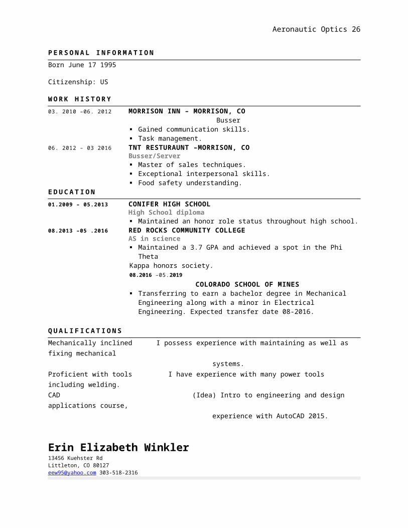
B l a k e S t a n d l e y8749 S Turkey Creek Rd Morrison, CO 80465 [email protected]
To obtain a position as an engineer that offers key participation; team oriented tasks, immediate challenges, and an opportunity where my resourceful experience and academic skills can be applied.
P E R S O N A L I N F O R M A T I O NBorn June 17 1995
Citizenship: US
W O R K H I S T O R Y03. 2010 –06. 2012 MORRISON INN – MORRISON, CO Busser
Gained communication skills. Task management.
06. 2012 – 03 2016 TNT RESTURAUNT –MORRISON, COBusser/Server Master of sales techniques. Exceptional interpersonal skills. Food safety understanding.
E D U C A T I O N01.2009 – 05.2013 CONIFER HIGH SCHOOL
High School diploma Maintained an honor role status throughout high school.
08.2013 –05 .2016 RED ROCKS COMMUNITY COLLEGEAS in science Maintained a 3.7 GPA and achieved a spot in the Phi Theta Kappa honors society.08.2016 –05.2019
COLORADO SCHOOL OF MINES Transferring to earn a bachelor degree in Mechanical Engineering along with a
minor in Electrical Engineering. Expected transfer date 08-2016. Q U A L I F I C A T I O N SMechanically inclined I possess experience with maintaining as well as fixing mechanical systems.Proficient with tools I have experience with many power tools including welding.CAD (Idea) Intro to engineering and design applications course, experience with AutoCAD 2015.
Erin Elizabeth Winkler

Aeronautic Optics 19
13456 Kuehster RdLittleton, CO [email protected] 303-518-2316
ObjectiveTo obtaining a professional position to gain professional experience in the work field that can be applied to real life while allowing the application of my college education in a professional environment.
Education
Arapahoe Community College and Red Rocks Community College – GPA 3.8/4.0Applied Mathematics and StatisticsDual degree expected by 2018 from Colorado School of Mines (Expecting To Transfer Fall 2016)
SkillsBrief knowledge—but willingness to learn more—of Java, particularly jGRASP, as well as C++, particularly Visual Studios, an AutoCAD 2016, familiarity with technical writing, knowledge of and experience with power tools, proficiency in Microsoft Office programs, fast learner, great with people, great leadership skills, personable, creative, great critical thinking skills, problem-solving abilities, decision-making abilities, great communication skills and collaboration skills, some knowledge of information and communications technology and information literacy, and an overall happy personality.
Technical ExperienceBlackJack Java Program – Using Java to create a sophisticated BlackJack game with a GUI.
Science Mentor – Mentored a group of 5th graders for the Science Fair. Taught the students the scientific method and helped students developed procedures by provoking their scientific curiosities.
Landslide Analysis and Mapping Drone – Through the IDEA (Intro to Design Engineering and Applications) class at Red Rocks Community College, my group developed, designed, and proposed a drone capable of taking high quality photos to be used for landslide analysis for Guatemala City per client request.
Work ExperienceJan 2016- Current
Science Matters Instructor – With monthly training, I teach science to elementary school students in an after school program. To date I have taught a chemistry class including curium surrounding polymers, gases, and states of matter changes, as well as a science mixed class that delves into rocks and minerals, weather, as well as energy and magnetism. Location: Science Matters in America, Littleton, CO
Aug 2014- Oct 2014, Aug 2015- Oct 2015 Head Middle School Volleyball Coach – Managed and coached a middle school volleyball team, developed it from a low-ranking team to 3rd in district by the season’s end. Managed the program with help from a volunteer parent and worked to develop practice plans, game plans, as well as growing, developing, and molding young minds. I have been asked to return for a 3rd year. Location: Denver School of Science and Technology Middle School – Stapleton Campus, Stapleton, CO
April 2015- July 2015Children Camps Head Coach – Formed and ran children’s camps. Duties included but not limited to creating camp plans and for watching, entertaining, and coaching children.Location: South Suburban Parks and Recreation District, Centennial, CO
Volunteer ServiceAugust 2008 – Nov 2012
Volleyball Coach – Roles ranged from assistant coach, co-coach, to head-coach. Location: Wolf Pack Volleyball Club (Gold Crown), Conifer, CO
October 2012 – March 2013

Aeronautic Optics 20
Set Builder/Wig Designer – Constructed props using heavy tools and equipment like power drills, saws, chop saws, hammers, etc. Location: Stagedoor Theatre, Conifer, CO.
Awards/AchievementsAwarded Most Outstanding Advanced Placement Statistics Student – A senior award awarded to only 2 of the senior class for math.Awarded Most Outstanding Social Studies Student – A senior award awarded to only 2 of the entire senior class for social studies.AP Scholar – Granted to students who receive scores of 3 or higher on three or more AP Exams.200 Club at Conifer High School – Awarded to students who donated at least 200 hours of their time towards community service.
Athletic AchievementVolleyball – Recreational levels to advanced club levels. Participated in out-of-state tournaments, played varsity volleyball and lettered.LOBO Award Medal – Grade 11

Aeronautic Optics 21
Meeting Minutes
Date: February 09, 2016 Location: Red Rocks Community College Subject: Client Interview Attendees: Erin Winkler, Hien Than, Blake Standley, Wassan Al Nakkash
Previous Items: Meeting the group, coming up with questions for the client
New Items: Answers to questions for Ethan regarding drone specifications, location, climate, costs, size, and photo quality specifications. Initial breakdown of research assignments.
To-Do-List:
Hien- begin research on materials based on the climate (most likely carbon fiber)
Erin- look into different forces that will act on the drone
Blake- research the electrical components of the drone
Wassan- research frame size and style
All further research collecting should be uploaded to Basecamp and all above and beyond work is not required but is welcomed.
Next Meeting: February 21st, 2016
Attachments: N/A

Aeronautic Optics 22
Meeting Minutes
Date: February 21st, 2016 Location: Starbucks (110611 W Florida Ave)Subject: Research Collaboration Attendees: Erin Winkler, Hien Than, Blake Standley
Previous Items: Meeting with the client to discuss project specifications and expectations. Additionally, the completion of Letter of Understanding occurred previous to this meeting. Each member was to study drones in general.
New Items: Members furthered the research on drones. The discussion topics of the meeting where; drone structure, amount of motors, possible size, camera type, gyroscopic motorized mount, battery size, camera “roll-cage” legs, geo-tagging, lift, frame material, total weight, costs, microcontroller ranges, and insulations. More specifically, the following items were found and require further research:
NZ Mini GPS, HD HERO 2 or 3 GoPro, Agisoft Photoscan, Cloud Compare, The Motors Hien Found
To-Do-List:
Hien- continue research on motors and propellers, visit hobby shop to look at motors
Erin- research micro-controllers and software, write meeting minutes, analyze drone weight
Blake- continue research on batteries
Wassan- research frame size and force points
All further research collecting should be uploaded to Basecamp and all above and beyond work is not required but is welcomed.
Next Meeting: February 27th, 2016
Attachments: “Helpful Links” found on Google Drive, once complete it will be uploaded to Basecamp.

Aeronautic Optics 23
Meeting Minutes
Date: February 27, 2016 Location: Blake’s House (W Alabama Pl, Lakewood, CO)Subject: Group ResearchAttendees: Erin Winkler, Hien Than, Blake Standley
Previous Items: Members furthered the research on drones. The discussion topics of the meeting where; drone structure, amount of motors, possible size, camera type, gyroscopic motorized mount, battery size, camera “roll-cage” legs, geo-tagging, lift, frame material, total weight, costs, microcontroller ranges, and insulations.
New Items: Hien began studying motors and propellers, Blake looked into batteries as well as began CAD sketches for the drone shape, Erin studied the software and looked into cameras and gimbals.
To-Do-List:
Hien- consult HobbyTown USA regarding motors, continue motor research
Erin- research cameras compatible with software, gimbal clarification research
Blake- continue CAD sketches, research battery, look into microcontrollers and GPS
Wassan- Research Force points and frame structure
All further research collecting should be uploaded to Basecamp and all above and beyond work is not required but is welcomed.
Next Meeting: February 21st, 2016
Attachments: N/A

Aeronautic Optics 24
Meeting Minutes
Date: March 1st, 2016 Location: Blake’s House (W Alabama Pl, Lakewood, CO)Subject: Further Group Research and Frame Design, Divvy SlidesAttendees: Erin Winkler, Hien Than, Blake Standley
Previous Items: Hien began studying motors and propellers, Blake looked into batteries as well as began CAD sketches for the drone shape, Erin studied the software and looked into cameras and gimbals.
New Items: Hien solidified the motors (Quantum MT) to be used. Erin solidified the camera as the Firefly but needs to find a gimbal. Blake created multiple drone sketches. Additionally, Erin drew up mock dimensions and Blake and Erin brainstormed sketches and designs for the legs as well as prop-protectors, body shape, and skeleton design (incorporating a “honeycomb” effect to decrease weight). Hien started a master spreadsheet for all parts of the drone including the weight of each item and the price to ensure we meet budget and decrease weight to maximize flight time.
To-Do-List:
Hien- to organize the spreadsheet and make it editable for additions, complete resume, complete slides (motors, propellers, cost)
Erin- find appropriate gimbal while decreasing weight of the drone, begin proposal write-up, complete slides (camera, gimbal), update spreadsheet
Blake- finish sketches, update spreadsheet, complete slides (battery, controller, GPS), complete resume
Wassan- research community and go through Ethan’s thesis, complete slides (community, intro), complete resume
All further research collecting should be uploaded to Basecamp and all above and beyond work is not required but is welcomed.
Next Meeting: N/A
Attachments: N/A

Aeronautic Optics 25
Red Rocks Community College13300 W 6th Ave
Lakewood CO 80228Mr. Ethan FaberGuatemala City, Guatemala
From: Erin Winkler, Hein Than, Wassan Al Nakkash, Blake Standley
Subject: Landslide-Risk Modeling Drone
Dear Mr. Faber:
The purpose of this letter is to 1) ensure our understand of our client’s needs 2) express understanding for the purpose of the project in question and 3) summarize the needs and specifications of the project for approval.
The prototype drone will be used to map out the risk of landslide in given areas in order to protect the civilians and other inhabitants in an analyzed community. The drone will be able to take photos which will have the ability to be compiled into three-dimensional images to aid in mapping elevations, slopes, and ultimately identifying and determining the risk of different communities by damage done by landslides as results of heavy rain, lack of foliage, earthquakes, hurricanes, general climate and so forth. The impoverished citizens of Guatemala City live on the slopes of mountains and thus, live in high risk zones prone to landslides which could destroy their homes and cost them their lives. This drone will be able to travel over areas that are otherwise inaccessible to completely map out the surrounding environments of different communities and thus aid in warning and educating the local citizens of possible dangers.
We understand that the main objective for this engineering project is to design a model drone that will be used for landslide analysis. On March 3rd, we will deliver to you a report and graphics portfolio with our design of the drone with the following capabilities:
The drone will compose of materials which can withstand high winds, storm, and water The drone will have a separate controller and a strong signal connecting them The drone will have a global positioning system (GPS) for tracking if drone gets lost The drone will have durable cameras which can take high quality photos The drone will be capable of automated flight plans along with an automated photo
routine The drone will be created in a cost-efficient manner The drone will be user-friendly and will contain universal mounts for future upgrades The drone will be designed to handle environments such as forests, farmlands, and the
city The drone will contain components which will be easily maintained along with easily
attained
To ensure that we meet all requirements for this project on the specified date, the following intermediate documents will be written and sent to you on the date indicated; design proposal presentation by teams on March 3rd and final document presentation to client on April 28th.
Aeronautic Optics 26
Please see the attached schedule for the landslide-risk modeling drone for a more in-depth representation of the design process.
Thank you for the opportunity for Aeronautic Optics and IDEA at Red Rocks Community College to work on this project. We are ecstatic to use our newly developing engineering skills to design and construct a landslide-risk analysis drone. Based upon our understanding of the project as described in this letter, do we have your authorization to continue our research and development of the prototype drone? If there are any concerns, please contact us through our joined Basecamp accounts, from which, we can set up Skype calls when necessary.
Sincerely,
Erin Winkler, Hein Than, Wassan Al Nakkash, Blake StandleyFor Aeronautic Optics and IDEA at Red Rocks Community College
Attached: Schedule for the Landslide-Risk Modeling Drone Project