zurichopenrepositoryand archive year: 2007
TRANSCRIPT
Zurich Open Repository andArchiveUniversity of ZurichMain LibraryStrickhofstrasse 39CH-8057 Zurichwww.zora.uzh.ch
Year: 2007
Spectrodirectional remote sensing: From pixels to processes
Schaepman, Michael E
Abstract: This paper discusses the historical evolution of imaging spectroscopy in Earth observationas well as directional (or multiangular) research leading to current achievements in spectrodirectionalremote sensing. It elaborates on the evolution from two separate research areas into a common approachto quantify the interaction of light with the Earth surface. The contribution of spectrodirectional remotesensing towards an improved understanding of the Earth System is given by discussing the benefits ofconverging from individual pixel analysis to process models in the land-biosphere domain. The paperconcludes with an outlook of research focus and upcoming areas of interest emphasizing towards mul-tidisciplinary approaches using integrated system solutions based on remote and in situ sensing, dataassimilation, and state space estimation algorithms.
DOI: https://doi.org/10.1016/j.jag.2006.09.003
Posted at the Zurich Open Repository and Archive, University of ZurichZORA URL: https://doi.org/10.5167/uzh-63093Journal ArticlePublished Version
Originally published at:Schaepman, Michael E (2007). Spectrodirectional remote sensing: From pixels to processes. InternationalJournal of Applied Earth Observation and Geoinformation, 9(2):204-223.DOI: https://doi.org/10.1016/j.jag.2006.09.003

Spectrodirectional remote sensing: From pixels to processes
Michael E. Schaepman *
Centre for Geo-Information, Wageningen University, P.O. Box 47, NL-6700 AA Wageningen, The Netherlands
Received 22 June 2006; accepted 11 September 2006
Abstract
This paper discusses the historical evolution of imaging spectroscopy in Earth observation as well as directional (or
multiangular) research leading to current achievements in spectrodirectional remote sensing. It elaborates on the evolution from
two separate research areas into a common approach to quantify the interaction of light with the Earth surface. The contribution of
spectrodirectional remote sensing towards an improved understanding of the Earth System is given by discussing the benefits of
converging from individual pixel analysis to process models in the land-biosphere domain. The paper concludes with an outlook of
research focus and upcoming areas of interest emphasizing towards multidisciplinary approaches using integrated system solutions
based on remote and in situ sensing, data assimilation, and state space estimation algorithms.
# 2006 Elsevier B.V. All rights reserved.
Keywords: Imaging spectroscopy; Imaging spectrometry; Directional; Multiangular; Remote sensing; Land-biosphere models
1. Introduction
This manuscript is reprinted in modified form of the
original address given by the author on the 7th October
2004 on the occasion of his accession to the post of
professor of geo-information science with special
emphasis on remote sensing at Wageningen University.
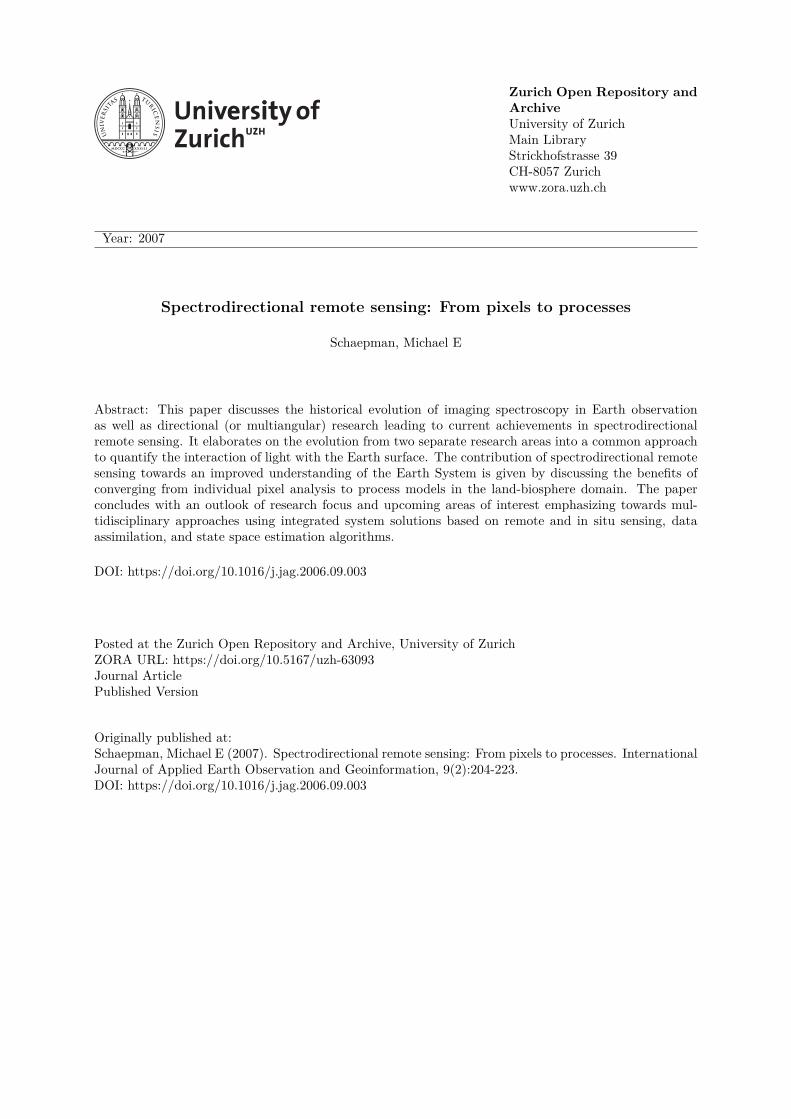
1.1. Brief history of spectroscopy
About 300 years ago, in 1704, Sir Isaac Newton
published in his ‘Treatise of Light’ (Newton, 1704) the
concept of dispersion of light (cf., Fig. 1). He
demonstrated that white light could be split up into
component colours by means of a prism, and found that
each pure colour is characterized by a specific refrang-
ibility. The corpuscular theory by Newton was gradually
successed over time by the wave theory. Consequently,
the substantial summary of past experiences performed
by Maxwell (1873), resulted in his equations of
electromagnetic waves. But it was not before the 19th
century, until the quantitativemeasurement of dispersed
light was recognized and standardized. A major
contribution was Fraunhofer’s discovery of the dark
lines in the solar spectrum (Fraunhofer, 1817); and their
interpretation as absorption lines on the basis of
experiments by Bunsen and Kirchhoff (1863). The term
spectroscopy was first used in the late 19th century and
provides the empirical foundations for atomic and
molecular physics (Born and Wolf, 1999). Significant
achievements in imaging spectroscopy are attributed to
airborne instruments, particularly arising in the early
1980s and 1990s (Goetz et al., 1985; Gower et al., 1987;
Green et al., 1998; Kruse et al., 1990; Rowlands et al.,
1994;Vane et al., 1984, 1993).However, itwas not before
1999 until the first launch of an imaging spectrometer in
space (e.g., NASA Moderate Resolution Imaging
Spectrometer (MODIS); http://modis.gsfc.nasa.gov/).
However, scientific terminology and definitions evolve
over time. Presently, an imaging spectrometer is usually
www.elsevier.com/locate/jag
International Journal of Applied Earth Observation
and Geoinformation 9 (2007) 204–223
* Tel.: +31 317 47 46 45; fax: +31 317 41 90 00.
E-mail address: [email protected].
0303-2434/$ – see front matter # 2006 Elsevier B.V. All rights reserved.
doi:10.1016/j.jag.2006.09.003
not any longer defined by a total minimum number of
spectral bands (earlier, >10 spectral bands was a
justification to use the term imaging spectrometer),
rather than by a contiguous (or redundancy) statement.
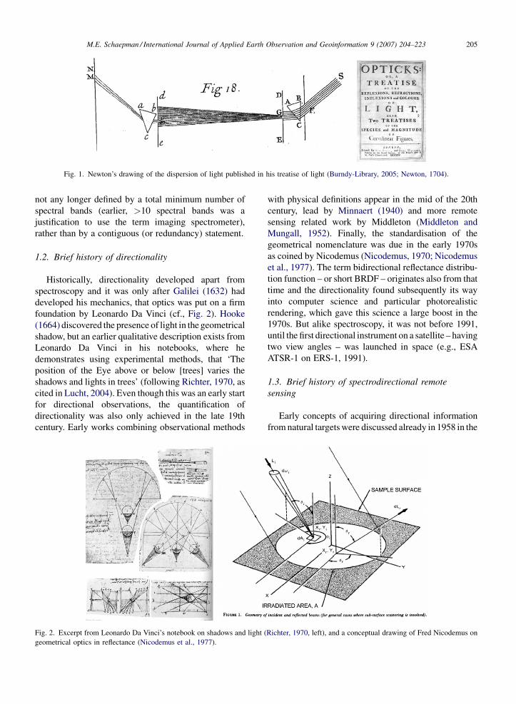
1.2. Brief history of directionality
Historically, directionality developed apart from
spectroscopy and it was only after Galilei (1632) had
developed his mechanics, that optics was put on a firm
foundation by Leonardo Da Vinci (cf., Fig. 2). Hooke
(1664) discovered the presence of light in the geometrical
shadow, but an earlier qualitative description exists from
Leonardo Da Vinci in his notebooks, where he
demonstrates using experimental methods, that ‘The
position of the Eye above or below [trees] varies the
shadows and lights in trees’ (following Richter, 1970, as
cited in Lucht, 2004). Even though this was an early start
for directional observations, the quantification of
directionality was also only achieved in the late 19th
century. Early works combining observational methods
with physical definitions appear in the mid of the 20th
century, lead by Minnaert (1940) and more remote
sensing related work by Middleton (Middleton and
Mungall, 1952). Finally, the standardisation of the
geometrical nomenclature was due in the early 1970s
as coined by Nicodemus (Nicodemus, 1970; Nicodemus
et al., 1977). The term bidirectional reflectance distribu-
tion function – or short BRDF – originates also from that
time and the directionality found subsequently its way
into computer science and particular photorealistic
rendering, which gave this science a large boost in the
1970s. But alike spectroscopy, it was not before 1991,
until the first directional instrument on a satellite – having
two view angles – was launched in space (e.g., ESA
ATSR-1 on ERS-1, 1991).
1.3. Brief history of spectrodirectional remote
sensing
Early concepts of acquiring directional information
fromnatural targetswere discussed already in 1958 in the
M.E. Schaepman / International Journal of Applied Earth Observation and Geoinformation 9 (2007) 204–223 205
Fig. 1. Newton’s drawing of the dispersion of light published in his treatise of light (Burndy-Library, 2005; Newton, 1704).
Fig. 2. Excerpt from Leonardo Da Vinci’s notebook on shadows and light (Richter, 1970, left), and a conceptual drawing of Fred Nicodemus on
geometrical optics in reflectance (Nicodemus et al., 1977).
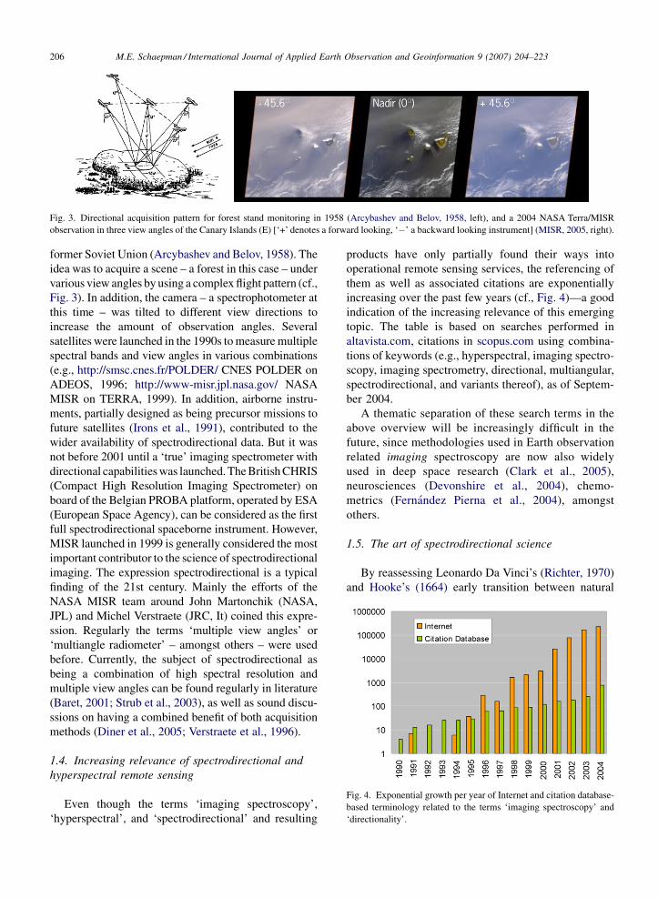
former Soviet Union (Arcybashev and Belov, 1958). The
idea was to acquire a scene – a forest in this case – under
various view angles by using a complex flight pattern (cf.,
Fig. 3). In addition, the camera – a spectrophotometer at
this time – was tilted to different view directions to
increase the amount of observation angles. Several
satellites were launched in the 1990s tomeasuremultiple
spectral bands and view angles in various combinations
(e.g., http://smsc.cnes.fr/POLDER/ CNES POLDER on
ADEOS, 1996; http://www-misr.jpl.nasa.gov/ NASA
MISR on TERRA, 1999). In addition, airborne instru-
ments, partially designed as being precursor missions to
future satellites (Irons et al., 1991), contributed to the
wider availability of spectrodirectional data. But it was
not before 2001 until a ‘true’ imaging spectrometer with
directional capabilitieswas launched.TheBritishCHRIS
(Compact High Resolution Imaging Spectrometer) on
board of the Belgian PROBA platform, operated by ESA
(European Space Agency), can be considered as the first
full spectrodirectional spaceborne instrument. However,
MISR launched in 1999 is generally considered the most
important contributor to the science of spectrodirectional
imaging. The expression spectrodirectional is a typical
finding of the 21st century. Mainly the efforts of the
NASA MISR team around John Martonchik (NASA,
JPL) and Michel Verstraete (JRC, It) coined this expre-
ssion. Regularly the terms ‘multiple view angles’ or
‘multiangle radiometer’ – amongst others – were used
before. Currently, the subject of spectrodirectional as
being a combination of high spectral resolution and
multiple view angles can be found regularly in literature
(Baret, 2001; Strub et al., 2003), as well as sound discu-
ssions on having a combined benefit of both acquisition
methods (Diner et al., 2005; Verstraete et al., 1996).
1.4. Increasing relevance of spectrodirectional and
hyperspectral remote sensing
Even though the terms ‘imaging spectroscopy’,
‘hyperspectral’, and ‘spectrodirectional’ and resulting
products have only partially found their ways into
operational remote sensing services, the referencing of
them as well as associated citations are exponentially
increasing over the past few years (cf., Fig. 4)—a good
indication of the increasing relevance of this emerging
topic. The table is based on searches performed in
altavista.com, citations in scopus.com using combina-
tions of keywords (e.g., hyperspectral, imaging spectro-
scopy, imaging spectrometry, directional, multiangular,
spectrodirectional, and variants thereof), as of Septem-
ber 2004.
A thematic separation of these search terms in the
above overview will be increasingly difficult in the
future, since methodologies used in Earth observation
related imaging spectroscopy are now also widely
used in deep space research (Clark et al., 2005),
neurosciences (Devonshire et al., 2004), chemo-
metrics (Fernandez Pierna et al., 2004), amongst
others.
1.5. The art of spectrodirectional science
By reassessing Leonardo Da Vinci’s (Richter, 1970)
and Hooke’s (1664) early transition between natural
M.E. Schaepman / International Journal of Applied Earth Observation and Geoinformation 9 (2007) 204–223206
Fig. 4. Exponential growth per year of Internet and citation database-
based terminology related to the terms ‘imaging spectroscopy’ and
‘directionality’.
Fig. 3. Directional acquisition pattern for forest stand monitoring in 1958 (Arcybashev and Belov, 1958, left), and a 2004 NASA Terra/MISR
observation in three view angles of the Canary Islands (E) [‘+’ denotes a forward looking, ‘�’ a backward looking instrument] (MISR, 2005, right).

science and artistic views, these can be translated into
today’s analogies.
Sol LeWitt (USA, *1928) is attributed to be a minimal
artist, but states himself that his work is conceptual art.
Working along his idea ‘the concept is themost important
aspect of thework’, he became a synonymof a sculptor of
connected open cubes in his artistic career. When he
created ‘Cubes in Color on Color’ in 2003, he gave a
perfect example of a conceptual definition of imaging
spectroscopy (cf., Fig. 5). Spectroscopists are using these
cubes with different colours to depict the two-dimen-
sional room of the space and the third dimension
indicating wavelength. When imaging spectroscopists
visualize their data, usually cubes are used to express the
spatial and spectral domain. Finally, an image cube can
be plotted and the spectral component is coloured
according to its surface reflectivity.
Paul Klee (CH, *1879, y1940) frequently used a
personal sign system in his works that is abstract and
figurative at the same time. His painting named
‘Ueberschach’ is therefore a perfect example to
visualize the directional component of a directional
data acquisition (cf., Fig. 6). The chessboard like pattern
in the directional image acquisition seems to be an
abstract feature of the landscape, but has its origin in
different view- and illumination geometries. While
flying an aircraft North–South, the scene is illuminated
homogeneously. A few minutes later the same scene
was recorded East–West and differences in ground
reflectance are due to variation in sun–target–observer
geometries.
Spectroscopy can be seen as detailing out colours,
and when Johannes Itten (CH, *1888, y1967) – like Paul
Klee a member of the Bauhaus – wrote his book ‘The
Art of Color’ (Itten, 1961) it was a logical follow up that
spectrodirectional models could make the best use out
of these colour definitions. The similarity of Itten’s
painting ‘Offenbarung’ and the visualization of a
M.E. Schaepman / International Journal of Applied Earth Observation and Geoinformation 9 (2007) 204–223 207
Fig. 5. ‘Cubes in Color on Color’ (by Sol LeWitt, Barbara-Krakow-Gallery, 2005, left) and imaging spectrometer data cube (Schaepman, 1999,
right).
Fig. 6. ‘Ueberschach’ (by Paul Klee in 1937; Kunsthaus-Zurich, 2005, left) and directional chessboard pattern (Beisl, 2001).
directional model (cf., Fig. 7) are not only analogous
due to similar colour theories, but also due to a potential
expression in directional illumination differences.
1.6. Spectrodirectional remote sensing—a
definition
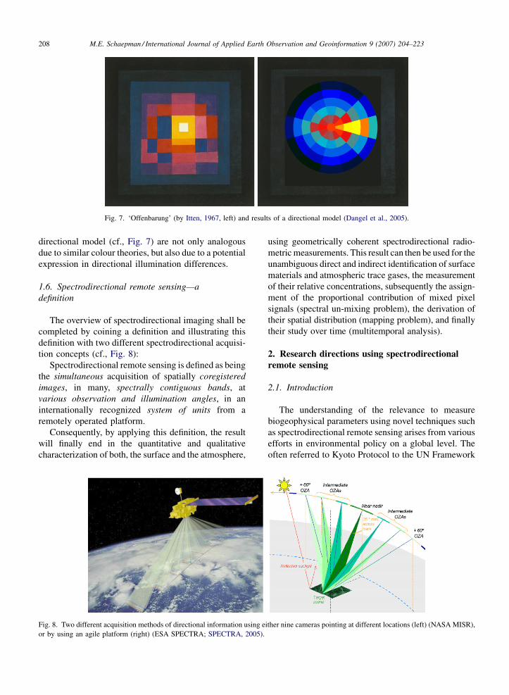
The overview of spectrodirectional imaging shall be
completed by coining a definition and illustrating this
definition with two different spectrodirectional acquisi-
tion concepts (cf., Fig. 8):
Spectrodirectional remote sensing is defined as being
the simultaneous acquisition of spatially coregistered
images, in many, spectrally contiguous bands, at
various observation and illumination angles, in an
internationally recognized system of units from a
remotely operated platform.
Consequently, by applying this definition, the result
will finally end in the quantitative and qualitative
characterization of both, the surface and the atmosphere,
using geometrically coherent spectrodirectional radio-
metricmeasurements. This result can then be used for the
unambiguous direct and indirect identification of surface
materials and atmospheric trace gases, the measurement
of their relative concentrations, subsequently the assign-
ment of the proportional contribution of mixed pixel
signals (spectral un-mixing problem), the derivation of
their spatial distribution (mapping problem), and finally
their study over time (multitemporal analysis).
2. Research directions using spectrodirectional
remote sensing
2.1. Introduction
The understanding of the relevance to measure
biogeophysical parameters using novel techniques such
as spectrodirectional remote sensing arises from various
efforts in environmental policy on a global level. The
often referred to Kyoto Protocol to the UN Framework
M.E. Schaepman / International Journal of Applied Earth Observation and Geoinformation 9 (2007) 204–223208
Fig. 7. ‘Offenbarung’ (by Itten, 1967, left) and results of a directional model (Dangel et al., 2005).
Fig. 8. Two different acquisition methods of directional information using either nine cameras pointing at different locations (left) (NASA MISR),
or by using an agile platform (right) (ESA SPECTRA; SPECTRA, 2005).

convention on Climate Change (UNFCC) proposes a
global policy to be applied at international level, based
on assessments of carbon emission and sequestration
rates. The aim of the protocol is therefore to stabilize the
CO2 concentration in the atmosphere in the long run. In
particular, the consideration of carbon sinks in the
protocol has given a large momentum to implement a
scientifically sound accounting and verification system.
The key issues to be resolved there are the variability,
uncertainty, attribution, non-permanence, leakage, and
future evolvement of the carbon sequestration in the
terrestrial biosphere (Valentini et al., 2000). The
estimated carbon uptake of the biosphere must be
consistent with all other evidence at three levels
of integration of the carbon budget: global, national,
and local.
One particular component of the Earth System, the
terrestrial environment has been identified as being a
critical component of the variability of the global
carbon cycle. But given the natural diversity of
landscapes, the (instrumented) measurement and
validation approach remains challenging. Earth obser-
vation from airborne or spaceborne platforms is the only
observational approach capable of providing data at the
relevant scales and resolution needed to extrapolate
findings of in situ (field) studies to larger areas, to
document the heterogeneity of the landscape at regional
scale and to connect these findings into a global view.
Extrapolation can either be done by statistical and/or
GIS techniques (Guisan and Zimmermann, 2000), as
well as by process modelling of ecosystems. The latter
is a very promising approach for testing ecological
hypotheses and for assessing and forecasting the state of
large landscapes up to the global scale.
Such approaches usually require the spatial input of
the state of the ecosystems at simulation start and of
relevant biophysical, biochemical, and/or structural
information of the terrestrial ecosystems (Schaepman
et al., 2003). Ecosystem models – often referred to as
biogeochemistry models because they simulate pools
and fluxes of relevant ecosystem elements such as
carbon, nitrogen, or water – ideally combine remote
sensing information on the structure of the vegetation
with monthly (e.g., CENTURY (a soil organic matter
agroecosystem model), see Wilson et al., 2003) to daily
(e.g., BIOME-BGC (a biogeochemical cycle model),
see Thornton et al., 2002) meteorological data and a set
of ecophysiological parameters, which drive the
processes of ecosystems. When applied to a gridded
landscape, the combination of spatially explicit air- or
spaceborne information on the vegetations structure
with ecosystem models allow for an accurate assess-
ment of ecosystem processes, for testing novel
ecological theories and for predicting possible future
states of the land surface (e.g., Kimball et al., 2000;
Turner et al., 2003).
Such large scale to global quantifications are clearly
beyond the realm of experimental analysis. The close
coordination of Earth observation satellites and airborne
instruments is thus essential for the successful valida-
tion of the contribution of the terrestrial component to
the global carbon cycle (Schaepman et al., 2005b).
Space agencies and international organizations have
recently established a coordinationmechanism (e.g., the
Integrated Global Observing Strategy Partnership
(IGOS-P)) that facilitates progress in space-based
measurements (Rast et al., 2001).
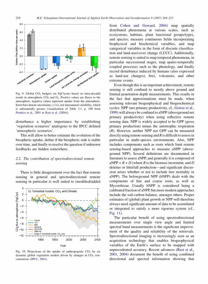
Rast et al. (2004) outlines that the interannual
variability of CO2 fluxes is much higher for the
terrestrial biosphere than for the oceans. Recent
estimates suggest even that during the 1980s, 23% of
the total anthropogenic carbon emissions were taken up
by the oceans, and as much as 32% by the terrestrial
biosphere. For the 1990s, the figures are 28% for the
oceans and 34% for the land. The land-atmosphere flux
represents the balance of a positive term due to land-use
change and a residual terrestrial sink. The two terms
cannot be separated on the basis of current atmospheric
measurements. Using independent analyses to estimate
the land-use change component for the 1980s based on
Houghton and Hackler (2000) and Houghton et al.
(1999), and the CCMLP (Carbon Cycle Model Linkage
Project) (Heimann et al., 1998) the residual terrestrial
sink can be inferred for the 1980s. Comparable global
data on land-use changes through the 1990s are not yet
available (Fig. 9).
When estimating future terrestrial carbon fluxes, the
contribution of the terrestrial biosphere remains
unclear, and in addition inter-model differences are
still large. Simulations using Dynamic Global Vegeta-
tion Models (DGVM), consistently indicate that rising
CO2 levels are causing a persistent, later saturating
carbon sink, while the effect of climate change may lead
to a reduction in sink strength or even in a source (cf.,
Fig. 10; Rast et al., 2004).
In summary, the land-biosphere CO2 uptake and its
associated uncertainty must be understood and reduced
further by performing the following actions: (i) a better
determination of relevant biosphere parameters by
representing the biosphere at their relevant scale in
appropriate spatial and temporal scales, (ii) an
enhanced (and standardized) parameterisation of the
carbon exchange between vegetation, soil and atmo-
sphere, and finally (iii) attributing the anthropogenic
M.E. Schaepman / International Journal of Applied Earth Observation and Geoinformation 9 (2007) 204–223 209
disturbance a higher importance by establishing
‘vegetation scenarios’ analogous to the IPCC defined
‘atmospheric scenarios’.
This will allow to better estimate the evolution of the
biospheric uptake, define if the biospheric sink is stable
over time, and finally to resolve the question if unknown
feedbacks are hidden somewhere.
2.2. The contribution of spectrodirectional remote
sensing
There is little disagreement over the fact that remote
sensing in general and spectrodirectional remote
sensing in particular is well suited to (modified/added
from Cohen and Goward, 2004) map spatially
distributed phenomena at various scales, such as
ecosystems, habitats, plant functional groups/types,
and species; measure continuous fields incorporating
biophysical and biochemical variables, and map
categorical variables in the form of discrete classifica-
tion and land-use/cover change (LUCC). Additionally,
remote sensing is suited to map temporal phenomena, in
particular successional stages, map spatio-temporally
coupled processes such as the phenology, and finally
record disturbance induced by humans (also expressed
as land-use changes), fires, volcanoes, and other
extreme events.
Even though this is an important achievement, remote
sensing is still confined to mostly above ground and
limited penetration depth measurements. This results in
the fact that approximations must be made, when
assessing relevant biogeophysical and biogeochemical
cycles: NPP (net primary productivity, cf., Gower et al.,
1999) will always be confined to aNPP (aboveground net
primary productivity) when using reflective remote
sensing data. NPP is widely accepted to be GPP (gross
primary production) minus the autotrophic respiration
(R). However, neither NPP nor GPP can be measured
directly using remote sensing andR is difficult to assess in
particular in multi-species environments. Also, NPP
includes components such as roots which limit remote
sensing-based approaches to measure aNPP (above-
ground NPP). Several definitions are documented in
literature to assess aNPP, and generally it is composed of
aNPP = B + D (where B is the biomass increment, andD
detritus or litterfall production—and significant discus-
sion arises whether or not to include tree mortality in
aNPP). The belowground NPP (bNPP) deals with the
components of fine and coarse roots, as well as
Mycorrhizae. Usually bNPP is considered being a
calibrated fraction of aNPP, butmoremodern approaches
include the soil-carbon balance, amongst others. Proper
estimates of (global) plant growth or NPP will therefore
always need significant amount of data to be assimilated
or integrated to satisfy a more rigorous system (cf.,
Fig. 11).
The particular benefit of using spectrodirectional
measurements over single view angle and limited
spectral band measurements is the significant improve-
ment of the quality and reliability of the retrievals.
Spectrodirectional imaging is increasingly seen as an
acquisition technology that enables biogeophysical
variables of the Earth’s surface to be mapped with
unprecedented accuracy. Recent advances (Rast et al.,
2001, 2004) document the benefit of using combined
directional and spectral information showing that
M.E. Schaepman / International Journal of Applied Earth Observation and Geoinformation 9 (2007) 204–223210
Fig. 9. Global CO2 budgets (in PgC/year) based on intra-decadal
trends in atmospheric CO2 and O2. Positive values are fluxes to the
atmosphere; negative values represent uptake from the atmosphere.
Error bars denote uncertainty (�1s), not interannual variability, which
is substantially greater (visualization of Table 3.1, p. 190 from
Prentice et al., 2001 in Rast et al. (2004)).
Fig. 10. Projections of the uptake of anthropogenic CO2 by six
dynamic global vegetation models driven by changes in CO2 con-
centrations (IPCC, 2001).
(Menenti et al., 2005) current distributed models of
biosphere processes can assimilate spectrodirectional
radiometric observations to improve estimates of NPP,
that data assimilation does provide access to complex
variables, such as soil respiration at regional scale, not
easily observed with local measurements, and that
directional thermal observations provide new opportu-
nities to improve a critical element of global land-
atmosphere models: the parameterization of sensible
heat transfer.
Additionally, the gained knowledge of directional
effects – or surface and atmospheric anisotropy – is
M.E. Schaepman / International Journal of Applied Earth Observation and Geoinformation 9 (2007) 204–223 211
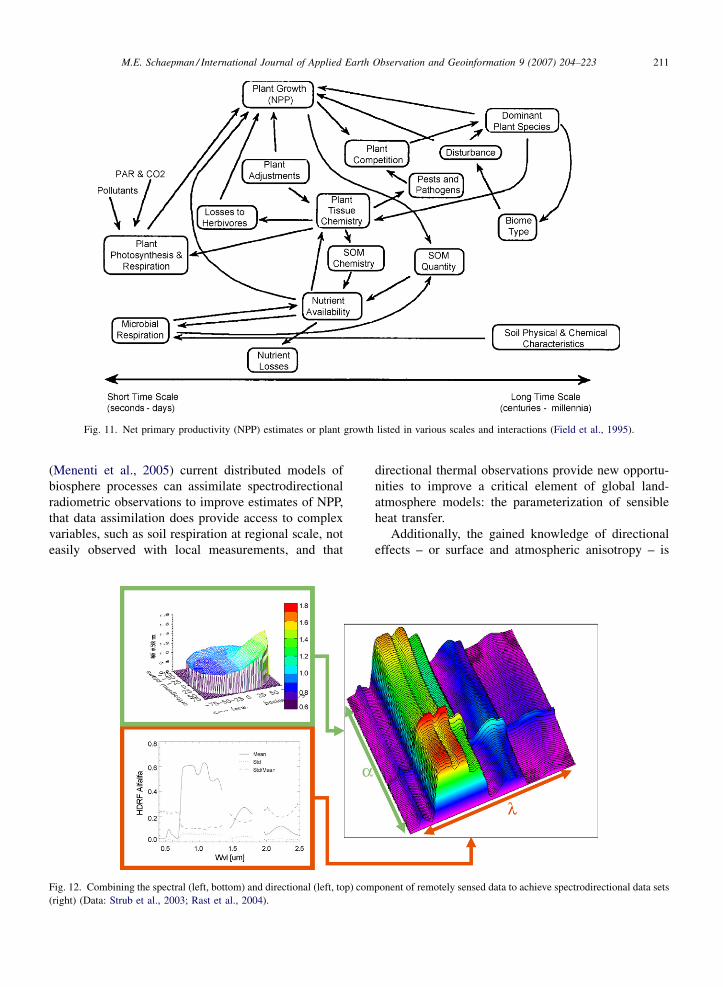
Fig. 11. Net primary productivity (NPP) estimates or plant growth listed in various scales and interactions (Field et al., 1995).
Fig. 12. Combining the spectral (left, bottom) and directional (left, top) component of remotely sensed data to achieve spectrodirectional data sets
(right) (Data: Strub et al., 2003; Rast et al., 2004).

presently also being used to correct undesired effects of
wide field of view angle sensors (Govaerts et al., 2004).
Concluding it can be said that the (spectro)direc-
tional remote sensing science community has two major
research objectives. These are namely minimizing the
influence of the anisotropic behaviour to achieve high
quality, standardized and therefore comparable and
reproducible data sets, as well as maximizing the
information retrieval to enhance the quality and
reliability of the derived products.
2.3. From pixels to processes
In situ measurements, individual radiance measure-
ments, as well as satellite observations in the solar
reflected domain in remote sensing are always influenced
by five dimensions (the spatial, spectral, directional,
temporal, and polarisation dimensions), whereas the
dimension ‘space’ is usually a two-dimensional observa-
tion (x and y), and the direction a combination of four
angles (illumination zenith and azimuth angles, aswell as
observation zenith and azimuth angles) having an
additional dependence of object topography and orienta-
tion (e.g., upright trees growing on a slope).
Fig. 12 identifies a monotemporal in situ measure-
ment over a homogeneous target, with neglected
polarisation dependent information, reducing the
dimensions to a spectral and a directional component.
Compiling literature references of documented
spectral absorption features (cf., Fig. 13), one can
easily estimate the potential of remote sensing to
identify biochemical compounds in plants. Never-
theless, the documented features are in many cases
measured using dried plant material, suggesting a
potential shift of spectral features compared to fresh
material, which may result in a variety of absorption
lines located close to each other, and slightly offset of
standard reported absorption features (Curran, 1989;
Wessman et al., 1988). A major challenge remains to
separate plant water content (leaf water) and columnar
water vapour contained in the atmosphere due to
significantly overlapping absorption lines (Sims and
Gamon, 2002, 2003).
The measurement of the spatial extent using
spectrometers can also vary significantly and is a
crucial item when trying to integrate various spatial
scales. In particular, the sampling scheme for in situ
measurements plays an important role for the choice of
the final application. Scaling from leaf to canopy level
as well as choosing the right spatial sampling interval to
characterize the landscape heterogeneity properly, is
highly over-determined in remote sensing and requires
trade-offs to be made to achieve the desired product
accuracy. Fig. 14 illustrates the measurement of leaf
optical properties at spatial scales from less than a few
cm2 up to the canopy level where usually half a m2 is a
proper measurement unit. These spatial scales ranging
from leaf to canopy level can be successfully modelled
using radiative transfer-based approaches (Jacquemoud
et al., 2000; Pinty et al., 2001, 2004; Verhoef and Bach,
2003).
At all spatial scales, vegetationcanopies and leavesare
undergoing substantial dynamic behaviour, and the
dynamic change of vegetation is still encapsulated with
a significant uncertainty in their quantification (Cao and
Woodward, 1998). By coupled analysis of spectral and
M.E. Schaepman / International Journal of Applied Earth Observation and Geoinformation 9 (2007) 204–223212
Fig. 13. Spectral features of vegetation biochemicals in the solar reflected domain: literature identified biochemical feature extraction based on
spectral band position (left, Schaepman, unpublished, data compiled from Curran, 1989; Fouche, 1995; Fourty et al., 1996; Hurcom et al., 1996;
Sims and Gamon, 2003; Verdebout et al., 1994; Wessman, 1990), absorption of five biochemical compounds found in leaves (right) (Wessman,
1990).

temporal features, it canbedemonstrated that full spectral
coverage is a predominant requirement to monitor all
relevant processes occurring at leaf and canopy level
(Lichtenthaler et al., 1998). This is demonstrated and
visualized in Fig. 15, which suggests that depending on
the stress exposure time of a single leaf, different portions
of the reflective part of the electromagnetic spectrum
undergo more changes than others (early stress is
dominating the shortwave infrared region at the begin-
ning, whereas leaf decomposition is affecting the visible
part more significantly in a later stage).
Another aspect of multitemporal analysis is the
inherent measurement stability of remote sensing instru-
ments. Significant advances have been made in measur-
ing the radiance field with higher accuracy (Fox et al.,
2003), and long-time calibration experiments demon-
stratemeasurement stability ofbetter than2%uncertainty
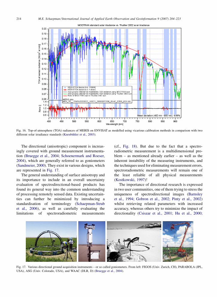
on the long run (Kneubuhler et al., 2003). Fig. 16 demon-
strates thisusingMERISonENVISATasanexample, and
puts additional emphasison theproper characterizationof
the atmosphere, including the proper choice of radiative
transfer models and the solar spectrum.
M.E. Schaepman / International Journal of Applied Earth Observation and Geoinformation 9 (2007) 204–223 213
Fig. 14. Spectral measurements from leaf (needle transmission in the laboratory (left), and in vivo (middle)) to canopy level (right) (pictures by the
author from the HyEco’04 campaign 2004 in the Millingerwaard (NL) and the EU MERCI project in Bily Kriz (CZ)).
Fig. 15. Measured decay of a ‘Ficus benjamina L.’ leaf under laboratory conditions with accelerated (water) stress, induced by illuminating the leaf
with a leaf clip using a built-in illumination source. Each image indicates a time step of 55 min with the original, unstressed leaf as a reference (upper
left). Total measurement time was 8.3 h (Schaepman and Bartholomeus, 2004).
The directional (anisotropic) component is increas-
ingly covered with ground measurement instrumenta-
tion (Bruegge et al., 2004; Schoenermark and Roeser,
2004), which are generally referred to as goniometers
(Sandmeier, 2000). They exist in various designs, which
are represented in Fig. 17.
The general understanding of surface anisotropy and
its importance to include in an overall uncertainty
evaluation of spectrodirectional-based products has
found its general way into the common understanding
of processing remotely sensed data. Existing uncertain-
ties can further be minimized by introducing a
standardisation of terminology (Schaepman-Strub
et al., 2006), as well as carefully evaluating the
limitations of spectroradiometric measurements
(cf., Fig. 18). But due to the fact that a spectro-
radiometric measurement is a multidimensional pro-
blem – as mentioned already earlier – as well as the
inherent instability of the measuring instruments, and
the techniques used for eliminatingmeasurement errors,
spectroradiometric measurements will remain one of
the least reliable of all physical measurements
(Kostkowski, 1997)!
The importance of directional research is expressed
in two user communities, one of them trying to stress the
uniqueness of spectrodirectional images (Barnsley
et al., 1994; Gobron et al., 2002; Pinty et al., 2002)
whilst retrieving related parameters with increased
accuracy, whereas others try to minimize the impact of
directionality (Csiszar et al., 2001; Hu et al., 2000;
M.E. Schaepman / International Journal of Applied Earth Observation and Geoinformation 9 (2007) 204–223214
Fig. 16. Top-of-atmosphere (TOA) radiances of MERIS on ENVISAT as modelled using vicarious calibration methods in comparison with two
different solar irradiance standards (Kneubuhler et al., 2003).
Fig. 17. Various directional ground acquisition instruments – or so called goniometers. From left: FIGOS (Univ. Zurich, CH), PARABOLA (JPL,
USA), ASG (Univ. Colorado, USA), and WAAC (DLR, D) (Bruegge et al., 2004).

Richter, 1998). Fig. 19 depicts the retrieval difference of
directional corrected and non-corrected results
expressed in a difference image (Schaepman-Strub
et al., 2003). The resulting difference LAI product
shows clearly vegetation structure aspects as well as the
position of the hot-spot (Li and Strahler, 1992; Liang
and Strahler, 1993) as a strong backscattering effect in
the irrigated canopies.
Finally, spectrodirectional remote sensing will allow
the generation of products that support the estimation of
critical vegetation parameters (Rast et al., 2004), but
neither is this approach limited to vegetation nor can all
relevant parameters be estimated using these sensors
alone.
The following table gives an indication of relevant
input parameters for land-biosphere modelling as
well as the technical implementation concept needed
to successfully retrieve them with acceptable uncer-
tainties.
The final products generated using spectrodirec-
tional remote sensing approaches do not differ from any
‘conventional’ retrieval in their final appearance, but
significantly differ in the resulting uncertainty. Fig. 20
illustrates classical products, such as LAI (leaf area
index), fAPAR (fraction of absorbed photosynthetically
active radiation), and fCover (fraction of vegetation
cover) as described in the DAISEX experiments in
Spain (Berger et al., 2001).
M.E. Schaepman / International Journal of Applied Earth Observation and Geoinformation 9 (2007) 204–223 215
Fig. 18. View angle dependent error of Albedo product retrieval
accuracies when ignoring directionality (Schaepman-Strub et al.,
2006).
Fig. 20. Three Level 3 products (from left: LAI, fAPAR, and fCover) derived from imaging spectrometers using atmospheric correction, geometric
correction, and including a compensation for directional effects induced by the atmosphere and the ground.
Fig. 19. Vegetation index difference images of directional corrected vs. uncorrected images. Left: Directional differences visible in two differently
acquired flights. Right: Ambrals (Hu et al., 1997) BRDF corrected images, minimizing the directional differences.Middle: Difference image of left
and right with applied GRVI (green vegetation index, Broge and Leblanc, 2001). Obviously, the difference image in the middle reveals information
about the vegetation structure as can be clearly seen (data from Moreno, 2001).
2.4. From pixels to processes: the land-biosphere
model approach
Typical land-biosphere models are composed of
‘building blocks’ with associated functions that treat the
interaction of photons with vegetation as follows:
� Carbon engine
o f (CO2, light, water availability, temperature,
nutrients)
� Carbon allocation
o f (geometry, physiology, plant functional type,
species)
� ‘‘Remineralisation’’
o f (plant functional type, physiology, microbiology,
molecular structure (e.g., lignin versus waxes or
cellulose))
� Soil hydrology
o f (root depth)
� Population dynamics
o Succession
f (stand height, stand age, physiology)
o Disturbances
f (climate, fire, humans)
TheCarbon engine usually defines howmuch carbon
is fixed per unit time by photosynthesis. In general, the
amount of carbon fixed per unit time is a function of
ambient (atmospheric) CO2, light, water availability,
temperature, and nutrients. The second part deals with a
recipe for carbon allocation of carbon fixed by
photosynthesis to different living tissue like stems or
roots. Carbon allocation is a function of plant geometry
and physiology. This is followed by a description of the
fate of dead plant material (Remineralisation), i.e., the
carbon flow from living to non-living forms and its
subsequent decomposition. The decay processes are a
function of plant species, physiology, microbiology and
molecular structure of plant tissue (e.g., lignin versus
waxes or cellulose). Next, a predictive equation of soil
moisture (Soil hydrology) is given. Soil moisture is a
function of soil hydraulic properties, evapotranspira-
tion, and precipitation. And finally a representation is
given of the dominant stochastic Population dynamics
processes like early versus late successional species
through competition for resources (light, nutrients,
water) which is a function of stand height, stand age,
and physiology, and disturbance by humans (land use),
fire, windfall, insects which is a function of climate and
human activity (Gloor, 2005).
Land-biospheremodels can begrouped into twobroad
classes. The ones that use satellite data to locate the
‘‘photosynthetically active’’ land vegetation. In these
models, the ‘‘Carbon engine’’ is then driven by absorbed
light estimated from satellite and a prescribed light use
efficiency. Typical representatives are the CASA model
(Potter, 1993) and the TURCmodel (Ruimy et al., 1996).
Population dynamics is in a sense implicit in this
M.E. Schaepman / International Journal of Applied Earth Observation and Geoinformation 9 (2007) 204–223216
Table 1
Four relevant vegetation parameter blocks needed to successfully run a land-biosphere model and associated remote sensing acquisition concepts
Vegetation variables (parameters) Spectrodirectional
(reflected)
Spectrodirectional
(emitted)
Radar
(SAR)
Laser
(LIDAR)
Vegetation spatial distribution and phenology
Fractional vegetation cover (fCover)
Leaf area index (LAI) U U U
Fraction living/dead biomass
Canopy structure
Vegetation height
Vegetation interaction with radiation
Albedo
Fraction of absorbed photosynthetically
active radiation (fAPAR)
U U
Foliage chemistry and water status
Leaf chlorophyll
Leaf water content U
Leaf dry matter
Leaf nitrogen/foliage nitrogen
Vegetation and soil energy balance
Foliage temperature (related to stomatal
evaporation rate)
U
Soil temperature (related to water stress)

formulation as explained later on. The second class of
models predicts the spatial vegetation distribution and the
organic soil pools on its own, while hydraulic properties
of the soils are prescribed. Typical examples are the
Lund–Potsdam–Jena (LPJ) model (Sitch et al., 2003),
and the EcosystemDemography (ED) model (Moorcroft
et al., 2001). Several models include population dynamic
processes like fire disturbance (e.g., LPJ). Nonetheless,
only a model that includes the description of demo-
graphics (age distribution of species classes as a function
of time) and competition for light by including a
description of height distribution can properly describe
disturbance processes and their effect on land vegetation
(Table 1). The only model that currently propagates both
height and age distributions is ED.
Table 2 compares five different land-biosphere
models indicating their implementation of the building
blocks (modified following Gloor, 2005; Schaepman,
2005). A more detailed discussion can be found in the
literature (Cramer et al., 1999; Ruimy et al., 1999).
Relevant remote sensing observations are used in the
building blocks ‘Carbon Engine’, ‘Phenology’, and
‘Discretization’.
3. Observations by data acquisition systems
In remote sensing, there are several mission
categories described, that contribute to the systematic
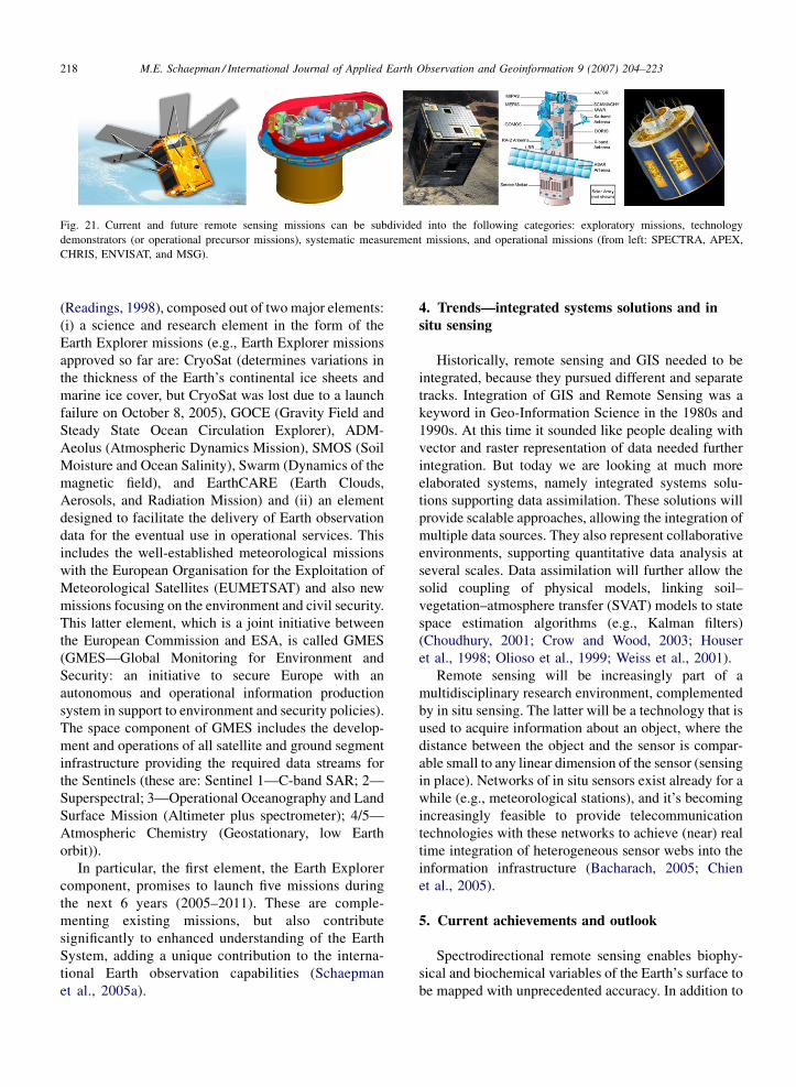
measurement of the Earth’s reflected radiance (Fig. 21).
These categories include exploratory missions (e.g.,
ESA: SPECTRA (Rast et al., 2004); NASA: ESSP
(Earth System Science Pathfinder Missions, cf., Crisp
and Johnson, 2005) and AVIRIS (Green et al., 1998)),
technology demonstrators and operational precursor
missions (e.g., ESA: CHRIS/PROBA (Cutter et al.,
2004) and APEX (Schaepman et al., 2004); NASA:
Hyperion/EO-1 (Ungar et al., 2003)), systematic
measurement missions (e.g., ESA: MERIS/ENVISAT
(Bezy et al., 1999); NASA: MODIS (Myneni et al.,
2002)), as well as operational missions (e.g., ESA:
MSG-1 (Borde et al., 2004); NOAA: AVHRR (Rao and
Chen, 1999)).
Several international programmes and national space
agencies and various national initiatives worldwide are
developing missions in the above framework. With a
particular European focus, the most important to be
mentioned is the Living Planet Programme of ESA
M.E. Schaepman / International Journal of Applied Earth Observation and Geoinformation 9 (2007) 204–223 217
Table 2
Comparison of five land-biosphere models describing individual functionality of their core parts ((P)FT—(Plant) functional type; C-ass—carbon
assimilation; N—nitrogen; P—phosphorus) (Gloor, 2005; Schaepman, 2005; Knorr, 2000; Wamelink et al., 2000; Anderson et al., 2004; Aber and
Federer, 1992)
(Readings, 1998), composed out of two major elements:
(i) a science and research element in the form of the
Earth Explorer missions (e.g., Earth Explorer missions
approved so far are: CryoSat (determines variations in
the thickness of the Earth’s continental ice sheets and
marine ice cover, but CryoSat was lost due to a launch
failure on October 8, 2005), GOCE (Gravity Field and
Steady State Ocean Circulation Explorer), ADM-
Aeolus (Atmospheric Dynamics Mission), SMOS (Soil
Moisture and Ocean Salinity), Swarm (Dynamics of the
magnetic field), and EarthCARE (Earth Clouds,
Aerosols, and Radiation Mission) and (ii) an element
designed to facilitate the delivery of Earth observation
data for the eventual use in operational services. This
includes the well-established meteorological missions
with the European Organisation for the Exploitation of
Meteorological Satellites (EUMETSAT) and also new
missions focusing on the environment and civil security.
This latter element, which is a joint initiative between
the European Commission and ESA, is called GMES
(GMES—Global Monitoring for Environment and
Security: an initiative to secure Europe with an
autonomous and operational information production
system in support to environment and security policies).
The space component of GMES includes the develop-
ment and operations of all satellite and ground segment
infrastructure providing the required data streams for
the Sentinels (these are: Sentinel 1—C-band SAR; 2—
Superspectral; 3—Operational Oceanography and Land
Surface Mission (Altimeter plus spectrometer); 4/5—
Atmospheric Chemistry (Geostationary, low Earth
orbit)).
In particular, the first element, the Earth Explorer
component, promises to launch five missions during
the next 6 years (2005–2011). These are comple-
menting existing missions, but also contribute
significantly to enhanced understanding of the Earth
System, adding a unique contribution to the interna-
tional Earth observation capabilities (Schaepman
et al., 2005a).
4. Trends—integrated systems solutions and in
situ sensing
Historically, remote sensing and GIS needed to be
integrated, because they pursued different and separate
tracks. Integration of GIS and Remote Sensing was a
keyword in Geo-Information Science in the 1980s and
1990s. At this time it sounded like people dealing with
vector and raster representation of data needed further
integration. But today we are looking at much more
elaborated systems, namely integrated systems solu-
tions supporting data assimilation. These solutions will
provide scalable approaches, allowing the integration of
multiple data sources. They also represent collaborative
environments, supporting quantitative data analysis at
several scales. Data assimilation will further allow the
solid coupling of physical models, linking soil–
vegetation–atmosphere transfer (SVAT) models to state
space estimation algorithms (e.g., Kalman filters)
(Choudhury, 2001; Crow and Wood, 2003; Houser
et al., 1998; Olioso et al., 1999; Weiss et al., 2001).
Remote sensing will be increasingly part of a
multidisciplinary research environment, complemented
by in situ sensing. The latter will be a technology that is
used to acquire information about an object, where the
distance between the object and the sensor is compar-
able small to any linear dimension of the sensor (sensing
in place). Networks of in situ sensors exist already for a
while (e.g., meteorological stations), and it’s becoming
increasingly feasible to provide telecommunication
technologies with these networks to achieve (near) real
time integration of heterogeneous sensor webs into the
information infrastructure (Bacharach, 2005; Chien
et al., 2005).
5. Current achievements and outlook
Spectrodirectional remote sensing enables biophy-
sical and biochemical variables of the Earth’s surface to
be mapped with unprecedented accuracy. In addition to
M.E. Schaepman / International Journal of Applied Earth Observation and Geoinformation 9 (2007) 204–223218
Fig. 21. Current and future remote sensing missions can be subdivided into the following categories: exploratory missions, technology
demonstrators (or operational precursor missions), systematic measurement missions, and operational missions (from left: SPECTRA, APEX,
CHRIS, ENVISAT, and MSG).

this, our quantitative understanding of the photon–
vegetation interaction has been significantly deepened,
by looking at many, contiguous spectral bands, as well
as various view-angles to the Earth’ surface.
Practically, this particular success is based on
improved data quality and wider availability of
consistent remote sensing observations to the user
community. Secondly, it is due to the broader
availability of computing resources, that are needed
to run quantitative, physical-based models.
In the near future, new emerging applications in
spectrodirectional remote sensing of vegetation will
focus on monitoring transitional zones, and in particular
ecotones, e.g., ecosystem-, communities-, or habitat
boundaries (e.g., tundra-boreal forest, forest-heathland,
etc.), where most of the pressure and changes in terms of
disturbance are being identified, also managed ecosys-
tems, where precision appliance is a key economical
factor, contributing to better yield estimates, and finally
(un-)managed ecosystems, where plant succession,
plant functional types, and invasive species are
important focus areas.
The above will be complemented by the consistent
measurements of calibrated and validated surface
reflectance to derive Albedo products, retrieval of
columnar atmospheric absorption, such as water vapour
and aerosol particle size distribution, the fraction of
vegetation contributing to the photosynthetic processes,
separation of canopy water and atmospheric water
content, the canopy light use efficiency (LUE) for
estimation of the carbon fixation rates, fire fuel and fuel
moisture, as well as anthropogenic and non-anthro-
pogenic induced disturbance (Asner et al., 2005;
Stuffler et al., 2004).
Major challenges to be resolved with spectrodirec-
tional remote sensing is still a continuous potential
mismatch of spatio-temporal scales of field, airborne and
spaceborne measurements, and model requirements.
Thesemust be addressed by pursuing a rigorous scientific
agenda that is not limited to the scientific use of
spectrodirectional data, but also includesamore thorough
view on spatio-temporal discontinuities inmeasurements
that may result in variable data and product quality,
disturbance processes that are difficult to capture, due to
limited mission duration times and missing backward
compatibility, data assimilation schemes becomingmore
important due to the steadily increasing availability of
geo-data at large, and finally there will be a convergence
to Earth System Sciences observed, truly linking various
disciplines into multidisciplinary approaches.
The combination of coupled soil–vegetation–atmo-
sphere transfer in view of ecological and CO2 related
research questions will be – as demonstrated in this
short overview – a primary focus for the upcoming
years.
Regional environmental modelling using spectro-
directional remote sensing will allow a more consistent
understanding of the relevant processes of our system
Earth.
Acknowledgements
I acknowledge the support from J. Clevers, A. Bregt
(Wageningen University), K. Itten, G. Schaepman-
Strub, B. Kotz (University of Zurich), T. Painter (Univ.
Colorado, Boulder), St. de Jong (Utrecht University),
M. Rast, and the ESA Earth Explorer Core Mission
Advisory Group of SPECTRA. I also wish to thank the
three reviewers for constructive comments on the
manuscript.
References
Aber, J.D., Federer, C.A., 1992. A generalized, lumped-parameter
model of photosynthesis, evapotranspiration and net primary
production in temperate and boreal forest ecosystems. Oecologia
92, 463.
Anderson, J.L., Broccoli, A.J., Cooke, W.F., Delworth, T.L., Dixon,
K.W., Donner, L.J., Freidenreich, S.M., Garner, S.T., Gudgel,
R.G., Gordon, C.T., Held, I.M., Hemler, R.S., Horowitz, L.W.,
Klein, S.A., Knutson, T.R., Kushner, P.J., Langenhost, A.R., Lau,
N.C., Liang, Z., Nath, M.J., Ploshay, J.J., Ramaswamy, V.,
Schwarzkopf, M.D., Sirutis, J.J., Soden, B.J., Stern, W.F., Thomp-
son, L.A., Wilson, R.J., Wyman, B.L., Balaji, V., Wittenberg, A.T.,
Dunne, K.A., Milly, P.C.D., Malyshev, S.L., Shevliakova, E.,
2004. The new GFDL global atmosphere and land model
AM2-LM2: Evaluation with prescribed SST simulations. J. Cli-
mate 17, 4641.
Arcybashev, E.S., Belov, S.V., 1958. The reflectance of tree species
[orig. russ] In: Steiner, D., Guterman, T. (Eds.), Russian Data on
Spectral Reflectance of Vegetation, Soil, and Rock Types. Juris
Druck/Verlag, Zurich, p. 232.
Asner, G.P., Ungar, S.G., Green, R.O., Knox, B., Roberts, D.A., Ustin,
S.L., Middleton, B., Gamon, J.A., Martin, M., Morisette, J.T.,
Field, C., Schimel, D., Ollinger, S.V., Collatz, J., Foley, J.,
Kucharik, C.J., Treuhaft, R., Hall, F., Huete, A., 2005. The Flora
Mission for Ecosystem Composition, Disturbance and Productiv-
ity—Mission Concept for the NAS Decadal Study. Carnegie
Institution of Washington, Standford.
Bacharach, S., 2005. Advancing the sensor web. GeoSpatial Solutions
15, 29.
Barbara-Krakow-Gallery, 2005. http://www.barbarakrakowgallery.-
com/contentmgr/showdetails.php/id/339.
Baret, F., 2001. Recent progress in canopy modelling and inversion of
observed spectro-directional reflectance. European Space Agency,
ESA SP, 229–230.
Barnsley, M.J., Strahler, A.H., Morris, K.P., Muller, J.P., 1994. Sam-
pling the surface bidirectional reflectance distribution function
(BRDF): 1. Evaluation of current and future satellite sensors.
Remote Sensing Rev. 8, 271.
M.E. Schaepman / International Journal of Applied Earth Observation and Geoinformation 9 (2007) 204–223 219
Beisl, U., 2001. Correction of Bidirectional Effects in Imaging
Spectrometer Data. PhD Thesis, University of Zurich, Zurich.
Berger, M., Rast, M., Wursteisen, P., Attema, E., Moreno, J., Mueller,
A., Beisl, U., Richter, R., Schaepman, M., Strub, G., Stoll, M.P.,
Nerry, F., Leroy,M., 2001. The DAISEX campaigns in support of a
future land-surface-processes mission. European Space Agency
ESA SP, ESA Bulletin 105, 335–345.
Bezy, J.-L., Gourmelon, G., Bessudo, R., Baudin, G., Sontag, H.,
Weiss, S., 1999. ENVISAT medium resolution imaging spectro-
meter (MERIS). In: International Geoscience and Remote Sensing
Symposium (IGARSS), vol. 2, p. 1432.
Borde, R., Konig, M., Schmetz, J., 2004. Meteosat-8: Europe’s new
geostationary meteorological satellite. In: Proceedings of SPIE—
The International Society for Optical Engineering, vol. 5570, p.
73.
Born, M., Wolf, E., 1999. Principles of Optics, seventh ed. Cambridge
University Press, Cambridge.
Broge, N.H., Leblanc, E., 2001. Comparing prediction power and
stability of broadband and hyperspectral vegetation indices for
estimation of green leaf area index and canopy chlorophyll
density. Remote Sensing Environ. 76, 156.
Bruegge, C.J., Schaepman, M., Strub, G., Beisl, U., Itten, K.I.,
Demircan, A., Geiger, B., Helmlinger, M.C., Martonchik, J.,
Abdou, W.A., Painter, T.H., Paden, B.E., Dozier, J., 2004. Field
measurements of bi-directional reflectance. In: von Schoener-
mark, M., Geiger, B., Roeser, H.-P. (Eds.), Reflection Properties
of Vegetation and Soil with a BRDF Database. Wissenschaft und
Technik Verlag, Berlin, pp. 195–224.
Bunsen, R., Kirchhoff, G., 1863. Untersuchungen ueber das Sonnen-
spektrum und die Spektren der Chemischen Elemente. Abh. kgl.
Akad. Wiss., 1861.
Burndy-Library, 2005. Newton’s Opticks, http://burndy.mit.edu/Col-
lections/Babson/Online/Principia/.
Cao, M., Woodward, F.I., 1998. Dynamic responses of terrestrial
ecosystem carbon cycling to global climate change. Nature
393, 249.
Chien, S., Cichy, B., Davies, A., Tran, D., Rabideau, G., Castano, R.,
Sherwood, R., Mandl, D., Frye, S., Shulman, S., Jones, J., Gros-
venor, S., 2005. An autonomous earth-observing sensorweb. IEEE
Intell. Syst. 20, 16.
Choudhury, B.J., 2001. Estimating gross photosynthesis using satellite
and ancillary data: approach and preliminary results. Remote
Sensing Environ. 75, 1.
Clark, R.N., Hoefen, T.M., Curchin, J.M., Brown, R.H., Lunine, J.,
Jaumann, R., Matz, K.D., Cruikshank, D.P., Nelson, R.M., Buratti,
B.J., Baines, K.H., Matson, D.L., McCord, T.B., Bellucci, G.,
Capaccioni, F., Cerroni, P., Coradini, A., Formisano, V., Mennella,
V., Bibring, J.P., Langevin, Y., Nicholson, P.D., Sicardy, B., Sotin,
C., Hibbits, K., Hansen, G., 2005. Compositional maps of Saturn’s
moon Phoebe from imaging spectroscopy. Nature 435, 66.
Cohen, W.B., Goward, S.N., 2004. Landsat’s role in ecological
applications of remote sensing. BioScience 54, 535.
Cramer, W., Bondeau, A., Kicklighter, D.W., Moore Iii, B., Schloss,
A.L., Churkina, G., Nemry, B., Ruimy, A., 1999. Comparing
global models of terrestrial net primary productivity (NPP): over-
view and key results. Global Change Biol. 5, 1.
Crisp, D., Johnson, C., 2005. The orbiting carbon observatory mission.
Acta Astronaut. 56, 193.
Crow, W.T., Wood, E.F., 2003. The assimilation of remotely sensed
soil brightness temperature imagery into a land surface model
using Ensemble Kalman filtering: a case study based on ESTAR
measurements during SGP97. Adv. Water Resour. 26, 137.
Csiszar, I., Gutman, G., Romanov, P., Leroy, M., Hautecoeur, O., 2001.
Using ADEOS/POLDER data to reduce angular variability of
NOAA/AVHRR reflectances. Remote Sensing Environ. 76, 399.
Curran, P.J., 1989. Remote sensing of foliar chemistry. Remote
Sensing Environ. 30, 271.
Cutter, M.A., Johns, L.S., Lobb, D.R., Williams, T.L., Settle, J.J.,
2004. Flight experience of the compact high resolution imaging
spectrometer (CHRIS). In: Proceedings of SPIE—The Interna-
tional Society for Optical Engineering, vol. 5159, p. 392.
Dangel, S., Verstraete, M., Schopfer, J., Kneubuhler, M., Schaepman,
M.E., Itten, K.I., 2005. Toward a direct comparison of field and
laboratory goniometer measurements. IEEE Trans. Geosci.
Remote Sensing 43, 2666–2675.
Devonshire, I.M., Berwick, J., Jones, M., Martindale, J., Johnston, D.,
Overton, P.G., Mayhew, J.E.W., 2004. Haemodynamic responses
to sensory stimulation are enhanced following acute cocaine
administration. NeuroImage 22, 1744.
Diner, D.J., Davies, R., Kahn, R.A., Braswell, B.H., Gobron, N., Pinty,
B., Hu, J., Knyazikhin, Y., Schaaf, C.B., Jin, Y., Loeb, N., Muller,
J.P., Nolin, A.W., Seiz, G., Stroeve, J., 2005. The value of multi-
angle measurements for retrieving structurally and radiatively
consistent properties of clouds, aerosols, and surfaces. Remote
Sensing Environ. 97, 495.
Fernandez Pierna, J.A., Baeten, V., Renier, A.M., Dardenne, P.,
Cogdill, R.P., 2004. Combination of support vector machines
(SVM) and near-infrared (NIR) imaging spectroscopy for the
detection of meat and bone meal (MBM) in compound feeds. J.
Chemom. 18, 341.
Field, C.B., Randerson, J.T., Malmstrom, C.M., 1995. Global net
primary production: combining ecology and remote sensing: 1.
Remote Sensing Environ. 51, 74–88.
Fouche, P.S., 1995. The use of low-altitude infrared remote sensing for
estimating stress conditions in tree crops. S. Afr. J. Sci. 91, 500.
Fourty, T., Baret, F., Jacquemoud, S., Schmuck, G., Verdebout, J.,
1996. Leaf optical properties with explicit description of its
biochemical composition: direct and inverse problems. Remote
Sensing Environ. 56, 104.
Fox, N., Aiken, J., Barnett, J.J., Briottet, X., Carvell, R., Frohlich, C.,
Groom, S.B., Hagolle, O., Haigh, J.D., Kieffer, H.H., Lean, J.,
Pollock, D.B., Quinn, T., Sandford, M.C.W., Schaepman, M.,
Shine, K.P., Schmutz, W.K., Teillet, P.M., Thome, K.J., Verstraete,
M.M., Zalewski, E., 2003. Traceable radiometry underpinning
terrestrial- and helio-studies (TRUTHS). Adv. Space Res. 32,
2253–2261.
Fraunhofer, J., 1817. Bestimmung des Brechungs- und Farbenzer-
streuungs-Vermoegens verschiedener Glasarten, in Bezug auf die
Vervollkommnung achromatischer Fernroehre. Gilberts Annalen
der Physik, vol. 56, pp. 264–313.
Galilei, G., 1632. Massimi Sistemi Del Mondo. Tolemaico, e Coper-
nicano Batista Landini, Fiorenza.
Gloor, M., 2005. Global carbon flux models. In: Dangel, S. (ed.),
SPECTRA End-To-End Simulator (Final Report). ESA, Noord-
wijk, The Netherlands, p. 80.
Gobron, N., Pinty, B., Verstraete, M.M., Widlowski, J.L., Diner, D.J.,
2002. Uniqueness of multiangular measurements—Part II: joint
retrieval of vegetation structure and photosynthetic activity from
MISR. IEEE Trans. Geosci. Remote Sensing 40, 1574.
Goetz, A.F.H., Vane, G., Solomon, J.E., Rock, B.N., 1985. Imaging
spectrometry for earth remote sensing. Science 228, 1147.
Govaerts, Y.M., Schmetz, J., Lattanzio, A., Pinty, B., 2004. Consistent
surface Albedo retrieval from two adjacent geostationary satel-
lites. Geophys. Res. Lett. 31.
M.E. Schaepman / International Journal of Applied Earth Observation and Geoinformation 9 (2007) 204–223220

Gower, J.F.R., Borstad, G.A., Edel, H.R., 1987. Fluorescence line
imager: first results from passive imaging of chlorophyll fluores-
cence. In: International Geoscience and Remote Sensing Sympo-
sium (IGARSS), IEEE, Michigan, p. 1605.
Gower, S.T., Kucharik, C.J., Norman, J.M., 1999. Direct and indirect
estimation of leaf area index, fAPAR, and net primary production
of terrestrial ecosystems. Remote Sensing Environ. 70, 29.
Green, R.O., Eastwood, M.L., Sarture, C.M., Chrien, T.G., Aronsson,
M., Chippendale, B.J., Faust, J.A., Pavri, B.E., Chovit, C.J., Solis,
M., Olah, M.R., Williams, O., 1998. Imaging spectroscopy and the
Airborne Visible/Infrared Imaging Spectrometer (AVIRIS).
Remote Sensing Environ. 65, 227.
Guisan, A., Zimmermann, N.E., 2000. Predictive habitat distribution
models in ecology. Ecol. Modell. 135, 147–186.
Heimann, M., Kaduk, J., Knorr, W., Sauf, W., Esser, G., Wittenberg,
U., Haxeltine, A., Prentice, I.C., Sitch, S., Kicklighter, D.W.,
Melillo, J., Kohlmaier, G.H., Otto, R.D., Wurth, G., McGuire,
A.D., Moore Iii, B., Schloss, A., 1998. Evaluation of terrestrial
carbon cycle models through simulations of the seasonal cycle of
atmospheric CO2: first results of a model intercomparison study.
Global Biogeochem. Cycles 12, 1.
Hooke, R., 1664. Micrographia—or some Physiological Descriptions
of Minute Bodies made by Magnifying Glasses. John Martyn and
James Allestry, London.
Houghton, R.A., Hackler, J.L., 2000. Changes in terrestrial carbon
storage in the United States. I: The roles of agriculture and
forestry. Global Ecol. Biogeogr. 9, 125.
Houghton, R.A., Hackler, J.L., Lawrence, K.T., 1999. The U.S. carbon
budget: contributions from land-use change. Science 285, 574.
Houser, P.R., Shuttleworth, W.J., Famiglietti, J.S., Gupta, H.V., Syed,
K.H., Goodrich, D.C., 1998. Integration of soil moisture remote
sensing and hydrologic modeling using data assimilation. Water
Resour. Res. 34, 3405.
Hu, B., Lucht, W., Li, X., Strahler, A.H., 1997. Validation of kernel-
driven semiempirical models for the surface bidirectional reflec-
tance distribution function of land surfaces. Remote Sensing
Environ. 62, 201.
Hu, B., Lucht, W., Strahler, A.H., Barker Schaaf, C., Smith, M., 2000.
Surface Albedos and angle-corrected NDVI from AVHRR obser-
vations of South America. Remote Sensing Environ. 71, 119.
Hurcom, S.J., Harrison, A.R., Taberner, M., 1996. Assessment of
biophysical vegetation properties through spectral decomposition
techniques. Remote Sensing Environ. 56, 203.
IPCC, 2001. In: Houghton, J.T., Ding, Y., Griggs, D.J., Noguer,
M., van der Linden, P.J., Dai, X., Maskell, K., Johnson, C.A.
(Eds.), Climate Change 2001: The Scientific Basis. Contribu-
tion of Working Group I to the Third Assessment Report of the
Intergovernmental Panel on Climate Change. Cambridge Uni-
versity Press, Cambridge, United Kingdom and New York, NY,
USA, p. 881.
Irons, J.R., Ranson, K.J., Williams, D.L., Irish, R.R., Huegel, F.G.,
1991. An off-nadir-pointing imaging spectroradiometer for ter-
restrial ecosystem studies. IEEE Trans. Geosci. Remote Sensing
29, 66.
Itten, J., 1961. Kunst der Farbe. Otto Maier Verlag, Ravensburg.
Itten, J., 1967. Offenbarung. Container Corp., New York.
Jacquemoud, S., Bacour, C., Poilve, H., Frangi, J.P., 2000. Compar-
ison of four radiative transfer models to simulate plant canopies
reflectance: direct and inverse mode. Remote Sensing Environ. 74,
471.
Kimball, J.S., Keyser, A.R., Running, S.W., Saatchi, S.S., 2000.
Regional assessment of boreal forest productivity using an eco-
logical process model and remote sensing parameter maps. Tree
Physiol. 20, 761–775.
Kneubuhler, M., Schaepman, M.E., Thome, K.J., Schlapfer, D.R.,
2003. MERIS/ENVISAT vicarious calibration over land. In:
Meynart, R., Neeck, S.P., Shimoda, H., Lurie, J.B., Aten, M.L.
(Eds.), Sensors, Systems, and Next-Generation Satellites VII, vol.
5234. SPIE, Barcelona, pp. 614–623.
Knorr, W., 2000. Annual and interannual CO2 exchanges of the
terrestrial biosphere: Process-based simulations and uncertainties.
Global Ecol. Biogeogr. 9, 225.
Kostkowski, H.J., 1997. Reliable Spectroradiometry, first ed. Spectro-
radiometry Consulting, La Plata.
Kruse, F.A., Kierein-Young, K.S., Boardman, J.W., 1990. Mineral
mapping at Cuprite, Nevada with a 63-channel imaging spectro-
meter. Photogramm. Eng. Remote Sensing 56, 83.
Kunsthaus-Zurich, 2005. http://www.kunsthaus.ch/ausstellungen/
2001/bilderschatz/e/workshopwahl/klee.html.
Li, X., Strahler, A.H., 1992. Geometric-optical bidirectional reflec-
tance modeling of the discrete crown vegetation canopy: effect of
crown shape and mutual shadowing. IEEE Trans. Geosci. Remote
Sensing 30, 276.
Liang, S., Strahler, A.H., 1993. Analytic BRDF model of canopy
radiative transfer and its inversion. IEEE Trans. Geosci. Remote
Sensing 31, 1081.
Lichtenthaler, H.K., Wenzel, O., Buschmann, C., Gitelson, A., 1998.
Plant stress detection by reflectance and fluorescence. Ann. N.Y.
Acad. Sci. 851, 271.
Lucht, W., 2004. Viewing the Earth from multiple angles: global
change and the science of multiangular reflectance. In: von
Schoenermark, M., Geiger, B., Roeser, H.-P. (Eds.), Reflection
Properties of Vegetation and Soil—With a BRDF Data Base, vol.
1. Wissenschaft und Technik Verlag, Berlin, pp. 20–24.
Maxwell, J.C., 1873. A Treatise on Electricity and Magnetism.
Clarendon Press, Oxford.
Menenti, M., Rast, M., Bach, H., Baret, F., van de Hurk, B., Jia, L., Li,
Z.L., Knorr, W., Probeck, M., Mauser, W., Miller, J., Moreno, J.,
Schaepman, M., Verhoef, W., Verstraete, M., 2005. Understanding
vegetation response to climate variability from space with hyper-
spectral, multi-angular observations. In: Liang, S., Liu, J., Li, X.,
Liu, R., Schaepman, M.E. (Eds.), Ninth International Symposium
on Physical Measurements and Signatures in Remote Sensing
(ISPMSRS), vol. XXXVI, ISPRS, Beijing, China, pp. 72–75.
Middleton, W.F.K., Mungall, A.G., 1952. The luminous directional
reflectance of snow. J. Opt. Soc. Am. 42, 572–579.
Minnaert, M., 1940. Natuurkunde van het Vrije Veld. Thieme & Cie,
Zutphen.
MISR, 2005. http://www-misr.jpl.nasa.gov/.
Moorcroft, P.R., Hurtt, G.C., Pacala, S.W., 2001. A method for scaling
vegetation dynamics: the ecosystem demography model (ED).
Ecol. Monogr. 71, 557.
Moreno, J., 2001. DAISEX (digital airborne spectrometer experi-
ment). In: Wooding, M. (Ed.), Daisex Workshop, vol. SP-499.
ESA, Noordwijk, The Netherlands, pp. 278.
Myneni, R.B., Hoffman, S., Knyazikhin, Y., Privette, J.L., Glassy, J.,
Tian, Y., Wang, Y., Song, X., Zhang, Y., Smith, G.R., Lotsch, A.,
Friedl, M., Morisette, J.T., Votava, P., Nemani, R.R., Running,
S.W., 2002. Global products of vegetation leaf area and fraction
absorbed PAR from year one of MODIS data. Remote Sensing
Environ. 83, 214.
Newton, I., 1704. Opticks: Or, a Treatise of the Reflexions, Refrac-
tions, Inflexions and Colours of Light Sam Smith and Benj.
Walford, London.
M.E. Schaepman / International Journal of Applied Earth Observation and Geoinformation 9 (2007) 204–223 221

Nicodemus, F., 1970. Reflectance nomenclature and directional reflec-
tance and emissivity. Appl. Opt. 9, 1474–1490.
Nicodemus, F.E., Richmond, J.C., Hsia, J.J., Ginsberg, I.W., Limperis,
T., 1977. Geometrical Considerations and Nomenclature for
Reflectance, Rep. No. 160. National Bureau of Standards, US
Department of Commerce, Washington, DC.
Olioso,A., Chauki,H., Courault,D.,Wigneron, J.P., 1999. Estimationof
evapotranspiration and photosynthesis by assimilation of remote
sensing data into SVAT models. Remote Sensing Environ. 68, 341.
Pinty, B., Gobron, N., Widlowski, J.L., Gerstl, S.A.W., Verstraete,
M.M., Antunes, M., Bacour, C., Jacquemoud, S., Gascon, F.,
Gastellu, J.P., Goel, N., North, P., Qin, W., Thompson, R.,
2001. Radiation transfer model intercomparison (RAMI) exercise.
J. Geophys. Res. D: Atmos. 106, 11937.
Pinty, B., Widlowski, J.L., Gobron, N., Verstraete, M.M., Diner, D.J.,
2002. Uniqueness of multiangular measurements—Part I: an
indicator of subpixel surface heterogeneity from MISR. IEEE
Trans. Geosci. Remote Sensing 40, 1560.
Pinty, B., Widlowski, J.L., Taberner, M., Gobron, N., Verstraete,
M.M., Disney, M., Lewis, P., Gascon, F., Gastellu, J.P., Jiang,
L., Li, X., Su, L., Tang, S., Wang, H., Wang, J., Yan, G., Zang, H.,
Kuusk, A., Nilson, T., Ni-Meister, W., North, P., Qin, W., Thomp-
son, R., Verhoef, W., 2004. Radiation transfer model intercom-
parison (RAMI) exercise: results from the second phase. J.
Geophys. Res. D: Atmos. 109.
Potter, C.S., 1993. Terrestrial ecosystem production: a process model
based on global satellite and surface data. Global Biogeochem.
Cycles 7, 811.
Prentice, I.C., Farquhar, G.D., Fasham, M.L., Heimann, M., Jaramillo,
V.J., Kheshgi, H.S., Le Quere, C., Scholes, R.J., Wallace, D.W.R.,
2001. The carbon cycle and atmospheric carbon dioxide. In:
Houghton, J.T., Ding, Y., Griggs, D.J., Noguer, M., van der
Linden, P.J., Dai, X., Maskell, K., Johnson, C.A. (Eds.), Cli-
mate Change 2001: The Scientific Basis. Contribution of Working
Group I to the Third Assessment Report of the Intergovernmental
Panel on Climate Change. Cambridge University Press, Cam-
bridge, United Kingdom and New York, NY, USA, p. 881.
Rao, C.R.N., Chen, J., 1999. Revised post-launch calibration of the
visible and near-infrared channels of the Advanced Very High
Resolution Radiometer (AVHRR) on the NOAA-14 spacecraft.
Int. J. Remote Sensing 20, 3485.
Rast, M., Baret, F., Menenti, M., Schimel, D., Verstraete, M.M.,
Mauser, W., Miller, J., Schaepman, M., 2001. SPECTRA—Sur-
face Processes and Ecosystem Changes Through Response Ana-
lysis. ESA, Noordwijk.
Rast, M., Baret, F., van de Hurk, B., Knorr, W., Mauser, W., Menenti,
M., Miller, J., Moreno, J., Schaepman, M.E., Verstraete, M., 2004.
SPECTRA—Surface Processes and Ecosystem Changes Through
Response Analysis. ESA Publications Division, Noordwijk.
Readings, C., 1998. The Science and Research Elements of ESA’s
Living Planet Programme. ESA Publications Division, Noordwijk,
The Netherlands.
Richter, J.P., 1970. The Notebooks of Leonardo Da Vinci. Dover Publ.
Inc., New York.
Richter, R., 1998. Correction of satellite imagery over mountainous
terrain. Appl. Opt. 37, 4004.
Rowlands, N., Neville, R.A., Powell, I.P., 1994. Short-wave infrared
(SWIR) imaging spectrometer for remote sensing. Proc. SPIE—
Int. Soc. Opt. Eng. 2269, 237.
Ruimy, A., Dedieu, G., Saugier, B., 1996. TURC: a diagnostic model
of continental gross primary productivity and net primary pro-
ductivity. Global Biogeochem. Cycles 10, 269.
Ruimy, A., Kergoat, L., Bondeau, A., 1999. Comparing global models
of terrestrial net primary productivity (NPP): analysis of differ-
ences in light absorption and light-use efficiency. Global Change
Biol. 5, 56.
Sandmeier, S.R., 2000. Acquisition of bidirectional reflectance
factor data with field goniometers. Remote Sensing Environ.
73, 257.
Schaepman-Strub, G., Schaepman, M.E., Painter, T.H., Dangel, S.,
Martonchik, J.V., 2006. Reflectance quantities in optical remote
sensing—definitions and case studies. Remote Sensing Environ.
103, 27–42.
Schaepman-Strub, G., Schaepman, M.E., Moreno, J., Knyazikhin, Y.,
Itten, K.I., 2003. Diurnal spectro-directional characterization of
alfalfa with FIGOS. In: Geophysical Research Abstracts, vol. 5.
EGU, Nice, p. 12311.
Schaepman, M., 1999. HyMap image cube (Zurichsee (CH)). Unpub-
lished.
Schaepman, M., 2005. Imaging spectroscopy in ecology and carbon
cycle—heading towards new frontiers. In: Zagajewski, B., Sobc-
zak, M., Prochnicki, W. (Eds.), Fourth Workshop on Imaging
Spectroscopy, vol. 1, EARSeL, Warsaw, p. 41.
Schaepman, M., Grassl, H., Johannessen, J., Kelder, H., Koike, T.,
Kosuth, P., Llewellyn-Jones, D., Quegan, S., Rex, M., Sandwell,
D., Scholes, B., Sobrino, J., 2005a. ESA-EOEP Science Review
Report—Assessment of the Science Benefits derived from the
ESA Earth Observation Envelope Programme (EOEP). Wagenin-
gen UR, Wageningen, The Netherlands.
Schaepman, M.E., Koetz, B., Schaepman-Strub, G., Itten, K.I., 2005b.
Spectrodirectional remote sensing for the improved estimation of
biophysical and -chemical variables: two case studies. Int. J. Appl.
Earth Observ. Geoinform. 6, 271.
Schaepman,M.E., Itten, K.I., Rast, M., 2003. Imaging spectroscopy as
a quantitative tool for the retrieval of biogeophysical parameters.
Geograph. Helv. 58, 120–130.
Schaepman, M., Bartholomeus, H., 2004. Remote Sensing Lecture
Notes, Wageningen University. Unpublished.
Schaepman, M.E., Itten, K.I., Schlapfer, D., Kaiser, J.W., Brazile, J.,
Debruyn, W., Neukom, A., Feusi, H., Adolph, P., Moser, R.,
Schilliger, T., de Vos, L., Brandt, G.M., Kohler, P., Meng, M.,
Piesbergen, J., Strobl, P., Gavira, J., Ulbrich, G.J., Meynart, R.,
2004. APEX: current status of the airborne dispersive pushbroom
imaging spectrometer. In: Meynart, R. (Ed.), Proceedings of SPIE:
Sensors, Systems, and Next-Generation Satellites VII, vol. 5234,
pp. 202–210.
Schoenermark, M.V., Roeser, H.P., 2004. Reflection properties of
vegetation and soil—with a new BRDF database. In: Proceedings
of SPIE—The International Society for Optical Engineering, vol.
5431, p. 198.
Sims, D.A., Gamon, J.A., 2002. Relationships between leaf pigment
content and spectral reflectance across a wide range of species,
leaf structures and developmental stages. Remote Sensing
Environ. 81, 337.
Sims, D.A., Gamon, J.A., 2003. Estimation of vegetation water
content and photosynthetic tissue area from spectral reflectance:
a comparison of indices based on liquid water and chlorophyll
absorption features. Remote Sensing Environ. 84, 526.
Sitch, S., Arneth, A., Bondeau, A., Cramer, W., Levis, S., Lucht, W.,
Thonicke, K., Venevsky, S., Smith, B., Sykes, M.T., Prentice, I.C.,
Kaplan, J.O., 2003. Evaluation of ecosystem dynamics, plant
geography and terrestrial carbon cycling in the LPJ dynamic
global vegetation model. Global Change Biol. 9, 161.
SPECTRA, 2005. http://www.esa.int/export/esaLP/spectra.html.
M.E. Schaepman / International Journal of Applied Earth Observation and Geoinformation 9 (2007) 204–223222

Strub, G., Schaepman, M.E., Knyazikhin, Y., Itten, K.I., 2003. Eva-
luation of spectrodirectional alfalfa canopy data acquired during
Daisex’99. IEEE Trans. Geosci. Remote Sensing 41, 1034–1042.
Stuffler, T., Kaufmann, C., Hofer, S., Mehl, H., Schreier, G., Mueller,
A., Arnold, G., Langemann, M., Bach, H., Doll, B., Benz, U.,
Haydn, R., Jung-Rothenhaeusler, F., 2004. The advanced hyper-
spectral mission ENMAP Germany prepares for the future. In:
Fifth IAA Symposium on Small Satellites for Earth Observation,
IAA, Berlin, p. 7.
Thornton, P.E., Law, B.E., Gholz, H.L., Clark, K.L., Falge, E., Ells-
worth, D.S., Golstein, A.H., Monson, R.K., Hollinger, D., Falk,
M., Chen, J., Sparks, J.P., 2002. Modeling and measuring the
effects of disturbance history and climate on carbon and water
budgets in evergreen needleleaf forests. Agric. Forest Meteorol.
113, 185–222.
Turner, D.P., Guzy, M., Lefsky, M.A., Van Tuyl, S., Sun, O., Daly, C.,
Law, B.E., 2003. Effects of land use and fine-scale environmental
heterogeneity on net ecosystem production over a temperate
coniferous forest landscape. Tellus Ser. B—Chem. Phys.
Meteorol. 55, 657–668.
Ungar, S.G., Reuter, D., Pearlman, J.S., Mendenhall, J.A., 2003.
Overview of the Earth Observing One (EO-1) mission. IEEE
Trans. Geosci. Remote Sensing 41, 1149.
Valentini, R., Matteucci, G., Dolman, A.J., Schulze, E.D., Rebmann,
C., Moors, E.J., Granier, A., Gross, P., Jensen, N.O., Pilegaard, K.,
Lindroth, A., Grelle, A., Bernhofer, C., Grunwald, T., Aubinet, M.,
Ceulemans, R., Kowalski, A.S., Vesala, T., Rannik, U., Berbigier,
P., Loustau, D., Guomundsson, J., Thorgeirsson, H., Ibrom, A.,
Morgenstern, K., Clement, R., Moncrieff, J., Montagnani, L.,
Minerbi, S., Jarvis, P.G., 2000. Respiration as the main determi-
nant of carbon balance in European forests. Nature 404, 861–865.
Vane, G., Chrisp, M., Enmark, H., Macenka, S., Solomon, J., 1984.
Airborne visible infrared imaging spectrometer (AVIRIS): an
advanced tool for earth remote sensing. Eur. Space Agency,
ESA SP 2, 751.
Vane, G., Green, R.O., Chrien, T.G., Enmark, H.T., Hansen, E.G.,
Porter, W.M., 1993. The airborne visible/infrared imaging spectro-
meter (AVIRIS). Remote Sensing Environ. 44, 127.
Verdebout, J., Jacquemoud, S., Andreoli, G., Hosgood, B., Schmuck,
G., 1994. Investigations on the biochemical components NIR
absorption features in AVIRIS and laboratory reflectance spectra
of vegetation. In: International Geoscience and Remote Sensing
Symposium (IGARSS), vol. 2, p. 993.
Verhoef, W., Bach, H., 2003. Simulation of hyperspectral and direc-
tional radiance images using coupled biophysical and atmospheric
radiative transfer models. Remote Sensing Environ. 87, 23.
Verstraete, M.M., Pinty, B., Myneni, R.B., 1996. Potential and
limitations of information extraction on the terrestrial biosphere
from satellite remote sensing. Remote Sensing Environ. 58, 201–
214.
Wamelink, G.W.W., Mol-Dijkstra, J.P., Van Dobben, H.F., Kros, J.,
Berendse, F., 2000. Eerste fase van de ontwikkeling van het
Successie Model SUMO 1: Verbetering van de vegetatiemodeller-
ing in de Nature Planner. Rapport 45.
Weiss, M., Troufleau, D., Baret, F., Chauki, H., Prevot, L., Olioso, A.,
Bruguier, N., Brisson, N., 2001. Coupling canopy functioning and
radiative transfer models for remote sensing data assimilation.
Agric. Forest Meteorol. 108, 113.
Wessman, C.A., 1990. Evaluation of canopy biochemistry. In: Hobbs,
R.J., Mooney, H.A. (Eds.), Remote Sensing of Biosphere Func-
tioning. Springer-Verlag, New York, pp. 135–156.
Wessman, C.A., Aber, J.D., Peterson, D.L., Melillo, J.M., 1988.
Remote sensing of canopy chemistry and nitrogen cycling in
temperate forest ecosystems. Nature 335, 154.
Wilson, K.B., Baldocchi, D., Falge, E., Aubinet, M., Berbigier, P.,
Bernhofer, C., Dolman, H., Field, C., Goldstein, A., Granier, A.,
Hollinger, D., Katul, G., Law, B.E., Meyers, T., Moncrieff, J.,
Monson, R., Tenhunen, J., Valentini, R., Verma, S., Wofsy, S.,
2003. Diurnal centroid of ecosystem energy and carbon fluxes at
FLUXNET sites. J. Geophys. Res. D: Atmos. 108, 4664.
M.E. Schaepman / International Journal of Applied Earth Observation and Geoinformation 9 (2007) 204–223 223