zoning summary - rezoning centrerezoning.vancouver.ca/applications/1065harwood1332...18 2.3 zoning...
TRANSCRIPT

18
Zoning Summary2.3
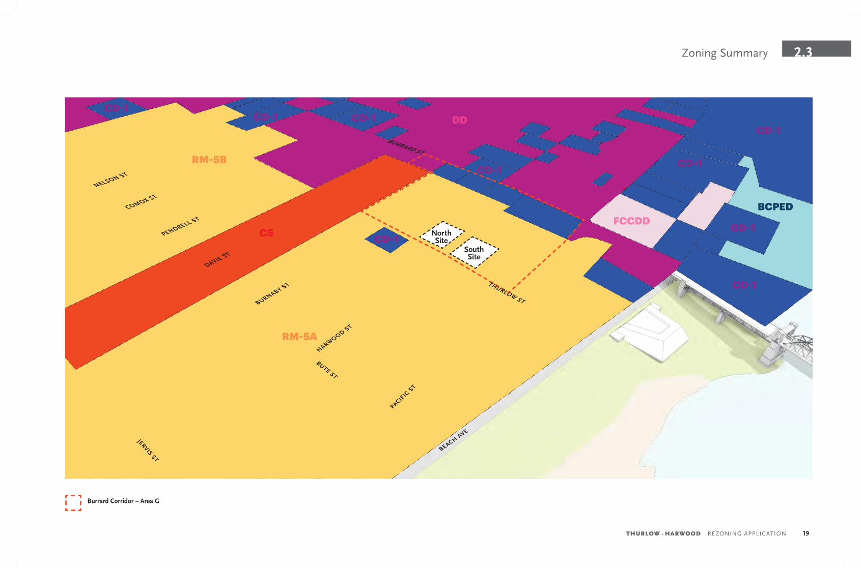
Zoning SummaryThe site is in the RM-5A zoning district and Area “G” of the West End Community Plan (Burrard Corridor).
The intent of RM-5A schedule is to permit a variety of residential developments, compatible retail, office, service and institutional uses. Emphasis is placed on achieving development which is compatible with neighbouring development with respect to streetscape character, open spaces, view retention, sunlight access and privacy. Additionally, the RM-5 district requires developments suited to families with children.
West End Community Plan (Burrard Corridor / Area ‘G’)To strategically locate opportunities for new growth through increased heights and densities. Where not restricted by view corridors building heights can be considered up to a maximum of 91.4 m (300 ft). New development should be in the form of a tower within landscaping at grade (i.e. “tower in a park”). The following table provides a summary of the zoning requirements. Refer to zoning bylaw and West End Community Plan for more zoning information.
zoNiNg rm-5a permitted – rm-5a weSt eNd commuNity plaN propoSed
North Site South Site
Uses Outright Cultural and Recreational Institutional Service Dwelling ConditionalOfficeParkingRetailUtility and Communication
Dwelling Dwelling
Site Area Not Applicable 1,606.48 m2 (17,292 ft2) 1,606.48 m2 (17,292 ft2)
Frontage Minimum 39.6 m (130 ft) Minimum 39.6 m (130 ft) 40.228 m (132 ft) 40.228 m (132 ft)
Height Outright: 18.3 m (60 ft)Discretionary: 58 m (190 ft)
91.4 m (300 ft) 91.4 m (300 ft) 91.4 m (300 ft)
Setbacks Thurlow: 3.0 m min. (9.84 ft)Front Yard: 3.7 m (12 ft)Side Yard: 2.1 m (7 ft)Rear Yard: 2.1 m (7 ft)
Thurlow: 5.49 m (18 ft)Front: 3.7 m (12 ft)Side Yard: 12.2 m (40 ft)Rear Yard: 3.7 m (12 ft)
Thurlow: 5.49 m (18 ft)Front: 5.7 m (18.7 ft)Side Yard: 12.2 m (40 ft)Rear Yard: 4.3 m (14.1 ft)
Thurlow: 5.49 m (18 ft)Front: 4.0 m (13.12 ft)Side Yard: 12.2 m (40 ft)Rear Yard: 5.39 m (17.68 ft)
FSR 2.20
Residential25% Social Housing75% Market Housing
2.20
Residential25% Social Housing75% Market Housing
10.46
Residential50% Social Housing50% Market Housing
10.11
Residential100% Market Housing
Site Coverage 50% 36.58% max. 36.58% 36.58%
Horizontal Angle of Daylight
One angle of 50 degrees over 24.0 m orTwo angles with sum of 70 degrees
Provided (40 ft setback from East Property line)
Provided (40 ft setback from East Property line)
19THURLOW+ HARWOOD REZONING APPLICATION
2.3Zoning Summary
Burrard Corridor – Area G
RM-5A
RM-5B
C5
DD
FCCDD
DAVIE ST
PENDRELL ST
COMOX ST
NELSON ST
BURNABY ST
HARWOOD ST
BUTE ST
JERVIS ST
PACIFIC
ST
BEACH AVE
BCPED
CD-1
CD-1CD-1 CD-1
CD-1CD-1
CD-1
CD-1
CD-1
North Site
South Site
BURRARD ST
THURLOW ST

20
Policy Context2.4
Policy ContextThe proposed development has been shaped in direct response to the policy context, the neighbourhood, and the unique site conditions.
A number of city policies have informed the design of the two project sites and have been addressed in this report, including:
• West End Community Plan (Refer to the following pages in this section.)
• Rezoning Policy for the West End
• West End – Tower Form, Siting and Setbacks
• RM-5, RM-5A, RM-5B, RM-5C and RM-5D District Schedule
• West End RM-5, RM-5A, RM-5B, RM-5C and RM-5D Guidelines
• View Protection Guidelines
• High-Density Housing for Families with Children Guidelines
• Vancouver’s Housing and Homelessness Strategy
• Tenant Relocation & Protection Policy
• Family Room: Housing Mix Policy for Rezoning Projects
• Housing Design and Technical Guidelines
• Rental Housing Stock (RHS) Official Development Plan
• Transportation 2040
• Green Building Policy for Rezonings
• Urban Agriculture Guidelines for the Private Realm
• Neighbourhood Energy Connectivity Standards
• Community Amenity Contributions through Rezonings
• Public Art Policies and Procedures for Rezoned Developments

21THURLOW+ HARWOOD REZONING APPLICATION
2.4Policy Context
Policy Response
Supporting GrowthThe project sites are located in an area designated for future growth, and is aligned with the goals of the West End Community Plan by providing housing and public benefits to support the local community. Under the West End Community Plan and Rezoning Policy for the West End, rezoning applications are considered for additional market residential density where at least 25% of the total floor area is provided as social housing, or existing market rental units are replaced one-for-one with social housing, whichever is greater. The proposed developments will achieve both and are fully aligned with those goals.
Social HousingThe proposed development supports the housing goals of the West End Community Plan by providing a minimum of 25% social housing, targeted as part of the City’s Housing Continuum. A minimum of 25% of the combined total FSR of the two towers will be provided as City-owned social housing, and will include a one-for-one replacement of the 98 existing market rental units. A total of 55% of all social housing units will be designed to support families with children, with a minimum of 20% of all units being 3 bedrooms or larger.
Families With ChildrenThe proposed market housing will support the City’s housing goals by adding to the supply of large units suitable for families with children. 60% of the proposed market residential units will be two bedrooms or larger, well beyond the City’s 35% requirement. The units will be suitable for families with children, and designed in accordance with the Housing for Families with Children Guidelines. On site amenities for both the market and social housing will support opportunities for families to gather and for children to play, and will be complimented by an array of off-site amenities in close proximity, including the seawall, Aquatic Centre and Sunset Beach.
Existing TenantsBlueSky Properties is dedicated to supporting existing tenants and will meet and in many cases exceed the requirements of the City’s Tenant Relocation and Protection Policy. The development team at BlueSky Properties fully appreciates the challenges that redevelopment poses on existing tenants and is dedicated to working with each and every tenant to find appropriate accommodations, as well as provide compensation and assistance for their move. A full time tenant relocation coordinator has been engaged to provide a point of contact for tenants and to provide the assistance required. Tenants meeting the eligibility requirements will also have the Right of First Refusal for the new social housing, giving them an opportunity to return the neighbourhood.
Privacy & ViewsThe residential towers have been sculpted to help protect privacy and views from existing residential towers and to minimize impacts to the surrounding neighbourhood. In a dense urban environment targeted for future growth, such as Area ‘G’ of the West End Community Plan’s Burrard Corridor, privacy and overlook are central concerns for livability. And while it is impossible to avoid some impacts to surrounding towers, relationships to existing and future towers were key considerations for the siting, sculpting and articulation of the towers, in particular for the location of balconies, to ensure existing privacy and views are maintained as much as possible.
Built Form & FitThe proposed towers in the park have been designed to meet the requirements of the West End – Tower Form, Siting and Setbacks and West End Community Plan requirements. The design of the towers are fully aligned with policy requirements for building heights, setbacks, tower separations, floor plate sizes and dimensions, and balcony projections. Of particular importance, no shadows are being cast on the north sidewalk of Davie street or onto any parks or public open space. The form of development is also well below any existing view cones and reinforces the dome-shaped skyline of the city.
22
Policy Context2.4
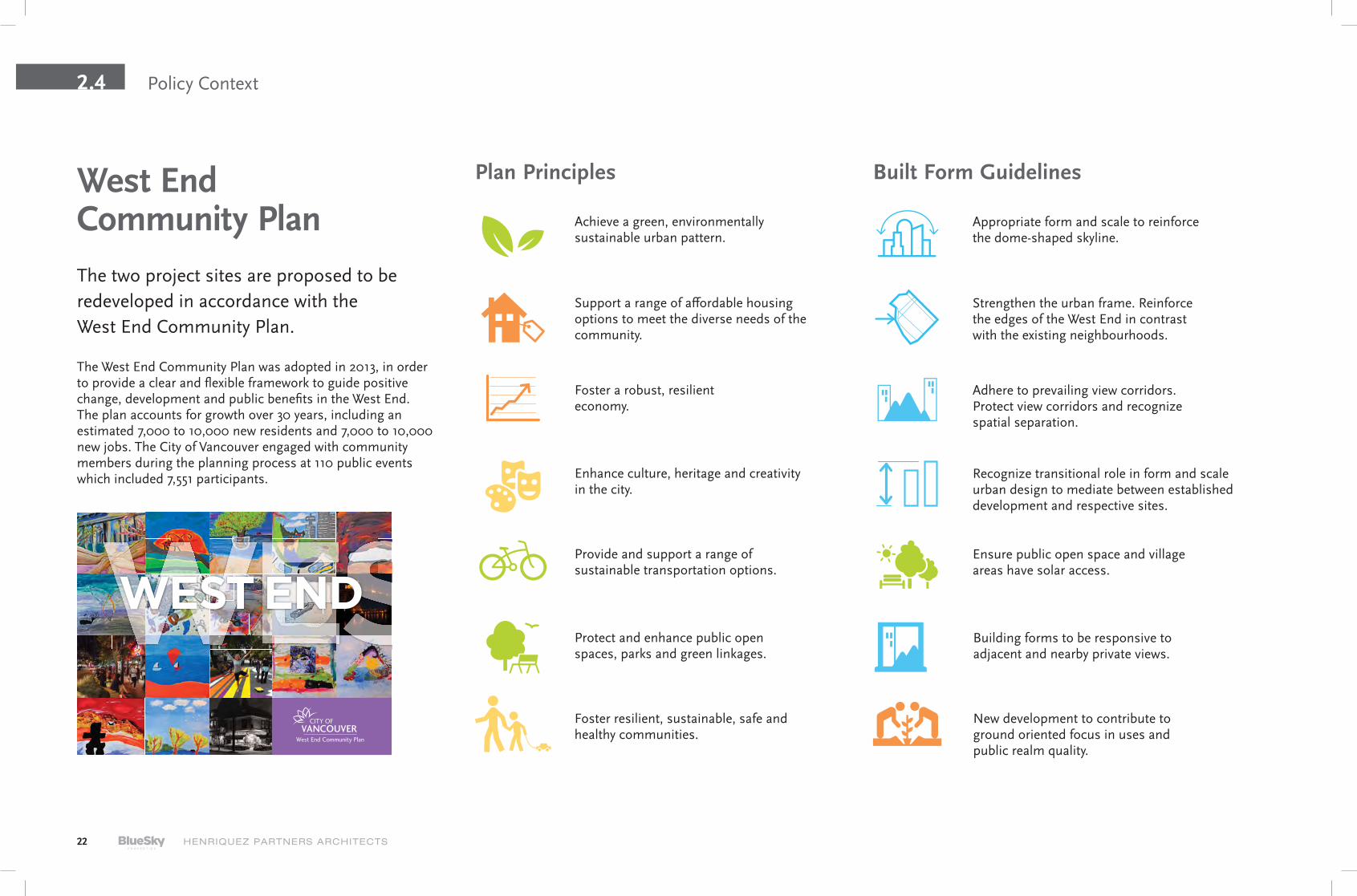
The West End Community Plan was adopted in 2013, in order to provide a clear and flexible framework to guide positive change, development and public benefits in the West End. The plan accounts for growth over 30 years, including an estimated 7,000 to 10,000 new residents and 7,000 to 10,000 new jobs. The City of Vancouver engaged with community members during the planning process at 110 public events which included 7,551 participants.
West End Community PlanThe two project sites are proposed to be redeveloped in accordance with the West End Community Plan.
Achieve a green, environmentally sustainable urban pattern.
Appropriate form and scale to reinforce the dome-shaped skyline.
Support a range of affordable housing options to meet the diverse needs of the community.
Strengthen the urban frame. Reinforce the edges of the West End in contrast with the existing neighbourhoods.
Foster a robust, resilient economy.
Adhere to prevailing view corridors. Protect view corridors and recognize spatial separation.
Enhance culture, heritage and creativity in the city.
Recognize transitional role in form and scale urban design to mediate between established development and respective sites.
Provide and support a range of sustainable transportation options.
Ensure public open space and village areas have solar access.
Protect and enhance public open spaces, parks and green linkages.
Building forms to be responsive to adjacent and nearby private views.
Foster resilient, sustainable, safe and healthy communities.
New development to contribute to ground oriented focus in uses and public realm quality.
Plan Principles Built Form Guidelines
23THURLOW+ HARWOOD REZONING APPLICATION
2.4Policy Context
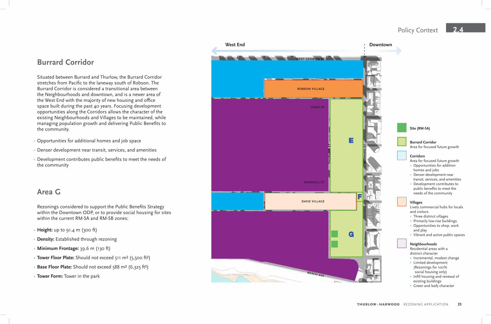
Burrard Corridor
Situated between Burrard and Thurlow, the Burrard Corridor stretches from Pacific to the laneway south of Robson. The Burrard Corridor is considered a transitional area between the Neighbourhoods and downtown, and is a newer area of the West End with the majority of new housing and office space built during the past 40 years. Focusing development opportunities along the Corridors allows the character of the existing Neighbourhoods and Villages to be maintained, while managing population growth and delivering Public Benefits to the community.
• Opportunities for additional homes and job space
• Denser development near transit, services, and amenities
• Development contributes public benefits to meet the needs of the community
Burrard CorridorArea for focused future growth
Site (RM-5A)
CorridorsArea for focused future growth• Opportunities for addition
homes and jobs• Denser development near
transit, services, and amenities• Development contributes to
public benefits to meet the needs of the community
DAVIE VILLAGE
BU
RR
AR
D S
T
BU
TE
ST
JER
VIS
ST
BR
OU
GH
TO
N S
T
BURNABY ST
HARWOOD ST
PACIFIC ST
BEACH AVE
COMOX ST
NELSON ST
BARCLAY ST
ROBSON VILLAGE
ALBERNI ST
WEST GEORGIA ST
G
F
E
NIC
OL
A S
T
Area G
TH
UR
LOW
ST
HARO ST
PENDRELL ST
DowntownWest End
Rezonings considered to support the Public Benefits Strategy within the Downtown ODP, or to provide social housing for sites within the current RM-5A and RM-5B zones:
• Height: up to 91.4 m (300 ft)
• Density: Established through rezoning
• Minimum Frontage: 39.6 m (130 ft)
• Tower Floor Plate: Should not exceed 511 m² (5,500 ft²)
• Base Floor Plate: Should not exceed 588 m² (6,325 ft²)
• Tower Form: Tower in the park
VillagesLively commercial hubs for locals and visitors• Three distinct villages• Primarily low-rise buildings• Opportunities to shop, work
and play• Vibrant and active public spaces
NeighbourhoodsResidential areas with a distinct character• Incremental, modest change• Limited development
( Rezonings for 100% social housing only)
• Infill housing and renewal of existing buildings
• Green and leafy character
24
Policy Context2.4
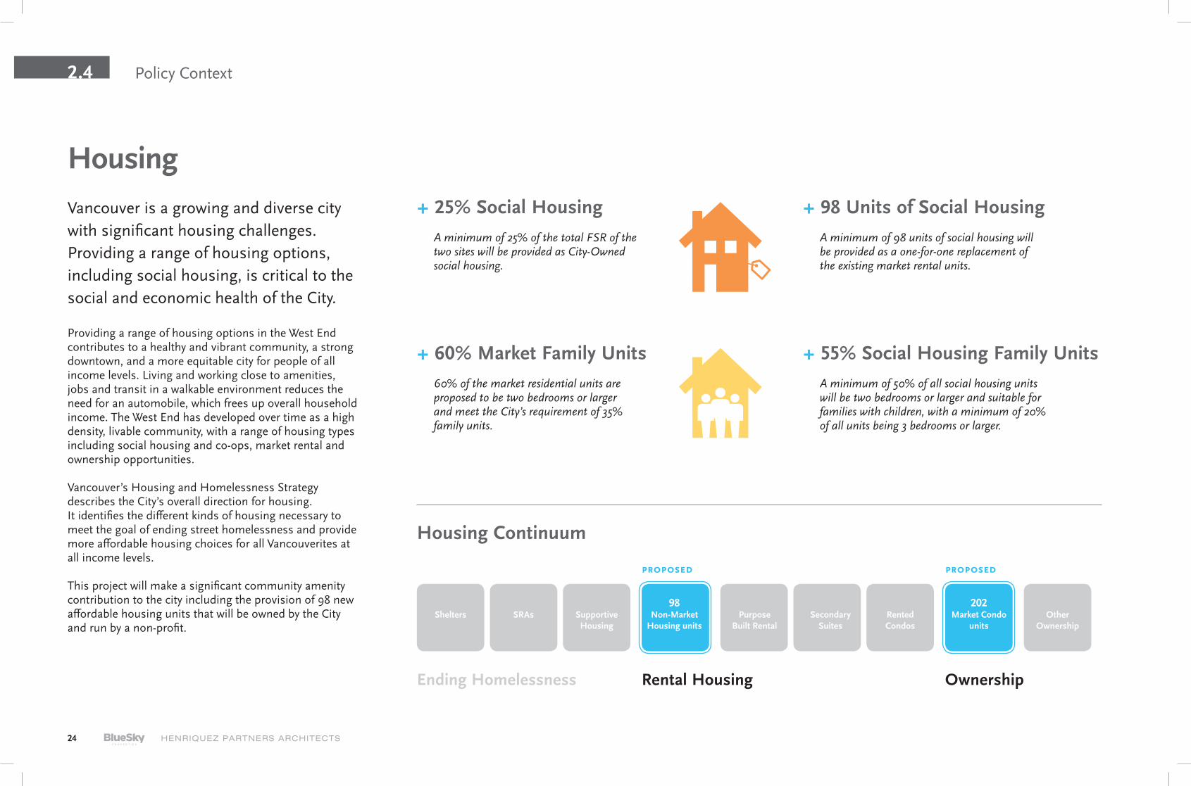
Providing a range of housing options in the West End contributes to a healthy and vibrant community, a strong downtown, and a more equitable city for people of all income levels. Living and working close to amenities, jobs and transit in a walkable environment reduces the need for an automobile, which frees up overall household income. The West End has developed over time as a high density, livable community, with a range of housing types including social housing and co-ops, market rental and ownership opportunities.
Vancouver’s Housing and Homelessness Strategy describes the City’s overall direction for housing. It identifies the different kinds of housing necessary to meet the goal of ending street homelessness and provide more affordable housing choices for all Vancouverites at all income levels.
This project will make a significant community amenity contribution to the city including the provision of 98 new affordable housing units that will be owned by the City and run by a non-profit.
+ 25% Social HousingA minimum of 25% of the total FSR of the two sites will be provided as City-Owned social housing.
+ 60% Market Family Units60% of the market residential units are proposed to be two bedrooms or larger and meet the City’s requirement of 35% family units.
+ 98 Units of Social HousingA minimum of 98 units of social housing will be provided as a one-for-one replacement of the existing market rental units.
+ 55% Social Housing Family UnitsA minimum of 50% of all social housing units will be two bedrooms or larger and suitable for families with children, with a minimum of 20% of all units being 3 bedrooms or larger.
Vancouver is a growing and diverse city with significant housing challenges. Providing a range of housing options, including social housing, is critical to the social and economic health of the City.
Ending Homelessness
98Non-Market
Housing units
Housing
Housing Continuum
Shelters SRAs Supportive Housing
Rental Housing
propoSed propoSed
Secondary Suites
Rented Condos
Purpose Built Rental
Other Ownership
Ownership
202Market Condo
units
25THURLOW+ HARWOOD REZONING APPLICATION
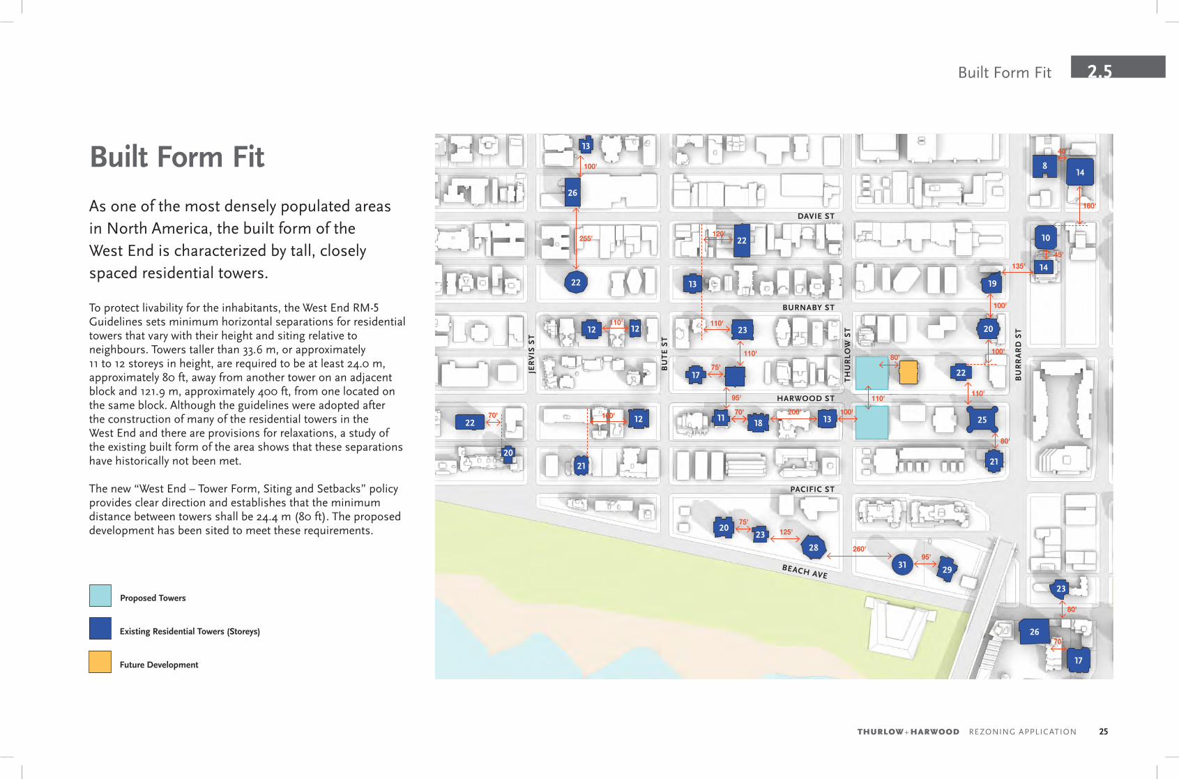
2.5Built Form Fit
Existing Residential Towers (Storeys)
Future Development
DAVIE ST
BURNABY ST
BEACH AVE
HARWOOD ST
PACIFIC ST
BU
RR
AR
D S
T
TH
UR
LOW
ST
BU
TE
ST
JER
VIS
ST
Proposed Towers
100'
110'
100'
110'
45'
80'
160'
80'
100'
95'
255'
110'
75'
40'
75'125'
260'95'
70'
100'200'70' 160'
120'
135'
110'
Built Form FitAs one of the most densely populated areas in North America, the built form of the West End is characterized by tall, closely spaced residential towers.
To protect livability for the inhabitants, the West End RM-5 Guidelines sets minimum horizontal separations for residential towers that vary with their height and siting relative to neighbours. Towers taller than 33.6 m, or approximately 11 to 12 storeys in height, are required to be at least 24.0 m, approximately 80 ft, away from another tower on an adjacent block and 121.9 m, approximately 400 ft, from one located on the same block. Although the guidelines were adopted after the construction of many of the residential towers in the West End and there are provisions for relaxations, a study of the existing built form of the area shows that these separations have historically not been met.
The new “West End – Tower Form, Siting and Setbacks” policy provides clear direction and establishes that the minimum distance between towers shall be 24.4 m (80 ft). The proposed development has been sited to meet these requirements.
110'
22
22
22
22
23
23
23
26
28
2931
26
20
20
21 21
2512 11
12
13
13
13
17
18
19
14
148
10
20
17
12
70'
80'

26
HARWOOD ST
PACIFIC ST
BURNABY ST
TH
UR
LOW
ST
BU
RR
AR
D S
T
80'12'
40'40'18'
12'
40'18'
12'
12'
Privacy & Views2.6
Privacy & SetbacksIn the context of the West End Plan and within corridors designated for future growth, relationships to existing and future towers are key considerations for the livability of the neighbourhood.
Separations to neighbours in response to the “West End – Tower Form, Siting and Setbacks” requirements directly inform the siting of the proposed towers. These separation distances ensure that residents of the proposed and neighbouring buildings are provided a sense of privacy. In order to meet the requirements, the location and shapes of the towers are well constrained by the size of the properties, the required setbacks, and the maximum width, depth and area of the floor plates. And while the massing of the two towers are well constrained, the location and articulation of balconies provide opportunities to direct views and improve privacy.
The primary overlook and privacy concerns will come from the east. At present there are ample separation distances between the proposed towers and line of existing towers along Burrard street, though future development in response to the West End plan will occur towards the east, whereas the area to the west is defined by the “Beach Neighbourhood” and does not permit rezonings for increased density. As a result, upper floor balconies have been minimized on the north and east elevations and rather have been located at the northwest, southwest, and southeast corners. The southwest balconies of both towers have been designed to direct views away from existing towers to improve privacy.
Existing Residential Towers Future Development
Burrard Corridor Area GBeach Neighbourhood

27THURLOW+ HARWOOD REZONING APPLICATION
2.6Privacy & Views
ViewsThe impact to existing views has been considered in relationship to the proposed development.
The primary views for towers in the area is towards the south and west. In particular, a view of Vanier Park and the HR MacMillan Space Centre to the south is framed by the Martello and Sunset Plaza Towers. Partial views of Sunset Beach Park to the west are also available from some towers. As a result, the existing towers along Burrard street towards the east will be the most concerned of view blockage. Detailed view studies have been prepared and included in Section 4.1 of this report to show the impact to individual buildings.
For the existing towers lining Burrard street, the primary view of Vanier Park and the HR MacMillan Space Centre is maintained. In addition, views of Sunset Beach from the Crystallis Tower is maintained. Views to the west will primarily be impacted by future development in closer proximity to Burrard, including the proposed tower at 1055 Harwood street. The southwest view of Sunset Beach from the Carlton Court tower is the most impacted since it is in a direct like of sight with the south tower. The distance between the two towers will allow for privacy.
Existing Residential Towers
View Maintained – Sunset Beach
West End Community Plan – Future Towers
View Maintained – Vanier Park & H.R. MacMillan Space Centre
Future Development
DAVIE ST
BURNABY ST
BEACH AVE
HARWOOD ST
BU
RR
AR
D S
T
TH
UR
LOW
ST
BU
TE
ST
JER
VIS
ST
Carlton Court
Martello
Sunset Plaza
Crystallis Tower