zoning experiences from new zealand: some selected aspects ... filezoning experiences from new...
TRANSCRIPT
Zoning experiences from New
Zealand: some selected aspects of
design and monitoring of deep-
sea sites
Malcolm Clark1, Ashley Rowden1,
Rachel Boschen2, Dave Bowden1
1 NIWA, 2 Victoria University
ISA IRZ-PRZ Workshop, Berlin, September 2017
Presentation Outline
• Three examples of work in New Zealand
– Not a “how to” talk
– Highlights some issues we have experienced
• SMS mining vs reference site
– Was the site selection adequate?
• Protected area network inside a licence area
– Phosphorite nodule habitat
– Was spatial planning useful?
• Monitoring recovery
– Post closure to bottom trawling on seamounts
– Can we measure changes over time?
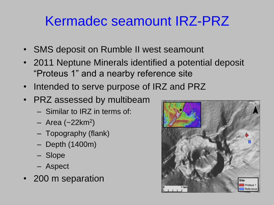
Kermadec seamount IRZ-PRZ
• SMS deposit on Rumble II west seamount
• 2011 Neptune Minerals identified a potential deposit
“Proteus 1” and a nearby reference site
• Intended to serve purpose of IRZ and PRZ
• PRZ assessed by multibeam
– Similar to IRZ in terms of:
– Area (~22km2)
– Topography (flank)
– Depth (1400m)
– Slope
– Aspect
• 200 m separation
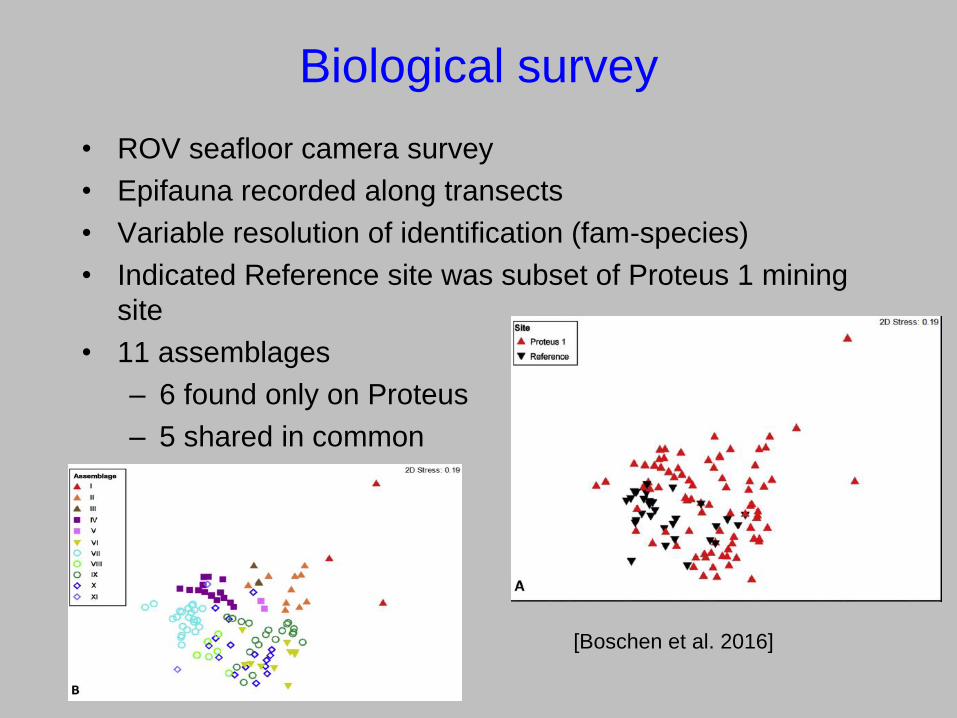
Biological survey
• ROV seafloor camera survey
• Epifauna recorded along transects
• Variable resolution of identification (fam-species)
• Indicated Reference site was subset of Proteus 1 mining
site
• 11 assemblages
– 6 found only on Proteus
– 5 shared in common
[Boschen et al. 2016]
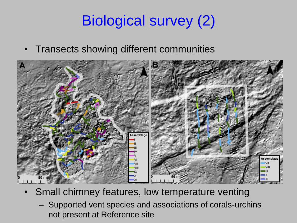
Biological survey (2)
• Transects showing different communities
• Small chimney features, low temperature venting
– Supported vent species and associations of corals-urchins
not present at Reference site
Biological survey conclusions
• Study shows a single PRZ was inadequate
• The multibeam survey, and physical proxies, did not
pick up the smaller spatial-scale variability
• Highlighted that studies conducted at multiple spatial
scales are needed
– Large-scale survey to define regional/licence area
significance of a potential PRZ
– Small-scale to describe heterogeneity within the
licence area
• The PRZ was too close to the impact area, as plumes
could extend 1 km
– Balance between proximity for faunal similarity and being
clear of any long-term mining impact (variable plume)
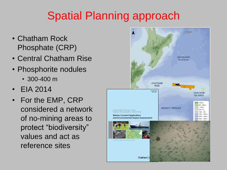
Spatial Planning approach
• Chatham Rock
Phosphate (CRP)
• Central Chatham Rise
• Phosphorite nodules
• 300-400 m
• EIA 2014
• For the EMP, CRP
considered a network
of no-mining areas to
protect “biodiversity”
values and act as
reference sites
CRP
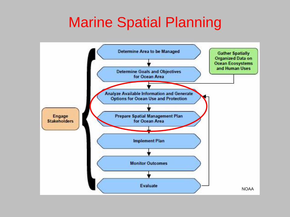
Marine Spatial Planning
NOAA

The CRP approach
• Attempt to structure
zoning on objective
rather than subjective
grounds
• Transparency in
assessment
• Zonation software
produces a hierarchical
prioritisation of the
seascape based on the
conservation value of
the site (grid cells),
iteratively removing the
least valuable cells

Data
Biodiversity Resource cost
8 x benthic
epifauna
communities
8 x demersal fish of
commercial interest
4 x protected coral
taxa
mining
prospectivity
trawl intensity
Numerous iterations with
different weightings and
sensitivities were trialled

Protected Area selection
Criteria:
• Protect high
biodiversity priority
areas (weighting of
protected corals)
• Distant from highest
mining priority
areas
• Large as possible
• Distributed
throughout area
and MEC classes
• Ranged in size from
6-200 km2 No-mining areas selected by CRP
Where did it get to?
• Important step in process of generating management options
for mitigating impact of phosphorite nodule mining on the
Chatham Rise
• Demonstrated the utility of this sort of approach
• Within the mining and licence area, the no-mining areas could
protect:
• >20% for all biodiversity features and 90% of the coral-
dominated epifaunal communities
• The application for mining was turned down
– Many issues not related to the EMP and closed area plans
– Important point relevant to THIS zoning was lack of REGIONAL
protection areas (issue of how PRZs relate to APEIs)
– Similar to the multiple scales Kermadec issue
– Highlights the regional-local issue of APEIs and PRZ roles
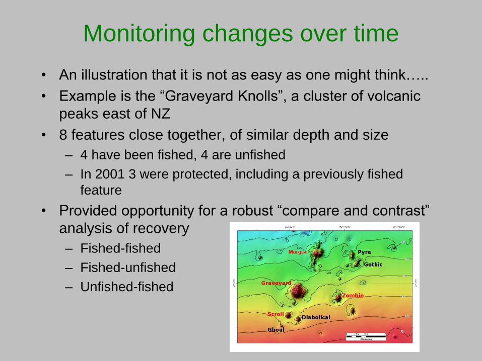
Monitoring changes over time
• An illustration that it is not as easy as one might think…..
• Example is the “Graveyard Knolls”, a cluster of volcanic
peaks east of NZ
• 8 features close together, of similar depth and size
– 4 have been fished, 4 are unfished
– In 2001 3 were protected, including a previously fished
feature
• Provided opportunity for a robust “compare and contrast”
analysis of recovery
– Fished-fished
– Fished-unfished
– Unfished-fished

Survey design
• Four surveys over 15 years
– 2001, 2006, 2009, 2015
• Using towed camera close to
the seafloor
• Attempted to survey same
lines

Technology creep
• Most taxa on all seamounts
show an increase in
abundance over time
• Includes taxa unlikely to
actually be able to increase
• But camera resolution (still
images1.5, 5, 10, 10 MP),
ship control (DPS part 2009,
all 2015) improved and mean
more stable and clearer
images over time
• Despite the SAME image
analyst, hard to maintain
consistent “down-grading” of
identifications and counts
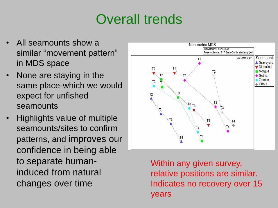
Overall trends
• All seamounts show a
similar “movement pattern”
in MDS space
• None are staying in the
same place-which we would
expect for unfished
seamounts
• Highlights value of multiple
seamounts/sites to confirm
patterns, and improves our
confidence in being able
to separate human-
induced from natural
changes over time
Within any given survey,
relative positions are similar.
Indicates no recovery over 15
years

Seamount comparisons
• ANOSIM analysis of
seamount pairs enables
us to evaluate the
patterns
• MORG-GRAV should be
recovery-no sign
• GRAV-GOTH should be
the most contrast (fished,
unfished)
• Monitoring over time
allows us to pick up real
changes, technology
changes, and outliers
which can be missed if
few surveys in time series
Thoughts from our experience
• Each resource and location has its own environmental and
faunal characteristics. Detailed biological surveys are
necessary to confirm IRZs and PRZs-physical proxies
may be inadequate.
• The complex spatial scale patterns in benthic communities
need to be described and incorporated into design. There
are both regional-scale and local-scale issues.
• Spatial planning software can be a useful tool to aid
selection of PRZs, especially for long-term biodiversity
protection
• Replication of sites (so several PRZs) may be needed to
confirm the nature and extent of natural changes.
• Careful planning is required to ensure time series data are
consistent and can support robust comparisons.
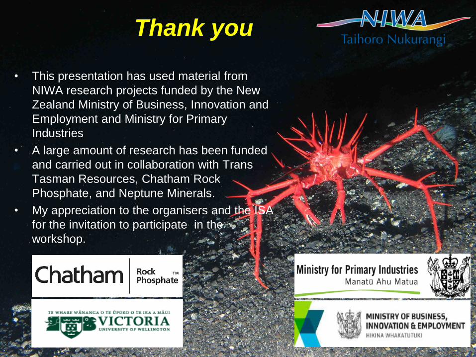
Thank you
• This presentation has used material from
NIWA research projects funded by the New
Zealand Ministry of Business, Innovation and
Employment and Ministry for Primary
Industries
• A large amount of research has been funded
and carried out in collaboration with Trans
Tasman Resources, Chatham Rock
Phosphate, and Neptune Minerals.
• My appreciation to the organisers and the ISA
for the invitation to participate in the
workshop.