zoning - · pdf filemarch 2014 ii contents appendix a: zoning zoning book page number...
TRANSCRIPT
March 2014 i
ZONING
CITY OF
HOMEWOOD, ALABAMA
This pamphlet is a reprint of Appendix A, Zoning, of the Code of Ordinances of the City of Homewood, Alabama, published by the order of the Mayor and Council.

March 2014 ii
CONTENTS
APPENDIX A: ZONING Zoning Book Page Number
ARTICLE I. INTRODUCTION 1
ARTICLE II. DEFINITIONS 3
ARTICLE III. GENERAL REGULATIONS 8
ARTICLE IV. DISTRICT USES 12
ARTICLE V. DISTRICT DEVELOPMENT CRITERIA 90
ARTICLE VI. REQUIRED DEVELOPEMNT PLAN 96
ARTICLE VII. OFF STREET PARKING AND LOADING REQUIRMENTS 100
ARTICLE VIII. RESERVED 105
ARTICLE IX. ADMISTRATION AND REVIEW PROCEDURES 106
ARTICLE I. INTRODUCTION Zoning Book Page Number
Sec. A. Authority 1
Sec. B. Short Title 1
Sec. C. Purpose 1
Sec. D. Method 2
ARTICLE II. DEFINITIONS 3
ARTICLE III. GENERAL REGULATIONS
Sec. A. Districts 8
Sec. B. Zoning map 9
Sec. C. Interpretation of district boundaries 9
Sec. D. General Use Requirements 9
Sec. E. Nonconforming uses of lands and buildings 10
Sec. F. Abandoned right-of-way 11
Sec. G. Nonconforming lots 11
Sec. H. Occupancy of Dwelling Units 11
iii
ARTICLE IV. DISTRICT USES
Zoning Book Page Number
Sec. A. NPD Neighborhood Preservation District 12
Sec. B. R-1 Detached Dwelling Unit District 14
Sec. C. R-2 Detached Dwelling Unit District 14
Sec. D. R-3 Detached Dwelling Unit District 14
Sec. E. R-4 Attached Dwelling Unit District 14
Sec. F. R-5 Attached Dwelling Unit District 14
Sec. G. R-6 Attached Dwelling Unit District 15
Sec. H. R-7 Attached Dwelling Unit District 15
Sec. I. PR-1 Planned Residential District 16
Sec. J. PR-2 Planned Residential District 16
Sec. K. C-1 Office Building District 16
Sec. L. C-2 Neighborhood Shopping District 17
Sec. M. C-3 Community Shopping District 18
Sec. N. C-4 Central Business District 20
Sec. O. C-4(a) Retail Shopping District 20
Sec. P. C-4(b) High Rise Office / Commercial District 21
Sec. Q. C-5 General Business District 22
Sec. R. I-1 Institutional District 23
Sec. S. I-2 Institutional District 24
Sec. T. I-3 Institutional District 24
Sec. U. PCD-1 Planned Office District 25
Sec. V. PCD-2 Planned Commercial District 25
Sec. W. M-1 Light Manufacturing District 26
Sec. X. PI Planned Industrial District 27
Sec. Y. PMUD Planned Mixed Use District 27
Sec. Z. MXD Mixed Use District 28
Sec. AA. EURD Edgewood Urban Renewal District 32
Sec. BB. GURD Greensprings Urban Renewal District 33
Sec. CC. Brookwood Overlay District (BOD) 35 Sec. DD. Land Preserve District (LPD) Sec. EE. West Homewood District (WHD)
36 38
ARTICLE V. DISTRICT DEVELOPMENT CRITERIA
Sec. A. Quantitative development criteria 90
Sec. B. General setback modifications 90
Sec. C. Front setback modifications 90
Sec. D. Accessory structures 90
Sec. E. Visibility 91
Sec. F. Lighting and glare 91
Sec. G. Buffer strip 91
Sec. H. Storage and dispensing of combustible and flammable liquids other than for sale
91
Sec. I. Community Garden 92

iv
ARTICLE VI. REQUIRED DEVELOPEMNT PLAN Zoning Book Page Number
Sec. A. Intent 96
Sec. B. Required development plan 96
Sec. C. Preliminary development plan 96
Sec. D. Final development plan 97
Sec. E. Final development plan review 98
Sec. F. Amending final development plan 99
ARTICLE VII. OFF STREET PARKING AND LOADING REQUIRMENTS
Sec. A. 100
Sec. B. 100
Sec. C. 100
Sec. D. 100
Sec. E. 100
Sec. F. 100
Sec. G. 100
Sec. H. 101
Sec. I. 101
Sec. J. 101
Sec. K. 101
Sec. L. 101
Sec. M. Required Parking Spaces for Individual Uses 102
Sec. N. Loading area Requirements 104 Sec. O. Parking and Loading Area Requirements for the Mixed Use District and
Land Preserve District 104
Sec. P. Parking Requirements for the Urban Renewal Districts 104
ARTICLE VIII. RESERVED 105
ARTICLE IX. ADMISTRATION AND REVIEW PROCEDURES
Sec. A. General administration 106
Sec. B. Zoning amendments 107
Sec. C. Use on appeal 110
Sec. D. Severability 111

1
APPENDIX A
ZONING*
Art. I. Introduction, §§ A--D Art. II. Definitions Art. III. General Regulations, §§ A--H Art. IV. District Uses, §§ A--DD Art. V. District Development Criteria, §§ A--H Art. VI. Required Development Plan, §§ A--F Art. VII. Off-Street Parking and Loading Requirements, §§ A--P Art. VIII. Reserved Art. IX. Administration and Review Procedures, §§ A—D
ARTICLE I. INTRODUCTION
Sec. A. Authority.
An ordinance, in pursuance of the authority granted by Title 11, Chapter 52, Article 4, Code of Alabama 1975, as amended and supplemented by all applicable laws to provide for the establishment of districts within the corporate limits of Homewood, Alabama; to regulate within such districts the height, number of stories, and size of buildings and other structures, the percentage of lots that may be occupied, the size of yards and other open spaces, the density of population and the use of buildings, structures, and land; to repeal all existing zoning ordinances and to provide methods of administration of this Ordinance and penalties for the violation thereof.
Sec. B. Short title.
This ordinance shall be known as the "Zoning Ordinance of Homewood, Alabama," and the map herein referred to, identified by the title "Zoning Map of Homewood, Alabama," shall be further identified by the signature of the mayor of Homewood and attested by the city clerk. The zoning map of Homewood is hereby adopted and made a part of this ordinance. Said zoning map shall zone only territory within Homewood. Such map is filed with the clerk of Homewood at the time of the introduction of this ordinance, will remain on file in the office of the said clerk and upon the adoption of the ordinance, said map will show by endorsement thereon the date of such adoption.
Sec. C. Purpose. The fundamental purpose of this ordinance is to promote the public health, safety, morals and general welfare; to provide for the orderly development and growth of Homewood; to avoid congestion on the public roads and streets; to conserve life, property and natural resources and the expenditure of funds for public improvements and services to conform with the most advantageous uses of land, resources and properties, for the general good and benefit to the people of Homewood ------------------------------------------------------------------------------------------------------------- *Editor's note--Ord. No. 1602, dated Dec. 9, 1986, adopted the zoning ordinance. Cross reference(s)--Planning commission, § 17-1 et seq.; board of adjustment, § 17-20 et seq. -------------------------------------------------------------------------------------------------------------
2
.
Sec. D. Method.
For the purpose previously stated, the City of Homewood is divided into districts of such number, shape and area, and of such common unity of purpose, adaptability or use, which are deemed most suitable to provide for the best general civic use, protect the common rights and interests within each district, preserve the general rights, and interests of all; and by further regulations to limit the location, uses and occupancy of buildings, structures and land to be used for trade, industry, residence or other purposes, and also the location, height, bulk, occupancy and uses of buildings or other structures, including the ratio of lot occupancy and coverage, setback lines, sizes of yards, and other open spaces.

3
ARTICLE II. DEFINITIONS
When not inconsistent with the context, words used in the present tense include the future, the singular number includes the plural and the plural the singular. The word "building" shall include the word "structure" and the word "shall" is mandatory and not directory. Words and terms are defined as follows:
Accessory structures: A subordinate structure incidental to the primary use of the lot.
Accessory use: A use which is related but subordinate to the main use of the lot.
Alley: A public way less in width than a street, designed for the special accommodation of the property it reaches, and not intended for general travel.
Alteration and altered: The word "alteration" shall include any of the following:
(a) Any addition to a building or structure.
(b) Any change in the location of any of the exterior walls of a building or structure.
In addition to the foregoing, a building or structure shall be classified as altered when it is repaired, renovated, remodeled, or rebuilt at a cost in excess of fifty (50) percent of its value prior to the occurrence which necessitated the alteration.
Attached dwelling unit: A dwelling unit in a building which contains two (2) or more dwelling units.
Basement: That portion of a building between floor and ceiling, which is partly above and partly below grade, but so located that the vertical distance from grade to the floor below is less than the vertical distance from grade to ceiling, provided, however, that the distance from grade to ceiling shall be at least four (4) feet six (6) inches.
Buffer strip: A vegetated strip of ground that is located within the property boundary and that meets all of the following criteria:
(1) At its narrowest point, it has a level, horizontally measured width of ten (10) feet minimum; and
(2) Its entire ground surface must remain unobstructed by manmade structures (except for approved fences and walls), pavement or any other impervious surface improvement; and
(3) It must be so populated with plant materials that, within one ( 1) full calendar year after the date of installation of the plant material, the plant population provides a persistent, evergreen barrier that has a uniform distribution of foliage that is sufficiently dense so as to be impervious to transverse view from every vantage point located 0-to-6 feet in height along the longitudinal edges of the strip; and the plant population must be cultured and maintained so that, within three (3) full calendar years after the original date of installation of the plant material, the plant population is sufficiently dense so as to be impervious to transverse view from every point located 0-to-8 feet in height along the longitudinal edges of the strip. All vantage points shall be determined by vertical (plumb) measure taken from the relative point on the ground surface along said longitudinal edges; and
4
(4) Its entire ground surface must be covered by an overstory of vegetation; and
(5) Its entire ground surface must be covered by a layer of organic mulch, having a minimum thickness of four (4) vertical inches and being comprised of clean pine straw, shredded tree bark or other organic material approved by the city planner; and
(6) It must be adequately maintained so as to affect the continuing and satisfactory performance of its requisite functions as a buffer strip.
Building: Any structure having a roof supported by columns or walls.
Building, main: The principal building on a lot, including an attached garage, carport, porch or part thereof.
Building area: The portion of the lot which may be occupied by the main building and accessory structures.
Building height: The vertical distance measured from the finished grade, to the highest point of the roof for flat and mansard roofs, and to the mean height between eaves and ridge for gable, hip and gambrel roofs.
Building line: A line defining the distance from the property line or lines beyond which a structure may be built in compliance with this ordinance.
Clinic: An establishment, public or private, where there are no overnight facilities and where people are given examination, diagnosis and treatment as out-patients by physicians, dentists, optometrists or other members of the medical profession.
Cold Frame: An unheated outdoor apparatus consisting of a wooden or concrete frame and a top of glass or clear plastic, used for protecting seedlings and plants from the cold no more than thirty-two (32) square feet in area and four (4) feet in height
Community Garden: A lot(s) or parcel(s) of land managed and maintained by a non-profit
organization, an association, or a group of individuals from multiple households to grow and to harvest food, crops and/or non-food, ornamental crops, such as flowers, for personal or group use, consumption, or donation. Community Gardens may be divided into separate plots for cultivations by individuals, or may be farmed collectively by the members of the group, and may include common areas maintained and used by group members. A Community Garden does not include a garden or edible landscaping maintained by an individual or members from one household for personal use.
Community Garden Structure: A detached structure, the use of which is customary to community
gardens.
Condominium: Individually owned attached dwelling units, situated on property which is owned and maintained by an association of residents, for their common use and benefit.
Day care center: Any child care facility receiving more than six (6) children for care.
Day care home: A child care facility which is a family home and which receives no more than six (6) children for care.

5
Detached dwelling unit: A dwelling unit which is the main building on a lot.
Dormitory: A structure other than a dwelling, designed, used or offered for residential occupancy, which is part of an institution, and serves only the members, students or employees thereof.
Duplex: A building containing two (2) dwelling units.
Dwelling: Any building or portion thereof which is designed or used primarily for residential occupancy, except that the word "dwelling" shall not include boarding or rooming houses, tents, dormitories, motels, hotels, or other structures designed or used primarily for transient residents.
Dwelling unit: Any portion of a building used, intended, or designed as a separate abode for one (1) family.
Family: One or more persons related by blood, marriage, adoption, or by some other legal custodial relationship, living as a single housekeeping unit in a dwelling unit, including persons who reside in the dwelling unit and are employed to care for family member; or three (3) unrelated individuals living as a single housekeeping unit in a dwelling unit. However, notwithstanding the preceding definition, a family shall also be deemed to include up to three (3) unrelated persons occupying a dwelling unit and living as a single, non-profit housekeeping unit, if any one or more of said three (3) unrelated occupants is handicapped as defined in Title VII of the Civil Rights Act of 1968 as amended by the Fair Housing Act Amendments of 1988 and the Alabama Fair Housing Law, § 24-8-1, et seq., Ala. Code 1975.
Fence: A structure intended for a barrier or enclosure constructed of any material except masonry or concrete.
Garden Coordinator: The person having legal or equitable interest in a propose project subject to the provision of this article. The coordinator performs the role of management of the community gardens in coordination with the city.
Grade: A reference plane representing the average of finished ground level adjoining the building at all exterior walls.
Home occupation: An accessory use of a dwelling, employing only the inhabitants thereof, which is clearly incidental and secondary to residential occupancy, and subject to the criteria set forth in Article IX, section C, subsection 1, subparagraph b of this ordinance.
Hoop House: An apparatus made of polyvinyl chloride (PVC) piping or other material covered with translucent plastic, constructed in a half-round or hoop shape, used for growing and protecting plants no more than 200 sq. ft. in area and 8 ft in height
Hotel: An establishment offering transient lodging accommodations to the general public, with all rooms having sole access, (other than required or permitted emergency exits) to the outside through the main lobby of the building, and providing additional services, such as restaurants, coffee shops, gift shops and meeting rooms.
Living area: The area on all floors of a building exclusive of porches, unfinished basements, unfinished attics, garages or breezeways.

6
Lot: A platted parcel of land that is part of a subdivision, abuts a public street, has the minimum area and dimensions required by the district regulations in which it is located, and is recorded in the office of the judge of probate.
Major vehicle repair: Rebuilding of engines and other components, painting, grinding, sanding, fabrication of parts, and other activities which require the storage of vehicles or are detrimental to property, health or safety beyond the district in which it is located, due to emission of odor, gas, dust, fumes, smoke, noise, vibration or waste material.
Mini-warehouse: A structure or group of structures, not to exceed one ( 1) story in height, partitioned for leasing of individual storage spaces of five hundred (500) square feet or less, wherein no retail or wholesale trade is conducted.
Motel: An establishment providing transient accommodations to the general public containing twenty-five (25) or more rooms, with at least seventy-five (75) percent of the rooms having access to the outside without the necessity of passing through the main lobby of the building.
Nonconforming lot of record: A lot which was lawful when platted but does not conform to the provisions of this ordinance, or any subsequent amendments thereto.
Nonconforming use: A use of any building, structure, or land which was lawful when the use commenced, but does not conform with the provisions of this ordinance or any subsequent amendments thereto for the district in which it is located.
Nursing home: A home for the aged, chronically ill or incurable persons (except mental or alcoholic patients and drug addicts), in which two (2) or more persons are received, kept or provided with food, shelter and care for compensation but not including hospitals, clinics or other institutions devoted primarily to the diagnosis, treatment or care of the sick or injured.
Office park: A lot or parcel on which more than one (1) office building is located.
Offices: Space or rooms used for professional, administrative, clerical and similar uses.
Parcel: A tract of land that is not part of a subdivision, the map of which has not been recorded in the office of the judge of probate.
Parking lot: An open area which is surfaced by either asphalt pavement or concrete used primarily for the purpose of parking motor driven vehicles.
Parking space: A clearly designated area located on private property, surfaced by either bituminous pavement or concrete, for temporary occupancy by a motor driven vehicle.
Parking structure: A structure or portion thereof designed or used primarily for the parking of motor driven vehicles.
Planning commission: The City of Homewood Planning Commission.
Property lines:
Front property line: Any property line along any street right- of-way.
Side property line: Any property line intersecting a street right-of-way line.

7
Rear property line: Any other property line.
Restaurant: A building in which food is cooked or prepared, offered for sale, and where patrons are served at tables by employees, including cafeterias.
Restaurant, fast food: A building in which food is cooked or prepared and offered for sale; designed where patrons serve themselves and eat at tables, on the premises in their cars, and off the premises.
Service station: Any place of business at which fuels or oils for the use of motor vehicles is offered for sale at retail, and where minor repairs, services, and inspections may be carried on and rendered incidental to the sale of such fuel.
Shopping center: A group of two (2) or more retail sales or service establishments located within one (1) building or a group of architecturally unified building; and having an integrated parking area.
Sign: Any object, device, display or structure, or part thereof, situated outdoors or indoors, which is used to advertise, identify, display, direct or attract attention to an object, person, institution, organization, business, product, service, event or location by any means, including words, letters, figures, design, symbols, fixtures, colors, illumination or projected images.
Story: That portion of a building included between the upper surface of any floor and the upper surface of the floor next above; or any portion of a building between the topmost floor and the roof, in which the floor area with eight (8) feet or more of head clearance is equivalent to fifty (50) percent or more of the floor area of the story next below. A top floor in which the floor area with eight (8) feet or more head clearance is less than fifty (50) percent of the floor area of the story next below is a " half-story." A basement shall be considered a story if its ceiling is more than four (4) feet six (6) inches above grade.
Street: Any public way set aside for common travel as designated on the master plan.
Structure: Any combination of materials, including buildings, constructed or erected, the use of which requires location on the ground or attachment to anything having location on the ground, including among other things signs, overhead wires, dish antennas, fences, retaining walls, decks, storage buildings, but excluding sidewalks and paving on streets, driveways, parking areas and patios.
Total floor area: The floor area of all stories of a building including garages, carports, and porches.
Townhouse: Attached dwelling units situated on individual lots.
Use: The purpose for which land or a building or other structure is designed, arranged, or intended or for which it is or may be occupied or maintained.
Zoning lot: A lot or parcel created by the combination of two (2) or more lots or parcels which are adjacent or contiguous to each other and are under common ownership on the effective date of this ordinance or subsequent thereto, where any of such individual lot(s) or parcel(s), do not meet the minimum requirements of this ordinance prior to combination.
(Ord. 2475, , § 1, 12-17-12; Ord. No. 2459, § 1, 5-14-12; Ord. No. 1826, § 1, 8-23-93; Ord. No. 2001, § 1, 11-23-98; Ord. No. 2019, § 1, 6-28-99)
8
ARTICLE III. GENERAL REGULATIONS
Sec. A. Districts.
In order to classify, regulate, and restrict the location of dwellings, institutions, business, industries, and the location of buildings designed for specific uses; to regulate and limit the height and bulk of buildings hereafter erected or structurally altered; to regulate and limit the intensity of the use of land area; and to regulate and determine the areas of open spaces within and surrounding such buildings; the City of Homewood, Alabama, is hereby divided into the following districts:
(1) Residential Districts:
NPD Neighborhood Preservation District
R-1 Detached Dwelling Unit District
R-2 Detached Dwelling Unit District
R-3 Detached Dwelling Unit District
R-4 Attached Dwelling Unit District
R-5 Attached Dwelling Unit District
R-6 Attached Dwelling Unit District
R-7 Attached Dwelling Unit District
PR-1 Planned Residential District
PR-2 Planned Residential District
(2) Commercial Districts:
C-1 Office District
C-2 Neighborhood Shopping District
C-3 Community Business District
C-4 Central Business District
C-4(a) Retail Shopping District
C-4(b) High Rise Office/Commercial District
C-5 General Business District
PCD-1 Planned Office District
PCD-2 Planned Commercial District
(3) Manufacturing Districts:
M-1 Light Manufacturing District
PI Planned Industrial District
(4) Institution Districts:
I-1 Institution District
I-2 Institution District

9
I-3 Institution District
(5) PMUD Planned Mixed Use Districts
(6) MXD Mixed Use District
(7) Urban Renewal Districts:
GURD Greensprings Urban Renewal District
EURD Edgewood Urban Renewal District
WHD West Homewood District
(8) LPD Land Preserve District
(Ord. No. 2505, § 1, 08-26-2013; Ord. No. 2455, § 1, 05-14-2012; Ord. No. 2257, § 1, 07-25-2005)
Sec. B. Zoning map.
The boundaries of the districts are as shown on the "Homewood Zoning Map," together with any subsequent zoning map amendments. Unless otherwise shown on said zoning map, the boundaries of districts are lot lines, the center lines of streets or alleys or such lines extended, railroad right- of-way lines, or corporate limit lines. The zoning map and all the notations, references, and other information shown thereon are a part of this ordinance. Such map shall be filed in the office of the city clerk and shall show thereon the date of adoption and revisions of said map.
Sec. C. Interpretation of district boundaries.
The zoning administrator shall make an interpretation of the “Homewood Zoning Map" upon request of any person. Where uncertainty exists as to the boundaries of any district shown on said maps, the following rules shall apply:
(1) Where boundaries are indicated as approximately following street and alley lines or land lot lines, such lines shall be construed to be such boundaries.
(2) In unsubdivided property or tracts where a district boundary divides a lot, the location of such boundaries, unless same are indicated by dimensions, shall be determined by the use of the scale appearing on such maps.
(3) Where boundaries are approximately parallel to public right-of- way lines, such boundaries shall be construed as being parallel thereto.
(4) In case any further uncertainty exists, the board of adjustment shall determine the location of boundaries.
(Ord. No. 2001, § 2, 11-23-98)
Sec. D. General use requirements.
(1) Application of this ordinance: No structure shall be construed, erected, placed or maintained and no land use commenced or continued within the city except as specifically or by necessary implication, authorized by this ordinance.
(2) Except as otherwise provided in this ordinance:
a. No land or structure may be used except for a purpose permitted in the district in which it is located.

10
b. No building shall be erected, converted, enlarged, reconstructed, or structurally altered except in conformity with the area and height regulations of the district in which the building is located.
c. The minimum building lines, parking spaces, open spaces, and lot areas, required by this ordinance for each existing building or for any building hereafter erected, shall not be encroached upon nor reduced.
d. Every building hereafter erected or structurally altered shall be located on one lot. However, this ordinance specifically permits more than one building on a lot, in the case of attached dwellings, and uses which require development plan approval. Townhouses shall be constructed as one building on more than one lot.
(3) Temporary structures for uses incidental to construction work may be permitted in any district during the period that construction work is in progress, but such temporary structures shall be removed upon completion or abandonment of the construction work.
(4) Utility structures including, but not limited to, poles, wires, cross arms, transformers attached to poles, guy wires, insulators, conduits and other facilities necessary for the transmission or distribution of electric power or to provide telephone, telegraph, or cable television service and pipe lines, vents, valves, hydrants, regulators, meters and other facilities necessary for the transmission or distribution of gas, oil, water or other fluids may be constructed, erected, repaired, maintained or replaced within any district within the City of Homewood. This is not to be construed to include the erection or construction of buildings or electric substations.
Sec. E. Nonconforming uses of land and buildings.
Statement of intent. Within the districts established by this ordinance or amendments that may later be adopted, there exist lots, structures, and uses of land and structures, which were lawful when established, but which would be prohibited or restricted under the terms of this ordinance or future amendment. It is the intent of this ordinance to permit these nonconformities to continue until they are removed, but not to encourage their survival. Nonconformities shall not be enlarged upon, expanded or extended, nor be used as grounds for adding other structures or uses prohibited elsewhere in the same district.
(1) Continuance: A nonconforming use lawfully existing at the effective date of this ordinance may be continued, except as hereafter provided, although such use does not conform with the provisions of this ordinance.
(2) Restoration to safe condition: Nothing in this ordinance shall prevent the restoration of any building or structure to a safe or sanitary condition when required by the proper authorities.
(3) Restoration after damages: Other than detached dwellings, no nonconforming building or structure which has been damaged by fire or other causes to the extent of more than fifty (50) percent of its current replacement value prior to the time of such damage, shall be rebuilt or restored except in conformity with the provisions of this ordinance.
(4) Abandonment: A nonconforming use which has been discontinued for a continuous period of one (1) year shall not be reestablished, and any future use shall be in conformity with the provisions of this ordinance.
(5) Change is use: A nonconforming use shall not be changed to another nonconforming use. A nonconforming use which is changed to a conforming use shall not be permitted to revert to a nonconforming use.

11
Sec. F. Abandoned right-of-way.
Whenever any street, alley or other public way is vacated or abandoned by official action of the City of Homewood, the zoning district adjoining each side of such street, alley or public way shall be automatically extended to the center of same and all area included therein shall then be subject to all appropriate regulations of the extended district.
Sec. G. Nonconforming lots.
There exist lots in the city, which were lawful when platted, but which are too small to be developed under the provisions of this ordinance. (Nonconforming lot(s) of record.) Some of these lots are in subdivisions which have a dwelling on each lot; others are in subdivisions which were developed using more than one (1) lot per dwelling.
It is the intent of this ordinance to maintain the average lot width and developed density within each of the city's subdivisions or districts.
If two (2) or more lots or parcels are adjacent or contiguous to each other and are under common ownership on the effective date of this ordinance, or subsequent thereto, such adjacent or contiguous lots or parcels shall be combined to form one (1) lot or parcel [hereinafter referred to as "zoning lot(s)"] and shall be considered one (1) zoning lot for purposes of complying with the Homewood Zoning Ordinance minimum lot width and area requirements, if any such individual lot(s) do not meet said minimum requirements. No zoning lot(s), or any portion thereof, shall be used in any way that conflicts with the regulations or requirements of this ordinance. No building permit shall be issued for construction on any nonconforming lot or portion of any zoning lot(s) that is sold, transferred, or conveyed in violation of the provision of this ordinance and/or of this section, provided however, that this provision shall not prevent the dividing of presently existing townhouses or other multifamily dwellings into separate ownership units.
The provisions of this section are intended to apply to all nonconforming lots or parcels whether shown on an approved or recorded plot or plan. No building permit shall be issued for any zoning lot(s), or any portion thereof, until such time as said zoning lot is resurveyed so as to create one (1) or more lots or parcels which conform with the provisions of this ordinance which include, but are not limited to, the minimum lot width or frontage and area requirements of the district in which such property is located.
A lot of record, at the time of the effective date of this ordinance (or December 9, 1986), which does not conform to the requirements of this ordinance and which is not adjacent to or contiguous to and under common ownership with another lot of record or parcel, may be used as a building site upon an appeal to and approval by the board of zoning and adjustment of the city. (Ord. No. 1826, § 2, 8-23-93)
Sec. H. Occupancy of Dwelling Units.
Occupancy of a dwelling unit shall be limited to one family as defined herein, and in no case shall a dwelling unit be occupied by more that one family. For a family who has a handicapped member, in case of extreme hardship, the family may request a variance to secure additional domestic help and state in writing a particular hardship and need for services of additional domestic help by making application to the Board of Zoning Adjustments or as otherwise required by the Federal Housing Act Amendment of 1988, as amended. (Ord. No. 2459, § 1, 05-14-12)
12
ARTICLE IV. DISTRICT USES
Sec. A. NPD Neighborhood Preservation District.
(1) Intent: To recognize the historical patterns and densities of residential subdivisions, and to encourage the continuation of homogeneous development patterns.
(2) Permitted uses: Detached dwelling units and accessory structures.
(3) Development regulations:
a. Property located in the NPD district may be developed if the lot area of the subject property is greater than or equal to eighty-five (85%) percent of the average developed density and lot width of the recorded residential lots within the impact area. Average developed density is defined as the number of dwellings within the impact area, divided into the square footage contained in the residential lots recorded in the Jefferson County Probate Office, within the impact area; subject to the following:
1. The proposed lot(s) shall not be used to compute average developed density.
2. If a portion of a lot is within the impact area, the entire lot shall be used to compute average developed density.
3. A vacant lot or a group of contiguous vacant lots owned by the same person or entity, shall be used to compute average developed density, only if they are contiguous to a lot under the same ownership, which contains a dwelling.
4. A vacant lot of one (1) acre or more, or a series of vacant lots with a cumulative area of one (1) acre or more, shall not be used to compute average developed density.
b. Impact area: The impact area for lots shall be all detached residential lots within two hundred fifty (250) feet in both directions along both sides of the road or nearest intersection which ever is closer, of the subject lot, except that no lots in any of the Planned Districts shall be used to compute the average developed density. In the event of a corner lot both streets will be used with each street being considered separately.
c. Average lot width: Because some NPD areas have a dwelling on each recorded lot, while other areas were developed using more than one (1) recorded lot per dwelling, average lot width shall be defined as follows: The cumulative distance determined by measuring the lot width at the front building line, of all lots used to compute average developed density, divided by the number of dwellings in the impact area. For the purpose of this calculation, the width of a corner lot shall be the average of the lot widths at the building line, for all abutting streets.
d. Setbacks:
1. Front: From the front property line no further than the closest house in the impact area or in no case closer than twenty –five (25) feet to the right of way.

13
2. Side:
Lot Width Min. Side Building Setback
40--55 feet 5 feet and 9 feet1&2
56--65 feet 9 feet and 9 feet2
66--75 feet 10 feet and 10 feet
76 feet and over Each side: 15 percent of lot width.
1 The nine (9) foot minimum setback shall apply to the property line which abuts the adjacent lot having the smaller side building setback of the two (2) adjacent lots.
2 A ten (10) foot minimum setback for all floors above the first, with a twenty (20) foot minimum separation from the closest building. Exception: Where an automatic sprinkler system shall be installed throughout the structure in accordance with NFPA 13D. The Zoning Administrator may allow the upper floor to follow the same setback as the first floor.
3. Rear: The minimum rear building setback shall be twenty (20) feet.
e. Maximum height: The maximum building height shall be the average of all elevations of the building:
Lot Width
Height
40--55 feet 25 ft
56--65 feet 30 ft
66--75 feet 35 ft
76 feet and over 35 ft
f. Minimum living area of dwelling:
Lot Width Minimum Living Area
40--49 feet 800 Square feet
50--55 feet 1200 Square feet
56--65 feet 1400 Square feet
66--75 feet 1600 Square feet
76 feet and greater 1800 Square feet
g. Maximum area of ground coverage by a structure to be 50% fifty percent of lot area.
h. Off-Street Parking and Loading Requirements, Article VII.
i. District Development Criteria, Article V, Section D.
j. Sign Regulations, Article VIII.
(Ord. No. 2477, § 1, 02-21-13, Ord. No. 2459, § 1, 05-14-12; Ord. No. 2430, § 5, 3-28-11; Ord. No. 1641, § 5, 2-8-88; Ord. No. 1776, § 1, 2-24-92; Ord. No. 2001, § 3, 11-23-98; Ord. No. 2031, § 1, 8-23-99)

14
Sec. B. R-1 Detached Dwelling Unit District.
(1) Intent: To provide areas for low density detached dwelling units, free from incompatible land uses.
(2) Permitted uses: Detached dwelling units and accessory structures.
(3) Other regulations:
a. District Development Criteria, Article V.
b. Off-Street Parking and Loading Regulations, Article VII.
c. Sign Regulations, Article VIII.
Sec. C. R-2 Detached Dwelling Unit District.
(1) Intent: To provide areas for low density detached dwelling units, free from incompatible land uses.
(2) Permitted uses: Detached dwelling units and accessory structures.
(3) Other regulations:
a. District Development Criteria, Article V.
b. Off-Street Parking and Loading Regulations, Article VII.
c. Sign Regulations, Article VIII.
Sec. D. R-3 Detached Dwelling Unit District.
(1) Intent: To provide areas for medium density dwelling units, free from incompatible land uses.
(2) Permitted uses: Detached dwelling units and accessory structures.
(3) Other regulations:
a. District Development Criteria, Article V.
b. Off-Street Parking and Loading Regulations, Article VII.
c. Sign Regulations, Article VIII.
Sec. E. R-4 Attached Dwelling Unit District.
(1) Intent: To provide areas for duplex and detached dwelling units, free from incompatible land uses.
(2) Permitted uses: Duplex and detached dwelling units and accessory structures.
(3) Other regulations:
a. District Development Criteria, Article V.
b. Off-Street Parking and Loading Regulations, Article VII.
c. Sign Regulations, Article VIII.
Sec. F. R-5 Attached Dwelling Unit District.
(1) Intent: To provide areas for medium density attached dwelling units.

15
(2) Permitted uses: Attached dwelling units and accessory structures, nonprofit health clubs and nursing homes.
(3) Other regulations:
a. District Development Criteria, Article V.
b. Off-Street Parking and Loading Regulations, Article VII.
c. Sign Regulations, Article VIII.
Sec. G. R-6 Attached Dwelling Unit District.
(1) Intent: To provide for high density attached dwelling units, developed in accord with an approved development plan, as required in Article VI.
(2) Permitted uses: Attached dwelling units and accessory structures, to include apartments and condominiums and recreation, fitness and entertainment facilities for use by residents only.
(3) Other regulations:
a. District Development Criteria, Article V.
b. Required Development Plans, Article VI.
c. Off-Street Parking and Loading Regulations, Article VII.
d. Sign Regulations, Article VIII.
(4) Height regulations: Maximum height of structures in the R-6 District shall be determined by planning commission review of a development plan, containing all information required in Article VI. High-rise structures have a propensity to obstruct visibility, obscure significant landmarks and features, deprive adjacent areas of natural ventilation and sunlight, and dramatically change the character of an area or city. Therefore, the planning commission shall consider as a minimum, the following factors when reviewing a development plan for high-rise structures:
a. Compatibility of the proposed development with the area or neighborhood in which it is proposed.
b. Capability of the area to accommodate a high density development in terms of: vehicular and pedestrian traffic, proximity to public transportation, storm drainage, and safe and efficient access to the site.
c. Proposed developments featuring high rise structures shall concentrate all proposed improvements, using a minimum amount of the site.
Sec. H. R-7 Attached Dwelling Unit District.
(1) Intent: To provide areas for townhouse dwelling units.
(2) Permitted uses: Townhouses and accessory structures.
(3) Other regulations:
a. District Development Criteria, Article V.
b. Off-Street Parking and Loading Regulations, Article VII, off- street parking spaces shall be provided in the rear yard.
c. Sign Regulations, Article VIII.
16
d. An easement appurtenant shall be provided where individuals must cross private property for maintenance or repairs.
Sec. I. PR-1 Planned Residential District.
(1) Intent: Planned development is a method of development which permits a tract of land to be developed as one lot, rather than separate lots. The technique is designed to encourage coordinated development; to permit higher densities in conjunction with improved, commonly owned or controlled, functional, open space; to promote efficient use of land; to promote preservation and enhancement of existing natural landscape features; and to be developed in compliance with an approved development plan, as stipulated in Article VI.
(2) Permitted uses: Detached dwelling units and accessory structures as well as recreation and service uses clearly incidental to residential occupancy.
(3) Other regulations:
a. District Development Criteria, Article V.
b. Required Development Plans, Article VI.
c. Off-Street Parking and Loading Regulations, Article VII.
d. Sign Regulations, Article VIII.
Sec. J. PR-2 Planned Residential District.
(1) Intent: Planned development is a method of development which permits a tract of land to be developed as one lot, rather than separate lots. The technique is designed to encourage coordinated development; to permit higher densities in conjunction with improved, commonly owned or controlled, functional open space; to promote efficient use of land; to promote preservation and enhancement of existing natural landscape features; and to be developed in compliance with an approved development plan, as stipulated in Article VI.
(2) Permitted uses: Detached and attached dwelling units and accessory structures, as well as recreation and service uses clearly incidental to residential occupancy.
(3) Other regulations:
a. District Development Criteria, Article V.
b. Required Development Plans, Article VI.
c. Off-Street Parking and Loading Regulations, Article VII.
d. Sign Regulations, Article VIII.
Sec. K. C-1 Office Building District.
(1) Intent: To provide areas for office and professional buildings, compatible with commercial and residential environments.
(2) Permitted uses: Buildings used exclusively for office purposes, funeral homes, and government administrative facilities. Office buildings in excess of two thousand five hundred (2,500) square feet of floor area may use ten (10) percent of the floor area for retail and service uses such as restaurants, opticians, gift shops, barber and beauty shops, quick copy services, specialty shops, banks, and other commercial uses appropriate to the professional office environment.
(3) Other regulations:

17
a. District Development Criteria, Article V.
b. Off-Street Parking and Loading Regulations, Article VII.
c. Sign Regulations, Article VIII.
Sec. L. C-2 Neighborhood Shopping District.
(1) Intent: To provide areas for retail and service establishments convenient to and compatible with the character of adjacent residential neighborhoods.
(2) Permitted uses:
Appliance store
Art gallery
Art supply and frame shop
Auto parts store, no service, installation, or repair
Bank, neighborhood
Barber and beauty shops
Bicycle shops
Car wash
Card, book and gift shops
Clothing store
Convenience store
Dance studio
Day care center
Drug store
Duplicating service
Emergency/family health clinic
Florist
Gasoline service station
Grocery store
Hardware store
Jewelry store
Laundromat and retail dry cleaning establishment
Music store
Office building, less than five thousand (5,000) square feet floor area
Optician
Paint and wallpaper stores
Photographic studio
Plant shop and nurseries

18
Postal facility, neighborhood
Rent-all stores (no outside storage)
Repair shops for small appliances, bicycles, clocks, locks, musical instruments, and similar establishments
Restaurant, except fast-food
Shoe store and repair
Sporting goods store
Tailor shop
Other neighborhood retail and service establishments
(3) Other regulations:
a. District Development Criteria, Article V.
b. Neighborhood shopping centers may be developed in the C-2 District, upon approval of a final development plan, by the planning commission, as required in Article VI.
c. Off-Street Parking and Loading Regulations, Article VII.
d. Sign Regulations, Article VIII.
e. Containers for garbage and trash disposal shall be located at the rear of the business premises located on the subject property and shall not be located in a public right-of-way, street, alley or parking area.
f. If any portion of any property zoned C-2 lies within one hundred fifty (150) feet of any tract or parcel of property that is zoned for residential use, containers for garbage and trash on that property, servicing businesses and improvements on the premises located within this district shall be enclosed in permanent structures, designed and constructed so as to completely screen and restrict the view of any containers or receptacles for garbage and trash disposals from any public right-of-way and the adjoining residential property.
g. If any portion of any property zoned C-2 lies within one hundred fifty (150) feet of any tract or parcel of property that is zoned for residential use, the area described above in paragraph (f) for containers for garbage and trash servicing within this district shall be paved with asphalt or concrete and accessible through a public right-of-way and shall be maintained so as to be free from any trash, debris or garbage at all times. Collection from the above identified containers or receptacles shall not be permitted between the hours of 8:00 p.m. and 6:00 a.m.
(Ord. No. 2192, § 1, 12-8-2003; Ord. No. 1793, § 1, 8-10-92)
Sec. M. C-3 Community Shopping District.
(1) Intent: To provide areas for community-wide and regional retail shopping establishments, which by their nature, are located along major traffic arteries.
(2) Permitted uses: Uses permitted in the C-1 and C-2 districts, plus:
Vehicle accessory sales and service such as: Tire, muffler, brake, transmission, upholstery, express oil change, and other similar services in which all work is conducted entirely within an enclosed building.
Vehicle sales and service; all work must be conducted within an enclosed building.

19
Banks and other financial institutions
Bars, taverns, lounges and night clubs
Building material sales and home improvement centers--no outside storage visible from off the premises.
Business school
Department store
Fast food restaurant
Game room
Hotel and motel
Indoor sport facilities: bowling, health club, skating, racquet sports, and similar facilities.
Laundry and dry cleaner
Liquor store
Nursing store
Outdoor amusements and commercial recreation: carpet golf, par 3 golf, go-cart tracks, water slides, skate board courses, batting cages, and similar facilities.
Pet Shop
Post office
Private club
Public transit station, taxi stand
Sales showrooms for: appliances, carpet, furniture, home furnishings, medical and office equipment, pianos and organs, light fixtures, and similar uses.
Theaters, indoor and drive-in
Union hall
Veterinarian
Vocational school
Other retail establishments in accord with the intent of this district.
(3) Other regulations:
a. District Development Criteria, Article V.
b. Shopping centers may be developed in the C-3 District, upon approval of a development plan by the planning commission, as required in Article VI.
c. Off-Street Parking and Loading Regulations, Article VII.
d. Sign Regulations, Article VIII.
(Ord. No. 2192, § 2, 12-8-2003)

20
Sec. N. C-4 Central Business District.
(1) Intent: To provide flexibility in development criteria and land use within the Homewood central business district; to encourage greater densities, a variety of uses, and pedestrian circulation.
(2) Permitted uses: Uses permitted in the C-3 District, except:
Adult type Entertainment
Building material sales and home improvement centers
Car title loans
Drive-in theater
Game Room
Hotel and Motel
Outdoor amusements and commercial recreation
Pawn Shop
Payday, check cashing
Plant nursery
Vehicle and vehicle accessory sales and service, and
Outside kennels
(3) Other regulations:
a. District Development Criteria, Article V.
b. Required Development Plans, Article VI.
c. Shopping centers may be developed in the C-4 District upon approval of a development plan, by the planning commission, as required in Article VI.
d. Off-Street Parking and Loading Regulations, Article VII.
e. Sign Regulations, Article VIII.
f. Containers for garbage and trash disposal shall not be located in a public right-of-way, street, alley or parking area.
(Ord. No. 2299, § 1, 6-23-2006)
Sec. O. C-4(a) Retail Shopping District.
(1) Intent: To provide a compact area within the Central Business District, for retail trade and service establishments which are dependent upon pedestrian shoppers, continuous store frontage at street level, off premise parking, and unity of purpose.
(2) Permitted uses:
Appliance stores
Auto parts store, no service, installation, or repair
Bank
Barber and beauty shops

21
Bicycle shops
Clothing store
Dance studio
Drug store
Duplicating service
Game room
Grocery store
Hardware
Liquor store
Office, located above the first story of the building
Optician
Paint and decorating center
Portrait studio
Post office
Repair shops for small appliances and similar services
Restaurant, except fast food
Shoe store and repair
Specialty shops such as: books, tobacco, stationary, gifts, cards, novelties, flowers, jewelry, sporting goods, pets, hobbies, toys, photo supplies, art supplies, music and video equipment
Tailor shop
Tavern
Variety store
Other retail and service establishments in accord with the intent of this district.
(3) Other regulations:
a. District Development Criteria, Article V.
b. Off-street parking is not required for permitted uses located on the street level story of a building. Floor area above the street level story shall provide off-street parking spaces as required for the C-4 District in the Off-Street Parking and Loading Regulations, Article VII.
c. Sign Regulations, Article VIII.
d. Containers for garbage and trash disposal shall not be located in a public right-of-way, street, alley nor parking area.
Sec. P. C-4(b) High Rise Office/Commercial District.
(1) Intent: To permit areas for high rise buildings, and to require that high rise buildings be permitted only under conditions that insure: adequate light and air around buildings and on the streets; useable open space available to the public; and prevent excessive congestion on streets.

22
(2) Permitted uses: uses permitted in the C-4(b) District shall be the same uses as permitted in the C-4(a) District, plus the following uses:
a. Office buildings
b. Health clubs and fitness centers located within an office building with total floor area greater than twenty thousand (20, 000) square feet.
c. Fast-food restaurant located in an office building with total floor area greater than twenty thousand (20,000) square feet.
(3) Other regulations. Subsections A through H shall apply only if the subject building is to be constructed to a height greater than thirty- five (35) feet using the floor area ratio as the determinant of building height.
a. The maximum gross floor area of a building shall be two hundred (200) percent of the lot area; however, the gross floor area may be increased as stipulated by the following provisions. This ratio of building floor area to lot area shall determine the permitted height of all buildings.
b. For every five (5) percent of lot area developed and maintained as permanent open space at grade, the maximum gross floor area of the building may be increased by an amount equal to fifty (50) percent of said permanent open space area, provided that such open space is not located within the proposed right-of-way of any street.
c. Each time the maximum horizontal area occupied by that portion of a building above the second story level is reduced by five (5) percent of lot area, the maximum gross floor area of the building may be increased by an amount equal to fifty (50) percent of lot area.
d. If that portion of a building above the second-story level sets back from its front street line an average distance not less than two (2) feet for each additional story in height, the maximum gross floor area may be increased by an amount equal to one hundred fifty (150) percent of lot area.
e. If that portion of a building above the second story level sets back from any interior side lot line by a distance not less than eight-tenths foot for each additional story in height or fifteen (15) feet, whichever is greater, the maximum gross floor area may be increased by an amount equal to fifty (50) percent of lot area.
f. If that portion of a building above the second story level sets back from any side street by an average distance not less than one and one-half (1.5) feet for each additional story in height, the maximum gross floor area may be increased by an amount equal to one hundred fifty (150) percent of lot area.
g. If a building sets back from any street line by a distance equal to proposed right-of-way widening of such street, gross floor area may be increased by an amount equal to four (4) times the lot area contained in the proposed right-of-way widening.
h. If a building contains an arcade or atrium with open floor space designed, furnished, and intended to be accessible by, and provided for the convenience of the general public during business hours, then for each square foot of non-leasable floor space in such arcade or atrium, the maximum gross floor area of the building may be increased by six (6) square feet.
i. District development criteria, Article V.C-4(a) quantitative development criteria shall apply unless the proposed building exceeds thirty-five (35) feet in height, using the floor area ratio as the determinant of building height.

23
j. Off-street parking and loading regulations, Article VII.
k. Sign regulations, Article VIII.
(Ord. No. 1641, § 4, 2-8-88)
Sec. Q. C-5 General Business District.
(1) Intent: To provide areas for the conduct of wholesale trade, warehousing, light fabrication, repair and storage uses, in a manner which minimizes the negative impact of such uses off the premises.
(2) Permitted uses: Uses permitted in the C-3 District, plus:
Armory
Light manufacturing, wholesale supply, and service facilities which are conducted entirely within an enclosed building.
Mini-warehouse
Office-warehouse
Printing and publication facilities
Research facilities
Testing labs
Warehouse
(3) Other regulations:
a. Repair, fabrication, and all other work activities shall be conducted entirely within an enclosed building.
b. Outside storage of materials, equipment, vehicles, and parking of fleet vehicles, shall be within an area behind the building set back line, and screened from view from off the premises.
c. District Development Criteria, Article V.
d. Off-Street Parking and Loading Regulations, Article VII.
e. Sign Regulations, Article VIII.
Sec. R. I-1 Institution District.
(1) Intent: To provide areas for those public and other uses which are neither residential, commercial, nor industrial in nature. Institution developments on sites of three (3) acres or more, or featuring more than one (1) building on a lot or parcel, shall be developed in accord with an approved development plan as stipulated in Article VI.
(2) Permitted uses:
Botanical gardens
Cemetery
Fire station
Golf course
Library

24
Museum
Park
Playground
Police station
(3) Other regulations:
a. District Development Criteria, Article V.
b. Required Development Plans, Article VI.
c. Off-Street Parking and Loading Regulations, Article VII.
d. Sign Regulations, Article VIII.
Sec. S. I-2 Institution District.
(1) Intent: To provide areas for those public and other uses which are neither residential, commercial, nor industrial in nature. Institution developments on sites of three (3) acres or more, or featuring more than one (1) building on a lot or parcel, shall be developed in accord with an approved development plan as stipulated in Article VI.
(2) Permitted uses:
Armory
Auditorium
City hall
Community center
Municipal jail
Religious institution
Schools, primary and secondary
(3) Other regulations:
a. District Development Criteria, Article V.
b. Required Development Plans, Article VI.
c. Off-Street Parking and Loading Regulations, Article VII.
d. Sign Regulations, Article VIII.
Sec. T. I-3 Institution District.
(1) Intent: To provide areas for those public and other uses which are neither residential, commercial, nor industrial in nature. Institution developments on sites of three (3) acres or more, or featuring more than one (1) building on a lot or parcel, shall be developed in accord with an approved development plan as stipulated in Article VI.
(2) Permitted uses:
Athletic Fields
College—University
Coliseum

25
Medical center complex
Hospital
Stadium
Vocational school
(3) Other regulations:
a. District Development Criteria, Article V.
b. Required Development Plans, Article VI.
c. Off-Street Parking and Loading Regulations, Article VII.
d. Sign Regulations, Article VIII.
(Ord. No. 2274, § 1, 11-28-2005)
Sec. U. PCD-1 Planned Office District.
(1) Intent: Planned development is a method of development which permits a tract of land to be developed as one (1) lot, rather than separate lots. The technique is designed to encourage coordinated development, to permit higher densities in conjunction with functional open space; to promote efficient use of land, to promote preservation and enhancement of existing natural landscape features, and to be developed in compliance with an approved development plan, as stipulated in Article VI.
(2) Permitted uses: Buildings used exclusively for office purposes, funeral homes and government administrative facilities. Office buildings in excess of two thousand five hundred (2,500) square feet of floor area may use up to ten (10) percent of the floor area for retail and service uses such as restaurants, banks, specialty shops, health and exercise clubs, and other commercial uses appropriate to the professional office environment.
(3) Other regulations:
a. District Development Criteria, Article V.
b. Required Development Plans, Article VI.
c. Off-Street Parking and Loading Regulations, Article VII.
d. Sign Regulations, Article VIII.
Sec. V. PCD-2 Planned Commercial District.
(1) Intent: Planned development is a method of development which permits a tract of land to be developed as one (1) lot, rather than separate lots. The technique is designed to encourage coordinated development, to permit higher densities in conjunction with functional open space, to promote efficient use of land, to promote preservation and enhancement of existing natural landscape features, and to be developed in compliance with an approved development plan, as stipulated in Article VI.
(2) Permitted uses: All permitted uses listed in the C-3 District.
(3) Other regulations:
a. District Development Criteria, Article V.
b. Required Development Plans, Article VI.
26
c. Off-Street Parking and Loading Regulations, Article VII.
d. Sign Regulations, Article VIII.
Sec. W. M-1 Light Manufacturing District.
(1) Intent: To provide areas for large warehousing and light manufacturing activities which do not cause a nuisance or constitute a hazard beyond the site. Industrial parks or subdivisions may be developed in the M-1 District upon approval of a development plan, by the planning commission, as required in Article VI.
(2) Permitted uses: All C-5 permitted uses, plus:
Bakery
Bottling plant
Building contractor yard
Collection and processing of recycled household materials
Food processing
Heavy equipment sales and service
Ice plant
Laundry plant
Mini-warehouse
Sanitary landfill
Sign manufacture
Tank farms and fuel distribution facilities
Tire recapping
Truck terminal
Utility service and installation yards
Utility sub-stations, pumping stations, storage tanks, broadcasting and receiving towers, and switching stations.
Welding and metal fabrication
Other light industrial, fabricating, processing, assembling and manufacturing uses which are not detrimental to property or to health and safety beyond the district, by reason of the emission of odor, gas, dust, fumes, smoke, noise, vibration or waste material.
(3) Prohibited uses:
Toxic or hazardous waste storage, processing, handling, or distribution.
Slaughter houses and tanneries
Glue factories
Rendering plants
Fertilizer plants
Junk yards
27
Paper and pulpwood plants
Iron and steel mills
Mining or quarry operations
Plants for processing stone, chert, gravel, cement, asphalt, clay, coal or iron ore
(4) Other regulations:
a. District Development Criteria, Article V.
b. Required Development Plans, Article VI.
c. Off-Street Parking and Loading Regulations, Article VII.
d. Sign Regulations, Article VIII.
Sec. X. PI Planned Industrial District.
(1) Intent: To provide areas for research, testing, and other light manufacturing establishments; set in a low density suburban environment; compatible with the surrounding area and characterized by a low percentage of developed lot area; and featuring landscaping and improved open space.
(2) Permitted uses: Uses permitted in the PCD-1 District, plus:
Testing laboratories
Research facilities
Light manufacturing activities which are conducted entirely within an enclosed building, and have no negative impact on surrounding property.
(3) Other regulations:
a. No outside storage or equipment handling.
b. Loading areas shall be screened from view.
c. District Development Criteria, Article V.
d. Required Development Plans, Article VI.
e. Off-Street Parking and Loading Regulations, Article VII.
f. Sign Regulations, Article VIII.
Sec. Y. PMUD Planned Mixed Use District.
(1) Intent: To provide areas for a variety of land uses, set in a medium density suburban environment with improved open space.
(2) Permitted uses:
a. Attached and detached dwellings.
b. Office and institution uses.
c. Retail and service uses, except: vehicle sales, service and rental; drive-in theater, outdoor amusements and commercial recreation, retail and service uses which store materials or equipment outside of a building, and hotels and motels.

28
d. Testing laboratories, research facilities and light manufacturing activities which are conducted entirely within an enclosed building and have no negative impact on surrounding property.
(3) Other regulations:
a. District Development Criteria
1. Minimum land area shall be fifty (50) acres.
2. No structures within fifty (50) feet of a PMUD boundary or thirty-five (35) feet of a land use boundary as described on a Final Development Plan. Setbacks for detached residential structures shall be determined by development plan.
3. Maximum area of ground coverage by buildings and parking shall be seventy-five (75) percent for each lot or parcel.
4. There shall be no maximum height for buildings. The gross floor area of a building or buildings, shall not exceed two hundred (200) percent of the area of the lot or parcel on which the building is located. The maximum permitted floor area for each lot and parcel of land shall be noted on the development plan when presented to the city for final development plan review.
b. District Development Criteria, Article V.
c. Required Development Plans, Article VI.
d. Off-Street Parking Regulations, Article VII.
e. Sign Regulations, Article VIII.
(Ord. No. 2405, § 1, 11-9-2009, Ord. No. 2001, § 4, 11-23-98)
Sec. Z. MXD Mixed Use District.
(1) Intent: The Mixed Use District is intended to combine commercial, institution, public and residential uses within a unified development concept that is diverse, compact and pedestrian oriented; with attributes sufficient to justify the application of a land use and development plan that may not comply in certain respects with other requirements of this Zoning Ordinance.
(2) Permitted uses:
Antique stores
Appliance stores
Art supply stores
Arts and crafts stores
Auditoriums
Auto parts stores, no service, installation or repair
Bakeries
Banks
Barber shops
Beauty shops
Bicycle shops
29
Book stores
Bridal shops
Business and professional offices
Card shops
City hall
Clothing stores
Community centers
Computer stores
Condominium dwelling units
Dance studios
Delicatessens
Drug stores
Duplicating services
Electronics stores
Fire stations
Florist shops
Furniture stores
Game rooms
Garden shops
Gift shops
Grocery stores
Hardware stores
Hobby shops
Ice cream-parlors
Interior design shops
Jewelry stores
Libraries
Liquor stores
Municipal jails
Museums
Music stores
Novelty stores
Opticians
Paint and decorating stores
Parks

30
Personal fitness trainers
Pet stores
Photo supply and developing stores
Physical therapists
Playgrounds
Police stations
Portrait studios
Post offices
Religious institutions
Repair shops for small appliances and similar services
Restaurants, except fast food
Schools
Shoe repair shops
Shoe stores
Sporting goods stores
Stationary stores
Tailor Shop
Tobacco shops
Toy stores
Travel agents
Other retail establishments in accordance with the intent of the District
Accessory uses, buildings and structures customarily incidental to the uses specifically permitted in this section.
(3) Zoning Application: A development plan, containing the following information about the proposed development of a parcel, and the following additional items and information shall be filed with each application for the change of the zoning classification to a Mixed Use District. The following requirements are in addition to, and not in lieu of, the requirements of Article IX, Sec. B. with respect to an application for a zoning amendment.
a. Development Plan.
1. Size, area, boundary lines, dimensions and street frontage of the subject property;
2. Location of proposed land uses
3. Location of parking areas and means of vehicular ingress and egress
4. The location and size of any public or common open space;
5. Location and dimensions of service yards;
6. Location, height, other dimensions and floor area of buildings;
7. Sidewalks, landscaping, exterior lighting, signs, fire hydrants and storm drainage facilities;

31
8. Outside appearance and exterior finishes of buildings;
9. The distance between each building, and the front, rear and side building setbacks;
10. The percentage of the parcel devoted to each proposed use;
11. Building height and number of floors in each building;
12. The number of parking spaces and dimensions of all parking areas
13. Parking, driveway and sidewalk paving materials
b. The above information shall be shown on the development plan, except that where necessary for a clear explanation of such information, the site plan may be accompanied by supplemental material.
c. Additional items and information.
1. A current survey and legal description of the subject property, prepared by a surveyor licensed as a surveyor by the State of Alabama;
2. The proposed density of land use for the subject property with tabulations by acreage and the percentage of the property to be occupied by each use;
3. A copy of any covenants or restrictions to which the property is subject;
4. A copy of any proposed covenants or restrictions which will be imposed upon the property or any improvements thereon;
5. A development schedule indicating the approximate commencement and completion dates of the development, and any phases thereof if the development is to be developed in phases;
6. A comprehensive traffic analysis indicating the probable effect of the proposed development on traffic patterns and capacities of adjacent streets in the immediate area, prepared by a registered professional engineer. (When required by the City);
7. A fire protection plan, approved by the Homewood Fire Department, indicating the location of all proposed fire hydrants and fire access lanes, as well as a description of all fire protection measures and devices for structures, which is to include sprinkler system design approved pursuant to the fire prevention code as currently adopted by the City of Homewood.
8. Proposed sign regulations.
(4) The city council may: (a) Approve the development plan, which approval would be evidenced by the signature of the president of the city council; (b) Disapprove the development plan; (c) Make suggestions for revisions to the development plan and, with the approval of the applicant, continue its consideration of the development plan to a future meeting of the city council; or (d) Approve the development plan subject to the applicant making certain specified minor revisions, which revisions would be subject to the approval of the zoning officer, and if such revisions are approved by the zoning officer the approval of the development plan would be final upon it being signed by the president of the city council. An application for rezoning to the Mixed Use District may be denied by the city council based upon anyone (1) or more of the items of information included in the development plan or any supplemental materials.
(5) Property which is the subject of an approved Mixed Use District zoning application shall be developed in compliance with the development plan and additional items and information approved by the city as part of the Mixed Use District zoning process.

32
(6) An approved development plan may be amended by the City, provided the procedure specified in Subsection (3) of this Section for Mixed Use District zoning is followed.
(7) Minor changes in the location, siting, elevation, or character of buildings and structures shown on the final development plan may be authorized by the zoning administrator. No change authorized by the zoning administrator under this section may increase the size of any building or structure by more than ten (10) percent, nor change the location of any building, or structure by more than ten (10) feet in any direction; provided, notwithstanding anything in the foregoing, the zoning administrator may not permit changes beyond the minimum or maximum requirements set forth in the Mixed Use District zoning approval.
(8) Other Regulations: District Development Criteria (Article V), Required Development Plans (Article VI) and Off-street Parking and Loading Regulations (Article VII) shall not apply to a Mixed Use District. Such development standards shall be established for each Mixed Use Development as part of the development plan review process as required in Subsection (3) of this Section.
a. Refuse and garbage service yards. Each building erected in a Mixed Use District shall be provided with a separate service yard for the storage of garbage and trash; provided, that a service yard may serve more than one (1) building if such arrangement is part of the development plan approved by the city council. Each service yard shall be located so as to be conveniently accessible by vehicles collecting such refuse and to occupants of the building or buildings served by such yard. Each service yard shall be paved with asphalt or concrete and shall be enclosed with an opaque wall or fence of permanent construction least six (6) feet in height, and designed and constructed so as to conceal such storage area from visibility from outside such wall or fence. Each entrance to the service yard shall be screened with a gate constructed of an opaque material, which gate must be at least six (6) feet, but not more than eight (8) feet in height.
b. Exterior lighting. If artificial illumination is provided for a parking area, it shall be arranged so as to shine and reflect away from any adjacent residential areas and away from any streets adjacent to or near the parcel of land. No lighting fixtures used for any parking area shall be elevated more than fourteen (14) feet above the ground. Each lighting fixture shall be designed and installed so as to direct its beam of light below the horizontal plane of such lighting fixture.
c. Fire protection. Each development plan shall provide information sufficient to show compliance with the applicable fire protection codes adopted by the city.
(Ord. No. 2200, § 1, 5-10-2004)
Sec. AA. EURD Edgewood Urban Renewal District
(1) Intent: To facilitate the maintenance, revitalization and redevelopment of the Edgewood Business District by requiring mixed use projects that feature a combination of residential, commercial and institutional uses in a pedestrian oriented, neighborhood environment.
(2) Permitted uses: Uses permitted in the C-1 and C-2 districts, plus:
Bank
Condominium Dwelling Units
Church
Department store
33
Hotel and motel
Laundry and dry cleaners
Pet shop, no outside business
Post office
Public Park and recreation facilities
Public safety facilities
Public transit station, taxi stand
School
Other retail and service establishments in accord with the intent of this district
(3) Other regulations:
a. District Development Criteria, Article V.
b. Off-Street Parking and Loading Regulations, Article VII.
c. Containers for garbage and trash disposal shall be located at the rear of the business premises and shall not be located in a public right-of-way, street, alley or parking area. The containers shall be enclosed in a permanent structure, designed and constructed to screen their view from any public right-of-way and from residential property. Such areas shall be maintained so as to be free from any trash, debris or garbage at all times. Collection from the above containers shall not be permitted between the hours of 8:00 p.m. and 6:00 a.m.
d. Each structure shall have a minimum roof pitch of 5:12
e. On-street parking and public parking may be used to satisfy the off-street parking requirements of Article VII. All dwelling units shall have dedicated off-street parking spaces.
(Ord. No. 2202 § 1, 5-10-2004; Ord. No. 2294 § 1, 5-22-2006)
Sec. BB. GURD Greensprings Urban Renewal District
(1) Intent: To encourage the maintenance, revitalization and redevelopment of the Greensprings corridor by encouraging a variety of commercial and institutional uses within a community shopping environment that reduces land use conflicts and improves the appearance of the corridor.
(2) Permitted uses: Uses permitted in the C-1, plus:
Appliance store
Art gallery
Art supply and frame shop
Bank
Barber and beauty shops
Bicycle shops
Building material sales and home improvement centers (no outside storage visible from off the premises)
Business school

34
Card, book, and gift shops
Church
Clothing store
Convenience store
Dance studio
Day care center
Department store
Drug store
Duplicating service
Emergency/family health clinic
Fast food restaurant
Florist
Game room
Gasoline service station
Grocery store
Hardware store
Hotel and motel
Indoor sport facilities: bowling, health club, skating, racquet sports, and similar facilities
Jewelry store
Laundromat and retail dry cleaning establishment
Music store
Optician
Paint and wallpaper stores
Pet shop (no outside business)
Photographic studio
Plant shop and nurseries
Postal facility
Public safety facilities
Public transit station, taxi stand
Rent-all stores (no outside storage)
Repair shops for small appliances, bicycles, clocks, locks, musical instruments, and similar establishments (no outside storage)
Restaurants
Sales showrooms for: appliances, carpet, furniture, home furnishings, medical and office equipment, pianos and organs, light fixtures and similar uses (no outside storage)

35
School
Shoe store and repair
Sporting goods store
Tailor shop
Theaters (indoor)
Vehicle Accessory sales and services such as: Tire, muffler, brake, transmission, upholstery, express oil change, and other similar services in which all work is conducted within an enclosed building and vehicle storage and service bays shall not front major arterial streets adjacent to the site
Vocational schools
Other retail and service establishments in accord with the intent of this district, but not to include any unattended free standing businesses
(Ord. No. 2449, § 1, 2-24-2012; Ord. No. 2354, § 1, 6-23-2008)
(3) Other regulations:
a. District Development Criteria, Article V.
b. Shopping centers may be developed in the Greensprings Urban Renewal District, upon approval of a final development plan by the planning commission, as required in Article VI.
c. Off-Street Parking and Loading Regulations, Article VII.
d. Containers for garbage and trash disposal shall be located at the rear of the business premises and shall not be located in a public right-of-way, street, alley or parking area. The containers shall be enclosed in a permanent structure, designed and constructed to screen their view from any public right-of-way and from residential property. Such areas shall be maintained so as to be free from any trash, debris or garbage at all times.
(Ord. No. 2203 § 1, 5-10-2004)
Sec. CC. BOD Brookwood Overlay District
(1) Intent: The intent of the Brookwood Overlay District (BOD) is to establish height regulations for structures that reflect the current development pattern of the district, while protecting adjacent residential neighborhoods.
(2) Method: The Brookwood Overlay District (BOD) is depicted on City of Homewood Zoning Map. The requirements of the underlying zoning districts shall apply to the development of property in the BOD, Except that the height regulations set out herein shall replace the Maximum Height of Structure requirement in Table 1 of Article V and shall be controlling for Development within in the BOD.
(3) Height Regulations:
a. Land disturbance is prohibited within fifty (50) feet of the corporate boundaries of the City of Homewood.
b. When any portion of a structure, alteration or attachment thereto is located less that three hundred (300) feet from the corporate boundaries of the City of Homewood, said structure, alteration or attachment thereto shall be set back at least three and one half (3 ½) feet from the corporate boundaries of the city of Homewood for each one (1) foot of structure height.

36
c. When any portion of an alteration to a structure or group of attached structures, is located three hundred (300) feet or more from the corporate boundaries of the City of Homewood, aid alteration shall not extend above the elevation of the highest point of the structure or group of attached structures being altered.
d. When a structure is attached to an existing structure or group of attached structures, including but not limited to attachment by means of pedestrian or vehicle access structures; said attachment shall not extend above the elevations of the highest point of the structure or group of attached structures, to which it is attached, when any portion of the attachment is located three hundred (300) feet or more from the corporate boundaries of the City of Homewood.
e. When any portion of a detached structure is located three (300) feet or more from the corporate boundaries of the City of Homewood, said structure shall not exceed ninety-six (96) feet in height.
(Ord. 2365, § 1, 7-28-2008)
Sec. DD. LPD Land Preserve District
(1) Intent: To preserve publically and privately owned open space lands within the City in a natural or largely undeveloped state in order to maintain through time the City’s natural beauty and/or to protect environmentally sensitive areas.
(2) Permitted Uses: Facilities intended to serve diverse passive recreational activities such as trailheads, outdoor class rooms, restrooms, scenic overlooks, but not including active recreational facilities (such as ball fields, pools, etc.)
(3) Zoning Application:
a. Development Plan.
1. Size, area, boundary lines, dimensions and street frontage of the subject property;
2. Location of proposed land uses;
3. Location of parking areas and means of vehicular ingress and egress;
4. The location and size of any public or common open space;
5. Location and dimensions of service yards;
6. Location, height, other dimensions and floor are of buildings;
7. Sidewalks, landscaping, exterior lighting, signs, fire hydrants and storm drainage facilities;
8. Outside appearance and exterior finishes of buildings;
9. The distance between each building, and the front, rear and side building setbacks’
10. The percentage of the parcel devoted to each proposed use;
11. Building height and number of floors in each building;
12. The number of parking spaces and dimensions of all parking areas; and
13. Parking, driveway and sidewalk paving materials. The above information shall be shown on the development plan, except that, where
necessary for a clear explanation of such information, the site plan may be accompanied by supplemental material.
37
b. Additional items and information.
1. A current survey and legal description of the subject property, prepared by a surveyor licensed as a surveyor by the State of Alabama;
2. The proposed density of land use for the subject property with tabulations by acreage and the percentage the property to be occupied by each use;
3. A copy of any covenants or restrictions to which the property is subject;
4. A copy of any proposed covenants or restrictions which will be imposed upon the property or any improvements thereon;
5. A development schedule indicating the approximate commencement and completion dates of the development, and any phases thereof if the development is the be developed in phases;
6. A comprehensive traffic analysis indicating the probable effect of the proposed development on traffic patterns and capacities of adjacent streets in the immediate area, prepared by a registered professional engineer (when required by the City);
7. A fire protection plan, approved by the Homewood Fire Department, indicating the location of all proposed fire hydrants and fire access lanes, as well as a description of all fire protection measures and devices for structures, which is to include sprinkler system design approved pursuant to the fire prevention code as currently adopted by the City of Homewood.
8. Proposed sign regulations.
The City Council may: (a) Approve the development plan, which approval would be evidenced by the signature of the President of the City Council; (b) Disapprove the development plan; (c) Make suggestions for revisions to the development plan and with the approval of the applicant, continue its consideration of the development plan to a future meeting of the City Council; or (d) Approve the development plan subject to the applicant making certain specified minor revisions, which revisions would be subject to the approval of the zoning officer, an if such revisions are approved by the zoning officer the approval of the development plan would be final upon it being signed by the President of the City Council. An application for rezoning to the Land Preserve District may be denied by the City Council based upon any one (1) or more of the items of information included in the development plan or any supplemental materials.
Property which is the subject of an approved Land Preserve district zoning application shall be developed in compliance with the development plan and additional items and information approved by the City as part of the Land Preserve District zoning process.
An approved development plan may be amended by the City, provided the procedure specified in Subsection (3) of this Section for Land Preserve District zoning is followed.
Minor Changes in the location, siting, elevation, or character of buildings and structures shown on the final development plan may be authorized by the zoning administrator. No change authorized by the zoning administrator under this section may increase the size of nay building or structure by more that ten percent (10%), nor change the location of any building, or structure by more than ten (10) feet in any direction; provided, notwithstanding anything in the foregoing, the zoning administrator may not permit changes beyond the minimum or maximum requirements set forth in the Land Preserve District zoning approval.
(4) Other Regulations: District Development Criteria (Article V), Required Development Plans (Article VI) and Off-street Parking and Loading Regulations (Article VII) shall not apply to a
38
Land Preserve District. Such development standards shall be established for each Land Preserve District development as part of the development plan review process as required in subsection (3) of this section.
a. Refuse and garbage service yards. Each building erected in a Land Preserve District shall be provided with a separate service yard for the storage of garbage and trash; provided, that a service yard may serve more than one (1) building if such arrangement is part of the development plan approved by the City Council. Each service yard shall be located so as to be conveniently accessible by vehicles collecting such refuse and to occupants of the building or buildings serve by such yard. Each service yard shall be paved with asphalt or concrete and shall be enclosed with an opaque wall or fence of permanent construction least six (6) feet in height, and designed and constructed so as to conceal such storage area from visibility from outside such wall or fence. Each entrance to the service yard shall be screened with a gate constructed of an opaque material, which gate must be at least six (6) feet, but not more than eight (8) feet, in height.
b. Exterior lighting. If artificial illumination is provided for a parking area, it shall be arranged so as to shine and reflect away from any adjacent residential areas and away from any streets adjacent to or near the parcel of land. No lighting fixtures used for any parking area shall be elevated more than fourteen (14) above the ground. Each light fixture shall be designed and installed so as to direct its beam of light below the horizontal plane of such light fixture.
i. Fire protection. Each development plan shall provide information sufficient to show compliance with the applicable fire protection codes adopted by the City.
(Ord. No. 2455, § 1, 05/14/2012)
Sec. EE. WHD West Homewood District
(1) Purpose and Intent:
a. The purpose of the West Homewood District Ordinance is to regulate standards governing allowable land uses, building and urban forms such as, but not limited to, building height and setback, signs, frontage types and thoroughfare designs in the West Homewood District. This Ordinance is intended to ensure that development projects, public and private, in the West Homewood District exhibit the highest standards of urban design, and create a form that is compact, walkable (pedestrian oriented) and mixed-use in character.
b. The West Homewood District Illustrative Plan below shall serve to guide the CDRC staff with regard to the City’s intent for land development in the West Homewood District. The images contained in this Ordinance are meant to demonstrate the character intended for the West Homewood District, but are for illustrative purposes only.
(2) Authority
a. The City of Homewood is authorized to adopt this Ordinance pursuant to Chapter 52, Article 4 of Title 11 of the Code of Alabama, 1975, as amended.
b. Adoption of this Ordinance by the City of Homewood is necessary to promote the health, safety, convenience, and general welfare of the citizens of West Homewood and to assist in the coordinated, efficient, and economic development of the city. This Ordinance is implemented in order to advance the purposes of the West Homewood District Plan.
c. This Ordinance was adopted by vote of the City of Homewood Planning Commission and the City Council.

39
(3) Applicability
a. Upon adoption by the City of Homewood, this Ordinance, when in conflict, shall supersede the provisions of other local codes, ordinances, regulations, and standards, except the Municipal Building Code and the Municipal Design and Construction Specifications.
b. Any subdivision of land proposed within the West Homewood District after the effective date of this Ordinance shall be consistent with the Homewood Subdivision Regulations, except for Article IV, Div. 3, Sec. 124b and Sec. 125 of the Homewood Subdivision Regulations, in which case the subdivision shall be consistent with the Public Space Standards established in Section (19) of this Ordinance.
c. The City of Homewood existing local codes, ordinances, regulations, and standards shall continue to be applicable to issues not covered by this Ordinance, except when in conflict with standards set forth in this Ordinance.
d. If any provision of this Ordinance is held, by a court of competent jurisdiction, to be invalid then the validity of the remaining provisions of this Ordinance shall not in any way be affected or impaired.
(4) Process
a. This Ordinance regulates any projects within the West Homewood District. To review applications for projects submitted under this Ordinance, the City of Homewood establishes a Community Development Review Committee (CDRC) to have jurisdiction over the reviewing and permitting of projects in the West Homewood District. The CDRC is also responsible for interpreting the standards established in this Ordinance. The CDRC shall consist of the following members: Mayor, City Council Representative, Planning Commission Representative, City Planner or Representative from Building Engineering and Zoning, and Fire Marshall. Operating procedures for the CDRC shall be determined by the CDRC, approved by the City Council, and published as CDRC Operating Procedures. These operating procedures shall be in writing and available for review by the public in the same manner as this Ordinance. Nothing in this Ordinance eliminates the need for obtaining any other permits required by the City of Homewood, or any permit, approval or entitlement required by any other applicable agency, and/or the regulations of any State or Federal agency.
b. The process for review and approval of project applications consist of the following steps:
1. Applicant must submit project plan for site and/or building to CDRC. The applicant shall list any Warrant it is requesting pursuant to Section (5). The CDRC shall schedule a review session within 21 days and review the application with the applicant to determine whether it complies with the standards set forth in this Ordinance. If the application is compliant and requires no Warrant then the application shall be approved.
2. If an application is not compliant, then the CDRC shall notify the applicant in writing within 15 days for each non-compliant aspect of the application. The CDRC shall also notify the applicant, after the review of the application, within 15 days if the applicant has requested a Warrant.
3. For an application that is denied, an applicant can re-submit its application within 15 days of receiving a letter of non-compliance for its initial application from the CDRC. Once re-submitted, the CDRC will review the changes and decide if the changes meet
40
the necessary criteria. The CDRC will make a decision on the revised application within 10 days. This process may be repeated as many times as necessary to achieve compliance. However, if the applicant does not re-submit their proposal within 15 days of a decision, the proposal shall be treated as a new proposal.
c. An applicant may appeal a decision of the CDRC to the City of Homewood Board of Zoning Adjustments (BZA) and may appeal a decision of the BZA to the Circuit Court. The CDRC shall schedule an appeal hearing within 15 days of receiving applicant’s written request for an appeal.
d. Applications that are filed under this Ordinance shall be processed with priority over other applications filed under the existing zoning code, including those with prior filing dates. The CDRC shall review and determine whether the application is approved or disapproved.
e. Should a violation of an approved application occur during construction, the CDRC has the right to require the applicant to stop, remove, and/or mitigate the violation, or to require the applicant to request a warrant to remedy the violation.
(5) Warrant
a. A Warrant is an allowance that permits a minor deviation from the Ordinance requirements where individual properties are both harshly and uniquely burdened by the strict application of the law. A Warrant does not include the substitution of uses assigned to other zones.
b. An applicant may deviate from the requirements of this Ordinance by obtaining a Warrant. The CDRC shall have the authority to administratively approve or disapprove a request for a Warrant. The CDRC shall establish a Warrant Request form, per approval by the City Council, as part of its CDRC Operating Procedures and application process for applicants seeking to obtain a Warrant. These operating procedures shall be in writing and available for review by the general public in the same manner as this Ordinance.
c. The request for a Warrant shall not subject the entire application to public hearing, but only that portion necessary to rule on the issue requiring a Warrant.
d. The following provision shall not be eligible for Warrant:
1. Maintaining primary entry from public sidewalk for other than houses and duplexes.
(6) Non-Conforming Structures and Uses
a. Any uses or structures that do not comply with the standards set forth in this Ordinance, at the time of adoption of this Ordinance, will be considered a non-conforming use or structure, but will be allowed to continue as a non-conforming use or structure, unless the non-conforming use, structure or use in the structure is:
1. Significantly renovated (50% or greater of the structure’s gross square footage over a period of seven (7) cumulative years)
2. Redeveloped to a non-conforming use
3. Abandoned for a period of 12 months or greater
4. Changed from one non-conforming use to another non-conforming use
b. Any of the above listed activities will be considered a violation of this Ordinance.
c. Any structure that is renovated or rebuilt to conform to the standards set froth in this Ordinance shall not be required to provide parking in addition to its existing parking. If
41
existing parking exceeds the requirements of this Ordinance, parking may be reduced to meet the standards of the Ordinance.
d. When a non-conforming structure has been brought into conformity with this Ordinance, the sign that is on the structure and/or the site on which the structure is located shall be brought into conformity with Section (18) Sign Standards of this Ordinance.
(7) Non-Conforming Signs
a. Any signs that do not comply with the regulations set forth in Section (18) Sign Standards of this Ordinance will be considered a non-conforming sign, but will be allowed to continue as a non-conforming sign, unless the sign, the structure, use or property the sign is associated with is:
1. Significantly renovated (50% or greater of the structure and/or sign’s gross square footage over a period of seven (7) cumulative years)
2. Redeveloped to a non-conforming use
3. Abandoned for a period of 12 months or greater
4. Changed from one non-conforming use and/or sign to another non-conforming use and/or sign
b. Non-conforming portable and temporary signs shall be removed or converted to a permitted sign within 60 days of official notification of a nonconforming status by the Code Enforcement Office.
c. Signs in the West Homewood District that are not regulated by the Sign Standards of this Ordinance are not defined as non-conforming signs. The following signs in the West Homewood District are not regulated by the Sign Standards of this Ordinance:
1. Any sign located in the public right-of-way (ROW) and installed or maintained by the public works department of the City or by any other public entity having legal authority to maintain signs.
2. Any sign that is located in a building or enclosed area designed to be viewed primarily by persons inside of such building or enclosed area.
3. Signs directly appended to a building with the sole purpose of displaying and communicating the building’s address.
(8) Pre-existing Conditions: Lots
a. An existing lot within the West Homewood District shall not be subject to the lot dimensions (width and depth) requirements of Section (15) Urban Standards - Scott Street
Zone G and H unless the lot is subdivided. Newly platted lots shall be dimensioned according to Section (15) Urban Standards - Scott Street Zone G and H.
(9) Language
a. When used in this Ordinance, the words “shall,” “must,” “will,” “is to,” and “are to” are always mandatory. “Should,” and “are encouraged to” are not mandatory but are strongly recommended; “may” is permissive. The present tense includes the past and future tenses; and the future tense includes the present. The singular number includes the plural number, and the plural the singular, unless the natural construction of the word indicates otherwise. The words “includes” and “including” shall mean “including but not limited to. .”
42
(10) Abbreviations bldg. = building CDRC = Community Development Review Committee ft or ’ = feet ” = inch max. = maximum min. = minimum - = not applicable N/P = not permitted n/a = not applicable # = number (amount) o.c. = on center POR = parking occupancy rate ROW = right-of-way s.f. = square feet

43
Illustrative Plan

44
(11) Components of the Ordinance
a. Urban Standards (Sections (13) - (16)) The Urban Standards consist of the Regulating Plan, acceptable uses, building placement, height, parking placement and encroachment regulations for properties or lots fronting the Scott Street Zone. The Urban Standards also regulate various building elements and provide additional requirements for the Scott Street Zone.
b. Frontage Types (Section (17)) Frontage Types provide description and design standards for each allowed frontage type in the West Homewood District. The allowance of Frontage Types in the West Homewood District is determined by the underlying zone in the Regulating Plan.
c. Sign Standards (Section (18)) Sign Standards establish regulations that govern the type, size and location of signs in the West Homewood District to ensure all signs contribute to the character of the District’s built environment and do not diminish the attractiveness of the District while providing an effective channel of communication. Sign Standards are also intended to safeguard and protect the public health, safety, and general welfare.
d. Public Space Standards (Section (19)) Public Space Standards regulate the configuration and design of the right-of-ways (ROW) in the West Homewood District to enhance the streetscape and improve the interaction between the public and private realm. Thoroughfare assemblies are used to illustrate and establish regulatory guidelines for right-of-ways in the West Homewood District. These thoroughfare standards are applicable to the transformation of existing streets or the creation of new streets on parcels within the West Homewood District. Additional thoroughfares may be integrated into Section (19) as they are approved by the CDRC.
e. Glossary (Section 20) Terms relevant to this Ordinance are defined in the Glossary.

45
(12) How to Use this Document? Step 1: Locate your property and find the zone your property fronts:
Use the Regulating Plan below (Section (13) a.) to locate your property and identify the applicable zone.
Step 2: Determine whether the intended use is permitted in your zone:
Check the Land Uses Table (Section (14)) to see what uses are permitted in your zone and if a special permit is required for the use. To determine whether the use is allowed on the 1st floor or upper floor of your building check the “Use-by-Floor” (Section (15)).
Step 3: Determine the placement, height, parking, encroachment, allowed frontage
type, building element and other requirements for your zone:
Review Sections (13) - (16) Urban Standards for your zone. The zone standards are color coded and correspond to the colors in the Regulating Plan for easier identification.
Step 4: Understand the frontage types that are allowed in your zone:
Use the Frontage Types (Section (17)) to see the design configuration and other requirements for the allowed frontage types in your zone.
Step 5: Determine what signs are allowed and their requirements for the West
Homewood District:
Use the Sign Standards (Section (18)) to determine the types, orientation, location and size of signs allowed in the West Homewood District.
Step 6: Determine the design requirements for modifying or creating right-of-ways
within the West Homewood District.
Use the Public Space Standards (Section (19)) for required minimum sidewalk widths, landscaping and on-street parking requirements.

46
(13) Urban Standards - New Zone
a. Regulating Plan
1. The Regulating Plan allocates and establishes the Scott Street Zone within the West Homewood District to provide a significant mixture of land uses and urban forms that meet the Intent (Section (1)) of this Ordinance. The Regulating Plan also identifies areas in the West Homewood District that are subject to the regulations of this Ordinance. The Scott Street Zone is delineated on the Regulating Plan using a street-based classification system. The street-based classification designates the Scott Street Zone by right-of-way and subjects the lot adjacent to or fronting the designated right-of-way to the requirements of the Scott Street Zone. A description of the Scott Street Zone is listed below.
i. The intent of the Scott Street (SS) Zone is to facilitate a dense mixed-use development with a pedestrian oriented character along Scott Street, Oxmoor Road and Oak Grove Road. The zone allows for both vertical mixed-uses (retail or office on ground floor and office or residential on upper floors) and horizontal mixed-uses (varying uses side by side on the same block).
2. The Regulating Plan also designates primary and secondary (side) streets and primary and secondary (side) facades for lots within the West Homewood District. The primary street is fronted by the primary facade of the principal building, while the secondary street is fronted by the secondary facade and, only when indicated on the Regulating Plan, by the primary facade of the principal building. Corner lots are the only lots to have primary and secondary street designations. For mid-block lots fronting a street, that street shall be the primary street. Alleys, passages and/or service lanes are not primary or secondary streets. When a mid-block lot fronts two streets, both streets shall be designated primary streets, per CDRC, and shall be fronted by primary facades.
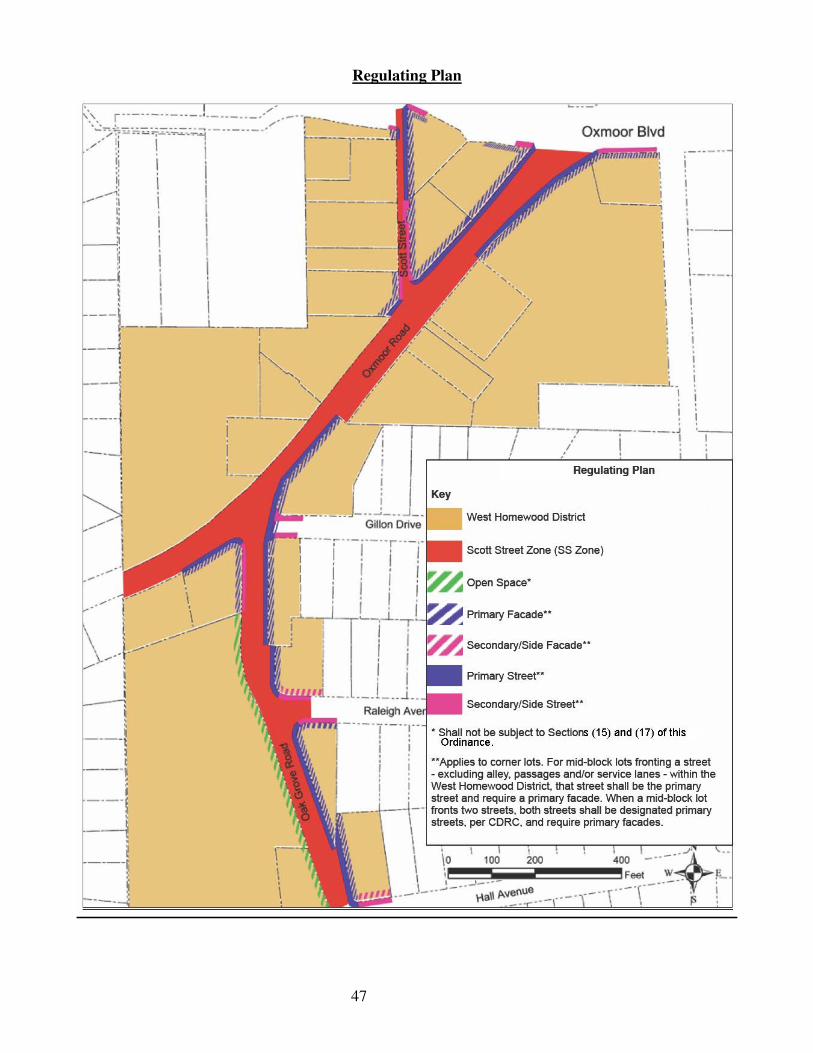
47
Regulating Plan
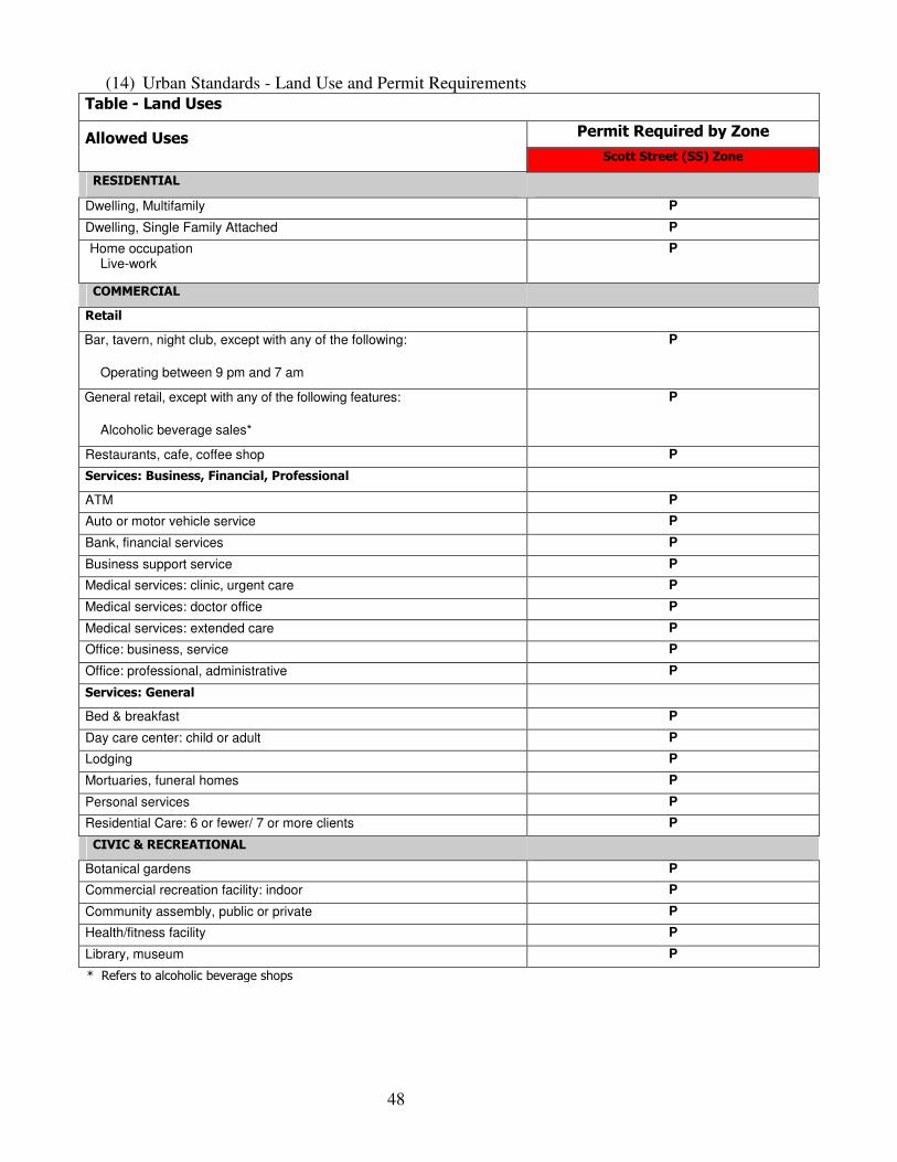
48
(14) Urban Standards - Land Use and Permit Requirements Table - Land Uses
Allowed Uses Permit Required by Zone
Scott Street (SS) Zone
RESIDENTIAL Dwelling, Multifamily P
Dwelling, Single Family Attached P
Home occupation Live-work
P
COMMERCIAL Retail Bar, tavern, night club, except with any of the following:
Operating between 9 pm and 7 am
P
General retail, except with any of the following features:
Alcoholic beverage sales*
P
Restaurants, cafe, coffee shop P
Services: Business, Financial, Professional ATM P
Auto or motor vehicle service P
Bank, financial services P
Business support service P
Medical services: clinic, urgent care P
Medical services: doctor office P
Medical services: extended care P
Office: business, service P
Office: professional, administrative P
Services: General Bed & breakfast P
Day care center: child or adult P
Lodging P
Mortuaries, funeral homes P
Personal services P
Residential Care: 6 or fewer/ 7 or more clients P
CIVIC & RECREATIONAL Botanical gardens P
Commercial recreation facility: indoor P
Community assembly, public or private P
Health/fitness facility P
Library, museum P
* Refers to alcoholic beverage shops
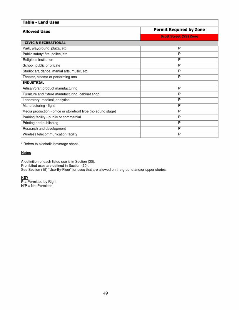
49
Table - Land Uses
Allowed Uses Permit Required by Zone
Scott Street (SS) Zone
CIVIC & RECREATIONAL Park, playground, plaza, etc. P
Public safety: fire, police, etc. P
Religious Institution P
School, public or private P
Studio: art, dance, martial arts, music, etc. P
Theater, cinema or performing arts P
INDUSTRIAL Artisan/craft product manufacturing P
Furniture and fixture manufacturing, cabinet shop P
Laboratory: medical, analytical P
Manufacturing - light P
Media production - office or storefront type (no sound stage) P
Parking facility - public or commercial P
Printing and publishing P
Research and development P
Wireless telecommunication facility P
* Refers to alcoholic beverage shops
Notes
A definition of each listed use is in Section (20). Prohibited uses are defined in Section (20). See Section (15) “Use-By-Floor” for uses that are allowed on the ground and/or upper stories. KEY P = Permitted by Right N/P = Not Permitted
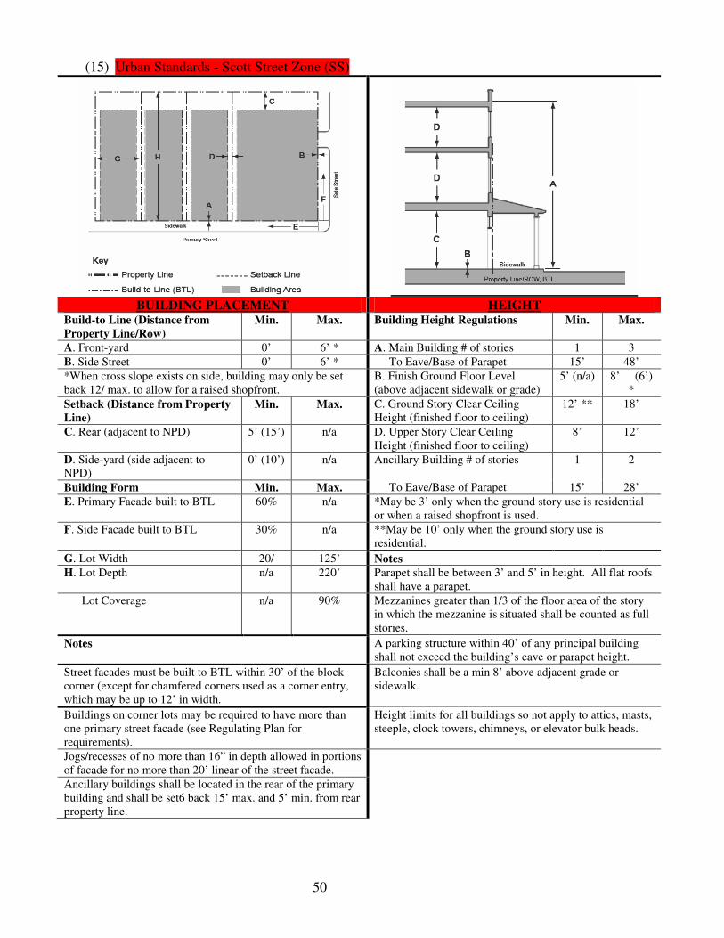
50
(15) Urban Standards - Scott Street Zone (SS)
BUILDING PLACEMENT HEIGHT
Build-to Line (Distance from
Property Line/Row) Min. Max. Building Height Regulations Min. Max.
A. Front-yard 0’ 6’ * A. Main Building # of stories 1 3
B. Side Street 0’ 6’ * To Eave/Base of Parapet 15’ 48’
*When cross slope exists on side, building may only be set back 12/ max. to allow for a raised shopfront.
B. Finish Ground Floor Level (above adjacent sidewalk or grade)
5’ (n/a) 8’ (6’) *
Setback (Distance from Property
Line) Min. Max. C. Ground Story Clear Ceiling
Height (finished floor to ceiling) 12’ ** 18’
C. Rear (adjacent to NPD) 5’ (15’) n/a D. Upper Story Clear Ceiling Height (finished floor to ceiling)
8’ 12’
D. Side-yard (side adjacent to NPD)
0’ (10’) n/a Ancillary Building # of stories 1 2
Building Form Min. Max. To Eave/Base of Parapet 15’ 28’
E. Primary Facade built to BTL 60% n/a *May be 3’ only when the ground story use is residential or when a raised shopfront is used.
F. Side Facade built to BTL 30% n/a **May be 10’ only when the ground story use is residential.
G. Lot Width 20/ 125’ Notes
H. Lot Depth n/a 220’ Parapet shall be between 3’ and 5’ in height. All flat roofs shall have a parapet.
Lot Coverage n/a 90% Mezzanines greater than 1/3 of the floor area of the story in which the mezzanine is situated shall be counted as full stories.
Notes A parking structure within 40’ of any principal building shall not exceed the building’s eave or parapet height.
Street facades must be built to BTL within 30’ of the block corner (except for chamfered corners used as a corner entry, which may be up to 12’ in width.
Balconies shall be a min 8’ above adjacent grade or sidewalk.
Buildings on corner lots may be required to have more than one primary street facade (see Regulating Plan for requirements).
Height limits for all buildings so not apply to attics, masts, steeple, clock towers, chimneys, or elevator bulk heads.
Jogs/recesses of no more than 16” in depth allowed in portions of facade for no more than 20’ linear of the street facade.
Ancillary buildings shall be located in the rear of the primary building and shall be set6 back 15’ max. and 5’ min. from rear property line.
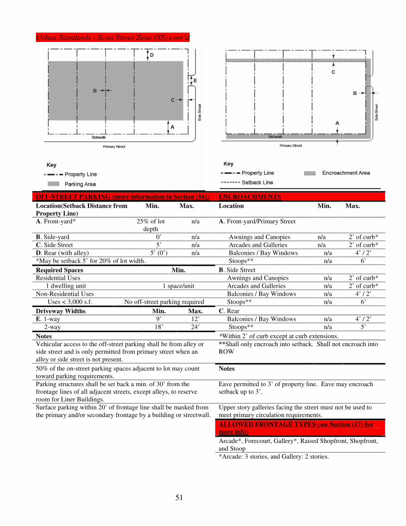
51
Urban Standards - Scott Street Zone (SS) cont’d
OFF-STREET PARKING (more information in Section (16)) ENCROACHMENTS
Location(Setback Distance from
Property Line)
Min. Max. Location Min. Max.
A. Front-yard* 25% of lot depth
n/a A. Front-yard/Primary Street
B. Side-yard 0’ n/a Awnings and Canopies n/a 2’ of curb*
C. Side Street 5’ n/a Arcades and Galleries n/a 2’ of curb*
D. Rear (with alley) 5’ (0’) n/a Balconies / Bay Windows n/a 4’ / 2’
*May be setback 5’ for 20% of lot width. Stoops** n/a 6’
Required Spaces Min. B. Side Street
Residential Uses Awnings and Canopies n/a 2’ of curb*
1 dwelling unit 1 space/unit Arcades and Galleries n/a 2’ of curb*
Non-Residential Uses Balconies / Bay Windows n/a 4’ / 2’
Uses < 3,000 s.f. No off-street parking required Stoops** n/a 6’
Driveway Widths Min. Max. C. Rear
E. 1-way 9’ 12’ Balconies / Bay Windows n/a 4’ / 2’
2-way 18’ 24’ Stoops** n/a 5’
Notes *Within 2’ of curb except at curb extensions.
Vehicular access to the off-street parking shall be from alley or side street and is only permitted from primary street when an alley or side street is not present.
**Shall only encroach into setback. Shall not encroach into ROW
50% of the on-street parking spaces adjacent to lot may count toward parking requirements.
Notes
Parking structures shall be set back a min. of 30’ from the frontage lines of all adjacent streets, except alleys, to reserve room for Liner Buildings.
Eave permitted to 3’ of property line. Eave may encroach setback up to 3’.
Surface parking within 20’ of frontage line shall be masked from the primary and/or secondary frontage by a building or streetwall.
Upper story galleries facing the street must not be used to meet primary circulation requirements.
ALLOWED FRONTAGE TYPES (see Section (17) for
more info)
Arcade*, Forecourt, Gallery*, Raised Shopfront, Shopfront, and Stoop
*Arcade: 3 stories, and Gallery: 2 stories.

52
Urban Standards - Scott Street Zone (SS) cont’d
ELEMENTS USE-BY-FLOOR
Openings/Glazing (windows,
doors, etc.)
Min. Max. Location
Primary Street (% of facade)* A. Ground Floor Residential, Commercial, Civic & Recreational, Industrial *
A. Ground Floor* (Residential Use)
70% (50%)
90% B. Upper Floor Residential, Commercial, Civic & Recreational, *
B. Upper Floor 30% 70% *See Land Uses Table (Section (14)) for specific uses.
Side Street (% of facade) ADDITIONAL REQUIREMENTS
A. Ground Floor* (Residential Use)
55% (35%)
85% A. All outdoor electrical, plumbing and mechanical equipment and other services shall be concealed from the direct view of streets or traffic or pedestrian aisles.
B. Upper Floors 30% 70% B. Services and their appurtenances shall be screened and shall not be located in required setback.
*No opaque or reflecting glazing allowed. C. Where an alley is present, services, including all utility access, above ground equipment, and trash enclosures, shall be located on alley.
Screenwall Heights* Min. Max. D. Driveways of adjacent parking lots shall connect to provide access between parking lots, except where access cannot be provided because of existing topographic conditions or an environmental feature requiring protection and/or preservation.
Streetwall Height 4’ 6’
Fence / Hedge Height** 3’ / 3’ 7’/5’
*Height measured above adjacent sidewalk or grade. E. Parking may be provided off-site within 1,300’ or as shared Parking.
**Fence permitted along rear and common property line. Hedge permitted along common and secondary frontage lines.
F. Awnings are not permitted on the ground floor when the ground floor use is residential and are not allowed on the upper floor.
Notes
All ground floors must have a primary entrance along the primary street facade (may have 1 primary entrance for buildings on a corner or to a courtyard).
Blank lengths of wall exceeding 15 linear feet are prohibited on all required BTL.
Any building or structure wider than 50” must be designed to read as a series of buildings no wider than 50’ each.
A property/lot not occupied by a primary building along the BTL shall be defined by a streetwall along the lot’s frontage line.
Streetwalls may be built along entire property line, except for entryways, driveways, and walkways.
50’ max. distance between ground floor entries.

53
(16) Urban Standards - Additional Parking Requirements
a. Parking Requirements. -Parking requirements are correlated to the building’s use and zone in the West Homewood District. For specific uses permitted within the West Homewood District see Land Uses Table (Section (14)).
Table - Minimum Parking Requirements by Building Use and Zone
Uses Zone
SS Zone
Residential 1.0 / dwelling unit (d u)
Commercial*
Retail 3.0/ 1,000 s.f.
Services: Business, Financial, Professional 3.01 1,000 s.f.
Services: General 1.0 / dwelling unit (d.u) for Lodging; 1.0/1000 s.f.
Civic & Recreational** 1.0 / 5 seats assembly use; 1.0 / 1,000 s.f. of exhibition or indoor recreation area
Commercial Recreation Facility: Indoor 1.0/500 s.f. of exhibition or indoor recreation area; 2.0/lane for bowling alleys
Religious Institution 1.0/5 seats assembly use; 1.0/1000 s.f. of exhibition or indoor recreation area
Theater, Cinema, or Performing Arts 1.0/3 seats assembly use; 1.0/500 s.f. of exhibition or indoor recreation area
Industrial** 1.0/1,000 s.f.
*Commercial uses < 3000 s.f. do not have to meet parking requirements set forth in this Table.
**CDRC may also use Article VII, Sec. M (Institutional Uses, Amusement and Recreation, and Warehouse Uses) of the City Zoning
Ordinance to determine parking requirements for Civic & Recreational and Industrial Uses.
Notes Parking requirement for Residential, Commercial (> 3000 s.f.), and Institutional & Recreational uses may be reduced according to the Parking Occupancy Rate Table below.
b. Shared Parking - Cumulative parking requirements for two or more uses in the same building or on the same lot or adjacent lot may be reduced. The gross minimum number of parking spaces listed in Table - Parking Requirements by Building Use and Zone above shall be multiplied by the “occupancy rate” as found in Table - Parking Occupancy Rate (POR) below, for each use for the weekday night, daytime and evening periods respectively, and weekend night, daytime and evening periods respectively. The gross minimum number of parking spaces for each of the uses referred to for each time period shall be added to produce the aggregate gross minimum number of parking spaces for each time period. The time period that requires the greatest aggregate gross minimum number of parking spaces shall be used (see Table - Required Parking and Shared Parking Calculation below for example).

54
Table - Parking Occupancy Rate (POR)
Uses
Days and Times
M-F M-F M-F SAT & SUN SAT & SUN SAT & SUN
8AM - 6PM 6PM - 12AM 12AM - 8AM 8AM - 6PM 6PM - 12AM 12AM - 8AM
Residential 60% 100% 100% 80% 100% 100%
Commercial
Retail 90% 80% 5% 100% 70% 5%
Bar, Tavern, Night Club 40% 100% 10% 80% 100% 50%
Restaurant (all types) 70% 100% 20% 70% 100% 20%
Services: Business, Financial, Professional
100% 20% 5% 5% 5% 5%
Services: General 100% 20% 5% 10% 5% 5%
Lodging 70% 100% 100% 70% 100% 100%
Civic & Recreational 100% 20% 5% 20% 20% 5%
Commercial Recreation Facility: Indoor
80% 100% 5% 80% 100% 5%
Religious Institution 20% 20% 5% 100% 50% 5%
Theater, Cinema, or Performing Arts
40% 80% 10% 80% 100% 10%
Industrial 100% 20% 5% 5% 5% 5%
c. Calculating Parking – The Minimum Required Parking and Shared Parking Calculation Table below provides an example of how to calculate the required and shared parking for a site or building with more than one use. For numbers with a decimal value (e.g., 0.3) that is < 0.5 round down to the nearest whole number, and for numbers with a decimal value ≥ 0.5 round up to the nearest whole number.
Table - Minimum Required Parking and Shared Parking Calculation
KEY
SS Zone
Residential Commercial
Retail
# of units or # of sq. ft. 20 units 8000 s.f.
Required Parking Per Unit or sq. ft. 1/d.u. 3/1000 s.f.
Gross Minimum # of spaces for each use 20 24
Cumulative Minimum Required Spaces 44
Parking Occupancy Rate
M-F (6PM - 12AM)* 100% 80%
SAT & SUN (6PM - 12AM)* 80% 100%
Gross Minimum # of Parking Spaces x POR
M-F (6PM - 12AM) 20 x 100% = 20 spaces 24 x 80% = 19.2 spaces
SAT & SUN (6PM - 12AM) 20 x 80% = 16 spaces 24 x 100% = 24 spaces
Aggregate Gross Minimum # of Parking Spaces for Each Time Period
M-F (6PM - 12AM) 20 + 19 = 39 spaces
SAT & SUN (6PM - 12AM) 16 + 24 = 40 spaces
Greatest Aggregate Gross Minimum # of Parking Spaces
SAT & SUN (6PM - 12AM) 40 min. shared spaces for both uses
* The two time periods were chosen after performing the calculations outlined in this Table for each time period in Table - Parking Occupancy Rate (POR) above. This was done to determine the greatest aggregate gross minimum number of parking spaces needed to accommodate shared parking for all time periods.
Notes: See City of Homewood website for parking calculator.

55
d. Parking Space Dimensions
Table - Parking Space Dimensions for all Zones
Angle Space Width (min.)
Space Depth* (min.)
Space Length (min.)
One-way Aisle Width (min.)
Two-way Aisle Width (min.)
Parellel 8’ 8’ 20’ 12’ 20’
30° * 9’ 18’ 20’ 12’ 24’
45° * 9’ 20’6” 20’ 14’ 24’
60° * 9’ 22’ 20’ 18’ 24’
Perpendicular 9’ 18’ 18’ 24’ 24’
*Measured perpendicular to aisle.
Notes The paved parking space length may be decreased by up to two feet by providing an equivalent vehicle overhang into landscaped areas, or over paved walkways.

56
(17) Frontage Types
a. Application
1. What are frontage types? Frontage Types are the architectural element of a building located between the transition area of the building facade and the public right-of-way (ROW). An example of a frontage type would be a front-yard and/or porch, as indicated in the frontage plan and section diagrams above. Frontage types help to define the public and private realm as well as enhance the streetscape.
2. What are the various frontage types in the West Homewood District? The various frontage types in the West Homewood are: arcade, gallery, shopfront, raised shopfront, forecourt, and stoop.
3. Where are frontage types allowed? The allowance of frontage types in the West Homewood District is determined by the underlying zone to ensure that the proposed frontage type is consistent with the zone’s form and character. The following table identifies the frontage types that are allowed in the West Homewood District’s Scott Street Zone.
Table - Allowed Frontage Types by Zone
Frontage Types Zones
Scott Street (SS) Zone
Arcade A
Gallery A
Shopfront A
Raised Shopfront* A
Forecourt A
Stoop A
*See Scott Street Zone “Allowed Frontage Types” Section (15) for specific requirements when Raised Shopfront is Allowed
A = Allowed, NP = Not Permitted
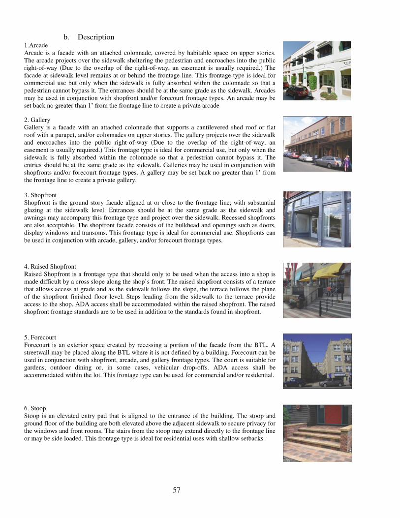
57
b. Description 1.Arcade Arcade is a facade with an attached colonnade, covered by habitable space on upper stories. The arcade projects over the sidewalk sheltering the pedestrian and encroaches into the public right-of-way (Due to the overlap of the right-of-way, an easement is usually required.) The facade at sidewalk level remains at or behind the frontage line. This frontage type is ideal for commercial use but only when the sidewalk is fully absorbed within the colonnade so that a pedestrian cannot bypass it. The entrances should be at the same grade as the sidewalk. Arcades may be used in conjunction with shopfront and/or forecourt frontage types. An arcade may be set back no greater than 1’ from the frontage line to create a private arcade
2. Gallery Gallery is a facade with an attached colonnade that supports a cantilevered shed roof or flat roof with a parapet, and/or colonnades on upper stories. The gallery projects over the sidewalk and encroaches into the public right-of-way (Due to the overlap of the right-of-way, an easement is usually required.) This frontage type is ideal for commercial use, but only when the sidewalk is fully absorbed within the colonnade so that a pedestrian cannot bypass it. The entries should be at the same grade as the sidewalk. Galleries may be used in conjunction with shopfronts and/or forecourt frontage types. A gallery may be set back no greater than 1’ from the frontage line to create a private gallery.
3. Shopfront Shopfront is the ground story facade aligned at or close to the frontage line, with substantial glazing at the sidewalk level. Entrances should be at the same grade as the sidewalk and awnings may accompany this frontage type and project over the sidewalk. Recessed shopfronts are also acceptable. The shopfront facade consists of the bulkhead and openings such as doors, display windows and transoms. This frontage type is ideal for commercial use. Shopfronts can be used in conjunction with arcade, gallery, and/or forecourt frontage types.
4. Raised Shopfront Raised Shopfront is a frontage type that should only to be used when the access into a shop is made difficult by a cross slope along the shop’s front. The raised shopfront consists of a terrace that allows access at grade and as the sidewalk follows the slope, the terrace follows the plane of the shopfront finished floor level. Steps leading from the sidewalk to the terrace provide access to the shop. ADA access shall be accommodated within the raised shopfront. The raised shopfront frontage standards are to be used in addition to the standards found in shopfront.
5. Forecourt Forecourt is an exterior space created by recessing a portion of the facade from the BTL. A streetwall may be placed along the BTL where it is not defined by a building. Forecourt can be used in conjunction with shopfront, arcade, and gallery frontage types. The court is suitable for gardens, outdoor dining or, in some cases, vehicular drop-offs. ADA access shall be accommodated within the lot. This frontage type can be used for commercial and/or residential.
6. Stoop Stoop is an elevated entry pad that is aligned to the entrance of the building. The stoop and ground floor of the building are both elevated above the adjacent sidewalk to secure privacy for the windows and front rooms. The stairs from the stoop may extend directly to the frontage line or may be side loaded. This frontage type is ideal for residential uses with shallow setbacks.

58
c. Frontage Configurations
Axonometric Diagram: Arcade
1. Arcade Configurations Min. Max.
The proportions of the arcade may correspond to the facade and architectural style of the building.
n/a n/a
A. Height (# of stories determined by underlying zone)
B.. Soffits, columns/arches may be treated consistent with the architecture of the building
- Clear Height (above adjacent sidewalk)
12’ 16’
C. Encroachment Depth (determined by underlying zone encroachment standards)
n/a n/a
D. Clear Depth 12’ n/a
E. Setback (from curb, except at curb extensions for intersections) 2’ n/a
F. Arcade should correspond to shopfront openings along primary street frontage.
- Distance (spacing between the columns/posts of the arcade along the right-of-way or property line)
8’ n/a
G. Shopfront Height and Proportion (see Shopfront Configurations) n/a n/a
H. Shopfront Opening Height (see Shopfront Configurations) n/a n/a
Plan Diagram: Arcade
I. Bulkhead Height (see Shopfront Configurations)
n/a n/a
Arcade Elements Min. Max.
Awnings are not allowed on arcade. n/a n/a
Signs (see Section (18) Sign Standards) n/a n/a
Notes
Heights measured from adjacent sidewalk.
Arcade may wrap corner.
Glazing determined by underlying zone.
Private arcades shall meet the requirements established in this section.
Section Diagram: Arcade

59
c. Frontage Configurations cont’d
Axonometric Diagram: Gallery
2. Gallery Configurations Min. Max.
The proportions of the gallery may correspond to the facade and architectural style of the building. n/a n/a
A . Height (# of stories determined by underlying zone)
B. Soffits, columns/arches may be treated consistent with the architecture of the building.
12’ 16’
- Clear Height (above adjacent sidewalk) 12’ 16’
C. Encroachment Depth (determined by underlying zone encroachment standards) n/a n/a
D. Clear Depth 12’ n/a
E . Setback (from curb, except at curb extensions for intersections) 2’ n/a
Gallery may correspond to shopfront openings along primary street frontage.
F.
Distance (spacing between the columns/posts of the gallery along the right-of-way or property line)
8’ n/a
G. Height 3’ 5’
H.
Shopfront Height and Proportion (see Shopfront Configurations) n/a n/a
Plan Diagram: Gallery
I.
Shopfront Opening Height (see Shopfront Configurations) n/a n/a
J. Bulkhead Height (see Shopfront Configurations) n/a n/a
Gallery Elements Min. Max.
Awnings are not allowed on gallery. n/a n/a
Signs (see Section (18) Sign Standards) n/a n/a
Notes
Heights measured from adjacent sidewalk.
Gallery may wrap corner.
Glazing determined by underlying zone.
Section Diagram: Gallery
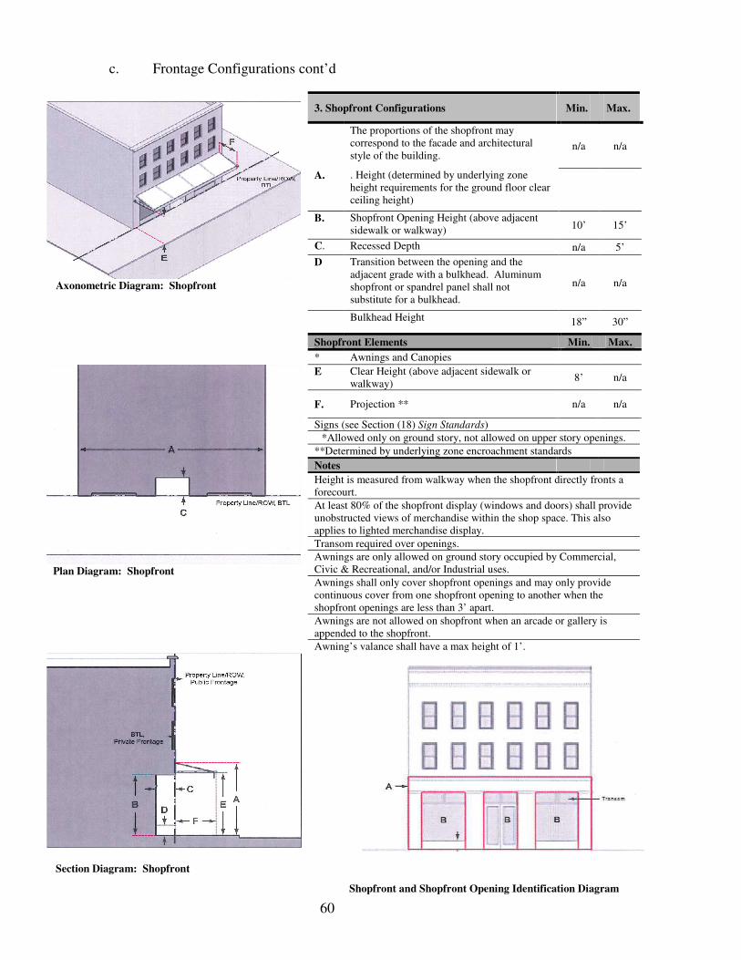
60
c. Frontage Configurations cont’d
Shopfront and Shopfront Opening Identification Diagram
Axonometric Diagram: Shopfront
3. Shopfront Configurations Min. Max.
The proportions of the shopfront may correspond to the facade and architectural style of the building.
n/a n/a
A. . Height (determined by underlying zone height requirements for the ground floor clear ceiling height)
B. Shopfront Opening Height (above adjacent sidewalk or walkway) 10’ 15’
C. Recessed Depth n/a 5’
D Transition between the opening and the adjacent grade with a bulkhead. Aluminum shopfront or spandrel panel shall not substitute for a bulkhead.
n/a n/a
Bulkhead Height 18” 30”
Shopfront Elements Min. Max.
* Awnings and Canopies
Plan Diagram: Shopfront
E Clear Height (above adjacent sidewalk or walkway)
8’ n/a
F. Projection ** n/a n/a
Signs (see Section (18) Sign Standards)
*Allowed only on ground story, not allowed on upper story openings.
**Determined by underlying zone encroachment standards
Notes
Height is measured from walkway when the shopfront directly fronts a forecourt.
At least 80% of the shopfront display (windows and doors) shall provide unobstructed views of merchandise within the shop space. This also applies to lighted merchandise display.
Transom required over openings.
Awnings are only allowed on ground story occupied by Commercial, Civic & Recreational, and/or Industrial uses.
Awnings shall only cover shopfront openings and may only provide continuous cover from one shopfront opening to another when the shopfront openings are less than 3’ apart.
Awnings are not allowed on shopfront when an arcade or gallery is appended to the shopfront.
Awning’s valance shall have a max height of 1’.
Section Diagram: Shopfront

61
c. Frontage Configurations cont’d
Axonometric Diagram: Raised Shopfront
4. Raised Shopfront Configurations Min. Max.
A. Terrace Width n/a 120’
B. . Finished Floor of Terrace (above adjacent sidewalk)
n/a 3’
C. Terrace Wall Height (above adjacent walkway
n/a 3’
D. Clear Depth 8’ n/a
E. Encroachment Depth n/a 11’
F. Terrace Wall Setback (from ROW) 1’ n/a
G. Distance (between stairs) n/a 15’
H. Stair Width 5’ n/a
I.
. The proportions of the shopfront may correspond to the facade and architectural style of the building - Height (determined by underlying zone height requirements for the first floor ceiling height)
n/a n/a
Plan Diagram: Raised Shopfront
J . Shopfront Opening Height 10’ 15’
K Transition between the opening and the adjacent grade with a bulkhead. Aluminum shopfront or spandrel panel shall not substitute for a bulkhead.
- Bulkhead Height 18” 30”
Raised Shopfront Elements Min. Max.
* Awnings and Canopies
L. - Clear Height (above adjacent walkway) 8’ n/a
M . - Projection n/a 7’
Signs (see Section (18) Sign Standards) n/a n/a
*Allowed only on ground story, not allowed on upper story openings.
Notes
At least 80% of the shopfront display (windows and doors) shall provide unobstructed views of merchandises within the shop space. This also applies to lighted merchandise display.
Transom required over openings.
Glazing determined by underlying zone.
Wherever possible terrace walls should be made into or be able to be used as seating.
Steps may lead from face of terrace wall to property line/ROW. Entry steps to raised shopfront shall not encroach into the public frontage (ROW).
Awning’s valance shall have a max height of 1’.
Section Diagram: Raised Shopfront

62
c. Frontage Configurations cont’d
Axonmetric Diagram: Forecourt
5. Forecourt Configurations Min. Max.
A. Forecourt Width 20’ 70’
B. Forecourt Depth 15’ 80’
C Forecourt may be raised above adjacent sidewalk and be defined by a small retaining wall at the BTL with entry steps to the forecourt.
- Height (above adjacent sidewalk) n/a 3’
D. Shopfront Height and Proportion (see Shopfront Configurations)
n/a n/a
E. Shopfront Opening Height (see Shopfront Configurations)
n/a n/a
F. Bulkhead Height (see Shopfront Configurations)
n/a n/a
Forecourt Elements Min. Max.
Awnings and Canopies*
Plan Diagram: Forecourt
- Height (above adjacent sidewalk/walkway)
8’ n/a
- Projection** n/a 10’
Signs (see Section (18) Sign Standards)
*Allowed only on ground story, not allowed on upper story openings.
**Determined by underlying zone encroachment standards when projecting from facade at BTL. Projections above apply to facades directly fronting the forecourt.
Notes
Entry steps to forecourt shall not encroach into the public frontage (ROW).
When the forecourt is raised above sidewalk, the height of retaining wall shall be 3’ max. above adjacent sidewalk or grade.
Glazing requirements for primary and secondary street facades are determined by underlying zone. Glazing for facades fronting the forecourt shall meet the following requirements: a min. of 60% and a max. of 90% for the ground story; and a min. of 30% and a max. of 70% on the upper story.
Awning’s valance shall have a max. height of 1’.
Section Diagram: Forecourt

63
c. Frontage Configurations cont’d
Axonmetric Diagram: Stoop
6. Stoop Configurations Min. Max.
A. The height and the proportions of the stoop may correspond to the facade and architectural style of the building.
n/a n/a
B. Stoop Floor Height (above adjacent sidewalk or grade)
n/a 3’
C. . Clear Depth (distance between the face of the facade and the posts/columns of the stoop)
5’ n/a
D. Clear Width of Stoop 5’ n/a
E. Encroachment Depth (determined by underlying zone)
n/a n/a
F. Stoop must directly align to the entrance of the building
n/a n/a
Stoop Elements Min. Max.
Streetwalls defining edge of frontage line (property line/ROW)
Plan Diagram: Stoop
- Height above Adjacent Sidewalk or Grade (determined by underlying zone)
n/a n/a
Notes
Stoop shall not encroach into public frontage (ROW).
Roofs may be used to cover the landing of the stoop. Height of the roof may correspond to the facade and architectural style of the building.
Stairs from Stoop may lead directly to frontage line, but shall not encroach into the public frontage (ROW). Stairs may also be side loaded.
Section Diagram: Stoop

64
(18) Sign Standards
a. General Provisions
1. Allowed Signs. The following signs are allowed within the West Homewood District: Alley/Passage, Awning Top-mounted, Awning Valance, Display Case, Marquee, Monument, Name Plate, Projecting, Sidewalk, Wall Mounted, Window, and Yard. Table - Allowed Signs by Frontage Type below identifies the allowed signs by frontage types.
2. Applicability The regulations of the Sign Standards shall apply to signs located in the West Homewood District, except for signs not regulated by this Ordinance (see Section (7)). All signs within the West Homewood District shall be subject to a review by the CDRC to ensure that signs are consistent and in harmony with the character of the West Homewood District. Signs that do not comply with the standards set forth in this section are not allowed in the West Homewood District (see Section (7)). Additional sign types may be integrated into this section as they are approved by the CDRC.
3. Materials Sign materials should complement the architecture of the structure. The following finish materials for signs are allowed:
i. Wood: painted or natural
ii. Metal: copper, brass, galvanized steel
iii. Painted Canvas
iv. Neon
v. Masonry: brick, stone, concrete, stucco
4. Lighting Sign lighting shall meet the following requirements:
i. External light sources shall only be used to provide lighting for the sign they are illuminating and shall be shielded or positioned in such a way that they do not produce glare on any other object.
ii. Signs shall not have lights that flash, blink, flutter, or change brightness, color or intensity.
iii. Sign lighting shall not have lights used in a manner that can be confused or construed as traffic control devices.
iv. Sign lighting shall not create safety hazards for pedestrians and motorist.
v. Sign lighting shall consist of fluorescent or compact fluorescent lamps, or more energy efficient light sources. Incandescent lamps are prohibited, except when it is used in historic signs.
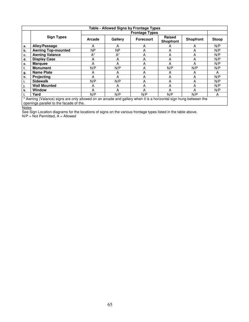
65
Table - Allowed Signs by Frontage Types
Sign Types
Frontage Types
Arcade Gallery Forecourt Raised
Shopfront Shopfront Stoop
a. Alley/Passage A A A A A N/P b. Awning Top-mounted NP NP A A A N/P c. Awning Valance A* A* A A A N/P d. Display Case A A A A A N/P e. Marquee A A A A A N/P f. Monument N/P N/P A N/P N/P N/P g. Name Plate A A A A A A h. Projecting A A A A A N/P i. Sidewalk N/P N/P A A A N/P j. Wall Mounted A A A A A N/P k. Window A A A A A N/P l. Yard N/P N/P N/P N/P N/P A * Awning (Valance) signs are only allowed on an arcade and gallery when it is a horizontal sign hung between the openings parallel to the facade of the.
Notes See Sign Location diagrams for the locations of signs on the various frontage types listed in the table above. N/P = Not Permitted, A = Allowed

66
5. Sign Location The diagrams below identify the allowed signs by the various frontage types and the general locations where signs are permitted. A max. of two sign types are allowed per business (only one marquee sign per building).
A. Arcade Frontage
Notes: “c” can be located between any of the arcade’s openings as long as it is in compliance with Section (18) b. 2.
B. Forecourt Frontage
Notes: Refer to the Shopfront location diagram for Awning Top-Mounted and Valance.
C. Gallery Frontage
Notes: “c” can be located between any of the arcade’s openings as long as it is in compliance with Section (18) b. 2.
D. Raised Shopfront Frontage
E. Shopfront Frontage
F. Stoop Frontage
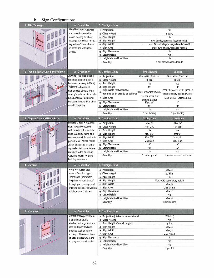
67
b. Sign Configurations
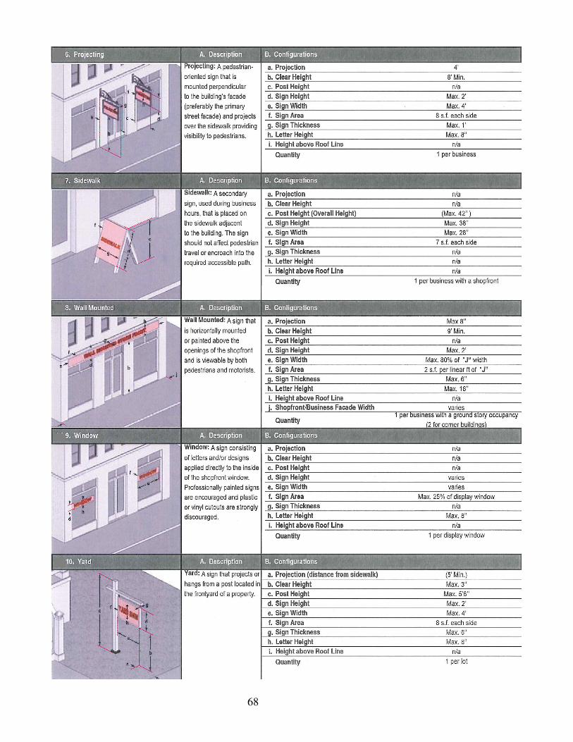
68

69
(19) Public Space Standards
a. General Provisions
1. Thoroughfares Assemblies Public Space Standards establish design standards for thoroughfares located within the West Homewood District. The design guidelines for thoroughfare assemblies, outlined in Section (19) b., work to achieve the following:
i. Provide the information with which to modify existing thoroughfares.
ii. Produce new thoroughfares that are designed to support both motor vehicles, and non-motor vehicles such as pedestrians.
2. Applicability
i. The requirements of the Public Space Standards apply to new thoroughfares (public and private) and to the modification, reconstruction, or retrofit of existing thoroughfares within the West Homewood District. Inclusion of wider sidewalks, tree plantings, and narrowed travel lanes shall be a priority and shall be incorporated into all phases of design for improvement of the area. Intersection designs, with the exception of curb radius dimensions, are not subject to the requirements of the Public Space Standards and should be appropriately engineered. Roundabouts are permitted instead of signalization, but require the approval of the CDRC.
ii. Where applicable, the Public Space Standards shall be used as criteria for the planning approval process and shall be sanctioned through the respective City departments including Engineering, Planning, Public Works and Parks & Recreation. Provisions of this section, when in conflict, take precedence over those of other codes, ordinances, regulations and standards for Engineering, Planning, Public Works and Parks & Recreation, except the Local Health and Safety Codes and Local, State, and National Building Codes.
iii. The Thoroughfare Assembly Plan (Section (19) a. 1.) identifies the existing right-of-ways that are subject to the requirements of the Public Space Standards and the applicable thoroughfare assembly for each existing right-of-way.
3. Types of Thoroughfare Assemblies The thoroughfare assembly type for the West Homewood District is listed below with design provisions further outlined in Section (19) b.
i. Commercial Street
Note: Since each type of thoroughfare assembly can have multiple configurations, the following classification system is used to differentiate the various configurations within each type of thoroughfare assembly:

70
4. Adding and Modifying Thoroughfare Assemblies Thoroughfare assemblies, beyond those identified on the Thoroughfare Assembly Plan and in Section (19) b., may be added upon approval by the CDRC, provided that the applicable safety requirements are addressed to the satisfaction of the CDRC. Existing thoroughfare assemblies may be modified upon approval by the CDRC.

71
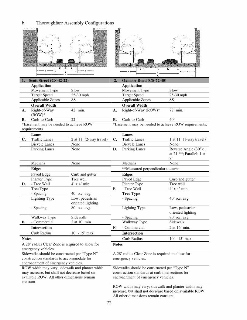
72
b. Thoroughfare Assembly Configurations
1. Scott Street (CS-42-22) 2. Oxmoor Road (CS-72-40)
Application Application
Movement Type Slow Movement Type Slow Target Speed 25-30 mph Target Speed 25-30 mph Applicable Zones SS Applicable Zones SS
Overall Width Overall Width
A. Right-of-Way (ROW)*
42’ min. A. Right-of-Way (ROW)* 72’ min.
B. Curb-to-Curb 22’ B. Curb-to-Curb 40’ *Easement may be needed to achieve ROW requirements.
*Easement may be needed to achieve ROW requirements.
Lanes Lanes
C. Traffic Lanes 2 at 11’ (2-way travel) C. Traffic Lanes 1 at 11’ (1-way travel)
Bicycle Lanes None Bicycle Lanes None
Parking Lanes None D. Parking Lanes Reverse Angle (30°): 1 at 21’**; Parallel: 1 at 8’
Medians None Medians None
Edges **Measured perpendicular to curb.
Paved Edge Curb and gutter Edges
Planter Type Tree well Paved Edge Curb and gutter
D. - Tree Well 4’ x 4’ min. Planter Type Tree well
Tree Type E. - Tree Well 4’ x 4’ min.
- Spacing 40’ o.c. avg. Tree Type
Lighting Type Low, pedestrian oriented lighting
- Spacing 40’ o.c. avg.
- Spacing 80’ o.c. avg. Lighting Type Low, pedestrian oriented lighting
Walkway Type Sidewalk - Spacing 80’ o.c. avg.
E. - Commercial 2 at 10’ min. Walkway Type Sidewalk
Intersection F. - Commercial 2 at 16’ min.
Curb Radius 10’ - 15’ max. Intersection
Notes Curb Radius 10’ - 15’ max.
A 28’ radius Clear Zone is required to allow for emergency vehicles.
Notes
Sidewalks should be constructed per “Type N” construction standards to accommodate for encroachment of emergency vehicles.
A 28’ radius Clear Zone is required to allow for emergency vehicles.
ROW width may vary; sidewalk and planter width may increase, but shall not decrease based on available ROW. All other dimensions remain constant.
Sidewalks should be constructed per “Type N” construction standards at curb intersections for encroachment of emergency vehicles.
ROW width may vary; sidewalk and planter width may increase, but shall not decrease based on available ROW. All other dimensions remain constant.

73
b. Thoroughfare Assembly Configurations Cont’d
3. Oxmoor Road (CS-64-38) 4. Oxmoor Road (CS-82-62) Application Application Movement Type Slow Movement Type Slow Target Speed 25-30 mph Target Speed 25-30 mph Applicable Zones SS Applicable Zones SS
Overall Width Overall Width A. Right-of-Way
(ROW)* 64’ min. A. Right-of-Way (ROW)* 82’ min.
B. Curb-to-Curb 38’ B. Curb-to-Curb 62’ *Easement may be needed to achieve ROW requirements.
*Easement may be needed to achieve ROW requirements.
Lanes Lanes C. Traffic Lanes 2 at 11’ (2-way travel) C. Traffic Lanes 2 at 11’ (2-way travel) Bicycle Lanes None Bicycle Lanes None Parking Lanes Parallel: 2 at 8’ D. Parking Lanes Reverse Angle (30°): 2
at 20’** Medians None Medians None
Edges **Measured perpendicular to curb.
Paved Edge Curb and gutter Edges Planter Type Tree well Paved Edge Curb and gutter D. - Tree Well 4’ x 4’ min. Planter Type Tree well Tree Type E. - Tree Well 4’ x 4’ min. - Spacing 40’ o.c. avg. Tree Type Lighting Type Low, pedestrian
oriented lighting - Spacing 40’ o.c. avg.
- Spacing 80’ o.c. avg. Lighting Type Low, pedestrian oriented lighting
Walkway Type Sidewalk - Spacing 80’ o.c. avg. E. - Commercial 2 at 13’ min. Walkway Type Sidewalk
Intersection F. - Commercial 2 at 10’ min.
Curb Radius 10’ - 20’ max. Intersection
Notes Curb Radius 10’ - 15’ max.
A 28’ radius Clear Zone is required to allow for emergency vehicles.
Notes
Sidewalks should be constructed per “Type N” construction standards to accommodate for encroachment of emergency vehicles.
A 28’ radius Clear Zone is required to allow for emergency vehicles.
ROW width may vary; sidewalk and planter width may increase, but shall not decrease based on available ROW. All other dimensions remain constant.
Sidewalks should be constructed per “Type N” construction standards at curb intersections for encroachment of emergency vehicles.
ROW width may vary; sidewalk and planter width may increase, but shall not decrease based on available ROW. All other dimensions remain constant.

74
b. Thoroughfare Assembly Configurations Cont’d
5. Oak Grove Road (CS-82-62) Application
Movement Type Slow
Target Speed 25-30 mph
Applicable Zones SS
Overall Width A. Right-of-Way
(ROW)* 82’ min.
B. Curb-to-Curb 62’
*Easement may be needed to achieve ROW requirements.
Lanes
C. Traffic Lanes 2 at 11’ (2-way travel)
Bicycle Lanes None
D. Parking Lanes Reverse Angle (30°): 2 at 20’**
Medians None
**Measured perpendicular to curb.
Edges
Paved Edge Curb and gutter
Planter Type Tree well
D. - Tree Well 4’ x 4’ min.
Tree Type
- Spacing 40’ o.c. avg.
Lighting Type Low, pedestrian oriented lighting
- Spacing 80’ o.c. avg.
Walkway Type Sidewalk
E. - Commercial 2 at 10’ min.
Intersection
Curb Radius 10’ - 15’ max.
Notes
A 28’ radius Clear Zone is required to allow for emergency vehicles.
Sidewalks should be constructed per “Type N” construction standards to accommodate for encroachment of emergency vehicles.
ROW width may vary; sidewalk and planter width may increase, but shall not decrease based on available ROW. All other dimensions remain constant.

75
(20) Glossary - Definitions Abandoned: Forsaken or deserted by owner and commencing when the power and/or water utilities are disconnected or discontinued.
Access: The physical pedestrian entrance to a unit that is provided directly from the street or courtyard.
Alcohol Beverage Shops: Location where the primary purpose, use, function, or product sold is alcohol, spirits, liquor, wine, beer, or any liquid or solid containing alcohol, spirits, wine, or beer containing one-half of one percent or more of alcohol by volume, and that is fit for beverage purposes either alone or when diluted, mixed, or combined with other substances for off-site consumption.
Alley: An alley is any public or private thoroughfare for the use of pedestrians or vehicles, not less than ten (10) feet or more than thirty (30) feet in width, and is intended for service and only a secondary means of access to abutting properties, typically located in the rear of a lot.
Alley/Passage Sign: see Section (18) Sign Standards.
Ancillary/Accessory Building: A building located on the same lot and customarily incidental and subordinate to the Primary Building on the lot or to the use of land. Where an ancillary building is attached to the Primary Building, as by a roof or common wall, such structures shall be considered a portion of the Primary Building. Typically, ancillary buildings are intended for a variety of purposes such as vehicular parking (garages housing a maximum of 4 vehicles), storage of lawn and garden equipment, storage of household items, play house and green house. Accessory structures may include a habitable area such as a home office, recreation room, guesthouse, and sleeping room. The habitable area of an ancillary building shall not exceed 600 s.f. Ancillary structures shall not be greater than 800 s.f.
Apartment: A dwelling unit sharing a building and a lot with other dwellings and/or uses. Apartments may be for rent or for sale as condominiums.
Artisan Shop: Premises available for the creation, assemblage, and/ or repair of artifacts, using hand-powered and table-mounted electrical machinery, and including their retail sale.
ATM: An automated teller machine (computerized, self-service machine used by banking customers for financial transactions, including deposits, withdrawals and fund transfers, without face-to-face contact with financial institution personnel), located outdoors at a bank, or in another location. Does not include check-cashing stores.
Attic: The area found between the ceiling joists of the top story and roof rafters of a structure.
Auto or Motor Vehicle Service: Repair of automobiles and the sale, installation, and servicing of automobile equipment and parts. Typical uses include muffler shops, tire shops, automotive detailing, tune-up shops, automobile repair garages, vehicle stereo installation and automobile glass shops
Average Grade: The average elevation of the surface of the ground comprising a site as determined by a survey taken from five equally-spaced points along each setback line.

76
Bank, Financial Service: An establishment for the custody, loan, exchange or issue of money for the extension of credit, and for facilitating the transmission of funds. Includes banks and trust companies, credit agencies, holding (but not primarily operating) companies, lending and thrift institutions, other investment companies, securities/commodity contract brokers and dealers, security and commodity exchanges, vehicle finance (equity) leasing agencies. Excludes check-cashing, payday loan, title loan stores and pawn shops.
Bar, Tavern, Night Club:
A. Bar, Tavern: A business where alcoholic beverages are sold for on-site consumption, that is not part of a larger restaurant. Includes bars, taverns, pubs, and similar establishments where food service is subordinate to the sale of alcoholic beverages. May also include beer brewing as part of a microbrewery (“brew-pub”), and other beverage tasting facilities. Excludes “Alcoholic Beverage Shops.”
B. Night Club: A facility serving alcoholic beverages for on-site consumption, and providing entertainment, examples of which include live music and/or dancing, comedy, etc. Does not include adult oriented businesses.
Bed & Breakfast: A residential structure with one or more bedrooms rented for overnight lodging, where meals may be provided subject to applicable Health Department regulations.
Botanical Garden: An establishment where plants are grown for display to the public and often for scientific study.
Building Height: The vertical extent of a building measured in stories, not including a basement or a habitable attic. Height limits do not apply to masts, belfries, clock towers, chimney flues, water tanks, elevator bulkheads and similar structures. Building height shall be measured from the curb level or average elevation of the finished grade along the front of the building when building is set back from front property line, to the building’s eave or the base of the building’s parapet.
Build-to Line (BTL): A stated setback dimension graphically represented by a line, along which a building facade must be placed.
Bulkhead: Panel that provides a transition from the display window of a shopfront to the adjacent grade and allows for merchandise to be elevated within the display window. The panels can be wood, cast iron, and, and masonry.
Business Support Service: An establishment within a building that provides services to other businesses. Examples include: computer-related services (rental, repair), copying, quick printing and blueprinting services, film processing and photofinishing (retail), and mailing and mail box services.
Carriage House: An ancillary housing unit located above or adjacent to the garage of a primary housing unit on the lot, with the front door and access directed towards an alley.
Chamfered: Angled to create a diagonal facade from two perpendicular facades.
City: The City of Homewood, Alabama

77
Civic & Recreational: For the purposes of this Ordinance, civic & recreational uses shall be considered to encompass all of the civic & recreational use categories as defined in the Land Uses Table in Section (14).
Commercial: For the purposes of this Ordinance, commercial uses shall be considered to encompass all of the commercial use categories as defined in the Land Uses Table in Section (14).
Commercial Recreation Facility - Indoor: An establishment providing indoor amusement and entertainment services for a fee or admission charge, including: bowling alleys, coin-operated amusement arcades, electronic game arcades (video games, pinball, etc.), ice skating, roller skating, and pool and billiard rooms as primary uses. This use does not include adult businesses. Four or more electronic games or coin-operated amusements in any establishment, or premises where 50 percent or more of the floor area is occupied by amusement devices, are considered an electronic game arcade as described above. Three or fewer machines are not considered a land use separate from the primary use of the site.
Common Property/Lot Lines: Lot lines shared by adjacent private lots that are not fronted by the primary building facade.
Community Assembly (Public or Private): Group gatherings conducted indoors, such as community centers, bingo halls, private clubs, fraternal, philanthropic and charitable organizations and lodges.
Day Care Center (Child or Adult): A state-licensed facility that provides non-medical care and supervision for adult clients or minor children for periods of less than 24 hours for any client. These facilities are required to be licensed by the Alabama State Department of Social Services.
Display Window: The transparent opening made of large expanses of glass or some other translucent material that provides unobstructed visibility into the shop interior and to merchandise in the shop.
District: A portion of the territory of the City of Homewood, known as the West Homewood District, within which certain uniform regulations and requirements or various combinations thereof apply under the provisions of this Ordinance.
Dwelling, Dwelling Unit, or Housing Unit: A room or group of internally connected rooms that have sleeping, cooking, eating, and sanitation facilities, but not more than one kitchen, which constitute an independent housekeeping unit, occupied by or intended for one household on a longterm basis.
Eave: Where used to limit encroachment, the eave shall be defined as the edge of the building or structure’s roof, usually projecting beyond the exterior wall of the building or structure. See diagrams below.

78
Eave (Height): Where used to limit building’s height, the eave shall be defined as the lowest point of intersection between the exterior wall and the roof (any part of the roof) of the building (not applicable to flat roofs). See diagrams below.
Elevation: An exterior wall of a building not along a primary street BTL or side street BTL.
Encroach: To break the plane of a vertical or horizontal regulatory limit with a structural element, so that it extends into a setback, into the public frontage/ROW, or above a height limit.
Entrance: The principal point of access for pedestrians to a building. In support of pedestrian activity, the main or primary entrance should be oriented to the frontage rather than to the parking.
Facade: The vertical surface of a building that is built along the BTL and is usually set facing the street.
Fast Food Restaurant: A restaurant with a drive-through facility providing food service directly to occupants of a motor vehicle. Fast food restaurants are not permitted within the West Homewood District.
Fence: A type of screenwall permitted along the common lot line and rear lot line. A fence is also defined as a barrier attached to the ground that may consist of vertical and horizontal supports and cross members which separate lot lines or yards. Fences may be built of wrought iron, cast iron, and welded steel ornamental fences or wood picket fences of substantial design. Metal fences also may be mounted on a low masonry wall and/ or spanning masonry piers. Wooden fences should be painted, preferably a light color. Chain link fences are highly discouraged, but are allowed under this Ordinance.
Fenestrated: Having one or more openings, measured in percentage of wall surface area.
79
Form: Refers to the physical public and private realm that make up the built environment in the West Homewood District. Form includes, but is not limited to, the following:
A. Building type, character, placement, height, mass, scale, relationship to the public frontage, adjacent private frontage, and other elements that are addressed in this Ordinance.
B. The public right-of-way, which consist of sidewalks, vehicular lanes, bicycle lanes, street trees and landscaping, street furniture, parking lanes and other elements that are part of the public realm. Also the relationship of the public frontage to the private frontage.
C. The type and character of signs along with the allocation of uses and off-street parking. Frontage: The area between a building facade and the vehicular lanes of the public ROW, inclusive of its built and planted components. Frontage is divided into Private Frontage and Public Frontage (see Section (17) Frontage Types).
Frontage Line: The property lines of a lot bordering a street or other public right-of-way (public frontage).
Front Yard: The area between the frontage line and the facade of the primary building that extends the full width of the lot.
Furniture and Fixture Manufacturing, Cabinet Shop: The manufacture or assembly of high grade articles of furniture and fixtures calling for fine finish, such as decorative cabinets, desks and chairs, store fixtures and office equipment. In the production of such goods, noise above 60 dB CNEL beyond the walls of the building is prohibited.
General Retail: Stores and shops selling many lines of merchandise. Examples include: art galleries, retail, art supplies including framing services, books, magazines, and newspapers, cameras and photographic supplies, clothing, shoes, and accessories, collectibles (cards, coins, comics, stamps, etc.), drug stores and pharmacies, dry goods, fabrics and sewing supplies, furniture and appliance stores, hobby materials, home and office electronics, jewelry, luggage and leather goods, musical instruments, parts and accessories, small wares, specialty grocery stores, specialty shops, sporting goods and equipment, stationery, toys and games, variety stores, videos, DVDs, records, CDs including rental stores. General retail does not include the following:
A. Adult business as defined in Homewood City Zoning Ordinance, title loans, payday loans and pawn shops.
B. Sheet metal shops, body-fender works, automobile paint shops, repair garages, and any activity which includes the processing, treatment, manufacturing, assembling or compounding of any product, other than that which is clearly and traditionally incidental and essential to a particular retail activity.
Gross Square Footage (GSF): The sum of all areas on all floors of a building included within the outside faces of its exterior walls, including all vertical penetration areas, for circulation and shaft areas that connect one floor to another. Also includes all areas on all floors of any structure that is directly appended to the building and located on the same lot as the building. Gross Area is computed by physically measuring or scaling measurements from the outside faces of exterior walls, disregarding cornices, pilasters, buttresses, etc., that extend beyond the wall faces. When referring to sign area, the gross square footage shall be the sum of all areas on all parts of a sign, including all areas outside and inside of the sign.

80
Ground Story/Floor: The first level of a building at or above grade. The next story above the ground story is the second story or floor.
Health/Fitness Facility: A fitness center, gymnasium, health and athletic club, which may include any of the following: exercise machines, weight facilities, group exercise rooms, sauna, spa or hot tub facilities, indoor tennis, handball, racquetball, archery and shooting ranges, other indoor sports activities, and indoor or outdoor pools.
Hedge: A type of screenwall made up of rows of closely planted shrubs or low-growing trees. Hedges are permitted along the common lot line and rear lot line, and along the secondary frontage line only when used as screens for surface parking. The heights of hedges along the frontage line shall not exceed five feet. Hedges shall not encroach into the ROW and shall be maintained.
Home Occupation: Residential premises used for the transaction of business or the supply of professional services. Home occupation shall be limited to the following: agent, architect, artist, broker, consultant, sman, dressmaker, engineer, interior decorator, lawyer, notary public, teacher, and other similar occupations, as determined by CDRC. Such use shall not simultaneously employ more than 1 person in addition to residents of the dwelling. The total gross area of the home occupation use shall not exceed 40 percent of the gross square footage of the residential unit. The home occupation use shall not disrupt the generally residential character of the neighborhood. The CDRC shall review the nature of a proposed home occupation use at the time of review of a business license for such use, and may approve with conditions, continue or deny the application.
Industrial: For the purposes of this Ordinance, industrial uses shall be considered to encompass all of the Industrial use categories, except the waste-related services and any animal processing, as listed in the Land Uses Table in Section (14).
Laboratory (Medical, Analytical): A place equipped for experimentation or observation in a field of study, or devoted to the application of scientific principles in testing and analysis. Quantities of biological or hazardous materials used on site shall be limited to those quantities established by the State or Local fire department.
Library, Museum: Public or quasi-public facilities, examples of which include: aquariums, arboretums, art galleries and exhibitions, botanical gardens, historic sites and exhibits, libraries, museums, planetariums, and zoos. May also include accessory retail uses such as a gift/book shop, restaurant, etc.

81
Light Manufacturing: The manufacture or assembly of products from previously treated material where no impact is created to the adjacent uses and no hazardous materials are used in the production of such products. The maximum number of employees shall be 15. Examples include: athletic equipment, bakeries, camera, photo equipment, clothing, electronics, musical instruments, optical goods, and woodworking (limited)
Live-Work: An integrated housing unit and working space, occupied and utilized by a single household in a structure that has been designed or structurally modified to accommodate joint residential occupancy and work activity.
Liner Building: A habitable building designed to mask a parking lot or a parking structure (any structure where the primary purpose is for parking of five (5) or more vehicles). A Liner Building shall be no less than 20’ deep.
Lodging: A facility (typically a hotel or motel) with guest rooms or suites, with or without kitchen facilities, rented to the general public for transient lodging. Hotels typically include a variety of services in addition to lodging, for example, restaurants, meeting facilities, personal services, etc. Also includes accessory guest facilities such as swimming pools, tennis courts, indoor athletic facilities, accessory retail uses, etc.
Lot: A single parcel of land accommodating a building or buildings which is legally described and recorded as such.
Lot Area: The computed area contained within the lot or property lines. Lot Coverage: The ratio of the ground floor area of all buildings or structures on a lot and the total area of the lot.
Lot Coverage: The ratio of the ground floor area of all buildings or structures on a lot and the total area of the lot.
Lot Line: The boundary that legally and geometrically demarcates a lot.
Lot Width and Depth: The lot width is the dimension of the primary frontage line. When a lot has more than one primary frontage line, only one of the primary frontage lines shall be used to determine the lot width - typically the shortest primary frontage line. Lot width is the shorter average horizontal dimension, generally perpendicular to the longer average horizontal dimension, which is the depth.
Mansard Roof: A four-sided gambrel-style hip roof characterized by two slopes on each of its sides, with the lower slope punctured by dormer windows at a steeper angle than the upper. Mansard roofs are not allowed in the West Homewood District.
Media Production (Office or Storefront Type): An establishment dedicated to the production of visual and audio mass media, including television, film, videos, video games, mobile devices, internet, and digital interactive media, but excluding magazines, newspapers,and periodicals.
Medical Services (Clinic, Urgent Care): A facility other than a hospital where medical, mental health, surgical and other personal health services are provided on an outpatient basis. Examples include: medical offices with five or more licensed practitioners and/or medical specialties, outpatient care facilities, urgent care facilities, and other allied health services. These facilities may also include incidental medical laboratories. Counseling services by other than medical doctors or psychiatrists are included under “Offices - Professional/ Administrative.”

82
Medical Services (Doctor Office): A facility other than a hospital where medical, dental, mental health, surgical, and/or other personal health care services are provided on an outpatient basis, and that accommodates no more than four licensed primary practitioners (for example, chiropractors, medical doctors, psychiatrists, dentist, etc., other than nursing staff) within an individual office suite. A facility with five or more licensed practitioners is instead classified under “Medical Services - Clinic, Urgent Care.” Counseling services by other than medical doctors or psychiatrists are included under “Offices - Professional/Administrative.”
Medical Services (Extended Care): Residential facilities providing nursing and health-related care as a primary use with inpatient beds. Examples include: board and care homes, convalescent and rest homes, extended care facilities, and skilled nursing facilities. Long-term personal care facilities that do not emphasize medical treatment are included under “Residential Care.”
Mid-block Lot: Refers to any lot that is not directly located on the corner(s) of a block.
Mixed-use: Multiple functions within the same building or the same general area through superimposition or within the same area through adjacency.
Mezzanine: An intermediate level between the ground floor and the second story. It may be in the form of a platform, podium, or wide balcony. Mezzanine uses are limited to a continuation of the ground floor activity.
Mortuary, Funeral Homes: A funeral home or parlor where deceased are prepared for burial or cremation and funeral services may be conducted. Does not include on-site cremation.
Multi-Family: A building containing two or more dwelling units. The following multi-family building types are allowed:
Duplex: A building with two separate dwellings located either side by side or one on top of the other.
Fourplex: A building with four separate dwellings.
Loft: Dwelling unit that contains the volume of two stories but where the second floor consists of less floor area than the first; as in a mezzanine.
Mixed-use multi-family dwelling: A building with a non-residential use that also contains two or more dwelling units.
Townhouse: A two to three-story building with two or more single-family dwellings attached side-by-side and reading as a continuous facade.
Triplex: A building with three separate dwellings.
Municipality: Shall mean the City of Homewood.
Nonconforming Sign: A sign that lawfully existed before the effective date of this Ordinance or amendment, and does not conform to the present requirements of this Ordinance (see Section (7))
83
Nonconforming Structure or Building: A structure or building that lawfully existed before the effective date of this Ordinance or amendment, and does not conform to the present requirements of this Ordinance (see Section (6))
Nonconforming Use: A use of land and/or a structure (either conforming or nonconforming) that lawfully existed before the effective date of this Ordinance or amendment, but which is no longer allowed under this Ordinance (see Section (6)).
Neighborhood Preservation District (NPD): see City Of Homewood Zoning Ordinance.
Office: These do not include medical offices
A. Business, Service: Establishments providing direct services to consumers. Examples include: employment agencies, insurance agent offices, real estate offices, travel agencies, utility company offices, elected official satellite offices, etc. This use does not include “Bank, Financial Service,” which is separately defined.
B. Administrative: Office-type facilities characterized by high employee densities and occupied by businesses engaged in information processing and other computer-dependent or telecommunications-based activities. Examples include: airline travel agencies (not including retail travel agencies) computer software and hardware design and development, consumer credit reporting, data processing services, health management organization (HMO) offices where no medical services are provided, insurance claim processing, mail order and electronic commerce transaction processing, telecommunications facility design and management, and telemarketing
C. Professional, Administrative: Office-type facilities occupied by businesses that provide professional services, or are engaged in the production of intellectual property. Examples include: accounting, auditing and bookkeeping services, advertising agencies, attorneys, business associations, chambers of commerce, commercial art and design services, construction contractors (office facilities only), counseling services, court reporting services, design services including architecture, engineering, landscape architecture, urban planning, detective agencies and similar services, educational, scientific and research organizations, financial management and investment counseling, literary and talent agencies, management and public relations services, media postproduction services, news services, photographers and photography studios, political campaign headquarters, psychologists, secretarial, stenographic, word processing, and temporary clerical employee services, security and commodity brokers, writers’ and artists’ offices.
Opening/Glazing: Openings in the building wall, including windows and doors, allowing light and views between interior and exterior. Opening/ Glazing is measured as glass area (excluding muntins and similar window frame elements with a dimension greater than one inch) for conditioned space and as open wall area for parking structures or other unconditioned, enclosed space.
Open Space: Land dedicated for the sole purpose of public outdoor recreation, which incudes, but is not limited to, the following: parks, playgrounds, plazas and other types of outdoor recreation facilities. Open space does not include commercial recreation facilities. Land dedicated ‘Open Space” shall not be subject to Section (15) and Section (17). However, structures, including but not limited to open-air pavilions, gazebos, picnic shelters, and outdoor
84
theaters, shall be designed and furnished to be consistent with the character of adjacent developments in the West Homewood District.
Ordinance: Shall mean the West Homewood District Ordinance.
Park, Playground, Plaza: An outdoor recreation facility that may provide a variety of recreational opportunities including playground equipment, open space areas for passive recreation and picnicking, and sport and active recreation facilities.
Parking Facility, Public or Private: Parking lots or structures operated by the City, or a private entity providing parking for a fee. Does not include towing impound and storage facilities.
Parking Occupancy Rate (POR): Parking occupancy rate is the percent of the basic minimum spaces needed during a specific time period for shared parking.
Parking Setback: A line/plane which extends vertically and generally parallel to the right-of-way, in front of which parking shall not be located unless otherwise specified on a regulating plan. The parking setback line shall only apply to off-street parking and not to on-street parking.
Parking Structure: Any structure where the primary purpose is for parking of five (5) or more vehicles.
Passage: A pedestrian connector, open or roofed, that passes between buildings to provide shortcuts through long blocks and connect rear parking areas to frontages.
Pedestrian Oriented: The practice of addressing the needs of people, once out of their automobiles, through a series of interdependent urban design and streetscape principles that typically include the following:
A. Building facades that are highly articulated at the street level, with interesting uses of material, color, and architectural detailing, located directly behind the sidewalk.
B. Visibility into buildings at the street level.
C. A continuous sidewalk, with minimum intrusions into pedestrian right-of-way and on-street parking.
D. Continuity of building facades along the street with few interruptions in the progression of buildings and stores, as well as interconnected, short blocks.
E. Signs oriented and scaled to the pedestrian rather than the motorist.
F. May also include design amenities related to the street level, such as awnings, arcades, landscaping, and street furniture.
Personal Services: Establishments that provide non-medical services to individuals as a primary use. Examples include: barber and beauty shops, clothing rental, dry cleaning pick-up stores with limited equipment, home electronics and small appliance repair, laundromats (self-service laundries), locksmiths, massage (licensed, therapeutic, non-sexual), nail salons, pet grooming with no boarding, shoe repair shops, tailors, tanning salons. These uses may also include accessory retail sales of products related to the services provided.
Planning Commission: The City of Homewood Planning Commission, referred to in this Ordinance, at times, as the Commission.
85
Primary/Principal Building: The main building on a lot, built along the BTL.
Primary/Principal Frontage Line: The property line of a lot bordering a primary street.
Primary Street: The primary street shall be defined as the street or main right-of-way on which the primary building facade fronts. Lots on a corner (intersection of two or more streets) are the only lots to have primary and secondary street designations. For all other lots fronting a street, that street shall be the primary street. Alleys and passages are not primary streets. The Regulating Plan identifies the primary and secondary streets for corner lots. It also identifies corner lots that have two designated primary facades.
Primary Facade: The facade of the primary building that fronts the primary street. Corner lots shall have at least one primary street facade, except when required to have two primary facades (see Regulating Plan). On corner lots, a building that is required to have more than one primary facade may have one primary entrance.
Primary Frontage Line: The property line along the ROW that the primary facade fronts.
Private Frontage: The privately held layer between the frontage line and the primary building facade. The structures and landscaping are held to specific standards. The variables of private frontage are the depth of the setback and the combination of architectural elements such as fences, stoops, porches and galleries. These elements influence social behavior in the public realm. The frontage layer may overlap the public streetscape in the case of awnings, galleries and arcades.
Prohibited Uses: The following are examples of uses not permitted anywhere within the West Homewood District area: title loan shop, payday loan shop, pawn shop; fast food restaurant; cemetery; animal hatchery; boarding house; chemical manufacturing, storage, or distribution; any commercial use where patrons remain in their automobiles while receiving goods or services, except service stations; enameling, painting, or plating of materials, except artist’s studio; kennel; the manufacture, storage, or disposal of hazardous waste materials; mini-storage warehouse; outdoor advertising or billboard; packing house; prisons or detention center, except as accessory to a police station; drug and alcohol treatment and rehab center; thrift store; sand, gravel, or other mineral extraction; scrap yard; tire vulcanizing and retreading; vending machine, except within a commercial building; uses providing goods or services of a predominantly adult-only or sexual nature, such as adult book or video store or sex shop; and other similar uses as determined by the CDRC.
Property: A lot and/or any structure on that lot.
Property Line: The physical boundaries of a lot that are demarcated graphically by a line.
Public Frontage: The area between the curb of the vehicular lanes and the Frontage Line. Physical elements include the type of curb, sidewalk, planter, street tree and streetlight.
Public Safety (Fire, Police, etc.): Uses of a public, nonprofit, or charitable nature providing ongoing public safety to the general public on a regular basis, without a residential component.
Rear Yard: The area between any principal building and the property line in the rear of the lot that extends for the full width of the rear property line.

86
Religious Institutions: An establishment that supports religious group gatherings conducted indoors such as synagogues, mosques, temples, and churches.
Renovation: A change or alteration to the existing sign, structure or building. Examples include, but are not limited to:
A. Remodeling or changing the exterior of an existing sign, structure or building,
B. A structural change to the foundation, roof, floor, or exterior of load-bearing walls of a facility, or the extension of an existing facility to increase its floor area.
C. Alteration of an existing facility such as to significantly change its function, even if such renovation does not include any structural change to the facility.
Research and Development: A quasi-industrial facility where creative work is undertaken on a systematic basis in order to increase the stock of knowledge generally in the fields of medicine, scientific instruments, safety-critical mechanism or high technology. These facilities may include pilot plant operations as an ancillary use, which shall not exceed 25 percent of the floor area. A facility providing full scale production shall be deemed a manufacturing use.
Residential: Premises used primarily for human habitation. For the purposes of this Ordinance, residential uses shall be considered to encompass all of the residential use categories as defined in the Land Uses Table in Section (14). (Units shall not be less than 400 square feet in net area.)
Residential Care, 6 or Fewer Clients: A single dwelling or multi-unit facility with six or fewer clients, licensed or supervised by a Federal, State, or local health/welfare agency that provides 24-hour nonmedical care of unrelated persons who are handicapped and in need of personal services, supervision, or assistance essential for sustaining the activities of daily living or for the protection of the individual in a family-like environment. Does not include day care facilities, which are separately defined.
Residential Care, 7 or more Clients: A single dwelling or multi-unit facility with seven or more clients, licensed or supervised by a Federal, State, or local health/welfare agency that provides 24-hour nonmedical care of unrelated persons who are handicapped and in need of personal services, supervision, or assistance essential for sustaining the activities of daily living or for the protection of the individual in a family-like environment. Does not include day care facilities, which are separately defined.
Restaurant (Cafe, Coffee Shop): A retail business selling ready-to-eat food and/or beverages for on- or off-premise consumption. These include eating establishments where customers are served from a walk-up ordering counter for either on- or off-premise consumption (“counter service”); and establishments where customers are served food at their tables for on-premise consumption (“table service”), that may also provide food for take-out, but does not include drive-through services.
Retail: Characterizing premises available for the sale of merchandise and food service. For the purposes of this Ordinance, retail uses shall also be considered to encompass all of the retail use sub-categories as listed in the Land Uses Table in Section (14).
Right-of-way (ROW): An area of land not on a lot that is dedicated for public or private use to accommodate a transportation system and necessary public utility infrastructure.
87
School (Public or Private): Includes the following facilities:
Elementary, Middle, Secondary: A public or private academic educational institution, including elementary (kindergarten through 6th grade), middle and junior high schools (7th and 8th grades), secondary and high schools (9th through 12th grades), and facilities that provide any combination of those levels. May also include any of these schools that also provide room and board.
Specialized Education/Training: A school that provides education and/or training, including tutoring or vocational training, in limited subjects. Examples of these schools include: art school, ballet and other dance school, business, secretarial, and vocational school, computers and electronics school, drama school, driver education school, establishments providing courses by mail, language school, martial arts, music school, professional school (law, medicine, etc.), seminaries/religious ministry training facility
Does not include pre-schools and child day care facilities (see “Day Care”). See also the definition of “Studio - Art, Dance, Martial Arts, Music, etc.” for smaller-scale facilities offering specialized instruction.
Screenwall: A freestanding wall built along the frontage line, or coplanar with the facade. It may mask a parking lot from the thoroughfare, provide privacy to a side yard, and/or strengthen the spatial definition of the public realm.
Services (Business, Financial, Professional): For the purposes of this Ordinance, service (business, financial, professional) uses shall be considered to encompass all of the service (business, financial, professional) use sub-categories as listed in the Land Uses Table in Section (14).
Services (General): For the purposes of this Ordinance, service (general) uses shall be considered to encompass all of the service (general) use sub-categories as listed in the Land Uses Table in Section (14).
Setback: The area of a lot measured from a lot line to a building facade that must be maintained clear of permanent structures excepting galleries, fences, garden walls, arcades, porches, stoops, balconies, bay windows, and terraces, which are permitted to encroach into the setback subject to the standards established in Sections (13) - (16) Urban Standards, per zone.
Side (Secondary) Street: On a corner lot, the right-of-way that is not designated a primary street and is not fronted by the primary building facade.
Side (Secondary) Facade: On a corner lot, the facade of the primary building that fronts a side street or secondary right-of-way.
Side Yard: The area between any building and the side common property line that extends for the full depth of the lot.
Sign: Any device, display or structure, other than a building or landscaping, which is readily visible from public property and is used primarily for visual communication for the purpose of, or having the effect of, bringing the subject matter depicted on the device, display or structures to the attention of persons off the premises on which the sign is displayed. The foregoing definition includes (but is not limited to) any and all reading matter, letters, numerals, pictorial

88
representations, emblems, trademarks, flags, banners, streamers, pennants, inscriptions, and patterns.
Sign Area: The total area of any portion of a structure to which any message is affixed.
Single Family (Attached): A building containing one dwelling unit. Permissible as part of a townhouse development or within a mixed-use building. The following single family building types are allowed:
Mixed-use single family dwelling: A building with a non-residential use that also contains one residential dwelling unit.
Townhouse: A two to three-story building with two or more single-family dwellings attached side-by-side and reading as a continuous facade.
Story: The habitable portion of a building included between the surface of any finished floor and the surface of the finished floor above it, or, if there is no floor above it, then the space between such floor and the ceiling above it.
Story, Half (.5): A story under a gable, hip or gambrel roof, the wall plates of which at least two opposite exterior walls are not more than two feet above the floor of such story.
Streetscape: The urban element that establishes the major part of the public realm. The streetscape is composed of thoroughfares (travel lanes for vehicles and bicycles, parking lanes for cars, and sidewalks or paths for pedestrians), as well as the visible private frontages (building facades and elevations, porches, yards, fences, awnings, etc.) and the amenities of the public frontages (street trees and planting, benches, streetlights, etc.)
Streetwall: A screenwall built along the BTL, frontage line, or coplanar with the building’s facade. Streetwalls may be built along the common lot line and rear lot line. Streetwalls are required along the lot’s BTL when a lot/property is not occupied by a primary building along the BTL. Streetwalls are built to the height specified in the respective zone’s Urban Standards under the Building Elements section. All streetwalls shall have openings no larger than is necessary to allow automobile and pedestrian access. In addition, all streetwalls 4 feet high and over shall be fenestrated or articulated a minimum of 30 percent to avoid blank walls. Streetwalls shall be brick, stone, concrete, precast concrete, and/or stucco-faced concrete or concrete block. No streetwall shall include razor wire or barbed wire. All streetwalls are subject to review and approval by the CDRC.
Studio (Art, Dance, Martial Arts, Music, etc): Small scale facilities, typically accommodating no more than two groups of students at a time, in no more than two instructional spaces. Examples of these facilities include: individual and group instruction and training in the arts; production rehearsal; photography and the processing of photographs produced only by users of the studio facilities; martial arts training studios; gymnastics instruction and aerobics and gymnastics studios with no other fitness facilities or equipment. Also includes production studios for individual musicians, painters, sculptors, photographers, and other artists.
Terrace Wall: A type of screenwall used in conjunction with a raised shopfront. Terrace walls shall be no higher than 3’.

89
Theater, Cinema or Performing Arts: An indoor facility for group entertainment, other than sporting events. Examples of these facilities include: civic theaters, facilities for live theater and concerts, and movie theaters
Thoroughfare: A right-of-way for use by vehicular and pedestrian traffic to provide access to lots and open spaces, consisting of vehicular lanes and the public frontage.
Transom: Window located above the display window in a shopfront in order to provide more light and/or ventilation to the interior.
Type N Construction: See ALDOT standard drawing - Spread drawing # 623-XY and Index # 703.
Upper Story: The story located above the ground story.
Wireless Telecommunications Facility: Public, commercial and private electromagnetic and photoelectrical transmission, broadcast, repeater and receiving stations for radio, television, telegraph, telephone, data network, and wireless communications, including commercial earth stations for satellite-based communications. Includes antennas, commercial satellite dish antennas, and equipment buildings. Does not include telephone, telegraph and cable television transmission facilities utilizing hard-wired or direct cable connections.
(Ord. 2505, §1, 08-26-14)
90
ARTICLE V. DISTRICT DEVELOPMENT CRITERIA
This article provides regulations for minimum lot sizes and building setbacks, height of structures, size of structures, required buffer strips and site plan requirements and review procedures.
Sec. A. Quantitative development criteria.
Table 1, in this article, provides quantitative criteria for minimum lot sizes, yards, and structures as well as maximum height and building coverage area.
Sec. B. General setback modifications.
(1) The entire lot area within the required minimum distance from property line to building line shall be open to the sky (except for landscaping) unobstructed by any accessory structure or part thereof, and unoccupied for storage, servicing or similar, use except as provided herein.
(2) Sills, belt courses or ornamental features may project beyond the building line not more than six (6) inches.
(3) Cornices or eaves may project beyond the building line not more than eighteen (18) inches.
(4) Decks and other un-roofed habitable structures, or ornamental features which do not extend more than five (5) feet above grade may project beyond the rear or side building lines, provided such projections be not closer than five (5) feet to a lot line.
Sec. C. Front setback modifications.
(1) In residential districts, no building need be set back more than the average of the setbacks of the existing dwellings on the same side of the street, within one hundred (100) feet each side thereof.
Sec. D. Accessory structures.
(1) Accessory structures shall include but not be limited to: storage and other buildings, swimming pools, detached garages and carports.
(2) Accessory structures in the NPD and other detached dwelling unit districts may contain a dwelling. Occupancy of a dwelling in an accessory structure shall be limited to members of the family, as defined herein, that reside in the detached dwelling unit on the lot.
(3) Accessory structures are not allowed in the front yard.
(4) Accessory structures shall not occupy more than thirty (30) percent of the required rear yard space.
(5) A garage or carport may be located in a side yard but must meet the side setbacks applied to the house.
(6) Rear yard accessory structures shall not be closer than five (5) feet to any side or rear lot line, except that rear yard accessory structures of two (2) or more floors or exceeding 750 total square feet shall not be closer than ten (10) feet to any side or rear lot line.
(Ord. 2510, §1, 12-16-13; Ord. 2479, §1, 02-11-13; Ord. 2472, §1, 10-12-12; Ord. No. 2459, § 1, 5-14-12; Ord. No. 2305 § 1, 9-18-2006)
91
Sec. E. Visibility.
No fence, wall, planting or structure shall be located so as to constitute a hazard to pedestrian or vehicular traffic on the public right- of-way.
Sec. F. Lighting and glare.
Direct or reflected light or glare shall not be produced so as to adversely affect the visibility or tend to interfere with the safety or welfare of persons located at or beyond any property line.
Sec. G. Buffer strip.
The following provisions shall apply to lots on which the construction of a new building is proposed. The provisions shall be enforced as part of the building permit approval process.
(1) Attached dwelling units in the R-5 or R-6 district, when adjacent to an existing detached dwelling unit or district; and not separated there from by a street or alley, shall provide and maintain in healthy growing condition, a buffer strip (as defined in Article II), along said property line or district boundary.
(2) All uses permitted in the Institution, Commercial and Business and Urban Renewal districts, when adjacent to an existing residence or residential district, and not separated there from by a street or alley, shall provide and maintain in healthy growing condition, a buffer strip (as defined in Article II) along said property line or district boundary.
(3) All uses permitted in the M-1 Light Manufacturing District, when adjacent to any district other than M-1, or any use other than those permitted in the M-1 District, and not separated therefrom by a street, shall provide and maintain in healthy growing condition, a buffer strip (as defined in Article II) along said property line or district boundary.
(4) Where the view from the adjoining district is blocked by a change in grade or other natural feature, a greenbelt may not be required. Where, because of intense shade or soil conditions, the planting screen cannot be expected to thrive, the Board of Adjustment may approve a substitute buffer.
(5) Buffer strips (as defined in Article II) required in the Mixed Use District shall be determined as part of the development plan review as required in the Mixed Use District zoning process.
(Ord. No. 2259, § 1, 07-25-2005)
Sec. H. Storage and dispensing of combustible and flammable liquids other than for
sale.
Above ground storage: Outside above ground storage of gasoline, diesel fuel, kerosene and other hazardous liquids is prohibited within the city, except for use by municipal emergency vehicles. Temporary use of moveable tanks in conjunction with the dispensing of such liquids into the fuel tanks of motorized equipment on premises not normally accessible to the public is permitted only after written approval for such uses has been obtained from the Homewood Fire Department. Inside above ground storage of gasoline, diesel fuel, kerosene and other hazardous liquids is permitted only after written approval is obtained from the Homewood Fire Department and must meet current NFPA standards.
Below ground storage: The below ground storage and/or dispensing of gasoline, diesel fuel, kerosene, and other hazardous liquids is prohibited in residential zones, except for use by municipal
92
emergency vehicles. Such storage of hazardous liquids, other than for sale, is permitted in nonresidential zones, upon written approval of the Homewood Fire Department and must meet current NFPA standards.
(Ord. No. 1928, § 1, 1-27-97)
Sec. I. Community Gardens
(1) Intent: Community Gardens are hereby established in order to ensure that Community Gardens are appropriately located, protected to meet the needs of the community’s health, education and environmental enhancement, for the preservation of green space and beautification, to assist in building social connections, to foster a spirit of community cooperation and enjoyment, to provide for recreational and leisure purposes, and to provide supplemental food sources for its members, on lots and parcels of land in the City pursuant to the provisions set out in this section.
(2) Establishment and Applicability
a. Community Gardens are permitted use in all zones; exception: use of vacant residential lots will need to be approved by the Board of Zoning Adjustments.
b. Community Gardens shall consist of land used for the operation of a Community Garden; an application for a permit to operate a Community Garden must be presented to the Zoning Administration.
(3) Development Standards: The following items will be needed to be documented to obtain a Community Garden Permit.
a. Water Supply – The land shall be served by a water supply sufficient to support the cultivation practices used on the site.
b. Location and Building Coverage – Any structure used in conjunction with the community garden shall comply with the following requirements:
1. Be located at least ten (10) feet from any property line.
2. In the absence of a principal structure, structures must be located 10 ft behind the front line of any primary structure abutting the property.
3. The following are not considered structures for the purpose of this section, provided they do not exceed a reasonable size: benches, bike racks, cold-frames, raised/accessible planting beds, compost or waste bins, picnic tables, garden art and rain barrel systems.
c. Location and description of proposed fence.
d. Soil testing – Prior to establishing a community garden, site operators shall obtain soil testing for, at minimum, total heavy metals: lead (Bp), cadmium(Cd), chromium (Cr), nickel (Ni), zinc (Zn), arsenic (As) and copper (Cu). For sites containing soil not suitable for gardening, site operators shall use raised planting beds with suitable soils for gardening. Soil testing is not needed for sites using raised planting beds.
e. Operating procedures – Site users must have an established set of operating rules addressing the following:
1. Governing structure of the garden
2. Hours of operation

93
3. Maintenance and security requirements and responsibilities
4. Identification of a garden coordinator to perform the coordinating role for the management of the community gardens
5. The name, telephone number and email address of the garden coordinator and a copy of the operating rules shall be kept on file with the Zoning Administrator.
6. A copy of item 5 will be laminated and posted at the sight.
f. Offsite Drainage – Explanation of the method of design and maintenance that will control water and fertilizer from draining onto adjacent properties.
g. A copy of a signed written agreement either stating that the garden coordinator(s) is the person or persons who own or otherwise have the present right of possession and control of the tract upon which the community garden is situated. Any change of the coordinator will need to be in writing and given to the Zoning Administrator.
h. Any other relevant information related to the operation of the Community Garden, if requested by the Zoning Administrator or Board of Zoning Adjustments
(4) Other Regulations:
a. Sales – There shall be no retail sales on site, except as permitted.
b. The site will follow all other City ordinances that are applicable.
c. Violation of any of the standards set out herein shall be cause for immediate revocation of the Community Gardens permit issued by the City.
d. The City shall not be obligated for any loss, financial or otherwise, which may occur by a permittee as a result of a revocation or termination of the permit by the City. The permittee expressly waives any claims for expenses or loss which the permittee might incur as a result of the City’s revocation or termination of the Community Garden permit.
e. Upon expiration or the termination of the Community Garden permit, the permittee shall restore the premises to its pre-Garden condition on the effective date, normal wear and tear expected, immediately cease all operations on the premises.
f. The City may at all times enter upon the Community Garden site without notice and conduct a full inspection of the condition and assessment of the property on which the Community Garden is located.
g. Any Community Garden permittee shall protect, defend, indemnify and hold the City and its elected officials, officers, employees, representatives and agents harmless from and against any and all claims asserted or liability established for damages or injuries to any person or property, including damages to permittee’s officers, employees, invitees, guests, agents or contractors which arise out of or in any way directly or indirectly connected to any permit issued by the City permitting a Community Garden.
(Ord. No. 2475, § 1, 12-17-12)

94
TABLE 1
QUANTITATIVE DEVELOPMENT CRITERIA
District Minimum Lot
Area
Minimum Lot Width At Front Building
Line
Minimum Distance From Property Line To
Building Line Maximum Height of Structure
Minimum Living Area of Dwelling
Unit
Maximum Area of Ground
Coverage (Bldg) Front Rear Ea. Side
R-1 15,000 sq. ft. 80' 35' 35' 15' 35' 1,400 sq. ft. --
R-2 10,000 sq. ft. 70' 30' 30' 10' 35' 1,200 sq. ft. --
R-3 7,500 sq. ft. 60' 30' 30' 10' 35' 1,000 sq. ft. --
R-4 6,000 sq. ft. 50’ 25' 25' 8' 35' 900 sq. ft. --
R-5 8,000 sq. ft. plus 2,500 sq.
ft. per unit
65' plus 5' per
unit
35' 35' 15'1 35' 700 sq. ft. 35%
R-6 Min. site of 5 acres is
required.
Height and density requirements shall be determined by development plan
R-7 3,100 sq. ft. 24' 24' 40' 02 35' 1,200 sq. ft. --
PRD-1 Minimum site of 2 acres is
required
40' -- 25%
PRD-2 Review and minimum site of 5 acres is
required
Height and density of structures shall be determined by development plan
-- 35%
C-1 -- -- 25' 20' 15’ 35’9 -- --
C-2 -- -- 0' 20' 03 35’9 -- --
C-3 10,000 sq. ft. -- 35' 20' 03 45’ -- --
C-4 6,000 sq. ft. -- -- 20’ 03 35’ -- --
C-4(a) 1,500 sq. ft. 25’ -- 15’ -- 35’ -- --
C-4(b) 50,000 sq. ft. 150’ -- -- -- Floor/area ratio
-- --
C-5 10.000 sq. ft. 75’ 20’ 20’ 04 35’ -- --
I-1, I-2 -- 75' --5 --5 --5 35'5 -- --
I-3 -- 75’ --5 --5 --5 35'6, 9 -- --

95
District Minimum Lot
Area
Minimum Lot Width At Front Building
Line
Minimum Distance From Property Line To
Building Line Maximum Height of Structure
Minimum Living Area of Dwelling
Unit
Maximum Area of Ground
Coverage (Bldg) Front Rear Ea. Side
PCD-1 and
PCD-2
5 acres 100' No structures located within 20' of a public street, or property line nor 15' from a district boundary. Permitted height of structures to be determined as part of development plan
-- 50%
M-1 3 acres 100' 35' 35' 20' 45' -- --
PI 10 acres 200' No structure located within 40' of a public street or property line, nor 50' from a district boundary. Permitted height of structures to be determined as part of development plan
-- 50%
PMUD 50 acres -- (Determined by development plan) -- --
MXD (Determined by development plan)
GURD 10,000 sq. ft. -- 35’ 20’ 03 45’ -- --
EURD -- -- 5’7&1 35’ 01 35’8 700 sq. ft.
LPD (Determined by development plan)
1No closer than 35' where adjacent to a detached dwelling district boundary
2No closer than 12' from the district boundary
3No closer than 15' when adjacent to a residential district boundary
4No closer than 25' from a public street, nor 15 feet from the district boundary
5No closer than 15' from the district boundary
6Athletic Fields – maximum height of light pole structures and light poles must be erected in such a location as to allow for a fall zone of 125% of the light pole height between the location of the pole and any dwelling.
7Maximum building setback
8No structure shall be more than two (2) stories 9Maximum height of structures in the Brookwood Overlay District shall be determined by the requirements of Article IV, Section CC “Brookwood Overlay District”
(Ord. No. 2455, § 1, 05/14/2012; Ord. 2312, § 1, 12-4-2006; Ord. 2275, § 1, 11-28-2005; Ord. No. 2201, § 1, 5-10-2004; Ord. No. 2001, § 5, 11-23-98; Ord. 2366, § 1, 7-28-2008)

96
ARTICLE VI. REQUIRED DEVELOPMENT PLAN
Sec. A. Intent.
Development under several of the zoning districts requires approval of a development plan by the City of Homewood, in accord with procedures contained in this article, prior to zoning action and issue of a building permit.
Sec. B. Required development plan.
(1) Approval of a preliminary development plan is required prior to zoning of property to the R-6 Residential District; the planned districts; institution district developments on sites of three (3) acres or more, or featuring more than one (1) building; proposed buildings with height determined by the floor area ratio method.
(2) Approval of a final development plan is required prior to issuance of a building permit for all developments requiring a preliminary development plan, as well as: shopping centers, industrial park, office parks.
Sec. C. Preliminary development plan.
(1) A person or firm applying for a zoning amendment to establish a district stipulated in subsection (1) of section B of this article shall submit a preliminary development plan to the planning commission, consisting of:
a. A site plan showing:
1. The direction of north, appropriate scale and topography.
2. The location of subject property in relation to the vicinity.
3. The use of property adjacent to the site.
4. The proposed use of land and density of development for the site.
5. Proposed access to, and traffic circulation within, the site.
b. A proposed development schedule for the project.
c. The development shall be located in an area for which public facilities and services are available and adequate for the uses proposed; provided, however, that the applicant may provide such facilities which are not presently available, and written assurance of such provision shall be included as a part of the preliminary development plan.
d. High rise structures have a propensity to obstruct visibility, obscure significant landmarks and features, deprive adjacent areas of natural ventilation and sunlight, and dramatically change the character of an area or city. Therefore, the planning commission shall consider as a minimum, the following factors when reviewing a development plan for high rise structures:
1. Compatibility of the proposed development with the area or neighborhood in which it is proposed.
2. Capability of the area to accommodate a high density development in terms of: vehicular and pedestrian traffic, proximity to public transportation, storm drainage, and safe and efficient access to the site.

97
3. Proposed developments featuring high rise structures shall concentrate all proposed improvements, using a minimum amount of the site.
(2) The planning commission and city council shall review and dispose of the proposed zoning amendment or any amendment to an approved preliminary development plan, in accord with procedures set forth in Title 11, Chapter 52, Article 4 of the Code of Alabama 1975, as amended.
Sec. D. Final development plan.
(1) Prior to removal of natural vegetation, restructuring of the land, or construction of any improvements, an approved final development plan is required for all developments stipulated in subsection (2) of section 2 of this article. A plan shall be submitted to the planning commission, which is consistent with the preliminary development plan, and containing:
a. A site plan showing:
1. The direction of north, appropriate scale and topography in not greater than five (5) foot contour intervals.
2. The proposed location and height of all structures.
3. The use of all structures and land.
4. The location and use of structures adjacent to the site.
5. The location, area and number of parking spaces and maneuvering areas.
6. The location and dimensions of streets, driveways and walks on and off the site.
7. All service and loading spaces.
8. The location, size, number and character of all exterior signs and lighting.
9. The location, character and extent of existing vegetation, landscaping, retaining and screen walls and other treatment for the protection of adjoining property.
10. The facilities for surface drainage of the premises.
11. Location and character of all public improvements including utilities.
b. The public improvements included in the final development plan shall be consistent with the Homewood Subdivision Regulations.
c. A copy of any deed restrictions to be recorded.
d. A comprehensive traffic analysis indicating the probable effect of the proposed development on traffic patterns and capacities of adjacent streets in the immediate area, prepared by a registered professional engineer. (When required by the planning commission).
e. A development schedule indicating the approximate date when construction of the development or stages thereof can be expected to begin.
f. Any other information necessary to establish compliance with this and other ordinances or the availability of adequate utility capacity.
g. A fire protection plan, approved by the Homewood Fire Department, indicating the location of all proposed fire hydrants, and fire access lanes, as well as a description of all fire protection measures and devices for structures, which is to include sprinkler system
98
designed and approved pursuant to the fire prevention code as currently adopted by the City of Homewood.
(2) Final development plans for Planned Development Districts shall conform to the following additional criteria:
a. The applicant shall provide for and establish an organization or other legal entity for the control and maintenance of any common areas designated on the final development plan. Such organization shall be created by covenants running with the land, and such covenants shall be included as a part of final development plans and subject to approval by the city council.
b. Improved, commonly owned or controlled, functional open space shall be required for planned developments, any portion of which features densities deemed by the planning commission, to be in excess of that which is appropriate for the site. The appropriate density for any site shall be determined by: the developed density of the surrounding area, the density permitted in the zone district in which the proposed use is a permitted use, and other factors deemed appropriate by the planning commission.
c. Structures and open space shall be arranged in such a way as best to serve the needs of residents and commercial users of the planned development and to minimize any adverse effects on neighboring districts.
d. Scenic assets and natural features, such as trees, streams, and topographic features, shall be protected and preserved to the extent possible.
e. At least fifty (50) percent of area remaining after the development of buildings, parking, rights-of-way, and utility or drainage easements, shall be developed to serve the needs of the residents of the development; including but not limited to landscaping, patios, walks, play areas, recreation and other uses consistent with the character of the planned development.
f. Buffers and building setbacks shall recognize and honor existing adjacent land development. All structures shall be situated so as to conform to the National Fire Code, "Standard 80A, Protection of Buildings from External Exposure Fires," as amended or supplemented.
g. Adequate screening and separation between different land uses shall be provided by means of buffers or other acceptable methods.
h. Vehicular access to the planned development shall be from streets capable of supporting existing and projected traffic. No streets or roads within the planned development shall connect to the public street system in such a way to encourage use of minor streets for through streets.
i. The planned development shall include provisions for safe and convenient pedestrian access and circulation.
Sec. E. Final development plan review.
(1) Upon receipt of an applicant's final development plan, the planning commission shall transmit a copy of the plan to the city engineer and such agencies as the planning commission may deem appropriate for their review, report, and recommendation. Such officials and agencies shall each within thirty (30) days from receiving the plan and documentation, furnish to the planning commission a report pertinent to their respective jurisdiction and concerns.

99
(2) The planning commission shall review the applicant's final development plan and within ninety (90) days following the applicant’s submission of the plan to the planning commission, the planning commission shall approve or disapprove the plan. If disapproved, the planning commission shall also prepare a written report stating clearly the reasons and justification therefore, and identify what changes are necessary in order for the plan to be approved. Such written disapproval shall be transmitted to the applicant.
(3) When the final development plan has been approved by the planning commission, the planning commission shall so certify on the record copy of the approved final development plan. The certified copy of the approved final development plan shall be retained in the records of the planning commission.
(4) The approved final development plan is not a subdivision plat. The city's subdivision regulations shall be enforced with regard to the subdivision of land and the dedication of public improvements.
Sec. F. Amending final development plan.
(1) The final development plan may be amended by the planning commission, provided the procedure specified in section E for review and approval is followed.
(2) Minor changes in the location, siting, elevation, or character of buildings and structures as shown on the final development plan may be authorized by the zoning administrator. No change authorized by the zoning administrator under this section may increase the size of any building or structure by more than ten (10) percent, nor change the location of any building, or structure by more than ten (10) feet in any direction; provided, notwithstanding anything in the foregoing, the zoning administrator may not permit changes beyond the minimum or maximum requirements set forth in this ordinance. All other changes in the final development plan, including changes in the site plan and in the development schedule, must be made under the procedures that are applicable to the initial approval of a final development plan.
100
ARTICLE VII. OFF-STREET PARKING AND LOADING
REQUIREMENTS
Sec. A.
Each off-street parking space shall have a minimum dimension of nine (9) feet wide by nineteen (19) feet long. A parking space located above ground level in a parking structure may have a minimum dimension of eight and one-half (8 1/2) feet wide by eighteen (18) feet long.
Sec. B.
There shall be provided in all districts at the time of creation or enlargement of any main building or accessory structure, off-street parking spaces as required in this article, for motor vehicles with adequate access to all spaces.
Sec. C.
The number of parking spaces required for uses in the various districts is set forth in this article. In the case of mixed or joint uses, parking spaces required shall equal the sum of the requirements of the uses computed separately.
Sec. D.
Required off-street parking may be provided either on the same lot or another lot, provided the parking area is not separated from the use which it serves by more than one hundred fifty (150) feet, measured along the proposed pedestrian access route.
Sec. E.
Off-street parking for any use, shall be located in a district in which the use which it serves is a permitted use.
Sec. F.
Up to fifty (50) percent of the parking spaces required for: a. public auditoriums, bowling alleys, night clubs, or churches may be provided and used jointly by b. offices, retail stores, service establishments and similar uses not open, used or operated during the same hours as those listed in "a" provided, however, that written agreement thereto is properly executed and filed.
Sec. G.
In any case where the required parking spaces are not located on the same lot with the building or use served, or where such spaces are collectively or jointly provided and used, a written agreement thereby assuring their retention for such purposes, shall be properly drawn and executed by the parties concerned, approved as to form by the city attorney and shall be filed with the application for a building permit, and shall be in full force and effect until released by resolution of the board of adjustment.

101
Sec. H.
Where off-street parking is located on a lot other than the lot occupied by the use which requires it, site plan approval for both lots is required. The proposed development shall provide safe and efficient pedestrian ways between and within the lots.
Sec. I.
These regulations shall apply to all additions, expansions or reconstructions, on the basis of the addition, expansion or reconstruction only.
Sec. J.
The use of any required parking space for the storage of any motor vehicle for sale, or for any other purpose other than the temporary parking of motor vehicles, is prohibited.
Sec. K.
No off-street parking spaces, except for detached dwelling unit districts, shall be entered or exited directly from a public street or alley.
Sec. L.
Use of off-street parking areas in residential districts for non- residential purposes is specifically prohibited.

102
Sec. M. Required parking spaces for individual uses:
Residential Uses Number
Detached dwelling 2 per unit
Attached dwelling unit 2 per unit
Institutional Uses Number
Auditorium 1 per 3 seats
Botanical gardens 10 per acre
Business-vocational school 1 per 50 sq. ft. of classroom
Church 1 per 5 seats of main assembly area
College-university 1 per 50 sq. ft. of classroom
Community center, YMCA, YWCA 1 per 300 sq. ft.
Dormitory 2 per 3 occupants
Exhibition Hall 1 per 150 sq. ft.
Fire station 6 spaces
Golf and country clubs 7 spaces per hole, or 1 space per 3 members
Government offices 1 per 250 sq. ft.
Hospital 1 per 3 beds
Library 1 per 800 sq. ft.
Museum, art gallery 1 per 800 sq. ft.
Nursing home 1 per 6 beds
Police station 1 per 250 sq. ft.
Post office 1 per 250 sq. ft.
Private clubs and lodges 1 per 200 sq. ft.
Stadium, arena, coliseum 1 per 3 seats
Elementary and middle schools 1 per 8 auditorium seats plus 1 per 3 employees
High schools 1 per 6 auditorium seats plus 1 per 2 employees
Amusements and Recreation Number
Bowling alley 2 per lane
Carpet golf 2 per hole
Drive-in theater 1 per 5 viewing stations
Game room 1 per 100 sq. ft.
Golf driving range 2 per tee
Health and athletic club 1 per 300 sq. ft.
Movie theater 1 per 3 seats
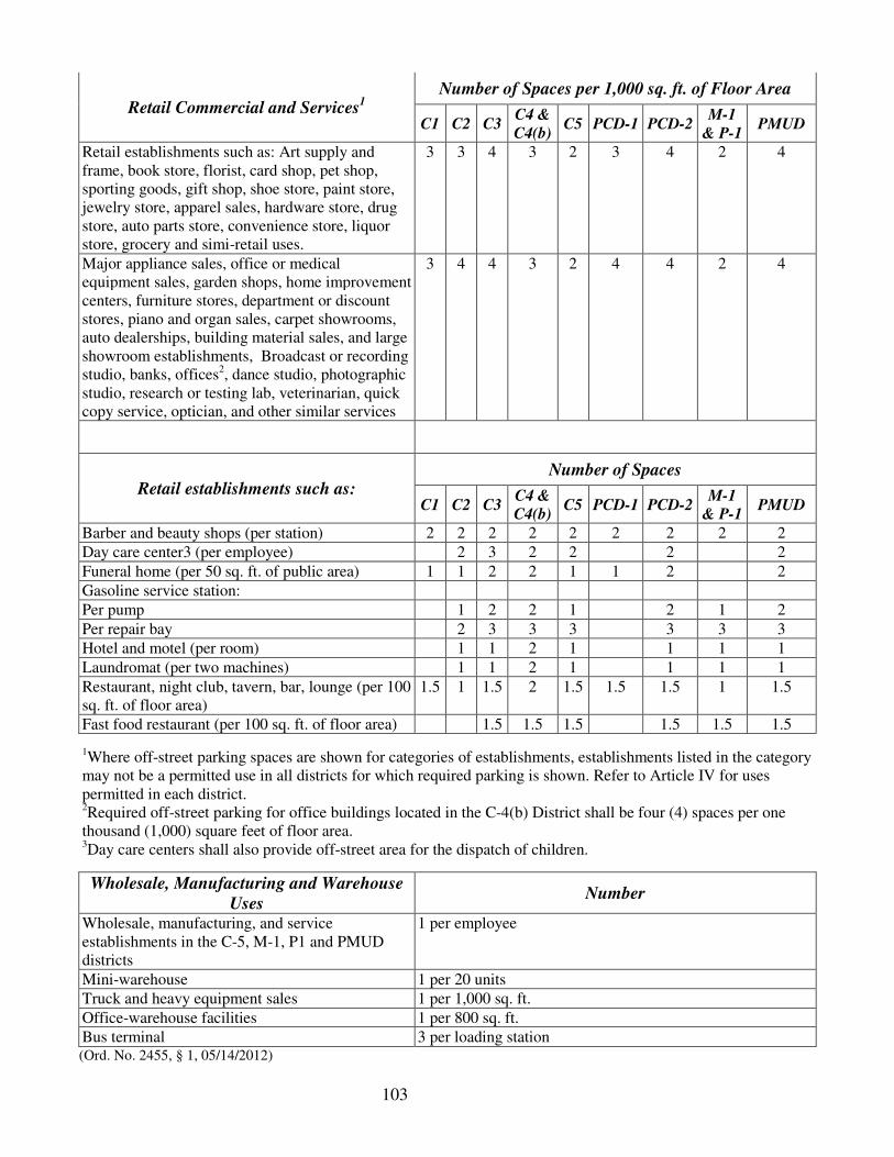
103
Retail Commercial and Services1
Number of Spaces per 1,000 sq. ft. of Floor Area
C1 C2 C3 C4 &
C4(b) C5 PCD-1 PCD-2
M-1
& P-1 PMUD
Retail establishments such as: Art supply and frame, book store, florist, card shop, pet shop, sporting goods, gift shop, shoe store, paint store, jewelry store, apparel sales, hardware store, drug store, auto parts store, convenience store, liquor store, grocery and simi-retail uses.
3 3 4 3 2 3 4 2 4
Major appliance sales, office or medical equipment sales, garden shops, home improvement centers, furniture stores, department or discount stores, piano and organ sales, carpet showrooms, auto dealerships, building material sales, and large showroom establishments, Broadcast or recording studio, banks, offices2, dance studio, photographic studio, research or testing lab, veterinarian, quick copy service, optician, and other similar services
3 4 4 3 2 4 4 2 4
Retail establishments such as: Number of Spaces
C1 C2 C3 C4 &
C4(b) C5 PCD-1 PCD-2
M-1
& P-1 PMUD
Barber and beauty shops (per station) 2 2 2 2 2 2 2 2 2
Day care center3 (per employee) 2 3 2 2 2 2
Funeral home (per 50 sq. ft. of public area) 1 1 2 2 1 1 2 2
Gasoline service station:
Per pump 1 2 2 1 2 1 2
Per repair bay 2 3 3 3 3 3 3
Hotel and motel (per room) 1 1 2 1 1 1 1
Laundromat (per two machines) 1 1 2 1 1 1 1
Restaurant, night club, tavern, bar, lounge (per 100 sq. ft. of floor area)
1.5 1 1.5 2 1.5 1.5 1.5 1 1.5
Fast food restaurant (per 100 sq. ft. of floor area) 1.5 1.5 1.5 1.5 1.5 1.5
1Where off-street parking spaces are shown for categories of establishments, establishments listed in the category may not be a permitted use in all districts for which required parking is shown. Refer to Article IV for uses permitted in each district. 2Required off-street parking for office buildings located in the C-4(b) District shall be four (4) spaces per one thousand (1,000) square feet of floor area. 3Day care centers shall also provide off-street area for the dispatch of children.
Wholesale, Manufacturing and Warehouse
Uses Number
Wholesale, manufacturing, and service establishments in the C-5, M-1, P1 and PMUD districts
1 per employee
Mini-warehouse 1 per 20 units
Truck and heavy equipment sales 1 per 1,000 sq. ft.
Office-warehouse facilities 1 per 800 sq. ft.
Bus terminal 3 per loading station (Ord. No. 2455, § 1, 05/14/2012)

104
Sec. N. Loading area requirement.
(1) Required loading space: On the same premises with every building or structure involving the receipt or dispatch of vehicles as a necessity for, or incidental to, the operation, or use of the building, there shall be provided and maintained adequate space for standing, loading and unloading services, in order to avoid undue interference with public use of streets or alleys. Each such space shall have a minimum clear height of fifteen (15) feet and shall be a minimum of fourteen (14) feet wide by forty (40) feet long, where vans are to be received, or a minimum of fourteen (14) feet wide by sixty (60) feet long, where tractors and semi-trailers are to be received.
(2) Loading area site arrangement: All loading areas shall be provided with safe entrance to and exit from the public thoroughfare. The planning commission shall approve the design and location of loading areas in the interests of convenience, safety, and other public requirements. The entire loading area shall be paved and graded to properly drain.
(3) Number of spaces required:
a. One space for floor areas up to 30,000 sq. ft.
b. Two (2) spaces for floor areas from 30,000 to 50,000 sq. ft.
c. Three spaces for floor areas from 50,000 to 100,000 sq. ft.
d. One additional space for each additional 100,000 sq. ft. of floor area.
Sec. O. Parking and Loading Area Requirements for the Mixed Use Districts and
Land Preserve Districts
The size, number and location of parking spaces required for specific uses in the Mixed Use District and the Land Preserve District shall be determined as part of the development plan review as required in the Mixed Use District and Land Preserve District zoning process. Adjacent on-street parking and public parking may be used to meet the parking requirements in the Mixed Use District and the Land Preserve District.
(Ord. No. 2455, § 1, 05/14/2012)
Sec. P. Parking Requirements for the Urban Renewal Districts.
Required parking spaces for individual uses in the Urban Renewal District shall be as required in Section M, for the Zoning district where the use is first mentioned in Article IV as a permitted use.
(Ord. 2258, § 1, 07-25-2005)

105
ARTICLE VIII. RESERVED*
*Editor's note--Section 2 of Ord. No. 1740, adopted Oct. 22, 1990, repealed Art. VIII, pertaining to sign regulations, which contained §§ A-- N and derived from Ord. No. 1602, adopted Dec. 9, 1986, and Ord. No. 1641 , §§ 1--3, adopted Feb. 8, 1988. Section 1 of Ord. No. 1740 enacted sign regulations which were included as Ch. 5, Art. V. -------------------------------------------------------------------------------------------------------------
106
ARTICLE IX. ADMINISTRATION AND REVIEW PROCEDURES
Sec. A. General Administration.
The provisions of this ordinance shall be administered and enforced by the building official of the city, who shall have the right to enter upon any premises at any reasonable time for the purpose of making inspections of land or structures necessary to carry out the enforcement of this ordinance.
(1) Board of adjustment: The Homewood Board of Adjustment was established pursuant to section 11-52-80, Code of Alabama 1975; and shall have all powers and duties delegated to boards of adjustment by said code, which generally are:
a. To hear and decide appeals where it is alleged there is error in any order, requirement, decision, or determination made by an administrative official in the enforcement of this ordinance.
b. To hear and decide special exceptions to the terms of this ordinance upon which the board is required to pass under this ordinance.
c. To authorize upon appeal in specific cases such variance from the terms of this ordinance as will not be contrary to the public interest, where, owing to special conditions, a literal enforcement of the provisions of this ordinance will result in unnecessary hardship, and so that the spirit of this ordinance shall be observed and substantial justice done.
(2) Standard building code: The Standard Building Code is that version presently adopted by the City of Homewood. The enforcement of this code provides minimum requirements to safeguard life, health and public welfare and the protection of property as it relates to these safeguards by regulating and controlling the design, construction, alteration, repair, equipment, use, and occupancy, location, maintenance, removal and demolition of all buildings or structures and appurtenances thereto. The first chapter of the building code sets forth the administrative process for the issue of a building permit.
(3) Building permit: It shall be unlawful to: a. commence earthwork, or b. commence construction of any building or other structure, including accessory structures or signs, or c. store building materials or erect temporary field offices, or d. commence the moving, alteration or repair of any structure, until the building official of the city has issued for such work, a building permit. Building permits shall be required for any excavation, construction, or alteration the cost of which is one thousand dollars ($1,000.00) or more.
(4) Review of building permit applications: It shall be unlawful for the building official of the city to approve any plans or issue a building permit until said official has inspected the plans in detail and found them in conformity with this ordinance. No building permit shall be issued for any structures in Districts regulated by a Final Development Plan until authorized by the Zoning Administrator. All plans submitted with a building permit application shall contain the following:
a. Location, size, dimensions and current Zoning of the site.
b. The use, location, size, and height of all existing and proposed structures on the site.
c. The location and number of parking spaces, as well as points of ingress and egress.
d. All easements and rights-of-way.

107
e. The setback and side lines of buildings on adjoining property, and other information concerning the lot or adjacent property as may be required for determining conformance with the provisions of this ordinance.
f. The location and dimensions of all exterior graphic displays.
g. Buffers.
(5) Unlawful structure: Any use of land or a structure, or construction or alteration of a structure in violation of this ordinance, is hereby declared to be a nuisance per se. Whenever the building official declares that the use of land or a structure is in violation of this ordinance, the owner or occupant shall, within seventy-two (72) hours from the issue of a notice from the building official to vacate such premises, accomplish the vacation of such land or structure until said use be made to conform to the provisions of this ordinance.
(6) Penalties: Any person, firm, corporation, or other organization which violates this ordinance shall be fined upon conviction not less than twenty dollars ($20.00) nor more than one hundred dollars ($100.00) and cost of court for each offense. Each day such violation continues shall constitute a separate offense.
(7) Remedies: When any building or other structure is erected, constructed, reconstructed, altered, repaired, converted, or maintained; or any building, structure or land is used in violation of this ordinance, the building official of the city or any other appropriate authority or any adjacent or neighboring property owner who would be damaged or caused hardship by such violation may bring an injunction, mandamus, or other appropriate action or proceeding, to correct or abate such violation or to prevent occupancy of such building, structure, or land.
(Ord. No. 2001, § 6, 11-23-98)
Cross reference(s)--Created and established, § 17-1.
Sec. B. Zoning amendments:
(1) Review procedure: A proposed amendment to the zoning ordinance, including the map, may be initiated by the city, or at the request of the owner of the subject property. All proposed amendments shall be considered by the city, in accordance with Title 11, Chapter 52, Article 4, of the Code of Alabama 1975, as amended, and section 1059(28) - 1059(31), Volume 14(c) of the 1973 supplement to the Code of Alabama 1940 as recompiled in 1958.
(2) Application requirements: At least thirty (30) days prior to a regularly scheduled planning commission meeting, the applicant shall submit to the secretary to the planning commission:
a. An administrative fee of two hundred fifty dollars ($250.00) plus an amount equal to the sum of any and all expenses incurred by the City of Homewood for publication, notification for hearings, planning, engineering, and surveying services rendered or required in connection with said application, and/or as otherwise provided by ordinances of the City of Homewood.
b. A completed application form supplied by the zoning administrator, accompanied by the following materials:
1. A site plan, drawn to scale, indicating:
i. The dimensions and location of the site.
ii. The shape, size, height and location of all existing structures on the site.

108
iii. The number and location of parking spaces, and location of ingress and egress.
iv. All rights-of-way and easements.
v. Other information which may be required by the planning commission during the review process.
2. A written statement indicating:
i. Reason for the request.
ii. Legal description of the subject property.
iii. Traffic volumes to be generated by the proposal.
iv. Availability of required utilities.
3. Public hearing notices on a form supplied by the zoning administrator, in accordance with the following provisions:
i. The notice shall be addressed to the owners of property located in whole or in part within five hundred (500) feet from the boundaries of the property which is the basis of the proposed amendment in zoning classification, as shown by the records of the Jefferson County Tax Assessor on a date not more than one (1) year prior to the date of such notice.
ii. The applicant shall complete number 10 plain white envelopes, supplied by the city, addressed and stamped for certified return receipt mailing from the city to all persons to whom notice shall be sent.
iii. Such notices shall state the street address of the property, if any, and the proposed amendment or change in zoning classification.
iv. Such notices shall state that a written protest of the proposed amendment may be filed with the secretary to the planning commission of the City of Homewood one (1) day prior to the proposed date of the public hearing for the consideration of the zoning classification amendment. The protest must be signed by the property owner making such protest and only one (1) protest shall be allowed for each separately assessed unit of property.
v. Such notices shall be deposited in the United States mail by the secretary to the planning commission at least seven (7) days prior to the proposed date of the public hearing.
4. Zoning amendments which require preliminary development plan approval shall submit said plan as required in Article VI of this ordinance.
c. The zoning administrator shall be responsible for posting property with signs that note the proposed district change and the time and place of the planning commission hearing. The zoning administrator shall post property at least fifteen (15) days in advance of the public hearing before the planning commission. The property shall remain posted until the public hearing is completed. The required signs shall be placed at reasonable intervals along the public street abutting the property subject to rezoning.

109
(3) Conditional rezoning.
a. In situations where more flexible and adaptable zoning methods are needed, rezoning amendments may be allowed subject to certain conditions that are not generally applicable to land similarly zoned. Proposed rezoning amendments may include the voluntary proffering in writing, signed by the property owner (and the authorized agent of the property owner, if any), of reasonable conditions in addition to the regulations provided for in the desired zoning district. Any such proffered conditions must adhere to the following criteria:
1. The rezoning itself must give rise to the need for the conditions.
2. Such conditions shall have a reasonable relation to the rezoning.
3. Such conditions shall not include a cash contribution to the city.
4. Such conditions shall not include dedication of property for public right-of-way or facilities, unless otherwise required by the Homewood Subdivision Regulations.
5. Such conditions shall not include payment for or construction of off-site improvements, unless otherwise required by the Homewood Subdivision Regulations.
6. No condition shall be proffered that is not related to the physical development or physical operation of the property.
7. No condition shall allow for the reversion of zoning held previous to the rezoning, unless a new application for rezoning is filed.
8. All such conditions shall be in conformity with the purposes and considerations of this ordinance.
b. The zoning administrator shall be vested with all necessary authority on behalf of the city council to administer and enforce conditions attached to a rezoning amendment.
c. The zoning map shall show by an appropriate symbol the existence of conditions attached to the zoning. The zoning administrator shall keep in his office and make available for public inspection a conditional zoning index. The index shall provide ready access to the ordinance creating conditions in addition to the regulations provided for in a particular zoning district. The zoning designation of the property shall carry a C suffix in addition to the zoning district designation (for example, M-1C), and the zoning map shall reference the conditional zoning index by ordinance number.
d. Any amendment, waiver, or variation of conditions created pursuant to the provisions of this section shall be subject to zoning amendment procedures.
(4) Limitations on rezoning amendments: Should the city council reject a rezoning amendment proposal by a property owner, the same kind of rezoning of the same tract land will not be considered by the planning commission until a period of one (1) year has elapsed from the date of such action by the city council. Further, a withdrawal of the application for rezoning after the hearing held by the planning commission, but prior to the hearing held by the city council shall also require a one-year time period before another application may be submitted. However, the planning commission may adjust this time period if in the opinion of a majority of the commission, an unusual situation or circumstance exists which would warrant another hearing. Each time the zoning amendment application is made, the required administrative fees must be paid. Under no condition shall fees be refunded for failure of such proposed amendment to be enacted into law.
110
(5) Public hearing-planning commission. Any requested zoning amendment or change is to be heard by the planning commission at a public hearing.
The public hearing to be held before the planning commission and notice of the same as provided hereinabove shall be in addition to and is not to supplement or change requirements for public hearing and notice of same to be held before the city council of the City of Homewood as per the terms and conditions of section 1 referred to hereinabove or contained in Section 1059(29), Volume 14(c) of the 1973 supplement to the Code of Alabama 1940 as recompiled in 1958.
(Ord. No. 1682, § 1, 5-22-89; Ord. No. 2001, § 7, 11-23-98)
Sec. C. Uses on appeal.
A use allowed on appeal is a use which is compatible with the permitted district uses but, because of its nature, must be reviewed and approved by the Building Inspection Superintendent or his designee (Zoning Administration) or the Board of Zoning Adjustments prior to issue of a business license. Such uses fall into two (2) separate categories: (1) home occupancy uses which are specifically mentioned in this ordinance as requiring approval by the Zoning Administration; and (2) uses requiring approval by the Board of Zoning Adjustments.
(1) Home occupations: Applications for home occupations may be approved by the Zoning Administration, provided that all of the following regulations and requirements are satisfied:
a. General Restrictions. The home occupation shall be clearly incidental to the residential character of the dwelling and shall not adversely affect the uses permitted in the zoning district in which it is located. No home occupations shall be permitted which might interfere with the general welfare of the surrounding residential area due to potential noise, increased pedestrian and vehicular traffic, or any other conditions which would constitute an objectionable use of residentially-zoned property.
b. Limitation of Type of Home Occupation. Home occupations shall be limited to an office, or a business of a personal service nature.
c. Limitation of Area. The use of a dwelling for a home occupation purpose shall be limited to twenty-five percent (25%) of one floor of the principal building and accessory building; however, no visible outside storage of any kind will be permitted in connection with any home occupation.
d. Employment Limitations. Employment shall be limited to members of the family residing in the dwelling with which the home occupation is associated; there shall be no employment of persons who are not members of said resident family.
e. Limitation of Patrons. All home occupations shall be restricted such that there shall not be any patrons (who are not member of the resident family) on the premises for any reason related to such home occupation.
f. Signage Restrictions. There shall be no signage erected or displayed on the premises that in any way identifies or advertises a home occupation.
g. Renewal. Failure to renew a business license will rescind any prior approval that may have been issued by the Engineering, Planning, and Zoning (permitting a home occupation), and may result in a reapplication fee at the discretion of the Zoning Administration.

111
h. Transfer of Home Occupation. There will be no transfer of a home occupation to another address. If you move to another neighborhood, you will have to re-apply with the Zoning Administration.
(2) Other uses on appeal: Home day care and all other uses which are not addressed by this ordinance may be permitted in a district which permits similar uses, upon approval of the Board of Zoning Adjustments. However, if the board determines that the granting of a use on appeal would constitute a rezoning of the property, then the board shall refer the request to the planning commission for legislative action.
(Ord. No. 2441, § 1, 09/12/2011)
Sec. D. Severability.
If any section or provision of this ordinance, including any part of the zoning map which is a part of this ordinance, be declared by a court of competent jurisdiction to be invalid, such decision shall not affect the validity of the ordinance as a whole or any part thereof other than the part so declared to be invalid.