yellowhead corridor area structure plan
TRANSCRIPT
Yellowhead Corridor ASP Office Consolidation
Yellowhead Corridor Area Structure Plan
Office Consolidation December 2021
Prepared by:
Development Services
Urban Planning and Economy
City of Edmonton
Bylaw 7044, as amended, was adopted by Council in April 1983. In December 2021, this document
was consolidated by virtue of the incorporation of the following bylaws: Bylaw 7044 Approved April 13, 1983 (to adopt the Yellowhead Corridor ASP)
Bylaw 7803 Approved April 23, 1985 (to replace Schedule C-3, Sub-Area 3)
Bylaw 7815 Approved May 14, 1985 (to delete references to “Special Study Area No. 1,” which is now included under
the Dunvegan Area Structure Plan)
Bylaw 7811 Approved May 29, 1985 (to replace Schedule C-2, Sub-Area 2)
Bylaw 9673 Approved January 29, 1991 (to replace Schedule C-3, Sub-Area 3 and deleting sub-section iii of Section
5.3.4.2)
Bylaw 9879 Approved September 24, 1991 (to replace map Schedule C-1 Sub-Area 1, and to amend Section 5.3.2.2 (i).
Bylaw 9997 Approved January 20, 1992 (to replace Schedule C-1, Sub-Area 1 and amend Section 5.3.2.2(iv))
Bylaw 10653 Approved November 8, 1994 (to amend Section 5.3.2.2, 5.3.2.3, 7.1.4, and replace Figure 7A)
Bylaw 11139 Approved October 30, 1995(to replace Schedule C-8, Sub-Area 8)
Bylaw 11101 Approved March 11, 1996 (to replace Schedule C-6, Sub-Area 6 and Figure 6C, Special Study Area 3)
Bylaw 11343 Approved October 21, 1996 (to replace Schedule C-6, Sub-Area 6 and to amend Sections 5.3.7.1, .3.7.2 (i),
5.3.7.2 (iii), and Section 5.3.7.2 (iv), 5.3.7.3, and deleting Section 7.1.3.3 and Figure 6C)
Bylaw 12076 Approved June 28, 1999 (to replace Schedule C-2, Sub-Area 2 and amend Section 5.3.3)
Bylaw 12387 Approved August 22, 2000 (to replace Schedule C-2, Sub-Area 2)
Bylaw 13162 Approved August 19, 2002 (to replace Section 5.3.2.2 (iii) and Schedule C-1, Sub-Area 1)
Bylaw 13497 Approved December 9, 2003 (to replace Policy 5.3.4.2 (ii) and Schedule C-3, Sub-Area 3)
Bylaw 13574 Approved January 13, 2004 (to replace Section 5.3.3.2 (iii), Schedule C-2, Sub-Area 2, and Schedule C-3,
Sub-Area 3)
Bylaw 13668 Approved May 3, 2004 (to replace Schedule C-2, Sub-Area 2)
Bylaw 14122 Approved November 8, 2005 (to replace Schedule C-6, Sub-Area 6)
Bylaw 14776 Approved January 14, 2008 (Amendment to Proposed Land Uses map in Schedule C-4 Sub Area 4’)
Bylaw 15187 Approved September 16, 2009 (to replace Schedule C-3, Sub-Area 3)
Bylaw 15377 Approved February 16, 2010 (to replace Schedule C-1, Sub- Area 1)
Bylaw 15624 Approved December 13, 2010 (to replace Schedule C-6, Sub-Area 6)
Bylaw 15843 Approved August 29, 2011 (to replace Schedule C-8, Sub Area 8)
Bylaw 15971 Approved January 30, 2012 (to replace Schedule C-4, Sub Area 4)
Bylaw 16034 Approved May 16, 2012 (to replace Schedule C-4, Sub-Area 4)
Bylaw 16141 Approved July 3, 2012 (to replace Schedule C-5, Sub-Area 5)
Bylaw 16288 Approved September 16, 2013 (to replace Schedule C-7, Sub-Area 7)
Bylaw 16696 Approved February 10, 2014 (to replace Schedule C-7, Sub-Area 7)
Bylaw 17381 Approved September 21, 2015 (to add sub-section (v) to the end of Section 5.3.7.2, to add text to the end of
Section 7.5, and to replace Schedule C-6, Sub-Area 6)
Bylaw 18455 Approved July 9, 2018 (to replace Schedule C-3, Sub-Area 3)
Bylaw 18907 Approved July 15, 2019 (to replace Schedule C-6, Sub-Area 6)
Bylaw 19273 Approved March 15, 2021 (To amend the boundaries of the Coliseum Station Area Redevelopment Plan to
align with the boundaries of the Edmonton Exhibition Lands Planning Framework)
Bylaw 19907 Approved December 7, 2021 (To amend Schedule C-5, Sub-Area 5 and land use statistics)
Editor’s Note:
This is an office consolidation edition of the Yellowhead Corridor Area Structure plan, Bylaw 7044 as approved
by City Council on April 13, 1983. This edition contains all amendments and additions to Bylaw 7044.

Yellowhead Corridor ASP Office Consolidation
For the sake of clarity, new maps and a standardized format were utilized in this Plan. All names of City
departments have been standardized to reflect their present titles. Private owners’ names have been removed in
accordance with the Freedom of Information and Protection of Privacy Act. Furthermore, all reasonable attempts
were made to accurately reflect the original Bylaws. All text changes are noted in the right margin and are
italicized where applicable.
This office consolidation is intended for convenience only. In case of uncertainty, the reader is advised to consult
the original Bylaws, available at the office of the City Clerk.
City of Edmonton
Urban Planning and Economy
Yellowhead Corridor ASP Office Consolidation
YELLOWHEAD CORRIDOR
AREA STRUCTURE PLAN

Yellowhead Corridor ASP Office Consolidation
TABLE OF CONTENTS
(Amended by Editor)
CHAPTER ONE - PLAN BOUNDARY ............................................................. 1
1.1 BOUNDARY ............................................................................................... 1
CHAPTER TWO - BACKGROUND .................................................................. 5
2.1 INTRODUCTION ................................................................................... 5
2.1.1 History ........................................................................................................................................ 5
2.1.2 Authorization ............................................................................................................................. 6
2.1.3 Purpose ....................................................................................................................................... 6
2.1.4 Issues ........................................................................................................................................... 8
2.1.5 Social and Environmental Impacts .......................................................................................... 8
2.2 EXISTING SITUATION .......................................................................... 9
2.2.1 Land Uses ................................................................................................................................... 9
2.2.2 Natural Environment................................................................................................................. 9
2.2.3 Roadway ................................................................................................................................... 10
2.2.4 Ownership ................................................................................................................................ 16
2.2.5 Services ..................................................................................................................................... 16
2.3 LAND USE CONTROLS...................................................................... 17
2.3.1 Land Use Zones ........................................................................................................................ 17
2.3.2 City of Edmonton General Municipal Plan ........................................................................... 18
2.3.3 Airport Protection Overlay ..................................................................................................... 18
2.3.4 Land Use Plan Programs ......................................................................................................... 23
2.3.5 Transportation Plan Programs ............................................................................................... 23
2.3.6 Edmonton Regional Plan - Municipal Part ........................................................................... 23
2.3.7 City/Provincial Agreement ...................................................................................................... 23
2.3.8 Restricted Development Areas (RDA's) ................................................................................. 24
CHAPTER THREE – OBJECTIVES OF PLAN .............................................. 25
Yellowhead Corridor ASP Office Consolidation
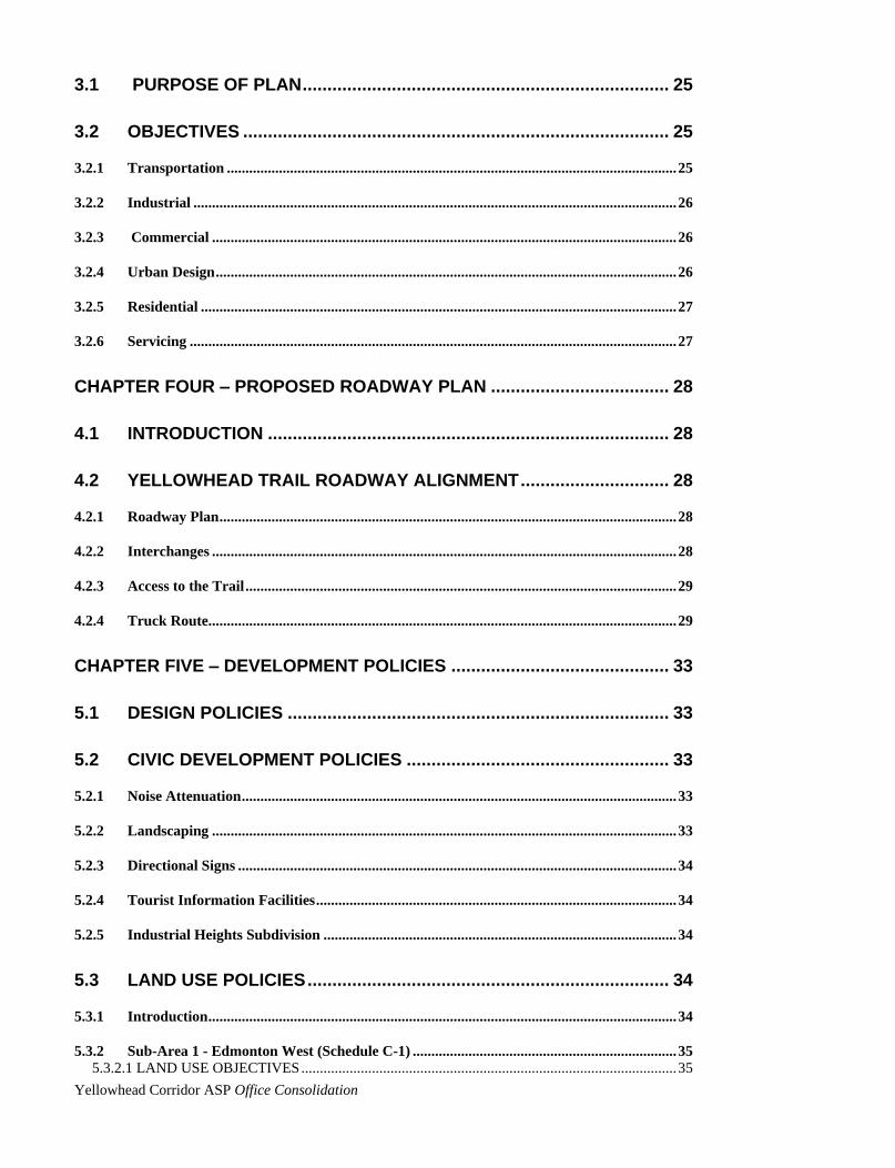
3.1 PURPOSE OF PLAN .......................................................................... 25
3.2 OBJECTIVES ...................................................................................... 25
3.2.1 Transportation ......................................................................................................................... 25
3.2.2 Industrial .................................................................................................................................. 26
3.2.3 Commercial ............................................................................................................................. 26
3.2.4 Urban Design ............................................................................................................................ 26
3.2.5 Residential ................................................................................................................................ 27
3.2.6 Servicing ................................................................................................................................... 27
CHAPTER FOUR – PROPOSED ROADWAY PLAN .................................... 28
4.1 INTRODUCTION ................................................................................. 28
4.2 YELLOWHEAD TRAIL ROADWAY ALIGNMENT .............................. 28
4.2.1 Roadway Plan ........................................................................................................................... 28
4.2.2 Interchanges ............................................................................................................................. 28
4.2.3 Access to the Trail .................................................................................................................... 29
4.2.4 Truck Route.............................................................................................................................. 29
CHAPTER FIVE – DEVELOPMENT POLICIES ............................................ 33
5.1 DESIGN POLICIES ............................................................................. 33
5.2 CIVIC DEVELOPMENT POLICIES ..................................................... 33
5.2.1 Noise Attenuation ..................................................................................................................... 33
5.2.2 Landscaping ............................................................................................................................. 33
5.2.3 Directional Signs ...................................................................................................................... 34
5.2.4 Tourist Information Facilities ................................................................................................. 34
5.2.5 Industrial Heights Subdivision ............................................................................................... 34
5.3 LAND USE POLICIES ......................................................................... 34
5.3.1 Introduction .............................................................................................................................. 34
5.3.2 Sub-Area 1 - Edmonton West (Schedule C-1) ....................................................................... 35 5.3.2.1 LAND USE OBJECTIVES ..................................................................................................... 35
Yellowhead Corridor ASP Office Consolidation
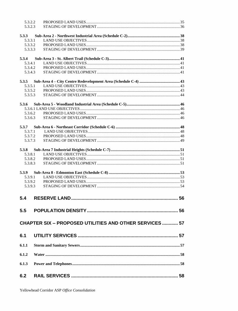
5.3.2.2 PROPOSED LAND USES ............................................................................................... 35 5.3.2.3 STAGING OF DEVELOPMENT .................................................................................... 36
5.3.3 Sub-Area 2 - Northwest Industrial Area (Schedule C-2) ..................................................... 38 5.3.3.1 LAND USE OBJECTIVES .............................................................................................. 38 5.3.3.2 PROPOSED LAND USES ............................................................................................... 38 5.3.3.3 STAGING OF DEVELOPMENT .................................................................................... 39
5.3.4 Sub-Area 3 - St. Albert Trail (Schedule C-3)........................................................................ 41 5.3.4.1 LAND USE OBJECTIVES .............................................................................................. 41 5.3.4.2 PROPOSED LAND USES ............................................................................................... 41 5.3.4.3 STAGING OF DEVELOPMENT .................................................................................... 41
5.3.5 Sub-Area 4 – City Centre Redevelopment Area (Schedule C-4) ......................................... 43 5.3.5.1 LAND USE OBJECTIVES .............................................................................................. 43 5.3.5.2 PROPOSED LAND USES ............................................................................................... 43 5.3.5.3 STAGING OF DEVELOPMENT .................................................................................... 44
5.3.6 Sub-Area 5 - Woodland Industrial Area (Schedule C-5) ...................................................... 46 5.3.6.1 LAND USE OBJECTIVES ..................................................................................................... 46 5.3.6.2 PROPOSED LAND USES ............................................................................................... 46 5.3.6.3 STAGING OF DEVELOPMENT .................................................................................... 46
5.3.7 Sub-Area 6 - Northeast Corridor (Schedule C-6) ................................................................. 48 5.3.7.1 LAND USE OBJECTIVES ............................................................................................. 48 5.3.7.2 PROPOSED LAND USES ............................................................................................... 48 5.3.7.3 STAGING OF DEVELOPMENT .................................................................................... 49
5.3.8 Sub-Area 7 Industrial Heights (Schedule C-7) ...................................................................... 51 5.3.8.1 LAND USE OBJECTIVES .............................................................................................. 51 5.3.8.2 PROPOSED LAND USES ............................................................................................... 51 5.3.8.3 STAGING OF DEVELOPMENT .................................................................................... 51
5.3.9 Sub-Area 8 - Edmonton East (Schedule C-8) ........................................................................ 53 5.3.9.1 LAND USE OBJECTIVES .............................................................................................. 53 5.3.9.2 PROPOSED LAND USES ............................................................................................... 53 5.3.9.3 STAGING OF DEVELOPMENT .................................................................................... 54
5.4 RESERVE LAND ................................................................................. 56
5.5 POPULATION DENSITY ..................................................................... 56
CHAPTER SIX – PROPOSED UTILITIES AND OTHER SERVICES ............ 57
6.1 UTILITY SERVICES ............................................................................ 57
6.1.1 Storm and Sanitary Sewers ..................................................................................................... 57
6.1.2 Water ........................................................................................................................................ 58
6.1.3 Power and Telephones ............................................................................................................. 58
6.2 RAIL SERVICES ................................................................................. 58

Yellowhead Corridor ASP Office Consolidation
6.3 AIRPORT SERVICES .......................................................................... 58
CHAPTER SEVEN – PLAN IMPLEMENTATION .......................................... 68
7.1 LAND USE IMPLEMENTATION ......................................................... 68
7.1.1 Specific Provisions Affecting Consideration of Discretionary Uses in IB Zones ................ 68
7.1.2 Rezoning ................................................................................................................................... 68
7.1.3 Special Study Areas ................................................................................................................. 68 7.1.3.1 Special Study Area #1 - (Peace River Division Yards) .................................................... 69 7.1.3.2 Special Study Area #2 - (Proposed Light Rail Transit Corridor) .................................... 69 7.1.3.3 Section Deleted ................................................................................................................ 69
7.1.4 Overlapping Plan Areas .......................................................................................................... 71 7.1.4.1 Sub-Area #1 ...................................................................................................................... 71 7.1.4.2 Sub-Area #8 ...................................................................................................................... 71
7.2 CIVIC DEVELOPMENT IMPLEMENTATION ...................................... 75
7.2.1 Noise Attenuation ..................................................................................................................... 75
7.2.2 Landscaping ............................................................................................................................. 75
7.2.3 Signs .......................................................................................................................................... 75
7.2.4 Tourist Information Facilities ................................................................................................. 76
7.3 UTILITY SERVICING ........................................................................... 76
7.3.1 General Policies ........................................................................................................................ 76
7.3.2 Storm Servicing Policies .......................................................................................................... 77
7.3.3 Sanitary Servicing Policies ...................................................................................................... 77
7.4 PLAN IMPLEMENTATION SUMMARY ................................................... 78
7.5 LAND USE DATA .................................................................................... 81
Yellowhead Corridor ASP Office Consolidation
0
LIST OF FIGURES AND SCHEDULES
(Amended by Editor)
Schedule A - Study Boundary
Figure 1 - Yellowhead Corridor Area Structure Plan Context Map
Figure 2 - Land Use
Figure 3 - Topographic - Edmonton West
Figure 4 - Topographic - Edmonton East
Figure 5 - Land Use Districts
Schedule B - Yellowhead Trail Roadway Alignment
Schedule C-1 - Proposed Land Uses - Sub-Area 1
Schedule C-2 - Proposed Land Uses - Sub-Area 2
Schedule C-3 - Proposed Land Uses - Sub-Area 3
Schedule C-4 - Proposed Land Uses - Sub-Area 4
Schedule C-5 - Proposed Land Uses - Sub-Area 5
Schedule C-6 - Proposed Land Uses - Sub-Area 6
Schedule C-7 - Proposed Land Uses - Sub-Area 7
Schedule C-8 - Proposed Land Uses - Sub-Area 8
Schedule D-1 - Utilities - Water, Storm Sewers, Sanitary and Combined Sewers
Schedule D-2 - Utilities – Power
Schedule D-3 - Utilities – Telephone
Figure 6A - Special Study Area #1 - (Peace River Division Yards)
Figure 6B - Special Study Area #2 - (Proposed Northwest LRT Corridor)
Figure 6C – Map Deleted (Bylaw 11343, October 21, 1996)
Figure 7A - Overlapping Plan Area
Figure 7B - Overlapping Plan Area
2-4
7
11-13
14
15
20-22
30-32
37-38
41
43
46
48
51
53
56
60-62
63-65
66-68
71
71
73
74
75
Yellowhead Corridor ASP Office Consolidation
1
CHAPTER ONE - PLAN BOUNDARY
1.1 BOUNDARY
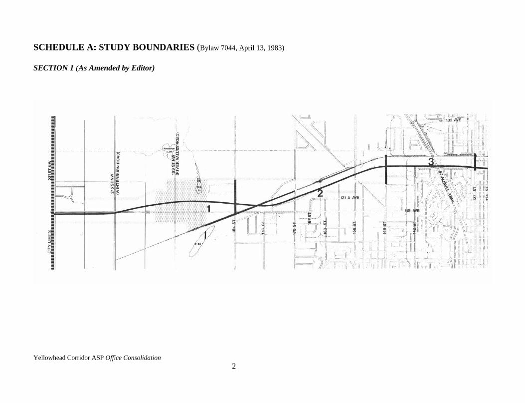
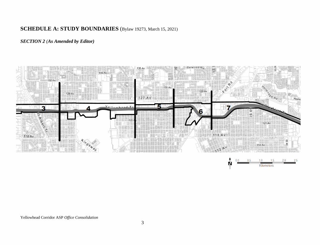
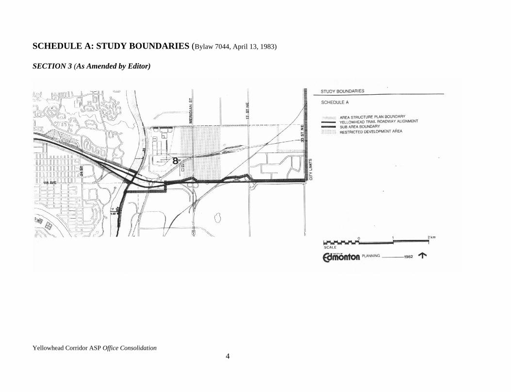
The boundaries of the Yellowhead Corridor Area Structure Plan are shown on Schedule A,
which for the purpose of this Plan, divides the Corridor into eight sub-areas.
More detailed illustration of boundaries is shown on the Schedule C maps.
The Plan area includes only those lands which are directly adjacent to or affected by the
Yellowhead Trail, and focuses predominantly on the industrial areas adjacent to the Trail.
Most of the adjacent residential areas are buffered from the industrial uses and are therefore
not included in this Plan.
Yellowhead Corridor ASP Office Consolidation
2
SCHEDULE A: STUDY BOUNDARIES (Bylaw 7044, April 13, 1983)
SECTION 1 (As Amended by Editor)
Yellowhead Corridor ASP Office Consolidation
3
SCHEDULE A: STUDY BOUNDARIES (Bylaw 19273, March 15, 2021)
SECTION 2 (As Amended by Editor)
Yellowhead Corridor ASP Office Consolidation
4
SCHEDULE A: STUDY BOUNDARIES (Bylaw 7044, April 13, 1983)
SECTION 3 (As Amended by Editor)
Yellowhead Corridor ASP Office Consolidation
5
CHAPTER TWO - BACKGROUND
2.1 INTRODUCTION
2.1.1 History
In 1977, the Province of Alberta and the City of Edmonton entered into an agreement for cost-
sharing the construction of the Yellowhead Trail under Alberta's Urban Transportation
Assistance Program entitled "Policy for Major Continuous Corridors Through Cities."
On 1977 07 13, City Council approved the recommendations of the Corridor Impact Study as
presented in the report, "Proposed Highway No. 16 Corridor: Fort Road to 173 Street, Volume
No. 2, Impact Study." One of the recommendations of the Study was that additional related
studies be done to assess the potential impacts of highway construction on existing and future
industrial and commercial land uses in the area. Consequently, on 1980 06 24, City Council
approved a work program and terms of reference for the Yellowhead Corridor Land Use
Study.
On 1981 09 08, the "Yellowhead Corridor Land Use Study - Interim Report" was presented to
City Council. Council approved the Report as a basis for the preparation of a land use plan for
lands adjacent to the Yellowhead Trail. Shortly after the preparation of this Report, the
Province awarded additional lands to the City, and the boundaries of the Land Use Study were
extended to include new areas adjacent to the Trail within the new City boundaries. The Plan
area reflects this extension.
Through the review of the Interim Report, it was determined that the most appropriate method
of implementing the recommendations of the Land Use Study was through the preparation of
an Area Structure Plan. An Area Redevelopment Plan was considered as another method of
achieving the Land Use Study recommendations but was discarded since much of the land in
the Plan is undeveloped.
This Plan provides a framework to review development proposals and serve as a guide to
future growth in the Corridor.
The Corridor, which is defined by, and coincidental with the Area Structure Plan boundary,
represents an area smaller than the original Land Use Study area. This allows the Plan to focus
on the adjacent industrial areas which will be most greatly impacted by improvements to the
Yellowhead Trail.

Yellowhead Corridor ASP Office Consolidation
6
2.1.2 Authorization
Authorization for the preparation of this Area Structure Plan came from two separate Council
actions. On 1981 09 08, City Council approved the "Yellowhead Corridor Land Use Study -
Interim Report" as a basis for the preparation of a Land Use Plan.
On 1982 02 23, Council approved in principle the "Urban Growth Strategy - Phase I Final
Report" which identified annexation areas to be reviewed within the context of the Yellowhead
Corridor Land Use Study, and directed that the appropriate land use plans be prepared. On
1982 07, Council gave first and second reading to the Report with third reading expected in
November of 1982.
2.1.3 Purpose
The purpose of this Area Structure Plan is to provide land use policies and strategies to guide
the future development of the industrial areas adjacent to the Yellowhead Trail and to identify
opportunities for new industrial and commercial development. The Plan is prepared on behalf
of the City of Edmonton with the aim of protecting the operational function of the Trail,
revitalizing the existing business industrial areas and improving aesthetics of the Yellowhead
Corridor and City entrances.
Yellowhead Corridor ASP Office Consolidation
7
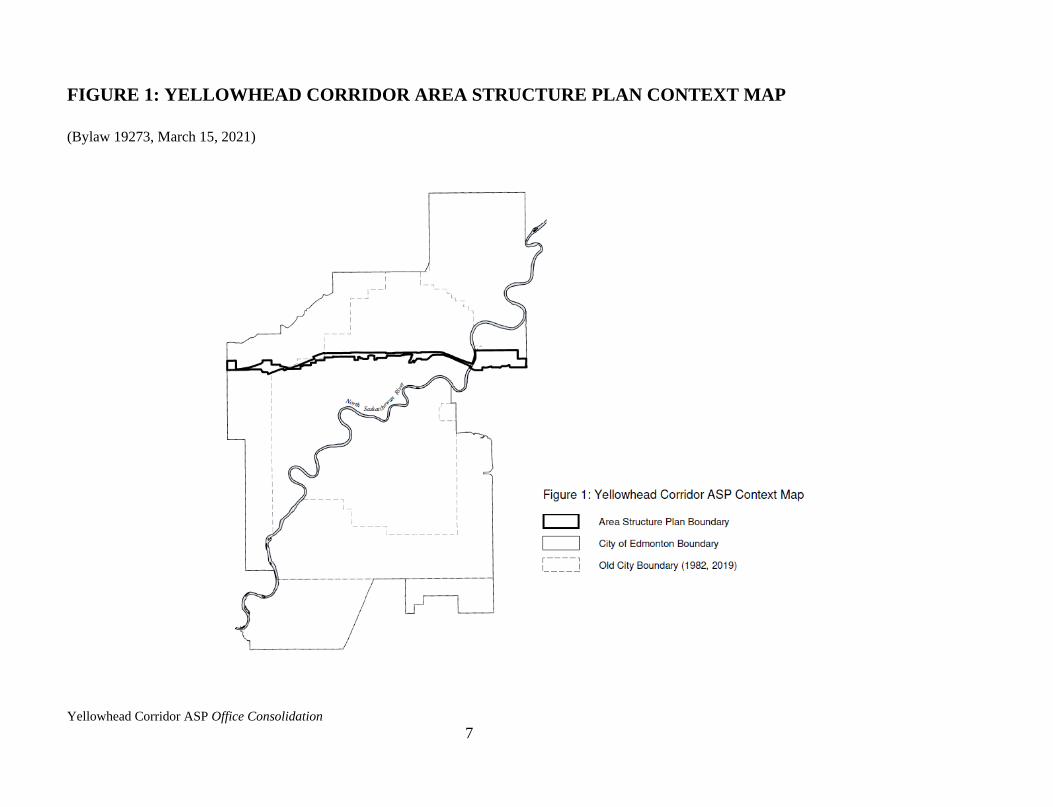
FIGURE 1: YELLOWHEAD CORRIDOR AREA STRUCTURE PLAN CONTEXT MAP
(Bylaw 19273, March 15, 2021)
Yellowhead Corridor ASP Office Consolidation
8
2.1.4 Issues
A number of key issues were identified as important considerations in preparing this Plan.
Through discussions with business groups, businesses in the Corridor. City and Provincial
Government representatives and through an extensive survey of existing land owners in the
Plan area, the following issues were identified:
i) there is overwhelming support to preserve the easy through movement of traffic on
the Trail;
ii) the business community wishes to maintain the industrial character of the land
uses adjacent to the Trail;
iii) there are areas of vacant land adjacent to the Trail which are ideal for the
development of high quality industrial uses;
iv) there are opportunities for the redevelopment of some of the older industrial uses;
v) there is a lack of facilities for the travelling public; and
vi) a conscious attempt should be made to improve the appearance of the Corridor and
City entrances.
These issues are addressed in the Plan.
2.1.5 Social and Environmental Impacts
A study completed by the City Planning Department in June 1977, entitled "Proposed
Highway No. 16 Corridor: Fort Road to 178 Street Functional Planning Study Volume No. 2,
Impact Study," identified the social and environmental impacts of the highway's construction
on adjacent properties between Fort Road and 142 Street.
Impacts identified included: the effects of property acquisition on communities and on the
families to be relocated; air quality as a result of increased traffic volumes; noise levels;
reduced access to Yellowhead Trail (formerly 125 Avenue); and the reduction in parkland as a
result of right-of-way acquisition.
This Plan addresses the need for noise attenuation along those portions of the Yellowhead Trail
adjacent to residential communities in Section 5.2.1, through the "Yellowhead Trail Noise
Attenuation Studies." The other impacts have been addressed prior to the preparation of this
Plan.

Yellowhead Corridor ASP Office Consolidation
9
2.2 EXISTING SITUATION
2.2.1 Land Uses
West of 156 Street, the majority of land has not been developed for urban purposes. The land
is basically in agricultural use, except for two clusters of country residential and scattered
commercial uses. (Refer to Figure 2 - Land Use)
Between 156 Street and 66 Street, businesses are predominantly involved in the movement and
storage of goods. A survey conducted by the Planning and Development Department indicated
28.4% of the businesses within the old City boundary's area are involved in warehousing,
wholesaling and transportation. Typically, these businesses have large site requirements and
few employees. Examples of such businesses are trucking companies and distribution centres.
The second major land use is manufacturing plants. These include a private corporation who
are involved in aviation manufacturing and repair, and two private corporations who are
involved in food processing. Light industrial uses fill in the remaining areas except for some
prominent commercial uses such as hotels and large retail stores.
There is one sizeable pocket of developable land lying between 66 Street and 50 Street. Much
of the area is vacant at present with the exception of a service station and trucking firms. The
City's Real Estate and Housing Department has recently received approval of a subdivision in
this area for the development of medium and light industrial uses which complies with this
Plan.
Sub-Area 8, located east of the North Saskatchewan River, is characterized by petrochemical
industries, construction and transportation related industries, the railway Clover Bar Satellite
Yard and a number of highway commercial uses. Much of the land has been subdivided but is
undeveloped.
A railway company and the Edmonton Municipal Airport, two major land users in the Plan
area, impact significantly on adjacent businesses. The railway lands run throughout the Plan
area and include the Bissell Yards, the Peace River Division Yards (formerly Northern Alberta
Railway Yards), the Calder Yards (the site of railway’s intermodal facilities), and the Clover
Bar Satellite Yards located east of the River. The Edmonton Municipal Airport is centrally
located and directly affects the land uses adjacent to it. These two users are in part responsible
for the original industrial character of the area.
2.2.2 Natural Environment
Land immediately west of 170 Street is relatively level with a slight rise in elevation to the
Amended by Editor
Amended by Editor
Amended by Editor

Yellowhead Corridor ASP Office Consolidation
10
west. Moving to the west City limit, the land is characterized by gently to moderately rolling
topography with a general decrease in elevation towards the north. Poor drainage in segments
of this area has resulted in intermittent lakes or sloughs and marshy lands. (Refer to Figure 3 -
Topographic - Edmonton West)
Between 170 Street and the North Saskatchewan River, the land is almost completely in a
developed or developable state. All the land has been graded and is ready for construction once
the necessary planning approvals and servicing arrangements are obtained.
Lands to the east of the North Saskatchewan River are also in a developed or developable
state. The roadway system is established and much of the land is already subdivided and ready
for construction pending any necessary planning approvals and servicing arrangements. (Refer
to Figure 4 - Topographic - Edmonton East)
2.2.3 Roadway
Construction of the Yellowhead Trail is nearing completion. East of Fort Road, the Trail is
completed to a four-lane limited access standard. From Fort Road to the west City limit,
various segments are complete and others are under construction. By 1984, the Trail will be in
full operation as a limited access roadway.

Yellowhead Corridor ASP Office Consolidation
11
FIGURE 2: LAND USE (Bylaw 7044, April 13, 1983)
SECTION 1 (As Amended by Editor)
Private
Corp
oratio
nPriv
ate C
orpora
tion
Private
Corp
oratio
n
Private
Corp
oratio
n
Private C
orporation
Private
Corp
oratio
n

Yellowhead Corridor ASP Office Consolidation
12
FIGURE 2: LAND USE SECTION 2 (Bylaw 19273, March 15, 2021)
SECTION 2 (As Amended by Editor)
Yellowhead Corridor ASP Office Consolidation
13
FIGURE 2: LAND USE (Bylaw 7044, April 13, 1983)
SECTION 3 (As Amended by Editor)
Private
Corp
oratio
n
Private
Corp
oratio
n
Private
Corp
oratio
n
Private
Corp
oratio
n
Private
Corp
oratio
n
Private
Corp
oratio
n
Private
Corp
oratio
n
Private
Corp
oratio
n
Gas
Private
Corp
oratio
n
Private
Corp
oratio
n
Yellowhead Corridor ASP Office Consolidation
14
FIGURE 3: TOPOGRAPHIC – EDMONTON WEST (Bylaw 7044, April 13, 1983)
Yellowhead Corridor ASP Office Consolidation
15
FIGURE 4: TOPOGRAPHIC – EDMONTON EAST (Bylaw 7044, April 13, 1983)
Yellowhead Corridor ASP Office Consolidation
16
2.2.4 Ownership
Ownership patterns play a significant role in the ultimate development of the Plan area. The
Plan aims to reflect the aspirations and future plans of the many land owners in the Corridor.
The major land owners, identified in Figure 2 include:
a) A rail line which owns the rail right-of-way there major marshalling yards and the
Peace River Division Yards (former Northern Alberta Railway);
b) the City of Edmonton, which owns the Yellowhead Trail right-of-way, works yards
in Sub-Areas 4 and 6, the Industrial Heights area (the former Manning Freeway
lands) in Sub-Area 7, the Edmonton Municipal Airport, and various parcels of land
acquired during the construction of the Trail;
c) the Province of Alberta, which has purchased land in the name of the Crown for the
proposed Outer Ring Road;
d) major corporate land owners including manufacturing plants, trucking companies,
and distribution centres; and
e) the Federal Government at 170 Street.
Within the Plan area there are also a number of smaller land owners whose future plans were
also considered in the preparation of this Plan.
2.2.5 Services
Land to the west of 170 Street is not serviced. With the recent annexation, the City is preparing
servicing plans which would permit the development of the area.
Between 170 Street and 66 Street, full services are provided. Water and sewer facilities are at
or near capacity. Future development and redevelopment must be assessed on an individual
basis to determine if any improvements are required. The land owner and/or developer is
currently required to make arrangements or pay the costs of providing services to proposed
developments.
The City has completed the necessary planning for the provision of services between 66 and 50
Streets.
The Southeast Regional Sewage Transmission Line, constructed by Alberta Environment, has
adequate capacity to provide sanitary servicing for the area east of the North Saskatchewan
Amended by Editor
Amended by Editor
Yellowhead Corridor ASP Office Consolidation
17
River.
Water is adequately provided in the entire area and storm water drainage flows directly into the
North Saskatchewan River. Current services are adequate, but upgrading will be required in
some areas.
2.3 LAND USE CONTROLS
2.3.1 Land Use Zones
The Plan area is currently regulated by four Land Use Bylaws. These are:
a) City of Edmonton Land Use Bylaw No. 5996;
b) County of Strathcona Land Use Bylaw No. 44-80;
c) Municipal District of Sturgeon Land Use Bylaw No. 388-81; and
d) County of Parkland Land Use Bylaw No. 19-79.
The City will be rezoning those lands which were located within the County of Strathcona, the
Municipal District of Sturgeon, and the County of Parkland prior to annexation, to conform
with the City of Edmonton Zoning Bylaw. In the interim, the existing County and Municipal
District Bylaws are being used in the review of development applications in those recently
annexed areas.
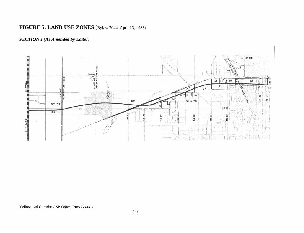
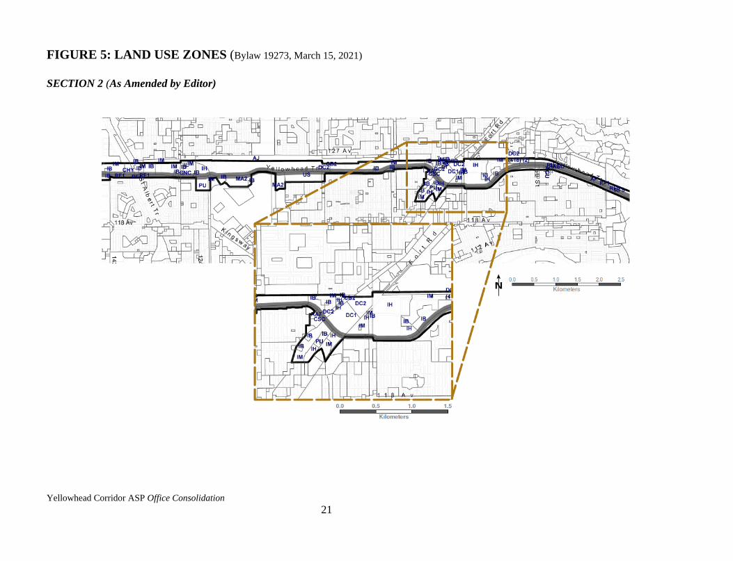
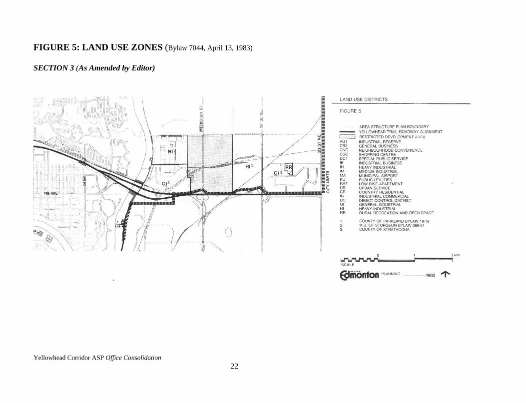
Figure 5 identifies the current Land Use Zones which are described below:
The west portion of the Plan area is designated Direct Control District under the County of
Parkland Land Use Bylaw. East of the Restricted Development Area (RDA) and north of the
rail line, the land is districted Industrial Commercial.
Between 170 Street and the North Saskatchewan River, the majority of the land is included in
the City of Edmonton Zoning Bylaw and is designated Medium Industrial. However, there are
portions of Heavy Industrial Zones and scattered commercial Zones throughout which, for the
most part, recognize existing uses. Between 160 Street and 149 Street there is a portion of land
regulated by the Municipal District of Sturgeon Land Use Bylaw. This land is designated
Industrial Commercial.
East of the North Saskatchewan River, the land is designated General Industrial and Heavy
Industrial under the County of Strathcona's Land Use Bylaw.
Amended by Editor
Amended by Editor
Amended by Editor
Amended by Editor
Amended by Editor
Yellowhead Corridor ASP Office Consolidation
18
Two special districts affect large areas of land. All railway lands are designated DC4 (Special
Public Service District). This District provides direct control to regulate uses of land which are
presently governed by superior legislation. If the land use changes or the land is sold, the DC4
District provides an interim control until a more appropriate District is applied. The MA Zone,
applied on the Edmonton Municipal Airport and adjacent lands, allows for the operation of the
airport and permits uses which are directly related to its operations. If the privately owned
lands are not required for airport operations, some of these lands may be rezoned. This could
permit a wider range of development opportunities such as small scale office uses and
warehousing uses not related to the operation of the airport.
2.3.2 City of Edmonton General Municipal Plan
The City of Edmonton General Municipal Plan includes a number of policies which are
specifically relevant to this Plan. The General Municipal Plan provides the following direction
for this Plan:
i) minimize land use conflicts while maintaining the Corridor as a major
transportation facility (Policy 8.D.3);
ii) identify areas suitable for office and employment nodes outside of Downtown
(Objectives 6.A and 6.F);
iii) identify locations for highway commercial uses (Policy 6.H.1);
iv) maintain viable industrial areas (Policy 7.B.1);
v) prohibit intrusion of commercial uses in industrial areas (Objective 7.C);
vi) upgrade the aesthetics of the Corridor by formulating design guidelines (Policy
15.B.3); and
vii) encourage the development of a thorough sign system (Policy 15.C.10).
The Growth Strategy provides similar direction for recently annexed lands in this Plan.
2.3.3 Airport Protection Overlay
The Airport Protection Overlay within the City of Edmonton's Zoning Bylaw provides for the
safe and efficient operation of the airport through the regulation of building heights and land
uses. The regulations in the Airport Protection Overlay are applied to the lands described by
Schedule 810A in the City of Edmonton's Land Use Bylaw No. 5996. These regulations take
Amended by Editor
Amended by Editor
Yellowhead Corridor ASP Office Consolidation
19
precedence over the regulations of the Land Use Zones.
Yellowhead Corridor ASP Office Consolidation
20
FIGURE 5: LAND USE ZONES (Bylaw 7044, April 13, 1983)
SECTION 1 (As Amended by Editor)
Yellowhead Corridor ASP Office Consolidation
21
FIGURE 5: LAND USE ZONES (Bylaw 19273, March 15, 2021)
SECTION 2 (As Amended by Editor)
Yellowhead Corridor ASP Office Consolidation
22
FIGURE 5: LAND USE ZONES (Bylaw 7044, April 13, 1983)
SECTION 3 (As Amended by Editor)
Yellowhead Corridor ASP Office Consolidation
23
2.3.4 Land Use Plan Programs
The Yellowhead Corridor Area Structure Plan abuts a number of Plan areas covered by other
plans and planning programs including the Calder Neighbourhood Improvement Program, the
proposed Coliseum Station Area Redevelopment Plan, the proposed Montrose/Santa Rosa
Area Redevelopment Plan, and the Kennedale Industrial Area Structure Plan. The Plan also
abuts the May Park replot and Bergman replot areas. The Yellowhead Corridor Area Structure
Plan recognizes the objectives of these Plans and is compatible with them.
2.3.5 Transportation Plan Programs
Within the Yellowhead Corridor Area Structure Plan area there are a number of transportation
planning studies under preparation. These include: Yellowhead Trail Noise Attenuation
Studies; 82 Street/Yellowhead Tight-Diamond Inter-change Functional Plan; and Northeast
Corridor - 115 Avenue to 134 Avenue Functional Planning Study.
The Yellowhead Corridor Area Structure Plan recognizes these studies and identifies a Special
Study Area in the vicinity of the Northeast Corridor which should be under-taken when
roadway plans are more certain. The land use proposals in the Plan will complement the
transportation plans and studies under preparation.
2.3.6 Edmonton Regional Plan - Municipal Part
Section 54(2) of the Planning Act requires that all statutory plans conform with the regional
plan. In the preparation of the Yellowhead Corridor Area Structure Plan, the need for
approximately seven regional plan amendments were identified. All necessary amendments to
the regional plan will be enacted prior to the adoption of this Plan by Council in order to
satisfy the above Planning Act requirement.
2.3.7 City/Provincial Agreement
The 1977 agreement between the City of Edmonton and the Province of Alberta established
the financial arrangements for cost-sharing of the Yellowhead Trail construction.
As part of the agreement, the City will "maintain the facility to a standard commensurate with
the operational requirements of the Corridor," and "consult with the Minister of Transportation
on any proposed reclassification of the land adjacent to the Corridor and have regard to the
Corridor when considering proposed development."
Yellowhead Corridor ASP Office Consolidation
24
The Plan also includes a portion of the Northwest Industrial Outline Plan area. The land use
proposals for the Yellowhead Corridor Area Structure Plan follows the general objectives of
the Outline Plan.
2.3.8 Restricted Development Areas (RDA's)
The Department of the Environment Act permits the Lieutenant Governor in Council, upon the
recommendation of the Minister of the Environment, to declare lands as Restricted
Development Areas (RDA's) and to make regulations for these lands. Within the Yellowhead
Corridor there exist two RDA's, one in Sub-Area 1 and the other in Sub-Area 8. Development
within these two areas has been restricted in order to protect land for the eventual construction
of a Ring Road and utility corridor.

Yellowhead Corridor ASP Office Consolidation
25
CHAPTER THREE – OBJECTIVES OF PLAN
3.1 PURPOSE OF PLAN
The aim of this Area Structure Plan is to guide and direct future growth and change in ways
that are compatible with the efficient operation of the Trail and the industrial character of the
area. Within this context, the Plan strives to implement the recommendations of the
Yellowhead Corridor Land Use Study and the policies of the General Municipal Plan.
The purpose of this Plan is to:
3.1.1 preserve the Yellowhead Trail as a limited access highway
(General Municipal Plan Policy 8.D.3, Objective 7.C);
3.1.2 preserve and rejuvenate the industrial character of the Yellowhead Trail
Corridor (General Municipal Plan Policy 7.B.1);
3.1.3 identify locations for new industrial and highway related development
(General Municipal Plan Objectives 6.A, 6.F, Policy 6.H.1); and
3.1.4 enhance the aesthetics of the Yellowhead Trail Corridor and
City entrances (General Municipal Plan Policy 15.B.3).
3.2 OBJECTIVES
3.2.1 Transportation
i) To maintain the Trail's function of accommodating through City traffic by
restricting uses which would generate traffic that may jeopardize this objective.
ii) To prohibit direct access from individual land parcels to the Yellowhead Trail.
iii) To encourage the use of rail spur lines by maintaining Land Use Zones which
permit rail-related warehousing uses.
iv) To ensure the safe operation of the Edmonton Municipal Airport by encouraging
compatible land uses and building form in its vicinity.
Amended by Editor
Yellowhead Corridor ASP Office Consolidation
26
3.2.2 Industrial
i) To encourage the development of business industrial uses in prominent locations
along the Trail.
ii) To maintain and rejuvenate the medium industrial areas in the Yellowhead Trail
Corridor.
iii) To maintain the existing supply of rail serviced lots.
iv) To limit the intrusion of commercial uses in the industrial areas of the Corridor.
3.2.3 Commercial
i) To prohibit the intrusion of scattered commercial development in industrial areas.
ii) To identify specific areas for services for the travelling public such as hotels,
motels, restaurants and service stations at points of high accessibility and
visibility.
iii) To restrict retail facilities and other commercial uses which would generate traffic
volumes that would jeopardize the Trail's operational efficiency.
iv) To maintain existing commercial uses.
3.2.4 Urban Design
i) To enhance the aesthetics of the Yellowhead Trail Corridor through design
guidelines emphasizing the screening of parking, loading and storage areas from
highway view.
ii) To enhance the image of the City entrances through the use of attractive roadway
landscaping and the promotion of tourist information services.
iii) To provide a sign system which is compatible with highway regulations and
provides clear direction to major City streets, City facilities and tourist services.
iv) To preserve and enhance the views to the City centre and major City landmarks.
v) To identify sites for tourist information facilities.
Yellowhead Corridor ASP Office Consolidation
27
3.2.5 Residential
i) To protect the adjacent residential communities by minimizing the effects of the
Yellowhead Trail through the construction of berms and/or noise barriers.
ii) To discourage residential development in industrial areas. To encourage the
transition of inappropriate existing residential areas to designated uses.
3.2.6 Servicing
i) To promote the underground location of utility services for new development
adjacent to or visible from the Trail.
ii) To ensure that the storm and sanitary servicing requirements of new developments
and redevelopments are designed, operated and maintained such that minimal
adverse impacts accrue to the existing storm water management techniques such as
roof-top storage, surface ponding, and underground storage with outflow controls.
Yellowhead Corridor ASP Office Consolidation
28
CHAPTER FOUR – PROPOSED ROADWAY PLAN
4.1 INTRODUCTION
Schedule B - Yellowhead Trail Roadway Alignment, provides an overview of the roadway
plan for the Yellowhead Trail as approved under the "Corridor Implementation Plan. June
1977," as amended. The Yellowhead Trail is scheduled for completion by 1984.
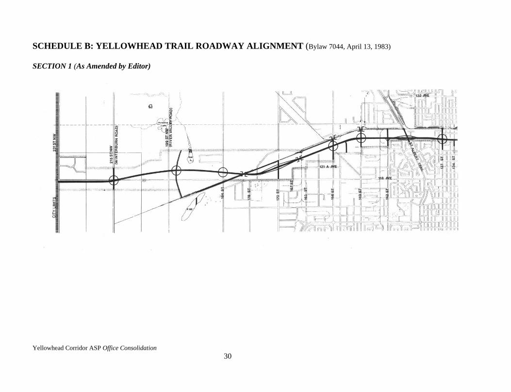
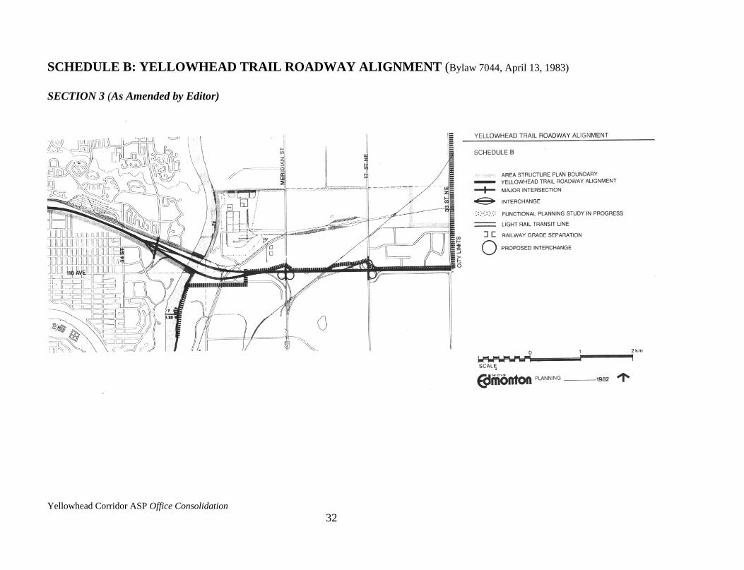
4.2 YELLOWHEAD TRAIL ROADWAY ALIGNMENT
4.2.1 Roadway Plan
Between the eastern City limit and 66 Street, the Trail is constructed as a four-lane divided
highway with provisions for six lanes. Two major at grade intersections exist at 50 Street and
66 Street.
From 66 Street to Fort Road, the Trail is constructed as a six-lane divided roadway. There is a
railway overpass.
Between Fort Road and 77 Street, the Trail is a five-lane divided roadway and from 77 Street
to 89 Street, it is a four-lane undivided roadway.
From 89 Street to 107 Street the Trail becomes a four-lane divided roadway, widening to a six-
lane divided roadway from 107 Street to 151 Street. There are two roadway underpasses in this
section of the Trail and major at grade intersections at 127 Street, 142 Street, and 149 Street.
A four-lane divided section of the Trail from 151 Street to 178 Street is scheduled for
completion in 1982, with a railway underpass at 163 Street, and a major at grade intersection at
156 Street.
The portion of the Trail between 178 Street and the west City limit will be constructed as a
four-lane divided roadway and is scheduled for completion in 1984.
4.2.2 Interchanges
Interchanges will be constructed to provide for the uninterrupted movement of traffic.
Interchanges have already been constructed at Meridian Street, 17 Street NE, and Victoria
Trail. Interchanges at 97 Street, St. Albert Trail, and 170 Street are scheduled for completion
in 1982. Two additional interchanges, for which functional planning studies are currently
underway, are under consideration for 82 Street and Wayne Gretzky Drive (Capilano
Yellowhead Corridor ASP Office Consolidation
29
Freeway). The following major intersections may some day be grade-separated: 50 Street, 66
Street, 127 Street, 149 Street, 156 Street, 184 Street, the proposed Parkway Ring Road and
Winterburn Road.
4.2.3 Access to the Trail
Access to the Yellowhead Trail will he via service or arterial and collector roads. In many
areas these roads already exist.
4.2.4 Truck Route
The Yellowhead Trail is currently identified as a Truck Route from the east City limits to 97
Street and from 121 Street to 149 Street. Upon completion of the roadway, the Trail will
become a continuous Truck Route.
Amended by Editor
Yellowhead Corridor ASP Office Consolidation
30
SCHEDULE B: YELLOWHEAD TRAIL ROADWAY ALIGNMENT (Bylaw 7044, April 13, 1983)
SECTION 1 (As Amended by Editor)

Yellowhead Corridor ASP Office Consolidation
31
SCHEDULE B: YELLOWHEAD TRAIL ROADWAY ALIGNMENT (Bylaw 7044, April 13, 1983)
SECTION 2 (As Amended by Editor)
Yellowhead Corridor ASP Office Consolidation
32
SCHEDULE B: YELLOWHEAD TRAIL ROADWAY ALIGNMENT (Bylaw 7044, April 13, 1983)
SECTION 3 (As Amended by Editor)
Yellowhead Corridor ASP Office Consolidation
33
CHAPTER FIVE – DEVELOPMENT POLICIES
5.1 DESIGN POLICIES
In keeping with the Urban Design Objectives in 3.2.4, the following policies are identified:
5.1.1 It is the policy of the Plan that loading and unloading facilities for medium
industrial and business industrial uses be located to the rear of buildings or
screened from view from the Yellowhead Trail.
5.1.2 It is the policy of the Plan that outdoor service, assembly, trash collection and
storage areas, including trucking yards associated with such activities, be
located to the rear of buildings or screened from view from the Yellowhead
Trail.
5.1.3 It is the policy of the Plan that parking facilities for medium industrial and
business industrial uses be located to the rear of buildings or screened from
view from the Yellowhead Trail.
These policies are implemented through Sections 69.2-69.4 and 73.2(4) in the Edmonton Land
Use Bylaw 5996.
In the Land Uses proposed in this Plan, the term "Prestige" is used to denote business
industrial uses incorporating the above design objectives and policies.
5.2 CIVIC DEVELOPMENT POLICIES
5.2.1 Noise Attenuation
i) It is a policy of the Plan that noise impacts of the Yellowhead Trail on the adjacent
residential communities be minimized through the construction of berms and/or
noise walls.
5.2.2 Landscaping
It is a policy of the Plan that the City develop attractive landscaping plans for the noise berms
and roadway right-of-ways adjacent to the Yellowhead Trail.
Yellowhead Corridor ASP Office Consolidation
34
5.2.3 Directional Signs
i) It is a policy of the Plan that the City identify the major streets intersecting the
Yellowhead Trail with overhead street signs.
ii) It is a policy of the Plan that the City provide directional signs to major City and
tourist facilities.
5.2.4 Tourist Information Facilities
It is a policy of the Plan that the City evaluate the potential for upgrading the services provided
at the tourist information facilities
5.2.5 Industrial Heights Subdivision
The City will promote the development of the Industrial Heights area. This is City owned land
which has recently been subdivided and zoned.
5.3 LAND USE POLICIES
5.3.1 Introduction
This section describes the proposed land uses in the eight sub-areas within the Plan.
The uses identified in this Plan are guides for the future development of the area.
Within the Plan, special study areas are identified. Potential uses and study guidelines for these
areas are discussed in Chapter 7.
Amended by Editor

Yellowhead Corridor ASP Office Consolidation
35
5.3.2 Sub-Area 1 - Edmonton West (Schedule C-1)
5.3.2.1 LAND USE OBJECTIVES
The land user proposed in this sub-area meet the following Plan objective:
to identify locations for new business industrial uses (Objective 3.2.2(i))
to identify locations for highway commercial uses (Objective 3.2.3(ii))
to identify a site for a tourist information facility (Objective 3.2.4(v))
to enhance the aesthetics of the Corridor through design guidelines (Objective 3.2.4(i))
to discourage residential uses in industrial areas (Objective 3.2.5(ii)).
5.3.2.2 PROPOSED LAND USES
i) "Prestige" Business Industrial
Much of the land adjacent to the Yellowhead Trail in this sub-area is proposed for
quality industrial, research-oriented, and business and office uses. The area
identified for business industrial uses south of the Trail and west of 215 Street NW
(Winterburn Road) will he accessed via an internal road system.
ii) Medium Industrial
One area of medium industrial use is proposed within this sub-area. This land
does not have direct access to Highway 16 (Yellowhead Trail), but does have
potential rail access, and will be developed with lands outside of this Plan’s
boundaries.
iii) Highway Commercial
A mixed highway commercial and prestige industrial business area is proposed
from 184 Street to Winterburn Road, south of the Trail. Uses such as service
stations, restaurants, motels, tourist information facilities and prestige industrial
business uses will be encouraged in this area. No service road will be required;
the development will be accessed from 118 A Avenue.
Amended by Editor
Bylaw 9879
September 24, 1991
Bylaw 10653
November 8, 1994
Amended by Editor
Bylaw 13162
August 19, 2002
Yellowhead Corridor ASP Office Consolidation
36
iv) Residential
The existing residential area known as Big Lake Estates will be retained. The
residential community known as Mooncrest Park will be dealt with in the
Kinokamau Plains Servicing Concept Design Brief (SCDB) and therefore excluded
from this Plan. The lots immediately south of Mooncrest Park will also be dealt
with in the SCDB.
v) Tourist Information Facility
A location for a City Tourist Information Facility is identified. A specific site will
be identified during a future development stage.
5.3.2.3 STAGING OF DEVELOPMENT
Development in this area will depend on the preparation of adjacent Area Structure Plans.
These Area Structure Plans may overlap with this Plan but must incorporate the land use and
design policies of this Plan. Areas which will not require further Area Structure Plans include:
i) Big Lake Estates, and
ii) the area between the Yellowhead Trail, 118 Avenue and 184 Street.
Also impacting development of this area is the timing for construction of Parkway Ring Road.
When this occurs, surplus RDA land may be released for development. Development of these
areas should reflect the adjacent land use proposed by this Plan.
Bylaw 9997
January 20, 1992
Bylaw 10653
November 8, 1994
Bylaw 10653
November 8, 1994
Yellowhead Corridor ASP Office Consolidation
37
PROPOSED LAND USES SCHEDULE C-1 SUB-AREA 1 (Bylaw 15377, February 16, 2010)
Yellowhead Corridor ASP Office Consolidation
38
5.3.3 Sub-Area 2 - Northwest Industrial Area (Schedule C-2)
5.3.3.1 LAND USE OBJECTIVES
The land uses proposed in this sub-area meet the following Plan objectives:
i) to identity locations for new business industrial uses (Objective 3.2.2(i))
ii) to identify locations for highway commercial uses (Objective 3.2.3(ii))
iii) to maintain existing supply of rail services lots (Objective 3.2.2(iii))
iv) to maintain medium industrial uses in the Corridor (Objective 3.2.2(ii)).
5.3.3.2 PROPOSED LAND USES
i) "Prestige" Business Industrial
The area between 170 Street and 149 Street will be developed as a prestige
business area where industrial and small scale business office uses are encouraged.
The existing Medium Industrial Districted area could remain but is subject to the
design policies of this Plan.
The predominant features of the development of this area include the following:
industrial and office development will be encouraged; and
lots adjacent to the Trail will be accessed via internal roads.
Lots adjacent to 149 Street may be considered for "Prestige" Business Industrial
uses providing they support the Plan's objectives.
ii) Medium Industrial
Land not adjacent to or visible from the Trail will be retained for Medium
Industrial uses. Business industrial uses may be considered for these areas.
iii) Highway Commercial“Prestige” Business Industrial
Hotels, motels, service stations and other uses directly related to providing services
to the travelling public, as well as prestige business industrial uses, will be
permitted in the area identified on Schedule C-2 for the Highway
Commercial/”Prestige Business Industrial use west of 170 Street. The proximity of
Bylaw 13574
January 13, 2004

Yellowhead Corridor ASP Office Consolidation
39
the area to the interchange at Yellowhead Trail and 170 Street allows for viable
highway commercial development opportunities, while the industrial character of
the surrounding area allows for viable industrial business opportunities. Access
will be permitted only from 118 Avenue.
iv) Commercial
Hotels, motels, service stations, and other retail uses will be permitted in the areas
identified on Schedule C-2 at the 149 Street intersection.
v) Other
Casinos and Other Major Gaming Establishments will be considered within the
context of a Direct Control Provision in an area identified on Schedule C-2 along
153 Street abutting the Yellowhead Trail.
5.3.3.3 STAGING OF DEVELOPMENT
The development of this area south of the railway tracks may proceed at the initiation of the
land owner. Rezoning to the appropriate zone identified in this Plan may be required. Access to
the individual parcel should be resolved prior to development.
The area north of the railway tracks may not be developed prior to the preparation of the
adjacent Area Structure Plan.
Amended by Editor
Amended by Editor
Bylaw 12076
June 28, 1999
Amended by Editor
Yellowhead Corridor ASP Office Consolidation
40
PROPOSED LAND USES SCHEDULE C-2 SUB-AREA 2
(Bylaw 13668, May 3, 2004)
Railway
Yellowhead Corridor ASP Office Consolidation
41
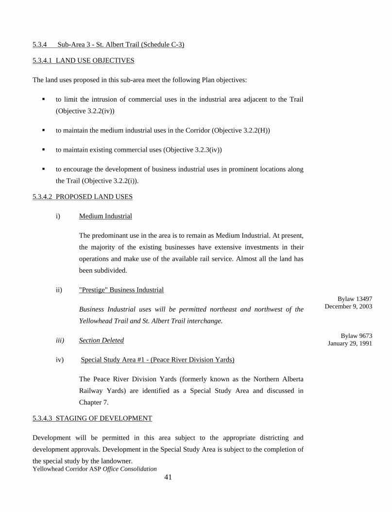
5.3.4 Sub-Area 3 - St. Albert Trail (Schedule C-3)
5.3.4.1 LAND USE OBJECTIVES
The land uses proposed in this sub-area meet the following Plan objectives:
to limit the intrusion of commercial uses in the industrial area adjacent to the Trail
(Objective 3.2.2(iv))
to maintain the medium industrial uses in the Corridor (Objective 3.2.2(H))
to maintain existing commercial uses (Objective 3.2.3(iv))
to encourage the development of business industrial uses in prominent locations along
the Trail (Objective 3.2.2(i)).
5.3.4.2 PROPOSED LAND USES
i) Medium Industrial
The predominant use in the area is to remain as Medium Industrial. At present,
the majority of the existing businesses have extensive investments in their
operations and make use of the available rail service. Almost all the land has
been subdivided.
ii) "Prestige" Business Industrial
Business Industrial uses will be permitted northeast and northwest of the
Yellowhead Trail and St. Albert Trail interchange.
iii) Section Deleted
iv) Special Study Area #1 - (Peace River Division Yards)
The Peace River Division Yards (formerly known as the Northern Alberta
Railway Yards) are identified as a Special Study Area and discussed in
Chapter 7.
5.3.4.3 STAGING OF DEVELOPMENT
Development will be permitted in this area subject to the appropriate districting and
development approvals. Development in the Special Study Area is subject to the completion of
the special study by the landowner.
Bylaw 9673
January 29, 1991
Bylaw 13497
December 9, 2003
Yellowhead Corridor ASP Office Consolidation
42
PROPOSED LAND USES SCHEDULE C-3 SUB-AREA 3
(Bylaw 18455, July 9, 2018)
Yellowhead Corridor ASP Office Consolidation
43
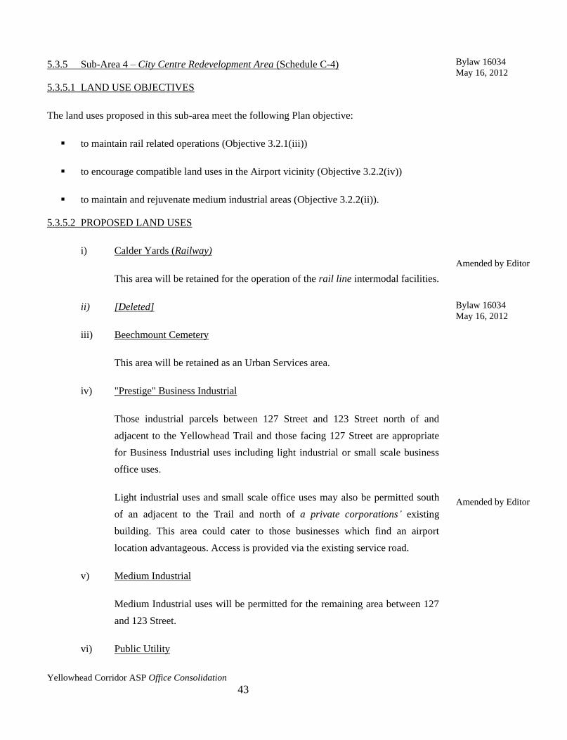
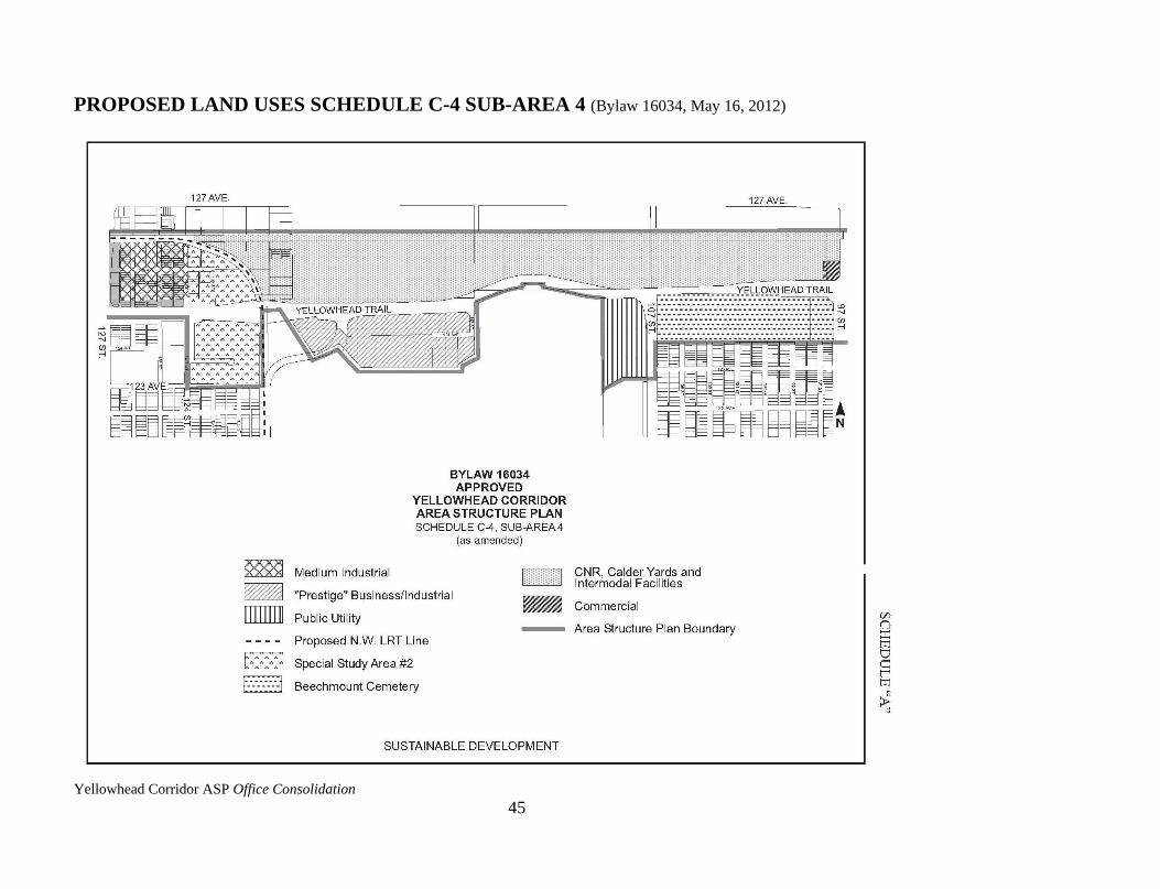
5.3.5 Sub-Area 4 – City Centre Redevelopment Area (Schedule C-4)
5.3.5.1 LAND USE OBJECTIVES
The land uses proposed in this sub-area meet the following Plan objective:
to maintain rail related operations (Objective 3.2.1(iii))
to encourage compatible land uses in the Airport vicinity (Objective 3.2.2(iv))
to maintain and rejuvenate medium industrial areas (Objective 3.2.2(ii)).
5.3.5.2 PROPOSED LAND USES
i) Calder Yards (Railway)
This area will be retained for the operation of the rail line intermodal facilities.
ii) [Deleted]
iii) Beechmount Cemetery
This area will be retained as an Urban Services area.
iv) "Prestige" Business Industrial
Those industrial parcels between 127 Street and 123 Street north of and
adjacent to the Yellowhead Trail and those facing 127 Street are appropriate
for Business Industrial uses including light industrial or small scale business
office uses.
Light industrial uses and small scale office uses may also be permitted south
of an adjacent to the Trail and north of a private corporations’ existing
building. This area could cater to those businesses which find an airport
location advantageous. Access is provided via the existing service road.
v) Medium Industrial
Medium Industrial uses will be permitted for the remaining area between 127
and 123 Street.
vi) Public Utility
Amended by Editor
Amended by Editor
Bylaw 16034
May 16, 2012
Bylaw 16034
May 16, 2012

Yellowhead Corridor ASP Office Consolidation
44
This area will be retained for public utility uses.
vii) Special Study Area #2 - (Proposed Northwest LRT Corridor)
This Special Study Area recognizes the potential impacts of the Northeast
Light Rail Transit Corridor and is further discussed in Chapter 7.
5.3.5.3 STAGING OF DEVELOPMENT
Development in this area is subject to the land owner's initiative. The appropriate redistricting,
subdivision and development approvals are required. Development in the Special Study Area
is dependent on the timing of the proposed LRT Corridor.
Yellowhead Corridor ASP Office Consolidation
45
PROPOSED LAND USES SCHEDULE C-4 SUB-AREA 4 (Bylaw 16034, May 16, 2012)

Yellowhead Corridor ASP Office Consolidation
46
5.3.6 Sub-Area 5 - Woodland Industrial Area (Schedule C-5)
5.3.6.1 LAND USE OBJECTIVES
The land uses proposed in this sub-area meet the following Plan objectives:
to maintain and rejuvenate the medium industrial areas in the Corridor (Objective
3.2.2(ii))
to encourage development of business industrial uses (Objective 3.2.2(i))
to maintain existing commercial uses (Objective 3.2.3(iv)).
5.3.6.2 PROPOSED LAND USES
i) Medium Industrial
Most land in this sub-area will be retained for Medium Industrial uses in order
to take advantage of rail access and highway proximity. Existing service
roads will be used for access.
ii) Commercial
Commercial and retail uses are designated for land at both 97 Street and 82
Street. Uses which are consistent with a general business district are
appropriate in these locations. These uses will be impacted by proposed
interchanges which may limit their potential for commercial and retail uses.
iii) "Prestige" Business Industrial
Business office or light industrial uses are proposed between 89 Street and 85
Street of north and adjacent to the Trail and adjacent to 97 Street and 82
Street as identified on Schedule C-5. Existing service roads will be used.
5.3.6.3 STAGING OF DEVELOPMENT
Development in this sub-area is subject to the land owner's initiative. The appropriate rezoning
and development approvals are required.
Amended by Editor

Yellowhead Corridor ASP Office Consolidation
47
PROPOSED LAND USES SCHEDULE C-5 SUB-AREA 5 (Bylaw 19907, December 7, 2021)
Yellowhead Corridor ASP Office Consolidation
48
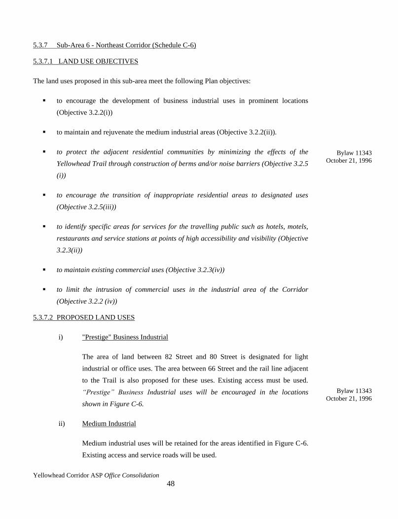
5.3.7 Sub-Area 6 - Northeast Corridor (Schedule C-6)
5.3.7.1 LAND USE OBJECTIVES
The land uses proposed in this sub-area meet the following Plan objectives:
to encourage the development of business industrial uses in prominent locations
(Objective 3.2.2(i))
to maintain and rejuvenate the medium industrial areas (Objective 3.2.2(ii)).
to protect the adjacent residential communities by minimizing the effects of the
Yellowhead Trail through construction of berms and/or noise barriers (Objective 3.2.5
(i))
to encourage the transition of inappropriate residential areas to designated uses
(Objective 3.2.5(iii))
to identify specific areas for services for the travelling public such as hotels, motels,
restaurants and service stations at points of high accessibility and visibility (Objective
3.2.3(ii))
to maintain existing commercial uses (Objective 3.2.3(iv))
to limit the intrusion of commercial uses in the industrial area of the Corridor
(Objective 3.2.2 (iv))
5.3.7.2 PROPOSED LAND USES
i) "Prestige" Business Industrial
The area of land between 82 Street and 80 Street is designated for light
industrial or office uses. The area between 66 Street and the rail line adjacent
to the Trail is also proposed for these uses. Existing access must be used.
“Prestige” Business Industrial uses will be encouraged in the locations
shown in Figure C-6.
ii) Medium Industrial
Medium industrial uses will be retained for the areas identified in Figure C-6.
Existing access and service roads will be used.
Bylaw 11343
October 21, 1996
Bylaw 11343
October 21, 1996
Yellowhead Corridor ASP Office Consolidation
49
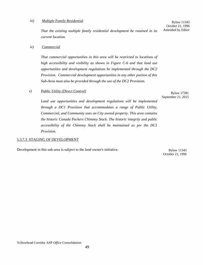
iii) Multiple Family Residential
That the existing multiple family residential development be retained in its
current location.
iv) Commercial
That commercial opportunities in this area will be restricted to locations of
high accessibility and visibility as shown in Figure C-6 and that land use
opportunities and development regulations be implemented through the DC2
Provision. Commercial development opportunities in any other portion of this
Sub-Area must also be provided through the use of the DC2 Provision.
v) Public Utility (Direct Control)
Land use opportunities and development regulations will be implemented
through a DC1 Provision that accommodates a range of Public Utility,
Commercial, and Community uses on City owned property. This area contains
the historic Canada Packers Chimney Stack. The historic integrity and public
accessibility of the Chimney Stack shall be maintained as per the DC1
Provision.
5.3.7.3 STAGING OF DEVELOPMENT
Development in this sub-area is subject to the land owner's initiative.
Bylaw 11343
October 21, 1996
Amended by Editor
Bylaw 11343
October 21, 1996
Bylaw 17381
September 21, 2015

Yellowhead Corridor ASP Office Consolidation
50
PROPOSED LAND USES SCHEDULE C-6 SUB-AREA 6
(Bylaw 19273, Approved March 15, 2021)

Yellowhead Corridor ASP Office Consolidation
51
5.3.8 Sub-Area 7 Industrial Heights (Schedule C-7)
5.3.8.1 LAND USE OBJECTIVES
The land uses proposed in this sub-area meet the following objectives:
to encourage the development of business industrial uses (Objective 3.2.2(i))
to encourage the use of rail spurs (Objective 3.2.1(iii)).
5.3.8.2 PROPOSED LAND USES
i) Heavy Industrial
This area identifies existing Heavy Industrial use. Based on the current investment
in present operations, it appears that the use is stable. If, however, this does change,
the Plan recognizes that this site has redevelopment potential and an amendment to
the Plan would be required.
ii) "Prestige" Business Industrial
Light industrial and business office uses are proposed for most areas adjacent to the
Trail. Access to these lots is obtained via an internal road system.
iii) Medium Industrial
Medium industrial uses are proposed for those areas not adjacent to the Trail. The
existing roads will be used.
5.3.8.3 STAGING OF DEVELOPMENT
Development in this sub-area is subject to the land owner's initiative. Appropriate rezoning and
development approvals are required.
Amended by Editor

Yellowhead Corridor ASP Office Consolidation
52
PROPOSED LAND USES SCHEDULE C-7, SUB-AREA 7 (Bylaw 16696, February 2014)

Yellowhead Corridor ASP Office Consolidation
53
5.3.9 Sub-Area 8 - Edmonton East (Schedule C-8)
5.3.9.1 LAND USE OBJECTIVES
The land uses proposed in this sub-area meet the following Plan objectives:
to identity specific areas for services for the travelling public such as hotels, motels,
restaurants and service stations (Objective 3.2.3(i))
to maintain medium industrial areas (Objective 3.2.2(ii)).
5.3.9.2 PROPOSED LAND USES
i) Heavy Industrial
The predominant use in this sub-area will remain Heavy Industrial. The existing
heavy industrial users have extensive investments in their operations, make use of
the available rail service, and are not hampered by encroaching residential
development. Additional heavy industrial land is proposed in this sub-area to
capitalize on the locational advantages.
ii) Medium Industrial
Medium industrial uses are proposed across the Clover Bar and Strathcona 16
Industrial subdivisions to take advantage of existing rail access and to provide a
buffer between heavy industrial uses to the north and highway commercial and
"prestige" business industrial and office uses to the south.
iii) "Prestige" Business Industrial
Light industrial and business office uses are proposed for several areas which are
directly adjacent to and visible from the Trail. These areas are to be accessed by
service roads.
iv) Highway Commercial
A highway commercial area is identified in this sub-area to meet the needs of
travellers entering the City from the east. Uses such as service stations, restaurants,
motels, and a tourist information facility are proposed and would be easily accessed
by an existing service road.
Yellowhead Corridor ASP Office Consolidation
54
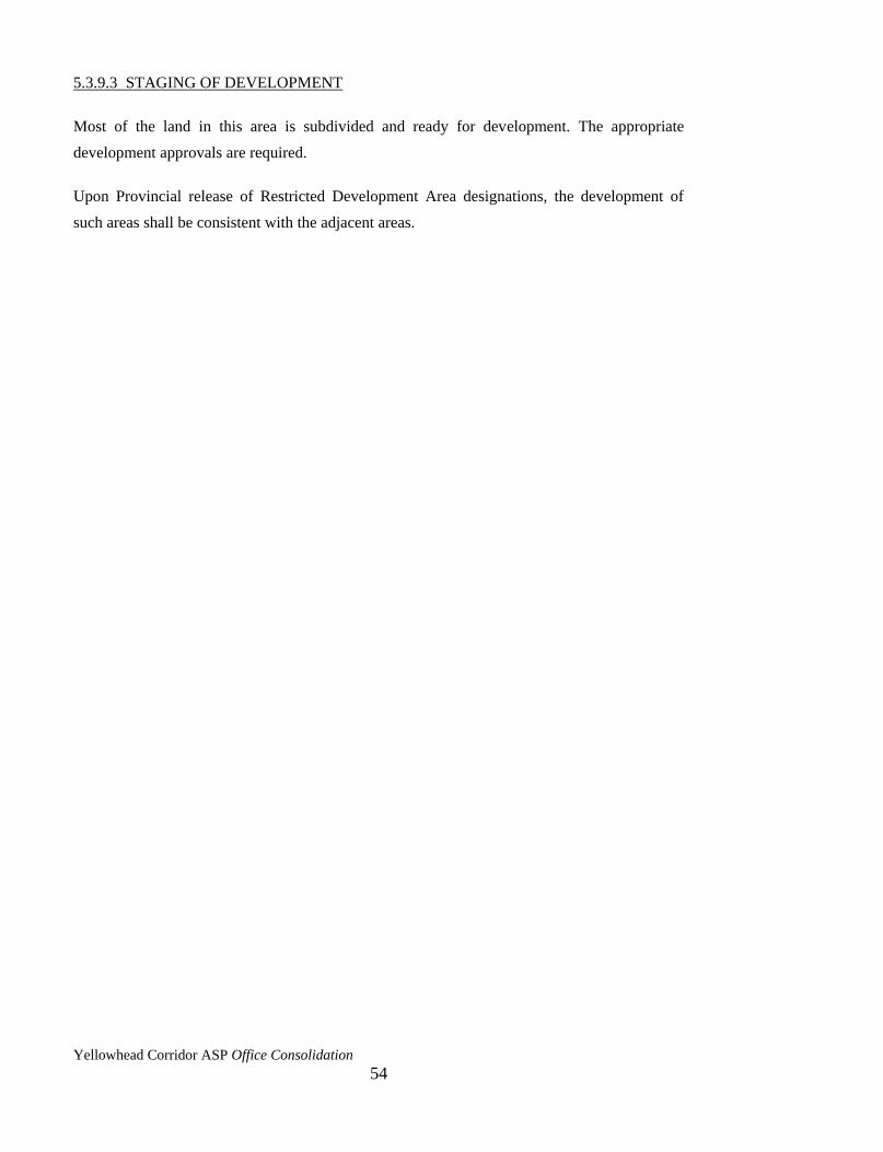
5.3.9.3 STAGING OF DEVELOPMENT
Most of the land in this area is subdivided and ready for development. The appropriate
development approvals are required.
Upon Provincial release of Restricted Development Area designations, the development of
such areas shall be consistent with the adjacent areas.
Yellowhead Corridor ASP Office Consolidation
55
PROPOSED LAND USES SCHEDULE C-8 SUB-AREA 8 (Bylaw 15843, August 29, 2011)
Yellowhead Corridor ASP Office Consolidation
56
5.4 RESERVE LAND
Reserve Land is not identified within the Plan area. Where reserve land is a requirement of
subdivision (Section 97, Planning Act), reserve land or money in lieu of land will be taken
subject to the existing Municipal Planning Commission Guidelines.
5.5 POPULATION DENSITY
In accordance with Section 64(2) of the Planning Act, an Area Structure Plan must describe the
density of population proposed. Since this Plan deals essentially with industrial development, a
detailed population description is not included. There is, however, one residential area within
the Plan which will be retained. Big Lake Estates residential area located on the west boundary
of the City, will be retained in its present form. This is a rural residential development with a
density of 0.43 units per hectare.
Yellowhead Corridor ASP Office Consolidation
57
CHAPTER SIX – PROPOSED UTILITIES AND OTHER SERVICES
6.1 UTILITY SERVICES
6.1.1 Storm and Sanitary Sewers
a) The provision of storm and sanitary sewers will be investigated throughout the
Yellowhead Corridor with the purpose of ensuring that adequate facilities exist to
meet anticipated future development.
b) As a condition of subdivision, rezoning and/or development in the area between 142
Street and the North Saskatchewan River, storm water discharge rates shall be limited
to those currently generated by the site. This may require storm water management
techniques such as roof-top storage, surface ponding, underground storage and others.
Design drawings showing the calculations and techniques of storm water management
used are required prior to development approval. This is in addition to other
applicable regulations.
c) All drainage requirements for areas west of 142 Street shall incorporate the storm
water management recommendations provided in the Watershed Plan for Northwest
Annexation Areas, and conform to the City's 1982 Servicing Standards Manual.
d) The drainage requirements for the area east of the North Saskatchewan River are
being studied taking into account both economic and environmental factors. This area
will be serviced either by existing ditches and watercourses using storm water
management techniques or by new outfalls to the River, and shall conform to the
City's 1982 Servicing Standards Manual.
e) The Sanitary Trunk System Study, prepared by the Edmonton Water and Sanitation
Department, recommends that the sanitary servicing requirements for the area west of
142 Street be provided by the Parkland Sewage Transmission Line.
f) The area east of the North Saskatchewan River may be serviced by the existing
Southeast Regional Sewage Transmission Line constructed by Alberta Environment.
Yellowhead Corridor ASP Office Consolidation
58
6.1.2 Water
The City will monitor the water supply system within the Yellowhead Corridor to ensure an
adequate supply for present and future development. For Sub-Area 1, which is not currently
serviced, the City will prepare a servicing plan which must be in place for future development
of the area.
Schedule D-1 identifies existing storm, sanitary and water system facilities.
6.1.3 Power and Telephones
For new developments adjacent to the Yellowhead Trail, customer laterals shall be located
underground. Where feasible, distribution feeders should also be located underground.
The provision of electrical power and telephone service to the Plan area will be monitored in
order to maintain an adequate level of service, particularly in Sub-Area 1 and Sub-Area 8,
recently annexed by the City.
Schedule "D-2" identifies existing facilities and lines.
6.2 RAIL SERVICES
It is a policy of this Plan to maintain and promote the use of rail facilities within the
Yellowhead Corridor by proposing land uses which are compatible with rail servicing
wherever feasible. Parcels of land with existing rail spur facilities can be identified on
Schedule B – Yellowhead Trail Roadway Alignment.
6.3 AIRPORT SERVICES
It is a policy of this Plan to promote the use of and ensure the safe operation of the Edmonton
Municipal Airport through the provision of land uses that are compatible with the airport's
operations. In this regard, roof-top storage, mentioned in 6.1.1(b), should not occur in the
vicinity of the airport due to the potential operational hazard which it may create.
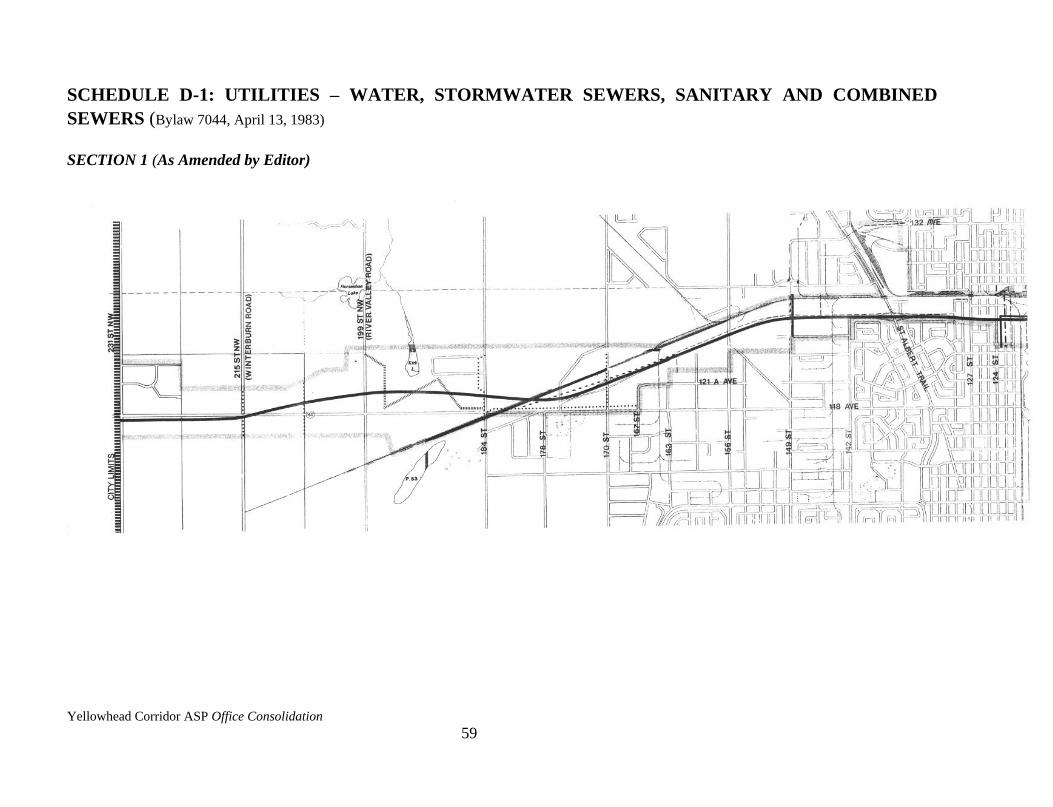
Yellowhead Corridor ASP Office Consolidation
59
SCHEDULE D-1: UTILITIES – WATER, STORMWATER SEWERS, SANITARY AND COMBINED
SEWERS (Bylaw 7044, April 13, 1983)
SECTION 1 (As Amended by Editor)
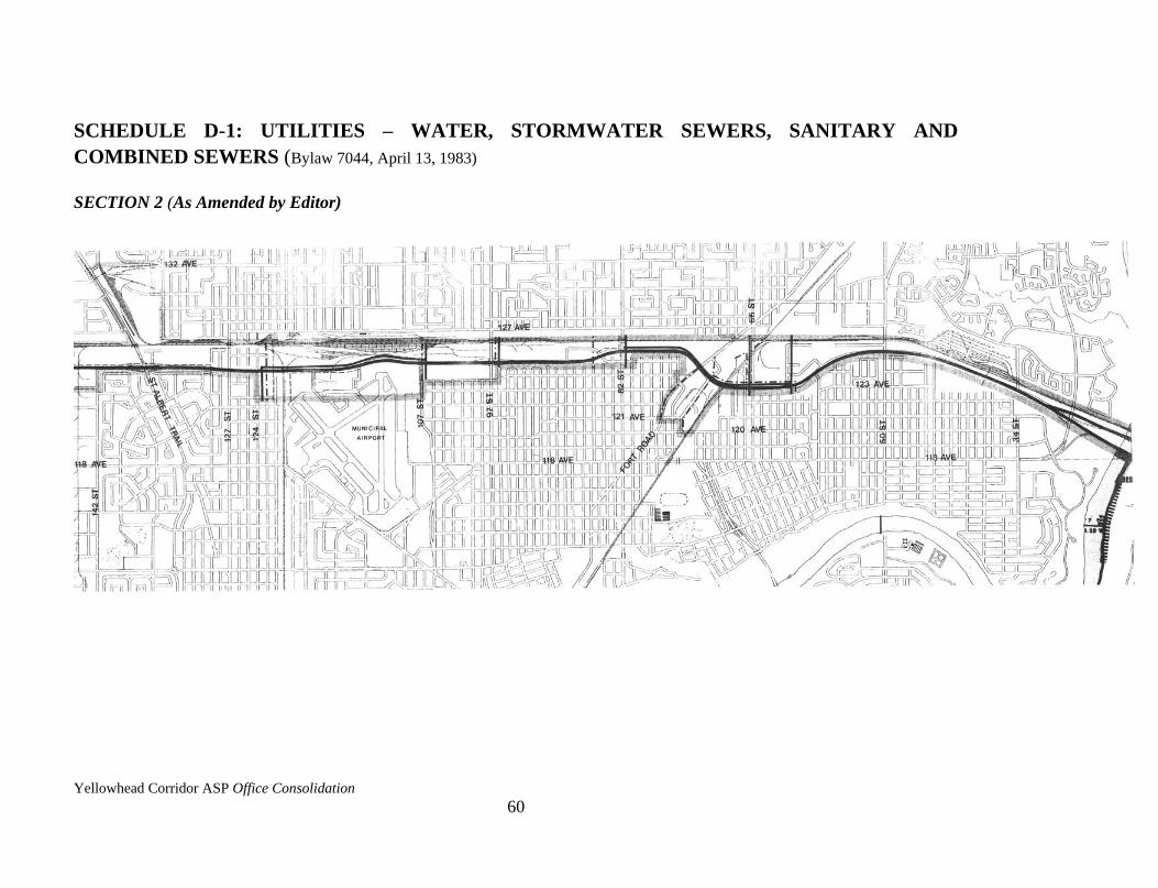
Yellowhead Corridor ASP Office Consolidation
60
SCHEDULE D-1: UTILITIES – WATER, STORMWATER SEWERS, SANITARY AND
COMBINED SEWERS (Bylaw 7044, April 13, 1983)
SECTION 2 (As Amended by Editor)

Yellowhead Corridor ASP Office Consolidation
61
SCHEDULE D-1: UTILITIES – WATER, STORMWATER SEWERS, SANITARY AND
COMBINED SEWERS (Bylaw 7044, April 13, 1983)
SECTION 3 (As Amended by Editor)
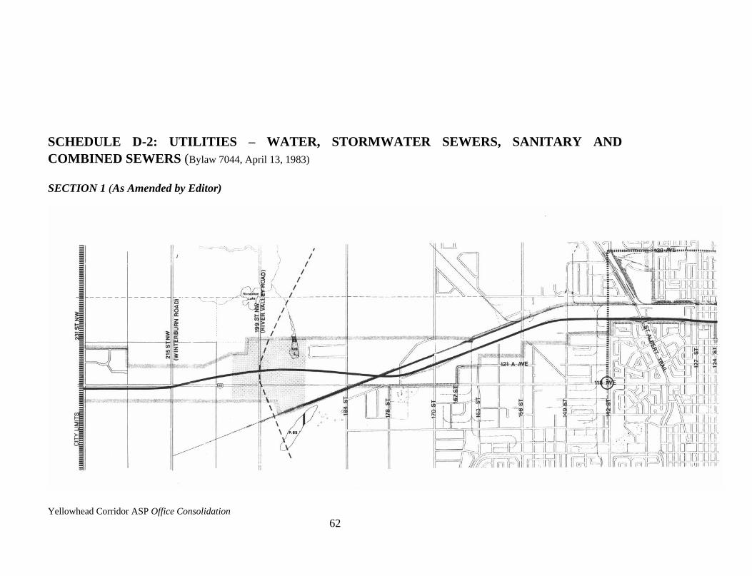
Yellowhead Corridor ASP Office Consolidation
62
SCHEDULE D-2: UTILITIES – WATER, STORMWATER SEWERS, SANITARY AND
COMBINED SEWERS (Bylaw 7044, April 13, 1983)
SECTION 1 (As Amended by Editor)
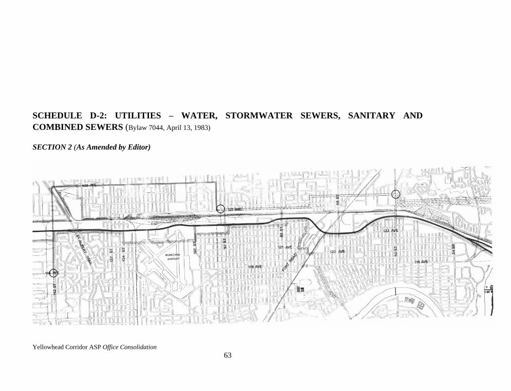
Yellowhead Corridor ASP Office Consolidation
63
SCHEDULE D-2: UTILITIES – WATER, STORMWATER SEWERS, SANITARY AND
COMBINED SEWERS (Bylaw 7044, April 13, 1983)
SECTION 2 (As Amended by Editor)

Yellowhead Corridor ASP Office Consolidation
64
SCHEDULE D-2: UTILITIES – WATER, STORMWATER SEWERS, SANITARY AND
COMBINED SEWERS (Bylaw 7044, April 13, 1983)
SECTION 3 (As Amended by Editor)
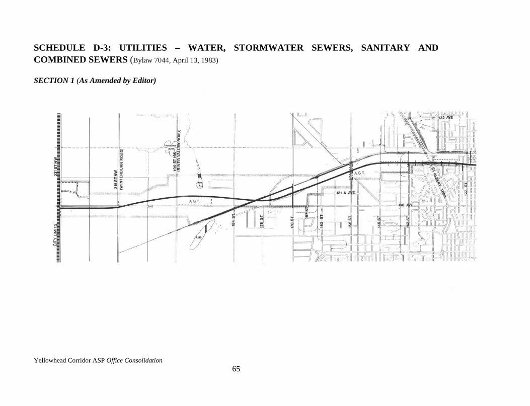
Yellowhead Corridor ASP Office Consolidation
65
SCHEDULE D-3: UTILITIES – WATER, STORMWATER SEWERS, SANITARY AND
COMBINED SEWERS (Bylaw 7044, April 13, 1983)
SECTION 1 (As Amended by Editor)
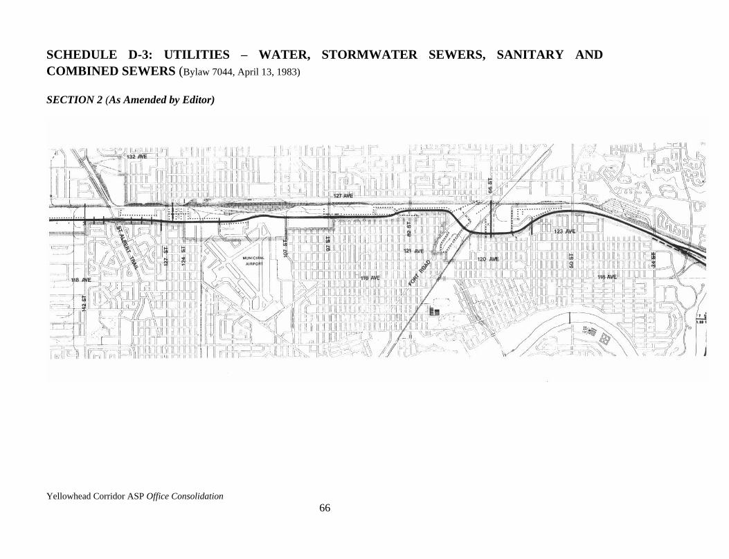
Yellowhead Corridor ASP Office Consolidation
66
SCHEDULE D-3: UTILITIES – WATER, STORMWATER SEWERS, SANITARY AND
COMBINED SEWERS (Bylaw 7044, April 13, 1983)
SECTION 2 (As Amended by Editor)
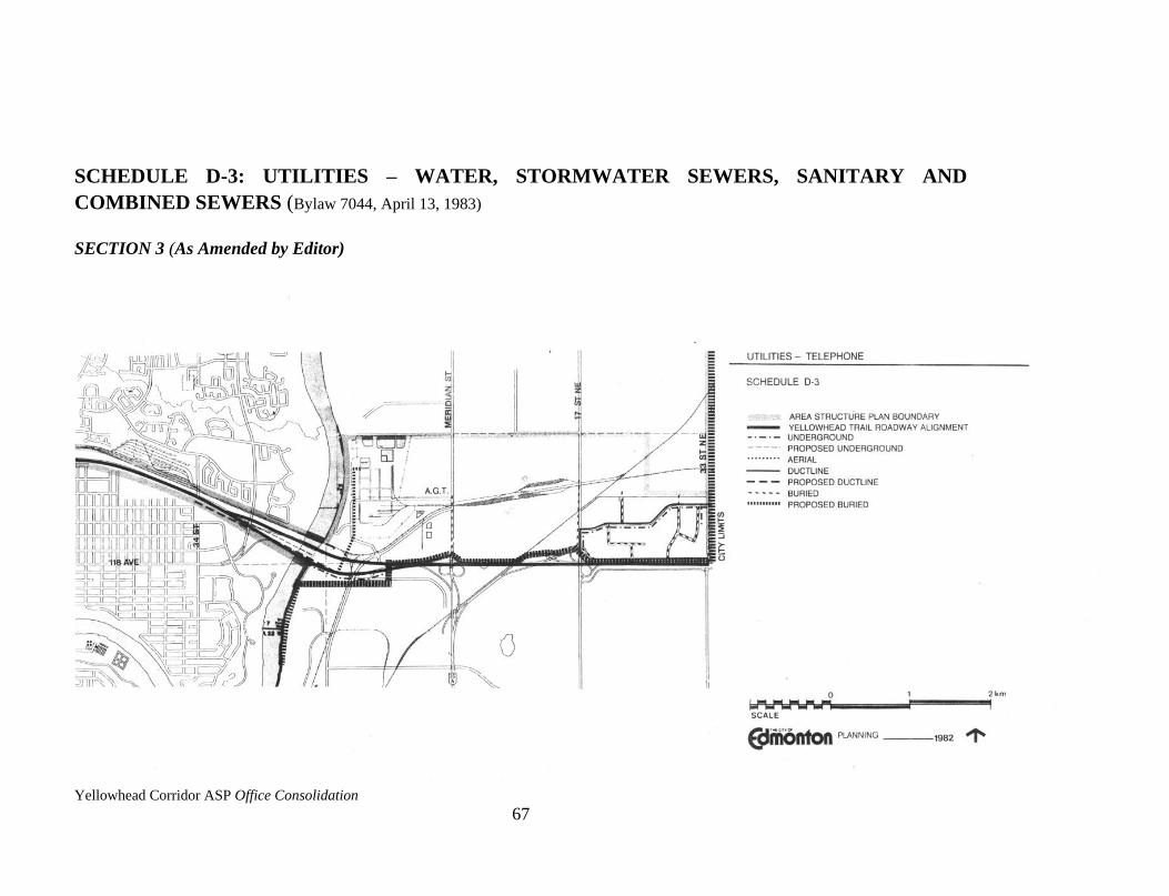
Yellowhead Corridor ASP Office Consolidation
67
SCHEDULE D-3: UTILITIES – WATER, STORMWATER SEWERS, SANITARY AND
COMBINED SEWERS (Bylaw 7044, April 13, 1983)
SECTION 3 (As Amended by Editor)

Yellowhead Corridor ASP Office Consolidation
68
CHAPTER SEVEN – PLAN IMPLEMENTATION
7.1 LAND USE IMPLEMENTATION
The design policies identified in 5.1.1, 5.1.2, and 5.1.3 are implemented through Sections 69.2-
69.4 and 73.2(4) in the Edmonton Land Use Bylaw 5996.
7.1.1 Specific Provisions Affecting Consideration of Discretionary Uses in IB Zones
(1) To meet objectives 3.2.1(i), 3.2.2(iv), 3.2.3(i), and 3.2.3(iii), the following Discretionary
Uses of a retail and traffic generating nature are discouraged:
i) Automotive and Minor Recreational Vehicle Sales/Rentals,
ii) Automotive and Equipment Repair Shops,
iii) Convenience Retail Stores,
iv) Drive-in Food Services,
v) Fleet Services,
vi) Major Eating and Drinking Establishments,
vii) Rapid Drive Through Vehicle Services,
viii) Recycling Depots.
7.1.2 Rezoning
Rezoning applications appropriate to the land uses proposed in Chapter 5 of this Plan will be
supported by Sustainable Development.
Rezoning of Medium Industrial parcels to Business Industrial Uses not specifically identified
in the Schedule C maps may receive Sustainable Development support if they support
objectives 3.2.1(i), 3.2.2(ii), 3.2.2(iii), and 3.2.4(i).
7.1.3 Special Study Areas
Amended by Editor
Amended by Editor
Amended by Editor
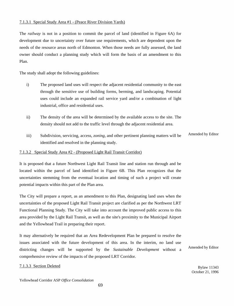
Yellowhead Corridor ASP Office Consolidation
69
7.1.3.1 Special Study Area #1 - (Peace River Division Yards)
The railway is not in a position to commit the parcel of land (identified in Figure 6A) for
development due to uncertainty over future use requirements, which are dependent upon the
needs of the resource areas north of Edmonton. When those needs are fully assessed, the land
owner should conduct a planning study which will form the basis of an amendment to this
Plan.
The study shall adopt the following guidelines:
i) The proposed land uses will respect the adjacent residential community to the east
through the sensitive use of building forms, berming, and landscaping. Potential
uses could include an expanded rail service yard and/or a combination of light
industrial, office and residential uses.
ii) The density of the area will be determined by the available access to the site. The
density should not add to the traffic level through the adjacent residential area.
iii) Subdivision, servicing, access, zoning, and other pertinent planning matters will be
identified and resolved in the planning study.
7.1.3.2 Special Study Area #2 - (Proposed Light Rail Transit Corridor)
It is proposed that a future Northwest Light Rail Transit line and station run through and be
located within the parcel of land identified in Figure 6B. This Plan recognizes that the
uncertainties stemming from the eventual location and timing of such a project will create
potential impacts within this part of the Plan area.
The City will prepare a report, as an amendment to this Plan, designating land uses when the
uncertainties of the proposed Light Rail Transit project are clarified as per the Northwest LRT
Functional Planning Study. The City will take into account the improved public access to this
area provided by the Light Rail Transit, as well as the site's proximity to the Municipal Airport
and the Yellowhead Trail in preparing their report.
It may alternatively be required that an Area Redevelopment Plan be prepared to resolve the
issues associated with the future development of this area. In the interim, no land use
districting changes will be supported by the Sustainable Development without a
comprehensive review of the impacts of the proposed LRT Corridor.
7.1.3.3 Section Deleted
Amended by Editor
Amended by Editor
Bylaw 11343
October 21, 1996
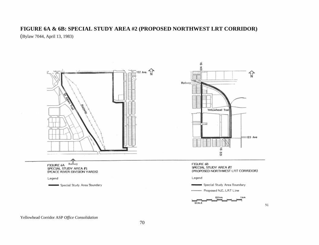
Yellowhead Corridor ASP Office Consolidation
70
FIGURE 6A & 6B: SPECIAL STUDY AREA #2 (PROPOSED NORTHWEST LRT CORRIDOR)
(Bylaw 7044, April 13, 1983)
Railway
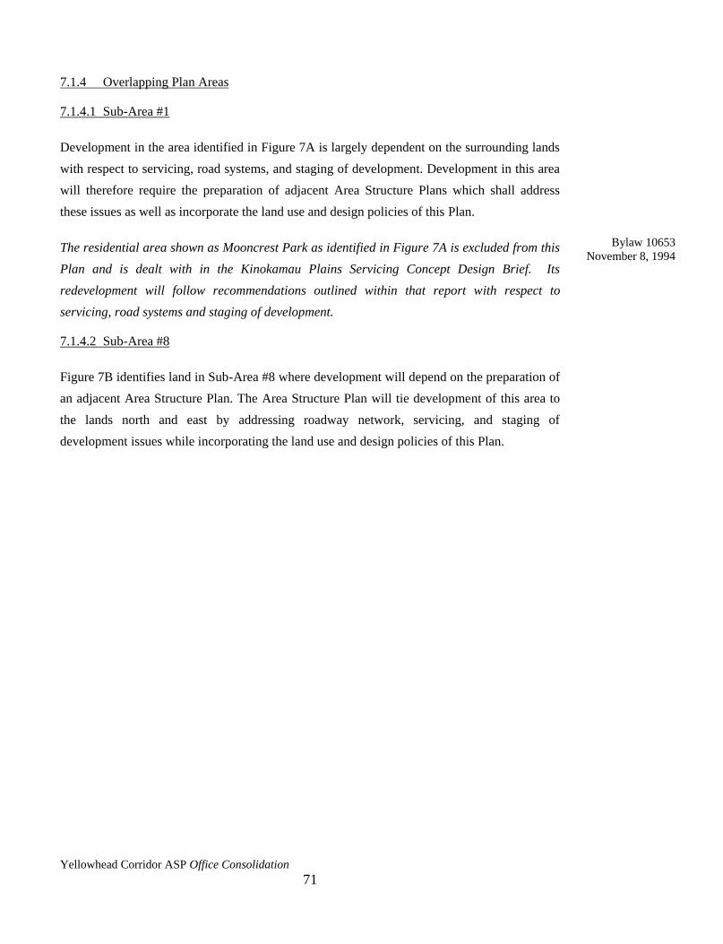
Yellowhead Corridor ASP Office Consolidation
71
7.1.4 Overlapping Plan Areas
7.1.4.1 Sub-Area #1
Development in the area identified in Figure 7A is largely dependent on the surrounding lands
with respect to servicing, road systems, and staging of development. Development in this area
will therefore require the preparation of adjacent Area Structure Plans which shall address
these issues as well as incorporate the land use and design policies of this Plan.
The residential area shown as Mooncrest Park as identified in Figure 7A is excluded from this
Plan and is dealt with in the Kinokamau Plains Servicing Concept Design Brief. Its
redevelopment will follow recommendations outlined within that report with respect to
servicing, road systems and staging of development.
7.1.4.2 Sub-Area #8
Figure 7B identifies land in Sub-Area #8 where development will depend on the preparation of
an adjacent Area Structure Plan. The Area Structure Plan will tie development of this area to
the lands north and east by addressing roadway network, servicing, and staging of
development issues while incorporating the land use and design policies of this Plan.
Bylaw 10653
November 8, 1994

Yellowhead Corridor ASP Office Consolidation
72
FIGURE 6C: MAP DELETED (Bylaw 11343, October 21, 1996)
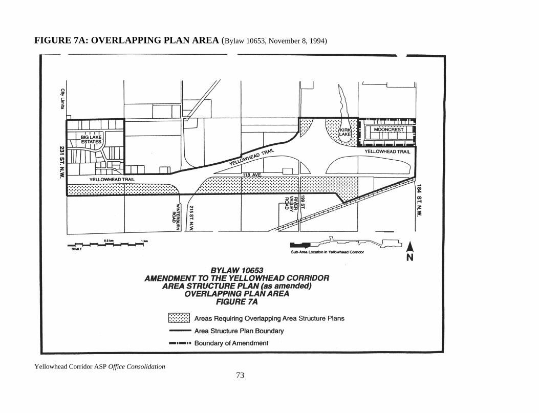
Yellowhead Corridor ASP Office Consolidation
73
FIGURE 7A: OVERLAPPING PLAN AREA (Bylaw 10653, November 8, 1994)
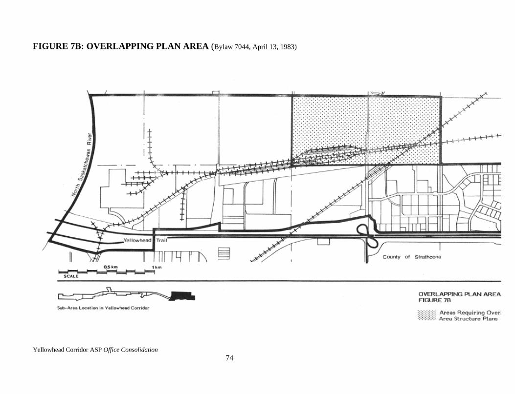
Yellowhead Corridor ASP Office Consolidation
74
FIGURE 7B: OVERLAPPING PLAN AREA (Bylaw 7044, April 13, 1983)

Yellowhead Corridor ASP Office Consolidation
75
7.2 CIVIC DEVELOPMENT IMPLEMENTATION
The Civic Development policies identified in 5.2.1, 5.2.2, 5.2.3, 5.2.4, and 5.2.5 of this Plan
shall be implemented by the City in the following manner.
7.2.1 Noise Attenuation
The City is currently evaluating the needs of the residential areas adjacent to the Yellowhead
Trail through the Yellowhead Trail Noise Attenuation Studies. Noise attenuation will be
achieved through the construction of berms and/or noise walls where residential communities
are situated adjacent to the Trail.
7.2.2 Landscaping
i) The City will implement an urban forestation program (landscaping technique
using primarily native species promoting natural regeneration and requiring
minimal maintenance) on a selected berm adjacent to the Trail on an experimental
basis. This experiment will be monitored for costs and public reaction.
ii) Should the experiment prove successful and subject to available funding, the urban
forestation program can be expanded to all bermed areas throughout the Corridor.
iii) Subject to available funding, traditional (standard) highway landscaping shall be
used for the remaining City rights-of-way such as boulevards and medians.
7.2.3 Signs
i) The City will provide overhead street identification signs consistent with the
"Alberta Urban Guide and Information Sign Manual" for the following locations:
50 Street, 66 Street, Fort Road, 82 Street, 97 Street, 107 Street, 127 Street,
St. Albert Trail, 149 Street, 156 Street, and 170 Street.
ii) The City will provide directional signs consistent with the "Alberta Urban Guide
and Information Sign Manual" to the following Civic facilities: City Centre
(Downtown), Hospitals, Municipal Airport, Northlands Coliseum/Exhibition
Grounds, Commonwealth Stadium, Parks and Campsites, Light Rail Transit
Stations or Transit Centres, Northern Alberta Institute of Technology. The City
will also do the same for general signs identifying major industrial areas adjacent
to the Yellowhead Trail, but not individual businesses.

Yellowhead Corridor ASP Office Consolidation
76
iii) The City will provide signs consistent with the "Alberta Urban Guide and
Information Sign Manual," for the following tourist services adjacent to or in close
proximity to the Trail: Hotels/Motels/Restaurants/ Campsites (as accredited
through Travel Alberta's Approved Accommodation Program); service stations;
and Tourist Information Facilities.
iv) The City will examine the feasibility of providing a "Welcome to Edmonton" sign
at the east and west Corporate boundaries.
7.2.4 Tourist Information Facilities
i) The City will evaluate the benefits of the following modifications to the existing
facility on the east entrance to the City: provision of camper services such as water
supply and sewage disposal, provision of a large outdoor map of the City
identifying major points of interest, and modification of design to create a more
inviting appearance.
ii) A general location for a tourist information facility for the west end has been
identified. The specific location will be identified by the appropriate City
departments at a later development stage. The same access restrictions apply to
tourist facilities as to the rest of the land uses.
7.3 UTILITY SERVICING
The following implementation policies are provided to guide future development within the
Plan area with respect to servicing requirements.
7.3.1 General Policies
i) All new development and redevelopments within areas currently serviced by
combined storm and sanitary sewers shall be provided with separate storm and
sanitary connections.
ii) The design, location, and construction of all services shall be to the satisfaction of
Drainage Engineering.
iii) Prior to the approval of any development, the developer shall execute a
development agreement.

Yellowhead Corridor ASP Office Consolidation
77
7.3.2 Storm Servicing Policies
i) Prior to approval of any subdivision within the old City limits, Asset Management
and Public Works requires the submission of a storm management study providing
a detailed analysis of the method for controlling runoff to pre-development levels.
ii) Prior to the approval of any subdivision, Asset Management and Public Works
requires the submission of a storm water management study which should conform
to its Watershed Plan and to the 1982 Servicing Standards Manual.
7.3.3 Sanitary Servicing Policies
i) Prior to the approval of a subdivision, Asset Management and Public Works
requires the submission of detailed sanitary servicing plans.
Amended by Editor
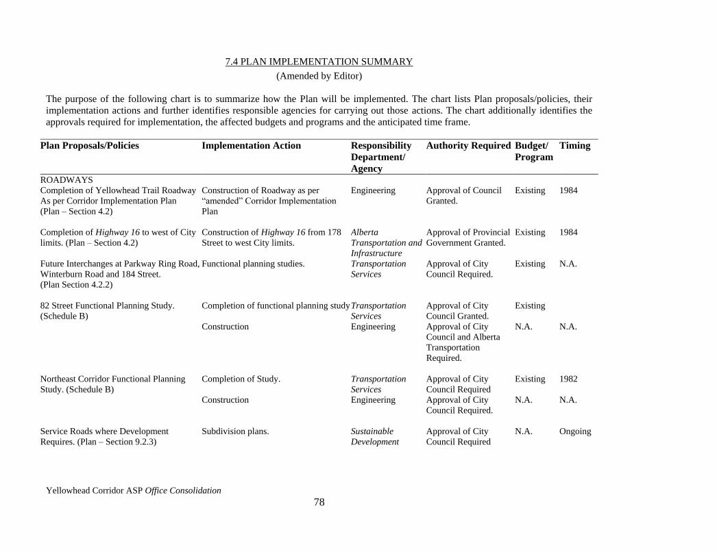
Yellowhead Corridor ASP Office Consolidation
78
7.4 PLAN IMPLEMENTATION SUMMARY
(Amended by Editor)
The purpose of the following chart is to summarize how the Plan will be implemented. The chart lists Plan proposals/policies, their
implementation actions and further identifies responsible agencies for carrying out those actions. The chart additionally identifies the
approvals required for implementation, the affected budgets and programs and the anticipated time frame.
Plan Proposals/Policies Implementation Action Responsibility
Department/
Agency
Authority Required Budget/
Program
Timing
ROADWAYS
Completion of Yellowhead Trail Roadway
As per Corridor Implementation Plan
(Plan – Section 4.2)
Construction of Roadway as per
“amended” Corridor Implementation
Plan
Engineering Approval of Council
Granted.
Existing 1984
Completion of Highway 16 to west of City
limits. (Plan – Section 4.2)
Construction of Highway 16 from 178
Street to west City limits.
Alberta
Transportation and
Infrastructure
Approval of Provincial
Government Granted.
Existing 1984
Future Interchanges at Parkway Ring Road,
Winterburn Road and 184 Street.
(Plan Section 4.2.2)
Functional planning studies. Transportation
Services
Approval of City
Council Required.
Existing N.A.
82 Street Functional Planning Study.
(Schedule B)
Completion of functional planning study
Transportation
Services
Approval of City
Council Granted.
Existing
Construction Engineering Approval of City
Council and Alberta
Transportation
Required.
N.A. N.A.
Northeast Corridor Functional Planning
Study. (Schedule B)
Completion of Study. Transportation
Services
Approval of City
Council Required
Existing 1982
Construction Engineering Approval of City
Council Required.
N.A. N.A.
Service Roads where Development
Requires. (Plan – Section 9.2.3)
Subdivision plans. Sustainable
Development
Approval of City
Council Required
N.A. Ongoing
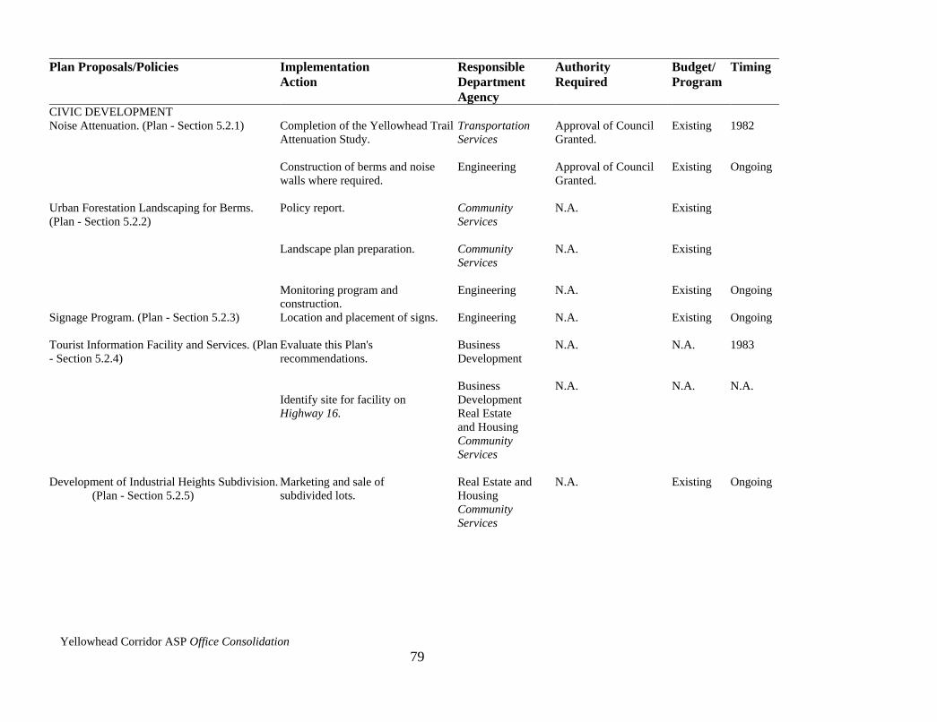
Yellowhead Corridor ASP Office Consolidation
79
Plan Proposals/Policies Implementation
Action
Responsible
Department
Agency
Authority
Required
Budget/
Program
Timing
CIVIC DEVELOPMENT
Noise Attenuation. (Plan - Section 5.2.1)
Completion of the Yellowhead Trail
Attenuation Study.
Transportation
Services
Approval of Council
Granted.
Existing
1982
Construction of berms and noise
walls where required.
Engineering Approval of Council
Granted.
Existing Ongoing
Urban Forestation Landscaping for Berms.
(Plan - Section 5.2.2)
Policy report.
Landscape plan preparation.
Monitoring program and
construction.
Community
Services
Community
Services
Engineering
N.A.
N.A.
N.A.
Existing
Existing
Existing
Ongoing
Signage Program. (Plan - Section 5.2.3) Location and placement of signs. Engineering N.A. Existing Ongoing
Tourist Information Facility and Services. (Plan
- Section 5.2.4)
Evaluate this Plan's
recommendations.
Identify site for facility on
Highway 16.
Business
Development
Business
Development
Real Estate
and Housing
Community
Services
N.A.
N.A.
N.A.
N.A.
1983
N.A.
Development of Industrial Heights Subdivision.
(Plan - Section 5.2.5)
Marketing and sale of
subdivided lots.
Real Estate and
Housing
Community
Services
N.A. Existing Ongoing
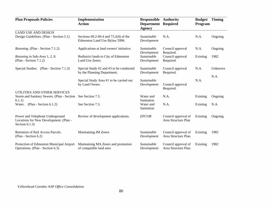
Yellowhead Corridor ASP Office Consolidation
80
Plan Proposals Policies Implementation
Action
Responsible
Department
Agency
Authority
Required
Budget/
Program
Timing
LAND USE AND DESIGN
Design Guidelines. (Plan - Section 5.1)
Sections 69.2-69.4 and 73.2(4) of the
Edmonton Land Use Bylaw 5996.
Sustainable
Development
N.A.
N.A.
Ongoing
Rezoning. (Plan - Section 7.1.2) Applications at land owners' initiative. Sustainable
Development
Council approval
Required.
N.A. Ongoing
Rezoning in Sub-Area 1, 2, 8.
(Plan - Section 7.1.2)
Redistrict lands to City of Edmonton
Land Use Zones.
Sustainable
Development
Council approval
Required.
Existing 1982
Special Studies. (Plan - Section 7.1.3) Special Study #2 and #3 to be conducted
by the Planning Department.
Special Study Area #1 to be carried out
by Land Owner.
Sustainable
Development
Sustainable
Development
Council approval
Required.
Council approval
Required.
N.A.
N.A.
Unknown
N.A.
UTILITIES AND OTHER SERVICES
Storm and Sanitary Sewers. (Plan - Section
6.1.1)
See Section 7.3.
Water and
Sanitation
N.A.
Existing
Ongoing
Water. (Plan - Section 6.1.2) See Section 7.3.
Water and
Sanitation
N.A. Existing N.A.
Power and Telephone Underground
Locations for New Development. (Plan -
Section 6.1.3)
Review of development applications. EPCOR Council approval of
Area Structure Plan
Existing Ongoing
Retention of Rail Access Parcels.
(Plan - Section 6.2)
Maintaining IM Zones. Sustainable
Development
Council approval of
Area Structure Plan.
Existing 1982
Protection of Edmonton Municipal Airport
Operations. (Plan - Section 6.3)
Maintaining MA Zones and promotion
of compatible land uses
Sustainable
Development
Council approval of
Area Structure Plan.
Existing 1982
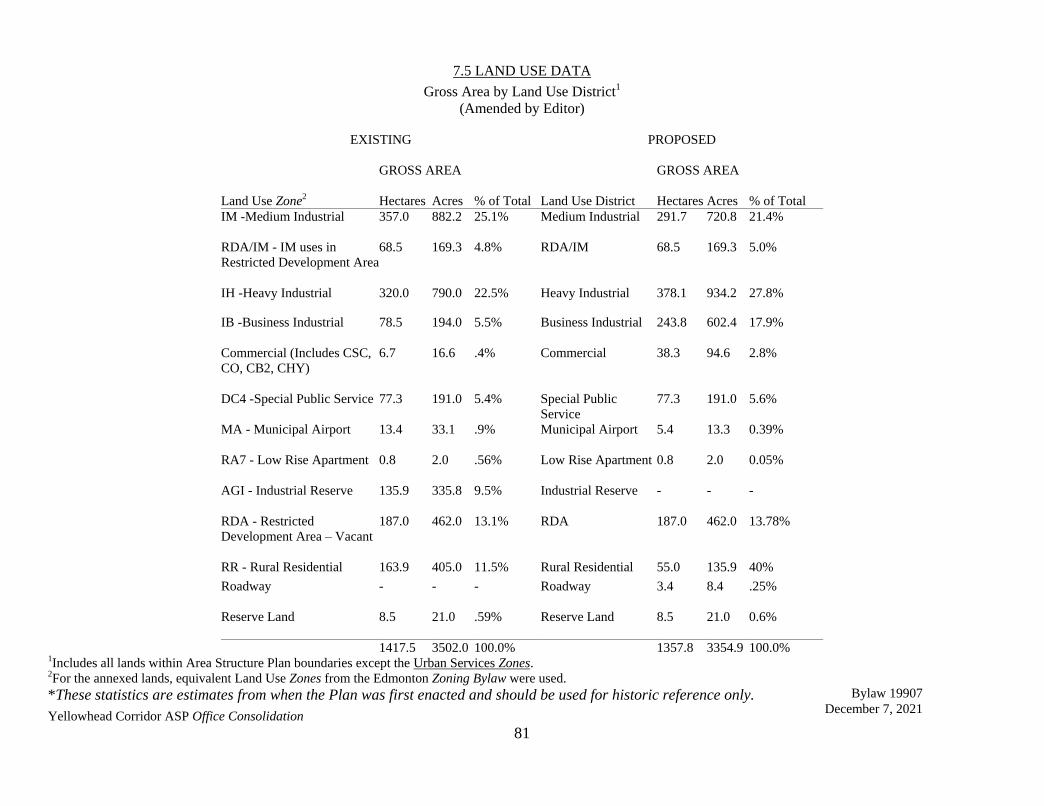
Yellowhead Corridor ASP Office Consolidation
81
7.5 LAND USE DATA
Gross Area by Land Use District1
(Amended by Editor)
EXISTING
PROPOSED
GROSS AREA
GROSS AREA
Land Use Zone2 Hectares Acres % of Total Land Use District Hectares Acres % of Total
IM -Medium Industrial
357.0 882.2 25.1% Medium Industrial 291.7 720.8 21.4%
RDA/IM - IM uses in
Restricted Development Area
68.5 169.3 4.8% RDA/IM 68.5 169.3 5.0%
IH -Heavy Industrial 320.0 790.0 22.5% Heavy Industrial 378.1 934.2 27.8%
IB -Business Industrial
78.5 194.0 5.5% Business Industrial 243.8 602.4 17.9%
Commercial (Includes CSC,
CO, CB2, CHY)
6.7 16.6 .4% Commercial 38.3 94.6 2.8%
DC4 -Special Public Service
77.3 191.0 5.4% Special Public
Service
77.3 191.0 5.6%
MA - Municipal Airport
13.4 33.1 .9% Municipal Airport 5.4 13.3 0.39%
RA7 - Low Rise Apartment
0.8 2.0 .56% Low Rise Apartment 0.8 2.0 0.05%
AGI - Industrial Reserve
135.9 335.8 9.5% Industrial Reserve - - -
RDA - Restricted
Development Area – Vacant
187.0 462.0 13.1% RDA 187.0 462.0 13.78%
RR - Rural Residential 163.9 405.0 11.5% Rural Residential 55.0 135.9 40%
Roadway - - - Roadway 3.4 8.4 .25%
Reserve Land 8.5 21.0 .59% Reserve Land 8.5 21.0 0.6%
1417.5 3502.0 100.0% 1357.8 3354.9 100.0% 1Includes all lands within Area Structure Plan boundaries except the Urban Services Zones. 2For the annexed lands, equivalent Land Use Zones from the Edmonton Zoning Bylaw were used.
*These statistics are estimates from when the Plan was first enacted and should be used for historic reference only. Bylaw 19907
December 7, 2021