wyoming’s final 2016/2018 integrated 305(b) and 303(d)...
TRANSCRIPT

Wyoming’s 2016/2018 Integrated 305(b) and 303(d) Report
Prepared by: Wyoming Department of Environmental Quality
Water Quality Division Watershed Section
Document # 18-0111

Wyoming’s Final 2016/2018 Integrated 305(b) and 303(d) Report
Page ii
Table of Contents Executive Summary ........................................................................................................................... vii 1.0 Introduction .................................................................................................................................. 1
1.1 Section 305(b) Requirements ..................................................................................................... 1 1.2 Section 303(d) Requirements ..................................................................................................... 1
2.0 Determining Surface Water Quality Condition .................................................................................. 1 2.1 Data Requirements .................................................................................................................... 2
Credible Data .............................................................................................................................. 2 Wyoming’s Weight of Evidence Approach ...................................................................................... 3 Historic Data ............................................................................................................................... 3
2.2 Designated Uses and Classifications ............................................................................................ 3 2.3 Designated Use Support Determinations ..................................................................................... 5 2.4 USEPA Categorization ................................................................................................................ 5
3.0 Surface Water Quality Monitoring ................................................................................................... 7 3.1 Wyoming’s Surface Water Monitoring Program ............................................................................ 7
Wyoming’s Probabilistic Rotating Basin Surveys ............................................................................. 7 3.2 Monitoring by Conservation Districts ........................................................................................... 8
4.0 TMDL Prioritization ........................................................................................................................ 8 4.1 Long-Term Vision Strategy ......................................................................................................... 9 Water Quality Prioritization Framework ............................................................................................. 9
5.0 Wyoming’s Nonpoint Source Program ........................................................................................... 17 6.0 Emerging Surface Water Quality Issues ........................................................................................ 17
Methylmercury .......................................................................................................................... 17 Climate Change ......................................................................................................................... 18
7.0 Public Participation ...................................................................................................................... 18 8.0 Basin Descriptions and Surface Water Quality Summaries .............................................................. 18
8.1 Bear River Basin ...................................................................................................................... 19 Upper Bear River Sub-basin (HUC 16010101) .............................................................................. 19 Central Bear River Sub-basin (HUC 16010102) ............................................................................ 21
8.2 Belle Fourche River Basin ......................................................................................................... 24 Upper Belle Fourche Sub-basin (HUC 10120201) ......................................................................... 25
8.3 Bighorn River Basin .................................................................................................................. 28 Upper Wind Sub-basin (HUC 10080001) ...................................................................................... 29 Little Wind Sub-basin (HUC 10080002) ....................................................................................... 32 Popo Agie Sub-basin (HUC 10080003) ........................................................................................ 33 Lower Wind Sub-basin (HUC 10080005)...................................................................................... 37 Badwater Creek Sub-basin (HUC 10080006) ................................................................................ 38 Upper Bighorn Sub-basin (HUC 10080007) .................................................................................. 38 Nowood Sub-basin (HUC 10080008) ........................................................................................... 42 Greybull Sub-basin (HUC 10080009) ........................................................................................... 44 Bighorn Lake Sub-basin (HUC 10080010) .................................................................................... 47 Dry Creek Sub-basin (HUC 10080011) ........................................................................................ 49 North Fork Shoshone River Sub-basin (HUC 10080012) ............................................................... 50 Shoshone River Sub-basin (HUC 10080014) ................................................................................ 51 Little Big Horn River Sub-basin (HUC10080016)........................................................................... 55
8.4 Cheyenne River Basin .............................................................................................................. 56 Antelope Creek Sub-basin (HUC 10120101) ................................................................................. 56 Upper Cheyenne Sub-basin (HUC 10120103) ............................................................................... 57 Angostura Reservoir Sub-basin (HUC10120106) .......................................................................... 59 Beaver Creek Sub-basin (HUC 10120107) ................................................................................... 60
8.5 Green River Basin .................................................................................................................... 61 Upper Green Sub-basin (HUC 14040101) .................................................................................... 61 New Fork Sub-basin (HUC 14040102) ......................................................................................... 64
Wyoming’s Final 2016/2018 Integrated 305(b) and 303(d) Report
Page iii
Slate Creek Sub-basin (HUC 14040103) ...................................................................................... 66 Big Sandy Sub-basin (HUC 14040104) ........................................................................................ 66 Bitter Creek Sub-basin (HUC 14040105) ...................................................................................... 68 Flaming Gorge Sub-basin (HUC 14040106) .................................................................................. 70 Blacks Fork Sub-basin (HUC 14040107) ...................................................................................... 71
8.6 Little Missouri River Basin ......................................................................................................... 74 8.7 Little Snake River Basin ............................................................................................................ 75
Little Snake Sub-basin (HUC 14050003) ...................................................................................... 75 Muddy Creek Sub-basin (HUC 14050004) .................................................................................... 78
8.8 Niobrara River Basin ................................................................................................................ 82 Niobrara Headwaters Sub-basin (HUC 10150002) ........................................................................ 82
8.9 North Platte River Basin ........................................................................................................... 83 Upper North Platte Sub-basin (HUC 10180002) ........................................................................... 84 Pathfinder-Seminoe Sub-basin (HUC 10180003) .......................................................................... 89 Medicine Bow Sub-basin (HUC 10180004) ................................................................................... 89 Little Medicine Bow Sub-basin (HUC 10180005) ........................................................................... 91 Sweetwater Sub-basin (HUC 10180006) ...................................................................................... 93 Middle North Platte Sub-basin (HUC 10180007) ........................................................................... 95 Glendo Sub-basin (HUC 10180008) ............................................................................................. 98 Upper Laramie Sub-basin (HUC 10180010) ............................................................................... 100 Lower Laramie Sub-basin (HUC 10180011) ............................................................................... 103 Horse Creek Sub-basin (HUC 10180012) ................................................................................... 106
8.10 Powder River Basin .............................................................................................................. 108 Middle Fork Powder Sub-basin (HUC 10090201) ........................................................................ 109 Upper Powder River Sub-basin (HUC 10090202) ........................................................................ 111 South Fork Powder Sub-basin (HUC 10090203) ......................................................................... 114 Salt Creek Sub-basin (HUC 10090204) ...................................................................................... 116 Crazy Woman Sub-basin (HUC 10090205) ................................................................................. 118 Clear Creek Sub-basin (HUC 10090206) .................................................................................... 122 Little Powder Sub-basin (HUC 10090208) .................................................................................. 126
8.11 Snake River Basin ................................................................................................................ 128 Snake Headwaters Sub-basin (HUC 17040101) ........................................................................ 128 Gros Ventre Sub-basin (HUC 17040102) ................................................................................. 131 Greys-Hoback Sub-basin (HUC 17040103)................................................................................. 132 Salt River Sub-basin (HUC17040105) ........................................................................................ 134
8.12 South Platte River Basin ....................................................................................................... 136 Crow Creek Sub-basin (HUC 10190009) .................................................................................... 136
8.13 Tongue River Basin .............................................................................................................. 139 Tongue Sub-basin (HUC 10090101) .......................................................................................... 140
8.14 Yellowstone River Basin ........................................................................................................ 151 Yellowstone Headwaters Sub-basin (HUC 10070001) ................................................................. 152 Clarks Fork Yellowstone Sub-basin (HUC 10070006) .................................................................. 153
9.0 Probability Survey Results .......................................................................................................... 154 9.1 Bighorn-Yellowstone Survey ................................................................................................... 154 9.2 Northeast Wyoming Basins ..................................................................................................... 157 9.3 Statewide Surveys ................................................................................................................. 160
10.0 Summary of Wyoming’s 305(b) and 303(d) Assessed Waters ..................................................... 161 10.1 Summary of 2016/2018 Surface Water Quality Assessments ................................................... 166
New 303(d) Listings ................................................................................................................. 166 Accidentally Omitted 303(d) Listings ......................................................................................... 166 Waters Moved from the 303(d) List to Category 2 (De-listings)................................................... 167 Waters Moved from the 303(d) List to Category 4A Due to Completion of TMDLs ........................ 167 New Waters Added to Category 2 ............................................................................................. 168
Wyoming’s Final 2016/2018 Integrated 305(b) and 303(d) Report
Page iv
Waters Moved From Category 4C to Category 2 ........................................................................ 168 Waters Moved From Category 4C to Category 3 ........................................................................ 170 4C Waters Removed from the Integrated Report ....................................................................... 170
10.2 Wyoming’s 305(b) List.......................................................................................................... 171 Category 2 Surface Waters ....................................................................................................... 171 Category 3 Surface Waters ....................................................................................................... 188 Category 4 Surface Waters ....................................................................................................... 189
10.3 Wyoming’s 303(d) List.......................................................................................................... 199 Category 5 Surface Waters ....................................................................................................... 199
11.0 References .............................................................................................................................. 214 Appendix A – USEPA Section 319 Nonpoint Source Program Success Story ......................................... 221

Wyoming’s Final 2016/2018 Integrated 305(b) and 303(d) Report
Page v
List of Acronyms
AFO Animal Feeding Operation ALUS Aquatic Life Use Support
AML Abandoned Mine Lands AMPs Allotment Management Plans
BLM United States Bureau of Land Management
BMP Best Management Practices CBM Coal Bed Methane
CBPU Cheyenne Board of Public Utilities CCCD Campbell County Conservation District
CCD Cody Conservation District
CCNRD Crook County Natural Resource District CFR Code of Federal Regulations
CFUs Colony Forming Units Chapter 1 Chapter 1 of the Wyoming Water Quality Rules and Regulations
CRM Coordinated Resource Management CRP Conservation Reserve Program
CWA Federal Clean Water Act
DOI United States Department of the Interior DCCD Dubois County Conservation District
EC Electrical Conductivity EIS Environmental Impact Statement
EMAP Environmental Monitoring and Assessment Program
HSCD Hot Springs Conservation District HUC Hydrologic Unit Code (HUC)
LCD Lincoln Conservation District LDCD Lake DeSmet Conservation District
LRCD Laramie Rivers Conservation District MCD Meeteetse Conservation District
NCCD Natrona County Conservation District
NCD Niobrara Conservation District NRCS Natural Resource Conservation Service
PACD Popo Agie Conservation District PCFCD Powell-Clarks Fork Conservation District
PCRD Platte County Resource District
PFC Proper Functioning Condition PRBIWG Powder River Basin Interagency Work Group
PRCD Powder River Conservation District PRBS Probabilistic Rotating Basin Surveys
RIVPACS River Invertebrate Prediction and Classification System
SAR Sodium Adsorption Ratio SCCD Sheridan or Sublette County Conservation Districts
SWCCD Sweetwater County Conservation District SCD Shoshone Conservation District
SDDENR South Dakota Department of Environment and Natural Resources Section 205j Section 205j of the CWA
Section 208 Section 208 of the CWA
Section 301 Section 301 of the CWA Section 319 Section 319 of the CWA
SMCLs USEPAs Secondary Maximum Contaminant Levels for Drinking Water

Wyoming’s Final 2016/2018 Integrated 305(b) and 303(d) Report
Page vi
TA Timberline Aquatics, Inc. TCD Teton Conservation District
TDS Total Dissolved Solids TMDL Total Maximum Daily Load
TRT Technical Review Team
TSS Total Suspended Solids UAA Use Attainability Analysis
UCCD Uinta County Conservation District USBOR United States Bureau of Reclamation
USEPA United States Environmental Protection Agency USFWS United States Fish and Wildlife Service
USGS United States Geological Survey
UW University of Wyoming WACD Wyoming Association of Conservation Districts
WCCD Washakie County Conservation District WDEQ Wyoming Department of Environmental Quality
WDH Wyoming Department of Health
WGFD Wyoming Game and Fish Department WLA Waste Load Allocation
WOGCC Wyoming Oil and Gas Conservation Commission WMP Watershed Monitoring Program
WQD Wyoming Water Quality Division WSII Wyoming Stream Integrity Index
WWP Western Watersheds Project
WWTF Waste Water Treatment Facility WYPDES Wyoming Point Source Discharge Elimination System
Wyoming’s Final 2016/2018 Integrated 305(b) and 303(d) Report
Page vii
Executive Summary To fulfill requirements under the federal Clean Water Act, the Wyoming Department of Environmental Quality/Water Quality Division (WDEQ/WQD) develops the Integrated 305(b) and 303(d) Report (Integrated Report) on a biennial basis and submits the report to the United States Environmental Protection Agency (USEPA) by April 1 of even numbered years. The Integrated Report contains information on the quality of Wyoming’s waters, including those waters that have been identified as not meeting water quality standards. Due to delays associated with the 2014 Integrated Report, this report combines assessments and information that would have been included in the 2016 Integrated Report with assessments and information from the 2018 Integrated Report. For consistency with previous formats, decision dates for assessments included in the 2016/2018 Integrated Report are identified as 2018. Changes to 2016/2018 Integrated Report from the 2014 Integrated Report include revisions to the TMDL Prioritization, Section 4, and Probability Survey Results, Section 9. WDEQ/WQD also removed the North Platte River from the 303(d) List and placed it into Category 2 because it is now meeting its selenium criteria protective of its cold water fish and aquatic life other than fish designated uses. Waters that have been found to not meet their water quality standards and were added to the 303(d) List in 2018 include: Brooks Lake (pH and nutrients), Hornecker Creek (E. coli), Middle Fork Popo Agie River (E. coli), Laramie River (sediment), 2 segments of Little Goose Creek (E. coli), Prairie Dog Creek (E. coli), and 2 segments of the Tongue River (E. coli). The 303(d) List also includes an additional impairment for the Little Popo Agie River for hydrogen sulfide that had been inadvertently omitted from the text and tables of the 2014 Integrated Report. The Little Popo Agie River was originally added to the 303(d) List in 2014 for oil and grease. Waters that and were moved from the 303(d) List to Category 4A of the Integrated Report because total maximum daily loads (TMDLs) were completed include: Middle Fork Crow Creek (E. coli), Salt River (E. coli), Stump Creek (E. coli), the Bear River (sediment) Prairie Dog Creek (E. coli), Meade Creek (E. coli), Dutch Creek (E. coli), Wildcat Creek (E. coli), Bitter Creek (E. coli) and Killpecker Creek (E. coli). Waters that were found to be meeting at least one designated use and were placed in Category 2 of the Integrated Report include segments of the: Middle Fork Popo Agie River (recreation), Laramie River (drinking water), and South Fork Fish Creek (drinking water, cold water fish, aquatic life other than fish, industry, wildlife, and agriculture). Waters that were previously in Category 4C, were reevaluated, and determined to be meeting at least one designated use were placed in Category 2 include: Rock Creek (fish consumption and drinking water), North Fork Crazy Woman Creek (fish consumption and drinking water), Grass Creek (fish consumption and drinking water), Crooked Creek (fish consumption and drinking water), and Muddy Creek (nongame fish and aquatic life other than fish). A segment of Soldier Creek that was previously in Category 4C was also reevaluated, but lacked sufficient data to determine whether any designated uses were supported, and was therefore included in Category 3 of the Integrated Report. Lastly, reevaluation of Horseshoe Creek, which had been in Category 4C, showed that no data had been collected on the segment. As a result, this segment of Horseshoe Creek was removed from the Integrated Report.
Wyoming’s Final 2016/2018 Integrated 305(b) and 303(d) Report
Page 1
1.0 Introduction In 1972, Congress enacted the Federal Water Pollution Control Act, otherwise known as the Clean Water
Act (CWA). The purpose of the CWA is to promote the restoration and/or maintenance of the chemical, physical and biological integrity of our nation’s surface waters and to support the protection and propagation of fish, shellfish, and wildlife and recreation in and on the water. WDEQ/WQD administers the
Clean Water Act in Wyoming. EPA or authorized tribes administer the Clean Water Act in Indian Country, as defined at 18 U.S.C. Section 1151.
1.1 Section 305(b) Requirements
Section 305(b) of the CWA requires that each state prepare and submit a biennial report to USEPA by April
1st of even numbered years. The Federal Code of Regulations (CFR) 40 CFR § 130.8 outlines the required
content of the report. The report must contain a description of the water quality of all navigable waters of the state for the preceding year, including the extent to which current conditions allow for the protection
and propagation of a balanced population of shellfish, fish, and wildlife, and allow recreational activities in and on the water. Section 305(b) also requires each state to report the water quality and the elimination
of pollutants necessary for designated use support. Specifically, each state is required to identify waters
not meeting the above conditions, recommend strategies to achieve these objectives and to estimate the environmental impacts, economic and social costs and benefits and the predicted timeline for project
completion. The sources and extent of non-point source pollution in each state must be estimated, including a description of the current program used to mitigate these pollutants and associated financial costs. Lastly,
the report must include an assessment of the water quality of all publicly owned lakes, including the status and trends of such water quality as specified in section 314(a)(1) of the CWA.
1.2 Section 303(d) Requirements
Section 303(d) of the CWA requires that states identify and list waters for which the effluent limits outlined in Section 301 are not effective in attaining designated uses. 40 CFR § 130.7 outlines the requirements of
section 303(d). Each state must submit a 303(d) List of impaired and threatened waters to USEPA by April
1st of each even numbered year. USEPA must review and approve or disapprove the 303(d) List within 30 days of submittal. The 303(d) List must also include waters for which controls on thermal discharges under
section 301 of the CWA are not stringent enough to assure the protection and propagation of a balanced population of shellfish, fish, and wildlife. Section 303(d) requires that states develop a separate total
maximum daily load (TMDL) for each pollutant/segment combination on the 303(d) List. A TMDL is the amount of pollution a waterbody can receive and still meet its designated uses. Waters on the 303(d) List
must be prioritized for TMDL development based on the severity of each pollutant/segment combination or
listing and the specific designated uses adversely impacted by the pollutant (see Section 4.0 below). Wyoming’s biennial Integrated 305(b) and 303(d) Report (hereafter referred to as the Integrated Report)
combines the requirements of both CWA sections into a single document.
2.0 Determining Surface Water Quality Condition
As part of administering the CWA in Wyoming, 40 CFR § 130.7(b)(5) requires that WDEQ shall assemble and evaluate all existing and readily available water quality-related data and information to develop the list required by §§130.7(b)(1) and 130.7(b)(2). At a minimum “all existing and readily available water quality-related data and information” includes but is not limited to all of the existing and readily available data and information about the following categories of waters:

Wyoming’s Final 2016/2018 Integrated 305(b) and 303(d) Report
Page 2
(i) Waters identified by the State in its most recent section 305(b) report as “partially meeting” or “not meeting” designated uses or as “threatened”;
(ii) Waters for which dilution calculations or predictive models indicate nonattainment of applicable water quality standards;
(iii) Waters for which water quality problems have been reported by local, state, or federal agencies; members of the public; or academic institutions. These organizations and groups should be actively solicited for research they may be conducting or reporting. For example, university researchers, the United States Department of Agriculture, the National Oceanic and Atmospheric Administration, the United States Geological Survey, and the United States Fish and Wildlife Service are good sources of field data; and
(iv) Waters identified by the State as impaired or threatened in a nonpoint assessment submitted to EPA under section 319 of the CWA or in any updates of the assessment.
WDEQ solicits data every two years using the department’s automated electronic mailing list or listserv.
Water quality data and other information must be received by WDEQ’s Water Quality Assessment Program no later than July 15 during odd-numbered (e.g., 2017) years to be considered for inclusion in the
subsequent Integrated Report (e.g., 2018). Any supplemental data or other information deemed necessary
by WDEQ must be provided promptly as requested. Incomplete data, or those submitted beyond the July 15 deadline are typically considered toward the subsequent Integrated Report (e.g., 2020).
Much of the data and information used in making designated use support determinations are generated by
WDEQ's Surface Water Quality Monitoring Program1. Surface Water Monitoring Program studies typically result in final reports, which are available on WDEQ's webpage. In addition, WDEQ routinely reviews water
quality data from a variety of other sources, including Wyoming’s 34 conservation districts, federal, state
and local government agencies, non-profit organizations and the private sector. All water quality data and other information are thoroughly evaluated by Surface Water Quality Monitoring and/or Water Quality
Assessment Program personnel against the surface water quality standards contained in Chapter 1 of Wyoming's Water Quality Rules and Regulations (WDEQ, 2013a)2.
2.1 Data Requirements
Credible Data
The Wyoming Environmental Quality Act (WDEQ, 2014), Wyoming Statute (W.S.) § 35-11-103(c)(xix), and
Section 2(a)(i) of Chapter 1 define credible data as scientifically valid chemical, physical and biological monitoring data collected under an accepted sampling and analysis plan including quality control, quality assurance procedures and available historical data. Section 35(b) of Chapter 1 requires that credible data be collected on each water body, and shall be considered for purposes of characterizing the integrity of the water body including consideration of soil, geology, hydrology, geomorphology, climate, stream succession and the influences of man upon the system. These data in combination with other available and applicable information shall be used through a weight-of-evidence approach to designate uses and determine whether those uses are being attained. Chapter 1, Section 35(d) requires that credible data shall be utilized in determining a water body’s attainment of designated uses, although a less than complete set of data may
be used to make a decision on designated use support (i.e., attainment) in instances where numerical standards contained in these rules are exceeded or on ephemeral or intermittent water bodies where chemical or biological sampling is not practical or feasible (Chapter 1, Section 35(b)). Hereafter, within this
document, the use of the term credible data will refer to the definition above.
1 http://deq.wyoming.gov/wqd/surface-water-monitoring/ Note that this link may only open in Google Chrome. 2 https://rules.wyo.gov/ Note that this link may only open in Google Chrome.
Wyoming’s Final 2016/2018 Integrated 305(b) and 303(d) Report
Page 3
As described in Section 35(a)(i) of Chapter 1, data must be collected using accepted referenced laboratory and field methods employed by a person who has received specialized training and has field experience in developing a monitoring plan, a quality assurance plan, and employing the methods outlined in such plans; or works under the supervision of a person who has these qualifications. Specialized training includes a thorough knowledge of written sampling protocols and field methods such that the data collection and interpretation are reproducible, scientifically defensible, and free from preconceived bias. Section 35(a)(ii)
of Chapter 1 states that data must include documented quality assurance, consisting of a plan that details how environmental data operations were planned, implemented, and assessed with respect to quality during the duration of the project. A variety of scientifically defensible laboratory and field methods may be used to collect and analyze data for the purpose of making designated use support determinations (i.e.,
assessments). WDEQ's Manual of Standard Operating Procedures for Sample Collection and Analysis
contains the standard procedures used by WDEQ's Surface Water Quality Monitoring Program.
Wyoming’s Weight of Evidence Approach
Section 35(b) of Chapter 1 requires that a weight-of-evidence approach be used to analyze credible data
when making designated use support determinations. Wyoming’s weight-of-evidence approach evaluates all relevant data and other information and uses scientific deduction to assess the designated use support
of surface waters. In using this approach, WDEQ may utilize statistical tests, analytical procedures and
evaluate additional data to ensure the validity, representativeness and objectiveness of data. WDEQ’s weight-of-evidence approach has been adapted from Section 3, Volume 2 of USEPA's Guidelines for
Preparation of the Comprehensive State Water Quality Assessments, 305(b) Reports and Annual Electronic Updates: Supplement EPA-841-B-97-002B (USEPA, 1997) and Section IV of USEPA's Guidance for 2006
Assessment, Listing and Reporting Requirements Pursuant to Sections 303(d), 305(b) and 314 of the Clean Water Act (USEPA, 2005).
Historic Data
Section 2(b)(xxii) of Chapter 1 defines historic data as scientifically valid data that is more than five years old, or qualitative information that adds some factual information on the historic conditions of a water body. This historic qualitative information may include photographs, journals and factual testimony of persons who have lived near or relied upon the water body, and old records on water use and water conditions. WDEQ uses the date when data and other information are received by the Water Quality Assessment
Program to define the end of the 5 year period described above. For example, if the Water Quality
Assessment Program received a water quality report on October 13, 2017, all data and other information within the report that is dated before October 13, 2012 would be considered historic. Following
recommendations in USEPA’s Consolidated Assessment and Listing Methodology (CALM) (USEPA, 2002), WDEQ will only evaluate historical data toward designated use support determinations if they are
considered representative of current water quality conditions and they are evaluated with data collected within the previous five years.
2.2 Designated Uses and Classifications
Section 2(b)(ix) of Chapter 1 defines designated uses as those uses specified in water quality standards for each water body or segment whether or not they are being attained. Designated uses are equivalent to
management goals or expectations for each of Wyoming’s surface waters, and are assigned to each water using a tiered classification system described in Section 4 of Chapter 1. This approach places waters into
Classes 1-4 (see Table 1) based on their designated uses, with Class 1 waters generally being managed for
the highest and Class 4 the lowest water quality, respectively. Wyoming’s current surface water classifications are contained within the Wyoming Surface Water Classification List (WDEQ, 2013c). Section
3 of Chapter 1 states that the objectives of the Wyoming pollution control program are to provide, wherever attainable, the highest possible water quality commensurate with the following nine uses:
Wyoming’s Final 2016/2018 Integrated 305(b) and 303(d) Report
Page 4
Drinking water - The drinking water use involves maintaining a level of water quality that is suitable
for potable water or intended to be suitable after receiving conventional drinking water treatment.
Fisheries - The fisheries use includes water quality, habitat conditions, spawning and nursery areas, and food sources necessary to sustain populations of cold water game fish, warm water game fish and nongame fish. This use does not include the protection of aquatic invasive species or other fish which may be considered “"undesirable” by the Wyoming Game and Fish Department or the U.S. Fish and Wildlife Service within their appropriate jurisdictions.
Aquatic life other than fish - This use includes water quality and habitat necessary to sustain
populations of organisms other than fish in proportions which make up diverse aquatic communities common to the waters of the state. This use does not include the protection of human pathogens, insect pests, aquatic invasive species or other organisms which may be considered “undesirable” by the Wyoming Game and Fish Department or the U.S. Fish and Wildlife Service within their appropriate jurisdictions.
Fish consumption - The fish consumption use involves maintaining a level of water quality that will
prevent any unpalatable flavor and/or accumulation of harmful substances in fish tissue.
Recreation - Recreational use protection involves maintaining a level of water quality which is safe for human contact. It does not guarantee the availability of water for any recreational purpose. The recreational designated use includes primary contact recreation and secondary contact recreation subcategories.
Wildlife - The wildlife use includes protection of water quality to a level which is safe for contact and
consumption by avian and terrestrial wildlife species.
Agriculture - For purposes of water pollution control, agricultural uses include irrigation and/or livestock watering.
Industry - The industrial use involves maintaining a level of water quality useful for industrial purposes.
Scenic value - Scenic value use involves the aesthetics of a waterbody (odor, color, taste, settleable solids, floating solids, suspended solids and solid waste) and is not necessarily related to general landscape appearance.
Designated uses assigned to particular surface waters are revised on an ongoing basis. Each change to a designated use is based on a scientific evaluation, called a use attainability analysis (UAA), considers
public input, and is finalized through a formal determination by the Administrator of the Water Quality Division. The designated use changes are then submitted to USEPA pursuant to the federal Clean Water Act.
Recent changes to designated uses include a statewide Categorical Use Attainability Analysis for
Recreation that changed many low flow channels in the state from primary contact recreation to secondary contact recreation. The Water Quality Division Administrator made a final determination on the
designated uses changes on September 1, 2016. The designations were submitted to the United States Environmental Protection Agency pursuant to the federal Clean Water Act in November 2016. The revised
designations became effective in Wyoming on February 15, 2017. On September 12, 2017, USEPA
approved the designated use changes, with 10 exceptions. Recreations designations can be determined using the recreation designated uses web map or by downloading

Wyoming’s Final 2016/2018 Integrated 305(b) and 303(d) Report
Page 5
shapefiles: http://deq.wyoming.gov/wqd/surface-water-quality-standards-2/resources/changes-designated-uses-and-site-specific-criteria/
DEQ will take any changes to recreation designated uses into consideration when evaluating attainment of designated uses using credible data.
Table 2.1. Wyoming’s surface water classifications (far left column) and designated uses (top row). For each surface water class. A “Yes” indicates that the use is designated; a “No” indicates that the use is not
designated.
Dri
nk
ing
wa
ter
Co
ld w
ate
r
ga
me
fis
h
Wa
rm w
ate
r
ga
me
fis
h
No
ng
am
e
fish
Fis
h
co
nsu
mp
tio
n
Aq
ua
tic l
ife
oth
er
tha
n
fish
Re
cre
ati
on
2
Wil
dli
fe
Ag
ricu
ltu
re
Ind
ustr
y
Sce
nic
va
lue
1 Yes1 Yes1 Yes1 Yes1 Yes1 Yes Yes Yes Yes Yes Yes
2AB Yes Yes Yes Yes Yes Yes Yes Yes Yes Yes Yes
2A Yes No No No No Yes Yes Yes Yes Yes Yes
2B No Yes Yes Yes Yes Yes Yes Yes Yes Yes Yes
2C No No No Yes Yes Yes Yes Yes Yes Yes Yes
2D No If
present
If
present
If
present Yes Yes Yes Yes Yes Yes Yes
3A No No No No No Yes Yes Yes Yes Yes Yes
3B No No No No No Yes Yes Yes Yes Yes Yes
3C No No No No No Yes Yes Yes Yes Yes Yes
3D No No No No No Yes Yes Yes Yes Yes Yes
4A No No No No No No Yes Yes Yes Yes Yes
4B No No No No No No Yes Yes Yes Yes Yes 1 Class 1 waters are not necessarily protected for all uses (indicated by an italicized “Yes”) in all circumstances. For example, all surface waters in National Parks and Wilderness Areas are Class 1; however, all such waters are not necessarily managed for fisheries or aquatic life other than fish uses (e.g., hot springs, ephemeral waters and wet meadows). 2 Wyoming’s recreational designated use is subdivided into primary and secondary recreational uses, but WDEQ uses only a single recreational designated use in assigning surface water classifications.
2.3 Designated Use Support Determinations
Designated use support determinations for Wyoming’s surface waters are made on a biennial basis during preparation of the Integrated Report. Chapter 1 contains all of Wyoming’s numeric and narrative criteria,
which define limits for the protection of the state’s designated uses. A numeric criterion is often comprised of a quantifiable unit of measurement for each parameter and a duration and frequency of exposure;
narrative criteria are descriptive parameters not easily expressed as quantitative values or for which
numeric criteria have yet to be developed. Section 2 of this document provides a detailed description of WDEQ’s data requirements for making designated use support determinations. All data and other
information used in making designated use support determinations, including those generated by WDEQ or from outside sources are available for public review. WDEQ’s methods for determining designated use
support for each of the state’s designated uses are described separately below.
2.4 USEPA Categorization
Wyoming's Methods for Determining Surface Water Quality Condition and TMDL Prioritization (WDEQ, 2014) outlines the methodology used by WDEQ for making designated use support determinations, or

Wyoming’s Final 2016/2018 Integrated 305(b) and 303(d) Report
Page 6
assessments, on surface waters. Once designated use support determinations are made by WDEQ, USEPA requires that all surface waters of the state be placed into one of five categories (USEPA 2005b, 2006).
Surface water categorizations are used to standardize these various approaches for USEPA’s national reporting purposes because designated uses, water quality standards and designated use support
methodologies are not consistent across all states, tribes and territories. In Wyoming, designated use
support determinations translate directly into the five categories below.
Category 1 - Available data and/or information indicate that all designated uses are supported and no use is threatened.
Category 2 - Available data and/or information indicate that at least one designated use is supported,
while one or more other uses are either indeterminate or not assessed.
Category 3 - Available data and/or information are either insufficient or inconclusive and designated use
support cannot be determined for any uses.
Category 4 - Available data and/or information indicate that at least one designated use is not being
supported or is threatened, but a TMDL is not needed. There are two sub-categories of Category 4 that can potentially be used in Wyoming’s Integrated Report:
4A. A state developed TMDL has been approved by EPA or a TMDL has been established by USEPA for
any segment-pollutant combination.
4B. Designated use support is expected to be restored in a reasonable period of time through other
pollution control measures. For example, a stream that has been historically impaired by excess sedimentation from urban stormwater runoff may be moved to Category 4B after stormceptors are
installed that are expected to effectively trap the excess sediment before it reaches the stream.
USEPA requires that states thoroughly demonstrate that an impaired water should be placed in Category 4B rather than in Category 5. All demonstrations must include: an identification of water
and cause of impairment; a description of pollution control measures and how they are expected to result in standards attainment; an estimated timeline for standards attainment; a schedule for
implementing and monitoring pollution controls; and a commitment to revise pollution controls as necessary.
Category 5 - Available data and/or information indicate that at least one designated use is not supported or is threatened because of a pollutant(s) and a TMDL is needed. Category 5 waters are placed on
Wyoming’s 303(d) List of impaired waters requiring TMDLs. Each pollutant/segment combination is considered a separate 303(d) Listing. For example, if the aquatic life other than fish use on a stream
segment is impaired due to copper, sediment and selenium, these three pollutants would be considered
three separate 303(d) Listings.
All categorized waters are georeferenced by WDEQ using GIS (Geographic Information Systems) and the U.S. Geological Survey (USGS) 1:24K NHD (National Hydrography Dataset) data layer. Linear (streams)
and polygon (lakes, reservoirs, ponds) shapefiles are updated every two years and submitted to USEPA
along with the Integrated 305(b) and 303(d) Report. These shapefiles are available to the public for download on WDEQ's Watershed Protection Program website3. Study site locations from available data
and/or information are used to delineate the extent of each categorized water. Lakes and reservoirs are typically placed into just one of the five categories, but can also be subdivided into several categories. In
contrast, streams commonly have segments in more than one category. WDEQ typically delineates stream segments in one of two ways, depending on the number of study sites used in the assessment. If two or
more study sites exist, the segment will usually be delineated to include the distance between the sites. If
only one study site exists, however, the segment is usually extended from this site to the nearest upstream
3 http://deq.wyoming.gov/wqd/watershed-protection/ Note that this link may only open in Google Chrome.
Wyoming’s Final 2016/2018 Integrated 305(b) and 303(d) Report
Page 7
and downstream tributary. WDEQ recommends that data submissions include the necessary number of study sites to allow for an accurate delineation of each assessment unit.
A unique 305(b) identifier is assigned to each categorized water by WDEQ and serves as a permanent
reference. Each identifier contains information about the state, river basin and 12-digit HUC (hydrologic
unit code) containing the water and a sequence number indicating the order in which waters have been categorized within the 12-digit HUC. For example, a 36.5 mile segment of the Bear River, from the
confluence with Woodruff Narrows Reservoir upstream to the confluence with Sulphur Creek was placed in Category 5 and added to the 303(d) List in 2002. The 305(b) identifier for this segment is
WYBR160101010303_01, indicating that it is located in Wyoming (WY), in the Bear River Basin (BR), in 12 digit HUC 160101010303 and that this was the first (01) categorization decision by WDEQ within this 12
digit HUC.
Data and information for all of Wyoming’s categorized surface waters are stored in an online database
called the Assessment and Total Maximum Daily Load Tracking and Implementation System (ATTAINS). ATTAINS was created by USEPA to assist states in reporting information about the conditions of the
Nation’s surface waters. ATTAINS also provides users with information on the status of waters at the
national, state, and waterbody level. ATTAINS is updated every two years and is submitted to USEPA along with the Integrated Report.
3.0 Surface Water Quality Monitoring
3.1 Wyoming’s Surface Water Monitoring Program
Wyoming’s 2010-2019 Surface Water Monitoring Strategy (WDEQ 2010) focuses on a rotating river basin
framework where probabilistic and targeted designated use-support monitoring are integrated. Using this
approach, a probabilistic survey will be completed for each of five geographic divisions of the state and the results of these surveys will identify high quality waters and waters where standards may not be attained
as candidates for targeted designated use-support studies. Other efforts that are common when working in a basin include expanding WDEQs reference datasets, evaluating non-point source project effectiveness,
developing use attainability analyses, and developing or evaluating TMDLs. WDEQ re-evaluates its water quality monitoring strategy at least every ten years to adjust management goals and objectives as priorities
change. Annual monitoring plans and project-specific sampling and analysis plans are placed on the
Watershed Protection Program website4 to inform stakeholders about WDEQ monitoring projects.
Wyoming’s Probabilistic Rotating Basin Surveys
Probabilistic Rotating Basin Surveys (PRBS) use a randomly selected subsample of a population (streams
and rivers), similar to a census, in order to make inferences about characteristics of the population as a whole. Wyoming uses a customized generalized random tessellation-stratified (GRTS) survey design using
the 1:100,000 scale National Hydrographic Dataset Plus (NHD+) as the base sample frame (http://archive.epa.gov/nheerl/arm/web/html/presents.html) from which 50 primary sites are randomly
selected from a target population of perennial, non-headwater (>1st Strahler order) rivers and streams
outside of national parks, congressionally-designated wilderness areas, and the Wind River Reservation within each of five geographic divisions of the State. The geographic divisions are referred to as
‘superbasins’ due to their delineation using combinations of 6-digit (3rd level) Hydrologic Unit Codes (HUC) and geographical location.
4 http://deq.wyoming.gov/wqd/watershed-protection/ Note that this link may only open in Google Chrome.
Wyoming’s Final 2016/2018 Integrated 305(b) and 303(d) Report
Page 8
The five superbasins and the associated HUC 6 basins they represent are:
Bighorn/Yellowstone [Bighorn and Yellowstone Basins] - PRBS completed in 2010
Northeast [Belle Fourche, Cheyenne, Little Missouri, Powder and Tongue Basins] - PRBS
completed in 2011
Green [Great Divide, Green and Little Snake Basins] - PRBS completed in 2015
Platte [Niobrara, North Platte and South Platte Basins] - PRBS completed in 2016
Bear/Snake [Bear and Snake Basins] - PRBS scheduled for 2020
Site selection is further stratified into aggregations of several 8-digit (4th level) HUCs, or “HUC 8 clusters,” within each superbasin. The additional stratification assures more equal spatial distribution of the 50
primary sites among all HUC 8 clusters and across a superbasin. Following the same design, a population
of 100 oversample sites (also stratified by HUC 8 cluster) is generated for each superbasin to be used as replacements when a primary site cannot be sampled. Oversample sites are used as replacements for
primary sites occurring within the same HUC 8 cluster to maintain representativeness and minimize logistical complexities of sampling. Data from the 50 sites sampled within each superbasin are used to make
inferences about water quality conditions within each superbasin, including the proportion of the stream
target population likely achieving water quality standards or statistically-derived expected conditions, and the occurrence, extent, and relative risk of various pollutants. Data from PRBS are not used to make
determinations of designated use support or resultant categorization decisions in Wyoming’s Integrated Report. PRBS data are used to identify waters of high quality and those that may not be fully supporting
their designated uses, thus are candidates for future targeted monitoring for determinations of designated
use-support.
3.2 Monitoring by Conservation Districts
Since 1998, many of Wyoming's Conservation Districts, with the guidance and leadership of local watershed steering committees, have worked to improve water quality in the state. All of Wyoming’s 34 Conservation
Districts are involved in water quality activities at some level. This includes monitoring waters within their
districts, developing watershed plans to address known impairments and threats, and assisting citizens in implementing best management practices (BMPs) to improve water quality (WADC, 2015). Most watershed
planning is intended to address waters on the 303(d) List of impaired waters requiring TMDLs and to provide an opportunity for voluntary and incentive based implementation activities to improve water quality
(WACD, 2011). These waters are often given a low priority for TMDL development by WDEQ to provide an opportunity for restoration to occur. Ultimately, the goal of watershed planning is to identify and implement
BMPs that will result in the removal of waters from the 303(d) List. Data and other information were
requested from all 34 of Wyoming’s Conservation Districts for this report. A USEPA Section 319 Nonpoint Source Program Success Story involving Uinta County Conservation District (UCCD) is included in this report
as an example of how Wyoming’s Conservation Districts have successfully contributed to stream restoration (see Appendix A). For additional information on the Wyoming Association of Conservation District’s
implementation and monitoring activities visit their website at: http://www.conservewy.com/index.html
4.0 TMDL Prioritization Section 303(d)(1) of the federal CWA requires states and tribes to “establish a priority ranking” for the segments identified as needing a TMDL. This ranking must evaluate the severity of the pollutant and the
specific designated uses adversely impacted by the pollutant. However, the most severe water quality problems or the most toxic pollutants need not always be given the highest priority for TMDL development
if circumstances warrant a lower priority. Consistent with 40 CFR § 130.7(b)(4), each state must also submit a priority ranking every two years within the 303(d) List of the Integrated Report, including waters targeted
for TMDL development in the next two years.

Wyoming’s Final 2016/2018 Integrated 305(b) and 303(d) Report
Page 9
4.1 Long-Term Vision Strategy
Until recently, states had been required to address waters on their 303(d) Lists by developing TMDLs within
8 to 13 years of the initial listing date. Although more than 40,000 TMDLs had been approved by USEPA
as of 2009, relatively few have led to significant improvements in water quality. As a result, in August 2011, USEPA and state water quality program managers began a collaborative effort to develop a more effective
strategy for improving the Nation’s water quality. The resulting strategy, “A Long-term Vision for Assessment, Restoration, and Protection under the Clean Water Act Section 319 Program” (hereafter
referred to as the Vision), was released by USEPA in December 2013. The Vision is expected to more effectively improve and maintain surface water quality by establishing priority watersheds, assessing waters
in priority watersheds, identifying and developing plans to protect healthy waters, encouraging the use of
non-TMDL restoration approaches, engaging with the public and stakeholders, and better integrating efforts across programs and agencies. Under the Vision, States are encouraged to develop individualized plans to
implement their CWA 303(d) Program responsibilities within the context of their overall water quality goals. States still identify threatened or impaired waters and develop TMDLs for these waters, but they are asked
to integrate these efforts into broader water quality goals that include prioritizing waters for assessment,
restoration, and protection.
The Vision also provides states more flexibility in establishing goals and receiving credit for their water quality work. For example, not all emphasis needs to be placed on impaired waters or on completing TMDLs.
States can instead choose to prioritize waters that are not on the 303(d) list for assessment, protection, or restoration. For waters that are on the 303(d) List, states can pursue a TMDL or an alternative restoration
approach (TMDL alternative). In some cases, TMDLs may be needed to develop an effective restoration
plan; however, TMDL alternatives may be quicker and more cost-effective in restoring water quality. For example, pollution mitigation efforts can sometimes be quickly implemented when the source(s) of
pollutants are known, resulting in relatively rapid improvements in water quality and eliminating the need for a TMDL. TMDL alternatives can also include changes to designated uses and/or site-specific criteria.
Changes to designated uses can be used in circumstances where designated uses are either not existing
and/or attainable and need to be modified. Site-specific criteria can developed in circumstances where water quality criteria are not appropriate, as in the case of waters with naturally elevated pollutant
concentrations.
To begin implementing the Vision, USEPA asked states to identify which waters will be prioritized for water
quality work during fiscal years (FY) 2016 through 2022 (referred to as the 2022 Vision), to document the rationale and process used to establish priorities, and to make this process and rationale available to the
public for review and comment. To meet these requirements, WDEQ has included a description of the rationale and process for Wyoming’s 2022 Vision below. The public is encouraged to review and provide
comments on the process and rationale as well as Wyoming’s 2022 vision during the 45-day public comment period for the 2016/2018 Integrated Report. Informal comments or questions about the 2022 Vision may
be directed to the WDEQ TMDL Program Coordinator.
Water Quality Prioritization Framework
To meet regulatory obligations concurrent with Wyoming’s 2022 Vision, WDEQ formed an internal
workgroup to prioritize waters and develop a schedule for the 2022 Vision. The workgroup consisted of the Watershed Protection Program Manager as well as staff from the Monitoring, TMDL, Nonpoint Source,
QA/QC, Water Quality Laboratory and Surface Water Quality Standards programs. The workgroup evaluated
303(d) Listed waters, using the 2012 303(d) List as a baseline, to determine which pollutant-segment combinations (i.e., listing) could be reasonably addressed by 2022.
Waters included in the 2012 303(d) list were in various stages of TMDL development, with some having
ongoing TMDL implementation efforts, while others would require a significant amount of effort to

Wyoming’s Final 2016/2018 Integrated 305(b) and 303(d) Report
Page 10
determine a restoration strategy. WDEQ will receive credit under the 2022 Vision for impaired waters listed in the 2012 303(d) List for which a TMDL has already been developed and implemented, thus DEQ included
all of those waters within the 2022 Vision. The internal workgroup evaluated the anticipated level of effort needed to complete TMDLs or restoration alternatives, using a three-step process shown in Figure 4.1.1,
to establish Wyoming’s 2022 Vision priorities and schedule.
The first step of the prioritization process included an initial screening of the 131 listings included on the
2012 303(d) List to determine: TMDL or TMDL alternative status, cause and sources of impairments, and any future anticipated changes to the listing that may result in their removal from the 303(d) List. All of
Figure 4.1.1. Screening process used to identify waters for 2022 Vision.
these factors influence the level of effort, time required, and likelihood of completing a TMDL or TMDL
alternative by 2022.
The listings were divided into the following groups:
Approved TMDLs: Listings for which TMDLs have already been completed and approved.
TMDLs in Development: Listings for which work toward completion of a TMDL is ongoing.
TMDL Alternative: Listings where alternatives such as watershed-based plans and ongoing
implementation activities may result in achievement of water quality standards in-lieu of TMDL development.
Data Required for TMDL: Listings that require additional data collection prior to initiation of
the TMDL process.

Wyoming’s Final 2016/2018 Integrated 305(b) and 303(d) Report
Page 11
Site-Specific Criteria Recommended: Listings that may require the development of site-
specific criteria due to natural pollutant sources (e.g., selenium, chloride) before TMDLs can be developed.
Designated Use Change Recommended: Listing that have exceedances of drinking water
criteria and non-support of drinking water uses; but, none of the waters are actual drinking water sources. A modification to the drinking water designated use is recommended for these waters.
Following completion of UAAs, TMDLs may not be necessary.
Low TMDL Priority: Listings considered low priority for TMDL development due to a variety of reasons or are likely to be removed from the 303(d) List.
In the initial screening, impairments of human health uses were generally given higher priority under the 2022 Vision. On the other hand, listings that had already been removed or were likely to be removed
from the 303(d) List, listings where a TMDL may not be needed, or those for which a direction could not be determined (Low Priority TMDL) were not brought forward to the secondary screening (i.e., not
prioritized for the 2022 Vision). Additionally, waters that require the development of site-specific criteria
(Site-Specific Criteria Recommended) or a change in the designated surface water use (Designated Use Changes Recommended) were also not included in the secondary screening.
Although these listings were not considered priorities under the 2022 Vision, the Watershed Protection
Program continues to work on them.
A secondary screening was performed by the workgroup to gage the readiness of the listings identified in
the initial screening for TMDL development. Listings in the Approved TMDL, TMDL in Development, and TMDL Alternative groups were retained for the 2022 Vision. Listings in the Data Required for
TMDL category were further evaluated to determine whether these waters were likely to have TMDLs
completed by 2022.
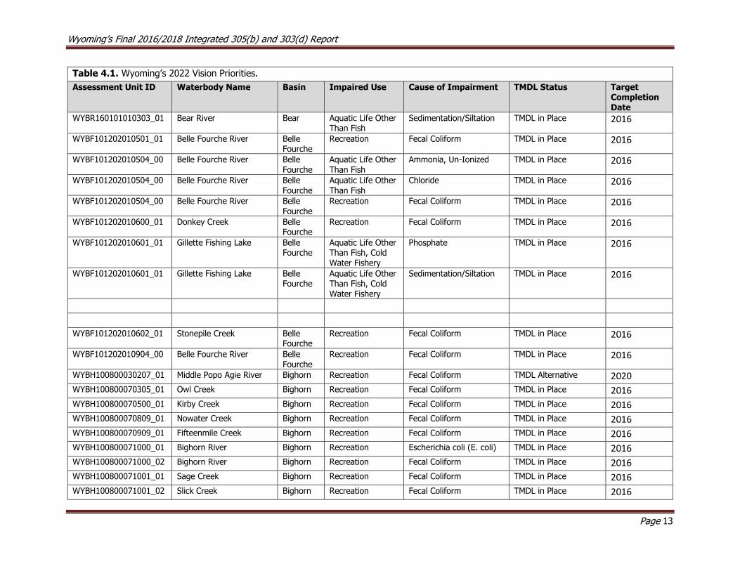
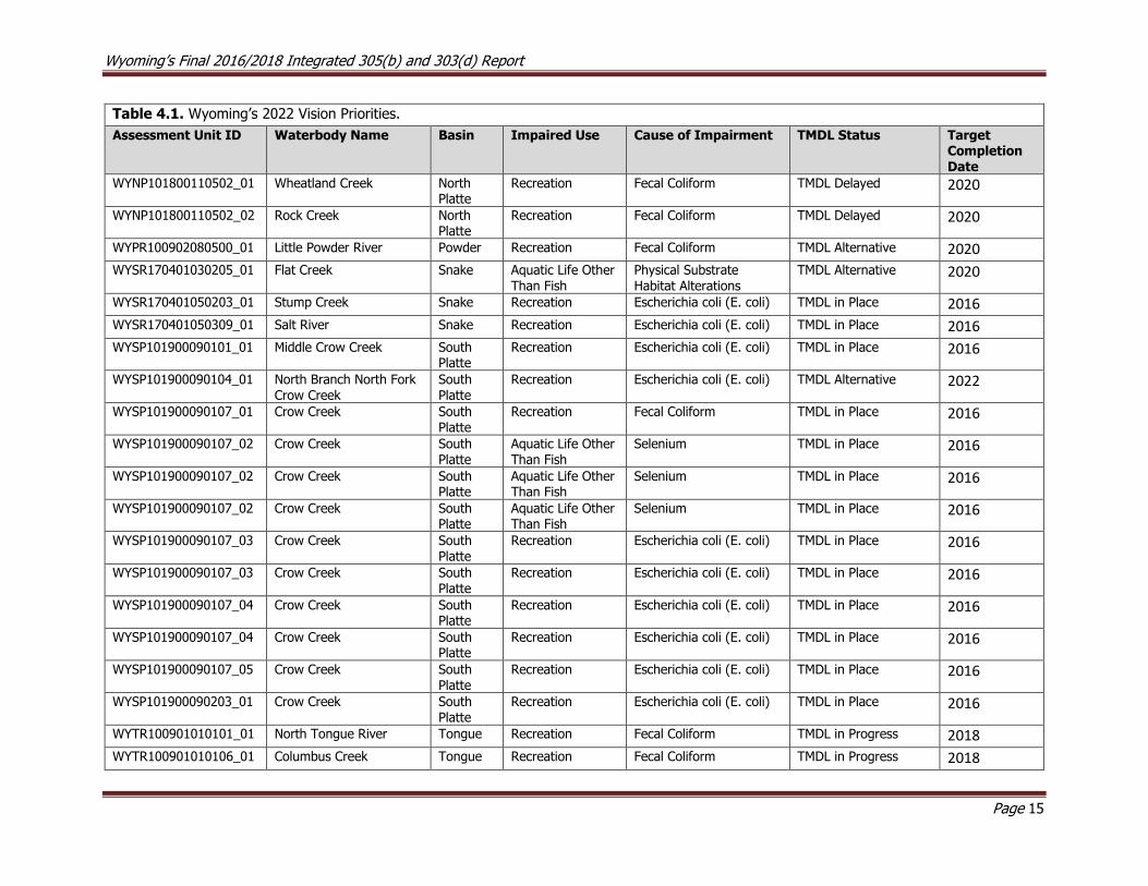
The results (i.e., the “2022 Vision”) are provided in Table 4.1. In addition to those waters listed in Table 4.1, DEQ is also actively engaged in a number of other efforts that may not be completed prior to 2022.
These include Boysen Reservoir, Little Medicine Bow River, Shoshone River, and Bitter Creek.
Boysen Reservoir was selected as a priority for implementing the Wyoming Nutrient Strategy. The Nutrient
Strategy identifies priority items and key next steps for addressing nutrient pollution in Wyoming’s surface waters and was developed by DEQ and the Wyoming Nutrient Work Group. To effectively implement the
strategy, DEQ and the Wyoming Nutrient Work Group prioritized those waters where public health was at
risk due to nutrient pollution. Boysen Reservoir was selected because it is used frequently for immersion recreation activities, has had high cyanobacteria densities or harmful algal blooms that may pose a risk to
human and animal health, has experienced fish kills, is a drinking water supply, and is heavily used for other types of recreation such as boating and fishing. DEQ has begun compiling the existing data available
for the reservoir and watershed and will work with the Wyoming Nutrient Work Group and stakeholders in the watershed to determine next steps for addressing the sources of nutrients in the reservoir.
In 2016, DEQ established an executive committee and three work groups to respond impacts to the Shoshone River fishery below Willwood Dam due to a sediment release in 2016. The objectives of this
effort are to restore aquatic life and habitat damaged due to the release, and to reduce the frequency, magnitude, and duration of future sediment releases to protect aquatic life and habitat downstream of
the dam. The Watershed Protection Program’s Standards, Monitoring, TMDL, and Nonpoint Source
programs have been working with stakeholders, the public, and other government agencies to identify meet the objectives of the committee. More information about the committee and its efforts are at
http://deq.wyoming.gov/wqd/willwood-dam-and-shoshone-river/.
In 2014, the Little Medicine Bow River from County Road 2E downstream 26.2 miles to the confluence with
Sheep Creek was placed on the 303(d) list of impaired waterbodies for not supporting its cold water fish and aquatic life other than fish designated uses due to sediment associated with historic uranium mining
operations. Reclamation of the mined area has been ongoing since the 1980’s, and the Abandoned Mine

Wyoming’s Final 2016/2018 Integrated 305(b) and 303(d) Report
Page 12
Land Program (AML) continues working to minimize environmental impacts from the mine on the river and surrounding landscape. In 2017, AML and the TMDL program teamed up in a long-term effort to monitor
sediment loads in the river to evaluate current reclamation efforts, and to collect baseline data for future watershed planning efforts.
E. coli TMDLs were completed for Bitter Creek (WYGR140401050506_01) in 2018. However, a chloride impairment remains to be addressed. DEQ is collaborating with the Sweetwater County Conservation
District to implement a monitoring program to better understand in-stream chloride concentrations and potential sources of chlorides within the Bitter Creek watershed.
Wyoming’s Final 2016/2018 Integrated 305(b) and 303(d) Report
Page 13
Table 4.1. Wyoming’s 2022 Vision Priorities.
Assessment Unit ID Waterbody Name Basin Impaired Use Cause of Impairment TMDL Status Target Completion Date
WYBR160101010303_01 Bear River Bear Aquatic Life Other Than Fish
Sedimentation/Siltation TMDL in Place 2016
WYBF101202010501_01 Belle Fourche River Belle Fourche
Recreation Fecal Coliform TMDL in Place 2016
WYBF101202010504_00 Belle Fourche River Belle Fourche
Aquatic Life Other Than Fish
Ammonia, Un-Ionized TMDL in Place 2016
WYBF101202010504_00 Belle Fourche River Belle Fourche
Aquatic Life Other Than Fish
Chloride TMDL in Place 2016
WYBF101202010504_00 Belle Fourche River Belle Fourche
Recreation Fecal Coliform TMDL in Place 2016
WYBF101202010600_01 Donkey Creek Belle Fourche
Recreation Fecal Coliform TMDL in Place 2016
WYBF101202010601_01 Gillette Fishing Lake Belle Fourche
Aquatic Life Other Than Fish, Cold Water Fishery
Phosphate TMDL in Place 2016
WYBF101202010601_01 Gillette Fishing Lake Belle Fourche
Aquatic Life Other Than Fish, Cold Water Fishery
Sedimentation/Siltation TMDL in Place 2016
WYBF101202010602_01 Stonepile Creek Belle Fourche
Recreation Fecal Coliform TMDL in Place 2016
WYBF101202010904_00 Belle Fourche River Belle Fourche
Recreation Fecal Coliform TMDL in Place 2016
WYBH100800030207_01 Middle Popo Agie River Bighorn Recreation Fecal Coliform TMDL Alternative 2020
WYBH100800070305_01 Owl Creek Bighorn Recreation Fecal Coliform TMDL in Place 2016
WYBH100800070500_01 Kirby Creek Bighorn Recreation Fecal Coliform TMDL in Place 2016
WYBH100800070809_01 Nowater Creek Bighorn Recreation Fecal Coliform TMDL in Place 2016
WYBH100800070909_01 Fifteenmile Creek Bighorn Recreation Fecal Coliform TMDL in Place 2016
WYBH100800071000_01 Bighorn River Bighorn Recreation Escherichia coli (E. coli) TMDL in Place 2016
WYBH100800071000_02 Bighorn River Bighorn Recreation Fecal Coliform TMDL in Place 2016
WYBH100800071001_01 Sage Creek Bighorn Recreation Fecal Coliform TMDL in Place 2016
WYBH100800071001_02 Slick Creek Bighorn Recreation Fecal Coliform TMDL in Place 2016

Wyoming’s Final 2016/2018 Integrated 305(b) and 303(d) Report
Page 14
Table 4.1. Wyoming’s 2022 Vision Priorities.
Assessment Unit ID Waterbody Name Basin Impaired Use Cause of Impairment TMDL Status Target Completion Date
WYBH100800080603_01 Paint Rock Creek Bighorn Recreation Fecal Coliform TMDL in Place 2016
WYBH100800080705_01 Nowood River Bighorn Recreation Fecal Coliform TMDL in Place 2016
WYBH100800090405_01 Greybull River Bighorn Recreation Fecal Coliform TMDL in Place 2016
WYBH100800100102_01 Granite Creek Bighorn Recreation Fecal Coliform TMDL in Place 2016
WYBH100800100204_01 Beaver Creek Bighorn Recreation Fecal Coliform TMDL in Place 2016
WYBH100800100206_01 Shell Creek Bighorn Recreation Fecal Coliform TMDL in Place 2016
WYBH100800100301_01 Bighorn River Bighorn Recreation Fecal Coliform TMDL in Place 2016
WYBH100800110204_01 Dry Creek Bighorn Recreation Fecal Coliform TMDL in Place 2016
WYBH100800140107_01 Dry Gulch Bighorn Recreation Escherichia coli (E. coli) TMDL in Place 2016
WYBH100800140206_01 Bitter Creek Bighorn Recreation Fecal Coliform TMDL in Place 2016
WYBH100800140303_01 Whistle Creek Bighorn Recreation Fecal Coliform TMDL in Place 2016
WYBH100800140307_01 Foster Gulch Bighorn Recreation Fecal Coliform TMDL in Place 2016
WYBH100800140407_01 Polecat Creek Bighorn Recreation Fecal Coliform TMDL in Place 2016
WYBH100800140408_01 Sage Creek Bighorn Recreation Fecal Coliform TMDL in Place 2016
WYBH100800140408_02 Big Wash Bighorn Recreation Fecal Coliform TMDL in Place 2016
WYBH100800140504_00 Shoshone River Bighorn Recreation Fecal Coliform TMDL in Place 2016
WYGR140401050506_01 Bitter Creek Green Recreation Fecal Coliform TMDL in Place 2018
WYGR140401050808_01 Killpecker Creek Green Recreation Fecal Coliform TMDL in Place 2018
WYGR140401070106_01 Blacks Fork Green Recreation Escherichia coli (E. coli) TMDL in Progress 2018
WYGR140401070208_00 Smiths Fork Green Recreation Fecal Coliform TMDL in Progress 2018
WYGR140401070208_01 Smiths Fork Green Recreation Escherichia coli (E. coli) TMDL in Progress 2018
WYGR140401070403_01 Blacks Fork Green Recreation Fecal Coliform TMDL in Progress 2018
WYNP101800100201_01 Laramie River North Platte
Recreation Escherichia coli (E. coli) TMDL Delayed 2022
WYNP101800100605_01 Little Laramie River North Platte
Recreation Escherichia coli (E. coli) TMDL Delayed 2022
WYNP101800100707_01 Laramie River North Platte
Recreation Escherichia coli (E. coli) TMDL Delayed 2022
Wyoming’s Final 2016/2018 Integrated 305(b) and 303(d) Report
Page 15
Table 4.1. Wyoming’s 2022 Vision Priorities.
Assessment Unit ID Waterbody Name Basin Impaired Use Cause of Impairment TMDL Status Target Completion Date
WYNP101800110502_01 Wheatland Creek North Platte
Recreation Fecal Coliform TMDL Delayed 2020
WYNP101800110502_02 Rock Creek North Platte
Recreation Fecal Coliform TMDL Delayed 2020
WYPR100902080500_01 Little Powder River Powder Recreation Fecal Coliform TMDL Alternative 2020
WYSR170401030205_01 Flat Creek Snake Aquatic Life Other
Than Fish
Physical Substrate
Habitat Alterations
TMDL Alternative 2020
WYSR170401050203_01 Stump Creek Snake Recreation Escherichia coli (E. coli) TMDL in Place 2016
WYSR170401050309_01 Salt River Snake Recreation Escherichia coli (E. coli) TMDL in Place 2016
WYSP101900090101_01 Middle Crow Creek South Platte
Recreation Escherichia coli (E. coli) TMDL in Place 2016
WYSP101900090104_01 North Branch North Fork Crow Creek
South Platte
Recreation Escherichia coli (E. coli) TMDL Alternative 2022
WYSP101900090107_01 Crow Creek South Platte
Recreation Fecal Coliform TMDL in Place 2016
WYSP101900090107_02 Crow Creek South Platte
Aquatic Life Other Than Fish
Selenium TMDL in Place 2016
WYSP101900090107_02 Crow Creek South Platte
Aquatic Life Other Than Fish
Selenium TMDL in Place 2016
WYSP101900090107_02 Crow Creek South Platte
Aquatic Life Other Than Fish
Selenium TMDL in Place 2016
WYSP101900090107_03 Crow Creek South Platte
Recreation Escherichia coli (E. coli) TMDL in Place 2016
WYSP101900090107_03 Crow Creek South Platte
Recreation Escherichia coli (E. coli) TMDL in Place 2016
WYSP101900090107_04 Crow Creek South Platte
Recreation Escherichia coli (E. coli) TMDL in Place 2016
WYSP101900090107_04 Crow Creek South Platte
Recreation Escherichia coli (E. coli) TMDL in Place 2016
WYSP101900090107_05 Crow Creek South Platte
Recreation Escherichia coli (E. coli) TMDL in Place 2016
WYSP101900090203_01 Crow Creek South Platte
Recreation Escherichia coli (E. coli) TMDL in Place 2016
WYTR100901010101_01 North Tongue River Tongue Recreation Fecal Coliform TMDL in Progress 2018
WYTR100901010106_01 Columbus Creek Tongue Recreation Fecal Coliform TMDL in Progress 2018

Wyoming’s Final 2016/2018 Integrated 305(b) and 303(d) Report
Page 16
Table 4.1. Wyoming’s 2022 Vision Priorities.
Assessment Unit ID Waterbody Name Basin Impaired Use Cause of Impairment TMDL Status Target Completion Date
WYTR100901010106_02 Smith Creek Tongue Recreation Fecal Coliform TMDL in Progress 2018
WYTR100901010107_02 Little Tongue River Tongue Recreation Escherichia coli (E. coli) TMDL in Progress 2018
WYTR100901010108_01 Fivemile Creek Tongue Recreation Fecal Coliform TMDL in Progress 2018
WYTR100901010110_01 Wolf Creek Tongue Recreation Fecal Coliform TMDL in Progress 2018
WYTR100901010111_01 Tongue River Tongue Recreation Escherichia coli (E. coli) TMDL in Progress 2018
WYTR100901010400_01 Prairie Dog Creek Tongue Recreation Fecal Coliform TMDL in Place 2018
WYTR100901010401_01 Meade Creek Tongue Recreation Escherichia coli (E. coli) TMDL in Place 2018
WYTR100901010402_01 Prairie Dog Creek Tongue Recreation Fecal Coliform TMDL in Place 2018
WYTR100901010402_02 Wildcat Creek Tongue Recreation Escherichia coli (E. coli) TMDL in Place 2018
WYTR100901010405_01 Dutch Creek Tongue Recreation Escherichia coli (E. coli) TMDL in Place 2018
Wyoming’s Final 2016/2018 Integrated 305(b) and 303(d) Report
Page 17
5.0 Wyoming’s Nonpoint Source Program The Wyoming Nonpoint Source Program operates under the Watershed Protection Program of the WDEQ,
WQD. Unlike point source pollution, which can be traced back to a single defined source, nonpoint source pollution is diffuse in nature, making it difficult to assess the source of the problem. Nonpoint source
pollution occurs when runoff from rainfall or snowmelt travels over and/or percolates through the soil and
picks up contaminants. These contaminants are deposited into streams, lakes, rivers, and groundwater. While some nonpoint source pollution can be natural in origin, it is generally associated with human land-
disturbing activities such as urban development, road construction, agriculture, recreation, silviculture and mineral exploration. Common anthropogenic nonpoint source contaminants include fertilizers and pesticides
from agricultural and residential activity; oil, grease, sediment and toxic chemicals from urban runoff; sediment from construction activity or stream bank erosion; and bacteria and nutrients from livestock and
pet waste or failing septic systems.
After recognizing that nonpoint source pollution is a serious impediment to meeting the goals of the CWA
and that more focus was needed in this area, Congress amended the CWA in 1987 to include Section 319, Nonpoint Source Management Programs, which provided the basis for the Wyoming Nonpoint Source
Program. Through Section 319 grants, funds can be made available to state, federal and local agencies,
nonprofit organizations, and private individuals. Projects that reduce the impacts of nonpoint source pollution and improve water quality are eligible. The vision for the Wyoming Nonpoint Source Program is
to sponsor projects that reduce or eliminate nonpoint source pollution in threatened, impaired, and high-quality waters of the state so all designated uses are supported for the benefit of all Wyoming citizens.
Section 319 grant funds are available each year on a competitive basis. Funds are awarded as reimbursement grants, meaning funds can be issued to the recipient only after proof of expenditure on
eligible costs. All proposals submitted must identify at least 40 percent of the total project cost as non-
federal cash or in-kind services match. The Nonpoint Source Program also administers funds available under Section 604(b)/205(j) of the CWA. Section 205(j) funds are available to local government agencies for the
purpose of water quality management planning.
6.0 Emerging Surface Water Quality Issues
Methylmercury
Mercury is a metal that naturally occurs in all of the world’s surface waters to some extent and is a water
quality pollutant of increasing concern. USEPA estimates that much of the mercury pollution in U.S. surface
waters is derived from industrial air emissions from power generation and other industrial and waste disposal activities within and outside of the U.S. It has been estimated that approximately 67% of
atmospheric mercury originates from anthropogenic sources (USGS, 2009a).
The methylation of mercury occurs when inorganic mercury is converted to organic methylmercury. The degree to which mercury is converted to methylmercury in various aquatic environments is currently not
well understood. Methylmercury is highly toxic and is known to concentrate, or bioaccumulate, in the tissues
of predatory fishes; the primary route of human exposure to methylmercury is through the consumption of fish and shellfish. USEPA's (2001) Recommended Fish Tissue Residue Methylmercury Criterion is 0.3 mg
methylmercury/kg, which is based on a fish consumption rate of 0.0175 kg fish/day. USGS (2009a) estimated that approximately 27% of waters surveyed across the U.S. (including only 2 sites in Wyoming)
had fish tissue concentrations equaling or exceeding 0.3 mg methylmercury/kg. USEPA’s recommended
criterion is intended to be used by states as guidance during the development of methylmercury water quality criteria. To date, Wyoming has not adopted fish tissue based methylmercury criteria protective of
the fish consumption designated use due to a number of potential implementation issues.
Wyoming’s Final 2016/2018 Integrated 305(b) and 303(d) Report
Page 18
Between 1972 and 2011, the Wyoming Game and Fish Department (WGFD) measured the methylmercury concentrations of various species of fish collected from several reservoirs across Wyoming. WGFD sampled
only omnivorous common carp in 1972 from ten reservoirs and one river across the state and found mostly very low concentrations of mercury. Surveys between 2000 and 2011 were focused almost exclusively on
larger predatory fishes (walleye, perch, crappie, sauger, trout, bass, burbot and catfish) and to a lesser
extent omnivorous fishes (white sucker, drum and carp). WGFD reported minimum and maximum concentrations of mercury for the various species and collection dates. Maximum values were commonly
above USEPA’s recommended criterion at several reservoirs across Wyoming. However, because larger size classes were intentionally targeted and maximum values reported, higher concentrations would be
expected. The Wyoming Department of Health (WDH), in cooperation with WGFD has issued fish consumption advisories for several reservoirs across the state. These advisories include detailed dietary
recommendations to assist the public in making informed fish consumption decisions for their families.
Climate Change
In response to four assessment reports by the Intergovernmental Panel on Climate Change (IPCC), USEPA released a document entitled: NATIONAL WATER PROGRAM STRATEGY: Response to Climate Change that
summarizes the agency’s strategies for addressing threats from climate change to aquatic systems. The document lists five anticipated impacts that may directly threaten the water quality of Wyoming’s streams,
lakes, reservoirs and wetlands; these include rising stream temperatures, an increase in extreme water
related events (e.g., droughts and floods), reductions in available drinking water, and the displacement of aquatic communities as water temperatures change. In the National Water Program Strategy, the USEPA
lists mitigation, adaptation, and research of climate change as areas of focus and outlines specific goals within each. The ultimate effects of global climate change on Wyoming’s aquatic ecosystems are unknown.
Some statistical models suggest that temperatures will increase in surface waters, and that the cold water fisheries of Wyoming are particularly vulnerable to these changes (Rahel et. al. 1996).
7.0 Public Participation WDEQ/WQD encourages public participation during development and revision of this biennial document.
Many entities routinely submit water quality data during WDEQ/WQD’s biennial call for data. WDEQ/WQD
also provides a 45-day public comment period for the draft Integrated Report and formally responds to those comments prior to finalizing the Integrated Report. Once WDEQ/WQD has reviewed the comments
and developed responses, the Integrated Report is finalized and released to the public. At this time there is then a two week period during which the public may contact the Water Quality Division Administrator
and request a review of the 303(d) List before the Water and Waste Advisory Board in circumstances where
there may be objections to waters either included or not included on the list. The Water and Waste Advisory Board will consider the comments and make recommendations to WDEQ. Once the two-week period has
lapsed, WDEQ/WQD submits the report to USEPA for approval. The public participation process provides an essential component to the development and review of this report. WDEQ/WQD therefore encourages
members of the public to participate in the development and review process and recommends that the
public contact WDEQ/WQD with any questions.
8.0 Basin Descriptions and Surface Water Quality Summaries In this section, an overview of each of Wyoming’s 14 river basins is provided. Basins are then subdivided into individual sub-basins (8 digit HUCs) and the water quality condition within each is summarized. Non-
WDEQ informational sources are cited in the text and listed in the references section. WDEQ water quality monitoring reports are also cited within the text, and hyperlinks are provided to electronic copies of many
of these documents.
Wyoming’s Final 2016/2018 Integrated 305(b) and 303(d) Report
Page 19
8.1 Bear River Basin
The Bear River Basin drains approximately 2,844 mi2 in Wyoming as well as portions of Utah and Idaho.
The river flows north from its headwaters in the Uinta Mountains of Utah into Wyoming near Hilliard, continues through Evanston and re-enters Utah below Woodruff Narrows Reservoir. The river then flows
back into Wyoming at the Cokeville Meadows National Wildlife Refuge before crossing into Idaho near the community of Border. The Bear River Compact of 1958 (amended in 1980) was developed to apportion
water from the Bear River among Idaho, Utah and Wyoming as it courses between these three states. The Bear River Commission, which is composed of nine governor appointed commissioners (3 from each state)
and one federal commissioner, is tasked with administering the provisions of the compact. The Bear River
Watershed Information System provides additional water quality information for the basin. Both Idaho (bacteria, phosphorus and sediment) and Utah (dissolved oxygen and phosphorus) have completed TMDLs
for portions of the Bear River Basin.
The Bear River Basin in Wyoming consists of sub-irrigated high valleys, foothills, low mountains and some
mid-elevation mountains of the Uinta Mountains (Chapman et al. 2003). Water from the Bear River is extensively diverted within high valleys and used to irrigate alfalfa, grains and pastures. Streams in the
basin are mostly perennial at higher elevations, but may be intermittent or ephemeral at lower elevations, which may be due in part to irrigation diversions, channel down cutting, loss of riparian vegetation and
damming (ERI, 1992; NRCS, 2001). The geology of the foothills and low mountains consists of easily
erodible fine-grained sedimentary formations, which contribute high natural loads of fine sediment, salts, carbonates, sulfates, and/or phosphate. Due to the presence of these highly erodible soils, streams in much
of the basin are highly dependent on vegetation for physical stabilization and are typically very sensitive to disturbance. Land uses in the basin include livestock grazing, irrigated agriculture, oil and gas production,
historic phosphate and coal mining, wildlife habitat and recreation on Bridger-Teton National Forest and BLM lands.
Historically, Bonneville (Bear River) cutthroat trout were found throughout the Bear River Basin, but competition from non-native species, loss of aquatic habitat and water quality changes have caused
populations of these fish to decline. In 1998, a petition was filed with the U.S. Fish and Wildlife Service (USFWS) to list the Bonneville cutthroat trout as threatened under the Endangered Species Act (ESA). In
2008, the USFWS determined that listing was not warranted because a range wide status review indicated
that self-sustaining Bonneville cutthroat trout populations are well distributed throughout their historic range and are being restored or protected in all currently occupied watersheds. The Wyoming Game and
Fish Department (WGFD) has been working with Idaho, Nevada and Utah as part of a Bonneville Cutthroat Interagency team to develop conservation strategies to improve and sustain Bonneville cutthroat trout
populations.
Upper Bear River Sub-basin (HUC 16010101)
Assessed Waters
Bear River (WYBR160101010201_01; WYBR160101010303_01), Class 2AB
Between 1995 and 1998, WDEQ (2001) collected physical, chemical, and biological data at five study sites
along the Bear River, and the report concluded that the entire Bear River watershed above Sulphur Creek, excluding Mill Creek, was fully supporting its aquatic life other than fish and cold water fish designated
uses. As a result, the Bear River (WYBR160101010201_01) watershed above Sulphur Creek, excluding Mill
Creek watershed was placed in Category 2 in 2002.
The same report (WDEQ, 2001) also concluded that the Bear River between Sulphur Creek and Woodruff Narrows Reservoir was not supporting its aquatic life other than fish and cold water fish designated uses
due to excess sediment. As a result, a 36.5 mile segment of the Bear River (WYBR160101010303_01) was
added to the 303(d) List in 2002 due to sediment. Sedimentation from Sulphur Creek and from habitat alteration along the Bear River were identified as likely sources of sediment. The report also noted that

Wyoming’s Final 2016/2018 Integrated 305(b) and 303(d) Report
Page 20
much of the river within this segment is channelized and has poor quality trout habitat. A WGFD riparian improvement project on the Bear River was completed near Evanston. Uinta County Conservation District
(UCCD) formed a watershed steering committee and has completed a Bear River watershed plan.
In 2016, a sediment TMDL was completed for the impaired segment of the Bear River
(WYBR160101010303_01). As a result, this stream segment was placed in Category 4A in 2018.
Pleasant Valley Creek (WYBR160101010301_01), Class 3B
In 1995, WDEQ (2001) collected physical, chemical, and biological data at five study sites along Pleasant
Valley Creek. The report indicated excess sediment and nutrient loading to Crompton Reservoir, but it
concluded that Pleasant Valley Creek was fully supporting its aquatic life other than fish designated use. No fish were observed during this study, which supports the current 3B classification of the creek. As a
result, the entire Pleasant Valley Creek (WYBR160101010301_01) watershed above Crompton Reservoir was placed in Category 2 in 2002.
Bridger Creek (WYBR160101010801_01), Class 3B
ERI (1992) identified the Bridger Creek watershed as a significant contributor of both sediment and
phosphates to the Bear River, and based on this study, WDEQ concluded that the Bridger Creek watershed was not supporting its aquatic life other than fish designated use. As a result, the entire Bridger Creek
(WYBR160101010801_01) watershed was added to the 303(d) List in 1998 due to sediment threatening
its designated uses. The watershed transitions between intermittent and ephemeral reaches, and the majority of the sediment loading occurs during spring snowmelt runoff and rain storm events. The primary
sources of sediment were identified as the re-routing and channelization of approximately 2,500 feet of the main stem of Bridger Creek for road and railroad construction, which resulted in extensive head cutting
and sedimentation in the lower watershed. The study also identified historic livestock and wildlife grazing
on the BLM’s Cumberland/Uinta Allotment as contributing to poor riparian vegetation cover, which in turn led to extensive down cutting and erosion of the stream channel throughout the watershed.
In 1996, a Section 319 Bridger Creek Restoration Project (ERI, 1996) was completed to reduce sediment
loading to the creek. As part of this project, seven small sediment retention reservoirs were constructed in the upper watershed to trap sediment, create an alternative water source for livestock and to reduce further
head cutting and down cutting in the upper watershed. In addition, a pre-existing large gravel pit in the
lower watershed near the Utah border was modified into a sediment basin designed to reduce head cutting in the stream channel near Highway 30/89 and to trap sediment from the upper watershed. ERI (1996)
estimated that the gravel pit reduced sediment loading to the Bear River by 58%. However, sediment data from before and after BMPs were implemented are largely lacking within the Bridger Creek watershed and
on the Bear River above and below the confluence with Bridger Creek. Livestock grazing management was
also modified through the 1996 BLM Cumberland/Uinta Allotment Operating Plan and the 2000 BLM Cumberland/Uinta Allotment Cooperative Management Plan to enhance riparian vegetation and improve
streambank stability. Green line studies conducted by the BLM in 2008-09 indicated that the riparian condition may be improving. However, there were relatively few physical indicators (e.g. sediment load,
water temperature and channel morphology) that can be used to determine whether the watershed’s condition has improved.
Other Monitoring Efforts in the Upper Bear River Sub-basin
Sulphur Creek
In 1998 and 1999, WDEQ (2002) monitored Sulphur Creek at study sites above and below Sulphur Creek
Reservoir. The study identified excess sediment and nutrients as concerns, but designated uses were not assessed. The report indicated that potential sources of these pollutants were heavy riparian grazing and
bank erosion, rapidly fluctuating flows below the reservoir, and changes in seasonal flows in the upstream
channel.

Wyoming’s Final 2016/2018 Integrated 305(b) and 303(d) Report
Page 21
Twin Creek
The Twin Creek watershed flows through highly erodible shales that contribute carbonates, salts and metals
to the watershed. Twin Creek was channelized during the construction of a railroad line built along the creek in the late 1800s. This channelization has restricted lateral channel adjustments and caused the
stream to down cut as much as 8-15 feet below its original flood plain. Resource concerns within the
watershed include the loss of perennial flows in upper Twin Creek since the 1970s, sediment and nutrient loading to the Bear River (NRCS, 2001), and damage to riparian areas from historic livestock grazing and
other land uses (BLM, 2005b). Phosphate was mined in the drainage between 1910 and 1977, and a phosphate mill operated until about 1985 using ore mined in Idaho. In 2008, a project to reclaim unstable
mine tailings and eroding spoils piles within a 140 acre area along Twin Creek was completed by WDEQ’s
Abandoned Mine Lands Division (AML).
Figure 8.1.1. Map of the Upper Bear River Sub-basin showing the location of assessed waters
Central Bear River Sub-basin (HUC 16010102)
Assessed Waters
Coantag Creek (WYBR160101020201_02), Class 2AB
In 1998, WDEQ (2002) collected physical, chemical, and biological data along Coantag Creek, and no
exceedances of any numeric criteria or narrative water quality criteria were detected, although water
hardness was slightly elevated (195 mg/l). The report concluded Coantag Creek was fully supporting its cold water fish and aquatic life other than fish designated uses. As a result, the entire Coantag Creek

Wyoming’s Final 2016/2018 Integrated 305(b) and 303(d) Report
Page 22
(WYBR160101020201_02) watershed above the confluence with Hobble Creek was placed in Category 2 in
2004.
Smiths Fork (WYBR160101020204_01), Class 2AB
Data collected by WDEQ on the Smiths Fork above Muddy Creek indicated that Smiths Fork was fully supporting its cold water fish and aquatic life other than fish designated uses. As a result, the entire Smiths
Fork (WYBR160101020204_01) watershed above Muddy Creek was placed in Category 2 in 2004.
Hobble Creek (WYBR160101020201_01), Class 2AB
Data collected by WDEQ indicated that Hobble Creek was fully supporting its cold water fish and aquatic
life other than fish designated uses. As a result, the entire Hobble Creek (WYBR160101020201_01)
watershed above Smiths Fork, excluding Coantag Creek, was placed in Category 2 in 2006.
Salt Creek (WYBR160101020303_01), Class 2AB
Salt Creek is a tributary to the Thomas Fork, which ultimately feeds into the Bear River. Some reaches of
Salt Creek have unstable banks due to naturally erosive geology and channel confinement imposed by the construction of a highway within the valley. As a result, sediment and nutrients were identified as possible
water quality concerns in portions of the Salt Creek watershed, both in Idaho and Wyoming (ERI, 1992).
In 1995 and 1998, WDEQ (2005) collected physical, chemical, and biological data at two study sites along Salt Creek. The report noted that riparian conditions are improving, the macroinvertebrate community was
fairly diverse, and that Salt Creek was fully supporting its cold water fish designated use. As a result, the
entire Salt Creek (WYBR160101020303_01) watershed upstream of the Idaho border, excluding Giraffe
Creek and Coal Creek watersheds, was placed in Category 2 in 2006.
WGFD and BLM have completed several riparian improvement projects on Coal and Little Muddy Creeks
within the Salt Creek watershed to enhance Bonneville cutthroat trout populations.
Giraffe Creek (WYBR160101020304_00), Class 2AB
WDEQ collected data on Giraffe Creek, a tributary to Salt Creek, in 1998 in response to concerns expressed
by Idaho DEQ regarding the impact of tributaries on designated uses for the Thomas Fork in Idaho. WDEQ
(2001) collected biological data at one study site along Giraffe Creek; the report concluded that Giraffe Creek supported its cold water fish and aquatic life other than fish designated uses. As a result, the entire
Giraffe Creek (WYBR160101020304_00) watershed upstream of Salt Creek was placed in Category 2 in
2006.

Wyoming’s Final 2016/2018 Integrated 305(b) and 303(d) Report
Page 23
Figure 8.1.2. Map of the Central Bear River Sub-basin showing the location of assessed waters
Wyoming’s Final 2016/2018 Integrated 305(b) and 303(d) Report
Page 24
8.2 Belle Fourche River Basin
The Belle Fourche River Basin in Wyoming drains approximately 5,512 mi2. The basin’s headwaters originate
in the rolling prairie and Pine Scoria Hills of southern Campbell County. The river then flows northeast through the semiarid Pierre Shale Plains and through the Black Hills Foothills before entering South Dakota.
Most streams originating in the plains are naturally intermittent; however, discharges from coal mines, CBM production, and those from the City of Gillette provide perennial flows in Donkey Creek, portions of the
Belle Fourche River and several other plains streams. Land uses in the basin consist mostly of oil and gas production, coal and bentonite mining, livestock grazing, dryland farming and wildlife habitat (Chapman et
al. 2003).
Keyhole Reservoir (193,753 acre-feet) is located on the Belle Fourche River about 17 miles northeast of
Moorcroft and is operated by the Bureau of Reclamation (USBOR). The reservoir was built in the 1950s to provide a supplemental water supply to the Belle Fourche Reservoir in South Dakota, to provide recreational
opportunities and for flood control. Water stored in the reservoir is allocated between Wyoming (10%) and
South Dakota (90%) users through provisions in the Belle Fourche River Compact of 1943. The Belle Fourche River below Keyhole Reservoir has perennial flow due to reservoir releases and perennial tributaries
originating in the Black Hills.
The South Dakota Department of Environment and Natural Resources (SDDENR) added the Belle Fourche
River from the Wyoming/South Dakota state line downstream to Fruitdale, South Dakota to their 303(d) List in 2002 because total suspended solids (TSS) and fecal coliform bacteria were impairing the Warmwater
Permanent Fish Life and Immersion Recreation Uses. SDDENR completed a TMDL for TSS on the Belle Fourche River (Hoyer and Larson, 2005). The TMDL concluded that most of the elevated TSS in the river
is likely from stream incision and bank failure. The study also indicated that releases of water from Keyhole Reservoir for irrigation have significantly increased TSS and specific conductivity in South Dakota. SDDENR
has also completed a TMDL for fecal coliform (Foreman, 2007) that estimates a 46% reduction in fecal
coliform bacteria would be necessary to bring the river into compliance with South Dakota’s water quality standards. Bacterial source tracking used in the study failed to distinguish between humans, livestock, and
wildlife as potential sources. Bacterial concentrations were the highest during runoff events and during water releases from Keyhole Reservoir, indicating that contamination may be occurring via overland flow
and through re-suspension of reservoir sediments. Crook County Natural Resource District (CCNRD)
completed a watershed plan for the Belle Fourche River in 2005.
In 2006 and 2009-2010, USGS (2011) sampled the Belle Fourche River near Moorcroft for pesticides and detected 33 different pesticides; however, concentrations of these pollutants were well below the human
health criteria for drinking water and fish consumption in Wyoming Water Quality Rules and Regulations, Chapter 1, Appendix B. In addition to sampling for pesticides, the State and the Crook County Natural
Resource District (CCNRD) collected other water quality samples during the late 2000’s. Data collected
resulted in five impaired segments on two waterbodies, Donkey Creek and the Belle Fourche River, being included in the 2010 Wyoming Department of Environmental Quality’s 303(d) list for the Upper Belle
Fourche River subbasin. Multiple agencies and organizations throughout the Belle Fourche River Watershed continued to collect data and information used to develop a Total Maximum Daily Load (TMDL) document
and implementation plan. The DEQ contracted development of the TMDLs to Tetra Tech who submitted a
total of seven TMDLs in 2011. The revised TMDLs for five stream segments were finalized for the WDEQ in August 2013 and approved later that year by the Environmental Protection Agency (EPA) as the Belle
Fourche River Watershed TMDLs for Pathogens, Ammonia, and Chloride.
Coal bed methane (CBM) production in the Belle Fourche River Basin peaked in July, 2009 and steadily
declined since. According to WYPDES, approximately 229 CBM permits, including 1,413 outfalls were present in the Belle Fourche River Basin during 2009, whereas approximately 38 permits and 214 outfalls
were present as of May, 2018.
Wyoming’s Final 2016/2018 Integrated 305(b) and 303(d) Report
Page 25
Upper Belle Fourche Sub-basin (HUC 10120201)
Assessed Waters
Belle Fourche River (WYBF101202010501_01; WYBF101202010504_00; WYBF101202010904_00), Class 2ABww
WDEQ identified the following three segments of the Belle Fourche River as not supporting their recreation
designated uses due to fecal coliform (WDEQ 2004a, 2004b): the Belle Fourche River (WYBF101202010501_01) from the confluence with Donkey Creek to a point upstream 6.2 miles; the Belle
Fourche River (WYBF101202010904_00) from the confluence Arch Creek downstream to the confluence with Sourdough Creek; and the Belle Fourche River (WYBF101202010504_00) from Keyhole Reservoir
upstream to the confluence with Donkey Creek. As a result, these three segments of the Belle Fourche
River were added to the 303(d) List in 2008 for fecal coliform. Data gathered between 2006 and 2008 from USGS gage #06426500 indicated high E. coli counts in the Belle Fourche River near Moorcroft. Crook
County Natural Resource District (CCNRD) has conducted monitoring, implemented septic and range and water improvement projects, and has developed a watershed plan to address these impairments.
USGS data from 2009-10 indicated that the Belle Fourche River frequently exceeded the acute chloride numeric criterion protective of the aquatic life and occasionally exceeded the acute ammonia numeric
criterion protective of the warm water game fish designated use. As a result, a segment of the Belle Fourche River (WYBF101202010504_00) from Keyhole Reservoir upstream to the confluence with Donkey Creek
was added to the 303(d) List in 2008 for chloride and ammonia.
TMDLs were completed in August, 2013 for the five 303(d) Listings in the upper Belle Fourche watershed;
these five listings were subsequently removed from the 303(d) List and placed in Category 4A in 2014.
Donkey Creek (WYBF101202010600_01) and Stonepile Creek (WYBF101202010602_01), Class 3B
The City of Gillette is the fourth largest municipality in Wyoming and is situated at the headwaters of the
Donkey Creek watershed. WDEQ (2000) collected physical, chemical, and biological data along Donkey Creek and Stonepile Creek, and several exceedances of the fecal coliform criterion protective of the primary
contact recreation designated use were detected on both creeks. As a result, a 61.4 mile segment of Donkey
Creek (WYBF101202010600_01) from the confluence with the Belle Fourche River upstream to Brorby Boulevard within the city of Gillette and a 7.5 mile segment of Stonepile Creek (WYBF101202010602_01)
were added to the 303(d) List in 2000 and 2002, respectively, for fecal coliform. Supplemental data, collected as part of the 2008 Little Powder River and Belle Fourche Drainages Watershed Implementation
Section 319 Project extended the impairment on Stonepile Creek an additional 0.1 mile. The segment now extends 7.6 miles, from the confluence with Donkey Creek upstream to the junction of Highways 14/16
and 59.
In 2006, the Campbell County Conservation District (CCCD), in cooperation with the Donkey Creek
Watershed Steering Committee, developed a watershed plan for Donkey Creek and Stonepile Creek. Implementation strategies identified by CCD and the Donkey Creek Watershed Steering Committee focused
on septic system improvements, education of urban and rural residents, urban sewage treatment, storm water runoff, solid waste management, small acreage land use management, and rural development issues.
CCCD completed the Powder River and Belle Fourche River Watersheds Monitoring 205(j) Final Report in
2014. The project included water quality monitoring during 2010 through 2013 on Donkey and Stonepile Creeks. Ammonia, chloride and E. coli were monitored on Donkey Creek and E. coli was monitored on
Stonepile Creek. Goals of the monitoring included determining water quality trends, identifying potential sources of pollution, and evaluating pollutant loading to impaired portions of the Belle Fourche River.
Concentrations of E. coli continue to be elevated in both Donkey and Stonepile Creeks. Chloride and ammonia concentrations in both creeks were elevated as well, indicating that these waters are contributing
to the high chloride impairing aquatic life uses in the Belle Fourche River. The report suggested that a
Wyoming’s Final 2016/2018 Integrated 305(b) and 303(d) Report
Page 26
source of these elevated concentrations may be wastewater treatment plants using chlorination, oil and gas discharges, and de-icing agents used on roads..
In 2013, the USEPA approved a TMDL for Donkey Creek and Stonepile Creek, and these waters were placed
in Category 4A in 2014. In August 2016, the CCCD and Donkey Creek Watershed Steering Committee
updated the 2006 watershed plan.
Gillette Fishing Lake (WYBF101202010601_01), Class 2ABww
Gillette Fishing Lake is a 25 acre lake located within the City of Gillette. The lake was added to the 303(d)
List in 1996 because WGFD suggested that excess sediment and phosphate were impairing the aquatic life
other than fish and cold water fish designated uses. A Section 205j Fishing Lake Water Quality Study (Ecological Services, 1995) was initiated by CCCD to determine the sources of these pollutants. Data
suggested that stormwater runoff from the City of Gillette was the primary source. CCCD, in cooperation with the city of Gillette, developed a water quality improvement plan to address these two impairments
(WADC, 2015). The three main goals outlined in the plan were to construct a wetland complex at the lake’s
inlet to trap sediment, stabilize the lake’s banks and dredge the lake. In 2011, the city began designing the wetland complex and bank stabilization structures (WACD, 2011). The City of Gillette completed Phase 1
of a Section 319 Project in 2012, which included the construction of the wetland complex with five sediment basins. The City of Gillette has received funding from the Wyoming Wildlife and Natural Resources Trust to
help offset the costs of upgrading Gillette Fishing Lake. These funds were utilized to purchase three floating islands that may mitigate nutrient concentrations within the Lake. The City of Gillette initiated sediment
and phosphate TMDLs for Gillette Fishing Lake in 2008. These TMDLs were delayed to allow a UAA that
changed Gillette Fishing Lake’s classification from cold water game fish (2AB) to warm water game fish (2ABww) submitted by the City of Gillette to be reviewed. The UAA was approved by WDEQ and USEPA in
2011. TMDLs on Gillette Fishing Lake for sediment and phosphate were approved by USEPA in February, 2013. As a result, Gillette Fishing Lake was removed from the 303(d) List and placed in Category 4A in
2014.
Blacktail Creek (WYBF101202010903_01), Class 2AB
The headwaters of Blacktail Creek are located in the northwestern portion of the Black Hills. The creek flows northwest and ultimately confluences with the Belle Fourche River near the town of Hulett. In 2000,
WDEQ (2004) collected physical, chemical and biological data from a single study site along Blacktail Creek
within the Black Hills, and no exceedances of any water quality numeric criteria were detected. Streambanks were considered moderately stable and sedimentation was not considered a problem in the creek channel.
The limited physical issues that were noted were attributed to historic grazing activities. The report concluded that Blacktail Creek was fully supporting its cold water fish and aquatic life other than fish
designated uses. As a result, the entire Blacktail Creek (WYBF101202010903_01) watershed above the
Black Hills National Forest boundary was placed in Category 2 in 2006.
Beaver Creek (WYBF101202010906_00), Class 2AB
Beaver Creek is located in the Bearlodge Mountains within the Black Hills National Forest. Beaver Creek
above Cook Lake is perennial, but it is intermittent below the lake’s outlet. In 2000, WDEQ (2004) collected
physical, chemical, and biological data at three study sites along Beaver Creek. Water temperatures within the lower section of Beaver Creek were periodically elevated, which was attributed to riparian degradation
from historic grazing and the stream’s naturally intermittent hydrology. The report concluded that Beaver Creek was fully supporting its cold water fish and aquatic life other than fish designated uses. As a result,
a segment of Beaver Creek (WYBF101202010906_00) from the confluence with Lame Jones Creek to a
point 32.1 miles upstream was placed in Category 2 in 2006.
Wood Canyon Creek (WYBF101202010906_02), Class 3B
Wood Canyon Creek is located in the Bearlodge Mountains within the Black Hills National Forest. The lower
reaches of Wood Canyon Creek are perennial, which is evidence that the lower reaches may be mis-
Wyoming’s Final 2016/2018 Integrated 305(b) and 303(d) Report
Page 27
classified as a 3B water. The other ephemeral/intermittent reaches of the creek are likely correctly classified. In 2000, WDEQ (2004) collected physical, chemical, and biological data at one study site along Wood
Canyon Creek. The report noted that stream banks in Wood Canyon Creek were stable and not actively eroding, and aquatic habitat was comparable to reference streams in the region. The report concluded that
Wood Canyon Creek was fully supporting its cold water fish and aquatic life other than fish designated
uses. As a result, a segment of Wood Canyon Creek (WYBF101202010906_02) from the confluence with
Beaver Creek to a point 2.7 miles upstream was placed in Category 2 in 2006.
Reservoir Gulch (WYBF101202010906_03), Class 3B
Reservoir Gulch is located in the Bearlodge Mountains within the Black Hills National Forest. Reservoir Gulch is predominantly a perennial stream, with flows originating from springs and seepage from beaver dams.
In 2000, WDEQ (2004) collected physical, chemical, and biological data at one study site along Reservoir Gulch. The report noted that stream banks in Reservoir Gulch were stable and not actively eroding, and
aquatic habitat was comparable to reference streams in the region. The report concluded that Reservoir
Gulch was fully supporting its cold water fish and aquatic life other than fish designated uses. As a result, a segment of Reservoir Gulch (WYBF101202010906_03) from the confluence with Beaver Creek to a point
1.8 miles upstream was placed in Category 2 in 2006.
Cub Creek (WYBF101202010906_04), Class 2AB
Cub Creek is located in the Bearlodge Mountains within the Black Hills National Forest. The upper section
of Cub Creek is perennial, with flows originating from seepage from beaver dams in some sections.
Downstream, the creek is ephemeral or intermittent. In 2000, WDEQ (2004) collected physical, chemical, and biological data at one study site along Cub Creek, and the report noted that riparian vegetation was
well established, banks were stable, and aquatic habitat was in good condition despite signs of heavy grazing. The report concluded that Cub Creek was fully supporting its cold water fish and aquatic life other
than fish designated uses. As a result, a segment of Cub Creek (WYBF101202010906_04) from the
confluence with Beaver Creek to a point 2.1 miles upstream was placed in Category 2 in 2006.
Fawn Creek (WYBF101202010906_06), Class 3B
The headwaters of Fawn Creek are located in the Bearlodge Mountains within the Black Hills National
Forest. In 2000, WDEQ, (2004) collected physical, chemical, and biological data from a single study site located on Fawn Creek. No exceedances of any water quality numeric criteria were detected. Excess fine
sediments were noted but were attributed to the stream channel adjusting to historic grazing practices and to the intermittent hydrology of the watershed. Streambanks and riparian condition were considered to be
stabilizing due to improvements in grazing management. The macroinvertebrate community was
considered comparable to reference condition. The report concluded that Fawn Creek supported its aquatic life other than fish designated use from the confluence with Beaver Creek to a point 3.1 miles upstream.
As a result, this segment Fawn Creek was placed in Category 2 in 2006.
Little Creek (WYBF101202010906_05), Class 3B
The headwaters of Little Creek are located in the Bearlodge Mountains within the Black Hills National Forest. In 2000, WDEQ (2004) collected physical, chemical, and biological data from a single study site along Little
Creek, and no exceedances of any water quality numeric criteria were detected. Elevated fine sediment was noted during this study, but was attributed to the failure of beaver dams. Overall, the streambanks
and streambed substrata were described as stable and composed of cobbles and boulders. The
comparability of the study site to reference was only 62%; however, this departure was attributed to differences in water chemistry associated with natural geology. The report concluded that Little Creek
supported its aquatic life other than fish designated use from the confluence with Beaver Creek to a point
1.3 miles upstream. As a result, this segment of Little Creek was placed in Category 2 in 2006.

Wyoming’s Final 2016/2018 Integrated 305(b) and 303(d) Report
Page 28
Figure 8.2.1. Map of the Upper Belle Fourche Sub-basin showing the location of assessed waters
Lower Belle Fourche Sub-basin (HUC 10120202) It is currently unknown whether the elevated bacteria concentrations that occur in the upper Belle Fourche sub-basin continue downstream into this sub-basin. Escherichia coli data collected along the Belle Fourche
River by CCNRD in 2003 and 2004 (EDE, 2005) showed some elevated individual sample concentrations;
however, all calculated geometric means were below WDEQ’s criterion protective of primary contact recreation. Foreman (2007) reported that 9 of 16 individual samples collected from the Belle Fourche River
in South Dakota near the WY/SD border during 2004 and 2005 exceeded SDDENR’s 400 CFU/100 mL single sample maximum criterion for fecal coliform bacteria.
Redwater Sub-basin (HUC 10120203) Springs discharge thousands of gallons of water per minute to Sand Creek, which is identified as a Class 1 water by WDEQ. The lower portion of the creek is considered a high quality trout fishery by WGFD. WDEQ
has monitored water quality on Sand Creek, but designated uses were not assessed.
8.3 Bighorn River Basin
The Big Horn River Basin in Wyoming drains approximately 20,949 mi2, and is bordered by the Absaroka
and Wind River Mountain Ranges to the west, Beaver Rim to the south and the Bighorn Mountains to the east. The Absaroka Mountains are a volcanic mountain range originating 40-50 million years ago from a
group of approximately 25 large volcanoes (Chapman et al. 2003 ). Ecoregions within this mountain range include alpine, sub-alpine and foothills. Soils in these mountains are nutrient rich, and consist of highly
erosional ash, tuff, basalt and pumice, which can naturally elevate stream turbidity during precipitation
Wyoming’s Final 2016/2018 Integrated 305(b) and 303(d) Report
Page 29
events. The Wind River Mountains consist of alpine and sub-alpine granitic mountains flanked by dry sedimentary foothills and low mountains. Soils in the latter two ecoregions are coarse, acidic and low in
nutrients; lower elevation sedimentary soils consist of sandstone, shales, siltstone and limestone. The Beaver Rim is composed of rolling sagebrush steppe, which includes rolling plains, mesas and terraces. The
Bighorn Mountains are geologically diverse, containing alpine, granitic and sedimentary sub-alpine, mid-
elevation sedimentary mountains and foothills. The mid-elevation Bighorn Mountains are characterized by rounded shale hills, limestone bluffs and sandstone flatirons and multiple steep canyons (Chapman et al.
2003). The Bighorn Basin lies between these mountain ranges and is divided between Bighorn Basin and Bighorn Salt Desert Shrub Basin ecoregions. The basin is an arid depression characterized by alkaline soils
consisting of shale, siltstone and sandstone. Land uses in the mountains of the basin include livestock grazing, wildlife habitat and recreation. Livestock grazing, irrigated cropland, oil and gas production,
bentonite mining and wildlife habitat are the primary land uses in the lower basin. Substantial portions of
the Upper Wind River and Little Wind River Sub-basins are located within the Wind River Indian Reservation; USEPA or authorized tribes administer the Clean Water Act in Indian Country, as defined at 18 U.S.C. Section 1151.
Water quality is generally good within the mountains of the basin (Ferguson, 2007), but gradually declines
as streams flow across the lower basin to the Bighorn River because of natural erosional processes that
increase sediment and TDS loads. Most of the lower Bighorn Basin has thin soils derived from highly erodible, saline, alkaline and/or phosphate-rich geologic materials. Much of the precipitation in the lower
elevation portions of this arid basin comes from thunderstorms, and these events can cause flash flooding and severe erosion of the sparsely-vegetated soils. Accelerated erosion, irrigated agricultural runoff,
discharge from oil and gas development and other human activities may also degrade water quality (USGS,
1956; USGS, 1999). Other anthropogenic impacts, thought to date to the 1880s, have affected sediment transport in some of the lower elevation portions of the basin. For example, historic livestock grazing
practices (long term/high density grazing) removed native grasses and began a cycle of intense runoff and gullying that exacerbated naturally unstable conditions (Marston and Anderson, 1991). Wohl et. al. (2007)
reported that many streams within the Bighorn National Forest have been substantially impacted by cattle grazing, irrigated crop production, flow regulation and diversion, and timber harvest. The prevalence of
dams and other hydrologic modifications have altered the natural flow regime of the basin (USGS, 1956;
Bray, 1996).
A study conducted by USGS (2007) compared the concentration of pesticides at two sites on the Bighorn River (near Kane and Basin) and one site on the Shoshone River (near Lovell) across three seasons. Sixteen
different pesticides were detected, all of which were at low concentrations and did not exceed the drinking
water criteria in Appendix B of Chapter 1. A second pesticide study (USGS, 2011) conducted during the summer of 2009 and spring of 2010 detected 4 and 12 different pesticides, respectively, in the Bighorn
River at Kane. The same studies detected 4 and 10 different pesticides during these two years in the Shoshone River near Lovell. Concentrations of these pollutants in both rivers were well below the state’s
drinking water criteria.
Upper Wind Sub-basin (HUC 10080001)
Assessed Waters
Brooks Lake (WYBH100800010104_01), Class 2AB
Brooks Lake drains a relatively small watershed (approximately 12.9 mi2) that is located in Fremont County, near Togwotee Pass. Fish kills were observed on Brooks Lake in both 2001 and 2008. Because large growths
of algae were observed at the lake on both occasions, it was suggested by WGFD that the mortalities were likely caused by depressed dissolved oxygen concentrations. Between 2009 and 2012, WDEQ (2015)
monitored Brooks Lake to determine: 1) the cause of the fish kills; 2) nutrient concentrations and algal
productivity in Brooks Lake as compared to adjacent reference lakes; 3) potential sources of nutrients to Brooks Lake; and 4) whether applicable water quality standards were attained in Brooks Lake. The report

Wyoming’s Final 2016/2018 Integrated 305(b) and 303(d) Report
Page 30
concluded that Brooks Lake was not supporting its cold water fish and aquatic life other than fish designated uses due to nutrient enrichment and elevated pH that regularly exceeded 9. Nearby horse corrals and a
wastewater lagoon located next to the lake were identified sources of excess nutrients and elevated pH. As a result, Brooks Lake (WYBH100800010104_01) was added to the 303(d) List in 2018 for not supporting
its cold water fish and aquatic life other than fish designated uses due to nutrients and pH.
Trappers Creek (WYBH100800010110_01), Class 2AB
Trappers Creek is a small tributary to Warm Spring Creek in the northern Wind River Mountains of the Bridger-Teton National Forest. In 1999, WDEQ (2004) monitored Trappers Creek because data collected
by USFS suggested that there may be excess sedimentation in the stream from livestock grazing, timber
harvest, and roads. The study confirmed that excess sedimentation was an issue in Trappers Creek. That said, the macroinvertebrate community was relatively healthy, so WDEQ decided to delay making a use
support determination on the creek until USFS BMPs could be implemented further. In 2004 and 2005, the USFS (2007) conducted surveys throughout the watershed to assess watershed health. The study
concluded that much of the sedimentation in the watershed was natural in origin, historic management
practices had accelerated erosion, and current land use practices had improved habitat conditions. WDEQ subsequently determined that the entire Trappers Creek watershed upstream of the confluence with Warm
Springs Creek was fully supporting its cold water fishy and aquatic life other than fish designated uses. As a result, the entire Trappers Creek (WYBH100800010110_01) watershed above Springs Creek was placed
in Category 2 in 2008.
Bear Creek (WYBH100800010408_00), Class 2AB
In 1999, WDEQ (2003) collected data on Bear Creek at two study sites and concluded the entire Bear Creek watershed upstream of the confluence with the East Fork Wind River was supporting its cold water fish and
aquatic life other than fish designated uses. As a result, the entire Bear Creek (WYBH100800010408_00)
watershed above the East Fork Wind River was placed in Category 2 in 2006.
East Fork Wind River (WYBH100800010409_00), Class 2AB
The main stem of the East Fork of the Wind River, including its confluence with the Wind River makes up
much of the northwest boundary of the Wind River Indian Reservation. In 1999, WDEQ (2003) collected
data on the East Fork of the Wind River and concluded that the entire watershed upstream of the confluence with Wiggins Fork (excluding Bear Creek) was fully supporting its cold water fish and aquatic life other than
fish designated uses. As a result, the East Fork Wind River (WYBH100800010409_00) watershed above Wiggins Fork was placed in Category 2 in 2006.
Other Monitoring Efforts in the Sub-basin
West Brooks Lake Creek
West Brooks Lake Creek is a small tributary to Brooks Lake within the Shoshone National Forest near
Togwotee Pass. In 1999 and 2004, WDEQ (2004) in collected data in Brooks Lake Creek after data collected by USFS suggested that vegetation removal, stream bank erosion, and siltation were negatively affecting
aquatic life and habitat in the stream. These conditions were thought to be caused primarily by livestock
grazing. In 1999, WDEQ monitored the creek and noted that the stream was much wider than expected, the stream banks were actively eroding, vegetation was sparse, and sediment was aggrading the channel.
USFS subsequently changed livestock grazing strategies in the watershed. WDEQ returned in 2004 to observe channel conditions, however no numeric data were collected. Vegetation, most notably willows,
was re-establishing along banks and bars and a new floodplain was beginning to form. WDEQ determined that the changes in grazing management were effective in curbing channel degradation on West Brooks
Lake Creek, but designated uses were not assessed.

Wyoming’s Final 2016/2018 Integrated 305(b) and 303(d) Report
Page 31
Horse Creek
The headwaters of Horse Creek originate within the Absaroka Mountains and flow south to the confluence
with the Wind River within the town of Dubois. In 1999, WDEQ (2003) monitored Horse Creek in response to data collected by USFS that suggested there may be excess sedimentation from irrigation, livestock
grazing, timber harvest, and roads; however, the report did not assess designated use support.
Warm Springs Creek
In 1999, WDEQ (2003) monitored Warm Springs Creek, but designated use support was not assessed.
Wind River
In 1999, WDEQ (2003) monitored seven sites along the Wind River above and below Dubois, but designated uses were not assessed.
Figure 8.3.1. Map of the Upper Wind Sub-basin showing the location of assessed waters.
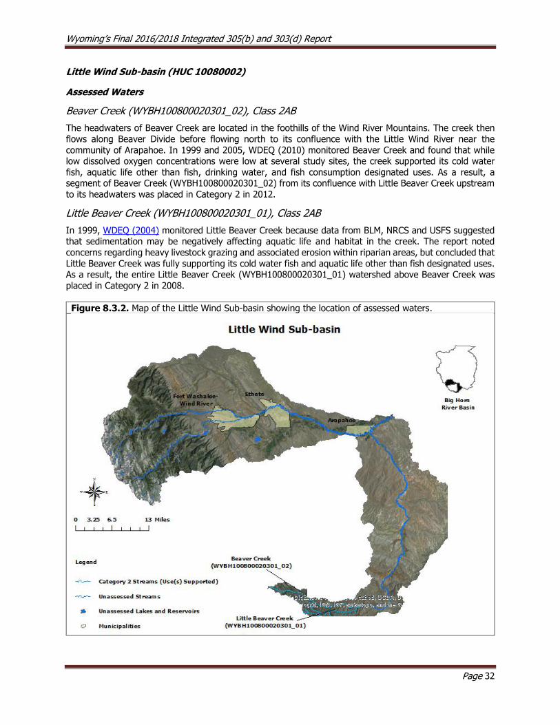
Wyoming’s Final 2016/2018 Integrated 305(b) and 303(d) Report
Page 32
Little Wind Sub-basin (HUC 10080002)
Assessed Waters
Beaver Creek (WYBH100800020301_02), Class 2AB
The headwaters of Beaver Creek are located in the foothills of the Wind River Mountains. The creek then
flows along Beaver Divide before flowing north to its confluence with the Little Wind River near the
community of Arapahoe. In 1999 and 2005, WDEQ (2010) monitored Beaver Creek and found that while low dissolved oxygen concentrations were low at several study sites, the creek supported its cold water
fish, aquatic life other than fish, drinking water, and fish consumption designated uses. As a result, a segment of Beaver Creek (WYBH100800020301_02) from its confluence with Little Beaver Creek upstream
to its headwaters was placed in Category 2 in 2012.
Little Beaver Creek (WYBH100800020301_01), Class 2AB
In 1999, WDEQ (2004) monitored Little Beaver Creek because data from BLM, NRCS and USFS suggested that sedimentation may be negatively affecting aquatic life and habitat in the creek. The report noted
concerns regarding heavy livestock grazing and associated erosion within riparian areas, but concluded that
Little Beaver Creek was fully supporting its cold water fish and aquatic life other than fish designated uses. As a result, the entire Little Beaver Creek (WYBH100800020301_01) watershed above Beaver Creek was
placed in Category 2 in 2008.
Figure 8.3.2. Map of the Little Wind Sub-basin showing the location of assessed waters.
Wyoming’s Final 2016/2018 Integrated 305(b) and 303(d) Report
Page 33
Popo Agie Sub-basin (HUC 10080003)
Assessed Waters
Middle Fork Popo Agie River (WYBH100800030207_01; WYBH100800030207_04; WYBH100800030207_05) and Hornecker Creek (WYBH100800030207_03), Class 2AB
The headwaters of the Middle Fork Popo Agie River are in the Popo Agie Wilderness within the southern
Wind River Mountains and Shoshone National Forest. The river then flows east through the town of Lander before it confluences with the North Fork Popo Agie River near the Lander-Hudson Oil Field. In
2000, WDEQ (2002) collected fecal coliform data along the Middle Fork Popo Agie River in response to
elevated bacteria concentrations identified in data collected by the Popo Agie Conservation District (PACD). The 5-sample geometric mean exceeded the applicable criteria. As a result, a segment of the
Middle Fork Popo Agie River was added to the 303(d) List in 2002.5
PACD developed a watershed plan for the Middle Fork Popo Agie watershed (PACD, 2001; PACD, 2005) to address water quality resource concerns by engaging the community in a collaborative effort. Between
2006 and 2011, PACD sponsored a Section 319 watershed improvement project (PACD, 2011) that
identified failing septic systems and livestock waste from Hornecker Creek, a tributary to the Middle Fork Popo Agie River above Lander, as the primary sources of the bacteria. Additional sources within Lander
also contribute bacterial loads to the river, but to a much lesser degree. The influence of the Hornecker Creek watershed on E. coli concentrations in the Middle Fork Popo Agie River is often most pronounced in
July and August because most of the discharge in the river above the confluence with the creek is typically
diverted for irrigation. The river can sometimes be completely dewatered during drought years for a short segment between cemetery ditch and the confluence with Hornecker Creek. PACD replaced several eligible
septic systems, implemented agricultural BMPs and supported further source identification and BMP
effectiveness monitoring in the watershed.
Between 2012 and 2014, PACD sampled seven sites on the Middle Fork Popo Agie River and two sites on
Hornecker Creek near Lander for approximately 18 consecutive weeks beginning in June and ending in the last week of September (PACD, 2014). Generally, E. coli concentrations in the Middle Fork Popo Agie River
tended to increase downstream from the confluence with Hornecker Creek. E. coli concentrations observed
on Hornecker Creek were consistently higher than concentrations in the Middle Fork Popo Agie River, while E. coli concentrations in the Middle Popo Agie River above the confluence with Hornecker Creek had
consistently low E. coli concentrations. E. coli concentrations in the Middle Fork Popo Agie River below the confluence with Hornecker Creek exceeded WDEQ’s primary recreational criteria on multiple occasions
between 2012 and 2014, and E. coli concentrations on Hornecker Creek exceeded the primary recreational
use criterion in 2013 and 2014; however, the Middle Fork Popo Agie River above the confluence with Hornecker Creek did not exceed the 60-day primary contact recreation criterion in 2014, and the report
concluded that it was fully supporting its primary contact recreation designated use. As a result, a segment of the Middle Fork Popo Agie River from the confluence of Hornecker Creek to a point 0.02 miles upstream
(WYBH100800030207_04) was placed in Category 2 in 2018. Conversely, a segment of Hornecker Creek (WYBH100800030207_03) from the confluence with the Middle Fork Popo Agie River upstream 1.5 miles
to Sinks Canyon Road and a segment of the Middle Fork Popo Agie (WYBH100800030207_05) from the
confluence with Hornecker Creek to a point 0.7 miles downstream were added to the 303(d) List in 2018. Sources of bacterial pollution for both of these segments were identified as livestock and other unknown
sources. PACD sampled two study sites along the Middle Fork Popo Agie River for optical brighteners to determine if sewage was contaminating the river from leaking sewage lines and/or leaking septic tanks;
5 According to the Wyoming 2002 305(b) State Water Quality Assessment Report and 2002 303(d) List of
Waters Requiring TMDLs, the impaired reach was defined as an “undetermined distance upstream and downstream of the City of Lander”. However, the mapped reach represented a segment extending from
the confluence of Baldwin Creek upstream approximately 4-miles.
Wyoming’s Final 2016/2018 Integrated 305(b) and 303(d) Report
Page 34
however, no optical brighteners were detected. The report concluded that additional BMPs need to be
implemented in the watershed.
In 2015, PACD initiated a Section 319 project with an anticipated completion date of 2018. As part of this
project, PACD is utilizing microbial source tracking to differentiate between human and other animal sources of E. coli in the watershed. WDEQ and PACD will continue to work together to identify additional
bacterial sources in the watershed.
Squaw Creek (WYBH100800030210_00) and Baldwin Creek (WYBH100800030207_02), Class 2AB
The Baldwin Creek watershed, including Squaw Creek, drains an area within and to the north of the town
of Lander. The riparian areas along Squaw Creek and Baldwin Creek were historically damaged by
overgrazing, channel alterations, willow removal, and development. These stressors combined to contribute to excessive erosion and sedimentation in these watersheds. PACD completed a Section 319 Squaw
Creek/Baldwin Creek Water Quality Improvement project in 1998 with the goals of reducing erosion and other nonpoint source pollution and improving water quality. BMPs included: constructing riparian fencing,
restoring riparian vegetation, constructing livestock water gaps, stabilizing streambanks, enhancing irrigation efficiency, grading adjacent lands and changing grazing practices. Data collected during the
project showed that these BMPs were successful in restoring degraded segments along both creeks and
these watersheds were determined to be fully supporting their cold water fish and aquatic life other than fish designated uses. As a result, the Squaw Creek and Baldwin Creek watersheds were placed in Category
2 in 2002.
Deep Creek (WYBH100800030103_01), Class 2AB
Deep Creek is a small foothills stream that originates in the southern foothills of the Wind River Mountains and then flows northeast to its confluence with Red Canyon Creek. WDEQ (2003) monitored the creek in
1999 and 2003 to address BLM’s concerns that water quality may be degraded. Chemical, biological and physical data collected by WDEQ indicated that the entire Deep Creek watershed supports its cold water
fish and aquatic life other than fish designated uses.
Little Popo Agie River (WYBH100800030104_01; WYBH100800030108_01; WYBH100800030108_02; WYBH100800030108_03), Class 2AB
The headwaters of the Little Popo Agie River originate from several alpine lakes in the southern Wind River Mountains in the Shoshone National Forest. In the early 1990’s, NRCS submitted data and information to
WDEQ that suggested water quality in the Little Popo Agie River was degraded due to siltation, salinity, and chlorides from industrial, agricultural, and natural sources. Between 1998 and 2012, WDEQ (2013)
collected physical, chemical, and biological data at six study sites along the Little Popo Agie River, between
Red Canyon Creek and the Popo Agie River, to address these concerns. The report noted trends of increasing sedimentation, total suspended solids, sulfates, conductivity, and total phosphorus downstream.
Exceedances of the chronic hydrogen sulfide numeric criterion and oil and grease narrative criterion protective of the cold water fish and aquatic life other than fish designated uses were detected in one
segment of the stream. As a result, the segment of the Little Popo Agie River (WYBH100800030108_03) from the confluence with Willow Creek upstream 4.5 miles to the oil production facility was added to the
303(d) List in 2014 for oil and grease. It was WDEQ/WQD’s intention to have included the hydrogen sulfide
impairment for this segment on 303(d) List in 2014, however, it was accidentally omitted from the text of the Integrated Report. The pollutant segment/combination had been included in the 2014 Integrated
Report geographic information systems (GIS) files WDEQ/WQD produced and the pollutant/segment combination had been submitted to the United States Environmental Protection Agency through the
Assessment Database (ADB). WDEQ/WQD has therefore included hydrogen sulfide to the 303(d) List with
a 2014 date within the 2016/2018 Integrated Report. The 2013 report also showed that three other segments of the river were fully supporting their aquatic life other than fish, cold water fish, drinking water,
and fish consumption designated uses. As a result, a segment of the Little Popo Agie River

Wyoming’s Final 2016/2018 Integrated 305(b) and 303(d) Report
Page 35
(WYBH100800030104_01) from the confluence with Red Canyon Creek to a point 8.7 miles downstream, a segment of the Little Popo Agie River (WYBH100800030108_01) from the confluence with Coal Mine
Draw upstream to the confluence with Willow Creek, and a segment of the Little Popo Agie River (WYBH100800030108_02) from the confluence with the Popo Agie River upstream 11.1 miles to the
confluence with Coal Mine Draw were placed in Category 2 in 2014.
Twin Creek (WYBH100800030106_01; WYBH100800030106_02; WYBH100800030106_03), Class 2AB
Twin Creek’s headwaters are located within the southeastern foothills of the Wind River Mountains. The
creek flows northeast and confluences with the Little Popo Agie River just upstream of the Dallas Dome Oil Field. WDEQ (2013) conducted a study on Twin Creek between 1996 and 2009 to address BLM, WGFD and
NRCS concerns that aquatic life uses may be degraded. Results of this study indicated that two segments of Twin Creek, from Old Highway 287 upstream 3.3 miles to the outlet of Carr Reservoir
(WYBH100800030106_02) and from the inlet of Carr Reservoir to a point 6.1 miles upstream
(WYBH100800030106_01), supported their drinking water and fish consumption uses. All other uses on these segments were either indeterminate or not assessed. As a result, these two segments of Twin Creek
were placed in Category 2 in 2014.
The same study (WDEQ 2013) also indicated that the remainder of lower Twin Creek, from Old 287
downstream 15.6 miles to the confluence with the Little Popo Agie River (WYBH100800030106_03) was not supporting its aquatic life other than fish and cold water fish designated uses. As a result, this segment
was added to the 303(d) List in 2014. The cause of the aquatic life use impairments was determined to be excess sedimentation; sources included livestock grazing and historic habitat modifications. The impaired
segment of Twin Creek exhibited significant channel instability, including an entrenched channel, and raw
and unconsolidated banks that are highly erosive. The macroinvertebrate community became increasingly degraded with distance downstream within the impaired segment.
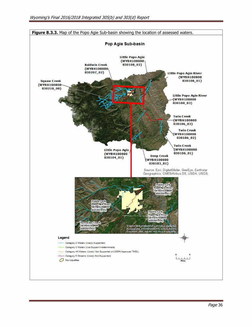
Wyoming’s Final 2016/2018 Integrated 305(b) and 303(d) Report
Page 36
Figure 8.3.3. Map of the Popo Agie Sub-basin showing the location of assessed waters.
Wyoming’s Final 2016/2018 Integrated 305(b) and 303(d) Report
Page 37
Lower Wind Sub-basin (HUC 10080005)
Assessed Waters
Muddy Creek (WYBH100800050607_01) and Poison Creek (WYBH100800050404_01), Class 2AB
The Muddy Creek and Poison Creek watersheds are the primary drainages in the Lower Wind Sub-basin.
Muddy Creek’s headwaters are located in the Owl Creek Mountains, from which the stream flows east
through the Wind River Indian Reservation, then through the Sand Mesa Wildlife Habitat management Area to its confluence with Boysen Reservoir. Poison Creek is an intermittent watershed that flows west across
a section of high desert and confluences with Boysen Reservoir near the town of Shoshoni. A USGS (2003) synoptic study found that fecal coliform concentrations were elevated above WDEQ’s recreational use
criterion in Muddy Creek and Poison Creek. As a result, Muddy Creek from the confluence with Boysen
Reservoir upstream to the boundary of the Wind River Indian Reservation and Poison Creek from the confluence with Boysen Reservoir to a point 2 miles upstream were added to the 303(d) List in 2002. In
2005, the Lower Wind River Conservation District (LWRCD) collected data as part of a Lower Wind River Conservation District Water Quality Assessment Section 319 project. These samples verified the occurrence
of elevated bacterial concentrations in lower Muddy Creek. The same study was inconclusive regarding bacterial concentrations in Poison Creek. A local landowner group has been formed to investigate the
sources of bacteria within the Muddy Creek watershed. Muddy Creek and Poison Creek Watershed Plans
were completed in 2007. A Use Attainability Analysis (UAA) to change the summer recreation use of Poison Creek from primary to secondary contact was submitted to WDEQ by LWRCD in 2010. Information in the
Poison Creek UAA was incorporated into the statewide UAA for recreation that was approved by USEPA in September 2017. Due to the proximity of Poison Creek to the Town of Shoshoni, the impaired segment of
Poison Creek continues to be designated for primary contact recreation. Portions of the impaired segment
of Muddy Creek were, however, changed to secondary contact recreation in the statewide recreation UAA.
Ocean Lake (WYBH100800050202_01), Class 2ABww
Ocean Lake is a small (6075.8 acre) and very shallow reservoir located in the Ocean Lake State Wildlife
Habitat Management Area. A WGFD study conducted in 1985 concluded that Ocean Lake’s fishery was
declining due to sediment, originating mainly from irrigated agriculture (WDEQ, 2005). Wave action in the lake frequently re-suspends sediment, significantly reducing light penetration and limiting the growth of
aquatic plants that would otherwise stabilize the deposited sediment and improve water quality. Elevated nutrients in the lake have also been a concern. The Save Ocean Lake (SOL) committee was formed in 1986
to coordinate efforts to reduce sediment loading to the lake; BMPs included installing drop structures on
irrigation ditches, fencing ditches, re-seeding banks, installing water gaps for livestock and the installation of dikes to more efficiently return water from fields to ditches. Ocean Lake was added to the 303(d) List in
1996 for not supporting its warm water fish and aquatic life other than fish uses due to physical degradation from excessive sedimentation. Monitoring conducted on Ocean Lake by WDEQ (2005) and WGFD showed
that most of the irrigation drains were contributing less sediment to Ocean Lake, but there were still areas contributing high loads. The LWRCD sponsored the formation of the Ocean Lake Watershed Steering
Committee in 2005 to address anthropogenic water quality issues affecting the lake and a watershed plan
was completed in 2009. A TMDL for Ocean Lake has been completed by WDEQ and was approved by
USEPA in December of 2009. As a result, Ocean Lake was moved to Category 4a in 2012.
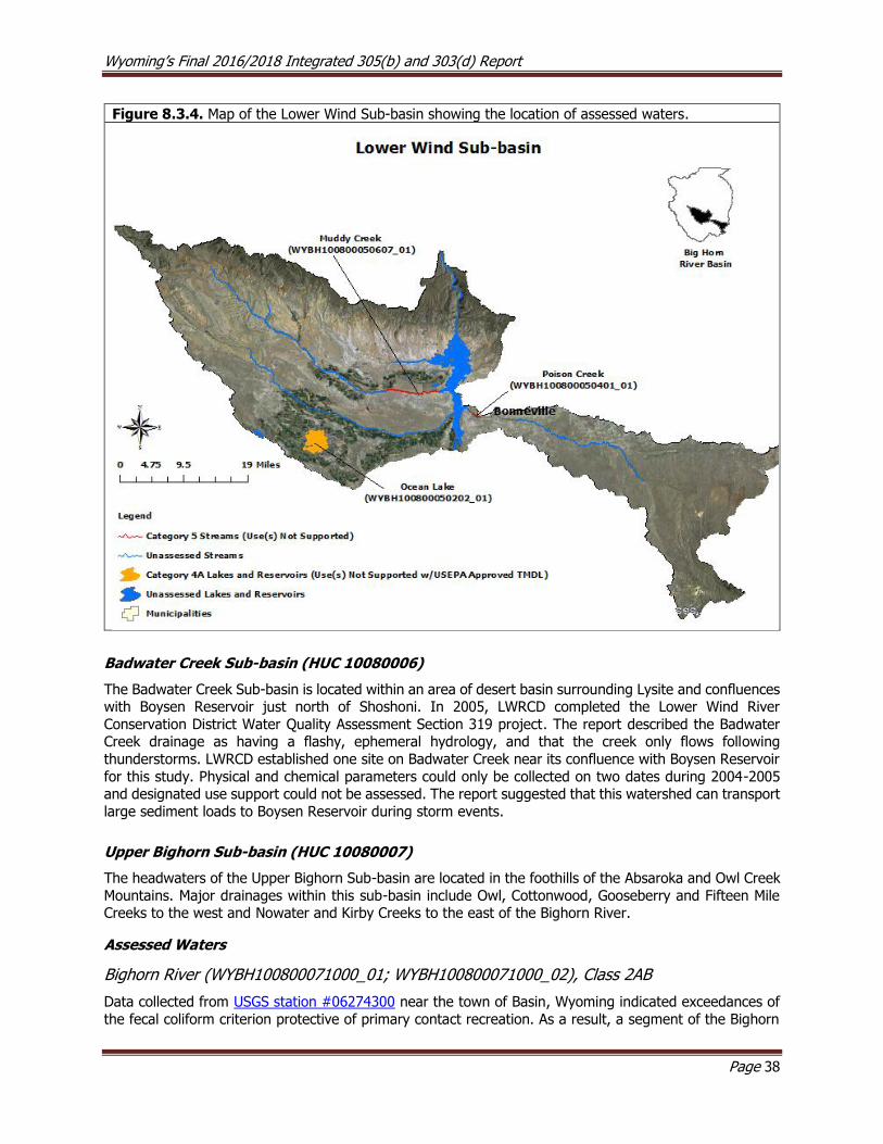
Wyoming’s Final 2016/2018 Integrated 305(b) and 303(d) Report
Page 38
Figure 8.3.4. Map of the Lower Wind Sub-basin showing the location of assessed waters.
Badwater Creek Sub-basin (HUC 10080006)
The Badwater Creek Sub-basin is located within an area of desert basin surrounding Lysite and confluences with Boysen Reservoir just north of Shoshoni. In 2005, LWRCD completed the Lower Wind River
Conservation District Water Quality Assessment Section 319 project. The report described the Badwater Creek drainage as having a flashy, ephemeral hydrology, and that the creek only flows following
thunderstorms. LWRCD established one site on Badwater Creek near its confluence with Boysen Reservoir
for this study. Physical and chemical parameters could only be collected on two dates during 2004-2005 and designated use support could not be assessed. The report suggested that this watershed can transport
large sediment loads to Boysen Reservoir during storm events.
Upper Bighorn Sub-basin (HUC 10080007)
The headwaters of the Upper Bighorn Sub-basin are located in the foothills of the Absaroka and Owl Creek
Mountains. Major drainages within this sub-basin include Owl, Cottonwood, Gooseberry and Fifteen Mile Creeks to the west and Nowater and Kirby Creeks to the east of the Bighorn River.
Assessed Waters
Bighorn River (WYBH100800071000_01; WYBH100800071000_02), Class 2AB
Data collected from USGS station #06274300 near the town of Basin, Wyoming indicated exceedances of
the fecal coliform criterion protective of primary contact recreation. As a result, a segment of the Bighorn

Wyoming’s Final 2016/2018 Integrated 305(b) and 303(d) Report
Page 39
River (WYBH100800071000_01) from the confluence with the Nowood River to a point 36.1 miles upstream and a segment of the Bighorn River (WYBH100800071000_02) from the confluence with the Greybull River
upstream to the confluence with the Nowood River were added to the 303(d) List in 2000. The primary source of fecal coliform in the segment downstream from the Nowood River (WYBH100800071000_02)
was identified as homes and businesses in the Town of Manderson discharging largely untreated
wastewater into the Nowood River just upstream from the Bighorn River. In 2005, the Town of Manderson constructed a new mechanical wastewater treatment system that contains filters to reduce microbes,
nitrogen, and total suspended solids in wastewater, as well as UV treatment, before being discharged.
In June of 2000 and 2001, WDEQ collected additional bacterial data near Basin, Wyoming, and several exceedances of the E. coli numeric criterion protective of primary contact recreation were detected. The
data indicated that the highest bacteria concentrations occurred during high flows in May and June, and the report hypothesized that bacterial loading may be associated with overland flow events.
In 2006, the Washakie County Conservation District (WCCD) developed a watershed plan for the upper Bighorn River watershed (WACD 2011).
Between 2007 and 2008, data collected by USGS continued to show elevated levels of E. coli in the Bighorn
River near Basin, Wyoming. The South Big Horn Conservation District (SBHCD) implemented a Section 319 project to evaluate water quality in the lower Bighorn basin and collected bacterial samples on the Bighorn
River near Basin; however, data from 2002-2004 submitted to WDEQ in a 2005 project report were
inconclusive. In 2008, SBHCD completed a report for a second Section 319 project that aimed to improve failing septic systems and replace or relocate several animal feeding operations (AFOs). The SBHCD
collected bacterial samples between 2005 and 2007 as part of the second project that indicated the Bighorn River continued to have high E. coli concentrations. As a result, the status of the Bighorn River above
Nowood River was changed from threatened to not supporting its primary contact recreation designated
use in 2010.
The WDEQ completed a TMDL for the impaired segments of the Bighorn River that was approved by USEPA
in April of 2014. As a result, the impaired segments of the Bighorn River (WYBH100800071000_01; WYBH100800071000_02) was removed from the 303(d) List and placed in Category 4A in 2014.
Owl Creek (WYBH100800070305_01), Class 2AB
Owl Creek’s headwaters are located along the northern edge of the Owl Creek Mountains. Naturally elevated
sodium and sulfates, together with silt and clay, affect the water quality in the Owl Creek watershed (Ogle, 1992). An abandoned sulfur mine in the watershed that had historically degraded water quality was
reclaimed by AML in 1995. A USGS (2003) synoptic study found that fecal coliform concentrations ranged
between 340-1500 cfu/100mL at two locations along lower Owl Creek. Based on this study, a segment of Owl Creek, from the confluence with the Bighorn River to a point 3.8 miles upstream was added to the
303(d) List in 2002 as threatened for not supporting its contact recreational use. Hot Springs Conservation District (HSCD) sponsored the formation of the Owl Creek Watershed Planning Committee and has been
monitoring E. coli levels in the creek. The committee finalized a watershed plan in 2006 and is implementing several BMPs (WACD 2011). A TMDL for Owl Creek was completed by WDEQ and approved by USEPA in
April of 2014; the segment was therefore removed from the 303(d) List and placed in Category 4A in 2014.
Kirby Creek (WYBH100800070500_01), Class 2C
The Kirby Creek watershed drains a relatively large portion of the Bighorn Basin east of the town of Lucerne.
HSCD completed the Kirby Creek Watershed Assessment and Inventory Section 205j Report in 2003. The report indicated that Kirby Creek has had high erosion rates since the early 1900’s due to channel
straightening, flow alteration and historic overgrazing. In addition, the elevation of the channel at the confluence with the Bighorn River was historically lowered approximately 10 feet. These activities have
resulted in significant instability from down cutting and head cutting, which have contributed large sediment loads to the Bighorn River. The report also identified that fecal coliform was exceeding WDEQ’s recreational
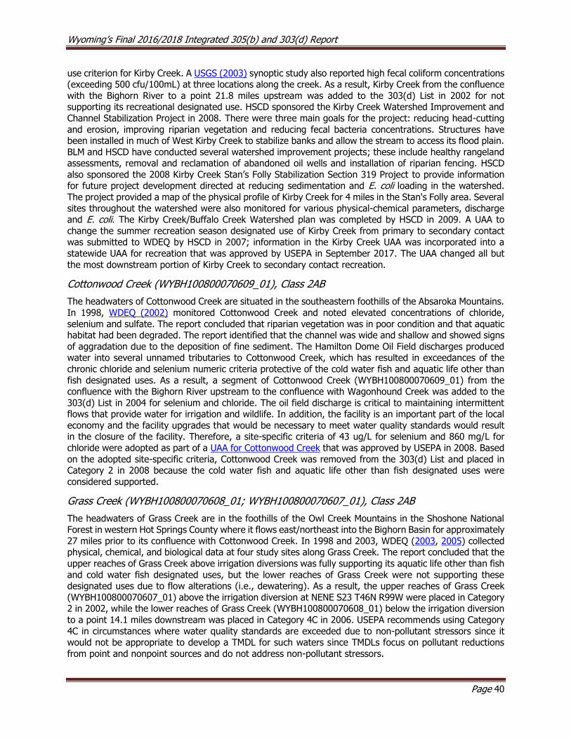
Wyoming’s Final 2016/2018 Integrated 305(b) and 303(d) Report
Page 40
use criterion for Kirby Creek. A USGS (2003) synoptic study also reported high fecal coliform concentrations (exceeding 500 cfu/100mL) at three locations along the creek. As a result, Kirby Creek from the confluence
with the Bighorn River to a point 21.8 miles upstream was added to the 303(d) List in 2002 for not supporting its recreational designated use. HSCD sponsored the Kirby Creek Watershed Improvement and
Channel Stabilization Project in 2008. There were three main goals for the project: reducing head-cutting
and erosion, improving riparian vegetation and reducing fecal bacteria concentrations. Structures have been installed in much of West Kirby Creek to stabilize banks and allow the stream to access its flood plain.
BLM and HSCD have conducted several watershed improvement projects; these include healthy rangeland assessments, removal and reclamation of abandoned oil wells and installation of riparian fencing. HSCD
also sponsored the 2008 Kirby Creek Stan’s Folly Stabilization Section 319 Project to provide information for future project development directed at reducing sedimentation and E. coli loading in the watershed.
The project provided a map of the physical profile of Kirby Creek for 4 miles in the Stan's Folly area. Several
sites throughout the watershed were also monitored for various physical-chemical parameters, discharge and E. coli. The Kirby Creek/Buffalo Creek Watershed plan was completed by HSCD in 2009. A UAA to
change the summer recreation season designated use of Kirby Creek from primary to secondary contact was submitted to WDEQ by HSCD in 2007; information in the Kirby Creek UAA was incorporated into a
statewide UAA for recreation that was approved by USEPA in September 2017. The UAA changed all but
the most downstream portion of Kirby Creek to secondary contact recreation.
Cottonwood Creek (WYBH100800070609_01), Class 2AB
The headwaters of Cottonwood Creek are situated in the southeastern foothills of the Absaroka Mountains.
In 1998, WDEQ (2002) monitored Cottonwood Creek and noted elevated concentrations of chloride,
selenium and sulfate. The report concluded that riparian vegetation was in poor condition and that aquatic habitat had been degraded. The report identified that the channel was wide and shallow and showed signs
of aggradation due to the deposition of fine sediment. The Hamilton Dome Oil Field discharges produced water into several unnamed tributaries to Cottonwood Creek, which has resulted in exceedances of the
chronic chloride and selenium numeric criteria protective of the cold water fish and aquatic life other than
fish designated uses. As a result, a segment of Cottonwood Creek (WYBH100800070609_01) from the confluence with the Bighorn River upstream to the confluence with Wagonhound Creek was added to the
303(d) List in 2004 for selenium and chloride. The oil field discharge is critical to maintaining intermittent flows that provide water for irrigation and wildlife. In addition, the facility is an important part of the local
economy and the facility upgrades that would be necessary to meet water quality standards would result in the closure of the facility. Therefore, a site-specific criteria of 43 ug/L for selenium and 860 mg/L for
chloride were adopted as part of a UAA for Cottonwood Creek that was approved by USEPA in 2008. Based
on the adopted site-specific criteria, Cottonwood Creek was removed from the 303(d) List and placed in Category 2 in 2008 because the cold water fish and aquatic life other than fish designated uses were
considered supported.
Grass Creek (WYBH100800070608_01; WYBH100800070607_01), Class 2AB
The headwaters of Grass Creek are in the foothills of the Owl Creek Mountains in the Shoshone National Forest in western Hot Springs County where it flows east/northeast into the Bighorn Basin for approximately
27 miles prior to its confluence with Cottonwood Creek. In 1998 and 2003, WDEQ (2003, 2005) collected physical, chemical, and biological data at four study sites along Grass Creek. The report concluded that the
upper reaches of Grass Creek above irrigation diversions was fully supporting its aquatic life other than fish
and cold water fish designated uses, but the lower reaches of Grass Creek were not supporting these designated uses due to flow alterations (i.e., dewatering). As a result, the upper reaches of Grass Creek
(WYBH100800070607_01) above the irrigation diversion at NENE S23 T46N R99W were placed in Category 2 in 2002, while the lower reaches of Grass Creek (WYBH100800070608_01) below the irrigation diversion
to a point 14.1 miles downstream was placed in Category 4C in 2006. USEPA recommends using Category
4C in circumstances where water quality standards are exceeded due to non-pollutant stressors since it would not be appropriate to develop a TMDL for such waters since TMDLs focus on pollutant reductions
from point and nonpoint sources and do not address non-pollutant stressors.

Wyoming’s Final 2016/2018 Integrated 305(b) and 303(d) Report
Page 41
In 2008, The Nature Conservancy (TNC) initiated Phase I of a Section 319 Project to reduce sedimentation, improve aquatic and riparian habitat, and lower water temperatures through better grazing management
in upper Grass Creek. Grazing BMPs for this project included off channel spring development as an alternative water source for livestock, the construction of fences to protect springs and weed control to
improve riparian health. A 2012 final report indicated that these BMPs had effectively reduced sediment
loading and improved the health of riparian vegetation in upper Grass Creek. Phase I also included the collection of baseline comparison data from neighboring Little Grass Creek, Enos Creek, and Left Hand
Creek, which were used in Phase II of the project. The results of these projects will be used to assess whether habitat conditions in the upper watershed are suitable for Yellowstone cutthroat trout
reintroduction.
Due to concerns from stakeholders that Wyoming’s surface water quality standards did not sufficiently
recognize the exemptions afforded to water rights, Senate Enrolled Act 75 was passed during the 2015
legislative session. SEA75 added W.S. § 35-11-302(c) to the Environmental Quality Act and charged WDEQ with developing water quality standards for waters where valid water rights preclude attainment of existing
water quality standards. SEA75 also outlined that WDEQ would prepare a schedule to develop water quality standards for those waters identified as not meeting water quality standards due to hydrologic modification
(i.e., 4C waters). In response to SEA75, WDEQ reevaluated the seven 4C waters that were included in the
2014 Integrated Report against Wyoming’s existing surface water quality standards. The reevaluation of Grass Creek indicated that there was not sufficient information to determine whether the cold water fish
and aquatic life other than fish designated uses were supported. However, because drinking water and fish consumption uses were supported, Grass Creek was moved to Category 2 in 2018.
Nowater Creek (WYBH100800070809_01), Sage Creek (WYBH100800071001_01), Fifteen Mile Creek (WYBH100800070909_01), and Slick Creek (WYBH100800071001_02), Class 3B
Data from USGS (2003) indicated that the primary contact recreation designated uses for Nowater Creek, Sage Creek, Fifteen Mile Creek, and Slick Creek were threatened due to elevated fecal coliform levels. As a
result, segments of all of these streams were added to the 303(d) List in 2002. In response, WCCD
implemented a Section 319 project to improve an AFO, repair several septic systems, and conduct E. coli monitoring. In 2008, additional exceedances of the E. coli numeric criterion protective of the primary
contact recreation designated use were detected during the Section 319 project monitoring efforts. As a result, the status of Fifteen Mile Creek, Nowater Creek, Sage Creek, and Slick Creek were changed from
threatened to not supporting their primary contact recreation designated use in 2010.
In 2012, WCCD initiated watershed planning for the Sage Creek and Slick Creek watersheds to coincide with TMDL development. A steering committee was formed and met monthly to develop the Sage
Creek/Slick Creek Watershed Implementation Plan that outlined goals and objectives for reducing E. coli concentrations in these watersheds. As part of this planning process, WCCD received NRCS National Water
Quality Initiative Funding and a Section 319 grant in 2013.
In 2014, TMDLs were approved by USEPA for the bacterial listings on Nowater Creek, Fifteen Mile Creek,
Sage Creek, and Slick Creek. As a result, and all of these waters were moved from the 303(d) List to
Category 4A in 2014.
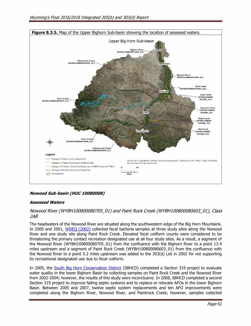
Wyoming’s Final 2016/2018 Integrated 305(b) and 303(d) Report
Page 42
Figure 8.3.5. Map of the Upper Bighorn Sub-basin showing the location of assessed waters.
Nowood Sub-basin (HUC 10080008)
Assessed Waters
Nowood River (WYBH100800080705_01) and Paint Rock Creek (WYBH100800080603_01), Class 2AB
The headwaters of the Nowood River are situated along the southwestern edge of the Big Horn Mountains.
In 2000 and 2001, WDEQ (2002) collected fecal bacteria samples at three study sites along the Nowood River and one study site along Paint Rock Creek. Elevated fecal coliform counts were considered to be
threatening the primary contact recreation designated use at all four study sites. As a result, a segment of the Nowood River (WYBH100800080705_01) from the confluence with the Bighorn River to a point 13.4
miles upstream and a segment of Paint Rock Creek (WYBH100800080603_01) from the confluence with the Nowood River to a point 5.2 miles upstream was added to the 303(d) List in 2002 for not supporting
its recreational designated use due to fecal coliform.
In 2005, the South Big Horn Conservation District (SBHCD) completed a Section 319 project to evaluate
water quality in the lower Bighorn Basin by collecting samples on Paint Rock Creek and the Nowood River from 2002-2004; however, the results of this study were inconclusive. In 2008, SBHCD completed a second
Section 319 project to improve failing septic systems and to replace or relocate AFOs in the lower Bighorn Basin. Between 2005 and 2007, twelve septic system replacements and ten AFO improvements were
completed along the Bighorn River, Nowood River, and Paintrock Creek; however, samples collected

Wyoming’s Final 2016/2018 Integrated 305(b) and 303(d) Report
Page 43
concurrent with the project indicated that all three waters continued to have high E. coli concentrations for the duration of project. In 2006, a watershed plan was completed by the SBHCD in 2006 (WADC, 2015).
In 2014, TMDLs were approved by USEPA for the bacterial listings on Paint Rock Creek and the Nowood
River, and these waters were moved from the 303(d) List to Category 4A in 2014.
South Paint Rock Creek (WYBH100800080603_02), Class 2AB
WDEQ (2010) collected physical, chemical, and biological data along South Paint Rock Creek near its confluence with Soldier Creek, and the report concluded that the creek was fully supporting its drinking
water and fish consumption designated uses; however, the support of all other designated uses were
indeterminate. The aquatic life other than fish and cold water fish designated uses were difficult to assess because of the small size of the watershed, which is not well represented in WDEQ’s macroinvertebrate
models. As a result, a segment of South Paint Rock Creek (WYBH1008000080603_02) from the confluence with Soldier Creek to a point 3.6 miles upstream was placed in Category 2 in 2012.
Canyon Creek (WYBH100800080406_01), Class 2AB
WDEQ (2006) collected macroinvertebrates and diatoms in upper Canyon Creek and determined that it was
likely reference quality. However, some areas of the lower Canyon Creek watershed have had willows removed in the past, and this is thought to have caused bank instability and increased water temperatures
during the summer. WGFD fish surveys in 2007 and 2010 showed an increase in young of the year and 1
year old brown trout but a decrease in mountain whitefish from a status of rarely collected to absent. WGFD stated that the brown trout population is limited by a lack of riparian cover and clean spawning gravels.
Indeed, the reach was reportedly composed almost entirely of sand and silt and was determined not to be a viable location for trout reproduction. It was suggested instead that recruitment likely occurs outside the
stream reach. To improve habitat conditions in Canyon Creek, WGFD suggested that the banks be stabilized
with woody vegetation and that the reach be rested from livestock grazing. A Section 319 Riparian Enhancement Project was completed by local citizens in 2009. Project activities included the installation of
a fence along more than a mile of the stream to better manage livestock, planting trees and shrubs and monitoring to evaluate physical trends.
In 2007 and 2009, WDEQ (2010) collected physical, chemical, and biological data from four study sites
along Canyon Creek to determine designated use support; however, the results were indeterminate. As a
result, a segment of Canyon Creek (WYBH100800080406_01) from the return of Hunsinger No. 1 Ditch upstream to Canyon Creek Ditch was placed in Category 3 in 2012.
Soldier Creek (WYBH100800080607_01), Class 2AB
In 2000, WDEQ (2007) collected physical, chemical, and biological data at two study sites along Soldier
Creek, a tributary to South Paint Rock Creek. The report noted that the stream was similar to the reference condition, and it concluded that Soldier Creek was fully supporting its cold water fish and aquatic life other
than fish designated uses. As a result, a segment of Soldier Creek (WYBH100800080607_01) from the confluence with South Paint Rock Creek to a point 7.4 miles upstream was placed in Category 2 in 2008.
Other Monitoring Efforts in the Sub-basin
Medicine Lodge Creek
Medicine Lodge Creek’s headwaters are situated along the western side of the Bighorn Mountains. The
creek flows southwest through Medicine Lodge Canyon and surrounding foothills before it confluences with Paint Rock Creek within the Town of Hyattville. WDEQ monitored a site on Medicine Lodge Creek in 2010,
and data from a single sample indicated that E. coli bacteria concentrations may be elevated in and around
Medicine Lodge Archaeological Site State Park. WDEQ (2013) collected data in 2012 and 2013; results
indicated that Wyoming’s E. coli criteria were not exceeded, however, recreational uses were not assessed.

Wyoming’s Final 2016/2018 Integrated 305(b) and 303(d) Report
Page 44
Figure 8.3.6. Map of the Nowood Sub-basin showing the location of assessed waters.
Greybull Sub-basin (HUC 10080009)
The headwaters of the Greybull Sub-basin are in the Absaroka Mountain Range within the Shoshone
National Forest. This sub-basin has three major irrigation reservoir projects, and summer flows in the Greybull River at the confluence with the Bighorn River are composed almost entirely of water from
irrigation returns. At times there may be little or no flow due to appropriations on the river (RPO, 1979).
Assessed Waters
Greybull River (WYBH100800090405_01), Class 2AB
USGS gage data (station 06276500) collected near the town of Meeteetse indicated that fecal coliform concentrations on the Greybull River spanning several dates during May and June of 1996, 1998 and 2000
were greater than WDEQ’s recreational use criterion. USGS (2003) collected additional data on the lower
Greybull River in 2000 and results indicated that concentrations were high at sites near the towns of Burlington and Greybull. WDEQ (2002) also monitored fecal coliform at three sites along the Greybull River

Wyoming’s Final 2016/2018 Integrated 305(b) and 303(d) Report
Page 45
in 2000 and 2001. Bacteria concentrations were particularly high at sites near the towns of Greybull and Otto, whereas concentrations near the Burlington waste water treatment facility (WWTF) and at the Town
of Meeteetse were relatively low. WDEQ and USGS data showed a trend of increasing fecal coliform concentration between the towns of Meeteetse and Greybull. Although high bacteria counts were
occasionally recorded as far upstream as Meeteetse by USGS from 2007-2008, samples have been collected
too infrequently to calculate a five sample geometric mean. Based on the studies described above, a segment of the Greybull River from the confluence with the Bighorn River upstream to Sheets Flat Bridge
was added to the 303(d) List in 2002 because the contact recreational use was not supported due to fecal coliform.
The Meeteetse Conservation District (MCD) showed in both the Sheets Flat E. coli Project (MCD, 2007) and
in the Greybull River E. coli Final Report (MCD, 2009) that E. coli concentrations in the watershed are
elevated during seasonal snowmelt runoff. This information suggests that the bacterial loading to the river is likely from nonpoint sources, but specific sources remain unknown. High water temperatures during
drought have raised concerns about the river’s ability to support its cold water fish designated use during low flows in summer. The Greybull River Watershed Plan was completed in 2010 by the MCD. The SBHCD
had a Section 319 project to evaluate water quality in the lower Bighorn basin and collected samples on
the Greybull River; 2002-2004 data submitted to WDEQ in a 2005 project report were inconclusive. A second Section 319 project, spanning the years 2005 and 2007 was completed in 2008 by SBHCD. The
goals of the project were to improve failing septic systems and to replace or relocate AFOs. Three septic systems and three AFO improvements were completed in the lower Greybull watershed. The study reported
continued high E. coli geometric means along the impaired segment of the Greybull River. There was also a trend of increasing bacterial concentrations from upstream to downstream that was attributed to
increases in the occurrence of irrigated agriculture and livestock. TMDLs were approved by USEPA in April
2014 for the bacterial listing on the Greybull River and this water has been moved from the 303(d) List to
Category 4A in 2014.
Wyoming’s Final 2016/2018 Integrated 305(b) and 303(d) Report
Page 46
Figure 8.3.7. Map of the Greybull Sub-basin showing the location of assessed waters.

Wyoming’s Final 2016/2018 Integrated 305(b) and 303(d) Report
Page 47
Bighorn Lake Sub-basin (HUC 10080010)
Bighorn Lake was created by the construction of Yellowtail Dam between 1963-67 to store water for
irrigation, to generate hydroelectric power, for flood control and recreation. The southern one third of the reservoir is in Wyoming and the remainder is in Montana.
Assessed Waters
Porcupine Creek (WYBH100800100600_01), Class 2AB
WDEQ (2005) assessed Porcupine Creek in 2001 and concluded that the entire watershed was fully
supporting its aquatic life other than fish and cold water fish designated uses. As a result, the entire Porcupine Creek watershed upstream of the Montana boarder, excluding Deer Creek watershed, was placed
in Category 2 in 2006. The report noted that the Porcupine Falls area of Porcupine Creek was the site of a
historic placer and lode gold mining operation that likely used a mercury-based amalgamation and potassium cyanide for gold extraction, so there may be elevated mercury in the creek.
Bighorn River (WYBH100800100301_01), Class 2AB
WDEQ (2002) assessed a segment of the Bighorn River below its confluence with the Greybull River to a
point 10.5 miles downstream for fecal coliform, and concluded that this segment was not supporting its contact recreation use. As a result, this segment of the Bighorn River was added to the 303(d) List in 2002.
Samples collected upstream from Bighorn Lake, however, did not exceed the criterion. A TMDL was approved by USEPA in April, 2014 for fecal coliform for this segment of the Bighorn River, and it was
subsequently moved from the 303(d) List to Category 4A in 2014.
Shell Creek (WYBH100800100206_01) and Beaver Creek (WYBH100800100204_01), Class 2AB
Shell Creek is the largest watershed in the Bighorn Lake sub-basin. Its headwaters are situated along the western slope of the Bighorn Mountains, from which the creek flows west across National Forest, BLM and
private lands before it confluences with the Bighorn River. USGS (2003) collected fecal coliform data on
Shell Creek just above the Shell Creek Campground within the Bighorn National Forest and near the towns of Shell and Greybull in 2000. Concentrations were low above the USFS campground and near Shell, but
were high near Greybull. Shell Creek was also monitored by WDEQ (2002) in 2001 to address concerns over elevated bacteria concentrations. Fecal bacteria samples collected approximately a half mile above
the confluence with the Bighorn River in July exceeded WDEQ’s fecal coliform criterion. As a result, Shell
Creek from the confluence with the Bighorn River to a point 5.3 miles upstream was added to the 303(d) List in 2002.
Beaver Creek is a major tributary to Shell Creek and these two streams confluence just west of the town
of Shell. USGS (2003) collected fecal coliform data on Beaver just upstream of the confluence with Shell Creek in 2000. The reported fecal coliform value exceeded WDEQ’s fecal coliform criterion. As a result,
Beaver Creek from its confluence with Shell Creek to a point 7.9 miles upstream was added to the 303(d)
List in 2002 for threats to the contact recreational use.
The South Big Horn Conservation District (SBHCD) had a Section 319 project to evaluate water quality in the lower Bighorn basin and collected samples on Shell and Beaver Creeks; 2002-2004 data submitted to
WDEQ in a 2005 project report were inconclusive. A second Section 319 project, spanning the years 2005
and 2007 was completed in 2008 by SBHCD. The goals of the project were to improve or replace failing septic systems and to relocate AFOs in the lower Bighorn Basin. Three septic systems and one AFO were
improved in the lower Shell Creek watershed. Data collected during this study showed that high E. coli concentrations continue to occur on Beaver and Shell Creeks.
TMDLs were approved by USEPA in April 2014 for fecal coliform for Shell Creek and Beaver, and they were
subsequently moved from the 303(d) List to Category 4A in 2014.

Wyoming’s Final 2016/2018 Integrated 305(b) and 303(d) Report
Page 48
Mail Creek (WYBH100800100101_01), Class 2AB
Mail Creek, a small tributary to Shell Creek, originates along the west slope of the Bighorn Mountains within
the Cloud Peak Wilderness Area. WDEQ (2004) monitored Mail Creek in 2000 using one study site to address concerns that the biological community may be degraded. The study determined that Mail Creek’s
cold water fish and aquatic life other than fish designated uses are supported from the confluence with
Shell Creek to a point 5.6 miles upstream. As a result, this segment of Mail Creek was placed in Category 2 in 2006.
Granite Creek (WYBH100800100102_01), Class 2A
Granite Creek is another small tributary to Shell Creek in upper Shell Creek Canyon. USGS (2003) collected
data on Granite Creek near the Shell Ranger station in 2000 and results indicated high bacterial concentrations. WDEQ (2002) subsequently monitored Granite Creek in August 2001 at five study sites to
determine whether the contact recreation use was supported. Results of the study indicated that Granite Creek is not meeting its contact recreation use due to high levels of bacteria from its confluence with Shell
Creek upstream approximately 5.8 miles to the vicinity of the Antelope Butte Ski Area. The septic system
leach field at the Antelope Butte Ski Area may have been a significant source of bacteria at the time of sampling. The ski area has not operated since the 2004-05 ski season, and the USFS is in the process of
finding a new operator for the facility. The USFS began monitoring bacterial concentrations in Granite Creek below Antelope Butte Ski Area in late 2004, and data again indicated that there were high E. coli concentrations in the creek. During 2005 and 2006 sampling, the maximum single sample concentrations
occurred during the primary contact recreation season (April 1st - September 30th), suggesting that loadings from sources other than the ski area may be occurring in the watershed. A TMDL was approved by USEPA
in April, 2014 for the bacterial listing on Granite Creek and this water was moved from the 303(d) List to Category 4A in 2014.
Crooked Creek (WYBH100800100502_01; WYBH100800100500_01), Class 2AB
Crooked Creek originates in the Pryor Mountains in southern Montana, flows south into Wyoming and
confluences with Bighorn Lake. In 2001, WDEQ (2005) collected physical, chemical, and biological data at two study sites along Crooked Creek. The report noted that portions of Crooked Creek in Wyoming may
become dry in summer and freeze solid in winter during some years, and local landowners have indicated
Crooked Creek is dewatered for irrigation and is dry during the irrigation season from Section 29, T58N, R95W downstream to Section 35, T58N, R95W. The creek is then re-wetted at the confluence with Sykes
Spring. The report concluded that the perennial segment of Crooked Creek was fully supporting its cold water fish and aquatic life other than fish designated uses upstream of the Montana state line, but the
dewatered segment of Crooked Creek was not supporting its cold water fish or aquatic life other than fish designated uses. As a result, the perennial segment of Crooked Creek (WYBH100800100502_01) from the
Montana state line to a point upstream 3.0 miles was placed in Category 2 in 2006, while the dewatered
segment of Crooked Creek (WYBH100800100500_01) from the confluence with Big Horn Lake to a point 7.9 miles upstream was placed in Category 4C in 2006. USEPA recommends using Category 4C in
circumstances where water quality standards are exceeded due to non-pollutant stressors. In such circumstances, it would not be appropriate to place those waters on the 303(d) List and attempt to develop
a TMDL because TMDLs focus on pollutant reductions from point and nonpoint sources and do not address
non-pollutant stressors.
Due to concerns from stakeholders that Wyoming’s surface water quality standards did not sufficiently
recognize the exemptions afforded to water rights, Senate Enrolled Act 75 was passed during the 2015 legislative session. SEA75 added W.S. § 35-11-302(c) to the Environmental Quality Act and charged WDEQ
with developing water quality standards for waters where valid water rights preclude attainment of existing water quality standards. SEA75 also outlined that WDEQ would prepare a schedule to develop water quality
standards for those waters identified as not meeting water quality standards due to hydrologic modification
(i.e., 4C waters). In response to SEA75, WDEQ reevaluated the seven 4C waters that were included in the 2014 Integrated Report against Wyoming’s existing surface water quality standards. The reevaluation of

Wyoming’s Final 2016/2018 Integrated 305(b) and 303(d) Report
Page 49
Crooked Creek indicated that there was not sufficient information to determine whether the cold water fish, aquatic life other, wildlife, agriculture, and industrial uses were supported. However, because drinking
water and fish consumption uses were supported, Crooked Creek was moved to Category 2 in 2018.
Figure 8.3.8. Map of the Bighorn Lake Sub-basin showing the location of assessed waters.
Dry Creek Sub-basin (HUC 10080011)
Assessed Waters
Dry Creek (WYBH100800110204_01), Class 2ABww
In 2000, USGS (2003) collected fecal coliform data from two sites along Dry Creek, and several exceedances of the fecal coliform criterion protective of the primary contact recreation designated use were detected.
Concentrations were estimated to be around five times WDEQ’s criterion for fecal coliform. As a result, a
segment of Dry Creek (WYBH100800110204_01) from its confluence with the Bighorn River to a point 4.7 miles upstream was added to the 303(d) List in 2002 for not supporting its recreational designated uses
due to fecal coliform.
The South Big Horn Conservation District (SBHCD) completed a Section 319 project that evaluated water quality in the lower Bighorn Basin by collecting samples on Dry Creek between 2002 and 2004; however,
the report was inconclusive. In 2008, SBHCD completed a second Section 319 project to improve failing

Wyoming’s Final 2016/2018 Integrated 305(b) and 303(d) Report
Page 50
septic systems and to replace or relocate AFOs. Between 2005 and 2007, one septic system was improved in the Dry Creek watershed as part of this project.
A TMDL was approved by USEPA in April, 2014 for the bacterial listing on Dry Creek and this water was
moved from the 303(d) List to Category 4A in 2014.
Figure 8.3.9. Map of the Dry Creek Sub-basin showing the location of assessed waters.
North Fork Shoshone River Sub-basin (HUC 10080012)
The headwaters of the North Fork Shoshone River Sub-basin are located in the highly erodible volcanic
geology of the northern Absaroka Range. Mass wasting and landslides are common. For example, a large landslide in the spring of 1997 contributed a significant amount of sediment to Middle Creek. Portions of
this watershed also burned in 1988 and again in 2001, which further increased sediment loading to the watershed. These events have raised concerns about the amount of sediment being deposited in Buffalo
Bill Reservoir.
Assessed Waters
North Fork Shoshone River Drainage (WYBH100800120000_00), Class 2AB
WDEQ collected physical, chemical, and biological data in the North Fork Shoshone River Drainage, and the study concluded that the entire North Fork Shoshone River Drainage watershed above Half Mile Creek
was supporting its cold water fish and aquatic life other than fish designated uses. As a result, the entire
North Fork Shoshone River Drainage (WYBH100800120000_00) watershed above the confluence with Half

Wyoming’s Final 2016/2018 Integrated 305(b) and 303(d) Report
Page 51
Mile Creek, near the Shoshone National Forest boundary, was placed in Category 2 in 2002. A final report was not written for this study.
Other Monitoring Efforts in the Sub-basin
Buffalo Bill Reservoir
Buffalo Bill Reservoir (originally called Shoshone Dam) was built in the early 1900s to capture and store
runoff from the North and South Forks of the Shoshone River; water in the reservoir is primarily used for irrigation, generating electricity, and recreation. Sediment entering the reservoir from the North and South
Fork Shoshone River settles to the bottom of Buffalo Bill Reservoir, effectively preventing this pollutant from reaching the Shoshone River downstream. However, these sediments can become an air quality issue
when the reservoir is low and sediments are exposed to frequent high winds in the area. The USBOR has
constructed dust abatement dikes to address this problem (WACD 2011).
Figure 8.3.10. Map of the North Fork Shoshone River Sub-basin showing the location of assessed
waters.
Shoshone River Sub-basin (HUC 10080014)
Assessed Waters In response to concerns by an area physician who treated several cases of severe gastro-intestinal illness in patients who had been swimming in area waters, WDEQ conducted fecal bacteria monitoring in 2000 in
several of the drainages in the lower Shoshone River watershed. Several waters exceeded the fecal bacteria
criterion and were added to the 303(d) List in 2002.

Wyoming’s Final 2016/2018 Integrated 305(b) and 303(d) Report
Page 52
Shoshone River (WYBH100800140504_00), Class 2AB
In 2000, USGS (2003) collected fecal coliform data at three sites along the Shoshone River: above Demaris
Springs near Cody, near the town of Lovell, and near the town of Kane. Fecal coliform was nearly non-detectable above Demaris Springs, while concentrations at the sites near Lovell and Kane were 4-5 times
higher than WDEQ’s fecal coliform criterion protective of contact recreation. As a result, a segment of the
Shoshone River (WYBH100800140504_00) from the confluence with Bighorn Lake to a point 9.7 miles upstream was added to the 303(d) List in 2002.
In 2005, the Cody Conservation District (CCD) completed the Shoshone River E. coli Baseline Sampling
Section 319 Project in the upper Shoshone River watershed to monitor E. coli levels. The sampling results
corroborated those reported by USGS: concentrations were minimal immediately below Buffalo Bill Reservoir and increased gradually downstream to just below Corbett Dam. In 2006, the SCD completed a
watershed plan for the Shoshone River, and PCFCD continued sampling the Shoshone River from 2010-2014.
In July, 2014, USEPA approved an E. Coli TMDL for the impaired segment of the Shoshone River, and this
segment was moved from the 303(d) List to Category 4A in 2014.
Dry Gulch (WYBH100800140107_01), Class 2AB
Dry Gulch, a tributary to the Shoshone River, is a naturally ephemeral stream; however, it receives irrigation
return flows that sustain the stream for most of the primary contact recreation season. Sampling conducted by the CCD indicated that Dry Gulch, from the confluence with the Shoshone River to a point 7.0 miles
upstream exceeded the E. coli criterion. As a result, Dry Gulch was added to the 303(d) List in 2008.
In July, 2014, USEPA approved an E. coli TMDL for the impaired segment of Dry Gulch, and this segment was moved from the 303(d) List to Category 4A in 2014.
Bitter Creek (WYBH100800140206_01), Class 2AB
In 2000, WDEQ (2000) collected fecal coliform data at three study sites along Bitter Creek, and several
exceedances of the fecal bacteria criterion protective of the primary contact recreation designated use were
detected. As a result, a segment of Bitter Creek (WYBH100800140206_01) from its confluence with the Shoshone River to a point 13.9 miles upstream was added to the 303(d) List in 2002. The sources of fecal
contamination in Bitter Creek was not identified.
The Powell-Clarks Fork Conservation District (PCFCD) monitored water quality at five sites along Bitter Creek in 2001 as part of the Bitter Creek Watershed Project 319 Report. The resulting dataset suggested
that the elevated bacterial concentrations may occur upstream as far as the Lane 8 Bridge (approximately
2.5 miles upstream of the town of Powell’s WWTF). In 2006, PCFCD received a Section 319 grant to improve eligible septic systems in the Bitter Creek watershed. To evaluate water quality after the modifications were
implemented, the PCFCD collected E. coli samples from 2007-2009 as part of this project, and PCFCD continued sampling Bitter Creek from 2010-2014.
In July, 2014, USEPA approved an E. Coli TMDL for the impaired segment of Bitter Creek, and this segment was moved from the 303(d) List and placed in Category 4A in 2014.
Sage Creek (WYBH100800140408_01), Class 2AB
In 2000, WDEQ (2002) collected fecal coliform data at two study sites along Sage Creek, and several
exceedances of the fecal bacteria criterion protective of the primary contact recreation designated use were detected. As a result, a segment of Sage Creek (WYBH100800140408_01) from its confluence with the
Shoshone River to a point 14.0 miles upstream was added to the 303(d) List in 2002. The sources of fecal contamination were not identified.

Wyoming’s Final 2016/2018 Integrated 305(b) and 303(d) Report
Page 53
In July, 2014, USEPA approved an E. Coli TMDL for the impaired segment of Sage Creek, and this segment was moved from the 303(d) List to Category 4A in 2014.
Polecat Creek (WYBH100800140407_01), Class 2AB
In 2001, WDEQ (2002) collected fecal coliform data at one study site along Polecat Creek, and several
exceedances of the fecal bacteria criterion protective of the primary contact recreation designated use were detected. As a result, a segment of Polecat Creek (WYBH100800140407_01) from its confluence with Sage
Creek to a point 2.5 miles upstream was added to the 303(d) List in 2002. The sources of fecal contamination were not identified.
In July, 2014, USEPA approved an E. Coli TMDL for the impaired segment of Polecat Creek, and this segment was moved from the 303(d) List to Category 4A in 2014.
Big Wash (WYBH100800140408_02), Class 3B
In 2000 and 2001, WDEQ (2002) collected fecal coliform data at two study sites along Big Wash, and
several exceedances of the fecal bacteria criterion protective of the primary contact recreation designated use were detected. As a result, a segment of Big Wash (WYBH100800140408_02) from its confluence with
Sage Creek upstream to Sidon Canal was added to the 303(d) List in 2002. The sources of fecal contamination were not identified.
In July, 2014, USEPA approved an E. Coli TMDL for the impaired segment of Big Wash, and this segment was moved from the 303(d) List to Category 4A in 2014.
Whistle Creek (WYBH100800140303_01), Class 2AB
In 2001, WDEQ (2002) collected fecal coliform data at one study site along Whistle Creek, and several
exceedances of the fecal bacteria criterion protective of the primary contact recreation designated use were detected. As a result, a segment of Whistle Creek (WYBH100800140303_01) from its confluence with the
Shoshone River to a point 8.7 miles upstream was added to the 303(d) List in 2002. The sources of fecal contamination were not identified.
In July, 2014, USEPA approved an E. Coli TMDL for the impaired segment of Whistle Creek, and this segment was moved from the 303(d) List to Category 4A in 2014.
Foster Gulch (WYBH100800140307_01), Class 2C
In 2000, USGS (2003) collected fecal coliform data along the lower reach of Foster Gulch, and high fecal
coliform counts were recorded. As a result, a segment of Foster Gulch (WYBH100800140307_01) from the confluence with the Shoshone River to a point 2.0 miles upstream was added to the 303(d) List in 2002 as
threatened by fecal coliform. The sources of fecal contamination were not identified.
In July, 2014, USEPA approved an E. Coli TMDL for the impaired segment of Foster Gulch, and this segment
was moved from the 303(d) List to Category 4A in 2014.
Other Monitoring Efforts in the Sub-basin
Information from SCD, WGFD, BLM and a Cooperative River Basin Study (SCS, 1994) suggest that salinity, oil, nutrients and streambank degradation may be additional stressors in Sage and Polecat Creeks in northwest Big Horn County.
In 2007, a malfunction in the Willwood Dam resulted in a large sediment release to the Shoshone River,
killing thousands of fish. Since then, the Willwood Irrigation District, responsible for maintenance of the dam, and the USBOR, the owner of the dam, have been working with the Wyoming Water Development
Office, WDEQ, WGFD to evaluate potential options for improving operation and maintenance of the dam.

Wyoming’s Final 2016/2018 Integrated 305(b) and 303(d) Report
Page 54
In 2016, another sediment release occurred during maintenance work on the dam. In response to the sediment release, WDEQ, WGFD, WWDO, USBOR, SEO, and other partners established three working
groups operating under the leadership and direction of an executive committee. The short and long-term objectives of this effort are to: 1) restore aquatic life and habitat damaged due to the release of
accumulated sediment from the Willwood Dam reservoir into the Shoshone River and 2) reduce and/or
eliminate future need to release accumulated sediment from the dam in amounts and of duration that are harmful to aquatic life and the aquatic and riparian habitats downstream of the dam. The intent of this
approach is to engage stakeholders in identifying workable solutions to achieve the objectives. Willwood Irrigation District’s right to divert water under state water laws shall not be impacted by the efforts of this
initiative. The three work groups are as follows: cleanup and flushing flow below Willwood Dam; development of alternatives for the long-term management of sediment above Willwood Dam, and evaluation of water quality standards; and addressing sediment sources upstream of Willwood Dam.
Figure 8.3.11. Map of the Shoshone River Sub-basin showing the location of assessed waters.

Wyoming’s Final 2016/2018 Integrated 305(b) and 303(d) Report
Page 55
Little Big Horn River Sub-basin (HUC10080016)
Assessed Waters
Little Bighorn River (WYBH100800160100_01), Class 2AB
The headwaters of the Little Bighorn River are mostly within the Bighorn National Forest, in north central
Wyoming. In 1997 and 2000, WDEQ (2004) collected physical, chemical, and biological data at eight study
sites in the Little Bighorn River watershed. The report concluded that the river was fully supporting its cold water fish and aquatic life other than fish designated uses. As a result, the entire Little Bighorn River
(WYBH100800160100_01) watershed upstream of the Montana border, excluding the Dry Fork Little Bighorn watershed, was placed in Category 2 in 2006.
West Pass Creek (WYBH100800160107_01), Class 2AB
West Pass Creek is a major tributary to the Little Bighorn River. In 1997 and 2000, WDEQ (2004) collected
physical, chemical, and biological data at two study sites in the West Pass Creek watershed. The report concluded that the creek was fully supporting its cold water fish and aquatic life other than fish designated
uses. As a result, the entire West Pass Creek (WYBH100800160107_01) watershed upstream of the
Montana border was placed in Category 2 in 2006.
Figure 8.3.12. Map of the Little Bighorn River Sub-basin showing the location of assessed waters.
Wyoming’s Final 2016/2018 Integrated 305(b) and 303(d) Report
Page 56
8.4 Cheyenne River Basin
The Cheyenne River Basin drains approximately 8,296 mi2 in east-central Wyoming. The basin drains mostly
the Powder River Geologic Basin, Semiarid Pierre Shale Plains and Black Hills Foothills ecoregions, with
isolated areas of Pine Scoria Hills (Chapman et al. 2003 ). Most of the basin consists of rolling mixed short grass prairie and rocky ponderosa pine forested outcrops of sedimentary shales and sandstones. The
Thunder Basin National Grasslands occupy a large portion of the central part of this basin. The Black Hills Foothills to the north contain mixed vegetation, but mostly consist of ponderosa pine with an understory
of mixed grasses. The basin receives little precipitation, and many of the streams are intermittent or ephemeral; most perennial streams originate in the Black Hills or Pine Ridge escarpment. Sedimentary
rocks in the lower portions of the basin contribute to elevated levels of iron and manganese, thus the
numeric human health criteria for iron and manganese do not apply to Little Thunder Creek and Class 2 tributaries of Little Thunder Creek below the confluence with North Prong and Class 2 tributaries of Antelope
Creek. Primary land uses in the basin are livestock grazing, wildlife habitat, coal mining, oil and gas production and some farming.
Antelope Creek Sub-basin (HUC 10120101)
The headwaters of the Antelope Creek sub-basin are located along Pine Ridge in western Converse County. The main stem of Antelope Creek is intermittent or ephemeral in the upper watershed and then transitions
to a perennial channel before it confluences with the Cheyenne River near Dull Center. Most of the
watershed lies within the Thunder Basin National Grassland. The lower, perennial reaches of Antelope Creek contain many beaver dam complexes. As a result, water from this watershed does not reach the Cheyenne
River except during high flow events.
Assessed Waters
Antelope Creek (WYCR101201010000_01), Class 3B
In 2003 and 2004, WDEQ (2007) collected physical, chemical, and biological data at one study site along Antelope Creek. The report noted that the macroinvertebrate community of Antelope Creek is comparable
to reference condition for intermittent streams in this basin, and the report concluded that the creek was fully supporting its aquatic life other than fish designated use. As a result, a segment of Antelope Creek
(WYCR101201010000_01) from the confluence with the Cheyenne River to a point 85.6 miles upstream
was placed in Category 2 in 2008. The report also noted that there is a diverse community of native non-game fish and warm water game fish, indicating the creek may be better classified as 2ABww rather than
3B.
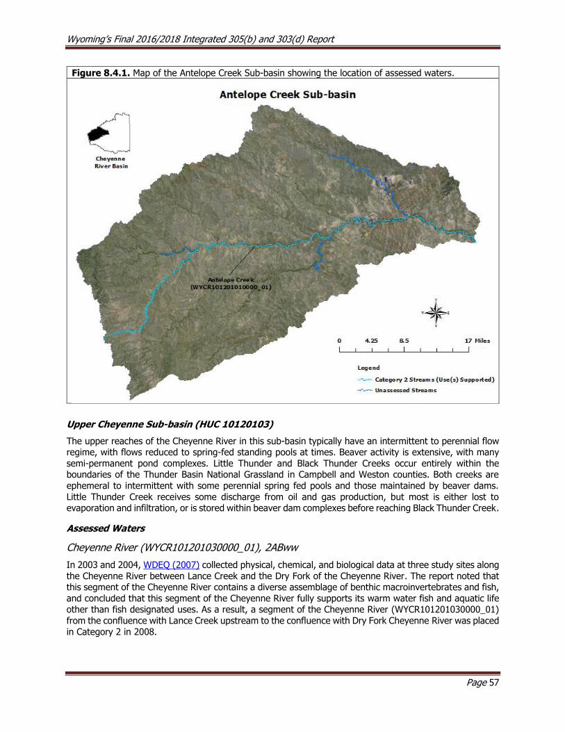
Wyoming’s Final 2016/2018 Integrated 305(b) and 303(d) Report
Page 57
Figure 8.4.1. Map of the Antelope Creek Sub-basin showing the location of assessed waters.
Upper Cheyenne Sub-basin (HUC 10120103)
The upper reaches of the Cheyenne River in this sub-basin typically have an intermittent to perennial flow regime, with flows reduced to spring-fed standing pools at times. Beaver activity is extensive, with many
semi-permanent pond complexes. Little Thunder and Black Thunder Creeks occur entirely within the boundaries of the Thunder Basin National Grassland in Campbell and Weston counties. Both creeks are
ephemeral to intermittent with some perennial spring fed pools and those maintained by beaver dams.
Little Thunder Creek receives some discharge from oil and gas production, but most is either lost to evaporation and infiltration, or is stored within beaver dam complexes before reaching Black Thunder Creek.
Assessed Waters
Cheyenne River (WYCR101201030000_01), 2ABww
In 2003 and 2004, WDEQ (2007) collected physical, chemical, and biological data at three study sites along
the Cheyenne River between Lance Creek and the Dry Fork of the Cheyenne River. The report noted that this segment of the Cheyenne River contains a diverse assemblage of benthic macroinvertebrates and fish,
and concluded that this segment of the Cheyenne River fully supports its warm water fish and aquatic life other than fish designated uses. As a result, a segment of the Cheyenne River (WYCR101201030000_01)
from the confluence with Lance Creek upstream to the confluence with Dry Fork Cheyenne River was placed
in Category 2 in 2008.
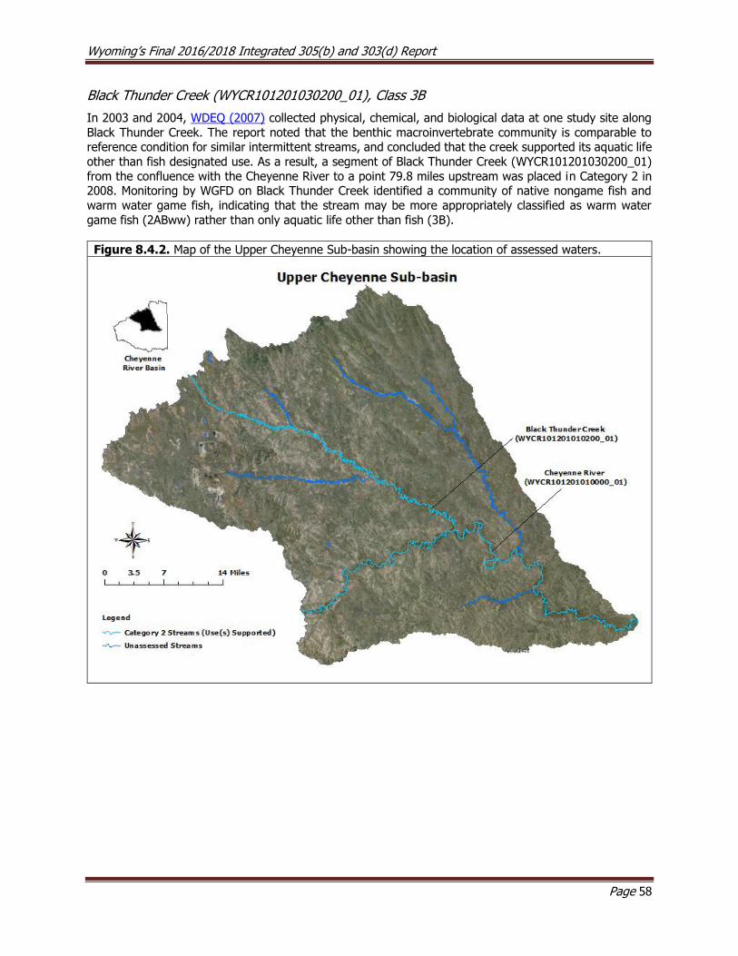
Wyoming’s Final 2016/2018 Integrated 305(b) and 303(d) Report
Page 58
Black Thunder Creek (WYCR101201030200_01), Class 3B
In 2003 and 2004, WDEQ (2007) collected physical, chemical, and biological data at one study site along
Black Thunder Creek. The report noted that the benthic macroinvertebrate community is comparable to reference condition for similar intermittent streams, and concluded that the creek supported its aquatic life
other than fish designated use. As a result, a segment of Black Thunder Creek (WYCR101201030200_01)
from the confluence with the Cheyenne River to a point 79.8 miles upstream was placed in Category 2 in 2008. Monitoring by WGFD on Black Thunder Creek identified a community of native nongame fish and
warm water game fish, indicating that the stream may be more appropriately classified as warm water
game fish (2ABww) rather than only aquatic life other than fish (3B).
Figure 8.4.2. Map of the Upper Cheyenne Sub-basin showing the location of assessed waters.

Wyoming’s Final 2016/2018 Integrated 305(b) and 303(d) Report
Page 59
Angostura Reservoir Sub-basin (HUC10120106)
The Cheyenne River in this sub-basin generally has perennial streamflow; however, during low flow, the
river is reduced to standing pools maintained by springs.
Assessed Waters
Cheyenne River (WYCR101201060100_01), Class 2ABww
In 2003 and 2004, WDEQ (2007) collected physical, chemical, and biological data at three study sites along the Cheyenne River between Lance Creek and the South Dakota state line. The report noted that this
segment of the Cheyenne River contains a diverse assemblage of macroinvertebrates and fish, and concluded that this segment of the Cheyenne River supported its aquatic life other than fish and warm
water fish designated uses. As a result, a segment of the Cheyenne River (WYCR101201060100_01) from
the confluence with Lance Creek downstream to the South Dakota border was placed in Category 2 in 2008.
Other Monitoring Efforts in the Sub-basin Between 2004 and 2006, USGS (2007) collected water quality samples on the lower Cheyenne River in Wyoming, immediately upstream of the South Dakota state line, as part of a Coal Bed Methane (CBM)
effluent monitoring project. The data showed elevated SAR, EC, TDS and TSS values. It is currently unknown to what extent these pollutants are natural versus anthropogenic and whether they impact
designated uses.
Figure 8.4.3. Map of the Angostura Reservoir Sub-basin showing the location of assessed waters.

Wyoming’s Final 2016/2018 Integrated 305(b) and 303(d) Report
Page 60
Beaver Creek Sub-basin (HUC 10120107)
The headwaters of streams in the Beaver Creek sub-basin are primarily located in the Black Hills.
Poison Creek (WYCR101201070103_01), Class 3B
Poison Creek flows through the Osage Oil Field and confluences with Beaver Creek near Osage. Some small
oil seeps are known to reach Poison Creek, but the extent to which these seeps are natural versus anthropogenic is unknown. Poison Creek (WYCR101201070103_01) from the confluence with Beaver Creek
to a point 7.3 miles upstream was added to the 303(d) List in 2002 because the aquatic life other than fish designated use was threatened due to these oil seeps. The Wyoming Oil and Gas Conservation Commission
(WOGCC) determined that it would be more cost effective to mitigate the oil seeps rather than attempt to
identify all sources, and has conducted cleanup efforts to prevent the contamination of Poison Creek and to protect the aquatic life other than fish designated uses.
In 2004 and 2006, WDEQ (2008) collected physical, chemical, and biological data at five study sites along
Poison Creek. The report concluded that WOGCC’s reclamation efforts had been successful in eliminating
the threat of oil seeps to Poison Creek, and that Poison Creek supported its aquatic life other than fish designated use. As a result, the impaired segment of Poison Creek (WYCR101201070103_01) was moved
from the 303(d) List to Category 2 in 2008.
Figure 8.4.4. Map of the Beaver Creek Sub-basin showing the location of assessed waters.
Wyoming’s Final 2016/2018 Integrated 305(b) and 303(d) Report
Page 61
8.5 Green River Basin
The Green River Basin in Wyoming drains approximately 16,629 mi2 of southwestern Wyoming. The Green
River Basin is part of the Colorado River Compact of 1922, which apportions the Colorado River Basin’s
water among Arizona, California, Colorado, Nevada, New Mexico, Utah and Wyoming. The headwaters of the Green River are located in the northern one third of the basin, which is bounded by the Wind River,
Gros Ventre and Wyoming Mountain Ranges of the Middle Rocky Mountains. The Wind River Mountains are granitic while the Gros Ventre and Wyoming Mountains are sedimentary. All three of these mountain ranges
contain alpine, subalpine and foothills ecoregions. The southwest corner of the basin contains mid-elevation portions of the Uinta Mountains. Snow melt runoff from these mountain ranges dominates the hydrology
of the Green River and most of its tributaries. Streams flowing from these mountains continue onto sub-
irrigated high valleys and then to lower elevation rolling sagebrush steppe and the salt desert shrub lands of the Wyoming Basin. Land uses in the Green River Basin include livestock grazing, wildlife habitat,
recreation, mining and oil and gas production.
Wyoming has the world’s largest trona (sodium carbonate typically occurring with halite and gypsum)
deposits. Extensive natural salt deposits of trona were first noted in late 1890s in the Green River Basin. These deposits were prospected and mined in the late 1930s-40s and mining continues today. Oil and gas
development also occurs throughout much of the basin and is an important industry for the region and state; coal deposits have also been mined in parts of the basin. There are currently concerns that energy
development may negatively affect water quality by increasing TDS concentrations in the Colorado River Basin (USBOR, 2011). USGS (2009) collected TDS and specific conductance data in an effort to establish
regression relationships for sites on the Green River near the town of Green River. These relationships will
allow TDS to be monitored more easily in the future using specific conductance measurements as a surrogate.
A pesticide occurrence study (USGS, 2011) conducted by the USGS during the summer of 2009 and spring
of 2010 detected just one pesticide in the Green River, near the town of Green River; concentrations were
well below WDEQ’s drinking water criteria.
Upper Green Sub-basin (HUC 14040101)
The headwaters of the upper Green sub-basin are located along the eastern edge of the Wyoming Range
within the Bridger-Teton National Forest.
Assessed Waters
Green River (WYGR140401010200_01), Class 2AB
In 1999, WDEQ extensively monitored the upper Green River watershed. The assessment concluded that
735.6 miles of the Green River watershed between Highway 191 and Green River Lakes
(WYGR140401010200_01) supported its cold water fish and aquatic life other than fish designated uses. A final report was not written for this study.
Fontenelle Creek (WYGR140401011302_00, WYGR140401011306_01), Class 2AB
As part of the 1999 Upper Green watershed study, WDEQ also monitored the Fontenelle Creek watershed.
The assessment concluded that the entire Fontenelle Creek watershed above Little Coal Creek supported its cold water fish and aquatic life other than fish designated uses. As a result, the entire Fontenelle Creek
(WYGR140401011302_00) upstream of the confluence with Little Coal Creek was placed in Category 2 in
2002.
WDEQ monitoring indicated that lower Fontenelle Creek, from Fontenelle Reservoir upstream 13.2 miles
(WYGR140401011306_01), supported its cold water fish and aquatic life other than fish designated uses.
As a result, this segment of Fontenelle Creek was added to Category 2 in 2008.
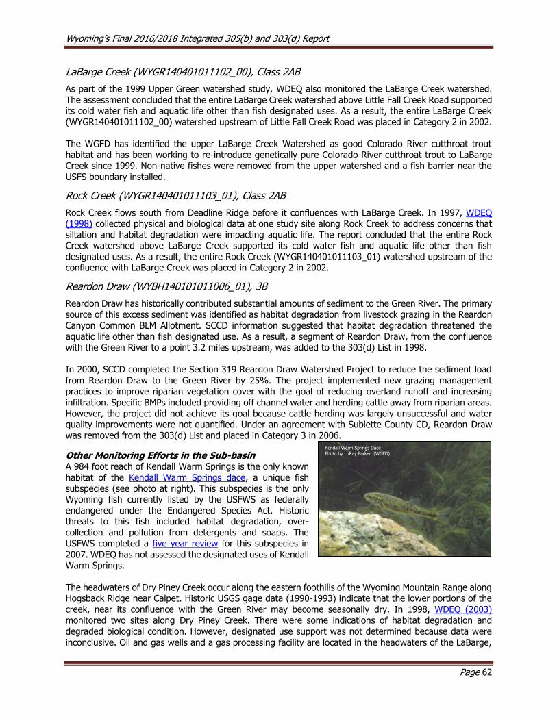
Wyoming’s Final 2016/2018 Integrated 305(b) and 303(d) Report
Page 62
LaBarge Creek (WYGR140401011102_00), Class 2AB
As part of the 1999 Upper Green watershed study, WDEQ also monitored the LaBarge Creek watershed.
The assessment concluded that the entire LaBarge Creek watershed above Little Fall Creek Road supported its cold water fish and aquatic life other than fish designated uses. As a result, the entire LaBarge Creek
(WYGR140401011102_00) watershed upstream of Little Fall Creek Road was placed in Category 2 in 2002.
The WGFD has identified the upper LaBarge Creek Watershed as good Colorado River cutthroat trout
habitat and has been working to re-introduce genetically pure Colorado River cutthroat trout to LaBarge Creek since 1999. Non-native fishes were removed from the upper watershed and a fish barrier near the
USFS boundary installed.
Rock Creek (WYGR140401011103_01), Class 2AB
Rock Creek flows south from Deadline Ridge before it confluences with LaBarge Creek. In 1997, WDEQ (1998) collected physical and biological data at one study site along Rock Creek to address concerns that
siltation and habitat degradation were impacting aquatic life. The report concluded that the entire Rock
Creek watershed above LaBarge Creek supported its cold water fish and aquatic life other than fish designated uses. As a result, the entire Rock Creek (WYGR140401011103_01) watershed upstream of the
confluence with LaBarge Creek was placed in Category 2 in 2002.
Reardon Draw (WYBH140101011006_01), 3B
Reardon Draw has historically contributed substantial amounts of sediment to the Green River. The primary source of this excess sediment was identified as habitat degradation from livestock grazing in the Reardon
Canyon Common BLM Allotment. SCCD information suggested that habitat degradation threatened the aquatic life other than fish designated use. As a result, a segment of Reardon Draw, from the confluence
with the Green River to a point 3.2 miles upstream, was added to the 303(d) List in 1998.
In 2000, SCCD completed the Section 319 Reardon Draw Watershed Project to reduce the sediment load
from Reardon Draw to the Green River by 25%. The project implemented new grazing management practices to improve riparian vegetation cover with the goal of reducing overland runoff and increasing
infiltration. Specific BMPs included providing off channel water and herding cattle away from riparian areas.
However, the project did not achieve its goal because cattle herding was largely unsuccessful and water quality improvements were not quantified. Under an agreement with Sublette County CD, Reardon Draw
was removed from the 303(d) List and placed in Category 3 in 2006.
Other Monitoring Efforts in the Sub-basin A 984 foot reach of Kendall Warm Springs is the only known
habitat of the Kendall Warm Springs dace, a unique fish subspecies (see photo at right). This subspecies is the only
Wyoming fish currently listed by the USFWS as federally
endangered under the Endangered Species Act. Historic threats to this fish included habitat degradation, over-
collection and pollution from detergents and soaps. The USFWS completed a five year review for this subspecies in
2007. WDEQ has not assessed the designated uses of Kendall Warm Springs.
The headwaters of Dry Piney Creek occur along the eastern foothills of the Wyoming Mountain Range along Hogsback Ridge near Calpet. Historic USGS gage data (1990-1993) indicate that the lower portions of the
creek, near its confluence with the Green River may become seasonally dry. In 1998, WDEQ (2003) monitored two sites along Dry Piney Creek. There were some indications of habitat degradation and
degraded biological condition. However, designated use support was not determined because data were
inconclusive. Oil and gas wells and a gas processing facility are located in the headwaters of the LaBarge,
Kendall Warm Springs Dace Photo by LuRay Parker (WGFD)
Wyoming’s Final 2016/2018 Integrated 305(b) and 303(d) Report
Page 63
Dry Piney, and South Piney Creek drainages. Oil seeps and ponds and physical degradation associated with wells and have been identified as concerns (WDEQ, 2003). Seasonal dewatering of North Piney, Middle
Piney, South Piney (WGFD, 2004) and Dry Piney Creeks (WDEQ, 2003) may also limit macroinvertebrate communities in these watersheds. Water quality assessments have not been made for these three
watersheds.
A study conducted by a graduate student at UW looked at whether oil and gas development in the Big
Piney Creek watershed effect water quality and the fish community (Girard, 2015). Streams within nearby South Beaver Creek watershed were used as reference and compared to streams in the Dry Piney Creek
watershed. The study concluded that several streams within the Dry Piney Creek watershed are ecologically degraded due to oil and gas development in the drainage. Specifically, the study found that habitat and
water quality were impacted by oil and gas, affecting both fish abundance and community composition.
Colorado River cutthroat trout and mottled sculpin were particularly vulnerable to habitat degradation due to a narrow thermal tolerance, sensitivity to contaminants discharged from oil fields and excess fine
sediments covering streambed particles. The study also indicated that livestock grazing likely contributed to the habitat degradation in the study area. The study concluded that physical and chemical stressors
related to oil and gas development have negatively impacted Colorado River cutthroat trout and mottled
sculpin in Dry Piney Creek.
Sublette County Conservation District (SCCD) funded a study (Marshall, 2007a) to evaluate baseline
biological condition within the upper Green River Basin (excluding the New Fork Basin) in Sublette County.
The study compared samples collected from 19 sites between the years 2001-05 and evaluated biological trends within sites using WDEQ’s WSII macroinvertebrate model. The report indicated that the
macroinvertebrate communities of Middle Piney Creek and Muddy Creek were in poor condition and that WWTF effluent and irrigation return flows may be having a negative effect. Water quality assessments
were not made using this report because there were insufficient physical, chemical and biological data.

Wyoming’s Final 2016/2018 Integrated 305(b) and 303(d) Report
Page 64
Figure 8.5.1. Map of the Upper Green Sub-basin showing the location of assessed waters.
New Fork Sub-basin (HUC 14040102)
Assessed Waters
New Fork River (WYGR140401020203_00), Class 2AB
The New Fork River originates along the western slope of the Wind River Mountains before flowing southwest to its confluence with the Green River near Marbleton. Between 1996 and 2001, WDEQ (2005)
collected physical, chemical, and biological data at five study sites along the New Fork River, and the report
concluded that the New Fork River was fully supporting its cold water fish and aquatic life other than fish designated uses. As a result, a segment of the New Fork River (WYGR140401020203_00) from the
confluence with the Green River upstream to Duck Creek, and the entire watershed upstream of the confluence with Duck Creek, excluding Pole Creek was placed in Category 2 in 2008.
Since the early 1990s, extensive natural gas development has been occurring in the approximately 198,345 square acre Pinedale Anticline area of the lower New Fork watershed. BLM manages the majority of land
in the Pinedale Anticline Project Area (PAPA). One of the outcomes of the BLM's Pinedale Anticline EIS Record of Decision was the need for an expanded ground and surface water monitoring network. The
operators of the gas field hired SCCD to conduct the surface water quality monitoring for this project. Chemical and biological monitoring began in 2000 at three locations on the New Fork River and five more
sites were added by 2007. A summary report of the baseline study was completed by Marshall (2005), and
included trend analyses of chemical and macroinvertebrate samples across 18 study sites. Results from a second study (Marshall, 2007b) suggested that the overall ecological condition of the New Fork River was

Wyoming’s Final 2016/2018 Integrated 305(b) and 303(d) Report
Page 65
not significantly different from expected values as defined by the baseline study. However, the report suggested that the macroinvertebrate community at a study site downstream of the majority of the Pinedale
Anticline gas field development had been negatively impacted by excess fine sediment and fine particulate organic matter. The report noted that the site was downstream of several pipelines constructed below the
streambed and approximately 3 miles downstream of the confluence with the East Fork River, which is a
sand dominated system. The relative influence of these and other potential sources on aquatic life was not quantified. Use support determinations were not made using this report because there were insufficient
physical, chemical, and biological data.
Pole Creek (WYGR140401020403_01), Class 2AB
Pole Creek’s headwaters are located along the western slope of the Wind River Mountains where it flows south to its confluence with the New Fork River just west of highway 191, between the towns of Pinedale
and Boulder. In 1999, WDEQ (2004) collected physical, chemical, and biological data at two study sites along 25 miles of Pole Creek to address WGFD concerns that habitat degradation (channelization) was
negatively impacting aquatic life. The report concluded that Pole Creek supported its cold water fish and
aquatic life other than fish designated uses. As a result, a segment of Pole Creek (WYGR140401020403_01) from the confluence with the New Fork River to a point 17.2 miles upstream was placed in Category 2 in
2006.
Figure 8.5.2. Map of the New Fork Sub-basin showing the location of assessed waters.

Wyoming’s Final 2016/2018 Integrated 305(b) and 303(d) Report
Page 66
Slate Creek Sub-basin (HUC 14040103)
The headwaters of the Slate Creek Sub-basin occur along Oyster and Slate Creek Ridges in central Lincoln
County. Slate Creek flows southwest to its confluence with the Green River between Fontenelle Reservoir and the Seedskadee National Wildlife Refuge. The Seedskadee National Wildlife Refuge supports a unique
community of waterfowl and is an important recreational fishery.
Other Monitoring Efforts in this Sub-basin In August 2007, WDEQ and WGFD investigated two fish kills on the Green River in this sub-basin. These
studies determined that the cause of the first fish kill near the City of Green River was the aerial application
of the insecticide malathion. The second fish kill was in the vicinity of the confluence with Slate Creek, immediately downstream of Fontenelle Dam, and included several hundred mountain whitefish and some
juvenile trout. WDEQ investigated this site shortly thereafter, measuring TDS, TSS, total petroleum hydrocarbons (TPH DRO), DO, pH, temperature and conductivity at three locations within the affected
reach. Temperatures were elevated at all three locations. USBOR data indicated that blue-green algae
blooms occurred within Fontenelle Reservoir in September 2007, but that toxins were not detected. The occurrence of blue-green algae may suggest episodes of elevated nutrients and water temperatures. No
water quality assessments were made using the above data.
Big Sandy Sub-basin (HUC 14040104)
Assessed Waters
Big Sandy River (WYGR140401040407_01), Class 2AB
In 1998, WDEQ (2003) collected physical, chemical, and biological data at four study sites along 35 miles
of the Big Sandy River. No exceedances of any physical or chemical water quality criteria were detected
during the study, but low dissolved oxygen and elevated water temperatures were noted in the report. The report also noted that the river had adjusted to transport sediment effectively under the altered flow regime
present in the studied segment, and there were no indications of anthropogenic impacts on the macroinvertebrate community. The report concluded that this segment of the Big Sandy River supported
its cold water fish and aquatic life other than fish designated uses. As a result, a 42.0 mile segment of the
Big Sandy River (WYGR140401040407_01) from the confluence with the Green River upstream to the confluence with the Little Sandy River was placed in Category 2 in 2002.
Little Sandy River (WYGR140401040203_01), Class 2AB
The Little Sandy River was added to Wyoming’s 303(d) List in 1996 for siltation, chloride, salinity, and TDS,
because it was determined that it was not supporting its cold water fish and aquatic life other than fish designated uses along a 26.9 mile segment below Elkhorn Junction. The primary sources of these pollutants
were identified as livestock grazing and natural sources. The impaired segment of the Little Sandy River was subsequently removed from the 303(d) List in 1998, however, because the data used to justify the
listing were deemed to be inadequate.
In 1998 and 2003, WDEQ (2003) collected physical, chemical, and biological data along the Little Sandy
River, and the report noted that siltation, chloride, salinity, and TDS were not a concern above Elkhorn Junction. However, areas of habitat degradation, streambank instability, and sedimentation were identified
along several miles of the Little Sandy River on BLM, State, and private lands below Elkhorn Junction. At that point, the BLM and grazing permit holders were already in the process of modifying the grazing
management plan along the Little Sandy River within the Little Sandy Grazing Allotment to improve riparian
and aquatic habitat. Management changes included the installation of electric fencing and the rotation of stock within the allotment (BLM-GR, 2002). In 2004, WDEQ met with a stakeholder group including SCCD,
SWCCD, BLM, and the Little Sandy Grazing Association (LSGA) to discuss WDEQ’s study findings and to conduct a watershed tour.
Wyoming’s Final 2016/2018 Integrated 305(b) and 303(d) Report
Page 67
Between 2004 and 2008, WDEQ (2010) collected physical, chemical, and biological data at five study sites along the Little Sandy River to evaluate the effectiveness of BMPs at reducing sedimentation within the
impacted reach, identify potential sources of sediment, and determine designated use support. The report concluded that a segment of the Little Sandy River above the Sublette/Sweetwater County line did not
support its cold water fish and aquatic life other than fish designated uses. As a result, a segment of the
Little Sandy River (WYGR140401040203_01) from the northern boundary of Section 33-Township 28 North-Range 104 West-downstream 17.7 miles to the Sublette/Sweetwater County line was added to the 303(d)
List in 2012 for sediment. The primary sources of excess sediment loads were identified as accelerated bank erosion due to livestock and wildlife grazing and historic habitat/channel modifications.
WDEQ received a formal commitment from the local stakeholder group to complete a watershed based
plan for the Little Sandy River Watershed. The SCCD issued a draft plan for a 45-day public comment period
beginning May 8, 2018.
Other Monitoring Efforts in the Sub-basin
Salinity Control
The headwaters of the Big Sandy Sub-basin are in the granitic geology of the southern Wind River Range,
resulting in streambed substrata dominated by coarse sand from eroded granite. The sub-basin has
extensive sedimentary geology in the lower portions of the basin and these deposits are rich in dissolved solids. Salinity in the basin’s surface waters is naturally high and has increased in part due to the influence
of irrigation returns, water withdrawals, reservoir evaporation and municipal and industrial discharges (WWDO). Water is diverted from the Big Sandy River below Big Sandy Reservoir to irrigate lands in the
Eden Project. Irrigation seepage into shallow aquifers has created saline seeps and springs below the Eden
Project, which contribute approximately 149,180 tons of salt annually to the Green River (SCS, 1987). The Green River is the largest tributary to the Colorado River and is subject to salinity control through the
Colorado River Basin Salinity Control Forum. High salinity in the Colorado River Basin negatively effects crop selection, crop yield, the amount of water necessary cultivate crops and increases the cost to treat
drinking water for municipalities. Since 1988, efforts to reduce salinity loading to the Green River have been implemented in the Big Sandy River Unit within the Big Sandy sub-basin (USBOR, 2011). The goal of
this project is to reduce salt loading to the Green River by improving irrigation efficiency across 18,370
acres near Farson and Eden; this project has reduced salt loading by approximately 52,900 tons/year (CRBSCF, 2002, WWDO). The program, managed through the NRCS, has improved 10,790 acres of irrigated
lands to date. Irrigation improvements include 114 improved sprinkler, drip and surface irrigation systems; 39 miles of improved water conveyance; and improved storage efficiency in 54 reservoirs (WWDO). Effects
of these salinity reduction efforts on streams in the Big Sandy and other Green River drainages have not
been determined, but crop production and water savings have reportedly increased where irrigation conversion has occurred (SWCCD, 2004).
Aquatic Habitat Restoration
Erosion due to unstable banks and a lack of woody riparian vegetation have been identified as concerns in
lower Big Sandy River. Flow alterations following the construction of Big Sandy Reservoir and cattle grazing are sources. Several riparian livestock exclosures were created in the 1980s to protect riparian areas along
the Big Sandy River, between Little Sandy River and the Green River, and to enhance fish habitat. Rock sill structures have also been built in the Big Sandy River and in Bone Draw to raise the water table, improve
channel conditions and promote riparian vegetation growth to provide habitat for juvenile fish. The Big
Sandy Working Group (BSWG), including BLM, grazing permit holders, WGFD, Trout Unlimited (TU), Sweetwater County Conservation District (SWCCD), various other stakeholders and a facilitator was formed
in 1996. Management changes have included modifying grazing rotations, allotment boundaries and seasons, installing electric fencing to protect riparian areas, developing upland water sources and
implementing the monitoring plan developed by BSWG (BLM-GR, 2003).

Wyoming’s Final 2016/2018 Integrated 305(b) and 303(d) Report
Page 68
Figure 8.5.3. Map of the Big Sandy Sub-basin showing the location of assessed waters.
Bitter Creek Sub-basin (HUC 14040105)
Assessed Waters
Bitter Creek (WYGR140401050506_01), 2C; Killpecker Creek (WYGR140401050808_01), Class 3B
Bitter Creek 303(d) Listing
The headwaters of Bitter Creek occur between Delaney Rim and Adobe Town Rim in southeastern
Sweetwater County. Bitter Creek flows northwest to Point of Rocks, then west along I-80 through Rock Springs to its confluence with the Green River at the Town of Green River. The WGFD collected several
game and nongame fish in Bitter Creek in 2009 and referred to the stream as “a local gem.” WDEQ (2001) monitored Bitter Creek for chlorides in 1998, 1999 and 2001. The data indicated that chloride
concentrations exceeded the acute aquatic life chloride criterion of 860 mg/L applicable to the nongame
fish designated use of Bitter Creek at several locations from just above the confluence with Killpecker Creek downstream to just above the confluence with the Green River. As a result, a segment of Bitter Creek from
the confluence with the Green River upstream to Killpecker Creek was added to the 303(d) List in 2002. As part of a Section 319 study, SWCCD monitored additional sites along Bitter Creek in 2004 and 2005 to more
accurately delineate the extent of the chloride impairment. Exceedances of the chronic chloride criterion
(230 mg/L) applicable to the nongame fish designated use on Bitter Creek were detected between Point of Rocks downstream to the confluence with Killpecker Creek, and exceedances of the acute criterion (860
mg/L) were detected in Bitter Creek from Killpecker Creek downstream to the Green River. As a result, the
Wyoming’s Final 2016/2018 Integrated 305(b) and 303(d) Report
Page 69
extent of the impaired segment of Bitter Creek was modified to include the 58.1 miles from the Green River upstream to Point of Rocks in 2008. The “list date” included on the 303(d) List remains 2002.
WDEQ (1999, 2000) also monitored Bitter Creek for fecal coliform in 1999 and 2000. WDEQ (1999) sampled three sites along Bitter Creek ranging from upstream of Rock Springs (near the airport road bridge) to just
above the Rock Springs WWTF. The data indicated that the two lowermost sites exceeded the fecal coliform
criterion, and, initially, only a small segment of Bitter Creek near Rock Springs was added to the 303(d) List in 2000. In 2000, WDEQ (2000) conducted a second study on Bitter Creek to more accurately delineate
the extent of the bacterial impairment. Nine study sites were used, ranging from the northeast edge of Rock Springs downstream to below Rock Spring’s WWTF. Only one site (located near Elk Street) exceeded
WDEQ’s fecal coliform criterion; however, bacteria levels may have been low due to low flow conditions and because samples were collected early in the recreational season. As part of a 2006 Section 319 study,
SWCCD monitored additional sites along Bitter Creek in 2004 and 2005 at several sites along the creek to
more accurately delineate the extent of the fecal coliform impairment. Fecal coliform criterion exceedances were detected in Bitter Creek well upstream of Rock Springs during high flow events, which suggests that
there may be a significant nonpoint source of bacteria in the upper watershed. The extent of the fecal coliform impairment on Bitter Creek was therefore changed in the 303(d) List in 2006 to extend from the
confluence with the Green River 58.1 miles upstream to Point of Rocks. The “list date” included on the
303(d) List remains 2000.
Killpecker Creek 303(d) Listing
Killpecker Creek originates just south of the Killpecker Sand Dune Field. The creek flows directly south
along County Route 17 and U.S. Route 191 to its confluence with Bitter Creek in the town of Rock Springs.
WDEQ (1999) monitored Killpecker Creek for several physical-chemical parameters at a single sampling site near the confluence with Bitter Creek. High chloride concentrations were noted at a site near the
confluence with Bitter Creek, but because the creek is classified as a 3B water, chloride criteria do not apply. The study suggested that these high chloride concentrations may be related to a fish kill observed
during the study on Bitter Creek just below the confluence with Killpecker Creek. WDEQ (2001) monitored Killpecker Creek above the confluence with Bitter Creek for chlorides in 1998, 1999 and 2001, and reported
chloride concentrations were around twice the highest measured concentrations on Bitter Creek during the
same study. The report identified Killpecker Creek as a major source of chloride loading to Bitter Creek.
WDEQ (1999) monitored Killpecker Creek in 1999 for fecal coliform at a single study site located in the town of Rock Springs, immediately downstream of Spring Drive Bridge. Fecal coliform concentrations
exceeded the criterion for contact recreation. As a result, a small segment of the creek was added to the
303(d) List in 2000. WDEQ (2000) conducted additional fecal coliform monitoring on Killpecker Creek in 2000 to more accurately delineate the extent of the fecal coliform impairment. Seven sites were sampled
on Killpecker Creek between a site upstream of the town of Reliance and a site immediately upstream of the confluence with Bitter Creek. The fecal coliform criterion for contact recreation was exceeded along a
segment of Killpecker Creek from the confluence with Bitter Creek upstream to Reliance. As a result, the
length of the impaired segment was extended to include Killpecker Creek from the confluence with Bitter Creek upstream to Reliance in the 303(d) List in 2002. The “list date” included on the 303(d) List remains
2000.
Bitter Creek and Killpecker Creek TMDL Development
In 2004 and 2005, SWCCD collected fecal coliform data at several sites along the main stems and tributaries of Bitter Creek and Killpecker Creek as part of a Section 319 project. Exceedances of the fecal coliform
criterion protective of the primary contact recreation designated use were detected in Bitter Creek upstream of Rock Springs during high flow events, which suggests that there may be significant nonpoint sources of
bacteria in the upper watershed. Additionally, high E. coli concentrations were observed on Killpecker Creek from Reliance downstream to the confluence with Bitter Creek, which suggests that septic system
contamination, urban runoff, and leaking sewage lines may be nonpoint sources of E. coli via groundwater
throughflow in the lower reaches of Bitter and Killpecker Creeks. The primary source of chloride loading in Bitter Creek and Killpecker Creek is likely the surrounding geology and soils of the watershed, especially in
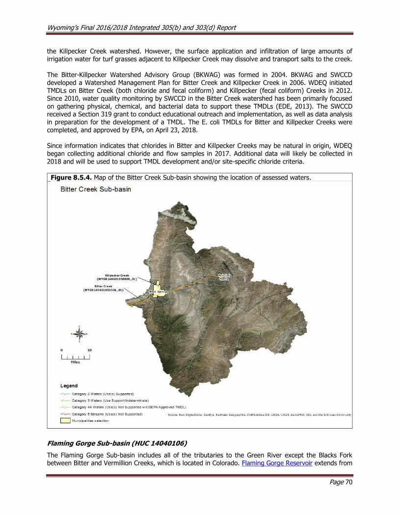
Wyoming’s Final 2016/2018 Integrated 305(b) and 303(d) Report
Page 70
the Killpecker Creek watershed. However, the surface application and infiltration of large amounts of irrigation water for turf grasses adjacent to Killpecker Creek may dissolve and transport salts to the creek.
The Bitter-Killpecker Watershed Advisory Group (BKWAG) was formed in 2004. BKWAG and SWCCD
developed a Watershed Management Plan for Bitter Creek and Killpecker Creek in 2006. WDEQ initiated
TMDLs on Bitter Creek (both chloride and fecal coliform) and Killpecker (fecal coliform) Creeks in 2012. Since 2010, water quality monitoring by SWCCD in the Bitter Creek watershed has been primarily focused
on gathering physical, chemical, and bacterial data to support these TMDLs (EDE, 2013). The SWCCD received a Section 319 grant to conduct educational outreach and implementation, as well as data analysis
in preparation for the development of a TMDL. The E. coli TMDLs for Bitter and Killpecker Creeks were
completed, and approved by EPA, on April 23, 2018.
Since information indicates that chlorides in Bitter and Killpecker Creeks may be natural in origin, WDEQ
began collecting additional chloride and flow samples in 2017. Additional data will likely be collected in
2018 and will be used to support TMDL development and/or site-specific chloride criteria.
Figure 8.5.4. Map of the Bitter Creek Sub-basin showing the location of assessed waters.
Flaming Gorge Sub-basin (HUC 14040106)
The Flaming Gorge Sub-basin includes all of the tributaries to the Green River except the Blacks Fork between Bitter and Vermillion Creeks, which is located in Colorado. Flaming Gorge Reservoir extends from
Wyoming’s Final 2016/2018 Integrated 305(b) and 303(d) Report
Page 71
just south of the town of Green River to the Wyoming/Utah border. The reservoir provides hydropower to approximately 50,000 homes across several western states and has a storage capacity of 3,788,900 acre-
feet.
Other Monitoring Efforts in the Sub-basin In 1990, WGFD, BLM and other stakeholders initiated the Little Mountain Watershed Enhancement Project
to address declining populations of Colorado River cutthroat trout and mule deer in the Currant Creek watershed. In 1995, the project was expanded to include the Red Creek watershed. As of 2008, more than
57,000 acres have been prescription burned, 216 grade control structures have been constructed, livestock
grazing management has been modified, and beaver have been re-introduced to these watersheds. These efforts have resulted in improvements to riparian and upland habitat, increased native fish populations,
reduced sedimentation (Mizuyama, 1993), and increased perennial stream flows.
Blacks Fork Sub-basin (HUC 14040107)
The headwaters of the Blacks Fork Sub-basin are in the Uinta Mountains in northeastern Utah and the Tunp
and Wyoming Ranges in Wyoming. The Black’s Fork flows through the Bridger Basin and into Flaming Gorge Reservoir near McKinnon Junction. Major tributaries to the Black’s Fork include Smiths Fork and Hams Fork.
Assessed Waters
Blacks Fork (WYGR140401070403_01) and Smiths Fork (WYGR140401070208_00; WYGR140401070208_01), Class 2AB
Blacks Fork 303(d) Listing
In 2000, WDEQ assessed the lower Blacks Fork for support of its recreational designated use on the lower
Blacks Fork using data collected from USGS gage #09222000 near the town of Lyman. Between 1995 and 1998, several exceedances of the fecal coliform criterion protective of the primary contact recreation
designated use were detected. As a result, a segment of the Blacks Fork (WYGR140401070403_01) from
the Hams Fork upstream to the confluence with the Smiths Fork was added to the 303(d) List in 2000 for fecal coliform. The sources of bacterial loading were not identified.
In 1998, WDEQ (2003) collected physical, chemical, and biological data at five study sites along the Blacks
Fork to address concerns about possible habitat degradation, however, the report was inconclusive.
Smiths Fork 303(d) Listing
In 2000, WDEQ (2000) assessed the Smiths Fork using sediment and fecal coliform data collected from USGS gage #09221650. The report noted that the highly erodible banks of the Smiths Fork were
contributing sediment inputs to the river faster than its sediment transport capacity, which prevented the river from supporting its cold water fish and aquatic life other than fish designated uses. Exceedances of
the fecal coliform criterion protective of the primary contact recreation designated use were also detected
(as high as 5,200 colonies/100mL). Elevated values were recorded by USGS during all flow regimes but were most prevalent during early summer and fall. As a result, a 4.0 mile segment of the Smiths Fork
(WYGR140401070208_01) from the Blacks Fork upstream to the confluence with Cottonwood Creek was added to the 303(d) List in 2000 for habitat alteration (i.e. sedimentation) and to the 303(d) List in 2008
for E. coli. The source(s) of the bank erosion and excess sediment loading were not identified.
In 2003, WDEQ (2003) collected physical, chemical, and biological data at one study site along the upper
reach of the Smiths Fork, and several exceedances of the fecal coliform criterion protective of the primary contact recreation designated use were detected. As a result, a 34.5 mile segment of the Smiths Fork
(WYGR140401070208_00) from its confluence with Cottonwood Creek upstream to the confluence with East and West Forks Smiths Fork was added to the 303(d) List in 2002 for fecal coliform. The source of the
bacterial loading was not identified.
Wyoming’s Final 2016/2018 Integrated 305(b) and 303(d) Report
Page 72
Blacks Fork and Smiths Fork TMDL Development
In 2006, the Uinta County Conservation District (UCCD) monitored water quality at twelve study sites along
the Blacks Fork as part of the Blacks Fork/Smiths Fork Watershed Section 319 Project Report. The goal of the project was to collect physical, chemical, and biological data from several study sites along the Blacks
Fork and Smiths Fork drainages. Data collected during this project showed that fecal coliform
concentrations were above WDEQ’s recreational criteria at several sites in both watersheds throughout the study. The report also noted that sedimentation was a concern in both watersheds. UCCD collected E. coli data in 2009 and 2010 that showed that bacterial concentrations on the Blacks and Smiths Forks were still exceeding WDEQ’s recreational use criteria. UCCD collected additional E. coli data on the Blacks Fork and
Smiths Fork during 2011, 2012 and 2013; these data were used in the development of the Blacks Fork and Smiths Fork TMDLs. In 2013, TMDLs for the Smiths and Blacks Forks were initiated and are currently in
draft; however, these documents were not formally submitted to USEPA for approval. WDEQ is currently
working with UCCD to finalize these TMDLs. UCCD has sponsored a watershed plan for the Blacks Fork and Smiths Fork Watersheds.
East Smiths Fork (WYGR140401070201_01) and West Smiths Fork (WYGR140401070203_01), Class 2AB
The East Smiths Fork and West Smiths Fork originate in the foothills of the Uinta Mountains in the Wasatch-Cache National Forest. The streams flow north and confluence to form the Smiths Fork. UCCD data and
information collected during 1996 and 1997 suggested that the cold water fish and aquatic life other than
fish uses within the East and West Forks of Smiths Fork were not supported due to excess sedimentation. Both waters were therefore added to the 303(d) List in 1998 from their confluence upstream to the Utah
border. Sources of sediment included grazing, vehicle traffic on nearby roads, recreational use, logging, irrigation return flows, riparian degradation and streambank destabilization.
UCCD completed a Section 319 project in 1999 to improve stream channels and riparian areas in the upper
Smiths Fork watershed. BMPs included repairing or replacing livestock watering tanks and constructing
snow fences to divert spring snow melt to these tanks and lessen sediment input to the two streams from overland flow. Uinta County improved the watershed’s infrastructure by repairing aging roads and bridges
adjacent to the two streams. Volunteers planted assorted trees, shrubs and forbs in riparian zones to help stabilize stream banks and create a sediment buffer. Lastly, farmers constructed fences along the streams
to protect re-establishing plant communities, stream banks and channels from the effects of livestock
grazing and adopted grazing BMPs that both promote the recovery of these two streams and allow for continued grazing.
In 2003, WDEQ (2003) monitored these streams and concluded that habitat had improved and that East
and West Forks of Smiths Fork supported their cold water fish and aquatic life other than fish designated uses. These streams were moved from the 303(d) List to Category 2 in 2006, and Section 319 Nonpoint
Source Success Stories were written for both (see Appendix A).
Willow Creek (WYGR140401070205_01), Class 2AB
Willow Creek is a major tributary to the Smiths Fork, with headwaters located in the northern foothills of
the Uinta Mountains in the Wasatch-Cache National Forest near the Utah/Wyoming border. Data and other information collected during the mid-1990s by UCCD showed that Willow Creek was physically degraded
due to eroding stream banks and excessive sedimentation. Poor riparian vegetation cover was also noted as a concern. Willow Creek was added to the 303(d) List in 1998 as threatened because the cold water fish
and aquatic life other than fish designated uses were not supported for the entire watershed upstream of the confluence with the Smiths Fork. The cause of this threat was determined to be habitat alterations (i.e.,
sediment); the source was identified as livestock grazing.
UCCD completed a Section 319 Project for Willow Creek in 1999. The goals of this project were to improve
the habitat condition and water quality of Willow Creek by implementing BMPs, including revising grazing

Wyoming’s Final 2016/2018 Integrated 305(b) and 303(d) Report
Page 73
management plans, planting riparian vegetation, improving and installing new upland stock watering ponds and fencing some riparian areas. WDEQ (2003) monitored Willow Creek at three sites in 2003 to determine
whether the above BMPs were effective in improving the threat to the Willow Creek watershed. Elevated temperature, pH and algal and macrophyte cover were noted as concerns. Riparian condition was fair at
all three study sites and streambed embeddedness was an issue within the middle reach. Results of
macroinvertebrate sampling were inconclusive. The report concluded that the aquatic life uses on Willow Creek were still threatened, but that habitat condition was improving.
In 2013, WDEQ began an ongoing monitoring effort on Willow Creek to re-assess designated use support.
Hams Fork (WYGR140401070600_01; WYGR140401070701_01), Class 2AB
The headwaters of the Hams Fork are located in the Tunp and Salt River Ranges within the Bridger-Teton
National Forest where it flows south through Kemmerer and Diamondville, then east to its confluence with the Blacks Fork at Granger. Data from the mid-1990’s collected on the Hams Fork at USGS gage station
#09224050 documented a few exceedances of the pH criterion protective of aquatic life. Causes of the
elevated pH were thought to be a result of higher than normal rates of photosynthesis due to nutrient enrichment below the Kemmerer-Diamondville WWTF. As a result, a segment of the Hams Fork
(WYGR140401070701_01) from below the Kemmerer-Diamondville WWTF to a point 7.6 miles downstream was added to the 303(d) List in 1996 for not supporting its cold water fish and aquatic life other than fish
uses.
Hams Fork was also monitored by WDEQ (2005) between 1995 and 1998 to address concerns that siltation
and habitat loss were negatively impacting aquatic life and better inform the permit renewal process for the Kemmerer WWTF. Eight study sites were established along the Hams Fork and one on Willow Creek (a
small tributary to Hams Fork). Sites along the Hams Fork extended from the Bridger-Teton National Forest downstream to the community of Granger and the Willow Creek site was located near the intersection of
forest route 306 and U.S. Highway 189. Diurnal dissolved oxygen fluctuations and elevated temperature
and nutrients were noted as concerns on Hams Fork and may be related to the high pH observed on Hams Fork. The report also noted that fine sediments and poor riparian condition are concerns on lower Hams
Fork near Granger. The entire upper Hams Fork (WYGR140401070600_01) watershed upstream of Kemmerer, excluding the Willow Creek watershed, was determined to support its cold water fish and
aquatic life other than fish uses. As a result, the entire Hams Fork watershed upstream of Kemmerer, excluding the Willow Creek watershed, was placed in category 2 in 2006. Designated use support for Willow
Creek was not determined.
Other Monitoring Efforts in the Sub-basin In 2008, BLM conducted a riparian health assessment of the Christensen Allotment, which includes a 0.5 mile section of Cottonwood Creek. The assessment indicated that resource conditions along the creek within
the allotment do not meet standards for soils and riparian condition because of excessive soil erosion and a lack of adequate riparian vegetation. The assessment further suggested that these conditions are the
result of large historic releases from Reed Reservoir.

Wyoming’s Final 2016/2018 Integrated 305(b) and 303(d) Report
Page 74
Figure 8.5.5. Map of the Black Forks Sub-basin showing the location of assessed waters.
8.6 Little Missouri River Basin
The Little Missouri Basin drains approximately 4,659 mi2 in northeastern Wyoming. The Little Missouri River Sub-basin contains several ecoregions that include Black Hills foothills, sagebrush steppe, Powder River
basin and pine scoria hills within the headwaters and semiarid Pierre shale plains in the lower sub-basin
(Chapman et al. 2003 ). The foothills of the Black Hills make up the hydrologic divide between the Little Missouri Sub-basin and the Belle Fourche Basin. This ecoregion is characterized by ponderosa pine forests
with an understory of grasses and shrubs. Pine scoria hills are located along the western margin of the sub-basin. These hills are mostly covered with ponderosa pine juniper. Porcellanite (or clinker) overlays a
mixture of coal, sandstone and shale. The remaining sub-basin is a mix of rolling plains and sagebrush steppe. Land uses within the sub-basin are livestock grazing, oil and gas production, bentonite mining,
dryland farming and wildlife habitat. WDEQ has not completed any water quality assessments for this basin.
Wyoming’s Final 2016/2018 Integrated 305(b) and 303(d) Report
Page 75
8.7 Little Snake River Basin
The Little Snake River Basin drains approximately 3,337 mi2 in Wyoming, where it is bordered to the east
by the continental divide and Sierra Madre Mountain Range, to the north by the Great Divide Basin and the
west by the Green River Basin. The Little Snake River’s headwaters are located in the Park Mountain Range in Colorado and Wyoming. The river flows west near the Wyoming/Colorado border for several miles before
entering Wyoming near Slater, Colorado. The river then continues flowing west along state highway 70 before turning southwest and re-entering Colorado near the town of Baggs. The river ultimately confluences
with the Yampa River in Colorado near Deerlodge Park. The Little Snake River basin has additional WYPDES permit requirements because it is within the Colorado River Basin Salinity Control area.
The Little Snake River Basin in Wyoming largely consists of rolling sagebrush steppe, foothill shrublands and low mountains, salt desert shrub basins and mid-elevation forests and shrublands of the Sierra Madre
Mountains (Chapman et al. 2003 ). The geology of the lower basin is mostly sedimentary and is dominated by sandstone and conglomerate sedimentary rock; siltstone, shale and limestone are also common. Soils
are alkaline and highly erodible in the lower portions of the basin. Land uses throughout the basin include
livestock grazing, mineral extraction, wildlife habitat and recreation.
Little Snake Sub-basin (HUC 14050003)
Assessed Streams
Haggerty Creek (WYLS140500030109_01) and West Fork Battle Creek (WYLS140500030109_02), Class 2AB
The headwaters of Haggarty Creek are located along the continental divide within the Medicine Bow-Routt
National Forest where it flows southwest to its confluence with Lost Creek, forming West Fork Battle Creek. The Haggarty Creek watershed was historically mined for copper ore, as is evidenced by the ghost mining
towns of Copperton, Dillon and Rudefeha along the creek and the abandoned Ferris-Haggarty Mine (FHM) in the upper watershed. Around the turn of the 19th century, FHM was one of the most productive copper
mines in the region. In 1903, the 1,400 foot long Osceola tunnel was constructed within FHM for hauling ore and dewatering the mine; mine effluent was discharged directly to Haggarty Creek. FHM closed in 1908
due to a fire at the smelter plant and declining copper prices. In 1975, a mining company attempted to
passively remediate the mine effluent using ion exchange within several sedimentation ponds. The ponds were largely non-operational in the years that followed and were removed in 2005 as part of a WDEQ AML
reclamation project. The mine effluent is now conveyed directly to Haggarty Creek through a short surface channel.
In 1996, WDEQ monitored the water quality of Haggarty Creek and West Fork Battle Creek. Several exceedances of the chronic copper, silver, and cadmium numeric criteria protective of the cold water fish
and aquatic life other than fish designated uses were detected in Haggarty Creek and West Fork Battle Creek. As a result, a segment of Haggarty Creek (WYLS140500030109_01) from the FHM downstream to
the confluence with West Fork Battle Creek was added to the 303(d) List in 1996 for copper, silver, and cadmium. Additionally, a segment of West Fork Battle Creek (WYLS140500030109_02) from the confluence
with Battle Creek upstream to the confluence with Haggarty Creek was added to the 303(d) List in 2000
for copper. The FHM was identified as the sole source of heavy metals for all four of these impairments. In 2001 and 2008, WDEQ conducted additional monitoring on 15 sites in the Haggarty Creek watershed to
further characterize the spatial and temporal trends in macroinvertebrate communities and heavy metals pollution. WDEQ reports were not written for any of the 1996-2008 data.
In 2011, the USEPA approved TMDLs for the impaired segments of Haggarty Creek (WYLS140500030109_01) and West Fork Battle Creek (WYLS140500030109_02). As a result, all four metal
impairments for these two waters were moved from the 303(d) List to Category 4A in 2012.

Wyoming’s Final 2016/2018 Integrated 305(b) and 303(d) Report
Page 76
Savery Creek (WYLS140500030408_01), Class 2AB
The headwaters of the Savery Creek watershed are located within the foothills along the northwestern
edge of the Sierra Madre Mountains. Savery Creek flows southwest to its confluence with the Little Snake River near the town of Savery. In 1998, Little Snake River Conservation District (LSRCD) completed the
Savery Creek Watershed Water Quality Assessment Section 319 Project to establish a baseline water quality
survey of the Savery Creek and several of its tributaries using physical, chemical, and biological data collected in 1996 and 1997. In addition, photo points were compared at each site to evaluate trends in
riparian condition over time. The report concluded that the cold water fish and aquatic life other than fish designated uses on lower Savery Creek were likely threatened due to sedimentation. As a result, a segment
of Savery Creek (WYLS140500030408_01) from the confluence with Little Sandstone Creek downstream
to the confluence with the Little Snake River was added to the 303(d) List in 1998 for habitat alteration due to livestock grazing.
East Fork Savery Creek (WYLS140500030401_01), Class 2AB
In 1997 and 2006, WDEQ collected physical, chemical, and biological data at one study site along East Fork
Savery Creek. The report concluded that the creek supported its cold water fish and aquatic life other than fish designated uses. As a result, a segment of East Fork Savery Creek (WYLS140500030401_01) from the
confluence with Savery Creek to a point 17.0 miles upstream, including Hatch Creek, was placed in Category
2 in 2008. A summary report was not written for this monitoring effort.
Dirtyman Fork (WYLS140500030402_01), Class 2AB
In 1996, WDEQ collected physical, chemical, and biological data at one study site along Dirtyman Fork. The report concluded that the creek supported its cold water fish and aquatic life other than fish designated
uses. As a result, a segment of Dirtyman Fork (WYLS140500030402_01) from the confluence with East
Fork Savery Creek to a point 7.8 miles upstream was placed in Category 2 in 2008. A summary report was
not written for this monitoring effort.
Little Savery Creek (WYLS140500030405_01), Class 2AB
In 1997, WDEQ collected physical, chemical, and biological data at one study site along Little Savery Creek. The report concluded that the creek supported its cold water fish and aquatic life other than fish designated
uses. As a result, a segment of Little Savery Creek (WYLS140500030405_01) from the confluence with
McCarty Creek to a point 4.6 miles downstream was placed in Category 2 in 2002. A summary report was
not written for this monitoring effort.
Loco Creek (WYLS140500030408_03), Class 2AB
In 1998, the LSRCD collected physical, chemical, and biological data along Loco Creek as part of the Savery Creek Watershed Water Quality Assessment Section 319 Project. The data indicated that Loco Creek
supported its cold water fish and aquatic life other than fish designated uses. As a result, a segment of Loco Creek (WYLS140500030408_03) from the confluence with Savery Creek to a point 9.1 miles upstream
was placed in Category 2 in 2002.
Big Sandstone Creek (WYLS140500030407_01), Class 2AB
In 1998, the LSRCD collected physical, chemical, and biological data along Big Sandstone Creek as part of the Savery Creek Watershed Water Quality Assessment Section 319 Project. The data indicated that the
entire Big Sandstone Creek watershed supported its cold water fish and aquatic life other than fish designated uses. As a result, the entire Big Sandstone Creek (WYLS140500030407_01) watershed
upstream of the confluence with Savery Creek was placed in Category 2 in 2008.

Wyoming’s Final 2016/2018 Integrated 305(b) and 303(d) Report
Page 77
West Fork Loco Creek (WYLS140500030408_02), Class 2AB
LSRCD and BLM conducted water quality surveys on West Fork Loco Creek in 1992 and concluded that the
cold water fish and aquatic life other than fish designated uses for the entire West Fork Loco Creek watershed upstream of Loco Creek were threatened due to sedimentation, elevated water temperatures,
and nutrients. As a result, the entire West Fork Loco Creek watershed, upstream of Loco Creek, was added
to the 303(d) List in 1996 for habitat alteration (i.e., sedimentation), nutrients, and temperature. The source of these pollutants was identified as livestock grazing.
North Fork Little Snake River (WYLS140500030104_00), Class 2AB
WDEQ monitored the chemical, physical, and biological condition of North Fork Little Snake River between
1996 and 1998 at a single study site and concluded that it was of reference quality. The entire North Fork Little Snake River watershed, upstream of the Colorado border, was determined to support its cold water
fish and aquatic life other than fish designated uses. As a result, the entire North Fork Snake River watershed, upstream of the Colorado border, was placed in Category 2 in 2002. A WDEQ summary report
was not written for this study.
Lost Creek (WYLS140500030109_03), Class 2AB
WDEQ monitored the chemical, physical, and biological condition of Lost Creek (1996, 2001, 2002 and 2004) using a single study site. Results showed that Lost Creek was of reference quality and supported its
cold water fish and aquatic life other than fish uses. As a result, a segment of Lost Creek from the
confluence with West Fork Battle Creek to a point 5.2 miles upstream was placed in Category 2 in 2006. A
WDEQ summary report was not written for these monitoring efforts.
Roaring Fork Little Snake River (WYLS140500030106_01)
The Roaring Fork Little Snake River’s (RFLSR) headwaters originate within the Sierra Madre Mountains of southern Wyoming. The river then flows south to its confluence with the Little Snake River near the
Colorado border. In the late 1990’s, the U.S. Bureau of Mines indicated that mine drainage from the
abandoned mines in the upper RFLSR was a concern, mostly because of high concentrations of copper. As part of their 2003 Medicine Bow National Forest Plan, USFS committed to coordinating with various agencies
to improve water quality in the RFLSR drainage. From 2010 to 2012, WDEQ, in cooperation with USFS, monitored water quality of the RFLSR in the vicinity of the Itmay and Standard mines (WDEQ, 2013). The
report concluded that the cold water fish and aquatic life other than fish designated uses on RFLSR were not supported from the confluence with a tributary draining the Standard Mine downstream 1.8 miles to
the confluence with an unnamed tributary due to exceedance of the aquatic life copper criterion. The source
of the copper was determined to be nearby hardrock mining operations. As a result, this segment of the
RFLSNR was added to the 303(d) List in 2012.
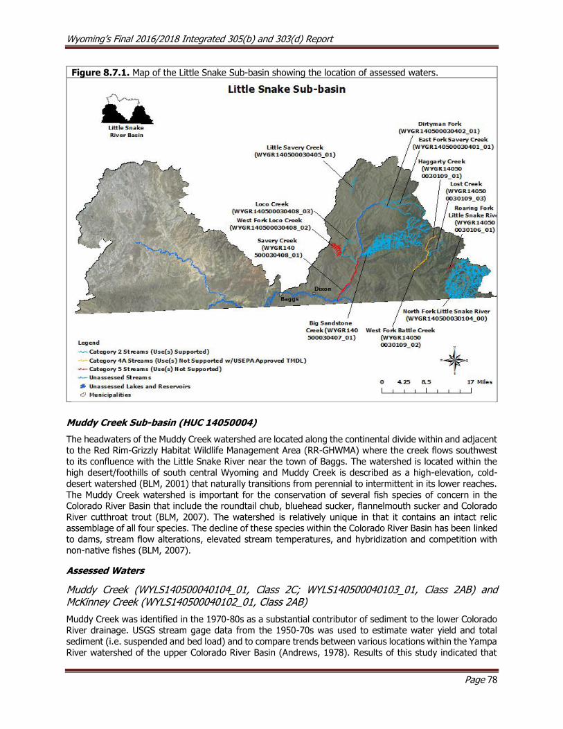
Wyoming’s Final 2016/2018 Integrated 305(b) and 303(d) Report
Page 78
Figure 8.7.1. Map of the Little Snake Sub-basin showing the location of assessed waters.
Muddy Creek Sub-basin (HUC 14050004)
The headwaters of the Muddy Creek watershed are located along the continental divide within and adjacent to the Red Rim-Grizzly Habitat Wildlife Management Area (RR-GHWMA) where the creek flows southwest
to its confluence with the Little Snake River near the town of Baggs. The watershed is located within the high desert/foothills of south central Wyoming and Muddy Creek is described as a high-elevation, cold-
desert watershed (BLM, 2001) that naturally transitions from perennial to intermittent in its lower reaches.
The Muddy Creek watershed is important for the conservation of several fish species of concern in the Colorado River Basin that include the roundtail chub, bluehead sucker, flannelmouth sucker and Colorado
River cutthroat trout (BLM, 2007). The watershed is relatively unique in that it contains an intact relic assemblage of all four species. The decline of these species within the Colorado River Basin has been linked
to dams, stream flow alterations, elevated stream temperatures, and hybridization and competition with non-native fishes (BLM, 2007).
Assessed Waters
Muddy Creek (WYLS140500040104_01, Class 2C; WYLS140500040103_01, Class 2AB) and McKinney Creek (WYLS140500040102_01, Class 2AB)
Muddy Creek was identified in the 1970-80s as a substantial contributor of sediment to the lower Colorado River drainage. USGS stream gage data from the 1950-70s was used to estimate water yield and total
sediment (i.e. suspended and bed load) and to compare trends between various locations within the Yampa
River watershed of the upper Colorado River Basin (Andrews, 1978). Results of this study indicated that

Wyoming’s Final 2016/2018 Integrated 305(b) and 303(d) Report
Page 79
while the Little Snake River sub-basin (3,730 mi2) contributed only 27% of the annual discharge to the Yampa River near Deerlodge Park, CO, it supplied 69% of the annual sediment load. In contrast, the Yampa
River sub-basin (3,410 mi2) contributed 73% of the discharge at this gage, but only 27% of the sediment load. It was also estimated that approximately 60% of the sediment load coming from the Little Snake
River sub-basin originated within a segment of the Little Snake River between Dixon, WY and Lily, CO
(Andrews, 1978).
Upper Muddy Creek and McKinney Creek were identified as being physically degraded due to livestock grazing, which was considered a threat to the cold water fish and aquatic life other than fish designated
uses. As a result, three segments in the Muddy Creek watershed were added to the 303(d) List in 1996 as threatened by habitat alteration: the lower reaches of upper Muddy Creek (WYLS140500040104_01) from
the confluence with Red Wash upstream to the confluence with Antelope Creek (west of Highway 789),
upper Muddy Creek (WYLS140500040103_01) from the confluence with Alamosa Gulch upstream to the confluence with Littlefield Creek, and McKinney Creek (WYLS140500040102_01) from the confluence with
Muddy Creek upstream to the confluence with Eagle Creek. The Muddy Creek watershed became the focus of extensive sediment remediation efforts beginning in the early 1990s (LSRCD, 2005). In 1992, a
Coordinated Resource Management (CRM) process, led by the Little Snake River Conservation District
(LSRCD) was initiated to address sources of excess sedimentation in the Muddy Creek watershed. The CRM combined resources from more than 34 groups to implement BMPs throughout the watershed, including
the development of off-channel livestock watering installations, riparian fencing, herding cattle away from riparian zones, prescribed burns to enhance upland vegetation diversity, planting riparian vegetation,
installation of channel stabilization structures, and repairing breached spreader dikes (dam structures built across streams to spread flows onto the adjacent land).
Breached spreader dikes were repaired to create the George Dew and Red Wash wetlands, which together encompass most of the threatened downstream segment of Upper Muddy Creek (WYLS140500040104_01).
The resulting wetland complex greatly reduced peak stream flows in the threatened segment by creating water storage impoundments, engineered channels, vertical drop structures, headgates for diversions,
overflow spillways, and a braided channel stream network to store and gradually release water back to
Muddy Creek. Data collected by LSCRD between March and June during 2000–2003 indicated that monthly average discharge was 5 to 10 cubic feet per second higher above the wetlands than below, and as a result
the wetlands greatly reduced the occurrence, magnitude, and duration of scouring stream flows that were causing accelerated erosion. As a result, the threatened segment of upper Muddy Creek
(WYLS140500040104_01) was moved from the 303(d) List to Category 4C for flow alteration, and the
segment was shortened from 17.5 miles to 10.6 miles to encompass the approximate boundaries of the wetland complex.
Due to concerns from stakeholders that Wyoming’s surface water quality standards did not sufficiently
recognize the exemptions afforded to water rights, Senate Enrolled Act 75 was passed during the 2015 legislative session. SEA75 added W.S. § 35-11-302(c) to the Environmental Quality Act and charged WDEQ
with developing water quality standards for waters where valid water rights preclude attainment of existing
water quality standards. SEA75 also outlined that WDEQ would prepare a schedule to develop water quality standards for those waters identified as not meeting water quality standards due to hydrologic modification
(i.e., 4C waters). In response to SEA75, WDEQ reevaluated the seven 4C waters that were included in the 2014 Integrated Report against Wyoming’s existing surface water quality standards. The reevaluation of
4C segment of Muddy Creek identified that the 4C categorization had been incorrect because significant
changes to the form and hydrologic function of the stream had permanently changed the segment from a perennial stream to an artificial wetland complex. Available data and information indicated that the current
hydrology was consistent with expected conditions for this waterbody, and the wetland complex supported its nongame fish and aquatic life other than fish designated uses. As a result, the threatened segment of
Muddy Creek (WYLS140500040104_01) from the confluence with Red Wash upstream to a point 10.6 miles upstream was moved from Category 4C to Category 2 in 2018.

Wyoming’s Final 2016/2018 Integrated 305(b) and 303(d) Report
Page 80
Additional watershed restoration efforts on upper Muddy Creek have occurred in the RR-GHWMA, which includes the upper Littlefield Creek drainage and portions of the Upper Muddy Creek drainage. WGFD has
been working with BLM, livestock grazing permit holders, and the LSRCD to implement new grazing strategies, the most important of which is to defer grazing for several years to allow willow re-
establishment. The BLM, in cooperation with TU, WGFD, LSRCD and NRCS, planted a variety of woody
riparian vegetation to help stabilize streambanks, removed a stream culverts, and restored 0.75 miles of stream in the upper Muddy Creek watershed.
Over the last two decades, groups representing various local, state, and federal agencies have produced a
variety of information and data in reports, theses, technical manuscripts, and raw data relating to the upper Muddy Creek watershed. In 2010, WDEQ hired Timberline Aquatics, Inc. (TA) to review and summarize
this information and data and conduct a trend analysis for the impaired reaches of upper Muddy Creek and
McKinney Creek (Rees and McMahon, 2011). Credible physical, chemical, and biological data indicated significant improvements in the macroinvertebrate communities within these reaches, which were
considered to resemble reference condition. There was also an improvement in the stream channel morphology, which continued to narrow, deepen, and form stable terraces. Recovery of the riparian
community helped stabilize the naturally erodible soils in the watershed and channel. Additionally, no
exceedances of any numeric water quality criteria were detected between 2008 and 2010, and sample values remained relatively constant. The report concluded that the threatened segments upper Muddy
Creek (WYLS140500040103_01) and McKinney Creek (WYLS140500040102_01) were no longer threatened by habitat alteration and both segments supported their cold water fish and aquatic life other than fish
designated uses. As a result, the threatened segment of upper Muddy Creek (WYLS140500040103_01) from the confluence with Alamosa Gulch upstream to the confluence with Littlefield Creek and the impaired
segment of McKinney Creek (WYLS140500040102_01) from the confluence with Muddy Creek upstream to
the confluence with Eagle Creek were moved from the 303(d) List to Category 2 in 2012. Section 319 Nonpoint Source Program Success Stories have been written for both waters.
Muddy Creek (Lower; WYLS140500040308_01), Class 3C
Between 2006 and 2009, data collected on lower Muddy Creek below Youngs Draw at USGS gage station
#09258980 showed exceedances of the chronic chloride and selenium numeric criteria protective of cold water fish and aquatic life other than fish designated uses. As a result, an additional segment of lower
Muddy Creek (WYLS140500040308_01) from below Youngs Draw upstream to Deep Creek was added to the 303(d) List in 2010.
Other Monitoring Efforts in the Sub-basin Projected increases in CBM development in the Muddy Creek Sub-basin may lead to increases in surface
disturbance, erosion, and sediment loading (USGS, 2009) in the Colorado River Basin. USGS (2009) collected TDS and specific conductance data in an effort to establish regression relationships for sites on
Muddy Creek near the Town of Baggs. These relationships will allow TDS to be monitored more easily in the future using specific conductance measurements as a surrogate. Camp, Dresser, and McKee Inc. (CDM)
has been monitoring the physical character and water quality of upper Muddy Creek in the Atlantic Rim area since 2008. The resulting Muddy Creek Monitoring Report (CDM, 2010) concluded that the study area
along Muddy Creek was highly erodible and dominated by fine sediments, but that this condition likely did
not worsen over the study period.
Bern et al. (2015) conducted a study within the Muddy Creek watershed to investigate several potential
sources of increased salinity noted between two time periods: 2005-2008 and 2009-2012. The study used conductivity as a surrogate measure of salinity. The primary ions associated with the increases in salinity
were identified as calcium, magnesium and sulfate. Sources of increased salinity that were ruled out
included effects from precipitation, evapotranspiration, reservoirs, grazing, irrigation return flow, groundwater discharge, discharge of energy co-produced waters and stream habitat restoration. It was
determined that increases in salinity were tied to areas of Lewis Shale within the watershed that had been disturbed to create infrastructure (e.g. construction of roads, pipelines across streams, and pads) for oil
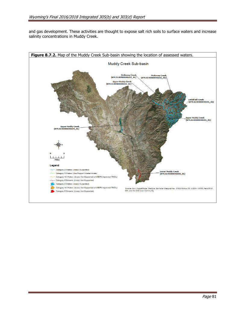
Wyoming’s Final 2016/2018 Integrated 305(b) and 303(d) Report
Page 81
and gas development. These activities are thought to expose salt rich soils to surface waters and increase
salinity concentrations in Muddy Creek.
Figure 8.7.2. Map of the Muddy Creek Sub-basin showing the location of assessed waters.

Wyoming’s Final 2016/2018 Integrated 305(b) and 303(d) Report
Page 82
8.8 Niobrara River Basin
The Niobrara River Basin drains approximately 814 mi2 in Wyoming and contains only the Niobrara
Headwaters Sub-basin. The sub-basin is bounded to the north by the Seventy Seven Hills and Hat Creek Breaks and to the southwest by the Wildcat Hills; these formations are composed of sedimentary geology
that has been eroded into pine bluffs and hills (Chapman et al. 2003 ). Most of the lower basin is composed of rolling plains and sandy and silty tablelands, where loamy soils have been formed from weathering
sandstone. Land uses are primarily livestock grazing with some dry land and irrigated farming.
Niobrara Headwaters Sub-basin (HUC 10150002)
The headwaters of the Niobrara River are formed from the many springs located in the upper watershed.
The Niobrara River flows east from its headwaters near Manville through the town of Lusk and ultimately
crosses the Wyoming/Nebraska border near Van Tassell. WGFD has estimated that there are only about four perennial stream miles in the Niobrara Basin in Wyoming, with all other stream miles being either
ephemeral or intermittent. As a result, locating reference stream sites in Wyoming was not possible, so WDEQ personnel established reference sites on the Niobrara River within the Agate Fossil Bed National
Monument, Nebraska in 2005.
Assessed Waters
Silver Spring Creek (WYNR101500020104_01), Class 3B
From 2001 to 2007, the Niobrara Conservation District (NCD) collected data and other information on Silver Spring Creek. The data indicated that Silver Spring Creek supported its aquatic life other than fish
designated use. As a result, a segment of Silver Spring Creek (WYNR101500020104_01) from the
confluence with the Niobrara River to a point 17.8 miles upstream was placed in Category 2 in 2008.

Wyoming’s Final 2016/2018 Integrated 305(b) and 303(d) Report
Page 83
Figure 8.8.1. Map of the Niobrara Headwaters Sub-basin showing the location of assessed waters.
8.9 North Platte River Basin
The headwaters of the North Platte River Basin originate in Medicine Bow, Never Summer, Rabbit Ears and Park mountain ranges surrounding North Park, Colorado; the river then flows north into Wyoming near the
community of Cowdrey, Colorado. The basin is the largest in the state, draining approximately 23,306 mi2
of southeastern Wyoming. The North Platte is by far the most geologically diverse river basin in Wyoming,
containing 4 level III and 20 level IV ecoregions (Chapman et al. 2003 ). The river enters Wyoming in the low elevation forests and shrublands of the Medicine Bow Mountain Range in the Platte River Wilderness
Area. It then flows north through the sub-irrigated high valleys south of Saratoga, between the Sierra
Madre and Medicine Bow Mountain Ranges, and across a large section of the Wyoming Basin between Saratoga and Casper. The river then flows east around the northern edge of the Laramie Mountains and
through the Northwestern Plains and High Plains to the Wyoming/Nebraska border. Primary land uses include irrigated agriculture, livestock grazing, oil and gas production, recreation, timber harvest, uranium
mining and wildlife habitat.
The North Platte River is impounded by a series of large reservoirs as it flows through Wyoming; these
include, from upstream to downstream, Seminoe, Kortes, Pathfinder, Alcova, Gray Reef, Glendo and Guernsey Reservoirs. These reservoirs are mainly utilized for water storage, hydropower and recreation.
The Kendrick Project stores and distributes water and provides hydropower using dams and power plants at Seminoe and Alcova Reservoirs. Water from the project is distributed to approximately 24,000 acres of
irrigated land located between Alcova Reservoir and the City of Casper using a series of canals. A portion
Wyoming’s Final 2016/2018 Integrated 305(b) and 303(d) Report
Page 84
of the surface water rights in the North Platte River Basin are allocated by the River Decree (1957) and the North Platte Decree (2001). The River Decree restricts water users in Colorado from using more than 19,875
acre-feet per year. The North Platte Decree restricts water users in Wyoming from irrigating more than 39,000 acre-feet along the Laramie River below Wheatland Number 2 Tunnel north of the Town of
Wheatland. The North Platte Decree also affected water usage along the North Platte River in Wyoming in
three ways: allocating only 25% of the natural flow to Wyoming water users between Guernsey Reservoir and the Tri-State Dam (near the WY/NE border), restricting Wyoming water users to 1,280,000 acre-feet
above Pathfinder Dam, and 890,000 acre-feet between Pathfinder Dam and Guernsey Dam during any ten year period.
Between 1996 and 2004, WDEQ (2007) collected physical, chemical, and biological data at 36 study sites
along the main stem of the North Platte River. Nutrients were identified as a concern from the Town of
Saratoga downstream to the Wyoming/Nebraska border. Selenium concentrations were above WDEQ’s chronic aquatic life criterion near the City of Casper that was attributed to irrigation return flows from the
Kendrick Project area. These results supported the decision to add the North Platte River to the 303(d) List in 1998 for selenium (see Middle North Platte Sub-basin below). The river was considered physically stable
from the Wyoming/Colorado border downstream to below the City of Casper, however, sediment
aggradation from Casper downstream was noted as a concern. Designated use support was not assessed using this report.
A study conducted by USGS (2007) compared the concentration of pesticides at two sites in the North
Platte River Basin across three seasons; one site was located on the Laramie River near Wheatland and a second was along the North Platte River near the WY/NE border. Eight different pesticides were detected,
all of which were at low concentrations and did not exceed the drinking water criteria in Appendix B of
Chapter 1. A second pesticide occurrence study (USGS, 2011) conducted during the summer of 2009 and spring of 2010 detected 1 and 6 different pesticides, respectively, in the North Platte River below Casper
and 4 and 5 different pesticides, respectively, in the North Platte River near the WY/NB border. Concentrations of these pollutants were also well below the state’s drinking water criteria.
Upper North Platte Sub-basin (HUC 10180002)
Assessed Waters
North Platte River (WYNP101800020000_01), Class 1
In 1997, WDEQ collected physical, chemical, and biological data at several study sites along the upper
North Platte River between Sage Creek and the Wyoming/Colorado border. The data indicated that the North Platte River supported its aquatic life other than fish and cold water fish designated uses. As a result,
a 77.3 mile segment of the North Platte River (WYNP101800020000_01) from the confluence with Sage Creek upstream to the Colorado border was placed in Category 2 in 2002. A final report was not written
for this study.
Douglas Creek (WYNP101800020107_01), Class 1; (WYNP101800020105_03), Class 2AB
The headwaters of Douglas Creek are located along the western slope of the Medicine Bow Mountain
Range. Railroad tie driving occurred on Douglas Creek from the late 1860s until 1940, when the Union Pacific Railroad stopped using hand hewn, river driven ties (Thybony et al., 2001). Devils Gate Creek, a
tributary to Douglas Creek was too steep and rocky to drive ties. A large flume was built to carry ties and logs to Douglas Creek, creating lasting physical impacts to this watershed. Douglas Creek has also been
degraded by gold and copper mining. Placer gold was first discovered near the historic mining community of Keystone in 1868, and by 1870, hardrock ore bodies were also discovered and mined. Most gold
production ceased by the 1890s, and copper was mined between 1900 and 1918. Several gold dredgers
currently operate in the watershed between the confluence with Lake Creek and USFS’s Bobbie Thompson Campground, and physical degradation to the stream channel from these activities is a concern (USFS,
2003).
Wyoming’s Final 2016/2018 Integrated 305(b) and 303(d) Report
Page 85
In 1997, WDEQ (1997) collected physical, chemical, and biological data at one study site along Douglas Creek, and the report concluded that the entire Douglas Creek (WYNP101800020107_01) watershed from
the confluence with the North Platte River upstream to Pelton Creek, and a segment of Douglas Creek (WYNP101800020105_03) from Pelton Creek upstream to the confluence with Muddy Creek, excluding
Smith North Creek supported their aquatic life other than fish and cold water fish designated uses. As a
result, these segments were placed in Category 2 in 2006 and 2008, respectively.
Smith North Creek (WYNP101800020105_01), Class 2AB
Smith North Creek is small tributary to Douglas Creek. In 2000 and 2004, WDEQ (2004) collected physical,
chemical, and biological data at one site along Smiths North Creek to address concerns that road construction and gold dredging had degraded aquatic habitat along an approximately four mile segment of
the creek. The report noted excess fine sediment but attributed it to beaver dam failures upstream, and the report concluded that Smith North Creek supported its cold water fish and aquatic life other than fish
designated uses. As a result, the entire Smith North Creek (WYNP101800020105_01) watershed upstream
of Douglas Creek was placed in Category 2 in 2006.
Muddy Creek (WYNP101800020105_02), Class 2AB
Muddy Creek is a small tributary to Douglas Creek that is located approximately 3 miles south of the Bobbie
Thompson Campground. Much of the forest surrounding the Muddy Creek drainage was harvested for
railroad ties in the 1930s, which is evidenced by remnants of an old splash dam used for driving ties harvested in the upper watershed (Thybony et al. 2001). In 1998, WDEQ collected physical, chemical, and
biological data along Muddy Creek to address concerns that erosion from adjacent roads was degrading aquatic habitat. The report concluded that while a couple of road crossings may contribute sediment to the
stream, Muddy Creek supported its cold water fish and aquatic life other than fish designated uses. As a
result, the entire Muddy Creek (WYNP101800020105_02) watershed upstream of Douglas Creek was placed in Category 2 in 2006. A final report was not written for this study.
Bear Creek (WYNP101800020104_01; WYNP101800020104_02), Class 2AB
Bear Creek is a small tributary to Rob Roy Reservoir in the upper Douglas Creek watershed. Between 2000
and 2008, WDEQ (2010) collected physical, chemical, and biological at two sites along Bear Creek, and several exceedances of the acute and chronic copper criteria protective of the cold water fish and aquatic
life other than fish designated use were detected. However, the aquatic macroinvertebrate community in Bear Creek, both above and below the confluence with Rambler Creek was found to be comparable to both
regional reference condition and other high quality benthic communities in adjacent watersheds. These
results suggested that the existing copper criteria for Bear Creek may be overly protective for the aquatic life other than fish designated use. Because little was known about the impact of the copper exceedances
on the cold water fish community, a segment of Bear Creek (WYNP101800020104_01) from the confluence with Rob Roy Reservoir to a point 2.9 miles upstream was temporarily placed in Category 3, because
support was indeterminate for the cold water fish designated use.
The data and information found in the previous report (WDEQ 2010) were subsequently re-assessed for
the 2014 Integrated Report. The new assessment concluded Bear Creek below Rambler Creek was not supporting its cold water fish designated use due to exceedances of the chronic and acute copper criteria,
but Bear Creek above Rambler Creek supported its cold water fish, aquatic life other than fish, drinking water, and fish consumption designated uses. As a result, the previously delineated segment was split into
two segments with two different categorizations: a segment of Bear Creek (WYNP101800020104_01) from
the confluence with Rambler Creek downstream 0.7 miles to the confluence with Rob Roy Reservoir was added to the 303(d) List in 2014 for copper, and a segment of Bear Creek (WYNP101800020104_02) above
Rambler Creek to a point 1.3 miles upstream was placed in Category 2 in 2014.
Wyoming’s Final 2016/2018 Integrated 305(b) and 303(d) Report
Page 86
Rambler Creek (WYNP101800020104_03), Class 3B
Rambler Creek, a tributary to Bear Creek, drains the abandoned historic New Rambler Copper Mine. The
site includes the mine itself and a broad delta of mine tailings. From 2000 to 2008, WDEQ (2010) collected physical, chemical, and biological at one site along Rambler Creek, and several exceedances of the acute
and chronic copper criteria protective of the aquatic life other than fish designated use were detected.
Copper concentrations were highest during snow melt runoff in the spring. As a result, a segment of Rambler Creek (WYNP101800020104_03) from the confluence with Bear Creek to a point 0.5 miles
upstream was added to the 303(d) List in 2014 for not supporting its aquatic life other than fish use due to the high copper concentrations.
Big Creek (WYNP101800020303_01), Class 2AB
The headwaters of Big Creek are located in the Sierra Madre Mountain Range near the Wyoming/Colorado
border where it flows northeast to its confluence with the North Platte River near the Big Creek public fishing access area. In 1999, WDEQ collected physical, chemical, and biological data at three study sites in
the Big Creek watershed on the North, Middle, and South Forks of Big Creek. All three study sites were
determined to be of reference quality, and the report concluded that the entire Big Creek watershed supported its aquatic life other than fish and cold water fish designated uses. As a result, the entire Big
Creek (WYNP101800020303_01) watershed upstream of the confluence with Spring Creek was placed in
Category 2 in 2002.
The USFS completed two projects in the South Fork Big Creek watershed in 2002 to reduce sediment loads
to the creek. One project involved replacing a failing wooden bridge at the Forest Road 498 crossing with a wider bridge, and the other project involved re-grading and re-vegetating a steep, eroding and unstable
bank located approximately 0.3 miles below the bridge (USFS, 2003). Both projects were successful in
reducing sedimentation in the South Fork Big Creek.
Encampment River (WYNP101800020500_01), Class 2AB; (WYNP101800020504_01), Class 1
The headwaters of the Encampment River originate along the Continental Divide in the Mt. Zirkel Wilderness
Area in north-central Colorado where the river flows north into Wyoming, through the Encampment Wilderness Area, and ultimately feeds into the North Platte River approximately 7 miles north of the Town
of Encampment. In 1999, WDEQ collected physical, chemical, and biological data within the upper
Encampment River watershed. The report concluded that the Encampment River and several tributaries supported their aquatic life other than fish and cold water fish designated uses. As a result, the Encampment
River (WYNP101800020500_01) tributaries from the confluence with (and including) the North Fork Encampment River upstream to the confluence with (and including) the East Fork Encampment River;
excluding Hog Park Creek, were placed in Category 2 in 2002. Several reference sites were also established during this study, but a final report was not written.
In 2000, WDEQ (2004) collected physical, chemical, and biological data at one study site along the Encampment River downstream of the East Fork Encampment River. The report concluded that this
segment of the Encampment River supported its aquatic life other than fish and cold water fish designated uses. As a result, a segment of the Encampment River (WYNP101800020504_01) from the confluence with
the East Fork Encampment River to a point 10.0 miles downstream was placed in Category 2 in 2006.
WGFD (2012) completed several habitat improvement projects within the Encampment River watershed.
The first project was completed in 2011, removing a cement weir, restoring the channel, and reconnecting eight miles of stream in the upper watershed. The second project was located along the mainstem of the
Encampment River below Highway 230. Project goals included dissipating stream energy and preventing land loss, improving bedload transport, enhancing grade control by installing several in-stream structures,
improving shading from riparian vegetation, and creating better pool habitat. Construction restoration along
a 300 foot reach began in 2011 that included the creation of a new channel and the planting of willow cuttings for increased stabilization.
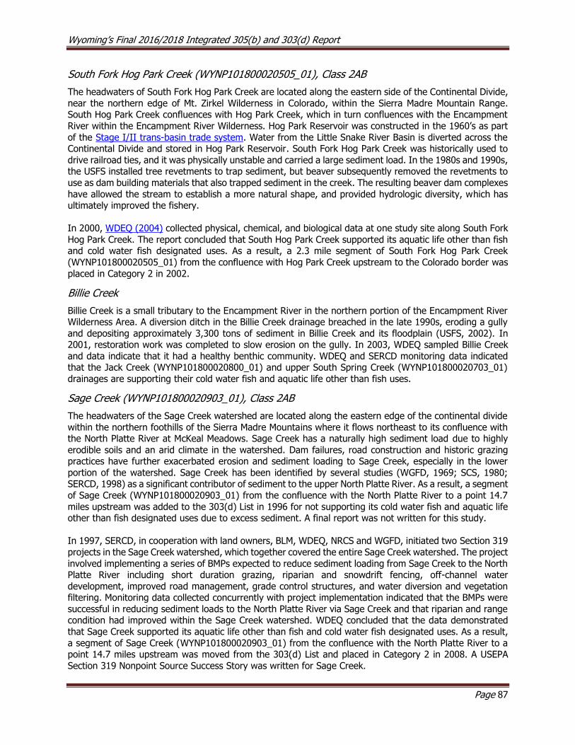
Wyoming’s Final 2016/2018 Integrated 305(b) and 303(d) Report
Page 87
South Fork Hog Park Creek (WYNP101800020505_01), Class 2AB
The headwaters of South Fork Hog Park Creek are located along the eastern side of the Continental Divide,
near the northern edge of Mt. Zirkel Wilderness in Colorado, within the Sierra Madre Mountain Range. South Hog Park Creek confluences with Hog Park Creek, which in turn confluences with the Encampment
River within the Encampment River Wilderness. Hog Park Reservoir was constructed in the 1960’s as part
of the Stage I/II trans-basin trade system. Water from the Little Snake River Basin is diverted across the Continental Divide and stored in Hog Park Reservoir. South Fork Hog Park Creek was historically used to
drive railroad ties, and it was physically unstable and carried a large sediment load. In the 1980s and 1990s, the USFS installed tree revetments to trap sediment, but beaver subsequently removed the revetments to
use as dam building materials that also trapped sediment in the creek. The resulting beaver dam complexes
have allowed the stream to establish a more natural shape, and provided hydrologic diversity, which has ultimately improved the fishery.
In 2000, WDEQ (2004) collected physical, chemical, and biological data at one study site along South Fork
Hog Park Creek. The report concluded that South Hog Park Creek supported its aquatic life other than fish and cold water fish designated uses. As a result, a 2.3 mile segment of South Fork Hog Park Creek
(WYNP101800020505_01) from the confluence with Hog Park Creek upstream to the Colorado border was
placed in Category 2 in 2002.
Billie Creek
Billie Creek is a small tributary to the Encampment River in the northern portion of the Encampment River Wilderness Area. A diversion ditch in the Billie Creek drainage breached in the late 1990s, eroding a gully
and depositing approximately 3,300 tons of sediment in Billie Creek and its floodplain (USFS, 2002). In 2001, restoration work was completed to slow erosion on the gully. In 2003, WDEQ sampled Billie Creek
and data indicate that it had a healthy benthic community. WDEQ and SERCD monitoring data indicated that the Jack Creek (WYNP101800020800_01) and upper South Spring Creek (WYNP101800020703_01)
drainages are supporting their cold water fish and aquatic life other than fish uses.
Sage Creek (WYNP101800020903_01), Class 2AB
The headwaters of the Sage Creek watershed are located along the eastern edge of the continental divide
within the northern foothills of the Sierra Madre Mountains where it flows northeast to its confluence with the North Platte River at McKeal Meadows. Sage Creek has a naturally high sediment load due to highly
erodible soils and an arid climate in the watershed. Dam failures, road construction and historic grazing practices have further exacerbated erosion and sediment loading to Sage Creek, especially in the lower
portion of the watershed. Sage Creek has been identified by several studies (WGFD, 1969; SCS, 1980; SERCD, 1998) as a significant contributor of sediment to the upper North Platte River. As a result, a segment
of Sage Creek (WYNP101800020903_01) from the confluence with the North Platte River to a point 14.7
miles upstream was added to the 303(d) List in 1996 for not supporting its cold water fish and aquatic life other than fish designated uses due to excess sediment. A final report was not written for this study.
In 1997, SERCD, in cooperation with land owners, BLM, WDEQ, NRCS and WGFD, initiated two Section 319
projects in the Sage Creek watershed, which together covered the entire Sage Creek watershed. The project
involved implementing a series of BMPs expected to reduce sediment loading from Sage Creek to the North Platte River including short duration grazing, riparian and snowdrift fencing, off-channel water
development, improved road management, grade control structures, and water diversion and vegetation filtering. Monitoring data collected concurrently with project implementation indicated that the BMPs were
successful in reducing sediment loads to the North Platte River via Sage Creek and that riparian and range condition had improved within the Sage Creek watershed. WDEQ concluded that the data demonstrated
that Sage Creek supported its aquatic life other than fish and cold water fish designated uses. As a result,
a segment of Sage Creek (WYNP101800020903_01) from the confluence with the North Platte River to a point 14.7 miles upstream was moved from the 303(d) List and placed in Category 2 in 2008. A USEPA
Section 319 Nonpoint Source Success Story was written for Sage Creek.
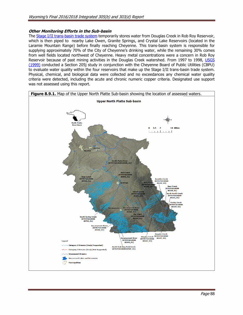
Wyoming’s Final 2016/2018 Integrated 305(b) and 303(d) Report
Page 88
Other Monitoring Efforts in the Sub-basin The Stage I/II trans-basin trade system temporarily stores water from Douglas Creek in Rob Roy Reservoir,
which is then piped to nearby Lake Owen, Granite Springs, and Crystal Lake Reservoirs (located in the Laramie Mountain Range) before finally reaching Cheyenne. This trans-basin system is responsible for
supplying approximately 70% of the City of Cheyenne’s drinking water, while the remaining 30% comes
from well fields located northwest of Cheyenne. Heavy metal concentrations were a concern in Rob Roy Reservoir because of past mining activities in the Douglas Creek watershed. From 1997 to 1998, USGS
(1999) conducted a Section 205j study in conjunction with the Cheyenne Board of Public Utilities (CBPU) to evaluate water quality within the four reservoirs that make up the Stage I/II trans-basin trade system.
Physical, chemical, and biological data were collected and no exceedances any chemical water quality criteria were detected, including the acute and chronic numeric copper criteria. Designated use support
was not assessed using this report.
Figure 8.9.1. Map of the Upper North Platte Sub-basin showing the location of assessed waters.
Wyoming’s Final 2016/2018 Integrated 305(b) and 303(d) Report
Page 89
Pathfinder-Seminoe Sub-basin (HUC 10180003)
The North Platte River is regulated by a series of dams at Seminoe, Kortes and Pathfinder Reservoirs as it
flows through this sub-basin. Seminoe Reservoir is a large reservoir (13,898 surface acres) constructed in 1938, approximately 38 miles northeast of the town of Sinclair. Kortes Reservoir is a small (83 surface
acres) reservoir located approximately 1.5 miles downstream of Seminoe Reservoir. Kortes Reservoir was
constructed in 1951 in a steep canyon between Seminoe and Pathfinder Reservoirs; the reservoir’s dam is uncontrolled and generates hydropower. The 5.5 mile segment of the river between Kortes Dam and the
inlet to Pathfinder Reservoir is a trophy trout fishery known as “The Miracle Mile” and has a minimum in-stream flow requirement of 500 cfs. The North Platte River then flows into the 22,121 surface-acre
Pathfinder Reservoir. Pathfinder reservoir is used for water storage and was constructed by the USBOR in 1909. Pathfinder Reservoir is part of the North Platte Project, which provides irrigation water to
approximately 226,000 irrigated acres in Wyoming and Nebraska. Seminoe and Kortes dams are part of
the Kendrick Project, which stores and distributes water and provides hydropower using dams and power plants at Seminoe and Alcova Reservoirs. Water from the project is distributed to approximately 24,000
acres of irrigated land located between Alcova Reservoir and the City of Casper using a series of canals.
Deweese Creek, which flows into Pathfinder Reservoir, is one of few perennial streams in this sub-basin.
WDEQ has monitored the creek and considers it to be a reference stream for the Wyoming Basin Ecoregion. A water quality assessment has not been completed for this creek.
Medicine Bow Sub-basin (HUC 10180004)
Assessed Waters
Medicine Bow River (WYNP101800040100_01), Class 2AB
The headwaters of the Medicine Bow River are located in the Snowy Range of the Medicine Bow Mountain Range. The river flows north from the mountains, through the foothills and into the lower basin and
confluences with Rock Creek near the town of Medicine Bow. The river then flows northwest to its
confluence with the Little Medicine Bow River near the town of Medicine Bow, turns west, and terminates at Seminoe Reservoir. Irrigation in the Medicine Bow River watershed dates to around 1870 (Thybony et
al. 2001).
In 2001, WDEQ collected physical, chemical, and biological data within the upper Medicine Bow River
watershed and concluded that the entire Medicine Bow River watershed supported its aquatic life other than fish and cold water fish designated uses. As a result, the entire Medicine Bow River
(WYNP101800040100_01) watershed upstream from the confluence with, and including, the East Fork Medicine Bow River was placed in Category 2 in 2004. A WDEQ final report was not written for this study.
Rock Creek (WYNP101800040201_01; WYNP101800040202_01; WYNP101800040202_02), Class 2AB
The headwaters of Rock Creek are located within the northern portions of the Medicine Bow Mountains, then flows north to its confluence with the Medicine Bow River near the town of Medicine Bow. In 2001,
WDEQ monitored the upper Rock Creek watershed and concluded that Rock Creek supported its aquatic
life other than fish and cold water fish designated uses. As a result, the entire Rock Creek (WYNP101800040201_01) watershed upstream of the confluence with, and including Overland Creek, was
placed in Category 2 in 2004. A final report was not written for this study.
In the mid-1990’s, NRCS suggested that siltation may be degrading biological communities on lower Rock
Creek, however, the quantitative data necessary to assess the cold water fish and aquatic life other than fish designated uses were lacking. Between 1999 and 2001, the Medicine Bow Conservation District (MBCD)
and students from the University of Wyoming (UW) conducted sampling on Rock Creek; their results
Wyoming’s Final 2016/2018 Integrated 305(b) and 303(d) Report
Page 90
suggested that biological condition declined in a downstream direction, due to the combined effects of
sedimentation, flow alteration, and drought.
In 2009 and 2010, WDEQ (2014) collected physical, chemical, and biological data at five study sites along Rock Creek from the base of the Medicine Bow Mountains downstream to the confluence with the Medicine
Bow River. The report concluded that Rock Creek above the town of Arlington supported its cold water fish,
aquatic life other than fish, drinking water, and fish consumption designated uses, but Rock Creek below Arlington did not support its cold water fish and aquatic life other than fish designated uses due to flow
alterations. As a result, the upstream segment of Rock Creek (WYNP101800040202_01) from the Town of Arlington to a point 1.6 miles upstream was placed in Category 2 in 2014, and a 106.5 mile segment of
Rock Creek (WYNP101800040202_02) from the town of Arlington downstream to the confluence with the
Medicine Bow River was placed in Category 4C in 2014.
Due to concerns from stakeholders that Wyoming’s surface water quality standards did not sufficiently
recognize the exemptions afforded to water rights, Senate Enrolled Act 75 was passed during the 2015 legislative session. SEA75 added W.S. § 35-11-302(c) to the Environmental Quality Act and charged WDEQ
with developing water quality standards for waters where valid water rights preclude attainment of existing water quality standards. SEA75 also outlined that WDEQ would prepare a schedule to develop water quality
standards for those waters identified as not meeting water quality standards due to hydrologic modification
(i.e., 4C waters). In response to SEA75, WDEQ reevaluated the seven 4C waters that were included in the 2014 Integrated Report against Wyoming’s existing surface water quality standards. The reevaluation of
Rock Creek (WYNP101800040202_02) indicated that there was not sufficient information to determine whether the cold water fish and aquatic life other than fish designated uses were supported. However,
because drinking water and fish consumption uses were supported, Rock Creek was moved to Category 2 in 2018.
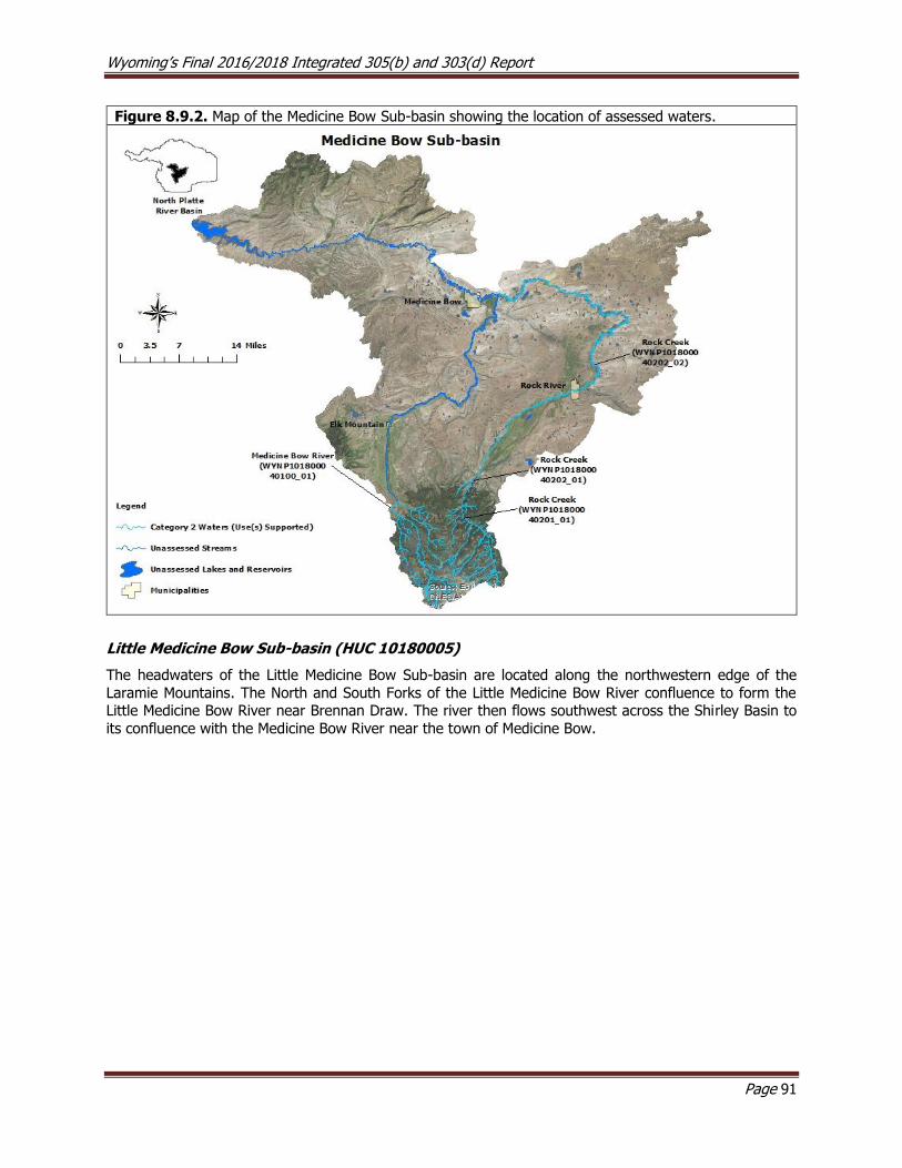
Wyoming’s Final 2016/2018 Integrated 305(b) and 303(d) Report
Page 91
Figure 8.9.2. Map of the Medicine Bow Sub-basin showing the location of assessed waters.
Little Medicine Bow Sub-basin (HUC 10180005)
The headwaters of the Little Medicine Bow Sub-basin are located along the northwestern edge of the
Laramie Mountains. The North and South Forks of the Little Medicine Bow River confluence to form the Little Medicine Bow River near Brennan Draw. The river then flows southwest across the Shirley Basin to
its confluence with the Medicine Bow River near the town of Medicine Bow.
Wyoming’s Final 2016/2018 Integrated 305(b) and 303(d) Report
Page 92
Assessed Waters
Little Medicine Bow River (WYNP101800050103_01, WYNP101800050103_02), Class 2AB
Uranium mining was initiated in 1959 in the northern-central region of the Shirley Basin and open-pit mining
operations began in 1969. In 1972, a segment of the Little Medicine Bow River (LMBR) was re-routed to accommodate pit expansion, resulting in a 40% reduction in the LMBR’s original channel length. Shortening
the channel resulted in excessive channel down cutting (17 to 50 feet of vertical incision) and increased sediment loading to the downstream reaches of the LMBR. Reclamation of the surface mine disturbances
began in the 1980’s and continues to date. Reclamation work has included the re-establishment of 3.12
miles of the of the LMBR channel in its original location, the construction of 8.4 miles of ephemeral drainage channels, 37 miles of erosion control drainage features and reclamation of 1,640 acres of disturbed mine
land. Two post-mine impoundments (Walker/Jenkins and Sullivan Pits) were also retained where large open mine pits once existed. The reconstructed LMBR channel now flows through post-mine topography
consisting of re-graded overburden-spoil material that was resurfaced with topsoil and revegetated.
Revegetation efforts have failed in some areas of the reclaimed mine region due to erosion on steep regraded side-slopes, low soil fertility and where insufficient topsoil was available to cover regraded
overburden materials with sodic, saline and acid-forming qualities. Between 1999 and 2001, MBCD and graduate students from UW collected water quality data to evaluate the health of the aquatic community
of the LMBR. Results of this work indicated that there was biological degradation due to excess
sedimentation along the LMBR downstream of the reclaimed uranium mine site and that the sources of this
pollutant were predominantly natural.
To verify these claims, WDEQ (2013) monitored the LMBR between 2007 and 2008 to collect the necessary data to assess the river. Excess sediment in the lower segment of the LMBR was primarily attributed to an
unstable reconstructed channel associated with the abandoned and reclaimed uranium mine. The unstable channel had resulted in severe channel degradation such as channel incision, head cutting and streambank
erosion in the reclaimed mine area. The resultant sediment aggradation between the reclaimed mine area
and Sheep Creek was beyond the assimilative capacity of the LMBR as evidenced by the presence of a homogenous coarse sand streambed, a wider and shallower channel, bar development, and braiding.
Further incision of the native drainage system upstream of the reclaimed mine region could have occurred if channel reconstruction work were forestalled for several more years. Instead, the channel reconstruction
disturbance and subsequent time period for channel stabilization were limited to 20-years. The report
concluded that a segment of the Little Medicine Bow River (WYNP101800050103_01) supports its cold water fish, aquatic life other than fish, drinking water, and fish consumption designated uses from County
Road 2E upstream to the confluence with the North and South Forks of the Medicine Bow River; this segment was placed in Category 2 in 2014. The report also concluded that a segment of Little Medicine
Bow River (WYNP101800050103_02) did not support its cold water fish and aquatic life other than fish designated uses from County Road 2E downstream 26.2 miles to the confluence with Sheep Creek; this
segment was added to the 303(d) List in 2014.
Shirley Basin Reservoir (WYNP101800050502_01), Class 2AB
The Muddy Creek watershed’s headwaters are located along the northern edge of the Shirley Mountains.
The creek flows southeast and confluences with the Little Medicine Bow River approximately 7 miles northeast of the Town of Medicine Bow. Shirley Basin Reservoir is a small reservoir located in the upper
Muddy Creek watershed. The reservoir receives inflows from three unnamed intermittent tributaries and the outlet confluences with Muddy Creek near the Point of Rocks geologic feature. In 2002, WDEQ (2006)
collected chemical, physical, and biological data from the Shirley Basin Reservoir, and the report concluded that the reservoir was fully supporting its cold water fish and aquatic life other than fish designated uses;
however, the report also recommended the implementation of BMPs to reduce erosion and sedimentation.
As a result, the Shirley Basin Reservoir was placed in Category 2 in 2008.
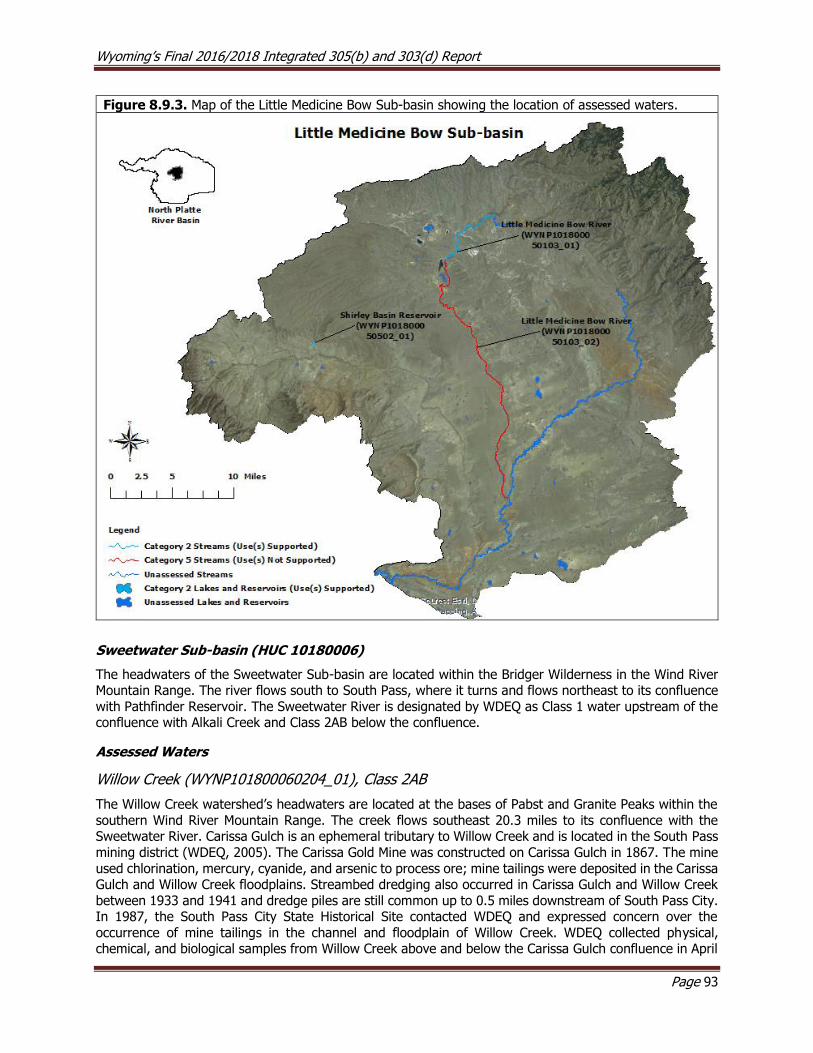
Wyoming’s Final 2016/2018 Integrated 305(b) and 303(d) Report
Page 93
Figure 8.9.3. Map of the Little Medicine Bow Sub-basin showing the location of assessed waters.
Sweetwater Sub-basin (HUC 10180006)
The headwaters of the Sweetwater Sub-basin are located within the Bridger Wilderness in the Wind River Mountain Range. The river flows south to South Pass, where it turns and flows northeast to its confluence
with Pathfinder Reservoir. The Sweetwater River is designated by WDEQ as Class 1 water upstream of the confluence with Alkali Creek and Class 2AB below the confluence.
Assessed Waters
Willow Creek (WYNP101800060204_01), Class 2AB
The Willow Creek watershed’s headwaters are located at the bases of Pabst and Granite Peaks within the
southern Wind River Mountain Range. The creek flows southeast 20.3 miles to its confluence with the Sweetwater River. Carissa Gulch is an ephemeral tributary to Willow Creek and is located in the South Pass
mining district (WDEQ, 2005). The Carissa Gold Mine was constructed on Carissa Gulch in 1867. The mine
used chlorination, mercury, cyanide, and arsenic to process ore; mine tailings were deposited in the Carissa Gulch and Willow Creek floodplains. Streambed dredging also occurred in Carissa Gulch and Willow Creek
between 1933 and 1941 and dredge piles are still common up to 0.5 miles downstream of South Pass City. In 1987, the South Pass City State Historical Site contacted WDEQ and expressed concern over the
occurrence of mine tailings in the channel and floodplain of Willow Creek. WDEQ collected physical, chemical, and biological samples from Willow Creek above and below the Carissa Gulch confluence in April
Wyoming’s Final 2016/2018 Integrated 305(b) and 303(d) Report
Page 94
and November 1988 and April 1989. AML conducted an additional, more intensive study of Willow Creek, Rock Creek and the Sweetwater River in 1989. The study design included the collection of mercury samples
from water column, fish tissue (collected by WGFD) and streambed sediment. Results of these studies showed that although arsenic was elevated at times, most samples were well below WDEQ’s water quality
criteria. Mercury in streambed sediments does not appear to affect water quality, but this pollutant could
be suspended if sediments are disturbed by dredging. Therefore, WDEQ decided not to approve any dredge and fill Section 401 permits on Willow Creek. Fish tissue sampling showed that mercury levels were below
the FDA guideline for action limit in muscle, but higher in other tissues. This trend does not suggest a human health concern, but may be a concern for piscivorous wildlife.
In 1999, WDEQ (2005) collected physical, chemical, and biological data along Willow Creek at three study
sites to address BLM concerns that sedimentation was degrading aquatic habitat. The study concluded that
Willow Creek had been physically impacted by historic dredging activities associated with mining activities. However, the report concluded that Willow Creek supported its aquatic life other than fish and cold water
fish designated uses. As a result, the entire Willow Creek (WYNP101800060204_01) watershed upstream of the confluence with the Sweetwater River was placed in Category 2 in 2004.
Crooks Creek (WYNP101800060603_01), Class 2AB
Crooks Creek’s headwaters are located along the southwestern edge of Green Mountain. The creek is
perennial as it flows around Green Mountain toward Jeffrey City, but becomes intermittent/ephemeral before it confluences with the Sweetwater River to the east of U.S. Route 287. In 1997, WDEQ collected
physical, chemical, and biological data in Crooks Creek at two study sites. A layer of oil and grease was
observed below the sandy streambed and was attributed to an upstream oil treater discharge. As a result, a segment of Crooks Creek (WYNP101800060603_01) from the confluence with Mason Creek to a point
1.4 miles downstream was added to the 303(d) List in 1998 for not meeting its cold water fish and aquatic
life other than fish designated uses due to oil and grease. A final report was not written for this study.
Other Monitoring Efforts in the Sub-basin
Lander Creek was placed on the 2012 303(d) list of impaired waters, then removed from the 2014 303(d)
list after the Escherichia coli (E. coli) data were found to not meet data quality requirements. Since that time, DEQ has collected additional data, but, the data were not available for analysis prior to completion of
the 2018 IR. These data will be evaluated and a formal decision regarding the impairment status
of Lander Creek will be presented in the 2020 IR.
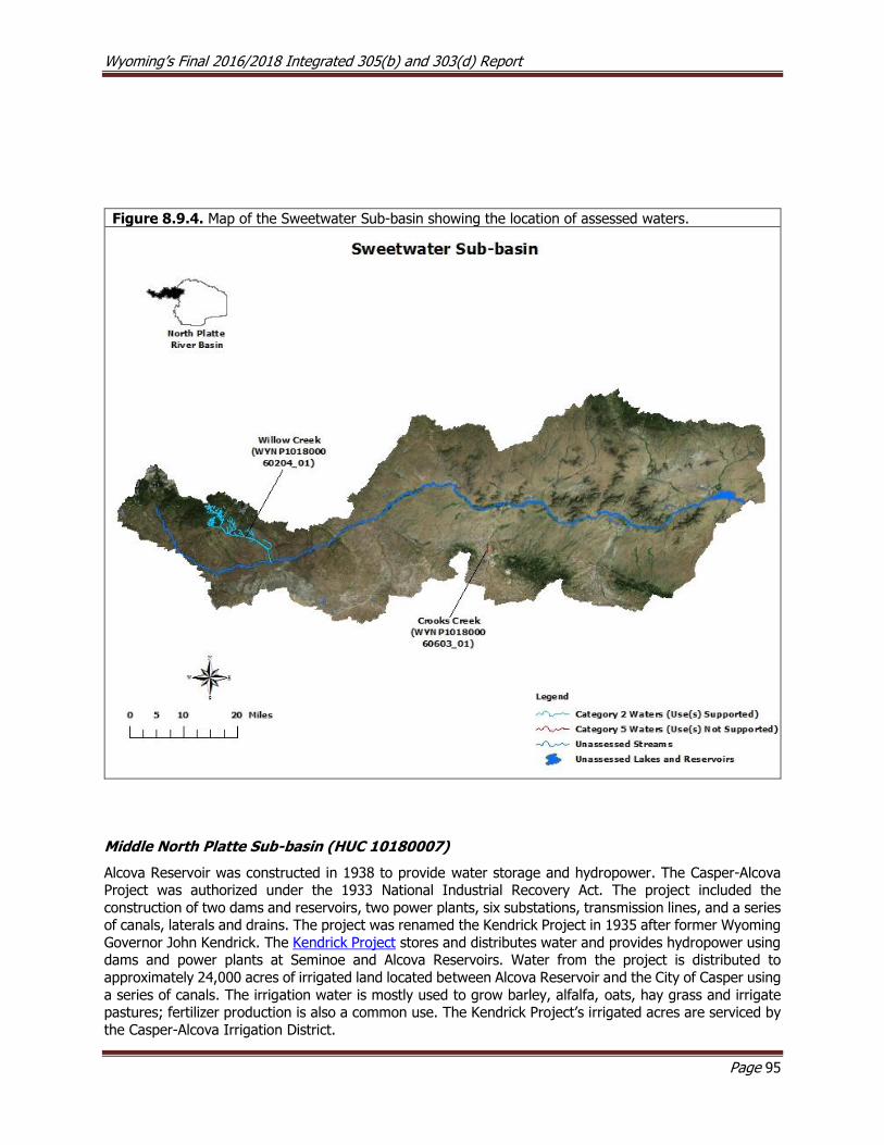
Wyoming’s Final 2016/2018 Integrated 305(b) and 303(d) Report
Page 95
Figure 8.9.4. Map of the Sweetwater Sub-basin showing the location of assessed waters.
Middle North Platte Sub-basin (HUC 10180007)
Alcova Reservoir was constructed in 1938 to provide water storage and hydropower. The Casper-Alcova Project was authorized under the 1933 National Industrial Recovery Act. The project included the
construction of two dams and reservoirs, two power plants, six substations, transmission lines, and a series of canals, laterals and drains. The project was renamed the Kendrick Project in 1935 after former Wyoming
Governor John Kendrick. The Kendrick Project stores and distributes water and provides hydropower using dams and power plants at Seminoe and Alcova Reservoirs. Water from the project is distributed to
approximately 24,000 acres of irrigated land located between Alcova Reservoir and the City of Casper using
a series of canals. The irrigation water is mostly used to grow barley, alfalfa, oats, hay grass and irrigate pastures; fertilizer production is also a common use. The Kendrick Project’s irrigated acres are serviced by
the Casper-Alcova Irrigation District.
Wyoming’s Final 2016/2018 Integrated 305(b) and 303(d) Report
Page 96
In 1985, the U.S. Department of the Interior (DOI) established the Irrigation Drainage Program to address
irrigation related water quality concerns on DOI managed lands. The program established a management plan and Task Group to identify priority study areas. The Task Group identified nine priority areas across
the western U.S., one of which was the Kendrick Project. WDEQ and the U.S. Department of the Interior
(DOI) funded a study spanning 1988-1990 to evaluate selenium concentrations in soil, plants, surface water, stream and lake sediments, and animal tissues in the Kendrick Project Area (USGS, 1992). The study
concluded that irrigation return flows from irrigated lands within the Kendrick Project contain high levels of selenium, increasing selenium loading to the North Platte River and several other streams, wetlands and
reservoirs in and around the project area.
Assessed Waters
North Platte River (WYNP101800070300_01), Class 2AB and the Kendrick Project Area (WYNP101800070302_01, WYNP101800070302_02, WYNP101800070302_03, WYNP101800070703_01, WYNP101800070406_01, WYNP101800070406_02, WYNP101800070406_03, WYNP101800070503_01, WYNP101800070504_01, WYNP101800070303_01)
North Platte River and Kendrick Area Listings
During the 1980s and 1990s, data collected from the North Platte River at USGS gage station #06645000 located below the City of Casper on the North Platte River indicated that the chronic selenium numeric
criterion protective of the cold water fish and aquatic life other than fish designated uses was regularly
exceeded. As a result, a segment of the North Platte River (WYNP101800070300_01) from the confluence with Muddy Creek upstream to the confluence with Poison Spider Creek was added to the 303(d) List in
1998. The source of excess selenium loading was determined to be irrigation return flows across the naturally selenium rich marine shales in Poison Spider Creek from the Kendrick Project area.
Exceedances of the chronic selenium numeric criterion protective of the aquatic life other than fish criterion were detected in several tributaries to the North Platte River within the Kendrick Irrigation Project area,
including Rasmus Lee Lake (WYNP101800070302_02), Goose Lake (WYNP101800070302_03), Illco Pond Reservoir (WYNP101800070503_01), Thirty Three Mile Reservoir (WYNP101800070703_01), Poison Spring
Creek (WYNP101800070302_01), three segments of Poison Spider Creek (WYNP101800070406_01, WYNP101800070406_02 and WYNP101800070406_03), Casper Creek (WYNP101800070504_01), and
Oregon Trail Drain (WYNP101800070303_01). All ten of these waters within the Kendrick Project Area were
added to the 303(d) List in 2000.
Watershed Planning, Monitoring, and Restoration
In the mid-1990s, planning efforts and best management practice (BMP) implementation were initiated to
address selenium loading within the Kendrick Irrigation Project area. In 2004, NCCD completed the
Historical Data Review - Kendrick Selenium Watershed Project Section 319 Report which summarized the available selenium data for the Kendrick Project Area. In 2005, NCCD in cooperation with the Kendrick
Watershed Steering Committee completed the Kendrick Watershed Plan, which reviewed available selenium data from the area, watershed condition, land use, and water use. Goals of the plan included improving
water quality through improved irrigation efficiency, identifying financially feasible conservation practices, public outreach and education, and improving aquatic habitat. In 2006, NCCD completed the Kendrick Best Management Practices Section 319 Report which established a water quality monitoring network and
identified feasible irrigation BMPs to reduce selenium loading in the Kendrick Project Area, including sprinkler irrigation and improving canals and drains. In 2008, NCCD completed the Kendrick Selenium Technical Assistance Section 319 Project which set a goal of reducing selenium loading by 25% by implementing selenium reduction BMPs on 2,449 acres. In 2011, NCCD completed the Kendrick Watershed Plan Implementation - Phase 1 Section 319 Project Final Report which summarized water quality monitoring
and educational outreach efforts in the Kendrick Project Area, and in 2012, NCCD sponsored the 2012
Wyoming’s Final 2016/2018 Integrated 305(b) and 303(d) Report
Page 97
North Platte River Watershed Project Implementation Plan – Segment I Selenium Monitoring Program Section 319 Project to promote, implement, and monitor BMPs and their effectiveness in priority selenium
areas on irrigated lands within the watershed. By the time the project was completed in 2016, a total of 726 acres had been converted from flood to sprinkler irrigation and 29,569 feet of underground pipeline
was installed to replace 35,519 feet of open dirt irrigation ditch. Due to the success of this project, NCCD
was awarded additional Section 319 funding in 2015 to continue their work to reduce selenium loading from irrigation return flows. To-date, 18 additional acres have been converted from flood to sprinkler
irrigation and 2,450 feet of dirt ditch have been converted to pipeline. NCCD will continue implementing BMPs under this project through 2018.
In 2012, NCCD conducted water quality monitoring at two study sites along the impaired segment of the
North Platte River to determine the effectiveness of BMPs at reducing selenium loading and whether the
impaired segment of the North Platte River was meeting the chronic water quality criterion for selenium. NCCD’s data showed that total selenium concentrations in the North Platte River had been at or below the
chronic criterion for at least three straight years with concomitant reductions in selenium loading from tributaries within the Kendrick Irrigation Project area; however, the data was not sufficient to remove the
impaired segment of the North Platte River from the 303(d) List due to the limited scope of the data.
Between 2014 and 2016, NCCD collected selenium data at the original two study sites and three additional
study sites along the impaired segment of the North Platte River to augment the existing data set. No exceedances of the chronic selenium criterion protective of the cold water fish designated use were
detected at four of the five sites across two consecutive years of monitoring; however, one slight instantaneous exceedance (6 μg/L) was detected near the confluence with the lower Casper Creek
watershed in May 2015. Monitoring continued at the study site where the exceedance occurred, as well as
the two original study sites. There were no additional exceedances detected at the study site near the confluence with the lower Casper Creek watershed between June 2015 and August 2017. During this time,
a single instantaneous exceedance (15.7 μg/L) was detected at one of the original study sites near the confluence with Bolton Creek and Red Creek, but it was linked to a storm flow event that produced “very
murky” waters. Thus, the sample was not considered to be “representative” of standard conditions, and
the sample was not used to evaluate the chronic selenium criteria. The data collected by the NCCD therefore demonstrated that the North Platte River was meeting the chronic selenium criteria and the impaired
segment of the North Platte River (WYNP101800070300_01) from the confluence with Muddy Creek upstream to the confluence with Poison Spider Creek was moved from the 303(d) List to Category 2 in
2018.
TMDL Development
In 2009, WDEQ initiated the development of selenium TMDLs for the North Platte River and the ten impairments within the Kendrick Irrigation Project area. In 2011, draft TMDLs were completed but were
not finalized due to uncertainty about the ability of the impairments in the Kendrick Irrigation Project area to achieve water quality standards due to natural sources of selenium in the watershed. WDEQ is evaluating
potential options for the Kendrick Irrigation Project area impairments, including potentially developing site-
specific selenium criteria.
Other Monitoring Efforts in the Sub-basin Bolton Creek is a small perennial/intermittent watershed that confluences with the North Platte River below
Gray Reef Reservoir. WGFD and BLM began a project in 2010 to reduce head cutting in Bolton Creek, stabilize the channel, and raise the water table. WGFD transplanted aspen into the watershed and
reintroduced beavers. A culvert near the confluence with the North Platte, which was causing the head cutting, was replaced in 2011.
The occurrence of oil sheens in 2010 and 2011 along the North Platte River near Casper prompted an investigation by WDEQ’s Solid and Hazardous Waste Division to determine the source of this pollutant.
Hydrocarbons were detected in monitoring wells adjacent to the river, which suggested that a nearby oil

Wyoming’s Final 2016/2018 Integrated 305(b) and 303(d) Report
Page 98
refinery could be a source. The facility operator is continuing to investigate this issue, including collecting water samples, installing more monitoring wells, and conducting a sediment study to determine whether
the oil is entering the river via erosion and overland flow and/or by groundwater inputs through streambed sediments.
The headwaters of Garden Creek are located along the northern slope of Casper Mountain in the Laramie Mountain Range. Garden Creek flows from Casper Mountain north through the City of Casper to its
confluence with the North Platte River. The stream is channelized and surrounded by impervious surfaces as it flows through Casper and is prone to short duration-high intensity or “flashy” streamflows, which
eroded streambanks within Nancy English Park. The City of Casper sponsored the Garden Creek Stream Restoration and Education Section 319 Project in 2009. Garden Creek’s channel was reconstructed using
log and rock structures, which allowed the stream to access its floodplain; this provided habitat for non-
game fish and facilitated the reestablishment of riparian vegetation.
Figure 8.9.5. Map of the Middle North Platte Sub-basin showing the location of assessed waters.
Glendo Sub-basin (HUC 10180008)
The North Platte River is regulated by dams at Glendo and Guernsey Reservoirs within this sub-basin.
Guernsey Reservoir was constructed northwest of the Town of Guernsey in 1927 and Glendo Reservoir was constructed between Pathfinder and Guernsey reservoirs in 1958. Both reservoirs provide water storage
and hydropower to residents of Wyoming and western Nebraska. Water rights in both reservoirs are determined by the North Platte Decree (2001).
Wyoming’s Final 2016/2018 Integrated 305(b) and 303(d) Report
Page 99
Suspended fine sediment, or silt, has historically functioned as a sealant for irrigation canals in the lower North Platte River Basin. The construction of Guernsey Reservoir dam decreased the amount of fine
sediment that would otherwise naturally occur in the lower North Platte River. Instead, sediment settles to the bottom of the reservoir and thus there is very little sediment in the water released below the dam. The
removal of these fine sediments can lead to canal leakage, bank collapse, and blockage within downstream
irrigation infrastructure. The USBOR uses the annual Guernsey Reservoir Silt Run to remove accumulated sediment from Guernsey Reservoir and maintain downstream irrigation canals and ditches. Water releases
from Glendo and Guernsey Reservoir’s dams are elevated during an approximate ten day period during summer to produce flushing flows. WDEQ allows a short term exemption, or waiver, from the turbidity
criterion for the North Platte River below Guernsey during this event.
Assessed Waters
Glendo Reservoir (WYNP101800080405_01), Class 2AB
Between 2004 and 2006, WDEQ (2009) monitored physical, chemical, and biological parameters at eight sampling sites in Glendo Reservoir between 2004 and 2006. Study sites were selected to represent pelagic
(open water) and littoral (shoreline) habitats within riverine, transitional and lacustrine reservoir zones. Two additional sites were located in bays that were of interest to the investigation. There were no
exceedances of any WDEQ water quality criteria during this study and aquatic life other than fish and cold
water fish designated uses were determined to be supported. As a result, Glendo Reservoir
(WYNP101800080405_01) was placed in Category 2 in 2010.
Horseshoe Creek (WYNP101800080905_01; WYNP101800080905_02; WYNP101800080905_03), Class 2AB
The headwaters of Horseshoe Creek are located in the Laramie Mountain Range within the Medicine Bow-
Routt National Forest where it flows northeast to its confluence with the North Platte River, approximately 1.5 miles below Glendo Reservoir Dam. In 1999, WDEQ (2004) collected physical, chemical, and biological
data at three study sites along Horseshoe Creek to address public concerns that hydrocarbons were leaking from an abandoned pipeline into the creek. Two of the study sites were located above and below the
pipeline and the third was located near the confluence with the North Platte River. Although oil and grease
was present above and below the pipeline, no exceedances of the oil and grease numeric criterion of 10 mg/L were detected. The source of oil and grease was not known, but it was thought to be from the
pipeline. The study noted that several miles of the lower creek was dry at the time of the study and exhibited habitat degradation due to irrigation withdrawals. The report concluded that the segments of
Horseshoe Creek with water supported their aquatic life other than fish and cold water fish designated uses
and a segment of Horseshoe Creek (WYNP101800080905_02) from the confluence with the North Platte River to a point 2.3 miles upstream and another segment of Horseshoe Creek (WYNP101800080905_01)
from the confluence with Spring Creek to a point 12.5 miles upstream were added to Category 2 in 2006. The dewatered segment of Horseshoe Creek fell between the two abovementioned segments and the
report concluded that the dewatered segment did not support its aquatic life other than fish and cold water fish designated uses due to habitat degradation linked to flow alterations. As a result, the dewatered
segment of Horseshoe Creek (WYNP101800080905_03) from the confluence with Spring Creek to a point
7.3 miles downstream was placed in Category 4C in 2006.
Due to concerns from stakeholders that Wyoming’s surface water quality standards did not sufficiently recognize the exemptions afforded to water rights, Senate Enrolled Act 75 was passed during the 2015
legislative session. SEA75 added W.S. § 35-11-302(c) to the Environmental Quality Act and charged WDEQ
with developing water quality standards for waters where valid water rights preclude attainment of existing water quality standards. SEA75 also outlined that WDEQ would prepare a schedule to develop water quality
standards for those waters identified as not meeting water quality standards due to hydrologic modification (i.e., 4C waters). In response to SEA75, WDEQ reevaluated the seven 4C waters that were included in the
2014 Integrated Report against Wyoming’s existing surface water quality standards. The reevaluation of
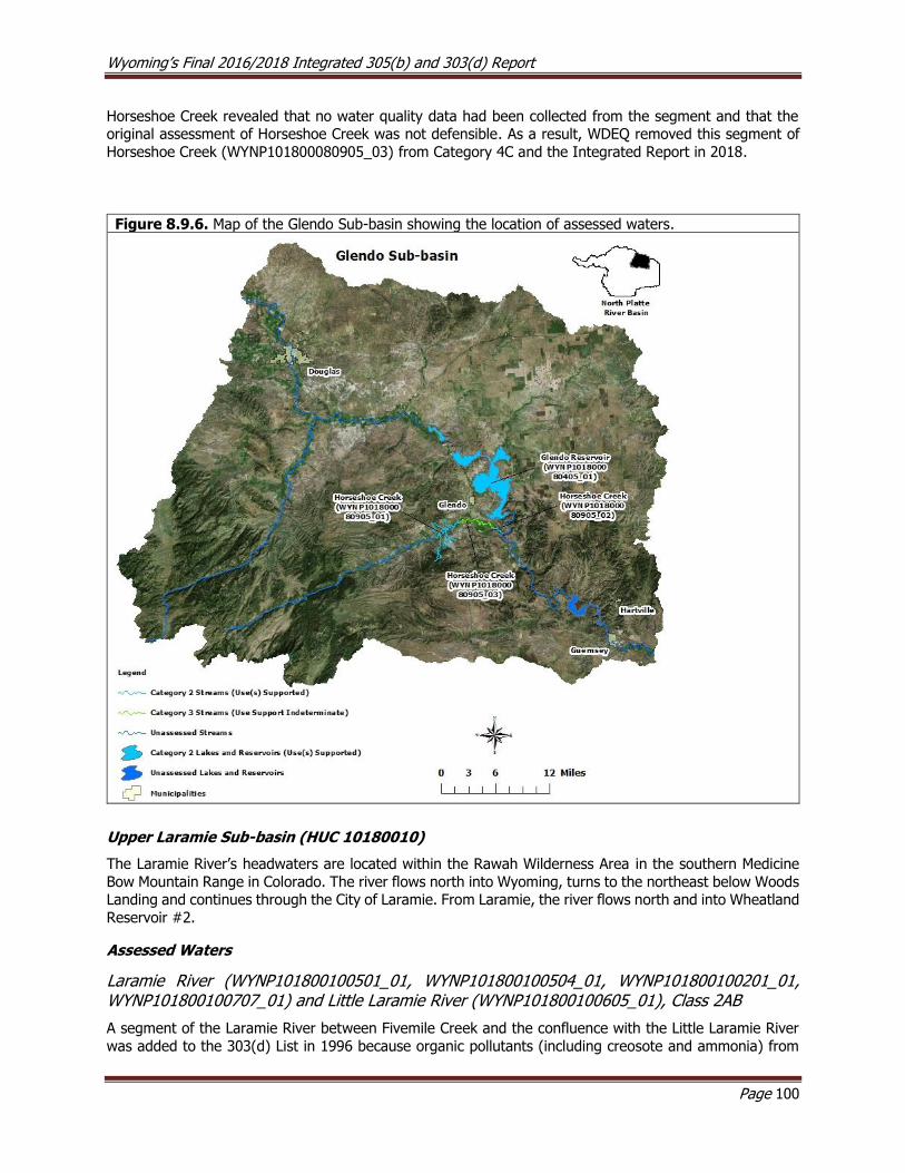
Wyoming’s Final 2016/2018 Integrated 305(b) and 303(d) Report
Page 100
Horseshoe Creek revealed that no water quality data had been collected from the segment and that the original assessment of Horseshoe Creek was not defensible. As a result, WDEQ removed this segment of
Horseshoe Creek (WYNP101800080905_03) from Category 4C and the Integrated Report in 2018.
Figure 8.9.6. Map of the Glendo Sub-basin showing the location of assessed waters.
Upper Laramie Sub-basin (HUC 10180010)
The Laramie River’s headwaters are located within the Rawah Wilderness Area in the southern Medicine
Bow Mountain Range in Colorado. The river flows north into Wyoming, turns to the northeast below Woods Landing and continues through the City of Laramie. From Laramie, the river flows north and into Wheatland
Reservoir #2.
Assessed Waters
Laramie River (WYNP101800100501_01, WYNP101800100504_01, WYNP101800100201_01, WYNP101800100707_01) and Little Laramie River (WYNP101800100605_01), Class 2AB
A segment of the Laramie River between Fivemile Creek and the confluence with the Little Laramie River
was added to the 303(d) List in 1996 because organic pollutants (including creosote and ammonia) from
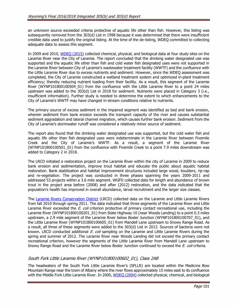
Wyoming’s Final 2016/2018 Integrated 305(b) and 303(d) Report
Page 101
an unknown source exceeded criteria protective of aquatic life other than fish. However, this listing was subsequently removed from the 303(d) List in 1998 because it was determined that there were insufficient
credible data used to justify the original listing. At the time of the de-listing, WDEQ committed to collecting adequate data to assess this segment.
In 2009 and 2010, WDEQ (2015) collected chemical, physical, and biological data at four study sites on the Laramie River near the City of Laramie. The report concluded that the drinking water designated use was
supported and the aquatic life other than fish and cold water fish designated uses were not supported in the Laramie River between City of Laramie’s wastewater treatment facility (WWTF) and the confluence with
the Little Laramie River due to excess nutrients and sediment. However, since the WDEQ assessment was completed, the City of Laramie constructed a wetland treatment system and optimized in-plant treatment
efficiency; thereby reducing nutrient loading from their facility. As a result, this segment of the Laramie
River (WYNP101800100504_01) from the confluence with the Little Laramie River to a point 24 miles upstream was added to the 303(d) List in 2018 for sediment. Nutrients were placed in Category 3 (i.e.,
insufficient information). Further study is needed to determine the extent to which enhancements to the City of Laramie’s WWTF may have changed in-stream conditions relative to nutrients.
The primary source of excess sediment in the impaired segment was identified as bed and bank erosion, wherein sediment from bank erosion exceeds the transport capacity of the river and causes substantial
sediment aggradation and lateral channel migration, which causes further bank erosion. Sediment from the City of Laramie’s stormwater runoff was considered a relatively minor source of sediment.
The report also found that the drinking water designated use was supported, but the cold water fish and
aquatic life other than fish designated uses were indeterminate in the Laramie River between Fivemile
Creek and the City of Laramie’s WWTF. As a result, a segment of the Laramie River (WYNP101800100501_01) from the confluence with Fivemile Creek to a point 7.9 miles downstream was
added to Category 2 in 2018.
The LRCD initiated a restoration project on the Laramie River within the city of Laramie in 2009 to reduce
bank erosion and sedimentation, improve trout habitat and educate the public about aquatic habitat restoration. Bank stabilization and habitat improvement structures included large wood, boulders, rip-rap
and re-vegetation. The project was conducted in three phases spanning the years 2009-2011 and addressed 53 projects within a 3.6 mile segment. WGFD collected data for length and abundance of brown
trout in the project area before (2008) and after (2012) restoration, and the data indicated that the
population’s health has improved in overall abundance, larval recruitment and the larger size classes.
The Laramie Rivers Conservation District (LRCD) collected data on the Laramie and Little Laramie Rivers from fall 2010 through spring 2011. The data indicated that three segments of the Laramie River and Little
Laramie River exceeded the E. coli criterion protective of primary contact recreational use, including the Laramie River (WYNP101800100201_01) from State Highway 10 (near Woods Landing) to a point 0.3 miles
upstream, a 2.9 mile segment of the Laramie River below Bosler Junction (WYNP101800100707_01), and
the Little Laramie River (WYNP101800100605_01) from Mandell Lane upstream to Snowy Range Road. As a result, all three of these segments were added to the 303(d) List in 2012. Sources of bacteria were not
known. LRCD conducted additional E. coli sampling on the Laramie and Little Laramie Rivers during the spring and summer of 2012. The Laramie River near Woods Landing did not exceed the primary contact
recreational criterion, however the segments of the Little Laramie River from Mandell Lane upstream to
Snowy Range Road and the Laramie River below Bosler Junction continued to exceed the E. coli criteria.
South Fork Little Laramie River (WYNP101800100602_01), Class 2AB
The headwaters of the South Fork Little Laramie River’s (SFLLR) are located within the Medicine Bow
Mountain Range near the town of Albany where the river flows approximately 15 miles east to its confluence with the Middle Fork Little Laramie River. In 2000, WDEQ (2004) collected physical, chemical, and biological

Wyoming’s Final 2016/2018 Integrated 305(b) and 303(d) Report
Page 102
data at one study site along the SFLLR. The report noted that streambanks were stable and well vegetated, but overland runoff from historically clear cut patches of forest resulted in moderate sedimentation to the
river. The biological community exceeded reference condition. The report concluded that a segment the SFLLR supported its aquatic life other than fish and cold water fish designated uses. As a result, a segment
of the SFLLR (WYNP101800100602_01) from the intersection of State Highway 11 to a point 5.5 miles
upstream was placed in Category 2 in 2002.
Middle Fork Mill Creek (WYNP101800100606_01), Class 2AB
The headwaters of Mill Creek are located in the eastern foothills of the Medicine Bow Mountain Range north
of the town of Centennial where it flows northeast to its confluence with the Little Laramie River. In 2000,
WDEQ (2004) collected physical, chemical, and biological data at one study site along Middle Fork Mill Creek. The report concluded that the Middle Fork of Mill Creek supported its aquatic life other than fish and
cold water fish designated uses. As a result, a segment of Middle Fork Mill Creek (WYNP101800100606_01) from the USFS boundary to a point 2.7 miles upstream was placed in Category 2 in 2002.
Hanging Lake (WYNP101800100603_01), Class 2AB
Hanging Lake is a small (4.2 acres), shallow (average depth of 3 feet) subalpine lake located in the upper
Little Laramie River watershed within Medicine Bow Mountain Range. Water from snowmelt runoff enters the lake from a diversion on Nash Fork, and the lake has no outlet. WGFD stocks Hanging Lake with adult
trout each year in the early summer, but the shallow lake limits overwinter survival of stocked fish. As of
2006, WGFD had not observed any algal blooms in Hanging Lake. In 2002, WDEQ (2006) collected chemical and physical data at three study sites on Hanging Lake. The report noted abundant vegetation, low
conductivity, and low alkalinity in the Hanging Lake, which resulted in a naturally elevated pH. The report concluded that Hanging Lake supported its aquatic life other than fish and cold water fish designated uses.
As a result, Hanging Lake (WYNP101800100603_01) was placed in Category 2 in 2008.
Miller Lake (WYNP101800100204_01), Class 2AB
Miller Lake is another small (4 acres) and shallow (average depth of 4.5 feet) subalpine lake located in the upper Fox Creek watershed within the Medicine Bow Mountain Range. Water from snowmelt runoff enters
the lake from a diversion on Evans Creek and water eventually reenters Evans Creek through a spillway.
In 2002, WDEQ (2006) collected chemical and physical data at three study sites on Miller Lake. The report
noted that elevated pH was likely due to natural conditions, including the lake’s shallowness and high photosynthesis from macrophytes and phytoplankton. Fish kills were an issue for the lake during winter,
but they were attributed to the shallowness of the lake. The report concluded that Miller Lake supported
its aquatic life other than fish and cold water fish designated uses. As a result, Miller Lake (WYNP101800100204_01) was placed in Category 2 in 2008.
Meeboer Lake (WYNP101800100403_01), Class 2AB
Meeboer Lake is a 113 acre, medium sized, shallow (average depth of 4 feet) lake located in the Laramie
Plains Lake complex southwest of Laramie. Water enters the lake through groundwater inflows and exits through a canal that connects to Soda Lake. WGFD stocks Meeboer Lake with adult trout each year in the
early summer, but the shallow lake limits overwinter survival of stocked fish. To address this issue, WGFD
installed aerators in 1994 and 1995 to maintain open ice and to reduce the potential for winterkill.
In 2002, WDEQ (2006) collected chemical and physical data at four study sites on Meeboer Lake. Water
temperatures were somewhat elevated, but were attributed to the natural shallowness of the lake. Shoreline habitat condition was good along the least impacted northern edge of the lake. However, the
western edge of the lake was heavily affected by foot and vehicle traffic and showed erosion from wind and wave action. The report concluded that Meeboer Lake was supported its cold water fish and aquatic
life other than fish designated uses. As a result, Meeboer Lake (WYNP101800100403_01) was placed in
Category 2 in 2008.
Wyoming’s Final 2016/2018 Integrated 305(b) and 303(d) Report
Page 103
Figure 8.9.7. Map of the Upper Laramie Sub-basin showing the location of assessed waters.
Lower Laramie Sub-basin (HUC 10180011)
The Laramie River in this sub-basin flows northeast from Wheatland Reservoir #2 and through the Laramie Mountain Range. The river then flows north of the Town of Wheatland to Greyrocks Reservoir and ultimately
confluences with the North Platte River near the Town of Fort Laramie.

Wyoming’s Final 2016/2018 Integrated 305(b) and 303(d) Report
Page 104
Assessed Waters
Wheatland Creek (WYNP101800110502_01) and Rock Creek (WYNP101800110502_02), Class 2C
Rock Creek’s headwaters are located to the south of the Town of Wheatland. The creek flows northeast
through Wheatland, where the name of the creek changes to Wheatland Creek. Wheatland Creek continues
north to its confluence with the Laramie River near the Basin Electric Power Plant. Since the 1980s, Wheatland Creek, below the town of Wheatland’s WWTF, has periodically exceeded criteria for ammonia
and pH and had issues with elevated fecal coliform and low dissolved oxygen. A segment of Wheatland Creek (WYNP101800110502_01), from the confluence with Rock Creek downstream to Wheatland Highway
was added to the 303(d) List in 1996 for exceeding criteria for ammonia and pH protective of its aquatic
life other than fish and nongame fish designated uses. To address high ammonia concentrations in Wheatland Creek, the WWTF began using zeolite (a clay material) to remove ammonia from the plant’s
effluent. In 1998, WDEQ (2002) collected physical, chemical, and biological data at four study sites along Wheatland Creek to evaluate the effectiveness of these changes on water quality in Wheatland Creek. The
study concluded that a segment of Wheatland Creek below the Town of Wheatland continued to exceed
criteria for ammonia and pH during the winter and spring; the Wheatland WWTF was identified as the source of these pollutants.
WDEQ (2002) later collected 40 fecal coliform bacteria samples during a 26 day period on Rock/Wheatland
Creek in 2001 at eight study sites. Three study sites on Rock Creek exceeded criterion for fecal coliform protective of its primary recreation designated use. As a result, the entire Rock Creek watershed
(WYNP101800110502_02) above the confluence with Wheatland Creek was added to the 303(d) List in
2002 for not meeting its recreation designated use. In addition, a segment of Wheatland Creek (WYNP101800110502_01), from the confluence with Rock Creek downstream to Wheatland Highway, was
added to the 303(d) List in 2002 for fecal coliform. The source was not known. The Platte County Conservation District (PCNRD) sponsored efforts to identify and address sources of fecal contamination in
Rock Creek, and these efforts were summarized and published in the 2007 Rock Creek watershed plan. To
date, 79 irrigation efficiency, 12 water quality improvement, 12 grazing management, and 32 wildlife habitat enhancement projects have been implemented, primarily using NRCS funding. Two AFO relocation
projects have also occurred in the drainage (WADC, 2015). In 2008, the Town of Wheatland’s WWTF went to a non-discharging treatment facility, and instead of discharging to Wheatland Creek, all of the treated
water from the WWTF is piped to an adjacent farm where it is stored in two reservoirs and used for crop irrigation. These remediation efforts effectively removed the anthropogenic sources of elevated ammonia
and pH to Wheatland Creek, so these two segments were removed from the 303(d) List in 2014.
Chugwater Creek (WYNP101800110906_01, WYNP101800110900_02), Class 2AB
In 1998, WDEQ monitored Chugwater Creek and concluded that Chugwater Creek
(WYNP101800110906_01) above Antelope Gap Road west of Wheatland supported its aquatic life other than fish designated use, however nutrients were noted as a concern. The assessment also indicated that
the physical and biological character of the creek changed substantially in a segment of Chugwater Creek below Antelope Gap Road, as the streambed was dominated by highly mobile sand, a substrate that is
considered poor habitat for most macroinvertebrate taxa. Additionally, WGFD fish data showed a corresponding reduction in fish community richness in the segment. In 2000 and 2001, PCNRD conducted
monitoring on Chugwater Creek to better define the extent of the degraded reach; they concluded that the
cold water fish and aquatic life other than fish designated uses were threatened by excess sediment in a segment of Chugwater Creek below Antelope Gap Road. As a result, a segment of Chugwater Creek
(WYNP101800110900_02) extending from an irrigation diversion in NE SW S26 T25N R67W upstream an undetermined distance to Antelope Gap Road was added to the 303(d) List in 2000 for excess sedimentation
from unknown sources.
Restoration efforts were implemented along the threatened reach of Chugwater Creek by landowners,
WGFD, and Pheasants Forever to improve riparian conditions and wildlife habitat. These efforts mostly involved the installation of riparian fencing in grazed pastures. Additionally, the irrigation district built a
Wyoming’s Final 2016/2018 Integrated 305(b) and 303(d) Report
Page 105
small reservoir on a bench above the creek to improve irrigation efficiency by capturing excess irrigation water and converted some flood irrigation to sprinkler irrigation. In 2005, the Water and Waste Advisory
Board met to consider comments about the decision by WDEQ to list Chugwater Creek and to consider a petition by PCNRD to remove Chugwater Creek from the 303(d) List. It was decided that a technical review
team (TRT), mediated by the Wyoming Department of Agriculture (WDA), would further investigate
Chugwater Creek. The TRT consisted of a panel of four experts in the fields of water quality, geomorphology, range science, and soil science. The TRT was tasked with assisting WDEQ in making a
final determination on the condition of the threatened stream reach, determining whether additional data were necessary to accurately assess creek conditions, assessing general watershed health, and preparing
a summary report of recommendations. WDEQ and PCRD were available to respond to questions by the TRT, and conducted a site visit of Chugwater Creek. Chemical and physical parameters, including stream
temperature, pH, electrical conductivity, dissolved oxygen, and oxygen saturation were measured during
the visit, and locations in the upper, middle and lower watershed were evaluated for impacts from sediment. The TRT concluded that the 1998 WDEQ assessment did not reflect current conditions and that excess
sediment was no longer evident in the impaired segment. The TRT also noted that riparian areas had been fenced, grazing periodicity and duration had changed, and that streambanks appeared stable. Lastly, the
TRT noted that vegetation was now colonizing point bars along the reach. The TRT suggested that water
gaps supplied minimal off-channel sediment and that these were necessary for livestock management. WDEQ concluded that the changed management practices within the Chugwater Creek watershed had
addressed the sediment threats to this reach and it was moved from the 303(d) List to Category 2 in 2008. The restoration Chugwater Creek was approved by USEPA as a Section 319 nonpoint source pollution
success story.

Wyoming’s Final 2016/2018 Integrated 305(b) and 303(d) Report
Page 106
Figure 8.9.8. Map of the Lower Laramie Sub-basin showing the location of assessed waters.
Horse Creek Sub-basin (HUC 10180012)
The headwaters of the Horse Creek Sub-basin are located in the Laramie Mountain Range. The creek flows
northeast across the high plains, then north past Hawk Springs and Goshen Hole Reservoirs and east across the Wyoming/Nebraska border. The headwaters of Bear Creek are located in the foothills of the Laramie
Mountain Range; the creek then flows northeast to its confluence with Horse Creek near the town of La Grange.
Assessed Waters
Horse Creek (WYNP101800120100_01), Class 2AB
In 1999, WDEQ monitored upper Horse Creek watershed by collecting physical, chemical, and biological
data at two study sites. Results of the study indicated that the entire Horse Creek watershed upstream of the confluence with South Fork Horse Creek supported its cold water fish and aquatic life other than fish
designated uses. As a result, the entire Horse Creek watershed upstream of South Fork Horse Creek was
placed in Category 2 in 2002. A final report was not written for this study.
Bear Creek (WYNP101800120300_01), Class 2AB
In 1999, WDEQ (2003) monitored the Bear Creek watershed by collecting physical, chemical, and biological
data at 14 sites. There were no exceedances of numeric water quality criteria detected, however, elevated
water temperatures were noted as a concern in the lower watershed. Macroinvertebrate data indicated that
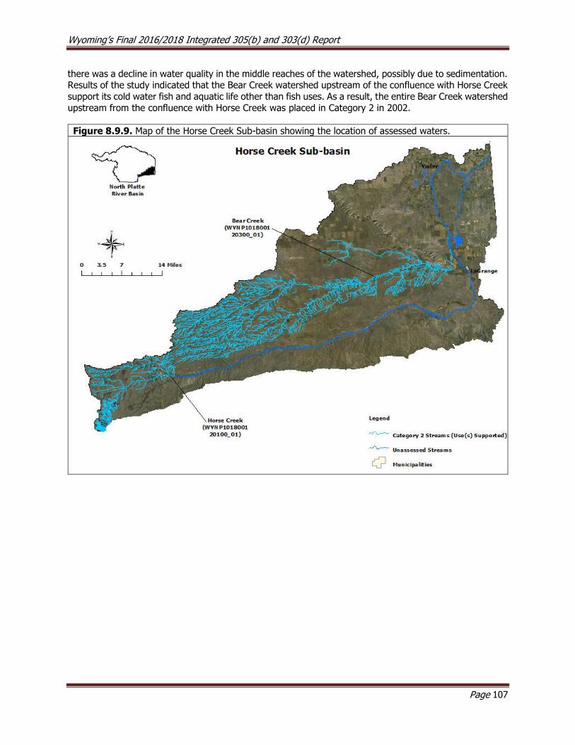
Wyoming’s Final 2016/2018 Integrated 305(b) and 303(d) Report
Page 107
there was a decline in water quality in the middle reaches of the watershed, possibly due to sedimentation. Results of the study indicated that the Bear Creek watershed upstream of the confluence with Horse Creek
support its cold water fish and aquatic life other than fish uses. As a result, the entire Bear Creek watershed
upstream from the confluence with Horse Creek was placed in Category 2 in 2002.
Figure 8.9.9. Map of the Horse Creek Sub-basin showing the location of assessed waters.

Wyoming’s Final 2016/2018 Integrated 305(b) and 303(d) Report
Page 108
8.10 Powder River Basin
The Powder River drains approximately 10,706 mi2 in northeastern Wyoming. The Powder River’s
headwaters are located within the Bighorn Mountain Range and the Casper Arch, which are located to the
west and south within the basin, respectively. The Powder River flows northeast through a large expanse of the Northwestern Great Plains before entering Montana near the Town of Moorhead, Montana. Nearly
all of the naturally perennial streams that reach the Powder River originate in the Bighorn Mountains. In contrast, streams originating in lower portions of the basin are typically ephemeral and flow only in response
to snowmelt or rainfall events unless they receive discharge water from point sources.
The Powder River Basin is composed of two level III and six level IV ecoregions (Chapman et al. 2003).
The western portion of the basin includes alpine zone, granitic subalpine zone, and dry mid-elevation sedimentary mountains of the Bighorn Mountain Range within the Bighorn National Forest. The alpine zone
is characterized by high precipitation and rockland, talus, tundra and glacial lakes. Vegetation consists mostly of forbs, sedges, and grasses. This ecoregion transitions to the lower elevation granitic subalpine
zone, a region which was once covered in sedimentary rock, but now has exposed granite cores following
natural erosion. Vegetation consists of mixed forest with an understory of shrubs and grasses. The mountains ultimately transition to the steep gradient dry mid-elevation mountains, consisting of shale
foothills, limestone bluffs, sandstone flatirons and forested canyons. Forested areas are patchy due to low precipitation and are dominated by shrubs and grasses. Land uses in the Bighorn Mountains include
livestock grazing, wildlife habitat, and recreation. The remainder of the basin consists of the lower elevation semiarid Northwestern Great Plains. Soils in this ecoregion consist mostly of shale and sandstone and are
often alkaline. Located to the northwest of the City of Casper, the Casper Arch is a transitional area between
the Wyoming Basin and the Northwestern Great Plains. The Powder River Basin occupies most of the remainder of the basin with occasional outcrops of the Pine Scoria Hills. Land uses in the basin include coal
mining, oil and gas production, livestock grazing, recreation, and wildlife habitat. Wohl et. al. (2007) reported that many streams within the Bighorn National Forest have been substantially impacted by cattle
grazing, irrigated crop production, flow regulation and diversion, and timber harvest.
Coal bed methane (CBM)
production in the Powder River Basin began in the late 1990s,
peaked in July, 2009 and steadily
declined since. According to WYPDES, approximately 483 CBM
permits, including 3,823 outfalls were present in the Powder River
Basin during 2009, whereas approximately 214 permits and
1651 outfalls were present as of August, 2014. The Powder River Basin Interagency Working Group
(PRBIWG) was developed in the early 2000s to address management issues associated with CBM development in the Powder River Basin in Wyoming and Montana. The group was comprised of multiple
state (including WDEQ) and federal agencies and met periodically to address issues associated with CBM monitoring and permitting. The group’s mission was to provide environmentally responsible CBM
development through the use of appropriate BMPs. Through this cooperative effort, each agency was
expected to achieve greater operational efficiency, enhance resource protection, and better serve the public. Particular attention was given to the possibility of cross-border effects of CBM discharge on
downstream segments of the Powder River in Montana.
To monitor the potential effects of CBM development on natural resources (e.g., water quality and quantity, aquatic life, wildlife, and air quality), water quality and aquatic life monitoring task groups were formed
and developed monitoring plans for the affected areas of NE Wyoming. The USGS was contracted to do
most of the water quality and aquatic life monitoring in the affected region of Wyoming. Several internet

Wyoming’s Final 2016/2018 Integrated 305(b) and 303(d) Report
Page 109
resources are available; these include a USGS website and fact sheet, the USGS Water Quality Monitoring Plan, and water quality and aquatic life monitoring plans. USGS (2009c) reported on the ecology of the
Powder River Structural Basin in Wyoming and Montana for the years 2005 and 2006. The study indicated that the biological condition of the mainstem Tongue River and the Powder River above and below Salt
Creek and between Crazy Woman and Clear Creeks decreased from upstream to downstream. Most streams
in the Powder River basin, however, showed a general trend of increasing biological condition from upstream to downstream.
A second USGS (2010a) report for the Powder River Structural Basin, spanning the years 2005-2008, was
completed in 2010. The goals of the study were to determine aquatic ecological conditions and to identify, where possible, the current and future effects of CBM produced water on aquatic life in the basin. The
study found that relatively few of WDEQ’s chronic or acute aquatic life criteria were exceeded during the
study period. In general, tributaries to the Tongue River had macroinvertebrate communities that were less pollution tolerant than those in the mainstem Tongue River. The macroinvertebrate and algal communities
along the Powder River were significantly more pollution tolerant between the confluence with Willow Creek downstream to the confluence with Crazy Woman Creek than communities above and below this segment.
The report was inconclusive as to these cause of these biological patterns. Fish communities were relatively
similar throughout the Powder River. Alkalinity, which was used to indicate the influence of CBM produced water, was similar throughout most of the mainstem of the Powder River. An exception to this pattern was
noted below the confluence with Burger Draw, where alkalinity was relatively high, however, the same location also had the highest diversity of fish of any site sampled during this study. Sturgeon chub, a native
fish in the Powder River Basin, is considered rare by WGFD. The fish is currently only found in the Powder River in Wyoming, and is believed to be adapted to turbid water.
A third USGS (2013) report analyzed trends in water quality data for several chemical constituents collected between 1980 and 2010 within the Tongue and Powder River basins. Specifically, conductivity, calcium,
magnesium, potassium, sodium adsorption ratio, sodium, alkalinity, chloride, fluoride, dissolved sulfate, and dissolved solids were compared across 16 study sites. The report summarizes general water quality
trends, and discusses the potential effects of bicarbonate on aquatic life and sodium on soils.
Due to naturally saline soils, WDEQ adopted site-specific chloride criteria for Salt Creek, Meadow Creek,
and the Powder River below the confluence with Salt Creek.
Middle Fork Powder Sub-basin (HUC 10090201)
The headwaters of the Middle Fork Powder River are located in the southern Bighorn Mountains. The river
flows northeast through a steep canyon and the WGFD’s Ed O Taylor Wildlife Habitat Management Area. The river ultimately confluences with the South Fork Powder River to form the Powder River approximately
12 miles west of the town of Sussex.
Assessed Waters
Middle Fork Powder River (WYPR100902010102_01), Class 1
Between 1993 and 2007, WDEQ collected physical, chemical, and biological data at several study sites along the Middle Fork Powder River. The data indicated that the Middle Fork Powder River from the
confluence with Buffalo Creek to a point 26.4 miles upstream supported its cold water fish and aquatic life
other than fish designated uses. As a result, this segment of the Middle Fork Powder River was placed in Category 2 in 2002. A final report was not written for this study.
Blue Creek (WYPR100902010202_01), Class 2AB
Between 1993 and 2007, WDEQ collected physical, chemical, and biological data at study sites along Blue
Creek. The data indicated that a segment of Blue Creek from the confluence with Beaver Creek to a point 8.8 miles upstream supported its cold water fish and aquatic life other than fish designated uses. As a
Wyoming’s Final 2016/2018 Integrated 305(b) and 303(d) Report
Page 110
result, this segment of Blue Creek was placed in Category 2 in 2002. A final report was not written for this study.
Rock Creek (WYPR100902010101_01), Class 2AB
Between 1993 and 2007, WDEQ collected physical, chemical, and biological data at several study sites
along Rock Creek. The data indicated that the entire Rock Creek watershed upstream of the confluence with Middle Fork Powder River supported its cold water fish and aquatic life other than fish designated
uses. As a result, this segment of Rock Creek was placed in Category 2 in 2008. A final report was not written for this study.
Beaver Creek (WYPR100902010202_00), Class 2AB
Beaver Creek is a small tributary to the Middle Fork Powder River. In 1999, WDEQ (2003) collected physical,
chemical, and biological data at a single study site near the Town of Barnum. There were no exceedances of numeric water quality criteria detected, and habitat quality was very good except for elevated levels of
fine sediments that were determined to be from natural sources. The report concluded that Beaver Creek
from the confluence with Blue Creek to a point 19.0 miles upstream supported its cold water fish and aquatic life other than fish designated uses. As a result, this segment of Blue Creek was placed in Category
2 in 2002.
Beartrap Creek (WYPR100902010206_01), Class 2AB
Beartrap Creek is a spring fed stream located in the southern Bighorn Mountain Range and is a tributary of the North Fork Red Fork Powder River. Historically, the upper Beartrap Creek drainage has been used as a
stock driveway and holding ground. However, management practices have changed over the past twenty years, and livestock now have limited access to streams and are moved through the drainage relatively
quickly during a short period in spring and fall. Log drop structures were installed in Beartrap Creek by BLM
and WGFD in 1989 to create additional pool and riffle habitats.
Between 1998 and 2002, WDEQ (2008) collected physical, chemical, and biological data at one study along Beartrap Creek. There were no exceedances of numeric water quality criteria detected, and habitat quality
was good, with abundant pools and an intact riparian zone. The presence of pollution sensitive
macroinvertebrate taxa indicated that water quality was good. The study concluded that the entire Beartrap Creek watershed above the confluence with the Middle Fork Powder River supported its cold water fish and
aquatic life other than fish designated uses. As a result, the entire Beartrap Creek watershed above the Middle Fork Powder River was placed in Category 2 in 2002.
Webb Creek (WYPR100902010301_01), Class 2AB
Webb Creek is a small tributary to the North Fork Powder River. In 1998, WDEQ (2004) collected physical,
chemical, and biological data at one study site along Webb Creek to address concerns about aquatic and riparian habitat degradation. There were no exceedances of numeric water quality criteria detected, and
habitat quality and the macroinvertebrate community were in good condition. The report concluded that
the entire Webb Creek watershed upstream of the confluence with the North Fork Powder River supported its cold water fish and aquatic life other than fish designated uses. As a result, the entire Webb Creek
watershed above the North Fork Powder River was placed in Category 2 in 2006.
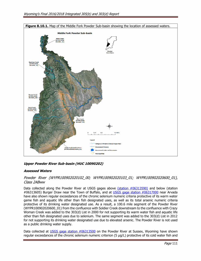
Wyoming’s Final 2016/2018 Integrated 305(b) and 303(d) Report
Page 111
Figure 8.10.1. Map of the Middle Fork Powder Sub-basin showing the location of assessed waters.
Upper Powder River Sub-basin (HUC 10090202)
Assessed Waters
Powder River (WYPR100902020102_00; WYPR100902020103_01; WYPR100902020600_01), Class 2ABww
Data collected along the Powder River at USGS gages above (station #06313590) and below (station
#06313605) Burger Draw near the Town of Buffalo, and at USGS gage station #06317000 near Arvada have also shown regular exceedances of the chronic selenium numeric criteria protective of its warm water
game fish and aquatic life other than fish designated uses, as well as its total arsenic numeric criteria protective of its drinking water designated use. As a result, a 100.6 mile segment of the Powder River
(WYPR100902020600_01) from the confluence with Soldier Creek downstream to the confluence with Crazy Woman Creek was added to the 303(d) List in 2000 for not supporting its warm water fish and aquatic life
other than fish designated uses due to selenium. The same segment was added to the 303(d) List in 2012
for not supporting its drinking water designated use due to elevated arsenic. The Powder River is not used
as a public drinking water supply.
Data collected at USGS gage station #06313500 on the Powder River at Sussex, Wyoming have shown
regular exceedances of the chronic selenium numeric criterion (5 µg/L) protective of its cold water fish and
Wyoming’s Final 2016/2018 Integrated 305(b) and 303(d) Report
Page 112
aquatic life other than fish designated uses. As a result, a 15.9 mile segment of the Powder River (WYPR100902020600_01) from the confluence with Salt Creek upstream to the confluence with the South
Fork Powder River and a 19.3 mile segment of the Powder River (WYPR100902020103_01) from the confluence with Salt Creek downstream to the confluence with Soldier Creek were added to the 303(d) List
in 2000.
Data collected at USGS gage station #06313500 on the Powder River at Sussex, Wyoming have also shown
regular exceedances of the chronic chloride numeric criterion (230 mg/L) protective of its aquatic life other than fish and warm water game fish designated uses. As a result, a 19.3 mile segment of the Powder River
(WYPR100902020103_01) from the confluence with Salt Creek downstream to the confluence with Soldier Creek was added to the 303(d) List in 1998. A site-specific chloride criterion of 984 mg/L was adopted by
WDEQ in 2007 for the Powder River below Salt Creek. However, USGS gage (station #06313500) data from
2003 and 2007 showed exceedances of the site-specific criterion on several occasions, thus the impaired segment remains on the 303(d) List. Much of the chloride loading to the Powder River originates in the Salt
Creek watershed.
Data collected at USGS gage station #06313500 between 2009 and 2010 on the Powder River at Sussex,
Wyoming have also shown regular exceedances of the total arsenic numeric criterion (10 µg/L) protective of its drinking water designated use. As a result, an impairment for arsenic was added to the 19.3 mile
segment of the Powder River (WYPR100902020103_01) from the confluence with Salt Creek downstream to the confluence with Soldier Creek in 2012. Data collected at the USGS gage (station #06313400) on Salt
Creek indicated that this tributary contributes arsenic to the Powder River, but the source(s) of arsenic within the Salt Creek watershed were unknown.
Fourmile Creek (WYPR100902020104_01), Class 3B
The headwaters of Fourmile Creek are locate approximately 20 miles northwest of the town of Kaycee. The
creek flows east approximately ten miles to its confluence with the Powder River. In 1999, WDEQ (2005)
collected physical data at one study site along Fourmile Creek and found that most of the watershed is ephemeral, with the exception of several on-channel ponds and reservoirs. Streambanks were moderately
stable with minimal sedimentation. The report concluded that the entire Fourmile Creek watershed upstream from the confluence with the Powder River supported its aquatic life other than fish designated
use. As a result, the entire Fourmile Creek watershed above the Powder River was placed in Category 2 in 2006.
Ninemile Creek (WYPR100902020100_01), Class 3B
The headwaters of Ninemile Creek are located approximately ten miles northeast of the town of Kaycee
where it flows east approximately 40 miles to its confluence with the Powder River. In 1998-1999, WDEQ
(2005) collected physical data at four study sites along Ninemile Creek and found that, similar to Fourmile Creek, the Ninemile Creek watershed is ephemeral, with the exception of several on-channel ponds and
reservoirs. Localized channel instability was considered moderate, and no excessive sedimentation was present. The report concluded that the entire Ninemile Creek watershed upstream from the confluence
with the Powder River supported its aquatic life other than fish designated use. As a result, the entire Ninemile Creek watershed above the Powder River was placed in Category 2 in 2006.
Middle Prong Wild Horse Creek (WYPR100902020808_01), Class 3B
The headwaters of Wild Horse Creek are located east of Arvada in western Campbell County where the
creek flows west to its confluence with the Powder River at Arvada. In 2002 and 2003, the Campbell County
Conservation District (CCCD) monitored portions of the Middle Prong of Wild Horse Creek as part of the Belle Fourche and Powder River Watersheds Water Quality Data and Analysis Section 319 Project.
Exceedances of the fecal coliform criterion for contact recreation designated use were detected twice in 2003 at a single study site in the lower Middle Prong of Wild Horse Creek. As a result, a segment of the

Wyoming’s Final 2016/2018 Integrated 305(b) and 303(d) Report
Page 113
Middle Prong Wild Horse Creek from its confluence with Wild Horse Creek to a point 4.6 miles upstream was added to the 303(d) List in 2006 for not meeting its recreation designated. The source was not known.
CCCD and NRCS have assisted landowners in implementing 13 water quality improvement projects in the
watershed. CCCD sponsored the Donkey/Stonepile Creek Sub-Watersheds, Little Powder River Sub-
Watershed and Upper/Middle Powder River Watershed 2007-2009 Section 319 Project. The goals of the project were to monitor bacterial, chloride, and ammonia concentrations in these watersheds, including
one study site along Middle Prong Wild Horse Creek. Results showed that Middle Prong Wild Horse Creek continued to exceed fecal coliform criterion protective of its contact recreation designated use in 2008 and
2009. Local stakeholders and CCCD initiated watershed planning in this watershed in 2007 (WACD 2011).
CCCD completed the Powder River and Belle Fourche River Watersheds Monitoring 205(j) Final Report in
2014. The project included E. coli monitoring during 2010 through 2013 on Middle Prong Wild Horse Creek. Goals of the monitoring included: determining trends in E. coli and chloride concentrations and identifying
potential sources of pollution. Middle Prong Wild Horse Creek was dry, except during the spring of 2010 and 2011, during which WDEQ’s primary recreational use criterion was not exceeded. The report indicated
that the source of E. coli bacteria to Middle Prong Wild Horse Creek is unknown non-point sources. Middle
Prong Wild Horse Creek is a class 3B water, therefore WDEQ’s aquatic life chloride criteria do not apply.
Flying E Creek (WYPR100902020602_01), Class 3B
The headwaters of Flying E Creek are located approximately 19 miles east of the Town of Buffalo where it
flows approximately 11 miles northeast to its confluence with the Powder River. In 1999, WDEQ (2003)
assessed Flying E Creek at five study sites and confirmed that Flying E Creek is ephemeral. No data were collected because the stream channel was dry during site visits. The report concluded that the entire Flying
E Creek watershed upstream from the confluence with the Powder River supported its aquatic life other than fish designated use. As a result, the entire Flying E Creek watershed above the Powder River was
placed in Category 2 in 2008.
Other Monitoring Efforts in the Sub-basin The headwaters of Pumpkin Creek are located north of Pumpkin Buttes in southeastern Campbell County.
The creek then flows northwest to its confluence with the Powder River. In 1999, WDEQ (2003) made
physical and biological observations at a single site on Pumpkin Creek, although designated use support was not determined.
The headwaters of Fortification Creek are located near Kinney Divide, approximately 15 miles east of the
City of Gillette. The creek follows the divide for approximately 20 miles before it confluences with the
Powder River. In 1999, WDEQ (2004) collected only physical data and information at six study sites along Fortification Creek because the stream channel was dry. The report concluded that Fortification Creek is
naturally ephemeral and likely only flows during periodic precipitation events. Data and other information
were insufficient to determine designated use support.
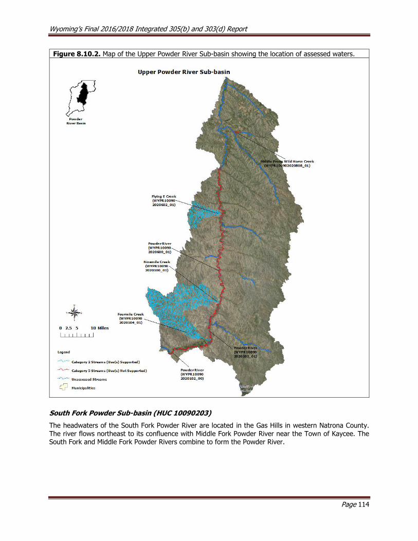
Wyoming’s Final 2016/2018 Integrated 305(b) and 303(d) Report
Page 114
Figure 8.10.2. Map of the Upper Powder River Sub-basin showing the location of assessed waters.
South Fork Powder Sub-basin (HUC 10090203)
The headwaters of the South Fork Powder River are located in the Gas Hills in western Natrona County.
The river flows northeast to its confluence with Middle Fork Powder River near the Town of Kaycee. The South Fork and Middle Fork Powder Rivers combine to form the Powder River.
Wyoming’s Final 2016/2018 Integrated 305(b) and 303(d) Report
Page 115
Assessed Waters
South Fork Powder River (WYPR100902030400_01), Class 2C
The Powder River Conservation District (PRCD) sponsored the South Fork/Salt Creek Water Quality
Monitoring Section 319 Project to monitor the water quality of the Powder River, South Fork Powder River
and Salt Creek watersheds. Monitoring was conducted between 2003 and 2006 and a final report was completed in 2007. Thirteen selenium samples were collected at two study sites between 2003 and 2004
along the South Fork Powder River. Samples regularly exceeded the numeric chronic selenium criterion protective of its nongame fish and aquatic life other than fish designated uses at both sites during this
period, with values ranging from 6-23 µg/L. As a result, a segment of the South Fork Powder River
(WYPR100902030400_01) from the confluence with Cloud Creek to a point 47.2 miles downstream was added to the 303(d) List in 2006.
Willow Creek (WYPR100902030403_01), Class 2AB
Willow Creek is a major tributary to the South Fork Powder River. In 2004, seven selenium samples were
collected at a single study site on Willow Creek between April and October. All seven samples exceeded the chronic selenium numeric criterion protective of its cold water fish and aquatic life other than fish
designated uses, with values ranging from 6-127 µg/L. As a result, a segment of Willow Creek (WYPR100902030403_01) from the confluence with the South Fork Powder River to a point 10.5 miles
upstream was added to the 303(d) List in 2006.
Murphy Creek (WYPR100902030407_01) and Posey Creek (WYPR100902030404_01), Class 3B
Murphy and Posey Creeks are both small tributaries to the South Fork Powder River. In 2005 and 2006, selenium samples were collected on Murphy and Posey Creeks that exceeded the chronic selenium numeric
criterion protective of their aquatic life other than fish designated uses; values ranged from 5-22 µg/L on
Murphy Creek and 5-154 µg/L on Posey Creek. As a result, a segment of Murphy Creek (WYPR100902030407_01) from the confluence with the South Fork Powder River to a point 12.2 miles
upstream and a segment of Posey Creek (WYPR100902030404_01) from the confluence with the South Fork Powder River to a point 8.0 miles upstream were added to the 303(d) List in 2008. The sources of
selenium for both creeks includes seleniferous geologic formations. In July 2010, PRCD submitted
documentation supporting development of site-specific criteria for Murphy Creek and provided supplemental information in August 2011. WDEQ has been working with PRCD and USEPA to refine the
proposal.
WDEQ (2003) collected physical, chemical, and biological data from one study site on Posey Creek in 1999.
Irrigated agriculture in contact with marine shales was identified as a possible source of selenium in the Posey Creek watershed. The report noted that the stream was channelized, and that larger streambed
substrate was embedded by silt. No measured water chemistry criteria were exceeded during this study, but pollution tolerant taxa dominated the macroinvertebrate community. Data collected during the study
were insufficient to make a designated use support determination.

Wyoming’s Final 2016/2018 Integrated 305(b) and 303(d) Report
Page 116
Figure 8.10.3. Map of the South Fork Powder River Sub-basin showing the location of assessed waters.
Salt Creek Sub-basin (HUC 10090204)
The headwaters of the Salt Creek watershed are located along the western edge of Pine Ridge in western
Converse County. Salt Creek flows northwest to its confluence with the Powder River near the community of Sussex. Several natural oil seeps occur within the Salt Creek watershed, which prompted the
development of several oil fields beginning in 1908. While most reaches in this semi-arid sub-basin are naturally ephemeral or intermittent, some segments of Salt Creek now have perennial flow due to oil treater
discharges. Much of the oil field infrastructure dates to the 1960s, and spills had been primarily due to the
age of the infrastructure, including bacterial corrosion in the injection lines. The current operator has developed a long term upgrade and maintenance plan to reduce the potential for large spills that may
affect water quality. The operator has also started using CO2 flood injection to enhance oil recovery. Switching to CO2 flood injection has further reduced the occurrence of spills because it has required that
injection and production lines be replaced. Lastly, a biocide treatment has been added to many water lines
since 2003 to reduce bacterial corrosion.
Salt Creek (WYPR100902040300_01), Class 2C
In 1996, WDEQ monitored and assessed Salt Creek using data from study sites located near the Town of
Midwest. The investigation revealed oil and grease deposits at two locations just above the confluence with
Castle Creek. As a result, a segment of Salt Creek (WYPR100902040300_01) from the confluence with the Powder River to a point 45.3 miles upstream was added to the 303(d) List in 1996 for oil and grease. The
Wyoming’s Final 2016/2018 Integrated 305(b) and 303(d) Report
Page 117
source of oil and grease was identified as petroleum production. A final report was not written for this study.
The Powder River Conservation District (PRCD) sponsored the South Fork/Salt Creek Water Quality
Monitoring Section 319 Project to monitor the water quality of the Powder River, South Fork Powder River,
and Salt Creek. Between 2003 and 2006, PRCD collected data at seven study sites within the Salt Creek watershed and a final report was completed in 2007. The report concluded that selenium concentrations
did not exceed the chronic selenium numeric criterion protective of its aquatic life other than fish designated use at any of the sample sites. The report noted high chloride concentrations in Salt Creek and the Powder
River below the confluence with Salt Creek due to oil field discharges. However, data from USGS gage station #06313400 showed that chloride concentrations exceeded the numeric chronic chloride criterion
protective of its aquatic life other than fish designated uses. As a result, a segment of Salt Creek from its
confluence with the Powder River to an undetermined distance upstream was added to the 303(d) List in 2002. A site-specific chloride criterion of 1,600 mg/L for Salt Creek was approved by USEPA in 2008 and
the chloride impairment for Salt Creek was removed from the 303(d) List in 2008.
Data collected in support of the development of the site-specific chloride criteria on Salt Creek detected
exceedances of the numeric chronic selenium criterion protective of its aquatic life other than fish designated use. As a result, a selenium impairment was added to the segment of Salt Creek
(WYPR100902040300_01) from the confluence with the Powder River to a point 45.3 miles upstream in 2008. It is unknown whether the primary source of selenium loading is natural or anthropogenic, but both
of these sources are likely contributors.

Wyoming’s Final 2016/2018 Integrated 305(b) and 303(d) Report
Page 118
Figure 8.10.4. Map of the Salt Creek Sub-basin showing the location of assessed waters.
Crazy Woman Sub-basin (HUC 10090205)
The headwaters of the Crazy Woman watershed are located along the eastern slope of the Big Horn
Mountains. Crazy Woman Creek begins at that confluence of the North and Middle Forks of Crazy Woman Creeks, then flows northeast to its confluence with the Powder River near the community of Arvada.
Assessed Waters
Crazy Woman Creek (WYPR100902050305_01), Class 2ABww
Data from USGS gage station #06316400 showed that Crazy Woman Creek regularly exceeded the
aesthetic drinking water criterion for manganese between 1999 and 2001. As a result, a segment of Crazy Woman Creek extending from the confluence with the Powder River to a point 9.2 miles upstream was
added to the 303(d) List in 2002 for not supporting its drinking water designated use due to elevated manganese. There are no known anthropogenic sources of manganese in Lower Crazy Woman Creek, and
it is unlikely that the creek will ever be used as a drinking water source due to its intermittent hydrology.
USEPA has established National Secondary Drinking Water Regulations that set water quality standards for
15 contaminants, including manganese. USEPA does not enforce these secondary maximum contaminant levels (SMCLs). Instead, they are intended to serve as guidelines to assist public water systems in managing
their drinking water for aesthetic considerations, such as taste, color and odor. These contaminants are
not considered a risk to human health at these SMCLs (USEPA, 1992). Wyoming’s aesthetic drinking water

Wyoming’s Final 2016/2018 Integrated 305(b) and 303(d) Report
Page 119
criterion for manganese is set at the USEPA SMCL. However, high manganese concentrations are common in streams in the Powder River Structural Basin due to the natural geology (Wasatch and Fort Union
Geologic Formations), and thus much of the basin does not have a human health criterion for this pollutant in Chapter 1 of Wyoming’s Water Quality Rules and Regulations. WDEQ will be evaluating the application
of drinking water designated uses in Wyoming at some point in the future; if it is established that the
drinking water use is not appropriate for Crazy Woman Creek, the impairment will be reevaluated.
North Fork Crazy Woman Creek (WYPR100902050100_01; WYPR100902050102_01), Class 2AB
The headwaters of the North Fork Crazy Woman Creek’s (NFCWC) are located near Powder Pass along the
east slope of the Bighorn Mountains where it flows southeast to its confluence with the Middle and South
Forks of Crazy Woman Creek, forming Crazy Woman Creek. A segment of the NFCWC (WYPR100902050100_01) from Muddy Creek Road to a point 22.6 miles upstream was initially added to
the 303(d) List in 1996 for habitat degradation, nutrients, and bioindicators. In response, 22 BMP projects were completed in the 1990s on the NFCWC watershed as part of a 319(h) grant, focusing mainly on
improving irrigation efficiency, relocating livestock corrals away from riparian zones, and planting riparian
vegetation. In 1993 and 1998, WDEQ (2003) collected physical, chemical, and biological data at a single study site along the NFCWC to evaluate the effectiveness of these BMPs. While there were notable
improvements to riparian and aquatic habitat from the BMPs, the biological community had declined slightly, possibly due to drought. Bio-West was contracted by WDEQ to analyze all available data and other
information and determine the effectiveness of these BMPs at reducing nutrient loading and improving habitat along the creek. The final report completed by Bio-West (2001) was inconclusive.
In 2008, WDEQ (2014) collected additional physical, chemical, and biological data at three study sites along the NFCWC to supplement the existing historical dataset and assess designated use support for the creek.
The report noted stable banks, reduced channel incision, and little evidence of sedimentation. Nutrient and chlorophyll a concentrations were mostly low. The report concluded that the impaired segment of the
NFCWC supported its cold water fish, aquatic life other than fish, and drinking water designated uses. As
a result, the habitat degradation and nutrient impairments for NFCWC (WYPR100902050100_01) extending from Muddy Creek Road to a point 22.6 miles upstream were removed from the 303(d) List in 2014. The
impairment for bioindicators had been found to be an error and was removed from the 303(d) List in 2012.
WDEQ (2014) also evaluated the lower reaches of the NFCWC that had not previously been assessed. The report noted that heavy utilization of the stream for irrigated agriculture had significantly altered the natural
flow regime, increased sedimentation downstream, and degraded macroinvertebrate and fish communities.
The report concluded that the NFCWC below Muddy Creek did not support its aquatic life other than fish and cold water fish designated uses due to flow alterations. As a result, a 28 mile segment of the NFCWC
(WYPR100902050102_01) from Muddy Creek Road downstream to the confluence with Middle Fork Crazy
Woman Creek was placed in Category 4C in 2014.
Due to concerns from stakeholders that Wyoming’s surface water quality standards did not sufficiently
recognize the exemptions afforded to water rights, Senate Enrolled Act 75 was passed during the 2015 legislative session. SEA75 added W.S. § 35-11-302(c) to the Environmental Quality Act and charged WDEQ
with developing water quality standards for waters where valid water rights preclude attainment of existing water quality standards. SEA75 also outlined that WDEQ would prepare a schedule to develop water quality
standards for those waters identified as not meeting water quality standards due to hydrologic modification
(i.e., 4C waters). In response to SEA75, WDEQ reevaluated the seven 4C waters that were included in the 2014 Integrated Report against Wyoming’s existing surface water quality standards. The reevaluation of
the 4C segment of North Fork Crazy Woman Creek indicated that there was not sufficient information to determine whether the cold water fish and aquatic life other than fish designated uses were supported.
However, because drinking water and fish consumption uses were supported, this segment of North Fork Crazy Woman Creek (WYPR100902050102_01) was moved to Category 2 in 2018.

Wyoming’s Final 2016/2018 Integrated 305(b) and 303(d) Report
Page 120
Pole Creek (WYPR100902050110_02), Class 2AB
Pole Creek is a small tributary to NFCWC. In 1998, WDEQ (2003) collected physical, chemical, and biological
data at two study sites along Pole Creek. No exceedances of the numeric criteria that were evaluated were detected during this study. A high percentage of fine sediment observed in the stream channel was
attributed to upstream beaver activity. Macroinvertebrate communities at both sites were comparable to
three reference streams used for the study. The report concluded that the entire Pole Creek watershed upstream from the confluence with Beaver Creek supported its cold water fish and aquatic life other than
fish designated uses. As a result, the entire Pole Creek (WYPR100902050110_02) watershed above Beaver Creek was placed in Category 2 in 2002.
Poison Creek (WYPR100902050107_01), Class 2AB
Poison Creek is a small spring fed tributary to NFCWC. The headwaters of Poison Creek are located in the
Big Horn Mountains, approximately 3 miles east of Powder River Pass, where it flows southeast to its confluence with NFCWC at the mouth of Robinson Canyon. In 1998, WDEQ (2003) collected physical,
chemical, and biological data from three study sites along Poison Creek. The report concluded that the
entire Poison Creek watershed upstream from the confluence with the Middle Fork Crazy Woman Creek supported its cold water fish and aquatic life other than fish designated uses. As a result, the entire Poison
Creek (WYPR100902050107_01) watershed above the Middle Fork Crazy Woman Creek was placed in Category 2 in 2002.
Doyle Creek (WYPR100902050106_01), Class 2AB
The headwaters of Doyle Creek are located along the eastern slope of the Big Horn Mountains where it
flows northeast to its confluence with the Middle Fork Crazy Woman Creek near upper Robinson Canyon. In 1998, WDEQ (2002) collected physical, chemical, and biological data from two study sites on Doyle
Creek, and no exceedances of any aquatic life water quality numeric criteria were detected. At both study
sites, aquatic and riparian habitat quality and the macroinvertebrate community were in good condition. The report concluded that a segment of Doyle Creek from its headwaters to a point 10.4 miles downstream
supported its cold water fish and aquatic life other than fish designated uses. As a result, a segment of Doyle Creek (WYPR100902050106_01) from its headwaters to a point 10.4 miles downstream was placed
in Category 2 in 2002.
Billy Creek (WYPR100902050103_01), Class 2AB
Billy Creek’s headwaters are located on within the eastern foothills of the Big Horn Mountains south of the Town of Buffalo where it flows east 10 miles before it confluences with Muddy Creek, approximately 0.20
miles upstream of the North Fork Crazy Woman Creek. In 1998, WDEQ (2004) collected physical, chemical,
and biological data at two study sites. There were no exceedances of measured aquatic life water chemistry numeric criteria detected during this study. The streambed substrate was dominated by sand, but this was
attributed to natural contributions from the geology of the watershed. Riparian vegetation was considered healthy, considering the physical constraints of the surrounding narrow terraces. The macroinvertebrate
community was also determined to be in good condition. The report concluded that a segment of Billy
Creek from the confluence with Muddy Creek to a point 13.4 miles upstream supported its cold water fish and aquatic life other than fish designated uses. As a result, a segment of Billy Creek
(WYPR100902050103_01) from the confluence with Muddy Creek to a point 13.4 miles upstream was
placed in Category 2 in 2006.
Little North Fork Crazy Woman Creek (WYPR100902050102_02), Class 2AB
The headwaters of Little North Fork Crazy Woman Creek (LNFCWC) are located within the foothills of the eastern slope of the Big Horn Mountains where it flows southeast approximately eight miles to its confluence
with North Fork Crazy Woman Creek. An herbicide spill occurred in the watershed in the 1970s, resulting
in poor riparian vegetation cover and related sedimentation within a localized area. Lake DeSmet Conservation District (LDCD) completed the North Fork Crazy Woman Creek (NFCWC) Section 319 Water
Wyoming’s Final 2016/2018 Integrated 305(b) and 303(d) Report
Page 121
Quality Project in 1990. As part of this project, LDCD and NRCS initiated riparian re-seeding and modified livestock grazing management within the affected area.
In 1993 and 1998, WDEQ (2003) monitored LNFCWC at a single study site to determine whether these
BMPs had reduced sedimentation and to assess designated use support. There were no exceedances of
measured aquatic life water chemistry numeric criteria detected during this study. Physical data indicated that there had been improvements in bank stability, streambed embeddedness, and riparian health. The
macroinvertebrate community condition improved over the study period and this trend was thought to be related to habitat improvements. The report concluded that the entire LNFCWC watershed upstream from
the confluence with NFCWC supported its cold water fish and aquatic life other than fish designated uses. As a result, the entire LNFCWC (WYPR100902050102_02) watershed above NFCWC was placed in Category
2 in 2002.
Middle Fork Crazy Woman Creek (WYPR100902050108_00), Class 2AB
The headwaters of the Middle Fork Crazy Woman Creek (MFCWC) are located in Robinson Canyon along
the eastern slope of the Big Horn Mountains where it flows east to its confluence with North Fork Crazy Woman Creek (NFCWC) near Interstate 25, and the confluence of these two creeks forms Crazy Woman
Creek. In 1996 and 1998, WDEQ (2003) collected physical, chemical, and biological data at three study sites along the MFCWC, and there were no exceedances of measured aquatic life water chemistry numeric
criteria detected during this study. Moderate streambed embeddedness was observed and attributed to a recently washed out road crossing upstream at one of the study sites. Overall, habitat condition appeared
to have improved over the course of the three year study, and biological communities at each of the three
sites were in good condition. The report concluded that the entire MFCWC watershed upstream of the confluence with the NFCWC, excluding Doyle Creek and Poison Creek, supported its cold water fish and
aquatic life other than fish designated uses. As a result, the entire MFCWC (WYPR100902050108_00) watershed above the NFCWC was placed in Category 2 in 2002
Beaver Creek (WYPR100902050110_01), Class 2AB
Beaver Creek is a small watershed that confluences with the South Fork Powder River near State Route
196. In 1999, WDEQ (2003) collected physical, chemical, and biological data at one site on Beaver Creek, and there were no exceedances of measured aquatic life water chemistry numeric criteria detected during
the study. Beaver Creek has naturally erosive geology, low gradient, and low stream power, but given these
natural limitations, the aquatic and riparian habitat were in good condition at the study site. Overall, the biological condition was also good at the study site. The report concluded that the entire Beaver Creek
watershed upstream from the confluence with the South Fork Crazy Woman Creek (SFCWC), excluding Pole Creek, supported its cold water fish and aquatic life other than fish designated uses. As a result, the
entire Beaver Creek (WYPR100902050110_01) watershed above the SFCWC was placed in Category 2 in
2002.
Other Monitoring Efforts in the Sub-basin The headwaters of South Fork Crazy Woman Creek (SFCWC) are located within the eastern foothills of the
Big Horn Mountains where the creek flows northeast for 14 miles to its confluence with Crazy Woman Creek, just east of Interstate 25. In 1999, WDEQ (2003) collected physical, chemical, and biological data
at four sites along SFCWC. No exceedances of measured aquatic life water chemistry criteria were detected during the study. The SFCWC has a naturally erosive geology with a low gradient and low stream power,
but given these natural limitations, the aquatic and riparian habitat were in good condition at all of the
study sites. Overall, the biological condition was also good at all of the study sites. However, the report did
not make a support determination for designated uses.

Wyoming’s Final 2016/2018 Integrated 305(b) and 303(d) Report
Page 122
Figure 8.10.5. Map of the Crazy Woman Sub-basin showing the location of assessed waters.
Clear Creek Sub-basin (HUC 10090206)
Assessed Waters
Clear Creek (WYPR100902060000_01), Class 2AB
The headwaters of the Clear Creek watershed are located in the Cloud Peak Wilderness Area within the Big Horn Mountains where it flows northeast from the mountains, through the Town of Buffalo and confluences
with the Powder River, approximately 10 miles south of the Wyoming/Montana border. In 1999, WDEQ
(2004) monitored Clear Creek by collecting physical, chemical, and biological data at 16 study sites. There were no exceedances of measured aquatic life or recreation water chemistry numeric criteria detected
during the study. Weighted embeddedness scores indicated that there was little siltation within Clear Creek and aquatic habitat was in good condition. Overall, the biological condition of Clear Creek was good at all
study sites. The report concluded that Clear Creek from the confluence with the Powder River upstream to
the confluence with Grommund Creek, and the entire Clear Creek watershed upstream of the confluence with Grommund Creek supported its cold water fish and aquatic life other than fish designated uses. As a
result, the entire Clear Creek (WYPR100902060000_01) watershed above Grommund Creek, as well as the main stem of Clear Creek between the Powder River and Grommund Creek were placed in Category 2 in
2006.
Wyoming’s Final 2016/2018 Integrated 305(b) and 303(d) Report
Page 123
North and South Fork Shell Creek (WYPR100902060305_01), Class 3B
The headwaters of Rock Creek and the North and South Forks of Shell Creek are located northwest of the
Town of Buffalo within the eastern foothills and mountains of the Big Horn Mountains. Rock Creek flows southeast to its confluence with Clear Creek northeast of the Town of Buffalo. The North and South Forks
of Shell Creek flow northeast into Shell Creek Reservoir. In 2001, LDCD completed the Rock and North and
South Fork Shell Creek Bioassessment Section 205j Project.
Data collected as part of the 205(j) project indicated that the entire main stem of North and South Forks Shell Creek (WYPR100902060305_01) upstream from the confluence with South Creek Reservoir were
threatened by physical degradation and were therefore added to the 303(d) List in 1996. Impacts to the
North and South Fork Shell Creek drainages are primarily due to irrigation diversions and conveyance. LDCD completed a Section 319 Project which addressed these problems, primarily through the installation of
more efficient irrigation systems. Biological data collected as part of the project were highly variable across collection dates and were inconclusive. WDEQ monitoring in 2003 and 2005 suggested that the BMPs
implemented on the North and South Forks of Shell Creek were somewhat effective, but that additional data were needed. WDEQ conducted biomonitoring on these streams again in 2006. Several nongame fish
were observed while sampling North and South Fork Shell Creeks, suggesting that these streams may be
better classified as 2C. Data indicated full support of the aquatic life other than fish use on these creeks. USEPA Section 319 Nonpoint Source Success Stories has been written for North and South Forks of Shell
Creeks.
Rock Creek (WYPR100902060202_01), Class 2AB
The headwaters of Rock Creek are located northwest of the Town of Buffalo in the eastern slope of the Big Horn Mountains where it flows southeast to its confluence with Clear Creek northeast of the Town of
Buffalo. Data collected as part of the Rock and North and South Fork Shell Creek Bioassessment Section 205j Project suggested that Rock Creek from the confluence with Clear Creek upstream to the confluence
with South Rock Creek did not support its cold water fish and aquatic life other than fish designated uses.
As a result, a segment of Rock Creek (WYPR100902060202_01) above Clear Creek upstream to South Rock Creek was added to the 303(d) List in 2002 for habitat degradation. The primary source of habitat
degradation was identified as heavy livestock grazing in small horse pastures near the stream. Landowners implemented best management practices (BMPs) specifically designed to improve irrigation efficiency.
In 1998, WDEQ (2003) re-assessed Rock Creek using physical, chemical, and biological data collected at 5 sample sites. There were no exceedances of measured aquatic life water chemistry numeric criteria
detected during this study. The report concluded that the impaired segment supported its cold water fish and aquatic life other than fish designated uses. As a result, the impaired segment of Rock Creek
(WYPR100902060202_01) was moved from the 303(d) List to Category 2 in 2004. A USEPA Section 319 Nonpoint Source Success Story was written for Rock Creek.
North Rock Creek (WYPR100902060201_01), Class 2AB
North Rock Creek’s headwaters are located in the foothills of the Big Horn Mountains northwest of the
Town of Buffalo where it flows east to its confluence with Rock Creek just north of the Bud Love Wildlife
Management Area. In 1998, WDEQ (2003) collected physical, chemical, and biological data at two study sites along North Rock Creek. There were no exceedances of measured aquatic life or recreation numeric
criteria detected during this study. At both study sites, the stream channel was rectangular with a high width to depth ratio from flow alterations and livestock grazing. The riparian zone was thin and over-utilized
by livestock grazing. Despite these physical limitations, the macroinvertebrate data indicated that North Rock Creek from the confluence with South Rock Creek to a point 9.6 miles upstream supported its cold
water fish and aquatic life other than fish designated uses. As a result, a 9.6 mile segment of North Rock
Creek (WYPR100902060201_01) above South Rock Creek was placed in Category 2 in 2008.
Wyoming’s Final 2016/2018 Integrated 305(b) and 303(d) Report
Page 124
Hunter Creek (WYPR100902060103_01), Class 2AB
Hunter Creek is a small tributary to North Fork Clear Creek in the Big Horn Mountains west of the Town of
Buffalo. In 1997 and 1998, WDEQ collected physical, chemical, and biological data at two study sites along Hunter Creek. The report concluded that fine sediment entering the stream channel from intensive livestock
grazing and from an adjacent road was threatening the cold water fish and aquatic life other than fish
designated uses along a segment of Hunter Creek from the confluence with North Clear Creek to a point 2.7 miles upstream. As a result, a 2.7 mile segment of Hunter Creek (WYPR100902060103_01) above North
Clear Creek was added to the 303(d) List in 1998 due to heavy siltation. In 2003, WDEQ and USFS implemented a series of BMPs to address excess siltation. BMPs included moving the road further from the
stream, re-planting vegetation to create a larger riparian buffer, constructing a roadside ditch and reservoir
to trap sediment, creating designated cattle crossings, and implementing a rotational grazing schedule. In 2003 and 2004, WDEQ re-evaluated Hunter Creek and determined that it supported its cold water fish and
aquatic life other than fish designated uses. As a result, Hunter Creek was removed from the 303(d) List and placed in Category 2 in 2004. A final report was not completed for the 2003-2004 WDEQ study. A
USEPA Section 319 Nonpoint Source Success Story was written for Hunter Creek.
North Piney Creek (WYPR100902060303_01, Class 2AB), Dalton Ditch (WYPR100902060303_02, WYPR100902060303_04, Class 3B), and Piney-Cruse Ditch (WYPR100902060303_03, Class 3B)
In July and August of 2005, WDEQ (2005) collected E. coli samples within and near the Town of Story in response to citizen concerns that sewage from failed septic systems was contaminating local surface waters.
There were no other known or suspected sources of fecal contamination in the area. Several exceedances of the numeric E. coli criterion protective of primary contact recreation were detected in Dalton Ditch and
North Piney Creek. As a result, a segment of North Piney Creek (WYPR100902060303_01) from the
confluence with Piney Creek to a point 6.4 miles upstream was added to the 303(d) List in 2006. Later, a 0.3 mile segment of Dalton Ditch (WYPR100902060303_02) within and near the Town of Story and a
segment of Piney-Cruse Ditch (WYPR100902060303_03) from the confluence with North Piney Creek to a point 2.2 miles upstream were added to the 303(d) List in 2008.
As part of the 2009 Story Septic Assessment Section 205j Project, Sheridan County investigated impacts from septic systems on an alluvial aquifer and the potential linkages between contaminated groundwater
and surface water in the area. The report noted that much of the community of Story uses a shallow alluvial aquifer for both drinking water and for septic waste disposal. The water level in the aquifer fluctuates
seasonally, it is highly connected to surface waters, and it is recharged during high flows in May and June.
Several septic systems within the area were subsequently repaired or replaced, following recommendations contained within the report.
Between 2008 and 2010, WDEQ (2014) collected E. coli samples at two study sites along North Piney Creek
and five sites along Dalton Ditch to determine whether E. coli concentrations had been reduced following repairs to local septic systems. The two sites on North Piney Creek were both within the impaired reach,
whereas those monitored on Dalton Ditch included sites within and beyond the impaired reach. No
exceedances of the numeric E. coli criterion protective of primary contact recreation were detected in North Piney Creek. As a result, the impaired segment of North Piney Creek (WYPR100902060303_01) was
removed from the 303(d) List in 2014. However, the report was unable to determine whether or not the septic repairs/replacements contributed to the observed reduction in E. coli concentrations. Exceedances
of the numeric E. coli criterion protective of primary contact recreation were detected in the impaired
segment of Dalton Ditch (WYPR100902060303_02), so it was not removed from the 303(d) List. During this study, samples collected upstream of the impaired segment of Dalton Ditch in 2010 also exceeded the
numeric E. coli criterion protective of primary contact recreation. As a result, an additional segment of Dalton Ditch (WYPR100902060303_04) from Cottage Grove Road to a point 0.04 miles upstream was added
to the 303(d) List in 2014. The report concluded that the majority of E. coli loading to Dalton Ditch occurs between Robertson and Cottage Grove Roads, but the source(s) of the pollutant are not known.
Wyoming’s Final 2016/2018 Integrated 305(b) and 303(d) Report
Page 125
Little Piney Creek (WYPR100902060304_01), Class 2AB
The headwaters of Little Piney Creek are located within the foothills of the Big Horn Mountains southeast
of the community of Story where it flows northeast to its confluence with Piney Creek. In 1998, WDEQ (2002) collected physical, chemical, and biological data at two study sites along Little Piney Creek, and no
exceedances of the measured numeric water quality criteria were detected. Streambed particle
embeddedness was minimal and riparian vegetation was in good condition, and the macroinvertebrate community was described as being in good condition and comparable to the reference stream. The report
concluded that a segment of Little Piney Creek from the confluence with Piney Creek to a point 14.0 miles upstream supported its cold water fish and aquatic life other than fish designated uses. As a result, a 14.0
mile segment of Little Piney Creek (WYPR100902060304_01) above Piney Creek was placed in Category 2
in 2002.
South Piney Creek (WYPR100902060302_01), Class 2AB
The headwaters of South Piney Creek originate at Lake Mead, within the Cloud Peak Wilderness in the Big
Horn Mountains where it flows through Cloud Peak Reservoir, Flatiron Lake, Frying Pan Lake, and Willow
Park Reservoir, then continues flowing northeast to its confluence with North Piney Creek. In 1996 and 1998, WDEQ (2003) collected physical, chemical, and biological data at two study sites along South Piney
Creek. No exceedances of evaluated water quality criteria were detected. Cobble was the dominant streambed substrate at both sites and there was very little embeddedness. The macroinvertebrate
community was in good condition at both sites in both years. The report concluded that South Piney Creek
from Piney Creek upstream, excluding Kearney Creek, supported its cold water fish and aquatic life other than fish designated uses. As a result, a 32.9 segment of South Piney Creek (WYPR100902060302_01)
above Piney Creek, excluding Kearney Creek, was placed in Category 2 in 2002.
Boxelder Creek (WYPR100902060404_01), Class 3B
The headwaters of Boxelder Creek originate southeast of Lake DeSmet in northern Johnson County where it flows northeast approximately 12 miles to its confluence with Piney Creek. In 1998, WDEQ (2003)
collected physical, chemical, and biological data at two sites along Boxelder Creek and no exceedances of the measured water quality criteria were detected. Channel degradation from flow alterations and intensive
livestock grazing were concerns in the upper watershed, while bank stability and riparian health were
considered excellent in the lower watershed. A more diverse macroinvertebrate community was present in lower Boxelder Creek than in upper Boxelder Creek. The report concluded that the entire Boxelder Creek
watershed upstream from the confluence with Piney Creek supported its aquatic life other than fish designated use. As a result, the entire Boxelder Creek (WYPR100902060404_01) watershed above Piney
Creek was placed in Category 2 in 2002.
French Creek (WYPR100902060106_01), Class 2AB
French Creek’s headwaters are located on the eastern slope foothills of the Big Horn Mountains northwest of the Town of Buffalo. The creek flows east approximately 17 miles to its confluence with Clear Creek. In
1998, WDEQ (2004) collected physical, chemical, and biological data at four sites along French Creek. No
exceedances of measured numeric water quality criteria were detected. Cobble substrate dominated the three upstream study sites and sand was dominant at the lowermost site. Substrate embeddedness was
high and riparian vegetation scores were low at all three of the sites. Macroinvertebrate communities were in good condition at all four study sites. The report concluded that French Creek from the confluence with
Clear Creek to a point 22.3 miles upstream supported its cold water fish and aquatic life other than fish designated uses. As a result, a 22.3 mile segment of French Creek (WYPR100902060106_01) above Clear
Creek was placed in Category 2 in 2002.
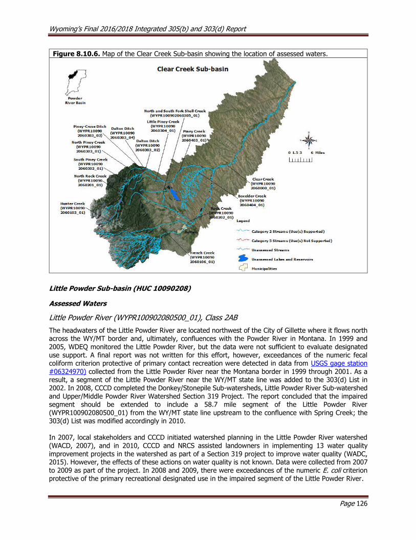
Wyoming’s Final 2016/2018 Integrated 305(b) and 303(d) Report
Page 126
Figure 8.10.6. Map of the Clear Creek Sub-basin showing the location of assessed waters.
Little Powder Sub-basin (HUC 10090208)
Assessed Waters
Little Powder River (WYPR100902080500_01), Class 2AB
The headwaters of the Little Powder River are located northwest of the City of Gillette where it flows north across the WY/MT border and, ultimately, confluences with the Powder River in Montana. In 1999 and
2005, WDEQ monitored the Little Powder River, but the data were not sufficient to evaluate designated
use support. A final report was not written for this effort, however, exceedances of the numeric fecal coliform criterion protective of primary contact recreation were detected in data from USGS gage station
#06324970) collected from the Little Powder River near the Montana border in 1999 through 2001. As a result, a segment of the Little Powder River near the WY/MT state line was added to the 303(d) List in
2002. In 2008, CCCD completed the Donkey/Stonepile Sub-watersheds, Little Powder River Sub-watershed
and Upper/Middle Powder River Watershed Section 319 Project. The report concluded that the impaired segment should be extended to include a 58.7 mile segment of the Little Powder River
(WYPR100902080500_01) from the WY/MT state line upstream to the confluence with Spring Creek; the 303(d) List was modified accordingly in 2010.
In 2007, local stakeholders and CCCD initiated watershed planning in the Little Powder River watershed
(WACD, 2007), and in 2010, CCCD and NRCS assisted landowners in implementing 13 water quality
improvement projects in the watershed as part of a Section 319 project to improve water quality (WADC, 2015). However, the effects of these actions on water quality is not known. Data were collected from 2007
to 2009 as part of the project. In 2008 and 2009, there were exceedances of the numeric E. coli criterion protective of the primary recreational designated use in the impaired segment of the Little Powder River.

Wyoming’s Final 2016/2018 Integrated 305(b) and 303(d) Report
Page 127
CCCD completed the Powder River and Belle Fourche River Watersheds Monitoring 205(j) Final Report in 2014, which summarizes E. coli and chloride monitoring efforts conducted from 2010 to 2013 on the Little
Powder River. The goal of the study was to determine trends in E. coli and chloride concentrations and to identify potential sources of these pollutants. No exceedances of the numeric chloride criterion protective
of the cold water fish designated use were detected during the study, however, several exceedances of the
numeric E. coli criterion protective of the primary recreational designated use were detected.
In 2014, CCCD sponsored a Section 205j project to define and report E. coli contamination sources in the
Little Powder River Watershed. CCCD collected physical, chemical and biological samples at two study sites along the impaired segment of the Little Powder River (WYPR100902080500_01) during 2015 and 2016.
Biological samples included paired bacterial grab samples to: 1) quantify E. coli concentrations and to 2) conduct microbial source tracking using Quantitative Polymerase Chain Reaction (qPCR) techniques. E. coli data indicated that the primary recreational criterion was exceeded in spring at both sites in 2015, but not
in spring of 2016. The criterion was also exceeded in the fall 2015 at one site, but not the other; samples were not collected at either site in fall 2016. Escherichia coli concentrations were the highest in spring 2015
at both sites, which was correlated with both discharge and turbidity. Between 2005 and 2007, CCCD completed several BMPs that were expected to reduce E. coli loading in the impaired segment of the Little
Powder River; these projects included eight animal feeding operation and 12 septic system improvements.
Microbial source tracking indicated that humans were not a source of E. coli during this study. None of the
chemical or physical data collected as part of this study exceeded water quality criteria.
Figure 8.10.7. Map of the Little Powder Sub-basin showing the location of assessed waters.

Wyoming’s Final 2016/2018 Integrated 305(b) and 303(d) Report
Page 128
8.11 Snake River Basin
The Snake River Basin drains 6,179 mi2 in Wyoming. Major tributaries to the Snake River include the Gros
Ventre River, Hoback River, Greys River, and Salt River. The headwaters of the Snake River are located in
Yellowstone National Park near Two Ocean Plateau where it flows southeast into Grand Teton National Park and into Jackson Lake. The river then flow out of Jackson Lake, through Jackson Hole, and enters
Palisades Reservoir near the WY/ID border. The Snake River ultimately confluences with the Columbia River in Washington.
The Snake River Basin in Wyoming consists solely of the Middle Rockies level III ecoregion (Chapman et
al. 2003). This ecoregion is characterized by high mountains covered by open canopy coniferous forests.
The basin is bordered by the Teton, Snake River, Gros Ventre, Wyoming, and Salt River Mountain Ranges. Mountains transition to sparsely wooded or shrub/grassland foothills. The basin also includes the mid-
elevation sedimentary mountains, alpine zone, Yellowstone plateau, granitic subalpine zone, sedimentary subalpine zone, high elevation valleys, partly forested mountains and dissected plateaus and Teton basin
level IV ecoregions. The northern portion of the basin consists of the volcanically active Yellowstone
Plateau, which is part of the Greater Yellowstone Ecosystem. Soils are dry, coarsely textured and nutrient poor and support coniferous and shrubland forest. Jackson Hole and Star Valley are in the lower elevations
of the basin, and both of these areas are considered high elevation valleys with wet riparian meadows and marshes surrounded by upland terraces, alluvial fans, and low elevation foothills. Mid-elevation sedimentary
mountains make up much of the middle and lower portions of the basin. These mountains are composed of marine deposits, including limestone, dolomite, sandstone and shale, which are water soluble and result
in higher nutrient concentrations in streams. Partially forested mountains make up the remainder of the
middle and lower portions of the basin. These mountains are located within the Snake River and Salt River Mountain Ranges along the WY/ID border. These mountains are dry and steep with shallow soils that limit
the extent to which trees can persist. Therefore, vegetation mostly consists of an even mix of conifers, shrubs and grasses. The alpine zones of these mountains are glaciated areas above timberline that consist
of open rocky areas, talus slopes, alpine tundra and glacial basins. The alpine zone receives larger amounts
of precipitation as compared to the lower elevation surrounding mountains. The mid-elevation mountains of these ranges have moist sedimentary geology and are characterized by a spruce-fir forest broken by
grassy slopes. Lastly, a small portion of the dissected plateaus and Teton Basin ecoregion is situated on the western slope of the Teton Mountain Range. This ecoregion is a high elevation, cold valley, with
productive soils and irrigated croplands. Common land uses within the Snake River Basin include wildlife
habitat, recreation, logging, mining, and livestock grazing.
Jackson Lake and Palisades Reservoir are both part of the USBOR's Minidoka Project. This large irrigation project was initiated in 1902 and was completed in 1907 for the purpose of irrigating lands adjacent to the
Snake River in southern Idaho and northwestern Wyoming. The project includes seven dams, 1,600 miles of canals, 4,000 miles of laterals, and provides hydropower and water for irrigating more than 1,000,000
acres annually. Palisades Reservoir stores approximately 650,000 acre-feet of water and is used for
irrigation, recreation, flood control, and hydropower. Jackson Lake Dam was completed in 1916 and stores approximately 847,000 acre-feet of water. A portion of the water stored in Jackson Lake is used for irrigation
in the Minidoka Project.
Snake Headwaters Sub-basin (HUC 17040101)
The headwaters of the Snake River are located within this sub-basin in Yellowstone National Park. More
than 400 miles of streams in the Snake River Headwaters Sub-basin were designated by Congress in 2009 as Wild and Scenic Rivers. These waters include the Buffalo River, North Buffalo River, South Buffalo River,
Soda Fork Buffalo River, Gros Ventre River, Hoback River, Bailey Creek, Blackrock Creek, Crystal Creek,
Granite Creek, Pacific Creek, Shoal Creek, Willow Creek, and Wolf Creek.
Wyoming’s Final 2016/2018 Integrated 305(b) and 303(d) Report
Page 129
Assessed Waters
North Fork Spread Creek (WYSR170401010503_01), Class 2AB
The headwaters of North Fork Spread Creek are located approximately five miles west of Togwotee Pass
where it flows northwest to its confluence with South Fork Spread Creek, forming Spread Creek. In 1996,
WDEQ collected semi-quantitative physical, chemical, and biological data at four study sites along North Fork Spread Creek. The channel was described as wide and shallow with few pools, streambank erosion
was common, and riparian condition was considered poor. The entire North Fork Spread Creek watershed upstream of the confluence with South Fork Spread Creek did not support its cold water fish and aquatic
life other than fish designated uses due to aquatic habitat degradation. As a result, the entire North Fork
Spread Creek (WYSR170401010503_01) watershed above South Fork Spread Creek was added to the 303(d) List in 1998.
In 1999, USFS completed the North Fork Spread Creek Riparian Demonstration Section 319 Project to
restore riparian and aquatic habitat in the North Fork Spread Creek watershed by reconstructing the channel
and floodplain and re-vegetating the riparian zone. Following restoration efforts, trout abundance in the creek increased by an estimated 43%. In 2003, WDEQ collected biological data in the North Fork Spread
Creek watershed and concluded that it supported its cold water fish and aquatic life other than fish designated uses. The impaired segment of North Fork Spread Creek (WYSR170401010503_01) was
subsequently removed from the 303(d) List in 2008. A final report was not written for this study. A USEPA Section 319 Nonpoint Source Success Story was written for North Fork Spread Creek.
Other Monitoring Efforts in the Sub-basin In 2006, USGS (2007) collected water quality data from Cottonwood Creek, Taggart Creek, Lake Creek,
and Granite Creek across several hydrologic regimes. These data were used to characterize the streams and were compared to data collected in 2002 from other streams in the sub-basin for management
objectives of Grand Teton National Park.
Fish Creek, Class 1
The headwaters of Fish Creek are located along the base of the Teton Mountain Range near Teton Village
where it flows south to its confluence with the Snake River. In 2005 and 2006, a USGS (2009) study was conducted to investigate chronic excessive plant and algae growth in Fish Creek by analyzing the ground-
surface water exchange in the Fish Creek watershed. The study concluded that upper Fish Creek near Teton Village gains large quantities of groundwater between spring and fall, while the middle and lower
reaches of Fish Creek also gain groundwater, but to a lesser extent.
In 2007 and 2008, a second USGS (2010b) study was conducted to determine nutrient concentrations;
identify potential nutrient sources; characterize streambed substrate; and catalogue the algal, macrophyte, and macroinvertebrate communities of Fish Creek. The study identified several chemical and biological
trends along the 15.5 mile study reach. The authors suggested that the abundant plant and algae observed in Fish Creek may rapidly assimilate nutrients because nutrient concentrations measured in groundwater
wells surrounding Fish Creek were consistently higher than concentrations in Fish Creek. However, the
authors concluded that additional sampling would be necessary to conclusively determine the cause of the
excessive algal and macrophyte growth in Fish Creek.
A third USGS (2013) study was conducted to collect additional samples from Fish Creek between 2009 and 2011. The report evaluated all of the physical, chemical, and biological data collected by USGS between
2007 and 2011. The data did not meet all of WDEQ’s QA/QC criteria and were therefore not used to assess
designated use support.
WDEQ is currently working with the Teton Conservation District (TCD) to collect the necessary data and
information to support an assessment of the cold water fish and aquatic life other than fish designated
Wyoming’s Final 2016/2018 Integrated 305(b) and 303(d) Report
Page 130
uses in Fish Creek. So far physical, chemical, and biological data has been collected in 2016 and 2017 at
targeted study sites on Fish Creek and control sites in adjacent watersheds.
USGS (2015), in cooperation with TCD conducted a study of the Fish Creek watershed to describe nutrient sources and relative contributions in the watershed. There were areas of in the watershed that had more
intense nutrient inputs due to wastewater injection wells, livestock waste, residential septic systems and
landscape fertilizer. Major contributors of nitrogen in the watershed were estimated as atmospheric deposition (46%), cattle waste (28%), and lawn fertilizers (11%). Major sources of phosphorus were
estimated as cattle waste (41%), atmospheric deposition (23%), and horse waste (16%). Wastewater injection wells and septic systems were estimated as contributing a relatively small amount of nitrogen
(4.8%) and phosphorus (11%) to the watershed. Results from this study will be used by stakeholders to
help guide effective nutrient reduction BMP implementation.
Snake River and Alpine Lakes in Grand Teton National Park and the John D. Rockefeller Jr. Memorial Parkway
Grand Teton National Park (GTNP) conducted a water quality monitoring project in 2013 that focused on characterizing the discharge and water quality at two Snake River study sites. Water quality was also
evaluated at Amphitheatre, Delta and Surprise Lakes. Snake River discharge patterns were compared to historic streamflow data and water chemistry data were compared to WDEQ aquatic life criteria. No water
quality criteria were exceeded on the Snake River. Total iron concentrations were noted in the report as
being elevated, which is thought to be attributable to natural sources. However, WDEQ’s chronic aquatic life and human health criteria are based on dissolved concentrations, which were low in this study. Delta
Lake had higher nitrogen concentrations than Amphitheatre and Surprise Lakes, which was attributed to glacial ice in the watershed. Phosphorus was also elevated in Delta Lake as compared to the other two
Lakes. GTNP plans to continue monitoring these waters.

Wyoming’s Final 2016/2018 Integrated 305(b) and 303(d) Report
Page 131
Figure 8.11.1. Map of the Snake Headwaters Sub-basin showing the location of assessed waters.
Gros Ventre Sub-basin (HUC 17040102)
The headwaters of the Gros Ventre River are located within the Gros Ventre Mountain Range in the Bridger-
Teton National Forest where it flows northeast around Sportsman Ridge and then northwest to its confluence with the Snake just north of West Gros Ventre Butte.
South Fork Fish Creek (WYSR170401020102_01), Class 2AB
South Fork Fish Creek originates in the Wind River Mountains where it flows northwest and confluences
with Fish Creek and then the Gros Ventre River near the Town of Jackson. In 2009, WDEQ collected physical, chemical, and biological data along a section of South Fork Fish Creek and no exceedances of
evaluated water quality criteria were detected. The report concluded that South Fork Fish Creek supported
its aquatic life other than fish, cold water fish, industry, wildlife, agriculture, and drinking water designated uses. As a result, a 5.7 mile segment of South Fork Fish Creek (WYSR170401020102_01) from
approximately Union Pass Road downstream to Road 646 was placed in Category 2 in 2018.
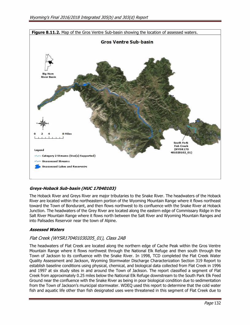
Wyoming’s Final 2016/2018 Integrated 305(b) and 303(d) Report
Page 132
Figure 8.11.2. Map of the Gros Ventre Sub-basin showing the location of assessed waters.
Greys-Hoback Sub-basin (HUC 17040103)
The Hoback River and Greys River are major tributaries to the Snake River. The headwaters of the Hoback River are located within the northeastern portion of the Wyoming Mountain Range where it flows northeast
toward the Town of Bondurant, and then flows northwest to its confluence with the Snake River at Hoback Junction. The headwaters of the Grey River are located along the eastern edge of Commissary Ridge in the
Salt River Mountain Range where it flows north between the Salt River and Wyoming Mountain Ranges and
into Palisades Reservoir near the town of Alpine.
Assessed Waters
Flat Creek (WYSR170401030205_01), Class 2AB
The headwaters of Flat Creek are located along the northern edge of Cache Peak within the Gros Ventre
Mountain Range where it flows northwest through the National Elk Refuge and then south through the
Town of Jackson to its confluence with the Snake River. In 1998, TCD completed the Flat Creek Water Quality Assessment and Jackson, Wyoming Stormwater Discharge Characterization Section 319 Report to
establish baseline conditions using physical, chemical, and biological data collected from Flat Creek in 1996 and 1997 at six study sites in and around the Town of Jackson. The report classified a segment of Flat
Creek from approximately 0.25 miles below the National Elk Refuge downstream to the South Park Elk Feed Ground near the confluence with the Snake River as being in poor biological condition due to sedimentation
from the Town of Jackson’s municipal stormwater. WDEQ used this report to determine that the cold water
fish and aquatic life other than fish designated uses were threatened in this segment of Flat Creek due to
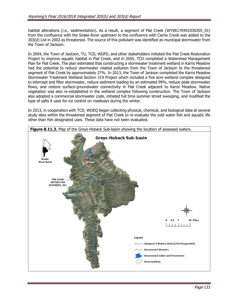
Wyoming’s Final 2016/2018 Integrated 305(b) and 303(d) Report
Page 133
habitat alterations (i.e., sedimentation). As a result, a segment of Flat Creek (WYSR170401030205_01) from the confluence with the Snake River upstream to the confluence with Cache Creek was added to the
303(d) List in 2002 as threatened. The source of this pollutant was identified as municipal stormwater from the Town of Jackson.
In 2004, the Town of Jackson, TU, TCD, WGFD, and other stakeholders initiated the Flat Creek Restoration Project to improve aquatic habitat in Flat Creek, and in 2005, TCD completed a Watershed Management
Plan for Flat Creek. The plan estimated that constructing a stormwater treatment wetland in Karns Meadow had the potential to reduce stormwater related pollution from the Town of Jackson to the threatened
segment of Flat Creek by approximately 27%. In 2013, the Town of Jackson completed the Karns Meadow Stormwater Treatment Wetland Section 319 Project which included a five acre wetland complex designed
to intercept and filter stormwater, reduce sediment loading by an estimated 99%, reduce peak stormwater
flows, and restore surface-groundwater connectivity in Flat Creek adjacent to Karns Meadow. Native vegetation was also re-established in the wetland complex following construction. The Town of Jackson
also adopted a commercial stormwater code, initiated full time summer street sweeping, and modified the type of salts it uses for ice control on roadways during the winter.
In 2013, in cooperation with TCD, WDEQ began collecting physical, chemical, and biological data at several study sites within the threatened segment of Flat Creek to re-evaluate the cold water fish and aquatic life
other than fish designated uses. These data have not been evaluated.
Figure 8.11.3. Map of the Greys-Hoback Sub-basin showing the location of assessed waters.
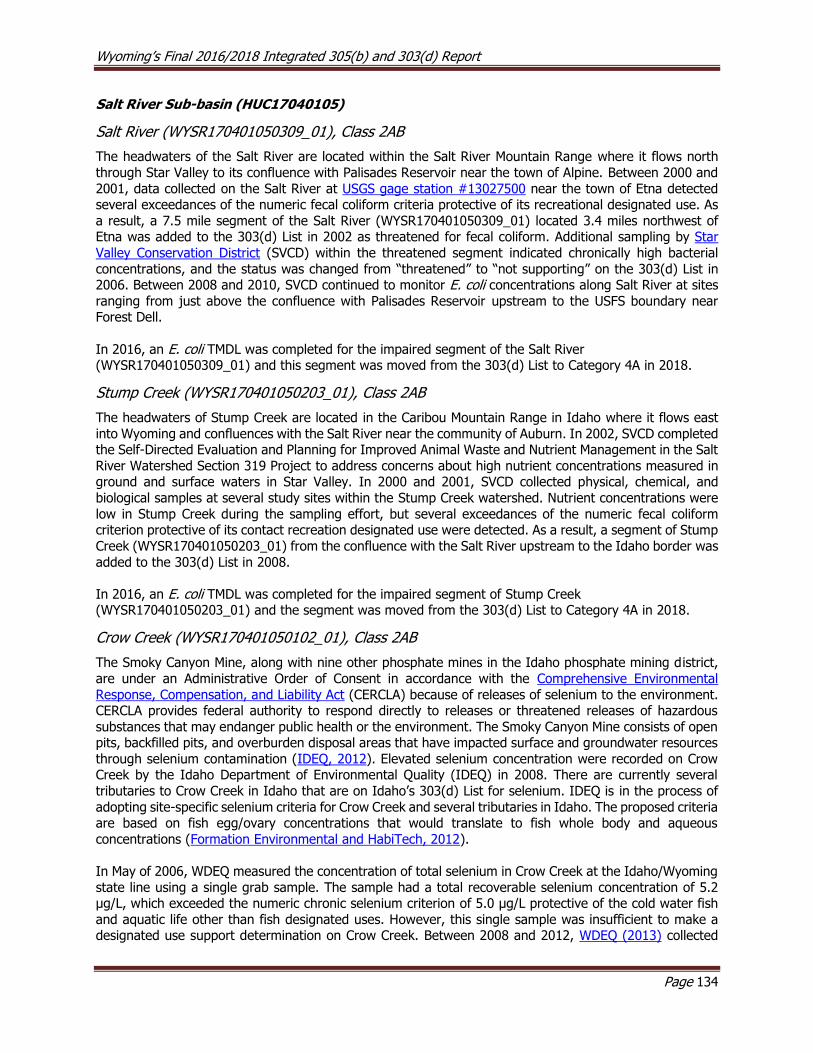
Wyoming’s Final 2016/2018 Integrated 305(b) and 303(d) Report
Page 134
Salt River Sub-basin (HUC17040105)
Salt River (WYSR170401050309_01), Class 2AB
The headwaters of the Salt River are located within the Salt River Mountain Range where it flows north
through Star Valley to its confluence with Palisades Reservoir near the town of Alpine. Between 2000 and
2001, data collected on the Salt River at USGS gage station #13027500 near the town of Etna detected several exceedances of the numeric fecal coliform criteria protective of its recreational designated use. As
a result, a 7.5 mile segment of the Salt River (WYSR170401050309_01) located 3.4 miles northwest of Etna was added to the 303(d) List in 2002 as threatened for fecal coliform. Additional sampling by Star
Valley Conservation District (SVCD) within the threatened segment indicated chronically high bacterial
concentrations, and the status was changed from “threatened” to “not supporting” on the 303(d) List in 2006. Between 2008 and 2010, SVCD continued to monitor E. coli concentrations along Salt River at sites
ranging from just above the confluence with Palisades Reservoir upstream to the USFS boundary near Forest Dell.
In 2016, an E. coli TMDL was completed for the impaired segment of the Salt River (WYSR170401050309_01) and this segment was moved from the 303(d) List to Category 4A in 2018.
Stump Creek (WYSR170401050203_01), Class 2AB
The headwaters of Stump Creek are located in the Caribou Mountain Range in Idaho where it flows east
into Wyoming and confluences with the Salt River near the community of Auburn. In 2002, SVCD completed the Self-Directed Evaluation and Planning for Improved Animal Waste and Nutrient Management in the Salt
River Watershed Section 319 Project to address concerns about high nutrient concentrations measured in ground and surface waters in Star Valley. In 2000 and 2001, SVCD collected physical, chemical, and
biological samples at several study sites within the Stump Creek watershed. Nutrient concentrations were
low in Stump Creek during the sampling effort, but several exceedances of the numeric fecal coliform criterion protective of its contact recreation designated use were detected. As a result, a segment of Stump
Creek (WYSR170401050203_01) from the confluence with the Salt River upstream to the Idaho border was
added to the 303(d) List in 2008.
In 2016, an E. coli TMDL was completed for the impaired segment of Stump Creek (WYSR170401050203_01) and the segment was moved from the 303(d) List to Category 4A in 2018.
Crow Creek (WYSR170401050102_01), Class 2AB
The Smoky Canyon Mine, along with nine other phosphate mines in the Idaho phosphate mining district,
are under an Administrative Order of Consent in accordance with the Comprehensive Environmental
Response, Compensation, and Liability Act (CERCLA) because of releases of selenium to the environment. CERCLA provides federal authority to respond directly to releases or threatened releases of hazardous
substances that may endanger public health or the environment. The Smoky Canyon Mine consists of open pits, backfilled pits, and overburden disposal areas that have impacted surface and groundwater resources
through selenium contamination (IDEQ, 2012). Elevated selenium concentration were recorded on Crow Creek by the Idaho Department of Environmental Quality (IDEQ) in 2008. There are currently several
tributaries to Crow Creek in Idaho that are on Idaho’s 303(d) List for selenium. IDEQ is in the process of
adopting site-specific selenium criteria for Crow Creek and several tributaries in Idaho. The proposed criteria are based on fish egg/ovary concentrations that would translate to fish whole body and aqueous
concentrations (Formation Environmental and HabiTech, 2012).
In May of 2006, WDEQ measured the concentration of total selenium in Crow Creek at the Idaho/Wyoming
state line using a single grab sample. The sample had a total recoverable selenium concentration of 5.2 μg/L, which exceeded the numeric chronic selenium criterion of 5.0 μg/L protective of the cold water fish
and aquatic life other than fish designated uses. However, this single sample was insufficient to make a designated use support determination on Crow Creek. Between 2008 and 2012, WDEQ (2013) collected
Wyoming’s Final 2016/2018 Integrated 305(b) and 303(d) Report
Page 135
additional selenium samples from Crow Creek and Spring Creek, and 13 exceedances of the selenium criterion were detected within this time period on Crow Creek between the ID/WY border and the
confluence with the Salt River. The highest concentration was 19 μg/L and the lowest was 5.2 μg/L. Spring Creek, a small tributary to Crow Creek, was used as a reference stream for comparison in this study. No
exceedances of the chronic selenium criterion were detected. As a result, a 15.6 mile segment of Crow
Creek (WYSR170401050102_01) from the Wyoming/Idaho border downstream to the confluence with the Salt River was added to the 303(d) List in 2014. The source of elevated selenium was identified as
phosphate mining.
Figure 8.11.3. Map of the Salt River Sub-basin showing the location of assessed waters.

Wyoming’s Final 2016/2018 Integrated 305(b) and 303(d) Report
Page 136
8.12 South Platte River Basin
The South Platte River Basin in Wyoming drains approximately 3,623 mi2 and consists of high plains and
southern Rockies level III ecoregions (Chapman et al. 2003). The eastern two thirds of the basin contains
rolling high plains and tablelands and typically receives low precipitation. There are three level IV ecoregions within the high plains, including flat to rolling plains and pine bluffs and hills to the east and relief plains
within the central part of the basin. The Laramie Mountain Range contains two level IV ecoregions; these include the foothills shrublands and mid-elevation forests and shrublands. The higher precipitation that
occurs in the Laramie Mountains promotes a more diverse plant community than lower elevation areas in the basin. The foothills shrubland contains prairie grasses, sagebrush, mountain mahogany inset with
aspen, pine and fir trees. The mid-elevation forests and shrublands are dominated by forests of aspen,
pine and fir trees broken by expanses of shrublands. Streams are generally perennial in the mountains, but can be intermittent in the plains as they flow southeast into Nebraska and Colorado. Primary land uses
include dryland and irrigated farming, livestock grazing, wildlife habitat, recreation, and logging.
Crow Creek Sub-basin (HUC 10190009)
Crow Creek’s headwaters are located in the Laramie Mountain Range west of the City of Cheyenne. The
creek then flows east through the City of Cheyenne and southeast into Colorado near the Town of Carpenter. Stream flows in the upper Crow Creek watershed are augmented by water from the Stage I/II
trans-basin trade system, which pipes water from the Douglas Creek drainage in the upper North Platte
Sub-basin to Crow Creek to supply a portion of Cheyenne’s municipal water supply. The stage I/II trans-basin trade system is responsible for supplying approximately 70% of Cheyenne’s drinking water. Water
from Rob Roy Reservoir is piped to Granite Springs and Crystal Lake Reservoirs (located in the Laramie Mountain Range) before finally reaching Cheyenne. The remaining 30% of Cheyenne’s drinking water
comes from well fields located northwest of Cheyenne.
Assessed Waters
Crow Creek (WYSP101900090107_01, Class 2C; WYSP101900090107_02, Class 2C; WYSP101900090107_03, Class 2C; WYSP101900090107_04, Class 2AB; WYSP101900090107_05, Class 2AB; WYSP101900090203_01, Class 2C)
In 1993, WDEQ (1995) collected chemical, physical, and biological data at six study sites along Crow Creek
in and around the City of Cheyenne, including a reference site located approximately three miles upstream of Cheyenne, three sites within the city limits, and two downstream of Cheyenne. The study identified a
gradient of biological communities where pollution tolerant taxa occurred within Cheyenne city limits and gradually transitioned toward a community more comparable to the reference condition as a function of
distance downstream from Cheyenne. The degraded biological condition within Cheyenne was attributed
to unspecified pollutants entering Crow Creek within Cheyenne city limits. The study did not assess designated use support.
Data collected from Crow Creek at USGS gage station #06756060 near Archer Parkway showed several
exceedances of the fecal coliform numeric criterion protective of contact recreation between 1993 and
1994. In addition, the data showed several exceedances of the acute and chronic ammonia numeric criteria protective of aquatic life between 1993 and 1998. Using this data, WDEQ determined that Crow Creek
above Round Top Road downstream to an undetermined distance below Dry Creek was not supporting its the aquatic life other than fish, cold water fish, and nongame fish designated uses. As a result, two
segments of Crow Creek were placed on the 303(d) List in 1996 for fecal coliform and ammonia: Crow Creek (WYSP101900090107_01) above Dry Creek to an undetermined distance above Round Top Road
and Crow Creek (WYSP101900090203_01) below Dry Creek an undetermined distance downstream.
In 1998 and 1999, WDEQ collected fecal coliform and ammonia samples at several study sites within the
two impaired segments, and the data corroborated those collected by USGS. The source of elevated

Wyoming’s Final 2016/2018 Integrated 305(b) and 303(d) Report
Page 137
ammonia was identified as Cheyenne’s two WWTFs. Both of Cheyenne’s WWTFs were upgraded to tertiary treatment systems that has reduced or eliminated ammonia loading to Crow Creek. In 2007 and 2008, data
collected by WDEQ (2009) and at USGS gage station #06756060 near Archer Parkway indicated that ammonia concentrations in Crow Creek had fallen below the chronic criterion protective of aquatic life. As
a result, the ammonia impairments for these two segments of Crow Creek (WYSP101900090107_01,
WYSP101900090203_01) were removed from the 303(d) List in 2010.
WDEQ (2009) determined that a segment of Crow Creek from Happy Jack Road downstream to Hereford Reservoir #1 did not support its aquatic life other than fish designated use due to sedimentation from the
City of Cheyenne’s stormwater system. As a result, three separate segments of Crow Creek were added to the 303(d) List in 2010: Crow Creek (WYSP101900090107_02) from 0.7 miles below Morrie Avenue
downstream to the inlet of Hereford Reservoir #1, Crow Creek (WYSP101900090107_03) from Morrie
Avenue to a point 0.7 miles downstream, and Crow Creek (WYSP101900090107_04) from Morrie Avenue upstream to Happy Jack Road.
WDEQ (2009) detected exceedances of the chronic total selenium numeric criterion protective of its aquatic
life other than fish designated use in a segment of Crow Creek from approximately 0.7 miles below Morrie
Avenue downstream to the inlet of Hereford Reservoir #1. As a result, selenium was also included as a pollutant for this segment of Crow Creek (WYSP101900090107_02) on the 303(d) List in 2010. In 2013, a
selenium TMDL for Crow Creek was approved by USEPA and the selenium impairment for Crow Creek was removed from the 303(d) List in 2014. However, this segment remains on the 303(d) List because the
sediment TMDL has not been finalized.
USEPA approved six additional TMDLs on Crow Creek in 2014, including one TMDL for fecal coliform
(WYSP101900090107_01), and five TMDLs for E. coli impairments (WYSP101900090107_02, WYSP101900090107_03, WYSP101900090107_04, WYSP101900090107_05, and
WYSP101900090203_01). Three segments (WYSP101900090107_02, WYSP101900090107_03, and WYSP101900090107_04) remain on the 303(d) List due to sediment impairments and the other three
segments (WYSP101900090107_01, WYSP101900090107_05, and WYSP101900090203_01) were placed
in Category 4A in 2014
Data from the Laramie County Conservation District’s (LCCD) 2008-2012 Crow Creek Watershed Cheyenne Area Water Quality Reports documented bacterial exceedances within the impaired segments of Crow
Creek. LCCD continues to monitor water quality and work to provide important education to the public
within the watershed. Within the City of Cheyenne, LCCD has implemented BMPs to reduce pollutant loading in Crow Creek, including the construction of wetlands, riparian fencing and buffer strips to trap pollutants,
irrigation system improvements, animal feeding operation projects, small acreage grazing projects, and storm drain stenciling. LCCD has completed a watershed plan for the Crow Creek watershed.
North Branch North Fork Crow Creek (WYSP101900090104_01) and Middle Fork Crow Creek (WYSP101900090101_01), Class 2AB
The headwaters of the North Branch North Fork Crow Creek (NBNFCC), South Branch Crow Creek, and Middle Fork Crow Creek (MFCC) watershed are located along the eastern slope of the Laramie Mountain
Range west of Cheyenne. In 2003, WDEQ (2003) collected bacterial data at six study sites along the
NBNFCC and the MFCC, and exceedances of the numeric criterion protective of the primary contact recreational designated use were detected in both creeks. As a result, a 1.3 mile segment of NBNFCC
(WYSP101900090104_01) near USFS Road 701 upstream 1.3 miles and a segment of MFCC (WYSP101900090101_01) near USFS Road 700 upstream 1.5 miles were placed on the 303(d) List in 2004.
The primary source of elevated bacterial concentrations in these waters was identified as livestock grazing.
In 2004, LCCD completed the Crow Creek Watershed Plan to address these impairments, and the USFS, in
cooperation with stakeholders, developed Water Quality Action Plans to implement BMPs, monitor water quality, and manage pollutant sources in the Crow Creek watershed. While improvements in water quality
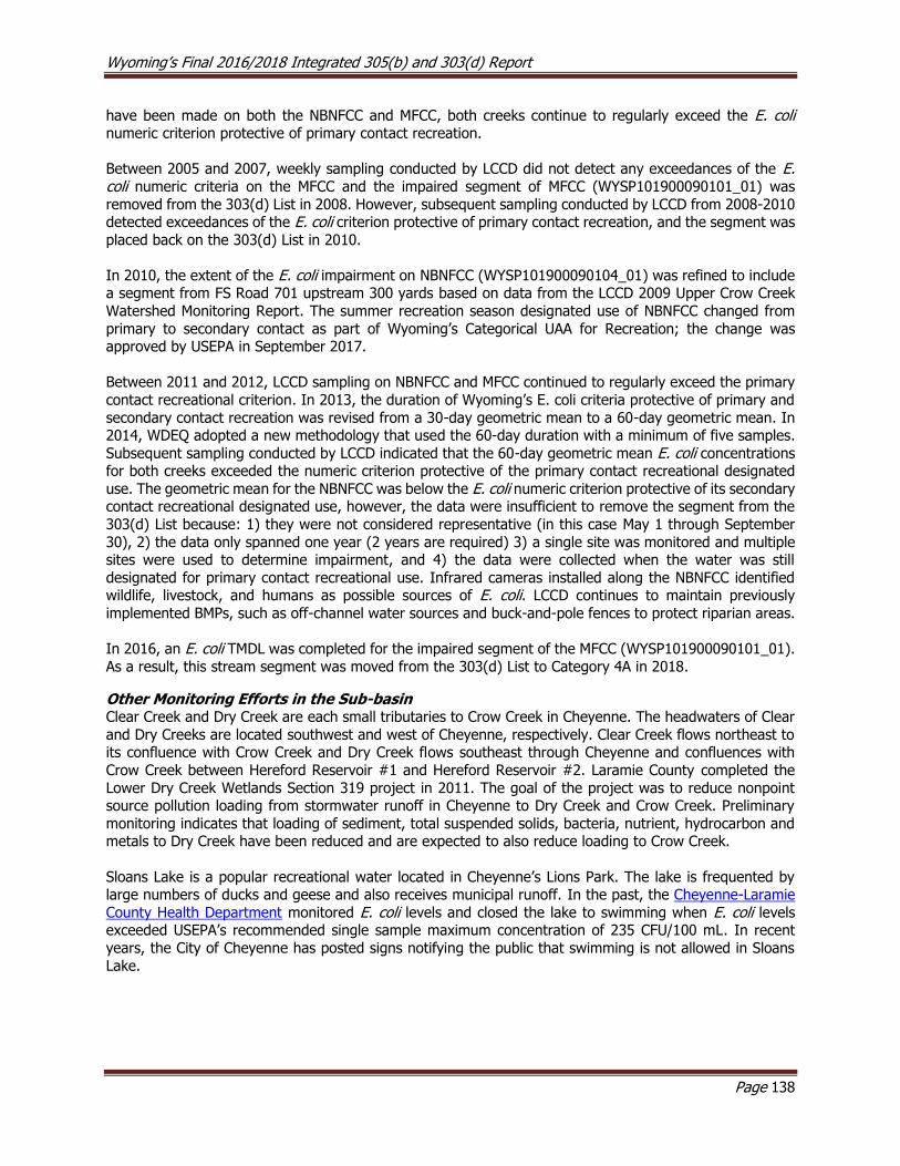
Wyoming’s Final 2016/2018 Integrated 305(b) and 303(d) Report
Page 138
have been made on both the NBNFCC and MFCC, both creeks continue to regularly exceed the E. coli numeric criterion protective of primary contact recreation.
Between 2005 and 2007, weekly sampling conducted by LCCD did not detect any exceedances of the E. coli numeric criteria on the MFCC and the impaired segment of MFCC (WYSP101900090101_01) was
removed from the 303(d) List in 2008. However, subsequent sampling conducted by LCCD from 2008-2010 detected exceedances of the E. coli criterion protective of primary contact recreation, and the segment was
placed back on the 303(d) List in 2010.
In 2010, the extent of the E. coli impairment on NBNFCC (WYSP101900090104_01) was refined to include a segment from FS Road 701 upstream 300 yards based on data from the LCCD 2009 Upper Crow Creek
Watershed Monitoring Report. The summer recreation season designated use of NBNFCC changed from
primary to secondary contact as part of Wyoming’s Categorical UAA for Recreation; the change was approved by USEPA in September 2017.
Between 2011 and 2012, LCCD sampling on NBNFCC and MFCC continued to regularly exceed the primary
contact recreational criterion. In 2013, the duration of Wyoming’s E. coli criteria protective of primary and
secondary contact recreation was revised from a 30-day geometric mean to a 60-day geometric mean. In 2014, WDEQ adopted a new methodology that used the 60-day duration with a minimum of five samples.
Subsequent sampling conducted by LCCD indicated that the 60-day geometric mean E. coli concentrations for both creeks exceeded the numeric criterion protective of the primary contact recreational designated
use. The geometric mean for the NBNFCC was below the E. coli numeric criterion protective of its secondary contact recreational designated use, however, the data were insufficient to remove the segment from the
303(d) List because: 1) they were not considered representative (in this case May 1 through September
30), 2) the data only spanned one year (2 years are required) 3) a single site was monitored and multiple sites were used to determine impairment, and 4) the data were collected when the water was still
designated for primary contact recreational use. Infrared cameras installed along the NBNFCC identified wildlife, livestock, and humans as possible sources of E. coli. LCCD continues to maintain previously
implemented BMPs, such as off-channel water sources and buck-and-pole fences to protect riparian areas.
In 2016, an E. coli TMDL was completed for the impaired segment of the MFCC (WYSP101900090101_01).
As a result, this stream segment was moved from the 303(d) List to Category 4A in 2018.
Other Monitoring Efforts in the Sub-basin Clear Creek and Dry Creek are each small tributaries to Crow Creek in Cheyenne. The headwaters of Clear
and Dry Creeks are located southwest and west of Cheyenne, respectively. Clear Creek flows northeast to its confluence with Crow Creek and Dry Creek flows southeast through Cheyenne and confluences with
Crow Creek between Hereford Reservoir #1 and Hereford Reservoir #2. Laramie County completed the
Lower Dry Creek Wetlands Section 319 project in 2011. The goal of the project was to reduce nonpoint source pollution loading from stormwater runoff in Cheyenne to Dry Creek and Crow Creek. Preliminary
monitoring indicates that loading of sediment, total suspended solids, bacteria, nutrient, hydrocarbon and metals to Dry Creek have been reduced and are expected to also reduce loading to Crow Creek.
Sloans Lake is a popular recreational water located in Cheyenne’s Lions Park. The lake is frequented by large numbers of ducks and geese and also receives municipal runoff. In the past, the Cheyenne-Laramie
County Health Department monitored E. coli levels and closed the lake to swimming when E. coli levels exceeded USEPA’s recommended single sample maximum concentration of 235 CFU/100 mL. In recent
years, the City of Cheyenne has posted signs notifying the public that swimming is not allowed in Sloans
Lake.
Wyoming’s Final 2016/2018 Integrated 305(b) and 303(d) Report
Page 139
Figure 8.12.1. Map of the Crow Creek Sub-basin showing the location of assessed waters.
8.13 Tongue River Basin
The Tongue River Basin in Wyoming drains approximately 2,533 mi2 and consists of the Middle Rockies and
Northwestern Great Plains level III ecoregions (Chapman et al. 2003 ). The Middle Rockies ecoregion
occupies the western one third of the basin, and includes Alpine Zone, Sedimentary Subalpine Zone, Granitic Subalpine Zone and Dry Mid-Elevation Sedimentary Mountains level IV ecoregions. The Alpine Zone receives
high precipitation and is composed of high elevation rocky areas of talus, alpine tundra, and glacial basins. The Alpine Zone transitions to the lower elevation sedimentary subalpine and granitic subalpine zones. The
sedimentary subalpine zone contains fine sedimentary soils. Vegetation consists of pine, spruce and fir forests broken by open grassy slopes. The Granitic Subalpine Zone contains coarse granitic and shallow
bedrock which allow better moisture retention than the sedimentary subalpine zone. Vegetation consists of
a dense canopy of pine, spruce and fir and a sparse understory of shrubs, forbs, and grasses. The Dry Mid-Elevation Sedimentary Mountains form the lower elevation eastern edge of the Big Horn Mountains. These
mountains are a mixture of hills, bluffs, flatirons, and canyons of sedimentary rock. The low precipitation has created an open canopy forest of ponderosa pine, mountain mahogany and shrubs. The basin then
transitions from the mountains to the Pryor-Bighorn Foothills, Montana Central Grasslands and Mesic
Dissected Plains ecoregions making up the eastern two-thirds of the basin. The Pryor-Bighorn Foothills are composed of semi-arid sedimentary terraces, alluvial fans and terraces. Vegetation in this ecoregion
consists mostly of grasses, with some scattered ponderosa pine and mountain mahogany. The Montana Central Grasslands consist of clay soils and vegetation dominated by grasses. The Mesic Dissected Plains
take up approximately the eastern half of the basin. This ecoregion contains steep grassy hills and alluvial
Wyoming’s Final 2016/2018 Integrated 305(b) and 303(d) Report
Page 140
valleys. Perennial streams originating in the Big Horn Mountains and relatively high precipitation have allowed riparian vegetation such as boxelder, snowberry, serviceberry, and bullberry to colonize riparian
corridors. Common land uses in the basin include irrigated agriculture, livestock grazing, wildlife habitat, recreation, logging, and mining.
USGS (2013) analyzed trends in water quality data for several chemical constituents collected between 1980 and 2010 within the Tongue and Powder River basins. Specifically, conductivity, calcium, magnesium,
potassium, sodium adsorption ratio, sodium, alkalinity, chloride, fluoride, dissolved sulfate, and dissolved solids were compared across 16 study sites. The report summarizes general water quality trends and
discusses the potential effects of bicarbonate on aquatic life and sodium on soils.
Wohl et al. (2007) reported that many streams within the Big Horn National Forest have been substantially
impacted by cattle grazing, irrigated crop production, flow regulation and diversion, and timber harvest. Some of these findings are reflected in the categorizations of waters in the basin.
Montana adopted electrical conductivity (EC) and sodium adsorption ratio (SAR) criteria for the Tongue
River in 2006. As of Montana DEQ's 2016 Water Quality Integrated Report, the lowermost segment of the
Tongue River in Montana is identified as impaired for these two parameters (Twelve Mile Dam to the confluence with the Yellowstone River) and they have begun TMDL development for the portion of the
Tongue River within Montana. Information regarding Montana’s Tongue River TMDL is available at: http://mtwaterqualityprojects.pbworks.com/w/page/108827317/Tongue%20River%20Watershed%20TM
DL%20Development.
E. coli TMDLs for Tongue River impaired waters were initiated in 2015, and drafts were completed in July of 2017. The 2018 Integrated Report call for data led to two newly proposed E. coli listings on the mainstem
of the Tongue River, which would have implications for the Dayton, Wyoming, wastewater treatment plant
discharge permit. The TMDL Program decided to table Tongue River TMDL development until the 2018 Integrated Report is approved by the EPA, and expand the draft TMDLs to address the new listings. The
Wyoming Pollution Discharge Elimination System Program (WYPDES) is currently in the process of renewing the discharge permit for Dayton which will lower the E. coli effluent limit to match Wyoming Water Quality
Standards. Tongue River E. coli TMDL development will resume with the approval of the 2018 Integrated Report. The TMDL Program will work with a Technical Advisory Committee on an initial review of the TMDLs,
and then put the draft out for a 45-day public comment period later in 2018. Once public comments have
been addressed, and the Water Quality Division Administrator has approved the TMDLs they will be sent
on for EPA approval.
Tongue Sub-basin (HUC 10090101)
Assessed Waters
Tongue River (WYTR100901010301_01, WYTR100901010111_02, WYTR100901010108_02, Class 2AB; WYTR100901010111_01, Class 1)
The headwaters of the Tongue River watershed are located in the Big Horn Mountains west of the City of Sheridan where it flows northeast through the Towns of Dayton, Ranchester, and Monarch and then across
the WY/MT border near the Town of Decker, Montana. In 1998, WDEQ (2002) collected physical, chemical, and biological data from four stations along a segment of the Tongue River extending from the WY/MT
border upstream to the community of Kleenburn. Although the streambed substrata was composed of more
sand and silt below the confluence with Goose Creek, habitat complexity was considered good at all study sites. The biological condition of the macroinvertebrate community in the Tongue River was slightly
degraded below the confluence with Goose Creek, and temperature, sulfates, and nutrients were identified as possible stressors. Several exceedances of the temperature numeric criterion protective of the cold water
fish designated use were detected during the summer. As a result, a 22.1 mile segment of the Tongue River (WYTR100901010301_01) from the confluence with Goose Creek downstream to the Montana border
Wyoming’s Final 2016/2018 Integrated 305(b) and 303(d) Report
Page 141
was added to the 303(d) List in 2002 because the cold water fish designated use was not supported due to elevated temperature. The source of the elevated temperatures in the Tongue River is not known.
In 1998, WDEQ (2003) collected physical, chemical, and biological data at six study sites along the Tongue
River, extending from just upstream of Dayton downstream to just below Ranchester, but designated use
support was not assessed during this study. In 2000, the Sheridan County Conservation District (SCCD) completed the 1996-1999 Tongue River Watershed Assessment Final Section 319 Report, which involved
monitoring water quality in the Tongue River watershed above the Town of Ranchester and developing a watershed plan for these waters. SCCD collected fecal coliform samples along the Tongue River, and several
exceedances of the fecal coliform numeric criteria protective of the primary contact recreation designated use were detected in the Tongue River above Monarch Road. As a result, a 13.5 mile segment of the
Tongue River (WYTR100901010111_01) from Monarch Road upstream to Wolf Creek Road was added to
the 303(d) List in 2002.
In 2004, SCCD completed the Tongue River Watershed Plan Implementation Final Section 319 Report. Restoration projects identified in the plan were implemented in the watershed between 2001 and 2004.
Projects included hosting workshops to educate the public, an animal feeding operation (AFO)
improvement, a septic system replacement, stream stabilization, and streambank protection. The septic system replacement project focused on replacing a poorly operating septic tank and absorption field located
in the floodplain of the Tongue River. The streambank stabilization project focused on realignment and stabilization of an approximately 1000 foot segment of the Tongue River.
In 2015, SCCD completed the 2013 Tongue River Watershed Interim Monitoring Report (SCCD, 2015),
which summarizes monitoring conducted at 16 study sites along the Tongue River and seven study sites
along tributaries to the Tongue River during the 2013 sampling period. Physical, chemical, and biological water quality data were collected in 2013 from 16 study sites on the Tongue River and its tributaries.
Parameters included some habitat measurements, macroinvertebrate samples, water temperature, pH, specific conductivity, dissolved oxygen, discharge, turbidity, and E. coli bacteria. Exceedances of the E. coli numeric criterion protective of the primary contact recreation designated use were detected at all study
sites, except for the uppermost and lowermost sites on the Tongue River. Exceedances occurred at two previously unassessed segments of the Tongue River and therefore a 7.5 mile segment of the Tongue River
(WYTR100901010108_02) from Wolf Creek Road upstream to the confluence with Smith Creek and a 4.7 mile segment of the Tongue River (WYTR100901010111_02) from the confluence with Goose Creek
upstream to Monarch Road were added to the 303(d) List in 2018. The source(s) of E. coli loading to these
segments is currently unknown, but it is thought to be related to spring runoff, overland flow, and the
resuspension of bacteria in streambed sediments.
North Tongue River (WYTR100901010101_01), Class 1
The headwaters of the North Tongue River watershed are located at the eastern base of Little Bald Mountain in the Big Horn Mountain Range where it flows northeast approximately 21 miles to its confluence with the
Tongue River. In 2003, a citizen complaint was filed with WDEQ regarding high concentrations of cattle in the riparian area of North Tongue River within the Bighorn National Forest. Specifically, the citizen was
concerned about the potential human health effects associated fecal contamination. In 2003, to address
these concerns WDEQ (2003) collected bacteria samples at six study sites along the North Tongue River from just above the confluence with Hidden Teepee Creek downstream to Forest Road 171. Exceedances
of the fecal coliform numeric criterion protective of primary contact recreation were detected in a segment of the North Tongue River from Bull Creek upstream to some undetermined distance above highway 14A,
and this segment of the North Tongue River was added to the 303(d) List in 2004. In 2003 and 2008, USFS
collected additional E. coli data on the North Fork Tongue River at three study sites to more accurately delineate the extent of the impaired segment. Regular exceedances of the fecal coliform numeric criterion
protective of primary contact recreation were detected during the summer months. As a result, the impaired segment of the North Tongue River (WYTR100901010101_01) was extended to include from Forest Road
171 upstream to the confluence with Pole Creek in the 303(d) List in 2010. A report was not written by the

Wyoming’s Final 2016/2018 Integrated 305(b) and 303(d) Report
Page 142
USFS for this study. A diverse stakeholder group, including the USFS, has worked to improve water quality in the North Tongue River by implementing livestock BMPs on the grazing allotments within the watershed.
South Fork Tongue River (WYTR100901010104_02), Class 1
The headwaters of the South Fork Tongue River are located in the Big Horn Mountain Range near the
northern boundary of the Cloud Peak Wilderness where it flows north to its confluence with the Tongue River, approximately 4 miles north of US Route 14. USFS completed a project in 2003 to stabilize the river’s
channel and reduce sediment inputs in the vicinity of the Dead Swede Campground. Between 1993 and 2003, WDEQ (2008) collected physical, chemical, and biological data on the South Tongue River at four
study sites to determine whether excess sediment was impairing the its cold water fish and aquatic life
other than fish designated uses. No exceedances of measured numeric water quality criteria were detected. Some E. coli single sample concentrations were elevated, but insufficient samples were collected to assess
support of the recreational designated use. Habitat condition generally decreased in a downstream gradient due to more pronounced sediment aggradation and streambank degradation. However, the biological
condition at all study sites was determined to be good, and the report concluded that the South Fork
Tongue River supported its aquatic life other than fish and cold water fish designated uses. As a result, an 11.4 mile segment of the South Fork Tongue River (WYTR100901010104_02) from 0.3 miles above HWY
14 upstream to the confluence with the East Fork South Fork Tongue River was placed in Category 2 in 2010.
Prune Creek (WYTR100901010104_01), Class 2AB
The headwaters of Prune Creek are located in the Big Horn Mountains southwest of the Town of Dayton
where it flows north to its confluence with Sibley Lake, and then it flows northwest to its confluence with South Tongue River near US Route 14. In 1998, WDEQ (2002) collected physical, chemical, and biological
data at two study sites along Prune Creek to address concerns that sedimentation was degrading aquatic
habitat. No exceedances of measured water quality criteria were detected and the habitat condition and macroinvertebrate communities were comparable to reference condition at both study sites. The report
concluded that Prune Creek above the South Tongue River supported its cold water fish and aquatic life other than fish designated uses and a segment of Prune Creek (WYTR100901010104_01) from the
confluence with the South Tongue River to a point 5.4 miles upstream was placed in Category 2 in 2002.
Little Tongue River (WYTR100901010107_01, WYTR100901010107_02), Class 2AB
The headwaters of the Little Tongue River watershed are located in the Big Horn Mountain Range west of the City of Sheridan where the river flows northeast around Horseshoe Mountain and temporarily flows
underground beneath a large boulder field before resurfacing. The river then flows approximately 12 miles
to its confluence with the Tongue River near the Town of Dayton. Between 1996 and 1999, WDEQ (2005) and the SCCD collected physical, chemical, and biological data along the Little Tongue River at one site.
WDEQ sampled two additional sites upstream in 2004. No exceedances of measured numeric water quality criteria were detected during the study. Habitat condition was good at the two upstream study sites and
declined slightly at the lowest site due to sediment aggradation. The report concluded the Little Tongue River supported its aquatic life other than fish and cold water fish designated uses within the entire
watershed upstream from the confluence with Frisbee Ditch. As a result, a 79.0 miles of the Little Tongue
River (WYTR100901010107_01) watershed were placed in Category 2 in 2006.
In 2000 and 2001, SCCD collected fecal coliform data from the Little Tongue River and determined that a segment of the Little Tongue River between Frisbee Ditch and the Tongue River was not supporting its
primary contact recreational use designated use. As a result, a 4.8 mile segment of the Little Tongue River
(WYTR100901010107_02) from the confluence with the Tongue River upstream to the confluence with Frisbee Ditch was added to the 303(d) List in 2002.
Wyoming’s Final 2016/2018 Integrated 305(b) and 303(d) Report
Page 143
Columbus Creek (WYTR100901010106_01, Class 2AB)
Columbus Creek is a tributary to the Tongue River that flows out of the eastern slope of the Bighorn
Mountains near the Wyoming-Montana border and joins the Tongue River between the Towns of Ranchester, WY and Dayton, WY. In 2000, the Sheridan County Conservation District (SCCD) completed
the 1996-1999 Tongue River Watershed Assessment Final Section 319 Report, which involved monitoring
water quality in the Tongue River watershed above the Town of Ranchester and developing a watershed plan for these waters. SCCD collected bacteria samples in the Tongue River watershed, and several
exceedances of the fecal coliform numeric criteria protective of the primary contact recreation designated use were detected in Columbus Creek above the Tongue River. As a result, a segment of Columbus Creek
(WYTR100901010106_01) from the Tongue River to a point 3.1 miles upstream was added to the 303(d)
List in 2002.
Smith Creek (WYTR100901010106_02), Class 2AB
Smith Creek is a tributary to the Tongue River that flows out of the eastern slope of the Bighorn Mountains
near the Wyoming-Montana border, south of Columbus Creek, and joins the Tongue River near the Town
of Dayton, WY. In 2000, the Sheridan County Conservation District (SCCD) completed the 1996-1999 Tongue River Watershed Assessment Final Section 319 Report, which involved monitoring water quality in
the Tongue River watershed above the Town of Ranchester and developing a watershed plan for these waters. SCCD collected bacteria samples in the Tongue River watershed, and several exceedances of the
numeric criteria protective of the primary contact recreation designated use were detected in Smith Creek
above the Tongue River. As a result, a segment of Smith Creek (WYTR100901010106_02) from the Tongue River to a point 5.8 miles upstream was added to 303(d) List in 2002.
Fivemile Creek (WYTR100901010108_01), Class 3B
Fivemile Creek is a tributary to the Tongue River that flows out of the hills near Parkman, WY where it
flows south to join the Tongue River near the Town of Ranchester, WY. In 2000, the Sheridan County Conservation District (SCCD) completed the 1996-1999 Tongue River Watershed Assessment Final Section
319 Report, which involved monitoring water quality in the Tongue River watershed above the Town of Ranchester and developing a watershed plan for these waters. SCCD collected bacteria samples in the
Tongue River watershed and several exceedances of the numeric criteria protective of the primary contact
recreation designated use were detected in Fivemile Creek above the Tongue River. As a result, a 2.1 mile segment of Fivemile Creek (WYTR100901010108_01) from the Tongue River upstream to the confluence
with Hanover Ditch was added to the 303(d) List in 2002.
In 2004, SCCD completed the Tongue River Watershed Plan Implementation Final Section 319 Report. Restoration projects identified in the plan were implemented in the watershed between 2001 and 2004.
Projects included hosting workshops to educate the public, an animal feeding operation (AFO)
improvement, a septic system replacement, stream stabilization, and streambank protection. The AFO project focused on moving livestock corrals approximately 1000 feet away from Fivemile Creek and re-
seeding the original location of the corrals.
Wolf Creek (WYTR100901010110_01), Class 2AB
Wolf Creek is a tributary to the Tongue River that flows out of the eastern slope of the Bighorn Mountains south of the Little Tongue River where it flows north and joins the Tongue River near the Town of
Ranchester, WY. In 2000, the Sheridan County Conservation District (SCCD) completed the 1996-1999 Tongue River Watershed Assessment Final Section 319 Report, which involved monitoring water quality in
the Tongue River watershed above the Town of Ranchester and developing a watershed plan for these
waters. SCCD collected bacteria samples in the Tongue River watershed and several exceedances of the criteria protective of the primary contact recreation designated use were detected in Wolf Creek above the
Tongue River. As a result, a 10.6 mile segment of Wolf Creek (WYTR100901010110_01) from the Tongue River upstream to the confluence with East Wolf Creek was added to the 303(d) List in 2002.
Wyoming’s Final 2016/2018 Integrated 305(b) and 303(d) Report
Page 144
Goose Creek (WYTR100901010209_01) Big Goose Creek (WYTR100901010205_01) and Little Goose Creek (WYTR100901010208_01, WYTR100901010207_03, WYTR100901010208_04), Class 2AB
The headwaters of the Goose Creek watershed are located in the Bighorn Mountains southwest of the City of Sheridan. Little Goose Creek and Big Goose Creek flow northeast and confluence to form Goose Creek
within the City of Sheridan. Goose Creek continues flowing north to its confluence with the Tongue River near the community of Kleenburn. Water quality monitoring by USGS and WDEQ in the Goose Creek
watershed began several decades ago. In 2001, the SCCD, in partnership with NRCS, Sheridan County, and the City of Sheridan, began extensive monitoring efforts in the watershed to try to understand and address
water quality concerns in the Goose Creek watershed. In 2001-2002, SCCD conducted the Goose Creek
Watershed Assessment, in partnership with Sheridan County and the City of Sheridan. Interim monitoring was also conducted in 2005, 2009, 2012, and in 2015 to evaluate changes in water quality over the long-
term. During interim monitoring, samples were collected at fewer stations and for fewer parameters than the initial assessment.
In the mid-1990s, WDEQ collected fecal coliform data on Big Goose Creek and Little Goose Creek, and several exceedances of the fecal coliform numeric criterion protective of the primary contact recreation
designated use were detected on both creeks. The source of elevated fecal coliform was not identified. As a result, a segment of Big Goose Creek (WYTR100901010205_01) from the City of Sheridan upstream to
the community of Beckton and a segment of Little Goose Creek (WYTR100901010208_01) from the City of Sheridan upstream to the community of Big Horn were added to the 303(d) List in 1996.
In 1998, WDEQ collected fecal coliform samples at four study sites along a segment of Goose Creek extending from below the City of Sheridan’s WWTF upstream to just above the Town of Big Horn, WY.
Exceedances of the fecal coliform numeric criterion protective of the primary contact recreation designated use were detected on Goose Creek and a segment of Goose Creek (WYTR100901010209_01) from the
confluence with Little Goose Creek downstream to the confluence with the Tongue River was added to the
303(d) List in 2000.
In 1999, data from USGS gage station #06302200 indicated exceedances of the fecal coliform numeric criterion protective of the primary contact recreation designated use on Big Goose Creek near the
community of Beckton (USGS 2000). In 1998 and 1999, WDEQ (1999) collected fecal coliform samples
from several study sites along Big Goose Creek and Little Goose Creek. Exceedances of the fecal coliform numeric criterion protective of the primary contact recreation designated use were detected at the four
downstream study sites on Big Goose Creek in 1998 and at the six downstream study sites along Little Good Creek in 1998. As a result, the extent of the impaired segments were extended to include a 19.2 mile
segment of Big Goose Creek (WYTR100901010205_01) from the confluence with Little Goose Creek upstream to the confluence with Rapid Creek and a 3.5 mile segment of Little Goose Creek
(WYTR100901010208_01) from the confluence with Big Goose Creek upstream to Brundage Lane in
Sheridan.
In 1999, WDEQ (2004) collected physical, chemical, and biological data at five study sites along Little Goose Creek in response to concerns of elevated water temperature. Habitat quality in Little Goose Creek was
considered poor due to a degraded riparian zone and a streambed dominated by fine sediments. The
macroinvertebrate community was dominated by tolerant taxa adapted to organic pollution and physical degradation. The report concluded that Little Goose Creek did not support its aquatic life other than fish
designated use due to sedimentation from stormwater from the City of Sheridan. As a result, a segment of Little Goose Creek (WYTR100901010208_01) from the confluence with Big Goose Creek upstream to
Brundage Lane in Sheridan was added to the 303(d) List in 2006 for habitat alterations and sediment.
In 2003, SCCD completed the 2001-2002 Goose Creek Watershed Assessment Section 319 Report under
the direction of the Goose Creek Drainages Advisory Group (GCDAG), which included representatives from
Wyoming’s Final 2016/2018 Integrated 305(b) and 303(d) Report
Page 145
SCCD, Sheridan County Commissioners, and the City of Sheridan. The project included an extensive evaluation of water quality in the Goose Creek watershed and involved collecting physical, chemical, and
fecal coliform samples at 46 study sites on Goose Creek, Big Goose Creek, Little Goose Creek, and several tributaries. Exceedances of the fecal coliform numeric criterion protective of the primary contact recreation
designated use were detected at sites on Goose Creek, Big Goose Creek, Little Goose Creek, Kruse Creek,
Sackett Creek, Jackson Creek, Beaver Creek, McCormick Creek, Rapid Creek, and Soldier Creek which supported the existing 303(d) Listings of these waters. However, the spatial extent of fecal coliform
exceedances observed during this study was less than that previously reported on Goose Creek, Big Goose, and Little Goose, possibly due to low flow conditions. The report noted that elevated water temperatures
were common in the lower watershed and that these reaches may be more appropriately classified as warm water fisheries. Elevated water temperatures may also be related to low flow conditions observed during
the study.
In 2004, WDEQ (2005) collected physical, chemical, and biological data at nine study sites along Little
Goose Creek and Goose Creek above and below the City of Sheridan. Additionally, data was collected from four study sites located below stormwater outfalls discharging to Goose Creek during three separate
precipitation events as part of the sampling requirements for a WYPDES stormwater permit. The report
concluded that Goose Creek did not support its aquatic life other than fish and cold water fish designated uses because stormwater discharges from the City of Sheridan were contributing excessive sediment to
Goose Creek. As a result, 12.7 mile segment of Goose Creek (WYTR100901010209_01) from the confluence with Little Goose Creek downstream to the confluence with the Tongue River was added to the 303(d) List
in 2006. The source of the excess sediment was identified as stormwater runoff.
TMDLs were completed in 2010 for the sediment impaired segments of Goose Creek
(WYTR100901010209_01) and Little Goose Creek (WYTR100901010208_01) and these stream segments were moved from the 303(d) List to Category 4A in 2012.
In 2011, SCCD completed the 2009 Goose Creek Watershed Interim Monitoring Section 319 Report. Monitoring results confirmed that all of the above waters continue to have high E. coli concentrations that
tended to increase from 2005 to 2009. The report suggested that E. coli may increase in response to precipitation and snow melt runoff events via overland flow and by stream flows re-suspending streambed
sediments containing E. coli.
In 2014, SCCD completed the 2012 Goose Creek Watershed Interim Monitoring Project Final Report which
summarizes water quality data collected in the Goose Creek watershed during the 2012 spring and summer sampling periods. During the 2012 interim monitoring period, SCCD collected data in the Goose Creek
watershed for E. coli, sediment, macroinvertebrates, temperature, pH conductivity, dissolved oxygen, discharge, turbidity, and qualitative habitat assessments at previously established study sites, plus two
additional sites, to evaluate water quality trends following watershed planning and improvement projects. The data were not sufficient to assess designated use support, however, because the dataset did not
include two separate years of data within a three year period. Instantaneous and continuous water
temperature measurements were occasionally recorded above the 20°C criterion protective of the cold water fish designated use, tributaries tended to have higher bacterial concentrations than main stem sites,
and bacterial concentrations across all sites were highest in summer. Goose and Big Goose Creeks generally had elevated bacterial concentrations in spring and fall along stream segments already known to be
impaired for E. coli. There were elevated bacterial concentrations at five of the six study sites sampled in
both spring and fall, four of which were previously unassessed segments of Little Goose Creek. Exceedances of the E. coli numeric criterion protective of the primary contact recreation designated use were detected
at four sites on Little Goose Creek from Woodland Park Road upstream 11.4 miles to Britton Road; however, WDEQ decided not to add two of these sites to the 303(d) List in 2018 because the geometric means at
both sites were relatively low and it was the first time the criterion had been exceeded at these sites. In addition, in September 2013, WDEQ revised the duration of the E. coli criteria from 30-days to 60-days and
the data were not collected using the 60-day duration. The segment connecting the remaining two sites on

Wyoming’s Final 2016/2018 Integrated 305(b) and 303(d) Report
Page 146
Little Goose Creek (WYTR100901010208_04) from Woodland Park Road to a point 5.3 miles upstream, however, was added to the 303(d) List in 2018 for not meeting its primary contact recreation designated
use due to E. coli.
In 2017, SCCD completed the 2015 Goose Creek Watershed Interim Monitoring Project Final Report which
summarizes water quality data collected in the Goose Creek watershed during the 2012 spring and summer sampling periods. During the 2015 interim monitoring period, SCCD collected data in the Goose Creek
watershed for water temperature, pH, conductivity, dissolved oxygen, discharge, turbidity, and E. coli at 17 study sites, to evaluate water quality trends following watershed planning and improvement projects.
The data were not sufficient to assess use support, however, because the dataset did not include two separate years of data within a three year period. Instantaneous water temperature measurements were
occasionally recorded above the 20°C criterion protective of the cold water fish designated use on the lower
study sites of Goose Creek and on five tributaries. Bacteria concentrations were generally lowest between May and June, with the exception of McCormick Creek. Study sites on the main stem of Goose Creek had
lower bacteria concentrations than tributaries. Exceedances of the E. coli numeric (geometric mean) criterion protective of the primary contact recreation designated use were detected at least once at almost
all study sites, including a previously unassessed study site on Little Goose Creek. As a result, a segment
of Little Goose Creek (WYTR100901010207_03), from the confluence with Kruse Creek to the confluence with Jackson Creek was added to the 303(d) List in 2018. The source(s) of E. coli loading to this segment
was not identified.
The SCCD intends to continue implementing BMPs and monitoring water quality trends at study sites within the Goose Creek watershed every three years as resources allow.
Beaver Creek (WYTR100901010205_02), Class 2AB
In 1998 and 1999, WDEQ (1999) collected fecal coliform samples at one study site along Beaver Creek to
investigate the extent to which it contributed bacterial loading to Big Goose Creek. Exceedances of the
fecal coliform numeric criterion protective of the primary contact recreation designated use were detected on Beaver Creek and a 6.5 mile segment of Beaver Creek (WYTR100901010205_02) from the confluence
with Big Goose Creek upstream to the confluence with Apple Run was added to the 303(d) List in 2000. A TMDL was completed in 2010 for the impaired segment of Beaver Creek (WYTR100901010205_02) and it
was moved from the 303(d) List to Category 4A in 2012.
Park Creek (WYTR100901010204_01), Class 2AB
In 1998 and 1999, WDEQ (1999) collected fecal coliform samples at one study site along Park Creek to investigate the extent to which it contributed bacterial loading to Big Goose Creek. Exceedances of the
fecal coliform numeric criterion protective of the primary contact recreation designated use were detected
on Park Creek and a segment of Park Creek (WYTR100901010204_01) from the confluence with Big Goose Creek to a point 2.8 miles upstream was added to the 303(d) List in 2000. In 2010, a TMDL was completed
for the impaired segment of Park Creek (WYTR100901010204_01) and the segment was moved from the 303(d) List to Category 4A in 2012.
Rapid Creek (WYTR100901010204_02), Class 2AB
In 1998 and 1999, WDEQ (1999) collected fecal coliform samples at one study site along Rapid Creek to
investigate the extent to which it contributed bacterial loading to Big Goose Creek. Exceedances of the fecal coliform numeric criterion protective of the primary contact recreation designated use were detected
on Rapid Creek and a segment of Rapid Creek (WYTR100901010204_02) from the confluence with Big
Goose Creek to a point 3.2 miles upstream was added to the 303(d) List in 2000. A TMDL was completed in 2010 for the impaired segment of Rapid Creek (WYTR100901010204_02) and it was moved from the
303(d) List to Category 4A in 2012.
Wyoming’s Final 2016/2018 Integrated 305(b) and 303(d) Report
Page 147
Kruse Creek (WYTR100901010208_03), Class 2AB
In 1998 and 1999, WDEQ (1999) collected fecal coliform samples at one study site along Kruse Creek to
investigate the extent to which it contributed bacterial loading to Little Goose Creek. Exceedances of the fecal coliform numeric criterion protective of the primary contact recreation designated use were detected
on Kruse Creek and a 2.5 mile segment of Kruse Creek (WYTR100901010208_03) from the confluence with
Little Goose Creek upstream to the confluence with East Fork Kruse Creek was added to the 303(d) List in 2000. A TMDL was completed in 2010 for the impaired segment of Kruse Creek (WYTR100901010208_03)
and it was moved from the 303(d) List to Category 4A in 2012.
Sackett Creek (WYTR100901010207_01), Class 2AB
In 1998 and 1999, WDEQ (1999) collected fecal coliform samples at one study site along Sackett Creek to investigate the extent to which it contributed bacterial loading to Little Goose Creek. Exceedances of the
fecal coliform numeric criterion protective of the primary contact recreation designated use were detected on Sackett Creek and a 3.1 mile segment of Sackett Creek (WYTR100901010207_01) from the confluence
with Little Goose Creek upstream to the confluence with East Fork Sackett Creek was added to the 303(d)
List in 2000. A TMDL was completed in 2010 for the impaired segment of Sackett Creek (WYTR100901010207_01) and it was moved from the 303(d) List to Category 4A in 2012.
Jackson Creek (WYTR100901010207_02), Class 2AB
In 1998 and 1999, WDEQ (1999) collected fecal coliform samples at one study site along Jackson Creek to
investigate the extent to which it contributed bacterial loading to Little Goose Creek. Exceedances of the fecal coliform numeric criterion protective of the primary contact recreation designated use were detected
on Jackson Creek and a segment of Jackson Creek (WYTR100901010207_02) from the confluence with Little Goose Creek to a point 6.4 miles upstream was added to the 303(d) List in 2000. In 2010, a TMDL
was completed for the impaired segment of Jackson Creek (WYTR100901010207_02) and it was moved
from the 303(d) List to Category 4A in 2012.
Soldier Creek (WYTR100901010209_02; WYTR100901010209_03; WYTR100901010209_04), Class 2AB
The headwaters of Soldier Creek are located east of Walker Mountain in the foothills of the Bighorn
Mountains where it flows northeast to its confluence with Goose Creek, north of the City of Sheridan. In 1998 and 1999, WDEQ monitored Soldier Creek at one study site above the confluence with Goose Creek
to determine whether this tributary was contributing significant bacterial loads to Goose Creek. Several exceedances of the fecal coliform numeric criterion protective of the primary contact recreation designated
use were detected on Soldier Creek. As a result, a segment of Soldier Creek (WYTR100901010209_02)
from the confluence with Goose Creek to a point 3.1 miles upstream was added to the 303(d) List in 2000. Data collected by the SCCD in 2001 and 2002 corroborated the results of the previous monitoring effort by
WDEQ (SCCD, 2003). A TMDL was completed in 2010 for the impaired segment of Soldier Creek (WYTR100901010209_02) and it was moved from the 303(d) List to Category 4A in 2012.
In 1998 and 1999, WDEQ (2005) collected physical, chemical, and biological samples from five study sites along Soldier Creek. No exceedances of any of the measured numeric water quality criteria were detected.
Total Suspended Solids (TSS) and turbidity increased from upstream to downstream, which may have been related to changes in land use and/or a precipitation event. Exceedances of the fecal coliform numeric
criterion were detected at the four most downstream study sites, similar to what was previously reported by WDEQ (1999). Habitat quality was considered to be near that of reference at upstream sites but declined
substantially downstream. Macroinvertebrate samples showed that the biological communities at study sites
near Sheridan were in poor condition. The report concluded that Soldier Creek supported its cold water fish and aquatic life other than fish designated uses and a segment of Soldier Creek (WYTR100901010209_04)
from the headwaters to a point 7.3 miles downstream was placed in Category 2 in 2008.

Wyoming’s Final 2016/2018 Integrated 305(b) and 303(d) Report
Page 148
In 2003, WDEQ (2009) collected additional physical, chemical, and biological data on Soldier Creek at five study sites to further investigate whether the aquatic life uses on the middle and lower reaches of Soldier
Creek were degraded. The report concluded that flow alterations were causing the aquatic life uses to be impaired on a segment of Soldier Creek (WYTR100901010209_03) from 3.1 miles upstream from the
confluence with Goose Creek to a point 17 miles upstream. However, because the impairment was caused
by a non-pollutant, flow alterations, the segment was placed in Category 4C in 2010.
Due to concerns from stakeholders that Wyoming’s surface water quality standards did not sufficiently recognize the exemptions afforded to water rights, Senate Enrolled Act 75 was passed during the 2015
legislative session. SEA75 added W.S. § 35-11-302(c) to the Environmental Quality Act and charged WDEQ with developing water quality standards for waters where valid water rights preclude attainment of existing
water quality standards. SEA75 also outlined that WDEQ would prepare a schedule to develop water quality
standards for those waters identified as not meeting water quality standards due to hydrologic modification (i.e., 4C waters). In response to SEA75, WDEQ reevaluated the seven 4C waters that were included in the
2014 Integrated Report against Wyoming’s existing surface water quality standards. The reevaluation of Soldier Creek indicated that there was not sufficient information to determine whether any designated uses
were supported. As a result, Soldier Creek was moved to Category 3 in 2018.
West Fork Big Goose Creek (WYTR100901010203_01), Class 2AB
The headwaters of West Fork Big Goose Creek are located within the northeastern portion of the Cloud Peak Wilderness in the Bighorn Mountains where it flows northeast to its confluence with East Fork Big
Goose Creek, forming Big Goose Creek near the upper end of Big Goose Creek Canyon. WDEQ (1996)
collected biological data at two sites on West Fork Big Goose Creek to assess the physical, chemical, and biological condition of the stream. No exceedances of any of the measured numeric water quality criteria
were detected during the study. Habitat quality within West Fork Goose Creek was good, however, sedimentation appeared to increase below the confluence with Coney Creek. The macroinvertebrate
community within West Fork Big Goose Creek declined somewhat in a downstream direction, and this
decline was attributed to sedimentation from Coney Creek. The report concluded that the West Fork Big Goose Creek watershed, excluding Snail Creek, Sawmill Creek, and Coney Creek, supported its cold water
fish and aquatic life other than fish designated uses. As a result, the entire West Fork Big Goose Creek (WYTR100901010203_01) watershed above Big Goose Creek, excluding Snail Creek, Sawmill Creek, and
Coney Creek, was placed in Category 2 in 2006.
Coney Creek (WYTR100901010203_02), Class 2AB
The headwaters of the Coney Creek watershed are located within the northeast portion of the Cloud Peak Wilderness in the Big Horn Mountains. Coney Creek flows approximately 3.5 miles through Coney and Stull
Lakes and Twin Lakes Reservoir before it confluences with West Fork Big Goose Creek near the USFS Twin
Lakes Campground. WDEQ (1996) collected biological data at one site on Coney Creek to assess the physical, chemical, and biological condition of the stream. Coney Creek had relatively high total suspended
solids (TSS) and turbidity, related to releases from the Twin Lakes Reservoir expansion project. Coney Creek habitat and physical condition was poor, mostly due to sedimentation and streambed embeddedness,
and nearly 100% of the streambed was composed of fine sediment. However, because this condition was the result of a recently completed construction project, it was unknown whether these conditions would
persist. WDEQ therefore decided to collect two additional years of data before assessing the designated
uses of Coney Creek.
In 1996 and 1998, WDEQ (2002) collected physical, chemical, and biological data at a single study site on Coney Creek below Twin Lakes Reservoir. The objective of the study was to determine the effects of a
Twin Lakes Reservoir expansion project on Coney Creek’s designated uses. No exceedances of any of the
measured numeric water quality criteria were detected during the study and the report noted a trend of decreasing TSS and turbidity. Habitat condition including streambed embeddedness and available fish cover
improved over the study period. The study site also had an intact riparian zone and minimal human disturbance. Macroinvertebrate samples suggested that the community was in fair condition. The report
Wyoming’s Final 2016/2018 Integrated 305(b) and 303(d) Report
Page 149
concluded that the Coney Creek watershed supported its cold water fish and aquatic life other than fish designated uses and the entire Coney Creek (WYTR100901010203_02) watershed was placed in Category
2 in 2002.
Prairie Dog Creek (WYTR100901010400_01; WYTR100901010401_02; WYTR100901010402_01), Class 2AB
The headwaters of Prairie Dog Creek are located along Moncreiffe Ridge, within the foothills of the Bighorn
Mountain Range northwest of the Town of Story where it flows northeast across the WY/MT border and confluences with the Tongue River near the town of Decker, MT. The creek is fed by a small spring at its
headwaters at a rate of less than 1 cfs. Water from Prairie Dog Creek is utilized extensively for irrigated
agriculture, and the creek’s natural streamflow is significantly augmented (increased to 60-80 cfs) during the May through September irrigation season using water diverted from the Piney Creek watershed in the
neighboring Powder River basin (EnTech, Inc., 2001). Water is piped to Jenks and Meade Creeks, which are both small tributaries to Prairie Dog Creek. Drop structures on Jenks and Meade Creeks have caused
heavy streambank erosion.
Exceedances of the manganese numeric criterion protective of the secondary drinking water designated
use and the fecal coliform numeric criterion protective of the primary contract recreation designated use were detected in data from USGS gage station #06306250 spanning from 2000 to 2003. In addition, WDEQ
(2005) collected E. coli data at six study sites on Prairie Dog Creek to address concerns regarding elevated
bacterial concentrations in the creek. Exceedances of the numeric bacteria criteria protective of the primary contact recreation designated use were detected at all six sites. As a result of this monitoring, a segment
of Prairie Dog Creek (WYTR100901010402_01) from the confluence with the Tongue River to a point 6.7 miles upstream was added to the 303(d) List in 2004 for manganese and fecal coliform and a segment of
Prairie Dog Creek (WYTR100901010400_01) from I-90 to a point 47.2 miles downstream was added to the 303(d) List in 2004 for fecal coliform. Concentrations of manganese in the creek are far below the human
health criteria, but can cause the discoloration of water and the staining of cooking utensils. It is likely that
the high manganese concentrations are due to the natural geology of the basin (Rice et al, 2002); Prairie Dog Creek is not a source for a public drinking water supply.
In 2009, SCCD completed the final report for the 2007-2008 Prairie Dog Creek Watershed Assessment Section 319 Project. The report identified excess sediment as a pollutant of a concern because it was acting
as a stressor on the macroinvertebrate community in Prairie Dog Creek. The manganese drinking water criterion and the cold water fish water temperature criterion were also exceeded along the impaired
segment of lower Prairie Dog Creek (WYTR100901010400_01), from I-90 to a point 47.2 miles downstream and manganese and temperature were added to the existing fecal coliform impairment for this segment in
2012. In addition, data showed that the temperature criteria was exceeded for the other impaired segment of Prairie Dog Creek, from the confluence with the Tongue River to a point 6.7 miles upstream
(WYTR100901010402_01). As a result, temperature were added to the existing fecal coliform and
manganese impairment for this segment in 2012.
As part of a 2009 Sheridan County Watershed Improvement Section 319 Project, SCCD, NRCS, and local citizens implemented 31 projects designed to address bacterial impairments in the Tongue River, Goose
and Prairie Dog Creek Watersheds. Projects included the replacement of six septic systems, three
streambank stabilization projects, and one large scale river restoration project. SCCD completed a Watershed Based Plan for Prairie Dog Creek in 2011 using data from the 2007-2008 Prairie Dog Creek
Watershed Assessment.
In 2012, SCCD completed the 2011 Prairie Dog Creek Watershed Interim Monitoring Project Final Report. The report corroborated results from SCCD’s 2009 report and described elevated temperature and E. coli concentrations at several sites within the watershed. Excessive fine sediment continues to be a concern
within Prairie Dog Creek that may be impacting the macroinvertebrate community.
Wyoming’s Final 2016/2018 Integrated 305(b) and 303(d) Report
Page 150
In 2016, SCCD completed the 2014 Prairie Dog Creek Watershed Interim Monitoring Project Final Report (SSCD, 2016) which summarizes physical, chemical, and biological data collected at 14 study sites on Prairie
Dog Creek during the 2011 and 2014 sampling period. Exceedances of the E. coli numeric criterion protective of the primary contact recreation designated use were detected at the eight lowest study sites
along Prairie Dog Creek during spring and summer of 2014, while the uppermost study site near the
Highway 87 bridge crossing only exceeded the criterion during summer of 2014. As a result, a segment of Prairie Dog Creek (WYTR100901010401_02) from I-90 upstream 4.0 miles was added to the 303(d) List in
2018.
All necessary E. coli TMDLs for the Prairie Dog Creek watershed (including Prairie Dog, Meade, Dutch, and
Wildcat Creeks) were completed, and approved by EPA on February 15, 2018.
Meade Creek (WYTR100901010401_01), Class 2AB
In 2009, SCCD completed the final report for the Prairie Dog Creek Watershed Assessment (2007-2008) Section 319 Project. Exceedances of the manganese numeric criterion protective of the secondary drinking
water designated use and of the E. coli criteria protective of the primary contact recreation designated use
were detected on Meade Creek. As a result, a segment of Meade Creek (WYTR100901010401_01) confluence with Prairie Dog Creek upstream 1.1 miles to the confluence with an unnamed tributary was
added to the 303(d) List in 2012 for manganese and E. coli.
Dutch Creek (WYTR100901010405_01), Class 3B
In 2009, SCCD completed the final report for the Prairie Dog Creek Watershed Assessment (2007-2008) Section 319 Project. Exceedances of the E. coli numeric criterion protective of the primary contact recreation
designated use were detected on Dutch Creek. As a result, a segment of Dutch Creek (WYTR100901010405_01) from the confluence with Prairie Dog Creek to a point 1.9 miles upstream was
added to the 303(d) List in 2012.
Wildcat Creek (WYTR100901010402_02), Class 3B
In 2009, SCCD completed the final report for the Prairie Dog Creek Watershed Assessment (2007-2008) Section 319 Project. Exceedances of the E. coli numeric criterion protective of the primary contact recreation
designated use were detected on Wildcat Creek. As a result, a segment of Wildcat Creek
(WYTR100901010402_02) from the confluence with Prairie Dog Creek to a point 0.8 miles upstream was added to the 303(d) List in 2012.
Other Monitoring Efforts in the Sub-basin WDEQ (2003) collected physical, chemical, and biological data at nine sites on Prairie Dog Creek and one sample each on Jenks, Murphy, Meade, and Wildcat Creeks. The report noted elevated TSS, turbidity, and
suspended sediment during the irrigation season as concerns. No measured numeric water quality criteria were exceeded during the study and macroinvertebrate communities were considered to be in good
condition across most study sites. However, designated uses were not assessed.
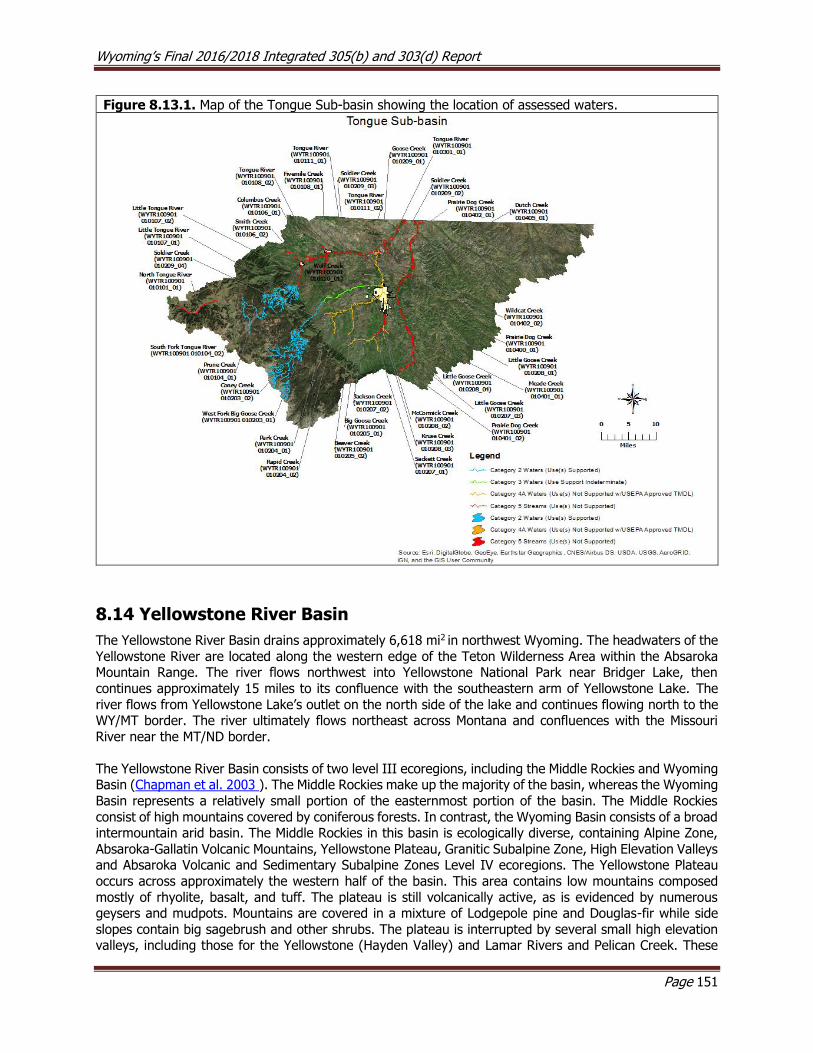
Wyoming’s Final 2016/2018 Integrated 305(b) and 303(d) Report
Page 151
Figure 8.13.1. Map of the Tongue Sub-basin showing the location of assessed waters.
8.14 Yellowstone River Basin
The Yellowstone River Basin drains approximately 6,618 mi2 in northwest Wyoming. The headwaters of the
Yellowstone River are located along the western edge of the Teton Wilderness Area within the Absaroka Mountain Range. The river flows northwest into Yellowstone National Park near Bridger Lake, then
continues approximately 15 miles to its confluence with the southeastern arm of Yellowstone Lake. The
river flows from Yellowstone Lake’s outlet on the north side of the lake and continues flowing north to the WY/MT border. The river ultimately flows northeast across Montana and confluences with the Missouri
River near the MT/ND border.
The Yellowstone River Basin consists of two level III ecoregions, including the Middle Rockies and Wyoming Basin (Chapman et al. 2003 ). The Middle Rockies make up the majority of the basin, whereas the Wyoming
Basin represents a relatively small portion of the easternmost portion of the basin. The Middle Rockies
consist of high mountains covered by coniferous forests. In contrast, the Wyoming Basin consists of a broad intermountain arid basin. The Middle Rockies in this basin is ecologically diverse, containing Alpine Zone,
Absaroka-Gallatin Volcanic Mountains, Yellowstone Plateau, Granitic Subalpine Zone, High Elevation Valleys and Absaroka Volcanic and Sedimentary Subalpine Zones Level IV ecoregions. The Yellowstone Plateau
occurs across approximately the western half of the basin. This area contains low mountains composed
mostly of rhyolite, basalt, and tuff. The plateau is still volcanically active, as is evidenced by numerous geysers and mudpots. Mountains are covered in a mixture of Lodgepole pine and Douglas-fir while side
slopes contain big sagebrush and other shrubs. The plateau is interrupted by several small high elevation valleys, including those for the Yellowstone (Hayden Valley) and Lamar Rivers and Pelican Creek. These
Wyoming’s Final 2016/2018 Integrated 305(b) and 303(d) Report
Page 152
valleys are characterized by wet riparian areas and marshes surrounded by terraces and foothill slopes. These valleys are important habitat for ungulates such as elk and bison. There is a small area of sedimentary
subalpine zone in the northwest corner of the basin. This ecoregion is composed of limestone, dolomite, shale and sandstone and vegetation consists of subalpine fir, Engelmann spruce and Lodgepole pine. The
central portion of the basin transitions to the Absaroka-Gallatin Volcanic Mountains, which consists of steep
sided mountains, ash beds and mud flows. Due to natural geology, streams originating in these mountains are often very turbid following precipitation events and have elevated nutrients. These mountains transition
to the higher elevation intermediate Absaroka Volcanic and Granitic Subalpine Zones before terminating in the Alpine Zone. The Absaroka Volcanic ecoregion, occurring in the Absaroka Mountain Range, is relatively
narrow in scope due to the erosion of its steep, broken and loosely consolidated cliff faces composed of ash, tuff, basalt and pumice. The Granitic Subalpine Zone occurs in the Beartooth Mountain Range and
consists of broad glacial valleys with many lakes. The Alpine Zone is a high precipitation area above treeline
and vegetation is limited due to high wind and snow drifting, and largely consists of krummholz (twisted or bent trees) and alpine forbs, sedges and grasses. The east slope of the Beartooth and Absaroka Mountain
Ranges transition to the Bighorn and Bighorn Salt Desert Shrub Basins. These ecoregions receive little precipitation and soils are composed of alkaline sedimentary geology such as shale, sandstone and siltstone.
Vegetation consists mostly of sagebrush, saltbush greasewood and saltgrass. Common land uses in the
Yellowstone Basin include wildlife habitat, livestock grazing, recreation, logging, oil and gas production, and mining.
The riparian areas of Yellowstone National Park have been heavily grazed by elk and/or bison and many
water quality concerns have been reported (Houston, 1982; Singer, 1996). For example, historical photos of the lower Lamar River Valley show thick stands of willow, which are very important for stabilizing
streambanks. Most of these willows were nearly eradicated because of sustained browsing by wildlife, and
as a consequence, considerable bank erosion occurred along the river. With the reintroduction of wolves to Yellowstone National Park, ungulates have been forced to become more mobile, and consequently spend
less time in riparian areas. As a result, riparian vegetation is recovering within Yellowstone National Park (Ripple and Beschta, 2003).
Yellowstone Headwaters Sub-basin (HUC 10070001)
All waters in the Yellowstone Headwaters sub-basin are classified as Class 1 by WDEQ and are contained within either Yellowstone National Park or Teton Wilderness Area. More than half of Yellowstone National
Park is contained within this sub-basin. While the majority of the park in this sub-basin is quite remote and
sees relatively few visitors, more than 3 million people visit the more accessible attractions each year.
In 1998, four sewage spills occurred in Yellowstone National Park within the Yellowstone Headwaters sub-basin. Two spills released approximately 180,000 gallons to Yellowstone Lake, approximately 1,000 gallons
were released to Myriad Creek and 40,000 gallons were released to the Firehole River. WDEQ subsequently
issued discharge permit notice of violations for each of these spills in the latter part of 1998. Yellowstone National Park managers agreed to implement a series of corrective actions in 1999 to reduce the risk of
future spills. Facility upgrades were completed in 2005.
The headwaters of Soda Butte Creek are located in the Absaroka Mountain Range in southern Montana.
The creek flows southwest through Cooke City and the historic New World Mining District before it enters Wyoming and confluences with the Lamar River. The New World Mining District includes the McLaren mill
mine tailings and the now defunct Republic Smelter. Heavy metals from this area have polluted the upper Soda Butte watershed. As a result of these impacts, the aquatic life uses on Soda Butte Creek in Montana
are considered to be impaired due to heavy metals. The Montana Department of Environmental Quality (MDEQ) completed a USEPA approved TMDL for Soda Butte Creek in 2002. The USFS and MDEQ have
relocated a large portion of the contaminated mine tailings and data collected by these entities indicate
that water quality has improved in Soda Butte Creek at the Yellowstone National Park boundary (Tetra
Wyoming’s Final 2016/2018 Integrated 305(b) and 303(d) Report
Page 153
Tech, 2007). It is unknown whether there are impacts to the Soda Butte watershed within Yellowstone National Park.
Clarks Fork Yellowstone Sub-basin (HUC 10070006)
The Clarks Fork Yellowstone River is a major tributary to the Yellowstone River. The headwaters of the Clarks Fork Yellowstone River are located in the Absaroka and Beartooth Mountain Ranges in southern
Montana. The river flows east through mountains and the steep and rugged Clarks Fork Canyon onto the lower elevation Bighorn Basin. The river continues across the WY/MT border near Chance, Montana and
ultimately confluences with the Yellowstone River. The Clarks Fork Wild and Scenic Rivers Act of 1990
added a 20.5 mile segment of the upper Clarks Fork Yellowstone River to the National Wild and Scenic River’s System. This segment extends from approximately 0.5 miles downstream of the Clarks Fork Bridge
on Highway 296 downstream to about 1 mile from the Shoshone National Forest boundary, near the mouth of the Clarks Fork Canyon. The Clarks Fork Yellowstone River above the Shoshone National Forest boundary
is a Class 1 water.
Assessed Waters
Clarks Fork Yellowstone River (WYYR100700060101_01), Class 1
Data collected from USGS gage station #06205450 in the late 1990s showed regular exceedances of the cadmium, silver, and copper aquatic life numeric criteria in the Clarks Fork Yellowstone River near the
WY/MT border. As a result, a 6.8 mile segment of the of the Clarks Fork Yellowstone River
(WYYR100700060101_01) from the Montana border downstream to the confluence with Crazy Creek was added to the 303(d) List in 2000 for not meetings its aquatic life uses due to cadmium, silver, and copper.
Montana also listed portions of the upper Clarks Fork Yellowstone River on its 303(d) List for cadmium, silver, and copper impairments.
The primary source of elevated metals was identified on the Montana 303(d) List as acid mine drainage,
impacts from abandoned mine lands, and mine tailings from historic mining activities in the New World
Mining District near Cooke City, Montana. USEPA approved TMDLs completed by Montana and remediation continues to occur within the New World Mining District. Montana’s TMDLs for the Clarks Fork Yellowstone
River were adopted by WDEQ to address the impaired segment of the river in Wyoming and the three impairments (WYYR100700060101_01) were moved from the 303(d) List to Category 4A in 2008.
Squaw Creek (WYYR100700060106_01), Class 2AB
The headwaters of Squaw Creek are located just beyond the northeastern boundary of the North Absaroka
Wilderness Area within the Absaroka Mountain Range. The creek flows southeast from the base of Squaw Peak to its confluence with the Clarks Fork Yellowstone River near State Route 296. Several anthropogenic
and natural events contributed to the degradation of the aquatic life uses in Squaw Creek during the late
1980s. First, a wildfire severely burned the drainage in 1988. Inadequately sized culverts trapped fine sediments from eroding slopes and then washed out during subsequent runoff events. A diesel fuel spill
occurred in 1989, causing a partial fish kill in the watershed.
In 2001, Park County, USFS, and WGFD completed the Squaw Creek Watershed Section 319 Project to
relocate Forest Road 117 away from the riparian zone and floodplain of Squaw Creek in an effort to reduce sedimentation and improve water quality. A final report for the project concluded that the sedimentation
issues had been addressed (Page and Zubik, 2001), and that Squaw Creek supported its cold water fish and aquatic life other than fish designated uses. As a result, the entire Squaw Creek
(WYYR100700060106_01) watershed upstream from the confluence with the Clarks Fork Yellowstone River was placed in Category 2 in 2002.

Wyoming’s Final 2016/2018 Integrated 305(b) and 303(d) Report
Page 154
Dead Indian Creek (WYYR100700060304_01), Class 2AB
The headwaters of Dead Indian Creek are located in the North Absaroka Wilderness Area, within the
Absaroka Mountain Range west of the town of Cody, where it flows northeast to its confluence with the Clarks Fork Yellowstone River in Clarks Fork Canyon. In 2001, WDEQ (2005) collected physical, chemical,
and biological data from Dead Indian Creek at two study sites located upstream and downstream of State
Route 296. No exceedances of any measured aquatic life numeric criteria were detected. The habitat quality of the lower study site may have been affected by human activities at the Dead Indian Creek Campground,
however, habitat condition at both sites were considered good. The macroinvertebrate communities at both sites contained sensitive taxa, providing additional evidence that water quality was good. The report
concluded that Dead Indian Creek was supported its aquatic life other than fish and cold water fish
designated uses. As a result, a 6.9 mile segment of Dead Indian Creek (WYYR100700060304_01) from the
confluence with the Clarks Fork upstream to Dry Creek was placed in Category 2 in 2002.
Figure 8.14.1. Map of the Clarks Fork Sub-basin showing the location of assessed waters.
9.0 Probability Survey Results
9.1 Bighorn-Yellowstone Survey
Findings from the Bighorn-Yellowstone (BYS) Probabilistic Survey (Hargett and ZumBerge 2014) indicate
that 56% of non-wilderness, non-first order perennial stream and river length (stream miles) in the BYS were in the least-disturbed biological condition or comparable to reference expectations. Approximately
26% of BYS stream miles were considered most-disturbed, implying an appreciable deviation from

Wyoming’s Final 2016/2018 Integrated 305(b) and 303(d) Report
Page 155
reference expectations associated with anthropogenic stressors. The remaining 18% of BYS stream miles were considered indeterminate with respect to biological condition.
Of fourteen stressors evaluated, elevated salinity (38% of stream miles), channel instability (34% of stream
miles), and elevated total suspended solids (TSS) (26% of stream miles) were the three most common stressors that influenced biological condition in the BYS. Of the 34% of stream miles with channel instability,
94% were due to excess sediment, 28% attributed to accelerated bank erosion, and 25% linked to channel incision. Elevated salinity was the most common stressor in the Big Horn Basin and West Big Horn at 70%
and 42%, respectively, of stream miles. Channel instability was within the top three most common stressors
in all HUC 8 clusters: 46% Big Horn Basin, 43% Yellowstone-Shoshone, 25% West Big Horn and 23% Wind River. Elevated TSS was the second most common stressor in the Big Horn Basin (50%) and Wind River
(15%). Some form of nutrient enrichment (elevated concentrations of total nitrogen, nitrate+nitrite-N or total phosphorus) was among the top four most common stressors in all HUC 8 clusters (11% - 44% of
stream miles).
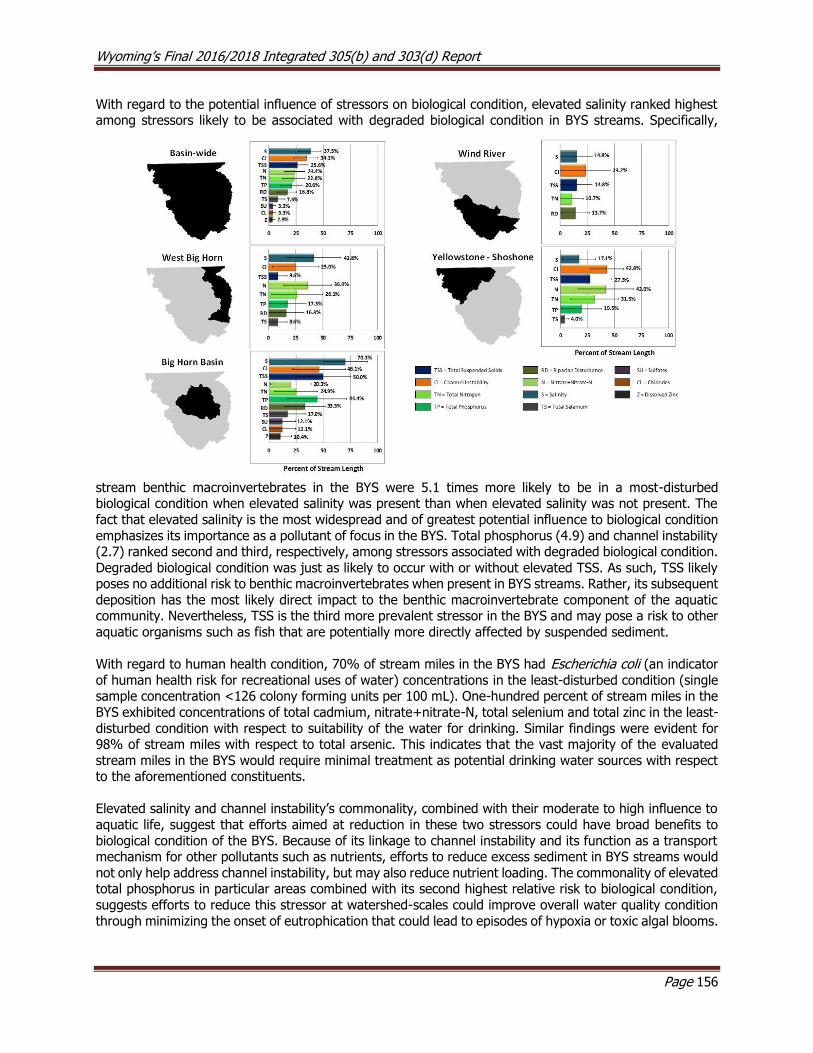
Wyoming’s Final 2016/2018 Integrated 305(b) and 303(d) Report
Page 156
With regard to the potential influence of stressors on biological condition, elevated salinity ranked highest among stressors likely to be associated with degraded biological condition in BYS streams. Specifically,
stream benthic macroinvertebrates in the BYS were 5.1 times more likely to be in a most-disturbed biological condition when elevated salinity was present than when elevated salinity was not present. The
fact that elevated salinity is the most widespread and of greatest potential influence to biological condition
emphasizes its importance as a pollutant of focus in the BYS. Total phosphorus (4.9) and channel instability (2.7) ranked second and third, respectively, among stressors associated with degraded biological condition.
Degraded biological condition was just as likely to occur with or without elevated TSS. As such, TSS likely poses no additional risk to benthic macroinvertebrates when present in BYS streams. Rather, its subsequent
deposition has the most likely direct impact to the benthic macroinvertebrate component of the aquatic community. Nevertheless, TSS is the third more prevalent stressor in the BYS and may pose a risk to other
aquatic organisms such as fish that are potentially more directly affected by suspended sediment.
With regard to human health condition, 70% of stream miles in the BYS had Escherichia coli (an indicator
of human health risk for recreational uses of water) concentrations in the least-disturbed condition (single sample concentration <126 colony forming units per 100 mL). One-hundred percent of stream miles in the
BYS exhibited concentrations of total cadmium, nitrate+nitrate-N, total selenium and total zinc in the least-
disturbed condition with respect to suitability of the water for drinking. Similar findings were evident for 98% of stream miles with respect to total arsenic. This indicates that the vast majority of the evaluated
stream miles in the BYS would require minimal treatment as potential drinking water sources with respect to the aforementioned constituents.
Elevated salinity and channel instability’s commonality, combined with their moderate to high influence to
aquatic life, suggest that efforts aimed at reduction in these two stressors could have broad benefits to
biological condition of the BYS. Because of its linkage to channel instability and its function as a transport mechanism for other pollutants such as nutrients, efforts to reduce excess sediment in BYS streams would
not only help address channel instability, but may also reduce nutrient loading. The commonality of elevated total phosphorus in particular areas combined with its second highest relative risk to biological condition,
suggests efforts to reduce this stressor at watershed-scales could improve overall water quality condition
through minimizing the onset of eutrophication that could lead to episodes of hypoxia or toxic algal blooms.
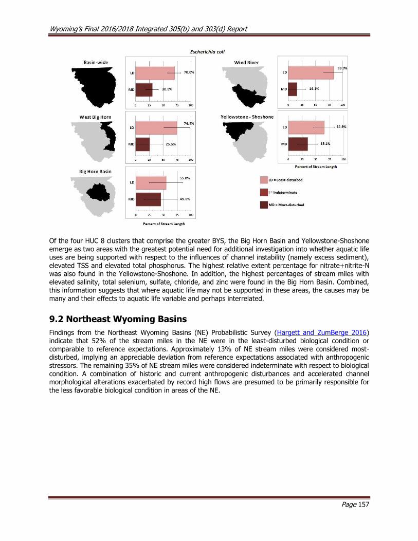
Wyoming’s Final 2016/2018 Integrated 305(b) and 303(d) Report
Page 157
Of the four HUC 8 clusters that comprise the greater BYS, the Big Horn Basin and Yellowstone-Shoshone
emerge as two areas with the greatest potential need for additional investigation into whether aquatic life uses are being supported with respect to the influences of channel instability (namely excess sediment),
elevated TSS and elevated total phosphorus. The highest relative extent percentage for nitrate+nitrite-N was also found in the Yellowstone-Shoshone. In addition, the highest percentages of stream miles with
elevated salinity, total selenium, sulfate, chloride, and zinc were found in the Big Horn Basin. Combined, this information suggests that where aquatic life may not be supported in these areas, the causes may be
many and their effects to aquatic life variable and perhaps interrelated.
9.2 Northeast Wyoming Basins
Findings from the Northeast Wyoming Basins (NE) Probabilistic Survey (Hargett and ZumBerge 2016) indicate that 52% of the stream miles in the NE were in the least-disturbed biological condition or
comparable to reference expectations. Approximately 13% of NE stream miles were considered most-disturbed, implying an appreciable deviation from reference expectations associated with anthropogenic
stressors. The remaining 35% of NE stream miles were considered indeterminate with respect to biological
condition. A combination of historic and current anthropogenic disturbances and accelerated channel morphological alterations exacerbated by record high flows are presumed to be primarily responsible for
the less favorable biological condition in areas of the NE.
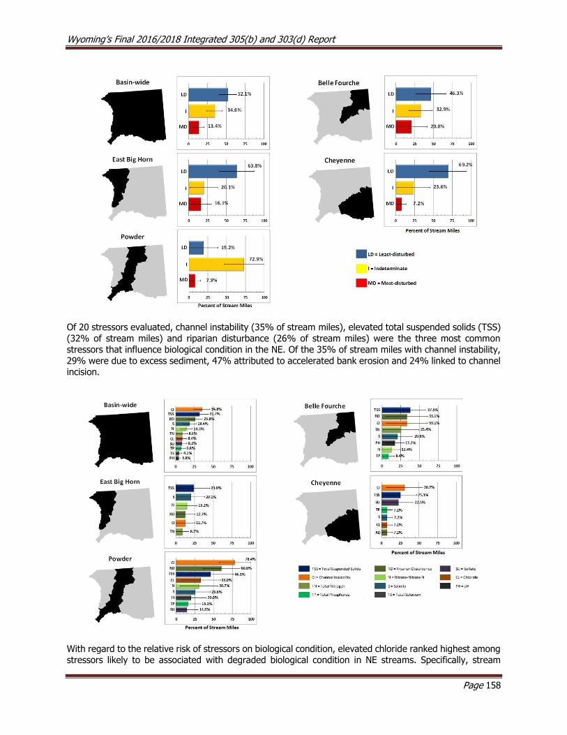
Wyoming’s Final 2016/2018 Integrated 305(b) and 303(d) Report
Page 158
Of 20 stressors evaluated, channel instability (35% of stream miles), elevated total suspended solids (TSS)
(32% of stream miles) and riparian disturbance (26% of stream miles) were the three most common stressors that influence biological condition in the NE. Of the 35% of stream miles with channel instability,
29% were due to excess sediment, 47% attributed to accelerated bank erosion and 24% linked to channel incision.
With regard to the relative risk of stressors on biological condition, elevated chloride ranked highest among stressors likely to be associated with degraded biological condition in NE streams. Specifically, stream
Wyoming’s Final 2016/2018 Integrated 305(b) and 303(d) Report
Page 159
benthic macroinvertebrates in the NE were 5.8 times more likely to be in a most-disturbed biological condition when elevated chloride was present than when not present. However, elevated chloride was only
the 7th most common stressor (8% of stream miles) in the NE. Total phosphorus (4.9) ranked second among stressors associated with degraded biological condition though again was less prevalent throughout
the NE (7% of stream miles). The relative risk of total nitrogen (4.2) implies its association with degraded
biological condition though further investigation suggests this is likely an overestimation as the elevated nitrogen in some streams appeared to be natural and/or the indirect effects of this stressor on the aquatic
community is not clear in the NE. Excluding total nitrogen, channel instability and elevated total selenium tied for 3rd (3.7) among stressors associated with degraded biological condition. The wide-spread extent
of channel instability and its potential influence to biological condition emphasizes its importance as a pollutant of focus in the NE. Similar to chloride and total phosphorus, elevated total selenium was only the
10th ranked stressor (4% of stream miles) throughout the NE. Though TSS ranked as the second most
common stressor in NE streams, a degraded biological condition was just as likely to occur with or without elevated concentrations of this stressor. Therefore, elevated TSS apparently poses no additional risk to
benthic macroinvertebrates when present in NE streams. Rather, its subsequent deposition has the most likely direct impact to the benthic macroinvertebrate component of the aquatic community. As such, TSS
when deposited is reflected as part of the channel instability stressor. Nevertheless, the commonality of
TSS may pose a risk to other aquatic organisms such as fish that are potentially more directly affected by suspended sediment.
With regard to human health condition, 54% of stream miles in the NE had E. coli concentrations in the
least-disturbed condition (singe sample concentration <126 colonies per 100ml), whereas 46% were in a most-disturbed condition (>126 colonies per 100ml). One-hundred percent of stream miles in the NE
exhibited concentrations of total cadmium, nitrate+nitrate-N, total selenium and total zinc in the least-
disturbed condition with respect to suitability of the water for drinking. Similar findings were evident for 91% of stream miles with respect to total arsenic. Only 66% of stream miles were in the least-disturbed
condition for dissolved manganese, which appears largely due to natural factors. This indicates that the vast majority of the evaluated stream miles in the NE would require minimal treatment as potential drinking
water sources with respect to the aforementioned constituents (with the exception of manganese).
The commonality of channel instability and riparian disturbance combined with their moderately high risk
to aquatic life, suggest that where benthic macroinvertebrates communities have been degraded, efforts aimed at reduction in these two stressors could have broad benefits to biological condition of the NE. Based
on the survey data, both stressors were often linked, and from a resource management perspective, efforts
that address one could benefit the other. Accelerated bank erosion was the most prominent of the three stressors linked to channel instability. Efforts to reduce accelerated bank erosion will not only help to
address channel instability and consequently elevated TSS, but may also reduce nutrient loading to streams in the NE since sediment can function as a transport mechanism for pollutants such as total phosphorus.
The commonality of elevated total phosphorus in particular areas of the NE combined with its second highest relative risk to biological condition, suggests efforts to reduce this stressor at watershed-scales
could improve overall water quality condition through minimizing the onset of eutrophication that could
lead to episodes of hypoxia or toxic algal blooms. Elevated chloride and total selenium exhibited the highest and third highest relative risks, respectively, to biological condition. Though their prevalence is confined to
particular watersheds, addressing these stressors could offer large benefits to the biological condition of some NE streams.

Wyoming’s Final 2016/2018 Integrated 305(b) and 303(d) Report
Page 160
9.3 Statewide Surveys
Prior to implementing the current monitoring strategy, WDEQ conducted two statewide probabilistic surveys of Wyoming's perennial streams and rivers (WDEQ, 2013a) in 2004-2007 and 2008-2011. Results from
these surveys provided an objective summary of the biological condition of Wyoming’s streams and rivers and identified the most important stressors. These surveys represent a more focused and representative
effort to characterize Wyoming’s streams relative to EPA’s EMAP-West (Peterson and others 2007). The
target population for the statewide surveys was approximately 17,513 miles (based on 1:24K RF3 digital stream coverage) of perennial streams and rivers or almost one-half of the total miles of perennial streams
and rivers in Wyoming. Biological condition was evaluated at both the statewide scale and separately for three climatic regions of the State: mountain, plains and xeric. A total of 64 and 45 study sites were
evaluated for the first and second statewide surveys, respectively.
According to the most recent statewide survey conducted in 2008-2011, 58% of stream miles in Wyoming
were in a least disturbed biological condition or comparable to reference expectations. This percentage is statistically similar to that estimated during 2004-2007 state wide survey (53%) and the EMAP-West study
period of 2000-2003 (52%). Approximately 18% of Wyoming’s stream miles were considered most-disturbed, implying an appreciable deviation from reference expectations associated with anthropogenic
stressors. This estimate is similar to the first statewide survey (22%). Both statewide surveys showed a
significant reduction from the estimate of most-disturbed stream miles documented during EMAP-WY (32%).
Channel instability and total suspended solids (TSS) were the most widespread stressors for both statewide
surveys, whereas sedimentation and riparian disturbance were the most common stressors statewide
during EMAP-WY. Based on the most recent statewide survey, riparian disturbance was among the most common stressor in all three climatic regions. Nutrient enrichment was the least important stressor both
statewide and within climatic regions.

Wyoming’s Final 2016/2018 Integrated 305(b) and 303(d) Report
Page 161
10.0 Summary of Wyoming’s 305(b) and 303(d) Assessed Waters To date, WDEQ has assessed 273 lotic segments and 13 lentic units in Wyoming, accounting for 18,109
lotic miles and 19,146 lentic acres (Table 10.1). The majority of the assessed lotic miles (87%) and lentic
acres (65%) were determined to support one or more designated uses (USEPA Category 2). None of the assessed lentic acres and less than 1% of the assessed lotic miles did not have sufficient data to determine
designated use support (USEPA Category 3). Approximately one third of the assessed lentic acres (32%) and 4% of the assessed lotic miles have had TMDLs developed to address impairments (USEPA Category
4). Approximately 3% of the assessed lentic acres and 9% of the assessed lotic miles are included on the
303(d) List for one or more impairment (USEPA Category 5).
Table 10.1. Summary of the number of lotic segments (rivers, streams, creeks) and lentic units (lakes, ponds, reservoirs) in each USEPA category, total miles/acres assessed, and the relative percent of assessed miles/acres in each USEPA category. The total number of TMDLs associated with Category 4A waterbodies is shown in parenthesis, and the total number of 303(d) Listings associated with Category 5 waterbodies is shown in parentheses (91).
Category
# of Lotic
Waterbody Segments Assessed
Total Lotic Miles
Assessed
Relative % of
Total Assessed
Miles
# of Lentic
Waterbody Units
Assessed
Total
Lentic Acres
Assessed
Relative %
of Total Assessed
Acres
1 0 0 0% 0 0 0%
2 145 15,794 87% 6 12,475 65%
3 3 25 0% 0 0 0%
4A 50 (60) 650 4% 2 (3) 6,107 32%
4B 0 0 0% 0 0 0%
4C 0 0 0% 0 0 0%
5 75 (91) 1,641 9% 5 (6) 556 3%
TOTAL 273 18,109 100% 13 19,146 100%
Bacteria (E. coli or fecal coliform), selenium, and sediment are the most common causes of lotic impairment
in Wyoming, accounting for over 70% of impaired lotic miles in the state (Figure 10.1). Sediment is the
most common cause of lentic impairment in Wyoming, accounting for over 90% of impaired lentic acres in
the state (Figure 10.2).
Table 10.2. Summary statistics for the causes of water quality impairment for Wyoming’s waterbodies, including both Category 4A and Category 5 (303(d) List) waters. (Please note that each impairment can have more than one cause.)
Summary of Causes and Sources of Wyoming’s Stream Impairments
Causes Miles of Stream/River Acres of Ponds/Lakes
E. Coli or Fecal Coliform 959 -
Selenium 333 147
Sediment 335 6,091
Habitat Modification 131 -
Arsenic 120 -
Chloride 99 -
Temperature 89 -
Manganese 64 -
Oil and Grease 51 -
Nutrients 37 209
Copper 20 -
Ammonia 14 -
Cadmium 12 -
Silver 12 -
pH 8 209
Hydrogen Sulfide 5 -
Phosphate - 15.4
TOTAL 2,290 6,671
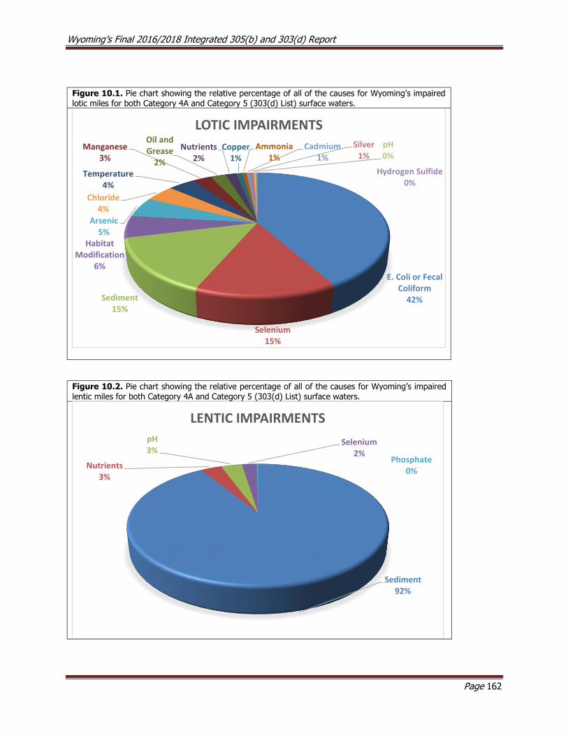
Wyoming’s Final 2016/2018 Integrated 305(b) and 303(d) Report
Page 162
Figure 10.1. Pie chart showing the relative percentage of all of the causes for Wyoming’s impaired lotic miles for both Category 4A and Category 5 (303(d) List) surface waters.
Figure 10.2. Pie chart showing the relative percentage of all of the causes for Wyoming’s impaired lentic miles for both Category 4A and Category 5 (303(d) List) surface waters.
E. Coli or Fecal Coliform
42%
Selenium15%
Sediment15%
Habitat Modification
6%
Arsenic5%
Chloride4%
Temperature4%
Manganese3%
Oil and Grease
2%
Nutrients2%
Copper1%
Ammonia1%
Cadmium1%
Silver1%
pH0%
Hydrogen Sulfide0%
LOTIC IMPAIRMENTS
Sediment92%
Nutrients3%
pH3%
Selenium2%
Phosphate0%
LENTIC IMPAIRMENTS
Wyoming’s Final 2016/2018 Integrated 305(b) and 303(d) Report
Page 163
The number of 303(d) Listed waters and USEPA-approved TMDLs were examined for trends over a twelve year period, including seven Integrated Reporting cycles. (Figure 10.5). The number of 303(d) Listings
steadily increased from 74 in 2004 to a peak of 131 in 2012, and is currently at 98 in 2016 (see Section 10.4.1). This negative trend in the number of 303(d) Listed waters since 2012 is mostly related to the
increased number of USEPA-approved TMDLs. The total number of approved TMDLs changed little from
2004 (0) to 2010 (3), then increased rapidly in 2012 (21) and 2014 (60). There were four new USEPA-approved TMDLs between the 2014 and 2016/2018 Integrated Reports. Table 10.8 lists the TMDL projects
that are either in the initial scoping phases, under development or are being reviewed by USEPA as of the publication date of this report. There are currently 28 TMDLs that are active in some capacity, and thus,
the number of surface waterbodies on the 303(d) List waters will likely decline in 2018.
Figure 10.3. Graph showing the number of 303(d) Listings (red bars) and USEPA approved TMDLs (orange bars) between the 2004-2016 Integrated 305(b) and 303(d) Reports.
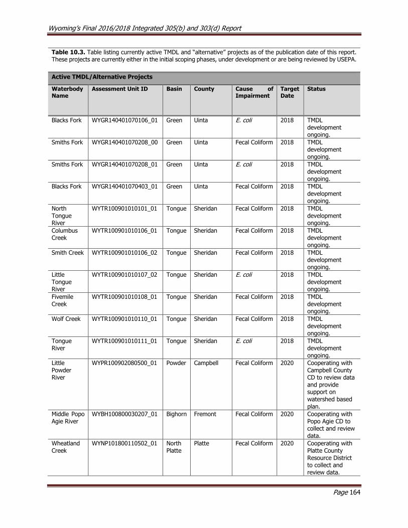
Wyoming’s Final 2016/2018 Integrated 305(b) and 303(d) Report
Page 164
Table 10.3. Table listing currently active TMDL and “alternative” projects as of the publication date of this report. These projects are currently either in the initial scoping phases, under development or are being reviewed by USEPA.
Active TMDL/Alternative Projects
Waterbody Name
Assessment Unit ID Basin County Cause of Impairment
Target Date
Status
Blacks Fork WYGR140401070106_01 Green Uinta E. coli 2018 TMDL development ongoing.
Smiths Fork WYGR140401070208_00 Green Uinta Fecal Coliform 2018 TMDL development ongoing.
Smiths Fork WYGR140401070208_01 Green Uinta E. coli 2018 TMDL development ongoing.
Blacks Fork WYGR140401070403_01 Green Uinta Fecal Coliform 2018 TMDL development ongoing.
North Tongue River
WYTR100901010101_01 Tongue Sheridan Fecal Coliform 2018 TMDL development ongoing.
Columbus Creek
WYTR100901010106_01 Tongue Sheridan Fecal Coliform 2018 TMDL development ongoing.
Smith Creek WYTR100901010106_02 Tongue Sheridan Fecal Coliform 2018 TMDL development ongoing.
Little Tongue River
WYTR100901010107_02 Tongue Sheridan E. coli 2018 TMDL development ongoing.
Fivemile Creek
WYTR100901010108_01 Tongue Sheridan Fecal Coliform 2018 TMDL development ongoing.
Wolf Creek WYTR100901010110_01 Tongue Sheridan Fecal Coliform 2018 TMDL development ongoing.
Tongue River
WYTR100901010111_01 Tongue Sheridan E. coli 2018 TMDL development ongoing.
Little Powder River
WYPR100902080500_01 Powder Campbell Fecal Coliform 2020 Cooperating with Campbell County CD to review data and provide support on
watershed based plan.
Middle Popo Agie River
WYBH100800030207_01 Bighorn Fremont Fecal Coliform 2020 Cooperating with Popo Agie CD to collect and review data.
Wheatland Creek
WYNP101800110502_01 North Platte
Platte Fecal Coliform 2020 Cooperating with Platte County Resource District to collect and review data.

Wyoming’s Final 2016/2018 Integrated 305(b) and 303(d) Report
Page 165
Table 10.3. Table listing currently active TMDL and “alternative” projects as of the publication date of this report. These projects are currently either in the initial scoping phases, under development or are being reviewed by USEPA.
Active TMDL/Alternative Projects
Waterbody Name
Assessment Unit ID Basin County Cause of Impairment
Target Date
Status
Rock Creek WYNP101800110502_02 North Platte
Platte Fecal Coliform 2020 Cooperating with Platte County Resource District to collect and review data.
Flat Creek WYSR170401030205_01 Snake Teton Physical Substrate
Habitat Alterations
2020 Cooperating with Teton County CD
to collect and review data and provide support on watershed based plan.
Laramie River
WYNP101800100201_01 North Platte
Albany E. coli 2022 Cooperating with Laramie Rivers CD to collect and review data.
Little Laramie River
WYNP101800100605_01 North Platte
Albany E. coli 2022 Cooperating with Laramie Rivers CD to collect and review data.
Laramie River
WYNP101800100707_01 North Platte
Albany E. coli 2022 Cooperating with Laramie Rivers CD to collect and
review data.
North Branch North Fork Crow Creek
WYSP101900090104_01 South Platte
Albany E. coli 2022 Coordinating with the CD’s to prepare either a TMDL or Watershed-Based Plan

Wyoming’s Final 2016/2018 Integrated 305(b) and 303(d) Report
Page 166
10.1 Summary of 2016/2018 Surface Water Quality Assessments
For the 2016/2018 Integrated 305(b) and 303(d) Report (Table 10.1), WDEQ added 11 new pollutant
segment combinations to the 303(d) List (one lake and eight stream segments) because at least one
designated use was not supported. WDEQ also added one impairment to the 303(d) List that had been accidentally left off of the list in 2014 (see Section 10.4, below). WDEQ also added three new segments to
Category 2 because data showed that at least one designated use was supported. Five waterbodies were removed from the 303(d) List: four waters were moved to Category 4A because a TMDL had been
developed to address their impairments and one waterbody was placed in Category 2 because it was supporting its designated uses. Seven 4C segments were either removed from the report (one water),
moved to Category 2 (five waters), or moved to Category 3 (one water).
New 303(d) Listings
Brooks Lake (Bighorn River Basin, WYBH100800010104_01) – Data collected by WDEQ (2015) in 2009-
2012 indicated that Brooks Lake’s cold water fish and aquatic life other than fish designated use was not supported due to elevated nutrients and pH.
Hornecker Creek (Bighorn River Basin, WYBH100800030207_03) – Data collected by PACD in 2012-2014 indicated that Hornecker Creek was exceeding the E. coli numeric criterion protective of its primary
recreation designated use from the confluence with the Middle Fork Popo Agie River upstream 1.5 miles to Sinks Canyon Road.
Middle Fork Popo Agie River (Bighorn River Basin, WYBH100800030207_05) – Data collected by PACD in
2012-2014 indicated that the Middle Fork Popo Agie River was exceeding the E. coli criterion
protective of its primary recreation designated use in a segment from the confluence with the Hornecker Creek to a point 0.7 miles downstream.
Laramie River (North Platte River Basin, WYNP101800100504_01) – Data collected by WDEQ (2015) in
2009-2010 indicated that the Laramie River cold water fish and aquatic life other than fish
designated uses were not supported due to elevated sediment from the confluence with the Little Laramie River to a point 24 miles upstream.
Little Goose Creek (Tongue River Basin, WYTR100901010207_03, WYTR100901010208_04) - Data
collected by SCCD in 2012 indicated that Little Goose Creek exceeded the E. coli numeric criterion
protective of its primary recreation designated use in a segment from Woodland Park Road to a point 5.3 miles upstream and a segment from the confluence with Kruse Creek to the confluence
with Jackson Creek.
Prairie Dog Creek (Tongue River Basin, WYTR100901010401_02) – Data collected by SCCD in 2011 and 2014 indicated that Prairie Dog Creek exceeded the E. coli numeric criterion protective of its primary
recreation designated use in a segment from I-90 to a point 4.0 miles upstream.
Tongue River (Tongue River Basin, WYTR100901010108_02, WYTR100901010111_02) – Data collected by
SCCD in 2013 indicated that the Tongue River exceeded the E. coli numeric criterion protective of its primary recreation designated use in segment from the confluence with Goose Creek to Monarch
Road and segment from Wolf Creek Road upstream to the confluence with Smith Creek.
Accidentally Omitted 303(d) Listings
Little Popo Agie River (Bighorn River Basin, WYBH100800030108_03) – Data collected by WDEQ (2013) in
1998-2012 indicated that the Little Popo Agie River was exceeding the chronic hydrogen sulfide
numeric criterion protective of the cold water fish and aquatic life other than fish designated uses in a segment from the confluence with Willow Creek upstream 4.5 miles to an oil production facility.

Wyoming’s Final 2016/2018 Integrated 305(b) and 303(d) Report
Page 167
Waters Moved from the 303(d) List to Category 2 (De-listings)
North Platte River (North Platte River Basin, WYNP101800070300_01) – Selenium data collected by NCCD
between 2012 and 2016 at five study sites along the impaired segment of the North Platte River indicated that the North Platte River was meeting the chronic selenium criteria protective of its cold
water fish and aquatic life other than fish designated uses. As a result, the impaired segment of
the North Platte River from the confluence with Muddy Creek upstream to the confluence with Poison Spider Creek was moved from the 303(d) List to Category 2.
Waters Moved from the 303(d) List to Category 4A Due to Completion of TMDLs
Middle Fork Crow Creek (South Platte River Basin, WYSP101900090101_01) –
A 1. 5mile segment of Middle Fork Crow Creek was added to the 303(d) List in 2004 for not meeting its contact recreation designated use due to bacteria. Data collected between 2005 and
2007 showed that the bacteria criteria were met and the segment was removed from the 303(d)
List in 2008. Data collected between 2008 and 2010 then detected exceedances of the E. coli criterion protective of primary contact recreation and the segment was again included on the
303(d) List in 2010. In 2016, an E. coli TMDL was completed for the impaired segment of the
MFCC and it was moved from the 303(d) List to Category 4A.
Salt River (Snake River Basin, WYSR170401050309_01) – A 7.5 mile segment of the Salt River was added
to the 303(d) List in 2002 for threatening the contact recreation use due to bacteria. The impairment was changed to “not supporting” its primary contact recreation designated use in 2006.
In 2016, an E. coli TMDL was completed for this segment of the Salt River and it was moved from
the 303(d) List to Category 4A in 2018.
Stump Creek (Snake River Basin, WYSR170401050203_01) – A 5.6 mile segment of Stump Creek from the confluence of the Salt River upstream to the Idaho border was added to the 303(d) List in 2008
for not supporting its primary contact recreation designated use due to exceedances of the E. coli numeric criterion. In 2018, an E. coli TMDL was completed for the impaired segment of Stump
Creek and it was moved from the 303(d) List to Category 4A in 2016.
Bear River (Bear River Basin, WYBR160101010303_01) – Data collected by WDEQ (2001) in 1995-1998
indicated that the Bear River did not support its cold water fish and aquatic life other than fish designated uses due excess sediment in a segment from the confluence with Woodruff Narrows
Reservoir upstream to the confluence with Sulphur Creek. This segment was added to the 303(d)
List in 2002. In 2018, a sediment TMDL was completed for the impaired segment and this segment of the Bear River was moved from the 303(d) List to Category 4A in 2016.
Prairie Dog Creek (Tongue River Basin, WYTR100901010400_01 and WYTR100901010402_01) -
Exceedances of the fecal coliform numeric criterion protective of the primary contract recreation
designated use were detected in data from USGS gage station #06306250 spanning from 2000 to 2003. In addition, WDEQ (2005) collected E. coli data at six study sites on Prairie Dog Creek to
address concerns regarding elevated bacterial concentrations in the creek. Exceedances of the numeric bacteria criteria protective of the primary contact recreation designated use were
detected at all six sites. As a result of this monitoring, a segment of Prairie Dog Creek (WYTR100901010402_01) from the confluence with the Tongue River to a point 6.7 miles
upstream and a segment (WYTR100901010400_01) from I-90 to a point 47.2 miles downstream
was added to the 303(d) List in 2004 for fecal coliform. E. coli TMDLs were completed for these two segments in 2018. As a result, both segments were moved from the 303(d) List to Category
4A in 2018.
Wyoming’s Final 2016/2018 Integrated 305(b) and 303(d) Report
Page 168
Meade Creek (Tongue River Basin, WYTR100901010401_01) - This segment of Meade Creek (WYTR100901010401_01 – from the confluence with Prairie Dog Creek upstream 1.1 miles to the
confluence with an unnamed tributary) was added to the 303(d) List in 2012 for manganese and E. coli. In 2018, an E. coli TMDL was completed and this segment was moved from the 303(d)
List to Category 4A.
Wildcat Creek (Tongue River Basin, WYTR100901010402_02) - This segment of Wildcat Creek
(WYTR100901010402_02 - from the confluence with Prairie Dog Creek to a point 0.8 miles upstream) was added to the 303(d) List in 2012 for exceedances of the E. coli numeric criterion
protective of the primary contact recreation designated use. In 2018, an E. coli TMDL was completed and this segment was moved from the 303(d) List to Category 4A.
Dutch Creek (Tongue River Basin, WYTR100901010405_01) - This segment of Dutch Creek (WYTR100901010405_01 - from the confluence with Prairie Dog Creek to a point 1.9 miles
upstream) was added to the 303(d) List in 2012 for exceedances of the E. coli numeric criterion protective of the primary contact recreation designated use. In 2018, an E. coli TMDL was
completed and this segment was moved from the 303(d) List to Category 4A.
Bitter Creek (Green River Basin, WYGR140401050506_01) - Bitter Creek was originally placed on the
303(d) List for exceedances of the Fecal Coliform criterion in 2000. In 2006 the segment (WYGR140401050506_01) was extended from the confluence of the Green River to a point 58.1
miles upstream at Point of Rocks. In 2018, an E. coli TMDL was completed and this segment was moved from the 303(d) List to Category 4A.
Killpecker Creek (Green River Basin, WYGR140401050506_01) - Killpecker Creek was originally placed on the 303(d) List for exceedances of the Fecal Coliform criterion in 2000. In 2002 this segment
(WYGR140401050506_01) was extended to include Killpecker Creek from the confluence with Bitter Creek upstream to Reliance. In 2018, an E. coli TMDL was completed and this segment
was moved from the 303(d) List to Category 4A.
New Waters Added to Category 2
Middle Fork Popo Agie River (Bighorn River Basin, WYBH100800030207_04) – Data collected by PACD in
2012-2014 indicated that the Middle Fork Popo Agie River supported its primary contact recreation
designated use in a segment from the confluence with the Hornecker Creek to a point 0.02 miles downstream. As a result, this segment was placed Category 2 in the 2018.
Laramie River (North Platte River Basin, WYNP101800100501_01) – Data collected by WDEQ (2015) in
2009-2010 indicated that the Laramie River supported its drinking water designated use in a
segment from the confluence with Fivemile Creek to a point 7.9 miles downstream. The data was indeterminate as to whether the segment supported its cold water fish and aquatic life other than
fish designated uses. As a result, this segment was placed in Category 2 in 2018.
South Fork Fish Creek (Snake River Basin, WYSR170401020102_01) – Data collected by WDEQ (2014) in
2009 indicated that South Fork Fish Creek supported its drinking water, aquatic life other than fish, cold water fish, industry, wildlife, and agriculture designated uses in a segment from approximately
Union Pass Road downstream to Road 646. As a result, this segment was placed in Category 2 in 2018.
Waters Moved From Category 4C to Category 2
Rock Creek (North Platte River Basin, WYNP101800040202_02) – Data collected by WDEQ (2013) in 2009
and 2010 indicated that Rock Creek from the town of Arlington downstream to the confluence with

Wyoming’s Final 2016/2018 Integrated 305(b) and 303(d) Report
Page 169
the Medicine Bow River did not support its cold water fish and aquatic life other than fish designated uses due to flow alterations and the segment was placed in 4C in 2014. As a result of SEA75 in the
2015 legislative session, WDEQ conducted a reevaluation of Rock Creek and determined that there was not sufficient information to determine whether the cold water fish and aquatic life other than
fish designated uses were supported. However, because fish consumption and drinking water
designated uses were supported, Rock Creek was moved to Category 2 in 2018.
North Fork Crazy Woman Creek (Powder River Basin, WYPR100902050102_01) – Data collected by WDEQ (2014) in 2008 indicated that the a segment of NFCWC from Muddy Creek Road downstream 28
miles to the confluence with the Middle Fork Crazy Woman Creek did not support its cold water fish and aquatic life other than fish designated uses due to flow alterations and the segment was
placed in Category 4C in 2014. As a result of SEA75 in the 2015 legislative session, WDEQ
conducted a reevaluation of NFCWC and determined that there was not sufficient information to determine whether the cold water fish and aquatic life other than fish designated uses were
supported. However, because fish consumption and drinking water designated uses were supported, NFCWC was moved to Category 2 in 2018.
Grass Creek (Bighorn River Basin, WYBH100800070608_01) – Data collected by WDEQ (2003, 2005) in 1998 and 2003 indicated that a 14.1 mile lower reach of Grass Creek did not support its cold water
fish and aquatic life other than fish designated uses due to flow alterations and the segment was placed in Category 4C in 2006. As a result of SEA75 in the 2015 legislative session, WDEQ
conducted a reevaluation of Grass Creek and determined that there was not sufficient information to determine whether the cold water fish and aquatic life other than fish designated uses were
supported. However, because fish consumption and drinking water designated uses were
supported, Grass Creek was moved to Category 2 in 2018.
Crooked Creek (Bighorn River Basin, WYBH100800100500_01) – Data collected by WDEQ (2005) in 2001
indicated that portions of Crooked Creek did not support its aquatic life other than fish designated
use due to flow alterations and the segment was placed in Category 4C in 2006. As a result of
SEA75 in the 2015 legislative session, WDEQ conducted a reevaluation of Crooked Creek and
determined that there was not sufficient information to determine whether the aquatic life other
than fish designated use was supported. However, because fish consumption and drinking water
designated uses were supported, Crooked Creek was moved to Category 2 in 2018.
Muddy Creek (Little Snake River Basin, WYLS140500040104_01) – In the 1990s, upper Muddy Creek was
identified as physically degraded due to livestock grazing and its nongame fish and aquatic life
other than fish designated uses threatened it by habitat alteration. As a result, the lower reaches
of upper Muddy Creek from the confluence with Red Wash upstream to the confluence with
Antelope Creek (west of Highway 789) was added to the 303(d) List in 1996. Several BMPs were
implemented throughout the watershed to reduce sedimentation to Muddy Creek, including
repairing breached spreader dikes (dam structures built across streams to spread flows onto the
adjacent land) to create the George Dew and Red Wash wetlands, which together encompass most
of the threatened segment of Muddy Creek. The resulting wetland complex greatly reduced the
occurrence, magnitude, and duration of scouring stream flows that were causing accelerated
erosion by storing water and gradually releasing it back to Upper Muddy Creek. The threatened
segment was reevaluated and moved from the 303(d) List to Category 4C because the flow
alterations associated with wetland complex were impairing the nongame fish and aquatic life other
than fish designated uses. As a result of SEA75 in the 2015 legislative session, WDEQ conducted a
reevaluation of Muddy Creek and determined that the decision to place upper Muddy Creek in
Category 4C had been incorrect because significant changes to the form and hydrologic function
Wyoming’s Final 2016/2018 Integrated 305(b) and 303(d) Report
Page 170
of the stream had permanently changed the segment from a perennial stream to an artificial
wetland. Available data and information indicated that the current hydrology was consistent with
expected conditions for this waterbody, and the wetland complex was determined to support its
nongame fish and aquatic life other than fish designated uses. As a result, this segment of Muddy
Creek was moved from Category 4C to Category 2 in 2018.
Waters Moved From Category 4C to Category 3
Soldier Creek (Tongue River Basin, WYTR100901010209_03) – Data collected by WDEQ (2009) in 2003
indicated that a 17 mile segment of Soldier Creek did not support its cold water fish and aquatic
life other than fish designated uses due to flow alterations and the segment was placed in Category
4C in 2010. As a result of SEA75 in the 2015 legislative session, WDEQ conducted a reevaluation
of Soldier Creek and determined that there was not sufficient information to determine whether
the cold water fish, aquatic life other than fish, or any other designated uses were supported.
Therefore, Soldier Creek was moved to Category 3 in 2018.
4C Waters Removed from the Integrated Report
Horseshoe Creek (North Platte River Basin, WYNP101800080905_03) – A study conducted by WDEQ (2004)
in 1999 indicated that 7.3 miles of lower Horseshoe Creek were dry and did not support their cold
water fish and aquatic life other than fish designated uses due to flow alterations and the segment
was placed in Category 4C in 2004. As a result of SEA75 in the 2015 legislative session, WDEQ
conducted a reevaluation of Horseshoe Creek and determined that no data had been collected in
the segment and therefore there was not sufficient information to determine whether any
designated uses were supported. WDEQ therefore removed this segment of Horseshoe Creek from
the Integrated Report in 2018.
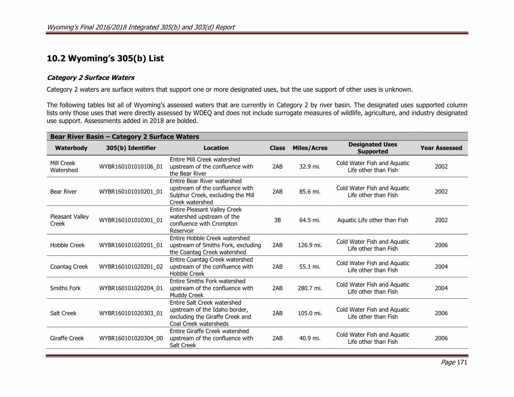
Wyoming’s Final 2016/2018 Integrated 305(b) and 303(d) Report
Page 171
10.2 Wyoming’s 305(b) List
Category 2 Surface Waters
Category 2 waters are surface waters that support one or more designated uses, but the use support of other uses is unknown.
The following tables list all of Wyoming’s assessed waters that are currently in Category 2 by river basin. The designated uses supported column
lists only those uses that were directly assessed by WDEQ and does not include surrogate measures of wildlife, agriculture, and industry designated
use support. Assessments added in 2018 are bolded.
Bear River Basin – Category 2 Surface Waters
Waterbody 305(b) Identifier Location Class Miles/Acres Designated Uses
Supported Year Assessed
Mill Creek Watershed
WYBR160101010106_01 Entire Mill Creek watershed upstream of the confluence with the Bear River
2AB 32.9 mi. Cold Water Fish and Aquatic
Life other than Fish 2002
Bear River WYBR160101010201_01
Entire Bear River watershed upstream of the confluence with Sulphur Creek, excluding the Mill Creek watershed
2AB 85.6 mi. Cold Water Fish and Aquatic
Life other than Fish 2002
Pleasant Valley Creek
WYBR160101010301_01
Entire Pleasant Valley Creek
watershed upstream of the confluence with Crompton Reservoir
3B 64.5 mi. Aquatic Life other than Fish 2002
Hobble Creek WYBR160101020201_01 Entire Hobble Creek watershed upstream of Smiths Fork, excluding the Coantag Creek watershed
2AB 126.9 mi. Cold Water Fish and Aquatic
Life other than Fish 2006
Coantag Creek WYBR160101020201_02 Entire Coantag Creek watershed upstream of the confluence with Hobble Creek
2AB 55.1 mi. Cold Water Fish and Aquatic
Life other than Fish 2004
Smiths Fork WYBR160101020204_01 Entire Smiths Fork watershed upstream of the confluence with Muddy Creek
2AB 280.7 mi. Cold Water Fish and Aquatic
Life other than Fish 2004
Salt Creek WYBR160101020303_01
Entire Salt Creek watershed upstream of the Idaho border, excluding the Giraffe Creek and Coal Creek watersheds
2AB 105.0 mi. Cold Water Fish and Aquatic
Life other than Fish 2006
Giraffe Creek WYBR160101020304_00 Entire Giraffe Creek watershed upstream of the confluence with Salt Creek
2AB 40.9 mi. Cold Water Fish and Aquatic
Life other than Fish 2006
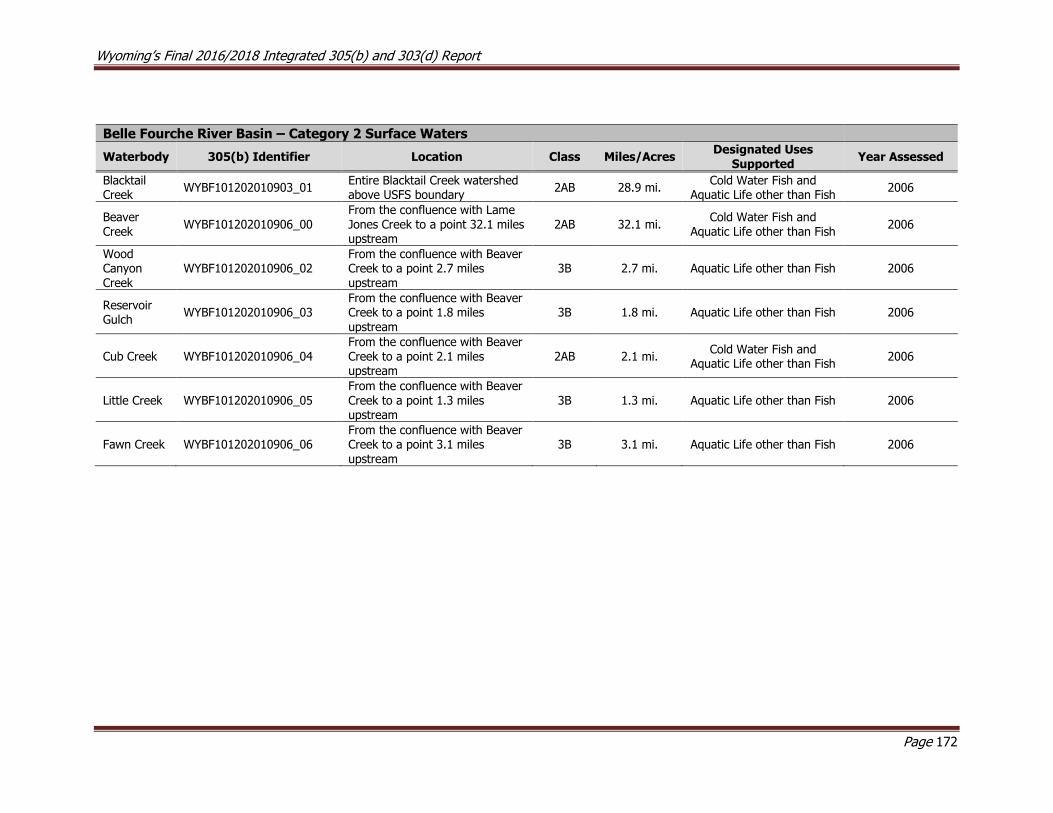
Wyoming’s Final 2016/2018 Integrated 305(b) and 303(d) Report
Page 172
Belle Fourche River Basin – Category 2 Surface Waters
Waterbody 305(b) Identifier Location Class Miles/Acres Designated Uses
Supported Year Assessed
Blacktail Creek
WYBF101202010903_01 Entire Blacktail Creek watershed above USFS boundary
2AB 28.9 mi. Cold Water Fish and
Aquatic Life other than Fish 2006
Beaver Creek
WYBF101202010906_00 From the confluence with Lame Jones Creek to a point 32.1 miles upstream
2AB 32.1 mi. Cold Water Fish and
Aquatic Life other than Fish 2006
Wood Canyon Creek
WYBF101202010906_02 From the confluence with Beaver Creek to a point 2.7 miles upstream
3B 2.7 mi. Aquatic Life other than Fish 2006
Reservoir Gulch
WYBF101202010906_03 From the confluence with Beaver Creek to a point 1.8 miles upstream
3B 1.8 mi. Aquatic Life other than Fish 2006
Cub Creek WYBF101202010906_04 From the confluence with Beaver Creek to a point 2.1 miles upstream
2AB 2.1 mi. Cold Water Fish and
Aquatic Life other than Fish 2006
Little Creek WYBF101202010906_05 From the confluence with Beaver Creek to a point 1.3 miles upstream
3B 1.3 mi. Aquatic Life other than Fish 2006
Fawn Creek WYBF101202010906_06 From the confluence with Beaver Creek to a point 3.1 miles upstream
3B 3.1 mi. Aquatic Life other than Fish 2006

Wyoming’s Final 2016/2018 Integrated 305(b) and 303(d) Report
Page 173
Bighorn River Basin – Category 2 Surface Waters
Waterbody 305(b) Identifier Location Class Miles/Acres Designated Uses
Supported Year
Assessed
Trappers Creek
WYBH100800010110_01 Entire Trappers Creek watershed upstream of the confluence with Warm Springs Creek
2AB 13.5 mi. Cold Water Fish and
Aquatic Life other than Fish
2008
Bear Creek WYBH100800010408_00 Entire Bear Creek watershed upstream of the confluence with the East Fork Wind River
2AB 79.9 mi. Cold Water Fish and
Aquatic Life other than Fish
2006
East Fork Wind River
WYBH100800010409_00 Entire watershed upstream of the confluence with Wiggins Fork, excluding
Bear Creek
2AB 465.2 mi. Cold Water Fish and
Aquatic Life other than
Fish
2006
Little Beaver Creek
WYBH100800020301_01 Entire watershed upstream of the confluence with Beaver Creek
2AB 24.1 mi. Cold Water Fish and
Aquatic Life other than Fish
2008
Beaver Creek
WYBH100800020301_02 Entire mainstem, from the confluence with Little Beaver Creek to a point 19.7 Miles upstream
2AB 19.7 mi.
Cold Water Fish, Aquatic Life other than Fish, Drinking
Water and Fish Consumption
2012
Deep Creek WYBH100800030103_01 Entire watershed upstream of the confluence with Red Canyon Creek
2AB 10.5 mi. Cold Water Fish, Aquatic Life other
than Fish 2008
Little Popo Agie River
WYBH100800030104_01 From the confluence with Red Canyon Creek to a point 8.7 miles downstream
2AB 8.7 mi.
Cold Water Fish, Aquatic Life other than Fish, Drinking
Water and Fish Consumption
2014
Twin Creek WYBH100800030106_01 From the inlet of Carr Reservoir to a point 6.1 miles upstream
2AB 6.1 mi. Drinking Water and Fish Consumption
2014
Twin Creek WYBH100800030106_02 From Old Highway 287 upstream 3.3 miles to the outlet of Carr Reservoir
2AB 3.3 mi. Drinking Water and Fish Consumption
2014
Little Popo Agie River
WYBH100800030108_01 From the confluence with Coal Mine Draw upstream 12.3 miles to the confluence with Willow Creek
2AB 12.4 mi.
Cold Water Fish and Aquatic Life other than Fish, Drinking
Water and Fish Consumption
2014
Little Popo Agie River
WYBH100800030108_02 From the confluence with the Popo Agie River upstream 11.1 miles to the confluence with Coal Mine Draw
2AB 11.1 mi. Drinking Water and Fish Consumption
2014
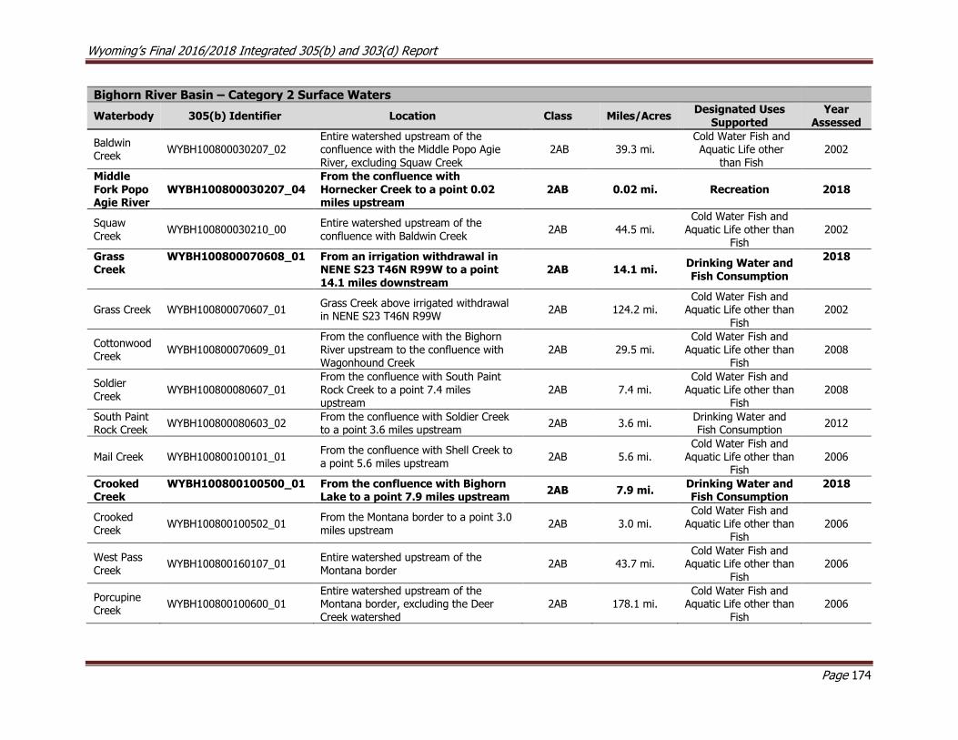
Wyoming’s Final 2016/2018 Integrated 305(b) and 303(d) Report
Page 174
Bighorn River Basin – Category 2 Surface Waters
Waterbody 305(b) Identifier Location Class Miles/Acres Designated Uses
Supported Year
Assessed
Baldwin Creek
WYBH100800030207_02 Entire watershed upstream of the confluence with the Middle Popo Agie River, excluding Squaw Creek
2AB 39.3 mi. Cold Water Fish and Aquatic Life other
than Fish 2002
Middle Fork Popo Agie River
WYBH100800030207_04 From the confluence with Hornecker Creek to a point 0.02 miles upstream
2AB 0.02 mi. Recreation 2018
Squaw
Creek WYBH100800030210_00
Entire watershed upstream of the
confluence with Baldwin Creek 2AB 44.5 mi.
Cold Water Fish and Aquatic Life other than
Fish 2002
Grass Creek
WYBH100800070608_01 From an irrigation withdrawal in NENE S23 T46N R99W to a point 14.1 miles downstream
2AB 14.1 mi. Drinking Water and Fish Consumption
2018
Grass Creek WYBH100800070607_01 Grass Creek above irrigated withdrawal in NENE S23 T46N R99W
2AB 124.2 mi. Cold Water Fish and
Aquatic Life other than Fish
2002
Cottonwood Creek
WYBH100800070609_01 From the confluence with the Bighorn River upstream to the confluence with Wagonhound Creek
2AB 29.5 mi. Cold Water Fish and
Aquatic Life other than Fish
2008
Soldier
Creek WYBH100800080607_01
From the confluence with South Paint Rock Creek to a point 7.4 miles upstream
2AB 7.4 mi. Cold Water Fish and
Aquatic Life other than Fish
2008
South Paint Rock Creek
WYBH100800080603_02 From the confluence with Soldier Creek to a point 3.6 miles upstream
2AB 3.6 mi. Drinking Water and Fish Consumption
2012
Mail Creek WYBH100800100101_01 From the confluence with Shell Creek to a point 5.6 miles upstream
2AB 5.6 mi. Cold Water Fish and
Aquatic Life other than Fish
2006
Crooked Creek
WYBH100800100500_01 From the confluence with Bighorn Lake to a point 7.9 miles upstream
2AB 7.9 mi. Drinking Water and Fish Consumption
2018
Crooked Creek
WYBH100800100502_01 From the Montana border to a point 3.0 miles upstream
2AB 3.0 mi. Cold Water Fish and
Aquatic Life other than Fish
2006
West Pass Creek
WYBH100800160107_01 Entire watershed upstream of the Montana border
2AB 43.7 mi. Cold Water Fish and
Aquatic Life other than Fish
2006
Porcupine Creek
WYBH100800100600_01 Entire watershed upstream of the Montana border, excluding the Deer Creek watershed
2AB 178.1 mi. Cold Water Fish and
Aquatic Life other than Fish
2006
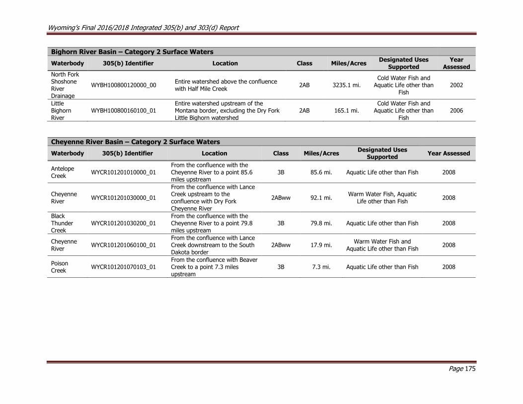
Wyoming’s Final 2016/2018 Integrated 305(b) and 303(d) Report
Page 175
Bighorn River Basin – Category 2 Surface Waters
Waterbody 305(b) Identifier Location Class Miles/Acres Designated Uses
Supported Year
Assessed
North Fork Shoshone River Drainage
WYBH100800120000_00 Entire watershed above the confluence with Half Mile Creek
2AB 3235.1 mi. Cold Water Fish and
Aquatic Life other than Fish
2002
Little Bighorn River
WYBH100800160100_01 Entire watershed upstream of the Montana border, excluding the Dry Fork Little Bighorn watershed
2AB 165.1 mi. Cold Water Fish and
Aquatic Life other than Fish
2006
Cheyenne River Basin – Category 2 Surface Waters
Waterbody 305(b) Identifier Location Class Miles/Acres Designated Uses
Supported Year Assessed
Antelope Creek
WYCR101201010000_01 From the confluence with the Cheyenne River to a point 85.6 miles upstream
3B 85.6 mi. Aquatic Life other than Fish 2008
Cheyenne River
WYCR101201030000_01
From the confluence with Lance Creek upstream to the confluence with Dry Fork Cheyenne River
2ABww 92.1 mi. Warm Water Fish, Aquatic
Life other than Fish 2008
Black Thunder Creek
WYCR101201030200_01 From the confluence with the Cheyenne River to a point 79.8 miles upstream
3B 79.8 mi. Aquatic Life other than Fish 2008
Cheyenne River
WYCR101201060100_01 From the confluence with Lance Creek downstream to the South Dakota border
2ABww 17.9 mi. Warm Water Fish and
Aquatic Life other than Fish 2008
Poison Creek
WYCR101201070103_01 From the confluence with Beaver Creek to a point 7.3 miles upstream
3B 7.3 mi. Aquatic Life other than Fish 2008

Wyoming’s Final 2016/2018 Integrated 305(b) and 303(d) Report
Page 176
Green River Basin – Category 2 Surface Waters
Waterbody 305(b) Identifier Location Class Miles/Acres Designated Uses
Supported Year Assessed
Green River WYGR140401010200_01 Entire watershed between highway 189 and Green River Lakes
2AB 735.6 mi. Cold Water Fish and
Aquatic Life other than Fish 2002
LaBarge Creek
WYGR140401011102_00 Entire watershed upstream of Little Fall Creek Road 2AB 160.1 mi.
Cold Water Fish and Aquatic Life other than Fish
2008
Rock Creek WYGR140401011103_01 Entire watershed upstream of
the confluence with LaBarge Creek
2AB 16.6 mi. Cold Water Fish and
Aquatic Life other than Fish 2002
Fontenelle Creek
WYGR140401011302_00 Entire watershed upstream of the confluence with Little Coal Creek
2AB 210.0 mi. Cold Water Fish and
Aquatic Life other than Fish 2008
Fontenelle Creek
WYGR140401011306_01 From the confluence with Fontenelle Reservoir to a point 13.2 miles upstream
2AB 13.2 mi. Cold Water Fish and
Aquatic Life other than Fish 2008
New Fork
River
WYGR140401020203_00 Entire watershed between Green River and New Fork Lakes 2AB 217.7 mi.
Cold Water Fish and Aquatic Life other than Fish
2008
Pole Creek WYGR140401020403_01 From the confluence with the New Fork River to a point 17.2
miles upstream
2AB 17.2 mi. Cold Water Fish and
Aquatic Life other than Fish 2006
Big Sandy River
WYGR140401040407_01 From the confluence with the Green River upstream to the confluence with the Little Sandy River
2AB 42.0 mi. Cold Water Fish and
Aquatic Life other than Fish 2002
East Fork Smiths Fork
WYGR140401070201_01 Entire watershed from the confluence with West Fork Smiths Fork upstream to the Utah border
2AB 34.6 mi. Cold Water Fish and
Aquatic Life other than Fish 2006
West Fork Smiths Fork
WYGR140401070203_01 Entire watershed from the confluence with East Fork Smiths Fork upstream to the Utah
border
2AB 47.2 mi. Cold Water Fish and
Aquatic Life other than Fish 2006
Hams Fork WYGR140401070600_01 Entire watershed upstream of Kemmerer, excluding the Willow Creek watershed
2AB 862.8 mi. Cold Water Fish and
Aquatic Life other than Fish 2006
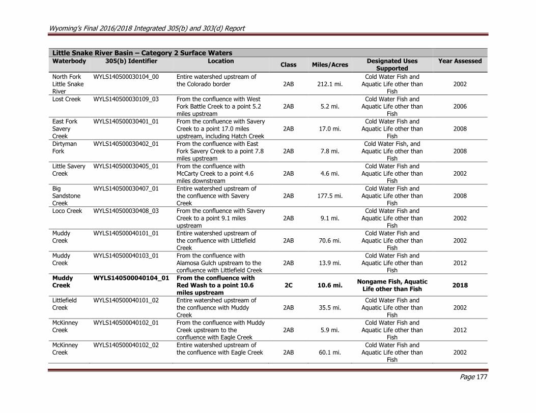
Wyoming’s Final 2016/2018 Integrated 305(b) and 303(d) Report
Page 177
Little Snake River Basin – Category 2 Surface Waters Waterbody 305(b) Identifier Location
Class Miles/Acres Designated Uses
Supported Year Assessed
North Fork Little Snake River
WYLS140500030104_00 Entire watershed upstream of the Colorado border 2AB 212.1 mi.
Cold Water Fish and Aquatic Life other than
Fish 2002
Lost Creek WYLS140500030109_03 From the confluence with West Fork Battle Creek to a point 5.2 miles upstream
2AB 5.2 mi. Cold Water Fish and
Aquatic Life other than Fish
2006
East Fork Savery
Creek
WYLS140500030401_01 From the confluence with Savery Creek to a point 17.0 miles
upstream, including Hatch Creek
2AB 17.0 mi. Cold Water Fish and
Aquatic Life other than
Fish
2008
Dirtyman Fork
WYLS140500030402_01 From the confluence with East Fork Savery Creek to a point 7.8 miles upstream
2AB 7.8 mi. Cold Water Fish, and
Aquatic Life other than Fish
2008
Little Savery Creek
WYLS140500030405_01 From the confluence with McCarty Creek to a point 4.6 miles downstream
2AB 4.6 mi. Cold Water Fish and
Aquatic Life other than Fish
2002
Big Sandstone Creek
WYLS140500030407_01 Entire watershed upstream of the confluence with Savery Creek
2AB 177.5 mi. Cold Water Fish and
Aquatic Life other than Fish
2008
Loco Creek WYLS140500030408_03 From the confluence with Savery Creek to a point 9.1 miles
upstream
2AB 9.1 mi. Cold Water Fish and
Aquatic Life other than
Fish
2002
Muddy Creek
WYLS140500040101_01 Entire watershed upstream of the confluence with Littlefield Creek
2AB 70.6 mi. Cold Water Fish and
Aquatic Life other than Fish
2002
Muddy Creek
WYLS140500040103_01
From the confluence with Alamosa Gulch upstream to the confluence with Littlefield Creek
2AB 13.9 mi. Cold Water Fish and
Aquatic Life other than Fish
2012
Muddy Creek
WYLS140500040104_01
From the confluence with Red Wash to a point 10.6 miles upstream
2C 10.6 mi. Nongame Fish, Aquatic
Life other than Fish 2018
Littlefield Creek
WYLS140500040101_02 Entire watershed upstream of the confluence with Muddy
Creek
2AB 35.5 mi. Cold Water Fish and
Aquatic Life other than
Fish
2002
McKinney Creek
WYLS140500040102_01 From the confluence with Muddy Creek upstream to the confluence with Eagle Creek
2AB 5.9 mi. Cold Water Fish and
Aquatic Life other than Fish
2012
McKinney Creek
WYLS140500040102_02 Entire watershed upstream of the confluence with Eagle Creek 2AB 60.1 mi.
Cold Water Fish and Aquatic Life other than
Fish 2002
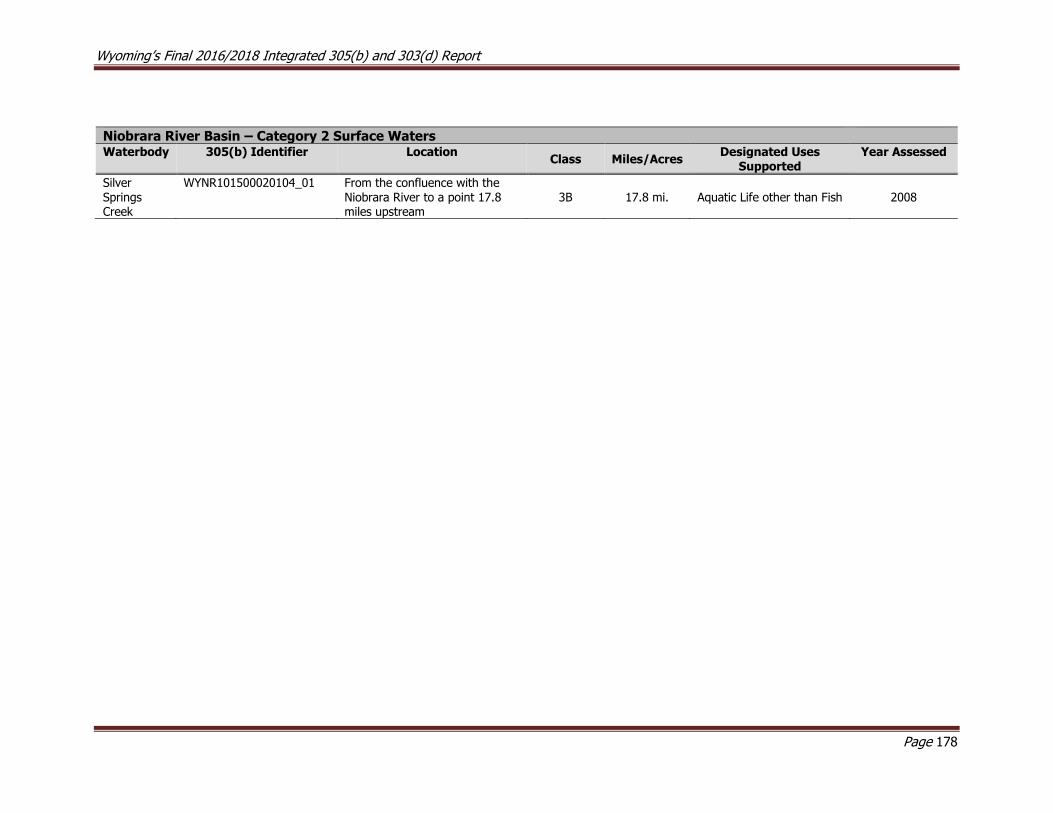
Wyoming’s Final 2016/2018 Integrated 305(b) and 303(d) Report
Page 178
Niobrara River Basin – Category 2 Surface Waters Waterbody 305(b) Identifier Location
Class Miles/Acres Designated Uses
Supported Year Assessed
Silver Springs Creek
WYNR101500020104_01 From the confluence with the Niobrara River to a point 17.8 miles upstream
3B 17.8 mi. Aquatic Life other than Fish 2008
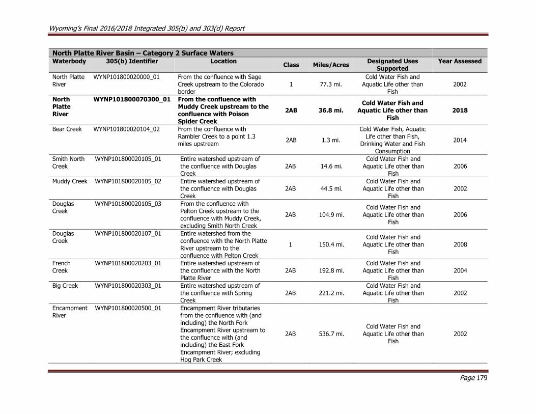
Wyoming’s Final 2016/2018 Integrated 305(b) and 303(d) Report
Page 179
North Platte River Basin – Category 2 Surface Waters Waterbody 305(b) Identifier Location
Class Miles/Acres Designated Uses
Supported Year Assessed
North Platte River
WYNP101800020000_01 From the confluence with Sage Creek upstream to the Colorado border
1 77.3 mi. Cold Water Fish and
Aquatic Life other than Fish
2002
North Platte River
WYNP101800070300_01 From the confluence with Muddy Creek upstream to the confluence with Poison Spider Creek
2AB 36.8 mi. Cold Water Fish and
Aquatic Life other than Fish
2018
Bear Creek WYNP101800020104_02 From the confluence with
Rambler Creek to a point 1.3 miles upstream
2AB 1.3 mi.
Cold Water Fish, Aquatic
Life other than Fish, Drinking Water and Fish
Consumption
2014
Smith North Creek
WYNP101800020105_01 Entire watershed upstream of the confluence with Douglas Creek
2AB 14.6 mi. Cold Water Fish and
Aquatic Life other than Fish
2006
Muddy Creek WYNP101800020105_02 Entire watershed upstream of the confluence with Douglas Creek
2AB 44.5 mi. Cold Water Fish and
Aquatic Life other than Fish
2002
Douglas Creek
WYNP101800020105_03 From the confluence with Pelton Creek upstream to the confluence with Muddy Creek, excluding Smith North Creek
2AB 104.9 mi. Cold Water Fish and
Aquatic Life other than Fish
2006
Douglas Creek
WYNP101800020107_01 Entire watershed from the confluence with the North Platte River upstream to the confluence with Pelton Creek
1 150.4 mi. Cold Water Fish and
Aquatic Life other than Fish
2008
French Creek
WYNP101800020203_01 Entire watershed upstream of the confluence with the North Platte River
2AB 192.8 mi. Cold Water Fish and
Aquatic Life other than Fish
2004
Big Creek WYNP101800020303_01 Entire watershed upstream of the confluence with Spring Creek
2AB 221.2 mi. Cold Water Fish and
Aquatic Life other than Fish
2002
Encampment River
WYNP101800020500_01 Encampment River tributaries from the confluence with (and including) the North Fork Encampment River upstream to the confluence with (and including) the East Fork Encampment River; excluding Hog Park Creek
2AB 536.7 mi. Cold Water Fish and
Aquatic Life other than Fish
2002
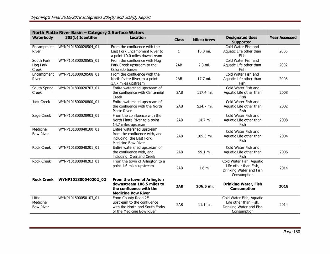
Wyoming’s Final 2016/2018 Integrated 305(b) and 303(d) Report
Page 180
North Platte River Basin – Category 2 Surface Waters Waterbody 305(b) Identifier Location
Class Miles/Acres Designated Uses
Supported Year Assessed
Encampment River
WYNP101800020504_01 From the confluence with the East Fork Encampment River to a point 10.0 miles downstream
1 10.0 mi. Cold Water Fish and
Aquatic Life other than Fish
2006
South Fork Hog Park Creek
WYNP101800020505_01 From the confluence with Hog Park Creek upstream to the Colorado border
2AB 2.3 mi. Cold Water Fish and
Aquatic Life other than Fish
2002
Encampment River
WYNP101800020508_01 From the confluence with the North Platte River to a point 17.7 miles upstream
2AB 17.7 mi. Cold Water Fish and
Aquatic Life other than Fish
2008
South Spring Creek
WYNP101800020703_01 Entire watershed upstream of the confluence with Centennial Creek
2AB 117.4 mi. Cold Water Fish and
Aquatic Life other than Fish
2008
Jack Creek WYNP101800020800_01 Entire watershed upstream of the confluence with the North Platte River
2AB 534.7 mi. Cold Water Fish and
Aquatic Life other than Fish
2002
Sage Creek WYNP101800020903_01 From the confluence with the North Platte River to a point 14.7 miles upstream
2AB 14.7 mi. Cold Water Fish and
Aquatic Life other than Fish
2008
Medicine Bow River
WYNP101800040100_01 Entire watershed upstream from the confluence with, and including, the East Fork Medicine Bow River
2AB 109.5 mi.
Cold Water Fish and
Aquatic Life other than Fish
2004
Rock Creek WYNP101800040201_01 Entire watershed upstream of the confluence with, and including, Overland Creek
2AB 99.1 mi. Cold Water Fish and
Aquatic Life other than Fish
2006
Rock Creek WYNP101800040202_01 From the town of Arlington to a point 1.6 miles upstream
2AB 1.6 mi.
Cold Water Fish, Aquatic Life other than Fish,
Drinking Water and Fish Consumption
2014
Rock Creek WYNP101800040202_02 From the town of Arlington downstream 106.5 miles to the confluence with the Medicine Bow River
2AB 106.5 mi. Drinking Water, Fish
Consumption 2018
Little Medicine Bow River
WYNP101800050103_01 From County Road 2E upstream to the confluence with the North and South Forks of the Medicine Bow River
2AB 11.1 mi.
Cold Water Fish, Aquatic Life other than Fish,
Drinking Water and Fish Consumption
2014

Wyoming’s Final 2016/2018 Integrated 305(b) and 303(d) Report
Page 181
North Platte River Basin – Category 2 Surface Waters Waterbody 305(b) Identifier Location
Class Miles/Acres Designated Uses
Supported Year Assessed
Shirley Basin Reservoir
WYNP101800050502_01 Within the Shirley Basin; NW S12 T26N R80W 2AB 15.5 ac.
Cold Water Fish and Aquatic Life other than
Fish 2008
Willow Creek WYNP101800060204_01 Entire watershed upstream of the confluence with the Sweetwater River
2AB 36.0 mi. Cold Water Fish and
Aquatic Life other than Fish
2006
Glendo Reservoir
WYNP101800080405_01 Southeast of town of Douglas in Platte County 2AB 12,049.8 ac.
Cold Water Fish, Aquatic Life other than Fish and
Fish Consumption 2010
Horseshoe Creek
WYNP101800080905_01 From the confluence with Spring Creek to a point 12.5 miles upstream
2AB 12.5 mi. Cold Water Fish and
Aquatic Life other than Fish
2006
Horseshoe Creek
WYNP101800080905_02 From the confluence with the North Platte River to a point 2.3 miles upstream
2AB 2.3 mi. Cold Water Fish and
Aquatic Life other than Fish
2008
Laramie River
WYNP101800100200_01 Entire watershed upstream of the confluence with Fox Creek, and including Fox Creek
2AB 354.7 mi. Cold Water Fish and
Aquatic Life other than Fish
2008
Miller Lake WYNP101800100204_01 Near Fox Park in Albany County 2AB 7.6 ac.
Cold Water Fish and Aquatic Life other than
Fish 2008
Meeboer Lake
WYNP101800100403_01 Adjacent to Mortensen Lake National Wildlife Refuge in Albany County
2AB 115.8 ac. Cold Water Fish and
Aquatic Life other than Fish
2008
Laramie River
WYNP101800100501_01 From the confluence with Fivemile Creek to a point 7.9 miles downstream
2AB 7.9 mi. Drinking Water 2018
Little Laramie River
WYNP101800100600_01 Entire watershed above Millbrook, excluding the South Fork Little Laramie River
2AB 454.4 mi. Cold Water Fish and
Aquatic Life other than Fish
2002
South Fork Little Laramie River
WYNP101800100602_01 From the intersection of State Highway 11 to a point 5.5 miles upstream
2AB 5.5 mi.
Cold Water Fish and
Aquatic Life other than Fish
2002
Hanging Lake
WYNP101800100603_01 Adjacent to State Highway 130; within the Nash Fork Watershed
2AB 3.8 ac. Cold Water Fish and
Aquatic Life other than Fish
2008

Wyoming’s Final 2016/2018 Integrated 305(b) and 303(d) Report
Page 182
North Platte River Basin – Category 2 Surface Waters Waterbody 305(b) Identifier Location
Class Miles/Acres Designated Uses
Supported Year Assessed
Snowy Range Lakes
WYNP101800100603_02 26 lakes within the upper North Fork Little Laramie Watershed 2AB 282.7 ac.
Cold Water Fish and Aquatic Life other than
Fish 2008
Middle Fork Mill Creek
WYNP101800100606_01 From the USFS boundary to a point 2.7 miles upstream 2AB 2.7 mi.
Cold Water Fish and Aquatic Life other than
Fish 2002
Chugwater Creek
WYNP101800110900_02 From the intersection of Antelope Gap Road to a point 77.1 miles upstream
2AB 77.1 mi. Cold Water Fish and
Aquatic Life other than Fish
2002
Chugwater Creek
WYNP101800110906_01 From the confluence with the Laramie River upstream to Antelope Gap Road
2AB 9.7 mi. Cold Water Fish and
Aquatic Life other than Fish
2008
Horse Creek WYNP101800120100_01 Entire watershed upstream of the confluence with South Fork Horse Creek
2AB 253.7 mi. Cold Water Fish and
Aquatic Life other than Fish
2002
Bear Creek WYNP101800120300_01 Entire watershed upstream from the confluence with Horse Creek
2AB 1,045.9 mi. Cold Water Fish and
Aquatic Life other than Fish
2002

Wyoming’s Final 2016/2018 Integrated 305(b) and 303(d) Report
Page 183
Powder River Basin – Category 2 Surface Waters Waterbody 305(b) Identifier Location
Class Miles/Acres Designated Uses
Supported Year Assessed
Rock Creek WYPR100902010101_01 Entire watershed upstream of the confluence with the Middle Fork Powder River
2AB 26.4 mi. Cold Water Fish and
Aquatic Life other than Fish
2008
Middle Fork Powder River
WYPR100902010102_01 From the confluence with Buffalo Creek to a point 26.4 miles upstream
1 26.4 mi. Cold Water Fish and
Aquatic Life other than Fish
2002
Beaver Creek
WYPR100902010202_00 From the confluence with Blue Creek to a point 19.0 miles
upstream
2AB 19.0 mi. Cold Water Fish and
Aquatic Life other than
Fish
2002
Blue Creek WYPR100902010202_01 From the confluence with Beaver Creek to a point 8.8 miles upstream
2AB 8.8 mi. Cold Water Fish and
Aquatic Life other than Fish
2002
Beartrap Creek
WYPR100902010206_01 Entire watershed upstream of the confluence with the Middle Fork Powder River
2AB 48.8 mi. Cold Water Fish and
Aquatic Life other than Fish
2006
Webb Creek WYPR100902010301_01 Entire watershed upstream of the confluence with the North Fork Powder River
2AB 17.8 mi. Cold Water Fish and
Aquatic Life other than Fish
2006
Ninemile Creek
WYPR100902020100_01 Entire watershed upstream from the confluence with the Powder
River
3B 543.7 mi. Aquatic Life other than
Fish 2006
Fourmile Creek
WYPR100902020104_01 Entire watershed upstream from the confluence with the Powder River
3B 174.9 mi. Aquatic Life other than
Fish 2006
Flying E Creek
WYPR100902020602_01 Entire watershed upstream from the confluence with the Powder River
3B 141.6 mi. Aquatic Life other than
Fish 2008
North Fork Crazy Woman Creek
WYPR100902050100_01 From Muddy Creek Road to a point 22.6 miles upstream
2AB 22.6 mi. Cold Water Fish, Aquatic Life other than Fish and
Drinking Water 2014
Pole Creek WYPR100902050101_01 Entire watershed upstream from
the confluence with North Fork Crazy Woman Creek
2AB 17.5 mi.
Cold Water Fish and
Aquatic Life other than Fish
2002
North Fork Crazy Woman Creek
WYPR100902050102_01 From Muddy Creek Road downstream 28 miles to the confluence with the Middle Fork Crazy Woman Creek
2AB 28.0 mi. Drinking Water, Fish
Consumption 2018

Wyoming’s Final 2016/2018 Integrated 305(b) and 303(d) Report
Page 184
Powder River Basin – Category 2 Surface Waters Waterbody 305(b) Identifier Location
Class Miles/Acres Designated Uses
Supported Year Assessed
Little North Fork Crazy Woman Creek
WYPR100902050102_02 Entire watershed upstream from the confluence with North Fork Crazy Woman Creek
2AB 55.5 mi. Cold Water Fish and
Aquatic Life other than Fish
2002
Billy Creek WYPR100902050103_01 From the confluence with Muddy Creek to a point 13.4 miles upstream
2AB 13.4 mi. Cold Water Fish and
Aquatic Life other than Fish
2006
Doyle Creek WYPR100902050106_01 From the headwaters of Doyle Creek to a point 10.4 miles downstream
2AB 10.4 mi. Cold Water Fish and
Aquatic Life other than Fish
2002
Poison Creek WYPR100902050107_01 Entire watershed upstream from the confluence with Middle Fork Crazy Woman Creek
2AB 70.0 mi. Cold Water Fish and
Aquatic Life other than Fish
2002
Middle Fork Crazy Woman Creek
WYPR100902050108_00 Entire watershed upstream from the confluence with North Fork Crazy Woman Creek, excluding Doyle Creek and Poison Creek
2AB 142.2 mi. Cold Water Fish and
Aquatic Life other than Fish
2002
Beaver Creek
WYPR100902050110_01 Entire watershed upstream from the confluence with South Fork Crazy Woman Creek, excluding Pole Creek
2AB 66.0 mi. Cold Water Fish and
Aquatic Life other than
Fish
2002
Pole Creek WYPR100902050110_02 Entire watershed upstream from the confluence with Beaver Creek
2AB 25.3 mi. Cold Water Fish and
Aquatic Life other than Fish
2002
Crazy Woman Creek
WYPR100902050204_01 From the confluence with South Fork Crazy Woman Creek to a point 23.6 miles downstream
2AB 23.6 mi. Cold Water Fish and
Aquatic Life other than Fish
2002
Clear Creek WYPR100902060000_01 Mainstem from the confluence with the Powder River upstream to the confluence with Grommund Creek and entire watershed upstream of the
confluence with Grommund Creek
2AB 338.0 mi. Cold Water Fish and
Aquatic Life other than Fish
2006
Hunter Creek
WYPR100902060103_01 From the confluence with North Clear Creek to a point 2.7 miles upstream
2AB 2.7 mi. Cold Water Fish and
Aquatic Life other than Fish
2002
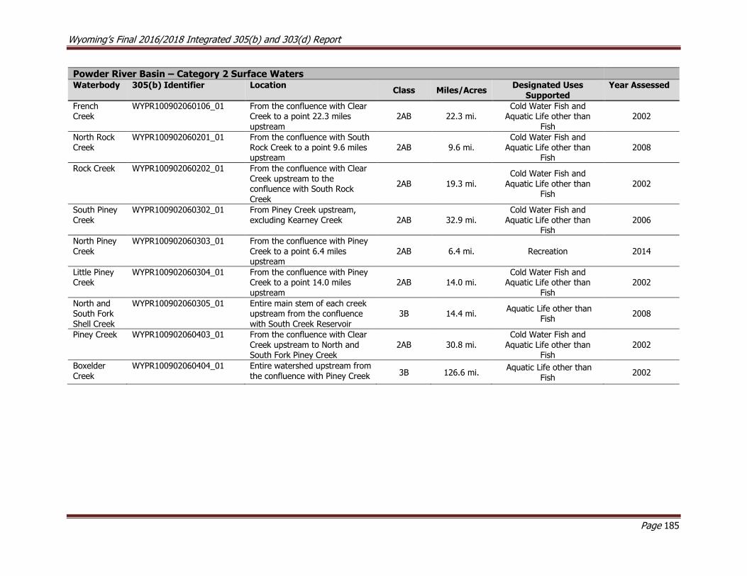
Wyoming’s Final 2016/2018 Integrated 305(b) and 303(d) Report
Page 185
Powder River Basin – Category 2 Surface Waters Waterbody 305(b) Identifier Location
Class Miles/Acres Designated Uses
Supported Year Assessed
French Creek
WYPR100902060106_01 From the confluence with Clear Creek to a point 22.3 miles upstream
2AB 22.3 mi. Cold Water Fish and
Aquatic Life other than Fish
2002
North Rock Creek
WYPR100902060201_01 From the confluence with South Rock Creek to a point 9.6 miles upstream
2AB 9.6 mi. Cold Water Fish and
Aquatic Life other than Fish
2008
Rock Creek WYPR100902060202_01 From the confluence with Clear Creek upstream to the confluence with South Rock Creek
2AB 19.3 mi.
Cold Water Fish and
Aquatic Life other than Fish
2002
South Piney Creek
WYPR100902060302_01 From Piney Creek upstream, excluding Kearney Creek 2AB 32.9 mi.
Cold Water Fish and Aquatic Life other than
Fish 2006
North Piney Creek
WYPR100902060303_01 From the confluence with Piney Creek to a point 6.4 miles upstream
2AB 6.4 mi. Recreation 2014
Little Piney Creek
WYPR100902060304_01 From the confluence with Piney Creek to a point 14.0 miles upstream
2AB 14.0 mi. Cold Water Fish and
Aquatic Life other than Fish
2002
North and South Fork Shell Creek
WYPR100902060305_01 Entire main stem of each creek upstream from the confluence with South Creek Reservoir
3B 14.4 mi. Aquatic Life other than
Fish 2008
Piney Creek WYPR100902060403_01 From the confluence with Clear Creek upstream to North and South Fork Piney Creek
2AB 30.8 mi. Cold Water Fish and
Aquatic Life other than Fish
2002
Boxelder Creek
WYPR100902060404_01 Entire watershed upstream from the confluence with Piney Creek 3B 126.6 mi.
Aquatic Life other than Fish
2002
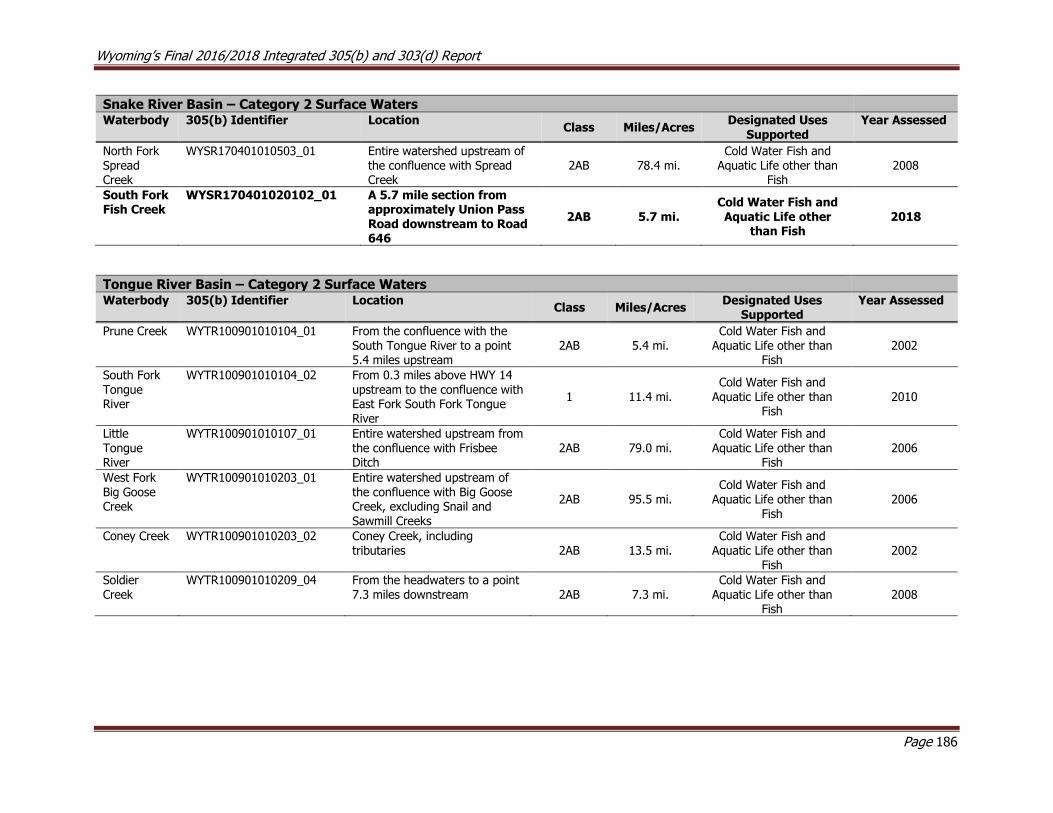
Wyoming’s Final 2016/2018 Integrated 305(b) and 303(d) Report
Page 186
Snake River Basin – Category 2 Surface Waters Waterbody 305(b) Identifier Location
Class Miles/Acres Designated Uses
Supported Year Assessed
North Fork Spread Creek
WYSR170401010503_01 Entire watershed upstream of the confluence with Spread Creek
2AB 78.4 mi. Cold Water Fish and
Aquatic Life other than Fish
2008
South Fork Fish Creek
WYSR170401020102_01 A 5.7 mile section from approximately Union Pass Road downstream to Road 646
2AB 5.7 mi. Cold Water Fish and Aquatic Life other
than Fish 2018
Tongue River Basin – Category 2 Surface Waters Waterbody 305(b) Identifier Location
Class Miles/Acres Designated Uses
Supported Year Assessed
Prune Creek WYTR100901010104_01 From the confluence with the South Tongue River to a point 5.4 miles upstream
2AB 5.4 mi. Cold Water Fish and
Aquatic Life other than Fish
2002
South Fork Tongue River
WYTR100901010104_02 From 0.3 miles above HWY 14 upstream to the confluence with East Fork South Fork Tongue River
1 11.4 mi. Cold Water Fish and
Aquatic Life other than Fish
2010
Little Tongue River
WYTR100901010107_01 Entire watershed upstream from the confluence with Frisbee Ditch
2AB 79.0 mi. Cold Water Fish and
Aquatic Life other than Fish
2006
West Fork Big Goose Creek
WYTR100901010203_01 Entire watershed upstream of the confluence with Big Goose Creek, excluding Snail and Sawmill Creeks
2AB 95.5 mi. Cold Water Fish and
Aquatic Life other than Fish
2006
Coney Creek WYTR100901010203_02 Coney Creek, including tributaries 2AB 13.5 mi.
Cold Water Fish and Aquatic Life other than
Fish 2002
Soldier Creek
WYTR100901010209_04 From the headwaters to a point 7.3 miles downstream 2AB 7.3 mi.
Cold Water Fish and Aquatic Life other than
Fish 2008

Wyoming’s Final 2016/2018 Integrated 305(b) and 303(d) Report
Page 187
Yellowstone River Basin – Category 2 Surface Waters Waterbody 305(b) Identifier Location
Class Miles/Acres Designated Uses
Supported Year Assessed
Squaw Creek
WYYR100700060106_01 Entire watershed upstream from the confluence with the Clarks Fork Yellowstone River
2AB 17.9 mi. Cold Water Fish and
Aquatic Life other than Fish
2002
Dead Indian Creek
WYYR100700060304_01 From the confluence with the Clarks Fork Yellowstone River upstream to the confluence with Dry Fork
2AB 6.9 mi. Cold Water Fish and
Aquatic Life other than Fish
2008

Wyoming’s Final 2016/2018 Integrated 305(b) and 303(d) Report
Page 188
Category 3 Surface Waters
Category 3 waters are surface waters which have been assessed by WDEQ but there is insufficient data to determine whether any designated uses
are supported.
The following tables list all of Wyoming’s assessed waters that are currently in Category 3 by river basin. All 2016/2018 assessments are bolded.
Bighorn River Basin – Category 3 Surface Waters
Waterbody 305(b) Identifier Location Class Miles/Acres Year Assessed
Canyon Creek WYBH100800080406_01
From the return of Hunsinger No. 1
Ditch upstream to Canyon Creek
Ditch
2AB 4.3 mi. 2012
Green River Basin – Category 3 Surface Waters
Waterbody 305(b) Identifier Location Class Miles/Acres Year Assessed
Reardon
Draw
WYBH140101011006_01
From the confluence with the Green
River to a point 3.2 miles upstream 3B 3.2 mi. 2006
Tongue River Basin – Category 3 Surface Waters
Waterbody 305(b) Identifier Location Class Miles/Acres Year Assessed
Soldier Creek
WYTR100901010209_03
From 3.1 miles upstream from the confluence with Goose Creek to a
point 17.0 miles upstream
2AB 17 mi. 2018
North Platte River Basin – Category 3 Surface Waters
Waterbody 305(b) Identifier Location Class Miles/Acres Year Assessed
Laramie River
WYNP101800100504_01 From the confluence with the Little Laramie River to a point 24 miles upstream
2AB 24 mi. 2018
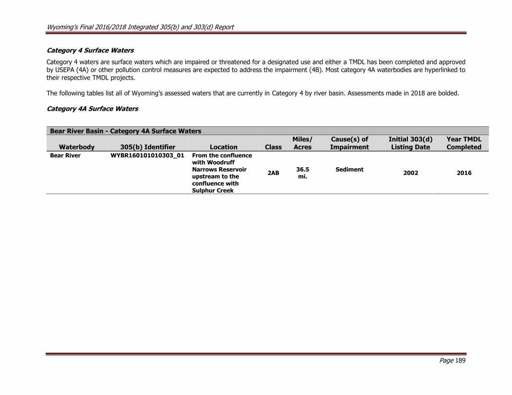
Wyoming’s Final 2016/2018 Integrated 305(b) and 303(d) Report
Page 189
Category 4 Surface Waters
Category 4 waters are surface waters which are impaired or threatened for a designated use and either a TMDL has been completed and approved
by USEPA (4A) or other pollution control measures are expected to address the impairment (4B). Most category 4A waterbodies are hyperlinked to
their respective TMDL projects.
The following tables list all of Wyoming’s assessed waters that are currently in Category 4 by river basin. Assessments made in 2018 are bolded.
Category 4A Surface Waters
Bear River Basin - Category 4A Surface Waters
Waterbody 305(b) Identifier Location Class
Miles/
Acres
Cause(s) of
Impairment
Initial 303(d)
Listing Date
Year TMDL
Completed
Bear River WYBR160101010303_01 From the confluence with Woodruff Narrows Reservoir upstream to the confluence with Sulphur Creek
2AB 36.5 mi.
Sediment
2002 2016
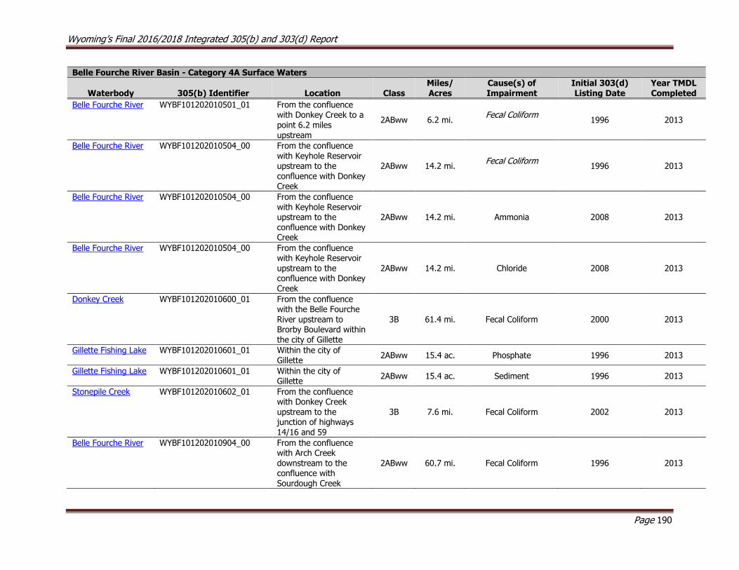
Wyoming’s Final 2016/2018 Integrated 305(b) and 303(d) Report
Page 190
Belle Fourche River Basin - Category 4A Surface Waters
Waterbody 305(b) Identifier Location Class Miles/ Acres
Cause(s) of Impairment
Initial 303(d) Listing Date
Year TMDL Completed
Belle Fourche River WYBF101202010501_01 From the confluence with Donkey Creek to a point 6.2 miles upstream
2ABww 6.2 mi. Fecal Coliform
1996 2013
Belle Fourche River WYBF101202010504_00 From the confluence with Keyhole Reservoir upstream to the confluence with Donkey Creek
2ABww 14.2 mi. Fecal Coliform
1996 2013
Belle Fourche River WYBF101202010504_00 From the confluence with Keyhole Reservoir upstream to the confluence with Donkey Creek
2ABww 14.2 mi. Ammonia 2008 2013
Belle Fourche River WYBF101202010504_00 From the confluence with Keyhole Reservoir upstream to the confluence with Donkey Creek
2ABww 14.2 mi. Chloride 2008 2013
Donkey Creek WYBF101202010600_01 From the confluence with the Belle Fourche River upstream to Brorby Boulevard within the city of Gillette
3B 61.4 mi. Fecal Coliform 2000 2013
Gillette Fishing Lake WYBF101202010601_01 Within the city of Gillette
2ABww 15.4 ac. Phosphate 1996 2013
Gillette Fishing Lake WYBF101202010601_01 Within the city of Gillette
2ABww 15.4 ac. Sediment 1996 2013
Stonepile Creek WYBF101202010602_01 From the confluence with Donkey Creek upstream to the junction of highways
14/16 and 59
3B 7.6 mi. Fecal Coliform 2002 2013
Belle Fourche River WYBF101202010904_00 From the confluence with Arch Creek downstream to the confluence with Sourdough Creek
2ABww 60.7 mi. Fecal Coliform 1996 2013
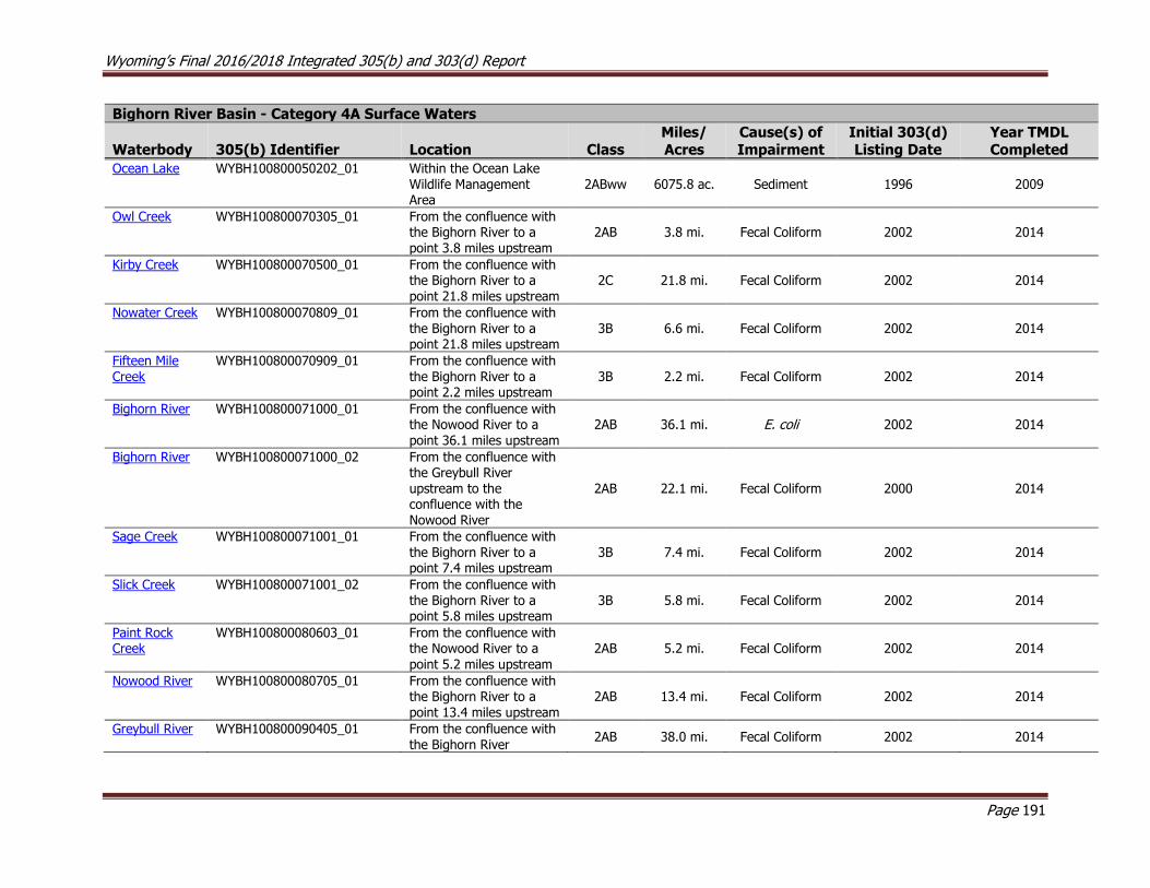
Wyoming’s Final 2016/2018 Integrated 305(b) and 303(d) Report
Page 191
Bighorn River Basin - Category 4A Surface Waters
Waterbody 305(b) Identifier Location Class Miles/ Acres
Cause(s) of Impairment
Initial 303(d) Listing Date
Year TMDL Completed
Ocean Lake WYBH100800050202_01 Within the Ocean Lake Wildlife Management Area
2ABww 6075.8 ac. Sediment 1996 2009
Owl Creek WYBH100800070305_01 From the confluence with the Bighorn River to a point 3.8 miles upstream
2AB 3.8 mi. Fecal Coliform 2002 2014
Kirby Creek WYBH100800070500_01 From the confluence with the Bighorn River to a point 21.8 miles upstream
2C 21.8 mi. Fecal Coliform 2002 2014
Nowater Creek WYBH100800070809_01 From the confluence with the Bighorn River to a point 21.8 miles upstream
3B 6.6 mi. Fecal Coliform 2002 2014
Fifteen Mile Creek
WYBH100800070909_01 From the confluence with the Bighorn River to a point 2.2 miles upstream
3B 2.2 mi. Fecal Coliform 2002 2014
Bighorn River WYBH100800071000_01 From the confluence with the Nowood River to a point 36.1 miles upstream
2AB 36.1 mi. E. coli 2002 2014
Bighorn River WYBH100800071000_02 From the confluence with the Greybull River upstream to the confluence with the Nowood River
2AB 22.1 mi. Fecal Coliform 2000 2014
Sage Creek WYBH100800071001_01 From the confluence with the Bighorn River to a point 7.4 miles upstream
3B 7.4 mi. Fecal Coliform 2002 2014
Slick Creek WYBH100800071001_02 From the confluence with the Bighorn River to a point 5.8 miles upstream
3B 5.8 mi. Fecal Coliform 2002 2014
Paint Rock Creek
WYBH100800080603_01
From the confluence with the Nowood River to a
point 5.2 miles upstream
2AB 5.2 mi. Fecal Coliform 2002 2014
Nowood River WYBH100800080705_01 From the confluence with the Bighorn River to a point 13.4 miles upstream
2AB 13.4 mi. Fecal Coliform 2002 2014
Greybull River WYBH100800090405_01 From the confluence with the Bighorn River
2AB 38.0 mi. Fecal Coliform 2002 2014

Wyoming’s Final 2016/2018 Integrated 305(b) and 303(d) Report
Page 192
Bighorn River Basin - Category 4A Surface Waters
Waterbody 305(b) Identifier Location Class Miles/ Acres
Cause(s) of Impairment
Initial 303(d) Listing Date
Year TMDL Completed
upstream to Sheets Flats Bridge
Granite Creek WYBH100800100102_01 From the confluence with Shell Creek upstream 5.8 miles, near the Antelope Butte Ski Area
2A 5.8 mi. Fecal Coliform 2002 2014
Beaver Creek WYBH100800100204_01 From the confluence with
Shell Creek to a point 7.9 miles upstream
2AB 7.9 mi. Fecal Coliform 2002 2014
Shell Creek WYBH100800100206_01 From the confluence with the Bighorn River to a point 5.3 miles upstream
2AB 5.3 mi. Fecal Coliform 2002 2014
Bighorn River WYBH100800100301_01 From the confluence with the Greybull River to a point 10.5 miles downstream
2AB 10.5 mi. Fecal Coliform 2002 2014
Dry Creek WYBH100800110204_01 From the confluence with the Bighorn River to a point 4.7 miles upstream
2ABww 4.7 mi. Fecal Coliform 2002 2014
Dry Gulch WYBH100800140107_01 From the confluence with the Shoshone River to a point 7.0 miles upstream
3B 7.0 mi. E. coli 2008 2014
Bitter Creek WYBH100800140206_01 From the confluence with the Shoshone River to a point 13.9 miles upstream
2AB 13.9 mi. Fecal Coliform 2000 2014
Whistle Creek WYBH100800140303_01 From the confluence with the Shoshone River to a point 8.7 miles upstream
2AB 8.7 mi. Fecal Coliform 2000 2014
Foster Gulch WYBH100800140307_01 From the confluence with the Shoshone River to a point 2.0 miles upstream
2C 2.0 mi. Fecal Coliform 2002 2014
Polecat Creek WYBH100800140407_01 From the confluence with the Sage Creek to a point 2.5 miles upstream
2AB 2.5 mi. Fecal Coliform 2002 2014
Sage Creek WYBH100800140408_01 From the confluence with the Shoshone River to a point 14.0 miles upstream
2AB 14.0 mi. Fecal Coliform 2002 2014
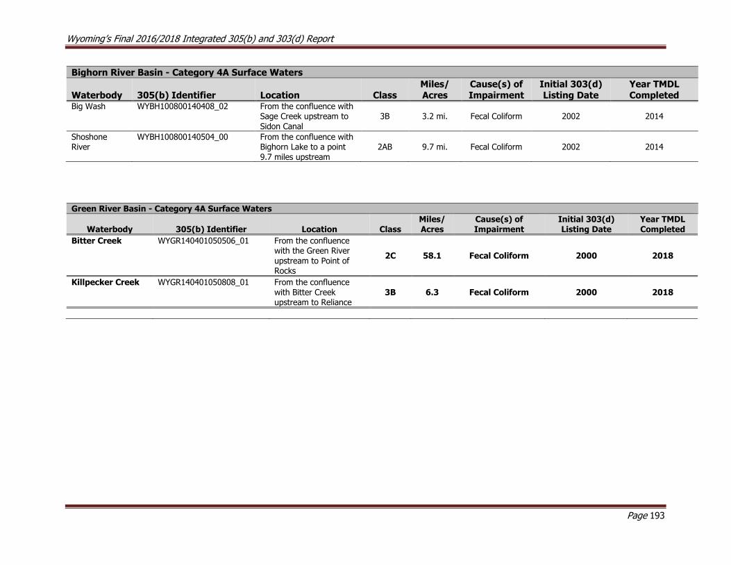
Wyoming’s Final 2016/2018 Integrated 305(b) and 303(d) Report
Page 193
Bighorn River Basin - Category 4A Surface Waters
Waterbody 305(b) Identifier Location Class Miles/ Acres
Cause(s) of Impairment
Initial 303(d) Listing Date
Year TMDL Completed
Big Wash WYBH100800140408_02 From the confluence with Sage Creek upstream to Sidon Canal
3B 3.2 mi. Fecal Coliform 2002 2014
Shoshone River
WYBH100800140504_00 From the confluence with Bighorn Lake to a point 9.7 miles upstream
2AB 9.7 mi. Fecal Coliform 2002 2014
Green River Basin - Category 4A Surface Waters
Waterbody 305(b) Identifier Location Class Miles/ Acres
Cause(s) of Impairment
Initial 303(d) Listing Date
Year TMDL Completed
Bitter Creek WYGR140401050506_01 From the confluence with the Green River upstream to Point of Rocks
2C 58.1 Fecal Coliform 2000 2018
Killpecker Creek WYGR140401050808_01 From the confluence with Bitter Creek upstream to Reliance
3B 6.3 Fecal Coliform 2000 2018
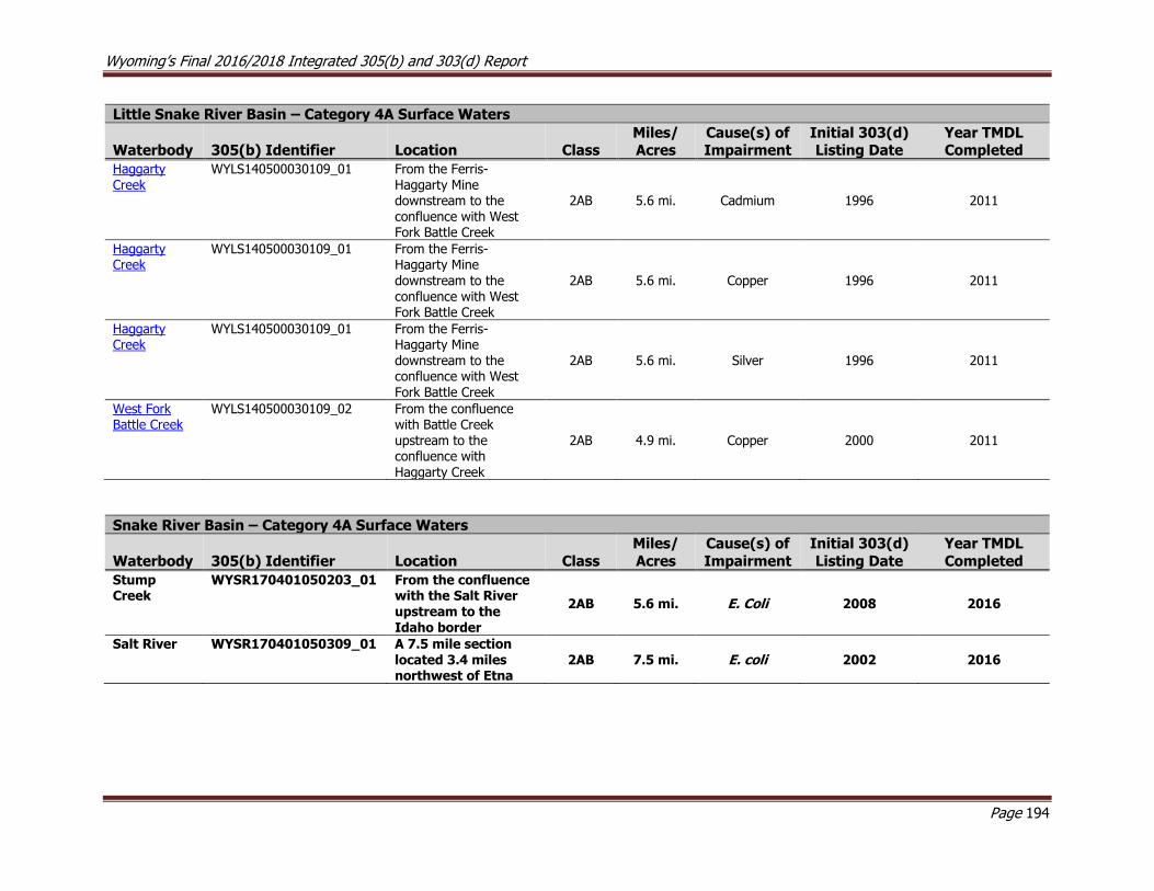
Wyoming’s Final 2016/2018 Integrated 305(b) and 303(d) Report
Page 194
Little Snake River Basin – Category 4A Surface Waters
Waterbody 305(b) Identifier Location Class Miles/ Acres
Cause(s) of Impairment
Initial 303(d) Listing Date
Year TMDL Completed
Haggarty Creek
WYLS140500030109_01 From the Ferris-Haggarty Mine downstream to the confluence with West Fork Battle Creek
2AB 5.6 mi. Cadmium 1996 2011
Haggarty Creek
WYLS140500030109_01 From the Ferris-Haggarty Mine
downstream to the confluence with West Fork Battle Creek
2AB 5.6 mi. Copper 1996 2011
Haggarty Creek
WYLS140500030109_01 From the Ferris-Haggarty Mine downstream to the confluence with West Fork Battle Creek
2AB 5.6 mi. Silver 1996 2011
West Fork Battle Creek
WYLS140500030109_02 From the confluence with Battle Creek upstream to the confluence with
Haggarty Creek
2AB 4.9 mi. Copper 2000 2011
Snake River Basin – Category 4A Surface Waters
Waterbody 305(b) Identifier Location Class
Miles/
Acres
Cause(s) of
Impairment
Initial 303(d)
Listing Date
Year TMDL
Completed
Stump Creek
WYSR170401050203_01 From the confluence with the Salt River upstream to the Idaho border
2AB 5.6 mi. E. Coli 2008 2016
Salt River WYSR170401050309_01 A 7.5 mile section located 3.4 miles northwest of Etna
2AB 7.5 mi. E. coli 2002 2016

Wyoming’s Final 2016/2018 Integrated 305(b) and 303(d) Report
Page 195
South Platte River Basin – Category 4A Surface Waters
Waterbody 305(b) Identifier Location Class Miles/ Acres
Cause(s) of Impairment
Initial 303(d) Listing Date
Year TMDL Completed
Crow Creek WYSP101900090107_01 From the inlet of Hereford Reservoir #2 upstream to the outlet of Hereford Reservoir #1
2C 9.4 mi. E. coli 1996 2014
Crow Creek WYSP101900090107_05 From Happy Jack Road upstream to Roadtop Road
2AB 3.1 mi. E. coli 2012 2014
Crow Creek WYSP101900090203_01 From Missile Road (HWY 217) upstream to the outlet of Hereford Reservoir #2
2C 10.1 mi. E. coli 1996 2014
Middle Fork Crow Creek
WYSP101900090101_01 A 1.5 mile section of creek at FS Road 700 crossing
2AB 1.5 mi. E. coli 2010 2016
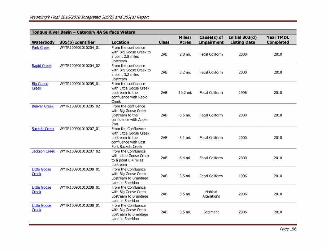
Wyoming’s Final 2016/2018 Integrated 305(b) and 303(d) Report
Page 196
Tongue River Basin – Category 4A Surface Waters
Waterbody 305(b) Identifier Location Class Miles/ Acres
Cause(s) of Impairment
Initial 303(d) Listing Date
Year TMDL Completed
Park Creek WYTR100901010204_01 From the confluence with Big Goose Creek to a point 2.8 miles upstream
2AB 2.8 mi. Fecal Coliform 2000 2010
Rapid Creek WYTR100901010204_02 From the confluence with Big Goose Creek to a point 3.2 miles
upstream
2AB 3.2 mi. Fecal Coliform 2000 2010
Big Goose Creek
WYTR100901010205_01 From the confluence with Little Goose Creek upstream to the confluence with Rapid Creek
2AB 19.2 mi. Fecal Coliform 1996 2010
Beaver Creek WYTR100901010205_02 From the confluence with Big Goose Creek upstream to the confluence with Apple Run
2AB 6.5 mi. Fecal Coliform 2000 2010
Sackett Creek WYTR100901010207_01 From the Confluence
with Little Goose Creek upstream to the confluence with East Fork Sackett Creek
2AB 3.1 mi. Fecal Coliform 2000 2010
Jackson Creek WYTR100901010207_02 From the Confluence with Little Goose Creek to a point 6.4 miles upstream
2AB 6.4 mi. Fecal Coliform 2000 2010
Little Goose Creek
WYTR100901010208_01 From the Confluence with Big Goose Creek upstream to Brundage Lane in Sheridan
2AB 3.5 mi. Fecal Coliform 1996 2010
Little Goose Creek
WYTR100901010208_01 From the Confluence with Big Goose Creek upstream to Brundage Lane in Sheridan
2AB 3.5 mi. Habitat
Alterations 2006 2010
Little Goose Creek
WYTR100901010208_01 From the Confluence with Big Goose Creek upstream to Brundage Lane in Sheridan
2AB 3.5 mi. Sediment 2006 2010

Wyoming’s Final 2016/2018 Integrated 305(b) and 303(d) Report
Page 197
Tongue River Basin – Category 4A Surface Waters
Waterbody 305(b) Identifier Location Class Miles/ Acres
Cause(s) of Impairment
Initial 303(d) Listing Date
Year TMDL Completed
McCormick Creek
WYTR100901010208_02 From the Confluence with Little Goose Creek to a point 2.2 miles upstream
2AB 2.2 mi. Fecal
Coliform 2004 2010
Kruse Creek WYTR100901010208_03 From the confluence with Little Goose Creek upstream to the
confluence with East Fork Kruse Creek
2AB 2.5 mi. Fecal Coliform 2000 2010
Goose Creek WYTR100901010209_01 From the confluence with Little Goose Creek downstream to the confluence with the Tongue River
2AB 12.7 mi. Fecal Coliform 2000 2010
Goose Creek WYTR100901010209_01 From the confluence with Little Goose Creek downstream to the confluence with the Tongue River
2AB 12.7 mi. Habitat
Alterations 2006 2010
Goose Creek WYTR100901010209_01 From the confluence
with Little Goose Creek downstream to the confluence with the Tongue River
2AB 12.7 mi. Sediment 2006 2010
Soldier Creek WYTR100901010209_02 From the confluence with Goose Creek to a point 3.1 miles upstream
2AB 3.1 mi. Fecal Coliform 2000 2010
Prairie Dog Creek
WYTR100901010400_01 From I-90 to a point 47.2 miles downstream
2AB 47.2 Fecal Coliform 2004 2018
Prairie Dog
Creek WYTR100901010402_01 From the confluence
with the Tongue River to a point 6.7 miles upstream
2AB 6.7 Fecal Coliform 2004 2018
Meade Creek WYTR100901010401_01 From the confluence with Prairie Dog Creek upstream 1.1 miles to the confluence with an unnamed tributary
2AB 1.1 E. coli 2012 2018

Wyoming’s Final 2016/2018 Integrated 305(b) and 303(d) Report
Page 198
Tongue River Basin – Category 4A Surface Waters
Waterbody 305(b) Identifier Location Class Miles/ Acres
Cause(s) of Impairment
Initial 303(d) Listing Date
Year TMDL Completed
Wildcat Creek WYTR100901010402_02 From the confluence with Prairie Dog Creek to a point 0.8 miles upstream
3B 0.8 E. coli 2012 2018
Dutch Creek WYTR100901010405_01 From the confluence with Prairie Dog Creek upstream 1.9 miles to
the confluence with an unnamed tributary
3B 1.9 E. coli 2012 2018
Yellowstone River Basin – Category 4A Surface Waters
Waterbody 305(b) Identifier Location Class Miles/ Acres
Cause(s) of Impairment
Initial 303(d) Listing Date
Year TMDL Completed
Clarks Fork Yellowstone River
WYYR100700060101_01 From the Montana border downstream to the confluence with Crazy Creek
1 6.8 mi. Cadmium 2000 2006
Clarks Fork Yellowstone River
WYYR100700060101_01 From the Montana border downstream to the confluence with Crazy Creek
1 6.8 mi. Copper 1998 2006
Clarks Fork Yellowstone River
WYYR100700060101_01 From the Montana border downstream to the confluence with Crazy Creek
1 6.8 mi. Silver 2000 2006

Wyoming’s Final 2016/2018 Integrated 305(b) and 303(d) Report
Page 199
10.3 Wyoming’s 303(d) List
Category 5 Surface Waters
The following tables list all of Wyoming’s assessed waters that are currently in Category 5 (Wyoming’s 2018 303(d) List) by river basin. Category 5
waters are surface waters which are impaired or threatened for a designated use and a TMDL has not yet been completed and approved by USEPA.
The TMDL date in the far right column represents either the year during which TMDLs that are currently being developed were initiated or the year
WDEQ expects to begin TMDL development. Listings with a low priority were not included in WDEQ’s 2016-2022 Vision Strategy and have been
given a TMDL initiation date of >2022 in the table. It is anticipated that WDEQ’s Vision Strategy will next be updated in the 2022 Integrated Report.
Water added to the 303(d) List in 2018 are bolded.
Bear River Basin – 2016/2018 303(d) List
Waterbody 305(b) Identifier Class Location Miles/Acres Uses Cause(s) List
Date TMDL Date Use Support Source(s)
Bridger Creek
WYBR160101010801_01 3B Entire watershed upstream of the Utah border
191.4 mi. Aquatic Life
other than Fish Sediment
1998 >2022
Threatened Grazing
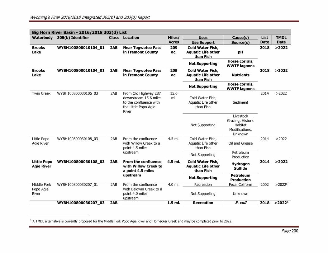
Wyoming’s Final 2016/2018 Integrated 305(b) and 303(d) Report
Page 200
Big Horn River Basin - 2016/2018 303(d) List
Waterbody 305(b) Identifier Class Location Miles/Acres
Uses Cause(s) List Date
TMDL Date Use Support Source(s)
Brooks Lake
WYBH100800010104_01 2AB Near Togwotee Pass in Fremont County
209 ac.
Cold Water Fish, Aquatic Life other
than Fish pH
2018 >2022
Not Supporting
Horse corrals, WWTF lagoons
Brooks Lake
WYBH100800010104_01 2AB Near Togwotee Pass in Fremont County
209 ac.
Cold Water Fish, Aquatic Life other
than Fish
Nutrients 2018 >2022
Not Supporting
Horse corrals, WWTF lagoons
Twin Creek WYBH100800030106_03 2AB From Old Highway 287 downstream 15.6 miles to the confluence with the Little Popo Agie River
15.6 mi. Cold Water Fish,
Aquatic Life other than Fish
Sediment
2014 >2022
Not Supporting
Livestock Grazing, Historic
Habitat Modifications,
Unknown
Little Popo Agie River
WYBH100800030108_03 2AB From the confluence with Willow Creek to a point 4.5 miles upstream
4.5 mi. Cold Water Fish, Aquatic Life other
than Fish Oil and Grease
2014 >2022
Not Supporting Petroleum Production
Little Popo Agie River
WYBH100800030108_03 2AB From the confluence with Willow Creek to a point 4.5 miles upstream
4.5 mi. Cold Water Fish, Aquatic Life other
than Fish
Hydrogen Sulfide
2014 >2022
Not Supporting Petroleum Production
Middle Fork
Popo Agie River
WYBH100800030207_01 2AB From the confluence
with Baldwin Creek to a point 4.0 miles upstream
4.0 mi. Recreation Fecal Coliform 2002 >20226
Not Supporting Unknown
WYBH100800030207_03 2AB 1.5 mi. Recreation E. coli 2018 >20225
6 A TMDL alternative is currently proposed for the Middle Fork Popo Agie River and Hornecker Creek and may be completed prior to 2022.

Wyoming’s Final 2016/2018 Integrated 305(b) and 303(d) Report
Page 201
Hornecker Creek
From the confluence with the Middle Fork Popo Agie River upstream 1.5 miles to Sinks Canyon Road
Not Supporting Livestock, Unknown
Middle Fork Popo Agie River
WYBH100800030207_05 2AB From the confluence with Hornecker Creek to a point 0.7 miles downstream
0.7 mi. Recreation E. coli 2018 >20225
Not Supporting Livestock, Unknown
Poison
Creek
WYBH100800050404_01 2AB From the confluence
with Boysen Reservoir to a point 2.0 miles upstream
2.0 mi. Recreation E. coli 2002 >2022
Not Supporting Unknown
Muddy Creek
WYBH100800050607_01 2AB From the confluence with Boysen Reservoir upstream to the Wind River Indian Reservation
11.8 mi.
Recreation E. coli 2002 >2022
Not Supporting Unknown
Green River Basin – 2016/2018 303(d) List
Waterbody 305(b) Identifier Class Location Miles/Acres Uses Cause(s) List
Date TMDL Date Use Support Source(s)
Little Sandy River
WYGR140401040203_01
2AB From the northern boundary of Section 33-Township 28 North-Range 104 West-downstream 17.7 miles to the Sublette/Sweetwater County line
17.7 mi. Cold Water
Fish, Aquatic Life other than
Fish
Sediment
2012 >2022
Not Supporting Grazing,
Historic Habitat
Modifications
Bitter Creek WYGR140401050506_01 2C From the confluence with the Green River upstream to Point of Rocks
58.1 mi. Non-Game Fish Chloride 2002 >2022
Not Supporting Natural Sources, Unknown
Blacks Fork WYGR140401070106_01 2AB From the confluence with the Smiths Fork upstream to Millburne
25.4 mi. Recreation Fecal Coliform 2000 2018
Not Supporting Unknown

Wyoming’s Final 2016/2018 Integrated 305(b) and 303(d) Report
Page 202
Green River Basin – 2016/2018 303(d) List
Waterbody 305(b) Identifier Class Location Miles/Acres Uses Cause(s) List
Date TMDL Date Use Support Source(s)
Willow Creek WYGR140401070205_01 2AB Entire watershed upstream of the confluence with the Smiths Fork
73.0 mi. Cold Water Fish, Aquatic
Life other than Fish
Habitat Alterations
1998 >2022
Threatened Grazing
Smiths Fork WYGR140401070208_00 2AB From the confluence with Cottonwood Creek upstream to the confluence with East and West Forks Smiths Fork
34.5 mi. Recreation Fecal Coliform 2002 2018
Not Supporting Unknown
Smiths Fork WYGR140401070208_01 2AB From the confluence with the Blacks Fork upstream to the confluence with Cottonwood Creek
4.0 mi. Cold Water Fish, Aquatic
Life other than Fish
Habitat Alterations
2000 >2022
Not Supporting Unknown
Smiths Fork WYGR140401070208_01 2AB From the confluence with the Blacks Fork upstream to the confluence with Cottonwood Creek
4.0 mi. Recreation E. coli 2008 2018
Not Supporting Unknown
Blacks Fork WYGR140401070403_01 2AB
From the confluence with the Hams Fork upstream to the confluence with the Smiths Fork
45.0 mi. Recreation Fecal Coliform 2000 2018
Not Supporting Unknown
Hams Fork WYGR140401070701_01 2AB From below the Kemmerer-Diamondville WWTF to a point 7.6 miles downstream
7.6 mi. Cold Water Fish, Aquatic
Life other than Fish
pH
1996 >2022
Not Supporting
Municipal WWTF
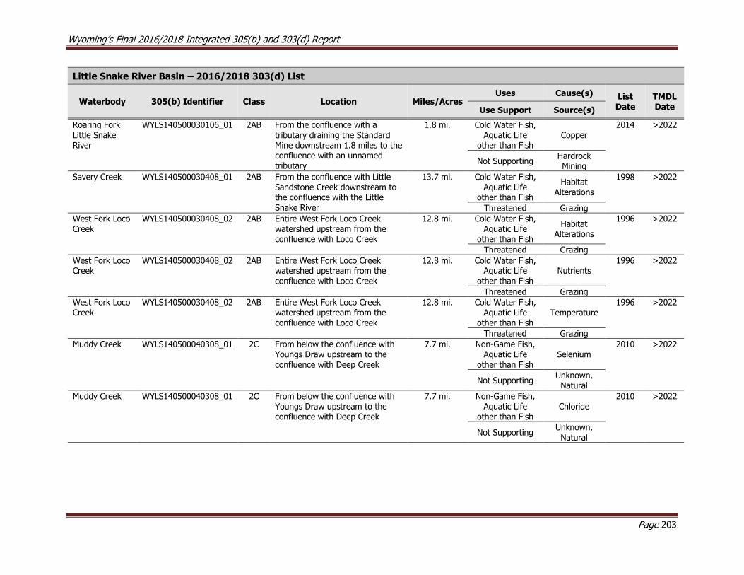
Wyoming’s Final 2016/2018 Integrated 305(b) and 303(d) Report
Page 203
Little Snake River Basin – 2016/2018 303(d) List
Waterbody 305(b) Identifier Class Location Miles/Acres Uses Cause(s) List
Date TMDL Date Use Support Source(s)
Roaring Fork Little Snake River
WYLS140500030106_01 2AB From the confluence with a tributary draining the Standard Mine downstream 1.8 miles to the confluence with an unnamed tributary
1.8 mi. Cold Water Fish, Aquatic Life
other than Fish Copper
2014 >2022
Not Supporting
Hardrock Mining
Savery Creek WYLS140500030408_01 2AB From the confluence with Little
Sandstone Creek downstream to the confluence with the Little Snake River
13.7 mi. Cold Water Fish,
Aquatic Life other than Fish
Habitat Alterations
1998 >2022
Threatened Grazing
West Fork Loco Creek
WYLS140500030408_02 2AB Entire West Fork Loco Creek watershed upstream from the confluence with Loco Creek
12.8 mi. Cold Water Fish, Aquatic Life
other than Fish
Habitat Alterations
1996 >2022
Threatened Grazing
West Fork Loco Creek
WYLS140500030408_02 2AB Entire West Fork Loco Creek watershed upstream from the confluence with Loco Creek
12.8 mi. Cold Water Fish, Aquatic Life
other than Fish Nutrients
1996 >2022
Threatened Grazing
West Fork Loco
Creek
WYLS140500030408_02 2AB Entire West Fork Loco Creek
watershed upstream from the confluence with Loco Creek
12.8 mi. Cold Water Fish,
Aquatic Life other than Fish
Temperature
1996 >2022
Threatened Grazing
Muddy Creek WYLS140500040308_01 2C From below the confluence with Youngs Draw upstream to the confluence with Deep Creek
7.7 mi. Non-Game Fish, Aquatic Life
other than Fish Selenium
2010 >2022
Not Supporting
Unknown, Natural
Muddy Creek WYLS140500040308_01 2C From below the confluence with Youngs Draw upstream to the confluence with Deep Creek
7.7 mi. Non-Game Fish, Aquatic Life
other than Fish Chloride
2010 >2022
Not Supporting
Unknown,
Natural
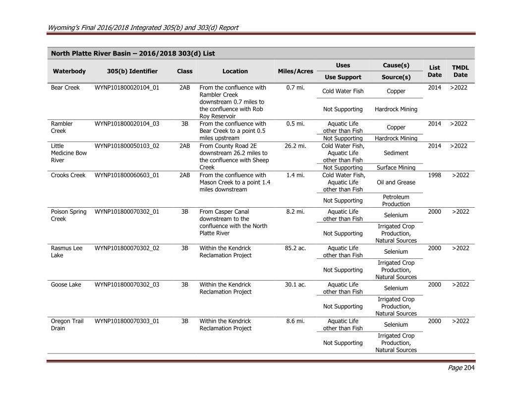
Wyoming’s Final 2016/2018 Integrated 305(b) and 303(d) Report
Page 204
North Platte River Basin – 2016/2018 303(d) List
Waterbody 305(b) Identifier Class Location Miles/Acres Uses Cause(s) List
Date TMDL Date Use Support Source(s)
Bear Creek WYNP101800020104_01
2AB From the confluence with Rambler Creek downstream 0.7 miles to the confluence with Rob Roy Reservoir
0.7 mi. Cold Water Fish Copper
2014 >2022
Not Supporting Hardrock Mining
Rambler Creek
WYNP101800020104_03
3B From the confluence with Bear Creek to a point 0.5 miles upstream
0.5 mi. Aquatic Life other than Fish
Copper 2014 >2022
Not Supporting Hardrock Mining
Little Medicine Bow River
WYNP101800050103_02
2AB From County Road 2E downstream 26.2 miles to the confluence with Sheep Creek
26.2 mi. Cold Water Fish, Aquatic Life
other than Fish Sediment
2014 >2022
Not Supporting Surface Mining
Crooks Creek WYNP101800060603_01 2AB From the confluence with Mason Creek to a point 1.4 miles downstream
1.4 mi. Cold Water Fish, Aquatic Life
other than Fish Oil and Grease
1998 >2022
Not Supporting
Petroleum Production
Poison Spring
Creek
WYNP101800070302_01 3B From Casper Canal
downstream to the confluence with the North Platte River
8.2 mi. Aquatic Life
other than Fish Selenium
2000 >2022
Not Supporting
Irrigated Crop Production,
Natural Sources
Rasmus Lee Lake
WYNP101800070302_02 3B Within the Kendrick Reclamation Project
85.2 ac. Aquatic Life other than Fish
Selenium 2000 >2022
Not Supporting
Irrigated Crop Production,
Natural Sources
Goose Lake WYNP101800070302_03 3B Within the Kendrick Reclamation Project
30.1 ac. Aquatic Life other than Fish
Selenium 2000 >2022
Not Supporting
Irrigated Crop
Production, Natural Sources
Oregon Trail Drain
WYNP101800070303_01 3B Within the Kendrick Reclamation Project
8.6 mi. Aquatic Life other than Fish
Selenium 2000 >2022
Not Supporting
Irrigated Crop Production,
Natural Sources
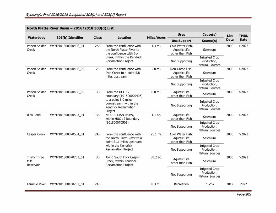
Wyoming’s Final 2016/2018 Integrated 305(b) and 303(d) Report
Page 205
North Platte River Basin – 2016/2018 303(d) List
Waterbody 305(b) Identifier Class Location Miles/Acres Uses Cause(s) List
Date TMDL Date Use Support Source(s)
Poison Spider Creek
WYNP101800070406_01 2AB From the confluence with the North Platte River to the confluence with Iron Creek, within the Kendrick Reclamation Project
1.3 mi. Cold Water Fish, Aquatic Life
other than Fish Selenium
2000 >2022
Not Supporting
Irrigated Crop Production,
Natural Sources
Poison Spider Creek
WYNP101800070406_02 2C From the confluence with Iron Creek to a point 5.8 miles upstream
5.8 mi. Non-Game Fish, Aquatic Life
other than Fish Selenium
2000 >2022
Not Supporting
Irrigated Crop Production,
Natural Sources
Poison Spider Creek
WYNP101800070406_03 3B From the HUC 12 boundary (101800070406) to a point 6.0 miles downstream, within the Kendrick Reclamation Project
6.0 mi. Aquatic Life other than Fish
Selenium 2000 >2022
Not Supporting Irrigated Crop Production,
Natural Sources
Illco Pond WYNP101800070503_01 3B NE S13 T35N R81W, within HUC 12 boundary (101800070503)
1.1 ac. Aquatic Life other than Fish
Selenium 2000 >2022
Not Supporting
Irrigated Crop Production,
Natural Sources
Casper Creek WYNP101800070504_01 2AB From the confluence with the North Platte River to a point 21.1 miles upstream, within the Kendrick Reclamation Project
21.1 mi. Cold Water Fish, Aquatic Life
other than Fish Selenium
2000 >2022
Not Supporting
Irrigated Crop Production,
Natural Sources
Thirty Three
Mile Reservoir
WYNP101800070703_01 3B Along South Fork Casper
Creek, within Kendrick Reclamation Project
30.2 ac. Aquatic Life
other than Fish Selenium
2000 >2022
Not Supporting
Irrigated Crop Production,
Natural Sources
Laramie River WYNP101800100201_01 2AB 0.3 mi. Recreation E. coli 2012 2022
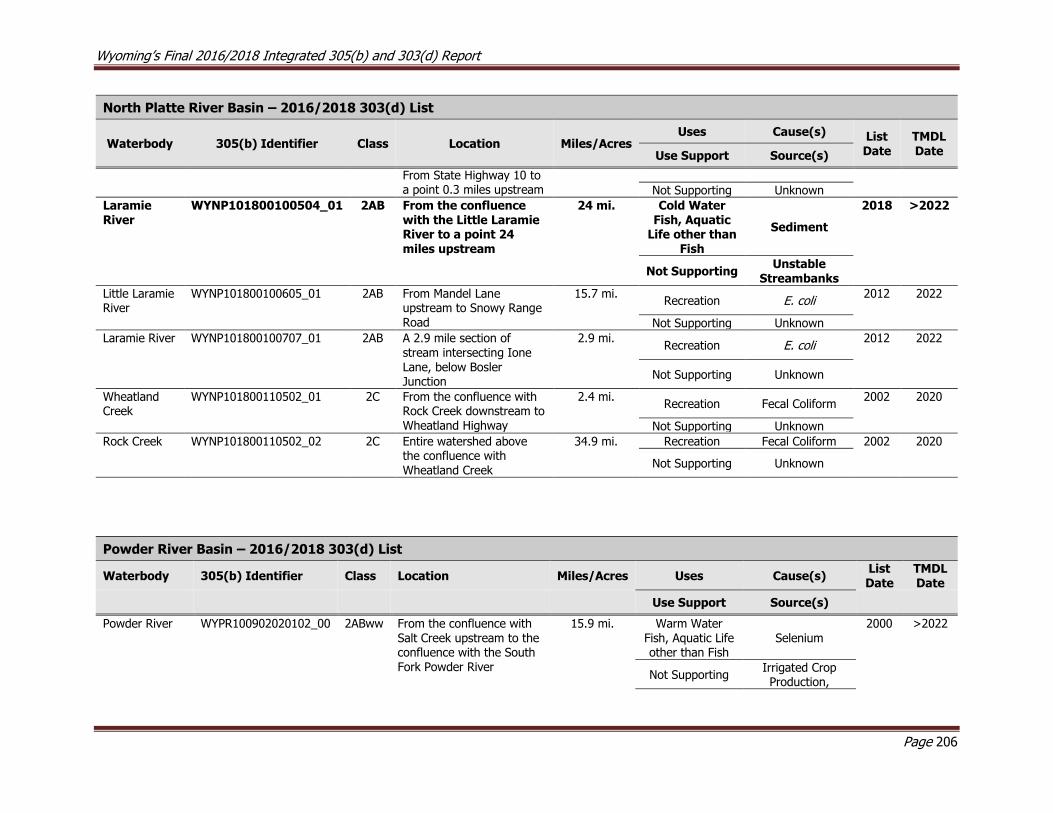
Wyoming’s Final 2016/2018 Integrated 305(b) and 303(d) Report
Page 206
North Platte River Basin – 2016/2018 303(d) List
Waterbody 305(b) Identifier Class Location Miles/Acres Uses Cause(s) List
Date TMDL Date Use Support Source(s)
From State Highway 10 to a point 0.3 miles upstream Not Supporting Unknown
Laramie River
WYNP101800100504_01 2AB From the confluence with the Little Laramie River to a point 24 miles upstream
24 mi. Cold Water Fish, Aquatic
Life other than Fish
Sediment
2018 >2022
Not Supporting
Unstable Streambanks
Little Laramie River
WYNP101800100605_01
2AB From Mandel Lane upstream to Snowy Range Road
15.7 mi. Recreation E. coli
2012 2022
Not Supporting Unknown
Laramie River WYNP101800100707_01
2AB A 2.9 mile section of stream intersecting Ione Lane, below Bosler Junction
2.9 mi. Recreation E. coli
2012 2022
Not Supporting Unknown
Wheatland Creek
WYNP101800110502_01 2C From the confluence with Rock Creek downstream to Wheatland Highway
2.4 mi. Recreation Fecal Coliform
2002 2020
Not Supporting Unknown
Rock Creek WYNP101800110502_02 2C Entire watershed above the confluence with Wheatland Creek
34.9 mi. Recreation Fecal Coliform 2002 2020
Not Supporting Unknown
Powder River Basin – 2016/2018 303(d) List
Waterbody 305(b) Identifier Class Location Miles/Acres Uses Cause(s) List Date
TMDL Date
Use Support Source(s)
Powder River WYPR100902020102_00 2ABww From the confluence with Salt Creek upstream to the confluence with the South Fork Powder River
15.9 mi. Warm Water Fish, Aquatic Life other than Fish
Selenium 2000 >2022
Not Supporting
Irrigated Crop Production,
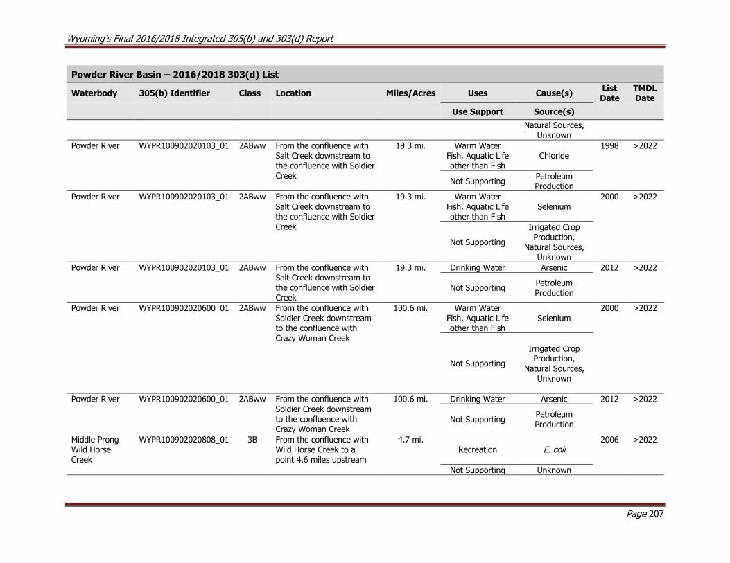
Wyoming’s Final 2016/2018 Integrated 305(b) and 303(d) Report
Page 207
Powder River Basin – 2016/2018 303(d) List
Waterbody 305(b) Identifier Class Location Miles/Acres Uses Cause(s) List Date
TMDL Date
Use Support Source(s)
Natural Sources, Unknown
Powder River WYPR100902020103_01 2ABww From the confluence with Salt Creek downstream to the confluence with Soldier Creek
19.3 mi. Warm Water Fish, Aquatic Life other than Fish
Chloride 1998 >2022
Not Supporting
Petroleum Production
Powder River WYPR100902020103_01 2ABww From the confluence with Salt Creek downstream to the confluence with Soldier Creek
19.3 mi. Warm Water Fish, Aquatic Life other than Fish
Selenium 2000 >2022
Not Supporting
Irrigated Crop Production,
Natural Sources, Unknown
Powder River WYPR100902020103_01 2ABww From the confluence with Salt Creek downstream to the confluence with Soldier Creek
19.3 mi. Drinking Water Arsenic 2012 >2022
Not Supporting
Petroleum Production
Powder River WYPR100902020600_01 2ABww From the confluence with Soldier Creek downstream to the confluence with Crazy Woman Creek
100.6 mi. Warm Water Fish, Aquatic Life other than Fish
Selenium 2000 >2022
Not Supporting
Irrigated Crop Production,
Natural Sources, Unknown
Powder River WYPR100902020600_01 2ABww From the confluence with Soldier Creek downstream to the confluence with Crazy Woman Creek
100.6 mi. Drinking Water Arsenic 2012 >2022
Not Supporting
Petroleum
Production
Middle Prong Wild Horse Creek
WYPR100902020808_01 3B From the confluence with Wild Horse Creek to a point 4.6 miles upstream
4.7 mi. Recreation E. coli
2006 >2022
Not Supporting Unknown
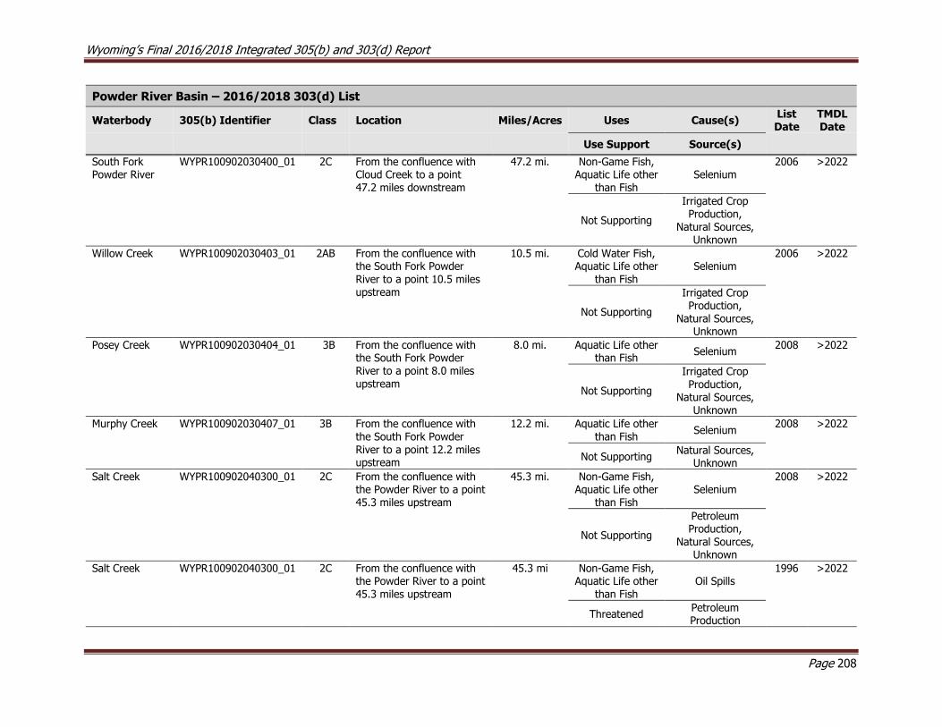
Wyoming’s Final 2016/2018 Integrated 305(b) and 303(d) Report
Page 208
Powder River Basin – 2016/2018 303(d) List
Waterbody 305(b) Identifier Class Location Miles/Acres Uses Cause(s) List Date
TMDL Date
Use Support Source(s)
South Fork Powder River
WYPR100902030400_01 2C From the confluence with Cloud Creek to a point 47.2 miles downstream
47.2 mi. Non-Game Fish, Aquatic Life other
than Fish Selenium
2006 >2022
Not Supporting
Irrigated Crop Production,
Natural Sources, Unknown
Willow Creek WYPR100902030403_01 2AB From the confluence with the South Fork Powder River to a point 10.5 miles upstream
10.5 mi. Cold Water Fish, Aquatic Life other
than Fish Selenium
2006 >2022
Not Supporting
Irrigated Crop Production,
Natural Sources, Unknown
Posey Creek WYPR100902030404_01 3B From the confluence with the South Fork Powder River to a point 8.0 miles upstream
8.0 mi. Aquatic Life other than Fish
Selenium 2008 >2022
Not Supporting
Irrigated Crop Production,
Natural Sources, Unknown
Murphy Creek WYPR100902030407_01 3B From the confluence with the South Fork Powder River to a point 12.2 miles upstream
12.2 mi. Aquatic Life other than Fish
Selenium 2008 >2022
Not Supporting
Natural Sources, Unknown
Salt Creek WYPR100902040300_01 2C From the confluence with the Powder River to a point 45.3 miles upstream
45.3 mi. Non-Game Fish, Aquatic Life other
than Fish Selenium
2008 >2022
Not Supporting
Petroleum Production,
Natural Sources, Unknown
Salt Creek WYPR100902040300_01 2C From the confluence with the Powder River to a point 45.3 miles upstream
45.3 mi Non-Game Fish, Aquatic Life other
than Fish Oil Spills
1996 >2022
Threatened
Petroleum Production
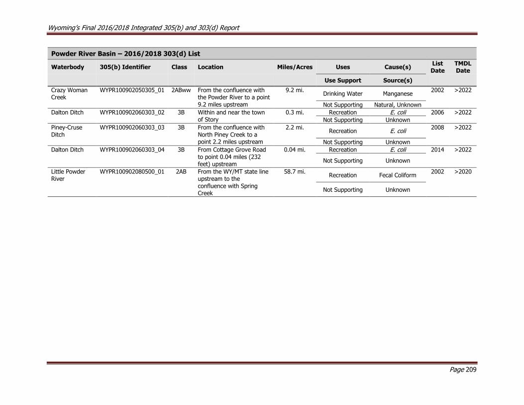
Wyoming’s Final 2016/2018 Integrated 305(b) and 303(d) Report
Page 209
Powder River Basin – 2016/2018 303(d) List
Waterbody 305(b) Identifier Class Location Miles/Acres Uses Cause(s) List Date
TMDL Date
Use Support Source(s)
Crazy Woman Creek
WYPR100902050305_01 2ABww From the confluence with the Powder River to a point 9.2 miles upstream
9.2 mi. Drinking Water Manganese
2002 >2022
Not Supporting Natural, Unknown
Dalton Ditch WYPR100902060303_02 3B Within and near the town of Story
0.3 mi. Recreation E. coli 2006 >2022
Not Supporting Unknown
Piney-Cruse Ditch
WYPR100902060303_03 3B From the confluence with North Piney Creek to a point 2.2 miles upstream
2.2 mi. Recreation E. coli
2008 >2022
Not Supporting Unknown
Dalton Ditch WYPR100902060303_04 3B From Cottage Grove Road to point 0.04 miles (232 feet) upstream
0.04 mi. Recreation E. coli 2014 >2022
Not Supporting Unknown
Little Powder River
WYPR100902080500_01 2AB From the WY/MT state line upstream to the confluence with Spring Creek
58.7 mi. Recreation Fecal Coliform
2002 >2020
Not Supporting Unknown

Wyoming’s Final 2016/2018 Integrated 305(b) and 303(d) Report
Page 210
Snake River Basin – 2016/2018 303(d) List
Waterbody 305(b) Identifier Class Location Miles/Acres Uses Cause(s) List Date
TMDL Date
Use Support Source(s)
Flat Creek WYSR170401030205_01 2AB From the confluence with the Snake River upstream to the confluence with Cache Creek
11.1 mi. Cold Water Fish, Aquatic Life other
than Fish
Habitat Alterations
2000 >2022
Threatened Stormwater
Crow Creek
WYSR170401050102_01 2AB From the Wyoming/Idaho Border downstream to the confluence with the Salt River
15.6 mi. Cold Water Fish, Aquatic Life other
than Fish Selenium
2014 >2022
Not Supporting
Phosphate Mining

Wyoming’s Final 2016/2018 Integrated 305(b) and 303(d) Report
Page 211
South Platte River Basin – 2016/2018 303(d) List
Waterbody 305(b) Identifier Class Location Miles/Acres Uses Cause(s) List Date
TMDL Date
Use Support Source(s)
North Branch North Fork Crow Creek
WYSP101900090104_01 2AB From FS Road 701 upstream 300 yards
0.2 mi. Recreation E. coli
2004 >2022
Not Supporting Grazing
Crow Creek WYSP101900090107_02 2C From 0.7 miles below Morrie Avenue downstream to the inlet of Hereford Reservoir #1
3.7 mi. Non-Game Fish, Aquatic Life other
than Fish Sediment
2012 2019
Not Supporting Stormwater
Crow Creek WYSP101900090107_03 2C From Morrie Avenue to a point 0.7 miles downstream
0.7 mi. Non-Game Fish, Aquatic Life other
than Fish Sediment
2010 2019
Not Supporting Stormwater
Crow Creek WYSP101900090107_04 2AB From Morrie Avenue upstream to Happy Jack Road
3.4 mi. Cold Water Fish, Aquatic Life other
than Fish Sediment
2012 2019
Not Supporting Stormwater
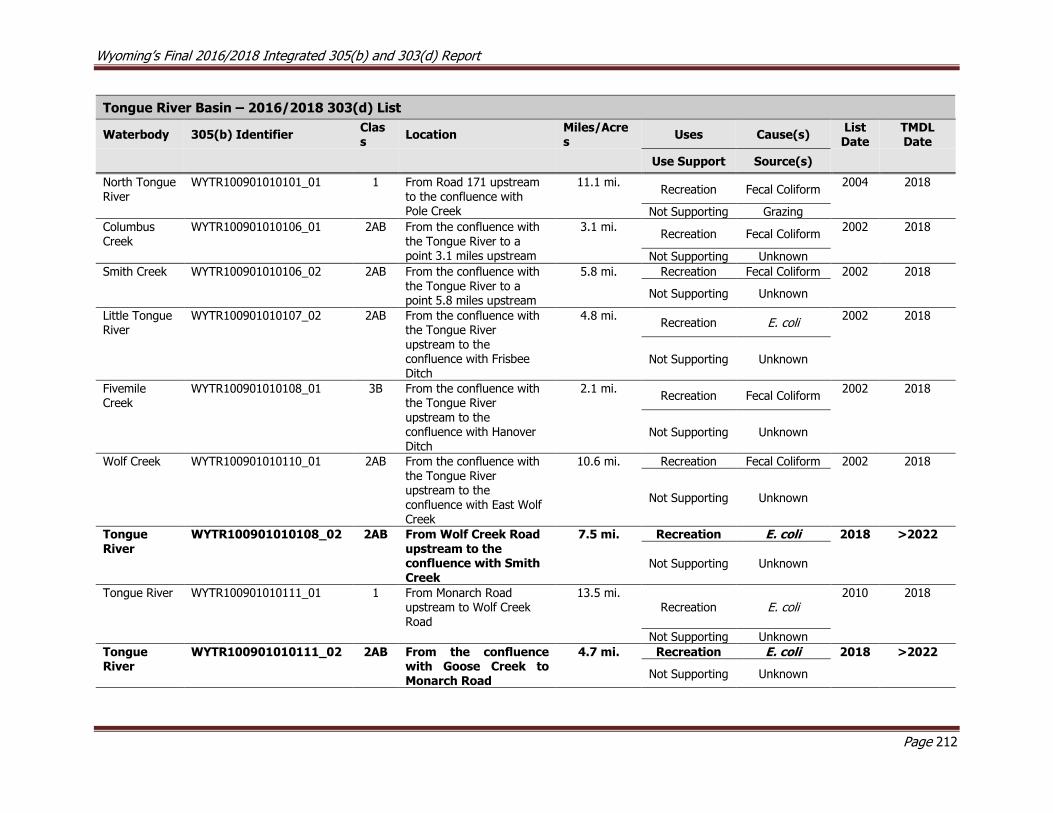
Wyoming’s Final 2016/2018 Integrated 305(b) and 303(d) Report
Page 212
Tongue River Basin – 2016/2018 303(d) List
Waterbody 305(b) Identifier Class
Location Miles/Acres
Uses Cause(s) List Date
TMDL Date
Use Support Source(s)
North Tongue River
WYTR100901010101_01 1 From Road 171 upstream to the confluence with Pole Creek
11.1 mi. Recreation Fecal Coliform
2004 2018
Not Supporting Grazing
Columbus Creek
WYTR100901010106_01 2AB From the confluence with the Tongue River to a point 3.1 miles upstream
3.1 mi. Recreation Fecal Coliform
2002 2018
Not Supporting Unknown
Smith Creek WYTR100901010106_02 2AB From the confluence with the Tongue River to a point 5.8 miles upstream
5.8 mi. Recreation Fecal Coliform 2002 2018
Not Supporting Unknown
Little Tongue River
WYTR100901010107_02 2AB From the confluence with the Tongue River upstream to the confluence with Frisbee Ditch
4.8 mi. Recreation E. coli
2002 2018
Not Supporting Unknown
Fivemile Creek
WYTR100901010108_01 3B From the confluence with the Tongue River upstream to the confluence with Hanover Ditch
2.1 mi. Recreation Fecal Coliform
2002 2018
Not Supporting Unknown
Wolf Creek WYTR100901010110_01 2AB From the confluence with the Tongue River upstream to the confluence with East Wolf Creek
10.6 mi. Recreation Fecal Coliform 2002 2018
Not Supporting Unknown
Tongue River
WYTR100901010108_02
2AB From Wolf Creek Road upstream to the confluence with Smith Creek
7.5 mi. Recreation E. coli 2018 >2022
Not Supporting Unknown
Tongue River WYTR100901010111_01 1 From Monarch Road upstream to Wolf Creek Road
13.5 mi. Recreation E. coli
2010 2018
Not Supporting Unknown
Tongue River
WYTR100901010111_02
2AB From the confluence with Goose Creek to Monarch Road
4.7 mi. Recreation E. coli 2018 >2022
Not Supporting Unknown
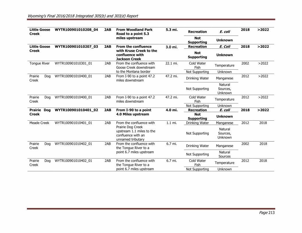
Wyoming’s Final 2016/2018 Integrated 305(b) and 303(d) Report
Page 213
Little Goose Creek
WYTR100901010208_04 2AB From Woodland Park Road to a point 5.3 miles upstream
5.3 mi. Recreation E. coli
2018 >2022
Not Supporting
Unknown
Little Goose Creek
WYTR100901010207_03
2AB From the confluence with Kruse Creek to the confluence with Jackson Creek
3.0 mi.
Recreation E. Coli 2018 >2022
Not Supporting
Unknown
Tongue River WYTR100901010301_01 2AB From the confluence with Goose Creek downstream to the Montana border
22.1 mi. Cold Water Fish
Temperature 2002 >2022
Not Supporting Unknown
Prairie Dog Creek
WYTR100901010400_01 2AB From I-90 to a point 47.2 miles downstream
47.2 mi. Drinking Water Manganese
2012 >2022
Not Supporting
Natural Sources, Unknown
Prairie Dog Creek
WYTR100901010400_01 2AB From I-90 to a point 47.2 miles downstream
47.2 mi. Cold Water Fish
Temperature 2012 >2022
Not Supporting Unknown
Prairie Dog Creek
WYTR100901010401_02
2AB From I-90 to a point 4.0 Miles upstream
4.0 mi. Recreation E. coli 2018 >2022
Not Supporting
Unknown
Meade Creek WYTR100901010401_01 2AB From the confluence with
Prairie Dog Creek upstream 1.1 miles to the confluence with an unnamed tributary
1.1 mi. Drinking Water Manganese 2012 2018
Not Supporting Natural Sources, Unknown
Prairie Dog Creek
WYTR100901010402_01 2AB From the confluence with the Tongue River to a point 6.7 miles upstream
6.7 mi. Drinking Water Manganese
2002 2018
Not Supporting
Natural Sources
Prairie Dog Creek
WYTR100901010402_01 2AB From the confluence with the Tongue River to a point 6.7 miles upstream
6.7 mi. Cold Water Fish
Temperature 2012 2018
Not Supporting Unknown

Wyoming’s Final 2016/2018 Integrated 305(b) and 303(d) Report
Page 214
11.0 References
Andrews, E.D. 1978. Present and Potential Sediment Yields in the Yampa River Basin, Colorado and Wyoming. USGS Water Resources Investigations 78-105
Bern, C.R., Clark, M.L., Schmidt, T.S., Holloway, J.M., McDougal, R.R. 2015. Soil Disturbance as a Driver of
Increased Stream Salinity in a Semiarid Watershed Undergoing Energy Development. Journal of Hydrology. February 2015. 524. pp. 123-136.
BIO-WEST, Inc. 2001. North Fork Crazy Woman Creek Final Water Quality Report. Wyoming Department of Environmental Quality, Water Quality Division, Cheyenne, WY. 119 pp.
Birkeland, F.S. Chapin III, P.M. Groffman, G.R. Guntenspergen, A.K. Knapp, A.D. McGuire, P.J. Mulholland,
D.P.C. Peters, D.D. Roby, and George Sugihara]. U.S. Geological Survey, Reston, VA, 156 pp.
BLM, 2001. Upper Colorado River Basin Rawlins Field Office Standards and Guidelines Assessment, 2001
Field Season. September, 2002. Rawlins Field Office, Rawlins, WY.
BLM-GR, 2002. Environmental Assessment WY-040-EA02-106, Bureau of Land Management, Green River
Resource Area, December 2002.
BLM-GR, 2003. Environmental Assessment WY-040-EA02-207, with attachments, Bureau of Land Management, Green River Resource Area, February 2003.
BLM, 2005a. Smithfork Allotment Management Plan, Allotment No. 21005. Kemmerer Field Office,
Kemmerer, WY. March 2005. 69pp.
BLM, 2005b. Twin Creek Allotment Cooperative Management Plan. Kemmerer Field Office, Kemmerer, WY.
March 2005. 21pp.
BLM. 2007. Environmental Assessment for the Catalina Unit Coalbed Natural Gas Produced Water Disposal
Project II. Carbon County, Wyoming. November 2007.
Bray, TJ 1996. Changes in Channel Morphology and Riparian Mosaics on the Bighorn River, Wyoming, MS Thesis, University of Wyoming, December 1996.
CCCD, 2016. Little Powder River E. coli Source Project, Draft, Campbell County Conservation District,
October 2016.
CCSP, 2009: Thresholds of Climate Change in Ecosystems. A report by the U.S. Climate Change Science
Program and the Subcommittee on Global Change Research Fagre, D.B., C.W. Charles, C.D. Allen, C.
CDM, 2010. Atlantic Rim Coal Bed Methane and Natural Gas Project, Carbon County, Wyoming. Muddy
Creek Monitoring Report – 2010. Camp, Dresser, and McKee Inc., October 19, 2010.
Chapman, S.S., Bryce, S.A., Omernik, J.M., Despain, D.G., ZumBerge, J., and Conrad, M., 2003, Ecoregions of Wyoming (color poster with map, descriptive text, summary tables, and photographs): Reston, Virginia,
U.S. Geological Survey (map scale 1:1,400,000).
CRBSCF, 2002. 2002 Review of Water Quality Standards for Salinity Colorado River System, Colorado River
Basin Salinity Control Forum, October 2002.
Wyoming’s Final 2016/2018 Integrated 305(b) and 303(d) Report
Page 215
Darton, LH 1906. The Hot Springs at Thermopolis, Wyoming. Journal of Geology, 14(3): 194-200.
Ecological Services, 1995. Fishing Lake Water Quality Study. Section 205j final report prepared for Campbell County Conservation District by Ecological Services, July 1995.
EDE Consultants, 2005. Belle Fourche River/Donkey Creek 319 Watershed Assessment. 2003-2004 indicator bacteria monitoring report. Prepared for Crook County Natural Resource District. Sundance, WY.
EDE Consultants, 2013. 2004 through 2012 Bitter and Killpecker Creek Watershed Monitoring
Comprehensive Data Compilation Document. Prepared by EDE Consultants for Sweetwater County Conservation District. Sundance, WY.
EnTech, 2001. Final Report for Prairie Dog Creek Watershed Level I Study, Prepared for Wyoming Water Development Commission, November 2001.
ERI, 1992. Water Quality in the Upper Bear River, Problems and Mitigation, Ecosystem Research Institute,
Logan, Utah.
ERI, 1996. Bridger Creek Restoration Project. Section 319 Nonpoint Source Pollution Control Program
Watershed Project Final Report, Ecosystem Research Institute, Logan, UT.
Foreman, C.S. 2007. Belle Fourche River fecal coliform analysis project final report. Section 319 nonpoint source pollution control program Topical Report RSI-1882. SD Dept. Environment and Nat. Resources and
Belle Fourche Watershed Partnership. December 2007.
Formation Environmental and Habitech, Inc. 2012. Proposed Site-Specific Selenium Criterion, Sage and
Crow Creeks, Idaho. Prepared for J.R. Simplot. Accessed via http://www.deq.idaho.gov/media/804989-simplot-site-specific-selenium-criterion-proposal-0112.pdf
Girard, C. 2015. The Effects of Oil and Natural Gas Development on Water Quality, Aquatic Habitat, and Native Fish in Streams along the Wyoming Range, Master’s Thesis, University of Wyoming, Department of
Zoology and Physiology, August 2015.
Hargett, E.G., J.R. ZumBerge and C.P. Hawkins. 2005. Development of a RIVPACS Model for Wadeable
Streams of Wyoming. Wyoming Department of Environmental Quality, Water Quality Division, Cheyenne, WY.
Hargett, E.G. 2011. The Wyoming Stream Integrity Index (WSII) - Multimetric Indices for Wadeable
Streams and Large Rivers in Wyoming. Wyoming Department of Environmental Quality, Water Quality Division, Cheyenne, WY.
Hargett, E.G. 2012. Assessment of aquatic biological condition using WY RIVPACS with comparisons to the Wyoming Stream Integrity Index (WSII). Wyoming Department of Environmental Quality, Water Quality
Division, Cheyenne, WY.
Houston, DB 1982. The northern Yellowstone Elk: ecology and management. Macmillan Publ. Co., New
York, N.Y.
Hoyer, D.P., Ph.D. and A.M. Larson. 2005. Belle Fourche River Watershed. Butte, Lawrence, and Meade Counties, SD. Section 319 nonpoint source pollution control program assessment/planning project (TMDL)
final report. SD DENR and Belle Fourche Watershed Partnership, June 27, 2005. Rapid City, SD.

Wyoming’s Final 2016/2018 Integrated 305(b) and 303(d) Report
Page 216
Idaho Department of Environmental Quality. 2011. Idaho Department of Environmental Quality Final 2010 Integrated Report. Boise, ID: Idaho Department of Environmental Quality.
LCCD, 2016. 2015 Upper Crow Creek Watershed Water Quality Data Report, Laramie County Conservation
District, January 2016.
LRCD, 2017. 2016 Upper Laramie Watershed Water Quality Data Report, Laramie Rivers Conservation District, February 2017.
Marshall, B.D., 2005. An Assessment of Chemical and Biological Trends in the New Fork River Basin,
Sublette County, Wyoming. Prepared for Sublette County Conservation District, Pinedale, Wyoming. Eco Analysts, Inc., Bozeman, MT.
Marshall, B.D. 2007a. Biological Baseline Condition in the Green River Basin, Sublette County, Wyoming: Biological Condition and Within Site Variability 2001-2005. Final Report prepared for Sublette County
Conservation District, Pinedale, Wyoming. River Continuum Concepts, Willow Creek, MT and Eco Analysts Inc., Bozeman, MT on December 11, 2007.
Marshall, B.D. 2007b. An assessment of the biological condition of the New Fork River, near the Pinedale Anticline Project Area: 2006. Final Report prepared for Sublette County Conservation District, Pinedale,
Wyoming. River Continuum Concepts, Willow Creek, MT.
Marston, RA, and JE Anderson 1991. Watersheds and Vegetation of the Greater Yellowstone Ecosystem. Conservation Biology, Vol.5:338-346.
MCD, 2007. Sheets Flat E. coli Project, Meeteetse Conservation District Report to the Wyoming Department of Agriculture, April, 2007.
MCD, 2009. Greybull River E. coli Monitoring, Wyoming Department of Agriculture Final Grant Report,
January, 2009.
NCCD, 2015. Report of Selenium Levels in the North Platte River and Selected Tributaries Associated with
the North Platte River Watershed Implementation Project, Segment I, Natrona County Conservation District, February 2015.
NCCD, 2017. Report of Selenium Levels in the North Platte River and Selected Tributaries Associated with the North Platte River Watershed Implementation Project, Segment II, Natrona County Conservation
District, February 2017.
NRCS, 2001. Twin Creek Initial Investigation Report, Natural Resources Conservation Service in cooperation with the Lincoln County Conservation District, October, 2001.
Ogle, KM 1992. Surface-and Ground-water Quality in the Owl Creek Basin, North-Central Wyoming. US Geological Survey Water Resources Investigations Report 91-4108, 1992.
PACD, 2001. Popo Agie Watershed Water Quality Monitoring Project 1999-2000 Final Report, Popo Agie
Conservation District, August 2001.
PACD, 2005. Popo Agie Watershed Water Quality Monitoring Project 2001-2002 Final Report, Popo Agie
Conservation District, April 2005.
PACD, 2014. Middle Fork of the Popo Agie River Planning and Assessment Project, Project No. 205j 2011A, Popo Agie Conservation District, December, 2014.

Wyoming’s Final 2016/2018 Integrated 305(b) and 303(d) Report
Page 217
Page, F and R Zubik, 2001. Squaw Creek Watershed Project Final Report. Park County, Shoshone National Forest, US Fish and Wildlife Foundation and Wyoming Game and Fish Department. January 2001.
Patterson, M.M., G.B. Paige, and K.J. Reddy, 2009. Selenium in Surface and Irrigation Waters of the
Kendrick Irrigation District, Wyoming. Environmental Monitoring and Assessment, December 18, 2009.
Peterson, D.A., Hargett, E.G., Wright, P.R., and Zumberge, J.R., 2007, Ecological status of Wyoming
streams, 2000-2003: U.S. Geological Survey Scientific Investigations Report 2007-5130, 32 p.
Potts, D.F., 1985. HYDROLOGIC IMPACTS OF A LARGE-SCALE MOUNTAIN PINE BEETLE (DENDROCTONUS PONDEROSAE HOPKINS) EPIDEMIC. JAWRA, 20:373-377.
Rahel, F.J., C.J. Keleher, and J.L. Anderson. 1996. Potential habitat loss and population fragmentation for cold water fish in the North Platte River Drainage of the Rocky Mountains: Response to Climate Change.
Journal of the American Society of Limnology and Oceanography. 41: 1116-1123.
Rees, D.E. and A.E. McMahon. 2011. Review of Habitat Restoration in 303(d) Listed Segments of the Muddy
Creek Basin. Timberline Aquatics, Inc. Fort Collins, Colorado
Rice, C.A., M.S. Ellis, T.T. Bartos and R.M. Flores 2002. Chemical and Isotopic Composition of Water Co-produced with Coalbed Methane in the Powder River Basin, Wyoming and Montana, in Proceedings of
Geological Society of America 2002 Annual Meeting, Denver, Colorado, October 27-30, 2002.
Ripple WJ and RL Beschta 2003. Wolf Reintroduction, Predation Risk, and Cottonwood Recovery in
Yellowstone National Park. Forest Ecology and Management, 184:299-313.
RPO, 1979. Bighorn Basin 208 Water Quality Management Plan. Regional Planning Office, Hot Springs, Washakie, Park, and Big Horn Counties, August 1979.
SCCD, 2003. Goose Creek Watershed Assessment Final Report 2001-2002, Sheridan County Conservation District.
SCCD, 2014. 2012 Goose Creek Watershed Interim Monitoring Report, Final Report, Sheridan County
Conservation District, July 2014.
SCCD, 2015. 2013 Tongue River Watershed Interim Monitoring Project, Final Report, Sheridan County
Conservation District, September 2015.
SCCD, 2016. 2014 Prairie Dog Creek Watershed Interim Monitoring Project, Final Report, Sheridan County Conservation District, February 2016.
SCCD, 2017. 2015 Goose Creek Watershed Interim Monitoring Report, Final Report, Sheridan County Conservation District, January 2017.
SCS, 1980. Watershed Investigation Report, Sage Creek Basin, Carbon County Wyoming, USDA Soil
Conservation Service.
SCS, 1987. Colorado River Salinity Control Program Final Environmental Impact Statement for Big Sandy
River Unit, Sublette and Sweetwater Counties, Wyoming. USDA Soil Conservation Service, September 1987.
SCS, 1994. Bighorn Basin Surface Water Quality Study, Final Report and Recommendations, Wyoming Cooperative River Basin Study, Project No. 4376. USDA Soil Conservation Service.
Wyoming’s Final 2016/2018 Integrated 305(b) and 303(d) Report
Page 218
SERCD, 1998. North Platte Water Quality Assessment Final Report. Saratoga-Encampment-Rawlins Conservation District.
Singer, F.J., ed. 1996. Effects of grazing by wild ungulates in Yellowstone National Park. USDI, National
Park Service, NPS/NRYELL/NRTR/96-01.
SWCCD, 2004. 2004 305(b) and 303(d) Report Comment Letter, Sweetwater County Conservation District,
February 10, 2004.
Tetra Tech, 2007. 2006 Surface Water and Groundwater Monitoring Report, New World Mining District, Response and restoration project. Prepared for USDA Forest Service, Gallatin National Forest. Helen, MT,
April 2007.
Thybony, S., R. Rosenberg and E. M. Rosenberg, 2001. THE MEDICINE BOWS Wyoming’s Mountain
Country. Caxton Press; 180 pp.
TNC, 2016. Grass, Enos, and Left Hand Creek Nonpoint Source Reduction Project Phase III: Using
Cooperative Grazing Management to Reduce Sediment Loading and Improve Riparian and Aquatic Habitat, Section 319 Nonpoint Source Pollution Control Program Assessment Project Final Report, Project No.
NPS2013B, The Nature Conservancy, December 2016.
TNC, 2017. 2nd Annual Cody Wild West River Fest, Section 319 Nonpoint Source Pollution Control Program Assessment Project Final Report, Project No. NPSSEP03, The Nature Conservancy, February 2017.
Trout Unlimited, 2007. Healing Troubled Waters, Preparing Trout and Salmon Habitat for Changing Climate. Report by Trout Unlimited. Arlington, VA. October, 2007.
USEPA, 1992. Secondary Drinking Water Regulations: Guidance for Nuisance Chemicals. July 1992, EPA
810/K-92-001.
USEPA, 1997. Section 3, Volume 2 of USEPA's Guidelines for Preparation of the Comprehensive State Water
Quality Assessments, 305(b) Reports and Annual Electronic Updates: Supplement EPA-841-B-97-002B
USEPA, 2001. Water Quality Criterion for the Protection of Human Health: Methylmercury. January 2001,
EPA-823-B-03-XXX.
USEPA. 2005a. Guidance for 2006 Assessment, Listing and Reporting Requirements Pursuant to Sections 303(d), 305(b) and 314 of the Clean Water Act. July 29, 2005.
USEPA, 2005b. Section IV of USEPA's Guidance for 2006 Assessment, Listing and Reporting Requirements
Pursuant to Sections 303(d), 305(b) and 314 of the Clean Water Act. July 29, 2005.
USFS, 2002. Billie Creek Water Quality Assessment. Medicine Bow-Routt National Forests and Thunder
Basin National Grassland. Saratoga, WY. March, 2002
USFS, 2003. North Zone Aquatics Monitoring and Accomplishment Report FY 2002. Medicine Bow-Routt
National Forests and Thunder Basin National Grassland. Saratoga, WY. May 5, 2003.
USFS, 2007. Watershed Assessment of Trappers Creek. A 7th level tributary of Warm Springs Creek (100800010110), which is a tributary to the Wind River (1008000101). Shoshone National Forest, Cody WY
USGS, 1956. Sedimentation and Chemical Quality of Surface Waters in the Wind River Basin, Wyoming.
US Geological Survey Water-Supply Paper 1373.

Wyoming’s Final 2016/2018 Integrated 305(b) and 303(d) Report
Page 219
USGS, 1992. DETAILED STUDY OF SELENIUM IN SOIL, REPRESENTATIVE PLANTS, WATER, BOTTOM
SEDIMENT, AND BIOTA IN THE KENDRICK RECALAMTION PROJECT. US Geological Survey, Water Investigations Report 91-4131
USGS, 1999. Environmental Setting of the Yellowstone River Basin, Montana, North Dakota, and Wyoming. US Geological Survey Water Resources Investigation Report 98-4269.
USGS, 2003. A Synoptic Study of Fecal-Indicator Bacteria in the Wind River, Bighorn River, Goose Creek
Basins, Wyoming. June-July 2000. US Geological Survey Water Resources Investigation Report 03-4055.
USGS, 2007. Pesticides in Surface Waters of the Bighorn and North Platte River Basins, Wyoming, 2006.
U.S. Geological Survey Fact Sheet 2007-3017.
USGS, 2009a. Mercury in Fish, Bed Sediment, and Water from Streams Across the United States, 1998-2005. U.S. Geological Survey Water Resources Investigation Report 2009-5109.
USGS, 2009b. Specific Conductance and Dissolved-Solids Characteristics for the Green River and Muddy Creek, Wyoming, Water Years 1999-2008. U.S. Geological Survey Water Resources Investigation Report
2009-5168.
USGS, 2009c. Ecological Assessment of Streams in the Powder River Structural Basin, Wyoming and Montana, 2005-06. U.S. Geological Survey Water Resources Investigation Report 2009-5023.
USGS, 2010a. Assessment of Ecological Conditions and Potential Effects of Water Produced from Coalbed Natural Gas Development on Biological Communities in Streams of the Powder River Structural Basin,
Wyoming and Montana, 2005–08. U.S. Geological Survey Water Resources Investigation Report 2009-5124.
USGS, 2010b. Characterization of water quality and biological communities, Fish Creek, Teton
County, Wyoming, 2007–08: U.S. Geological Survey Scientific Investigations Report 2010–5188, 70 p., available at http://pubs.usgs.gov/sir/2010/5188/.
USGS, 2011. Pesticides in Wyoming’s Rivers, 2006-2010. U.S. Geological Survey Fact Sheet 2011-3011.
USGS, 2013. Trends in major-ion constituents and properties for selected sampling sites in the Tongue and Powder River watersheds, Montana and Wyoming. U.S. Geological Survey Water Resources Investigations
Report 2013-5179.
USGS, 2016. Estimated Nitrogen and Phosphorus Inputs to the Fish Creek Watershed, Teton County, Wyoming, 2009-15, Scientific Investigations Report 2016-5160, United States Geological Survey, Virginia,
2016.
WADC, 2015. Wyoming Watersheds Progress Report 2015 Wyoming Association of Conservation Districts.
WDEQ, 2010. Surface Water Monitoring Strategy 2010-2019. Wyoming Department of Environmental
Quality, May 2010.
WDEQ, 2013a. Water Quality Condition of Wyoming Perennial Streams and Rivers - Results of the First
(2004-2007) and Second (2008-2011) Statewide Probability Surveys. January, 2013.
WDEQ, 2013b. Chapter 1 of Wyoming's Water Quality Rules and Regulations (WDEQ, 2013a). September 24, 2013

Wyoming’s Final 2016/2018 Integrated 305(b) and 303(d) Report
Page 220
WDEQ, 2013c. Wyoming Surface Water Classification List. Wyoming Department of Environmental Quality, Water Quality Division, Cheyenne, WY.
WDEQ, 2014. Wyoming's 2014 Methods for Determining Surface Water Quality Condition and TMDL
Prioritization (WDEQ, 2014). April 29, 2014.
WGFD, 1969. An evaluation of the effects of Teton Reservoir on silt levels in the North Platte River,
Wyoming Game and Fish Department, Project #0569-07-6101.
WGFD, 2004. 305(b) and 303(d) Report Comment Letter, Wyoming Game and Fish Department, February 12, 2004.
WGFD, 2012. 2011 Annual Report Strategic Habitat Plan Accomplishments. WGFD, April 2012.
Wohl, E., D. Cooper, L. Poff, F. Rahel, D. Staley, and D. Winters. 2007. Assessment of Stream Ecosystem Function and Sensitivity in the Bighorn National Forest, Wyoming. Environmental Management. 40:284-
302.
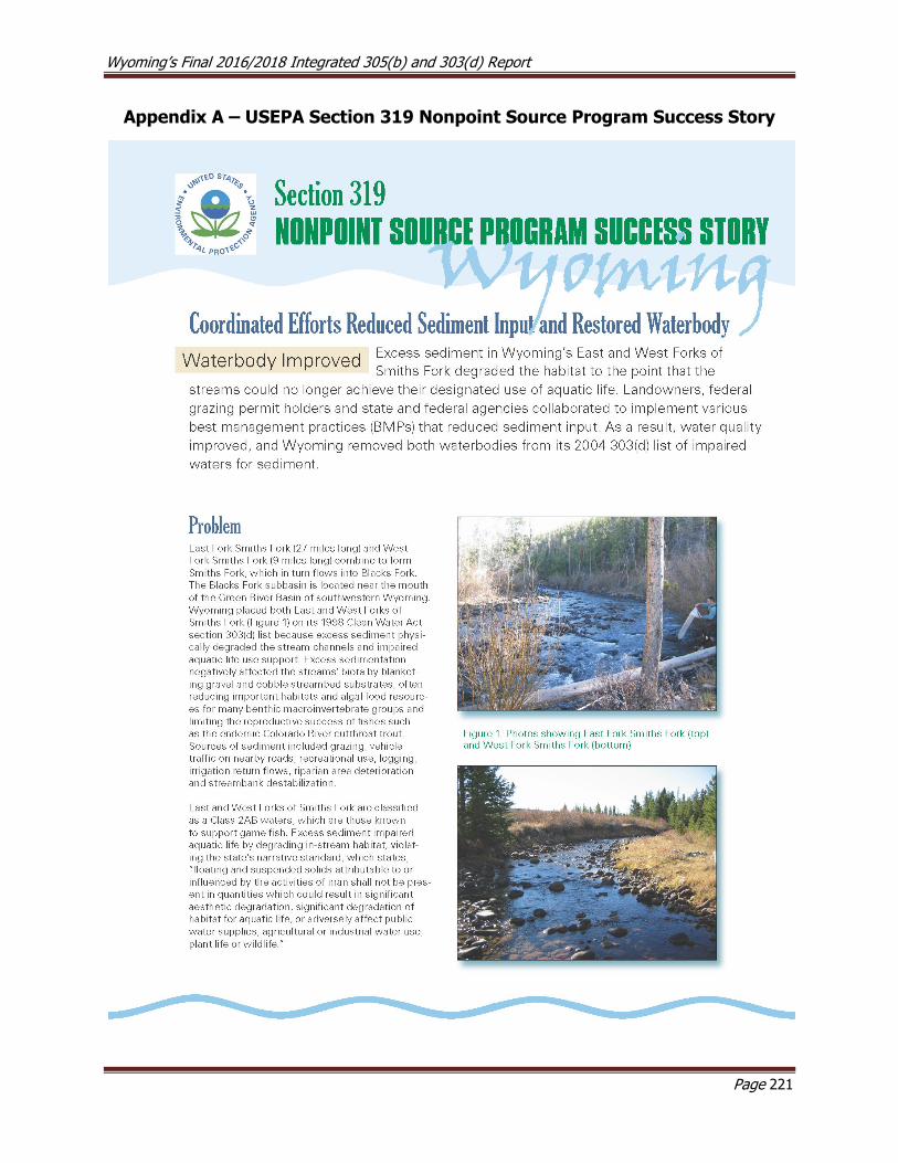
Wyoming’s Final 2016/2018 Integrated 305(b) and 303(d) Report
Page 221
Appendix A – USEPA Section 319 Nonpoint Source Program Success Story

Wyoming’s Final 2016/2018 Integrated 305(b) and 303(d) Report
Page 222