wylfa newydd project a5025 on-line highway improvements · pdf fileenergy working for britain...
TRANSCRIPT

ENERGY W
ORKIN
G FOR BRITAIN
Wylfa Newydd ProjectA5025 On-line Highway Improvements
Water Framework Directive Compliance Assessment
APPLICATION November 2017

Wylfa Newydd Project Water Framework Directive Compliance Assessment A5025 On-line Highway Improvements
© Horizon Nuclear Power Wylfa Limited
Page i
Contents 1 Introduction ...................................................................................................... 1
1.1 Purpose of the document ................................................................................. 1
1.2 Background ..................................................................................................... 1
1.3 Horizon Nuclear Power Wylfa Limited ............................................................. 1
1.4 The Wylfa Newydd Project .............................................................................. 1
Wylfa Newydd DCO Project ............................................................................. 1
Licensable Marine Activities ............................................................................ 2
Enabling Work ................................................................................................. 3
1.5 The A5025 On-line Highway Improvements .................................................... 3
Mitigation ......................................................................................................... 4
Water Framework Directive ............................................................................. 5
2 Methodology .................................................................................................... 9
2.1 Scope of the assessment ................................................................................ 9
WFD Compliance Assessment steps ............................................................... 9
Desk study and walkover surveys .................................................................. 10
3 WFD Compliance Assessment ...................................................................... 13
3.1 Step 1: screening assessment ....................................................................... 13
3.2 Step 2: baseline conditions ............................................................................ 14
Tan R’Allt ....................................................................................................... 15
Cleifiog (Valley) .............................................................................................. 16
The Skerries .................................................................................................. 17
Ynys Môn Secondary ..................................................................................... 18
3.3 Step 3: potential effects on quality elements ................................................. 18
3.4 Step 4: review of actions to deliver WFD mitigation measures ...................... 23
3.5 Step 5: compliance with European legislation ............................................... 24
Bathing waters ............................................................................................... 24
Special Protection Areas (SPA), Special Areas of Conservation (SAC) and Ramsar sites .................................................................................................. 24
Drinking water ................................................................................................ 25
3.6 Step 6: determination of compliance .............................................................. 25
4 References .................................................................................................... 26

Water Framework Directive Compliance Assessment Wylfa Newydd Project A5025 On-line Highway Improvements
© Horizon Nuclear Power Wylfa Limited
Page ii
List of Tables Table 3-1 Screening assessment ............................................................................ 13
Table 3-2 Current WFD water body status .............................................................. 14
Table 3-3 Summary of activities potentially affecting each WFD water body .......... 19
Table 3-4 Potential effects on the WFD water body quality elements...................... 20
Table 3-5 Potential effects on the WFD groundwater body quality elements .......... 23
Table 3-6 WFD Compliance Assessment against the key WFD objectives ............. 25
List of Figures Figure 1-1 Overview of the A5025 On-line Highway Improvements ........................... 7
Figure 2-1 Proposed Development study area and WFD receptors ......................... 11

Wylfa Newydd Project Water Framework Directive Compliance Assessment A5025 On-line Highway Improvements
© Horizon Nuclear Power Wylfa Limited
Page 1
1 Introduction
1.1 Purpose of the document
1.1.1 This Water Framework Directive (WFD) Compliance Assessment forms part of the documentation that will comprise the planning application for the A5025 On-line Highway Improvements (the Proposed Development).
1.1.2 The Proposed Development is described in section 1.3 of this report.
1.1.3 This report should be read in conjunction with the A5025 On-line Highway Improvements Environmental Report, which presents the findings of the environmental assessment of the Proposed Development undertaken in parallel with the WFD Compliance Assessment.
1.2 Background
1.2.1 Land adjacent to the Existing Power Station at Wylfa Head, west of Cemaes on the north coast of the Isle of Anglesey, is considered by the UK Government to be suitable for the construction of a new nuclear power station. Horizon Nuclear Power Wylfa Limited (Horizon) proposes to construct and operate a new nuclear power station, known as Wylfa Newydd, on this land. This power station would deliver approximately 2,700 megawatts of electricity, enough power for around five million homes.
1.3 Horizon Nuclear Power Wylfa Limited
1.3.1 Horizon is a UK energy company developing a new generation nuclear power station to help meet the country's need for stable and sustainable low carbon energy. Horizon's ultimate parent company is Hitachi Ltd., a Japanese corporation and the parent company of the multi-national Hitachi group of companies.
1.4 The Wylfa Newydd Project
1.4.1 Horizon is proposing to construct and operate the Wylfa Newydd Project, which comprises the Wylfa Newydd DCO Project, the Licensable Marine Activities and the Enabling Works. Each of these elements is described further below. The Licensable Marine Activities will be consented under a Marine Licence and the Wylfa Newydd DCO Project under a DCO, however there is some overlap between the two; the Marine Works (see below) will be consented under both.
Wylfa Newydd DCO Project
1.4.2 The Wylfa Newydd DCO Project comprises those parts of the Wylfa Newydd Project which are to be consented by a DCO, namely:
Power Station: the proposed new nuclear power station, including two
UK Advanced Boiling Water Reactors (UK ABWRs) to be supplied by
Hitachi-GE Nuclear Energy Ltd., supporting facilities, buildings, plant and
structures, and radioactive waste and spent fuel storage buildings and

Water Framework Directive Compliance Assessment Wylfa Newydd Project A5025 On-line Highway Improvements
© Horizon Nuclear Power Wylfa Limited
Page 2
apparatus to transfer electrical energy to the National Grid high voltage
electricity transmission network;
Other on-site development: including landscape works and planting,
drainage, surface water management systems, public access works
including temporary and permanent closures and diversions of public
rights of way, new Power Station Access Road and internal site roads,
car parking, construction works and activities including construction
compounds and temporary parking areas, laydown areas, working areas
and temporary works and structures, temporary construction viewing
area, diversion of utilities, perimeter and construction fencing;
Marine Works comprising:
- Permanent Marine Works: the Cooling Water System , Marine Off-
Loading Facility (MOLF), breakwater structures, shore protection
works, surface water drainage outfalls, fish recovery and return
system, fish deterrent system, navigation aids and Dredging;
- Temporary Marine Works: temporary cofferdams, a temporary
access ramp, temporary navigation aids, temporary outfalls and a
temporary barge berth;
Off-Site Power Station Facilities: comprising the Alternative
Emergency Control Centre (AECC), Environmental Survey Laboratory
(ESL) and a Mobile Emergency Equipment Garage (MEEG); and
Associated Development: the Site Campus within the Wylfa Newydd
Development Area; temporary Park and Ride facility at Dalar Hir for
construction workers (Park and Ride); temporary Logistics Centre at Parc
Cybi (Logistics Centre); and the A5025 Off-line Highway Improvements.
1.4.3 The following terms are used when describing the geographical areas related to the Wylfa Newydd DCO Project and the Licensable Marine Activities.:
Power Station Site - the indicative area of land and sea within which the
majority of the permanent Power Station buildings, plant and structures
would be located. This includes the two nuclear reactors, steam turbines,
the Cooling Water System, breakwaters and the MOLF.
Wylfa Newydd Development Area - the indicative areas of land and sea
including the Power Station Site, and the surrounding areas that would
be used for construction and operation of the Power Station, Marine
Works and other on-site development. It would also include the Site
Campus. This area is representative of the maximum area that would be
physically affected by construction activities related to the Power Station
and used to form the setting and landscaping features of the operational
Power Station.
Licensable Marine Activities
1.4.4 The Licensable Marine Activities comprise the Permanent Marine Works, the Temporary Marine Works, the disposal of dredged material at the Disposal

Wylfa Newydd Project Water Framework Directive Compliance Assessment A5025 On-line Highway Improvements
© Horizon Nuclear Power Wylfa Limited
Page 3
Site, the drainage of surface water into the sea. During construction phase this includes the construction of a waste water treatment effluent outfall, and the drainage of treated sewage into the sea.
Enabling Work
1.4.5 The Enabling Works comprise the Site Preparation and Clearance Proposals (SPC Proposals) and the A5025 On-line Highway Improvements.
1.4.6 Horizon has submitted applications for planning permission for the Enabling Works under the Town and Country Planning Act 1990 to the Isle of Anglesey County Council (IACC).
1.4.7 In order to maintain flexibility in the consenting process for the Wylfa Newydd DCO Project, the SPC Proposals have also been included in the application for development consent. The A5025 On-line Highway Improvements are not part of the application for development consent.
1.5 The A5025 On-line Highway Improvements
1.5.1 Construction of the Power Station would require very substantial transport needs for materials, large components and staff. Studies undertaken by Horizon in 2010–2011 identified that the stretch of the A5025 between Valley and the proposed Power Station Access Road Junction has physical and operational constraints in relation to its width, alignment, overtaking opportunities and surfacing condition (see chapter 2).
1.5.2 As a result of these studies Horizon has committed to improve this section of the A5025 in order to mitigate the predicted impacts of increased traffic associated with construction activities that would be undertaken at the Wylfa Newydd Development Area, and from operational Power Station traffic, that would travel along this part of the highway network.
1.5.3 Horizon therefore intends to deliver a series of on-line and off-line improvements (collectively termed the A5025 Highway Improvements) between Valley and the proposed Power Station Access Road Junction as part of its wider transport strategy for the Project, the objectives being to:
upgrade the route, both in terms of standard of construction and road
geometry, such that it can support increased levels of traffic, and
improve safety and accessibility;
ensure that all relevant abnormal loads can pass along the full length
of the A5025;
reduce any potential increase in road accident risk;
reduce any adverse impacts on local communities;
reduce any adverse impacts on the environment; and
seek opportunities where possible to achieve improvements for local
communities and the environment through road design measures.
1.5.4 The 16.19km stretch of the A5025 identified for on-line improvement has been divided into eight sections (see figure 1-1).

Water Framework Directive Compliance Assessment Wylfa Newydd Project A5025 On-line Highway Improvements
© Horizon Nuclear Power Wylfa Limited
Page 4
Section 1 – A5 east of Valley junction to north of Valley Junction
(A5/A5025) – a length of 1.06km;
Section 2 – north of Valley Junction (A5/A5025) to north of Llanynghenedl
– a length of 2.46km;
Section 3 – north of Llanynghenedl to north of Llanfachraeth – a length
of 2.28km;
Section 4 – north of Llanfachraeth to south of Llanfaethlu – a length of
2.7km;
Section 5 – south of Llanfaethlu to north of Llanfaethlu – a length of
1.43km;
Section 6 – north of Llanfaethlu to north of Llanrhuddlad – a length of
3.36km;
Section 7 – north of Llanrhuddlad to north of Cefn Coch – a length of
1.3km; and
Section 8 – north of Cefn Coch to the proposed Power Station Access
Road Junction – a length of 1.6km.
1.5.5 The Proposed Development involves the implementation of on-line improvements largely within the existing highway boundary of the A5025. In summary, these comprise:
improvement of the existing pavement through the application of a
surface dressing through sections 1, 3, 5 and 7;
reconstruction and localised widening of the existing pavement through
sections 2, 4, 6 and 8;
modifications and improvements to existing signage and road markings
through sections 1–8; and
the construction of a Temporary Construction Compound (incorporating
a temporary pavement recycling facility) within section 7, immediately
adjacent to the A5025.
1.5.6 The A5025 Off-line Highway Improvements would involve the construction of bypasses to reduce the effects of future traffic on existing communities, the formation of new junction arrangements (including the provision of the proposed Power Station Access Road Junction), and localised improvements to existing bends.
1.5.7 The A5025 Off-line Highway Improvements form an integral component of the Wylfa Newydd DCO Project application, and do not form part of the planning application for the Proposed Development.
Mitigation
1.5.8 Embedded mitigation includes all those measures that are incorporated into the design of the Proposed Development to avoid or reduce environmental effects. These are presented in detail in chapter 2 of the A5025 On-line Highway Improvements Environmental Report. Those of relevance to the WFD Compliance Assessment comprise:
Wylfa Newydd Project Water Framework Directive Compliance Assessment A5025 On-line Highway Improvements
© Horizon Nuclear Power Wylfa Limited
Page 5
the phasing of the works to reduce the overall duration of construction
activities along the highway corridor, and the timing of working periods to
reduce disruption to road users, residents, businesses and community
facilities, and to avoid the bird breeding season;
widening within the existing highway boundary wherever possible and,
where this is not achievable, minimising the area of new hardstanding
introduced;
the incorporation of existing infrastructure and regimes into the overall
drainage design, where possible, to reduce the requirement to install new
drainage components;
the inclusion of new highway drainage and attenuation measures, where
necessary, to control runoff and reduce potential flood risk;
the inclusion of a temporary pavement recycling facility within a single
Temporary Construction Compound to reduce temporary land take
requirements, the quantities of waste generated, the transportation of
material off-site, the requirement to import new material and vehicle
movements on the highway network; and
the development of an indicative internal layout of the Temporary
Construction Compound, the demarcation of a protective 10m wide buffer
area around watercourses and the containment of the site through the
use of wooden perimeter fencing.
1.5.9 Good practice mitigation comprises mitigation that would be required regardless of the environmental assessment, as it is imposed, for example, as a result of legislative requirements and/or standard sectoral practices.
1.5.10 Good practice mitigation measures of specific relevance to the WFD Compliance Assessment are presented in the A5025 On-line Highway Improvements Code of Construction Practice.
Water Framework Directive
1.5.11 The European Union Water Framework Directive (Council Directive) (2000/60/EC) [RD3] is European water legislation with the overarching objective of all water bodies in Europe attaining Good or High Ecological Status or Potential by 2027. The WFD [RD1] is implemented in Wales by The Water Environment (Water Framework Directive) (England and Wales) Regulations 2017 [RD4], which establish a framework for the protection of surface waters and groundwater, such that they obtain ‘high’ ecological status.
1.5.12 Natural Resources Wales (NRW) requires an assessment of the impact of any works (including modification) to water bodies in the UK under the WFD. The primary aim of the WFD is to improve and maintain the ecological status and potential of all WFD water bodies. In addition, the WFD requires no deterioration in overall status, or the status of individual quality elements. Ecological quality comprises a series of biological, physico-chemical and hydromorphological ‘quality elements’.

Water Framework Directive Compliance Assessment Wylfa Newydd Project A5025 On-line Highway Improvements
© Horizon Nuclear Power Wylfa Limited
Page 6
1.5.13 For surface WFD water bodies to achieve overall Good Ecological Status or Good Ecological Potential, a series of quality elements have been assessed falling within three categories: biological, physico-chemical and hydromorphological. Good Status refers to situations where the ecological characteristics show only a slight deviation from a natural reference condition. Artificial and heavily modified water bodies (A/HMWBs) have a target to achieve Good Potential recognising their important uses, whilst making sure the water body is protected as far as possible.
1.5.14 The following set of objectives for this WFD Compliance Assessment has been agreed with NRW and are based on those objectives set out in the WFD [RD3]:
prevent deterioration of the status of all bodies of surface water (Article
4.1 (a)(i));
protect, enhance and restore all bodies of surface water with the aim of
achieving good surface water status by 2015 (cycle 1) and 2021 (cycle
2) (Article 4.1 (a)(ii));
protect and enhance all A/HMWBs, with the aim of achieving Good
Ecological Potential and good surface water chemical status by 2015
(Article 4.1 (a)(iii));
reduce pollution from priority substances and cease, or phase out,
emissions, discharges and losses of priority hazardous substances
(Article 4.1 (a)(iv));
prevent or limit the input of pollutants into groundwater and prevent
deterioration of the status of all bodies of groundwater (Article 4.1 (b)(i));
protect, enhance and restore all bodies of groundwater and to allow a
balance between abstraction and recharge of groundwater (Article 4.1
(b)(ii));
make sure that the achievement of objectives in other water bodies is not
compromised (Article 4.8); and
take into account the protection provided by other community legislation
(Article 4.9).
1.5.15 The WFD water bodies are grouped into River Basin Districts. Details of the water bodies and measures to meet the overall objectives are outlined in the Western Wales River Basin Management Plan [RD10].
1.5.16 The potential for a scheme to be non-compliant is identified as part of the environmental assessment process. Where a scheme is considered to cause deterioration, or where it could contribute to a failure of the water body to meet Good Status/Potential, then an Article 4.7 assessment [RD3] would be required. This process requires the comparison of the scheme against a series of criteria, for which evidence must be provided to support the scheme failing to meet the legislative obligations. This includes consideration of all possible measures to mitigate the impact. Should a modification or change meet all of the criteria set out in Article 4.7 [RD3] then the scheme can be permitted.

Wylfa Newydd Project Water Framework Directive Compliance Assessment A5025 On-line Highway Improvements
© Horizon Nuclear Power Wylfa Limited
Page 7
Figure 1-1 Overview of the A5025 On-line Highway Improvements

Water Framework Directive Compliance Assessment Wylfa Newydd Project A5025 On-line Highway Improvements
© Horizon Nuclear Power Wylfa Limited
Page 8
[This page is intentionally blank]

Wylfa Newydd Project Water Framework Directive Compliance Assessment A5025 On-line Highway Improvements
© Horizon Nuclear Power Wylfa Limited
Page 9
2 Methodology
2.1 Scope of the assessment
2.1.1 This WFD Compliance Assessment relates solely to the Proposed Development and is specific to the improvements associated with pavement reconstruction and widening works proposed within sections 2, 4, 6 and 8. Figure 2-1 provides an overview of the study area used in the assessment.
2.1.2 As the application of surface dressing within sections 1, 3, 5 and 7 would not lead to any potential effects on the WFD quality elements (biological, physico-chemical and hydromorphological) these four sections of the A5025 have been scoped out of this assessment. However, the Temporary Construction Compound area in section 7 has been scoped into this assessment, as it would involve potential works and operations within the vicinity of watercourses within the study area.
2.1.3 Key activities associated with construction of Proposed Development considered relevant to this assessment include:
site clearance of vegetation, topsoil and field boundaries;
installation of highway drainage infrastructure, and the formation of
attenuation ponds and outfalls to watercourses;
works to create or improve kerbs, footways/cycleways, parking
arrangements and Private Means of Access;
minor earthworks;
processing, batching and transportation of recycled pavement material;
and
pavement reconstruction (including the construction of a new section of
carriageway associated with bend improvements at Bytheicws (section
4)).
2.1.4 Operation of the Proposed Development would involve the permanent modification of drainage regimes and the attenuation of road runoff.
WFD Compliance Assessment steps
2.1.5 The sequence of this WFD Compliance Assessment is based on the steps as summarised below:
Step 1: screening assessment of water bodies within a study area, their
relevance and whether they can be scoped in or out of the WFD
Compliance Assessment depending on the proximity to a proposed
scheme and the potential pathways to the WFD water bodies.
Step 2: site walkover and identification of the baseline conditions from
desk study of the biological, physico-chemical and hydromorphological
quality elements.

Water Framework Directive Compliance Assessment Wylfa Newydd Project A5025 On-line Highway Improvements
© Horizon Nuclear Power Wylfa Limited
Page 10
Step 3: specific assessments of the proposed scheme against biological
(including flora and fauna), physico-chemical (including water quality
parameters such as dissolved oxygen, pH and specific nutrients) and
hydromorphological (including quantity and dynamics of flow, bed and
bank material and riparian connectivity) quality elements.
Step 4: review of actions to deliver WFD mitigation measures.
Step 5: assessment of proposed options against European Union
legislation.
Step 6: assessment of proposed options against WFD status objectives.
2.1.6 This WFD Compliance Assessment has been based on a review of desk-based information and the findings of a site walkover assessment (described below).
Desk study and walkover surveys
2.1.7 A desk-based study has been undertaken to inform the WFD Compliance Assessment, reviewing existing information for the Proposed Development and study area to develop the baseline. The following information has been used in the desk study:
contemporary Ordnance Survey mapping [RD5];
geological and soil maps [RD6];
current aerial photography [RD5];
historical maps [RD7];
maps showing statutory designated areas [RD5, RD8];
hydrological information [RD9]; and
existing WFD status and objectives for the 2015 River Basin
Management Plans [RD10].
2.1.8 Geomorphological reconnaissance surveys were completed for the Proposed Development during November 2014, July 2015 and January 2016. The surveys provide an understanding of existing geomorphological conditions of the river channels. A photographic record of the general character and features of the river channels was also compiled.
2.1.9 Ecological walkover surveys of the Proposed Development were undertaken quarterly between spring 2014 and spring 2015. A further survey was undertaken in August 2015. The surveys assessed all relevant biological quality indicators (fish, invertebrates, macrophytes and phytobenthos) by way of sampling, the number of samples depending on the season and suitability of each receptor for sampling. Details of the ecological walkover surveys are presented in the A5025 On-line Highway Improvements Environmental Report.

Wylfa Newydd Project Water Framework Directive Compliance Assessment A5025 On-line Highway Improvements
© Horizon Nuclear Power Wylfa Limited
Page 11
Figure 2-1 Proposed Development study area and WFD receptors

Water Framework Directive Compliance Assessment Wylfa Newydd Project A5025 On-line Highway Improvements
© Horizon Nuclear Power Wylfa Limited
Page 12
[This page is intentionally blank]

Wylfa Newydd Project Water Framework Directive Compliance Assessment A5025 On-line Highway Improvements
© Horizon Nuclear Power Wylfa Limited
Page 13
3 WFD Compliance Assessment
3.1 Step 1: screening assessment
3.1.1 A total of nine WFD water bodies have been identified within the study area (see figure 2-1). The study area comprises a 1km buffer around the Proposed Development. These WFD water bodies were considered to have potential pathways for effects to arise from the Proposed Development.
3.1.2 Step 1 has resulted in five of the WFD water bodies being screened out of the assessment and four WFD water bodies being screened into the assessment. Table 3-1 provides a summary of the screening process and an explanation why WFD water bodies were screened in and out.
Table 3-1 Screening assessment
Water body name
Water body ID Screening assessment
Screened in
Cleifiog (Valley)
GB110102058930 Two watercourses potentially affected by the Proposed Development form part of the Cleifiog (Valley) WFD water body. It has therefore been screened in.
Tan R’Allt GB110102059100 The Tan R’Allt WFD water body could potentially be affected by the Proposed Development. It has therefore been screened in.
The Skerries
GB611010390000 A coastal WFD water body encompassing the fluvial catchment of the Afon Cafnan. The WFD water body has been screened in as two tributaries of the Afon Cafnan could potentially be affected by the Proposed Development.
Ynys Môn Secondary
GB41002G204400 A WFD groundwater body which covers all Proposed Development sections. Screened in for this reason.
Screened out
Alaw GB521010207600 A transitional WFD water body downstream of the Tan R’Allt WFD water body. The WFD water body has been screened out due to the significant distance from the Proposed Development and the lack of pathways to the WFD water body.
Wygyr GB110102059170 The watercourses forming part of the Wygyr WFD water body would not be affected by the Proposed Development as the road does not cross the water body and none of the watercourses that it crosses discharge into the river. It has, therefore, been screened out.
Caernarfon Bay North
GB621010380000 A coastal WFD water body downstream of the Afon Carreglwyd. The Afon Carreglwyd is crossed by section 4 of the A5025 On-line Highway Improvements; however, it would not be directly or indirectly affected with no formal crossing or drainage to the channel. The WFD water body has, therefore, been screened out.

Water Framework Directive Compliance Assessment Wylfa Newydd Project A5025 On-line Highway Improvements
© Horizon Nuclear Power Wylfa Limited
Page 14
Water body name
Water body ID Screening assessment
Anglesey North
GB641010620000 The watercourses forming part of the Anglesey North WFD water body would not be affected by the Proposed Development as none of the watercourses that the road crosses discharge into the water body. It has, therefore, been screened out.
Cemlyn Lagoon
GB610100083000 The watercourses forming part of the Cemlyn Lagoon WFD water body would not be affected by the Proposed Development as none of the watercourses that the road crosses discharge into the lagoon. It has, therefore, been screened out.
3.2 Step 2: baseline conditions
3.2.1 The four WFD water bodies screened into the assessment are all within the Western Wales River Basin District. The Tan R’Allt and Cleifiog (Valley) are fluvial WFD water bodies, The Skerries is a coastal water body and the Ynys Môn Secondary is a groundwater body. Table 3-2 provides an overview of the WFD quality elements information for each, taken from the Western Wales River Basin Management Plan [RD10].
Table 3-2 Current WFD water body status
Element Description
Name Tan R’Allt Cleifiog (Valley)
The Skerries Ynys Môn Secondary
Water body ID
GB110102059100
GB110102058930
GB611010390000
GB41002G204400
Overall status Moderate status Moderate status High status Poor status
Current ecological status/ potential
Moderate status Moderate status High status N/A
Hydromorpho-logical designation
Not designated A/HMWB
Not designated A/HMWB
Not A/HMWB N/A
Chemical status
Good Good Good Poor
Failing elements
Phosphate Phosphate N/A Chemical dependent surface water body status
Reasons for not achieving good status or potential
Diffuse source (certainty: suspected). Activity: dairy/beef field
Diffuse source (certainty: suspected). Activity: dairy/beef field
N/A Diffuse source (certainty: probable)
Activity: abandoned mine

Wylfa Newydd Project Water Framework Directive Compliance Assessment A5025 On-line Highway Improvements
© Horizon Nuclear Power Wylfa Limited
Page 15
Element Description
Name Tan R’Allt Cleifiog (Valley)
The Skerries Ynys Môn Secondary
Point source (certainty: suspected). Activities: sewage discharge (continuous); unsewered domestic sewage
Point source (certainty: suspected). Activities: sewage discharge (continuous); unsewered domestic sewage
(certainty: probable)
Overall objective
Good by 2021 Good by 2021 High by 2021 Poor (no known technical solution is available)
Listed on NRW Protected Area Register on 2 May 2017
No No No Yes, but probably not at risk
3.2.2 The following sections of the report present the baseline data on each WFD water body. The WFD water bodies are considered as entire catchments, encompassing all tributaries that feed into the main named watercourse. The locations of the WFD water bodies and the contributing fluvial catchments are shown in figure 2-1.
Tan R’Allt
3.2.3 The Tan R’Allt WFD water body is formed by the main watercourse (the Tan R’Allt) and a network of tributaries feeding into this channel. The source of the Tan R’Allt is to the west of Mynydd Mechell, and it flows south to a confluence with the Alaw estuary (a transitional WFD water body). The main watercourse would be directly crossed by the Proposed Development.
3.2.4 The Tan R’Allt channel has a sinuous planform with some reaches where it appears to have been artificially straightened. Aerial photography indicates that the Tan R’Allt is predominantly adjoined by agricultural fields, consisting of both semi-improved grassland and tilled arable fields. There appeared to be very little vegetated riparian corridor present along either bank at the time of the survey.
3.2.5 Road and field drains were observed to enter the channel, which could be sources of fine sediment into Tan R’Allt. The channel was observed to be between 2m and 2.5m wide throughout, with the exception of locations where poaching by animals had widened the channel. There was evidence of undercutting, slumping and vertically eroding banks within the downstream reach indicating activity. A vegetated gravel mid-channel bar and side bars were observed (indicative of deposition).
3.2.6 Water quality analysis for reactive phosphorus indicated that the watercourse failed to meet good WFD status at the monitoring location. The adjacent

Water Framework Directive Compliance Assessment Wylfa Newydd Project A5025 On-line Highway Improvements
© Horizon Nuclear Power Wylfa Limited
Page 16
agricultural land could potentially be a contributor to the high phosphate concentrations through run-off. Following field surveys, the River Invertebrate Classification Tool (RICT) achieved good status within this catchment, meaning the watercourse meets the expected standard under WFD. Several species of mayfly (from families Baetidae, Caenidae and Ephemerellidae) were recorded within the watercourse. The Lotic-invertebrate Index for Flow Evaluation score reflects an invertebrate community of faster, consistently flowing, waters. Analysis of the Proportion of Sediment-sensitive Invertebrates shows that the locations sampled had a moderate amount of sediment accumulation. The Ecological Quality Ratio suggested that there were few flow-stressors at these monitoring locations that would not be present in pristine reference conditions. One species of local conservation importance was recorded (European eel). Brown trout (Salmo trutta), European eel (Anguilla anguilla), lamprey (Lampetra spp.) and three-spined stickleback (Gasterosteus aculeatus) were caught from this watercourse, with brown trout as the most abundant species.
Cleifiog (Valley)
Cleifiog (Valley) watercourse
3.2.7 The Cleifiog (Valley) watercourse is the main watercourse within the WFD water body. It flows in a south-westerly direction from Bodedern for approximately 4km before crossing through a large culvert under the A55 (approximately 100m in length). Section 2 of the Proposed Development would run parallel to the Cleifiog (Valley) for 2.5km and, at its closest point, would be 140m to the east of the existing A5025. A number of small surface water drains feed the Cleifiog (Valley) from the A5025. These watercourses are low quality field drains, likely to be ephemeral during drier months.
3.2.8 The channel for the Cleifiog (Valley) is likely to have been historically realigned (straightened) for agricultural purposes, delineating a number of field boundaries. The vegetated riparian zone was fragmented along the watercourse, with a scattering of trees. Aerial photography suggests the predominant land use in the catchment to be livestock grazing. Some fords were visible along the watercourse, possibly leading to accelerated erosion and fine sediment production by vehicle and animal movements. The channel was observed to have some submerged and floating macrophytes at the time of the visit, particularly in reaches of no perceptible flow.
3.2.9 Reactive phosphorus concentrations were elevated such that the watercourse failed to meet good WFD status at one of the survey locations, indicating possible nutrient enrichment due to adjacent agricultural land use. All other monitored locations currently meet good WFD status.
3.2.10 The biological quality element for invertebrates on the Cleifiog (Valley) watercourse was classified as poor during surveys undertaken in 2015 for the A5025 Off-line Highway Improvements, although only one location along this watercourse was sampled. However, analysis of Proportion of Sediment-sensitive Invertebrates indicated that the location sampled had extensive sediment deposits and, when the Ecological Quality Ratio was calculated, it

Wylfa Newydd Project Water Framework Directive Compliance Assessment A5025 On-line Highway Improvements
© Horizon Nuclear Power Wylfa Limited
Page 17
revealed that there was a serious impact from sedimentation at this monitoring location that would not be present in pristine reference conditions.
3.2.11 Macrophyte surveys showed species indicative of nutrient-enriched, slow-flowing environments including two species of duckweed, the fat duckweed (Lemna gibba) and the least duckweed (Lemna minuta).
3.2.12 Fish surveys on the Cleifiog (Valley) revealed the presence of European eel and three-spined stickleback.
Nant Bryn Teg and tributary of Nant Cleifiog Isaf (north and south)
3.2.13 Nant Bryn Teg and tributary of Nant Cleifiog Isaf (north and south) form part of the Cleifiog (Valley) catchment. These watercourses are man-made drainage channels with limited geomorphological features, ephemeral in nature. They are considered to be fine sediment sources to the main watercourse in the WFD water body catchment.
The Skerries
The Skerries coastal water body
3.2.14 The Skerries coastal water body is characterised by strong tidal currents, semi-diurnal tides and localised eddies in the bays around Wylfa Head. The water body is well mixed all year round with no evidence of a permanent thermocline, halocline or seasonal stratification [RD11]. The coast mainly comprises hard rocky cliffs with sandy bays. The bedrock would have been covered by ice sheets, during the last glaciation, and loose material eroded/detached during that period has since been moved and sorted by currents driven by tidal and wave forces. Offshore, the sea floor is composed of a mixture of bedrock, boulders, cobbles, gravels and sands. Over the long-term, the rocky coast will be extremely slow to change, even with strong tidal currents and wave action.
3.2.15 The results of analysis from surveys carried out between 2010 and 2014 showed expected concentrations of chemicals to be mainly below the limit of detection. These values are in line with previous studies and typical of coastal waters around the north of Isle of Anglesey [RD11].
3.2.16 Phytoplankton production is low, most likely as a result of the low nutrient levels, which is a known feature of this area of the Irish Sea [RD11]. The intertidal ecological communities are characteristic of an exposed, western, rocky coastline, and the habitats support diverse assemblages of macrophytes [RD12]. The subtidal benthic communities are considered to be of high quality and are generally undisturbed [RD12].
Afon Cafnan
3.2.17 The Afon Cafnan, the main watercourse feeding into The Skerries coastal catchment, is a small river following north from Llyn Llygeirian to Porth-y-pistyll. It has a relatively straight artificial planform and forms the boundary of several fields. During a geomorphological reconnaissance survey, the

Water Framework Directive Compliance Assessment Wylfa Newydd Project A5025 On-line Highway Improvements
© Horizon Nuclear Power Wylfa Limited
Page 18
channel was found to exhibit signs of natural processes and channel recovery between Mynydd Ithel and Cafnan.
3.2.18 Surveys carried out between 2011 and 2016 recorded the average channel width as between 0.8m and 1.0m and channel depth as between 0.1m and 0.3m [RD11]. Lengths of poaching and erosion have been noted and longitudinal connectivity was observed to be affected by culverts and bridges throughout the length.
3.2.19 During a physical habitat characterisation survey, some channel lengths were found to exhibit complex flow diversity with a number of flow types, including runs, glides and lengths of slacker flow [RD11]. Substrate was observed during the survey to be predominantly gravel, with riparian vegetation present along both banks, providing potentially good-quality habitat for macroinvertebrates and fish. Brown trout, European eel and both freshwater stickleback species were recorded from the Afon Cafnan. The channel was found, during the survey, to support a varied macrophyte assemblage in some locations, and their abundance was greater in those lengths with reduced trees and scrub.
Tributary of Afon Cafnan (north and south)
3.2.20 The tributaries of Afon Cafnan (north and south) are man-made drainage channels with limited geomorphological features, ephemeral in nature.
Nant Llygeirian
3.2.21 A small watercourse with trapezoidal cross-section and limited vegetated riparian buffer. At the time of survey, the watercourse appeared to be narrowing with aquatic vegetation accumulating fine sediment along the channel margins. The channel had limited geomorphological features and the bed was observed to comprise a predominantly silt substrate with some cobbles.
Ynys Môn Secondary
3.2.22 The Ynys Môn Secondary WFD groundwater body covers most of Anglesey.
3.2.23 The published data states that the Ynys Môn Secondary groundwater body is currently achieving poor status overall, as the current chemical status is poor (table 3-2). However, following discussions with, and receipt of a Scoping Opinion [RD13] from the IACC for the A5025 Highway Improvements (where advice was taken from NRW), it is understood that the overall quality within the groundwater body is actually considered to be good. However, the formal classification for water chemistry is poor because there are local discharges of metals from abandoned mines in some areas leading to some effects on local surface water quality [RD14].
3.3 Step 3: potential effects on quality elements
3.3.1 Step 3 aims to provide a specific assessment of the construction and operation of the Proposed Development in relation to the three quality elements: biological, physico-chemical and hydromorphological.

Wylfa Newydd Project Water Framework Directive Compliance Assessment A5025 On-line Highway Improvements
© Horizon Nuclear Power Wylfa Limited
Page 19
3.3.2 Table 3-3 provides a summary of the activities potentially affecting each WFD water body, which are shown in figure 2-1.
Table 3-3 Summary of activities potentially affecting each WFD water body
Water body name
Activities
Cleifiog (Valley)
Nant Bryn Teg (forming Cleifiog Fawr):
One new outfall.
Tributary of Cleifiog Isaf (north):
Two new attenuation ponds constructed over the existing course of the channel.
Four new outfalls.
One new channel connecting two attenuation ponds.
Tributary of Cleifiog Isaf (south):
One new outfall.
Tan R’Allt One new outfall.
The Skerries
Nant Llygeirian:
Construction of Temporary Construction Compound
Tributary of Afon Cafnan (north):
One culvert extension.
Additional discharge from one existing outfall.
Tributary of Afon Cafnan (south):
One culvert extension.
Additional discharge from one existing outfall.
Ynys Môn Secondary
Change in drainage systems and potential for discharges to ground.
3.3.3 Tables 3-4 and 3-5 detail the key potential effects. The following provides a key to the colour coding used in the tables:
purple – no change;
green – negligible to low risk of deterioration of status;
orange – medium risk of deterioration of status (some mitigation
required); and
red – high risk of deterioration of status (non-compliant and major
mitigation required).

Water Framework Directive Compliance Assessment Wylfa Newydd A5025 On-line Highway Improvements
© Horizon Nuclear Power Wylfa Limited
Page 20
Table 3-4 Potential effects on the WFD water body quality elements
Quality element Tan R’Allt Cleifiog (Valley) The Skerries
Biological quality elements
Composition and abundance of aquatic flora
Localised habitat loss and hydrological changes from modification to drainage infrastructure and clearance of the site of the Proposed Development.
No effect predicted at a water body level due to small-scale (i.e. localised to the specific area of modification) nature of effect.
Localised habitat loss and hydrological changes from modification to drainage infrastructure and culvert extension on Afon Cafnan.
No effect predicted at a water body level due to small-scale (i.e. localised to the specific area of modification) nature of effect.
Composition and abundance of benthic invertebrate fauna
Composition, abundance and age structure of fish fauna
European eel known to migrate into Tan R’Allt. Localised habitat loss and hydrological changes from modification to drainage infrastructure and clearance of the site of the Proposed Development.
Negligible effect predicted on composition, abundance and age structure of fish (including European eel) at a water body level due to small-scale (i.e. localised to the specific area of modification) nature of effect
European eel known to migrate into Cleifiog (Valley). Localised habitat loss and hydrological changes from modification to drainage infrastructure and clearance of the Development Area.
Negligible effect predicted at a water body level due to small-scale (i.e. localised to the specific area of modification) nature of effect.
European eel known to migrate into Afon Cafnan. Localised habitat loss and hydrological changes from modification to drainage infrastructure and culvert extension.
No effect predicted at a water body level due to small-scale (i.e. localised to the specific area of modification) nature of effect.
Physico-chemical quality elements
Physico-chemical quality elements
Physico-chemical changes would occur from modification to drainage
Localised hydrological changes from modification to drainage infrastructure
Localised impacts on physico-chemical aspects due to increased discharge from outfalls on Tributary of Afon Cafnan (north and south).

Wylfa Newydd Project Water Framework Directive Compliance Assessment A5025 On-line Highway Improvements
© Horizon Nuclear Power Wylfa Limited
Page 21
infrastructure and clearance of the site of the Proposed Development.
Negligible effect predicted at a water body level due to small-scale, predominantly localised, nature of effect. New drainage infrastructure likely to result in an improvement over the existing operational condition with regards to water quality from discharges (due to improvements being made in the treatment of run-off which currently doesn’t exist).
and clearance of the site of the Proposed Development.
Negligible effect predicted at a water body level due to small-scale, predominately localised, nature of effect. New drainage infrastructure likely to result in an improvement over the existing operational condition with regards to water quality from discharges (due to improvements being made in the treatment of run-off which currently doesn’t exist).
No effect predicted at a water body level due to small-scale (i.e. localised to the specific area of drainage discharge) nature of effect. New drainage infrastructure likely to result in an improvement over the existing operational condition with regards to water quality from discharges (due to improvements being made in the treatment of run-off which currently doesn’t exist).
Hydromorphological quality elements
Quantity and dynamics of water flow
In-channel working likely to locally alter flow processes, but effect considered temporary.
The dynamics of water flow could be impacted very locally within the vicinity of the proposed outfall, particularly if the outfall extends into the channel, but the effects would rapidly dissipate downstream.
Negligible effect predicted at a water body level due to small-scale nature of effect.
In-channel working would be likely to locally alter flow processes, but effect considered temporary.
A new outfall on Nant Bryn Teg and tributaries of Nant Cleifiog Isaf (north and south) would alter the local dynamics of water flow within the vicinity of the proposed structure, but the effects would rapidly dissipate downstream.
Negligible effect at a water body scale due to small-scale nature of effect.
Localised impacts on flow conditions within the culverts on tributaries of Afon Cafnan (north and south). Localised impact on flow processes due to additional discharge from existing outfall on both tributaries. Localised effect on Afon Cafnan associated with increased impermeable area at the construction compound, but the effects would rapidly dissipate downstream.
Negligible effect at a water body scale due to small-scale nature of effect.
Connection to groundwater bodies
The proposed outfalls would be likely to require concrete which would extend into the bed of the channel. This could have an effect on localised groundwater connectivity; however, this would be unlikely to be significant due to the small portion of channel bed affected and the widespread presence of low permeability till that limits surface water/groundwater interactions. Negligible effect predicted at a water body level due to small-scale nature of effect.
River continuity The outfall headwall would be likely to have a small effect on lateral connectivity of the water body with the floodplain. However, as the headwall is not anticipated to be a large structure, a negligible effect is predicted at a water body level.
There would be a small effect on lateral connectivity of the tributaries Afon Cafnan (north and south) with the floodplain at the location of the culvert extensions. However, due to the nature of the channels, this is
Water Framework Directive Compliance Assessment Wylfa Newydd A5025 On-line Highway Improvements
© Horizon Nuclear Power Wylfa Limited
Page 22
considered a negligible effect at a water body level due to small-scale nature of effect.
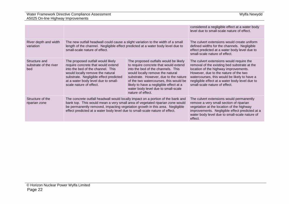
River depth and width variation
The new outfall headwall could cause a slight variation to the width of a small length of the channel. Negligible effect predicted at a water body level due to small-scale nature of effect.
The culvert extensions would create uniform defined widths for the channels. Negligible effect predicted at a water body level due to small-scale nature of effect.
Structure and substrate of the river bed
The proposed outfall would likely require concrete that would extend into the bed of the channel. This would locally remove the natural substrate. Negligible effect predicted at a water body level due to small-scale nature of effect.
The proposed outfalls would be likely to require concrete that would extend into the bed of the channels. This would locally remove the natural substrate. However, due to the nature of the two watercourses, this would be likely to have a negligible effect at a water body level due to small-scale nature of effect.
The culvert extensions would require the removal of the existing bed substrate at the location of the highway improvements. However, due to the nature of the two watercourses, this would be likely to have a negligible effect at a water body level due to small-scale nature of effect.
Structure of the riparian zone
The concrete outfall headwall would locally impact on a portion of the bank and bank top. This would mean a very small area of vegetated riparian zone would be permanently removed, impacting vegetation growth in this area. Negligible effect predicted at a water body level due to small-scale nature of effect.
The culvert extensions would permanently remove a very small section of riparian vegetation at the location of the highway improvements. Negligible effect predicted at a water body level due to small-scale nature of effect.

Wylfa Newydd Project Water Framework Directive Compliance Assessment A5025 On-line Highway Improvements
© Horizon Nuclear Power Wylfa Limited
Page 23
Table 3-5 Potential effects on the WFD groundwater body quality elements
Quality element Ynys Môn Secondary
Quantitative assessment
Road development activities and processing of pavement arisings.
Possible effect on underlying aquifers, for example, if any small-scale dewatering is required as a result of construction works involving excavation, although no dewatering is planned. Negligible effect predicted at a water body level due to small-scale nature of effect.
Chemical assessment
Road development activities and processing of pavement arisings.
Risk of spillage or leakage of fuel or oil from storage tanks or construction plant which, without suitable mitigation measures, can enter aquifers. Provided mitigation is in place (see section 1.3), negligible effect predicted at a water body level.
In the event of accidental spillage, potential contamination could migrate through the upper unsaturated zone reaching the shallow drift aquifers and impair groundwater quality, unless appropriate measures for control of discharge and drainage were undertaken. Provided mitigation is in place (see section 1.3), negligible effect predicted at a water body level.
3.4 Step 4: review of actions to deliver WFD mitigation measures
3.4.1 As part of the Western Wales River Basin Management Plan [RD10] a programme of measures to achieve WFD outcomes for 2021 have been established. These include national measures for Wales and locally targeted measures for the Western Wales River Basin District. The main issues that the programme of measures have been devised to tackle have been grouped into significant water management issues, including:
physical modifications;
pollution from sewage and waste water;
pollution from towns, cities and transport;
pollution from rural areas;
invasive non-native species;
pollution from mines;
effects of acidification; and
changes to the natural flow and level of water.
3.4.2 There is a specific measure to address each issue and an organisation responsible for delivering that measure.
3.4.3 Although several additional outfalls and two culvert extensions are required as part of the Proposed Development, these physical modifications would have a negligible effect at the water body and catchment scale. As a result, the Proposed Development would not prevent any of the 96 national measures

Water Framework Directive Compliance Assessment Wylfa Newydd Project A5025 On-line Highway Improvements
© Horizon Nuclear Power Wylfa Limited
Page 24
listed in the Wales Water Body Objectives and Measures (update 2015) [RD15] from being put in place.
3.5 Step 5: compliance with European legislation
3.5.1 The WFD [RD3] specifies that where an area requires special protection under another EC Directive, or where water is used for the abstraction of drinking water, that these areas are identified as ‘protected areas’. These areas have their own objectives and standards. Where WFD water body boundaries overlap with protected areas, the most stringent objective applies – that is the requirements of one particular EC Directive should not undermine the requirements of another.
3.5.2 The following provides the details of the relevant European legislation within the study area and how the Proposed Development complies with this legislation.
Bathing waters
3.5.3 EC Directive 2006/7/EC [RD16] seeks to preserve, protect and improve the quality of the environment and to protect human health by complementing Directive 2000/60/EC [RD3] and providing a framework for the monitoring, classification and management of bathing water quality. Directive 2006/7/EC [RD16] applies to an area encompassed by The Skerries WFD water body. However, there are no bathing waters within the study area and, therefore, the Proposed Development would not affect any Bathing Waters.
Special Protection Areas (SPA), Special Areas of Conservation (SAC) and Ramsar sites
3.5.4 The following European Designated Sites are considered in the A5025 On-line Highway Improvements Report to Inform Habitats Regulations Assessment Screening:
Bowland Fells SPA;
Skokholm and Skomer SPA;
Skomer, Skokholm and the seas off Pembrokeshire/Skomer, Sgogwm a
moroedd Benfro potential SPA;
Poulaphouca Reservoir SPA;
Ribble and Alt Estuaries SPA;
Ribble and Alt Estuaries Ramsar;
Lambay Island SPA;
Lough Neagh and Lough Beg SPA;
Morecambe Bay Ramsar;
Morecambe Bay SPA;
Saltee Islands SPA; and
Wexford Harbour and Slobs SPA.

Wylfa Newydd Project Water Framework Directive Compliance Assessment A5025 On-line Highway Improvements
© Horizon Nuclear Power Wylfa Limited
Page 25
3.5.5 The A5025 On-line Highway Improvements Report to Inform Habitats Regulations Assessment Screening, which will form part of the submitted planning application documentation, has concluded that the Proposed Development would not affect the integrity of any European Designated Sites in accordance with Regulation 61 of the Conservation of Habitats and Species Regulations 2010 (as amended) [RD17].
Drinking water
3.5.6 The WFD sets out that member states should identify waters used for the abstraction of drinking water and ensure compliance with Council Directive 80/778/EEC relating to the quality of water intended for human consumption. Llyn Alaw and Ynys Môn Secondary are the only drinking water protected areas within the vicinity of the Proposed Development. As the Llyn Alaw is over 5km from the existing A5025, it is assumed that the Proposed Development would not affect the protected area. The Proposed Development has been assessed as having a negligible effect on the Ynys Môn Secondary WFD groundwater body (see table 3-5).
3.6 Step 6: determination of compliance
3.6.1 Compliance of the Proposed Development against the WFD objectives detailed in section 1 has been assessed. Table 3-6 provides a summary of the overall compliance of the Proposed Development.
Table 3-6 WFD Compliance Assessment against the key WFD objectives
Objective Proposed Development compliance
Deterioration in the status/potential of the water body
Compliant - There is considered to be no deterioration in the status of the four WFD water bodies screened in. The effects are considered to be highly localised and not significant at a water body scale.
Ability of the water body to achieve Good Ecological Potential/Status
Compliant - The Proposed Development would not prevent any of the WFD water bodies from achieving good status.
Impact on the WFD objectives of other water bodies within the same River Basin District
Compliant - There is considered to be no effect on the WFD objectives of other WFD water bodies upstream or downstream of the screened in WFD water bodies or within the same River Basin District.
Impact on implementation of the WFD mitigation measures
Compliant - The Proposed Development would not prevent the implementation of any of the WFD mitigation measures identified for the screened in WFD water bodies or the River Basin District as a whole.

Water Framework Directive Compliance Assessment Wylfa Newydd Project A5025 On-line Highway Improvements
© Horizon Nuclear Power Wylfa Limited
Page 26
4 References
ID Reference
RD1 Planning Act 2008. [Online] [Accessed June 2017] Available at: http://www.legislation.gov.uk/ukpga/2008/29/part/11
RD2 Town and Country Planning Act 1990. [Online] [Accessed June 2017] Available at: http://www.legislation.gov.uk/ukpga/1990/8/part/III/crossheading/secretary-of-states-powers-as-respects-planning-applications-and-decisions
RD3 Council Directive 2000/60/EC of the European Parliament and of the Council of 23 October 2000 establishing a framework for Community action in the field of water policy (the ‘Water Framework Directive’ (WFD)). Official Journal of the European Communities L 327, 22.12.2000, pp. 1–73.
RD4 The Water Environment (Water Framework Directive) (England and Wales) Regulations 2017. (SI 2017/407) London: The Stationery Office.
RD5 Multi-Agency Geographic Information for the Countryside (MAGIC). 2016. [Online] [Accessed April 2016] Available from: http://www.magic.gov.uk/MagicMap.aspx
RD6 British Geological Survey (BGS) (2016) Geoindex Onshore, [Online] [Accessed April 2016] Available from: http://mapapps2.bgs.ac.uk/geoindex/home.html
RD7 British Library (2016) Maps [Online] [Accessed April 2016] Available from: https://www.bl.uk/subjects/maps
RD8 Natural Resources Wales. 2016. WFD Rivers and Water Bodies in Wales. [Online] [Accessed: May 2016] Available from: http://waterwatchwales.naturalresourceswales.gov.uk/en/
RD9 Centre for Ecology and Hydrology. UK river flow data [Online] [Accessed April 2016] Available from: http://www.ceh.ac.uk/news-and-media/news/uk-river-flow-data-now-web-accessible
RD10 Natural Resources Wales. 2015. Western Wales River Basin Management Plan 2015 – 2021. Natural Resources Wales, Cardiff
RD11 Jacobs UK Ltd. 2015. Water quality and plankton surveys report 2010 – 2014. Report no. 60PO8007/AQE/REP/004. Unpublished report.
RD12 Jacobs UK Ltd. 2015. Benthic surveys report. Report no. 60PO8007/AQE/REP/005. Unpublished report.
RD13 Isle of Anglesey County Council. 2015. Scoping Opinion for A5025 highway improvements between Valley and Cemaes.
RD14 Natural Resources Wales. 2016. Bathing water quality. [Online] [Accessed May 2016] Available from: https://naturalresources.wales/water/quality/bathing-water-quality/?lang=en
RD15 Natural Resources Wales. 2016. Wales Water Body Objectives and Measures Update 2015. [Online] [Accessed September 2016] Available from: https://drive.google.com/file/d/0B2hsDbbdxz1tcUdGV1c5U0dXMkk/view

Wylfa Newydd Project Water Framework Directive Compliance Assessment A5025 On-line Highway Improvements
© Horizon Nuclear Power Wylfa Limited
Page 27
ID Reference
RD16 Directive 2006/7/EC of the European Parliament and of the Council of 15 February 2006 concerning the management of bathing water quality and repealing Directive 76/160/EEC (the ‘Bathing Waters Directive’). Official Journal of the European Union L 64, 4.3.2006, pp. 37–51.
RD17 The Conservation of Habitats and Species Regulations 2010 (SI 2010/490). London: The Stationery Office.
RD18 Council Directive 98/83/EC of 3 November 1998 on the quality of water intended for human consumption (the 'Drinking Water Directive’). Official Journal of the European Communities L 330, 5.12.1998, pp. 32–54.
Water Framework Directive Compliance Assessment Wylfa Newydd Project A5025 On-line Highway Improvements
© Horizon Nuclear Power Wylfa Limited
Page 28
[This page is intentionally blank]

© Horizon Nuclear Power Wylfa Limited
2 |
Horizon Nuclear Power Sunrise House 1420 Charlton Court Gloucester Business Park Gloucester, GL3 4AE
T +44 (0)1242 508508
www.horizonnuclearpower.com
CONTACT US: If you have any questions or feedback regarding the Wylfa Newydd Project you can contact us on our dedicated Wylfa Newydd freephone hotline and email address, by calling on 0800 954 9516 or emailing [email protected]
All material in this document is, unless specified otherwise, copyright of Horizon Nuclear Power Wylfa Ltd and may not be reproduced without prior permission. Any unauthorised use or copying of the material may violate trademark, copyright and other proprietary rights and civil and criminal statutes. The material shall not be used in any manner that infringes any trademark, copyright or other proprietary rights and Horizon Nuclear Power Wylfa Ltd reserves all rights with respect to such unauthorised use.
WN0904-JAC-OS-REP-00005 Rev 1.0