worldwide marine radio facsimile broadcast schedules
TRANSCRIPT

8/4/2019 Worldwide Marine Radio Facsimile Broadcast Schedules
http://slidepdf.com/reader/full/worldwide-marine-radio-facsimile-broadcast-schedules 1/122
WORLDWIDE MARINE
RADIOFACSIMILEBROADCAST SCHEDULES
U.S. DEPARTMENT OF COMMERCENATIONAL OCEANIC and ATMOSPHERIC ADMINISTRATION
NATIONAL WEATHER SERVICE
Feb 24, 2009

8/4/2019 Worldwide Marine Radio Facsimile Broadcast Schedules
http://slidepdf.com/reader/full/worldwide-marine-radio-facsimile-broadcast-schedules 2/122
INTRODUCTION
A printed copy of this publication is distributed free of charge to all shipsthat participate in the U.S. Voluntary Observing Ship (VOS) program. If your ship is not participating in this worthwhile international program, weurge you to join. Remember, the meteorological agencies that do the
weather forecasting cannot help you without input from you. ONLY YOUKNOW THE WEATHER AT YOUR POSITION!!
Please report the weather at 0000, 0600, 1200, and 1800 UTC asexplained in the National Weather Service Observing Handbook No. 1for Marine Surface Weather Observations.
Within 300 nm of a named hurricane, typhoon or tropical storm, or within200 nm of U.S. or Canadian waters, also report the weather at 0300,0900, 1500, and 2100 UTC. Your participation is greatly appreciated byall mariners.
For assistance, contact a Port Meteorological Officer (PMO), who will
come aboard your vessel and provide all the information you need toobserve, code and transmit weather observations.
Appendix C contains information on a PC software program known asAMVER/SEAS which greatly assists in coding and transmittingmeteorological observations and AMVER position reports.
This publication is made available via Internet at:
http://www.nws.noaa.gov/om/marine/home.htm
This webpage also contains information on the dissemination of U.S.National Weather Service marine products including radiofax, such asfrequency and scheduling information as well as links to products. Alisting of other recommended webpages may be found in the Appendix.
8/4/2019 Worldwide Marine Radio Facsimile Broadcast Schedules
http://slidepdf.com/reader/full/worldwide-marine-radio-facsimile-broadcast-schedules 3/122
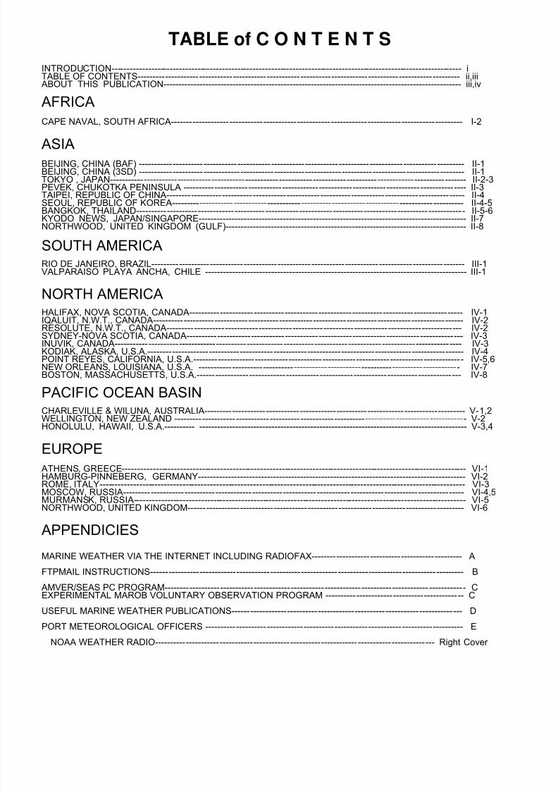
TABLE of C O N T E N T S
INTRODUCTION------------------------------------------------------------------------------------------------------------------ i TABLE OF CONTENTS--------------------------------------------------------------------------------------------------------- ii,iiiABOUT THIS PUBLICATION--------------------------------------------------------------------------------------------------- iii,iv
AFRICA
CAPE NAVAL, SOUTH AFRICA----------------------------------------------------------------------------------------------- I-2
ASIA
BEIJING, CHINA (BAF) ---------------------------------------------------------------------------------------------------------- II-1BEIJING, CHINA (3SD) ---------------------------------------------------------------------------------------------------------- II-1TOKYO , JAPAN-------------------------------------------------------------------------------------------------------------------- II-2-3PEVEK, CHUKOTKA PENINSULA -------------------------------------------------------------------------------------------- II-3TAIPEI, REPUBLIC OF CHINA------------------------------------------------------------------------------------------------- II-4SEOUL, REPUBLIC OF KOREA----------------------------------------------------------------------------------------------- II-4-5BANGKOK, THAILAND----------------------------------------------------------------------------------------------------------- II-5-6KYODO NEWS, JAPAN/SINGAPORE----------------------------------------------------------------------------------------- II-7NORTHWOOD, UNITED KINGDOM (GULF)-------------------------------------------------------------------------------- II-8
SOUTH AMERICA
RIO DE JANEIRO, BRAZIL------------------------------------------------------------------------------------------------------ III-1VALPARAISO PLAYA ANCHA, CHILE --------------------------------------------------------------------------------------- III-1
NORTH AMERICA
HALIFAX, NOVA SCOTIA, CANADA----------------------------------------------------------------------------------------- IV-1IQALUIT, N.W.T., CANADA----------------------------------------------------------------------------------------------------- IV-2RESOLUTE, N.W.T., CANADA------------------------------------------------------------------------------------------------ IV-2SYDNEY-NOVA SCOTIA, CANADA------------------------------------------------------------------------------------------ IV-3INUVIK, CANADA----------------------------------------------------------------------------------------------------------------- IV-3KODIAK, ALASKA, U.S.A.------------------------------------------------------------------------------------------------------- IV-4POINT REYES, CALIFORNIA, U.S.A.---------------------------------------------------------------------------------------- IV-5,6NEW ORLEANS, LOUISIANA, U.S.A. ------------------------------------------------------------------------------------- IV-7BOSTON, MASSACHUSETTS, U.S.A.-------------------------------------------------------------------------------------- IV-8
PACIFIC OCEAN BASIN
CHARLEVILLE & WILUNA, AUSTRALIA------------------------------------------------------------------------------------- V-1,2WELLINGTON, NEW ZEALAND ----------------------------------------------------------------------------------------------- V-2HONOLULU, HAWAII, U.S.A.---------- ----------------------------------------------------------------------------------------- V-3,4
EUROPE
ATHENS, GREECE---------------------------------------------------------------------------------------------------------------- VI-1HAMBURG-PINNEBERG, GERMANY----------------------------------------------------------------------------------------- VI-2ROME, ITALY----------------------------------------------------------------------------------------------------------------------- VI-3MOSCOW, RUSSIA--------------------------------------------------------------------------------------------------------------- VI-4,5MURMANSK, RUSSIA------------------------------------------------------------------------------------------------------------ VI-5NORTHWOOD, UNITED KINGDOM------------------------------------------------------------------------------------------ VI-6
APPENDICIES
MARINE WEATHER VIA THE INTERNET INCLUDING RADIOFAX------------------------------------------------- A
FTPMAIL INSTRUCTIONS------------------------------------------------------------------------------------------------------ B
AMVER/SEAS PC PROGRAM-------------------------------------------------------------------------------------------------- CEXPERIMENTAL MAROB VOLUNTARY OBSERVATION PROGRAM --------------------------------------------- C
USEFUL MARINE WEATHER PUBLICATIONS--------------------------------------------------------------------------- D
PORT METEOROLOGICAL OFFICERS ------------------------------------------------------------------------------------ E
NOAA WEATHER RADIO------------------------------------------------------------------------------------------- Right Cover

8/4/2019 Worldwide Marine Radio Facsimile Broadcast Schedules
http://slidepdf.com/reader/full/worldwide-marine-radio-facsimile-broadcast-schedules 4/122
ABOUT THIS PUBLICATION
The schedules contained in this book were obtained from official and unofficialsources. The information herein may neither be complete or accurate.Wherever possible, the schedules are dated with the latest change available. Inseveral cases, unofficial reception reports have been received identifying thestation as no longer being operational. The National Weather Service would
like to thank everyone who provided assistance.For ease of use, all stations are listed by WMO region, in alphabetical order, bycountry and location. All times listed herein are Universal Coordinated Time(UTC), unless otherwise indicated.
Unless otherwise stated, assigned frequencies are shown, for carrier frequencysubtract 1.9 kHz. Typically dedicated radiofax receivers use assignedfrequencies, while receivers or transceivers, connected to external recorders or PC's, are operated in the upper sideband (USB) mode using carrier frequencies.
For information on weather broadcasts worldwide, also refer to NGA Publication117, the Canadian Coast Guard Radio Aids to Navigation (Canada Only) andthe British Admiralty List of Signals, which are updated through Notices toMariners. Information on these and other marine weather publications may befound in Appendix D. These publications are HIGHLY recommended.
This document also includes information on how to obtain National Weather Service text forecasts, graphic forecasts, and marine observations via theInternet and e-mail (FTPMAIL). Mariners are highly encouraged to explorethese options.
The accuracy of this publication depends on YOUR input.
Please direct comments, recommendations, and corrections for this publicationto:
Tim RulonNational Weather Service W/OS211325 East-West HighwaySilver Spring, MD 20910 USA1-301-713-1677 x1281-301-713-1520 (fax)[email protected]@noaa.govhttp://www.nws.noaa.gov/om/marine/home.htm

8/4/2019 Worldwide Marine Radio Facsimile Broadcast Schedules
http://slidepdf.com/reader/full/worldwide-marine-radio-facsimile-broadcast-schedules 5/122

8/4/2019 Worldwide Marine Radio Facsimile Broadcast Schedules
http://slidepdf.com/reader/full/worldwide-marine-radio-facsimile-broadcast-schedules 6/122

8/4/2019 Worldwide Marine Radio Facsimile Broadcast Schedules
http://slidepdf.com/reader/full/worldwide-marine-radio-facsimile-broadcast-schedules 7/122
CAPE NAVAL, SOUTH AFRICA
CALL SIGNS FREQUENCIES TIMES EMISSION POWER ZSJ 4014 kHz 16Z-06Z (when available) F3C 10 KWZSJ 7508 kHz ALL BROADCAST TIMES F3C 10 KWZSJ 13538 kHz ALL BROADCAST TIMES F3C 10 KWZSJ 18238 kHz 06Z-16Z (when available) F3C 10 KW
TIME CONTENTS OF TRANSMISSION RPM/IOC VALID MAP
TIME AREA 0430 SCHEDULE 120/5760500 SURFACE ANALYSIS(SHIPPING) 120/576 0000 ASXX0630 UPPER AIR PROG 120/576 1200 FUXX0730 SURFACE PROG 120/576 1200 FSXX0800 ANTARTIC ICE LIMITS (OCT-MAR) 120/576 AIAA0915 RTTY WEATHER BULLETINS FOR COASTAL WATERS AND HIGHSEAS RTTY (170 Hz shift, 75 Baud)1030 SURFACE ANALYSIS(SHIPPING) 120/576 0600 ASXX1100 SURFACE PROG 120/576 0000 FSXX1530 SURFACE ANALYSIS(SHIPPING) 120/576 1200 ASXX1700 RTTY WEATHER BULLETINS FOR COASTAL WATERS AND HIGHSEAS RTTY (170 Hz shift, 75 baud)2230 SURFACE ANALYSIS(SHIPPING) 120/576 1800 ASXX
MAP AREAS:ASXX 1:20,000 Lambert 00S20W 00S70E 60S50W 60S90EFUXX 1:20,000 Mercator 05S15W 05S60E 60S15W 60S60EFSXX 1:20,000 Mercator 05S15W 05S60E 60S15W 60S60E
AIAA 30E to 30W Antarctic coast to edge of ice pack except NIC West
(INFORMATION DATED May 2005) http://www.weathersa.co.za/Marine/FrequencyShipFCBroadcast.jsp
I-1

8/4/2019 Worldwide Marine Radio Facsimile Broadcast Schedules
http://slidepdf.com/reader/full/worldwide-marine-radio-facsimile-broadcast-schedules 8/122

8/4/2019 Worldwide Marine Radio Facsimile Broadcast Schedules
http://slidepdf.com/reader/full/worldwide-marine-radio-facsimile-broadcast-schedules 9/122

8/4/2019 Worldwide Marine Radio Facsimile Broadcast Schedules
http://slidepdf.com/reader/full/worldwide-marine-radio-facsimile-broadcast-schedules 10/122
8/4/2019 Worldwide Marine Radio Facsimile Broadcast Schedules
http://slidepdf.com/reader/full/worldwide-marine-radio-facsimile-broadcast-schedules 11/122
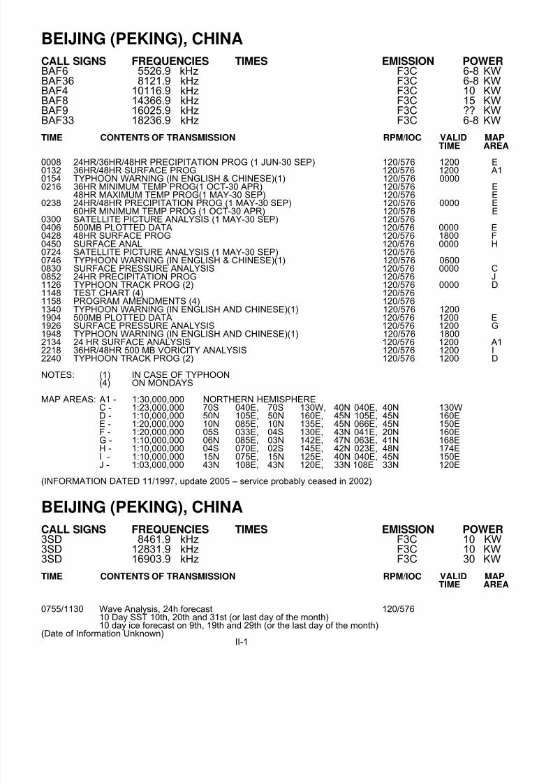
BEIJING (PEKING), CHINA
CALL SIGNS FREQUENCIES TIMES EMISSION POWER BAF6 5526.9 kHz F3C 6-8 KWBAF36 8121.9 kHz F3C 6-8 KWBAF4 10116.9 kHz F3C 10 KWBAF8 14366.9 kHz F3C 15 KWBAF9 16025.9 kHz F3C ?? KWBAF33 18236.9 kHz F3C 6-8 KW
TIME CONTENTS OF TRANSMISSION RPM/IOC VALID MAPTIME AREA
0008 24HR/36HR/48HR PRECIPITATION PROG (1 JUN-30 SEP) 120/576 1200 E0132 36HR/48HR SURFACE PROG 120/576 1200 A10154 TYPHOON WARNING (IN ENGLISH & CHINESE)(1) 120/576 00000216 36HR MINIMUM TEMP PROG(1 OCT-30 APR) 120/576 E
48HR MAXIMUM TEMP PROG(1 MAY-30 SEP) 120/576 E0238 24HR/48HR PRECIPITATION PROG (1 MAY-30 SEP) 120/576 0000 E
60HR MINIMUM TEMP PROG (1 OCT-30 APR) 120/576 E0300 SATELLITE PICTURE ANALYSIS (1 MAY-30 SEP) 120/5760406 500MB PLOTTED DATA 120/576 0000 E0428 48HR SURFACE PROG 120/576 1800 F0450 SURFACE ANAL 120/576 0000 H0724 SATELLITE PICTURE ANALYSIS (1 MAY-30 SEP) 120/5760746 TYPHOON WARNING (IN ENGLISH & CHINESE)(1) 120/576 06000830 SURFACE PRESSURE ANALYSIS 120/576 0000 C0852 24HR PRECIPITATION PROG 120/576 J1126 TYPHOON TRACK PROG (2) 120/576 0000 D1148 TEST CHART (4) 120/5761158 PROGRAM AMENDMENTS (4) 120/5761340 TYPHOON WARNING (IN ENGLISH AND CHINESE)(1) 120/576 12001904 500MB PLOTTED DATA 120/576 1200 E1926 SURFACE PRESSURE ANALYSIS 120/576 1200 G1948 TYPHOON WARNING (IN ENGLISH AND CHINESE)(1) 120/576 18002134 24 HR SURFACE ANALYSIS 120/576 1200 A12218 36HR/48HR 500 MB VORICITY ANALYSIS 120/576 1200 I2240 TYPHOON TRACK PROG (2) 120/576 1200 D
NOTES: (1) IN CASE OF TYPHOON(4) ON MONDAYS
MAP AREAS: A1 - 1:30,000,000 NORTHERN HEMISPHERE
C - 1:23,000,000 70S 040E, 70S 130W, 40N 040E, 40N 130WD - 1:10,000,000 50N 105E, 50N 160E, 45N 105E, 45N 160EE - 1:20,000,000 10N 085E, 10N 135E, 45N 066E, 45N 150EF - 1:20,000,000 05S 033E, 04S 130E, 43N 041E, 20N 160EG - 1:10,000,000 06N 085E, 03N 142E, 47N 063E, 41N 168EH - 1:10,000,000 04S 070E, 02S 145E, 42N 023E, 48N 174EI - 1:10,000,000 15N 075E, 15N 125E, 40N 040E, 45N 150EJ - 1:03,000,000 43N 108E, 43N 120E, 33N 108E 33N 120E
(INFORMATION DATED 11/1997, update 2005 – service probably ceased in 2002)
BEIJING (PEKING), CHINA
CALL SIGNS FREQUENCIES TIMES EMISSION POWER 3SD 8461.9 kHz F3C 10 KW
3SD 12831.9 kHz F3C 10 KW3SD 16903.9 kHz F3C 30 KW
TIME CONTENTS OF TRANSMISSION RPM/IOC VALID MAPTIME AREA
0755/1130 Wave Analysis, 24h forecast 120/57610 Day SST 10th, 20th and 31st (or last day of the month)10 day ice forecast on 9th, 19th and 29th (or the last day of the month)
(Date of Information Unknown)II-1

8/4/2019 Worldwide Marine Radio Facsimile Broadcast Schedules
http://slidepdf.com/reader/full/worldwide-marine-radio-facsimile-broadcast-schedules 12/122
TOKYO, JAPAN
CALL SIGNS FREQUENCIES TIMES EMISSION POWER JMH 3622.5 kHz ALL BROADCAST TIMES F3C 5 KWJMH2 7795 kHz ALL BROADCAST TIMES F3C 5 KWJMH4 13988.5 kHz ALL BROADCAST TIMES F3C 5 KW
TIME CONTENTS OF TRANSMISSION RPM/IOC VALID MAPTIME AREA
0000/1200 RETRANSMISSION OF 2200/0840 120/5760020/------ 96HR SURFACE PRESSURE, PRECIP PROGS 120/576 1200 C0040/------ 120HR SURFACE PRESSURE, PRECIP PROGS 120/576 1200 C-------/1220 12/24/48/72HR OCEAN WAVE PROG 120/576 0000-------/1240 24 HR 500HPA TEMPERATURE AND 700HPA DEWPOINT 120/576 0000
DEPRESSION PROG24HR 850HPA TEMPERATURE WIND AND 700HPA VERTICALP-VELOCITY PROG
-------/1251 36 HR 500HPA TEMPERATURE AND 700HPA DEWPOINT 120/576 0000DEPRESSION PROG36HR 850HPA TEMPERATURE WIND AND 700HPA VERTICALP-VELOCITY PROG
0103/1303 TEST CHART 120/5760110/1310 METEOROLOGICAL SATELLITE PICTURE (MSAT) 120/576 00/12 C'0130/1330 RETRANSMISSION OF 1019/0730 120/5760150/1350 TROPICAL CYCLONE FORECAST(1) 120/576 00/12 C’0210/------ SEA SURFACE CURRENT, WATER TEMPERATURE AT 100M DEPTH (2) 120/576
0229/------- RADIO PREDICTION (3) 120/576-------/1420 RETRANSMISSION OF 0210 (2)0240/1440 SURFACE ANALYSIS 120/576 00/12 C’0300/------- SEA SURFACE WATER TEMPERATURE (2) 120/5760320/1520 THE FIRST RETRANSMISSION OF 0240/1440 120/5760340/------- BROADCAST SCHEDULE, MANUAL AMENDMENTS 120/5760400/1540 RETRANSMISSION OF 0150/1350 (1) 120/576------/1620 RETRANSMISSION OF 0300 (2) 120/5760421/------- OCEAN WAVE ANALYSIS (NORTH PACIFIC) 120/576 0000 C'’0440/------- COASTAL WAVE ANALYSIS 120/576 0000 X0459/1640 500HPA HEIGHT, TEMPERATURE 120/576 00/12 C0518/1700 850HPA HEIGHT, TEMPERATURE, DEW POINT DEPRESSION 120/576 00/12 C-------/1719 COASTAL WAVE ANALYSIS (1) 120/576 1200 X0537/1739 24HR 500HPA HEIGHT, VORTICITY PROGNOSIS 120/576 00/12
24 HR SURFACE PRESSURE, PRECIPITATION PROGNOSIS0548/------- 24HR SURFACE PRESSURE, WIND, FOG, ICING, SEA ICE PROG 120/576 0000 C’0610/1750 THE SECOND RETRANSMISSION OF 0240/1440 120/576
0630/------- 48/72 HR SURFACE PRESSURE, PRECIPITATION PROGNOSIS 120/576 00/00------/1810 36HR 500HPA HEIGHT, VORTICITY PROGNOSIS 120/576 120036HR SURFACE PRESSURE, PRECIPITATION PROGNOSIS
------/1821 24 HR 500HPA TEMPERATURE AND 700HPA DEWPOINT 120/576 1200DEPRESSION PROG24HR 850HPA TEMPERATURE WIND AND 700HPA VERTICALP-VELOCITY PROG
------/1832 36 HR 500HPA TEMPERATURE AND 700HPA DEWPOINT 120/576 1200DEPRESSION PROG36HR 850HPA TEMPERATURE WIND AND 700HPA VERTICALP-VELOCITY PROG
------/1850 12/24/48/72HR OCEAN WAVE PROG 120/576 12000651/------ 24HR WAVE PROG (NORTH PACIFIC) 120/576 0000 C’’0710/1910 METEOROLOGICAL SATELLITE PICTURE (GOES-9) 120/576 06/18 C'0730/------ 24HR COASTAL WAVE PROG 120/576 0000 X-------/1930 24HR SURFACE PRESSURE, WIND, FOG, ICING, SEA ICE PROG 120/576 1200 C’0750/1950 TROPICAL CYCLONE FORECAST (1) 120/576 06/18 C’
------/2010 24HR COASTAL WAVE PROG (1) 120/576 1200 X0809/------- 36HR 500HPA HEIGHT, VORTICITY PROGNOSIS 120/576 0000
36HR SURFACE PRESSURE, PRECIPITATION PROGNOSIS0820/------ 48HR SURFACE PRESSURE, WIND, FOG, ICING, SEA ICE PROG 120/576 0000 C’0840/2040 SURFACE ANALYSIS 120/576 06/18 C'-------/2100 48HR SURFACE PRESSURE, WIND, FOG, ICING, SEA ICE PROG 120/576 1200 C0900/------ RETRANSMISSION OF 0750 (1) 120/5760920/2120 THE FIRST RETRANSMISSION OF 0840/2040 120/5760940/2140 RETRANSMISSION OF 0630/1950 120/5761000/------ RETRANSMISSION OF 0820 120/576------/2200 48/72HR SURFACE PRESSURE, PRECIPITATION PROGNOSIS 120/576 12/12
II-2

8/4/2019 Worldwide Marine Radio Facsimile Broadcast Schedules
http://slidepdf.com/reader/full/worldwide-marine-radio-facsimile-broadcast-schedules 13/122
TOKYO, JAPAN
TIME CONTENTS OF TRANSMISSION RPM/IOC VALID MAP
1019/------- SEA ICE CONDITION ANAL(4), 48HR & 168 HR PROGS(5) 120/576 LATEST L/L'------/2220 RETRANSMISSION OF 1719 120/5761040/2240 RETRANSMISSION OF 0548/2040 120/5761100/2300 RETRANSMISSION OF 0421/1930 120/5761119/2320 RETRANSMISSION OF 0440/2010 120/5761140/2340 RETRANSMISSION OF 0651/2100 120/576
NOTES:(1) IN CASE OF TROPICAL CYCLONE(2) EVERY TUESDAY AND FRIDAY (3) ON THE 20TH AND 21ST.(4) EVERY TUESDAY AND FRIDAY (SEASONAL) RETRANSMISSION: AT 0130 ON THE NEXT DAY (5) EVERY WEDNESDAY AND SATURDAY (SEASONAL). RETRANSMISSION: AT 0130 ON THE NEXT DAY
A. For the purpose of maintaining the JMH broadcasting system, the test chart will be transmitted during the periodfrom 01:55 to 02:35 UTC on 3, 4, 6, 10 and 11 Dec 2008 as well as 4 and 5 Feb 2009.
B. If WTAS07 is broadcast, each test will be cancelled. If additional tests are necessary, the notification will bedistributed as MANAM in advance.
MAP AREAS: C - 1:20,000,000 27N 062E, 51N 152W, 05S 106E, 02N 160EC' - 1:20,000,000 39N 066E, 39N 146W, 01S 113E, 01S 167EC'’ - 1:20,000,000 38N 067E, 39N 148W, 01S 112E, 01S 167EL - 1:10,000,000 SEA OF OKHOTSK, NORTHERN SEA OF JAPAN, BO HAI, AND
ADJACENT WATERS OF THE NORTH PACIFIC.L' - 1:05,000,000 49N 140E 49N 151E, 41N 140E 40N 149EX - 1: 6,000,000 46N 107E, 43N 160E, 18N 118E, 17N 147E
(INFORMATION DATED 01 MAR 2007/ Nov 2008) http://www.jma.go.jp/jma/kishou/177jmh/JMH-ENG.pdf
PEVEK, CHUKOTKA PENINSULA
CALL SIGNS FREQUENCIES TIMES EMISSION POWER 148 kHz ALL BROADCAST TIMES F3C
TIME CONTENTS OF TRANSMISSION RPM/IOC VALID MAPTIME AREA
0530-0730 ICE 90/5761130-1330 ICE 90/5761430-1630 ICE 90/576
(INFORMATION DATED 11/97)
II-3

8/4/2019 Worldwide Marine Radio Facsimile Broadcast Schedules
http://slidepdf.com/reader/full/worldwide-marine-radio-facsimile-broadcast-schedules 14/122
TAIPEI, REPUBLIC OF CHINA
CALL SIGN FREQUENCIES TIMES EMISSION POWER BMF 4616 kHz F3C 10 KW
5250 kHz F3C 10 KW8140 kHz F3C 10 KW
13900 kHz F3C 10 KW18560 kHz F3C 10 KW
TIME CONTENTS OF TRANSMISSION RPM/IOC VALID MAPTIME AREA 0040/------- BROADCAST SCHEDULE 120/5760110/1310 TYPHOON WARNINGS (ENGLISH & CHINESE) 120/576 00/120130/1330 GMS SATELLITE IMAGE 120/576 00/120250/1450 FISHERY WEATHER FORECAST (IN CHINESE) 120/576 00/120330/1530 SURFACE ANALYSIS WITH PLOTTED DATA 120/576 00/120350/------ 24HR SURFACE PROG 120/576 00000410/1610 TYPHOON WARNING (ENGLISH & CHINESE) 120/576 03/150430/1630 850HPA ANALYSIS WITH PLOTTED DATA 120/576 00/120440/1640 700HPA ANALYSIS WITH PLOTTED DATA 120/576 00/120450/1650 500HPA ANALYSIS WITH PLOTTED DATA 120/576 00/120500/1700 300HPA ANALYSIS WITH PLOTTED DATA 120/756 00/120510/1710 RFS SURFACE PRESSURE ANALY/RFS 500HPA HEIGHT ANALYSIS 120/576 00/120520/1720 RFS 12HR SURFACE PROG/RFS 12HR 500HPA PROG 120/576 00/120530/1730 RFS 24HR SURFACE PROG/RFS 24HR 500HPA PROG 120/576 00/120540/1740 RFS 36HR SURFACE PROG/RFS 24HR 500HPA PROG 120/576 12/00
0550/1750 RFS 48HR SURFACE PROG/RFS 48HR 500HPA PROG 120/576 00/120600/1800 RFS 72HR SURFACE PROG/RFS 72HR 500HPA PROG 120/576 00/120620/1820 GFS 850HPA EQUATORIAL BELT WIND ANALYSIS 120/576 00/120630/1830 GFS 200HPA EQUATORIAL BELT WIND ANALYSIS 120/576 00/120640/1840 GFS 24HR 850HPA EQUATORIAL BELT WIND PROG 120/576 00/120650/1850 GFS 24HR 200HPA EQUATORIAL BELT WIND PROG 120/576 00/120710/1910 TYPHOON WARNINGS (ENGLISH & CHINESE) 120/576 06/180730/1930 GMS SATELLITE IMAGE 120/576 06/180745/1945 GFS 48HR 850HPA EQUATORIAL BELT WIND PROG 120/576 00/120755/1955 GFS 48HR 200HPA EQUATORIAL BELT WIND PROG 120/576 00/120805/------ WAVE ANALYSIS 120/576 00000820------- 36HR WAVE PROG 120/576 0000------/2005 GFS 72HR 850HPA EQUATORIAL BELT WIND PROG 120/576 1200------/2015 GFS 72HR 200HPA EQUATORIAL BELT WIND PROG 120/576 1200------/2025 GFS 96HR SURFACE PROG 120/576 1200------/2035 GFS 72HR SURFACE PROG 120/576 12000850/2050 FISHERY WEATHER FORECAST (IN CHINESE) 120/576 06/18
0930/2130 SURFACE ANALYSIS WITH PLOTTED DATA 120/576 06/181010/------ TYPHOON WARNINGS (ENGLISH & CHINESE) 120/576 0900------/2150 GFS 120HR SURFACE PROG 120/576 1200------/2200 GFS 120HR 500HPA PROG 120/576 1200------/2210 TYPHOON WARNINGS (ENGLISH & CHINESE) 120/576 2100
MAP AREA: 48N 060E, 48N 172W, EQ 099E, EQ 154E
(SCHEDULE EFFECTIVE APR 01, 2002)(INFORMATION DATED 10/2002) http://marine.cwb.gov.tw/qa/BMF-BROADCAST-SCHEDULE.htm
SEOUL, REPUBLIC OF KOREA
CALL SIGN FREQUENCIES TIMES EMISSION POWER HLL1 3585 kHz ALL BROADCAST TIMES F3C 3 KWHLL2 5857.5 kHz ALL BROADCAST TIMES F3C 3 KWHLL3 7433.5 kHz ALL BROADCAST TIMES F3C 3 KWHLL4 9165 kHz ALL BROADCAST TIMES F3C 3 KWHLL5 13570 kHz ALL BROADCAST TIMES F3C 3 KW
II-4

8/4/2019 Worldwide Marine Radio Facsimile Broadcast Schedules
http://slidepdf.com/reader/full/worldwide-marine-radio-facsimile-broadcast-schedules 15/122
SEOUL, REPUBLIC OF KOREA
TIME CONTENTS OF TRANSMISSION RPM/IOC VALID MAPTIME AREA
0000/1200 LOCAL WEATHER ADVISORY/WARNING REPORT (KOREAN) 120/5760020/1220 LOCAL WEATHER ADVISORY/WARNING REPORT (KOREAN) 120/576 00/120032/------- LIGHTHOUSE WEATHER OBSERVATION REPORT (KOREAN) 120/576 00000046/1246 WEATHER OBSERVATION REPORT FOR FISHERY (KOREAN) 120/576 00/120120/------- MANUAL AMENDMENTS 120/5760140/1340 SURFACE ANALYSIS 120/576 00/12
0200/1400 TYPHOON WARNING AND FORECAST (1)(KOREAN) 120/576 00/120300/------ KOREAN PENINSULA MONTHLY WEATHER FORECAST (2)(KOREAN) 120/576-------/1500 LOCAL WEATHER ADVISORY/WARNING REPORT (KOREAN) 120/5760320/1520 SEA-SHORE WEATHER OBSERVATION REPORT (KOREAN) 120/576 03/150332/------- LIGHTHOUSE WEATHER OBSERVATION REPORT (KOREAN) 120/576 03000346/1546 WEATHER OBSERVATION REPORT FOR FISHERY (KOREAN) 120/576 03/150415/------- KOREAN PENINSULA WEEKLY WEATHER FORECAST (KOREAN) 120/5760440/1640 SURFACE ANALYSIS 120/576 03/150455/1655 850MB ANALYSIS 120/576 00/120507/1707 700MB ANALYSIS 120/576 00/120519/1719 500MB ANALYSIS 120/576 00/120600/1800 LOCAL WEATHER ADVISORY/WARNING REPORT (KOREAN) 120/5760620/1820 SEA-SHORE WEATHER OBSERVATION REPORT (KOREAN) 120/576 06180632/------- LIGHTHOUSE WEATHER OBSERVATION REPORT (KOREAN) 120/576 06000646/1846 WEATHER OBSERVATION REPORT FOR FISHERY (KOREAN) 120/576 06/180700/1900 SATILLITE IMAGERY 120/576 0530/17300712/------- SST OBSERVATION CHART OF NEAR KOREAN PENINSULA AREA 120/5760740/1940 SURFACE ANALYSIS 120/576 06/180800/2000 TYPHOON WARNING AND 12HR/24HR FORECASTS (1) (KOREAN) 120/576 06/18
0821/2021 12HR SEA WAVE HT & WIND FORECAST OF NEAR KOREAN PENINSULA 120/576 00/120834/2034 24HR SEA WAVE HT & WIND FORECAST OF NEAR KOREAN PENINSULA 120/576 00/120847/2047 36HR SEA WAVE HT & WIND FORECAST OF NEAR KOREAN PENINSULA 120/576 00/120900/2100 SEA WEATHER FORECAST OVER NEAR KOREAN PENINSULA (KOREAN)120/576 0830/20300920/2120 SEA-SHORE WEATHER OBSERVATION REPORT (KOREAN) 120/576 09/210932/2132 LIGHTHOUSE WEATHER OBSERVATION REPORT (KOREAN) 120/576 09/210946/2146 WEATHER OBSERVATION REPORT FOR FISHERY (KOREAN) 120/576 09/121012/2212 WEATHER FORECAST FOR SHIP ROUTE (KOREAN) 120/576 0830/2030------/2227 LIGHTHOUSE WEATHER OBSERVATION REPORT (3) (KOREAN) 120/576 22001040/2240 SURFACE ANALYSIS 120/576 09/21
NOTES: 1. IN CASE OF TYPHOON.2. BROADCAST AT THE END OF THE MONTH.3. NOVEMBER TO APRIL.4. ALTERNATING BLACK AND WHITE SIGNALS WITH FREQUENCY OF 300 Hz WILL BE
TRANSMITTED FOR 10 SECONDS PRIOR TO THE PHASING SIGNAL.5. PHASING SIGNALS WILL BE TRANSMITTED FOR 30 SECONDS PRIOR TO TRANSMISSION
OF EACH CHART.6. STOP SIGNALS WILL BE TRANSMITTED FOR 15 SECONDS AFTER EACH TRANSMISSION.
(INFORMATION DATED 02/1999) http://web.kma.go.kr/kma06/weathernews/kma_submain_weathernews_right05.htm
II-5

8/4/2019 Worldwide Marine Radio Facsimile Broadcast Schedules
http://slidepdf.com/reader/full/worldwide-marine-radio-facsimile-broadcast-schedules 16/122
BANGKOK, THAILAND
CALL SIGNS FREQUENCIES TIMES EMISSION POWER HSW64 7395.0 kHz * F3C 3 KW
TIME CONTENTS OF TRANSMISSION RPM/IOC VALID MAPTIME AREA
0050/------ TEST CHART 120/5760100/0700 FORECAST FOR SHIPPING (IN ENGLISH) 120/576 00/06 A0120/------ SURFACE PRESSURE 120/576 1200 A0140------ SURFACE ANALYSIS 120/576 1800 A0200/------ BROADCAST SCHEDULE 120/5760300/0720 24 HR SURFACE PROG 120/576 12/12 A0320/0740 48 HR SURFACE PROG 120/576 12/12 A0340/0800 72 HR SURFACE PROG 120/576 12/12 A------/0820 24 HR 850 MB WIND/TEMP PROG 120/576 1200 A0400/1000 FORECAST FOR SHIPPING (IN ENGLISH) 120/576 03/09 A0420/------ 24 HR 850 MB WIND/TEMP PROG 120/576 1200 A0500/1020 SURFACE ANALYSIS 120/576 00/06 A0520/------ 850 MB ANALYSIS 120/576 0000 A0540/------ 700 MB ANALYSIS 120/576 0000 A0600/------ 500 MB ANALYSIS 120/576 0000 A------/1300 FORECAST FOR SHIPPING (IN ENGLISH) 120/576 1200 A------/1700 FORECAST FOR SHIPPING (IN ENGLISH) 120/576 1700 A------/1720 SURFACE ANALYSIS 120/576 1200------/2300 FORECAST FOR SHIPPING (IN ENGLISH) 120/576 1700 A
------/2320 SURFACE ANALYSIS 120/576 1800 A
MAP AREA: A - 1:20,000,000 50N 045E, 50N 160E, 30S 045E, 30S 160E
* May refer to carrier frequency, for center frequency add 1.9 kHz
(INFORMATION DATED JAN 2009)
II-6

8/4/2019 Worldwide Marine Radio Facsimile Broadcast Schedules
http://slidepdf.com/reader/full/worldwide-marine-radio-facsimile-broadcast-schedules 17/122
KYODO NEWS AGENCY, JAPAN/SINGAPORE
CALL SIGNS FREQUENCIES TIMES EMISSION POWER JJC 4316 kHz ALL BROADCAST TIMES F3C 5 KWJJC 8467.5 kHz ALL BROADCAST TIMES F3C 10 KWJJC 12745.5 kHz ALL BROADCAST TIMES F3C 15 KWJJC 16971 kHz ALL BROADCAST TIMES F3C 15 KWJJC 17069.6 kHz ALL BROADCAST TIMES F3C 15 KWJJC 22542 kHz ALL BROADCAST TIMES F3C 15 KW9VF/252 16035 kHz 0740-1010, 1415-1815 F3C 10 KW9VF/252 17430 kHz 0740-1010, 1415-1815 F3C 10 KW
TIME CONTENTS OF TRANSMISSION RPM/IOC VALID MAPTIME AREA
0145 Sports Ed 2(R), (Seasonal during Sumo or High School baseball series) 60/5760200 MON: NX for 1 week 120/5760200 TUE-SUN: NX (R),Epidemic Information(R)(SUN only), 120/576
Ocean Information(N)(4th,14th, and 24th,3rd,13th,23rd if a MON) 60/5760245 Morning Ed(R), Sports Ed 1(R), NX(R) 60/5760430 WX Chart 120/576 00000430 Ocean Information(n)(4th,14th, and 24th) 120/5760540 TUE&FRI: Satellite Fishery Information 60/5760540 SAT&SUN: Ocean Graphic Information 60/576
0540 SUN&MON: Sea Surface Current Prog 60/5760610 TUE-SAT: English Ed (R) 120/5760635 MON-SAT: FAX DAYORI 4(N), (except 2nd & 4th MON 60/576
and every WED and FRI)0650 SUN:WX Chart, Fishing Information (3 times per month) 60/576 03000650 MON-SAT: WX Chart 60/576 03000705 Background Stories(N), Life(N)(except MON) 60/5760745 SUN:
Sunday Ed(N), FAX DAYORI 1,2,3 (N) 60/576Sumo match (begins 0930 SAT as well) 60/576
0745 MON-SAT:Evening Ed(N), Kaiun-Suisan News(N) (Except SAT), 60/576Epidemic Information(N)(SAT only), FAX DAYORI 1(N), 60/576Sumo match (Seasonal)(N), FAX DAYORI 2(N)(except TUE&SAT) 60/576
0745 NATIONAL HOLIDAYS:Morning Ed(R), Sports Ed 1 (R), FAX DAYORI 1(N), 60/576Sumo match (Seasonal)(N)FAX DAYORI 2(N) 60/576
1100 NX (N), Sumo match (Seasonal)(R) 60/5761130 MON-FRI: English Ed (N) 60/5761335 Background Stories(R), Life(R)(except MON) 60/5761415 MON-FRI: Kaiun-Suisan News(R) 60/5761445 Sports Ed 2(N), (Seasonal during Sumo or High School baseball series) 60/5761500 Morning Ed(N), Sports Ed 1(N), NX(R) 60/5761645 MON: Sunday Ed(R) 60/5761645 TUE-SUN: Evening Ed(R) 60/5761810 TUE-SAT: English Ed (R) 60/5761930 MON: Evening Ed(R), NX(R), FAX DAYORI 2,1,3 (R) 60/5761930 TUE-SUN: Evening Ed(R), NX(R), FAX DAYORI 2,1,4 60/576
(no 4 on THU,SAT and TUE following 2nd & 4th MONAlso no 2 on WED and SUN)(R)
2030 DAY AFTER NATIONAL HOLIDAYS: NX(R), FAX DAYORI 2,1,4 (R) 60/5762215 MON and DAY AFTER NATIONAL HOLIDAYS:
Morning Ed(R),Sports Ed 1,2(R),NX(R),FAX DAYORI 1-3(R)(3 Mon only)60/576WX Chart 60/576 2100
2215 TUE-SUN:Morning Ed(R), Sports Ed 1,2(R), NX(R), 60/576Kaiun-Suisan News(R) (Except SUN), Epidemic Info (SUN only) 60/576FAX DAYORI 1,2 (R)(no 2 on SUN and WED) 60/576WX Chart 60/576 2100
NX: Navigational Warning, N: New, R: Repeat
Some of these transmissions may be encrypted
(INFORMATION DATED March 1, 1999 provided by Kyodo News April 2001)
II-8
8/4/2019 Worldwide Marine Radio Facsimile Broadcast Schedules
http://slidepdf.com/reader/full/worldwide-marine-radio-facsimile-broadcast-schedules 18/122
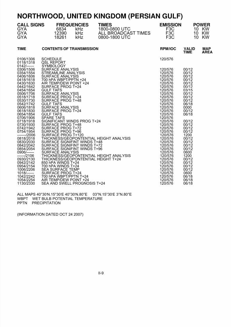
NORTHWOOD, UNITED KINGDOM (PERSIAN GULF)
CALL SIGNS FREQUENCIES TIMES EMISSION POWERGYA 6834 kHz 1800-0800 UTC F3C 10 KWGYA 12390 kHz ALL BROADCAST TIMES F3C 10 KWGYA 18261 kHz 0800-1800 UTC F3C 10 KW
TIME CONTENTS OF TRANSMISSION RPM/IOC VALID MAPTIME AREA
0106/1306 SCHEDULE 120/5760118/1318 QSL REPORT0142/------ SYMBOLOGY0306/1506 SURFACE ANALYSIS 120/576 00/120354/1554 STREAMLINE ANALYSIS 120/576 00/120406/1606 SURFACE ANALYSIS 120/576 00/120418/1618 700 hPA WBPT/PPTN +24 120/576 00/120430/1630 AIR TEMP/DEW POINT +24 120/576 00/120442/1642 SURFACE PROG T+24 120/576 00/120454/1654 GULF TAFS 120/576 03/150506/1706 SURFACE ANALYSIS 120/576 00/120518/1718 SURFACE PROG T+24 120/576 00/120530/1730 SURFACE PROG T+48 120/576 00/120542/1742 GULF TAFS 120/576 06/180606/1818 SURFACE ANALYSIS 120/576 00000618/1830 SURFACE PROG T+24 120/576 00/12
0654/1854 GULF TAFS 120/576 06/180706/1906 SPARE TAFS 120/5760718/1918 SIGNIFICANT WINDS PROG T+24 120/576 00/120730/1930 SURFACE PROG T+48 120/576 00/120742/1942 SURFACE PROG T+72 120/576 00/120754/1954 SURFACE PROG T+96 120/576 00/12-------/2006 SURFACE PROG T+120 120/576 12000818/2018 THICKNESS/GEOPONTENTIAL HEIGHT ANALYSIS 120/576 00/120830/2030 SURFACE SIGNIFINT WINDS T+48 120/576 00/120842/2042 SURFACE SIGNIFINT WINDS T+72 120/576 00/120854/2054 SURFACE SIGNIFINT WINDS T+96 120/576 00/120906/------ SURFACE ANALYSIS 120/576 0600------/2106 THICKNESS/GEOPONTENTIAL HEIGHT ANALYSIS 120/576 12000930/2130 THICKNESS/GEOPONTENTIAL HEIGHT T+24 120/576 00/120942/2142 850 hPA WINDS T+24 120/576 00/120954/2154 700 hPA WINDS T+24 120/576 00/121006/2206 SEA SURFACE TEMP 120/576 00/121018/------ SURFACE PROG T+24 120/576 06001042/2242 700 hPA WBPT/PPTN T+24 120/576 06/181054/2254 AIR TEMP/DEW POINT +24 120/576 06/181130/2330 SEA AND SWELL PROGNOSIS T+24 120/576 06/18
ALL MAPS 40°30′ N.15°30′ E 40°30′ N.80°E 03°N.15°30′ E 3°N.80°EWBPT WET BULB POTENTIAL TEMPERATUREPPTN PRECIPITATION
(INFORMATION DATED OCT 24 2007)
II-9

8/4/2019 Worldwide Marine Radio Facsimile Broadcast Schedules
http://slidepdf.com/reader/full/worldwide-marine-radio-facsimile-broadcast-schedules 19/122

8/4/2019 Worldwide Marine Radio Facsimile Broadcast Schedules
http://slidepdf.com/reader/full/worldwide-marine-radio-facsimile-broadcast-schedules 20/122

8/4/2019 Worldwide Marine Radio Facsimile Broadcast Schedules
http://slidepdf.com/reader/full/worldwide-marine-radio-facsimile-broadcast-schedules 21/122
RIO DE JANEIRO, BRAZIL
CALL SIGNS FREQUENCIES TIMES EMISSION POWERPWZ-33 12665 kHz ALL BROADCAST TIMES F3C 1 KWPWZ-33 16978 kHz ALL BROADCAST TIMES F3C 1 KW
TIME CONTENTS OF TRANSMISSION RPM/IOC VALID MAPTIME AREA
0745/1630 TEST CHART 120/5760750/1635 SURFACE ANALYSIS (Hpa) 120/576 00/12 A0810/1655 WAVES SIG HEIGHT (m) AND DIR PROG 12/00Z+36HR 120/576 00/12 B0830/1715 WIND AT 10 m (KTS) PROG 12/00Z +36 HR 120/576 00/12 C0850/1735 SEA SURFACE TEMPERATURE 120/576 12/00 D
MAP AREA: A: 1:101,200,000 20N 090W,20N 000E,70 S 090W, 70S 000EB: 1:58,500,000 20N 090W,20N 020E,70S 090W,70S 020EC: 1:58,500,000 20N 090W, 20N 020E, 70S 090W, 70S 020ED: 1:32,700,000 15N 072W, 15N 018W, 50S 072W, 50S 018E
(INFORMATION DATED 28 Oct 2008) http://www.mar.mil.br/dhn/chm/meteo/info/transmissoes/apend3ing.htm
VALPARAISO PLAYA ANCHA, CHILE
CALL SIGNS FREQUENCIES TIMES EMISSION POWERCBV 4228.0 kHz ALL BROADCAST TIMES F3C 1 KWCBV 8677.0 kHz ALL BROADCAST TIMES F3C 1 KWCBV 17146.4 kHz ALL BROADCAST TIMES F3C 1 KW
TIME CONTENTS OF TRANSMISSION RPM/IOC VALID MAPTIME AREA
1115 SURFACE ANALYSIS 120/576 0600 A1130 SATELLITE IMAGE 120/576 0900 A1630 SURFACE ANALYSIS 120/576 1200 A1645 SATELLITE IMAGE 120/576 1500 A1915 SIGNIFICANT WAVE MAP (MTS) 120/576 1200 A1930 SATELLITE IMAGE 120/576 1800 A2200 SURFACE ANALYSIS 120/576 1800 A
2215 ICE REPORT 120/576 A2230 12HR WINDS BARB ISOTACHS FORECAST 120/576 1200 A2310 12HR SURFACE FORECAST 120/576 A2325 SATELLITE IMAGE 120/576 2100 A
MAP AREA: A: 10S-120W, 10S-050W, 80S-130W, 80S-030W
(INFORMATION DATED Sep 10, 2003) http://www.directemar.cl/meteo/operador/horarios.htm
III-1

8/4/2019 Worldwide Marine Radio Facsimile Broadcast Schedules
http://slidepdf.com/reader/full/worldwide-marine-radio-facsimile-broadcast-schedules 22/122

8/4/2019 Worldwide Marine Radio Facsimile Broadcast Schedules
http://slidepdf.com/reader/full/worldwide-marine-radio-facsimile-broadcast-schedules 23/122

8/4/2019 Worldwide Marine Radio Facsimile Broadcast Schedules
http://slidepdf.com/reader/full/worldwide-marine-radio-facsimile-broadcast-schedules 24/122

8/4/2019 Worldwide Marine Radio Facsimile Broadcast Schedules
http://slidepdf.com/reader/full/worldwide-marine-radio-facsimile-broadcast-schedules 25/122
HALIFAX, NOVA SCOTIA, CANADA
CALL SIGN FREQUENCIES TIMES EMISSION POWER CFH 122.5 kHz ALL BROADCAST TIMES F3C 10 KW
4271 kHz ALL BROADCAST TIMES F3C 6 KW6496.4 kHz ALL BROADCAST TIMES F3C 6 KW
10536 kHz ALL BROADCAST TIMES F3C 6 KW13510 kHz ALL BROADCAST TIMES F3C 6 KW
TIME CONTENTS OF TRANSMISSION RPM/IOC VALID MAPTIME AREA
0001/------ Ice Chart #1 (see note): Latest) 120/576 LATEST-------/1201 3-DAY PROG 120/576 1200 G0101/------ SATELLITE PHOTO INFRARED 120/576 0000-------/1222 4-DAY PROG 120/576 1200 G-------/1301 5-DAY PROG 120/576 1200 G0201/1401 12/00Z SIGNIFICANT WEATHER DEPICTION 120/576 12/00 A0301/1501 500MB ANALYSIS 120/576 00/12 B0322/1522 SURFACE ANALYSIS 120/576 00/12 F-------/1601 850MB ANALYSIS 120/576 1200 B0401/1622 36HR 500MB FORECAST 120/576 12/00 H0422/1701 24HR SURFACE PROG 120/576 00/12 A0501/----- 850 MB FORECAST WINDS 120/576 18&00 C0601/1801 36HR SURFACE PROG 120/576 12/00 A------/1822 850MB FORECAST WINDS 120/576 06&12 C
0701/1901 18/06Z SIIGNIFICANT WEATHER DEPICTION 120/576 18/06 A0801/2001 24/36HR SIGNIFICANT WAVE PROGNOSIS 120/576 0&12/12&0 A0901/2101 SURFACE ANALYSIS 120/576 06/18 F1001/------ SST: NOVA SCOTIA - MON NEWFOUNDLAND - TUE/FRI 120/576 LATEST E/D1001/------ OFA: NOVA SCOTIA - WED/SAT NEWFOUNDLAND - SUN/THU 120/576 LATEST E/D------/2201 SST: NOVA SCOTIA - TUE/THU/FRI NEWFOUNDLAND - WED/SAT 120/576 LATEST E/D------/2201 OFA: NOVA SCOTIA - SUN NEWFOUNDLAND - MON 120/576 LATEST E/D1022/------ SATELLITE PHOTO INFRARED 120/576 0900-------/2222 NEWFOUNDLAND ICE CHART 120/576 LATEST1101/------ CFH BROADCAST SCHEDULE 120/576-------/2301 GULF OF ST LAWRENCE ICE CHART (SEASONAL) 120/576 LATEST
NOTES:
This schedule of chart and text transmission is subject to short notice change according to the requirements of theCanadian Forces.
The geographical area of coverage for the ice charts varies according to season. The typical areas are: Gulf of St.Lawrence, East Newfoundland waters, Labrador Coast, Hudson Strait, Davis Strait and Baffin Bay. The Canadian IceService prepares all ice charts.
MAP AREAS: A. 56N 87W, 56N 24W, 34N 38W, 34N 73W E. 50N 75W, 50N 48W, 34N 48W, 34N 75WB. 76N 16W, 30N 20W, 23N 11W, 08N 69W F. 52N 98W, 58N 24W, 30N 39W, 28N 78WC. 52N 80W, 65N 15W, 30N 60W, 34N 17W G. 52N 98W, 56N 24W, 30N 39W, 28N 78WD. 60N 68W, 60N 33W, 43N 33W, 43N 68W H. 30N 107W, 15N 67W, 34N 24W, 79N 60W
I. 54N 100W, 58N 22W, 30N 39W, 28N 78W
(INFORMATION DATED 2008) http://www.ccg-gcc.gc.ca/folios/00026/docs/ramn_atlantic2008-eng.pdf
IV-1

8/4/2019 Worldwide Marine Radio Facsimile Broadcast Schedules
http://slidepdf.com/reader/full/worldwide-marine-radio-facsimile-broadcast-schedules 26/122
IQALUIT, N.W.T., CANADA
CALL SIGN FREQUENCIES TIMES EMISSION POWER VFF 3253.0 kHz 2100 – 2330 UTC J3C 5 KWVFF 7710.0 kHz 0010 – 0900 UTC J3C 5 KW
TIME CONTENTS OF TRANSMISSION RPM/IOC VALID MAPTIME AREA
0010/------ Ice Analysis Hudson Bay south, Hudson Bay north, Hudson Strait, 120/576Foxe Basin, Labrador Coast, Davis Strait, Baffin Bay.
0600/2100 Marine Surface Analysis (Arctic) 120/576
Marine wind prognosis (Arctic) ( experimental product)Regional Marine Wind Prognosis (on request)0700/2125 Ice Analysis Hudson Bay south, Hudson Bay north, Hudson Strait, 120/576
Foxe Basin, Labrador Coast, Davis Strait, Baffin Bay.0800/2330 Marine Surface Analysis (Arctic) 120/576
Marine wind prognosis (Arctic) ( experimental product)Regional Marine Wind Prognosis (on request)
0900/------ Ice Analysis Hudson Bay south, Hudson Bay north, Hudson Strait, 120/576Foxe Basin, Labrador Coast, Davis Strait, Baffin Bay.
Operating only from approximately mid-June until late-November
NOTE: THE AREAS INCLUDED IN THE BROADCASTS VARY WITH ICE CONDITIONS AND MARINE ACTIVITY. ALLCHARTS AVAILABLE CAN BE TRANSMITTED ON REQUEST.
(INFORMATION DATED 2008) http://www.ccg-gcc.gc.ca/folios/00026/docs/ramn_atlantic2008-eng.pdf
RESOLUTE, N.W.T., CANADACALL SIGN FREQUENCIES TIMES EMISSION POWER VFR 3253.0 kHz 0010 – 0900 UTC J3C 5 KWVFR 7710.0 kHz 2100 – 2330 UTC J3C 5 KW
TIME CONTENTS OF TRANSMISSION RPM/IOC VALID MAPTIME AREA
0010/------ Ice analysis Baffin Bay, Approaches to Resolute, Resolute-Byam, 120/576Eureka Sound, McClure Strait, Parry Channel and Queen Maude.
0600/2100 Marine Surface Analysis (Arctic) 120/576Marine wind prognosis (Arctic) ( experimental product)Regional Marine Wind Prognosis (on request)
0700/2125 Ice analysis Baffin Bay, Approaches to Resolute, Resolute-Byam, 120/576Eureka Sound, McClure Strait, Parry Channel and Queen Maude.
0800/2330 Marine Surface Analysis (Arctic) 120/576Marine wind prognosis (Arctic) ( experimental product)Regional Marine Wind Prognosis (on request)
0900/------ Ice analysis Baffin Bay, Approaches to Resolute, Resolute-Byam, 120/576Eureka Sound, McClure Strait, Parry Channel and Queen Maude.
Operating only from approximately mid-June until late-November
(INFORMATION DATED 2008) http://www.ccg-gcc.gc.ca/folios/00026/docs/ramn_atlantic2008-eng.pdf
IV-2

8/4/2019 Worldwide Marine Radio Facsimile Broadcast Schedules
http://slidepdf.com/reader/full/worldwide-marine-radio-facsimile-broadcast-schedules 27/122
SYDNEY - NOVA SCOTIA, CANADACALL SIGN FREQUENCIES TIMES EMISSION POWER VCO 4416 kHz 1121-1741 J3CVCO 6915.1 kHz 2200-2331 J3C
TIME CONTENTS OF TRANSMISSION RPM/IOC VALID MAPTIME AREA
1121 ICE ANALYSIS GULF OF ST. LAWRENCE 120/5761142 ICE ANALYSIS EAST OR SOUTHEAST NEWFOUNDLAND WATERS 120/5761741 ICE ANALYSIS ICEBERG LIMIT 120/5762200 ICE ANALYSIS GULF OF ST. LAWRENCE 120/5762331 ICE ANALYSIS EAST OR SOUTHEAST NEWFOUNDLAND WATERS 120/576
(INFORMATION DATED 2008) http://www.ccg-gcc.gc.ca/folios/00026/docs/ramn_atlantic2008-eng.pdf
INUVIK, CANADACALL SIGN FREQUENCIES TIMES EMISSION POWER
VFA 8457.8 kHz J3C 1 KW
TIME CONTENTS OF TRANSMISSION RPM/IOC VALID MAPTIME AREA
0200 Marine Wind Prognosis 120/576 1200(Availability of charts may vary depending on shippingIce Analysis (mid July to October 15)Amundsen Gulf, Queen Maud and McClure Strait.Ice Analysis Beaufort Sea/Alaskan Coast
1630 Marine Surface Analysis 120/576 1200(Availability of charts may vary depending on shippingIce Analysis (mid July to October 15)Amundsen Gulf, Queen Maud and McClure Strait.Ice Analysis Beaufort Sea/Alaskan Coast
Note: Also available on request
(INFORMATION DATED 2008) http://www.ccg-gcc.gc.ca/folios/00026/docs/ramn_pacific2008-eng.pdf
IV-3
8/4/2019 Worldwide Marine Radio Facsimile Broadcast Schedules
http://slidepdf.com/reader/full/worldwide-marine-radio-facsimile-broadcast-schedules 28/122
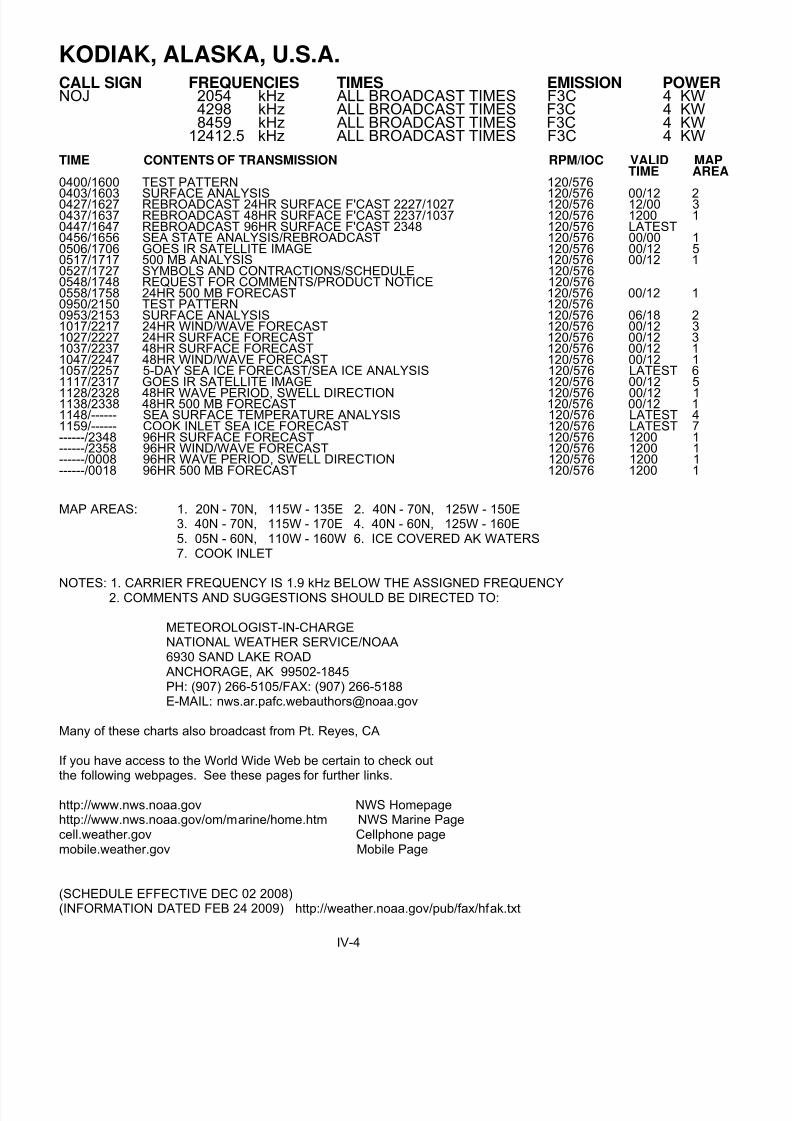
KODIAK, ALASKA, U.S.A.
CALL SIGN FREQUENCIES TIMES EMISSION POWER NOJ 2054 kHz ALL BROADCAST TIMES F3C 4 KW
4298 kHz ALL BROADCAST TIMES F3C 4 KW8459 kHz ALL BROADCAST TIMES F3C 4 KW
12412.5 kHz ALL BROADCAST TIMES F3C 4 KW
TIME CONTENTS OF TRANSMISSION RPM/IOC VALID MAPTIME AREA
0400/1600 TEST PATTERN 120/576
0403/1603 SURFACE ANALYSIS 120/576 00/12 20427/1627 REBROADCAST 24HR SURFACE F'CAST 2227/1027 120/576 12/00 30437/1637 REBROADCAST 48HR SURFACE F'CAST 2237/1037 120/576 1200 10447/1647 REBROADCAST 96HR SURFACE F'CAST 2348 120/576 LATEST0456/1656 SEA STATE ANALYSIS/REBROADCAST 120/576 00/00 10506/1706 GOES IR SATELLITE IMAGE 120/576 00/12 50517/1717 500 MB ANALYSIS 120/576 00/12 10527/1727 SYMBOLS AND CONTRACTIONS/SCHEDULE 120/5760548/1748 REQUEST FOR COMMENTS/PRODUCT NOTICE 120/5760558/1758 24HR 500 MB FORECAST 120/576 00/12 10950/2150 TEST PATTERN 120/5760953/2153 SURFACE ANALYSIS 120/576 06/18 21017/2217 24HR WIND/WAVE FORECAST 120/576 00/12 31027/2227 24HR SURFACE FORECAST 120/576 00/12 31037/2237 48HR SURFACE FORECAST 120/576 00/12 11047/2247 48HR WIND/WAVE FORECAST 120/576 00/12 11057/2257 5-DAY SEA ICE FORECAST/SEA ICE ANALYSIS 120/576 LATEST 61117/2317 GOES IR SATELLITE IMAGE 120/576 00/12 5
1128/2328 48HR WAVE PERIOD, SWELL DIRECTION 120/576 00/12 11138/2338 48HR 500 MB FORECAST 120/576 00/12 11148/------ SEA SURFACE TEMPERATURE ANALYSIS 120/576 LATEST 41159/------ COOK INLET SEA ICE FORECAST 120/576 LATEST 7------/2348 96HR SURFACE FORECAST 120/576 1200 1------/2358 96HR WIND/WAVE FORECAST 120/576 1200 1------/0008 96HR WAVE PERIOD, SWELL DIRECTION 120/576 1200 1------/0018 96HR 500 MB FORECAST 120/576 1200 1
MAP AREAS: 1. 20N - 70N, 115W - 135E 2. 40N - 70N, 125W - 150E3. 40N - 70N, 115W - 170E 4. 40N - 60N, 125W - 160E5. 05N - 60N, 110W - 160W 6. ICE COVERED AK WATERS7. COOK INLET
NOTES: 1. CARRIER FREQUENCY IS 1.9 kHz BELOW THE ASSIGNED FREQUENCY2. COMMENTS AND SUGGESTIONS SHOULD BE DIRECTED TO:
METEOROLOGIST-IN-CHARGENATIONAL WEATHER SERVICE/NOAA6930 SAND LAKE ROADANCHORAGE, AK 99502-1845PH: (907) 266-5105/FAX: (907) 266-5188E-MAIL: [email protected]
Many of these charts also broadcast from Pt. Reyes, CA
If you have access to the World Wide Web be certain to check outthe following webpages. See these pages for further links.
http://www.nws.noaa.gov NWS Homepagehttp://www.nws.noaa.gov/om/marine/home.htm NWS Marine Pagecell.weather.gov Cellphone pagemobile.weather.gov Mobile Page
(SCHEDULE EFFECTIVE DEC 02 2008)(INFORMATION DATED FEB 24 2009) http://weather.noaa.gov/pub/fax/hfak.txt
IV-4
8/4/2019 Worldwide Marine Radio Facsimile Broadcast Schedules
http://slidepdf.com/reader/full/worldwide-marine-radio-facsimile-broadcast-schedules 29/122
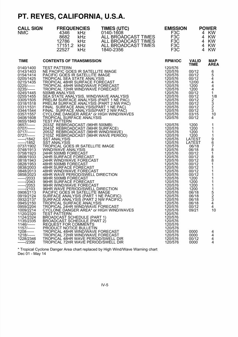
PT. REYES, CALIFORNIA, U.S.A.
CALL SIGN FREQUENCIES TIMES (UTC) EMISSION POWER NMC 4346 kHz 0140-1608 F3C 4 KW
8682 kHz ALL BROADCAST TIMES F3C 4 KW12786 kHz ALL BROADCAST TIMES F3C 4 KW17151.2 kHz ALL BROADCAST TIMES F3C 4 KW22527 kHz 1840-2356 F3C 4 KW
TIME CONTENTS OF TRANSMISSION RPM/IOC VALID MAPTIME AREA
0140/1400 TEST PATTERN 120/5760143/1403 NE PACIFIC GOES IR SATELLITE IMAGE 120/576 00/12 60154/1414 PACIFIC GOES IR SATELLITE IMAGE 120/576 00/12 50205/1425 TROPICAL SEA STATE ANALYSIS 120/576 00/12 40215/1435 TROPICAL 48HR SURFACE FORECAST 120/576 12/00 40225/------ TROPICAL 48HR WIND/WAVE FORECAST 120/576 1200 40235/------ TROPICAL 72HR WIND/WAVE FORECAST 120/576 1200 40245/1445 500MB ANALYSIS 120/576 00/12 10255/1455 SEA STATE ANALYSIS, WIND/WAVE ANALYSIS 120/576 00/12 1/80305/1505 PRELIM SURFACE ANALYSIS (PART 1 NE PAC) 120/576 00/12 20318/1518 PRELIM SURFACE ANALYSIS (PART 2 NW PAC) 120/576 00/12 30331/1531 FINAL SURFACE ANALYSIS(PART 1 NE PAC) 120/576 00/12 20344/1544 FINAL SURFACE ANALYSIS(PART 2 NW PAC) 120/576 00/12 30357/1557 CYCLONE DANGER AREA* or HIGH WIND/WAVES 120/576 03/15 10
0408/1608 TROPICAL SURFACE ANALYSIS 120/576 00/12 40655/1840 TEST PATTERN0657/------ 2033Z REBROADCAST (96HR 500MB) 120/576 1200 10707/------ 2043Z REBROADCAST (96HR SURFACE) 120/576 1200 10717/------ 2053Z REBROADCAST (96HR WIND/WAVE) 120/576 1200 10727/------ 2103Z REBROADCAST (96HR WAVE PERIOD) 120/576 1200 1------/1842 SST ANALYSIS 120/576 LATEST 9------/1852 SST ANALYSIS 120/576 LATEST 60737/1902 TROPICAL GOES IR SATELLITE IMAGE 120/576 06/18 70748/1913 WIND/WAVE ANALYSIS 120/576 06/18 80758/1923 24HR 500MB FORECAST 120/576 00/12 10808/1933 24HR SURFACE FORECAST 120/576 00/12 80818/1943 24HR WIND/WAVE FORECAST 120/576 00/12 80828/1953 48HR 500MB FORECAST 120/576 00/12 10838/2003 48HR SURFACE FORECAST 120/576 00/12 10848/2013 48HR WIND/WAVE FORECAST 120/576 00/12 10858/2023 48HR WAVE PERIOD/SWELL DIRECTION 120/576 00/12 1------/2033 96HR 500MB FORECAST 120/576 1200 1------/2043 96HR SURFACE FORECAST 120/576 1200 1------/2053 96HR WIND/WAVE FORECAST 120/576 1200 1------/2103 96HR WAVE PERIOD/SWELL DIRECTION 120/576 1200 10908/2113 PACIFIC GOES IR SATELLITE IMAGE 120/576 06/18 50919/2124 SURFACE ANALYSIS (PART 1 NE PACIFIC) 120/576 06/18 20932/2137 SURFACE ANALYSIS (PART 2 NW PACIFIC) 120/576 06/18 30945/2150 TROPICAL SURFACE ANALYSIS 120/576 06/18 40959/2204 TROPICAL 24HR WIND/WAVE FORECAST 120/576 00/12 41009/2214 CYCLONE DANGER AREA* or HIGH WIND/WAVES 120/576 09/21 101120/2320 TEST PATTERN 120/5761124/2324 BROADCAST SCHEDULE (PART 1) 120/5761135/2335 BROADCAST SCHEDULE (PART 2) 120/5761146/------ REQUEST FOR COMMENTS 120/5761157/------ PRODUCT NOTICE BULLETIN 120/5761208------ TROPICAL 48HR WIND/WAVE FORECAST 120/576 0000 4
1218/------ TROPICAL 72HR WIND/WAVE FORECAST 120/576 0000 41228/2346 TROPICAL 48HR WAVE PERIOD/SWELL DIR 120/576 00/12 4------/2356 TROPICAL 72HR WAVE PERIOD/SWELL DIR 120/576 0000 4
* Tropical Cyclone Danger Area chart replaced by High Wind/Wave Warning chartDec 01 - May 14
IV-5

8/4/2019 Worldwide Marine Radio Facsimile Broadcast Schedules
http://slidepdf.com/reader/full/worldwide-marine-radio-facsimile-broadcast-schedules 30/122
PT. REYES, CALIFORNIA, U.S.A.
MAP AREAS: 1. 20N - 70N, 115W - 135E 2. 20N - 70N, 115W - 175W3. 20N - 70N, 175W - 135E 4. 20S - 30N, EAST OF 145W5. 05N - 55N, EAST OF 180W 6. 23N - 60N, EAST OF 150W7. 05N - 32N, EAST OF 130W 8. 18N - 62N, EAST OF 157W9. 40N - 53N, EAST OF 136W 10. 0N - 40N, 80W - 180W
NOTES: 1. CARRIER FREQUENCY IS 1.9 kHz BELOW THE ASSIGNED FREQUENCY2. COMMENTS AND SUGGESTIONS SHOULD BE DIRECTED TO:
NATIONAL WEATHER SERVICE/NOAANATIONAL CENTER FOR ENVIRONMENTAL PREDICTIONMARINE FORECAST BRANCH W/NMC315200 AUTH ROADCAMP SPRINGS, MD 20746-4304PHONE: (301) 763-8294x7401/FAX: (301) 763-8085EMAIL: [email protected]
Many of these charts also broadcast from Kodiak, AK and Honolulu, HI
If you have access to the World Wide Web be certain to check outthe following webpages. See these pages for further links.
http://www.nws.noaa.gov NWS Homepagehttp://www.nws.noaa.gov/om/marine/home.htm NWS Marine Pagecell.weather.gov Cellphone pagemobile.weather.gov Mobile Page
(SCHEDULE EFFECTIVE NOV 03, 2008 1719z)(INFORMATION DATED FEB 24, 2009) http://weather.noaa.gov/pub/fax/hfreyes.txt
IV-6

8/4/2019 Worldwide Marine Radio Facsimile Broadcast Schedules
http://slidepdf.com/reader/full/worldwide-marine-radio-facsimile-broadcast-schedules 31/122
NEW ORLEANS, LOUISIANA, U.S.A.
CALL SIGN FREQUENCIES TIMES (UTC) EMISSION POWER NMG 4317.9 kHz ALL BROADCAST TIMES F3C 4 KW
8503.9 kHz ALL BROADCAST TIMES F3C 4 KW12789.9 kHz ALL BROADCAST TIMES F3C 4 KW17146.4 kHz 1200-2045 F3C 4 KW
TIME CONTENTS OF TRANSMISSION RPM/IOC VALID MAP
TIME AREA0000/1200 TEST PATTERN 120/5760005/1205 U.S./TROPICAL SURFACE ANALYSIS (W HALF) 120/576 18/06 10020/1220 TROPICAL SURFACE ANALYSIS (E HALF) 120/576 18/06 20035/1235 (REBROADCAST OF 1835/0635) 120/576 12/00 30045/1245 (REBROADCAST OF 1845/0645) 120/576 12/00 30055/1255 (REBROADCAST OF 1855/0655) 120/576 12/00 30105/1305 (REBROADCAST OF 1905/0705) 120/576 12/00 30115/1315 (REBROADCAST OF 1915/0715) 120/576 12/00 30125/1325 (REBROADCAST OF 1925/0725) 120/576 12/00 30135/1335 CYCLONE DANGER AREA* or 48 HR HIGH WIND/WAVES 120/576 21/09 60150/------ (REBROADCAST OF 0825) 120/576 0000 3------ /1350 36 HR WIND/WAVE FORECAST 120/576 1200 30200/1400 GOES IR TROPICAL SATELLITE IMAGE 120/576 00/12 40215/1415 00 HR SEA STATE ANALYSIS 120/576 00/12 30225/1425 REQUEST FOR COMMENTS/PRODUCT NOTICE 120/5760245/1445 HIGH SEAS FORECAST (IN ENGLISH) 120/576 22/10 5
0600/1800 TEST PATTERN 120/5760605/1805 U.S./TROPICAL SURFACE ANALYSIS (W HALF) 120/576 00/12 10620/1820 TROPICAL SURFACE ANALYSIS (E HALF) 120/576 00/12 20635/1835 24 HR WIND/WAVE FORECAST 120/576 00/12 30645/1845 48 HR WIND/WAVE FORECAST 120/576 00/12 30655/1855 72 HR WIND/WAVE FORECAST 120/576 00/12 30705/1905 24 HR SURFACE FORECAST 120/576 00/12 30715/1915 48 HR SURFACE FORECAST 120/576 00/12 30725/1925 72 HR SURFACE FORECAST 120/576 00/12 30735/1935 CYCLONE DANGER AREA* or 48HR HIGH WIND/WAVES 120/576 03/15 60750/1950 48 HR WAVE PERIOD/SWELL DIRECTION 120/576 00/12 30800/2000 GOES IR TROPICAL SATELLITE IMAGE 120/576 07/18 40815/2015 (REBROADCAST OF 0215/1415) 120/576 00/12 30825/------ 72 HR WAVE PERIOD/SWELL DIRECTION 120/576 0000 30835/------ (REBROADCAST OF 1350) 120/576 1200------/2025 BROADCAST SCHEDULE 120/5760845/2045 HIGH SEAS FORECAST (IN ENGLISH) 120/576 04/16 5
* Tropical Cyclone Danger Area chart replaced by 48HR High Wind/Wave Warning chartDec 01-May 14. Valid times 00z, 06z, 12z and 18z. Map area 05N-40N, 35W-100W
MAP AREAS: 1. 5S - 50N, 55W - 125W2. 5S - 50N, 0W - 70W3. 0N - 31N, 35W - 100W4. 12S - 44N, 28W - 112W5. 7N - 31N, 35W - 98W (AREA COVERED BY TEXT FORECAST)6. 05N - 60N, 0W - 100W
NOTES: 1. CARRIER FREQUENCY IS 1.9 kHz BELOW THE ASSIGNED FREQUENCY2. THIS BROADCAST ORIGINATES FROM THE TROPICAL PREDICTION CENTER
(FORMERLY THE NATIONAL HURRICANE CENTER) OF THE NATIONAL WEATHERSERVICE). COMMENTS AND SUGGESTIONS SHOULD BE DIRECTED TO:
TROPICAL PREDICTION CENTERATTN: CHIEF TAFB11691 SOUTHWEST 17TH STREETMIAMI, FL 33165-2149PHONE: (305) 229-4430/FAX: (305) 553-1264EMAIL: [email protected]
Further information see: http://www.nws.noaa.gov/om/marine/home.htm
(Schedule Effective Dec 01, 2008)(Information dated FEB 24, 2009) http://weather.noaa.gov/fax/gulf.shtml
IV-7
8/4/2019 Worldwide Marine Radio Facsimile Broadcast Schedules
http://slidepdf.com/reader/full/worldwide-marine-radio-facsimile-broadcast-schedules 32/122
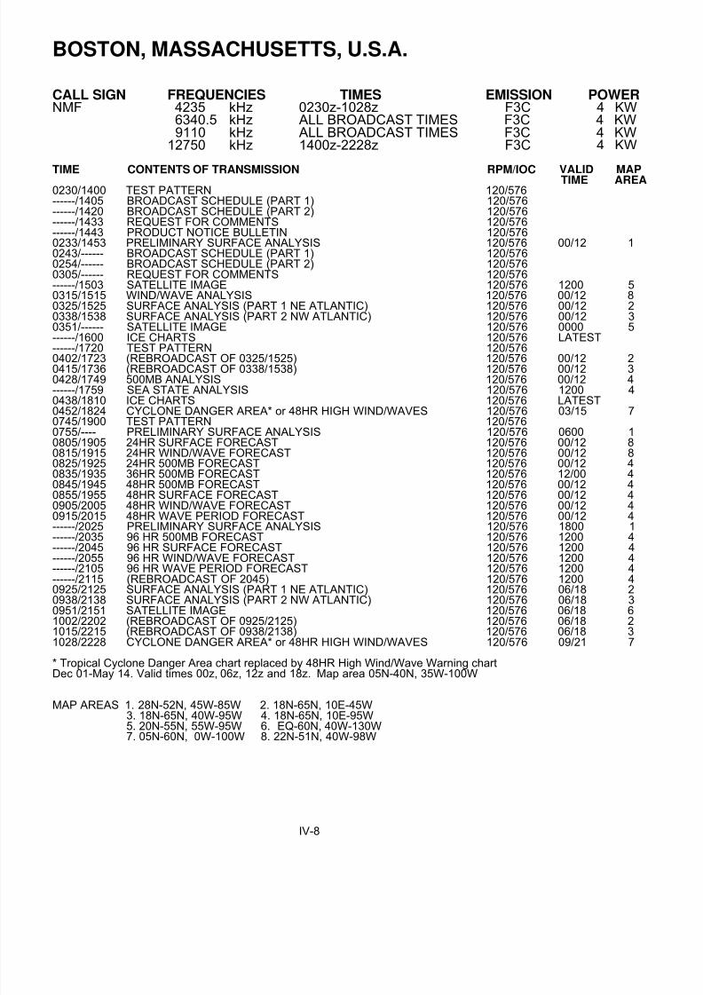
BOSTON, MASSACHUSETTS, U.S.A.
CALL SIGN FREQUENCIES TIMES EMISSION POWERNMF 4235 kHz 0230z-1028z F3C 4 KW
6340.5 kHz ALL BROADCAST TIMES F3C 4 KW9110 kHz ALL BROADCAST TIMES F3C 4 KW
12750 kHz 1400z-2228z F3C 4 KW
TIME CONTENTS OF TRANSMISSION RPM/IOC VALID MAPTIME AREA 0230/1400 TEST PATTERN 120/576------/1405 BROADCAST SCHEDULE (PART 1) 120/576------/1420 BROADCAST SCHEDULE (PART 2) 120/576------/1433 REQUEST FOR COMMENTS 120/576------/1443 PRODUCT NOTICE BULLETIN 120/5760233/1453 PRELIMINARY SURFACE ANALYSIS 120/576 00/12 10243/------ BROADCAST SCHEDULE (PART 1) 120/5760254/------ BROADCAST SCHEDULE (PART 2) 120/5760305/------ REQUEST FOR COMMENTS 120/576------/1503 SATELLITE IMAGE 120/576 1200 50315/1515 WIND/WAVE ANALYSIS 120/576 00/12 80325/1525 SURFACE ANALYSIS (PART 1 NE ATLANTIC) 120/576 00/12 20338/1538 SURFACE ANALYSIS (PART 2 NW ATLANTIC) 120/576 00/12 30351/------ SATELLITE IMAGE 120/576 0000 5------/1600 ICE CHARTS 120/576 LATEST
------/1720 TEST PATTERN 120/5760402/1723 (REBROADCAST OF 0325/1525) 120/576 00/12 20415/1736 (REBROADCAST OF 0338/1538) 120/576 00/12 30428/1749 500MB ANALYSIS 120/576 00/12 4------/1759 SEA STATE ANALYSIS 120/576 1200 40438/1810 ICE CHARTS 120/576 LATEST0452/1824 CYCLONE DANGER AREA* or 48HR HIGH WIND/WAVES 120/576 03/15 70745/1900 TEST PATTERN 120/5760755/---- PRELIMINARY SURFACE ANALYSIS 120/576 0600 10805/1905 24HR SURFACE FORECAST 120/576 00/12 80815/1915 24HR WIND/WAVE FORECAST 120/576 00/12 80825/1925 24HR 500MB FORECAST 120/576 00/12 40835/1935 36HR 500MB FORECAST 120/576 12/00 40845/1945 48HR 500MB FORECAST 120/576 00/12 40855/1955 48HR SURFACE FORECAST 120/576 00/12 40905/2005 48HR WIND/WAVE FORECAST 120/576 00/12 40915/2015 48HR WAVE PERIOD FORECAST 120/576 00/12 4------/2025 PRELIMINARY SURFACE ANALYSIS 120/576 1800 1------/2035 96 HR 500MB FORECAST 120/576 1200 4------/2045 96 HR SURFACE FORECAST 120/576 1200 4------/2055 96 HR WIND/WAVE FORECAST 120/576 1200 4------/2105 96 HR WAVE PERIOD FORECAST 120/576 1200 4------/2115 (REBROADCAST OF 2045) 120/576 1200 40925/2125 SURFACE ANALYSIS (PART 1 NE ATLANTIC) 120/576 06/18 20938/2138 SURFACE ANALYSIS (PART 2 NW ATLANTIC) 120/576 06/18 30951/2151 SATELLITE IMAGE 120/576 06/18 61002/2202 (REBROADCAST OF 0925/2125) 120/576 06/18 21015/2215 (REBROADCAST OF 0938/2138) 120/576 06/18 31028/2228 CYCLONE DANGER AREA* or 48HR HIGH WIND/WAVES 120/576 09/21 7
* Tropical Cyclone Danger Area chart replaced by 48HR High Wind/Wave Warning chartDec 01-May 14. Valid times 00z, 06z, 12z and 18z. Map area 05N-40N, 35W-100W
MAP AREAS 1. 28N-52N, 45W-85W 2. 18N-65N, 10E-45W3. 18N-65N, 40W-95W 4. 18N-65N, 10E-95W5. 20N-55N, 55W-95W 6. EQ-60N, 40W-130W7. 05N-60N, 0W-100W 8. 22N-51N, 40W-98W
IV-8

8/4/2019 Worldwide Marine Radio Facsimile Broadcast Schedules
http://slidepdf.com/reader/full/worldwide-marine-radio-facsimile-broadcast-schedules 33/122
BOSTON, MASSACHUSETTS, U.S.A.
NOTES: 1. CARRIER FREQUENCY IS 1.9 kHz BELOW THE ASSIGNED FREQUENCY2. COMMENTS AND SUGGESTIONS SHOULD BE DIRECTED TO:
NATIONAL WEATHER SERVICE/NOAANATIONAL CENTER FOR ENVIRONMENTAL PREDICTIONMARINE FORECAST BRANCH W/NMC31
5200 AUTH ROADCAMP SPRINGS, MD 20746-4304PHONE: (301) 763-8294x7401/FAX: (301) 763-8085EMAIL: [email protected]
Tropical cyclone charts also broadcast from New Orleans, LA
If you have access to the World Wide Web be certain to check outthe following webpages. See these pages for further links.
http://www.nws.noaa.gov NWS Homepagehttp://www.nws.noaa.gov/om/marine/home.htm NWS Marine Pagecell.weather.gov Cellphone pagemobile.weather.gov Mobile Page
(EFFECTIVE DATE: MAY 16, 2006/DEC 01, 2008)(INFORMATION DATED FEB 24, 2009) http://weather.noaa.gov/pub/fax/hfmarsh.txt
IV-8

8/4/2019 Worldwide Marine Radio Facsimile Broadcast Schedules
http://slidepdf.com/reader/full/worldwide-marine-radio-facsimile-broadcast-schedules 34/122

8/4/2019 Worldwide Marine Radio Facsimile Broadcast Schedules
http://slidepdf.com/reader/full/worldwide-marine-radio-facsimile-broadcast-schedules 35/122

8/4/2019 Worldwide Marine Radio Facsimile Broadcast Schedules
http://slidepdf.com/reader/full/worldwide-marine-radio-facsimile-broadcast-schedules 36/122

8/4/2019 Worldwide Marine Radio Facsimile Broadcast Schedules
http://slidepdf.com/reader/full/worldwide-marine-radio-facsimile-broadcast-schedules 37/122
CHARLEVILLE, AUSTRALIACALL SIGNS FREQUENCIES TIMES EMISSION POWER VMC 2628 kHz 0900-1900 F3C 1 KWVMC 5100 kHz All Broadcast Times F3C 1 KWVMC 11030 kHz All Broadcast Times F3C 1 KWVMC 13920 kHz All Broadcast Times F3C 1 KWVMC 20469 kHz 1900-0900 F3C 1 KW
WILUNA, AUSTRALIACALL SIGN FREQUENCIES TIMES EMISSION POWERVMW 5755 kHz 1100-2100 F3C 1 KWVMW 7535 kHz All Broadcast Times F3C 1 KWVMW 10555 kHz All Broadcast Times F3C 1 KWVMW 15615 kHz All Broadcast Times F3C 1 KWVMW 18060 kHz 2100-1100 F3C 1 KW
TIME CONTENTS OF TRANSMISSION RPM/IOC VALID MAPTIME AREA
------/1200 Australian MSLP Prog (H+36) 120/576 1200 AUST0015/1215 VMC/VMW Schedule Page 1 of 2 120/5760030/1230 VMC/VMW Schedule Page 2 of 2 120/5760045/------- VMC/VMW Information Notice 120/5760100/------- IPS Recommended Frequencies for VMC (Charleville)) 120/5760130/------- IPS RECOMMENDED FREQUENCIES FOR VMW 120/576------/1245 Indian Ocean MSLP Prog (H+36) 120/576 1200 IO------/1315 South Pacific Ocean Total Waves (H+48) 120/576 0000 SWP------/1330 Indian Ocean Total Waves (H+48) 120/576 0000 IO------/1345 Pacific Ocean Sea Surface Temps (Weekly) 120/576 LATEST SWP------/1400 Indian Ocean Sea Surface Temps (Weekly) 120/576 LATEST IO0200/------- Australian MSLP Prog (H+36) 120/576 0000 AUST------/1415 Casey Eastern and Western High Seas (H+48) 120/576 00000245/1430 Australian MSLP Anal (Manual) 120/576 00/12 AUST0300/1500 Australian 500 hPa Anal 120/576 00/12 AUST0315/------ Voice Broadcast Information for VMW (Wiluna) 120/576------/1515 Australian MSLP Prog (H+36) 120/576 1200 AUST0400/1600 Australian 500 hPa (H+24) Prog 120/576 00/12 AUST0430/------ Australian MSLP 4-day forecast, Days 1 and 2 120/5760445------- Australian MSLP 4-day forecast, Days 3 and 4 120/576------/1630 IPS Recommended Frequencies for VMC (Charleville) 120/576------/1700 IPS Recommended Frequencies for VMW (Wiluna) 120/576
0600/1800 Asian (Part A) Gradient Level Wind Anal (Manual) 120/576 00/12 A0623/1823 Asian (Part B) Gradient Level Wind Anal (Manual) 120/576 00/12 B0645/------- Asian MSLP Anal (Manual) 120/576 0000 C0730/1915 Indian Ocean MSLP Anal (Manual) 120/576 00/12 IO0745/1930 Australian Wind Waves Ht(m) Prog 120/576 00/12 AUST0800/1945 Australian Swell Waves Ht(m) Prog (H+24) 120/576 00/12 AUST0830/------- South Pacific Ocean MSLP Anal 120/576 0000 SWP0845/------- Australian MSLP Anal (Manual) 120/576 0600 AUST0900/------- Australian MSLP Prog (H+36) (Repeat) 120/576 0000 AUST0915/------- Australian MSLP 4-day forecast, Days 1 and 2 (Repeat) 120/5760930/------- Australian MSLP 4-day forecast, Days 3 and 4 (Repeat) 120/576------/2000 South Pacific Ocean MSLP Anal (Manual) 120/576 1200 SWP------/2015 Casey Eastern and Western High Seas (H+24) 120/576 1200------/2030 Australian MSLP Anal (Manual) 120/576 1800 AUST1015/------ Casey Eastern and Western High Seas (H+24) 120/576 0000------/2215 Casey Eastern and Western High Seas (H+36) 120/576 12001030/2230 S.H. 500 hPa Prog (H+48) 120/576 00/12 SH
1045/2245 S.H. MSLP Prog (H+48) 120/576 00/12 SH1100/------ Casey Eastern and Western High Seas (H+36) 120/576 00001115/2300 S.H. 500 hPa Anal 120/576 00/12 SH------/2315 Casey Eastern and Western High Seas (H+48) 120/576 12001130/------- Asian Sea Surface Temp Anal (Weekly) 120/576 LATEST E------/2330 Australian MSLP Prog (H+36) 120/576 0000 AUST------/2345 Indian Ocean MSLP Prog (H+48) 120/576 1200 IO1145/------- VMC/VMW Information Notice 120/576
V-1

8/4/2019 Worldwide Marine Radio Facsimile Broadcast Schedules
http://slidepdf.com/reader/full/worldwide-marine-radio-facsimile-broadcast-schedules 38/122
CHARLEVILLE & WILUNA, AUSTRALIA
TIME CONTENTS OF TRANSMISSION RPM/IOC VALID MAPTIME AREA
The following charts are repeat broadcasts on 11030 kHz only via a directional aerial pointing from Charleville (VMC)towards Tasmania.
0345 Australian MSLP Anal (Manual) Valid 0000
0500 Australian MSLP 4-day Forecast, Days 1 and 20515 Australian MSLP 4-day Forecast, Days 3 and 40000 Indian Ocean MSLP Anal (Manual) Valid 1200
FOR FURTHER INFORMATION CONTACT:
SYSTEM HELP DESKPH: (03) 9669 4054EMAIL: [email protected]
MAP AREAS: A: 30N - 35S, 120E – 180AUST: LAMBERT 10S - 50S, 090E - 170EB: 30N - 35S, 070E - 130EC: 30N - 35S, 070E - 180E: 40N - 40S, 70E – 180IO POLAR 10S - 90S, 0 - 090E - 180CASEY MERCATOR 50S - 70S, 080E - 160ESH POLAR 20S - 90S, all longitudesPSST MERCATOR 20N - 50S, 140E - 180 - 100WSWP POLAR 20S - 90S, 150E - 180 - 90WIOSST MERCATOR 20N - 50S, 30E - 150E
(INFORMATION DATED Nov 14, 2007) http://www.bom.gov.au/marine/radio-sat/radio-fax-schedule.shtml
WELLINGTON, NEW ZEALANDCALL SIGN FREQUENCIES TIMES EMISSION POWER
ZKLF 3247.4 kHz 0945-1700 F3C 5 KW5807 kHz ALL BROADCAST TIMES F3C 5 KW9459 kHz ALL BROADCAST TIMES F3C 5 KW
13550.5 kHz ALL BROADCAST TIMES F3C 5 KW16340.1 kHz 2145-0500 F3C 5 KW
Single transmitter used. Times below reflect broadcast times at 5807 kHzAdd 15 minutes for 9459 kHz, 30 minutes for 13550.5 kHz and 45 minutes for 3247.4 and 16340.1 kHz
TIME CONTENTS OF TRANSMISSION RPM/IOC VALID MAPTIME AREA
0000/1200 SOUTHWEST PACIFIC 30HR SURFACE PROG (MSL) 120/576 00/12 SWP0100/1300 SOUTHWEST PACIFIC 48HR SURFACE PROG (MSL) 120/576 00/12 SWP0200/1400 SOUTHWEST PACIFIC 72HR SURFACE PROG (MSL) 120/576 00/12 SWP
0300/1500 TASMAN-NEW ZEALAND MSL ANALYSIS 120/576 00/12 TNZ0400/1600 SOUTHWEST PACIFIC MSL ANALYSIS 120/576 00/12 SWP0900/2100 TASMAN-NEW ZEALAND MSL ANALYSIS 120/576 06/18 TNZ1000/2200 SOUTHWEST PACIFIC MSL ANALYSIS 120/576 06/18 SWP1100/2300 TRANSMISSION SCHEDULE
MAP AREAS: TNZ - TASMAN SEA - NEW ZEALANDSWP - SOUTHWEST PACIFIC
(INFORMATION DATED MAY 2002) http://www.metservice.com/default/index.php?alias=radiofaxscheduletxt
V-2

8/4/2019 Worldwide Marine Radio Facsimile Broadcast Schedules
http://slidepdf.com/reader/full/worldwide-marine-radio-facsimile-broadcast-schedules 39/122
HONOLULU, HAWAII, U.S.A.
CALL SIGN FREQUENCIES TIMES (UTC) EMISSION POWER KVM70 9982.5 kHz 0519-1556 F3C 4 KW
11090 kHz ALL BROADCAST TIMES F3C 4 KW16135 kHz 1719-0356 F3C 4 KW
TIME CONTENTS OF TRANSMISSION RPM/IOC VALID MAPTIME AREA 0519/1719 TEST PATTERN 120/5760524/1724 SIGNIFICANT CLOUD FEATURES 120/576 03/15 D0535/1735 CYCLONE DANGER AREA 120/576 03/15 E0555/1755 STREAMLINE ANALYSIS 120/576 00/12 B0615/1815 SURFACE ANALYSIS 120/570 00/12 C0635/1835 EAST PACIFIC GOES IR SATELLITE IMAGE 120/576 06/18 G0649/1849 SW PACIFIC GOES IR SATELLITE IMAGE 120/576 06/18 H0701/1901 24HR SURFACE FORECAST 120/576 00/12 A0714/1914 48HR SURFACE FORECAST 120/576 00/12 A0727/1927 72HR SURFACE FORECAST 120/576 00/12 A0740/1940 WIND/WAVE ANALYSIS 120/576 00/12 B0753/1953 24HR WIND/WAVE FORECAST 120/576 00/12 B0806/2006 24HR WIND/WAVE FORECAST 120/576 00/12 40816/2016 48HR SURFACE FORECAST 120/576 00/12 10826/2026 48HR WIND/WAVE FORECAST 120/576 00/12 1
0836/2036 48/96HR WAVE PERIOD,SWELL DIRECTION 120/576 00/12 10846/2046 rebroadcast/ 96HR SURFACE FORECAST 120/576 12/12 10856/2056 rebroadcast/ 96HR WIND/WAVE FORECAST 120/576 12/12 10906/2106 PACIFIC GOES IR SATELLITE IMAGE 120/576 06/18 50917/2117 SURFACE ANALYSIS (PART 1 NE PACIFIC) 120/576 06/18 20930/2130 SURFACE ANALYSIS (PART 2 NW PACIFIC) 120/576 06/18 30943/2143 TROPICAL GOES IR SATELLITE IMAGE 120/576 06/18 Y0954/2154 TROPICAL SURFACE ANALYSIS 120/576 06/18 Z1008/2208 24HR TROPICAL WIND/WAVE FORECAST 120/576 00/12 Z1042/2242 CYCLONE DANGER AREA 120/570 09/21 E1102/2302 48HR WIND/WAVE FORECAST 120/576 00/12 B1115/2315 72HR WIND/WAVE FORECAST 120/576 00/12 B1128/2328 SEA SURFACE TEMPS 120/576 LATEST F1141/2341 rebroadcast 24HR WIND/WAVE FORECASTS 120/576 00/12 B1154/2354 STREAMLINE ANALYSIS 120/576 06/18 B1214/0014 SURFACE ANALYSIS 120/576 06/18 C1234/0034 EAST PACIFIC GOES IR SATELLITE IMAGE 120/576 12/00 G1248/0048 SW PACIFIC GOES IR SATELLITE IMAGE 120/576 12/00 H1300/0100 SCHEDULE PART I 120/5761320/0120 SCHEDULE PART II 120/5761340/0140 SYMBOLS OR PRODUCT NOTICE BULLETIN 120/5761400/0200 24HR TROPICAL SURFACE FORECAST 120/576 00/12 Z1410/0210 48HR TROPICAL SURFACE FORECAST 120/576 00/12 Z1420/0220 72HR TROPICAL SURFACE FORECAST 120/576 00/12 Z1430/0230 48/72HR TROPICAL WAVE PERIOD,SWELL DIR 120/576 00/00 Z1440/0240 TROPICAL SEA STATE ANALYSIS 120/576 12/00 Z1450/0250 rebroadcast 24HR TROPICAL WIND/WAVE FORECASTS 120/576 00/12 Z1500/0300 48HR TROPICAL WIND/WAVE FORECAST 120/576 00/12 Z1510/0310 72HR TROPICAL WIND/WAVE FORECAST 120/576 00/12 Z1520/0320 rebroadcast/SEA STATE ANALYSIS 120/576 00/00 11530/0330 SURFACE ANALYSIS(PART 1 NE PAC) 120/576 12/00 21543/0343 SURFACE ANALYSIS(PART 2 NW PAC) 120/576 12/00 31556/0356 TROPICAL SURFACE ANALYSIS 120/576 12/00 Z
MAP AREAS:A. 30S - 50N, 110W - 130E B. 30S - 30N, 110W - 130E Honolulu Forecast OfficeC. EQ - 50N, 110W - 130E D. 30S - 50N, 110W - 160E Honolulu Forecast OfficeE. EQ - 40N, 80W - 170E F. EQ - 55N, 110W - 160E Honolulu Forecast OfficeG. 05S - 55N, 110W - 155E H. 40S - 05N, 130W - 165E Honolulu Forecast Office1. 20N - 70N, 115W - 135E 2. 20N - 70N, 115W - 175W Ocean Prediction Center 3. 20N - 70N, 175W - 135E 4. 18N - 62N, EAST OF 157W Ocean Prediction Center 5. 05N - 55N, EAST OF 180W Ocean Prediction Center Y. 05N - 32N, EAST OF 130W Z. 20S - 30N, EAST OF 145W Tropical Prediction Center
V-3

8/4/2019 Worldwide Marine Radio Facsimile Broadcast Schedules
http://slidepdf.com/reader/full/worldwide-marine-radio-facsimile-broadcast-schedules 40/122
HONOLULU, HAWAII, U.S.A.
STREAMLINES ARE LINES OF CONSTANT WIND DIRECTION.WIND SPEEDS ARE GIVEN BY WIND BARBS INDEPENDENT OF STREAMLINES.
THE SIGNIFICANT CLOUD FEATURES CHARTS DEPICT CLOUD FEATURES BASED UPONIMAGES FROM THE VARIOUS GEOSTATIONARY AND POLAR ORBITING SATELLITES OVERTHE PACIFIC. ABBREVIATIONS ON THESE CHARTS INCLUDE: AC - ALTOCUMULUS;AS - ALTOSTRATUS; BKN - BROKEN; CB - CUMULONIMBUS; CC - CIRROCUMULUS;CI - CIRRUS; CS - CIRROSTRATUS; CU - CUMULUS; FEW - FEW; ISOL - ISOLATED;
LYRS - LAYERS; NS - NIMBOSTRATUS; OVC - OVERCAST; SC - STRATO-CUMULUS;SCT - SCATTERED; TCU - TOWERING CUMULUS; TSTM – THUNDERSTORM
RADIOFAX FREQUENCIES ARE ASSIGNED FREQUENCIES. TO CONVERT TO CARRIERFREQUENCIES, SUBTRACT 1.9 KHZ FROM THE ASSIGNED FREQUENCIES.
YOU MAY ADDRESS COMMENTS ABOUT THIS BROADCAST TO:
Meteorologist In ChargeNational Weather Service2525 Correa Rd.Honolulu, HI 96822PHONE: (808) 973-5270/FAX: (808) 973-5281E-Mail [email protected]
Many of these charts also broadcast via Pt. Reyes, CA and Kodiak, AK
If you have access to the World Wide Web be certain to check outthe following webpages. See these pages for further links.
http://www.nws.noaa.gov NWS Homepagehttp://www.nws.noaa.gov/om/marine/home.htm NWS Marine Pagecell.weather.gov Cellphone pagemobile.weather.gov Mobile Page
(SCHEDULE EFFECTIVE Nov 03, 2008)(INFORMATION DATED FEB 24, 2009) http://weather.noaa.gov/fax/hawaii.shtml
V-4

8/4/2019 Worldwide Marine Radio Facsimile Broadcast Schedules
http://slidepdf.com/reader/full/worldwide-marine-radio-facsimile-broadcast-schedules 41/122

8/4/2019 Worldwide Marine Radio Facsimile Broadcast Schedules
http://slidepdf.com/reader/full/worldwide-marine-radio-facsimile-broadcast-schedules 42/122

8/4/2019 Worldwide Marine Radio Facsimile Broadcast Schedules
http://slidepdf.com/reader/full/worldwide-marine-radio-facsimile-broadcast-schedules 43/122
ATHENS, GREECE
CALL SIGN FREQUENCY TIMES EMISSION POWERSVJ4 4481 kHz F3C 8 KWSVJ4 8105 kHz F3C 8 KW
TIME CONTENTS OF TRANSMISSION RPM/IOC VALID MAPTIME AREA
0845 SURFACE ANALYSIS 120/576 0600 A0857 SURFACE PROG (H+24) 120/576 0600 A0909 SURFACE PROG (H+48) 120/576 0600 A0921 WAVE HEIGHT PROG (H+30) 120/576 1800 B0933 WAVE HEIGHT PROG (H+36) 120/576 0000 B0945 WAVE HEIGHT PROG (H+42) 120/576 0600 B0957 WAVE HEIGHT PROG (H+48) 120/576 1200 B1009 WAVE HEIGHT PROG (H+30) 120/576 1800 C1021 WAVE HEIGHT PROG (H+36) 120/576 0000 C1033 WAVE HEIGHT PROG (H+42) 120/576 0600 C1044 WAVE HEIGHT PROG (H+48) 120/576 1200 C
MAP AREA: A - SOUTH EUROPE , MEDITERRANEAN SEA, BLACK SEAB - MEDITERRANEAN
C - AEGEAN
(INFORMATION DATED (03/2007) http://www.gnto.gr/pages.php?pageID=238&langID=2
VI-1

8/4/2019 Worldwide Marine Radio Facsimile Broadcast Schedules
http://slidepdf.com/reader/full/worldwide-marine-radio-facsimile-broadcast-schedules 44/122
HAMBURG/PINNEBERG, GERMANY
CALL SIGNS FREQUENCIES TIMES EMISSION POWER DDH3 3855 kHz ALL BROADCAST TIMES F3C 10 KWDDK3 7880 kHz ALL BROADCAST TIMES F3C 20 KWDDK6 13882.5 kHz ALL BROADCAST TIMES F3C 20 KW
TIME CONTENTS OF TRANSMISSION RPM/IOC VALID MAPTIME AREA
------/1520 Ice conditions chart West Baltic Sea or special area 120/576 0900------/1540 Ice conditions chart West Baltic Sea or special area 120/576 09000430/1600 Surface weather chart 120/576 00/120512/------- h + 30 (GME ) surface pressure 120/576 18000525/1800 surface pressure analysis, arrows showing the movement of pressure 120/576 00/12
systems, significant weather, ice0546/1821 Information of tropical storms, North Atlantic (during the season ) 120/576 03/15-------/1834 H+24 (GME) surface pressure 120/576 12000559/------- H + 12, H + 24 (GME) 500 hPa H + T, surface P 120/576 00000612/------- H + 12, H + 24 (GME) 850 hPa H + T, 700 hPa U 120/576 00000625/------- H + 36, H + 48 (GME) 500 hPa H + T, surface P 120/576 00000638/------- H + 36, H + 48 (GME) 850 hPa H + T, 700 hPa U 120/576 00000651/------- H + 60, H + 72 (GME) 500 hPa H + T, surface P 120/576 00000704/------ H + 60, H + 72 (GME) 850 hPa H + T, 700 hPa U 120/576 00000717/------- Repetition chart 0512 UTC 120/576 18000730/1847 H+48 (GME) surface pressure 120/576 00/12
0743/------- Repetition chart 0525 UTC 120/576 00000804/1900 H+84 (GME) surface pressure 120/576 00/120817/------- H+108 (GME) surface pressure 120/576 00000830/1913 H+24 (GSM) Sea and swell, wind direction, direction of swell 120/576 00/120842/1926 H+48 (GSM) Sea and swell, wind direction, direction of swell 120/576 00/120854/1939 H+72 (GSM) Sea and swell, wind direction, direction of swell 120/576 00/120906/------ H+96 (GSM) Sea and swell, wind direction, direction of swell 120/576 00000930/2100 Ice conditions chart Northwest Atlantic 120/576 00/120945/------- Sea surface temperature North Sea 120/576 00001007/2115 Ice conditions chart West Baltic Sea 120/576 00/151029/2137 H+48 wave prediction 120/576 00/121050/2200 Surface weather chart 120/576 06/181111/------ Transmission schedule 120/5761132/------ Test chart 120/5761145/------- Repetition chart 1050 UTC 120/576 0600
Notes: Abbreviations have the following meaning: GME Global model (31 layers, 60 km)H Contour lines (gpdam) MSL Mean sea level T Isotherms (° C) U Relative humidity (%)
(INFORMATION DATED (Jan 11, 2007)http://www.dwd.de/bvbw/generator/Sites/DWDWWW/Content/Oeffentlichkeit/TI/TI1/Informationstechnik/Datenverteilung/Boadcasting/Pinneberg/pdf/Sendeplan_20Seefax,templateId=raw,property=publicationFile.pdf/Sendeplan%20Seefax.pdf
VI-2
8/4/2019 Worldwide Marine Radio Facsimile Broadcast Schedules
http://slidepdf.com/reader/full/worldwide-marine-radio-facsimile-broadcast-schedules 45/122
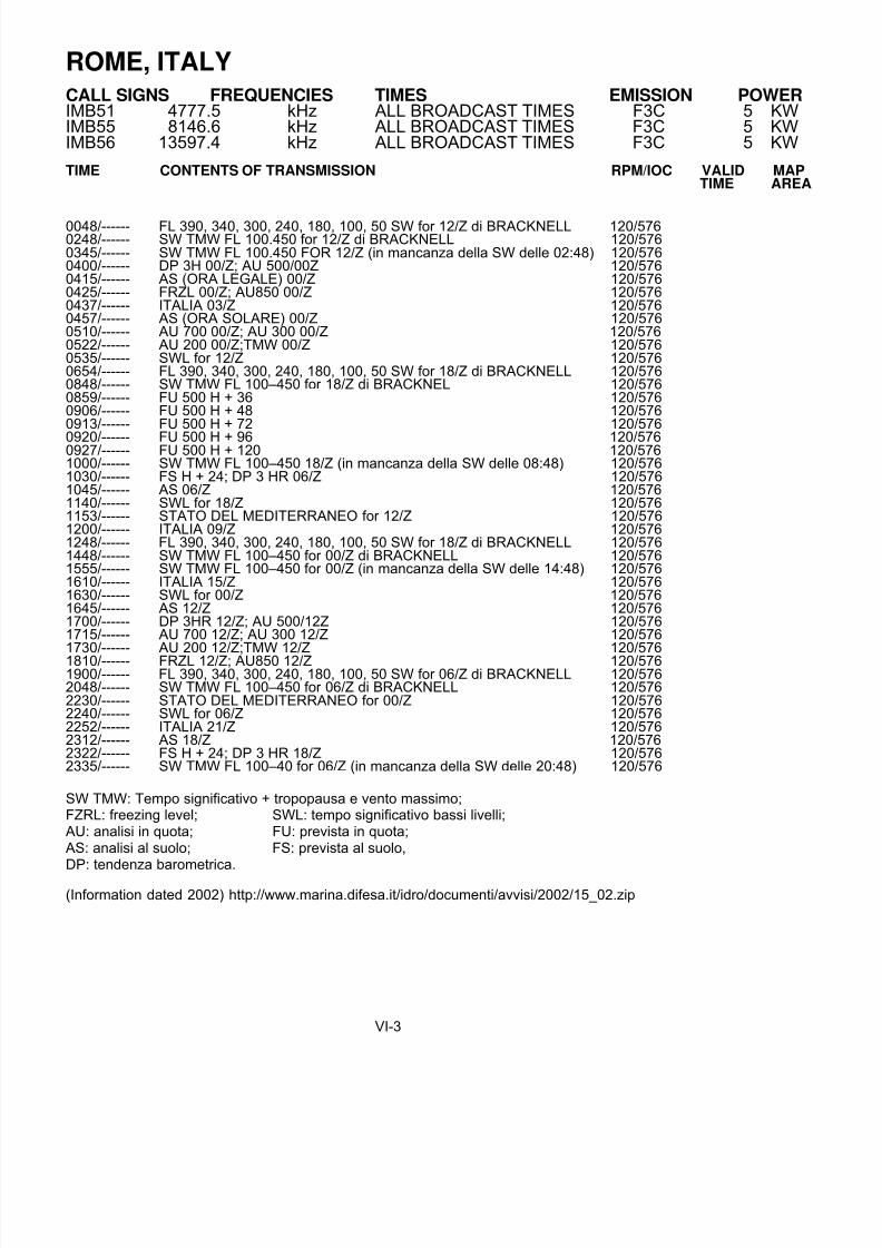
ROME, ITALY
CALL SIGNS FREQUENCIES TIMES EMISSION POWER IMB51 4777.5 kHz ALL BROADCAST TIMES F3C 5 KWIMB55 8146.6 kHz ALL BROADCAST TIMES F3C 5 KWIMB56 13597.4 kHz ALL BROADCAST TIMES F3C 5 KW
TIME CONTENTS OF TRANSMISSION RPM/IOC VALID MAPTIME AREA
0048/------ FL 390, 340, 300, 240, 180, 100, 50 SW for 12/Z di BRACKNELL 120/5760248/------ SW TMW FL 100.450 for 12/Z di BRACKNELL 120/5760345/------ SW TMW FL 100.450 FOR 12/Z (in mancanza della SW delle 02:48) 120/5760400/------ DP 3H 00/Z; AU 500/00Z 120/5760415/------ AS (ORA LEGALE) 00/Z 120/5760425/------ FRZL 00/Z; AU850 00/Z 120/5760437/------ ITALIA 03/Z 120/5760457/------ AS (ORA SOLARE) 00/Z 120/5760510/------ AU 700 00/Z; AU 300 00/Z 120/5760522/------ AU 200 00/Z;TMW 00/Z 120/5760535/------ SWL for 12/Z 120/5760654/------ FL 390, 340, 300, 240, 180, 100, 50 SW for 18/Z di BRACKNELL 120/5760848/------ SW TMW FL 100–450 for 18/Z di BRACKNEL 120/5760859/------ FU 500 H + 36 120/5760906/------ FU 500 H + 48 120/5760913/------ FU 500 H + 72 120/576
0920/------ FU 500 H + 96 120/5760927/------ FU 500 H + 120 120/5761000/------ SW TMW FL 100–450 18/Z (in mancanza della SW delle 08:48) 120/5761030/------ FS H + 24; DP 3 HR 06/Z 120/5761045/------ AS 06/Z 120/5761140/------ SWL for 18/Z 120/5761153/------ STATO DEL MEDITERRANEO for 12/Z 120/5761200/------ ITALIA 09/Z 120/5761248/------ FL 390, 340, 300, 240, 180, 100, 50 SW for 18/Z di BRACKNELL 120/5761448/------ SW TMW FL 100–450 for 00/Z di BRACKNELL 120/5761555/------ SW TMW FL 100–450 for 00/Z (in mancanza della SW delle 14:48) 120/5761610/------ ITALIA 15/Z 120/5761630/------ SWL for 00/Z 120/5761645/------ AS 12/Z 120/5761700/------ DP 3HR 12/Z; AU 500/12Z 120/5761715/------ AU 700 12/Z; AU 300 12/Z 120/5761730/------ AU 200 12/Z;TMW 12/Z 120/5761810/------ FRZL 12/Z; AU850 12/Z 120/5761900/------ FL 390, 340, 300, 240, 180, 100, 50 SW for 06/Z di BRACKNELL 120/5762048/------ SW TMW FL 100–450 for 06/Z di BRACKNELL 120/5762230/------ STATO DEL MEDITERRANEO for 00/Z 120/5762240/------ SWL for 06/Z 120/5762252/------ ITALIA 21/Z 120/5762312/------ AS 18/Z 120/5762322/------ FS H + 24; DP 3 HR 18/Z 120/5762335/------ SW TMW FL 100–40 for 06/Z (in mancanza della SW delle 20:48) 120/576
SW TMW: Tempo significativo + tropopausa e vento massimo;FZRL: freezing level; SWL: tempo significativo bassi livelli;AU: analisi in quota; FU: prevista in quota;AS: analisi al suolo; FS: prevista al suolo,DP: tendenza barometrica.
(Information dated 2002) http://www.marina.difesa.it/idro/documenti/avvisi/2002/15_02.zip
VI-3
8/4/2019 Worldwide Marine Radio Facsimile Broadcast Schedules
http://slidepdf.com/reader/full/worldwide-marine-radio-facsimile-broadcast-schedules 46/122
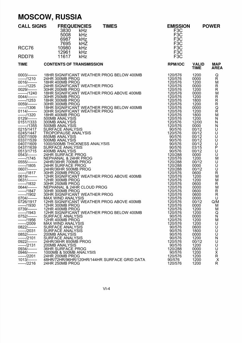
MOSCOW, RUSSIA
CALL SIGNS FREQUENCIES TIMES EMISSION POWER 3830 kHz F3C5008 kHz F3C6987 kHz F3C7695 kHZ F3C
RCC76 10980 kHz F3C12961 kHz F3C
RDD78 11617 kHz F3C
TIME CONTENTS OF TRANSMISSION RPM/IOC VALID MAPTIME AREA
0003/------- 18HR SIGNIFICANT WEATHER PROG BELOW 400MB 120/576 1200 Q------/1210 24HR 300MB PROG 120/576 0000 R0016/------- 18HR 400MB PROG 120/576 1200 M------/1225 24HR SIGNIFICANT WEATHER PROG 120/576 0000 R0029/------- 30HR 200MB PROG 120/576 1200 R-------/1240 18HR SIGNIFICANT WEATHER PROG ABOVE 400MB 120/576 0000 M0044/------- 30HR 250MB PROG 120/576 1200 R------/1253 18HR 300MB PROG 120/576 1800 R0059/------- 30HR 300MB PROG 120/576 1200 R------/1306 18HR SIGNIFICANT WEATHER PROG BELOW 400MB 120/576 0000 Q0114/------- 30HR SIGNIFICANT WEATHER PROG 120/576 1200 R------/1320 18HR 400MB PROG 120/576 1800 M
0129/------- 500MB ANALYSIS 120/576 1200 N0151/1333 300MB ANALYSIS 120/576 12/00 N-------/1355 500MB ANALYSIS 120/576 0000 N0215/1417 SURFACE ANALYSIS 90/576 00/12 U0245/1447 TROPOPAUSE ANALYSIS 120/576 00/12 U0307/1509 850MB ANALYSIS 90/576 00/12 U0337/1539 500MB ANALYSIS 90/576 00/12 U0407/1609 1000/500MB THICKNESS ANALYSIS 90/576 00/12 U0437/1639 SURFACE ANALYSIS 90/576 03/15 P0513/1715 400MB ANALYSIS 90/576 00/12 U0543/------- 24HR SURFACE PROG 120/288 0000 U------/1745 NEPHANAL & 24HR PROG 120/576 1200 M0555/------- 24HR/36HR 700MB PROG 120/288 00/12 U------/1805 24HR SURFACE PROG 120/288 0000 U0607/------- 24HR/36HR 500MB PROG 120/288 00/12 U------/1817 30HR 200MB PROG 120/576 0600 R0619/------- 12HR SIGNIFICANT WEATHER PROG ABOVE 400MB 120/576 1200 M
0631/------- 12HR 300MB PROG 120/576 1200 M------/1832 30HR 250MB PROG 120/576 0600 R0644/------- NEPHANAL & 24HR CLOUD PROG 120/576 0000 M------/1847 30HR 300MB PROG 120/576 0600 R------/1902 30HR SIGNIFICANT WEATHER PROG 120/576 0600 R0704/------- MAX WIND ANALYSIS 120/576 0000 U0726/1917 12HR SIGNIFICANT WEATHER PROG ABOVE 400MB 120/576 00/12 Q/M------/1930 12HR 300MB PROG 120/576 0000 M0739/------- 12HR 400MB PROG 120/576 1200 M------/1943 12HR SIGNIFICANT WEATHER PROG BELOW 400MB 120/576 1200 Q0752/------- SURFACE ANALYSIS 90/576 0000 N------/1956 12HR 400MB PROG 120/576 1200 M------/2009 MAX WIND ANALYSIS 120/576 1200 U0822/------- SURFACE ANALYSIS 90/576 0600 U------/2031 SURFACE ANALYSIS 90/576 1800 U0852/------- 200MB ANALYSIS 90/576 0000 U------/2101 SURFACE ANALYSIS 90/576 1200 N0922/------- 24HR/36HR 850MB PROG 120/576 00/12 U------/2131 200MB ANALYSIS 90/576 1200 U0934/------- 36HR SURFACE PROG 120/288 0000 U0946/------- 1000MB & 500MB ANALYSIS 90/576 1200 X------/2201 24HR 200MB PROG 120/576 1200 R1013/------- 48HR/72HR/96HR/120HR/144HR SURFACE GRID DATA 90/576 1200 X------/2216 24HR 250MB PROG 120/576 1200 R
VI-4

8/4/2019 Worldwide Marine Radio Facsimile Broadcast Schedules
http://slidepdf.com/reader/full/worldwide-marine-radio-facsimile-broadcast-schedules 47/122
MOSCOW, RUSSIA
TIME CONTENTS OF TRANSMISSION RPM/IOC VALID MAPTIME AREA
------/2231 24HR 300MB PROG 120/576 1200 R1040/2246 SURFACE ANALYSIS 90/576 09/21 P1116/------- TECHNICAL STOP------/2322 24HR SIGNIFICANT WEATHER PROG 120/576 1200 R------/2337 18HR SIGNIFICANT WEATHER PROIG ABOVE 400MB 120/576 1200 M1140/------ 24HR 200MB PROG 120/576 0000 R------/2350 18HR 300MB PROG 120/576 0600 M
1155/------- 24HR 250MB PROG 120/576 0000 RMAP AREAS:
M - 1:15,000,000 56N 018W, 58N 108E, 30N 016W, 32N 072EN - 1:30,000,000 03N 097W, 03S 027W, EQ 142E, 05S 077EP - 1:05,000,000 67N 002E, 42N 028E, 74N 061E, 44N 055EQ - 1:07,500,000 61N 010E, 43N 022E, 61N 071E, 43N 059ER - 1:30,000,000 39N 066W, 08N 014E, 18N 149E, 02S 088EU - 1:20,000,000 32N 051W, 15N 014E, 32N 167E, 16N 103EX - 1:30,000,000 NORTHERN HEMISPHERE 90N - 20N
(INFORMATION DATED 11/1996)(Update 3/2001) - Frequencies reported as 53.8, 10611 and 13886 kHz and also 5108 and 6890 kHz at irregular times.(Update 3/2002) - Frequencies reported as 4318, 5108, 6890(night), 10611 and 13886 (night)(Update 3/2002) - All broadcasts reported as 120/576 or 120/288 mode. 60 or 90 rpm is no longer used.
MURMANSK, RUSSIA
CALL SIGN FREQUENCIES TIMES EMISSION POWERRBW 41 5336 kHz F3C
6445.5 kHz ALL BROADCAST TIMES F3C7908.8 kHz 1900-0600 F3C
RBW48 10130 kHz 0600-1900 F3C
TIME CONTENTS OF TRANSMISSION RPM/IOC VALID MAP
TIME AREA0700 36HR SURFACE PROG 120/576 0000 A0800 SEA STATE ANALYSIS 120/576 0600 C1400 SURFACE TEMP ANALYSIS/ICEBERG POSITIONS 120/576 1200 B1400 ANAL OF ICEBERG POSITIONS FOR PAST+24HR 120/576 1200 C1430 24HR SEA STATE PROG 120/576 1200 C1850 BROADCAST SCHEDULE 90/5762000 ICEBERG PROGNOSIS 120/576
NOTES: (1) BASIC COVERAGE AREA IS FOR BARENTS SEA.MAP AREAS:
A -1:05,000,000 67N 032W, 53N 047E, 72N 074E, 51N 004WB -1:03,000,000 79N 010E, 74N 010E, 79N 040E, 74N 040EC -1:05,000,000 78N 010E, 66N 010E, 78N 070E, 66N 070E
(INFORMATION DATED 11/97)
Update 03/2000 - Current operational frequencies report as being 6446 and 8444 kHz (nights) and 7907 kHz (days).Update 03/2000 - Broadcast schedule may no longer be transmitted on-air.Update 03/2002 - May only be transmitting on 6446 kHz.
VI-5

8/4/2019 Worldwide Marine Radio Facsimile Broadcast Schedules
http://slidepdf.com/reader/full/worldwide-marine-radio-facsimile-broadcast-schedules 48/122
NORTHWOOD, UNITED KINGDOM
CALL SIGNS FREQUENCIES TIMES EMISSION POWERGYA 2618.5 kHz 2000-0600 UTC F3C 10 KWGYA 4610 kHz ALL BROADCAST TIMES F3C 10 KWGYA 8040 kHz ALL BROADCAST TIMES F3C 10 KWGYA 11086.5 kHz 0600-2000 UTC F3C 10 KW
TIME CONTENTS OF TRANSMISSION RPM/IOC VALID MAPTIME AREA
0000/1200 SFC ANALYSIS 120/576 18/060012/1212 SFC PRONOSIS T+24 120/576 18/060024/1224 850MB WEBT/PPTN T+24 120/576 18/060036/1236 OAT AND TD CONTOUR T+24 120/576 18/060048/1248 SHIP ICE ACCRETION 120/576 12/000100/1300 MAIN SCHEDULE 120/5760124/1324 QSL REPORT 120/5760136/1336 OCEAN FRONTS 120/5760148/1348 300MB GPH 120/576 18/060212/------ SYMBOLOGY 120/576------/1400 SEA SURFACE TEMP 120/576 00000236/1436 SFC ANALYSIS 120/576 00/120300/1500 SFC ANALYSIS 120/576 00/120348/1548 GALE WARNING SUMMARY 120/576 04/160400/1600 SFC ANALYSIS 120/576 00/120412/------ OAT AND TD CONTOUR T+24 120/576 0000------/1612 TA AND TD CONTOUR T+24 120/576 1200
0424/1624 850MB WEBT/PPTN T+24 120/576 00/120436/1636 SURFACE PROGNOSIS T+24 120/576 00/120448/1648 SCEXA TAFS 120/5760500/1700 SFC ANALYSIS 120/576 00/120512/1712 SURFACE PROGNOSIS T+24 120/576 00/120524/1724 SURFACE PROGNOSIS T+48 120/576 00/120536/1736 SCEXA TAFS 120/576 06/180548/1748 GALE WARNING SUMMARY 120/576 06/180612/1800 SFC ANALYSIS 120/576 00/120624/1812 SURFACE PROGNOSIS T+24 120/576 00/120648/1848 SCEXA TAFS 120/576 07/190700/------ SPARE SCEXA TAFS 120/576 0700------/1900 THICKNESS/GPH ANALYSIS 120/576 12000712/1912 SIG WINDS T+24 120/576 00/120724/1924 SFC PROGNOSIS T+48 120/576 00/120736/1936 SFC PROGNOSIS T+72 120/576 00/12
0748/1948 SFC PROGNOSIS T+96 120/576 00/120800/2012 SFC PROGNOSIS T+120 120/576 00/120812/------ THICKNESS/GPH ANALYSIS 120/576 00/120824/2024 SIG WINDS T+48 120/576 00/120836/2036 SIG WINDS T+72 120/576 00/120848/2048 SIG WINDS T+96 120/576 00/120900/2100 SFC ANALYSIS 120/576 06/180912/2112 THICKNESS/GPH ANALYSIS 120/576 00/120924/2124 THICKNESS/GPH T+24 120/576 00/120936/2136 850MB SPOT WINDS T+24 120/576 00/120948/2148 700MB SPOT WINDS T+24 120/576 00/121000/2200 SFC ANALYSIS 120/576 06/181012/2212 SURFACE PROGNOSIS T+24 120/576 06/181024/2224 REDUCED VIS T+24 120/576 06/181036/2236 850MB WEBT/PPTN T+24 120/576 06/181048/2248 OAT AND TD CONTOUR T+24 120/576 06/181100/2300 SFC ANALYSIS 120/576 06/18
1112/2312 SURFACE PROGNOSIS T+24 120/576 06/181124/2324 SEA AND SWELL T+24 120/576 00/121136/2336 THICKNESS/GPH T+24 120/576 12/001148/2348 GALE WARNING SUMMARY
All MAPS 54°N.82°W 26°N.45°W 54°N.51°E 28°N.12°E
OAT Outside Air TemperatureTD Dewpoint TemperatureSCEXA TAFS South Coast Exercise Area Terminal Airfield Forecasts
(INFORMATION DATED OCT 25 2007)VI-6

8/4/2019 Worldwide Marine Radio Facsimile Broadcast Schedules
http://slidepdf.com/reader/full/worldwide-marine-radio-facsimile-broadcast-schedules 49/122

8/4/2019 Worldwide Marine Radio Facsimile Broadcast Schedules
http://slidepdf.com/reader/full/worldwide-marine-radio-facsimile-broadcast-schedules 50/122

8/4/2019 Worldwide Marine Radio Facsimile Broadcast Schedules
http://slidepdf.com/reader/full/worldwide-marine-radio-facsimile-broadcast-schedules 51/122
NATIONAL WEATHER SERVICE MARINE PRODUCTS VIA INTERNETINCLUDING RADIOFAX
The Internet is not part of the National Weather Service's operational data stream and should never be relied upon asa means to obtain the latest forecast and warning data. Become familiar with and use other means such as NOAAWeather Radio to obtain the latest forecasts and warnings. Please read our disclaimer http://www.nws.noaa.gov/disclaimer.php .
Note: Any reference to a commercial product or service does not imply any endorsement by the National Weather Service as to function or suitability for your purpose or environment.
Marine Text Forecasts and Products The majority of National Weather Service (NWS) forecasts and warnings may be found under the NWS webpage http://www.nws.noaa.gov/ . Of specific interest to mariners are the NWS Marine Text Forecasts and Products http://www.nws.noaa.gov/om/marine/home.htm#text . For convenience, High Seas, Offshore and Coastal marineforecasts are subdivided by sea area or zone and available via the Internet using our text interface or graphic interface.Individual NWS Forecast Offices and Centers producing marine forecasts provide links to their products as well asadditional regionally focused information (see map above).
Marine Graphic Forecasts and Products Graphic marine forecasts are produced by NWS for broadcast via radiofax
http://www.nws.noaa.gov/om/marine/radiofax.htm and also made available via the Internet at Marine Radiofax Charts http://weather.noaa.gov/fax/marine.shtml .
The National Weather Service also plans to make available marine forecast data in gridded and vector formats for display on electronic charts and use by other value-added applications. Graphics using these data are available via theInternet for most U.S. coastal areas. See Marine News - Gridded and Vector Data http://www.nws.noaa.gov/om/marine/newsgridded.htm . Gridded forecast data for offshore and high seas areas areforthcoming.
Also see Computer Generated Model Guidance below.
Satellite and RADAR Imagery Satellite imagery may be found on the GOES webpage http://www.goes.noaa.gov/ , and is also available from NASA
http://rsd.gsfc.nasa.gov/goes/ . Ocean surface winds and other data derived from polar orbiting and geostationarysatellites may be found on NOAA's Marine Observing Systems Team Homepage http://manati.orbit.nesdis.noaa.gov/ and NOAA's Coastwatch Homepage http://coastwatch.noaa.gov/ .Information and links to Sea Surface Temperature Charts and Gulf Stream charts may be found on our FAQ http://www.nws.noaa.gov/om/marine/faq.htm webpage. NEXRAD Doppler Radar images http://radar.weather.gov/Conus/index_lite.php are available on the Internet on the NWS Homepage http://www.nws.noaa.gov/ and local NWS Forecast Offices http://www.nws.noaa.gov/om/marine/marine_map.htm homepages. NEXRAD Doppler Radar images may also befound on local cable channels and the webpages of local media including TV stations, radio stations and newspapersas well as others.
Ice Analysis, Forecasts and Iceberg Reports Ice analyses, forecasts and iceberg reports are available from the National Ice Center http://www.natice.noaa.gov/ ,
the U.S. Coast Guard's International Ice Patrol http://www.uscg.mil/lantarea/iip/home.html , and local NWS marine forecast offices http://www.nws.noaa.gov/om/marine/marine_map.htm in areas such as Alaska http://pafc.arh.noaa.gov/ice.php where ice is a concern. Ice forecasts and observations are also made available asradiofax http://www.nws.noaa.gov/om/marine/radiofax.htm , text products http://www.nws.noaa.gov/om/marine/home.htm#text and computer generated model guidance.
APPENDIX A-1

8/4/2019 Worldwide Marine Radio Facsimile Broadcast Schedules
http://slidepdf.com/reader/full/worldwide-marine-radio-facsimile-broadcast-schedules 52/122
Computer Generated Model GuidanceComputer generated model guidance products used by marine forecasters is available from the Ocean Modeling Branch http://polar.ncep.noaa.gov/ , National Centers for Environmental Prediction http://www.ncep.noaa.gov/ ,the Environmental Modeling Center http://www.emc.ncep.noaa.gov/ , the National Ocean Service's Chesapeake Bay Operational Forecast System http://tidesandcurrents.noaa.gov/ofs/cbofs/cbofs.html , and the Great Lakes Forecasting System http://superior.eng.ohio-state.edu/ .
NCEP model data in graphic and gridded binary (GRIB) form may be found on NCEP's N.O.M.A.D.S. (NOAAOperational Model Archive Distribution System) http://www.nomad3.ncep.noaa.gov/ , NOMADS3, NOMADS5and NOMADS6 webservers.
The Weather Charts http://weather.noaa.gov/fax/graph.shtml webpage contains charts, intended as guidance toforecasters, which can prove of value to mariners. Note: Several charts listed under "Weather Charts", which are nolonger required to support NWS operations, may be terminated or made available at alternate sites. This should notinclude those which are broadcast by marine radiofacsimile.
Caution...these data have not been validated by marine forecasters and may be misleading. Mariners should usethese data in conjunction with forecaster generated forecasts.
Marine Climatological Information User-friendly climatological information for marine coastal areas may be found in Appendix T of the National Ocean Service's Coast Pilot's, volumes 1-9 http://chartmaker.ncd.noaa.gov/nsd/coastpilot.htm . These appendices,which were prepared by the National Climatic Data Center http://lwf.ncdc.noaa.gov/oa/ncdc.html , also contain
other useful meteorological information such as conversion tables. Visit their webpage for further information.
The National Geospatial-Intelligence Agency now makes available some of its Pilot Charts http://www.nga.mil/portal/site/maritime/ on-line.
Foreign Marine ForecastsLinks to foreign meteorological services http://www.wmo.int/pages/members/index_en.html , and foreign marinemeteorological services are available courtesy of the World Meteorological Organization (WMO) http://www.wmo.int/pages/index_en.html .
The WMO has also introduced an experimental GMDSS Webpage http://weather.gmdss.org/ which, as a first step,provides links to worldwide meteorological bulletins and warnings issued for the high seas via SafetyNet.
Also try these Navy links https://www.fnmoc.navy.mil and https://www.navo.navy.mil and "Computer GeneratedModel Guidance" above for data which is outside the area of U.S. marine forecast responsibility.
Buoy and Other Real-Time ObservationsThe latest coastal and offshore weather observations from NOAA fixed and drifting data buoys and Coastal-MarineAutomated Network (C-MAN) stations may be found at the National Data Buoy Center http://www.ndbc.noaa.gov/ webpage. Real time meteorological and oceanographic observations for several sites are also available from thePhysical Oceanographic Real-Time System (Ports) http://tidesandcurrents.noaa.gov/ports.html . PORTS is aprogram of the U.S. National Ocean Service http://oceanservice.noaa.gov/ that supports safe and cost-efficientnavigation by providing ship masters and pilots with accurate real-time information required to avoid groundings andcollisions. Several National Ocean Service tide gages are also equipped with ancillary meteorological sensors http://tidesonline.nos.noaa.gov/geographic.html . Regionally focused observation data may also be found on thewebpages of local NWS Forecast Offices http://www.nws.noaa.gov/om/marine/marine_map.htm . Some marineobservations may also be found on our NWS Marine Product Listing and Schedule http://www.nws.noaa.gov/om/marine/forecast.htm . Historical and real-time beach temperature data is availablefrom the NODC Coastal Water Temperature Guide http://www.nodc.noaa.gov/dsdt/cwtg/ .
NOAA's Forecast Systems Laboratory (FSL) offers a Display of Surface Data http://www-frd.fsl.noaa.gov/mesonet/ from several government, commercial and voluntarily operated mesonets as well as observations of those of theVoluntary Observing Ship (VOS) Program http://www.vos.noaa.gov/ and data buoys. A variety of marineobservations may also be viewed on the National Ocean Service's nowCOAST Web Portal(BETA) http://chartmaker.ncd.noaa.gov/csdl/op/nowcoast.htm .
APPENDIX A-2

8/4/2019 Worldwide Marine Radio Facsimile Broadcast Schedules
http://slidepdf.com/reader/full/worldwide-marine-radio-facsimile-broadcast-schedules 53/122
For mariners with a low speed Internet connection....... The latest buoy or C-MAN data may be retrieved via theInternet as in the following example where 44017 refers to buoy #44017.
http://www.ndbc.noaa.gov/mini_station_page.php?station=44017
WEBCAMSThe advent of the Internet has brought about a new type of observation system popular with beachgoers, surfers, andothers - the WEBCAM which displays live images of current conditions. To find WEBCAMS for marine areas use your favorite Internet search engine to search for such key words as Beach Cams, Surf Cams, Coastal Cams, OceanCams, Port Cams and Cruise Cams. You may wish to refine your search by adding your geographic area to thesearch's key words.
Tide Predictions, Observations and Storm Surge Forecasts Near real-time Water Level Observations, and Predicted Tide Information for the calendar yearhttp://tidesandcurrents.noaa.gov/, are available from the National Ocean Service http://oceanservice.noaa.gov/ .Read the NOS Tides FAQ http://tidesandcurrents.noaa.gov/faq1.html for further information on obtaining NOStides and tidal current data. Caution is urged in using tide data made available at University and other webpages. Thisinformation may not be based on current government data and be of unknown quality.
The National Weather Service's Cleveland Forecast Office makes available a series of experimental Great Lakes Water Levels Graphs http://marine.wcle.noaa.gov/levels.html , using National Ocean Service data, intended to below speed connection friendly for Internet access by vessels afloat.
Experimental, computer generated, Extratropical Water Level Forecasts http://www.nws.noaa.gov/mdl/etsurge/ are available from the National Weather Service's Meteorological Development Laboratory http://www.nws.noaa.gov/tdl/ . Status maps are provided to give the user a quick overview of a region. Forecasts of storm surge produced as a result of a tropical storm or hurricane are available from your local NWS Forecast Office http://www.weather.gov/organization.php .
The National Ocean Service's Chesapeake Bay Operational Forecast System (CBOFS) http://tidesandcurrents.noaa.gov/ofs/cbofs/cbofs.html and The Port of New York and New Jersey Operational Forecast System (NYOFS) http://tidesandcurrents.noaa.gov/nyofs.html have been created by NOS to provide themaritime community with improved short-term predictions of water levels. Please be advised that these predictions arebased on a hydrodynamic model and, as such, should be considered as computer-generated forecast guidance.
For Emergency Responders and Planners
NOAA's Office of Response and Restoration, National Ocean Service http://response.restoration.noaa.gov/index.php , offers a series of job aids and software to predict weather andocean affects on the trajectory of hazardous materials such as oil spills. The information may be helpful for further applications as well.
Historic Weather Forecasts, Satellite Images and Oceanographic Data For historic weather forecasts, satellite images and oceanographic data, contact the National Climatic Data Center andNational Oceanographic Data Center, found on our listing of Phone Numbers and Addresses http://www.nws.noaa.gov/om/marine/phone.htm .
Voluntary Observations from Mariners All NWS marine forecasts rely heavily on the Voluntary Observing Ship (VOS) http://www.vos.noaa.gov/ programfor obtaining meteorological observations. Ship observations may also be found on the NOAA's Forecast Systems Laboratory (choose maritime) http://www-frd.fsl.noaa.gov/mesonet/ , CoolWX http://coolwx.com/buoydata/ , andSailWX.info http://www.sailwx.info , Oceanweather http://www.oceanweather.com/data/index.html webpages.
The National Weather Service has a number of other volunteer observation programs including the SKYWARN,MAREP, MAROB, MARS, APRSWXNET/Citizen Weather Observer Program (CWOP) and the Cooperative Observer Program (COOP) see http://www.nws.noaa.gov/om/marine/voluntary.htm which are of benefit to themarine community.
APPENDIX A-3

8/4/2019 Worldwide Marine Radio Facsimile Broadcast Schedules
http://slidepdf.com/reader/full/worldwide-marine-radio-facsimile-broadcast-schedules 54/122
Marine WebpagesThe Internet contains a great number of webpages of interest to the mariner. Visit our Links http://www.nws.noaa.gov/om/marine/mlinks.htm page for a listing of recommended webpages pertaining to MarineWeather. The U.S. Coast Guard Maritime Telecommunications Information webpage http://www.navcen.uscg.gov/marcomms contains an excellent description of marine communication systems. Thereare also many other Internet sites of interest to the mariner. Use one the Internet search engines to search on topicssuch as "marine weather", "radiofax", "radiofacsimile", "weather buoys", "tides", etc. The NOAA Library http://www.lib.noaa.gov/ provides an excellent listing of links to marine related webpages within NOAA andelsewhere.
Marine Weather Publications On the WebMany marine weather related government publications are available on the Web. Visit our publications webpage http://www.nws.noaa.gov/om/marine/pub.htm for several we recommend including our popular Marine ServiceCharts, the Weather Log Magazine, and our listing of Worldwide Marine Radiofacsimile Broadcast Schedules.
Internet Access for Mariners Internet at sea can be problematic unless you stay within cellular telephone range of shore. The maximum speed for cellular telephones is typically 14.4 Kbaud, however, a number of cellular service providers are now offering enhancedservices with speeds in the range of 56 Kbaud - 144 Kbaud. Terrestrial wireless Internet services such as thoseprovided by GoAmerica, TeleSea, and Motient, are beginning to become available, however, these provide limitedmaritime coverage. These companies may employ “Marine WIFI" technology which is rapidly becoming popular atmarinas and in favorite harbor areas. Satellite services including Inmarsat, Iridium, Globalstar, Thuraya,
Emsat, ACeS, tracNet/DirecPC, Mobile Satellite Ventures, Boatracs, Orbcomm , Digital Seas International , andMTN are available, however, costs are generally greater. Several companies offer e-mail services designed tooptimize satellite connectivity including MAILASAIL, MarineNet, OCENS, Telaurus, UUPLUS and XGate. Full Internetaccess is often available if you have a satellite terminal onboard, but presently unless you restrict your use to e-mailmessages, costs can be high. A number of satellite services such as Inmarsat-C offer e-mail messaging services onlyand provide no access to the World Wide Web. Several transmission and data compression schemes are availableand in development to make the Web more accessible to the mariner. There are also several public FTP-to-EMAIL andWWW-to-EMAIL servers available to allow Internet access for users who do not have direct or cost effective access tothe World Wide Web but who are equipped with an e-mail system. See http://www.faqs.org/faqs/internet- services/access-via-email/ for information. Low cost, worldwide, access to the World Wide Web via satellite should beavailable to the mariner in the next five to ten years.
If you have an HF marine radio, E-mail service is available from companies such as Sailmail, SeaMail, CruiseEmail,
Global Marine Networks, MarineNet Wireless, Kielradio, Globe Wireless and Mobile Marine Radio (WLO)/Telaurus. E-mail can be accomplished at no cost using amateur radio http://www.nws.noaa.gov/om/marine/ham.htm .
The domain of the Internet is rapidly expanding to now include wireless devices such as so-called "Internet-Ready"digital cellular phones and Personal Data Assistants (PDAs). These offer great potential for making marine forecastsavailable to coastal mariners, who have limited other options available. The majority of these other options are byvoice where there is always the possibility of misunderstanding.
A webpage for the most popular marine text forcasts compatible with many PDA's may be found athttp://www.nws.noaa.gov/om/marine/marinewxi.htm .
Visit http://www.nhc.noaa.gov/aboutwap.shtml where you will find NHC/TPC's wireless web page. There you canfind the link to obtain NHC/TPC's most popular hurricane products, offshore forecasts, and high seas forecasts.
A WAP webpage for compatible cellphones containing marine and public forecasts may be found at:cell.weather.gov NOW WITH GREATLY ENHANCED MARINE LINKS (includes a capability to view the forecast for any zip/city and radar images).
A low bandwidth webpage containing marine and public forecasts intended for mobile devices may be found at:http://mobile.weather.gov/ (includes a capability to view the forecast for any zip/city and radar images).Note....WAP/WML webpages require a WAP-capable cellphone or other WAP-capable device.
A number of Cellular service providers are beginning to offer value-added Internet-like services which provide accessto NOAA tide data, marine forecasts, and other items of interest to the wireless customer. These require a digitalphone with some of the more advanced features. See your Cellular service provider for details. There may be anominal fee required for using these services.
APPENDIX A-4

8/4/2019 Worldwide Marine Radio Facsimile Broadcast Schedules
http://slidepdf.com/reader/full/worldwide-marine-radio-facsimile-broadcast-schedules 55/122
National Weather Service Products Available Via E-MAIL (FTPMAIL)
National Weather Service marine text forecasts, radiofax charts and buoy observations are available via e-mail.Further, FTPMAIL may be used to acquire any file on the tgftp.nws.noaa.gov FTP server. The FTPMAIL server isintended to allow Internet access for mariners and other users who do not have direct access to the World Wide Webbut who are equipped with an e-mail system. Turnaround is generally in under one hour, however, performance mayvary widely and receipt cannot be guaranteed. To get started in using the NWS FTPMAIL service, follow these simpledirections to obtain the FTPMAIL "help" file (11 KBytes), or see http://weather.noaa.gov/pub/fax/ftpmail.txt .
Send an e-mail to: [email protected] Subject line: Put anything you like
Body: help
An FAQ webpage describing several public and commercial FTP-to-EMAIL and WWW-to-EMAIL servers may befound at: www.faqs.org/faqs/internet-services/access-via-email/
A webpage describing several different e-mail "robots" similar in concept to FTPMAIL, including some with advancedfeatures such as allowing retrieval of NWS marine GRIB files, simple webpages, and allowing products to be retrievedon a scheduled, recurring basis may be found at: http://weather.noaa.gov/pub/fax/robots.txt
Internet Broadcasts Marine weather data may also be obtained via the Internet using EMWINhttp://www.nws.noaa.gov/om/marine/emwin.htm. As part of the New NOAA Weather Wire
Servicehttp://www.nws.noaa.gov/om/marine/wxwire.htm , Computer Sciences Corporation http://dynis.fedcsc.com/contracts/other/nwws/default.htm broadcasts the entire Weather Wire product stream on the Internet as a commercial service http://dynis.fedcsc.com/contracts/other/nwws/options.htm .
Watches, Warnings and Advisories Using RSS and CAP XML Based Formats The National Weather Service provides access to watches, warnings and advisories for land areas http://www.weather.gov/alerts/ , and for hurricane watches and warnings http://www.nhc.noaa.gov/aboutrss.shtml , via RSS http://www.weather.gov/alerts/#rss and CAP/XMLhttp://www.weather.gov/alerts/#cap to aid the automated dissemination of this information. Planning is in progress toextend this to marine warnings.
Directories of NWS Marine Forecasts
For Website developers or other "power" users, many NWS marine text forecast products are available at the followingURL's, indexed by WMO header or zone.http://weather.noaa.gov/pub/data/forecasts/marine/ ftp://tgftp.nws.noaa.gov/data/forecasts/marine/ http://weather.noaa.gov/pub/data/raw/ ftp://tgftp.nws.noaa.gov/data/raw/ http://www.ndbc.noaa.gov/data/Forecasts/ http://www.weather.gov/data/ http://www.srh.noaa.gov/data http://www.weather.gov/view/validProds.php
Many National Weather Service Weather Charts may be found in the following directories, indexed by WMO ID or other identifier.http://weather.noaa.gov/pub/fax/ftp://tgftp.nws.noaa.gov/fax/
Change Notices For details on changes to NWS products, visit the Office of Climate, Water, and Weather Services Service Change Notifications http://www.nws.noaa.gov/om/notif.htm , the Data Product Change Management Status Reports http://www.nws.noaa.gov/om/cm/status.html , and NWS Telecommunication Operations Center (TOC) Data Management Change Notices http://www.nws.noaa.gov/datamgmt/notices.shtml webpages. See http://www.nws.noaa.gov/om/marine/recent.htm for a summary of recent changes of most interest to mariners andcoastal residents.
APPENDIX A-5

8/4/2019 Worldwide Marine Radio Facsimile Broadcast Schedules
http://slidepdf.com/reader/full/worldwide-marine-radio-facsimile-broadcast-schedules 56/122
NATIONAL WEATHER SERVICE INTERNET SITES
NWS Homepage http://www.nws.noaa.gov
NWS Marine Forecasts http://www.nws.noaa.gov/om/marine/home.htm
NWS Marine Text Products http://www.nws.noaa.gov/om/marine/home.htm#text
NWS Marine Radiofax Products http://www.nws.noaa.gov/fax/marine.shtml
NWS Voluntary Observing Ship Program http://www.vos.noaa.gov
AMVER/SEAS Homepage http://seas.amverseas.noaa.gov/seas/
U.S. NAVY AND OTHER WEATHER INTERNET SITES
See these sites for further links
Naval Oceanographic Office https://www.navo.navy.mil/
Navy Fleet Numerical https://www.fnmoc.navy.mil/
International Ice patrol http://www.uscg.mil/lantarea/iip/home.html
National Ice Center http://www.natice.noaa.gov
WMO Homepage http://www.wmo.ch
JCOMM GMDSS http://weather.gmdss.org/
USCG Maritime Telecommunications http://www.navcen.uscg.gov/marcomms
APPENDIX A-6

8/4/2019 Worldwide Marine Radio Facsimile Broadcast Schedules
http://slidepdf.com/reader/full/worldwide-marine-radio-facsimile-broadcast-schedules 57/122
FTPMAIL help file
*****************
* WARNING
*
* This is a United States Government Computer. Use of
* this computer for purposes for which authorization
* has not been extended is a violation of federal law.
*
* (Reference Public Law 99-474)
* For Help contact:
*
* [email protected] 301-713-1677 x 128
*
*****************
**** IMPORTANT NOTICES ****
Effective January 08, 2008, the address of the FTPMAIL service changed
from [email protected] to [email protected].
If you restrict incoming e-mail as a means of preventing spam, you mustconfigure your e-mail system to allow mail from [email protected]
Read the help file carefully - 99% of errors using FTPMAIL are simple
typo's, incorrect capitalization, failure to send in plain text format,
leading or trailing spaces, or failure to set up any spam filters properly.
These instructions are subject to revision....download frequently.
**********
**** NEW USERS....Read these notes Carefully *****
CAUTION - READ THIS HELP FILE CAREFULLY - 99% OF ERRORS USING FTPMAIL
ARE SIMPLE TYPO'S, INCORRECT CAPITALIZATION, FAILURE TO SEND IN PLAINTEXT FORMAT, LEADING OR TRAILING SPACES, OR FAILURE TO SET UP ANY SPAM
FILTERS PROPERLY. FOLLOW THE EXAMPLES CLOSELY!
FTPMAIL e-mail requests must be sent in ASCII/Plain Text only.
HTML formatting will likely result in no response from the FTPMAIL
server.
tgftp.nws.noaa.gov is the only valid FTP site for this service.
This National Weather Service (NWS) FTPMAIL server is intended to
allow Internet access for users who do not have direct access to
the World Wide Web but who are equipped with an e-mail system.The service is free and no signup is required. Using FTPMAIL,
users can request files from NWS and have them automatically
e-mailed back to them. Turnaround is generally in under one
hour, however, performance may vary widely and receipt cannot be
guaranteed.
NOTICE - Check time and date of forecasts. Downloaded data may not
represent the latest forecast. The Internet is not part of the
National Weather Service's operational data stream and should never
be relied upon as a means to obtain the latest forecast and warning
data. Become familiar with and use other means such as NOAA Weather

8/4/2019 Worldwide Marine Radio Facsimile Broadcast Schedules
http://slidepdf.com/reader/full/worldwide-marine-radio-facsimile-broadcast-schedules 58/122
Radio to obtain the latest forecasts and warnings. Please read our
disclaimer at http://www.nws.noaa.gov/disclaimer.php
Although these instructions are tailored for marine users to gain
access to graphic(radiofax) and text products via e-mail, all
publicly available data on the tgftp.nws.noaa.gov Internet FTP
server is accessible using the FTPMAIL service.
To use FTPMAIL, the user sends a small script file via e-mail to
NWS requesting the desired file(s).
Users should be familiar with sending and receiving messages and
attachments with their particular e-mail system. Attachments are
received in UUencoded form. The majority of modern e-mail
systems handle the conversion automatically, other users will
need to run the UUdecode program for their particular system.
See your system administrator if you have any questions on this
topic. The UUencoding process can add 0 to >100% overhead
depending on your system and the type of file.
Files sizes for NWS radiofax graphic files average 35KB but can
be much greater. Users should be aware of the costs for operating
their particular e-mail system before attempting to use FTPMAIL,
especially when using satellite communication systems. For marineusers, using FTPMAIL via INMARSAT-C for obtaining current NWS
radiofax graphic files is cost prohibitive. Using the FTPMAIL
compression feature of FTPMAIL is not recommended as these files
are already in a compressed T4(G4) format enveloped in TIFF for
viewing. You will need a graphics program capable of displaying
files in this format in order to view them. Suggestions for TIFF
viewers may be found in file http://weather.noaa.gov/fax/rfaxtif.txt
NEW! Radiofax .TIF files now also available as (larger) .gif files
The following examples demonstrate the use of FTPMAIL. Indexes of
currently available marine products, the list FTPMAIL commands,
and suggestions for TIFF viewers may be obtained following these
instructions.
To use FTPMAIL:
o Send an e-mail via the Internet to: [email protected]
o Put anything you like on the subject line
o Enter a command script in the body of the message
NOTE: Correct capitalization for commands, directory and file
names is critical
Example scripts are:
help
Connect to default_site (tgftp.nws.noaa.gov) and send back
this help file to e-mail address of requestor
open
cd fax
get PWAE98.TIF
quit
Connect to default_site (tgftp.nws.noaa.gov) and send back

8/4/2019 Worldwide Marine Radio Facsimile Broadcast Schedules
http://slidepdf.com/reader/full/worldwide-marine-radio-facsimile-broadcast-schedules 59/122
the chart file PWAE98.TIF to e-mail address of requestor
open
cd data
cd forecasts
cd marine
cd coastal
cd an
get anz231.txt
quit
Connect to default_site (tgftp.nws.noaa.gov) and send back coastal
marine zone forecast ANZ231 to e-mail address of requestor
open
cd data
cd forecasts
cd zone
cd md
get mdz009.txt
quit
Connect to default_site (tgftp.nws.noaa.gov) and send back public
land zone forecast MDZ009 to e-mail address of requestor.(Contact your local forecast office to identify the public
forecast zone number for your county, known as the UGC code)
reply-to [email protected]
open
dir
quit
Connect to default_site (tgftp.nws.noaa.gov) and send back the
contents of the top level directory to [email protected]
open
cd fax
get ftpcmd.txt (List of FTPMAIL commands)
get rfaxtif.txt (TIFF suggestions)
get rfaxatl.txt (Atlantic radiofax file directory)
get rfaxpac.txt (Pacific radiofax file directory)
get rfaxmex.txt (Gulf of Mexico and Trop Atl radiofax file dir)
get rfaxak.txt (Alaska radiofax and ice file directory)
get rfaxhi.txt (Hawaii radiofax file directory)
get otherfax.txt (Foreign charts file directory)
get marine1.txt (Highseas,Offshore,Open Lakes,NAVTEX text file dir)
get marine2.txt (Hurricane text file directory)get marine3.txt (Coastal forecasts text file directory)
get marine4.txt (Offshore forecasts by zone directory)
get marine5.txt (Atlantic coastal forecasts by zone directory)
get marine6.txt (Pacific coastal forecasts by zone directory)
get marine7.txt (Gulf of Mexico coastal forecasts by zone dir)
get marine8.txt (Great Lakes coastal forecasts by zone directory)
get marine9.txt (Alaska coastal forecasts by zone directory)
get marine10.txt (Hawaii&Trust coastal forecasts by zone directory)
get uk.txt (UK marine forecasts from Bracknell directory)
get canada.txt (Canadian marine text forecast directory)
get tsunami.txt (Tsunami products directory)

8/4/2019 Worldwide Marine Radio Facsimile Broadcast Schedules
http://slidepdf.com/reader/full/worldwide-marine-radio-facsimile-broadcast-schedules 60/122
get robots.txt (Marine forecasts and info via e-mail systems)
quit
Connect to default_site (tgftp.nws.noaa.gov) and send back the
requested files to e-mail address of requestor.
Many, but not all National Weather Service forecast products may be
obtained using FTPMAIL if the WMO/AWIPS Header is known as follows.
Example:To obtain the Atlantic high seas Forecast, WMO header FZNT01 KWBC,
AWIPS header HSFAT1
Send an e-mail to: [email protected]
Subject Line: Put anything you like
Body: open
cd data
cd raw
cd fz
get fznt01.kwbc.hsf.at1.txt
quit
*************************SPECIAL NOTES*************************
CAUTION - READ THIS HELP FILE CAREFULLY - 99% OF ERRORS USING FTPMAIL
ARE SIMPLE TYPO'S, INCORRECT CAPITALIZATION, FAILURE TO SEND IN PLAIN
TEXT FORMAT, OR FAILURE TO SET UP ANY SPAM FILTERS PROPERLY.
FOLLOW THE EXAMPLES CLOSELY!
FTPMAIL e-mail requests must be sent in ASCII/Plain Text only.
HTML formatting will likely result in no response from the FTPMAIL
server.
Problems have been reported by users of Hotmail. (This may now be fixed)
If you restrict incoming e-mail as a means of preventing spam, youmust program your e-mail system to allow messages from:
The majority of error messages have been disabled. You may or may
not receive an error message back from FTPMAIL if your script is in
error.
FTPMAIL problems are occasionally encountered when embedded control
characters are received within the e-mail message received by the
FTPMAIL server. These control characters may be introduced by the
user's e-mail system and may be unavoidable.
Also be certain that each of your commands does not have any leadingand/or trailing space(s) or you may see an error message with a number
of statements saying "=20"
Problems may also be encountered in trying to go down several levels
of directories simultaneously, e.g. "cd data/forecasts/marine/test".
Use a series of commands "cd data", "cd forecasts", "cd marine" instead.
In both these instances, the likely error will be "Directory not Found"
If the FTPMAIL server is too busy, you will receive an e-mail with a
subject line similar to: "ftpmail job queuing for retry queue/097095.69568"
Your request will be resubmitted automatically and your requested

8/4/2019 Worldwide Marine Radio Facsimile Broadcast Schedules
http://slidepdf.com/reader/full/worldwide-marine-radio-facsimile-broadcast-schedules 61/122
file(s) should be received within several hours.
****************************************************************
An FAQ webpage describing several public and commercial FTP-to-EMAIL
and WWW-to-EMAIL servers may be found at:
www.faqs.org/faqs/internet-services/access-via-email/
If you have access to the Internet, be certain to check out
the following webpages. See these pages for further links.
http://www.nws.noaa.gov NWS Homepage
http://www.nws.noaa.gov/om/marine/home.htm NWS Marine Page
cell.weather.gov Cellphone page
mobile.weather.gov Mobile Page
Author: Timothy Rulon, Marine and Coastal Weather Services Branch W/OS21
National Weather Service
Last Modified Aug 27, 2008
Document URL: http://weather.noaa.gov/pub/fax/ftpmail.txt
ftp://tgftp.nws.noaa.gov/fax/ftpmail.txt

8/4/2019 Worldwide Marine Radio Facsimile Broadcast Schedules
http://slidepdf.com/reader/full/worldwide-marine-radio-facsimile-broadcast-schedules 62/122
***FTPMAIL commands for [email protected] FTPMAIL server***
**** IMPORTANT NOTICES ****
Effective January 08, 2008, the address of the FTPMAIL service changed
from [email protected] to [email protected] you restrict incoming e-mail as a means of preventing spam, you must
configure your e-mail system to allow mail from [email protected]
Read the help file carefully - 99% of errors using FTPMAIL are simple
typo's, incorrect capitalization, failure to send in plain text format,
leading or trailing spaces, or failure to set up any spam filters properly.
These instructions are subject to revision....download frequently.
FTP's files and sends them back via electronic mail
NOTE: *.noaa.gov are the only valid FTP sites for this FTPMAIL server.
NOTE: Capitalization is critical for this server. Commands are
un-capitalized, while some directory and file names are
CAPITALIZED, while others are un-capitalized.
To use FTPMAIL:
o Send an E-mail via the Internet to [email protected]
o Put anything you like on the subject line
o Enter a command script in the body of the message
Example scripts are:
reply-to [email protected]
open
dir
quit
Connect to default_site (tgftp.nws.noaa.gov) and send back the
contents of the top level directory to [email protected]
open
cd faxget PWAG01.TIF
quit
Connect to default_site (tgftp.nws.noaa.gov) and send back the
chart file PWAG01.TIF to e-mail address of requestor
>>Valid commands to the ftpmail gateway are:

8/4/2019 Worldwide Marine Radio Facsimile Broadcast Schedules
http://slidepdf.com/reader/full/worldwide-marine-radio-facsimile-broadcast-schedules 63/122
reply-to email-address Who to send the response to. This is optional
and defaults to the users email address
>>Followed by one of:
help Just send back help
delete jobid Delete the given job
(jobid is received from server)
open [site [user [pass]]]
Site to ftp to. Default is:
default_site anonymous reply-to-address.
>>If there was an open then it can be followed by up to 100 of the
>>following commands
cd pathname Change directory.
cd .. Move up 1 directory.
cd / Move to the root directory.
ls [pathname] Short listing of pathname.
Default pathname is current directory.
dir [pathname] Long listing of pathname.
Default pathname is current directory.
get pathname Get a file and email it back.
compress Compress files/dir-listings before emailing back
gzip Gzip files/dir-listings before emailing back
uuencode These are mutually exclusive options for
btoa converting a binary file before emailing.(Default is uuencode.)
force uuencode Force all files or directory listings to
force btoa be encoded before sending back.
There is no default.
mime Send the message as a Mime Version 1.0 message.
Text will be sent as text/plain charset=US-ASCII
Non-text as application/octet-stream.
If the file is splitup then it will be sent
as a message/partial.
force mime As mime but force text files to be sent asapplication/octet-stream
no [compress|gzip|uuencode|btoa|mime]
Turn the option off.
size num[K|M] Set the max size a file can be before it
is split up and emailed back in parts to
the given number of Kilo or Mega bytes.
This is limited to 275KB. Default is 275KB.
mode binary Change the mode selected for the get

8/4/2019 Worldwide Marine Radio Facsimile Broadcast Schedules
http://slidepdf.com/reader/full/worldwide-marine-radio-facsimile-broadcast-schedules 64/122
mode ascii command. Defaults to binary.
quit End of input - ignore any following lines.
Author: Timothy Rulon, Marine and Coastal Weather Services Branch W/OS21
National Weather Service
Last Modified Sep 12, 2008
Document URL: http://weather.noaa.gov/pub/fax/ftpcmd.txtftp://tgftp.nws.noaa.gov/fax/ftpcmd.txt

8/4/2019 Worldwide Marine Radio Facsimile Broadcast Schedules
http://slidepdf.com/reader/full/worldwide-marine-radio-facsimile-broadcast-schedules 65/122
Suggested TIFF Viewers
The (G4)/TIFF format is used because the facsimile charts are in BLACK &
WHITE and other encoding formats generate significantly larger files.
The suggested TIFF viewers listed here are to help in your selection and
have been found to work in viewing these charts in past testing. The
viewers and sources listed imply no endorsement by the NWS.
Commercial Viewers for DOS/Windows 3.1
HyperFax.111 by Hypersoft (603) 356-0210
Viewdirector by TMS, Inc. (800) 944-7654
Imagehandler by LeadTools (800) 637-4699
Keyview by FTP Software (800) 242-4FTP
Snowview Platinum by Snowbound Software (617) 630-9495
Shareware viewers for DOS/Windows 3.1
Paint Shop Pro 3.0 by Jasc, Inc. (612) 930-9171
Graphic Workshop v1.1p
VIDVUE v1.1 by L. GozumQuickView v1.2e (limited - can't rotate)
Shareware viewers for OS/2
PMJPEG
PMView v0.9
Shareware viewer for Apple/MAC
GraphicConverter 2.6
All programs that support Quicktime 6.0+
Netscape 7.0 (Free)
Internet Explorer 5.1 (Free)
Eudora Pro 4.2 (shareware)
PictureViewer QT 6.0 (Free included with Macs)
Graphic Converter 3.6 - 4.x (shareware)Canvas 7.0 +
Photoshop Elements 2.0 (Free with Wacom Tablets etc.)
Photoshop 6.0 +
Canon file viewer utility 1.3.2.9 (included with Canon Digital cameras)
Media Assistant 2.0.4 (image cataloger) Low cost
Cumulus 5.5 (Image Cataloger) Low cost
Author: Timothy Rulon, Marine and Coastal Weather Services Branch W/OS21
National Weather Service
Last Modified Aug 27, 2008
Document URL: http://weather.noaa.gov/pub/fax/rfaxtif.txt
ftp://tgftp.nws.noaa.gov/fax/rfaxtif.txt

8/4/2019 Worldwide Marine Radio Facsimile Broadcast Schedules
http://slidepdf.com/reader/full/worldwide-marine-radio-facsimile-broadcast-schedules 66/122
NATIONAL WEATHER SERVICE RADIOFAX PRODUCTS
for the Western Atlantic Ocean
**** IMPORTANT NOTICES ****
Effective January 08, 2008, the address of the FTPMAIL service changed
from [email protected] to [email protected].
If you restrict incoming e-mail as a means of preventing spam, you must
configure your e-mail system to allow mail from [email protected]
Read the help file carefully - 99% of errors using FTPMAIL are simple
typo's, incorrect capitalization, failure to send in plain text format,
leading or trailing spaces, or failure to set up any spam filters properly.
These instructions are subject to revision....download frequently.
U.S. Coast Guard Communications Station NMF - Boston, Massachusetts
Assigned frequencies 4235.0, 6340.5, 9110, 12750 kHz
Select a carrier frequency 1.9 kHz below those listed when using asingle sideband radio in the USB mode to receive these broadcasts.
The latest version of marine weather charts for broadcast by the U.S. Coast
Guard are available from the National Weather Service Telecommunication
Gateway on this server. The listed charts are in the G4(T4) format and
enveloped in TIFF for viewing. Satellite images are in JPEG format.
These charts may be found in directory: ftp://tgftp.nws.noaa.gov/fax or
http://weather.noaa.gov/pub/fax
For information of how these files and other text and graphic marine
forecasts may be downloaded via e-mail (FTPMAIL) see:
http://weather.noaa.gov/pub/fax/ftpmail.txt
.TIF files now also available as .gif files
This file is intended to assist mariners using the FTPMAIL system
which is used to obtain National Weather Service products via
e-mail. The following is an example in the use of the FTPMAIL
system.
PAY ATTENTION TO CAPITALIZATION:
Example using FTPMAIL:
Send an e-mail to: [email protected]
Subject line: Put anything you like
Body: opencd fax
get PPAE10.TIF
get PWAE98.gif
quit
The "help" file contains a more detailed description of the
FTPMAIL system and available products. To obtain a copy of the
FTPMAIL "help" file.
Send an e-mail to: [email protected]
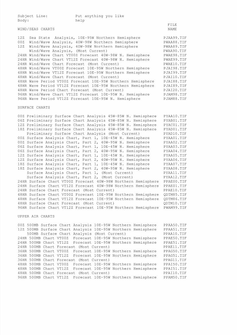
8/4/2019 Worldwide Marine Radio Facsimile Broadcast Schedules
http://slidepdf.com/reader/full/worldwide-marine-radio-facsimile-broadcast-schedules 67/122
Subject Line: Put anything you like
Body: help
FILE
WIND/SEAS CHARTS NAME
12Z Sea State Analysis, 10E-95W Northern Hemisphere PJAA99.TIF
00Z Wind/Wave Analysis, 40W-98W Northern Hemisphere PWAA88.TIF
12Z Wind/Wave Analysis, 40W-98W Northern Hemisphere PWAA89.TIF
Wind/Wave Analysis, (Most Current) PWAA90.TIF
24HR Wind/Wave Chart VT00Z Forecast 40W-98W N. Hemisphere PWAE98.TIF
24HR Wind/Wave Chart VT12Z Forecast 40W-98W N. Hemisphere PWAE99.TIF24HR Wind/Wave Chart Forecast (Most Current) PWAE10.TIF
48HR Wind/Wave VT00Z Forecast 10E-95W Northern Hemisphere PJAI98.TIF
48HR Wind/Wave VT12Z Forecast 10E-95W Northern Hemisphere PJAI99.TIF
48HR Wind/Wave Chart Forecast (Most Current) PJAI10.TIF
48HR Wave Period VT00Z Forecast 10E-95W Northern Hemisphere PJAI88.TIF
48HR Wave Period VT12Z Forecast 10E-95W Northern Hemisphere PJAI89.TIF
48HR Wave Period Chart Forecast (Most Current) PJAI20.TIF
96HR Wind/Wave Chart VT12Z Forecast 10E-95W N. Hemisphere PJAM98.TIF
96HR Wave Period VT12Z Forecast 10E-95W N. Hemisphere PJAM88.TIF
SURFACE CHARTS
00Z Preliminary Surface Chart Analysis 45W-85W N. Hemisphere PYAA10.TIF06Z Preliminary Surface Chart Analysis 45W-85W N. Hemisphere PYAB01.TIF
12Z Preliminary Surface Chart Analysis 45W-85W N. Hemisphere PYAC01.TIF
18Z Preliminary Surface Chart Analysis 45W-85W N. Hemisphere PYAD01.TIF
Preliminary Surface Chart Analysis (Most Current) PYAD10.TIF
00Z Surface Analysis Chart, Part 1, 10E-45W N. Hemisphere PYAA01.TIF
00Z Surface Analysis Chart, Part 2, 40W-95W N. Hemisphere PYAA02.TIF
06Z Surface Analysis Chart, Part 1, 10E-45W N. Hemisphere PYAA03.TIF
06Z Surface Analysis Chart, Part 2, 40W-95W N. Hemisphere PYAA04.TIF
12Z Surface Analysis Chart, Part 1, 10E-45W N. Hemisphere PYAA05.TIF
12Z Surface Analysis Chart, Part 2, 40W-95W N. Hemisphere PYAA06.TIF
18Z Surface Analysis Chart, Part 1, 10E-45W N. Hemisphere PYAA07.TIF
18Z Surface Analysis Chart, Part 2, 40W-95W N. Hemisphere PYAA08.TIF
Surface Analysis Chart, Part 1, (Most Current) PYAA11.TIF
Surface Analysis Chart, Part 2, (Most Current) PYAA12.TIF24HR Surface Chart VT00Z Forecast 40W-98W Northern Hemisphere PPAE00.TIF
24HR Surface Chart VT12Z Forecast 40W-98W Northern Hemisphere PPAE01.TIF
24HR Surface Chart Forecast (Most Current) PPAE10.TIF
48HR Surface Chart VT00Z Forecast 10E-95W Northern Hemisphere QDTM85.TIF
48HR Surface Chart VT12Z Forecast 10E-95W Northern Hemisphere QDTM86.TIF
48HR Surface Chart Forecast (Most Current) QDTM10.TIF
96HR Surface Chart VT12Z Forecast 10E-95W Northern Hemisphere PWAM99.TIF
UPPER AIR CHARTS
00Z 500MB Surface Chart Analysis 10E-95W Northern Hemisphere PPAA50.TIF
12Z 500MB Surface Chart Analysis 10E-95W Northern Hemisphere PPAA51.TIF
500MB Surface Chart Analysis (Most Current) PPAA10.TIF24HR 500MB Chart VT00Z Forecast 10E-95W Northern Hemisphere PPAE50.TIF
24HR 500MB Chart VT12Z Forecast 10E-95W Northern Hemisphere PPAE51.TIF
24HR 500MB Chart Forecast (Most Current) PPAE11.TIF
36HR 500MB Chart VT00Z Forecast 10E-95W Northern Hemisphere PPAG50.TIF
36HR 500MB Chart VT12Z Forecast 10E-95W Northern Hemisphere PPAG51.TIF
36HR 500MB Chart Forecast (Most Current) PPAG11.TIF
48HR 500MB Chart VT00Z Forecast 10E-95W Northern Hemisphere PPAI50.TIF
48HR 500MB Chart VT12Z Forecast 10E-95W Northern Hemisphere PPAI51.TIF
48HR 500MB Chart Forecast (Most Current) PPAI10.TIF
96HR 500MB Chart VT12Z Forecast 10E-95W Northern Hemisphere PPAM50.TIF

8/4/2019 Worldwide Marine Radio Facsimile Broadcast Schedules
http://slidepdf.com/reader/full/worldwide-marine-radio-facsimile-broadcast-schedules 68/122
TROPICAL CYCLONE CHARTS
Tropical Cyclone Danger Area* VT03, 05N-60N, 00W-100W PWEK89.TIF
Tropical Cyclone Danger Area* VT09, 05N-60N, 00W-100W PWEK90.TIF
Tropical Cyclone Danger Area* VT15, 05N-60N, 00W-100W PWEK91.TIF
Tropical Cyclone Danger Area* VT21, 05N-60N, 00W-100W PWEK88.TIF
Tropical Cyclone Danger Area* (Most Current) PWEK11.TIF
SATELLITE IMAGERY
00Z GOES IR Satellite Image, West Atlantic evnt00.jpg06Z GOES IR Satellite Image, Atlantic evnt06.jpg
12Z GOES IR Satellite Image, West Atlantic evnt12.jpg
18Z GOES IR Satellite Image, Atlantic evnt18.jpg
W Atlantic or Atlantic (Most Current) evnt99.jpg
ICE CHARTS
Ice Chart from U.S. Coast Guard International Ice Patrol PIEA88.TIF
(During Ice Season only ~Feb-Sep, for further information see:
http://www.uscg.mil/lantarea/iip/home.html)
SCHEDULE INFORMATION
Radiofax Schedule Part 1 (Boston, MA) PLAZ01.TIF
Radiofax Schedule Part 2 (Boston, MA) PLAZ02.TIF
Radiofax Schedule (DOS Text Version) hfmarsh.txt
Request for Comments PLAZ03.TIF
Product Notice Bulletin PLAZ04.TIF
Test Pattern PZZZ94.TIF
Internet File Names (This file) rfaxatl.txt
* Tropical Cyclone Danger Area chart replaced by 48HR High Wind/Wave Warning
chart Dec 01 - May 14 Valid times 00z,06z,12z and 18z, Map area 05N-40N, 35W-100W
Tropical cyclone charts also broadcast from New Orleans, LA
If you have access to the World Wide Web be certain to check outthe following webpages. See these pages for further links.
http://www.nws.noaa.gov NWS Homepage
http://www.nws.noaa.gov/om/marine/home.htm NWS Marine Page
cell.weather.gov Cellphone page
mobile.weather.gov Mobile Page
Author: Timothy Rulon, Office of Marine and Coastal Services W/OS21,
National Weather Service
Last Modified Nov 14, 2008
Document URL: http://weather.noaa.gov/pub/fax/rfaxatl.txt
ftp://tgftp.nws.noaa.gov/fax/rfaxatl.txt

8/4/2019 Worldwide Marine Radio Facsimile Broadcast Schedules
http://slidepdf.com/reader/full/worldwide-marine-radio-facsimile-broadcast-schedules 69/122
NATIONAL WEATHER SERVICE RADIOFAX PRODUCTS
for the North and Tropical East Pacific
**** IMPORTANT NOTICES ****
Effective January 08, 2008, the address of the FTPMAIL service changed
from [email protected] to [email protected].
If you restrict incoming e-mail as a means of preventing spam, you must
configure your e-mail system to allow mail from [email protected]
Read the help file carefully - 99% of errors using FTPMAIL are simple
typo's, incorrect capitalization, failure to send in plain text format,
leading or trailing spaces, or failure to set up any spam filters properly.
These instructions are subject to revision....download frequently.
U.S. Coast Guard Communications Station NMC - Point Reyes, CA
Assigned frequencies 4346, 8682, 12786, 17151.2, 22527 kHz
Select a carrier frequency 1.9 kHz below those listed when using asingle sideband radio in the USB mode to receive these broadcasts.
The latest version of marine weather charts for broadcast by the U.S. Coast
Guard are available from the National Weather Service Telecommunication
Gateway on this server. The listed charts are in the G4(T4) format and
enveloped in TIFF for viewing. Satellite images are in JPEG format.
These charts may be found in directory: ftp://tgftp.nws.noaa.gov/fax or
http://weather.noaa.gov/pub/fax
For information of how these files and other text and graphic marine
forecasts may be downloaded via e-mail (FTPMAIL) see:
http://weather.noaa.gov/pub/fax/ftpmail.txt
.TIF files now also available as .gif files
This file is intended to assist mariners using the FTPMAIL system
which is used to obtain National Weather Service products via
e-mail. The following is an example in the use of the FTPMAIL
system.
PAY ATTENTION TO CAPITALIZATION:
Example using FTPMAIL:
Send an e-mail to: [email protected]
Subject line: Put anything you like
Body: opencd fax
get PWBE10.TIF
get PWBM99.gif
quit
The "help" file contains a more detailed description of the
FTPMAIL system and available products. To obtain a copy of the
FTPMAIL "help" file.
Send an e-mail to: [email protected]
Subject Line: Put anything you like

8/4/2019 Worldwide Marine Radio Facsimile Broadcast Schedules
http://slidepdf.com/reader/full/worldwide-marine-radio-facsimile-broadcast-schedules 70/122
Body: help
FILE
WIND/WAVE CHARTS NAME
00Z Sea State Analysis 20N-70N, 115W-135E PJBA99.TIF
@00Z Wind/Wave Analysis 18N-62N, E OF 157W PWBA88.TIF
06Z Wind/Wave Analysis 18N-62N, E OF 157W PWBB88.TIF
12Z Wind/Wave Analysis 18N-62N, E OF 157W PWBA89.TIF
18Z Wind/Wave Analysis 18N-62N, E OF 157W PWBD89.TIF
Wind/Wave Analysis 18N-62N, E OF 157W (Most Current) PWBA90.TIF24HR Wind/Wave Forecast VT00Z 18N-62N, E of 157W PWBE98.TIF
24HR Wind/Wave Forecast VT12Z 18N-62N, E of 157W PWBE99.TIF
24HR Wind/Wave Forecast (Most Current) PWBE10.TIF
48HR Wind/Wave Forecast VT00Z 20N-70N, 115W-135E PJBI98.TIF
48HR Wind/Wave Forecast VT12Z 20N-70N, 115W-135E PJBI99.TIF
48HR Wind Wave Forecast (Most Current) PJBI10.TIF
48HR Wave Period/Swell Direction VT00Z 20N-70N, 115W-135E PJBI88.TIF
48HR Wave Period/Swell Direction VT12Z 20N-70N, 115W-135E PJBI89.TIF
48HR Wave Period/Swell Direction (Most Current) PJBI20.TIF
96HR Wind/Wave Forecast VT12Z 20N-70N, 115W-135E PJBM98.TIF
96HR Wave Period/Swell Direction VT12Z 20N-70N, 115W-135E PJBM88.TIF
TROPICAL WIND/WAVE CHARTS
Tropical Sea State Analysis VT00Z 20S-30N, E of 145W PKFA88.TIF
Tropical Sea State Analysis VT12Z 20S-30N, E of 145W PKFA89.TIF
Tropical Sea State Analysis (Most Current) PKFA10.TIF
24HR Wind/Wave Forecast VT00Z 20S-30N, E of 145W PWFE01.TIF
#24HR Wind/Wave Forecast VT06Z 20S-30N, E of 145W PWFE02.TIF
24HR Wind/Wave Forecast VT12Z 20S-30N, E of 145W PWFE03.TIF
#24HR Wind/Wave Forecast VT18Z 20S-30N, E of 145W PWFE04.TIF
24HR Wind/Wave Forecast (Most Current) PWFE10.TIF
48HR Wind/Wave Forecast VT00Z 20S-30N, E of 145W PWFI88.TIF
48HR Wind/Wave Forecast VT12Z 20S-30N, E of 145W PWFI90.TIF
48HR Wind/Wave Forecast (Most Current) PWFI10.TIF
48HR Wave Period/Swell Direction VT00Z 20S-30N,E of 145W PJFI87.TIF48HR Wave Period/Swell Direction VT12Z 20S-30N, E of 145W PJFI88.TIF
48HR Wave Period/Swell Direction (Most Current) PJFI11.TIF
72HR Wind/Wave Forecast VT00Z 20S-30N, E of 145W PWFK92.TIF
72HR Wind/Wave Forecast VT12Z 20S-30N, E of 145W PWFK93.TIF
72HR Wind/Wave Forecast (Most Current) PWFK10.TIF
72HR Wave Period/Swell Direction VT00Z 20S-30N,E of 145W PJFK93.TIF
# These charts will no longer be available after Nov 03, 2008
SURFACE CHARTS
00Z Surface Analysis NE Pacific (Part 1) 20N-70W, 115W-175W PYBA01.TIF00Z Surface Analysis NW Pacific (Part 2) 20N-70W, 175W-135E PYBA02.TIF
06Z Surface Analysis NE Pacific (Part 1) 20N-70W, 115W-175W PYBA03.TIF
06Z Surface Analysis NW Pacific (Part 2) 20N-70W, 175W-135E PYBA04.TIF
12Z Surface Analysis NE Pacific (Part 1) 20N-70W, 115W-175W PYBA05.TIF
12Z Surface Analysis NW Pacific (Part 2) 20N-70W, 175W-135E PYBA06.TIF
18Z Surface Analysis NE Pacific (Part 1) 20N-70W, 115W-175W PYBA07.TIF
18Z Surface Analysis NW Pacific (Part 2) 20N-70W, 175W-135E PYBA08.TIF
Surface Analysis, Part 1 (Most Current) PYBA90.TIF
Surface Analysis, Part 2 (Most Current) PYBA91.TIF
24HR Surface Forecast VT00Z Forecast 18N-62N, E of 157W PPBE00.TIF
24HR Surface Forecast VT12Z Forecast 18N-62N, E of 157W PPBE01.TIF
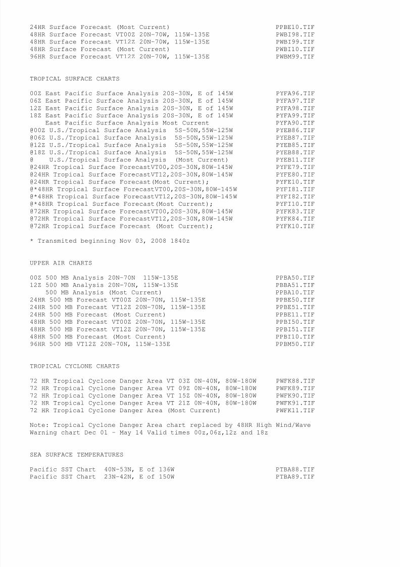
8/4/2019 Worldwide Marine Radio Facsimile Broadcast Schedules
http://slidepdf.com/reader/full/worldwide-marine-radio-facsimile-broadcast-schedules 71/122
24HR Surface Forecast (Most Current) PPBE10.TIF
48HR Surface Forecast VT00Z 20N-70W, 115W-135E PWBI98.TIF
48HR Surface Forecast VT12Z 20N-70W, 115W-135E PWBI99.TIF
48HR Surface Forecast (Most Current) PWBI10.TIF
96HR Surface Forecast VT12Z 20N-70W, 115W-135E PWBM99.TIF
TROPICAL SURFACE CHARTS
00Z East Pacific Surface Analysis 20S-30N, E of 145W PYFA96.TIF
06Z East Pacific Surface Analysis 20S-30N, E of 145W PYFA97.TIF12Z East Pacific Surface Analysis 20S-30N, E of 145W PYFA98.TIF
18Z East Pacific Surface Analysis 20S-30N, E of 145W PYFA99.TIF
East Pacific Surface Analysis Most Current PYFA90.TIF
@00Z U.S./Tropical Surface Analysis 5S-50N,55W-125W PYEB86.TIF
@06Z U.S./Tropical Surface Analysis 5S-50N,55W-125W PYEB87.TIF
@12Z U.S./Tropical Surface Analysis 5S-50N,55W-125W PYEB85.TIF
@18Z U.S./Tropical Surface Analysis 5S-50N,55W-125W PYEB88.TIF
@ U.S./Tropical Surface Analysis (Most Current) PYEB11.TIF
@24HR Tropical Surface ForecastVT00,20S-30N,80W-145W PYFE79.TIF
@24HR Tropical Surface ForecastVT12,20S-30N,80W-145W PYFE80.TIF
@24HR Tropical Surface Forecast(Most Current); PYFE10.TIF
@*48HR Tropical Surface ForecastVT00,20S-30N,80W-145W PYFI81.TIF
@*48HR Tropical Surface ForecastVT12,20S-30N,80W-145W PYFI82.TIF@*48HR Tropical Surface Forecast(Most Current); PYFI10.TIF
@72HR Tropical Surface ForecastVT00,20S-30N,80W-145W PYFK83.TIF
@72HR Tropical Surface ForecastVT12,20S-30N,80W-145W PYFK84.TIF
@72HR Tropical Surface Forecast (Most Current); PYFK10.TIF
* Transmited beginning Nov 03, 2008 1840z
UPPER AIR CHARTS
00Z 500 MB Analysis 20N-70N 115W-135E PPBA50.TIF
12Z 500 MB Analysis 20N-70N, 115W-135E PBBA51.TIF
500 MB Analysis (Most Current) PPBA10.TIF
24HR 500 MB Forecast VT00Z 20N-70N, 115W-135E PPBE50.TIF24HR 500 MB Forecast VT12Z 20N-70N, 115W-135E PPBE51.TIF
24HR 500 MB Forecast (Most Current) PPBE11.TIF
48HR 500 MB Forecast VT00Z 20N-70N, 115W-135E PPBI50.TIF
48HR 500 MB Forecast VT12Z 20N-70N, 115W-135E PPBI51.TIF
48HR 500 MB Forecast (Most Current) PPBI10.TIF
96HR 500 MB VT12Z 20N-70N, 115W-135E PPBM50.TIF
TROPICAL CYCLONE CHARTS
72 HR Tropical Cyclone Danger Area VT 03Z 0N-40N, 80W-180W PWFK88.TIF
72 HR Tropical Cyclone Danger Area VT 09Z 0N-40N, 80W-180W PWFK89.TIF
72 HR Tropical Cyclone Danger Area VT 15Z 0N-40N, 80W-180W PWFK90.TIF72 HR Tropical Cyclone Danger Area VT 21Z 0N-40N, 80W-180W PWFK91.TIF
72 HR Tropical Cyclone Danger Area (Most Current) PWFK11.TIF
Note: Tropical Cyclone Danger Area chart replaced by 48HR High Wind/Wave
Warning chart Dec 01 - May 14 Valid times 00z,06z,12z and 18z
SEA SURFACE TEMPERATURES
Pacific SST Chart 40N-53N, E of 136W PTBA88.TIF
Pacific SST Chart 23N-42N, E of 150W PTBA89.TIF

8/4/2019 Worldwide Marine Radio Facsimile Broadcast Schedules
http://slidepdf.com/reader/full/worldwide-marine-radio-facsimile-broadcast-schedules 72/122
SATELLITE IMAGERY
@00Z GOES IR Satellite Image, Tropical East Pacific evpn02.jpg
06Z GOES IR Satellite Image, Tropical East Pacific evpn07.jpg
@12Z GOES IR Satellite Image, Tropical East Pacific evpn04.jpg
18Z GOES IR Satellite Image, Tropical East Pacific evpn08.jpg
GOES IR Satellite Image, Tropical East Pac (MOST CURRENT) evpn10.jpg
@06Z GOES IR Satellite Image, East Pacific evpn03.jpg
12Z GOES IR Satellite Image, East Pacific evpn13.jpg
@18Z GOES IR Satellite Image, East Pacific evpn14.jpg21Z GOES VISIBLE Satellite Image, East Pacific evpn00.jpg
GOES Satellite Image, East Pacific (MOST CURRENT) evpn98.jpg
00Z GOES IR Satellite Image, Pacific evpn01.jpg
06Z GOES IR Satellite Image, Pacific evpn06.jpg
12Z GOES IR Satellite Image, Pacific evpn12.jpg
18Z GOES IR Satellite Image, Pacific evpn18.jpg
GOES IR Satellite Image, Pacific (MOST CURRENT) evpn99.jpg
SCHEDULE INFORMATION
Radiofax Schedule Part 1 (Point Reyes, CA) PLBZ01.TIF
Radiofax Schedule Part 2 (Point Reyes, CA) PLBZ02.TIFRadiofax Schedule (DOS Text Format) hfreyes.txt
Request for Comments PLBZ03.TIF
Product Notice Bulletin PLBZ04.TIF
Test Pattern PZZZ93.TIF
Internet File Names (This file) rfaxpac.txt
@ Not transmitted via Pt. Reyes radiofax but listed here for convenience
Many of these charts also broadcast from Kodiak, AK and Honolulu, HI
If you have access to the World Wide Web be certain to check out
the following webpages. See these pages for further links.
http://www.nws.noaa.gov NWS Homepage
http://www.nws.noaa.gov/om/marine/home.htm NWS Marine Page
cell.weather.gov Cellphone page
mobile.weather.gov Mobile Page
Author: Timothy Rulon, Office of Marine and Coastal Services W/OS21,
National Weather Service
Last Modified Nov 07, 2008
Document URL: http://weather.noaa.gov/pub/fax/rfaxpac.txt
ftp://tgftp.nws.noaa.gov/fax/rfaxpac.txt

8/4/2019 Worldwide Marine Radio Facsimile Broadcast Schedules
http://slidepdf.com/reader/full/worldwide-marine-radio-facsimile-broadcast-schedules 73/122
NATIONAL WEATHER SERVICE RADIOFAX PRODUCTS
for the Gulf of Mexico, Caribbean, Tropical Atlantic and Tropical E Pacific
**** IMPORTANT NOTICES ****
Effective January 08, 2008, the address of the FTPMAIL service changed
from [email protected] to [email protected].
If you restrict incoming e-mail as a means of preventing spam, you must
configure your e-mail system to allow mail from [email protected]
Read the help file carefully - 99% of errors using FTPMAIL are simple
typo's, incorrect capitalization, failure to send in plain text format,
leading or trailing spaces, or failure to set up any spam filters properly.
These instructions are subject to revision....download frequently.
U.S. Coast Guard Communications Station NMG - New Orleans, Louisiana
Assigned frequencies 4317.9, 8503.9 12789.9, 17146.4 kHz
Select a carrier frequency 1.9 kHz below those listed when using asingle sideband radio in the USB mode to receive these broadcasts.
The latest version of marine weather charts for broadcast by the U.S. Coast
Guard are available from the National Weather Service Telecommunication
Gateway on this server. The listed charts are in the G4(T4) format and
enveloped in TIFF for viewing. These charts may be found in directory:
ftp://tgftp.nws.noaa.gov/fax or http://weather.noaa.gov/pub/fax
For information of how these files and other text and graphic marine
forecasts may be downloaded via e-mail (FTPMAIL) see:
http://weather.noaa.gov/pub/fax/ftpmail.txt
.TIF files now also available as .gif files
This file is intended to assist mariners using the FTPMAIL system
which is used to obtain National Weather Service products via
e-mail. The following is an example in the use of the FTPMAIL
system.
PAY ATTENTION TO CAPITALIZATION:
Example using FTPMAIL:
Send an e-mail to: [email protected]
Subject line: Put anything you like
Body: open
cd faxget PWEE11.TIF
get PYEA11.gif
quit
The "help" file contains a more detailed description of the
FTPMAIL system and available products. To obtain a copy of the
FTPMAIL "help" file.
Send an e-mail to: [email protected]
Subject Line: Put anything you like
Body: help

8/4/2019 Worldwide Marine Radio Facsimile Broadcast Schedules
http://slidepdf.com/reader/full/worldwide-marine-radio-facsimile-broadcast-schedules 74/122
FILE
WIND/WAVE CHARTS NAME
00Z Sea State Analysis, 0N-31N, 35W-100W PJEA88.TIF
12Z Sea State Analysis, 0N-31N, 35W-100W PJEA90.TIF
Sea State Analysis (Most Current) PJEA11.TIF
24HR Wind/Wave Forecast VT00, 0N-31N, 35W-100W PWEE89.TIF
#24HR Wind/Wave Forecast VT06, 0N-31N, 35W-100W PWEE90.TIF
24HR Wind/Wave Forecast VT12, 0N-31N, 35W-100W PWEE91.TIF
#24HR Wind/Wave Forecast VT18, 0N-31N, 35W-100W PWEE92.TIF24HR Wind/Wave Forecast (Most Current) PWEE11.TIF
+36HR Wind/Wave Forecast VT12, 0N-31N, 35W-100W PWED98.TIF
48HR Wind/Wave Forecast VT00, 0N-31N, 35W-100W PWEI88.TIF
48HR Wind/Wave Forecast VT12, 0N-31N, 35W-100W PWEI89.TIF
48HR Wind/Wave Forecast (Most Current) PWEI11.TIF
48HR Wave Period/Swell Dir Forecast VT00, 0N-31N, 35W-100W PJEI88.TIF
48HR Wave Period/Swell Dir Forecast VT12, 0N-31N, 35W-100W PJEI89.TIF
48HR Wave Period/Swell Direction Forecast (Most Current) PJEI11.TIF
72HR Wind/Wave Forecast VT00, 0N-31N, 35W-100W PJEK88.TIF
72HR Wind/Wave Forecast VT12, 0N-31N, 35W-100W PJEK89.TIF
72HR Wind/Wave Forecast (Most Current) PJEK11.TIF
72HR Wave Period/Swell Dir Forecast VT00, 0N-31N, 35W-100W PKEK88.TIF
# These charts will no longer be available after Nov 03, 2008 1800z
+ New chart available beginning Nov 03, 2008 1800z
SURFACE CHARTS
@00Z U.S./Tropical Surface Analysis (W Half) 5S-50N,55W-125W PYEB86.TIF
@06Z U.S./Tropical Surface Analysis (W Half) 5S-50N,55W-125W PYEB87.TIF
@12Z U.S./Tropical Surface Analysis (W Half) 5S-50N,55W-125W PYEB85.TIF
@18Z U.S./Tropical Surface Analysis (W Half) 5S-50N,55W-125W PYEB88.TIF
@ U.S./Tropical Surface Analysis (W Half) (Most Current) PYEB11.TIF
00Z Tropical Surface Analysis (E Half) 5S-50N, 0W-70W PYEA86.TIF
06Z Tropical Surface Analysis (E Half) 5S-50N, 0W-70W PYEA87.TIF
12Z Tropical Surface Analysis (E Half) 5S-50N, 0W-70W PYEA85.TIF18Z Tropical Surface Analysis (E Half) 5S-50N, 0W-70W PYEA88.TIF
Tropical Surface Analysis (E Half) (Most Current) PYEA11.TIF
24HR Tropical Surface Forecast(E Half)VT00,00N-31N, 35W-100W PYEE79.TIF
24HR Tropical Surface Forecast(E Half)VT12,00N-31N, 35W-100W PYEE80.TIF
Tropical Surface Forecast(Most Current) PYEE10.TIF
48HR Tropical Surface Forecast(E Half)VT00,00N-31N, 35W-100W PYEI81.TIF
48HR Tropical Surface Forecast(E Half)VT12,00N-31N, 35W-100W PYEI82.TIF
Tropical Surface Forecast(Most Current) PYEI10.TIF
72HR Tropical Surface Forecast(E Half)VT00,00N-31N, 35W-100W PYEK83.TIF
72HR Tropical Surface Forecast(E Half)VT12,00N-31N, 35W-100W PYEK84.TIF
Tropical Surface Forecast(Most Current) PYEK10.TIF
@ For further forecasts covering the Tropical East Pacific,see Pt. Reyes and Honolulu charts
TROPICAL CYCLONE CHARTS
Tropical Cyclone Danger Area* VT03, 05N-60N, 00W-100W PWEK89.TIF
Tropical Cyclone Danger Area* VT09, 05N-60N, 00W-100W PWEK90.TIF
Tropical Cyclone Danger Area* VT15, 05N-60N, 00W-100W PWEK91.TIF
Tropical Cyclone Danger Area* VT21, 05N-60N, 00W-100W PWEK88.TIF
Tropical Cyclone Danger Area* (Most Current) PWEK11.TIF
HIGH SEAS FORECASTS

8/4/2019 Worldwide Marine Radio Facsimile Broadcast Schedules
http://slidepdf.com/reader/full/worldwide-marine-radio-facsimile-broadcast-schedules 75/122
04Z High Seas Forecast 7N-31N, 35W-98W, In English PLEA86.TIF
10Z High Seas Forecast 7N-31N, 35W-98W, In English PLEA87.TIF
16Z High Seas Forecast 7N-31N, 35W-98W, In English PLEA89.TIF
22Z High Seas Forecast 7N-31N, 35W-98W, In English PLEA88.TIF
High Seas Forecast (Most Current) PLEA10.TIF
SATELLITE IMAGERY
0645Z GOES IR Satellite Image, 12S-44N, 28W-112W evst06.jpg
1145Z GOES IR Satellite Image, 12S-44N, 28W-112W evst12.jpg1745Z GOES IR Satellite Image, 12S-44N, 28W-112W evst18.jpg
2345Z GOES IR Satellite Image, 12S-44N, 28W-112W evst00.jpg
GOES IR Satellite Image (Most Current) evst99.jpg
SCHEDULE INFORMATION
Radiofax Schedule (New Orleans, LA) PLEZ01.TIF
Radiofax Schedule (DOS Text Format) hfgulf.txt
Request for Comments PLEZ02.TIF
Product Notice Bulletin PLEZ03.TIF
Test Chart PZZZ95.TIF
Internet File Names, (This file) rfaxmex.txt
* Tropical Cyclone Danger Area chart replaced by 48HR High Wind/Wave Warning
chart Dec 01 - May 14 Valid times 00z,06z,12z and 18z, Map area 05N-40N, 35W-100W
If you have access to the World Wide Web be certain to check out
the following webpages. See these pages for further links.
http://www.nws.noaa.gov NWS Homepage
http://www.nws.noaa.gov/om/marine/home.htm NWS Marine Page
cell.weather.gov Cellphone page
mobile.weather.gov Mobile Page
Author: Timothy Rulon, Office of Marine and Coastal Services W/OS21,
National Weather Service
Last Modified Nov 14, 2008Document URL: http://weather.noaa.gov/pub/fax/rfaxmex.txt
ftp://tgftp.nws.noaa.gov/pub/fax/rfaxmex.txt

8/4/2019 Worldwide Marine Radio Facsimile Broadcast Schedules
http://slidepdf.com/reader/full/worldwide-marine-radio-facsimile-broadcast-schedules 76/122
NATIONAL WEATHER SERVICE RADIOFAX PRODUCTS
for the Northeast and Eastern Pacific
**** IMPORTANT NOTICES ****
Effective Tuesday December 2, 2008 the Anchorage Forecast Office will
terminate production and dissemination of the Coastal Marine Forecast Tables.
For questions regarding this notice please contact: [email protected]
Effective January 08, 2008, the address of the FTPMAIL service changedfrom [email protected] to [email protected].
If you restrict incoming e-mail as a means of preventing spam, you must
configure your e-mail system to allow mail from [email protected]
Read the help file carefully - 99% of errors using FTPMAIL are simple
typo's, incorrect capitalization, failure to send in plain text format,
leading or trailing spaces, or failure to set up any spam filters properly.
These instructions are subject to revision....download frequently.
U.S. Coast Guard Communications Station NOJ - Kodiak, Alaska
Assigned frequencies 2054, 4298, 8459, 12412.5 kHz
Select a carrier frequency 1.9 kHz below those listed when using a
single sideband radio in the USB mode to receive these broadcasts.
The latest version of marine weather charts for broadcast by the U.S. Coast
Guard are available from the National Weather Service Telecommunication
Gateway on this server. The listed charts are in the G4(T4) format and
enveloped in TIFF for viewing. Satellite images are in JPEG format.These charts may be found in directory: ftp://tgftp.nws.noaa.gov/fax or
http://weather.noaa.gov/pub/fax
For information of how these files and other text and graphic marine
forecasts may be downloaded via e-mail (FTPMAIL) see:
http://weather.noaa.gov/pub/fax/ftpmail.txt
.TIF files now also available as .gif files
This file is intended to assist mariners using the FTPMAIL system
which is used to obtain National Weather Service products via
e-mail. The following is an example in the use of the FTPMAIL
system.
PAY ATTENTION TO CAPITALIZATION:
Example using FTPMAIL:
Send an e-mail to: [email protected]
Subject line: Put anything you like
Body: open
cd fax
get PJBI99.TIF
get PYBE10.gif

8/4/2019 Worldwide Marine Radio Facsimile Broadcast Schedules
http://slidepdf.com/reader/full/worldwide-marine-radio-facsimile-broadcast-schedules 77/122
quit
The "help" file contains a more detailed description of the
FTPMAIL system and available products. To obtain a copy of the
FTPMAIL "help" file.
Send an e-mail to: [email protected]
Subject Line: Put anything you like
Body: help
FILE
WIND/WAVE CHARTS NAME
00Z Sea State Analysis 20N-70N, 115W-135E PJBA99.TIF
24HR Wind/Wave Forecast VT00Z 40N-70N, 115W-170E PJBE88.TIF
24HR Wind/Wave Forecast VT12Z 40N-70N, 115W-170E PJBE89.TIF
24HR Wind Wave Forecast (Most Current) PJBE10.TIF
48HR Wind/Wave Forecast VT00Z 20N-70N, 115W-135E PJBI98.TIF
48HR Wind/Wave Forecast VT12Z 20N-70N, 115W-135E PJBI99.TIF
48HR Wind Wave Forecast (Most Current) PJBI10.TIF
48HR Wave Period/Swell Direction VT00Z 20N-70N, 115W-135E PJBI88.TIF
48HR Wave Period/Swell Direction VT12Z 20N-70N, 115W-135E PJBI89.TIF
48HR Wave Period/Swell Direction (Most Current) PJBI20.TIF96HR Wind/Wave Forecast VT12Z 20N-70N, 115W-135E PJBM98.TIF
96HR Wave Period/Swell Direction VT12Z 20N-70N, 115W-135E PJBM88.TIF
SURFACE CHARTS
00Z Surface Analysis 40N-70N, 125W-150E PYCA00.TIF
06Z Surface Analysis 40N-70N, 125W-150E PYCA01.TIF
12Z Surface Analysis 40N-70N, 125W-150E PYCA02.TIF
18Z Surface Analysis 40N-70N, 125W-150E PYCA03.TIF
Surface Analysis (Most Current) PYCA10.TIF
24HR Surface Chart Forecast VT00Z 40N-70N, 115W-170E PYBE00.TIF
24HR Surface Chart Forecast VT12Z 40N-70N, 115W-170E PYBE01.TIF
24HR Surface Chart Forecast (Most Current) PYBE10.TIF48HR Surface Chart Forecast VT00Z 20N-70N 115W-135E PWBI99.TIF
48HR Surface Chart Forecast VT12Z 20N-70N 115W-135E PWBI98.TIF
48HR Surface Chart Forecast (Most Current) PWBI10.TIF
96HR Surface Chart Forecast VT12Z PWBM99.TIF
UPPER AIR CHARTS
00Z 500 MB Analysis 20N-70N 115W-135E PPBA50.TIF
12Z 500 MB Analysis 20N-70N, 115W-135E PBBA51.TIF
500 MB Analysis (Most Current) PPBA10.TIF
24HR 500 MB Forecast VT00Z 20N-70N, 115W-135E PPBE50.TIF
24HR 500 MB Forecast VT12Z 20N-70N, 115W-135E PPBE51.TIF
24HR 500 MB Forecast (Most Current) PPBE11.TIF48HR 500 MB Forecast VT00Z 20N-70N, 115W-135E PPBI50.TIF
48HR 500 MB Forecast VT12Z 20N-70N, 115W-135E PPBI51.TIF
48HR 500 MB Forecast (Most Current) PPBI10.TIF
96HR 500 MB VT12Z 20N-70N, 115W-135E PPBM50.TIF
SEA SURFACE TEMPERATURES
Sea Surface Temperature Analysis 40N-60N,125W - 160E PTCA88.TIF

8/4/2019 Worldwide Marine Radio Facsimile Broadcast Schedules
http://slidepdf.com/reader/full/worldwide-marine-radio-facsimile-broadcast-schedules 78/122
SATELLITE IMAGERY
00Z GOES IR Satellite Image, Pacific evpn01.jpg
06Z GOES IR Satellite Image, Pacific evpn06.jpg
12Z GOES IR Satellite Image, Pacific evpn12.jpg
18Z GOES IR Satellite Image, Pacific evpn18.jpg
GOES IR Satellite Image, Pacific (MOST CURRENT) evpn99.jpg
ICE CHARTS
Sea Ice Analysis PTCA89.TIF
5 Day Sea Ice Forecast PTCO89.TIF
Cook Inlet Sea Ice Analysis PTCA87.TIF
OTHER PRODUCTS
AK Coastal Forecast Tables (To be terminated Dec 02, 2008) PLBZ00.TIF
SCHEDULE INFORMATION and MISCELLANEOUS
Radiofax Schedule Kodiak, AK; PLBZ05.TIFRadiofax Schedule (DOS Text Version) hfak.txt
Request for Comments xxxxxx.xxx
Product Notice Bulletin xxxxxx.xxx
Test Pattern; xxxxxx.xxx
Radiofacsimile Symbols and Contractions PLBZ06.TIF
Internet File Names; (This file) rfaxak.txt
xxxxxx.xxx = Currently unavailable
Many of these charts also broadcast from Pt. Reyes, CA
If you have access to the World Wide Web be certain to check out
the following webpages. See these pages for further links.
http://www.nws.noaa.gov NWS Homepage
http://www.nws.noaa.gov/om/marine/home.htm NWS Marine Page
cell.weather.gov Cellphone page
mobile.weather.gov Mobile Page
Author: Tim Rulon, NWS Marine And Coastal Weather Services Branch W/OS21
Last Modified Nov 14, 2008
Document URL: http://weather.noaa.gov/pub/fax/rfaxak.txt
ftp://tgftp.nws.noaa.gov/fax/rfaxak.txt

8/4/2019 Worldwide Marine Radio Facsimile Broadcast Schedules
http://slidepdf.com/reader/full/worldwide-marine-radio-facsimile-broadcast-schedules 79/122
NATIONAL WEATHER SERVICE RADIOFAX PRODUCTS
for the Central, Southeast and North Pacific
**** IMPORTANT NOTICES ****
On Nov 03, 2008 several radiofax charts produced by the Tropical Prediction
Center/National Hurricane Center and broadcast from New Orleans, Pt. Reyes
and Honolulu be based on information from different model run times. A 36
hour wind/wave chart will be added to the New Orleans broadcast. The newbroadcast schedules may be found at http://weather.noaa.gov/fax/marine.shtml
and will be broadcast on-air beginning on or about Oct 27, 08. This change
is to better align workflow to model production.
Effective January 08, 2008, the address of the FTPMAIL service changed
from [email protected] to [email protected].
If you restrict incoming e-mail as a means of preventing spam, you must
configure your e-mail system to allow mail from [email protected]
Read the help file carefully - 99% of errors using FTPMAIL are simple
typo's, incorrect capitalization, failure to send in plain text format,
leading or trailing spaces, or failure to set up any spam filters properly.
These instructions are subject to revision....download frequently.
NAVY Communications Station KVM-70 - Honolulu, Hawaii
Assigned frequencies 9982.5, 11090 and 16135 kHz
Select a carrier frequency 1.9 kHz below those listed when using a
single sideband radio in the USB mode to receive these broadcasts.
The latest version of NWS marine weather charts for broadcast by the NAVY
are available from the National Weather Service Telecommunication
Gateway on this server. The listed charts are in the G4(T4) format and
enveloped in TIFF for viewing. These charts may be found in directory:
ftp://tgftp.nws.noaa.gov/fax or http://weather.noaa.gov/pub/fax
For information of how these files and other text and graphic marine
forecasts may be downloaded via e-mail (FTPMAIL) see:
http://weather.noaa.gov/pub/fax/ftpmail.txt
xxxxxx (Not yet available from these directories)
.TIF files now also available as .gif files
This file is intended to assist mariners using the FTPMAIL system
which is used to obtain National Weather Service products via
e-mail. The following is an example in the use of the FTPMAIL
system.
PAY ATTENTION TO CAPITALIZATION:
Example using FTPMAIL:
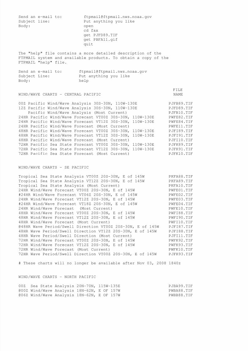
8/4/2019 Worldwide Marine Radio Facsimile Broadcast Schedules
http://slidepdf.com/reader/full/worldwide-marine-radio-facsimile-broadcast-schedules 80/122
Send an e-mail to: [email protected]
Subject line: Put anything you like
Body: open
cd fax
get PJFD89.TIF
get PBFA11.gif
quit
The "help" file contains a more detailed description of the
FTPMAIL system and available products. To obtain a copy of the
FTPMAIL "help" file.
Send an e-mail to: [email protected]
Subject Line: Put anything you like
Body: help
FILE
WIND/WAVE CHARTS - CENTRAL PACIFIC NAME
00Z Pacific Wind/Wave Analysis 30S-30N, 110W-130E PJFB89.TIF
12Z Pacific Wind/Wave Analysis 30S-30N, 110W-130E PJFD89.TIF
Pacific Wind/Wave Analysis (Most Current) PJFB10.TIF
24HR Pacific Wind/Wave Forecast VT00Z 30S-30N, 110W-130E PWFE82.TIF
24HR Pacific Wind/Wave Forecast VT12Z 30S-30N, 110W-130E PWFE84.TIF24HR Pacific Wind/Wave Forecast (Most Current) PWFE11.TIF
48HR Pacific Wind/Wave Forecast VT00Z 30S-30N, 110W-130E PJFI89.TIF
48HR Pacific Wind/Wave Forecast VT12Z 30S-30N, 110W-130E PJFI91.TIF
48HR Pacific Wind/Wave Forecast (Most Current) PJFI10.TIF
72HR Pacific Sea State Forecast VT00Z 30S-30N, 110W-130E PJFK89.TIF
72HR Pacific Sea State Forecast VT12Z 30S-30N, 110W-130E PJFK91.TIF
72HR Pacific Sea State Forecast (Most Current) PJFK10.TIF
WIND/WAVE CHARTS - SE PACIFIC
Tropical Sea State Analysis VT00Z 20S-30N, E of 145W PKFA88.TIF
Tropical Sea State Analysis VT12Z 20S-30N, E of 145W PKFA89.TIF
Tropical Sea State Analysis (Most Current) PKFA10.TIF24HR Wind/Wave Forecast VT00Z 20S-30N, E of 145W PWFE01.TIF
#24HR Wind/Wave Forecast VT06Z 20S-30N, E of 145W PWFE02.TIF
24HR Wind/Wave Forecast VT12Z 20S-30N, E of 145W PWFE03.TIF
#24HR Wind/Wave Forecast VT18Z 20S-30N, E of 145W PWFE04.TIF
24HR Wind/Wave Forecast (Most Current) PWFE10.TIF
48HR Wind/Wave Forecast VT00Z 20S-30N, E of 145W PWFI88.TIF
48HR Wind/Wave Forecast VT12Z 20S-30N, E of 145W PWFI90.TIF
48HR Wind/Wave Forecast (Most Current) PWFI10.TIF
@48HR Wave Period/Swell Direction VT00Z 20S-30N, E of 145W PJFI87.TIF
48HR Wave Period/Swell Direction VT12Z 20S-30N, E of 145W PJFI88.TIF
48HR Wave Period/Swell Direction (Most Current) PJFI11.TIF
72HR Wind/Wave Forecast VT00Z 20S-30N, E of 145W PWFK92.TIF
72HR Wind/Wave Forecast VT12Z 20S-30N, E of 145W PWFK93.TIF72HR Wind/Wave Forecast (Most Current) PWFK10.TIF
72HR Wave Period/Swell Direction VT00Z 20S-30N, E of 145W PJFK93.TIF
# These charts will no longer be available after Nov 03, 2008 1840z
WIND/WAVE CHARTS - NORTH PACIFIC
00Z Sea State Analysis 20N-70N, 115W-135E PJBA99.TIF
@00Z Wind/Wave Analysis 18N-62N, E OF 157W PWBA88.TIF
@06Z Wind/Wave Analysis 18N-62N, E OF 157W PWBB88.TIF

8/4/2019 Worldwide Marine Radio Facsimile Broadcast Schedules
http://slidepdf.com/reader/full/worldwide-marine-radio-facsimile-broadcast-schedules 81/122
@12Z Wind/Wave Analysis 18N-62N, E OF 157W PWBA89.TIF
@18Z Wind/Wave Analysis 18N-62N, E OF 157W PWBD89.TIF
@ Wind/Wave Analysis 18N-62N, E OF 157W (Most Current) PWBA90.TIF
24HR Wind/Wave Forecast VT00Z 18N-62N, E OF 157W PWBE98.TIF
24HR Wind/Wave Forecast VT12Z 18N-62N, E OF 157W PWBE99.TIF
24HR Wind/Wave Forecast (Most Current) PWBE10.TIF
48HR Wind/Wave Forecast VT00Z 20N-70N, 115W-135E PJBI98.TIF
48HR Wind/Wave Forecast VT12Z 20N-70N, 115W-135E PJBI99.TIF
48HR Wind Wave Forecast (Most Current) PJBI10.TIF
48HR Wave Period/Swell Direction VT00Z 20N-70N, 115W-135E PJBI88.TIF
@48HR Wave Period/Swell Direction VT12Z 20N-70N, 115W-135E PJBI89.TIF48HR Wave Period/Swell Direction (Most Current) PJBI20.TIF
96HR Wind/Wave Forecast VT12Z 20N-70N, 115W-135E PJBM98.TIF
96HR Wave Period/Swell Direction VT12Z 20N-70N, 115W-135E PJBM88.TIF
SURFACE CHARTS - CENTRAL PACIFIC
@00Z North Pacific Preliminary Analysis 20N-80N, 110W-110E xxxxxx.TIF
@06Z North Pacific Preliminary Analysis 20N-80N, 110W-110E xxxxxx.TIF
@12Z North Pacific Preliminary Analysis 20N-80N, 110W-110E xxxxxx.TIF
@18Z North Pacific Preliminary Analysis 20N-80N, 110W-110E xxxxxx.TIF
@ North Pacific Preliminary Analysis (Most Current) PYPA00.TIF
00Z Pacific Surface Analysis EQ-50N, 110W-130E PPBA88.TIF06Z Pacific Surface Analysis EQ-50N, 110W-130E PPBA89.TIF
12Z Pacific Surface Analysis EQ-50N, 110W-130E PPBA90.TIF
18Z Pacific Surface Analysis EQ-50N, 110W-130E PPBA91.TIF
Pacific Surface Analysis (Most Current) PPBA11.TIF
00Z Pacific Streamline Analysis 30S-30N, 110W-130E PWFA90.TIF
06Z Pacific Streamline Analysis 30S-30N, 110W-130E PWFA91.TIF
12Z Pacific Streamline Analysis 30S-30N, 110W-130E PWFA92.TIF
18Z Pacific Streamline Analysis 30S-30N, 110W-130E PWFA93.TIF
Pacific Streamline Analysis (Most Current) PWFA11.TIF
@$00Z Tropical Surface Analysis 40S-40N, 100W-120E xxxxxx.TIF
@$06Z Tropical Surface Analysis 40S-40N, 100W-120E xxxxxx.TIF
@$12Z Tropical Surface Analysis 40S-40N, 100W-120E xxxxxx.TIF
@$18Z Tropical Surface Analysis 40S-40N, 100W-120E xxxxxx.TIF
@$ Tropical Surface Analysis (Most Current) QYFA99.TIF03Z Significant Cloud Features 30S-50N, 110W-160E PBFA99.TIF
15Z Significant Cloud Features 30S-50N, 110W-160E PBFC99.TIF
Significant Cloud Features (Most Current) PBFA11.TIF
24HR Pacific Surface Forecast VT00Z 30S-50N 110W-130E PYFE87.TIF
24HR Pacific Surface Forecast VT12Z 30S-50N 110W-130E PYFE88.TIF
24HR Pacific Surface Forecast (Most Current) PYFE11.TIF
@$24HR Wind/Stream Forecast VT00Z 30S-50N, 100W-120E QWFI99.TIF
@$48HR Wind/Stream Forecast VT00Z 30S-50N, 100W-120E QWFQ99.TIF
48HR Pacific Surface Forecast VT00Z 30S-50N 110W-130E PYFI87.TIF
48HR Pacific Surface Forecast VT12Z 30S-50N 110W-130E PYFI88.TIF
48HR Pacific Surface Forecast (Most Current) PYFI11.TIF
72HR Pacific Surface Forecast VT00Z 30S-50N 110W-130E PYFK87.TIF
72HR Pacific Surface Forecast VT12Z 30S-50N 110W-130E PYFK88.TIF72HR Pacific Surface Forecast (Most Current) PYFK11.TIF
$ These charts will no longer be available sometime after June 20, 2006
SURFACE CHARTS - SE PACIFIC
00Z East Pacific Surface Analysis 20S-30N, E of 145W PYFA96.TIF
06Z East Pacific Surface Analysis 20S-30N, E of 145W PYFA97.TIF
12Z East Pacific Surface Analysis 20S-30N, E of 145W PYFA98.TIF
18Z East Pacific Surface Analysis 20S-30N, E of 145W PYFA99.TIF

8/4/2019 Worldwide Marine Radio Facsimile Broadcast Schedules
http://slidepdf.com/reader/full/worldwide-marine-radio-facsimile-broadcast-schedules 82/122
East Pacific Surface Analysis Most Current PYFA90.TIF
@00Z U.S./Tropical Surface Analysis 5S-50N,55W-125W PYEB86.TIF
@06Z U.S./Tropical Surface Analysis 5S-50N,55W-125W PYEB87.TIF
@12Z U.S./Tropical Surface Analysis 5S-50N,55W-125W PYEB85.TIF
@18Z U.S./Tropical Surface Analysis 5S-50N,55W-125W PYEB88.TIF
@ U.S./Tropical Surface Analysis 5S-50N,55W-125W PYEB11.TIF
24HR Tropical Surface Forecast VT00 20S-30N, E of 145W PYFE79.TIF
24HR Tropical Surface Forecast VT12 20S-30N, E of 145W PYFE80.TIF
24HR Tropical Surface Forecast(Most Current) PYFE10.TIF
48HR Tropical Surface Forecast VT00 20S-30N, E of 145W PYFI81.TIF
48HR Tropical Surface Forecast VT12 20S-30N, E of 145W PYFI82.TIF48HR Tropical Surface Forecast(Most Current) PYFI10.TIF
72HR Tropical Surface Forecast VT00 20S-30N, E of 145W PYFK83.TIF
72HR Tropical Surface Forecast VT12 20S-30N, E of 145W PYFK84.TIF
72HR Tropical Surface Forecast (Most Current) PYFK10.TIF
SURFACE CHARTS - NORTH PACIFIC
00Z Surface Analysis NE Pacific (Part 1) 20N-70W, 115W-175W PYBA01.TIF
00Z Surface Analysis NW Pacific (Part 2) 20N-70W, 175W-135E PYBA02.TIF
06Z Surface Analysis NE Pacific (Part 1) 20N-70W, 115W-175W PYBA03.TIF
06Z Surface Analysis NW Pacific (Part 2) 20N-70W, 175W-135E PYBA04.TIF
12Z Surface Analysis NE Pacific (Part 1) 20N-70W, 115W-175W PYBA05.TIF12Z Surface Analysis NW Pacific (Part 2) 20N-70W, 175W-135E PYBA06.TIF
18Z Surface Analysis NE Pacific (Part 1) 20N-70W, 115W-175W PYBA07.TIF
18Z Surface Analysis NW Pacific (Part 2) 20N-70W, 175W-135E PYBA08.TIF
Surface Analysis, Part 1 (Most Current) PYBA90.TIF
Surface Analysis, Part 2 (Most Current) PYBA91.TIF
@24HR Surface Forecast VT00Z 18N-62W, E of 157W PPBE00.TIF
@24HR Surface Forecast VT12Z 18N-62W, E of 157W PPBE01.TIF
@24HR Surface Forecast (Most Current) PPBE10.TIF
48HR Surface Forecast VT00Z 20N-70W, 115W-135E PWBI98.TIF
48HR Surface Forecast VT12Z 20N-70W, 115W-135E PWBI99.TIF
48HR Surface Forecast (Most Current) PWBI10.TIF
96HR Surface Forecast VT12Z 20N-70W, 115W-135E PWBM99.TIF
TROPICAL CYCLONE CHARTS - PACIFIC
72 HR Tropical Cyclone Danger Area VT 03Z 0N-40N, 80W-170E PWFK03.TIF
72 HR Tropical Cyclone Danger Area VT 09Z 0N-40N, 80W-170E PWFK09.TIF
72 HR Tropical Cyclone Danger Area VT 15Z 0N-40N, 80W-170E PWFK15.TIF
72 HR Tropical Cyclone Danger Area VT 21Z 0N-40N, 80W-170E PWFK21.TIF
72 HR Tropical Cyclone Danger Area (Most Current) PWFK12.TIF
SEA SURFACE TEMPERATURE CHARTS
Pacific SST Chart 55N-EQ, 110W-160E PTFA88.TIF
SATELLITE IMAGERY (IR)
00Z Eastern Pacific Satellite Image 05S-55N, 110W-155E evpz00.jpg
06Z Eastern Pacific Satellite Image 05S-55N, 110W-155E evpz06.jpg
12Z Eastern Pacific Satellite Image 05S-55N, 110W-155E evpz12.jpg
18Z Eastern Pacific Satellite Image 05S-55N, 110W-155E evpz18.jpg
Eastern Pacific Satellite Image (Most Current) evpz11.jpg
00Z Southwest Pacific Satellite Image 40S-05N, 130W-165E evps00.jpg
06Z Southwest Pacific Satellite Image 40S-05N, 130W-165E evps06.jpg
12Z Southwest Pacific Satellite Image 40S-05N, 130W-165E evps12.jpg
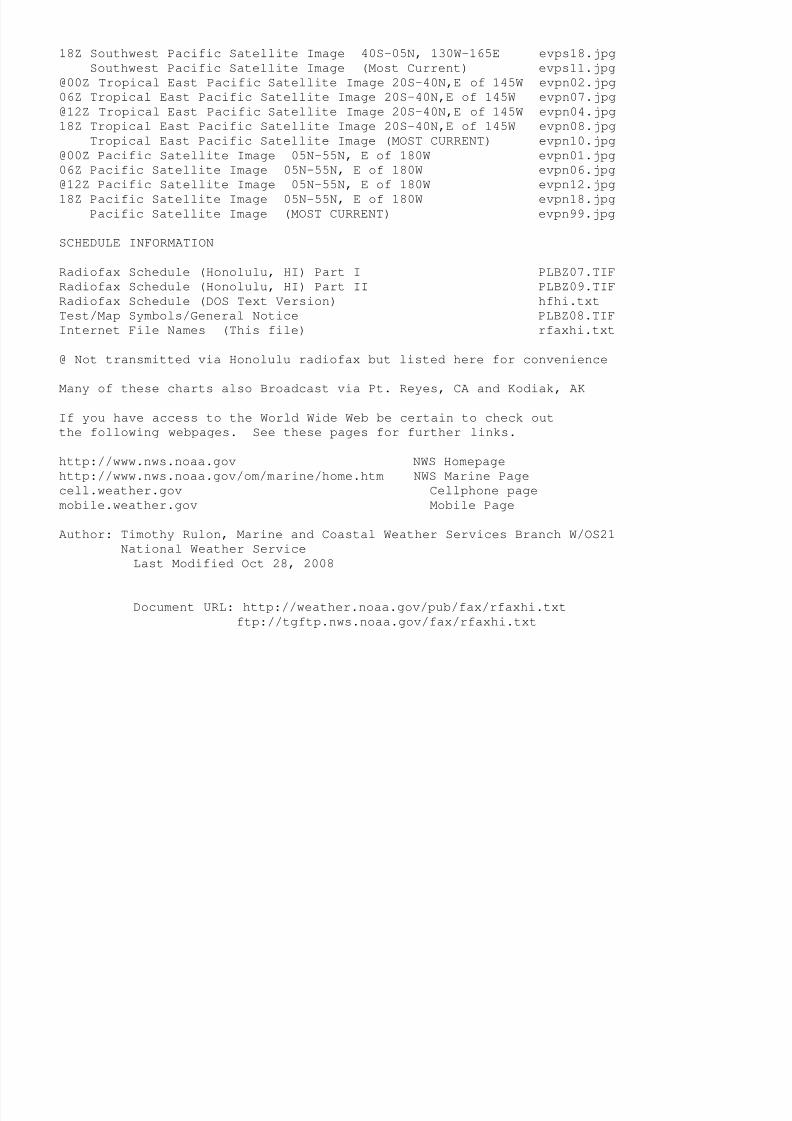
8/4/2019 Worldwide Marine Radio Facsimile Broadcast Schedules
http://slidepdf.com/reader/full/worldwide-marine-radio-facsimile-broadcast-schedules 83/122
18Z Southwest Pacific Satellite Image 40S-05N, 130W-165E evps18.jpg
Southwest Pacific Satellite Image (Most Current) evps11.jpg
@00Z Tropical East Pacific Satellite Image 20S-40N,E of 145W evpn02.jpg
06Z Tropical East Pacific Satellite Image 20S-40N,E of 145W evpn07.jpg
@12Z Tropical East Pacific Satellite Image 20S-40N,E of 145W evpn04.jpg
18Z Tropical East Pacific Satellite Image 20S-40N,E of 145W evpn08.jpg
Tropical East Pacific Satellite Image (MOST CURRENT) evpn10.jpg
@00Z Pacific Satellite Image 05N-55N, E of 180W evpn01.jpg
06Z Pacific Satellite Image 05N-55N, E of 180W evpn06.jpg
@12Z Pacific Satellite Image 05N-55N, E of 180W evpn12.jpg
18Z Pacific Satellite Image 05N-55N, E of 180W evpn18.jpgPacific Satellite Image (MOST CURRENT) evpn99.jpg
SCHEDULE INFORMATION
Radiofax Schedule (Honolulu, HI) Part I PLBZ07.TIF
Radiofax Schedule (Honolulu, HI) Part II PLBZ09.TIF
Radiofax Schedule (DOS Text Version) hfhi.txt
Test/Map Symbols/General Notice PLBZ08.TIF
Internet File Names (This file) rfaxhi.txt
@ Not transmitted via Honolulu radiofax but listed here for convenience
Many of these charts also Broadcast via Pt. Reyes, CA and Kodiak, AK
If you have access to the World Wide Web be certain to check out
the following webpages. See these pages for further links.
http://www.nws.noaa.gov NWS Homepage
http://www.nws.noaa.gov/om/marine/home.htm NWS Marine Page
cell.weather.gov Cellphone page
mobile.weather.gov Mobile Page
Author: Timothy Rulon, Marine and Coastal Weather Services Branch W/OS21
National Weather Service
Last Modified Oct 28, 2008
Document URL: http://weather.noaa.gov/pub/fax/rfaxhi.txt
ftp://tgftp.nws.noaa.gov/fax/rfaxhi.txt

8/4/2019 Worldwide Marine Radio Facsimile Broadcast Schedules
http://slidepdf.com/reader/full/worldwide-marine-radio-facsimile-broadcast-schedules 84/122
NATIONAL WEATHER SERVICE MARINE TEXT PRODUCTS
HIGHSEAS, FORECAST DISCUSSION, OFFSHORE, NAVTEX, and OPEN LAKE PRODUCTS
**** IMPORTANT NOTICES ****
Effective January 08, 2008, the address of the FTPMAIL service changed
from [email protected] to [email protected].
If you restrict incoming e-mail as a means of preventing spam, you must
configure your e-mail system to allow mail from [email protected]
Read the help file carefully - 99% of errors using FTPMAIL are simple
typo's, incorrect capitalization, failure to send in plain text format,
leading or trailing spaces, or failure to set up any spam filters properly.
These instructions are subject to revision....download frequently.
**********
This file is intended to assist mariners using the FTPMAIL system
which is used to obtain National Weather Service products via
e-mail. The following is an example in the use of the FTPMAIL
system. NOTE CAPITALIZATION!
Send an e-mail to: [email protected]
Subject Line: Put anything you like
Body: open
cd data
cd forecasts
cd marine
cd high_seas
get north_pacific.txt
get north_atlantic.txt
quit
The "help" file contains a more detailed description of the
FTPMAIL system and available products. To obtain a copy of the
FTPMAIL "help" file.
Send an e-mail to: [email protected]
Subject Line: Put anything you like
Body: help
HIGH SEAS FORECASTS
These files may be found in directory:
ftp://tgftp.nws.noaa.gov/data/forecasts/marine/high_seas/
PRODUCT DESCRIPTION FILE NAME
Northwest Atlantic Highseas (GMDSS Area IV) north_atlantic.txt
Northeast Pacific Highseas (GMDSS Area XII) north_pacific.txt
Peru Highseas (GMDSS Area XVI) east_pacific_3.txt
25S-0N, 160E-120W South Central Pacific south_hawaii.txt
30-60N, east of 160 E (p/o NE Pacific) east_pacific_1.txt
0-30N, E of 140W (p/o NE Pacific) east_pacific_2.txt
0-30N, 160E-140W (p/o NE Pacific) north_hawaii.txt

8/4/2019 Worldwide Marine Radio Facsimile Broadcast Schedules
http://slidepdf.com/reader/full/worldwide-marine-radio-facsimile-broadcast-schedules 85/122
FORECAST DISCUSSION
These files may be found in directory:
ftp://tgftp.nws.noaa.gov/data/raw/ag/
Example:
Send an e-mail to: [email protected]
Subject Line: Put anything you like
Body: open
cd data
cd rawcd ag
get agnt40.kwnm.mim.atn.txt
quit
PRODUCT DESCRIPTION FILE NAME
Northwest Atlantic agnt40.kwnm.mim.atn.txt
Northeast Pacific agpn40.kwnm.mim.pac.txt
Gulf, Caribbean Sea & SW N. Atlantic agxx40.knhc.mim.ats.txt
Note...these Forecast Discussions are primarily intended for use
by forecasters and make heavy use of abbreviations. A glossary is
not available.
OFFSHORE FORECASTS
For offshore forecasts, NAVTEX forecasts can also be utililized
which are nearly identical and may contain supplementary
information at times for coastal areas.
These files may be found in directory:
ftp://tgftp.nws.noaa.gov/data/raw/fz/
Example:
Send an e-mail to: [email protected]
Subject Line: Put anything you likeBody: open
cd data
cd raw
cd fz
get fznt21.kwbc.off.nt1.txt
quit
PRODUCT DESCRIPTION FILE NAME
New England fznt21.kwbc.off.nt1.txt
Mid-Atlantic fznt22.kwbc.off.nt2.txtSW North Atlantic, Caribbean fznt23.knhc.off.nt3.txt
Gulf of Mexico fznt24.knhc.off.nt4.txt
Washington, Oregon fzpn25.kwbc.off.pz5.txt
California fzpn26.kwbc.off.pz6.txt
Eastern Gulf of Alaska fzak67.pajk.off.ajk.txt
Western Gulf of Alaska fzak61.pafc.off.aer.txt
Bering Sea fzak62.pafc.off.alu.txt
Hawaii fzhw60.phfo.off.hfo.txt
NAVTEX FORECASTS

8/4/2019 Worldwide Marine Radio Facsimile Broadcast Schedules
http://slidepdf.com/reader/full/worldwide-marine-radio-facsimile-broadcast-schedules 86/122
These files may be found in directory:
ftp://tgftp.nws.noaa.gov/data/raw/fz/
Example:
Send an e-mail to: [email protected]
Subject Line: Put anything you like
Body: open
cd data
cd raw
cd fzget fznt23.kwnm.off.n01.txt
quit
PRODUCT DESCRIPTION FILE NAME
NAVTEX Boston, MA fznt23.kwnm.off.n01.txt
NAVTEX Chesapeake, VA fznt24.kwnm.off.n02.txt
NAVTEX Savannah, GA fznt25.kwnm.off.n03.txt
NAVTEX Miami, FL fznt25.knhc.off.n04.txt
NAVTEX San Juan, PR fznt26.knhc.off.n05.txt
NAVTEX New Orleans, LA fznt27.knhc.off.n06.txt
NAVTEX Astoria, OR fzpn24.kwnm.off.n09.txt
NAVTEX Pt. Reyes, CA fzpn23.kwnm.off.n08.txtNAVTEX Cambria, CA fzpn22.kwnm.off.n07.txt
NAVTEX Honolulu, HI fzhw61.phfo.off.n10.txt
NAVTEX Kodiak,(SE) AK fzak61.pajk.off.n11.txt
NAVTEX Kodiak,(N Gulf) AK fzak63.pafc.off.n12.txt
NAVTEX Kodiak,(W) AK fzak64.pafc.off.n13.txt
NAVTEX Kodiak,(NW and Artic) AK fzak69.pafg.off.n14.txt
OPEN LAKE FORECASTS
These files may be found in directory:
ftp://tgftp.nws.noaa.gov/data/raw/fz/
Example:Send an e-mail to: [email protected]
Subject Line: Put anything you like
Body: open
cd data
cd raw
cd fz
get fzus61.kbuf.glf.sl.txt
quit
PRODUCT DESCRIPTION FILE NAME
St. Lawrence fzus61.kbuf.glf.sl.txt
Lake Ontario fzus61.kbuf.glf.lo.txtLake Erie fzus61.kcle.glf.le.txt
Lake St. Clair fzus63.kdtx.glf.sc.txt
Lake Huron fzus63.kdtx.glf.lh.txt
Lake Michigan fzus63.klot.glf.lm.txt
Lake Superior fzus63.kmqt.glf.ls.txt
If you have access to the World Wide Web be certain to check out
the following webpages. See these pages for further links.
http://www.nws.noaa.gov NWS Homepage

8/4/2019 Worldwide Marine Radio Facsimile Broadcast Schedules
http://slidepdf.com/reader/full/worldwide-marine-radio-facsimile-broadcast-schedules 87/122
http://www.nws.noaa.gov/om/marine/home.htm NWS Marine Page
cell.weather.gov Cellphone page
mobile.weather.gov Mobile Page
Author: Timothy Rulon, Office of Marine and Coastal Services W/OS21,
National Weather Service
Last Modified Aug 27, 2008
Document URL: http://weather.noaa.gov/pub/fax/marine1.txt
ftp://tgftp.nws.noaa.gov/fax/marine1.txt

8/4/2019 Worldwide Marine Radio Facsimile Broadcast Schedules
http://slidepdf.com/reader/full/worldwide-marine-radio-facsimile-broadcast-schedules 88/122
NATIONAL WEATHER SERVICE MARINE TEXT PRODUCTS
HURRICANE PRODUCTS
**** IMPORTANT NOTICES ****
Effective January 08, 2008, the address of the FTPMAIL service changed
from [email protected] to [email protected].
If you restrict incoming e-mail as a means of preventing spam, you must
configure your e-mail system to allow mail from [email protected]
Read the help file carefully - 99% of errors using FTPMAIL are simpletypo's, incorrect capitalization, failure to send in plain text format,
leading or trailing spaces, or failure to set up any spam filters properly.
These instructions are subject to revision....download frequently.
**********
This file is intended to assist mariners using the FTPMAIL system
which is used to obtain National Weather Service products via
e-mail. The following is an example in the use of the FTPMAIL
system. NOTE CAPITALIZATION!
Send an e-mail to: [email protected]
Subject Line: Put anything you like
Body: open
cd data
cd hurricane_products
cd atlantic
cd weather
get outlook.txt
cd /data
cd hurricane_products
cd atlantic
cd storm_2
get technical_advisory.txtquit
The "help" file contains a more detailed description of the
FTPMAIL system and available products. To obtain a copy of the
FTPMAIL "help" file.
Send an e-mail to: [email protected]
Subject Line: Put anything you like
Body: help
ATLANTIC HURRICANE PRODUCTS
These files may be found in directory:
ftp://tgftp.nws.noaa.gov/data/hurricane_products/atlantic
PRODUCT DESCRIPTION FILE NAME
Tropical WX Outlook /weather/outlook.txt
Tropical WX Discussion /weather/discussion.txt
Tropical WX Summary /weather/summary.txt
Tropical WX Disturbance Stmt /weather/advisory.txt
Tropical Cyclone Update (Storm #1) /storm_1/update.txt
Tropical Cyclone Update (Storm #2) /storm_2/update.txt

8/4/2019 Worldwide Marine Radio Facsimile Broadcast Schedules
http://slidepdf.com/reader/full/worldwide-marine-radio-facsimile-broadcast-schedules 89/122
Tropical Cyclone Update (Storm #3) /storm_3/update.txt
Tropical Cyclone Update (Storm #4) /storm_4/update.txt
Tropical Cyclone Update (Storm #5) /storm_5/update.txt
Tropical Cyclone Discussion (Storm #1) /storm_1/discussion.txt
Tropical Cyclone Discussion (Storm #2) /storm_2/discussion.txt
Tropical Cyclone Discussion (Storm #3) /storm_3/discussion.txt
Tropical Cyclone Discussion (Storm #4) /storm_4/discussion.txt
Tropical Cyclone Discussion (Storm #5) /storm_5/discussion.txt
Public Advisory (Storm #1) /storm_1/advisory.txt
Public Advisory (Storm #2) /storm_2/advisory.txt
Public Advisory (Storm #3) /storm_3/advisory.txtPublic Advisory (Storm #4) /storm_4/advisory.txt
Public Advisory (Storm #5) /storm_5/advisory.txt
Tropical Depression Forecast (Storm #1) /storm_1/technical_advisory.txt
Tropical Depression Forecast (Storm #2) /storm_2/technical_advisory.txt
Tropical Depression Forecast (Storm #3) /storm_3/technical_advisory.txt
Tropical Depression Forecast (Storm #4) /storm_4/technical_advisory.txt
Tropical Depression Forecast (Storm #5) /storm_5/technical_advisory.txt
Hurricane Probabilities (Storm #1) /storm_1/strike_probability.txt
Hurricane Probabilities (Storm #2) /storm_2/strike_probability.txt
Hurricane Probabilities (Storm #3) /storm_3/strike_probability.txt
Hurricane Probabilities (Storm #4) /storm_4/strike_probability.txt
Hurricane Probabilities (Storm #5) /storm_5/strike_probability.txt
RECON Plan TBD
Atlantic Tropical Weather Outlook normally issued 0300z, 0900z, 1500z
and 2100z during hurricane season, June 1 - November 30. Remaining
products issued when active systems exist. May be issued at 3-hourly
intervals and other unscheduled times as system approaches landfall.
EASTERN PACIFIC HURRICANE PRODUCTS
These files may be found in directory:
ftp://tgftp.nws.noaa.gov/data/hurricane_products/eastern_pacific
PRODUCT DESCRIPTION FILE NAME
Tropical WX Outlook /weather/outlook.txtTropical WX Discussion /weather/discussion.txt
Tropical WX Summary /weather/summary.txt
Tropical WX Disturbance Stmt /weather/advisory.txt
Tropical Cyclone Update (Storm #1) /storm_1/update.txt
Tropical Cyclone Update (Storm #2) /storm_2/update.txt
Tropical Cyclone Update (Storm #3) /storm_3/update.txt
Tropical Cyclone Update (Storm #4) /storm_4/update.txt
Tropical Cyclone Update (Storm #5) /storm_5/update.txt
Tropical Cyclone Discussion (Storm #1) /storm_1/discussion.txt
Tropical Cyclone Discussion (Storm #2) /storm_2/discussion.txt
Tropical Cyclone Discussion (Storm #3) /storm_3/discussion.txt
Tropical Cyclone Discussion (Storm #4) /storm_4/discussion.txt
Tropical Cyclone Discussion (Storm #5) /storm_5/discussion.txtPublic Advisory (Storm #1) /storm_1/advisory.txt
Public Advisory (Storm #2) /storm_2/advisory.txt
Public Advisory (Storm #3) /storm_3/advisory.txt
Public Advisory (Storm #4) /storm_4/advisory.txt
Public Advisory (Storm #5) /storm_5/advisory.txt
Tropical Depression Forecast (Storm #1) /storm_1/technical_advisory.txt
Tropical Depression Forecast (Storm #2) /storm_2/technical_advisory.txt
Tropical Depression Forecast (Storm #3) /storm_3/technical_advisory.txt
Tropical Depression Forecast (Storm #4) /storm_4/technical_advisory.txt
Tropical Depression Forecast (Storm #5) /storm_5/technical_advisory.txt
RECON Plan TBD

8/4/2019 Worldwide Marine Radio Facsimile Broadcast Schedules
http://slidepdf.com/reader/full/worldwide-marine-radio-facsimile-broadcast-schedules 90/122
Eastern Pacific Tropical Weather Outlook normally issued 0300z, 0900z,
1500z and 2100z during hurricane season, May 15 - November 30.
Remaining products issued when active systems exist. May be issued
at 3-hourly intervals and other unscheduled times as system approaches
landfall.
CENTRAL PACIFIC HURRICANE PRODUCTS
These files may be found in directory:ftp://tgftp.nws.noaa.gov/data/hurricane_products/central_pacific
PRODUCT DESCRIPTION FILE NAME
Tropical WX Outlook /weather/outlook.txt
Tropical WX Discussion (discontinued)
Tropical WX Summary /weather/summary.txt
Tropical WX Disturbance Stmt /weather/advisory.txt
Tropical Cyclone Update (Storm #1) /storm_1/update.txt
Tropical Cyclone Update (Storm #2) /storm_2/update.txt
Tropical Cyclone Update (Storm #3) /storm_3/update.txt
Tropical Cyclone Update (Storm #4) /storm_4/update.txt
Tropical Cyclone Update (Storm #5) /storm_5/update.txtTropical Cyclone Discussion (Storm #1) /storm_1/discussion.txt
Tropical Cyclone Discussion (Storm #2) /storm_2/discussion.txt
Tropical Cyclone Discussion (Storm #3) /storm_3/discussion.txt
Tropical Cyclone Discussion (Storm #4) /storm_4/discussion.txt
Tropical Cyclone Discussion (Storm #5) /storm_5/discussion.txt
Public Advisory (Storm #1) /storm_1/advisory.txt
Public Advisory (Storm #2) /storm_2/advisory.txt
Public Advisory (Storm #3) /storm_3/advisory.txt
Public Advisory (Storm #4) /storm_4/advisory.txt
Public Advisory (Storm #5) /storm_5/advisory.txt
Tropical Depression Forecast (Storm #1) /storm_1/technical_advisory.txt
Tropical Depression Forecast (Storm #2) /storm_2/technical_advisory.txt
Tropical Depression Forecast (Storm #3) /storm_3/technical_advisory.txt
Tropical Depression Forecast (Storm #4) /storm_4/technical_advisory.txtTropical Depression Forecast (Storm #5) /storm_5/technical_advisory.txt
RECON PLAN TBD
Central Pacific Tropical Weather Outlook normally issued 0300z, 0900z,
1500z and 2100z during hurricane season, June 1 - November 30.
Remaining products issued when active systems exist. May be issued
at 3-hourly intervals and other unscheduled times as system approaches
landfall.
WESTERN PACIFIC HURRICANE PRODUCTS
These files may be found in directory:http://tgftp.nws.noaa.gov/pub/data/raw/wt
Example:
Send an e-mail to: [email protected]
Subject Line: Put anything you like
Body: open
cd data
cd raw
cd wt
get wtpq31.pgum.tcp.pq1.txt

8/4/2019 Worldwide Marine Radio Facsimile Broadcast Schedules
http://slidepdf.com/reader/full/worldwide-marine-radio-facsimile-broadcast-schedules 91/122
quit
PRODUCT DESCRIPTION FILE NAME
Public Advisory (Storm #1) /wtpq31.pgum.tcp.pq1.txt
Public Advisory (Storm #2) /wtpq32.pgum.tcp.pq2.txt
Public Advisory (Storm #3) /wtpq33.pgum.tcp.pq3.txt
Public Advisory (Storm #4) /wtpq34.pgum.tcp.pq4.txt
Public Advisory (Storm #5) /wtpq35.pgum.tcp.pq5.txt
These products may only contain information on cyclones with potential landfalls
in U.S. areas. See NAVY products below for additional information..
WESTERN PACIFIC HURRICANE PRODUCTS (NAVY)
These files may be found in directory:
http://tgftp.nws.noaa.gov/pub/data/raw/wt
Example:
Send an e-mail to: [email protected]
Subject Line: Put anything you like
Body: open
cd data
cd raw
cd wt
get wtpn21.pgtw..txt
quit
PRODUCT DESCRIPTION FILE NAME
NW Pacific Tropical Cyclone Formation Alert Storm #1 /wtpn21.pgtw..txt
NW Pacific Tropical Cyclone Formation Alert Storm #2 /wtpn22.pgtw..txt
NW Pacific Tropical Cyclone Formation Alert Storm #2 /wtpn23.pgtw..txtNW Pacific Tropical Cyclone Formation Alert Storm #4 /wtpn24.pgtw..txt
NW Pacific Tropical Cyclone Formation Alert Storm #5 /wtpn25.pgtw..txt
SW Pacific Tropical Cyclone Formation Alert Storm #1 /wtps21.pgtw..txt
SW Pacific Tropical Cyclone Formation Alert Storm #2 /wtps22.pgtw..txt
SW Pacific Tropical Cyclone Formation Alert Storm #3 /wtps23.pgtw..txt
SW Pacific Tropical Cyclone Formation Alert Storm #4 /wtps24.pgtw..txt
SW Pacific Trocical Cyclone Formation Alert Storm #5 /wtps25.pgtw..txt
NW Pacific Tropical Cyclone Warning Storm #1 /wtpn31.pgtw..txt
NW Pacific Tropical Cyclone Warning Storm #2 /wtpn32.pgtw..txt
NW Pacific Tropical Cyclone Warning Storm #3 /wtpn33.pgtw..txt
NW Pacific Tropical Cyclone Warning Storm #4 /wtpn34.pgtw..txt
NW Pacific Tropical Cyclone Warning Storm #5 /wtpn35.pgtw..txt
SW Pacific Tropical Cyclone Warning Storm #1 /wtpS31.pgtw..txtSW Pacific Tropical Cyclone Warning Storm #2 /wtpS32.pgtw..txt
SW Pacific Tropical Cyclone Warning Storm #3 /wtpS33.pgtw..txt
SW Pacific Tropical Cyclone Warning Storm #4 /wtpS34.pgtw..txt
SW Pacific Tropical Cyclone Warning Storm #5 /wtpS35.pgtw..txt
Author: Timothy Rulon, Marine and Coastal Weather Services Branch W/OS21
National Weather Service
Last Modified Aug 27, 2008
Document URL: http://weather.noaa.gov/pub/fax/marine2.txt
ftp://tgftp.nws.noaa.gov/fax/marine2.txt

8/4/2019 Worldwide Marine Radio Facsimile Broadcast Schedules
http://slidepdf.com/reader/full/worldwide-marine-radio-facsimile-broadcast-schedules 92/122
NATIONAL WEATHER SERVICE MARINE TEXT PRODUCTS
COASTAL and NEARSHORE MARINE FORECASTS
**** IMPORTANT NOTICES ****
Effective January 08, 2008, the address of the FTPMAIL service changed
from [email protected] to [email protected].
If you restrict incoming e-mail as a means of preventing spam, you mustconfigure your e-mail system to allow mail from [email protected]
Read the help file carefully - 99% of errors using FTPMAIL are simple
typo's, incorrect capitalization, failure to send in plain text format,
leading or trailing spaces, or failure to set up any spam filters properly.
These instructions are subject to revision....download frequently.
**********
This file is intended to assist mariners using the FTPMAIL system
which is used to obtain National Weather Service products via
e-mail. The following is an example in the use of the FTPMAILsystem. NOTE CAPITALIZATION!
Send an e-mail to: [email protected]
Subject Line: Put anything you like
Body: open
cd data
cd raw
cd fz
get fzus56.kmtr.cwf.mtr.txt
quit
The "help" file contains a more detailed description of theFTPMAIL system and available products. To obtain a copy of the
FTPMAIL "help" file.
Send an e-mail to: [email protected]
Subject Line: Put anything you like
Body: help
COASTAL and NEARSHORE MARINE FORECASTS
These files may be found in directory:
ftp://tgftp.nws.noaa.gov/data/raw/fz
PRODUCT DESCRIPTION FILE NAME
Caribou, ME fzus51.kcar.cwf.car.txt
Gray, ME fzus51.kgyx.cwf.gyx.txt
Taunton, MA fzus51.kbox.cwf.box.txt
New York, NY fzus51.kokx.cwf.okx.txt
Philadelphia, PA fzus51.kphi.cwf.phi.txt
Washington, DC fzus51.klwx.cwf.lwx.txt
Wakefield, VA fzus51.kakq.cwf.akq.txt
Newport/Morehead City, NC fzus52.kmhx.cwf.mhx.txt
Wilmington, NC fzus52.kilm.cwf.ilm.txt

8/4/2019 Worldwide Marine Radio Facsimile Broadcast Schedules
http://slidepdf.com/reader/full/worldwide-marine-radio-facsimile-broadcast-schedules 93/122
Charleston, SC fzus52.kchs.cwf.chs.txt
Jacksonville, FL fzus52.kjax.cwf.jax.txt
Melbourne, FL fzus52.kmlb.cwf.mlb.txt
Miami, FL fzus52.kmfl.cwf.mfl.txt
Key West, FL fzus52.kkey.cwf.key.txt
San Juan, PR fzca52.tjsj.cwf.sju.txt
San Juan, PR (Spanish) fzca52.tjsj.cwf.spn.txt
Tampa, FL fzus52.ktbw.cwf.tbw.txt
Tallahasee, FL fzus52.ktae.cwf.tae.txt
Mobile, AL fzus54.kmob.cwf.mob.txt
New Orleans, LA fzus54.klix.cwf.lix.txtLake Charles, LA fzus54.klch.cwf.lch.txt
Houston/Galveston, TX fzus54.khgx.cwf.hgx.txt
Corpus Christi, TX fzus54.kcrp.cwf.crp.txt
Brownsville, TX fzus54.kbro.cwf.bro.txt
Seattle, WA fzus56.ksew.cwf.sew.txt
Portland, OR fzus56.kpqr.cwf.pqr.txt
Medford, OR fzus56.kmfr.cwf.mfr.txt
Eureka, CA fzus56.keka.cwf.eka.txt
San Francisco, CA fzus56.kmtr.cwf.mtr.txt
Los Angeles, CA fzus56.klox.cwf.lox.txt
San Diego, CA fzus56.ksgx.cwf.sgx.txt
Hawaii fzhw50.phfo.cwf.hfo.txt
Hawaii (Generalized) fzhw51.phfo.cwf.hi1.txtMarianas (Guam) fzmy50.pgum.cwf.my.txt
East Micronesia fzpq51.pgum.cwf.pq1.txt
West Micronesia fzpq52.pgum.cwf.pq2.txt
Samoa fzzs50.nstu.cwf.ppg.txt
Buffalo,NY fzus51.kbuf.nsh.buf.txt
Cleveland,OH fzus51.kcle.nsh.cle.txt
Detroit/Pontiac,MI fzus53.kdtx.nsh.dtx.txt
Gaylord, MI fzus53.kapx.nsh.apx.txt
Grand Rapids,MI fzus53.kgrr.nsh.grr.txt
Northern Indiana, IN fzus53.kiwx.nsh.ixw.txt
Chicago,IL fzus53.klot.nsh.lot.txt
Milwaukee/Sullivan,WI fzus53.kmkx.nsh.mkx.txt
Green Bay,WI fzus53.kgrb.nsh.grb.txt
Marquette,MI fzus53.kmqt.nsh.mqt.txtDuluth,MN fzus53.kdlh.nsh.dlh.txt
AK, SE Inner Coastal Waters fzak51.pajk.cwf.ajk.txt
AK, SE Outside Coastal Waters fzak52.pajk.cwf.aeg.txt
AK, Yakutat Bay fzak57.paya.cwf.yak.txt
AK, North Gulf Coast and Kodiak fzak51.pafc.cwf.aer.txt
AK, Valdez Arm and Narrows fzak58.pavw.cwf.vws.txt
AK, Chiniak and Marmot Bays fzak58.padq.cwf.adq.txt
Southwest AK and the Aleutians fzak52.pafc.cwf.alu.txt
Western AK fzak52.pafg.cwf.wcz.txt
Arctic Coast fzak51.pafg.cwf.nsb.txt
Sea Ice Advisory West & Arctic AK fzak80.pafc.ice.afc.txt
Author: Timothy Rulon, Marine and Coastal Weather Services Branch (W/OS21)National Weather Service
Last Modified Aug 27, 2008
Document URL: http://weather.noaa.gov/pub/fax/marine3.txt
ftp://tgftp.nws.noaa.gov/fax/marine3.txt
8/4/2019 Worldwide Marine Radio Facsimile Broadcast Schedules
http://slidepdf.com/reader/full/worldwide-marine-radio-facsimile-broadcast-schedules 94/122
Marine Forecasts and Related Information Available via E-mail
National Weather Service (and other) marine forecasts are available via
a variety of Government, University, Commercial and Public/Freeware
systems intended to make information accessible to users such as mariners
who may have an e-mail capability but do not have direct Internet access.
The following is a listing of several known automated systems.
Note: Any reference to any product or service does not imply any
endorsement by the National Weather Service as to function or suitabilityfor your purpose or environment.
This document (http://weather.noaa.gov/pub/fax/robots.txt) may be
retrieved via e-mail as follows:
Send an e-mail to: [email protected]
Subject line: Put anything you like
Body: open
cd fax
get robots.txt
quit
FTPMAIL
**** IMPORTANT NOTICES ****
Effective January 08, 2008, the address of the FTPMAIL service changed
from [email protected] to [email protected].
If you restrict incoming e-mail as a means of preventing spam, you must
configure your e-mail system to allow mail from [email protected]
Read the help file carefully - 99% of errors using FTPMAIL are simple
typo's, incorrect capitalization, failure to send in plain text format,
leading or trailing spaces, or failure to set up any spam filters properly.
These instructions are subject to revision....download frequently.
National Weather Service marine text forecasts and radiofax charts are
available via e-mail via an FTPMAIL server. Further, FTPMAIL may be used
to acquire any file on the tgftp.nws.noaa.gov FTP server. The FTPMAIL server
is intended to allow Internet access for mariners and other users who do nothave direct access to the World Wide Web but who are equipped with an e-mail
system. Turnaround is generally less than one hour, however, performance
may vary widely and receipt cannot be guaranteed. To get started in using the
NWS FTPMAIL service, follow these simple directions to obtain the FTPMAIL
"help" file (11 KBytes), or see http://weather.noaa.gov/pub/fax/ftpmail.txt
Send an e-mail to: [email protected]
Subject line: Put anything you like
Body: help
Not all NWS forecast products are available via FTP and therefore
8/4/2019 Worldwide Marine Radio Facsimile Broadcast Schedules
http://slidepdf.com/reader/full/worldwide-marine-radio-facsimile-broadcast-schedules 95/122
accessible via FTPMAIL such as worldwide computer generated model
forecasts which include areas beyond the area of U.S. forecasting
responsibility such as the Indian Ocean and South Atlantic.
To retrieve Wave Watch III (http://polar.ncep.noaa.gov/waves/main_table.html)
and other forecasts via e-mail, use one of the www-to-email systems
such as SAILDOCS or OTHERS described below. Be aware computer generated
products from forecast models are not reviewed by forecasters and are
therefore subject to error. E.G. per the Wave Watch III webpage:
URLs = http://polar.ncep.noaa.gov/waves/latest_run/xxxx.yyyyzzzz
e.g.
http://polar.ncep.noaa.gov/waves/latest_run/nww3_na.f024h.3.gif
where xxxx =
"nww3_at" Atlantic
"nww3_na" North Atlantic
"wna" Western North Atlantic
"wna_ecg" WNA US coastal zoom
"nah" North Atlantic Hurricane
"nah_ecg" NAH US coastal zoom
"nww3_in" Indian Ocean
"nww3_pa" Pacific"nww3_np" North Pacific
"enp" Eastern North Pacific
"enp_haw" ENP Hawaii zoom
"enp_wc" ENP west coast zoom
"nph" North Pacific Hurricane
"nph_haw" NPH Hawaii zoom
"nph_wc" NPH west coast zoom
"akw" Alaskan Waters
where "yyyy" = "h006" or "h000" for -6 or zero hour hindcasts
where "yyyy" = "f006" to "f180" (multiples of 6 hours) for forecasts
where "zzzz" =
"h.gif" Wave Height Forecast"h.2.gif" Wave Period and Direction Forecast
"h.3.gif" Wind Speed and Direction Forecast
e.g. 24hr Wind Speed and Direction Forecast for North Atlantic =
http://polar.ncep.noaa.gov/waves/latest_run/nww3_na.f024h.3.gif
(See SAILDOCS or OTHERS described below to retrieve via e-mail,
file size ~ = 30k Bytes )
And similarly, to retrive sea surface temperature and surface
current forecasts from NOAA's for Real-Time Ocean Forecast System (Atlantic):
URLs = http://polar.ncep.noaa.gov/ofs/aofs_images/large/aofs_zzz_yyyy_xxxx.pnge.g.
http://polar.ncep.noaa.gov/ofs/aofs_images/large/aofs_cur_f120_wnatlzoom.png
where xxxx =
"natl" North Atlantic
"wnatl" Western North Atlantic
"wnatlzoom" Western North Atlantic zoom
"hurr" Gulf of Mexico
where yyyy =
"nowcast", "f024", "f048", "f072", "f096" or "f120"

8/4/2019 Worldwide Marine Radio Facsimile Broadcast Schedules
http://slidepdf.com/reader/full/worldwide-marine-radio-facsimile-broadcast-schedules 96/122
where "zzz" =
"sst" Sea Surface Temperature (°C)
"cur" Surface Current (magnitude m/sec)
National Hurricane Center Listserver
The National Weather Service's National Hurricane Center operates an
e-mail listserver which is special interest to mariners who do not have
direct access to the World Wide Web but who are equipped with an e-mail
system. This listserver provides an automated means to receive NWShurricane forecast products via e-mail. However, performance may vary
and receipt cannot be guaranteed. This is an experimental service.
Interruptions or duplications in e-mail deliveries while we test the
system are to be expected. To get started in using the National
Hurricane Center Listserver, follow these simple directions for more
information, or see: http://www.nhc.noaa.gov/signup.shtml
Send an e-mail to: [email protected]
Subject line: Put anything you like
Body: open
cd fax
get nhclist.txt
quit
University of Illinois Listserver
The University of Illinois at Urbana-Champaign operates an e-mail
listserver of which two Lists, WX-ATLAN, and WX-TROPL are of special
interest to mariners who do not have direct access to the World Wide Web
but who are equipped with an e-mail system. These Lists provide an
automated means to receive NWS hurricane (and some marine) forecast
products via e-mail. However, performance may vary and receipt cannot be
guaranteed. To get started in using the University of Illinois
Listserver, follow these simple directions to obtain further information,
or see: http://www.lsoft.se/scripts/wl.exe?XH=LISTSERV.UIUC.EDU
Send an e-mail to: [email protected]
Subject line: Put anything you like
Body: open
cd fax
get uiuclist.txt
quit
Hurricane Watch Net YahooGroup Listserver
The Amateur Radio "HAM" Hurricane Watch Net manages two YahooGroup Lists,
HWN, and hwn_epac , which are of special interest to mariners who do not
have direct access to the World Wide Web but who are equipped with ane-mail system. These Lists provide an automated means to receive NWS
hurricane forecast products via e-mail. However, performance may vary
and receipt cannot be guaranteed. Due to a system limitation, duplicate
e-mails are likely. To get started in using the HWN/hwn_epac YahooGroup
Listserver, follow these simple directions to obtain further information,
or see: http://www.hwn.org/, http://groups.yahoo.com/group/HWN and
http://groups.yahoo.com/group/hwn_epac
Send an e-mail to: [email protected]
Subject line: Put anything you like
Body: open

8/4/2019 Worldwide Marine Radio Facsimile Broadcast Schedules
http://slidepdf.com/reader/full/worldwide-marine-radio-facsimile-broadcast-schedules 97/122
cd fax
get hwnlist.txt
quit
SAILDOCS
SAILDOCS is an email-based document-retrieval system which currently
offers two services: a document retrieval service which will return
documents from the Internet or SAILDOCS own files, and a subscription
service which will send Internet documents (for example weather reports)at scheduled intervals. SAILDOCS files include National Weather Service
text forecasts and gridded binary (GRIB files) for wind, pressure, 500mb,
and sea surface temperature. SAILDOCS is supported in part by Sailmail
(www.sailmail.com) but is an independent service that can be used by
anyone who agrees to the terms and conditions. To get started in using
SAILDOCS, follow these simple directions to obtain further information,
or see: http://www.saildocs.com/
Send an e-mail to: [email protected]
Subject line: Put anything you like
Body: Put anything you like
NAVIMAIL
Météo-France's NAVIMAIL system enables you to receive gridded binary
(GRIB files) for wind, pressure, waves, sea surface temperature, as well
as text bulletins and satellite images. There is a service charge for
GRIB data, however, text bulletins and satellite images are available at
no charge. To get started in using NAVIMAIL, follow these simple
directions to obtain further information, or see:
http://www.meteo.fr/marine/navimail
Send an e-mail to: [email protected]
Subject line: Put anything you like
Body: open
cd faxget navimail.txt
quit
U.S. NOTICES TO MARINERS BY E-MAIL
The National Geospatial-Intelligence Agency (NGA) provides a
service whereby the U.S Notices to Mariners are e-mailed to the
requesting address every weekend, with the following limitations:
* The notice transmitted is listed on the Maritime Safety
Information (MSI) Website in the "Notice to Mariners" section as
"Entire NtM". Graphics provided in this version are inadequate
for navigation purposes. Navigation-quality chartlets are availablefor download on the MSI website as needed.
* Many networks and e-mail applications have restrictions on file
sizes for e-mail attachments. In order to ensure all notices are
received, the limit on file sizes for the receiving account should
be changed to 2.5 Mb. Contact your system administrator or help desk
for more assistance.
* In order to subscribe, the customer must be logged into the e-mail
account to which they wish the notice sent. When the hyperlink below
is selected, an e-mail window is generated with the "To" and "From"
addresses filled out. The "Subject" and "Body" will be blank.
Selecting "Send" subscribes the user to the e-mailed Notice to Mariners.

8/4/2019 Worldwide Marine Radio Facsimile Broadcast Schedules
http://slidepdf.com/reader/full/worldwide-marine-radio-facsimile-broadcast-schedules 98/122
* Instructions to unsubscribe from the notice are included in each Notice
to Mariners e-mail.
Privacy Act Advisory
Your e-mail address will be used for the purpose of electronically
mailing the U.S. Notice to Mariners to you. Upon receipt of your
subscription, your identification as the sender will be stripped from
your e-mail and only the destination e-mail address you provide will
be automatically added to the subscription list. Subscriptions will
be processed automatically. If you unsubscribe, your e-mail address
will be purged from the file and will not be retained. NGA may collectstatistical data about the number of subscribers, number of subscription
cancellations, and the number of delivery failures.
To subscribe to U.S. Notices to Mariners by E-mail:
Send an e-mail to: [email protected]
Subject line: Leave blank
Body: Leave blank
U.S. COAST GUARD LOCAL NOTICES TO MARINERS (LNM) LISTSERVER
LNM's and other maritime related information are available via a one-way
listserver at: http://www.navcen.uscg.gov/lnm/listserver.htm
NANUS & GPS STATUS MSGS BY EMAIL
Users with an urgent need to be notified of changes to the GPS Constellation
may subscribe to the Navigation Center NANU List Server
(http://cgls.uscg.mil/mailman/listinfo/nanu) and/or the GPS Status Message
List Server (http://cgls.uscg.mil/mailman/listinfo/gps). These services
provide emails containing the NANU and/or GPS Status Messages, generally
within 60 minutes of notification by the Air Force of a change to the GPS
Constellation. This is a free service. PRIVACY INFORMATION: Disclosure of
your email address is voluntary. It is solicited for the sole purpose of
delivering the requested information to you and will not be released to
any other party.
OTHERSA non-NWS FAQ webpage describing several FTP-to-EMAIL and WWW-to-EMAIL
servers may be found at:
http://www.faqs.org/faqs/internet-services/access-via-email/
If you have access to the World Wide Web be certain to check out
the following webpages. See these pages for further links.
http://www.nws.noaa.gov NWS Homepage
http://www.nws.noaa.gov/om/marine/home.htm NWS Marine Page
cell.weather.gov Cellphone page
mobile.weather.gov Mobile Page
Author: Timothy Rulon, Marine and Coastal Weather Services Branch W/OS21
National Weather Service
Last Modified Aug 27, 2008
Document URL: http://weather.noaa.gov/pub/fax/robots.txt
ftp://tgftp.nws.noaa.gov/fax/robots.txt

8/4/2019 Worldwide Marine Radio Facsimile Broadcast Schedules
http://slidepdf.com/reader/full/worldwide-marine-radio-facsimile-broadcast-schedules 99/122
AMVER/SEAS
In Pursuit of Safety At Sea
Under a cooperative agreement between the National Oceanic and Atmospheric Administration (NOAA) and the U. S.Coast Guard (USCG), software has been created to assist Volunteer Observing Ships (VOS) in submitting marineweather reports and participating in the Automated Mutual-assistance VEssel Rescue system (AMVER). The VOSprogram allows ships to report marine weather to the National Weather Service (NWS) so that high seas forecasts will
be as timely and accurate as possible. The AMVER system allows ships to report their intended track so that in theevent of an emergency all available resources may be focused on aiding ships in distress. Both of these systems arevoluntary and are intended to aid all mariners on the high seas. All transmission costs are paid by the U.S. CoastGuard and NOAA. The ship is not responsible for any transmission costs, provided messages are sent to the addressspecified in the user =s guide.
NOAA’s SEAS (Shipboard Environmental data Acquisition System) program relies on volunteer observers to reportweather at least four times per day at 00Z, 06Z, 12Z, and 18Z. Ships are encouraged to also submit reports at 03Z,09Z, 15Z and 21Z. In addition, a very limited number of ships are asked to collect oceanographic data. For theseships, a SEAS field representative installs the extra hardware needed and trains the crew in collecting and transmittingthe data. Portions of the software needed for these observations are password protected to eliminate confusion.
AMVER reports allow the U. S. Coast Guard to track a vessel=s position. The AMVER program relies on ships to
submit four types of reports: (1) Sail Plans; (2) Position Reports; (3) Arrival Reports and (4) Deviation Reports, whennecessary. The U. S. Coast Guard updates their database with the position information from these reports, whichallows them to identify vessels in the vicinity of a ship in distress.
Ships may participate in either the AMVER or SEAS program, but there are benefits to participating in both. A ship canreduce reporting requirements, since AMVER position reports are created from every weather message andautomatically forwarded to the U.S. Coast Guard.
A typical voyage would require the submission of an AMVER Sail Plan before departure, submissions of weather reports four times per day and the submission of an Arrival Report upon arrival. A Deviation Report is only submitted if the ship deviates from its original plan. Ships that follow the same routes repeatedly get an additional benefit since SailPlans can be stored in the system and recalled and modified rather than creating new ones.
The AMVER/SEAS PC software was developed for use with INMARSAT C transceivers. For those ships alreadyparticipating in the SEAS program, GOES transmitters will continue to work for the transmission of SEAS observations.To participate in the AMVER program the ship must possess an INMARSAT C transmitter with a floppy drive and theability to send messages in binary format, and a 286 (or better) IBM compatible PC.
A Windows 95/98/00/ME/NT/XP version of AMVER/SEAS is now available.
For Information on SEAS contact: Your nearest U.S. Port Meteorological Officer or SEAS representative listed in the Appendix.
For Information on AMVER contact:
Ben Strong 1-212-668-7762 1-212-668-7684 (FAX)e-mail: [email protected]
or visit the SEAS website at:http://seas.amverseas.noaa.gov/seas/
APPENDIX C-1

8/4/2019 Worldwide Marine Radio Facsimile Broadcast Schedules
http://slidepdf.com/reader/full/worldwide-marine-radio-facsimile-broadcast-schedules 100/122
MAROB
An Experimental Voluntary Marine Observation Program
All Information with Respect to the MAROB Program Are Preliminary and Subject to Revision
The MAROB Program is an experimental voluntary marine observation program of the National WeatherService in the early stages of development. It seeks the participation of all mariners, both commercial andrecreational, which are not part of the more in-depth VOS program. It is the goal of the program to collectas many marine observations as practicable, to improve the accuracy of coastal, offshore and high seasforecasts, by taking advantage of technological advancements in marine communications and theproliferation of the Internet.
MAROB observations will be in coded form which can be better ingested, distributed and displayed byforecasters than observations in plain language. The MAROB report format will be identical to VOS codereports, with the exception that "MAROB" will replace "BBXX". The MAROB program will differ from theVOS Program in at least several other aspects: Although MAROBs will be used by forecasters in forecasdecision process, these data will likely not be used directly by computer models; Any communicationscharges and the cost of any observing equipment will not be reimbursed by the Weather Service; Theobservation elements collected will typically be a subset of those collected in the full VOS report.
The National Weather Service is in the process of developing cooperative arrangements with organizatiosuch as the United States Power Squadrons, the Coast Guard Auxiliary, the WinLink 2000 Global RadioNetwork, the Maritime Mobile Service Network, CruiseEmail.com, Ocens, Sailmail, SkyMate, MarineNetWireless, and the YOTREP Reporting System, to both train observers and forward observations to NWSTechnologies utilized may include cellular telephone, HF Marine radio, MF Marine radio, VHF MarineRadio, Ham Radio, Webforms and e-mail.
In several cases, MAROB reporting schemes will work in conjunction with vessel position reportingsystems such as WinLink's Position Reporter, the Maritime Mobile Service Network's ShipTrak, and theYOTREPs Reporter, to enhance the safety of mariners.
At present, mariners may participate in the MAROB program in any of several ways.
For information on the MAROB Program see:
http://www.nws.noaa.gov/om/marine/marob.htm
Or contact:[email protected] x 128
For information on other marine observation programs of the National Weather Service see:
http://www.nws.noaa.gov/om/marine/voluntary.htm
Note: Any reference to a commercial product or service does not imply any endorsement by the National Weather Service as to function or suitability for your purpose or environment.
APPENDIX C-2
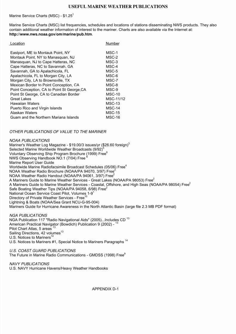
8/4/2019 Worldwide Marine Radio Facsimile Broadcast Schedules
http://slidepdf.com/reader/full/worldwide-marine-radio-facsimile-broadcast-schedules 101/122
USEFUL MARINE WEATHER PUBLICATIONS
Marine Service Charts (MSC) - $1.251
Marine Service Charts (MSC) list frequencies, schedules and locations of stations disseminating NWS products. They alsocontain additional weather information of interest to the mariner. Charts are also available via the Internet at:http://www.nws.noaa.gov/om/marine/pub.htm.
Location Number
Eastport, ME to Montauk Point, NY MSC-1
Montauk Point, NY to Manasquan, NJ MSC-2Manasquan, NJ to Cape Hatteras, NC MSC-3Cape Hatteras, NC to Savannah, GA MSC-4Savannah, GA to Apalachicola, FL MSC-5Apalachicola, FL to Morgan City, LA MSC-6Morgan City, LA to Brownsville, TX MSC-7Mexican Border to Point Conception, CA MSC-8Point Conception, CA to Point St George,CA MSC-9Point St George, CA to Canadian Border MSC-10Great Lakes MSC-11/12Hawaiian Waters MSC-13Puerto Rico and Virgin Islands MSC-14Alaskan Waters MSC-15
Guam and the Northern Mariana Islands MSC-16
OTHER PUBLICATIONS OF VALUE TO THE MARINER
NOAA PUBLICATIONS Mariner's Weather Log Magazine - $19.00/3 issues/yr ($26.60 foreign)3 Selected Marine Worldwide Weather Broadcasts (9/92)5 Voluntary Observing Ship Program Brochure (1999) Free6 NWS Observing Handbook NO.1 (7/04) Free 6 Marine Report User GuideWorldwide Marine Radiofacsimile Broadcast Schedules (05/06) Free4 NOAA Weather Radio Brochure (NOAA/PA 94070, 3/97) Free2
NOAA Weather Radio Handout (NOAA/PA 94061, 3/97) Free2 A Mariners Guide to Marine Weather Services - Great Lakes (NOAA/PA 98053) Free2 A Mariners Guide to Marine Weather Services - Coastal, Offshore, and High Seas (NOAA/PA 98054) Free2 Safe Boating Weather Tips (NOAA/PA 94058, 6/98) Free2 National Ocean Service Coast Pilot, Volumes 1-91 Directory of Private Weather Services - Free10 Lightning & Boats (NOAA/Sea Grant NCU-G-95-004)Mariners Guide for Hurricane Awareness in the North Atlantic Basin (large file 2.3 MB PDF format)
NGA PUBLICATIONS NGA Publication 117 "Radio Navigational Aids" (2005)...Includes CD 13 American Practical Navigator (Bowdich) Publication 9 (2002) - 13 Pilot Chart Atlas, 5 areas 13
Sailing Directions, 42 volumes13
U.S. Notices to Mariners14 U.S. Notices to Mariners #1, Special Notice to Mariners Paragraphs 14
U.S. COAST GUARD PUBLICATIONS The Future in Marine Radio Communications - GMDSS (1998) Free9
NAVY PUBLICATIONS U.S. NAVY Hurricane Havens/Heavy Weather Handbooks
APPENDIX D-1

8/4/2019 Worldwide Marine Radio Facsimile Broadcast Schedules
http://slidepdf.com/reader/full/worldwide-marine-radio-facsimile-broadcast-schedules 102/122
Non-U.S. GOVERNMENT PUBLICATIONS Canadian Coast Guard Radio Aids to Navigation - $18.95 CdnThe British Admiralty List of Radio Signals8
Volume 1 Coast Radio Stations (2 parts)Volume 2 Radio Navigational Aids, Satellite Navigation Systems, Legal Time,Radio Time Signals & Electronic Fixing SystemsVolume 3 Maritime Safety Information Services (2 Parts)Volume 4 Meteorological Observation StationsVolume 5 Global Maritime Distress and Safety SystemsVolume 6 Pilot Services, Vessel Traffic Services & Port Operations (5 parts)
INTERNATIONAL PUBLICATIONS TSUNAMI The Great Waves - Free 11 The SafetyNET Users Handbook - FreeInternational SafetyNET Manual, 1994; IMO-908E12 NAVTEX Manual, 1994; IMO-951E12 GMDSS Handbook, 1995 (Includes GMDSS Master Plan); IMO-970E12 SOLAS Consolidated Edition, 1997; IMO-110E12 World Meteorological Organization Publication 9 - Weather Reporting 15
Volume A - Observing StationsVolume C1 - Meteorological BulletinsVolume C2 - Transmission Programmes (Incluides broadcast information)Volume D - Information for Shipping (Includes broadcast information)
1. FAA, National Aeronautical Charting OfficeDistribution Division, AJW-355010201 Good Luck RoadGlenn Dale, Maryland 20769(301) 436-8301(800) 638-8972 toll free, U.S. only(301) 436-6829 FAXEmail: [email protected]://chartmaker.ncd.noaa.govor your local chart agent: http://chartmaker.ncd.noaa.gov/nsd/states.html
2. Available Internet: Via http://www.nws.noaa.gov/om/index.htmlOr from your local National Weather Service Forecast Office.
3. Superintendent of DocumentsP.O. Box 371954Pittsburgh, PA 15250-7954(202) 512-1800 (7:30am-4:30pm EST)(202) 512-2250 FAXhttp://www.gpo.govhttp://www.nws.noaa.gov/om/mwl/mwl.htm(Distributed free to ships in VOS program)Click here for the GPO printed order formClick here for the GPO online order form
4. (Printed version available only to ships participating in U.S. VOS program)web version http://www.nws.noaa.gov/om/marine/rfax.pdf National Weather ServiceVoluntary Observing Ship Technical LeadRobert "Luke" LukeNDBC Bldg #1100Stennis Space Center, MS 39529(228) 688-1457(228) 688-3153 (fax)[email protected]://www.vos.noaa.gov
APPENDIX D-2

8/4/2019 Worldwide Marine Radio Facsimile Broadcast Schedules
http://slidepdf.com/reader/full/worldwide-marine-radio-facsimile-broadcast-schedules 103/122
5. Joint Publication of National Weather Service and Naval Oceanography CommandOut of date, no longer producedMarine Communications Program Manager, W/OS21National Weather Service, NOAA1325 East-West HighwaySilver Spring, MD 20910(301)-713-1677 x128(301)-713-1598http://www.nws.noaa.gov/os/marine/feedback.htm
6. (Some publications available only to ships participating in U.S. VOS program)
National Weather ServiceVoluntary Observing Ship Technical LeadRobert "Luke" LukeNDBC Bldg #1100Stennis Space Center, MS 39529(228) 688-1457(228) 688-3153 (FAX)[email protected]://www.vos.noaa.gov
8. UK Hydrographic OfficeAdmiralty Way, Tauton, SomersetTA1 2DNm United Kingdom
+44(0) 1823 337900 x3333+44(0) 1823 323753 [email protected]://www.ukho.gov.ukhttp://www.ukho.gov.uk/amd/distributorsList.asp (Distributors)
9. Commandant (G-SCT)U.S. Coast Guard2100 Second Street S.W.Washington, D.C. 20593(202)-267-2860(202)-267-4106 (FAX)[email protected]
http://www.navcen.uscg.gov/marcomms/gmdss/#Brochurehttp://www.navcen.uscg.gov/marcomms/default.htm
10. National Weather ServiceIndustrial Meteorology Staff 1325 East-West HighwaySilver Spring, MD 20910(301)-713-0258(301)[email protected]://www.nws.noaa.gov/im/
11. International Tsunami Information Center 737 Bishop St. Suite 2200Honolulu, HI 96813-3213808-532-6422808-532-5576 (FAX)[email protected]://www.prh.noaa.gov/itic/
APPENDIX D-3

8/4/2019 Worldwide Marine Radio Facsimile Broadcast Schedules
http://slidepdf.com/reader/full/worldwide-marine-radio-facsimile-broadcast-schedules 104/122
12. International Maritime Organization (IMO)4 Albert EmbankmentLondon SE1 7SR UK+44 207 7357611+44 207 5873210 FAX (general enquiries)+44 207 5873241 FAX (publication sales)Telex: [email protected]://www.imo.org
13. Superintendent of DocumentsP.O. Box 371954Pittsburgh, PA 15250-7954(202) 512-1800 (7:30am-4:30pm EST)(202) 512-2250 FAXhttp://bookstore.gpo.gov
14. Since 2004, no longer printed by U.S. Government
15. American Meteorological SocietyAttn: WMO Publications Center 45 Beacon StreetBoston, MA 02108 USA
1-617-227-2425 Fax: [email protected]://www.wmo.ch/web/catalogue/
APPENDIX D-4

8/4/2019 Worldwide Marine Radio Facsimile Broadcast Schedules
http://slidepdf.com/reader/full/worldwide-marine-radio-facsimile-broadcast-schedules 105/122
Points of Contact
U.S. Port Meteorological Officers
Headquarters
John WassermanVoluntary Observing Ship Operations
Manager National Data Buoy Center Building 3203Stennis Space Center, MS 39529-6000Tel: 228-688-1818Fax: 228-688-3923E-mail: [email protected]
Robert A. LukeVoluntary Observing Ship Program Manager
National Data Buoy Center Building 3203Stennis Space Center, MS 39529-6000Tel: 228-688-1457Fax: 228-688-3923E-mail: [email protected]
Atlantic Ports
Vacant, PMONational Weather Service, NOAA2550 Eisenhower Blvd, Suite 312P.O. Box 350067Port Everglades, FL 33316Tel: 954-463-4271Fax: 954-462-8963E-mail: [email protected]
John Warrelmann, PMONational Weather Service, NOAA13701 Fang RoadJacksonville, FL 32218-7933Tel: 904-741-5186 Ext. 117Fax: 904-741-0078E-mail: [email protected]
Tim Kenefick, PMONOAA Coastal Services Center 2234 South Hobson AvenueCharleston, SC 29405-2413Tel: 843-740-1281Fax: 843-740-1289E-mail: [email protected]
Peter Gibino, PMONational Weather Service, NOAA4034-B Geo. Wash. Mem. Hwy.Yorktown, VA 23692-2724Tel: 757-877-1692Fax: 757-877-9561E-mail: [email protected]
James Saunders, PMONational Weather Service, NOAAMaritime Center I, Suite 2872200 Broening HighwayBaltimore, MD 21224-6623Tel: 410-633-4709Fax: 410-633-4713E-mail: [email protected]
Jim Luciani, PMONew York/New JerseyNational Weather Service, NOAA110 Main Street, Suite 201South Amboy, NJ 08879-1367Tel: 732-316-5409Fax: 732-316-7643E-mail: [email protected]
Great Lakes Ports
Amy Seeley, PMONational Weather Service, NOAA333 West University Dr.Romeoville, IL 60446-1804Tel: 815-834-0600 Ext. 269Fax: 815-834-0645E-mail: [email protected]

8/4/2019 Worldwide Marine Radio Facsimile Broadcast Schedules
http://slidepdf.com/reader/full/worldwide-marine-radio-facsimile-broadcast-schedules 106/122
Gulf of Mexico Ports
Paula Rychtar, PMOc/o NOAA FisheriesP.O. Drawer 1207Pascagoula, MS 39568-1207Tel: 504-289-2294E-mail: [email protected]
Chris Fakes, PMONational Weather Service, NOAA1353 FM646Suite 202Dickinson, TX 77539
Tel: 281-534-2640 Ext. 277Fax: 281-534-4308E-mail: [email protected]
Pacific PortsDerek LeeLoyOcean Services Program Coordinator National Weather Service Pacific Region HQGrosvenor Center, Mauka Tower 737 Bishop Street, Suite 2200Honolulu, HI 96813-3201Tel: 808-532-6439Fax: 808-532-5569E-mail: [email protected]
Robert Webster, PMONational Weather Service, NOAA501 West Ocean Blvd., Room 4480Long Beach, CA 90802-4213Tel: 562-980-4090Fax: 562-436-1550E-mail: [email protected]
Daniel CurtisNational Weather Service, NOAA1301 Clay Street, Suite 1190NOakland, CA 94612-5217
Tel: 510-637-2960Fax: 510-637-2961E-mail: [email protected]
Patrick Brandow, PMONational Weather Service, NOAA7600 Sand Point Way, N.E., BIN C15700Seattle, WA 98115-6349Tel: 206-526-6100Fax: 206-526-4571 or 6094E-mail: [email protected]
Richard CourtneyNational Weather Service, NOAA600 Sandy Hook Street, Suite 1Kodiak, AK 99615-6814Tel: 907-487-2102Fax: 907-487-9730E-mail: [email protected]
Debra Elliott, OICNational Weather Service, NOAA,Box 427Valdez, AK 99686-0427Tel: 907-835-4505
Fax: 907-835-4598E-mail: [email protected]
Larry HubbleNational Weather Service Alaska Region222 West 7th Avenue #23Anchorage, AK 99513-7575Tel: 907-271-5135Fax: 907-271-3711E-mail: [email protected]
U.S. Coast Guard AMVER Center Ben Strong, AMVER Maritime Relations Officer, United States Coast GuardBattery Park BuildingNew York, NY 10004Tel: 212-668-7762Fax: 212-668-7684E-mail: [email protected]

8/4/2019 Worldwide Marine Radio Facsimile Broadcast Schedules
http://slidepdf.com/reader/full/worldwide-marine-radio-facsimile-broadcast-schedules 107/122
SEAS Field Representatives
AOML SEAS Program Manager Dr. Gustavo GoniAOML
4301 Rickenbacker CausewayMiami, FL 33149-1026Tel: 305-361-4339Fax: 305-361-4412E-mail: [email protected]
Drifter Program Manager Dr. Rick LumpkinAOML/PHOD4301 Rickenbacker CausewayMiami, FL 33149-1026Tel: 305-361-4513Fax: 305-361-4412
E-mail: [email protected]
ARGO Program ManagerDr. Claudia SchmidAOML/PHOD4301 Rickenbacker CausewayMiami, FL 33149-1026Tel: 305-361-4313Fax: 305-361-4412E-mail: [email protected]
Global Drifter ProgramShaun Dolkr
AOML/PHOD4301 Rickenbacker CausewayMiami, FL 33149-1026Tel: 305-361-4446Fax: 305-361-4366E-mail:[email protected]
Northeast Atlantic SEAS Rep.Jim FarringtonSEAS Logistics/AMC
439 West York StreetNorfolk, VA 23510Tel: 757-441-3062Fax: 757-441-6495E-mail: [email protected]
Southwest Pacific SEAS Rep.Carrie WolfeSouthern California Marine Institute820 S. Seaside AvenueSan Pedro, Ca 90731-7330Tel: 310-519-3181Fax: 310-519-1054
E-mail: [email protected]
Southeast Atlantic SEAS Rep.Derrick SnowdenAOML/GOOS Center 4301 Rickenbacker CausewayMiami, FL 33149-1026Tel: 305-361-4332Fax: 305-361-4412E-mail: [email protected]
Pacific Northwest SEAS Rep.Steve Noah
SEAS Logistics/PMCOlympic Computer Services, Inc.Tel: 360-385-2400Cell: 425-238-6501E-mail: [email protected] or [email protected]

8/4/2019 Worldwide Marine Radio Facsimile Broadcast Schedules
http://slidepdf.com/reader/full/worldwide-marine-radio-facsimile-broadcast-schedules 108/122
Other Port Meteorological Officers
ARGENTINA
Mario J. Garcia, Jefe del Dto. Redes
Servicio Meteorlógico Nacional25 de Mayo 658 (C1002ABN)Buenos AiresArgentinaTel: +54-11 4514 1525Fax: +54-11 5167 6709E-mail: [email protected]
AUSTRALIA
Head OfficeGraeme Ball, Mgr.,Marine Observations GroupBureau of MeteorologyGPO Box 1289KMelbourne, VIC 3001AustraliaTel: +61-3 9669 4203Fax: +61-3 9669 4168E-mail: [email protected] E-mail: [email protected]
FremantleMalcolm (Mal) Young, PMA
c/o Bureau of MeteorologyPO Box 1370West Perth WA 6872AustraliaTel: +61-8 9474 1974Fax: +61-8 6210 1801E-mail: [email protected]
MelbourneAlbert Dolman, PMAc/o Bureau of MeteorologyGPO Box 1636MMelbourne, Vic. 3001AustraliaTel: +61-4 3858 7341Fax: +61-3 5229 5432E-mail: [email protected]
SydneyCapt. Einion E. (Taffy) Rowlands, PMAc/o Bureau of Meteorology
GPO Box 413Darlinghurst NSW 1300AustraliaTel:+61-2 9296 1547Fax: +61-2 9296 1648E-mail: [email protected]

8/4/2019 Worldwide Marine Radio Facsimile Broadcast Schedules
http://slidepdf.com/reader/full/worldwide-marine-radio-facsimile-broadcast-schedules 109/122
CANADA
Canadian HeadquartersGerie Lynn Lavigne, Life Cycle Manager Marine Networks, Environment CanadaSurface Weather, Climate and Marine
Networks4905 Dufferin StreetToronto, OntarioCanada M3H 5T4Tel: +1-416 739 4561Fax: +1-416 739 4261E-mail: [email protected]
British ColumbiaHamid Nasr, PMOEnvironment Canada140 - 13160Vanier PlaceRichmond, British Columbia V6V 2J2CanadaTel: +1-604-713-9523Cel: +1-604-839-8630Fax: +1-604-664-4094E-mail: [email protected]
NewfoundlandAndrew Dwyer, PMOEnvironment Canada6 Bruce StreetSt John's, Newfoundland A1N 4T3CanadaTel: +1-709-772-4798
Fax: +1-709-772-5097E-mail: [email protected]
Nova ScotiaRandy Sheppard, PMOMeteorological Service of Canada16th Floor, 45 Aldernay Drive
Dartmouth, Nova Scotia B2Y 2N6CanadaTel: 1+902 426 6703E-mail: [email protected]
OntarioTony Hilton , Supervisor PMO, RickShukster, PMO & Roland Kleer, PMOEnvironment CanadaMeteorological Service of Canada100 East Port Blvd.Hamilton, Ontario L8H 7S4 CanadaTel: +1-905 312 0900Fax: +1-905 312 0730E-mail: [email protected]
[email protected]@ec.gc.ca
QuebecErich Gola, PMOMeteorological Service of CanadaQuebec Region100 Alexis Nihon, Suite 300, 3rd Floor Montreal, Quebec H4M 2N8CanadaTel: +1-514 283-1644
Cel: +1-514 386-8269Fax: +1-514 496-1867E-mail: [email protected]
CHINAYU ZhaoguoShanghai Meteorological Bureau166 Puxi RoadShanghai, China

8/4/2019 Worldwide Marine Radio Facsimile Broadcast Schedules
http://slidepdf.com/reader/full/worldwide-marine-radio-facsimile-broadcast-schedules 110/122
CROATIA
Port of SplitCaptain Zeljko SoreMarine Meteorological Office-SplitP.O. Box 370
Glagoljaska 11HR-21000 SplitCroatiaTel: +385-21 589 378Fax: +385-21 591 033 (24 hours)E-mail: [email protected]
Port of RijekaSmiljan ViskovicMarine Meteorological Office-Rijeka
Riva 20HR-51000 RijekaCroatiaTel: +385-51 215 548Fax: +385-51 215 574
DENMARK
Cmdr Roi Jespersen, PMO & Cmdr Harald R. Joensen, PMODanish Meteorological Inst., Observation DeptSurface and Upper Air Observations DivisionLyngbyvej 100
DK-2100 CopenhagenDenmarkTel: +45 3915 7337Fax: +45 3915 7390E-mail: [email protected]@dmi.dk
FALKLANDSCaptain R. Gorbutt, Marine Officer
Fishery Protection OfficePort StanleyFalklandsTel: +500 27260Fax: +500 27265Telex: 2426 FISHDIR FK

8/4/2019 Worldwide Marine Radio Facsimile Broadcast Schedules
http://slidepdf.com/reader/full/worldwide-marine-radio-facsimile-broadcast-schedules 111/122
FRANCE
HeadquartersAndré Péries, PMO Supervisor Météo-France DSO/RESO/PMO42, Avenue Gustave Coriolis
31057 Toulouse CédexFranceTel: +33-5 61 07 98 54Fax: +33-5 61 07 98 69E-mail: [email protected]
Boulogne-sur-mer Gérard DoligezMétéo-France DDM6217, boulevard Sainte-Beuve62200 Boulogne-sur-mer FranceTel: +33-3 21 10 85 10Fax: +33-2 21 33 33 12E-mail: [email protected]
BrestLouis Stéphan, Station Météorologique16, quai de la douane29200 BrestFranceTel: +33-2 98 44 60 21Fax: +33-2 98 44 60 21
La RéunionYves Morville, Station MétéorologiquePort RéunionFranceFax: +262 262 921 147Telex: 916797REE-mail: [email protected] [email protected]
Le HavreAndre Devatine, Station MétéorologiqueNouveau SémaphoreQuai des Abeilles
76600 Le HavreFranceTel: +33-2 32 74 03 65Fax: +33 2 32 74 03 61E-mail: [email protected]
MarseilleMichel Perini, PMOMétéo-France / CDM 132A BD du Château-Double13098 Aix en Provence Cédex 02FranceTel: +00 33 (0)4 42 95 25 42Fax: +00 33 (0)4 42 95 25 49E-mail: [email protected]
Montoir de BretagneJean Beaujard, Station MétéorologiqueAérodome de Saint-Nazaire-Montoir 44550 Montoir de BretagneFranceTel: +33-2 40 17 13 17Fax: +33-2 40 90 39 37
New CaledoniaHenri Lévèque, Station MétéorologiqueBP 15198845 Noumea PortNew CaledoniaFranceTel: +687 27 30 04Fax: +687 27 42 95

8/4/2019 Worldwide Marine Radio Facsimile Broadcast Schedules
http://slidepdf.com/reader/full/worldwide-marine-radio-facsimile-broadcast-schedules 112/122
GERMANY
HeadquartersVolker Weidner, PMO Advisor Deutscher WetterdienstBernhard-Nocht-Strasse 76
D-20359 HamburgGermanyTel: +49-40 6690 1410Fax: +49-40 6690 1496E-mail: [email protected]
BremenUlrich Ranke, PMODeutscher WetterdienstFlughafendamm 45D-28199 BremenGermanyTel: +49-421 5372 163Fax: +49-421 5372 166E-mail: [email protected]
BremerhavenHenning Hesse, PMODeutscher WetterdienstAn der Neuen Schleuse 10bD-27570 BremerhavenGermanyTel: +49-471 70040-18Fax: +49-471 70040-17E-mail: [email protected]
HamburgPeter Gollnow, PMO &Horst von Bargen, PMODeutscher WetterdienstBernhard-Nocht-Strasse 76D - 20359 HamburgGermanyTel: +49-40 6690 1411 or 1412Fax: +49 40 6990 1496
E-mail: [email protected]
RostockChristine Bergs, PMO &Christel Heidner, PMODeutscher WetterdienstSeestrasse 15aD-18119 RostockGermanyTel: +49 381 54388-30/31Fax: +49 381 54388-63E-mail: [email protected]
GILBRALTARPrincipal Meteorological Officer Meteorological OfficeRAF Gilbraltar BFPO 52Gilbraltar Tel: +350 53419Fax: +350 53474
GREECE
Michael Myrsilidis, Marine MeteorologySectionHellenic National Meteorological Service(HNMS)El, Venizelou 1416777 HellinikonAthens
GreeceTel: +30-10 9699013Fax: +30-10 9628952, 9649646E-mail: [email protected]

8/4/2019 Worldwide Marine Radio Facsimile Broadcast Schedules
http://slidepdf.com/reader/full/worldwide-marine-radio-facsimile-broadcast-schedules 113/122
HONG KONG, CHINA
Wing Tak Wong, Senior Scientific Officer Hong Kong Observatory134A Nathan RoadKowloonHong Kong, ChinaTel: +852 2926 8430Fax: +852 2311 9448E-mail: [email protected]
ICELAND
Hreinn Hjartarson, Icelandic Met. OfficeBústadavegur 9IS-150 ReykjavikIcelandTel: +354 522 6000Fax: +354 522 6001
E-mail: [email protected]
INDIA
CalcuttaPort Meteorological OfficeAlibnagar, Malkhana BuildingN.S. Dock Gate No. 3Calcutta 700 043IndiaTel: +91-33 4793167
ChennaiPort Meteorological Office10th Floor, Centenary BuildingChennai Port Trust, Rajaji RoadChennai 600 001IndiaTel: +91-44 560187
Fort MumbaiPort Meteorological Office3rd Floor, New Labour Hamallage BuildingYellow Gate, Indira DoctFort Mumbai 400 001IndiaTel: +91-2613733
GoaPMO, Port Meteorological Liaison OfficeSada, P.O., Head Land SadaGoa 403 804IndiaTel: +91-832 520012
KochiPort Meteorological OfficeCochin Harbour, North End, WellingtonIslandKochi 682 009IndiaTel: +91-484 667042
VisakhapatnamPort Meteorological Officec/o The Director, Cyclone Warning CentreChinna Waltair Visakhapatnam 530 017.Andra PradeshIndiaTel: +91-891 746506

8/4/2019 Worldwide Marine Radio Facsimile Broadcast Schedules
http://slidepdf.com/reader/full/worldwide-marine-radio-facsimile-broadcast-schedules 114/122
INDONESIA
Belawan
Stasiun Meteorologi Maritim BelawanJl. Raya Pelabuhan IIIBelawan - 20414IndonesiaTel: +62-21 6941851Fax: +62-21 6941851
Bitung
Stasiun Meteorologi Maritim BitungJl. Kartini No. 1Bitung - 95524IndonesiaTel: +62-438 30989
Fax: +62-438 21710
JakartaMochamad RifangiMeteorological and Geophysical AgencyJl. Angkasa I No. 2 KemayoranJakarta - 10720
IndonesiaTel: +62-21 4246321Fax: +62-21 4246703
Stasiun Meteorologi Maritim Tanjung PriokJl. Padamarang PelabuhanTanjung PriokJakarta - 14310IndonesiaTel: +62-21 4351366Fax: +62-21 490339
Makassar Stasiun Meteorologi Maritim Makassar Jl. Sabutung I No. 20 PaotereMakassar IndonesiaTel: +62-411 319242Fax: +62-411 328235
SemarangStasiun Meteorologi Maritim SemarangJl. Deli PelabuhanSemarang - 50174IndonesiaTel: +62-24 3549050Fax: +62-24 3559194
SurabayaStasiun Meteorologi Maritim SurabayaJl. Kalimas baru No. 97BSurabaya - 60165IndonesiaTel: +62-31 3291439Fax: +62-31 3291439

8/4/2019 Worldwide Marine Radio Facsimile Broadcast Schedules
http://slidepdf.com/reader/full/worldwide-marine-radio-facsimile-broadcast-schedules 115/122
IRELAND
CorkBrian Doyle, PMOMet Eireann
Cork AirportCorkIrelandTel: +353-21 4917753Fax: +353-21 4317405
DonegalPaddy Delaney, Station Manager Met EireannCork AirportMalinHeadLiffordCo. Donegal
Ireland
DublinColumba Creamer, Marine UnitMet EireannGlasnevin HillDublin 9Ireland
MayoAndy Clohessy, Station Manager
Connaught International AirportCharlestonCo. MayoIreland
WexfordDennis O. Mahoney, Station Manager Met EireannRossiare Harbour WexfordIrelandTel: +353-53 33113Fax: +353-53 33105
E-mail: [email protected]
ISRAEL
AshdodAharon Ofir, PMOMarine DepartmentAshdod PortTel: 972 8 8524956
HaifaHani Arbel, PMOHaifa PortTel: 972 4 8664427

8/4/2019 Worldwide Marine Radio Facsimile Broadcast Schedules
http://slidepdf.com/reader/full/worldwide-marine-radio-facsimile-broadcast-schedules 116/122
JAPAN
HeadquartersDr. Kazuhiko Hayashi, Scientific Officer Marine Div., Climate and Marine Dept.Japan Meteorological Agency
1-3-4 Otemachi, Chiyoda-kuTokyo, 100-8122JapanTel: +81-3 3212 8341 ext. 5144Fax: +81-3 3211 6908Email: [email protected]@climar.kishou.go.jp
KobePort Meteorological Officer Kobe Marine Observatory1-4-3, Wakinohamakaigan-dori, Chuo-kuKobe 651-0073JapanTel: +81-78 222 8918Fax: +81-78 222 8946
NagoyaPort Meteorological Officer Nagoya Local Meteorological Observatory
2-18, Hiyori-ho, Chigusa-kuNagoya, 464-0039JapanTel: +81-52 752 6364Fax: +81-52 762-1242
YokohamaPort Meteorological Officer Yokohama Local MeteorologicalObservatory99 Yamate-cho, Naka-kuYokohama, 231-0862JapanTel: +81-45 621 1991Fax: +81-45 622 3520Telex: 2222163
KENYA
Ali Juma Mafimbo, PMOPO Box 98512MombasaKenyaTel: +254-11 225687 / 433689Fax: +254-11 433689E-mail:[email protected]
MALASYA
Port BintuluPaul Chong Ah Poh, PMOBintulu Meteorological StationP.O. Box 28597007 BintuluSarawakMalaysiaFax: +60-86 314 386
Port KlangMohd Shah Ani, PMOMalaysian Meteorological ServiceJalan Sultan46667 Petaling JayaSelangor MalaysiaFax: +60-3 7957 8046
Port KinabaluMohd Sha Ebung, PMOMalaysian Meteorological Service7th Floor, Wisma Dang BandangP.O. Box 5488995 Kota KinabaluSabahMalaysiaFax: +60-88 211 019
8/4/2019 Worldwide Marine Radio Facsimile Broadcast Schedules
http://slidepdf.com/reader/full/worldwide-marine-radio-facsimile-broadcast-schedules 117/122
MAURITUISPort LouisMeteorological Services
St. Paul RoadVacoasMauritiusTel: +230 686 1031/32Fax: +230 686 1033E-mail:[email protected]
NETHERLANDS
Bert de Vries, PMO &René Rozeboom, PMOKNMI, PMO-OfficeWilhelminalaan 10Postbus 2013730 Ae de BiltNetherlandsTel: +31-30 2206391Fax: +31-30 2210849E-mail: [email protected]
NEW ZEALAND
Julie Fletcher, MMOMeteorological Service New Zealand Ltd.P.O. Box 722
WellingtonNew ZealandTel: +64-4 4700 789Fax: +64-4 4700 772
NORWAY
Tor Inge Mathiesen, PMONorwegian Meteorological InstituteAllégaten 70
N-5007 BergenNorwayTel: +47-55 236600Fax: +47-55 236703Telex: 40427/42239
PAKISTAN
Hazrat Mir, Senior MeteorologistPakistan Meteorological DepartmentMeteorological OfficeJinnah International AirportKarachiPakistanTel:+ 92-21 45791300, 45791322Fax: +92-21 9248282E-mail: [email protected]

8/4/2019 Worldwide Marine Radio Facsimile Broadcast Schedules
http://slidepdf.com/reader/full/worldwide-marine-radio-facsimile-broadcast-schedules 118/122
PHILIPINES
Cagayan de Oro CityLeo RodriguezPagasa Complex StationCagayan de Oro City 9000, Misamis
OccidentalPhilipinesTel: +63-8822 722 760
Davao CityEdwin FloresPagasa Complex Station, Bangoy AirportDavao City 8000PhilipinesTel: +63-82 234 08 90
Dumaguete CityEdsin CuliPagasa Complex StationDumaguete City AirportDumaguete City, Negros Oriental 6200PhilipinesTel: +63-35 225 28 04
Legaspi CityOrthello EstarejaPagasa Complex StationLegaspi City, 4500
PhilipinesTel: +63-5221 245 5241
Iloilo CityConstancio Arpon, Jr.Pagasa Complex StationIloilo City 5000PhilipinesTel: +63-33 321 07 78
Mactan CityRoberto Entrada
Pagasa Complex Station, Mactan AirportMactan City, CEBU 6016PhilipinesTel: +63-32 495 48 44
ManilaDr. Juan D. Cordeta & Benjamin Tado, Jr.Pagasa Port Meteorological OfficePPATC Building, Gate 4South Harbor Manila 1018Philipines 1100Tel: +63-22 527 03 16
POLAND
Józef Kowalewski, PMO Gdynia and GdanskInstitute of Meteorology and Water ManagementWaszyngton 42PL-81-342 GdyniaPolandTel: +48-58 6204572Fax: +48-58 6207101Telex: 054216E-mail:[email protected]
REPUBLIC OF KOREA
InchonInchon Meteorological Station25 Chon-dong, Chung-guInchonRepublic of KoreaTel: +82-32 7610365Fax: +82-32 7630365
PusanPusan Meteorological Station1-9 Taechong-dong, Chung-guPusanRepublic of KoreaTel: +82-51 4697008Fax: +82-51 4697012

8/4/2019 Worldwide Marine Radio Facsimile Broadcast Schedules
http://slidepdf.com/reader/full/worldwide-marine-radio-facsimile-broadcast-schedules 119/122
RUSSIAN FEDERATION
Ravil S. FakhrutdinovRoshydromet12, Novovagan’kovsky Street
Moscow 123242Russian FederationTel:+7-095 255 23 88Fax: +7-095 255 20 90Telex: 411117 RUMS RFE-mail: [email protected] [email protected]
SAUDI ARABIA
Mahmoud M. Rajkhan, PMOMeteorology and Environmental ProtectionAdministration (MEPA)P.O. Box 1358Jeddah 21431Saudi ArabiaTel: +966-2 6512312 Ext. 2252 or 2564
SINGAPORE
Amran bin Osman, PMSMeteorological ServicePO Box 8Singapore Changi AirportSingapore 9181Tel: 5457198Fax: +65 5457192Telex: RS50345 METSIN
SOUTH AFRICA
HeadquartersJohan Stander Regional Manager: Western CapeAntarctica and IslandsSouth African Weather Service
P O Box 21Cape Town international Airport7525South AfricaTel: +27 (0) 21 934 0450Fax: +27 (0) 21 934 4590Cell: +27 (0) 82 281 0993Weatherline: 082 162 [email protected]
Cape TownC. Sydney Marais, PMOCape Town Regional Weather OfficeSouth African Weather Service
P O Box 21Cape Town international Airport7525South AfricaTel: +27-21 934 0836Fax: +27-21 934 3296Cell: +27(0) 84 279 [email protected]
DurbanGus McKay, PMODurban Regional Weather OfficeDurban International AirportDurban 4029South AfricaTel: +27-31 408 1446Fax: +27-31 408 1445Cell: +27 (0) 82 567 1745E-mail:[email protected]

8/4/2019 Worldwide Marine Radio Facsimile Broadcast Schedules
http://slidepdf.com/reader/full/worldwide-marine-radio-facsimile-broadcast-schedules 120/122
SWEDENKerstin SvenssonSMHIUniversitetsallén 32SE-851 71 SUNDSVALLTel +46 60 785 88 30
TANZANIA, UNITEDREPUBLIC OF
H. Charles Mwakitosi, PMOP.O. Box 3056Dar es SalaamUnited Republic of Tanzania
THAILAND
Kesrin Hanprasert, MeteorologistMarine and Upper Air Observation SectionMeteorological Observation DivisionThai Meteorological Department4353 Sukhumvit Road, BangnaBangkok 10260ThailandTel: +66-2 399 4561Fax: +66-2 398 9838E-mail:[email protected]
UNITED KINGDOM
HeadquartersSarah C. North, Marine Networks Manager MetOfficeObservations Supply - Marine NetworksFitzRoy RoadExeter DevonEX1 3PBUnited KingdomTel: +44-1392 855 617Fax: +44-870 900 5050E-mail: [email protected]
Group E-mail:[email protected]
North EnglandColin B. Attfield, PMOMet officec/o 12 Brackley CloseWallaseyMerseyside CH44 3EJUnited KingdomTel:+44-151 638 8516Fax: +44-870 900 5050E-mail:[email protected]
South EnglandSteve Key, PMOMet OfficeTrident House21 Berth, Tilbury DockTilbury, Essex RM18 7HLUnited KingdomTel: +44-1375 859 970Fax: +44-1375 859 972e-mail: [email protected]
PMO Southampton forthcoming
ScotlandTony Eastham, PMOMet OfficeSaughton House, Broomhouse DriveEdinburgh EH11 3XQUnited KingdomTel: +44-131 528 7305Fax: +44-131 528 7345E-mail:[email protected]
Ian J. Hendry, Offshore Adviser Met OfficeDavidson House Campus 1Aberdeen Science & Technology ParkBridge of DonAberdeen AB22 8GTUnited KingdomTel: +44-1224 407 557Fax: +44-1224 407 568E-mail:[email protected]

8/4/2019 Worldwide Marine Radio Facsimile Broadcast Schedules
http://slidepdf.com/reader/full/worldwide-marine-radio-facsimile-broadcast-schedules 121/122
NOAA WEATHER RADIO NETWORK
(1) 162.550 mHz(2) 162.400 mHz(3) 162.475 mHz(4) 162.425 mHz (5) 162.450 mHz (6) 162.500 mHz
(7) 162.525 mHz Channel numbers, e.g. (WX1, WX2) etc. have no special significance but are often designated this way iconsumer equipment. Other channel numbering schemes are also prevalent.
The NOAA Weather Radio network provides voice broadcasts of local and coastal marine forecasts on acontinuous cycle. The forecasts are produced by local National Weather Service Forecast Offices.Coastal stations also broadcast predicted tides and real time observations from buoys and coastalmeteorological stations operated by NOAA's National Data Buoy Center. Based on user demand, andwhere feasible, Offshore and Open Lake forecasts are broadcast as well.
The NOAA Weather Radio network provides near continuous coverage of the coastal U.S, Great Lakes,Hawaii, and populated Alaska coastline. Typical coverage is 25 nautical miles offshore, but may extendmuch further in certain areas.

8/4/2019 Worldwide Marine Radio Facsimile Broadcast Schedules
http://slidepdf.com/reader/full/worldwide-marine-radio-facsimile-broadcast-schedules 122/122