wilshire community plan - department of city …cityplanning.lacity.org/complan/pdf/wilcptxt.pdf ·...
TRANSCRIPT

WILSHIRE
Community Plan
TABLE OF CONTENTS
ACTIVITY LOG
COMMUNITY PLAN
I. Introduction
II. Function of the Community Plan
III. Land Use Policies and Programs
IV. Coordination Opportunities for Public Agencies
V. Urban Design
www.lacity.org/PLN (General Plans)
A Part of the General Plan - City of Los Angeles

WILSHIRE
ACTIVITY LOG
ADOPTION DATE
Sept. 19, 2001 Dec. 19, 1980 Jan. 23, 2001
ADOPTION DATE
June 30, 1987
PLAN
Wilshire Community Plan Park Mile Specific Plan Vermont-Western Station Neighborhood Area Plan (SNAP)
AMENDMENT
Park Mile Specific Plan Amendment
CPC FILE NO.
97-0051 CPU 27006 00-1976 SP
CPC FILE NO. 27006
COUNCIL FILE NO.
01-1366
75-2824 S9
00-1999
COUNCIL FILE NO. 83-1674 S2
Sept. 7, 2016 Mobility Plan 2035 Update CPC-2013-910-GPA-SPCA-MSC 15-0719

WILSHIRE
Community
Chapter I
INTRODUCTION
COMMUNITY BACKGROUND PLAN AREA The majority of the Wilshire Community Plan Area consists of gently
sloping plains and includes about 8,954 acres (about 14 square miles), which is approximately 3 percent of the total land in the City of Los Angeles.
The Wilshire Community Plan Area is often spoken of as the Mid-City section of Los Angeles. The eastern edge of the approximately 2.5-mile wide by 6-mile long plan area is about 6 miles west of downtown Los Angeles, while the western edge abuts the City of Beverly Hills.
The plan area is bounded by Melrose Avenue and Rosewood Avenue to the north; 18th Street, Venice Boulevard and Pico Boulevard to the south; Hoover Street to the east; and the Cities of West Hollywood and Beverly Hills to the west.
Wilshire is surrounded by the City of Los Angeles community plan areas of Hollywood to the north; South Central Los Angeles and West Adams-Leimert-Baldwin Hills to the south; Silverlake-Echo Park and Westlake to the east; and West Los Angeles to the west.
The plan area is generally southwest of the Hollywood Freeway (U.S. 101), which is oriented northwest-southeast across the northeast corner of the Plan Area at Vermont and Rosewood Avenues.
The Hollywood Freeway is the only freeway within the Wilshire plan area. The Harbor Freeway (I-110) is located one mile to the east; the Santa Monica Freeway (I-10) is located one mile to the south; and the San Diego Freeway (I-405) is approximately five miles to the west of the community boundaries.
The Metro Red Line subway also serves the Wilshire Community Plan area, running along portions of Wilshire Boulevard and Vermont Avenue.
The Wilshire Community Plan Area has a pattern of low to medium density residential uses interspersed with areas of higher density residential uses. Long narrow corridors of commercial activity can be found along major s t r e e t s including Wilshire, Pico, La Cienega, Western and Vermont. The plan area east of Western Avenue contains large concentrations of higher-density residential neighborhoods surrounding the regional commercial area known as Wilshire Center.
__________WILSHIRE__________
I-1

Existing residential land use totals 4,568 acres, including approximately 116,575 dwelling units. The Wilshire Community Plan designates 4,592 acres for residential land uses, accommodating a projected 134,300 dwelling units.
Existing commercial land uses comprise 1,054 acres. There is approximately 40,004,300 square feet of existing commercial development. Planned commercial land use as designated in the Community Plan totals 1,129 acres, with a projected developed commercial total of 41,833,820 square feet.
Existing industrial land use is 50 acres. There is approximately 1,527,800 square feet of existing industrial development. Planned industrial land use designated in the Community Plan is 38 acres, with a build-out projection equal to current conditions.
There are 191 acres of land designated as open space. This category represents 2.1 percent of total land acreage in the Wilshire Community.
The street pattern in the Wilshire area is primarily a grid. Most of the street network is oriented on primary compass points with few exceptions. Notably, south of Wilshire Boulevard and west of Wilton Place, the street grid shifts uniformly towards a northeast/southwest alignment, while east/west streets shift somewhat to a northwest/southeast orientation.
DEMOGRAPHICS The 2000 Census recorded a Wilshire Community Plan Area population
of 292,101. This includes an ethnic mix of 8.8 percent African American, 23.3 percent Asian, 23.7 percent Caucasian (non-Latino), 41.3 percent Latino, and less than one percent Native American.
The Wilshire area is one of the most ethnically and economically diverse areas in the City of Los Angeles. Population make-up varies dramatically from block to block and historically many neighborhoods are ethnically and racially integrated.
A multitude of cultures, ethnicities, and activities together define this diverse area of Los Angeles. For example, Fairfax Avenue itself runs through a district of Ethiopian restaurants, crosses museum row, then arrives at a thriving Orthodox Jewish. Established high-end residential districts abut first generation immigrant neighborhoods, creating dynamic, intricate, and vibrant social patterns of neighborhood interaction and community.
The Koreatown area loosely overlaps a collection of neighborhoods including many primarily Latino areas in the eastern portion of the plan area. Koreatown is centered around Olympic Boulevard between Western and Vermont Avenues.
The Southern California Association of Governments (SCAG) projects a 2010 population of 337,144 persons, a 25 percent increase over the 1990 Census total of 271,620. The Community Plan provides capacity to meet this projection. Population density in 1990 averaged 30.6 persons per gross acre, the second highest for community plan areas in the City of Los Angeles.
__________WILSHIRE__________
I-2

NEIGHBORHOODS AND ACTIVITY CENTERS RESIDENTIAL The Wilshire District contains an overwhelming majority of multi-family
units (86 percent of total housing units). The remaining single family units comprise 42 percent of the total residential land area, with an average net single family density of eight units per acre.
The Wilshire Community Plan Area includes several neighborhoods that consist almost exclusively of duplexes, most notably areas between La Brea Avenue and Fairfax Avenue from Melrose to Third Street, between Olympic and Pico Boulevards from Rimpau Boulevard to Redondo Boulevard, and along Crescent Heights Boulevard.
A combination of low to mid-rise multi-family units and areas containing a mix of mid to high-rise buildings are concentrated along the Wilshire corridor between Vermont Avenue and Wilton Place, in aggregate forming the area known as Wilshire Center.
Residential areas with a mix of high and medium densities are generally found adjacent to commercial corridors in the area bounded by Third Street on the north and Eighth Street on the south. The remainder of the area is largely low-rise residential homes and apartments.
Scattered mid-rise residential areas are located elsewhere throughout the plan area, with building heights exceeding eight stories in Park La Brea and along Rossmore Avenue. The average net multi-family density is 42 units per acre, one of the highest in the city, with the average net density for all housing types at 25 units per acre.
COMMERCIAL Wilshire Boulevard between Hoover Street and Western Avenue includes
a substantial number of mid-rise buildings, generally with minimal setbacks or setbacks that increase the sidewalk width along the boulevard and some with ground floor shops and services. This highly urbanized section of the boulevard experiences considerable pedestrian activity and is supported by Metro Red Line subway service. The urban character along Wilshire Boulevard moving west from Wilton Place to Highland Avenues changes to predominantly low-rise freestanding buildings with landscaped setbacks and limited ground floor retail use. The Park Mile Specific Plan governs development in this area.
Many fine mid-rise examples of Art Deco architecture line Wilshire Boulevard along the Miracle Mile, from La Brea Avenue to Fairfax Avenue, complemented with a consistent urban streetscape and low-rise commercial storefronts. Mid-rise buildings occur more frequently from Fairfax Avenue to San Vicente Boulevard, similarly interspersed with low-rise buildings. The Wilshire Corridor continues west from San Vicente Boulevard through Beverly Hills.
Low-rise commercial buildings consisting of a mix of building types occur along most of the boulevardss except within Hancock Park.
Corridors east of Hancock Park include the following: Pico Boulevard; Olympic Boulevard east of Crenshaw Boulevard; Eighth Street east of Western Avenue which includes higher commercial intensities in
__________WILSHIRE__________
I-3

Koreatown; Sixth Street; Third Street; Beverly Boulevard and Melrose Avenue between Hoover Street and Western Avenue; Temple Street, consisting of largely zero-setback blank wall buildings; Vermont Avenue; and Western Avenue.
Corridors west of Hancock Park include the following: Third Street; Beverly Boulevard; Melrose Avenue, Robertson Boulevard, and La Brea Avenue, consisting primarily of one-story pedestrian-oriented streetfronts; and La Cienega and Pico Boulevards which include a mix of building types.
Larchmont Boulevard is a three-block shopping district within Windsor Square of which the southernmost block consists of pedestrian-oriented storefronts; Larchmont Boulevard includes one mid-rise medical tower north of Beverly Boulevard.
INDUSTRIAL Most of Wilshire’s low intensity industrial land uses are located around the
intersection of Beverly Boulevard and Virgil Avenue, and along Pico Boulevard between Vermont and Western Avenues. These business park-style developments provide limited employment bases. They consist of small and medium scale automobile repair businesses, wholesale/retail distribution outlets, and storage operations.
COMMUNITY PARTICIPATION
The State of California requires citizen participation in the preparation of the General Plan. Government Code Section 65351 reads, “During the preparation or amendment of the General Plan, the planning agency shall provide opportunities for involvement of citizens, public agencies, public utility companies, and civic, education, and other community groups, through public hearings and any other means the city or county deems appropriate”.
In 1997 and 1998, Community participation was initiated through more than 40 focus group meetings. During 1999 and 2000, additional community participation was encouraged during five public workshops and two open houses. In 2001, two open houses followed by public hearings were held. The City Planning Commission reviewed the proposed plan on May 10, 2001 and the plan was approved by the City Council on September 19, 2001.
The public hearing served as a forum for the public review of the Final Environmental Impact Report (EIR), and of the Transportation Improvement and Mitigation Program (TIMP), both of which were prepared for the update of the Wilshire Community Plan.
Community members continue to assist in the identification of major issues and with the formulation of land use policies and objectives in the Wilshire Community Plan Area.
COMMUNITY ISSUES AND OPPORTUNITIES
The following summarizes planning and land use issues and
__________WILSHIRE__________
I-4
opportunities identified by residents, property owners, and business owners in the Wilshire Community Plan Area.
RESIDENTIAL Issues
? Need to maintain low density character of single family neighborhoods, avoiding encroachment from other uses, commercial off-street parking, and “spillover” traffic from adjacent development.
? Need to preserve the existing character of residential neighborhoods
while accommodating more affordable housing and child care facilities.
? Improved land use transitions in scale, density and character are
needed between multiple family and adjacent single family neighborhoods.
? Improved land use transitions are needed between commercial uses
and single family and multiple family areas.
? Increased off-street parking areas and facilities, open space, and recreational facilities are needed, particularly in multiple family residential areas.
? Non-conforming residential units exist in areas zoned and
designated for commercial land use.
? New development needs to be coordinated with the availability of public infrastructure.
Opportunities
? The Wilshire Community Plan Area includes large, ethnically diverse neighborhoods which are economically vibrant, and which have unique architectural and historic characteristics.
? Proximity to cultural and intellectual resources such as museums,
theaters and educational institutions, as well as to recreational and ocean amenities, and to the Los Angeles Airport.
? Public transit access to employment centers within the Wilshire
Community as well as to Hollywood, Central City, West Los Angeles, Westwood, Century City, and Santa Monica.
? Potential for additional mixed-use commercial and residential
boulevards, along Beverly, Olympic, Pico, Robertson, and La Cienega Boulevards, and along 3rd Street, Fairfax, Vermont and Western Avenues.
COMMERCIAL Issues
? Need to plan for better cohesiveness, diversity, and continuity of
__________WILSHIRE__________
I-5

complementary uses along commercial frontages.
? Improved appearance of strip commercial developments is needed, with concise, clear signage, better visual identity, adequate parking, and convenient access.
? Out-of-scale, cluttered signs including billboards, very large
murals, wall signs, and flashing signs have proliferated. Signage is perceived by residents as visually blighting.
? Improvements to the appearance of new construction is needed
through additional landscaping and more imaginative architecture to offset an otherwise severe industrial appearance along some major thoroughfares.
? New commercial development needs to be compatible with
existing buildings in terms of architectural design, bulk and building heights.
? Adequate street furniture, lighting, and street trees, as well as
extensive repairs to City sidewalks, parking strips, curbs and gutters, and driveways, are needed to promote a more pedestrian friendly environment.
Opportunities
? Potential for mixed-use development in Wilshire Center, along Beverly, Olympic, Pico, Robertson, and La Cienega Boulevards;
and along 3rd Street, Fairfax, La Brea, Vermont and Western Avenues, to encourage pedestrian activity, reduce traffic circulation and congestion, and invigorate commercial areas.
? Designated Scenic Highways along Wilshire and San Vicente
Boulevards, Highland Avenue, and Burton Way encourage the enhancement of the visual environment, and pedestrian amenities.
? Through the Park Mile Specific Plan, potential to establish
appropriate neighborhood and pedestrian-oriented land uses, building intensity, lot coverage, setbacks, landscaping, signage controls, and design and parking requirements for Wilshire Boulevard.
? Existing Park Mile Specific Plan regulates land uses according to
vehicle trip generation rates by land use type, and thereby provides for some traffic mitigation.
? Shuttle bus systems which connect major activity centers (e.g.,
Miracle Mile, Park Mile, Wilshire Center, Koreatown, Beverly Center, Farmer’s Market).
? Existing neighborhood commercial uses (e.g., furniture and
general goods stores, ethnic restaurants, plant nurseries, resident hotels, etc.) need to be preserved and enhanced along Beverly,
__________WILSHIRE__________
I-6
Olympic, Pico, Robertson, and La Cienega Boulevards, and along 3rd Street, Fairfax, Vermont and Western Avenues.
INDUSTRIAL Issues
? The need exists to utilize limited industrial and industrial commercial manufacturing designated land for commercial and retail purposes, to provide a larger, more diverse employment base.
? Improved buffering and landscaping are needed in industrial areas
adjacent to residential development.
? Non-conforming residential units need to be discouraged from areas zoned and designated for industrial land uses.
? Aesthetic improvements of Boulevards II and Avenues(e.g., Beverly
and Pico Boulevards and Virgil Avenue) are needed adjacent to industrial designated areas.
Opportunities
? Land presently zoned and designated for industrial uses may be
convertible to commercial uses to provide additional employment base, while also being more compatible with adjacent multiple family residential uses.
? Urban design policies and standards are needed to visually improve
converted industrial areas.
? Entertainment and related high technology uses need to be encouraged in the converted industrial areas.
TRANSPORTATION Issues
? Severe traffic congestion along most major transportation corridors and intersections, with many streets functioning in excess of full capacity.
? Overflow of traffic from congested commercial corridors negatively
impacts the quality of life in residential neighborhoods.
? Inadequate transportation linkages exist between residential areas and commercial, retail and recreation facilities.
? Frequent violation of on-street peak-hour parking restrictions which effectively reduces available traffic lanes for automobiles and buses.
? Insufficient off-street parking areas and structures, resulting in
spillover parking from commercial areas into adjacent residential areas.
? Due to the existing level of traffic congestion, the impact of new
_____WILSHIRE____
I-7

large projects on traffic circulation will continue to be a major concern in the community.
? There is a limited number of north-south Boulevards II which
provide continuity through the Plan Area (e.g., ).
? Many Collector Streets are lined with fronting residential land uses (single family homes and duplexes) with high volumes of traffic.
? The Plan Area includes some of the most heavily patronized and
crowded bus routes in the MTA system.
? Many Avenuesand Collector Streets have not been built to current design standards and there is limited potential for widening due to existing development patterns.
Opportunities
• The Wilshire Transportation Improvement and Mitigation Program (TIMP), identifies measures to mitigate some impacts of new developments on the transportation system, primarily through measures funded by traditional transportation revenue sources (e.g., Proposition A & C, MTA Call For Projects, gasoline taxes) and coordinated through project phasing.
• The rise of mass-transit alternatives include three MTA Red Line
subway stations on Wilshire Boulevard at Vermont, Normandie, and Western Avenues; and a fourth station at Beverly Boulevard and Vermont Avenue. Metro Bus, Metro Rapid, Metro Rail, DASH shuttles, Smart Shuttles, and designated bikeways all provide access from residential areas to major employment and activity centers, and to community schools and recreation areas.
• Expansion of Intelligent Transportation Systems (ITS) strategies
such as Automated Traffic Surveillance and Control (ATSAC) and Adaptive Traffic Control Systems (ATCS) on B o u l e v a r d s II and Avenues, may improve traffic flow in some areas.
• Implementation of local area-specific traffic mitigation measures are
required for major projects to be completed in the Wilshire Plan Area.
• Provide high-capacity bus lane corridors along selected Boulevardand
Avenue bus routes, with signal priority treatment for buses and enhanced bus stops. A Rapid Bus system is operating currently along Wilshire Boulevard, with further improvements planned.
• Implementation of Neighborhood Traffic Management Plans in residential areas, developed cooperatively between LADOT and residents can lessen the negative effects of pass-through traffic.
_____WILSHIRE____
I-8

RECREATION AND PUBLIC FACILITIES
Issues • Severe shortage of public parks and open spaces in reasonable
proximity to high-density, multiple family residential neighborhoods.
• Poorly designed or maintained parks and public facilities can become focal points for criminal activity and create negative impacts on surrounding neighborhoods.
• Critical need to provide additional school facilities to meet current
and projected enrollment levels.
• Major need for additional recreation and public facilities, including neighborhood, community, and regional parks; branch libraries; and neighborhood community centers.
Opportunities
• Construction of small pocket parks, local neighborhood libraries, community centers or day-care facilities as possible development incentives required in large, mixed-use projects.
• Conversion of small public and private parcels, and streets and
alleyways for utilization as pocket parks and open space areas.
• Conversion of alleyways into neighborhood open space as outlined under the City’s Nuisance Alley Conversion Project.
• Increased joint-use of public play fields, classrooms, and auditoriums
for shared public recreation.
COMMUNITY PROFILE
The community profile provides an overview of population, housing, and socio-demographics for the Wilshire Community Plan Area as compared to the rest of the City. The following tables contain the statistical data for previous census dates and rates of growth.
__________WILSHIRE__________
I-9

Chapter II
FUNCTION OF THE COMMUNITY PLAN
A Community Plan is an integral part of the General Plan, the fundamental policy document of the City of Los Angeles. The General Plan defines the framework by which the City’s physical and economic resources are to be managed and utilized over time. Decisions by the City are all guided by the plan with regard to the intended use of its land, design and character of buildings and open spaces, conservation of existing housing stock and provision of new housing, provision of supporting infrastructure and public and human services, protection of environmental resources, and protection of residents from natural and human-caused hazards.
The General Plan clarifies and articulates the City’s intentions with respect to the rights and expectations of the general public, property owners, prospective investors, and business interests.
STATUTORY REQUIREMENTS
California State law (Government Code Section 65300), and the City of Los Angeles City Charter (Section 554) require that the City prepare and adopt a comprehensive, long- term General Plan for its development.
It must contain seven elements including land use, circulation, housing, conservation, open space, and noise and safety. California State law requires that the land use element be prepared as part of a City’s General Plan and that it correlate with the circulation element.
In the City of Los Angeles, 35 Community Plans, including the Wilshire Community Plan, comprise the Land Use Element of the City’s General Plan.
The Land Use Element has the broadest scope of the State-required General Plan elements, since it regulates how land is to be utilized. It correlates with many of the issues and policies contained in all other General Plan elements.
Government Code Section 65302(a) requires a land use element which designates the proposed general distribution and general location and extent of the following land uses: housing, business, industry, open space, agriculture, natural resources, recreation and enjoyment of scenic beauty, education, public buildings and grounds, solid waste disposal facilities, and other categories of public and private land uses.
The land use element is also required to include a statement of the standards of population density and building intensity recommended for the various communities and other territory covered by the General Plan.
ROLE OF THE COMMUNITY PLAN
WILSHIRE
II-1

The General Plan is the fundamental planning policy document of the City of Los Angeles. It defines the framework by which the City’s physical and economic resources are to be managed and utilized over time.
The General Plan guides the City in the use of public and private land, the design and character of buildings and open spaces, the conservation of existing housing and provision of new housing, commercial development, the provision of supporting infrastructure and public services, the protection of environmental resources and the protection of residents from natural and other known hazards.
The General Plan expresses the City’s intentions with respect to the rights and expectations of the general public, property owners, and prospective investors and business interest.
The Community Plans further refine the General Plan, and are intended to promote an arrangement of land uses, streets and services which will encourage and contribute to the economic, social and physical health, safety, welfare and convenience of the people who live and work in the community.
The Community Plans are intended to coordinate development among the 35 communities of the City of Los Angeles and among adjacent municipalities for the benefit of all residents.
The Community Plans also guide development by informing the general public of the City’s planning goals, policies and development standards with the objective of creating a healthy and pleasant environment.
Planning goals, objectives, policies and programs are created to meet the existing and future needs of the community through the year 2010.
The Community Plan identifies and provides for economic opportunities, and for the maintenance of significant environmental resources within the community. It also seeks to enhance the distinctive community identity and recognize and promote the unique character of neighborhoods within the Community Plan Area.
PURPOSE OF THE WILSHIRE COMMUNITY PLAN
The last comprehensive review of the Wilshire Community Plan was completed in 1976, and revised in 1988 through the General Plan Consistency Program. Since that time, considerable growth and change has occurred and continues to occur in the Wilshire Community Plan Area.
New planning issues, concepts, and policies have arisen along with the emergence of new community objectives and goals regarding the management of development and neighborhood preservation.
Consequently, it is necessary to update the Wilshire Community Plan to not only reflect current conditions, but to accurately synthesize the prevailing visions and objectives of the area’s residents, property owners, and business owners.
WILSHIRE
II-2

The Wilshire Community Plan sets forth planning goals and objectives to maintain the community's distinctive character by:
• Enhancing the positive characteristics of residential neighborhoods
while providing a variety of housing opportunities.
• Improving the function, design and economic vitality of commercial areas.
• Preserving and enhancing the positive characteristics of existing
uses which provide the foundation for community identity, such as scale, height, bulk, setbacks and appearance.
• Maximizing development opportunities around existing and future
transit systems while minimizing adverse impacts.
• Preserving and strengthening commercial developments to provide a diverse job-producing economic base.
• Improving the quality of the built environment through design
guidelines, streetscape improvements, and other physical improvements which enhance the appearance of the community.
ORGANIZATION AND CONTENT OF THE WILSHIRE COMMUNITY PLAN
The Wilshire Community Plan sets forth planning goals, objectives, policies, and programs that pertain to the Wilshire Community. Broader planning issues, goals, objectives and policies are provided by the Citywide General Plan through its Framework Element.
The Wilshire Community Plan is organized and formatted to facilitate periodic updates. The State of California recommends that local land use elements be comprehensively reviewed every five years to reflect new conditions, local issues, and technological advances.
The principal method for the implementation of the Wilshire Community Plan Maps, particularly the land use map, is the City Zoning Code. The City’s zoning maps are updated periodically to remain consistent with the adopted land use map.
Together, the City Zoning Code and the City Zoning Maps identify the specific types of land use and development standards applicable to specific areas and parcels of land within the Wilshire Community Plan Area.
WILSHIRE
II-3
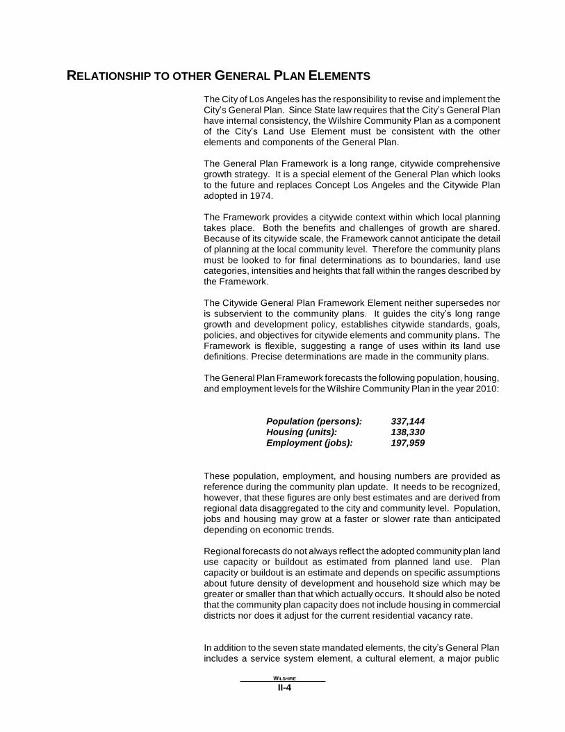
RELATIONSHIP TO OTHER GENERAL PLAN ELEMENTS
The City of Los Angeles has the responsibility to revise and implement the City’s General Plan. Since State law requires that the City’s General Plan have internal consistency, the Wilshire Community Plan as a component of the City’s Land Use Element must be consistent with the other elements and components of the General Plan.
The General Plan Framework is a long range, citywide comprehensive growth strategy. It is a special element of the General Plan which looks to the future and replaces Concept Los Angeles and the Citywide Plan adopted in 1974.
The Framework provides a citywide context within which local planning takes place. Both the benefits and challenges of growth are shared. Because of its citywide scale, the Framework cannot anticipate the detail of planning at the local community level. Therefore the community plans must be looked to for final determinations as to boundaries, land use categories, intensities and heights that fall within the ranges described by the Framework.
The Citywide General Plan Framework Element neither supersedes nor is subservient to the community plans. It guides the city’s long range growth and development policy, establishes citywide standards, goals, policies, and objectives for citywide elements and community plans. The Framework is flexible, suggesting a range of uses within its land use definitions. Precise determinations are made in the community plans.
The General Plan Framework forecasts the following population, housing, and employment levels for the Wilshire Community Plan in the year 2010:
Population (persons): Housing (units): Employment (jobs):
337,144 138,330 197,959
These population, employment, and housing numbers are provided as reference during the community plan update. It needs to be recognized, however, that these figures are only best estimates and are derived from regional data disaggregated to the city and community level. Population, jobs and housing may grow at a faster or slower rate than anticipated depending on economic trends.
Regional forecasts do not always reflect the adopted community plan land use capacity or buildout as estimated from planned land use. Plan capacity or buildout is an estimate and depends on specific assumptions about future density of development and household size which may be greater or smaller than that which actually occurs. It should also be noted that the community plan capacity does not include housing in commercial districts nor does it adjust for the current residential vacancy rate.
In addition to the seven state mandated elements, the city’s General Plan includes a service system element, a cultural element, a major public
WILSHIRE
II-4

facilities element and an air quality element. All provisions and requirements of these elements apply to the Wilshire Community Plan.
Additional working tools within the Wilshire Community Plan include specific plans, business improvement districts (BIDs), historical preservation overlay zones (HPOZs), community design overlay districts (CDOs), Streetscape programs, Streetscape plans, Neighborhood Traffic Mitigation Plans (NTMP), mixed use (MU) districts, and community redevelopment areas under jurisdiction of the Community Redevelopment Agency (CRA). These districts and zones combine planning policy and specific implementation tools to address detailed issues specific to local neighborhoods.
The community plan also includes appropriate policies generated from mitigation measures relating to the Environmental Impact Report (EIR) and Transportation Improvement and Mitigation Program (TIMP) prepared as part of the plan.
PLAN CONSISTENCY
The City of Los Angeles has the responsibility to maintain and implement the City’s General Plan. Since state law requires that the General Plan have internal consistency, the Wilshire Community Plan must be consistent with the other elements and components of the General Plan.
Each plan land use category indicates the corresponding zones permitted by the plan, unless further restricted by the plan text, footnotes, specific plans, or other limitations established by discretionary approval. The plan recognizes that the residential densities and industrial densities depicted on the plan map are theoretical and may not occur due to plan and zone regulations, economic conditions and design limitations.
For each plan category, the plan permits all identified corresponding zones, as well as those zones which are more restrictive as referenced in Section 12.23 of the Los Angeles Municipal Code (LAMC). Any subsequent action that modifies the plan or any monitoring review that results in changes to the plan must make new plan consistency findings at the time of that decision.
City actions on most discretionary projects require a finding that the action is consistent or in conformance with the General Plan. In addition to the required general finding, decision makers acting on certain projects in the Wilshire Community Plan area shall refer to each of the applicable additional findings that the plan identifies as programs, policies, or objectives contained in Chapter III. To further substantiate the consistency findings, decision makers may cite other programs, policies or objectives that would be furthered by the proposed project. In addition, Chapter V of the Plan requires a decision-maker to make a finding of conformance with applicable design standards for discretionary projects.
PLAN MONITORING
WILSHIRE
II-5

In order to accommodate changes in anticipated population growth, The Wilshire Community Plan has a theoretical maximum land use and population capacity greater than the projected development likely to occur during the Community Plan period. The Framework Element of the General Plan commits the Department of City Planning to develop a monitoring system and prepare an annual report on growth and infrastructure, to be submitted to the City Planning Commission, Mayor and City Council.
In the fifth year following plan adoption (and every five years thereafter), the Director of Planning shall report to the commission on the relationship between population, employment, housing growth and plan capacities. If growth has occurred faster than projected, a revised environmental impact analysis will be prepared and appropriate changes recommended to the community plan. These plan and zoning changes shall be submitted to the Planning Commission, Mayor and City Council as specified in the Los Angeles Municipal Code.
WILSHIRE
II-6

Chapter III
LAND USE PLAN POLICIES AND PROGRAMS
Chapter III of the plan text contains goals, objectives, policies, and programs relating to all land use issues including residential, commercial and industrial, as well as public and institutional designations. The Planning Department has responsibility for the goals, objectives, policies, initiation, and implementation of the programs contained in this chapter.
RESIDENTIAL The quality of life and stability of neighborhoods throughout the Wilshire Community Plan Area critically depend on the adequate provision of infrastructure resources (e.g., transportation, police, fire, water, sewerage, parks, etc.) commensurate with the needs of the population.
If population growth occurs faster than projected, and without needed infrastructure improvements to keep pace with that growth, the quality of life within the Wilshire Community would be adversely affected.
Accordingly, with regard to residential land use planning, the proposed Wilshire Community Plan has three fundamental premises.
1) A general limitation of residential densities in various neighborhoods
to the prevailing existing density of development within these neighborhoods.
2) The monitoring of population growth and infrastructure
improvements through the City’s Annual Report on Growth and Infrastructure, with a report to the City Planning Commission every five years on the Wilshire Community following Plan adoption.
3) If this monitoring finds that population in the Plan area is occurring
faster than projected; and that infrastructure resource capacities are threatened in relation to user need, particularly critical ones such as water and sewerage, but also including public schools, police and fire services, and transportation infrastructure; and, that there is not a clear commitment to at least begin the necessary improvements within twelve months; then building controls would be put into effect for the affected portions of the Wilshire Community until land use designations for the Community Plan and corresponding zoning are revised to more appropriately limit new development.
The Community Plan includes appropriate policies and implementation measures generated from the mitigation measures which are listed in the Environmental Impact Report (EIR) and Transportation Improvement and Mitigation Program (TIMP). In many instances these measures also encompass the policies contained in the General Plan Framework Element.
The following table depicts the reasonable expected population and dwelling unit count for the year 2010, using a mid-point range for the dwelling-units-per-acre category. The mid-point represents a reasonable factor, since new development within each land use category is unlikely
__________WILSHIRE__________
III-1

to occur at the extremes of the range, but more likely, throughout the range.
PLAN POPULATION AND DWELLING UNIT CAPACITY
RESIDENTIAL DU’S PER NET NET NUMBER OF PERSONS PER REASONABLE
LAND USE ACRE MIDPOINT ACRE DWELLING DWELLING UNIT EXPECTED
CATEGORY (RANGE) UNITS (2010) POPULATION (2010)
VERY LOW I
2
(1 to 3)
24
48
2.98
143
VERY LOW II
3.5
(3 to 4)
287
1,004
2.98
2,992
LOW I
4.5
(4 to 9)
111
499
2.98
1,487
LOW II
7 (4 to 9)
1,494
10,458
2.98
31,164
LOW MEDIUM I
13.5
(9 to 18)
550
7,425
2.53
18,785
LOW MEDIUM II
23.5
(18 to 29)
291
6,838
2.53
17,300
MEDIUM
42 (29 to 55)
1061
44,562
2.45
109,177
HIGH MEDIUM
82 (55 to 109)
773
63,386
2.45
155,296
TOTALS
- - - -
4,592
134,300
2.51
336,344
GOAL 1 Objective 1-1
PROVIDE A SAFE, SECURE, AND HIGH QUALITY RESIDENTIAL
ENVIRONMENT FOR ALL ECONOMIC, AGE, AND ETHNIC
SEGMENTS OF THE WILSHIRE COMMUNITY. Provide for the preservation of existing quality housing, and for the development of new housing to meet the diverse economic and physical needs of the existing residents and expected new residents in the Wilshire Community Plan Area to the year 2010.
Policies
1-1.1 Protect existing stable single family and low density residential
neighborhoods from encroachment by higher density residential uses and other uses that are incompatible as to scale and character, or would otherwise diminish quality of life.
Program: The Community Plan Map identifies lands where only single family residential development is permitted. These areas are protected by designating appropriate densities for each land use category designation and for each corresponding zone, to minimize incompatible uses.
__________WILSHIRE__________
III-2

1-1.2 Promote neighborhood preservation in all stable residential neighborhoods.
Program: With the implementation of the Wilshire Community Plan, all discretionary actions, Specific Plans, and any community and neighborhood residential projects must be consistent with Wilshire Community Plan recommendations.
Program: The Neighborhood Preservation Program administered
by the City’s Housing Department provides financial assistance rehabilitating Single Family homes and Multiple Family housing.
Program: Provide loans to owners of small residential buildings (one to four units) to correct code violations through the Homeowners Encouragement Loan Program (HELP), administered by the City’s Housing Department.
1-1.3 Provide for adequate Multiple Family residential development.
Program: The Community Plan Map, identifies land where Multiple Family residential development is permitted.
1-1.4 Provide for housing along mixed-use boulevards where
appropriate.
Program: Create Mixed Use Districts along targeted boulevards identified in the General Plan Framework to support the construction of mixed use development
Program: Implement a Mixed Use District in the Wilshire Center Area, including the area generally bounded by Third Street, Hoover Street, Olympic Boulevard, and Western Avenue.
Objective 1-2 Reduce vehicular trips and congestion by developing new housing in
close proximity to regional and community commercial centers, subway stations and existing bus route stops.
Policies
1-2.1 Encourage higher density residential uses near major public
transportation centers.
Program: To accommodate the anticipated population increase to the Wilshire Community Plan Area by the year 2010, the Plan designates a number of increased residential density city blocks, in close proximity to the City’s highest number of major public transit corridors, major bus route stops, and subway stations.
Objective 1-3 Preserve and enhance the varied and distinct residential character and
integrity of existing residential neighborhoods.
Policies
__________WILSHIRE__________
III-3

1-3.1 Promote architectural compatibility and landscaping for new Multiple Family residential development to protect the character and scale of existing residential neighborhoods.
Program: Develop Community Design Overlays (CDO) and companion Streetscape Plans for the Miracle Mile Regional Center (generally from Highland on the east to La Cienega on the west); for Third Street (between Fairfax and La Cienega); for Fairfax Avenue (between Third and Rosewood, and between Olympic and Pico); and Melrose Avenue (between Van Ness and Hoover). Design Guidelines for corresponding Multiple Family Residential Development are listed in Chapter V.
1-3.2 Support historic preservation goals in neighborhoods of
architectural merit and/or historic significance.
Program: Develop Historic Preservation Overlay (HPOZ) districts for the Windsor Square and Hancock Park neighborhoods, and other neighborhoods as appropriate including the Miracle Mile and Beverly-Fairfax neighborhoods, with community involvement and support.
Program: In recognition of the historic and intended park-like settings of many neighborhoods such as Hancock Park and Windsor Square, facilitate and support application and enforcement of existing regulations that establish minimum setbacks and limit fences, walls and hedges.
1-3.3 Promote the preservation and rehabilitation of individual
residential buildings of historic significance
Program: Facilitate the declaration of Historic-Cultural Monuments through the Cultural Affairs Department on a building-by-building basis. Raise awareness within the community of this and other public and private resources available to protect and rehabilitate historic structures.
Program: Inventory neighborhoods in the Pico/Normandie area and identify possible candidates for Historic-Cultural Monument status, and neighborhoods for possible inclusion in an Historic Preservation Overlay District as a means to preserve architectural diversity and built history.
1-3.4 Monitor the impact of new development on residential streets.
Locate access to major development projects so as not to encourage spillover traffic on local residential streets.
Program: Incorporate Neighborhood Traffic Mitigation Plans (NTMP) for major development and provide LADOT assistance to neighborhoods in design of NTMP’s.
Objective 1-4 Provide affordable housing and increased accessibility to more population
segments, especially students, the handicapped and senior citizens.
__________WILSHIRE__________
III-4

Policies
1-4.1 Promote greater individual choice in type, quality, price and location of housing.
Program: The plan promotes greater individual choice by allocating adequate lands in the Plan Area for a variety of residential densities, and for the promotion of housing in mixed-use projects.
1.4-2 Ensure that new housing opportunities minimize displacement of
residents.
Program: Decision-makers should adopt displacement findings in any decision relating to the construction of new housing.
1.4-3 Encourage multiple family residential and mixed use
development in commercial zones.
Program: The community plan identifies areas for mixed use development in commercial zones, as illustrated on the General Plan Framework Map.
Program: Create and implement mixed-use districts along boulevards as designated in the General Plan Framework.
COMMERCIAL Commercial land uses designated in the Wilshire Community Plan consist of 1,129 acres or 12 percent of the total plan acreage. In 1996, the Wilshire area contained approximately 40,004,300 million square feet of commercial development. Approximately 20,520,100 million square feet (51 percent) was devoted to office use and 19,484,200 million (49 percent) to retail use.
Most of the commercial development can be categorized within four concentrations based on the general orientation of uses: Regional, Community, General, and Neighborhood. The General Plan Framework Element identifies and sets forth criteria of these designations.
REGIONAL COMMERCIAL
Four major areas designated in the Plan as Regional Commercial include: Wilshire Center Regional Commercial Center; the Miracle Mile Regional Commercial Center; the Beverly Center-Cedars Sinai Regional Commercial Center; and the Koreatown Regional Commercial Center. They total approximately 270 acres.
Wilshire Center Regional Commercial Center
The Wilshire Center Regional Commercial Center is approximately 100 acres in size. It includes a dense collection of high rise office buildings, large hotels, regional shopping complexes, churches, entertainment centers, and both high-rise and low-rise apartment buildings.
__________WILSHIRE__________
III-5

The Regional Commercial Center includes Wilshire Boulevard in the eastern central portion of the Plan Area and is generally bounded by 3rd
Street on the north, 8th Street on the south, Hoover Street on the east, and Wilton Place on the west.
The Regional Commercial Center includes the Vermont, Normandie, and Western Metro Red Line subway stations along Wilshire Boulevard.
Wilshire Center is designated in both the General Plan Framework Element and on the Community Plan Land Use Diagram as a Regional Commercial Center.
Miracle Mile Regional Commercial Center
The Miracle Mile Regional Commercial Center is approximately 100 acres in size. It is centered around Wilshire Boulevard in the west central portion of the plan area, and is generally bounded by 6th Street on the north; 8th Street on the south; Sycamore Avenue on the east; and San Vicente Boulevard on the west.
Miracle Mile is characterized primarily by numerous high rise office buildings, mid to low rise apartments, single-family areas south of 8th
Street, entertainment centers, museums, and regional shopping complexes. Both the General Plan Framework Element and the Community Plan Land Use Diagram designate the Miracle Mile as a Regional Commercial Center.
Beverly Center-Cedars Sinai Regional Commercial Center
The Beverly Center-Cedars Sinai Regional Commercial Center is approximately 60 acres in size. It is centered around Alden Drive and San Vicente Boulevard in the northwestern portion of the Plan Area, and is generally bounded by Beverly Boulevard on the north, 3rd Street on the south, La Cienega Boulevard on the east, and Robertson Boulevard on the west.
The Beverly Center-Cedars Sinai Regional Commercial Center is primarily improved with high-rise medical and office buildings, hotels, apartment towers, entertainment centers and regional shopping complexes.
It is designated in the General Plan Framework Element, and on the Community Plan Land Use Diagram as a Regional Commercial Center.
Koreatown Regional Commercial Center
The Koreatown Regional Commercial Center runs along Olympic Boulevard, directly south of Wilshire Center. The intersection of Western Avenue and Olympic Boulevard is the core of this center. It is in the southwestern portion of the Plan Area, and is generally bounded by Eighth Street on the north, Twelfth Street on the south, Western Avenue on the west, and continues east towards Vermont Avenue.
The Regional Center includes low to mid-rise office and retail uses along Olympic Boulevard, with adjoining multiple family apartment blocks. The
__________WILSHIRE__________
III-6

area is a cultural meeting place and nucleus of Korean American businesses, restaurants, and shops in addition to a wide range of community serving commercial uses and large shopping centers.
COMMUNITY COMMERCIAL
There are four main areas designated as Community Commercial Centers in the Wilshire Community Plan.
These include: the Crenshaw Community Center; the Pico Community Center; the Beverly-Fairfax Community Center, and the Vermont Community Center .
Crenshaw Community Commercial Center
The Crenshaw Community Center is approximately 34 acres in size. It is centered around Crenshaw and Olympic Boulevards in the southeastern
portion of the Plan Area, and is generally bounded by 9th Street on the north, Country Club Drive on the south, Bronson Avenue on the east, and Victoria Avenue on the west.
The Community Center includes the Crenshaw Shopping Center. The area has been developed with commercial land uses ranging from one and two-story retail uses to high-rise office buildings and large shopping centers.
Olympic Boulevard between Crenshaw Boulevard and Wilton Place is designated as a Mixed Use Boulevard on the Community Plan Land Use Diagram. The majority of this segment is shown as Community Commercial on the Plan Map.
Pico Community Commercial Center
The Pico Community Center is approximately 34 acres in size. It is centered around Pico, San Vicente and Venice Boulevards in the south central portion of the Plan Area, and is generally bounded by Pico Boulevard on the north; Venice Boulevard on the south; West Boulevard on the east; and Mansfield Avenue on the west.
The Community Center includes a supermarket and shopping area, and the Santa Monica-Metro Bus Customer Service Center Station. The area has been developed with commercial land uses ranging from one and two-story retail to high-rise office buildings and large shopping centers. The entire length of Pico Boulevard is designated as a Mixed Use Boulevard on the Community Plan Land Use Diagram. This segment is shown as Community Commercial on the Plan Map.
Beverly-Fairfax Community Commercial Center
The Beverly-Fairfax Community Center is approximately 34 acres in size. It is in the northwestern portion of the Plan Area, and is generally bounded by Beverly Boulevard on the north, 3rd Street on the south, Gardener Avenue on the east, and Fairfax on the west.
The Community Center includes the Farmer’s Market shopping complex;
__________WILSHIRE__________
III-7

CBS Television City Studios; and the Pan Pacific Regional Park. The area has been developed with commercial land uses ranging from one and two-story retail to high-rise office, multiple apartment towers, wholesale nurseries, and large shopping centers.
Beverly Boulevard and Fairfax Avenue are designated as Mixed Use Boulevards on the Community Plan Land Use Diagram. The majority of these segments are shown as Community Commercial on the Plan Map.
Vermont Community Commercial Center
The Vermont Community Center is approximately 34 acres in size. It is centered around Vermont Avenue and Beverly Boulevard in the northeastern portion of the plan area. It is generally bounded by the Hollywood 101 Freeway to the north; Council and 1st Streets to the south; Hoover Street to the east; and New Hampshire Street to the west.
The Community Center includes the Vermont-Beverly Metro Red Line station. A Station Neighborhood Area Plan (SNAP) for this area as well as along portions of Vermont Avenue and Hollywood Boulevard has been created to regulate development in conjunction with the Metro Red Line subway.
NEIGHBORHOOD DISTRICTS
There are four areas within the Wilshire Community Plan Area that are designated as Neighborhood Districts by the Community Plan Land Use Diagram. The four Neighborhood Districts total approximately 150 acres.
The Larchmont Neighborhood District includes commercial frontage along
Larchmont Boulevard from Beverly Boulevard on the north to 1st Street on the south. Uses permitted in this unique neighborhood district are limited by special zoning regulations intended to protect and promote Larchmont Boulevard as a neighborhood-serving shopping district.
Other neighborhood districts include: the Fairfax-Beverly Neighborhood District (Fairfax Avenue frontage from Rosewood Avenue on the north, to Beverly Boulevard on the south); the 3rd Street Neighborhood District (3rd
Street frontage from Fairfax Avenue on the east, to La Jolla Avenue on the west); and the Fairfax-Olympic Neighborhood District (Fairfax Avenue frontage from Olympic Boulevard on the north, to Pico Boulevard on the south).
These areas are primarily developed into small commercial village arrangements, with one to four-story retail and office uses, and a mix of residential units.
GENERAL COMMERCIAL
The remaining commercial areas, designated as General Commercial, consist of approximately 325 acres and are located on portions of Wilshire, Pico, and Olympic Boulevards.
Land uses on Pico and Olympic Boulevards include one to three-story retail and office buildings. The south side of Olympic Boulevard is predominantly improved with retail and office uses, but also supports several older low-density apartment buildings, motels and auto-oriented establishments. It is identified as a Mixed Use Boulevard on the
__________WILSHIRE__________
III-8
Community Plan Land Use Diagram.
MIXED USE BOULEVARDS
The Mixed Use Boulevard concept encourages cohesive commercial development integrated with housing.
These structures incorporate retail, office and/or parking on the lower floors and residential units on the upper floors. The mixed use concept also accommodates separate commercial and residential structures in the same block.
The intent of mixed use development is to provide housing in close proximity to jobs and services, to reduce vehicular trips, traffic congestion and air pollution, to provide rental housing, and to stimulate vibrancy and activity in pedestrian-oriented areas.
Mixed use development may also provide community facilities such as libraries, meeting rooms, post offices, senior centers, or child day care facilities.
The Wilshire Community Plan aims to encourage well planned and integrated mixed use developments in designated commercial areas which have the potential to benefit from pedestrian oriented development. To that end, the plan calls for the creation of Mixed-Use Districts (MUs) and the policies, incentives, and design standards contained therein.
The plan supports applicable commercially zoned portions of the following as mixed-use boulevards and districts, as shown on the General Plan Framework map:
3rd Street (From La Cienega to Fairfax, From Western to Vermont) 8th Street (From Western to Vermont) Beverly Blvd (From Fairfax to Gardner, From Western to Vermont) Fairfax Ave (From Wilshire to Beverly) La Brea Ave (From Wilshire to Beverly) La Cienega (From 18th to Olympic) Larchmont Blvd (From Melrose to Beverly) Olympic Blvd (From Crenshaw to Hoover) Pico Blvd (From Crest to Hoover) Robertson Blvd (From Gregory to 18th) Vermont Ave (From Beverly to Pico) Western Ave (From Melrose to Pico) Wilshire Center (Commercial areas within the area bounded by 6th
Street, Vermont Avenue, 8th Street, and Western Avenue)
GOAL 2 Objective 2-1
ENCOURAGE STRONG AND COMPETITIVE COMMERCIAL SECTORS
WHICH PROMOTE ECONOMIC VITALITY AND SERVE THE NEEDS OF
THE WILSHIRE COMMUNITY THROUGH WELL-DESIGNED, SAFE
AND ACCESSIBLE AREAS, WHILE PRESERVING HISTORIC AND
CULTURAL CHARACTER. Preserve and strengthen viable commercial development and provide additional opportunities for new commercial development and services
__________WILSHIRE__________
III-9

within existing commercial areas.
Policies
2-1.1 New commercial uses should be located in existing established commercial areas or shopping centers.
2-1.2 Protect existing and planned commercially zoned areas,
especially in Regional Commercial Centers, from encroachment by stand alone residential development by adhering to the community plan land use designations.
2-1.3 Enhance the viability of existing neighborhood stores and
businesses which support the needs of local residents and are compatible with the neighborhood.
Program: Coordinate with the City Clerk’s Office to assist businesses in obtaining technical and financial assistance for the formation of Business Improvement Districts (BID) and of other programs from the City of Los Angeles.
Objective 2-2 Promote distinctive commercial districts and pedestrian-oriented areas.
Policies
2-2.1 Encourage pedestrian-oriented design in designated areas and in new development.
Program: Establish Community Design Overlay Districts (CDOs), and Pedestrian Oriented Districts (PODs), which have design policies in designated areas to ensure the creation of pedestrian-friendly commercial development. Develop a CDO for the Miracle Mile area.
Program: Implement the Design Guidelines in Chapter 5, as they apply to commercial projects and projects located within Neighborhood Districts.
2-2.2 Encourage large mixed use projects to incorporate facilities
beneficial to the community such as libraries, child care facilities, community meeting rooms, senior centers, police sub-stations, and/or other appropriate human service facilities as part of the project.
2-2.3 Encourage the incorporation of retail, restaurant, and other
neighborhood serving uses in the first floor street frontage of structures, including mixed use projects located in Neighborhood Districts.
Objective 2-3 Enhance the visual appearance and appeal of commercial districts.
Policies
__________WILSHIRE__________
III-10

2-3.1 Improve streetscape identity and character through appropriate controls of signs, landscaping, and streetscape improvements; and require that new development be compatible with the scale of adjacent neighborhoods.
Program: Prepare Streetscape Plans for commercial corridors to coordinate and improve the public streetscape as funds become available for implementation and construction.
Program: Work with the Wilshire Center BID to formally adopt existing streetscape plans for that portion of Wilshire Boulevard between Western and Hoover Street.
Program: Create a Streetscape Plan for the Miracle Mile, in conjunction with the proposed Community Design Overlay to coordinate and improve the public realm in conjunction with private urban design and facade improvements.
Program: Encourage the application of the Design Standards in Chapter 5 of the Plan by other City Departments, public agencies, and the private sector regarding improvement of public spaces and rights-of-way in commercial areas, especially in Community Commercial and Regional Commercial Centers.
Program: Promote assistance from the City of Los Angeles in the creation and implementation of Business Improvement Districts (BID).
INDUSTRIAL The Wilshire area includes only minimal light industrial uses. In 1990, there were approximately 1.5 million square feet of industrial development in the Wilshire Community Plan Area, representing 0.05 percent of the total industrial square footage in the City of Los Angeles.
A total of 38 acres, or .43 percent of the total Plan Area is designated for industrial use. The largest such area is located along Beverly Boulevard, from Oakwood Avenue on the north, to Council and 1st Streets on the south, to Hoover Street on the east, to Juanita Avenue on the west, and is occupied by various business park type uses.
The Raleigh Studio site, between Melrose Avenue, Clinton Street, Van Ness Avenue and Bronson Avenue, is also designated as industrial land use in the Plan.
Some of these areas have been developed with two story retail and medium-rise office buildings (two to four stories); however, the majority of the area has been developed with retail/wholesale businesses and light manufacturing uses.
GOAL 3 PROVIDE SUFFICIENT LAND FOR LIGHT INDUSTRIAL USES WITH
EMPLOYMENT OPPORTUNITIES THAT ARE SAFE FOR THE
ENVIRONMENT AND WORKERS, AND WHICH HAVE MINIMAL
ADVERSE IMPACT ON ADJACENT USES.
__________WILSHIRE__________
III-11

Objective 3-1 Retain existing industrial uses and promote future development,
especially in entertainment and high technology applications, which contribute to job opportunities and minimize environmental impacts.
Policies
3-1.1 Designate and preserve lands for the continuation of existing
industry and for the development of new industrial parks, research and development uses, light manufacturing and similar uses.
3-1.2 Encourage compliance with environmental protection standards
and health and safety requirements.
Program: Continue to enforce environmental protection
standards and health and safety requirements through the appropriate Federal, State, County, and City agencies.
Objective 3-2 Improve the aesthetic quality and design of industrial areas, eliminate
blight and detrimental visual impact, and mitigate noise and air quality impacts generated by industrial uses on nearby residential neighborhoods.
Policies
3-2.1 Encourage new industrial development designs to be compatible
with adjacent land uses.
Encourage appropriate building orientation and scale, landscaping, buffering and increased setbacks in the development of new industrial properties.
Program: Require new industrial development located adjacent to residential neighborhoods to conform with the Industrial/Residential Design Guidelines in Chapter 5 of this Plan.
Program: Study the creation of a Community Design Overlay District (CDO) to resolve issues of visual blight along Pico and Venice Boulevard industrial areas.
3-2.2 To buffer residential/industrial land uses, promote a transition of
industrial uses, from intensive uses to less intensive uses, in those areas in close proximity to residential neighborhoods.
Objective 3-3 Continue to promote light industrial uses and accompanying employment
bases in locations which are in close proximity to public transportation facilities and are compatible with surrounding land uses.
Policies
3-3.1 Minimize environmental impacts of industrial uses from other
__________WILSHIRE__________
III-12

uses by highways and other physical barriers.
Program: Implement this policy according to the land use designations on the Plan Maps, Map Footnotes, and the corresponding zoning.
RECREATION AND PARK FACILITIES
The Public Recreation Plan of the City of Los Angeles provides an official guide for considering minimum needs of neighborhoods and communities for recreational sites. It sets forth standards for the size, service areas, and types of facilities needed as recreation sites.
The City of Los Angeles Recreation and Parks Department operates 20 public parks and recreational facilities in the Wilshire Community Plan area. Parks are classified as Regional, Community, and Neighborhood. The Wilshire Community Plan designates approximately 191 acres of park land, including about 100 acres of private golf course (Wilshire Country Club). There are 10 Neighborhood Parks and Recreation Centers, 9 Community Parks and Recreation Centers, and one Regional Park.
The public parks and recreational facilities in the Wilshire Community Plan area are seriously inadequate by all Federal, State, and local standards to meet the needs of residents in the Wilshire Community Plan Area.
GOAL 4 Objective 4-1
PROVIDE ADEQUATE RECREATION AND PARK FACILITIES TO
MEET THE NEEDS OF RESIDENTS IN THE WILSHIRE COMMUNITY
PLAN AREA. Conserve, maintain and better utilize existing recreation and park facilities which meet the recreational needs of the community.
Policies
4-1.1 Preserve and improve the existing recreational facilities and
park spaces.
Program: Maintain all open space designations within the Wilshire Community Plan. Designate open space parkland as acquired by the Department of Recreation and Parks.
4-1.2 Encourage the shared use of other public facilities for recreational
purposes.
Program: The Planning Department encourages the Los Angeles Unified School District and the City’s Department of Recreation and Parks to continue to develop and implement programs to fully utilize the shared use potential of each of their respective sites.
__________WILSHIRE__________
III-13

Objective 4-2 Provide facilities for specialized recreational needs by utilizing existing
public lands such as utility easements, Department of Water and Power properties, and unused or underutilized rights-of-way.
Policies
4-2.1 Underutilized public lands should be considered for open space
and recreational purposes.
Program: Implement walking and jogging trails within the landscaped median portions of Designated Scenic Highways including San Vicente Boulevard and Highland Avenue, as land and funding become available; and if compatible with use as a transportation corridor.
Objective 4-3 Ensure the accessibility, security and safety of parks by their users,
particularly families with children and senior citizens.
Policies
4-3.1 Ensure that parks are adequately policed, monitored, maintained and illuminated for safe use at night, as appropriate.
Program: Continue the management, design, construction and maintenance of public parks, by the Department of Recreation and Parks.
Program: Continue the provision of security and patrols of public parks and recreational facilities by the Los Angeles Police Department.
Objective 4-4 Expand and improve Neighborhood, Community, and Regional Parks,
and Recreation Centers and Senior Citizen Centers throughout the Wilshire Community Plan Area on an accelerated basis, as funds and land become available.
Policies
4-4.1 Develop new Neighborhood and Community parks to help offset the Wilshire Community’s parkland deficit for both its current population, and for the projected year 2010 population.
Program: Continue the location of development opportunities for new park sites, by the Department of Recreation and Parks, utilizing community input and available funds.
Program: Facilitate the creation of small neighborhood serving pocket parks within highly urbanized areas as potential parcels and funding become available.
Program: Develop City or private funding programs for the
__________WILSHIRE__________
III-14

acquisition and construction of new recreation and park facilities.
Program: Establish joint-use agreements with the Los Angeles Unified School District and other public and private entities which could contribute to the availability of recreational opportunities in the community plan area.
Program: Implement the Wilshire Community Plan recommendations for new Pocket Parks and Neighborhood Park expansions along all Boulevards, within public right-of-ways, and on unused and underutilized public properties, particularly as expansions of existing facilities, as land and funding become available; and if compatible with uses as transportation corridors, where applicable.
Program: Encourage the expansion of the Queen Anne Park and Recreation Center, at West Boulevard, 12th Street, and Queen Anne Place, southerly to Pico Boulevard, through joint agency efforts among the Community Redevelopment Agency (CRA), the Metropolitan Transportation Authority (MTA), and the Department of Recreation and Parks.
OPEN SPACE There are two classifications of open space: publicly-owned and privately-
owned.
Open Space is broadly defined as land which is essentially free of structures and buildings or is natural in character, and is categorized by one or more of the following functions:
1. Recreational and educational opportunities. 2. Scenic, cultural, and historic values. 3. Public health and safety.
4. Preservation and creation of community identity.
5. Right-of-ways for utilities and transportation facilities.
6. Preservation of physical resources or ecologically important areas. 7. Preservation of scenic resources including topographic features.
Lands designated as Open Space in the Wilshire Community Plan include the private Wilshire Country Club and Golf Course, as well as all public parklands.
GOAL 5 Objective 5-1
PROVIDE SUFFICIENT OPEN SPACE IN BALANCE WITH
DEVELOPMENT TO SERVE THE RECREATIONAL, ENVIRONMENTAL,
HEALTH AND SAFETY NEEDS OF THE WILSHIRE COMMUNITY, AND
TO PROTECT ENVIRONMENT AND AESTHETIC RESOURCES. Preserve existing open space resources and where possible develop new open space.
Policies
5-1.1 Encourage the retention of passive and visual open space to
__________WILSHIRE__________
III-15

provide a balance to urban development.
Program: The land use plan map designates areas to be preserved as open space.
5-1.2 Encourage continuous efforts by Federal, State and County
agencies to acquire additional vacant land for open space.
Program: Encourage the utilization of the Open Space and parkland purchase programs available through Federal, State and County agencies.
5-1.3 Convert and upgrade underutilized publicly-owned property.
Program: Improve available rights-of-way throughout the Wilshire Community Plan area with landscaping, benches, picnic sites, walkways, for low-intensity recreational uses.
Encourage this improvement separately, and in combination with transit center or busway improvements, currently under study by the MTA.
5-1.4 Unused or underutilized public lands should be considered for
open space and recreational purposes.
Program: Encourage the development of Neighborhood Parks and Pocket Parks along public right-of-ways and vacant public parcels.
SCHOOLS The Los Angeles Unified School District (LAUSD) administers the
planning, location, design, development, and operation of all public schools in the Wilshire Community Plan Area.
There are 21 Public Elementary Schools, three Public Middle Schools, and one Public High School within the Wilshire Community Plan Area, all of which are operating above capacity. Many of the public schools are among the oldest in the City of Los Angeles. They are all in need of substantial repairs and improvements
The Plan encourages shared use of existing public school facilities for the general public after hours, on weekends, and on holidays, as class schedules allow. School grounds should be made available so as to facilitate after school hour recreational uses.
GOAL 6 Objective 6-1
FACILITATE THE PROVISION OF PUBLIC SCHOOLS AND
ADEQUATE SCHOOL FACILITIES TO SERVE EVERY
NEIGHBORHOOD IN THE WILSHIRE COMMUNITY PLAN AREA. Locate schools in areas complimentary to existing surrounding land uses with buffering, convenient to local neighborhoods, and with access to recreational opportunities.
Policies
__________WILSHIRE__________
III-16

6-1.1 Encourage compatibility between school locations, site layouts, architectural designs, and local neighborhood character.
Program: Require decision-makers in discretionary review actions for a proposed public school, to adopt findings which support this policy.
6-1.2 Encourage public school design that buffers classrooms from
noise sources.
Program: Implement appropriate provisions of the City’s Noise Element of the General Plan, specific for application of daytime school use, which requires noise measurements be made over the typical hours of use, instead of a 24-hour measurement.
Program: Incorporate noise mitigation measures to reduce
adverse environmental impacts in compliance with California Environmental Quality Act (CEQA) Guidelines.
6-1.3 Expansion of existing public school facilities should be
considered prior to acquisition of new sites.
Program: Coordinate Wilshire Community Plan Area possible school site locations with the Los Angeles Unified School District (LAUSD), the responsible agency for providing public school facilities.
6-1.4 Encourage cooperation between the LAUSD and the
Department of Recreation and Parks to provide shared use of schools and recreation facilities for the entire Wilshire Community.
Program: Continue to assist the LAUSD and the Department of Recreation and Parks with the shared-use program where both public schools and parks are utilized for recreational and instructional purposes.
Objective 6-2 Continue to work constructively with the LAUSD to promote the siting and
construction of adequate public school facilities phased with anticipated population growth in the Wilshire Community Plan Area.
Policies
6-2.1 Explore creative alternatives for providing new public school
sites in the Wilshire Community Plan Area, where appropriate.
Program: Develop plans to work to resolve issues of siting and joint use of facilities, especially including strategies for school expansions in close proximity to major public transit routes.
Program: Utilize the City’s Annual Report on Growth & Infrastructure for growth and potential new school sites.
__________WILSHIRE__________
III-17

Objective 6-3 Maximize the use of public schools for neighborhood use, and of local
open space and parks for public school use.
Policies
6-3.1 Continue to encourage the siting of neighborhood facilities (e.g., libraries, parks, schools, and auditoriums) together as shared-use facilities.
Program: Formulate and update plans to work to resolve issues relating to siting and the joint use of such neighborhood facilities.
Identify strategies for the expansion of public school facilities including:
1) Encourage siting of public schools and other
neighborhood facilities within a transit station, center, or mixed-use area to maximize the most efficient use of the land provided for these services.
2) Locate public middle schools and public high schools
where possible, close to mass transit stations, centers, and mixed-use districts, to allow students to use the transit system to get to and from school.
3) Encourage public and private redevelopment of existing
public school sites in the immediate vicinity of transit stations and centers, so that the existing low density land use would be replaced by a high-intensity mixed-use development that would incorporate school facilities.
Objective 6-4 Encourage the provision of charter schools, especially in the Wilshire
Center area, as an effective method of delivering quality public education facilities at the neighborhood level.
Policies
6-4.1 Recognize the ability of charter schools to effectively provide
classroom space in impacted urban areas.
6-4.2 Encourage the location of charter schools in the Wilshire Center area as a means to alleviate overcrowded school conditions.
Program: Prepare information for distribution at the Department
of City Planning public counter outlining the permitting process for charter schools and identifying suitable land use designations and zones.
6-4.3 Support the construction of charter schools as being desirable
to public convenience and welfare. LIBRARIES Public libraries serve as a center of community activity by providing
__________WILSHIRE__________
III-18

information, research materials, books, journals, and newspapers, and services for students and meeting places. The Public Libraries Plan of the City of Los Angeles serves as a guide for the construction, maintenance, and operation of public library facilities.
There are six Community Branch Libraries within the Wilshire Community Plan Area: Felipe de Neve, Memorial, Mid-City, Pio Pico-Koreatown, Robertson, and Wilshire.
GOAL 7 Objective 7-1
ENSURE THAT ADEQUATE LIBRARY FACILITIES ARE PROVIDED
FOR THE WILSHIRE COMMUNITY. Encourage the City’s Library Department to continue to provide adequate library service to the Wilshire Community Plan Area.
Policies
7-1.1 Support construction of new libraries and rehabilitation and
expansion of existing libraries.
Program: Provide for the retention, rehabilitation and expansion of existing library sites.
7-1.2 Encourage flexibility in siting libraries in mixed-use projects,
shopping malls, pedestrian-oriented areas, office buildings and similarly accessible facilities.
Program: Continue to support such joint-use opportunities, when the Library Department and decision-makers review and approve new libraries sites.
POLICE PROTECTION The Los Angeles Police Department (LAPD) provides police protection
within the Wilshire Community Plan Area.
LAPD facilities include: the Wilshire Area Police Station, and four additional Police Department Stop-In Sites.
There are no further facilities expansion plans at this time.
GOAL 8 Objective 8-1
CONTINUE TO PROVIDE THE WILSHIRE COMMUNITY WITH
ADEQUATE POLICE FACILITIES AND SERVICES TO PROTECT ITS
RESIDENTS FROM CRIMINAL ACTIVITY, REDUCE THE INCIDENCE
OF CRIME, AND PROVIDE OTHER NECESSARY LAW
ENFORCEMENT SERVICES. Provide adequate police facilities, personnel and protection to correspond with existing and future population and service demands
Policies
8-1.1 Consult with the LAPD in the review of development projects
and land use changes to determine law enforcement needs and
__________WILSHIRE__________
III-19

requirements. Objective 8-2 Improve the ability of the community and police department to minimize
crime and provide adequate security for all residents.
Policies
8-2.1 Support and encourage community based crime prevention efforts (such as Neighborhood Watch) through regular interaction and coordination with existing policing, foot and bicycle patrols, community watch programs and regular communication with neighborhood and civic organizations.
Program: Continue to support community-oriented law enforcement programs, as administered by the LAPD.
Program: Encourage Business Improvement Districts to supplement patrol services with private services through training and coordination programs administered by the LAPD.
8-2.2 Provide adequate lighting around residential, commercial and
industrial buildings, and park, school, and recreational areas to improve security.
Program: Coordinate discretionary land use reviews by the Department of City Planning in consultation with the LAPD, and include implementation of the principles of the City of Los Angeles Crime Prevention Through Environmental Design (CPTED) Guidelines.
8-2.3 Ensure that landscaping around buildings does not impede
visibility and provide hidden places which could foster criminal activity.
Program: Continue to apply and require CPTED standards in discretionary land use approvals, in consultation with the LAPD.
FIRE PROTECTION The City of Los Angeles Fire Department provides fire protection within
the Wilshire Community Plan Area.
There are six fire stations within the Wilshire Community Plan Area.
The Fire Protection and Prevention Plan of the City of Los Angeles Fire Department provides an official guide to City Departments, other governmental agencies, developers, and interested citizens for the construction, maintenance, and operation of fire facilities.
It is intended to promote fire prevention by maximizing fire safety education and minimizing loss of life through fire prevention programs. Pursuant to this Plan, it may be necessary to expand or relocate existing facilities as land patterns change.
__________WILSHIRE__________
III-20

GOAL 9 Objective 9-1
PROTECT THE RESIDENTS OF THE WILSHIRE COMMUNITY AREA
THROUGH A COMPREHENSIVE FIRE AND LIFE SAFETY PROGRAM. Maintain fire facilities and protective services that are sufficient for the existing and future population and land use.
Policies
9-1.1 Coordinate with the City of Los Angeles Fire Department during
the review of significant development projects and General Plan amendments affecting land use to determine the impacts on service demands.
Program: Decision-makers should continue to include findings on the impacts on fire service demands of a proposed project or Plan Amendment.
Program: Encourage the continued consultation with the City of Los Angeles Fire Department, which is currently in effect for projects subject to the subdivision process.
9-1.2 Assist the City of Los Angeles Fire Department in locating fire service facilities at appropriate locations throughout the Wilshire Community Plan Area.
Program: Identify locations of existing fire service facilities, and assist in the location of future sites, as determined by the City of Los Angeles Fire Department.
TRANSPORTATION
A number of local, state and regional plans and ordinances, prepared by various public agencies, work to implement transportation improvements in the Wilshire Community Plan Area. These include:
The Los Angeles County Congestion Management Program (CMP); the Long Range Plan prepared by the Los Angeles County Metropolitan Transportation Authority (LACMTA); the Regional Transportation Plan (RTP) prepared by the Southern California Association of Governments (SCAG); and the Statewide Transportation Improvement Program (STIP) prepared by the California Department of Transportation (CALTRANS).
LADOT also implements pedestrian-oriented arterials, bikeways, and transit-priority streets.
TRANSPORTATION
IMPROVEMENT AND
MITIGATION
PROGRAM (TIMP)
A Transportation Improvement and Mitigation Program (TIMP) was prepared for the Wilshire Community Plan Area that analyzes land use impacts on transportation, projected to the year 2010. The TIMP analysis is part of the Environmental Impact Report and is
__________WILSHIRE__________
III-21

prepared to analyze the environmental impacts of implementation of the Wilshire Community Plan.
The TIMP establishes a program of specific measures to reduce land use impacts on transportation to be undertaken during the life of the Wilshire Community Plan. It also takes into account and incorporates the local, state and regional programs noted above.
The Wilshire TIMP provides an implementation program for the circulation needs of the Wilshire Community Plan Area, which consist of recommendations as follows:
A. Street Reclassifications B. Transit Improvements C. Non-Motorized Transportation
D. Transportation Demand Management Strategies (TDM) E. Transportation Systems Management Strategies (TSM) F. Residential Neighborhood Protection Plans G. Parking
H. Capital Improvements
A. STREET RECLASSIFICATIONS
Street Classifications
Streets in the Wilshire Community Plan Area are classified as: Boulevards II and Divided B o u l e v a r d s II; Avenues and DividedAvenues; Collector Streets and Local Streets.
The following reclassifications are made in this plan:
1 Lucerne Bl.
2 Commonwealth Ave.
3 Wilton Place
4 Venice Bl.
5 8th St.
6 Redondo Bl.
7 Westmoreland Ave.
8 June St. 9 Rosewood Ave.
Local Street : From Third St. to Wilshire Bl.
Collector Street : From Beverly Bl. to Wilshire Bl.
Collector Street : From Beverly Bl. to Third St. BoulevardII: From Arlington Avenue to Highland Ave. Collector Street : From Fairfax Ave. to Crenshaw Bl. Modified Collector Street : From La Brea Ave. to Venice Bl.
Local Street : From Wilshire Bl. to 7th
St. Local Street : From Melrose Ave. to 3rd St. Local Street : From Serrano Ave. to Normandie Ave.
_____WILSHIRE____
III-22

10 Stanley Ave. (now The Grove Drive) 11 Virgil Ave.
12 Edgewood Place
13 Crescent Heights Bl.
Collector Street : Beverly Bl. to 3rd St. Avenue (II) : From Beverly Bl. to Wilshire Bl. Collector Street : From Redondo Bl. to La Brea Ave. ModifiedAvenue (III)from Wilshire Bl. to Rosewood Ave. as shown on Exhibits A & B.
Alternate Standards
In addition, the Wilshire Community Plan maintains the following alternate standards for the development of certain streets due to environmental and urban design considerations:
1 Robertson Blvd. (south of Whitworth Drive to 18th)
Modified Avenue II Standard - 80 foot right-of-way, 60 foot roadway
2 Highland Ave. (Between Melrose and Wilshire)
Trees to be preserved; no improvements beyond the existing right-of-way.
3 Wilshire Blvd.
No widening in excess of existing roadway.
4 Beverly Blvd.
No widening of roadway west of Western Avenue.
5 Fairfax
Avenue south of Melrose, modified Boulevard II north of Melrose.
6 Crescent Heights Blvd. Modified Avenue (IIII)from Wilshire Bl. to Rosewood Ave. - Road way restricted to current width along single family, low, and low medium density residential areas as shown in Exhibit A. Permit flaring or other types of improvements at the commercial
intersections at the commercial intersections of Wilshire Bl., 3rd
St., and Beverly Bl. The City may acquire dedication, 100 feet beyond the alley behind these intersections for improvements only if the adjacent lots are ever developed with commercial, commercial parking or high or medium density multiple family residential uses.
It is the intent of this plan for the Avenue (III)to allow traffic signals and other mitigation measures in order to reduce speeds and increase safety, and to restrict, along the single family areas, the function of the roadway to a collector street for all other purposes.
7 Redondo Blvd.
Modified Collector - 70 foot right-of-way, 50 foot roadway to accommodate Class II Bikeway
_____WILSHIRE____
III-23

8 Oxford Avenue
Collector Street standard - 66 foot right-of-way, 40 foot roadway
B. TRANSIT IMPROVEMENTS
Opportunities exist within the Wilshire Community Plan Area to increase the use of public transit. While it is anticipated that the private automobile will remain the primary mode of private transportation within the time frame of the Plan (2000-2010), bus service, community bus and van shuttles, and the Red Line subways will provide alternative public transit modes.
Public transit services in Wilshire are currently provided by the Metropolitan Transportation Authority (MTA), the Los Angeles Department of Transportation (LADOT), and by buses from nearby cities.
The City of Los Angeles continues to work with other public agencies in evaluating travel needs and recommending modifications and improvements to existing public transit systems, and additions of new public transit systems.
GOAL 10 Objective 10-1
DEVELOP ADDITIONAL PUBLIC TRANSIT SERVICES WHICH
IMPROVE MOBILITY WITH EFFICIENT, RELIABLE, SAFE,
CONVENIENT ALTERNATIVES TO AUTOMOBILE TRAVEL. Continue to encourage improved and additional local and express bus service and neighborhood shuttles throughout the Wilshire Community Plan Area. . Policies
10-1.1 Continue to coordinate with the Metropolitan Transportation
Authority (MTA) and the Los Angeles Department of Transportation (LADOT) with plans to improve local and express bus service serving Wilshire.
Program: Increase, expand and implement additional bus service along high travel demand routes, especially east-west along Melrose Avenue, Beverly Boulevard, 3rd Street; Wilshire, Olympic, and Pico Boulevards; and Western and Vermont Avenues; and 3rd Street, La Brea, La Cienega, and Fairfax Avenues.
Program: Enhance and optimize public transit alternatives to the Westside, working with the recommendations made as part of the Westside Transit Restructuring Study, as prepared by the MTA, with support from LADOT.
The Transit Restructuring Study area includes connections between the major activity centers in the Wilshire Community Plan Area and commercial corridors along Wilshire, and Olympic
__________WILSHIRE__________
III-24

Boulevards.
Program: Finalize the demonstration project to evaluate the effectiveness of the “Bus Rapid Transit” concept, as proposed by the MTA for the Wilshire Boulevard - East Los Angeles corridor and the Pico/Rimpau - Downtown - East Los Angeles corridor.
LADOT should participate in this evaluation project and seek to identify one or more north-south Rapid Bus corridors in Wilshire. One such corridor that should be investigated is Western Avenue to provide improved access to the MTA Red Line Subway Stations on Wilshire and Hollywood Boulevards.
Program: Continue to provide Smart Shuttles as “feeder” services for public transit among residential areas along Collector Streets and Local Streets; and provide convenient access to bus services, Subway Stations or activity centers, such as, Farmers Market, Beverly Center/Cedars-Sinai, Wilshire Center, the Miracle Mile, and Park La Brea.
These Shuttles, with 20-passenger seating capacity, complement existing bus services in approximately 20-minute full-circle routes in areas not currently served by larger buses.
10-1.2 Encourage the expansion, wherever feasible, of programs aimed
at enhancing the mobility of senior citizens, disabled people,
students, and low-income, transit-dependent populations.
Program: Expand the existing LADOT City Ride Program.
Program: Expand Shuttle routes to supplement other paratransit
services for senior citizens, disabled people, students, and low-
income, transit-dependent populations. Objective 10-2 Increase work trips and non-work trips made on public transit.
Policies
10-2.1 Develop coordinated intermodal public transit plans to implement linkages to future public transit services.
Program: Continue the implementation of the MTA Preliminary Planning Study recommendations for the Wilshire Boulevard Corridor, connecting the Westside to the Wilshire Community Plan Area.
Program: Encourage development of “Public Transit Transfer Centers”, including public transit stations, located at convenient locations to allow easy transfers to other routes and public services, employment areas, and shopping centers.
10-2.2 Implement Transit Priority Treatments (such as signal
coordination or replacement, public transit signal priority, queue
__________WILSHIRE__________
III-25

jumpers, signing and striping placement and color modification).
Program: Implement Transit Priority Treatment bus speed improvement measures, according to the General Plan Transportation Element, <Measures f rom an outdated p lan . Ed i t tex t or de lete program?> on all Boulevards II in the Wilshire Community Plan Area with scheduled bus service. Program: Provide enhanced amenities at major transit stops including such facilities as widened sidewalks, pedestrian waiting areas, transit shelters, enhanced lighting, improved crosswalks, information kiosks, and advanced fare collection mechanisms.
C. NON-MOTORIZED TRANSPORTATION The City’s Mobility Plan (2035) provides for non-motorized circulation in the Wilshire Community Plan Area, including Bikeway Study Corridors, and Class II Bikeways. These include; <San Vicente designated for a Class IV Bikeway> one along Redondo Boulevard, from San Vicente Boulevard to Venice Boulevard. A Commuter Bikeway is also designated along Pico Boulevard, from San Vicente Boulevard to Hoover Street. The Mobility Plan’s Pedestrian Enhanced Districts and Neighborhood Enhanced Network<outdated> also depict potential areas with a high degree of pedestrian orientation: along Fairfax Avenue from Beverly Boulevard to Rosewood Avenue; along 3rd Street from Fairfax Avenue to San Vicente Boulevard; along Larchmont Boulevard from Beverly Boulevard to 1st Street; in the Vermont Community Commercial Center, and around Beverly Boulevard and Vermont Avenue.
It is the intent of the Wilshire Community Plan to facilitate the development of a Bikeway system which will complement other transportation modes, and encourage the use of bikeways as a commuter option, in accordance with the Transportation Element.
GOAL 11 Objective 11-1
ENCOURAGE A SYSTEM OF SAFE, EFFICIENT AND ATTRACTIVE
BICYCLE AND PEDESTRIAN FACILITIES. Promote an adequate system of Bikeways for commuter, school and recreational use.
Policies
11-1.1 Encourage funding and construction of Bikeways to connect
residential neighborhoods to schools, open space areas, and employment centers.
Program: The City’s Mobility Plan promotes the expansion of bicycle usage through further development of bikeways and improvement of appropriate support programs.
11-1.2 Provide Bikeways along BoulevardsII and Avenues
__________WILSHIRE__________
III-26

in the Wilshire Community Plan Area.
Program: Continue to implement the Mobility Plan for the Wilshire Community Plan Area, which includes the following proposed bikeways:
Class II Bikeway along San Vicente Boulevard, from Beverly Boulevard toBurton Way.
Class II Bikeway along Redondo Boulevard.
Commuter Bikeway along Pico Boulevard, from Hoover Street to San Vicente Boulevard.
11-1.3 Assure that local bicycle facilities are linked with the
facilities of neighboring areas of the City.
11-1.4 Support the provision of bicycle facilities in all new development.
Program: Continue to enforce the Los Angeles Municipal Code (LAMC 12.21-A16), which requires the provision of changing rooms, showers and bicycle storage at all new non-residential developments and public places.
Objective 11-2 Promote pedestrian mobility, safety, amenities, and access between
employment centers, residential areas, recreational areas, schools, and transit centers.
Policies
11-2.1 Encourage the safe utilization of public utility easements and
other public rights-of-way along streets wherever feasible for the use of pedestrians.
Program: Continue implementation of the Citywide Land Use/Transportation Policy (Guide to Decisions on the Design of Public Rights-of-Way) and the City’s discretionary project approval process.
11-2.2 Require sidewalks with new roadway construction and substantial
reconstruction of existing roadways.
Program: Continue to coordinate with the City’s Capital Improvement Program (CIP), Public Works construction projects and the City’s discretionary project approval process.
11-2.3 Protect and improve existing pedestrian oriented street
segments.
Program: Develop precise guidelines to develop, protect, and foster the pedestrian oriented nature of these areas.
Program: Encourage pedestrian-oriented streetscape design, as part of DOT’s Neighborhood Traffic Management program,
__________WILSHIRE__________
III-27

especially in regards to mitigating some of negative impacts of avenues through residential neighborhoods (including Wilton Place and Crescent Heights Boulevard).
D. TRANSPORTATION DEMAND MANAGEMENT STRATEGIES
(TDM)
The estimated increase in vehicle trips which will be generated by future development in the Wilshire Community Plan Area calls for the implementation of a Transportation Demand Management Program (TDM).
TDM measures encourage people to change their travel mode from single-occupancy vehicles (SOV) to other transportation modes, including public transit.
Incentives are given to utilize TDM measures such as all forms of public transit, ridesharing, modified work schedules, van pools, telecommuting; and non-motorized transportation modes, such as bicycles and walking.
Transportation Demand Management (TDM) Program
1. Transportation Management Association
Formation/Coordination
Continue to encourage the formation of Transportation Management Associations (TMA’s) to assist employers in creating and managing trip reduction programs, particularly in and around Wilshire Regional Commercial Centers, Community Commercial Centers, and along major commercial corridors.
2. TMA Coordinating Council
Establish a coordinating council to coordinate data among various TMAs in the Wilshire Community Plan Area, and within adjacent communities and jurisdictions. This council may also serve to coordinate and publicize alternatives to automobile use.
3. Participation in Regional Transportation Management
Programs
Continue to participate in local and regional TDM programs and coordinate the Wilshire TDM program with those of other communities, agencies and adjacent jurisdictions.
4. TDM Ordinance
Continue to implement the Citywide TDM and Trip Reduction Measures Ordinance (LAMC 12.26-J) in the Wilshire Community Plan Area, which require trip reduction.
5. Monitoring
__________WILSHIRE__________
III-28

LADOT has the responsibility to monitor the Citywide TDM ordinance.
6. Bikeways
Continue to implement the Mobility Plan (2035), which includes a future bikeway system in the Wilshire Community Plan Area, as part of an overall Transportation Demand Management Strategy.
7. Telecommuting
Encourage large employers to provide teleconferencing facilities.
Encourage large residential developments to incorporate “Local Work Centers” for telecommuting purposes.
GOAL 12 Objective 12-1
ENCOURAGE ALTERNATIVE MODES OF TRANSPORTATION TO
REDUCE SINGLE-OCCUPANCY VEHICULAR TRIPS. Pursue Transportation Demand Management Strategies that maximize vehicle occupancy, minimize average trip length, and reduce the number of vehicle trips.
Policies
12-1.1 Encourage non-residential developments to provide employee
incentives for using alternatives to the automobile (car pools, van pools, buses, shuttles, subways, bicycles, walking) and provide flexible work schedules.
Program: The Citywide Ordinance on TDM and Trip Reduction Measures should continue to be implemented and monitored by LADOT.
12-1.2 Encourage the use of Multiple-Occupancy Vehicle programs for
shopping and other non-work activities to reduce midday, evening, and special event traffic.
Program: Continue to provide park-and-ride shuttle services to activity centers and special events, through LADOT.
Program: Design and implement a public education program to promote ridesharing.
12-1.3 Require that proposals for major non-residential development projects include submission of a TDM Plan to the City.
Program: Decision-makers and LADOT shall require a TDM plan as condition of approval of projects. Such programs should include telecommuting, flexible work schedules, and teleconferencing.
__________WILSHIRE__________
III-29

12-1.4 Promote the development of transportation facilities and services that encourage higher transit ridership, increased vehicle occupancy, and improved pedestrian and bicycle access.
Program: Pursue measures such as locally-based Transportation Management Organizations, merchant incentives, preferential parking areas, bicycle access and parking, and lighting for pedestrian, vehicular, bicycle, and public transit uses.
E. TRANSPORTATION SYSTEMS MANAGEMENT
STRATEGIES (TSM)
Transportation Systems Management (TSM) is the optimization of the transportation system by improving the traffic flow with low capital cost projects and minimal construction, implemented in a short time frame.
TSM strategies include: synchronization of traffic signals; localized intersection improvements; traffic light cameras for enforcement at high-risk intersections; prohibition of on-street parking on Boulevards II and Avenues and during peak travel times on Collector Streets; establishment of Preferential Parking Districts; and implementation of rapid bus programs with signal preemption and queue jumping.
TSM improvements also entail the application of new technologies through the use of Intelligent Transportation Systems (ITS) technologies. These include traveler information systems (e.g., changeable message signs, highway advisory radio), traffic management systems (e.g., enhanced signal systems, closed circuit TV for monitoring), incident management, and transit priority systems.
GOAL 13 Objective 13-1
PROVIDE A WELL-MAINTAINED, SAFE, EFFICIENT FREEWAY
AND STREET NETWORK. Increase traffic capacity on existing freeways and streets, through policy changes, and minor physical improvements to existing streets.
Policies
13-1.1 Install Automated Traffic Surveillance and Control (ATSAC)
equipment at all signalized intersections in the Wilshire Community Plan Area.
LADOT estimates that implementation of this system improves intersection capacity by as much as 7%.
Program: Expand Adaptive Traffic Control Systems (ATCS), which are currently on line along two corridors of signal-controlled intersections, to improve intersection capacity in the Wilshire
_____WILSHIRE____
III-30

Community Plan Area.
13-1.2 Install an Adaptive Traffic Control System (ATCS) at all intersections along Boulevards II and Avenues, and some Collector Streets to improve intersection capacity by an additional 3%. This upgrade of the existing ATSAC system provides an additional capacity enhancement beyond that of ATSAC.
Program: Install ATCS along all Boulevards II and Avenues, and along selected Collector Streets, throughout the Wilshire Community Plan Area.
13-1.3 Implement or enhance “Smart Corridors” to coordinate Caltrans’
freeway traffic management system, with the ATSAC/ATCS street traffic signal management system to enhance incident management and motorist information, and thereby reduce traffic delays.
Program: Implement ATSAC along the Hollywood Freeway (I-101) Corridor, along all Boulevards II and Avenues, and some Collector Streets to the north and south, (e.g., Beverly Boulevard, and Vermont, Melrose, and Rosewood Avenues) to create a “Smart Corridor” along the Hollywood Freeway Corridor similar to the Santa Monica Freeway.
13-1.4 Improve the strict and constant enforcement of all parking
restrictions in the Wilshire Community Plan Area, including tow-away responses.
Program: Where feasible, and in a manner consistent with the policies of Mobility Plan 2035, expand peak- hour parking restrictions for more restrictive days and times along Boulevards II and Avenues, and along Collec tor Streets currently operating at a Level of Service (LOS) of “D” or below, to maximize vehicle utilization of all available lanes in all directions.
13-1.5 Identify and implement intersection improvements
(channelization, turn lanes, signal modifications) on all Boulevards II and Avenues, and along some Collector Streets, throughout the Wilshire Community Plan Area
Program: Study implementation plans within the community to look at off center striping, emphasizing traffic on pairs of arterials, particularly in the north/south direction.
Objective 13-2 Ensure that adequate maintenance of the street system is provided to
facilitate the movement of the current and future traffic volumes, as well as emergency services.
Policies
13-2.1 Set aside additional funds for the maintenance and rehabilitation
of all Streets.
_____WILSHIRE____
III-31

Program: Continue operating and refining the City’s Pavement Management System to develop optimum street maintenance strategies, with an emphasis on full-width resurfacing.
Revise maintenance strategies to ensure that all on-street work is conducted only during non-peak days and hours and that no vehicles, equipment, materials, supplies, etc., are parked or stored on any Boulevards II and Avenues during weekdays.
F. RESIDENTIAL NEIGHBORHOOD PROTECTION PLANS
Within the Wilshire Community Plan Area, Residential Neighborhood Protection Plans are developed and implemented by the Department of Transportation.
These Plans include traffic control measures which regulate, warn, and guide movement of pedestrians and vehicular traffic in a safe, efficient and compatible manner.
They include such measures as stop signs and other traffic control signs, speed humps, traffic circles, semi-traffic diverters and right or left turn only lanes. Stronger enforcement of turn restrictions, stop sign adherence and speed limits is also goal of the LAPD traffic enforcement unit.
Acceptable traffic conditions on local residential streets may include elements beyond capacity or local congestion, including speed, safety and the maximum traffic volume that is compatible with a livable neighborhood environment. Response on a case-by-case basis without analyses of the entire regional or neighborhood traffic scenario has been ineffective to minimize such “unwanted traffic” intrusion into the residential neighborhoods.
Furthermore, well-meaning implementation of neighborhood traffic controls on one street can simply cause intruding traffic and spill-over parking to shift to adjacent residential neighborhoods. There is no one solution to these issues.
In order for Residential Neighborhood Protection Plans to be effective, traffic control measures should be clearly understood by motorists and pedestrians. Traffic control measures should convey clear, advanced warning, unambiguous messages, be justified, and should appropriately regulate the traffic for which they are intended.
Effective Residential Neighborhood Protection Plans should be implemented on an area-wide basis, and must involve all affected parties, including Planning staff, LADOT staff, LAPD, City Council Representatives, and neighborhood businesses and residents.
GOAL 14 DISCOURAGE NON-RESIDENT TRAFFIC FLOW ON RESIDENTIAL
__________WILSHIRE__________
III-32

LOCAL STREETS, AND ENCOURAGE COMMUNITY INVOLVEMENT
IN DETERMINING NEIGHBORHOOD TRAFFIC AND PARKING
CONTROLS. Objective 14-1 Initiate and continue existing Residential Neighborhood Protection Plans
to mitigate traffic and parking impacts throughout the Wilshire Community Plan Area.
Policies
14-1.1 The City Planning Department and LADOT should continue to
work closely with the Wilshire Community Plan Area residents to identify existing and anticipated “cut-through” traffic and spillover parking from adjacent commercial areas. Through neighborhood community meetings, traffic calming programs and strategies should be developed for effective Residential Neighborhood Protection Plans.
Program: Implement Residential Neighborhood Protection Plans to include traffic control monitoring programs to accomplish the following:
? Installation of proper traffic control devices. ? Analysis of effectiveness. ? Ensure that undesirable impacts on established residential
neighborhoods are minimal. ? Examination of the need for additional controls.
14-1.2 Support and research emerging traffic calming techniques as
potential traffic mitigation factors in impacted residential neighborhoods.
Program: Create neighborhood streetscape plans to coordinate and implement traffic calming measures, maintaining openness and connectivity while improving safety, appearance, and control.
G. PARKING
The Wilshire Community Plan supports the City’s continuing effort to develop City-owned (off-street) parking facilities so that an adequate supply of parking can be provided to meet demand.
City-owned parking lots and structures should be located in or near all commercial areas, with highest priority given to all Regional and Community Commercial Centers in a phased program, and to Boulevards and Avenues in the Wilshire Community Plan Area.
GOAL 15 PROVIDE A SUFFICIENT SUPPLY OF WELL-DESIGNED AND
CONVENIENT OFF-STREET PARKING LOTS AND FACILITIES
THROUGHOUT THE PLAN AREA.
__________WILSHIRE__________
III-33

Objective 15-1 Provide off-street parking in appropriate locations in accordance with
Citywide standards and community needs.
Policies
15-1.1 Minimize the number of ingress and egress points to and from all Boulevards II and Avenues in the Wilshire Community Plan Area.
Program: The City Planning Department with LADOT should develop a phased, coordinated parking management strategy to implement this policy.
15-1.2 Develop off-street parking resources, including parking structures
and underground parking in accordance with design standards.
Program: Continue to apply the Urban Design Chapter guidelines for parking facilities.
Program: Promote the provision of shared parking facilities in appropriate centers and districts.
15-1.3 Manage the supply of on-street parking to provide convenient
parking for customers of commercial land uses and to encourage employees to park in off-street lots or garages or use alternate modes of transportation.
Program: LADOT should periodically review the supply and allocation of on-street parking and adjust time limits, hours of
parking restrictions and meter rates to maximize the availability of on-street parking for customers of commercial land uses.
H. CAPITAL IMPROVEMENTS
Street Improvements
The Plan Area includes four Designated Scenic Highways:
1.) Highland Avenue, north-south from Rosewood Avenue to
Wilshire Boulevard 2.) Wilshire Boulevard, east-west from La Brea Avenue to Fairfax
Avenue 3.) Burton Way, east-west from La Cienega Boulevard to Oakhurst
Drive (City of Los Angeles boundary) 4.) San Vicente Boulevard, southeast-northwest from Pico
Boulevard to La Cienega Boulevard.
Designated Scenic Highways merit special controls and/or visual enhancement programs in order to protect scenic resources. The land contiguous to a scenic highway is known as a Scenic Corridor.
It is appropriate that protective land use controls be established for these Corridors, particularly with respect to signage and billboards.
__________WILSHIRE__________
III-34

San Vicente Boulevard and Burton Way are presently being studied by the Metropolitan Transportation Authority (MTA) to improve the rights-of-way with landscaping of medians and sidewalk areas, and provision of pedestrian amenities.
GOAL 16 Objective 16-1
TO THE EXTENT FEASIBLE AND CONSISTENT WITH THE MOBILITY PLAN 2035'S AND COMMUNITY PLANS’ POLICIES PROMOTING MULTI-MODAL TRANSPORTATION AND SAFETY, PROVIDE A COMMUNITY-WIDE CIRCULATION SYSTEM OF FREEWAYSAND STREETS WHICH SUPPORTS EXISTING AND PLANNED LAND USES AND ANTICIPATED TRAFFIC FLOW VOLUMES, WHILE MAINTAINING ACCEPTABLE LEVELS OF SERVICE AT INTERSECTIONS. To the extent feasible and consistent with the Mobility Plan 2035’s and the Community Plans’ policies promoting multi-modal transportation and safety, comply with Citywide performance standards for acceptable Levels of Service (LOS) and ensure that necessary Freeway and Street access and improvements are provided to accommodate additional traffic anticipated from Wilshire Community Plan land use changes and/or by new development.
Policies 16-1.1 To the extent feasible and consistent with the Mobility Plan
2035’s and the Community Plans’ policies promoting multi-modal transportation (e.g. walking, bicycling, driving and taking public transit) and safety, maintain a satisfactory Level of Service (LOS) above LOS “D” for Boulevards II s, especially those which serve Regional Commercial Centers and Community Commercial Centers; and above LOS “D” for Avenues and Collector Streets.
Program: Improve to designated standard dimensions substandard segments of Boulevards II and Avenues which are expected to experience additional heavy traffic congestion by the year 2010, with special consideration given to environmental issues and pedestrian-oriented street segments.
Program: Construct Stanley Avenue as a Collector Street between Beverly Boulevard and 3rd Street in conjunction with planned development at the adjacent Farmers Market site.
Program: Implement the Capital Improvement Program.
Widen Streets in those roadway segments listed in the Wilshire
Transportation Improvement and Mitigation Plan.
The TIMP identifies the following specific nonstandard roadway segments for capacity improvement consistent with their roadway classification in response to congestion levels projected for the Year 2010:
• Airdrome Street, from La Cienega Boulevard to Robertson
Boulevard: Widen and reconstruct to be consistent with Collector Street standards (2 lanes).
• Normandie Avenue, from Olympic Boulevard to Pico
Boulevard: Reconstruct and widen to improve to _____WILSHIRE____
III-35
Avenue standards (4 lanes).
This improvement would continue and facilitate the provision of consistent Avenue (III) standard lanes, and realign Normandie Avenue at Olympic Boulevard with a larger radius curve to improve traffic flow.
• Vermont Avenue, from Beverly Boulevard to Council Street;
Improve and widen within existing right of way, to be consistent with Avenue I standards (6 lanes with parking prohibition) and to provide adequate flow of traffic.
• Vermont Avenue, from Melrose Avenue to Oakwood
Avenue; Improve and widen right of way, to be consistent with Avenue I standards (6 lanes with parking prohibition).
This would improve traffic operations by increasing the capacity for turning movements (additional left-turn lanes) from Vermont Avenue on northbound and southbound 101 Hollywood Freeway on-ramps.
Policies
16-1.2 Streets should be developed in accordance with standards and
criteria contained in the Transportation Element of the General Plan and consistent with the City’s Standard Street Dimensions.
In some cases exceptions may exist where significant environmental issues and/or sound planning practices may warrant alternate standards, consistent with street performance standards and traffic flow volume capacity requirements.
Program: Implement the Transportation Element.
Roadway widening along not fully improved streets is required under LAMC 12.37.
This method minimizes disruption to neighboring businesses and residents and will improve traffic circulation over the life of the plan as redevelopment occurs.
Objective 16-2 Ensure that the location, intensity and timing of development is consistent
with the provision of adequate transportation infrastructure.
Policies
16-2.1 No increase in density shall be effected by zone change, plan amendment, subdivision or any other discretionary action, unless the Decision-makers make the following findings or a statement of overriding considerations:
__________WILSHIRE__________
III-36

The transportation infrastructure serving the project site and surrounding area, presently serving the affected area within the Wilshire Community Plan, have adequate capacity to accommodate the existing traffic flow volumes, and any additional traffic volume which would be generated from projects enabled by such discretionary actions.
Program: Decision-makers shall adopt findings with regard to infrastructure adequacy as part of their action on discretionary approvals of projects which could result in increased density or intensity.
HISTORIC AND CULTURAL RESOURCES
CULTURAL AND HISTORIC
MONUMENTS
The Wilshire Community Plan Area has a wealth of City-designated Historic-Cultural Monuments, with over 60 such monuments within the plan area. A complete listing of locations and descriptions can be found on the City website (www.lacity.org) within the Cultural Affairs Department. An appendix of all Historic-Cultural Monuments within the plan area has also been prepared as part of this community plan.
Some of the most notable Historic-Cultural monuments along Wilshire Boulevard include:
The Bullock’s Wilshire Building, the I. Magnin & Company Building, the May Company Wilshire Building, the Wiltern Theater, the Farmer’s Market, the First Congregational Church, the Wilshire Boulevard Temple, the Wilshire Boulevard Christian Church Building, the Wilshire United Methodist Church, the First Baptist Church of Los Angeles, the Ebell Club of Los Angeles Building, the El Rey Theater, and the Ambassador Hotel.
The Los Angeles Cultural Affairs Department in coordination with the California Institute of the Arts, has also identified Wilshire Boulevard as the Historic Wilshire Neon Corridor, home to LUMENS, a Living Urban Museum of Electric and Neon Signs, the most concentrated area of original Art Deco neon signs in the world, with over 150 recognized (over 40 have been relit), along the Wilshire Corridor.
These groups have produced “Neon at Night, A Guide to Neon Lights Along the Wilshire Corridor”.
GOAL 17 Objective 17-1
PRESERVE AND RESTORE CULTURAL RESOURCES,
NEIGHBORHOODS AND LANDMARKS WHICH HAVE HISTORICAL
AND/OR CULTURAL SIGNIFICANCE. Ensure that the Wilshire Community’s historically significant resources are protected, preserved, and/or enhanced.
__________WILSHIRE__________
III-37

Policies
17-1.1 Encourage the preservation, maintenance, enhancement and reuse of existing historic buildings and the restoration of original facades.
Program: Adhere to the City’s Historic Properties Preservation Ordinances and City’s Cultural Heritage Commission requirements for preservation and implementation of design standards.
Program: Seek City Historic and Cultural Monument designation for appropriate sites, including those of Native Americans.
The Plan Maps identify sites designated by the City of Los Angeles as Historic-Cultural Monuments and as Cultural/Historical resources in the Wilshire Community Plan Area.
Program: Maintain and relocate if necessary, all historical street lighting standards. If feasible, restore old standards with newer illumination technology. If so desired, all efforts should be made to accommodate the re-introduction of authentic historic street lights and other fixtures.
Objective 17-2 Preserve and enhance neighborhoods having a distinctive and significant
historical character.
Policies
17-2.1 Continue to identify and document Wilshire Community Plan Area Cultural and Historical Monuments.
Program: Continue to apply the City’s zoning regulations which provide for the documentation and establishment of Historic Preservation Overlay Zones (HPOZ).
Program: Encourage the preservation, maintenance, enhancement and return of neon signs, especially on historic buildings and the restoration of original neon sign facades.
Encourage private owners of historic resources to maintain and enhance Objective 17-3 their properties in a manner that will preserve the integrity of such
resources.
Policies
17-3.1 Assist private owners of historic resources to maintain and enhance their properties in a manner that will preserve the integrity of such resources.
Program: Continue to implement the Park Mile Specific Plan, and HPOZs at Carthay Circle, South Carthay, and Miracle Mile North.
__________WILSHIRE__________
III-38

Program: Support the creation and implementation of Hancock Park, Windsor Square, and other areas of architectural or historical significance as historic districts under the Planning Department’s HPOZ program.
Program: Continue to adhere to the City’s historic properties
preservation ordinances and Cultural Heritage Commission requirements for preservation and implementation of design standards.
Program: Utilize City historic properties restoration programs which provide funding for renovating and/or reusing historic structures.
__________WILSHIRE__________
III-39

WILSHIRE
SUMMARY OF LAND USE
CATEGORY
RESIDENTIAL
Single Family
Multiple
COMMERCIAL
LAND USE
Very Low I Very Low II Low I Low II
Low Medium I Low Medium II Medium Low Medium
Limited
CORRESPONDING ZONES
RE20, RA RE15, RE11 RE9 R1, RS, RD6
R2,RD3, RD4,RZ3, RZ4, RD1.5, RD2, RW2, RZ2.5 R3 R4
CR, C1, C1.5, P
NET
ACRES
23
347
118
1,590
571
305
1,145
767
49
TOTAL
%AREA NET ACRES
2,077
1.1
16.7
5.7
76.5
2,788
20.5
11.0
41.1
27.5
1,222
4.0
TOTAL %
AREA
23.2
31.1
13.6
General (F)
Neighborhood
Community
Regional Center
Regional (F)
C1.5, C2, C4, P
C1, C1.5, C2, C4, P CR, C2, C4, P, PB C2, C4, P, PB CR, C1.5, C2, C4,R3, R4,
R5, P, PB
347 28.4
311 25.4 183 15.0 279 22.8
53 4.4
INDUSTRIAL
Limited CM, MR1, M1, P
40 0.5
40 100.0 OPEN SPACE/PUBLIC FACILITIES
Open Space OS, A1
Public Facilities PF STREETS
Private Street
Public Street
412 4.6
190 46.1
222 53.9
2,421 27.0
38 1.6 2,384 98.4
TOTAL 8,961 100.0
WILSHIRE

CHAPTER IV
COORDINATION OPPORTUNITIES FOR PUBLIC AGENCIES
Chapter IV identifies actions which are recommended to be promoted by the City through the appropriate City Departments and through other agencies including Federal, State and private sector entities to further the goals of the Plan. These are objectives or goals of which the Planning Department does not directly have responsibility, but which involve issues that should be identified in the Wilshire Community Plan. Coordination of public agencies implements, achieves, and reinforces the goals and objectives found in Chapter III.
PUBLIC WORKS 1. Encourage awareness of the importance of streetscape components
in the community-wide urban design policies as well as all adopted streetscape plans, among the agencies responsible for construction and maintenance on public property, especially rights-of-way.
2. Encourage cooperation between public works and utility agencies to
maximize opportunities for undergrounding utilities.
3. Seek active involvement of those agencies regulating public property, especially rights-of-way, in the preparation of specific plans or overlay district ordinances to implement this Plan.
4. Coordinate a program for locating and phasing public facilities to
meet existing and future needs. CODE ENFORCEMENT 1. Promote more effective enforcement of all applicable government
codes regulating the built environment and environmental quality.
2. Assist enforcement agencies in increasing community awareness of existing and proposed building, housing, and zoning regulations.
3. Encourage greater inter-agency cooperation in developing zone
code amendments and other zoning tools to better define roles and responsibilities for review and enforcement.
4. Encourage cooperation in updating and disseminating zoning maps
and data in a timely matter among regulatory agencies to ensure that regulations are applied consistently. Incorporate intranet and Internet information access models as dissemination tools.
5. Provide inter-departmental training opportunities on an on-going
basis to respond to changing enforcement issues.
RECREATION AND PARK FACILITIES
1. Encourage the City Department of Recreation and Parks to continue to work with the Los Angeles Unified School District to develop a program for shared use of school sites for recreation and park sites for education.
2. Encourage continuing efforts by County, State and Federal agencies
__________WILSHIRE__________
IV-1

to acquire vacant land for publicly-owned open space.
3. Ensure that parks are adequately illuminated and policed for safe
use at night, as appropriate.
4. Provide for the supervision of park activities and promote enforcement of codes restricting illegal activities.
5. Coordinate with the Department of Recreation and Parks and the
Police Department to ensure adequate police patrols and the utilization of “defensible space” in the design of recreation and park facilities.
6. Improve the utilization and development of recreational facilities
at existing parks.
7. Coordinate with City Departments, neighboring cities, and County, State and Federal agencies to interconnect open spaces and utilize existing public lands such as utility easements, vacant land adjoining freeways, and Department of Water and Power properties for such recreational uses as hiking, jogging, and biking.
8. Plan and design the expansion of existing facilities and the
acquisition of new sites to minimize the displacement of housing and relocation of residents.
9. Target park and recreation projects for areas with the greatest
deficiencies.
10. Pursue resources to clean up and activate land that can be used for public recreation.
SCHOOLS 1. Encourage the siting of new public schools on large vacant parcels
as a first alternative, rather than acquiring sites with existing uses which may be displaced.
2. Maximize the accessibility of school facilities to neighborhood
organizations. LIBRARIES 1. Seek additional resources to maintain and expand library services
to satisfy service demands.
2. Develop a Citywide policy for locating non-English language permanent collections.
POLICE PROTECTION 1. Ensure that an adequate number of police stations and properly
equipped police personnel are maintained by periodically evaluating population growth, level-of-service (response time and staffing) and police service within the Community.
2. Support and encourage community-based crime prevention efforts
(such as Neighborhood Watch and Business Improvement District patrols) through coordination with existing community-based
__________WILSHIRE__________
IV-2

policing, foot and bicycle patrols and watch programs.
3. Identify neighborhoods most in need of police protection facilities.
FIRE PROTECTION
1. Ensure that an adequate number and type of fire stations and properly equipped fire service personnel are maintained by periodically evaluating population growth, level-of-service (response time and staffing) and fire hazards within the Wilshire Community.
2. Prioritize the development of fire station sites in neighborhoods
deficient in fire facilities and services.
HISTORIC PRESERVATION
Assist private owners of historic resources to maintain, enhance and conserve their properties.
HOUSING 1. Encourage development of housing for
senior citizens, the physically challenged, and low-income persons in close proximity to health and community service facilities, retail services and public transportation.
2. Maintain and preserve the character and integrity of existing
neighborhoods and encourage participation in self-help preventive maintenance to promote neighborhood conservation, beautification and rehabilitation.
3. Encourage affordable housing programs in the Wilshire Community
Plan Area for low-income persons.
4. Encourage new and alternative housing concepts, building materials and construction methods, which lower construction costs, and are compatible with City codes.
INDUSTRIAL 1. Encourage economic revitalization and reuse of older industrial
properties for light manufacturing industrial uses, especially for high technology and entertainment-related industrial manufacturing centers, through available City, State and Federal incentive programs.
2. Assist in the aggregation of smaller, older sites into business park
style areas, to facilitate revitalization or reuse, where appropriate.
UTILITIES EMPLOYMENT
1. Install utilities underground, with an emphasis on combined cable Internet communications services, through assessment districts, or other funding mechanisms, when possible.
1. Encourage businesses to participate in job-training programs for
local residents.
__________WILSHIRE__________
IV-3

2. Develop employment opportunities for a wide range of jobs, skills
and wages. PUBLIC TRANSPORTATION
1. Coordinate with the Los Angeles County Metropolitan Transportation
Authority (LACMTA), LADOT, and other local agencies to improve local bus service, including Dash and Smart Shuttle feeder service to and within the Wilshire Community Plan Area.
2. Encourage the expansion of public rapid transit programs, including
bus, rail, and , wherever feasible, aimed at enhancing the mobility of senior citizens, physically challenged, and low-income persons, and the transit-dependent population.
NON-MOTORIZED TRANSPORTATION
1. Encourage funding and construction of a bicycle network connecting neighborhoods to schools, parks and open space areas, and to employment and public transit routes, stops, stations, and centers.
__________WILSHIRE__________
IV-4

CHAPTER V
URBAN DESIGN
The Wilshire Community Plan Area consists of many neighborhoods with distinctive and varied characteristics. The purpose of this chapter is to define general policies and urban design standards for Commercial, Multiple Family Residential, and Limited Industrial development, and for overall community design.
This chapter identifies general Urban Design Standards to be required by Decision-makers when reviewing individual projects throughout the Wilshire Community Plan Area.
These policies establish the minimum level of design required in Commercial, Multiple Family Residential, and Limited Industrial private projects. In addition, the Community Design and Landscaping Guidelines section is directed at the use of streetscape improvements and landscaping in public spaces and rights-of-way.
The policies and standards found in this Chapter are and will be formalized by ordinance, with the establishment of Transit-Oriented Districts, (TODs), Community Design Overlay Districts (CDOs), or Pedestrian-Oriented Districts (PODs), per the Supplemental Use District Section of the Zoning Code LAMC (Section 13.00), and per the Park Mile Specific Plan Design Standards and Procedures, adopted for specified areas within the Park Mile Specific Plan Area.
Transit Oriented Districts
The Vermont/Western Station Neighborhood Area Plan (SNAP) has been developed in conjunction with the opening of the Metro Red Line subway stations along Vermont Avenue and Hollywood Boulevard.
The portion of the SNAP between 3rd and Melrose, along Vermont Avenue, is within the Wilshire Community Plan. The SNAP seeks to integrate recently developed mass transit stations into the local urban fabric while providing guidance for development along the corridor.
The SNAP is a document that describes the community’s vision for the local built environment to the year 2020. It includes an ordinance that amends the City’s Zoning Code to be consistent with the neighborhood vision, a developed streetscape program, a parking management strategy, and an economic strategy.
As enacted, the SNAP complements the Wilshire Community Plan and makes corresponding plan amendments and zone changes to the Wilshire Community Plan.
__________WILSHIRE__________
V-1
Community Design Overlay Districts
Ordinance 172,032, effective June 28, 1998, established the Community Design Overlay District enabling ordinance (CDO). The ordinance was designed to permit Community Design Overlay Districts in areas of the City where it is appropriate and desirable to improve the quality of building and site design, and the functional and aesthetic quality of the community. It is intended to promote a stable and pleasant environment with a desirable character.
A CDO provides visual continuity of the streetscape, creates a pedestrian-oriented environment, and stimulates economic activity. The CDO requires that all new developments or major exterior renovations to existing developments make an aesthetically compatible contribution to the existing built environment.
The CDO is limited to urban design concerns, however, and may not be used to prohibit the type of land uses otherwise allowed by right.
The establishment of a CDO can be initiated by local area property owners, by resolution of the City Planning Commission, or by the City Council. Precise boundaries of the area are required at the time of application or initiation of an individual Community Design Overlay District.
In establishing any individual CDO District, the Director of Planning shall submit Community Design Guidelines and Standards for the overlay area to the City Planning Commission for their approval. Within an adopted CDO area, no building permit shall be issued for any project, unless the project complies with the adopted Guidelines and Standards for the Community Design Overlay District.
GOAL AND PURPOSES These Design Policies and Guidelines ensure that private Residential,
Commercial, and Industrial projects, as well as public spaces and right-of-ways, incorporate specific elements of good design to promote a stable and pleasant environment.
In Commercial areas, the emphasis is on the provision and maintenance of the visual continuity of streetscapes, and the creation of an environment that encourages both pedestrian and economic activity. The intent is to help establish identifiable neighborhoods fostered by commercial settings which contribute to the social life and economic vitality of the Wilshire Community Plan Area
In Multiple-Family Residential areas, the emphasis is on the promotion of architectural design that enhances the quality of life, living conditions, and neighborhood pride of the residents.
In Limited Industrial areas, the emphasis is on compatibility with adjacent, non-industrial uses, and economically viable, industrial development.
These Design Policies and Guidelines will assist the establishment of the Wilshire Community Plan Area as a vibrant and diverse business, residential, cultural and entertainment community.
Overall, they promote pedestrian activity, providing for a more livable
__________WILSHIRE__________
V-2
community within a more livable city.
They encourage the principles of sustainable development. They provide some examples of practical design solutions which will help citizens, business owners and design professionals to positively contribute to the quality of commercial and residential neighborhoods in the Wilshire Community Plan Area.
DESIGN POLICIES FOR INDIVIDUAL PROJECTS
A. COMMERCIAL
1. SITE PLANNING
Structures shall be oriented toward the main commercial street where a parcel is located and avoid pedestrian/vehicular conflicts by:
a. Locate parking areas between commercial and residential
uses, to provide a buffer.
Parking must be separated from adjacent residential uses by a solid wall and/or landscaped setback.
b. Minimize the number of driveways/curb cuts which provide
access from Arterials.
c. Maximize pedestrian oriented retail and commercial service uses along street grade level frontages along commercial boulevards.
d. Provide front pedestrian entrances for businesses which front
on main commercial streets, with building facades and uses designed to promote customer interest, such as outdoor restaurants, and inviting public way extensions.
e. Prohibit driveway openings, or garage or parking lot entries
in exterior frontage walls of buildings, or between frontage buildings, unless the Los Angeles Department of Transportation determines that driveways cannot be practically placed elsewhere.
f. Encourage pedestrian-only walkway openings, or entries
(require at least one ground floor pedestrian entry), in exterior frontage walls of buildings, or between frontage buildings to plazas or courtyards with outdoor dining, seating, water features, kiosks, paseos, open air vending, or craft display areas.
g. Provide fully landscaped and maintained unused building
setback areas, and strips between driveways and walkways which allow safe and inviting pedestrian access to the rear of properties.
h. Provide speed bumps for driveways which parallel walkways,
__________WILSHIRE__________
V-3

or which are longer than 50 linear feet.
i. Provide underground new utility service, including Internet
services.
j. Screen all mechanical and electrical equipment from public view.
k. Screen all rooftop equipment and building appurtenances
from public view.
l. Require the enclosure of trash areas behind buildings for all projects.
2. PEDESTRIAN-ORIENTED, BUILDING HEIGHT AND DESIGN
In Regional Commercial Centers, Community Commercial Centers, Neighborhood Districts, and along Mixed-Use Boulevards, the mass, proportion and scale of all new buildings and remodels must encourage pedestrian orientation.
The design of all proposed projects must be articulated to provide variation and visual interest, and must enhance the streetscape and preclude opportunities for criminal activity and graffiti.
Building materials should provide relief to untreated portions of building facades.
The purpose of these provisions is to ensure that a project does not result in large sterile expanses of blank building walls, is harmonious with the surrounding neighborhood, and creates a stable environment with a pleasant and desirable character. This will be achieved by the following policies:
a. For building frontages, require the use of offset building
masses, recessed pedestrian entries, articulations, and surface perforations, or porticoes. Also require transparent windows (non-reflective, non-tinted glass for maximum visibility from sidewalks into building interiors). Also require recessed doors, entryways or courtyards, decorative planters, pedestrian scale murals or public art, mosaic tiles, or other means of creating visual interest, to break up long, flat building facades and free-standing blank walls greater than ten feet wide.
b. Require each new building to have a pedestrian-oriented
ground floor, and maximize the building area devoted to ground level display windows and display cases, store front glass, doors, windows and other transparent elements on front facades to afford pedestrian views into retail, office, and lobby space, and those building surfaces facing rear parking areas.
c. Require each new building to have building frontage on the
floor immediately above the ground floor to be differentiated from the ground floor by recessed windows, balconies, offset
__________WILSHIRE__________
V-4

planes, awnings, or other architectural details, but on buildings with pedestrian walkway openings, require continuity of an architectural feature on the facade, to retain continuity of the building wall at the ground floor.
d. Provide color, lighting, and surface texture accents and
complementary building materials to building walls and facades, consistent with neighborhood adjacent architectural themes.
e. Maximize the applications of architectural features and
articulations to building facades.
f. Locate new structures to form common and semi-continuous building walls along street frontages and sidewalks of Arterials and Collector Streets.
g. Locate surface and above grade parking areas to the rear of
buildings, with access driveways on side streets, or from rear streets where project buildings cover the majority of block areas.
h. Integrate landscaping within pedestrian-friendly plazas, green
space, pocket parks, and other open space compliments.
3. PARKING STRUCTURES
Parking structures should be integrated with the design of buildings they serve.
a. Design parking structure exteriors to match the style,
materials, texture, and color of the main building(s).
b. Landscape areas to screen parking structures and areas, which are not otherwise architecturally integrated with the main building(s).
c. Utilize decorative walls and landscaping to buffer adjacent
residential uses from parking structures.
4. SURFACE PARKING LANDSCAPING
a. Devote 7% of total area of surface parking lots to landscaping.
b. Provide a landscaped buffer along public streets and/or
adjacent residential uses.
5. LIGHT AND GLARE
a. Install on-site lighting along all pedestrian walkways and vehicular access ways.
__________WILSHIRE__________
V-5

b. Retail shops shall have well-lit entries with directly accessible
pedestrian access from the sidewalk, located at frequent intervals, with well-lit exterior frontages.
c. Shield and direct on-site lighting down onto driveways and
walkways, away from adjacent residential uses.
6. MIXED USE
Maximize commercial uses on the ground floor by requiring 10% of commercial development to serve the needs of the residential portion of the building.
B. MULTIPLE RESIDENTIAL
1. SITE PLANNING
Where feasible, Multiple Family Residential development of five or more units should be designed around a landscaped focal point or courtyard to serve as an amenity for residents.
a. Provide a pedestrian entrance at the front of each project.
b. Require useable open space for outdoor activities, especially
for children.
2. DESIGN
The design of all buildings should be of a quality and character that improves community appearance by avoiding excessive variety or monotonous repetition. Achievement of this can be accomplished via the following:
a. Encourage the use of articulations, recesses, surface
perforations and/or porticoes to break up long, flat building facades.
b. Utilize complementary building materials on building facades.
c. Incorporate variation in design to provide definition for each
floor.
d. Integrate building fixtures, awnings, and security fences and gates, into the design of building(s).
e. Screen all roof-top equipment and building appurtenances
from view.
f. Encourage decorative masonry walls to enclose trash areas.
3. PARKING STRUCTURES
Parking structures should be integrated with the design of buildings they serve.
__________WILSHIRE__________
V-6

a. Design parking structure exteriors to match the style,
materials, texture, and color of the main building.
b. Landscape to screen parking structures not architecturally integrated with the main building(s).
c. Use decorative walls and/or landscaping to buffer residential
uses from parking structures.
C. INDUSTRIAL
1. STRUCTURE
Attractive buffers should be created along street frontages of Limited Industrial sites, to serve such purposes as security, sound attenuation, the separation of functional areas, and the screening of unsightly nuisances or unpleasant odors:
a. Design the site and building(s) to convey visual interest and
to be visually compatible with adjacent uses.
b. Treat large expanses of blank walls and tilt-up concrete walls visible from the public right-or-ways with contrasting complementary colors, building plane variation, planters, and other landscape elements to create visual interest.
c. Screen mechanical and electrical equipment from public
view.
d. Screen all rooftop equipment and building appurtenances from public view.
e. Require the enclosure of trash areas for all projects.
f. Screen open delivery and storage areas from public view.
g. Require freestanding walls to use articulations, surface
perforations or other elements, and to include plantings of vines or tall shrubs or trees along exterior faces, to relieve long monotonous expanses and to discourage graffiti.
h. Use landscaping to screen parking and delivery areas from
roadways, and to screen storage areas, trash containers and utility equipment from public view.
I. Locate loading and delivery facilities at the rear of industrial
sites, or alternately, in areas where they can function efficiently yet be screened from the street or adjacent non-industrial uses, such as by landscaping.
j. Provide on-site parking in areas which do not interfere with
other site activities, and which are screened from public view by landscaping, berms, fencing and/or walls.
__________WILSHIRE__________
V-7

k. Require on-site parking for new and/or expanded industrial
sites, including additional space for trucks awaiting loading or unloading, to prevent the use of public sidewalks and streets for such purposes.
2. LIGHTING
Integrate exterior lighting with site design, directing exterior lighting down and onto the project site and the location of flood lights so as not to impact adjacent residential uses.
D. INDUSTRIAL/ RESIDENTIAL
INTERFACE AREAS
In order to mitigate potential negative impacts generated by Limited Industrial uses when they are located adjacent to residentially-zoned neighborhoods, new development should incorporate the following design guidelines.
1. LOADING AREAS
a. New development of Limited Industrial uses, which will be
located across a Local Street, or Collector Street in a residentially-zoned area should be designed in such a manner such that truck deliveries, loading, and unloading will be restricted to the rear portion of the lot, and separated from the street by the building which surrounds the industrial use.
b. New development adjacent to residentially-zoned areas
should be designed to restrict loading, unloading, and storage of materials and products on the project site and on the street frontage farthest from residentially zoned properties.
2. WALLS/LANDSCAPING
a. Where vehicle parking, loading, or storage for a new Limited
Industrial development is located within 50 feet of a public street, which separates the industrial and residential zones, a minimum 3-foot, 6-inch high, solid decorative masonry wall in a front yard; or, a minimum 5-foot, 9-inch high solid decorative masonry wall in a side or rear yard should be provided .
A minimum 5-foot wide landscaped setback buffer with an automatic sprinkler system should be located in front of said wall, along the street frontage.
b. New industrial development located directly across from a
Local Street or a Collector Street in a residentially-zoned neighborhood should have a minimum 5-foot wide landscaped setback along any portion of the frontage not required for driveways, facing the residentially zoned properties.
__________WILSHIRE__________
V-8

Said landscaping should contain a minimum of one 24-inch box tree for every 20 linear feet of frontage (with a minimum trunk diameter of 2 inches, at a height of 8 feet, at the time of planting, and installed with an automatic sprinkler system).
c. On any other interior property line which separates an
industrial use from an adjacent residential zone, a minimum 5-foot, 9-inch high solid decorative masonry wall should be provided.
3. ARCHITECTURAL GUIDELINES
a. New industrial development located directly across a Local
Street or a Collector Street, or with a lot line adjoining a residentially-zoned area should have outdoor, on-site lighting designed and installed with shielding, such that the light source is directed down and away from adjacent residentially zoned properties.
b. New industrial development on Local Streets or Collector
Streets which also front onto residentially-zoned areas should be designed with articulated facades facing the residentially-zoned areas (for example, facades that have architectural details, wall breaks, or other architectural features which provide at least 5 linear feet of relief to a minimum depth of 8 inches, every 20 feet of the building wall).
c. New industrial development adjacent to residentially-zoned
properties should be designed with no window openings facing residentially-zoned properties, and with a minimum 5-foot, 9-inch high, solid decorative masonry wall adjacent to these properties if no such wall exists. There should be no window openings higher than the adjacent wall.
d. All exhaust fans and exterior or rooftop mechanical
equipment should be enclosed, and sound-absorbing materials and shielding provisions should be incorporated in the design of the project. Such equipment should be setback as far as possible from adjacent residentially-zoned property lines.
COMMUNITY DESIGN
AND LANDSCAPING GUIDELINES
In addition to the establishment of Design Standards for individual projects, improvements to the streetscape and landscaping of public spaces, roadway medians, and other rights-of-way plays create an attractive and orderly public realm and contribute to the overall urban aesthetic of a community. It is the intent of this section to establish a set of guidelines that will serve to improve the environment, both aesthetically and physically, as opportunities in the Wilshire Community Plan Area occur which involve public improvements or other public and/or private projects that affect public spaces and right-of-ways.
A sense of entry and identity should be created for the Wilshire Community, and for individual commercial areas and neighborhoods
__________WILSHIRE__________
V-9
within the Wilshire Community Plan Area, particularly where individual commercial areas and neighborhoods include distinctive cultural, historical origins, or ethnic characteristics or themes.
The Wilshire Community and the individual commercial areas and neighborhoods should be featured as unique and distinguishable from adjacent communities.
Cohesive visual identities should be developed for individual commercial areas at entry points at major intersections along Boulevards II and Avenuess.
The presence of street trees is an important ingredient in the aesthetic quality of an area. Consistent use of appropriate street trees, which soften aspects of solid urban design and development, and which provide shade during hot summer months, emphasizes sidewalk activity by separating vehicle and pedestrian traffic, and by creating an area-wide identity, which distinguishes the individual commercial areas and neighborhoods from each other.
The following improvements are recommended:
A. ENTRYWAY IMPROVEMENTS
1. Provide improvements along Boulevards II and Avenues,
at major identified intersections and edges which clearly distinguish these as major entries to the individual commercial areas of the Wilshire Community. Such improvements should include elements such as signage, monuments, archways, landscaping, vertical pylons and other distinctive treatments.
2. Establish primary entry and individual commercial area identity
improvements at the following locations:
a. “Wilshire Center”
On Wilshire Boulevard and Hoover Street at the eastern entry, and at Wilton Place at the western entry.
b. “Miracle Mile”
On Wilshire Boulevard and San Vicente Boulevard at the western entry, and at La Brea Avenue at the eastern entry.
c. “Museum Row”
On Wilshire Boulevard and Fairfax Avenue at the western entry, and at Burnside Avenue at the eastern entry.
d. “Koreatown”
On Olympic Boulevard and Vermont Avenue at the eastern entry; and at Western Avenue at the western entry.
e. “Park Mile”
On Wilshire Boulevard and Wilton Place at the eastern entry, and at Highland Avenue at the western entry.
__________WILSHIRE__________
V-10

f. “Beverly-Fairfax”
On Fairfax Avenue and Rosewood Avenue at the northern entry, and at Wilshire Boulevard at the southern entry.
g. “Cedars Sinai-Beverly Center”
On San Vicente Boulevard and Burton Way at the southern entry, and at Beverly Boulevard at the northern entry.
h. “Farmer’s Market”
On Fairfax Avenue and Third Street at the southern entry, and at Beverly Boulevard at the northern entry.
i. “Larchmont Village”
On Larchmont Boulevard and First Street at the southern entry, and at Melrose Avenue at the northern entry.
j. “Vermont-Beverly”
On Vermont Avenue and Melrose Avenue at the northern entry, and at Third Street at the southern entry.
3. Similarly, establish primary entry and individual neighborhood
identity improvements, primarily with signage compatible with residential areas, at locations throughout the Wilshire Community Plan Area, in consultation with local neighborhood and homeowner associations, as appropriate.
B. STREETSCAPE
1. Provide for a coordinated streetscape design at identified entries
to the Wilshire Community Plan Area, Regional and Community Commercial Centers, and to Neighborhood Districts to include: street lighting, street furniture, and sidewalk and crosswalk improvements in the public right-of-way.
2. Establish a comprehensive streetscape and landscape
improvement program for identified corridors and districts that will set standards and priorities for the selection and installation of the following:
a. Street trees
b. Street lighting
c. Streetscape elements
(sidewalk/crosswalk paving, street furniture)
d. Public signage
3. Identify locations for, and develop landscaped median strips on commercial streets provided there is adequate roadway, non-congested traffic flow, site access and the appropriate street cross-section.
C. STREET TREES
__________WILSHIRE__________
V-11

1. Select types of trees which:
a. Enhance the pedestrian character and convey a distinctive
high quality visual image for the streets.
b. Are drought and smog tolerant, and fire resistant.
c. Complement the existing trees.
d. Do not have invasive root systems, do not require frequent maintenance and pruning, are not shallow-rooted and prone to lose limbs or topple, and do not create major amounts of leaf and seed litter.
2. Establish a hierarchy for street trees which include:
a. Major Accent Trees. These trees should be located at entry
locations, intersections, and activity centers.
b. Street Trees. Select specific species to be the common tree for street frontages.
A single flowering species may be selected for all residential neighborhoods and commercial districts or different species selected to distinguish one neighborhood, district, or street from another.
In residential neighborhoods, the trees should be full, to provide shade and color.
In commercial districts, the trees should provide shade, but be more transparent to promote views of store fronts and signs.
c. Ornamental or Special Plantings. At special areas along the
street frontages, such as linkages to pedestrian walkways and plazas and outdoor dining areas, ornamental trees providing shade and color should be utilized to emphasize and focus attention to those places.
3. Provide for the installation of street trees along public sidewalks
defining the types and spacing.
D. STREET FURNITURE
Install street furniture that encourages pedestrian activity or physical and visual access to buildings and which is aesthetically pleasing, functional and comfortable, including such elements as bus and pedestrian benches, newspaper racks, bicycle racks, bus shelters, trash receptacles, kiosks, public telephones, landscaped planters, drinking fountains, and bollards. Priority should be given to pedestrian oriented areas.
E. STREET LIGHTING
__________WILSHIRE__________
V-12

1. Install new street lights in commercial districts, which are
shielded, down directed, and pedestrian-oriented, attractively designed, compatible in design with facades and other street furniture, and provide adequate visibility, security, and a festive night-time environment.
2. Establish a consistent street lighting type utilizing a light standard
that is compatible with the overall street furniture and graphics/signage program.
3. Any new street lighting or pedestrian lighting system built in the
public right-of-way must be designed to currently adopted City standards. Equipment must be tested and approved by the Bureau of Street Lighting. If so desired, all efforts should be made to accommodate the re-introduction of authentic historic street lights and other fixtures.
4. New lighting systems should be designed to minimize glare and
“light trespass”.
5. No new or replacement street tree should be planted closer than 20 feet from an existing or proposed streetlight. Exceptions will be considered by the Bureau of Street Lighting after reviewing mature tree characteristics.
6. All new or replacement lighting systems require due process.
Street lighting is installed through the formation of Special Assessment Districts. Where any increase in special assessment is anticipated, public hearings are required.
7. Ornamental or historic poles cannot be removed without the prior
approval of the City’s Cultural Affairs Commission.
F. SIDEWALKS/PAVING
1. Re-pave existing sidewalks in pedestrian-oriented areas, with brick pavers, concrete, or other safe, non-slip materials to create a distinctive pedestrian environment.
2. Along some Collector Streets or Local Streets, develop sidewalk
pull-out areas near intersections, where they do not adversely impact traffic flow, bus service or safety, by extending the sidewalk out to the width of a parking stall, to accommodate additional limited landscaping and street furniture and reduce the crosswalk width.
G. SIGNAGE
1. Throughout Commercial areas in the Wilshire Community Plan
Area, require consistent design for all commercial signage, which prescribes numbers, sizes, and locations of signs on buildings, fixture types, lettering, colors, symbols, lighting, motion elements, and logos designed for specific areas or pathways. Require all signs to relate harmoniously to the building they reference.
__________WILSHIRE__________
V-13

2. Provide distinctive signage which identifies principal entries to
unique neighborhoods, cultural centers, ethnically identifiable areas, historic structures and districts, and public buildings and parks.
3. Ensure that public signage complements, and does not detract
from adjacent commercial and residential uses
4. Require signage which uniquely identifies and enhances designated historic sites and districts.
5. Require principle identification signs to be in English, or
alternatively to include additional informational sub-titles in English.
H. PUBLIC OPEN SPACE AND PLAZAS
Establish public open space standards that will guide the design of new public plazas and open spaces. These standards should include the following:
1. The siting of open space to maximize pedestrian accessibility and
circulation.
2. Solar exposure or protection.
3. Adjacent to pedestrian routes and other open spaces.
4. Appropriate landscape materials.
__________WILSHIRE__________
V-14

Oakwood Av
R R
12´ 23´
46´ 23´
12´
L Beverly Bl
Crescent Heights Boulevard Typical Existing
First St
R R
10´ 22´
44´ 22´
10´
5´ L 5´
Collector Street
For use in quarter mile streets and school areas
Legend:
Crescent Heights Boulevard
Residential Area
Commercial Area Residential
Low II
Low Medium I
Low Medium II
Medium
High Medium
Commercial
General
Neighborhood & Office
Community
Regional Center
Open Space, Public/Quasi-Public
Open Space
Public Facility
PROPOSED MODIFIED Avenue
& EXISTING LAND USE Crescent Heights Boulevard
Ha
rper
Av
Fair
fax
Av
Crescent
He
igh
ts
Blv
d
Ha
ywo
rth
Av
Ed
inbu
rgh
A
v
Laure
l A
v
Kilk
ea
Dr
La J
olla A
v
70´
C
Harp
er
Av
Ha
ywo
rth
Av
Kilk
ea
Dr
64´
Laure
l A
v
C
Fair
fax
Av
Exhibit A

Not to scaleN Prepared by the Graphics Section of the Los Angeles City Planning Department · November 2001

Rosewood Av
70
80 Existing Dedication (in feet)
70
Oakwood Av
70 Beverly Bl
80
Beverly Bl
70 78
70
First St
70
80
80
70
Already Aquired Dedication
Transitional Extensions
R=25´ P.I. of R
R R=25´ x Face of Curb
P.I. of R R 30x 150´
Dimensions shall be measured angle point to angle point
Standard Flare Section (Plan View)
EXISTCrescent Heights Boulevard
Not to scaleN
Prepared by the Graphics Section of the Los Angeles City Planning Department · November 2001
Sw
eetz
er
Ave
Flore
s S
t
Fair
fax
Av
Crescent
He
igh
ts
Blv
d
Ha
ywo
rth
Av
Ed
inbu
rgh
A
v
Laure
l A
v
Kilk
ea
Dr
La J
olla A
v
Harp
er
Av
Cre
scen
t H
eig
hts
B
l
Kilk
ea
Dr
Lau
rel
Av
Cre
scen
t H
eigh
ts
Bl
Flore
s S
t
Harp
er
Av
Ha
ywo
rth
Av
Laure
l A
v
Kilk
ea
Dr
Kilk
ea D
r
Laur
el
Av
Fair
fax
Av
ING DEDICATION
Exhibit B
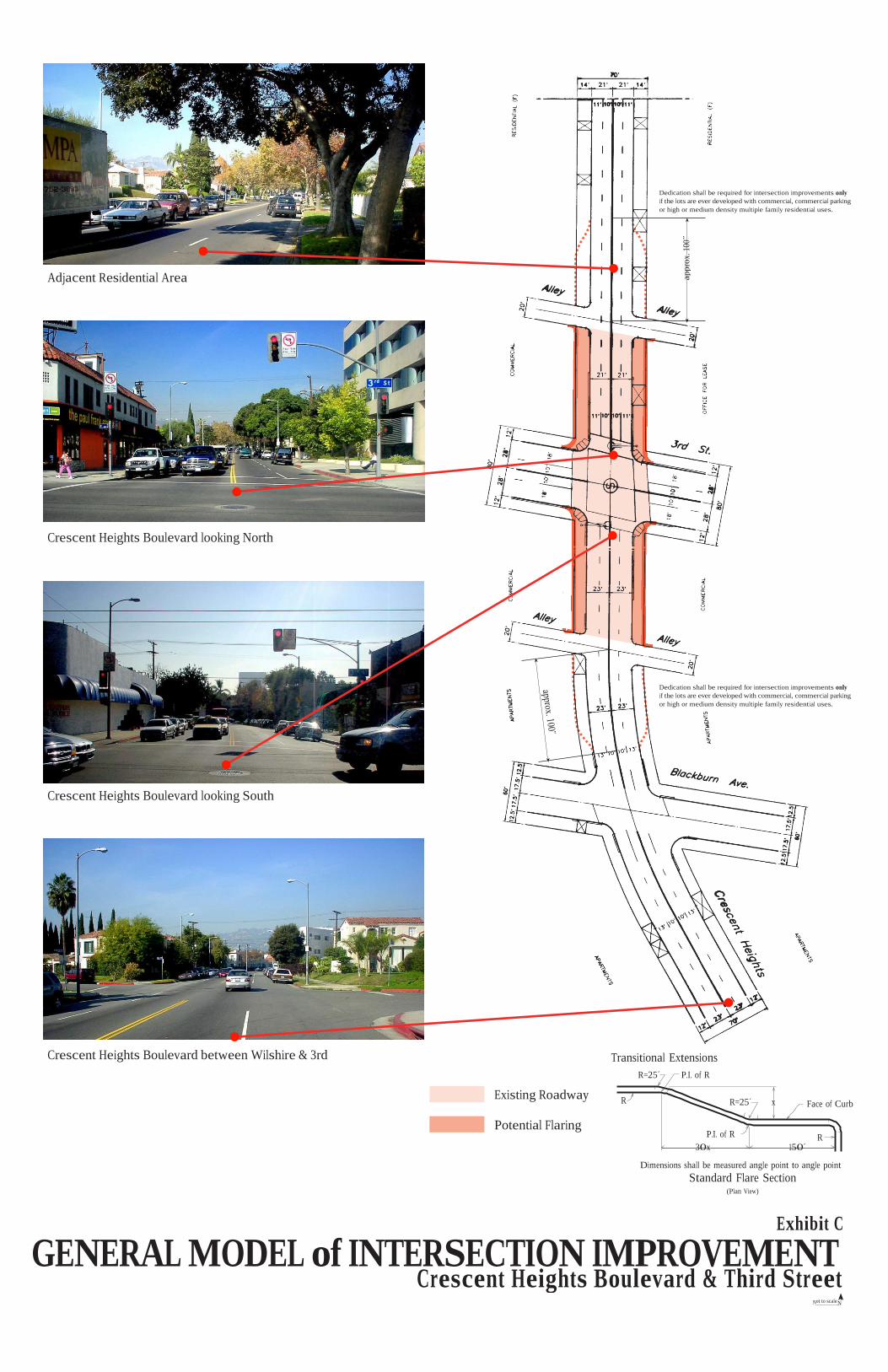
Dedication shall be required for intersection improvements only
if the lots are ever developed with commercial, commercial parking
or high or medium density multiple family residential uses.
Adjacent Residential Area
Crescent Heights Boulevard looking North
Dedication shall be required for intersection improvements only
if the lots are ever developed with commercial, commercial parking
or high or medium density multiple family residential uses.
Crescent Heights Boulevard looking South
Crescent Heights Boulevard between Wilshire & 3rd Transitional Extensions
R=25´
Existing Roadway R
P.I. of R
R=25´ x Face of Curb
Potential Flaring P.I. of R R
30x 150´
Dimensions shall be measured angle point to angle point
Standard Flare Section (Plan View)
GENERAL MODEL of INTERSECTION IMPROVEMENT
Not to scaleN
ap
pro
x. 1
00˝
Crescent Heights Boulevard & Third Street
Exhibit C

Prepared by the Graphics Section of the Los Angeles City Planning Department · November 2001

JAMES KENNETH HAHN, MAYOR Rockard Delgadillo, City Attorney
Laura Chick, Controller
CITY COUNCIL Alex Padilla, President
Hal Bernson
Ruth Galanter
Eric Garcetti
Janice Hahn
Nate Holden Cindy Miscikowski
Nick Pacheco Jan Perry
Ed Reyes Mark Ridley-Thomas
Joel Wachs Jack Weiss
Dennis Zine
CITY PLANNING COMMISSION Peter M. Weil, President
Jorge Jackson, Vice-President
Rodger Landau Mitchell B. Menzer
Susan Hubbard Oakley
Marna Schnabel
Robert L. Scott Darrell E. Walker
Chester A. Widom
DEPARTMENT OF CITY PLANNING Con Howe, Director of Planning
Franklin Eberhard, Deputy Director
Gordon B. Hamilton, Deputy Director
Robert H. Sutton, Deputy Director
COMMUNITY PLAN UPDATE COMMUNITY PLANNING Dave Gay, Principal City Planner
Charles Rausch, Senior City Planner
Daniel Scott, Senior City Planner
Ron Maben, City Planner Kevin Keller, Planning Assistant GEOGRAPHIC INFORMATION SYSTEMS
Paul Burns, GIS Supervisor I
Cathy Luijt, GIS Supervisor I
Carmen Miraflor, GIS Supervisor I
Linda Clark-O’Brian, GIS Specialist
Daniel Garcia, GIS Specialist
PUBLICATION
Jae H. Kim, City Planning Associate
Nelson Larios, Clerk Typist
C:\Documents and Settings\pcuser\Desktop\Wilshire CPU.wpd
Updated Dec 2002


