widows creek fossil plant soil … content...widows creek fossil plant soil excavation and gypsum...
TRANSCRIPT

Document Type: EA-Administrative Record Index Field: Environmental Assessment Project Name: Widows Creek Fossil Plant
Soil Excavation and Gypsum Stack Closure
Project Number: 2013-16
WIDOWS CREEK FOSSIL PLANT SOIL EXCAVATION AND GYPSUM STACK CLOSURE
ENVIRONMENTAL ASSESSMENT Jackson County, Alabama
Prepared by: TENNESSEE VALLEY AUTHORITY
Knoxville, Tennessee
February 2014

This page intentionally left blank

Contents
Environmental Assessment i
Table of Contents
CHAPTER 1 – PURPOSE AND NEED FOR ACTION ......................................................................... 1
1.1 Background .............................................................................................................................. 1 1.2 Decision to be Made ................................................................................................................ 6 1.3 Related Environmental Reviews .............................................................................................. 6 1.4 Scope of the Environmental Assessment ................................................................................ 7 1.5 Public Involvement ................................................................................................................... 7 1.6 Necessary Permits or Licenses ............................................................................................... 8
CHAPTER 2 – ALTERNATIVES .......................................................................................................... 9
2.1 Description of Alternatives ....................................................................................................... 9 2.1.1 Alternative A – The No Action Alternative ......................................................................... 9 2.1.2 Alternative B – The Proposed Action Alternative .............................................................. 9 2.1.3 Alternatives Considered but Eliminated From Further Discussion .................................. 14
2.2 Comparison of Alternatives .................................................................................................... 15 2.3 Identification of Mitigation Measures ...................................................................................... 16 2.4 The Preferred Alternative ....................................................................................................... 16
CHAPTER 3 – AFFECTED ENVIRONMENT AND ENVIRONMENTAL CONSEQUENCES ................................................................................................................. 17
3.1 Air Quality ............................................................................................................................... 17 3.1.1 Affected Environment ...................................................................................................... 17 3.1.2 Environmental Consequences......................................................................................... 19
3.2 Geology and Soils .................................................................................................................. 19 3.2.1 Affected Environment ...................................................................................................... 20 3.2.2 Environmental Consequences......................................................................................... 21
3.3 Water Resources ................................................................................................................... 22 3.3.1 Affected Environment ...................................................................................................... 22 3.3.2 Environmental Consequences......................................................................................... 26
3.4 Biological Resources .............................................................................................................. 28 3.4.1 Affected Environment ...................................................................................................... 28
3.4.1.1 Terrestrial Ecology—Vegetation ............................................................................... 28 3.4.1.2 Terrestrial Ecology—Wildlife ..................................................................................... 29 3.4.1.3 Threatened and Endangered Species ...................................................................... 30 3.4.1.4 Wetlands ................................................................................................................... 33
3.4.2 Environmental Consequences......................................................................................... 33 3.4.2.1 Terrestrial Ecology—Vegetation ............................................................................... 33 3.4.2.2 Terrestrial Ecology—Wildlife ..................................................................................... 36 3.4.2.3 Threatened and Endangered Species ...................................................................... 37 3.4.2.4 Wetlands ................................................................................................................... 38
3.5 Cultural and Historic Resources ............................................................................................ 39 3.5.1 Affected Environment ...................................................................................................... 39 3.5.2 Environmental Consequences......................................................................................... 40
3.6 Visual Resources ................................................................................................................... 41 3.6.1 Affected Environment ...................................................................................................... 41 3.6.2 Environmental Consequences......................................................................................... 41
3.7 Land Use ................................................................................................................................ 42 3.7.1 Affected Environment ...................................................................................................... 42 3.7.2 Environmental Consequences......................................................................................... 42
3.8 Socioeconomics and Environmental Justice.......................................................................... 43
Widows Creek Fossil Plant Soil Excavation and Gypsum Stack Closure
ii Environmental Assessment
3.8.1 Affected Environment ...................................................................................................... 43 3.8.2 Environmental Consequences......................................................................................... 43
3.9 Solid and Hazardous Waste .................................................................................................. 44 3.9.1 Affected Environment ...................................................................................................... 44 3.9.2 Environmental Consequences......................................................................................... 44
3.10 Transportation ........................................................................................................................ 44 3.10.1 Affected Environment ...................................................................................................... 44 3.10.2 Environmental Consequences......................................................................................... 45
3.11 Noise ...................................................................................................................................... 47 3.11.1 Affected Environment ...................................................................................................... 47 3.11.2 Environmental Consequences......................................................................................... 47
3.12 Cumulative Impacts ................................................................................................................ 48 3.13 Unavoidable Adverse Environmental Impacts ....................................................................... 48 3.14 Relationship of Short-Term Uses and Long-Term Productivity ............................................. 48 3.15 Irreversible and Irretrievable Commitments of Resources ..................................................... 49
CHAPTER 4 – LIST OF PREPARERS .............................................................................................. 51
4.1 NEPA Project Management ................................................................................................... 51 4.2 Other Contributors .................................................................................................................. 51
CHAPTER 5 – ENVIRONMENTAL ASSESSMENT RECIPIENTS .................................................... 53
5.1 Federal Agencies ................................................................................................................... 53 5.2 Federally Recognized Tribes ................................................................................................. 53 5.3 State Agencies ....................................................................................................................... 53
CHAPTER 6 – LITERATURE CITED ................................................................................................. 55
List of Appendices
Appendix A – Wetlands No-Practicable Alternative Notification ......................................................... 59 Appendix B – U.S. Army Corps of Engineers Correspondence .......................................................... 63 Appendix C – U.S. Fish and Wildlife Service Correspondence .......................................................... 67 Appendix D – State Historic Preservation Officer Correspondence ................................................... 75
List of Tables
Table 2-1 Summary and Comparison of Alternatives by Resource Area .................................... 15 Table 3-2 Plants of Conservation Concern Known from Within 5 Miles of the Project
Area .............................................................................................................................. 30 Table 3-3 Listed Terrestrial Wildlife in the Vicinity of the Project Area ........................................ 31
Contents
Environmental Assessment iii
List of Figures
Figure 1-1 Widows Creek Fossil Plant Location Map ...................................................................... 3 Figure 1-2 Widows Creek Fossil Plant Facilities ............................................................................. 5 Figure 2-1 Gypsum Stack Closure Plan View and Cross Section ................................................. 11 Figure 2-2 Proposed Soil Excavation Area and Haul Road .......................................................... 12 Figure 2-3 Proposed Temporary Bridge Design at Horn Branch Crossing ................................... 13 Figure 3-1 Location of Gypsum Stack Groundwater Wells ........................................................... 25 Figure 3-2 2013 Wetland Survey Results ...................................................................................... 34 Figure 3-3 Wetlands Identified near the Gypsum Stack ................................................................ 35 Figure 3-4 Proposed County Road 96 Closure and Alterative Routes .......................................... 46

This page intentionally left blank
Symbols, Acronyms, and Abbreviations
Environmental Assessment v
Symbols, Acronyms, and Abbreviations
& and µg/m3 micrograms per cubic meter in/yr Inches per year AADT Annual Average Daily Traffic ADEM Alabama Department of Environmental Management AHC Alabama Historical Commission ALDOT Alabama Department of Transportation APE Area of Potential Effects bgs below ground surface BMP best management practice CCR coal combustion residual CR county road CT Census tract dBA A-weighted decibel EA Environmental Assessment EIS Environmental Impact Statement EO Executive Order gpm gallons per minute GS gypsum stack HELP Hydrologic Evaluation of Landfill Performance IRP Integrated Resource Plan MCL Maximum containment level msl mean sea level NAAQS National Ambient Air Quality Standards NEPA National Environmental Policy Act NHPA National Historic Preservation Act NPDES National Pollution Discharge Elimination System NRCS Natural Resources Conservation Service NRHP National Register of Historic Places PAP Pollution abatement plan PM Particulate Matter PM10 Particulate Matter Having a Diameter of Less Than or Equal to 10 Microns PM2.5 Particulate Matter Having a Diameter of Less Than or Equal to 2.5 Microns ppb parts per billion ppm parts per million RCRA Resource Conservation and Recovery Act RFFA reasonably foreseeable future action SCS Soil Conservation Service SEA soil excavation area SSS Soil survey staff TVA Tennessee Valley Authority USACE U.S. Army Corps of Engineers USEPA U.S. Environmental Protection Agency USFWS U.S. Fish And Wildlife Service VSSL Vegetative Soil Support Layer WCF Widows Creek Fossil Plant

This page intentionally left blank
Chapter 1 – Purpose and Need for Action
Environmental Assessment 1
CHAPTER 1 – PURPOSE AND NEED FOR ACTION
The Tennessee Valley Authority (TVA) proposes to close the Gypsum Stack (GS) at its Widows Creek Fossil Plant (WCF). The GS is a 160-acre facility used for the long-term storage of gypsum and some fly ash. Part of this closure effort would involve constructing a cover over the GS. This cover would shed surface water, limit infiltration, and isolate the gypsum/fly ash from direct contact with the environment. TVA proposes to use soils excavated from recently acquired land adjacent to WCF to construct the cover over the GS.
With the retirement or idling of seven of the eight coal units at WCF, continued operation of the GS is no longer needed. Closing the GS would result in a stable facility that would reduce the infiltration of water into the gypsum/fly ash and the potential release of leachate from the facility.
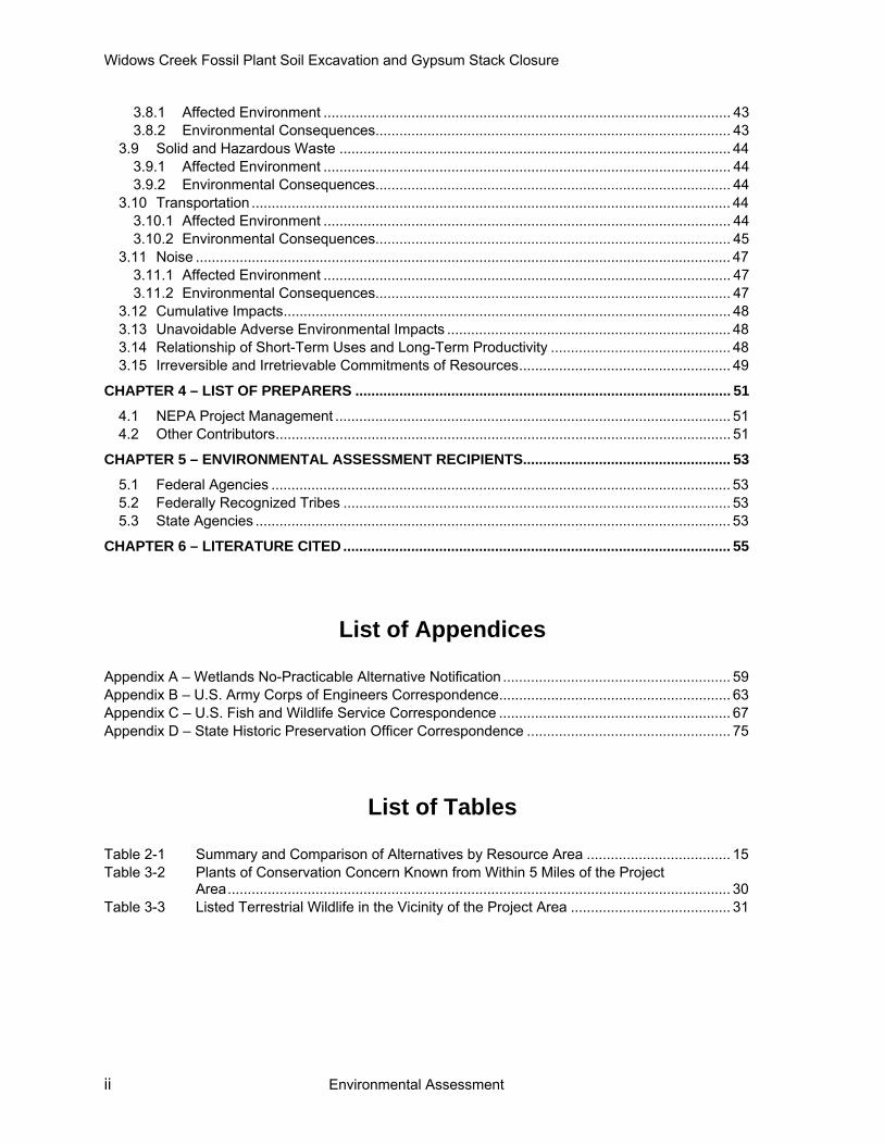
1.1 Background The WCF is located in Jackson County, Alabama adjacent to the Tennessee River about 5 miles east of Stevenson, Alabama (Figure 1-1). The plant, which TVA has been operating since 1952, is situated on a 2,542-acre reservation on the right (north) bank of the Tennessee River at its confluence with Widows Creek.
Construction of the GS began in 1981 when an initial dike was built. Since then, TVA has been using the facility for disposing of coal combustion residuals (CCR) consisting primarily of gypsum and some fly ash from WCF Units 7 and 8. The GS was operated using elevated rim ditching and upstream methods of construction. About 12 million cubic yards of CCR are stored in the GS in a stack with a maximum height of approximately 70 feet.
TVA idled WCF Units 1 through 6 in 2011 and plans to retire them through July 31, 2015. In November 2013, TVA announced that WCF Unit 8 will also be retired. With the idling and pending retirement of the seven WCF units, TVA does not need all of its current WCF facilities to dispose of CCR.
In October 2012, TVA representatives met with the Alabama Department of Environmental Management (ADEM) to discuss the closure of CCR impoundments at WCF, including the GS. In this meeting, TVA proposed the WCF CCR impoundment closure be handled under the National Pollution Discharge Elimination System (NPDES) permit framework. ADEM requested the submittal of a plan for the GS closure under the ADEM Solid Waste Branch Administrative Code Rule 335-13-1-13.
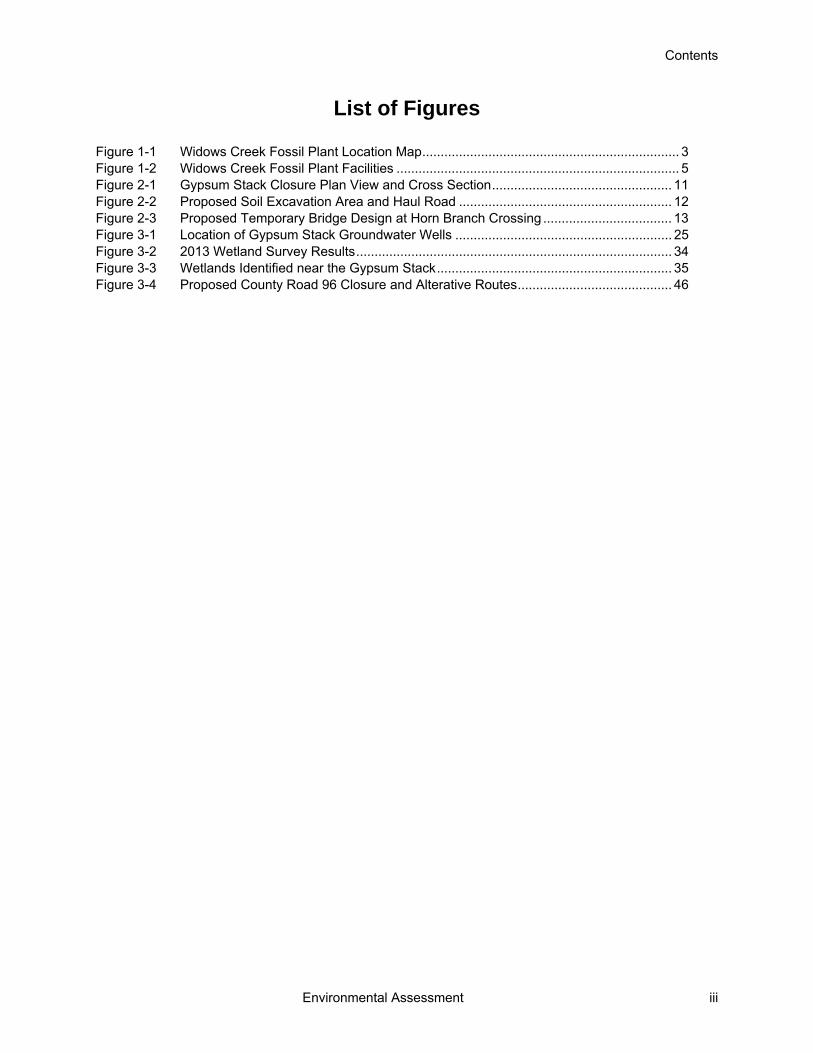
In February 2013, TVA discontinued sluicing operations to the GS. CCR from Units 7 and 8 are now being disposed of in the Main Ash Pond (Figure 1-2).

This page intentionally left blank

Chapter 1 – Purpose and Need for Action
Environmental Assessment 3
Figure 1-1 Widows Creek Fossil Plant Location Map

This page intentionally left blank

Chapter 1 – Purpose and Need for Action
Environmental Assessment 5
Figure 1-2 Widows Creek Fossil Plant Facilities

Widows Creek Fossil Plant Soil Excavation and Gypsum Stack Closure
6 Environmental Assessment
Recently, TVA purchased 21 parcels that encompass approximately 600 acres immediately adjoining the reservation (TVA 2013). TVA acquired these properties to preserve the ability to convert wet CCR handling systems at WCF to dry handling systems in the future. With the pending retirement of the seven WCF units, however, it is no longer necessary to preserve the option of converting CCR systems from wet to dry.
County Road (CR) 96 runs between WCF facilities, including the GS, and the recently purchased parcels. This road provides access to private properties in the general area. Contractors also use the road to access WCF. Jackson County maintains the road. TVA participated in a public hearing held by Jackson County on CR96 on December 10, 2013. TVA initially proposed to obtain ownership of 1.26 miles of CR96 that is within the project area, which would require closing it to the public permanently. After attending the public hearing, TVA revised its proposed action to only close the 1.26 miles of CR96 during working hours (Monday through Friday, 7:00am to 4:00pm) to address the public’s concern about loss of access. Another public hearing was held by Jackson County on February 10, 2014 so that the County officials could vote on the CR96 road closure. At this hearing, the Commission approved the request to restrict the public’s access to CR96 as described above.
1.2 Decision to be Made The decision before TVA is how to close the GS and whether to use soils excavated from the property acquired by TVA adjacent to WCF to cover the stored CCR.
1.3 Related Environmental Reviews In 2011, TVA completed an Integrated Resource Plan (IRP) to detail how it would meet demands for electric power in its service area for the next 20 years while fulfilling its mission of providing low-cost reliable power, environmental stewardship, and economic development (TVA 2011b). TVA released the accompanying IRP environmental impact statement (EIS) in March 2011 (TVA 2011a). This environmental assessment (EA) tiers to the 2011 IRP EIS. Previously completed environmental reviews relevant to this EA include:
Widows Creek Fossil Plant House Demolition (TVA 2013) This EA evaluated the demolition and debris removal of structures located on the 600-acre property TVA purchased adjacent to its WCF. The demolitions allowed TVA to protect human health and safety by removing abandoned structures that could attract vagrants and crime, including illegal drug activities and parties.
Gypsum Removal from Widows Creek (TVA 2009) This EA evaluated the emergency action to remove and dispose of gypsum deposits from Widows Creek. In January 2009, TVA discovered water and gypsum from a pond associated with the GS had bypassed the existing system and drained into an adjacent settling pond. After the settling pond filled, it then overflowed into Widows Creek.

Chapter 1 – Purpose and Need for Action
Environmental Assessment 7
1.4 Scope of the Environmental Assessment TVA has prepared this EA to comply with the National Environmental Policy Act (NEPA) and associated implementing regulations. TVA considered the possible environmental effects of the proposed action and determined that potential effects to the environmental resources listed below were relevant to the decision to be made. Thus, potential effects to the following environmental resources were addressed in detail in this EA:
Air quality Solid and hazardous waste
Water resources (surface water and groundwater)
Biological resources (vegetation, terrestrial wildlife, and wetlands)
Geology and soils Noise
Transportation Socioeconomics and Environmental Justice
Visual resources Cultural and historic resources
Land Use
TVA also considered potential effects related to aquatic ecology; aquatic endangered and threatened species; floodplains; health and safety; natural areas; and global climate change. Potential effects to these resources, however, were found to be absent or minor, and not to require further or only limited consideration.
TVA’s Safety Standard Programs and Processes (TVA 2011c) would be strictly adhered to during implementation of the proposed action. The safety programs and processes are designed to identify actions required for the control of hazards in all activities, operations, and programs. It also establishes responsibilities for implementing Section 19 of the Occupational Safety and Health Act of 1970.
1.5 Public Involvement The potential adverse effects of the proposed action are primarily confined to the Widows Creek plant site and adjacent TVA property. The public could be impacted by closure of CR96. Accordingly, TVA participated in the public hearings held by the County (as described above in Section 1.1). Doing those hearings, TVA provided information about the proposed project and responded to questions from the public, including questions about environmental issues. In addition, TVA published a no-practicable alternative notice in the local newspaper (The Scottsboro Sentinel) on February 7, 2014. The notice described potential wetland and floodplain impacts associated with the proposed action (Appendix A) and provided the public ten days to comment. No comments were received.

Widows Creek Fossil Plant Soil Excavation and Gypsum Stack Closure
8 Environmental Assessment
1.6 Necessary Permits or Licenses The proposed action would be subject to the following environmental permit requirements and regulations:
ADEM sand and gravel general permit for soil excavation. A pollution abatement plan would be developed as part of this permit.
U.S. Army Corps of Engineers (USACE) Section 404 Permit.
Water quality certification under Section 401 of the Clean Water Act.

Chapter 2 - Alternatives
Environmental Assessment 9
CHAPTER 2 – ALTERNATIVES
Descriptions of the proposed action and its alternatives, a brief comparison of their environmental effects, and TVA’s preferred alternative are presented in this chapter.
2.1 Description of Alternatives This EA documents the evaluation of two alternatives: the No Action and Proposed Action Alternatives.
2.1.1 Alternative A – The No Action Alternative Under the No Action Alternative, TVA would not proceed with the closure of the GS. TVA would also not construct a soil excavation area (SEA) on property adjacent to its WCF. Environmental conditions in the project area would not change. Absent continued maintenance, the GS would become more susceptible to failures and safety risks would increase over time.
2.1.2 Alternative B – The Proposed Action Alternative Under the Proposed Action Alternative, TVA would proceed with the closure of the GS. To facilitate the closure, TVA is proposing to use property adjacent to WCF as a SEA to provide a sufficient quantity of suitable soil for construction of the final cover system.
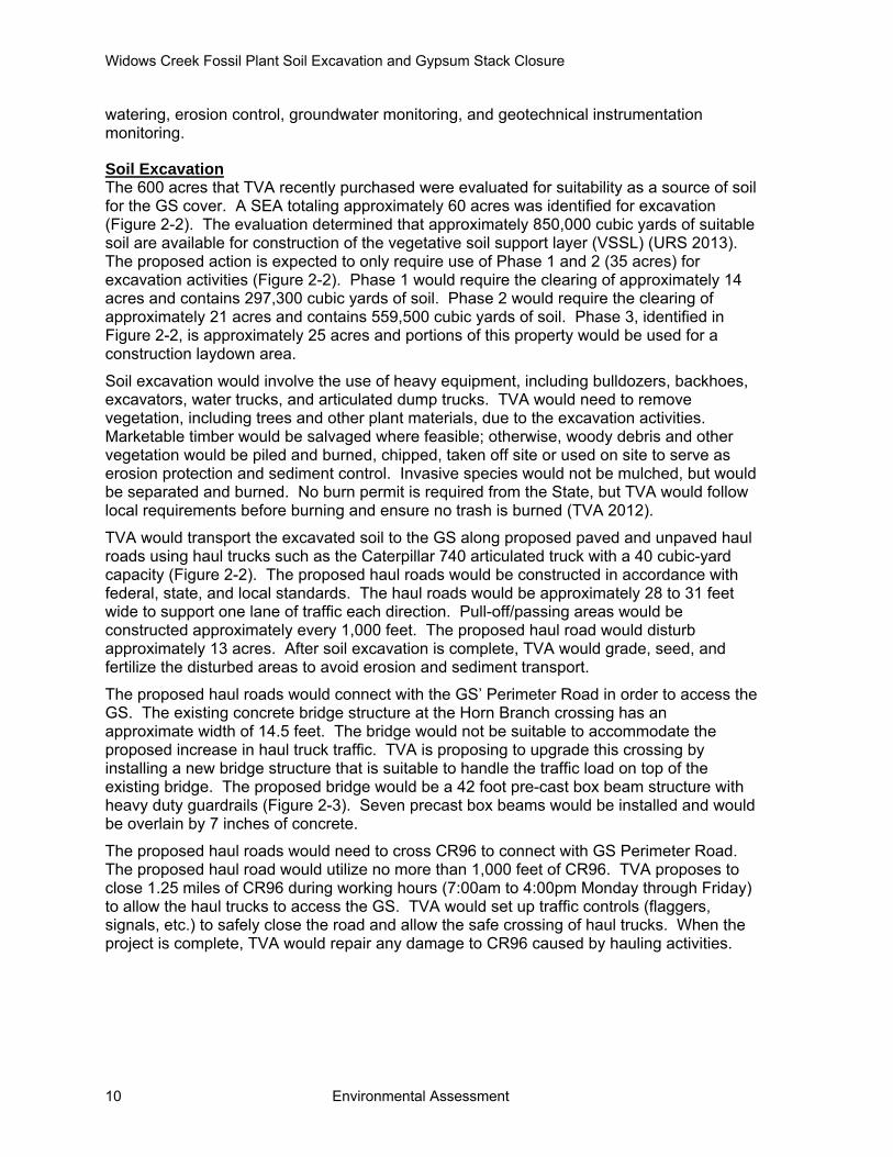
Gypsum Stack Closure The GS is a 160-acre facility. The GS’ crest elevation is approximately 680 feet, up to about 80 feet above the surrounding terrain, and the surface area encompasses approximately 90 acres. About 12 million cubic yards of CCR have been disposed of in the GS.
The GS closure would follow a two stage process. Stage 1 consists of installing permanent and interim storm drainage pipes from the top of the GS to the existing perimeter ditch; grading the top of the GS; and construction of the final cap/cover system. Stage 2 consists of grading the side slopes of the GS; installation of drainage pipes and structure on the slope and perimeter ditch; re-grading perimeter ditch; installation of outlet culverts; and final surfacing of the access and perimeter roads (Stantec 2013). The closure design and cross section are shown in Figure 2-1. The Stilling Pond would be dewatered and the CCRs would be removed and placed within the GS. The pond would then be graded to drain and a culvert would be installed directing stormwater to Widows Creek. The pond would be seeded and mulched to establish vegetation.
The final cover system would consist of a flexible membrane layer, which would be overlain by a geocomposite drainage layer and cover soil. The geocomposite consists of a triaxial geonet structure that retains soil or sand particles allowing filtered water to pass to irregular surfaces. It is anticipated that approximately 400,000 cubic yards of soil for vegetative soil support layer (VSSL) would be needed to close the GS. The VSSL would be a minimum of 18 inches of earthen material that is capable of sustaining native plant growth. Seeding or sod would be placed over the cap to facilitate the establishment of vegetation.
The proposed GS closure is anticipated to take 48 months. During closure activities, TVA would utilize the dredge cell as the laydown area, which is previously disturbed. All disturbed areas would be revegetated with non-invasive species at the completion of the GS closure project. Post-closure maintenance would continue after the date of final completion and ADEM approval of closure of the GS. These maintenance activities include
Widows Creek Fossil Plant Soil Excavation and Gypsum Stack Closure
10 Environmental Assessment
watering, erosion control, groundwater monitoring, and geotechnical instrumentation monitoring.
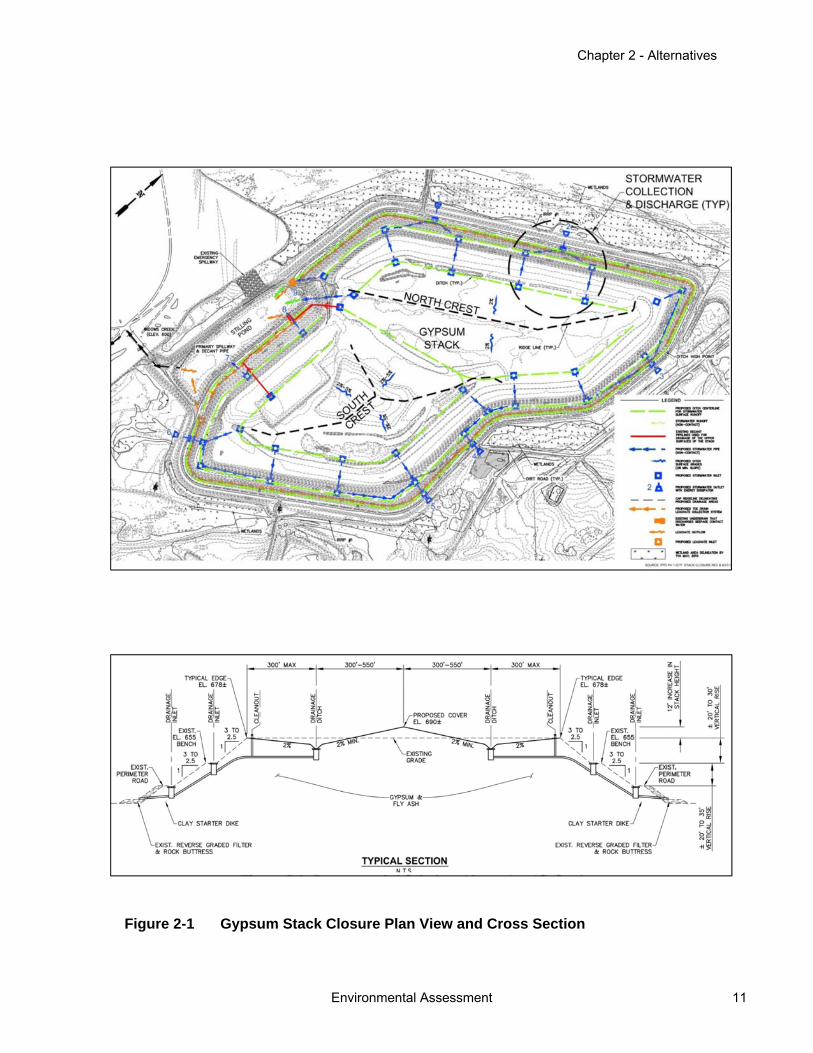
Soil Excavation The 600 acres that TVA recently purchased were evaluated for suitability as a source of soil for the GS cover. A SEA totaling approximately 60 acres was identified for excavation (Figure 2-2). The evaluation determined that approximately 850,000 cubic yards of suitable soil are available for construction of the vegetative soil support layer (VSSL) (URS 2013). The proposed action is expected to only require use of Phase 1 and 2 (35 acres) for excavation activities (Figure 2-2). Phase 1 would require the clearing of approximately 14 acres and contains 297,300 cubic yards of soil. Phase 2 would require the clearing of approximately 21 acres and contains 559,500 cubic yards of soil. Phase 3, identified in Figure 2-2, is approximately 25 acres and portions of this property would be used for a construction laydown area.
Soil excavation would involve the use of heavy equipment, including bulldozers, backhoes, excavators, water trucks, and articulated dump trucks. TVA would need to remove vegetation, including trees and other plant materials, due to the excavation activities. Marketable timber would be salvaged where feasible; otherwise, woody debris and other vegetation would be piled and burned, chipped, taken off site or used on site to serve as erosion protection and sediment control. Invasive species would not be mulched, but would be separated and burned. No burn permit is required from the State, but TVA would follow local requirements before burning and ensure no trash is burned (TVA 2012).
TVA would transport the excavated soil to the GS along proposed paved and unpaved haul roads using haul trucks such as the Caterpillar 740 articulated truck with a 40 cubic-yard capacity (Figure 2-2). The proposed haul roads would be constructed in accordance with federal, state, and local standards. The haul roads would be approximately 28 to 31 feet wide to support one lane of traffic each direction. Pull-off/passing areas would be constructed approximately every 1,000 feet. The proposed haul road would disturb approximately 13 acres. After soil excavation is complete, TVA would grade, seed, and fertilize the disturbed areas to avoid erosion and sediment transport.
The proposed haul roads would connect with the GS’ Perimeter Road in order to access the GS. The existing concrete bridge structure at the Horn Branch crossing has an approximate width of 14.5 feet. The bridge would not be suitable to accommodate the proposed increase in haul truck traffic. TVA is proposing to upgrade this crossing by installing a new bridge structure that is suitable to handle the traffic load on top of the existing bridge. The proposed bridge would be a 42 foot pre-cast box beam structure with heavy duty guardrails (Figure 2-3). Seven precast box beams would be installed and would be overlain by 7 inches of concrete.
The proposed haul roads would need to cross CR96 to connect with GS Perimeter Road. The proposed haul road would utilize no more than 1,000 feet of CR96. TVA proposes to close 1.25 miles of CR96 during working hours (7:00am to 4:00pm Monday through Friday) to allow the haul trucks to access the GS. TVA would set up traffic controls (flaggers, signals, etc.) to safely close the road and allow the safe crossing of haul trucks. When the project is complete, TVA would repair any damage to CR96 caused by hauling activities.
Chapter 2 - Alternatives
Environmental Assessment 11
Figure 2-1 Gypsum Stack Closure Plan View and Cross Section
Widows Creek Fossil Plant Soil Excavation and Gypsum Stack Closure
12 Environmental Assessment
Figure 2-2 Proposed Soil Excavation Area and Haul Road

Chapter 2 - Alternatives
Environmental Assessment 13
Figure 2-3 Proposed Temporary Bridge Design at Horn Branch Crossing
Widows Creek Fossil Plant Soil Excavation and Gypsum Stack Closure
14 Environmental Assessment
Finally, TVA would construct several structures to control the flow and discharge of surface water near the SEA. These structures include two stormwater detention basins and three new culverts under the haul road (Figure 2-2). Together, the two detention basins would disturb approximately 2.5 acres, which are included in the overall 13 acres of disturbance for the haul road construction. Disturbance from installing the culverts would occur within the limits of disturbance for the haul road.
2.1.3 Alternatives Considered but Eliminated From Further Discussion There were alternatives to TVA’s proposed action that were considered but eliminated from detailed analysis in this EA. During the scoping of this project and the development of Alternatives A and B, several other potential alternatives were considered. These alternatives were determined to not be technically or economically practical or feasible. The two alternatives that were considered but later eliminated are summarized below.
Transportation of Gypsum to an Off-site Lined Landfill An alternative involving relocating the CCRs from the GS to a lined landfill off-site was considered. The relocation would involve transporting more than 12 million tons of CCR to an off-site permitted landfill. At this time, no landfills permitted to take this material have the capacity to accept 12 million tons of CCR. A new landfill would have to be constructed and permitted off-site or an existing landfill would need to be expanded. The rail system at WCF would need to be upgraded, and haul roads from the GS to the rail would need to be constructed to transport the CCR to an off-site landfill. There would also be an increased environmental risk during construction due to significant CCR handling (URS 2012). The estimated cost to transport the CCR to an off-site landfill is $40 per ton by rail and $35 per ton by truck. The total cost of the project would be approximately $450 million to $500 million, which is substantially more expensive than capping the GS in place (Alternative B). Based on the potential environmental and economic impacts of transporting 12 million tons to an off-site landfill via 40-ton trucks or rail, TVA determined that this was not a reasonable alternative to closing the GS in place. Consequently, this alternative was eliminated from detailed analysis.
Construction of an On-site Lined Landfill Another alternative involving relocating the CCRs from the GS to an on-site lined landfill was considered. In 2010, TVA evaluated six candidate sites for a proposed CCR landfill, and Site A was selected as the preferred location. As discussed in Section 1.1, TVA purchased the 600-acre Site A, which was located adjacent to the WCF reservation. The CCR landfill construction activities would include construction of haul roads, leachate system, abandonment of CR96, and Horn Branch bridge improvements. TVA would excavate and remove the gypsum to the level of the clay perimeter dike on site. TVA would transport approximately 12 million tons of CCR via 40-ton trucks along a newly constructed haul road to the landfill location on Site A. The proposed landfill would require the clearing of approximately 155 acres of a greenfield site. The remainder of the site (445 acres) would be utilized for staging, stockpiling, and buffer areas. The height of the landfill would have visual impacts on nearby residents. There would also be an increased environmental risk during construction due to significant CCR handling (URS 2012).
A 155-acre landfill with a capacity to hold 20 million tons of CCR would cost approximately $108 million. The cost of the currently proposed alternative is $27 million, which is 75 percent less expensive. The required permitting, design and construction of the landfill could take years and increase overall cost of the project. Based on cost and potential

Chapter 2 - Alternatives
Environmental Assessment 15
environmental impacts of transporting CCR material to the lined landfill, TVA determined that this was not a reasonable alternative to closing the GS in place. Consequently, this alternative was eliminated from detailed analysis.
Consideration of Gypsum Stack Cover Options In 2012, TVA performed a cover system alternatives analysis for the GS closure project that identified seven alternatives, including the proposed action (URS 2012). Several technical approaches were evaluated to address each of the closure needs. The alternatives consisted of various options to address GS stability, seepage, stormwater management, slope grading, and final cover. After consideration of cost, construction duration, extent of regrading and earthwork quantities, variances to ADEM guidelines, and risk of environmental impacts and erosion, Alternative 6C was selected as the Proposed Action. Alternative 6C has been carried forward in this EA as Alternative B. Implementation of this alternative would result in superior cap infiltration reduction while providing a cost-effective solution to handling the current stability issue of the GS.
2.2 Comparison of Alternatives Table 2-1 comparatively summarizes the potential effects that would occur under the two alternatives that were considered in detail.
Table 2-1 Summary and Comparison of Alternatives by Resource Area
Impacts from Alternative
Resource Area A B
Air quality None Minor, temporary increase in fugitive dust and vehicular emissions
Overall, no significant impacts
Geology and soils None Minor, temporary increase in erosion of soils
No significant impacts
Water resources None Minor, temporary decrease in surface water quality in Horn Branch during bridge work
Beneficial impacts to groundwater
quality and no impacts to groundwater supply
Biological Resources None Disturbance to 0.85 acre of wetlands. No significant impacts to species of special concern. Increase in available wildlife habitats with reclamation of GS and
revegetation of the soil excavation area
No effects to threatened and endangered species
Cultural and historic resources
None No significant impacts
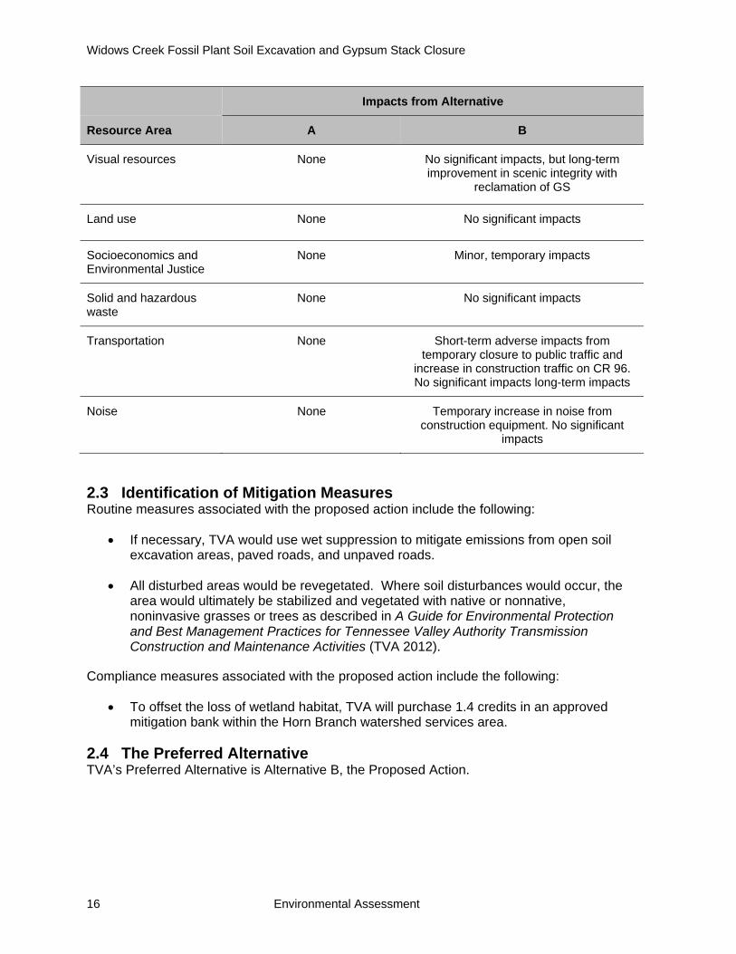
Widows Creek Fossil Plant Soil Excavation and Gypsum Stack Closure
16 Environmental Assessment
Impacts from Alternative
Resource Area A B
Visual resources None No significant impacts, but long-term improvement in scenic integrity with
reclamation of GS
Land use None No significant impacts
Socioeconomics and Environmental Justice
None Minor, temporary impacts
Solid and hazardous waste
None No significant impacts
Transportation None Short-term adverse impacts from temporary closure to public traffic and
increase in construction traffic on CR 96. No significant impacts long-term impacts
Noise None Temporary increase in noise from construction equipment. No significant
impacts
2.3 Identification of Mitigation Measures Routine measures associated with the proposed action include the following:
If necessary, TVA would use wet suppression to mitigate emissions from open soil excavation areas, paved roads, and unpaved roads.
All disturbed areas would be revegetated. Where soil disturbances would occur, the area would ultimately be stabilized and vegetated with native or nonnative, noninvasive grasses or trees as described in A Guide for Environmental Protection and Best Management Practices for Tennessee Valley Authority Transmission Construction and Maintenance Activities (TVA 2012).
Compliance measures associated with the proposed action include the following:
To offset the loss of wetland habitat, TVA will purchase 1.4 credits in an approved mitigation bank within the Horn Branch watershed services area.
2.4 The Preferred Alternative TVA’s Preferred Alternative is Alternative B, the Proposed Action.
Chapter 3 – Affected Environment and Environmental Consequences
Environmental Assessment 17
CHAPTER 3 – AFFECTED ENVIRONMENT AND ENVIRONMENTAL CONSEQUENCES
This chapter describes the nature, extent, and importance of environmental resources in their existing setting on the project area. It provides a baseline for the assessment of potential effects of the alternatives described in Chapter 2. This chapter also presents the anticipated environmental consequences that would occur to the various resources from the adoption of Alternative A—No Action and Alternative B—Proposed Action. This information is summarized in Section 2.2 and in Table 2-1.
In the environmental analysis, some environmental resources were determined to require no further or only limited consideration. The SEA and GS are not located within a floodplain and the proposed activities would not have any indirect effects on floodplains. The proposed Horn Branch bridge improvement is within the limits of the 100-year floodplain. Consistent with Executive Order (EO) 11988, a bridge improvement is considered to be a repetitive action in the 100-year floodplain. The bridge improvement would not be expected to result in unacceptable increases in upstream flood elevations. Therefore, no unacceptable impacts on floodplains are anticipated with the implementation of Alternative A or B. Because no designated Wild and Scenic Rivers or their tributaries occur at or adjacent to the project area, the proposed action is not anticipated to affect these designated waters. The project area is located approximately 2 miles from a natural area (Raccoon Creek State Wildlife Management Area). Because of this physical separation, the proposed action would not affect the natural area. No habitats to support federally or state-listed endangered or threatened aquatic species occur in the project area. Therefore, no direct or indirect impacts to endangered or threatened aquatic species would occur.
3.1 Air Quality
3.1.1 Affected Environment Air quality is a valuable environmental resource. Through its passage of the Clean Air Act, Congress mandated the protection and enhancement of our nation’s air quality resources. National Ambient Air Quality Standards (NAAQS) for the following criteria pollutants have been set to protect the public health and welfare:
sulfur dioxide ozone nitrogen dioxide particulate matter whose particles are less than or equal to 10 micrometers (PM10) particulate matter whose particles are less than or equal to 2.5 micrometers (PM2.5) carbon monoxide lead
The primary NAAQS were promulgated to protect the public health, and the secondary NAAQS were promulgated to protect the public welfare from any known or anticipated adverse effects associated with the presence of pollutants in the ambient air. Areas in violation of the NAAQS are designated as nonattainment areas. New sources to be located in or near these areas may be subject to more stringent air permitting requirements. A listing of the NAAQS is presented in Table 3-1. These ambient standards, other than annual standards, are not to be exceeded more than once per year (except where noted).

Widows Creek Fossil Plant Soil Excavation and Gypsum Stack Closure
18 Environmental Assessment
Table 3-1 National Ambient Air Quality Standards
Pollutant Primary and Secondary Standards
Averaging Time
Level Form
Carbon Monoxide Primary 8-hour 9 ppm
Not to be exceeded more than once per year 1-hour 35 ppm
Lead Primary and secondary
Rolling 3 month average
0.15 μg/m3 (1)
Not to be exceeded
Nitrogen Dioxide
Primary 1-hour 100 ppb 98th Percentile, averaged over 3 years
Primary and secondary
Annual 53 ppb (2) Annual mean
Ozone Primary and secondary
8-hour 0.075 ppm (3)
Annual fourth-highest daily maximum 8-hour
concentration, averaged over 3 years
Particulate Matter (PM2.5)
Primary and secondary
Annual 15 μg/m3 Annual mean, averaged over 3 years
24-hour 35 μg/m3 98th Percentile, averaged over 3 years
Particulate Matter (PM10)
Primary and secondary
24-hour 150 μg/m3 Not to be exceeded more
than once per year on average over 3 years
Sulfur Dioxide
Primary 1-hour 75 ppb (4)
99th Percentile of 1hour daily maximum
concentrations, averaged over 3 years
Secondary 3-hour 0.5 ppm Not to be exceeded more
than once per year on average over 3 years
Source: U.S. Environmental Protection Administration (USEPA) 2012 Abbreviations: PM = particulate matter, ppb = parts per billion, ppm = parts per million, μg/m3 = micrograms per cubic meter. Notes: (1) Final rule signed on October 15, 2008. The 1978 lead standard (1.5 micrograms per cubic meter [µg/m3] as a quarterly average) remains in effect until one year after an area is designated for the 2008 standard, except that in areas designated nonattainment for the 1978 standard, the 1978 standard remains in effect until implementation plans to attain or maintain the 2008 standard are approved. (2) The official level of the annual nitrogen dioxide standard is 0.053 ppm, equal to 53 ppb, which is shown here for the purpose of clearer comparison to the 1-hour standard. (3) Final rule signed on March 12, 2008. The 1997 ozone standard (0.08 ppm, annual fourth-highest daily maximum 8-hour concentration, averaged over 3 years) and related implementation rules remain in place. In 1997, the United States Environmental Protection Agency revoked the 1-hour ozone standard (0.12 ppm, not to be exceeded more than once per year) in all areas, although some areas have continued obligations under that standard (“anti-backsliding”). The 1-hour ozone standard is attained when the expected number of days per calendar year with maximum hourly average concentrations above 0.12 ppm is less than or equal to 1. (4) Final rule signed on June 2, 2010. The 1971 annual and 24-hour sulfur dioxide standards were revoked in that same rulemaking. However, these standards remain in effect until one year after an area is designated for the 2010 standard, except in areas designated nonattainment for the 1971 standards, where the 1971 standards remain in effect until implementation plans to attain or maintain the 2010 standard are approved.
Chapter 3 – Affected Environment and Environmental Consequences
Environmental Assessment 19
Based on available monitoring, the ambient air quality near the project area is generally good. USEPA has designated Jackson County as partial nonattainment for PM2.5 and in attainment for all other criteria pollutants.
3.1.2 Environmental Consequences Alternative A Under Alternative A, TVA would not close the GS facility. Therefore, TVA would no longer need to construct a soil excavation area adjacent to WCF. Environmental conditions in the project area would not change and no direct or indirect impacts to air quality would occur.
Alternative B Under Alternative B, GS closure and soil excavation activities would likely generate fugitive dust. Hauling excavated soil to the GS facility using trucks driven on paved and unpaved surfaces would also generate fugitive dust. In addition, pollutants would be emitted in the exhaust from internal combustion engines powering the machinery used for excavating and hauling soil to the GS facility.
Fugitive emissions from GS closure, including detention ponds and haul road construction and soil excavation activities would produce particles that would be deposited primarily in the project area. Ninety-five percent (by weight) of fugitive emissions from vehicular traffic over paved roads would be deposited beyond the property boundaries or roadway rights-of-way. In contrast, a large fraction of fugitive emissions from vehicle traffic in unpaved areas would be deposited near the unpaved areas. If necessary, emissions from open demolition areas, paved roads, and unpaved roads would be mitigated using wet suppression. Wet suppression can reduce fugitive dust emissions by as much as 95 percent from roadways and unpaved roads.
Combustion of gasoline and diesel fuels by internal combustion engines (excavation equipment and haul trucks) would generate local emissions of PM, nitrogen oxides, carbon monoxide, volatile organic compounds, and sulfur dioxide. The total amount of these emissions would be small and would result in minimal off-site impacts. TVA’s request for proposals will require potential bidders to consider reducing the potential impact of WCF trucking activities upon the environment. The contractor would be required take into account such factors as air pollution, erosion control, noise control, solid waste disposal, and wastewater disposal, among other things. The contract would require that truck owners properly maintain trucks, including tune-ups. The use of ultra-low sulfur diesel fuel and minimizing idling time would also be required. Consequently, potential effects to air quality from hauling activities would be minor and short term in nature under Alternative B.
Air quality impacts from GS closure and soil excavation activities would be temporary and dependent on both man-made factors (e.g., intensity of activity, control measures) and natural factors (e.g., wind speed, wind direction, soil moisture). Even under unusually adverse conditions, these emissions would have, at most, minor, temporary on- and off-site air quality impacts and would not cause exceedance of the applicable NAAQS. Consequently, the direct and indirect air quality impacts under Alternative B would not be significant.
3.2 Geology and Soils The area of potential effects (APE) for geology and soils is defined as the footprint of the proposed areas of disturbance (Figures 2-2 and 2-3).

Widows Creek Fossil Plant Soil Excavation and Gypsum Stack Closure
20 Environmental Assessment
3.2.1 Affected Environment Limitations of project area soils and potential impacts to soil resources were assessed using the Soil Conservation Service (SCS) Soil Survey of Jackson County (Swenson et al. 1954), as well as interpreted soil properties developed by the National Resource Conservation Service (NRCS) and accessed online through the NRCS Web Soil Survey (Soil Survey Staff [SSS] 2013).
Soils within the project area have predominantly formed in residual materials, with lesser amounts formed in alluvium. Most residual soils formed in residuum weathered from limestone and dolomite of the Knox Group (Dinterman and Irvin 2009; SSS 2013). Alluvial soils are present only in the southeastern-most portion of the project area near Horn Branch. Texturally, near-surface residual soils within the project area are silt clay loams, whereas alluvial soils contain less clay and are classified as silt loams. Mapped soil series present within or in the immediate vicinity of the project area include Fullerton cherty silt loam (multiple phases including eroded, hilly, and undulating), Greendale cherty silt loam, Colbert silty clay, Capshaw silt loam, Etowah loam, Lindside silt loam, and Melvin silt loam (SSS 2013).
In 2010, a geotechnical investigation was performed. The soil borings were advanced within the project area to depths of approximately 50 to 70 feet below ground surface (bgs). In the northern portion of the project area, very stiff to hard clays were encountered from 712 feet above mean sea level (msl) to 700 feet msl, dense to medium dense clayey sands were encountered from 700 to 654 feet msl, and very dense gravel and silty sands were encountered from 654 to 642 feet msl. In the southern portion of the project area, fat to lean clays were encountered between 695 and 601 feet msl and were underlain by medium dense to loose silt from 601 to 574 feet msl (URS 2011).
In November 2011, a second geotechnical investigation within the project area began and included completion of 22 soil borings, 10 test pits, and 6 groundwater monitoring wells. Soil borings were completed to depths ranging from 9 to 126 feet bgs. The test pits ranged in depth from 6 to 10.5 feet bgs. Five of the six groundwater monitoring wells were screened at variable depths ranging from 16.5 and 56 feet bgs (URS 2013). The sixth well was screened at 98 to 113 feet bgs.
Soils observed during both geotechnical investigations are characterized as stiff to hard sandy clays or clayey sands with varying, sometimes significant amounts of chert gravel. One to two feet of silty topsoil was observed in most borings. Depth to bedrock across the project area ranged from approximately 30 to 100 feet bgs. Gravelly soils are present as lenses (2 to 5 inches thick) and pockets (several feet thick) throughout the site. Although these gravelly soils are typically located 10 to 30 feet bgs, they may be shallower (URS 2013).
Most of the project area is hilly, with slopes of up to 20 percent, with the exception of the southeastern portion of the project area along Horn Branch which is nearly level (slopes of 1 percent) (SSS 2013). Areas of Fullerton cherty silt loam, which comprise the majority of the project area, are very susceptible to erosion if existing vegetative cover is removed and the soil surface is exposed. Other silty loams with steep slopes within the project area are moderately susceptible to erosion. Due to flat topography, alluvial soils within the project area are only slightly susceptible to erosion.

Chapter 3 – Affected Environment and Environmental Consequences
Environmental Assessment 21
Soil series considered to represent prime farmland by NRCS are present within the project area and include the Capshaw silt loam, Etowah silt loam, Greendale cherty silt loam, Lindside silt loam, and Fullerton cherty silt loam (undulating phase).
The geologic setting of the project area is described in relation to regional and local groundwater in Section 3.3.
3.2.2 Environmental Consequences Alternative A Under Alternative A, existing resource trends would continue. Rates of soil erosion and productivity would not be adversely or beneficially affected under Alternative A. No direct or indirect impacts to geologic resources would occur under Alternative A.
Alternative B Alternative B would require the removal of large volumes of soil, subsoil, and residuum from the SEA as well as lesser amounts of soil for haul road grading activities. Approximately 35 acres of surface soils would be directly impacted for the SEA. Soil functions in these areas would be adversely impacted until restoration is completed. Until stabilization can be achieved, soils not removed in these areas would be subject to more erosion and transport than under present conditions. The detention ponds would limit the amount of soil transported from the project area to surface water drainage ways via stormwater by detaining the runoff and trapping sediment. Sediment from the disturbance for the ponds themselves would be detained in the ponds.
Published soil erosion hazards for project area soils do not directly apply to most subsoils and residuum that would be exposed during excavation. Within the SEA, excavations would generally range in depth from approximately 10 to 40 feet and all topsoil and subsoil within the SEA is expected to be removed. Compacted stiff sandy clay and clayey sands present in the subsurface (URS 2013) are anticipated to be somewhat more resistant to erosion than surficial soils. The gravel component of gravel pockets is expected to be somewhat erosion-resistant, but interbedded sandy or silty matrix would not. In portions of the SEA, post-reclamation slopes would be steeper than existing slopes, which generally range from 4 to 20 percent. The 3 Horizontal:1 Vertical ratio of post-reclamation slopes (approximately 33 percent) would be at an increased risk of erosion. Given the removal of topsoil and unfavorable characteristics of subsoil and residuum for establishing vegetation, soil functions are expected to be moderately difficult to restore. Revegetation procedures will be conducted in accordance with A Guide for Environmental Protection and Best Management Practices for Tennessee Valley Authority Transmission Construction and Maintenance Activities (TVA 2012).
Similarly, prior to excavation, grading of excavation areas and haul roads would lead to disruption of vegetative cover and upper soil layers as well as compaction. Increasing the amount and distribution of bare ground at the expense of canopy, microbiotic, and litter covers decreases the effective saturated conductivity of soil, which, in turn, decreases infiltration and increases runoff and soil loss (Jadczyszyn and Niedzwiecki 2005). In addition, most soils in the project area have low cohesive strength, which would lead to prevalent formation of ruts during machinery operation, especially under wet conditions (SSS 2013).
Most of the proposed haul road grading operations would occur on areas of Fullerton cherty silt loam. These soils have slight to moderate erosion hazards because of off-road or off-

Widows Creek Fossil Plant Soil Excavation and Gypsum Stack Closure
22 Environmental Assessment
trail vehicle operation that exposes bare soil, but severe erosion hazard on unsurfaced roads or trails (SSS 2013). Erosion hazards are lower for alluvial soils north of Horn Branch. This relationship indicates that reducing the development of ruts and temporary roads due to extended or repeated equipment operation in the same location would reduce the potential for soil erosion because of grading. Grading of existing gravel roads or grading for new roads is likely to increase erosion rates in those areas. Surfacing (e.g., applying gravel) would likely reduce the potential for soil loss. Similarly, because steep slopes are a primary contributor to erosion within the project area, constructing structures such as water bars would reduce the velocity of water flow on roads and decrease the potential for erosion. Because soils potentially impacted by grading activities would be subsequently revegetated, impacts to soil productivity due to grading would be short-term. However, during grading activities, the potential for exposed soils to be eroded and transported to nearby waterbodies would increase above existing conditions. Installation of a temporary bridge is anticipated to disturb minor amounts of soils on either side of Horn Branch. Erosion rates would increase temporarily until the haul road is surfaced.
Excavation activities have the potential to introduce sediment to Widows Creek via the unnamed tributary that flows west from the SEA. Surface disturbances during activities elsewhere within the project area are not anticipated to contribute sediment load to Widows Creek. Most surface runoff is anticipated to infiltrate to groundwater and entrained sediment would be deposited prior to reaching Widows Creek. Thus, the potential for introduction of eroded sediments into Widows Creek is low.
As discussed in Section 1.5, TVA would submit a notice of intent to ADEM for coverage under the NPDES General Permit for the entire project area. As part of this application, a CMBPP would be developed and implemented to control and confine sediment to the project area. Therefore, no significant indirect or direct geological resource impacts would occur under Alternative B.
3.3 Water Resources The APE for water resources is defined as the area extending from the proposed project area southward to the Tennessee River. For surface waters, the APE includes Widows Creek and other surface water bodies. For groundwater, the APE includes all shallow aquifers within the surface water APE.
3.3.1 Affected Environment Surface Water The Tennessee River is the primary surface water drainage feature in Jackson County and northeastern Alabama. Locally, natural flow of the Tennessee River is to the southwest. Guntersville Dam, located approximately 49 miles southwest of the project area, has dammed the Tennessee River to form the 76-mile long Guntersville Reservoir.
Widows Creek, which is the primary drainage feature near the project area, is a first-order tributary of the Tennessee River (URS 2011). The confluence between Widows Creek and the Tennessee River is approximately 1.5 miles south of the project area. Before reaching the Tennessee River, Widows Creek flows through an artificial channel, which reduces flow velocity before discharging to the river.
The project area itself is bisected by Horn Branch, a small perennial, south-southwest flowing stream that discharges to Widows Creek approximately 0.2 mile southwest of the project area. The westernmost portion of the project area drains west towards an unnamed
Chapter 3 – Affected Environment and Environmental Consequences
Environmental Assessment 23
tributary of Widows Creek. The southern portion of the project area drains south towards CR70; however, surface flow is expected to infiltrate to groundwater prior to reaching Widows Creek. According to the 1983 U.S. Geological Survey Topographic map, the unnamed tributary of Widows Creek is a blue line stream. However, a field survey of the project area indicated that the unnamed tributary flows only during and immediately after precipitation, has no defined channel, and evidence of aquatic life.
Major surface water bodies near the project area have impaired water quality that does not support designated beneficial uses (e.g., swimming, public water supply, aquatic habitat) (ADEM 2012). Widows Creek and Guntersville Reservoir (Lake Guntersville) are both listed as impaired because of elevated mercury levels. Widows Creek is considered impaired from its confluence with the Tennessee River to 5 miles upstream; this includes the stretch of Widows Creek adjacent to the GS. Guntersville Reservoir is considered impaired over an approximately 2,700-acre area between Pump Spring Branch (approximately 4 miles downstream from the project area) and the Alabama-Tennessee state line (approximately 8 miles upstream of the project area).
Both listings are a result of a fish consumption advisory issued by Alabama Department of Public Health in 2010. In both cases, the presence of elevated concentrations of mercury is attributed to atmospheric deposition. Widows Creek and Guntersville Reservoir were listed on the 2012 Alabama Final 303(d) list, but total maximum daily levels for mercury have not been established for either water body (ADEM 2012). Horn Branch was not assessed during development of the 2012 list (ADEM 2012).
Groundwater The Project area is located within the Sequatchie Valley district of the Cumberland Plateau physiographic province. This district consists of a broad, northeast-trending anticlinal valley, oriented parallel to the axis of the Sequatchie Anticline (Cook et al. 2009, Dinterman and Irvin 2009). The project area is located near the contact between the Upper Cambrian to Lower Ordivician Knox Group (undifferentiated) and the Middle Ordivician Nashville and Stones River Groups (undifferentiated). Most of the project area is likely to be underlain by the Knox Group because this unit consists of dolomite and limestone, which weather to cherty residuum (Dinterman and Irvin 2009) as observed in area soil surveys (Swenson et al. 1954).
Groundwater within the Tennessee River watershed occurs in multiple semi-confined or unconfined bedrock aquifers that are recharged by direct infiltration of precipitation. Groundwater movement within these aquifers is controlled by gravity (i.e., flows from ridges to valleys) and is generally parallel to the Tennessee River near the project area (Kopaska-Merkel et al. 2008, Cook et al. 2009).
Soil Excavation Area Bedrock of the southeastern portion of the SEA may consist of Nashville Group argillaceous limestone, as indicated by description of the parent material of the Colbert silty clay (SSS 2013). Bedrock was cored at boring LFAB24 in the southeastern part of the project area, beginning at a depth of 73 feet bgs. This boring encountered predominantly limestone with some chert inclusions. Bedrock is expected to occur at approximately 30 to 100 feet bgs (URS 2013).
Groundwater beneath the SEA is likely to be encountered within the Knox-Shady aquifer (also known as the Valley and Ridge aquifer system [Kopaska-Merkel et al. 2008]) (URS

Widows Creek Fossil Plant Soil Excavation and Gypsum Stack Closure
24 Environmental Assessment
2011). The SEA is located in the recharge area of the Valley and Ridge aquifer system, where there is high vulnerability to contamination from the surface (Kopaska-Merkel et al. 2008).
Shallow groundwater (8 feet bgs) was observed in a concrete cistern near the drainage in the central portion of the SEA, as was minor seepage in the north-south tending creek bed that bisects the SEA (URS 2011). Additionally, perched groundwater was identified in 9 of 22 geotechnical borings installed in 2013 (URS 2013). These observations indicate the likely presence of a shallow perched water zone within the SEA residuum that is not in communication with the uppermost groundwater aquifer. A deeper perched aquifer may be present within project area residuum as indicated by observations of saturated zones during geotechnical borings (URS 2013).
Gauged groundwater levels between February 2011 and April 2011 indicate static groundwater levels in the southern portion of the SEA were approximately 32 to 40 feet bgs (598 to 606 feet msl). The results of pumping tests in the southern portion of the SEA indicate that the uppermost aquifer is likely to be a low-yield aquifer that may flow generally toward the Tennessee River (URS 2011). Observations of groundwater in geotechnical borings indicate groundwater elevations at approximately the same level as the Tennessee River, supporting the interpretation of southerly flow (URS 2013). These observations are consistent with general descriptions of aquifers in the area having high yields if present within carbonate cavity systems, but otherwise being low yield (Cook et al. 2009).
Gypsum Stack Closure The GS is composed of cast and sedimented gypsum comingled with fly ash underlain by lean to fat clayey residual soils (Stantec 2013). Rock core samples collected from geotechnical borings show the underlying bedrock to consist of limestone with dolomitic zones. The bedrock encountered at the site correlates with the Sequatichie Formation, Nashville Group, and Stone River Group described above. The apparent top of rock elevation ranges from 585.3 feet to 5,618.9 feet. (Stantec 2013)
All groundwater is discharged to surface waters, and none is known to leave the site as underflow or deeper groundwater flow (Julian and Danzig 1997). Groundwater at WCF is not used for drinking water. Phreatic levels in surrounding wells suggest the uppermost groundwater in the immediate vicinity of the GS is present between one and 24 feet bgs. Based on historical groundwater monitoring, flow is generally locally radial outward from the GS and regionally to the west towards Widows Creek. The hydraulic gradient is highly variable at different locations and is mounded underneath the GS, with radial potentiometric contours that discharge into Widows Creek of the Tennessee River. Hydraulic testing was performed in 1995 on various monitoring wells across the WCF site to establish ranges for aquifer characteristics for both the soil overburden and bedrock (Stantec 2013).
The current network of monitoring wells for the GS includes one background well and three downgradient monitoring wells (Figure 3-1). The background well (W10) is located to be representative of background water quality unaffected by a CCR unit. The downgradient wells (10-51, 10-52, 31) were located to be hydraulically downgradient and constructed in a manner to detect potential CCR-related exceedances of regulated parameters. Groundwater monitoring at the GS has been conducted semi-annually since March 2011 and is consistent with ADEM’s requirements.
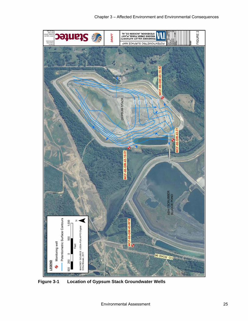
Chapter 3 – Affected Environment and Environmental Consequences
Environmental Assessment 25
Figure 3-1 Location of Gypsum Stack Groundwater Wells

Widows Creek Fossil Plant Soil Excavation and Gypsum Stack Closure
26 Environmental Assessment
The results of this monitoring have not demonstrated a persistent water quality issue through the data observed. A few exceedances of maximum contaminant levels (MCLs) have, however, occurred at the site. The only chronic exceedance from 2011-2013 has been sulfate in well 10-52. Sulfate is a secondary drinking water MCL. MCL exceedance of beryllium and lead primary drinking water MCLs observed during November 2013 is likely due to the very heavy sample turbidity observed during that event. The amount of water in that well was greatly reduced from what has historically been observed, and the sample recovered from the event the day after fully evacuating the well was likely not representative. During that sampling, other constituents in W31 (including arsenic, barium, chromium, mercury, nickel, selenium, and sulfate) exceeded previously observed ranges established for that well, but were below applicable MCLs.
3.3.2 Environmental Consequences Alternative A Under Alternative A, existing resource trends would continue. No significant changes to surface water or groundwater availability or quality are anticipated. Widows Creek and Guntersville Reservoir are anticipated to remain impaired. Limited amounts of sediment would continue to be transported to Widows Creek and Horn Branch from current sources of erosion. No additional direct or indirect impacts to surface water or groundwater are anticipated under Alternative A.
Alternative B Surface Water Closure of the GS is anticipated to have long-term, beneficial impacts on water quality within Widows Creek and the Tennessee River. Accidental releases of gypsum such as that assessed in TVA (2009) or CCR would be less likely to occur. Reducing the potential for introduction of gypsum into Widows Creek and the Tennessee River would also reduce the potential for introduction of inorganic mercury (which occurs as a trace component of gypsum) into these water bodies. As the quantity of mercury introduced to these water bodies under existing conditions from the GS is low, the beneficial impacts are expected to be minor and to not significantly contribute to removal of the fish consumption advisory and/or removal of Widows Creek or the Tennessee River from the ADEM 303(d) listing.
As stated in Section 3.2.2, potential exists for increased rates of erosion within the project area under Alternative B. The potential for those eroded sediments to be transported to surface waters, such as Widows Creek and Horn Branch, is low because the two detention ponds will slow runoff and trap sediment. The proposed detention pond is located within the limits of an unnamed ephemeral tributary to Widows Creek. After a February 6, 2014 site visit, the USACE determined that the unnamed tributary is not waters of the United States and would not require a Section 404 permit (Appendix B). Given the intermittent flow and lack of aquatic life, there would be no adverse impacts to modifications of this ephemeral stream.
Operation of excavation and construction equipment could lead to minor leaks of fuel, lubricating, or hydraulic liquids in areas adjacent to Horn Branch. Leaks of these types, however, are not expected, and are unlikely to reach surface waters even if one were to occur. Consequently, direct impacts to Horn Branch water quality are anticipated to be negligible to minor.
Furthermore, because only negligible to minor impacts to Horn Branch are anticipated, no downstream impacts to Widows Creek or Guntersville Reservoir would occur. Existing

Chapter 3 – Affected Environment and Environmental Consequences
Environmental Assessment 27
resource trends in Widows Creek and Guntersville Reservoir would continue and these surface water bodies are anticipated to remain impaired under Alternative B. The proposed SEA activities would not result in additional mercury contributions to Widows Creek or Guntersville Reservoir which are listed on the 303d list for mercury impairment.
As discussed in Section 1.5, TVA would submit a notice of intent to ADEM for coverage under the General NPDES Permit for Discharges of Storm Water Associated with Construction Activities for the entire project area. As part of this application, a pollution abatement plan (PAP) would be developed and implemented to control and confine sediment to the project area. With proper implementation of best management practices (BMPs) and additional measures outlined in the PAP, there would be no direct or indirect impacts to surface waters.
Groundwater Soil Excavation Area The shallow perched groundwater zone is likely to be intercepted by excavation activities at the SEA. Excavation activities would be deep enough to reach the deeper perched groundwater zone (if present) and Knox-Shady aquifer (URS 2013). Groundwater flow patterns within the shallow perched groundwater zone would be affected by excavation. Instead of maintaining flow within the perched zone, groundwater may daylight within the northern SEA before re-infiltrating into what are now deeper portions of the residuum. Overall recharge to the Knox-Shady aquifer via infiltration through the residuum is not expected to be adversely affected. Groundwater infiltration rates at the SEA are anticipated to increase due to reduction of slope gradient in those areas. Although minor spills of fuel, lubricating, or hydraulic liquids could occur and infiltrate shallow groundwater, these types of events are not anticipated. Construction of the proposed haul road under Alternative B would not adversely affect groundwater quality within the APE.
Gypsum Stack Closure Infiltration is the process by which water enters the soil and once water has infiltrated the soil it can percolate down to the groundwater. Infiltration for the proposed cover of the GS was estimated using the Hydrologic Evaluation of Landfill Performance (HELP) Model Version 3.07. Infiltration was estimated for the top and side sloped of the GS. The model results show a 0.12 inch per year (in/yr) top infiltration and a 0.06 in/yr side slope infiltration. The weighted infiltration (total average infiltration over the entire area of the GS) is 0.10 in/yr (URS 2012).
Leachate is the water that flows through (and out of) the GS, plus the material and/or chemical compounds that get caught up in that water. Rain falls on the top of the GS, works its way down through the stack, and out through the bottom or the side of the GS. When that water exits the GS, it is called leachate at that point. The infiltration rates above were used in conjunction with seepage modeling to perform a preliminary estimate of leachate flow rates. The estimated leachate flow rate (yearly average) for the proposed cover system is 0.1 gallons per minute (URS 2012), which will seasonally vary depending on local precipitation. These results show a negligible amount of leachate flow with the installation of the proposed geomembrane cover system.
The minimum ADEM cover is equivalent to the minimum cover required in the Resource Conservation and Recovery Act (RCRA), Subtitle D. This minimum cover includes 18 inches of compacted clay and a 6 inch VSSL. The estimated leachate flow rate for the RCRA Subtitle D cover is 150 gpm, which is considerably more than the proposed action

Widows Creek Fossil Plant Soil Excavation and Gypsum Stack Closure
28 Environmental Assessment
rate of 0.1 gpm (the proposed action would be significantly more protective of groundwater than regulatory requirements) (URS 2012).
Dewatering and installation of the cover system on the GS is anticipated to have beneficial impacts on groundwater quality within the Knox-Shady aquifer and no impact on groundwater supply. The cover system would reduce infiltration of precipitation into the GS by establishing an impervious cover over the GS. This cover includes a 40-millimeter thick linear low density polyethylene geomembrane. The reduction in infiltration would minimize the potential for constituents in the GS to leach out of the stack in precipitation that is infiltrating through the GS. Thus, the cover system would reduce infiltration and leaching substantially below levels that were occurring while the GS was actively in use and uncovered.
Groundwater monitoring would be performed on a semi-annual basis for five years after the final GS closure is completed. A groundwater monitoring report for each semi-annual event would be generated and submitted to ADEM.
3.4 Biological Resources Biological resources included in the environmental review include terrestrial ecology (vegetation and wildlife) and terrestrial threatened or endangered species that could be affected by the alternatives.
3.4.1 Affected Environment
3.4.1.1 Terrestrial Ecology—Vegetation The project area lies within the Sequatchie Valley, a subregion of the Southwestern Appalachian ecoregion. The Sequatchie Valley extends from the Tennessee border nearly 100 miles southwest into Alabama. In the vicinity of WCF, the open, rolling, valley floor, 600 feet in elevation, is nearly 1,000 feet below the top of the Cumberland Plateau and Sand Mountain.
Overall, this is an agriculturally productive region, with areas of pasture, hay, soybeans, small grain, corn, and tobacco (Griffith et al. 2001). The proposed SEA occurs in a landscape disturbed and shaped by previous development practices, including residential buildings, outbuildings, and roadways. TVA removed all structures located in the proposed SEA in 2013 (TVA 2013). The slopes of the GS are seeded with grass to help stabilization, no other vegetation is present.
Vegetation in the proposed SEA includes areas of mixed deciduous forest and herbaceous vegetation. Herbaceous vegetation found in previously mowed areas is common in the region. Common species found include Bermuda grass, blackberries, butterfly weed, chicory, daisy fleabane, Johnson grass, narrow-leaf plantain, perennial ryegrass, orchard grass, Queen Anne’s lace, smooth brome grass, tall fescue, yellow sweet clover, and white sweet clover.
Executive Order (EO) 13112 (Invasive Species) defines an invasive species as any species that is not native to that ecosystem and whose introduction does or is likely to cause economic or environmental harm or harm to human health. Invasive plants are common in and near the project area. They include autumn olive, bush honeysuckle, Chinese privet, crown vetch, Japanese honeysuckle, Japanese stilt grass, Johnson grass, mimosa, multiflora rose, and sericea lespedeza. All of these species have the potential to affect the
Chapter 3 – Affected Environment and Environmental Consequences
Environmental Assessment 29
native plant communities adversely because of their ability to spread rapidly and displace native vegetation.
3.4.1.2 Terrestrial Ecology—Wildlife The landscape directly surrounding the project site is relatively disturbed, and thus not ideal for most sensitive wildlife species. It includes a relatively even mix of industrial areas (primarily the TVA Widows Creek Fossil Plant), residential homes, agricultural fields, roads, transmission line rights-of-way, and patches of forest. In 2011 tornados moved through the area destroying homes and heavily impacting some of the remaining forested fragments. The project area itself has been heavily impacted by the tornado activity as well as human development.
The project area is mostly comprised of herbaceous fields, however some forest fragments remain. Most of these forested areas are in various stages of regrowth after high winds from the tornados blew down, broke or killed standing trees. These fragments typically have open canopy comprised of mature pine (many of which are snags) and a cluttered understory of invasive plants as described above in section 3.4.1. At least one of these areas has been logged recently. The section of forest around the perimeter of the gypsum pond also has an open canopy dominated by pine. Subcanopy species in this area are more diverse and include box elder, red bud, red maple, sweet gum, and willow species. The understory however, is similarly dominated by invasive plants. One farm pond surrounded by emergent vegetation and trees lies within the soil excavation area. Two ponds exist adjacent to these excavation areas. Several roads are present in the project area as well, remnants of past residential use.
Fields covered in herbaceous growth provide habitat for common birds such as field sparrow, indigo bunting, white-eyed vireo and yellow-breasted chat. Mammals such as bobcat, golden mouse, northern short-tailed shrew, and white-tailed deer also are likely to utilize this area. Disturbed forests and forest edges provide habitat for birds such as Carolina chickadee, Carolina wren, eastern tufted titmouse, northern cardinal, northern flicker, and northern mockingbird. Mammals found in these habitats include common raccoon, eastern gray squirrel, hispid cotton rat, nine-banded armadillo, and Virginia opossum. The three ponds found in and around preferred soil excavation sites are relatively small in size and depth. Despite their small size, these ponds provide suitable habitat for a multitude of amphibian and reptilian species. Amphibians likely to use the area include American bullfrog, eastern red-spotted newt, northern cricket frog, southern leopard frog, and upland chorus frog. Reptiles utilizing these wet areas and the surrounding habitat include garter, northern water, rat and ring-necked snakes. Common bat species also have been found to forage over these ponds. These species include big brown, hoary, tricolored, and silver-haired bats.
Review of the TVA Regional Natural Heritage database in September of 2013 indicates that seven caves are reported within three miles of the project area. No caves were found on the project area and the nearest cave record is 2.3 miles from the project area. No other unique or important terrestrial habitats exist on the project site.
No aggregations of migratory birds or colonial wading bird colonies are known from the project area. However, two colonial wading bird colonies exist within 0.5 and 0.7 miles from the project area. These great blue heron rookeries are on the support beams of two transmission line structures set in the middle of the ash settling pond at WCF.
Widows Creek Fossil Plant Soil Excavation and Gypsum Stack Closure
30 Environmental Assessment
Great blue herons other wading birds, are likely to use bodies of water on top of and alongside the gypsum stack and the adjacent settling pond as foraging habitat as well. These species include, Canada geese, common mergansers, double crested cormorants, great egrets, green herons, and mallards. Shorebirds may also utilize this habitat as stop over locations during migrations. Some shorebirds potentially found here during the migratory season include dunlin, greater yellowlegs, least sandpipers, lesser yellowlegs, and spotted sandpipers.
3.4.1.3 Threatened and Endangered Species The Endangered Species Act requires federal agencies to conserve listed species and to determine the effects of their proposed actions on endangered and threatened species and their critical habitats. Endangered species are those determined to be in danger of extinction throughout all or a significant portion of their range. Threatened species are those determined to be likely to become endangered within the foreseeable future. Section 7 of the Endangered Species Act requires federal agencies to consult with the U.S. Fish and Wildlife Service (USFWS) when their proposed actions may affect endangered or threatened species and their critical habitats. No aquatic endangered or threatened species are known or likely to occur in the project area.
Plant Species An October 2013 review of the TVA Regional Heritage database identified no documented occurrences of federally listed species and documented occurrences of six state-listed species within five miles of the project area (Table 3-2). Alabama does not confer a particular status to state-listed species, but instead provides rankings. Occurrences of three federally listed plants in Jackson County, Alabama have been documented and they were included in this analysis.
Table 3-2 Plants of Conservation Concern Known from Within 5 Miles of the Project Area
Common Name Scientific Name Federal Status
State Rank1
Alabama lipfern Cheilanthes alabamensis -- S3
American columbo Frasera caroliniensis -- S2
Bog goldenrod Solidago uliginosa -- SH
Dutchman's breeches Dicentra cucullaria -- S2
*Green pitcher plant Sarracenia oreophila LE S2
*Monkey-face orchid Platanthera integrilabia C S2
*Price's potato bean Apios priceana LT S2
Pussy willow Salix humilis -- S2S3
Yellow giant-hyssop Agastache nepetoides -- S1 * known from the county but not from within five miles of the project area 1 Alabama does not give status to state listed species Federal status abbreviations: C=Candidate for listing as threatened or endangered, LT=Listed threatened, LE=Listed Endangered State rank abbreviations: S1 – critically imperiled often with 5 or fewer occurrences, S2 – Imperiled often with <20 occurrences, S3 – rare or uncommon often with <80 occurrences, S4--apparently secure in the state with many occurrences; H=historical record

Chapter 3 – Affected Environment and Environmental Consequences
Environmental Assessment 31
Based on photos, maps, and knowledge of rare plant habitats in the region and the knowledge that the project area has been highly disturbed, it is unlikely that habitats to support listed plants are present within the project area.
Animal Species A September 2013 review of the TVA Regional Heritage database identified two Alabama state-listed terrestrial animal species and documented occurrences of one federally protected terrestrial animal species (the bald eagle) within three miles of the proposed project area. Bat surveys performed in August 2013 documented federally endangered gray bats foraging over ponds in the project area. Occurrences of one additional federally endangered (Indiana bat) and on federally proposed endangered (northern long-eared bat) species have been documented in Jackson County, Alabama (Table 3-3).
Table 3-3 Listed Terrestrial Wildlife in the Vicinity of the Project Area
Scientific Name Common Name State Status1 (Rank2) Federal Status
Aneides aeneus Green Salamander PROT (S3) --
Haliaeetus leucocephalus Bald eagle PROT (S3) DM
Myotis grisescens Gray bat PROT (S2) LE
Myotis septentrionalis3 Northern long-eared bat TRKD(S2) PE
Myotis sodalis3 Indiana bat PROT (S2) LE
Nesticus barri Cave obligate spider TRKD (S3) -- 1Status abbreviations: Federal Rank: LE=Listed Endangered, PE = Proposed Endangered, DM= Downlisted, in need of management. Alabama State Rank; PROT= Protected by state of Alabama; TRKD = Tracked in State of Alabama. 2State Rank abbreviations: S1 = Extremely imperiled; S2 = imperiled; S3 = rare or uncommon 3Federally-listed species that occur within the county where work would occur, but not within 3 miles of the project area.
Green salamanders are found in damp areas, including rocky outcrops and ledges, beneath loose bark or cracks of trees, and under logs. Eggs are laid in similarly moist, dark places. The nearest record of this species documents an observation on a rock ledge approximately 3 miles from the project area. Suitable habitats do not exist for this species in the project area.
Bald eagles are protected under the Bald and Golden Eagle Protection Act. This species is associated with large mature trees capable of supporting its massive nests, which are usually found near larger waterways that offer suitable foraging habitats. Records document the occurrence of 17 bald eagle nests within Jackson County, Alabama, including one nest approximately 2.6 miles from the project area. However, this nest no longer exists.
No large waterways occur in the project area and the nearest large waterway is the Tennessee River on the south side of WCF. In addition, the recent tornado in and near the project area damaged many large trees that may have otherwise been capable of supporting nests of this species. Finally, many other trees were logged from the area prior to TVA taking possession of the property. Potentially suitable habitats for bald eagle nests do not occur in the project area and no nests or resident pairs are known from the immediate vicinity.

Widows Creek Fossil Plant Soil Excavation and Gypsum Stack Closure
32 Environmental Assessment
Gray bats roost in caves year-round and migrate between summer and winter roosts during spring and fall (Tuttle 1976). Records document the occurrence of eight hibernacula of the gray bat in Jackson County, Alabama. Two of these are identified as priority hibernacula for the gray bat in the Gray Bat Recovery Plan (USFWS 1982). Sauta Cave (30 miles away) and Fern Cave (36 miles away). The two closest documented hibernacula are 4.8 (Horse Skull Cave) miles away in Jackson County, Alabama and 9 (Nickajack Cave) miles away in Marion County, Tennessee. Nickajack Cave is also listed as a Priority 1 cave in the Gray Bat Recovery Plan (USFWS 1982).
Although no caves have been found in the project area and the nearest documented cave is 2.3 miles from the project area, gray bats may forage in the project area. Small ponds present in the area offer potentially suitable foraging habitats. In addition, several gray bat calls were recorded and one post-lactating female gray bat was captured during acoustic and mist net surveys conducted in the project area on August 6–10, 2013.
The Indiana bat hibernates in caves and forms summer roosts in mature forests with open understories, available roosts, and nearby sources of water. Roosts are formed under the exfoliating bark of live and dead trees (Pruitt and TeWinkel 2007, Kurta et al. 2002). Historical records document the occurrence of Indiana bats in Nickajack Cave, Sittons Cave (14.7 miles away, Dade County, Georgia), and Fern Cave. The closest caves currently occupied by Indiana bats are Saltpeter Cave (11.6 miles away, Jackson County, Alabama), Case Cave (14.8 miles away, Dade County, Georgia) and Sauta Cave. Additionally, records from a bat survey performed by the Alabama Bat Working Group October 7-11, 2013 include one Indiana bat captured at the entrance of Roberts Folly Cave, 19.8 miles away from the project area.
Although no caves have been found in the immediate project area, and the nearest documented cave is 2.3 miles from the project area, potentially suitable habitats for Indiana bats exist in the area. The recent tornado in and near the project area has contributed to the quantity of snags available for summer roosting. Trees and shrubs in the project area offer potentially suitable habitats for foraging, and small ponds offer nearby sources of water. Habitat assessments conducted on August 6, 2013 indicate the high number of snags and presence of large trees in the project area provide moderately suitable summer roosting habitat for Indiana bat. Acoustic and mist net surveys were conducted in the project area on August 6-10, 2013 to determine presence of Indiana bat in the project area.
No Indiana bats were captured during mist net surveys. Analysis of acoustic surveys using Kaleidoscope software did not identify any calls as Indiana bat calls. However, 12 calls were identified as Indiana bat calls during acoustic analysis using Bat Call Identification software. Qualitative review of these 12 calls revealed that only one of these recorded call sequences might be from an Indiana bat. Thus, Indiana bat use of the area is uncertain.
Data currently available for northern long-eared bat suggests that this species occupies habitat similar to Indiana bat, although roost trees are just as likely to be live as dead, and the species is considered more common. There are no known records of northern long-eared hibernacula from Jackson County, Alabama. However, a few individuals have been reported from Armstrong Cave, 9 miles away during recent winter hibernacula by the Alabama Department of Conservation and Natural Resources and Division of Wildlife and Freshwater Fisheries (unpublished). Three individuals were also reported as far south as Bibb County, Alabama during hibernacula surveys in 2010. Bat surveys conducted by the Alabama Bat Working Group have reported mist net and harp net captures of northern long-

Chapter 3 – Affected Environment and Environmental Consequences
Environmental Assessment 33
eared bats at Armstrong Cave (70 individuals) and Mountain Springs Cave (7 individuals, 7 miles away, Lawrence County, Alabama) in August 2008. However the closest known northern long-eared record is from a bat survey at Big Coon Cave approximately 15.3 miles away, Jackson County, Alabama. This species was not captured during mist net surveys or identified during analysis of acoustic surveys performed on site August 6-10, 2013, thus this species is not likely to occur at the project site.
Finally, cave obligate spiders are found in subterranean habitats in caves. As noted previously, no caves have been found in the immediate project area, and the nearest documented cave is 2.3 miles from the project area. In addition, the closest record of this species is from a cave approximately 3 miles from the project area. No suitable habitat exists for the cave obligate spider in the project area.
3.4.1.4 Wetlands Wetlands are those areas inundated by surface or groundwater such that vegetation adapted to saturated soil conditions is prevalent. Examples include swamps, marshes, bogs, and wet meadows. Wetland fringe areas are also found along the edges of most watercourses and impounded waters (both natural and man-made).
WCF is located within the Southwestern Appalachian ecoregion where wetlands are relatively uncommon. Within this ecoregion, wetlands comprise approximately 0.2 percent of the total land use/land cover (Loveland and Acevedo, 2000). Wetlands are primarily associated with low-lying, poorly drained areas, floodplains, and riparian zones.
On August 1, 2013, the project area was surveyed for wetlands. This survey located and delineated two wetlands and two farm ponds (See Figures 2-2 and 3-2). Wetland 1 (W001), located in the southernmost portion of the project area, is a 0.14-acre emergent wetland. Wetland 2 (W002) is a 0.22-acre emergent wetland near CR96 that appears to be hydrologically connected to the farm pond located just north of the wetland.
Another survey conducted in December 2012 focused on areas surrounding the GS. This survey identified approximately 50 acres of wetlands, including a large, 30-acre forested wetland along the northern edge of the GS (Figure 3-3). This wetland is associated with Horn Branch.
3.4.2 Environmental Consequences
3.4.2.1 Terrestrial Ecology—Vegetation Alternative A Under Alternative A, TVA would not close the GS and would not use the adjacent property for soil excavation. Vegetation and plant communities would not be affected by any project-related actions. Therefore, there would be no direct or indirect impacts to terrestrial plant communities under Alternative A.
Alternative B Under Alternative B, the proposed soil excavation activities would remove approximately 35 acres of vegetation. The vegetation in the project area is common and representative of the region. Therefore, no direct or indirect impacts to unique or important terrestrial plant communities are anticipated.
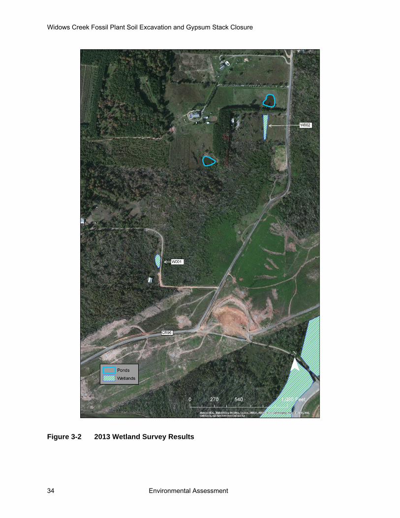
Widows Creek Fossil Plant Soil Excavation and Gypsum Stack Closure
34 Environmental Assessment
Figure 3-2 2013 Wetland Survey Results

Chapter 3 – Affected Environment and Environmental Consequences
Environmental Assessment 35
Figure 3-3 Wetlands Identified near the Gypsum Stack

Widows Creek Fossil Plant Soil Excavation and Gypsum Stack Closure
36 Environmental Assessment
Once TVA is finished with the excavation areas, the disturbance would be reclaimed and revegetated. The SEA would be revegetated with native grasses. Thus, the revegetated area would provide a low quality native for wildlife than what is currently on the site. In addition, closure of the GS would increase the amount and distribution of native vegetation in the project area. Once vegetation is established on the GS, the structure would no longer be an industrial facility, but a revegetated area that would provide improved habitats for wildlife.
The proposed soil excavation and GS closure activities would require the movement of heavy equipment, which would result in soil disturbance that could be a vector for the introduction of invasive species. With the condition to revegetate disturbed areas with native or non-native, non-invasive species, the potential for this project to contribute to the spread of invasive plant species would be minimized, as directed by EO 13112.
3.4.2.2 Terrestrial Ecology—Wildlife Alternative A Under Alternative A, TVA would not close the GS facility. Therefore, TVA would no longer need to construct a soil excavation area adjacent to WCF. Soil and vegetation would remain in place in their current state, and new roads and turnaround areas would not be built to accommodate hauling needs. Therefore, there would be no direct or indirect impacts to wildlife under Alternative A.
Alternative B Under Alternative B, TVA would excavate the proposed SEA removing soil and vegetation in the process. Haul roads and turnaround areas would be constructed where needed within the project area in order to transport excavated soil to the GS. The soil excavation site has been heavily impacted by logging, residential uses, and tornado activity. Thus the wildlife habitat that exists in the project area is comprised of common species that thrive in disturbed areas.
The proposed actions would displace wildlife using this habitat while the project activities are taking place (approximately 2 years). The disturbance in the area and removal of habitat would likely force wildlife to move to surrounding environments and attempt to reestablish territories, shelter, and find new sources of food. If surrounding areas are already crowded, populations could be stressed by the influx of more individuals. However, similarly disturbed environments are common in areas surrounding the project site, and it is unlikely that these would be negatively impacted by the influx. Surrounding areas that were not as heavily impacted by tornado activity may provide higher quality habitat for some of these species. Mortality of individuals that are unable to mobilize quickly would occur.
Closure of the GS would permanently remove foraging habitat for shorebirds, herons, and other migratory birds that forage in the area. Similar habitat still remains at the ash settling pond at WCF, adjacent to the GS. Additionally the Tennessee River is adjacent to the WCF and also provides suitable foraging habitat for several of these species. Any wildlife using the GS to forage would relocate to these surrounding areas and the net reduction in habitat would not have significant impacts on area wildlife populations.
Reclamation at both the GS and soil excavation areas would create herbaceous habitat for wildlife. Although species diversity would not be as great without forest and edge habitat, some common species could return and re-populate the area once activities are complete.
Chapter 3 – Affected Environment and Environmental Consequences
Environmental Assessment 37
This alternative is not expected to result in significant impacts to terrestrial wildlife of their habitats.
3.4.2.3 Threatened and Endangered Species Alternative A Under Alternative A, TVA would not close the GS or use the adjacent property for soil excavation activities. Environmental conditions would remain the same within the project area. Therefore, no direct or indirect impacts to terrestrial threatened and endangered species would occur.
Alternative B Plant Species No known occurrences of federally or state-listed plant species or habitats to support these species are known on or immediately adjacent to the proposed project area. Consequently, no direct or indirect impacts to listed plant species are expected to occur under Alternative B.
Animal Species Six terrestrial animal species were assessed based on documented presence within three miles of the project area. Two of these species are considered rare by the state of Alabama and one federally protected, two federally listed, and one federally proposed endangered species are known from the county. Suitable habitat does not exist in the proposed project area for green salamander, cave obligate spider and bald eagle, thus these species would not be impacted by the proposed actions.
Presence of suitable foraging and summer roosting habitat in the project area indicates that the three federally listed bat species have the potential to occur in the project area. Additionally, one of the bat species was documented in the project area (gray bat). However, no caves are known from the project area thus no hibernacula for any of these bat species would be impacted by the proposed actions.
Summer roosting habitat surveys for Indiana bat were performed in August 2013. Due to the high number of snags, presence of large trees, and several sources of water in the project area, habitat was determined to be moderately suitable for summer roosting Indiana bat. Forested areas in the project footprint also may offer foraging habitat for the Indiana bat. Project activities would remove this summer roosting and foraging habitat for this species during winter months when the species do not exist on the landscape, thus no direct effects to this species would occur. Nonetheless, removal of this summer roosting habitat would permanently displace any individuals that typically roost in these trees during summer months. Similar habitat is common in the surrounding landscape due to the expansive impacts of the tornados. Thus, alternative summer roosting trees are likely available in the surrounding area.
Following USFWS Indiana bat survey guidance from May of 2013 (USWFS 2013), if project activities cannot avoid impacts to suitable summer roosting habitat, presence/absence surveys for Indiana bat should be conducted. Therefore, acoustic and mist net surveys were conducted August 6-10, 2013.
No Indiana bats were captured in mist nets and call survey analysis suggests one bat was recorded using this habitat. These survey results in combination with the presence of only moderately suitable summer roosting habitat on the project site, and plentiful similar habitat
Widows Creek Fossil Plant Soil Excavation and Gypsum Stack Closure
38 Environmental Assessment
in the surrounding landscape, indicate that tree removal in the project area is not likely to adversely affect this species.
While performing the bat surveys, one post-lactating female gray bat was captured and several gray bat calls were recorded on acoustic monitors. Gray bats utilize caves year-round but leave the caves to forage at night. The project activities would remove one small farm pond in the project footprint, thus this source of foraging habitat would be impacted for gray bats. However, foraging habitat for the gray bat is plentiful in the area as the surrounding landscape is dotted with other ponds and the Tennessee River is approximately 1.2 miles from the project area. Removal of suitable foraging habitat for the gray bat may affect this species; however, the proposed actions are not likely to adversely affect this species.
Research suggests that northern long-eared bats occupy similar habitat to Indiana bats, thus this species has the potential to be present on the project site. However, surveys performed on the project site did not indicate that this species was utilizing this area. Tree removal would not jeopardize this species.
In a letter dated December 9, 2013, the USFWS concurred with TVA’s determination that the proposed action may affect, but is not likely to adversely affect Indiana bat or gray bat, and would not jeopardize the northern long-eared bat (Appendix C). Therefore, no direct or indirect impacts to listed wildlife species would occur under Alternative B.
3.4.2.4 Wetlands Wetlands are protected under Sections 404 of the Clean Water Act and by EO 11990. In order to conduct specific activities in wetlands, authorization under a Section 404 permit from the USACE may be required depending on the wetland’s size and hydrologic connectivity to a navigable waterway. EO 11990 requires all federal agencies to minimize the destruction, loss or degradation of wetlands, and to preserve and enhance the natural and beneficial values of wetlands in carrying out the agency’s responsibilities.
Alternative A Under Alternative A, TVA would not close the GS facility. Therefore, TVA would no longer need to construct a soil excavation area adjacent to WCF. Environmental conditions in the project area would not change and no direct or indirect impacts to wetlands would occur.
Alternative B Under Alternative B, TVA would proceed with the closure of the GS and use property adjacent to WCF as a soil excavation area. TVA was able to redesign the soil excavation area and the haul road to avoid potential impacts to W-001 (0.14-acre emergent wetland) and W-002 (0.22-acre emergent wetland) identified in the 2013 survey. After a February 6, 2014 site visit, the USACE determined that W-001 was a farm pond and not a jurisdictional wetland (Appendix B). The placement of the foundation for the proposed Horn Branch bridge improvements would impact approximately 0.10 acre of the large forested wetland complex just north of the GS.
Seven stormwater outflows from the closed GS would be constructed and/or directed into portions of the wetlands surrounding the perimeter of the GS (Figure 2-1). The construction of five of the outflows and some grading on the southeast side of the GS would impact approximately 0.6 acre of wetlands. These outflows would affect wetland hydrology by changing the amount and duration of water entering the wetlands. Depending on the
Chapter 3 – Affected Environment and Environmental Consequences
Environmental Assessment 39
seasonality of these changes, there could be changes in wetland extent and habitat types. Given the dynamic nature of wetland ecosystems, the effects of increased stormwater input are not expected to be adverse.
Based on site topography and existing site constraints (roads and site geology) of the GS, TVA has determined there is no practicable alternative to the direct impacts of 0.70 acre of wetland under Alternative B. Wetland impacts would be offset by compliance with applicable USACE Section 404 regulations. Mitigation requirements require mitigation at a minimum 2:1 ratio, with the preferred method being purchase of credits in a USACE-approved mitigation bank. To meet these regulatory requirements, TVA would purchase 1.4 credits in an approved mitigation bank within the Horn Branch watershed service area. With required mitigation, wetland impacts would be insignificant.
3.5 Cultural and Historic Resources Cultural resources include, but are not limited to, prehistoric and historic archaeological sites, historic structures, and historic sites at which important events occurred. Cultural resources are finite, non-renewable, and often fragile. They are frequently threatened by industrial, commercial, and residential development, as well as construction of roads and other infrastructure. TVA is mandated by the National Historic Preservation Act of 1966 (NHPA) and the Archaeological Resources Protection Act of 1979 to preserve significant cultural resources (i.e., archaeological sites and historic structures) located on TVA lands or such resources that would be affected by TVA undertakings. The NHPA addresses the preservation of “historic properties,” which is defined under the Act as any prehistoric or historic district, site, building, structure, or object included in or eligible for inclusion in the National Register of Historic Places (NRHP).
Two broad categories of cultural resources are archaeological resources and historic architecture. Some examples of archaeological resources are earthworks, weapons and projectiles, human remains, rock carvings, and remains of subsurface structures such as domestic fire pits. Historic architecture consists of standing structures that are 50 years old or older. Consistent with Section 106 of NHPA, such structures, as well as archaeological resources, must meet certain criteria to qualify for inclusion on the NRHP.
3.5.1 Affected Environment TVA surveyed 600 acres of the APE in 2011 to document and assess archaeological and architectural resources present in the APE pertinent to these resources. However, the APE for archaeological and architectural resources for the proposed action is only the approximately 230-acre project area that includes the GS, SEA, and haul roads. The survey identified one previously recorded archaeological site (1JA1125) (TRC Environmental Corporation 2011). Site 1JA1125 features a twentieth-century historic scatter that was recommended as ineligible for inclusion on the NRHP. In July 2010, TVA determined Site 1JA1125 ineligible for inclusion in the NRHP and the Alabama Historical Commission (AHC) agreed (Appendix D).
In addition, Jackson County historic architectural survey records at the AHC were reviewed to identify previously recorded architectural properties listed on, or eligible for inclusion in the NRHP. The records search identified two previously recorded architectural resources (071-00001 and 071-00002) located within the project APE (TRC Environmental Corporation 2011). In July 2010, TVA determined properties 071-00001 and 071-00002 ineligible for the NRHP and the AHC agreed (Appendix D).
Widows Creek Fossil Plant Soil Excavation and Gypsum Stack Closure
40 Environmental Assessment
Following the records search, 600 acres of the APE was surveyed on foot, using both systematic visual examinations and shovel testing to prospect for archaeological remains (TRC Environmental Corporation 2011). Visual inspections were undertaken in areas of greater than 50 percent surface visibility. In areas of low surface visibility and less than 20 percent slope, shovel testing was conducted at 30-m (98-foot) intervals. Areas with substantial tornado damage were not surveyed due to the safety risks. No archaeological resources were discovered in these visual inspections.
A historic architectural survey of the APE was also conducted. This survey resulted in the identification of one previously unrecorded architectural resource (HS-1). This resource was recommended ineligible for the NRHP because of its lack of architectural distinction and loss of integrity caused by modern alterations (TRC Environmental Corporation 2011). In addition, the survey revealed that previously recorded properties 071-00001 and 071-00002 were destroyed by the tornadic activity in the spring of 2011. On December 13, 2011, the AHC agreed with TVA’s findings and determinations that no eligible historic structures would be impacted. (Appendix D).
In October 2013, TVA conducted a field reconnaissance of the haul road portion of the APE. Two of the proposed turnaround areas are within extensively disturbed areas from past activities associated with the existing transmission line corridor and the WCF GS. The third turnaround area (easternmost) located within a wooded area adjacent to the GS, shows little potential for intact archaeological deposits and was disturbed by previous vehicle use. The proposed stream crossing shows little potential for archaeological deposits due to the setting (a wet creek bottom). No archaeological resources were identified during the survey. On December 2, 2013, the AHC agreed with TVA’s findings (Appendix D).
In summary, the APE contains no archaeological or architectural properties listed in, or eligible for inclusion in, the NRHP.
3.5.2 Environmental Consequences Alternative A Implementing Alternative A would require no ground disturbance activities. TVA demolished and removed all structures that were previously present in the APE as per the House Demolition EA (TVA 2013). Therefore, no direct or indirect impacts to cultural resources would occur under Alternative A.
Alternative B TVA demolished and removed all structures that were previously present in the APE as per the House Demolition EA (TVA 2013). None of the manmade structures that were present in the APE were eligible for the NRHP. Properties 071-00001 and 071-00002, which were already determined ineligible for the NRHP, were destroyed by the tornado in 2011. Resource HS-1 lacked architectural distinction and had a loss of integrity because of modern alterations. Further, archaeological Site 1JA1125 was not eligible for the NRHP. The proposed haul road and turnaround areas do not contain archaeological resources. Consequently, the proposed action would not affect architectural or archaeological resources, directly or indirectly.

Chapter 3 – Affected Environment and Environmental Consequences
Environmental Assessment 41
3.6 Visual Resources
3.6.1 Affected Environment The physical, biological, and cultural features of an area combine to make the visual landscape character both identifiable and unique. Scenic integrity indicates the degree of unity or wholeness of the visual character. Scenic attractiveness is the evaluation of outstanding or unique natural features, scenic variety, seasonal change, and strategic location. Where and how the landscape is viewed affect the more subjective perceptions of its aesthetic quality and sense of place.
Views of a landscape are described in terms of what is seen in foreground, middleground, and background distances. In the foreground, an area within 0.5 mile of the observer, details of objects are easily distinguished in the landscape. In the middleground, normally between 1 and 4 miles from the observer, objects may be distinguishable but their details are weak and they tend to merge into larger patterns. Details and colors of objects in the background, the distant part of the landscape, are not normally discernible unless they are especially large and standing alone. The impressions of an area’s visual character can have a substantial influence on how it is appreciated, protected, and used. The general landscape character of the study area is described in this section.
The proposed project area adjoins and includes the reservation for the WCF. Views of the project area would likely be up to distances in the foreground (0 feet to 0.5 mile) from local roads and other nearby residential areas. Scenic attractiveness of the portion of the project area adjacent to WCF is common, and scenic integrity is low because of land disturbance resulting from residential development, transmission lines, and damage from recent tornadoes. The project area within WCF has a low scenic integrity because of land disturbance associated with the development of industrial facilities, including the GS.
3.6.2 Environmental Consequences Visual consequences are examined in terms of visual changes between the existing landscape and proposed actions, sensitivity of viewing points available to the public, their viewing distances, and visibility of proposed changes. Scenic integrity indicates the degree of intactness or wholeness of the landscape character. These measures help identify changes in visual character based on commonly held perceptions of landscape beauty and the aesthetic sense of place.
Alternative A Under Alternative A, TVA would not proceed with the closure of the GS. TVA would also not construct a soil excavation area on property adjacent to its WCF. The environmental conditions would remain unchanged. Therefore, no indirect or direct visual impacts would occur under Alternative A.
Alternative B Under this alternative, there would be a minor visual change in the landscape because of the soil excavation activities. The soil excavation area is located adjacent to a transmission line corridor and the active WCF. Based on criteria developed by the U.S. Bureau of Land Management (1986) to rate scenic quality, overall scenic values of the project area are low because of the relatively low relief, lack of significant visual features, and the similarity to surrounding areas. There may be some moderate visual impacts during excavation because of the construction and use of active haul roads and an increase in activity. These visual obtrusions would be temporary until areas have been restored to conditions using

Widows Creek Fossil Plant Soil Excavation and Gypsum Stack Closure
42 Environmental Assessment
TVA standard BMPs (TVA 2012). After the completion of the GS closure, the soil excavation area would be graded and reseeded with native or nonnative, noninvasive species. Scenic attractiveness and integrity would be restored, creating a somewhat naturally appearing landscape. In addition, the currently unvegetated GS would be revegetated with native plants, which would improve the visual aesthetics of the area. Therefore, there are no significant adverse visual impacts anticipated because of this project and the long-term visual impacts would be beneficial.
3.7 Land Use
3.7.1 Affected Environment Approximately 35 acres of land purchased by TVA would be used for soil excavation. Most of the area is characterized by residual clay soils covered by grass, scrub, pasture, and mixed forests. The ridgeline that forms the southern boundary of the soil excavation area is densely forested. Prior to TVA’s purchase of the property, some of the land was cleared, leveled, and developed with homes and some lots were landscaped with shrubs, flowers, trees, and turf grass. Following its purchase of the property, TVA removed the buildings and converted the area from low density residential and agricultural use to undeveloped land. Less than 10 percent of the project area is considered prime farmland; however, the land is not actively being used for agriculture. Horn Branch is the major drainage feature of the site and runs southwest across the area.
3.7.2 Environmental Consequences Alternative A Under the No Action Alternative, TVA would not proceed with the closure of the GS. TVA would also not construct a soil excavation area on property adjacent to its WCF. Environmental conditions would remain unchanged and the GS would continue to be susceptible to failures, creating a safety risk.
Alternative B Implementation of this alternative would have minor affects to land use. The soil excavations would remove approximately 400,000 cubic yards of soil from the 35-acre SEA.
The removal of the soil in this area would represent a minor direct impact to land use within the project area because this area would likely no longer be suitable for farming. Less than 9 acres of prime farmland would be impacted. According to the USDA-SCS, 1941, Soil Survey of Jackson County, Alabama prime farmland covers 168,241 acres. The conversion of the TVA property proposed here represents less than 0.01 percent of the total available farmland in the county. After the completion of the GS closure, the project area would be graded and reseeded with native or nonnative, noninvasive species. This could allow for a return to other land uses for the project area. Overall, no significant adverse land use impacts anticipated because of this project and the long-term visual impacts would be minor.
Chapter 3 – Affected Environment and Environmental Consequences
Environmental Assessment 43
3.8 Socioeconomics and Environmental Justice
3.8.1 Affected Environment The WCF is located in Census Tract (CT) 9503 in Jackson County, Alabama and is directly adjacent to CT 9502. As of the 2010 United States Census of Population, the population of CT 9503 was 5,969 and CT 9502 was 3,339 (United States Census Bureau 2011).
Total employment in Jackson County in 2010 was 23,355 (United States Department of Commerce 2010). In 2010, more than 21 percent of total jobs in Jackson County were in manufacturing—a substantially higher proportion than the state level of 9.7 percent and the national level of 6.9 percent. Jackson County also had fewer jobs in the professional, scientific, and technical services at 2.8 percent compared to 5.5 percent at the state and 6.8 percent at the national levels.
According to the Census Bureau, per capita personal income in CT 9503 is $19,185, in CT 9502 is $18,889 and in Jackson County it is $19,770, which are about 68.7, 67.6, and 70.8 percent of the national average of $27,915, respectively. Statewide, per capita personal income was $23,483, 84 percent of the national level (United States Census Bureau 2011).
Minority populations of about 16.7 percent in CT 9503 and 14.5 percent in CT 9502 are greater than the county minority population of 9.9 percent. In contrast, the state and national minority populations of 32.7 and 35.8 percent are substantially higher (United States Census Bureau 2011).
The poverty levels in CT 9503 and 9502 are 19.5 and 16.5 percent and 17.1 percent in Jackson County. The state and national levels are 17.6 and 14.3 percent, respectively. CT 9503 is higher than the state, county, and national poverty levels (United States Census Bureau 2011).
3.8.2 Environmental Consequences Alternative A Under the No Action Alternative, TVA would not proceed with the closure of the GS. TVA would also not construct a soil excavation area on property adjacent to its WCF. The GS would continue to be susceptible to failures that could create a potential safety risk.
As discussed in Section 3.8.1, minority population shares are above those in Jackson County as a whole, and are lower than the state and national levels. Poverty levels within the impact area are higher than those in Jackson County as a whole, but less than the state and the nation. Given the current use and fairly remote nature of the site location, no impacts that would disproportionately affect either minority or low-income populations have been identified.
Alternative B Implementation of this alternative would have negligible to minor effects on the local population, employment, personal income, and poverty. The project activities would be conducted by current TVA employees and contractors. The activities would not generate any demand for new employees or in-migrants to fulfill new positions. Consequently, the current population and levels of employment, personal income, and poverty would remain unchanged.

Widows Creek Fossil Plant Soil Excavation and Gypsum Stack Closure
44 Environmental Assessment
The proposed action would maintain or enhance aesthetic benefits to those in view of the site. There is potential for minor impacts during the soil excavation and GS closure, such as noise or traffic. However, these would be temporary and intermittent. No significant negative impacts to property values have been identified.
Any negative impacts of the soil excavation or GS closure process on environmental justice would be temporary and intermittent. The temporary nature of the activities combined with the potential benefits to adjoining properties would result in no disproportionate negative impacts to disadvantaged populations.
3.9 Solid and Hazardous Waste
3.9.1 Affected Environment As described in Section 3.4, the excavation area is a vacant, somewhat disturbed site. TVA removed the man-made structures that used to occupy the area and reclaimed the disturbances. All debris was removed. Consequently, no solid or hazardous materials or wastes exist in the area.
The GS is a 160-acre facility that TVA has been using for the treatment and storage of CCR since 1981 (Stantec 2013). The facility contains an estimated 12 million cubic yards of CCR. TVA stopped wet sluicing CCR to the GS in February 2013 in preparation for closure. Any CCR waste in the Stilling Pond at time of closure would be placed in the GS after the pond is dewatered. (See Section 2.1.2).
3.9.2 Environmental Consequences Alternative A Under the No Action Alternative, TVA would not proceed with the closure of the GS. TVA would also not construct a soil excavation area on property adjacent to its WCF. The property would remain disturbed and the GS would continue to be susceptible to erosion and failures, creating a safety risk. The status of WCF as a small quantity generator of hazardous waste would not change.
Alternative B Under the Action Alternative, some debris and waste materials may be generated and removed from the soil excavation area. It is expected that this material would primarily be vegetative waste associated with the construction of haul roads and preparation of the area for soil excavation. TVA would coordinate material removal using TVA standard BMPs (TVA 2012). All materials would be properly disposed of at approved solid waste facilities or recycled in compliance with Alabama waste regulations and laws. The status of WCF as a small quantity generator of hazardous waste would not change under this alternative.
3.10 Transportation
3.10.1 Affected Environment WCF is served by service roads, rail, and barge. The description of the affected environment was framed by the truck route from the soil excavation area to the GS.TVA would transport the excavated soil to the GS in large trucks along proposed paved and unpaved haul roads (Figure 2-2).
The proposed haul roads would need to cross CR96 to connect with GS Perimeter Road. Jackson County currently owns CR96. The proposed haul road would utilize no more than 1,000 feet of CR96. No traffic data exist for CR96. The closest Alabama Department of

Chapter 3 – Affected Environment and Environmental Consequences
Environmental Assessment 45
Transportation (ALDOT) traffic station with average annual daily traffic (AADT) data is located on Route 277 approximately 1½ miles northeast of CR96. This counter recorded 3,640 AADT in 2011. It is estimated that this number is substantially higher than the estimated AADT for CR96 because CR96 is generally used only be local residences, TVA employees and vendors. For the purpose of this analysis a conservative AADT of one-twentieth the traffic on Route 277 or approximately 150 vehicles per day was used for CR96.
3.10.2 Environmental Consequences Alternative A Under Alternative A, TVA would not proceed with the closure of the GS. TVA would also not construct a soil excavation area on property adjacent to its WCF. Therefore, if soil excavation was not to occur and material not transported to the GS, no indirect or direct transportation impacts would occur.
Alternative B Rail and Barge transportation would not be impacted by the proposed action. This analysis evaluates the impacts of transporting soil from the soil excavation area to the GS by trucks on the proposed transportation networks. The expansion of the bridge across Horn Branch would be required in order to accommodate the proposed increase in haul truck traffic. This expansion as well as the construction of the roads within the soil excavation area would be done in accordance with all appropriate health and safety guidelines.
Transportation of fill material from the soil excavation area to the GS would have moderate impacts on transportation routes within the local area over the estimated 48 month work period. It is estimated that 400,000 cubic yards of soil is required to close the GS. TVA would use 40-cubic-yard capacity haul trucks for transporting the excavated soil to the GS. Based on 1,080 workdays over the four-year period (hauling Monday through Friday), approximately 10,000 truck round trips would be needed over the 48-month construction period. In addition, during the project period there may be additional deliveries of gravel or other materials that could impact traffic in and around the project location. It was estimated that as many as 10 truck round trips per day may be required over the 1,080 work days anticipated in association with GS closure. For the purpose of this evaluation, a conservative estimate of 15 truck trips per day was assumed over the 48-month project period.
Hauling the soil material to the GS and the potential for material delivery, as stated above, would result in moderate impacts to traffic along CR96. The Transportation Research Board (2000) outlines methods for evaluating the operational conditions within a traffic stream. Including the additional 15 truck trips for the days materials would be hauled from the soil excavation to the WCF site, projected AADT for CR96 would increase from a projected 150 to 165 vehicles per day. This change represents an approximately ten percent increase in traffic along CR96. However, these truck routes are limited to the project area along the closed portion of CR96 and would not contribute to the in increase traffic numbers on the nearby road network.
TVA is proposing to close 1.26 miles of CR96 during working hours (7:00am to 4pm, Monday through Friday) during the duration of the project. This road closure would temporarily impact CR96 traffic. However, traffic would be able to bypass the road closure via an alternative route using CR70 and Route 277 (Figure 3-4). It would take an additional 10 minutes to travel 5.0 miles around the closure on the alternative route. The proposed
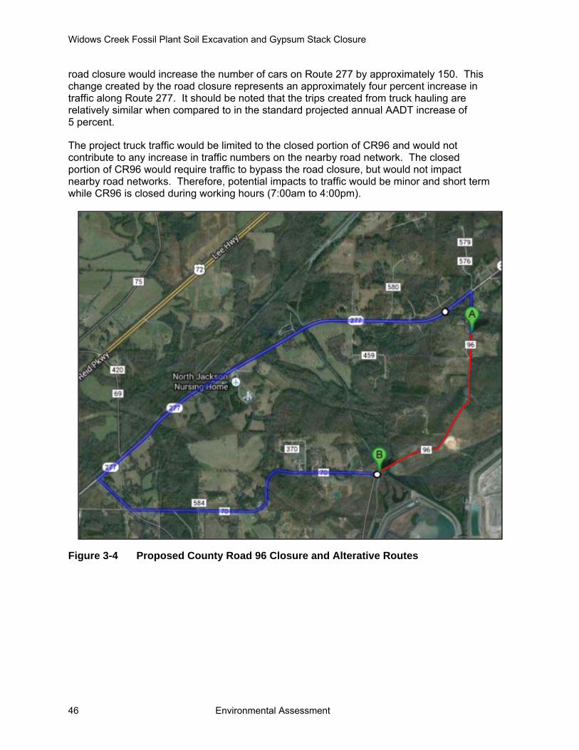
Widows Creek Fossil Plant Soil Excavation and Gypsum Stack Closure
46 Environmental Assessment
road closure would increase the number of cars on Route 277 by approximately 150. This change created by the road closure represents an approximately four percent increase in traffic along Route 277. It should be noted that the trips created from truck hauling are relatively similar when compared to in the standard projected annual AADT increase of 5 percent.
The project truck traffic would be limited to the closed portion of CR96 and would not contribute to any increase in traffic numbers on the nearby road network. The closed portion of CR96 would require traffic to bypass the road closure, but would not impact nearby road networks. Therefore, potential impacts to traffic would be minor and short term while CR96 is closed during working hours (7:00am to 4:00pm).
Figure 3-4 Proposed County Road 96 Closure and Alterative Routes

Chapter 3 – Affected Environment and Environmental Consequences
Environmental Assessment 47
3.11 Noise
3.11.1 Affected Environment The project area is a semi-rural area with broadly distributed man-made structures. During the summer 2013, TVA demolished and removed structures in the project area (TVA 2013).
The primary affected environments from the noise of soil excavation, GS closure, and associated activities include the workers and residents who live adjacent to the site or along the trucking routes for materials that are hauled into and out of the operation. Section 3.10, Transportation, describes the proposed hauling routes to and from WCF.
3.11.2 Environmental Consequences Alternative A Under the No Action Alternative, TVA would not proceed with the closure of the GS. TVA would also not construct a soil excavation area on property adjacent to its WCF. Environmental conditions in the project area would not change. Therefore, no indirect or direct noise impacts would occur under Alternative A.
Alternative B The proposed project would involve soil excavation and transportation of soil material to the GS. Heavy construction equipment for this project would include (but may not be limited to) stationary equipment (generators, and compressors), bulldozers, backhoes, excavators, water trucks, and articulated dump trucks. This project may create temporary or intermittent short-term annoyance for the local community, which would cease after the completion of the project.
Construction equipment is operated in two modes: stationary and mobile. Stationary equipment operates in one location for one or more days at a time. Mobile equipment (such as bulldozers, graders, and loaders) moves around a construction site with power applied in cyclic fashion. Noise impacts from stationary equipment are assessed from the center of the equipment, while noise impacts for mobile construction equipment are assessed from the center of the equipment activity or construction site.
Noise is measured in decibels. Because not all noise frequencies are perceptible to the human ear, A-weighted decibels (dBA), which filter out sound in frequencies above and below human hearing, are typically used in noise assessments. Short-term maximum noise levels generated by heavy construction equipment can possibly range from approximately 68 dBA to in excess of 100 dBA when measured at 50 feet. These types of noise levels would diminish with distance from the construction site at a rate of approximately 6 dBA per each doubling of distance. For the purposes of this analysis, an overall noise level of 86 dBA-equivalent noise level at 50 feet was used as the worst-case scenario where stationary equipment, an excavator, dump truck, and a bulldozer are operating simultaneously at the center of the site. The soil excavation areas are located at least a quarter mile from nearby local residences and directly adjacent to CR 96. Also, terrain exists at the site that would limit propagation of noise from the excavation site and haul road.
The equipment used for site preparation and debris removal would be inspected for properly functioning mufflers prior to operation. These operations would be limited to daylight hours, and would cause insignificant, short-term impacts. Likewise, the noise from
Widows Creek Fossil Plant Soil Excavation and Gypsum Stack Closure
48 Environmental Assessment
the site preparation would cause insignificant impacts because the site preparation would be very short in duration, and it would occur during daylight hours.
3.12 Cumulative Impacts The cumulative impacts analysis included the proposed action and potential reasonably foreseeable future actions (RFFAs) for the recently acquired properties. As noted above, the use of the excavation area for topsoil and clay for capping other closed facilities at WCF in the future is a RFFA. Some of these complexes could be closed with the impending retirement of WCF’s units 1 through 6 and 8.
The house demolition and reclamation work conducted earlier in 2013 has already begun the process of restoring conditions of the APE to pre-disturbance conditions. Following reclamation of the excavation area and GS, the areal extent of productive soils and vegetation would be expanded and the habitats available to wildlife would be expanded. Therefore, the overall condition and productivity of the project area following closure of the GS would be increased upon completion of the proposed activities and RFFAs. The future closure or capping of other facilities at WCF would remove potential habitat for wading bird colonies and migratory birds that currently use the GS and ash settling pond.
The demolition and proposed soil excavation efforts would not contribute to long-term direct or indirect effects to air quality. Equipment working to remove soils and transport them to the GS would generate fugitive dust during the project. The excavation and transportation of soils to the GS would be the primary contribution to particulate matter and other emissions over the short term.
The projects would result in beneficial long-term cumulative effects to visual resources. The completed demolition and removal of structures resulted in the reclamation of the project area to a less developed state. In addition, the excavation and transport of soils to the GS would result in the lessening of man-made disturbances as well. With reclamation, the excavation area and GS would be revegetated and blended into the surrounding terrain and vegetation. In the predominant semi-rural setting, they would not be obvious to a casual observer.
3.13 Unavoidable Adverse Environmental Impacts The proposed activities could cause some unavoidable adverse environmental effects. Specifically, soil excavation and transportation of soil would generate fugitive dust. The proposed activities would increase noise in the general area and the transportation of materials would result in an increase in traffic on CR 96. With the application of appropriate control methods, however, these unavoidable adverse effects would be minor.
3.14 Relationship of Short-Term Uses and Long-Term Productivity Short-term uses are those that generally occur on a year-to-year basis. Examples are wildlife use of forage, timber management, recreation, and uses of water resources. Long-term productivity is the capability of the land to provide resources, both market and non-market, for future generations.
In this context, long-term impacts to site productivity would be those that last beyond the life of the project. The Project would affect long-term productivity beneficially by covering the GS with native vegetation that would provide productive habitats for wildlife.

Chapter 3 – Affected Environment and Environmental Consequences
Environmental Assessment 49
3.15 Irreversible and Irretrievable Commitments of Resources An irreversible or irretrievable commitment of resources would occur when resources would be consumed, committed, or lost because of the project. The commitment of resources would be irreversible if the project started a process (chemical, biological, or physical) that could not be stopped. Similarly, commitment of a resource would be considered irretrievable when the project would directly eliminate the resource, its productivity, or its utility for the life of the project and possibly beyond.
The excavation of soils would remove productive soils and vegetation from the excavation area, but would cover the GS with productive soils and vegetation. The transfer of soils from the excavation area to the GS would be both an irreversible and irretrievable commitment of resources. Reclaiming both the excavation area and GS, however, would return both sites to productive status. Thus, the loss of vegetation until the areas are successfully reclaimed would be an irretrievable commitment of resources.

This page intentionally left blank

Chapter 4 – List of Preparers
Environmental Assessment 51
CHAPTER 4 – LIST OF PREPARERS
4.1 NEPA Project Management David Cameron (ARCADIS) Position: Principal Scientist Education: M.S., Animal Ecology, B.S., Biology Experience: 34 years in impact assessment and NEPA compliance Involvement: Contractor Project Management, NEPA Compliance,
Document Preparation
Loretta McNamee (ARCADIS) Position: Staff Environmental Scientist Education: B.S., Biology Experience: 5 years in NEPA Compliance Involvement: Contractor Assistant Project Management, NEPA
Compliance, Document Preparation
Charles P. Nicholson (TVA) Position: Principle Program Manager Education: Ph.D., Ecology and Evolutionary Biology; M.S., Wildlife
Management; B.S., Wildlife and Fisheries Science Experience: 34 years in Zoology, Endangered Species Studies, and NEPA
Compliance Involvement: NEPA Compliance
4.2 Other Contributors
Jason Adams, PG (ARCADIS) Position: Staff Geologist Education: M.S. Geological Sciences, B.S. Earth Sciences Experience: 7 years; 5 years in NEPA Compliance, Environmental
Assessment, and Groundwater Remediation/Hydrology Involvement: Geology, Soils, and Water Resources
Elizabeth C. Burton (TVA) Position: Biologist/Zoologist Education: M.S., Wildlife and Fisheries Science, B.A. Biology and
Anthropology Experience: 12 years; 3 years endangered species studies, and NEPA
Compliance Involvement: Terrestrial Ecology and Threatened and Endangered Species

Widows Creek Fossil Plant Soil Excavation and Gypsum Stack Closure
52 Environmental Assessment
Jocelyn Finch (ARCADIS) Position: Scientist II Education: M.S. Forestry, B.S. Biology and Anthropology Experience: 9 years; 2 years in NEPA Compliance and Environmental
Compliance Involvement: Transportation, Noise, Solid and Hazardous Waste, Visual
Resources and Socioeconomics
Kim Pilarski-Hall (TVA) Position: Senior Wetlands Biologist Education: M.S., Geography, Minor Ecology Experience: 17 years in Wetlands Assessment and Delineation Involvement: Wetlands
Chapter 5 – Environmental Assessment Recipients
Environmental Assessment 53
CHAPTER 5 – ENVIRONMENTAL ASSESSMENT RECIPIENTS
5.1 Federal Agencies Natural Resources Conservation Service, Alabama State Conservationist U.S. Army Corps of Engineers, Mobile District U.S. Army Corps of Engineers, Nashville District U.S. Fish and Wildlife Service, Daphne Field Office U.S. Fish and Wildlife Service, Refuge Office
5.2 Federally Recognized Tribes Eastern Band of Cherokee Indians United Keetoowah Band of Cherokee Indians in Oklahoma Cherokee Nation Chickasaw Nation Muscogee (Creek) Nation of Oklahoma Thlopthlocco Tribal Town Kialegee Tribal Town Alabama-Quassarte Tribal Town Alabama-Coushatta Tribe of Texas Eastern Shawnee Tribe of Oklahoma Shawnee Tribe Absentee Shawnee Tribe of Oklahoma Seminole Tribe of Florida Seminole Nation of Oklahoma Poarch Band of Creek Indians
5.3 State Agencies Alabama Department of Conservation and Natural Resources Alabama Department of Environmental Management Alabama Department of Environmental Economic and Community Affairs Alabama Forestry Commission Alabama Historical Commission Top of Alabama Regional Council of Governments

This page intentionally left blank

Chapter 6 – Literature Cited
Environmental Assessment 55
CHAPTER 6 – LITERATURE CITED
Alabama Department of Environmental Management (ADEM). 2010 Assessed Waters GIS Layers [Web page]. Located at: http://adem.alabama.gov/programs/water/303d.cnt. Accessed: October 21, 2013.
______. 2012. 2012 Final Alabama 303(d) List and Fact Sheet [Web page]. Located at: http://adem.alabama.gov/programs/water/303d.cnt. Accessed: April 26, 2013.
Alabama Department of Transportation (ALDOT). 2013. 2011 Alabama Traffic Data [Web page]. Located at: http://aldotgis.dot.state.al.us/atd/default.aspx. Accessed: April 26, 2013.
Cook, M. R., Moss, N. E., Jennings, S. P., and C. C. Johnson. 2009. Groundwater Hydrogeology, Recharge, and Water Availability in the Tennessee River Watershed of Alabama. Geological Survey of Alabama Open File Report 0910. 44 pages.
Dinterman, P. A. and G. D. Irvin. 2009. Geologic Map of the Stevenson 7.5-minute Quadrangle, Jackson County, Alabama. Geological Survey of Alabama Quadrangle Series Map 51 [Web page]. Located at: http://www.ogb.state.al.us/gsa/QS_results.aspx?PubID=QS51. Accessed: April 23, 2013.
Griffith, G. E., J. M. Omernik, J. A. Comstock, S. Lawrence, G. Martin, A. Goddard, V. J. Hulcher, and T. Foster. 2001. Ecoregions of Alabama and Georgia, (color poster with map, descriptive text, summary tables, and photographs): Reston, Virginia, U.S. Geological Survey (map scale 1:1,700,000).
Jadczyszyn, J., and J. Niedzwiecki. 2005. Relation of Saturated Hydraulic Conductivity to Soil Losses. Polish Journal of Environmental Studies 14(4):431-435.
Kopaska-Merkel, D. C., L. S. Dean, and J. D. Moore. 2008. Hydrogeology and Vulnerability to Contamination of Major Aquifers in Alabama: Area 2. Geological Survey of Alabama Circular 199F. 37 pages.
Kurta, A., S. W. Murray, and D. H. Miller. 2002. Roost selection and movements across the summer landscape. Pages 118-129 in A. Kurta and J. Kennedy, editors. The Indiana Bat: Biology and Management of an Endangered Species. Bat Conservation International, Austin, Texas.
Loveland, T. R., and W. Acevedo. 2000. Land Cover Change in the Eastern United States. Available online at: http://landcovertrends.usgs.gov. Accessed: October 17, 2013.
Pruitt, L., and L. TeWinkel, editors. 2007. Indiana Bat (Myotis sodalis) Draft Recovery Plan: First Revision. U.S. Fish and Wildlife Service, Fort Snelling, Minnesota. 258 pages.
Soil Survey Staff (SSS). 2013. Web Soil Survey. Natural Resources Conservation Service. [Online Database]. Located at: http://websoilsurvey.nrcs.usda.gov/app/WebSoilSurvey.aspx. Accessed: April 23, 2013.

Widows Creek Fossil Plant Soil Excavation and Gypsum Stack Closure
56 Environmental Assessment
Stantec Consulting Services, Inc. 2013. Final Closure Plan (Rev. 0). Gypsum Stack Final Closure, Widows Creek Fossil Plant, Stevenson, Jackson County, Alabaman. Stantec Consulting Services, Inc. Lexington, Kentucky. 8 pages + attachments.
Swenson, G. A., R. Wildermuth, B. H. Williams, H. Sherard, C. L. McIntyre, H. P Thomas, A. Baxter, E.D. McCall, and R. S. Farnham. 1954. Soil Survey of Jackson County, Alabama. USDA Soil Conservation Service Soil Survey Series 1941, Number 8. 222 pages.
Transportation Research Board. 2000. Highway Capacity Manual. Transportation Research Board, National Research Council, Washington, D.C.
TRC Environmental Corporation. 2012. Phase I Cultural Resources Survey of 360 Acres for a Potential Coal Combustion Landfill Site Near the Widows Creek Fossil Plant in Jackson County, Alabama. TRC Environmental Corporation, Nashville, Tennessee.
Tuttle, M. D. 1976. Population ecology of the gray bat (Myotis grisescens): philopatry, timing, and patterns of movement, weight loss during migration, and seasonal adaptive strategies. Occasional Papers of the Museum of Natural History, University of Kansas 54:1-38.
United States Census Bureau. 2011. American Fact Finder [Web page]. Located at: http://factfinder2.census.gov/faces/nav/jsf/pages/index.xhtml. Accessed: May 7, 2013.
United States Department of Commerce. 2010. Regional Data: GDP & Personal Income. Bureau of Economic Analysis [Web page]. Located at: http://www.bea.gov/iTable/. Accessed: May 26, 2013.
United States Department of Transportation. 2012. Large Truck and Bus Crash Facts 2010 [Web page]. Federal Motor Carrier Safety Administration. Located at: http://www.fmcsa.dot.gov/facts-research/LTBCF2010/LargeTruckandBusCrashFacts2010.aspx. Accessed: May 15, 2013.
United States Environmental Protection Agency (USEPA). 2012. National Ambient Air Quality Standards. Codified at 40 Code of Federal Regulations Part 50 [Web page]. Located at: http://www.epa.gov/air/criteria.html. Accessed: May 14, 2013.
United States Fish and Wildlife Service (USFWS).1982. The Gray Bat Recovery Plan. July 1, 1982. Located at http://pbadupws.nrc.gov/docs/ML1214/ML12146A326.pdf. Accessed: November 26, 2013.
______. 2013. 2013 Revised Range-Wide Indiana Bat Summer Survey Guidelines [Web page]. U.S. Fish and Wildlife Service. Located at: http://www.fws.gov/midwest/endangered/mammals/inba/surveys/pdf/FinalRevised2013IndianaBatSummerSurveyGuidelines5May2013.pdf.
Tennessee Valley Authority (TVA). 2009. Final Environmental Assessment. Widows Creek Fossil Plant Gypsum Removal Project, Jackson County, Alabama. Tennessee Valley Authority, Knoxville, Tennessee. 42 pages + appendices.

Chapter 6 – Literature Cited
Environmental Assessment 57
______. 2011a. Environmental Impact Statement for TVA’s Integrated Resource Plan. TVA’s Environmental and Energy Future. Volume 1. Tennessee Valley Authority, Knoxville, Tennessee. 253 pages.
______. 2011b. Integrated Resource Plan. TVA’s Environmental and Energy Future. Tennessee Valley Authority, Knoxville, Tennessee. 171 pages + appendices.
______. 2011c. TVA Standard Programs and Processes - Safety. TVA-SPP-18.0 Rev.0006. October 2, 2011. Tennessee Valley Authority, Knoxville, Tennessee.
______. 2012. A Guide for Environmental Protection and Best Management Practices for Tennessee Valley Authority Transmission Construction and Maintenance Activities. Revision 2.1 – 2012. 100 pages.
______. 2013. Widows Creek Fossil Plant House Demolition Environmental Assessment. Jackson County, Alabama. Tennessee Valley Authority, Knoxville, Tennessee. 38 pages + appendices.
URS Corporation (URS). 2011. Hydrogeologic/Geotechnical Investigation Work Plan, New Dry CCP Landfill, Widows Creek Fossil Plant (WCF), Jackson County, Alabama. URS Corporation, Cleveland, Ohio.
______. 2012. Project Planning Document. Phase 1 Work Activities, Gypsum Stack Closure. TVA Project Number 202242, Widows Creek Fossil Plant, Jackson County, Alabama. Revision 0, October 31, 2012. URS Corporation, Cleveland, Ohio. 30 pages + attachments.
______. 2013. Project Planning Document. Soil Excavation Site Development and Haul Road Projects. TVA Projects #605453 and #605767. Widows Creek Fossil Plant, Jackson County, Alabama. Revision 0, August 21, 2013. URS Corporation, Cleveland, Ohio. 10 pages + attachments.

This page intentionally left blank

Appendix A – Wetlands No-Practicable Alternative Notification
Environmental Assessment 59
Appendix A – Wetlands No-Practicable Alternative Notification

This page intentionally left blank
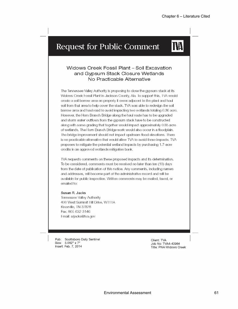
Chapter 6 – Literature Cited
Environmental Assessment 61

This page intentionally left blank

Appendix B – U.S. Army Corps of Engineers Correspondence
Environmental Assessment 63
Appendix B – U.S. Army Corps of Engineers Correspondence

This page intentionally left blank

Appendix B – Wetlands No-Practicable Alternative Notification
Environmental Assessment 65

This page intentionally left blank

Appendix C – U.S. Fish and Wildlife Service Correspondence
Environmental Assessment 67
Appendix C – U.S. Fish and Wildlife Service Correspondence

This page intentionally left blank
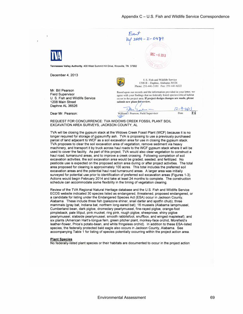
Appendix C – U.S. Fish and Wildlife Service Correspondence
Environmental Assessment 69
70 Environmental Assessment

Appendix C – U.S. Fish and Wildlife Service Correspondence
Environmental Assessment 71

72 Environmental Assessment

Appendix C – U.S. Fish and Wildlife Service Correspondence
Environmental Assessment 73
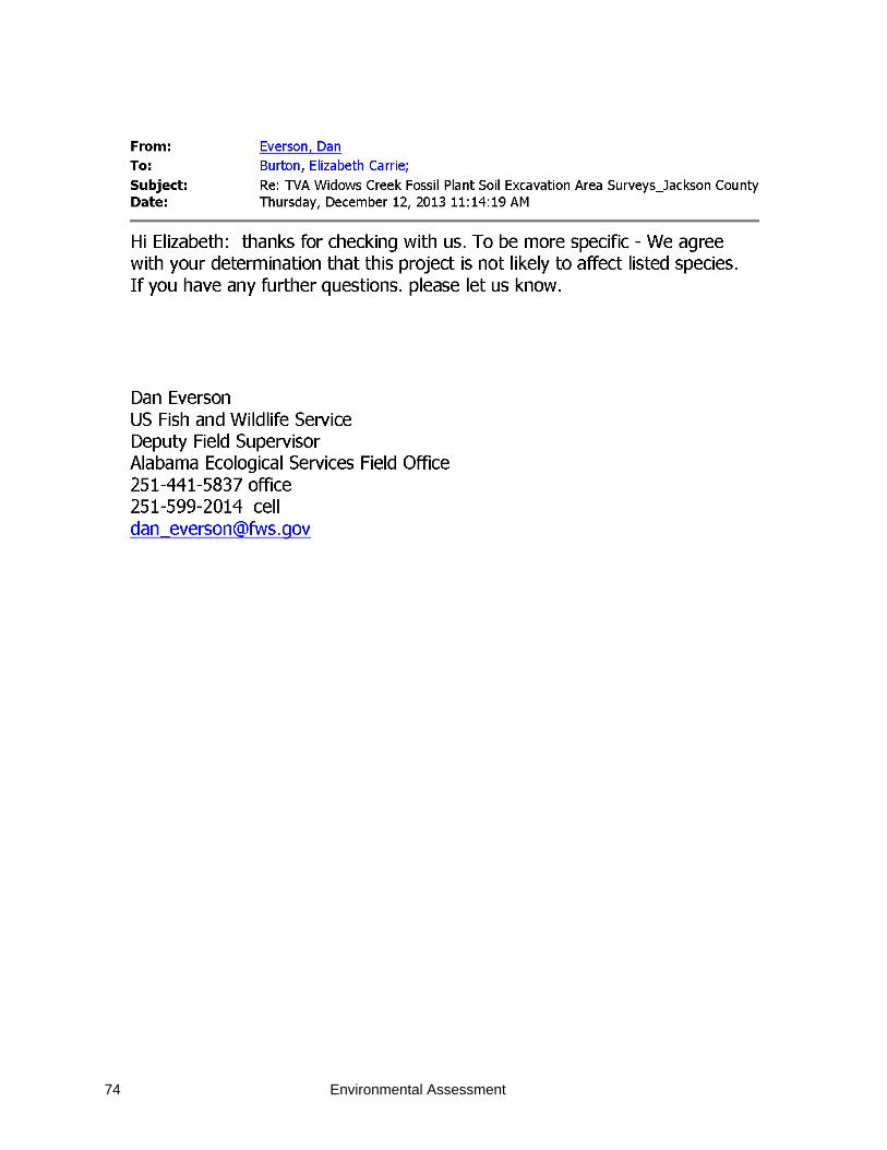
74 Environmental Assessment

Appendix D – State Historic Preservation Officer Correspondence
Environmental Assessment 75
Appendix D – State Historic Preservation Officer Correspondence

This page intentionally left blank
Appendix D – State Historic Preservation Officer Correspondence
Environmental Assessment 77
T

Widows Creek Fossil Plant Soil Excavation and Gypsum Stack Closure
78 Environmental Assessment