why look for water?
DESCRIPTION
Why look for water?. Humans exploring the Moon will need water: Option 1: Carry it there. Option 2: Use water that may be there already! Carrying water to the Moon will be expensive! Learning to “Live off the land” would make human lunar exploration easier. Living off the land. - PowerPoint PPT PresentationTRANSCRIPT


Why look for water?Why look for water?
• Humans exploring the Moon will need water:– Option 1: Carry it there.– Option 2: Use water that may be there already!
• Carrying water to the Moon will be expensive!
• Learning to “Live off the land”would make human lunar exploration easier.
• Humans exploring the Moon will need water:– Option 1: Carry it there.– Option 2: Use water that may be there already!
• Carrying water to the Moon will be expensive!
• Learning to “Live off the land”would make human lunar exploration easier.

Living off the landLiving off the land
• Even compared to many meteorites, the Moon is highly depleted in volatile elements and compounds, especially water.
• However, oxygen does exist within various mineral structures. Hydrogen from the solar wind can also be obtained from the lunar soil.
• Very energy intensive to obtain these key raw materials (have to heat regolith to at least 700° C).
• Life would be much easier and cheaper if we could just find H2O on the Moon.

Clementine bistatic radar - 1994Clementine bistatic radar - 1994
• Circular polarization ratio (CPR) consistent with ice crystals in the south polar regolith.
• Later ground-based studies confirmed high-CPR in some permanently-shadowed craters.
• However, Arecibo scans have also found high-CPR in some areas that are illuminated, probably due to surface roughness.
• Are we seeing ice or rough terrain in dark polar craters?

Lunar Prospector neutron spectrometer maps of the lunar poles. These low resolution data indicate elevated concentrations of
hydrogen at both poles; it does not tell us the form of the hydrogen. Map courtesy of D. Lawrence, Los Alamos National Laboratory.
Lunar Prospector neutron spectrometer maps of the lunar poles. These low resolution data indicate elevated concentrations of
hydrogen at both poles; it does not tell us the form of the hydrogen. Map courtesy of D. Lawrence, Los Alamos National Laboratory.
Hydrogen has been detected at the poles by Lunar Prospector in 1999. Is it water ice???Hydrogen has been detected at the poles by Lunar Prospector in 1999. Is it water ice???

Lunar Prospector Impact – July 31, 1999Lunar Prospector Impact – July 31, 1999
• South pole impact at end of mission
• Low angle (6.3°), low mass (161 kg), and low velocity (1.69 km/s) less than ideal for water ice detection.
• No water detected.
• Results not conclusive.
• South pole impact at end of mission
• Low angle (6.3°), low mass (161 kg), and low velocity (1.69 km/s) less than ideal for water ice detection.
• No water detected.
• Results not conclusive.

How could there be water at the lunar poles?How could there be water at the lunar poles?
The sun never gets more then several degrees about the polar horizon, thus topography can provide “permanent” shade.
Permanently shadowed regions (PSRs) may have temperatures < -200° C (-328° F).
Over the history of the Moon, when comets or asteroids impact the Moon's surface they briefly produce a very tenuous atmosphere that quickly disperses into space.
However, PSRs could act as cold-traps. Volatile gasses that enter could condense and accumulate for billions of years.
Clementine Mosaic - South Pole

How much water might there be?How much water might there be?
• We don’t know! Even if there is none, that is a very valuable thing to learn.
• We can do some “back-of-envelope” calculations.
• There are about 12,500 square km of permanently shadowed terrain on the Moon.
• If the top 1 meter of this area were to hold 1% (by mass) water, that would be equivalent to about 4.1 x 10¹¹ liters of water!
• This is approximately 2% the volume of the Great Salt Lake in Utah.

Where will we look?Where will we look?

How can we look for water?How can we look for water?
Lunar Reconnaissance OrbiterLRO
Lunar Crater Observationand Sensing Satellite
LCROSS

Lunar Reconnaissance OrbiterLunar Reconnaissance Orbiter
• LROC – image and map the lunar surface in unprecedented detail
• LOLA – provide precise global lunar topographic data through laser altimetry
• LAMP – remotely probe the Moon’s permanently shadowed regions
• CRaTER - characterize the global lunar radiation environment
• DIVINER – measure lunar surface temperatures
• LEND – measure neutron flux to study hydrogen concentrations in lunar soil

LRO Mission OverviewLRO Mission Overview
• On-board propulsion system used to capture at the Moon, insert into and maintain 50 km mean altitude circular polar reconnaissance orbit.
• 1 year exploration mission followed by handover to NASA science mission directorate.
• On-board propulsion system used to capture at the Moon, insert into and maintain 50 km mean altitude circular polar reconnaissance orbit.
• 1 year exploration mission followed by handover to NASA science mission directorate.
Minimum Energy Lunar Transfer
Lunar Orbit Insertion Sequence
Commissioning Phase, 30 x 216 km Altitude
Quasi-Frozen Orbit, Up to 60 Days
Polar Mapping Phase, 50 km Altitude Circular Orbit, At least 1 Year

LCROSS Mission ConceptLCROSS Mission Concept
• Impact the Moon at 2.5 km/sec with a Centaur upper stage and create an ejecta cloud that may reach over 10 km about the surface
• Observe the impact and ejecta with instruments that can detect water
• Impact the Moon at 2.5 km/sec with a Centaur upper stage and create an ejecta cloud that may reach over 10 km about the surface
• Observe the impact and ejecta with instruments that can detect water
Ejecta Curtain
Peter Schultz

Excavating with 6.5-7 billion JoulesExcavating with 6.5-7 billion Joules
• ~200 metric tons (220 tons) minimum of regolith will be excavated
• Crater estimated to have ~20-25 m diameter and ~3 depth
• Similar in size to East Crater at Apollo 11 landing site
• ~200 metric tons (220 tons) minimum of regolith will be excavated
• Crater estimated to have ~20-25 m diameter and ~3 depth
• Similar in size to East Crater at Apollo 11 landing site

LCROSS Mission SystemLCROSS Mission System
• Shepherding Spacecraft: guides and aims the Centaur to its target and carries all of the critical instrumentation.
• CentaurUpper Stage: provides the thrust to get us from Earth orbit to the Moon and will then be used as an impactor
• Shepherding Spacecraft: guides and aims the Centaur to its target and carries all of the critical instrumentation.
• CentaurUpper Stage: provides the thrust to get us from Earth orbit to the Moon and will then be used as an impactor
14.5 m

LCROSS InstrumentsLCROSS Instruments

Scheduled Launch: June 2009Scheduled Launch: June 2009
• Both LCROSS and LRO will share space aboard an Atlas V launch vehicle
• Launch will occur at Cape Canaveral
• Both LCROSS and LRO will share space aboard an Atlas V launch vehicle
• Launch will occur at Cape Canaveral

Centaur-LCROSS-LRO at TLICentaur-LCROSS-LRO at TLI
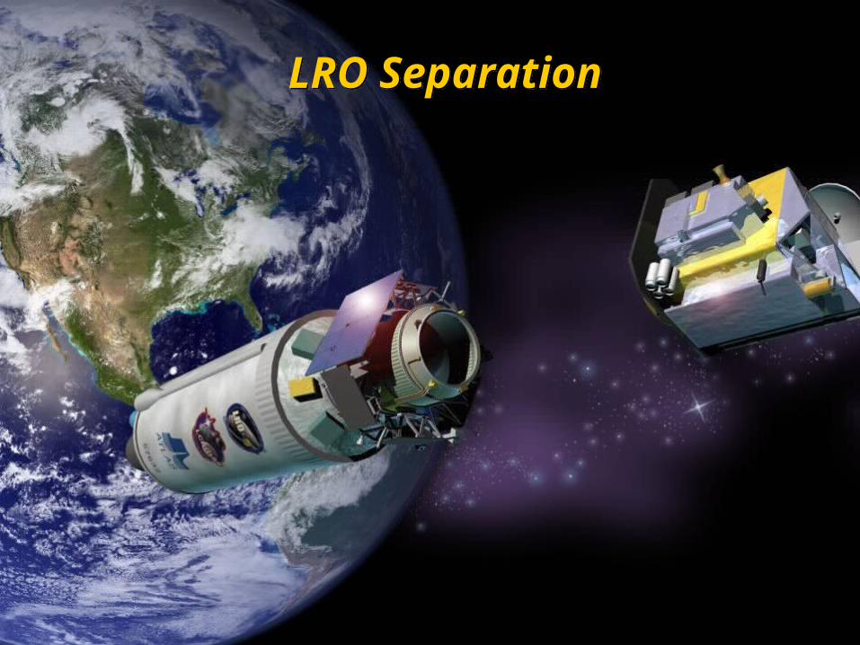
LRO SeparationLRO Separation

LCROSS Lunar Flyby: L + 5 daysLCROSS Lunar Flyby: L + 5 days

LCROSS Trajectory: The Long and Winding RoadLCROSS Trajectory: The Long and Winding Road
• Flyby transitions to Lunar Gravity Assist Lunar Return Orbits (LGALRO)
• Multiple LGALRO orbits about Earth (~38 day period)
• Long transit also provides time to vent any remaining fuel from Centaur
• Flyby transitions to Lunar Gravity Assist Lunar Return Orbits (LGALRO)
• Multiple LGALRO orbits about Earth (~38 day period)
• Long transit also provides time to vent any remaining fuel from Centaur

LCROSS Separation: Impact - 9 hrsLCROSS Separation: Impact - 9 hrs

Centaur ImpactCentaur Impact

Centaur ImpactCentaur Impact

Into the PlumeInto the Plume
• During the next 4 minutes, the Shepherding Spacecraft descends into the debris plume, measuring its morphology and composition, and transmitting this information back to Earth.
• The Shepherding Spacecraft then ends its mission with a second impact on the Moon
• During the next 4 minutes, the Shepherding Spacecraft descends into the debris plume, measuring its morphology and composition, and transmitting this information back to Earth.
• The Shepherding Spacecraft then ends its mission with a second impact on the Moon

Impact Observation Campaign

Ground-based Telescopes
Timing of impacts prioritized to allow observations from Hawaii, and western Continental U.S.
••••• •
•••

We believe reasonable grade amateur telescopes may be able to witness the impact plume.
This is an exciting mission!
www.amateurastronomy.org

Student Telemetry ProgramStudent Telemetry Program
• GAVRT – Goldstone Apple Valley Radio Telescope run by Lewis Center for Educational Research
• 34m DSS-12 &DSS-13 dishes
• Used by thousands
of K-12 students
around the world
• GAVRT – Goldstone Apple Valley Radio Telescope run by Lewis Center for Educational Research
• 34m DSS-12 &DSS-13 dishes
• Used by thousands
of K-12 students
around the world
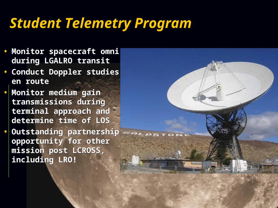
Student Telemetry ProgramStudent Telemetry Program
• Monitor spacecraft omni during LGALRO transit
• Conduct Doppler studies en route
• Monitor medium gain transmissions during terminal approach and determine time of LOS
• Outstanding partnership opportunity for other mission post LCROSS, including LRO!
• Monitor spacecraft omni during LGALRO transit
• Conduct Doppler studies en route
• Monitor medium gain transmissions during terminal approach and determine time of LOS
• Outstanding partnership opportunity for other mission post LCROSS, including LRO!
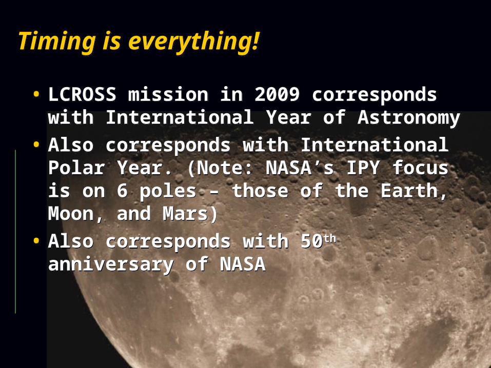
Timing is everything!Timing is everything!
• LCROSS mission in 2009 corresponds with International Year of Astronomy
• Also corresponds with International Polar Year. (Note: NASA’s IPY focus is on 6 poles – those of the Earth, Moon, and Mars)
• Also corresponds with 50th anniversary of NASA
• LCROSS mission in 2009 corresponds with International Year of Astronomy
• Also corresponds with International Polar Year. (Note: NASA’s IPY focus is on 6 poles – those of the Earth, Moon, and Mars)
• Also corresponds with 50th anniversary of NASA

LRO/LCROSS Launch PreviewLRO/LCROSS
Launch Preview
How
Where
When
How
Where
When

• We will use the Atlas V Launch Vehicle• Latest version in the Atlas family of
boosters• Early Atlas boosters were used for manned
Mercury missions 1962-63• Atlas V has become a mainstay of U.S.
satellite launches• NASA has used Atlas V to launch MRO to
Mars in 2004 and New Horizons to Pluto and the Kuiper Belt in 2006
How?

• We will launch from Space Launch Complex 41 (SLC-41) at Cape Canaveral
• Helios probes to the Sun• Viking probes to Mars• Voyager planetary flyby and
deep space probes• Mars Reconnaissance Orbiter• New Horizons spacecraft to
Pluto and Kuiper Belt
• We will launch from Space Launch Complex 41 (SLC-41) at Cape Canaveral
• Helios probes to the Sun• Viking probes to Mars• Voyager planetary flyby and
deep space probes• Mars Reconnaissance Orbiter• New Horizons spacecraft to
Pluto and Kuiper Belt
Where?
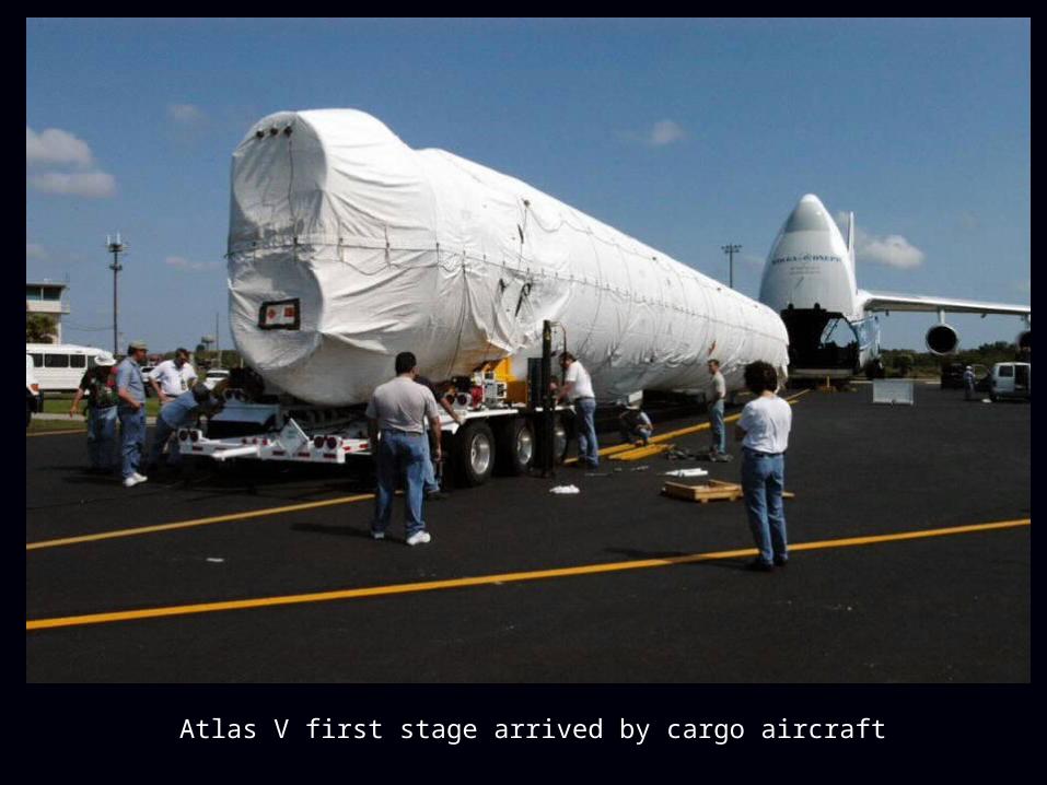
Atlas V first stage arrived by cargo aircraft

Vertical Integration Facility

What’s going to happen?What’s going to happen?
First stage delivered to VIF

First stage lifted into VIF

First stage lifted into VIF

Centaur stacked on first stage

LRO and LCROSS will be stacked onto Centaur

Mobile Launch Platform will transport spacecraft from VIF to pad

When?When?
• LRO/LCROSS scheduled for June launch
• Currently looking at an early October impact for LCROSS
• Impact is currently targeting South Pole of the Moon
• LRO/LCROSS scheduled for June launch
• Currently looking at an early October impact for LCROSS
• Impact is currently targeting South Pole of the Moon

QuestionsQuestions