why do lake levels matter? - michigan · 2) how water level change and extreme water levels impact...
TRANSCRIPT

Elizabeth LaPorteUniversity of Michigan Graham Sustainability Institute
State of Lake Michigan Conference – 2015Lake Michigan Track II
Coastal Resiliency
Why Do Lake Levels Matter?

Presentation Overview
• About the U-M Graham Sustainability Institute
• Research Methods (Integrated Assessment)
• Water Levels Research Efforts
– Process
– Shoreline Property Owner Survey
– Science Outreach
– Planning Grants
– Next Steps

Centers:• Climate• Integrated Assessment• Water
Programs:
• Scholars (57)• Fellowships (78)• Campus Stewardship• Faculty Support
Common Principles:
• Scientifically Rigorous
• Interdisciplinary
• Engaged with Practice
• Collaborative
• Inclusive & Diverse
• Local to Global
Graham Institute & U-MGraham Institute & U-M
U-M Planet Blue Ambassadors (students, staff & faculty) completed17,000 action pledges, reducing 5 M lbs. of greenhouse gas emissions,preventing 250 lbs. of landfill waste, & saving 5 M gal. of water – FY 15

AssessmentsCollaborative teams review andanalyze existing research and datarelated to a specific issue.
Integrating• Policy or management context• Diverse stakeholder perspectives• Multiple disciplines• An analysis of causes and
possible solutions
To• Build consensus and inform
decisions
Integrated Assessment ResearchIntegrated Assessment Research

Integrated Assessment Research Process

Presentation Overview
Water Levels Research Efforts
• Research Process
• Shoreline Property Owner Survey
• Science Outreach
• Planning Grants
• Next Steps

Scoping & Development
– Stakeholder mapping
– Shoreline property owners survey
– Develop advisory committee
Research ProcessResearch Process
MDEQ, Office ofthe Great Lakes
U.S. Army Corps ofEngineers
Ducks UnlimitedWisconsin HarborTowns Association
ODNR, Office ofCoastal Management
EnvironmentCanada
The NatureConservancy
W. Michigan ShorelineRegional Dev. Comm.
ConservationOntario
Ohio Lake ErieCommission
Georgian BayForever
Save our Shoreline
International JointCommission
Wisconsin &Michigan Sea Grant
Council of GreatLakes Industries
Great Lakes Coalition

Guiding Question (based on scoping):
What environmentally, socially, politically, and economicallyfeasible policy options and management actions canpeople, businesses, and governments implement in orderto adapt to current and future variability in Great Lakeswater levels?
Key Impact Areas:
• Infrastructure • Shoreline economies
• Water Quality • Nearshore &
• Recreation & Tourism coastal habitat
Research Process: Guiding QuestionResearch Process: Guiding Question

Purpose:Help equip the region with a robust set ofadaptive strategies for addressingfluctuating water levels to protect theecological integrity, economic stability, andcultural values of the region.
Focus:
• Lakes Michigan-Huron & Erie
• Identify & evaluate adaptivemanagement options (not lake levelcontrol structures)
Research Process: Purpose & FocusResearch Process: Purpose & Focus

Local (place-based):
• Evaluate specific, integrated, andfeasible options
• Engage local stakeholders
• Build local ownership
Regional:
• Identify opportunities for wide varietyof shorelines and issues for lakesMichigan-Huron and Erie
Research Process: ConsiderationsResearch Process: Considerations

Research Process: InterdisciplinaryResearch Process: Interdisciplinary
Environmental Social Political Economic
• Climatechange
• Hydroclimateprocesses/modeling
• Shorelinestability
• Slope erosion
• Ecosystemdynamics
• Habitat
• Effects of shorelinemanagement activitieson neighboringproperties
• Distribution of costs andbenefits of water levelimpacts and shorelinemanagement activities
• Changes to theculture/feel of acommunity
• Education/communication andoutreach/engagement
• Resiliency planning
• Shoreline orfloodplainbuilding andzoningregulations
• Shoreline orfloodplainplanning
• Landconservation
• Decision tools
• Property values
• Propertydamage
• Decreasedbusinessrevenue
• Increasedoperatingexpenses
• Incentives
• Financialplanning andbudgets

Project Schedule: 2015-2017Project Schedule: 2015-2017
Local

Planning Grants: 7 Teams
Purpose:
Identify appropriate locations, interested partners,and existing data to determine feasibility of a largerresearch project.

Planning Grants ($70K)
• Threatened and Endangered Species Habitat – Emmet County, MI
Dennis Albert, Oregon State University (PI); Paul Drevnick, U-M
• Adaptive Management – Huron County, ON
George Arhonditsis and Vincent Cheng - University of Toronto at Scarborough; LynnePeterson, Consultant; Agnes Richards, Environment Canada
• Visualization & Scenario Planning – Regional
Adam Fenech, University of Prince Edward Island; Daniel Scott, University ofWaterloo; Colin Dobel, Ontario Water Center
• Tribal Fisheries – Regional
Frank Marsik (PI) and Richard Rood, U-M; Kyle Whyte, Michigan State University
• Coastal Bluffs & Shoreline Planning – Ozaukee and Milwaukee Counties, WI
David Hart (PI), Jane Harrison, and Adam Mednick, Wisconsin Sea Grant; BruceBessert, Concordia University; John Janssen and Jenny Kehl, University ofWisconsin-Milwaukee; Jim LaGro, David Mickelson, Brian Ohm, and Chin Wu,University of Wisconsin-Madison
• Stakeholder Perceptions – Grand Traverse & Leelanau Counties, MI
Hans VanSumeren (PI) and Constanza Hazelwood, Northwestern Michigan College
• Land-use Regulation and Infrastructure Policy – Regional
Richard Norton, U-M (PI); Guy Meadows, Michigan Technological University

Presentation Overview
– Shoreline Property Owners Survey
– Science Outreach
– Next steps

Survey Goals
Goals:
• Inform the direction & scope of the research efforts
• Collect data on perceptions of water level change
Information we want from stakeholders:
1) The level of concern about water level change
2) How water level change and extreme water levels impactproperty owners and managers
3) What people believe about water level change
4) How to best reach people with usable information
Conducted by: Rachel Jacobson (MS/MPP, currently at NOAA PPI)

• 1,815 Responses
• 70% Property owners
• 90% Residential
Responses by Lake LocationSurvey
EmailDistribution
(1,527)
Postal MailDistribution
(288) 22%
73%
2%1% 1%
1%Michigan (256)
Huron (851)
Erie (30)
Superior (13)
Ontario (11)
H-E Corridor(7)
Survey Response
Jacboson, 2014

Survey Results
Participant concerns:• Property damage during high water levels (blue); and a decrease in
recreational opportunities during low water levels (red)
Graham Sustainability Institute, adapted with permission from Jacobson (2014)

Responses
Perceptions:
• High water levels = negative impacts (majority)
• Low water levels = negative impacts (50%)
• Ranking – How humans impact water level
changes: (1) diversions, (2) structural controls &
(3) dredging

Why Do Water Levels Matter?
Science Outreach Strategy:
• Summarize key issues, stakeholderperceptions, current science and data (averagewater levels over time)
– Address misconceptions & knowledge gaps:• Illinois (Chicago) diversion is “huge”
• Water level monitoring is not accurate
• Explain how monitoring is done, how data iscollected, who does it, and accuracy
• Present information about climate change andmonitoring challenges (over lake evaporation)

Outreach Methods
Develop Two Summaries & Vet with Experts
Collaborative Group
• Water Level Experts (U-M & GLERL) & Graham Staff
– Iterative process writing & review
Dissemination
• Supported Research Teams (Planning & Phase 1)
– Share with Stakeholders & End Users
• Graham Website
– Water Levels Project Webpage
– Social Media
• Partners (MDEQ)

Addressing Perceptions
Knowledge Gaps
Survey participantperceptions:• The top three ways
humans impact waterlevels: (1) Diversions, (2)structural controls, and(3) dredging
Fact:• Amount of water leaving
the system throughdiversions is quite small
Example: (1953-2010)
• Illinois diversion H2O (near
Chicago) avg. loss = -90 cubic
meters per second (CMS)
• Avg. rate H2O entering Lake
MI-HU, via precip. & runoff =
5,800 CMS
• Avg. amount H2O entering
Lake Superior (Ogoki & Long
Lac diversions) = 160 CMS

Summary 1: Water Budget
Data from GLERL
Values shown:Thousands of cubicmeters per second(CMS) for each lake.
Averages (1953-2010):Evaporation (e),Precipitation (p),Runoff (r), andArtificial Diversions
Figure modified by the GrahamSustainability Institute from original,used with permission by Michigan SeaGrant.
Data source: NOAA-GLERLHydrometorological database

Summary 1: Water Budget
Values shown:
Cubic meters per second
(CMS), converted to
gallons per minute,
compared to an Olympic
swimming pool.
Amount water diverted into
and out of the GL system
(1953-2010 averages).

Summary 1: Water Budget
Values Shown:
Converted from CMS to
Gallons Per Minute.
Average Amount of
Precipitation and
Runoff into Lake
Michigan-Huron (1953-
2010)

Summary 2: Water Levels
• Lake Michigan-Huron water level fluctuations (1918-2015)• Note long period of low water levels (late 1990s to 2013).• Despite rapid rise in levels since 2013, lakes are still well
below the highest level recorded (mid-1980s)
Data: NOAA CO-OPS, the Canadian Hydrographic Service, USACE, and EnvironmentCanada (courtesy of NOAA GLERL)
Summary 2: Water Levels
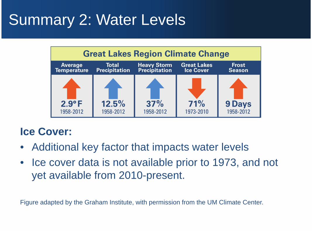
Ice Cover:
• Additional key factor that impacts water levels
• Ice cover data is not available prior to 1973, and notyet available from 2010-present.
Figure adapted by the Graham Institute, with permission from the UM Climate Center.

Summary 2: Preparing for the Future
• Consider: How we may better prepare for theextremes of high and low water levels
• New strategies: Address how we may better adaptto Great Lakes water level variability:
– Sound planning efforts
– Consider variable water levels as part ofanticipating vulnerabilities
– Preparing for extremes and adapting accordingly

Summary 2: Water Levels
Monitoring Lake Levels• More than 150 years of data
– 1860: USACE beganmonitoring levels
• NOAA Center forOperational OceanographicProducts and Services(53 water level stations)
• Canadian HydrographicService (33 stations)
Water levels are preciselymeasured and recordedevery few minutes.
• Binational Partnership:USACE and EnvironmentCanada coordinate waterlevel data and seasonalforecasts through a, as partof their operational dutiesrelated to Great Lakes watermanagement
• Predictions:These and other agencies(NOAA-GLERL), use waterlevel data to conductresearch and improvemodels that help predictwater level fluctuations

Summary 2: Water Levels
Coastal Resiliency
The Great Lakes region, a focal point of NOAA’snation-wide effort (reducing current and potentialfuture risks for coastal communities)
Key Priority: Implement actions thatpromote adaptation to changingenvironmental conditions, and addressdisaster preparedness.

Presentation Overview
• Graham Sustainability Institute
• Integrated Assessment
• Water Levels Integrated Assessment
– Process
– Shoreline Property Owner Survey
– Outreach Materials
– Planning Grants
– Next steps

Phase 1
• November 2015 – April 2016: Teams provideinterdisciplinary overview synthesis and reports ofstatus, trends, causes, and consequences of projects
Phase 2
• May 2016 – October 2016: With stakeholderinput, teams develop reports analyzing viablepolicies and adaptive actions
Phase 3
• November 2016 – April 2017: Teams work withGraham personnel to develop finalcomprehensive reports of select options
Next StepsNext Steps
Local
Regional

Next Steps: Address Guiding Question
Answer Guiding Question:What environmentally, socially,politically, and economically feasiblepolicy options and management actionscan people, businesses, andgovernments implement in order toadapt to current and future variability inGreat Lakes water levels?
Purpose:Help equip the region with a robust setof adaptive strategies for addressingfluctuating water levels to protect theecological integrity, economic stability,and cultural values of the region.
NaturalScienceNaturalScience
SocialScienceSocial
Science
PolicyPolicy
InformedDecisions

Thank You!
Water Levels Advisory Committee
• Jon Allan, Director, Office of the Great Lakes, MDEQ
• John Allis, Chief, Great Lakes Hydraulics and Hydrology Office, US ACOE, Detroit District
• Mark Breederland, Extension Educator, Michigan Sea Grant
• Matthew Child, Deputy Director, IJC, GL Regional Office
• Gene Clark, Coastal Engineering Specialist, Wisconsin Sea Grant
• John Coluccy, Director of Conservation Planning, Ducks Unlimited
• Patrick Doran, Director of Conservation for Michigan, The Nature Conservancy
• Bonnie Fox, Manager of Policy and Planning, Conservation Ontario
• Gail Hesse, Executive Director, Ohio Lake Erie Commission
• Erin Kuhn, Executive Director, W. Mich. Shoreline Regional Development Commission
• Wendy Leger, Physical Science Senior Officer, Environment Canada
• Scudder D. Mackey, Chief, Office of Coastal Management, Ohio DNR
• David Powers, Attorney, Smith, Martin, Powers & Knier, Save our Shoreline
• Larry J. Robson, Board Chair, Great Lakes Coalition
• Ana Sirviente, Program Development Director, Council of GL Industries
• David Sweetnam, Executive Director, Georgian Bay Forever
• Kathy Tank, President, Wisconsin Harbor Towns Association

Water Level Resources:• Graham Institute Website: graham.umich.edu
(Integrated Assessment / Water-levels)• NOAA-GLERL Website: glerl.noaa.gov
(now/wlevels/levels.html)
Contacts:• Elizabeth LaPorte, Science Outreach Manager,
[email protected]• John Callewaert, Program Director,