why are cancun beaches eroding - bairdbaird.com/assets/documents/cancunbeacherosion.pdf · why are...
TRANSCRIPT
XIII CONGRESO PANAMERICANO DE INGENIERIA OCEANICA Y COSTERA
WHY ARE CANCUN BEACHES ERODING? A QUESTION OF INTEGRATED COASTAL ZONE MANAGEMENT
Dibajnia, M.1, Sanchez, C.2, Martinez, M.3, Lara, A.2, Nairn, R.B.1, Marván, F. G.1, Fournier, C.F. 1
and Risk, M.4
1 W.F. Baird & Associates Coastal Engineers 2 Comisión Federal de Electricidad
3 Consejo Coordinador Empresarial del Caribe 4 McMaster University, Hamilton, Ontario, Canada
1. Introduction
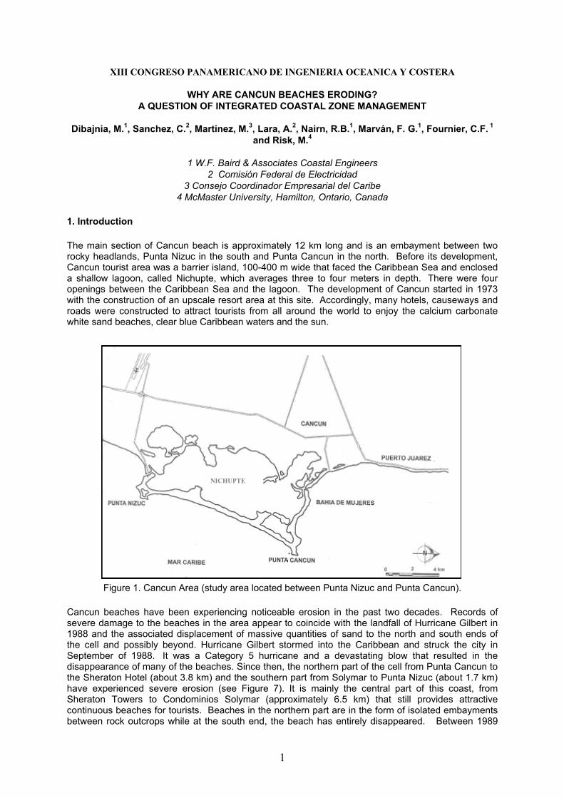
The main section of Cancun beach is approximately 12 km long and is an embayment between two rocky headlands, Punta Nizuc in the south and Punta Cancun in the north. Before its development, Cancun tourist area was a barrier island, 100-400 m wide that faced the Caribbean Sea and enclosed a shallow lagoon, called Nichupte, which averages three to four meters in depth. There were four openings between the Caribbean Sea and the lagoon. The development of Cancun started in 1973 with the construction of an upscale resort area at this site. Accordingly, many hotels, causeways and roads were constructed to attract tourists from all around the world to enjoy the calcium carbonate white sand beaches, clear blue Caribbean waters and the sun.
NICHUPTE
Figure 1. Cancun Area (study area located between Punta Nizuc and Punta Cancun).
Cancun beaches have been experiencing noticeable erosion in the past two decades. Records of severe damage to the beaches in the area appear to coincide with the landfall of Hurricane Gilbert in 1988 and the associated displacement of massive quantities of sand to the north and south ends of the cell and possibly beyond. Hurricane Gilbert stormed into the Caribbean and struck the city in September of 1988. It was a Category 5 hurricane and a devastating blow that resulted in the disappearance of many of the beaches. Since then, the northern part of the cell from Punta Cancun to the Sheraton Hotel (about 3.8 km) and the southern part from Solymar to Punta Nizuc (about 1.7 km) have experienced severe erosion (see Figure 7). It is mainly the central part of this coast, from Sheraton Towers to Condominios Solymar (approximately 6.5 km) that still provides attractive continuous beaches for tourists. Beaches in the northern part are in the form of isolated embayments between rock outcrops while at the south end, the beach has entirely disappeared. Between 1989
1
and 2000 the erosion rate was 1.5 m/year in the northern part, 0.5 m/year for the central part and 2.6 m/year for the southern part.
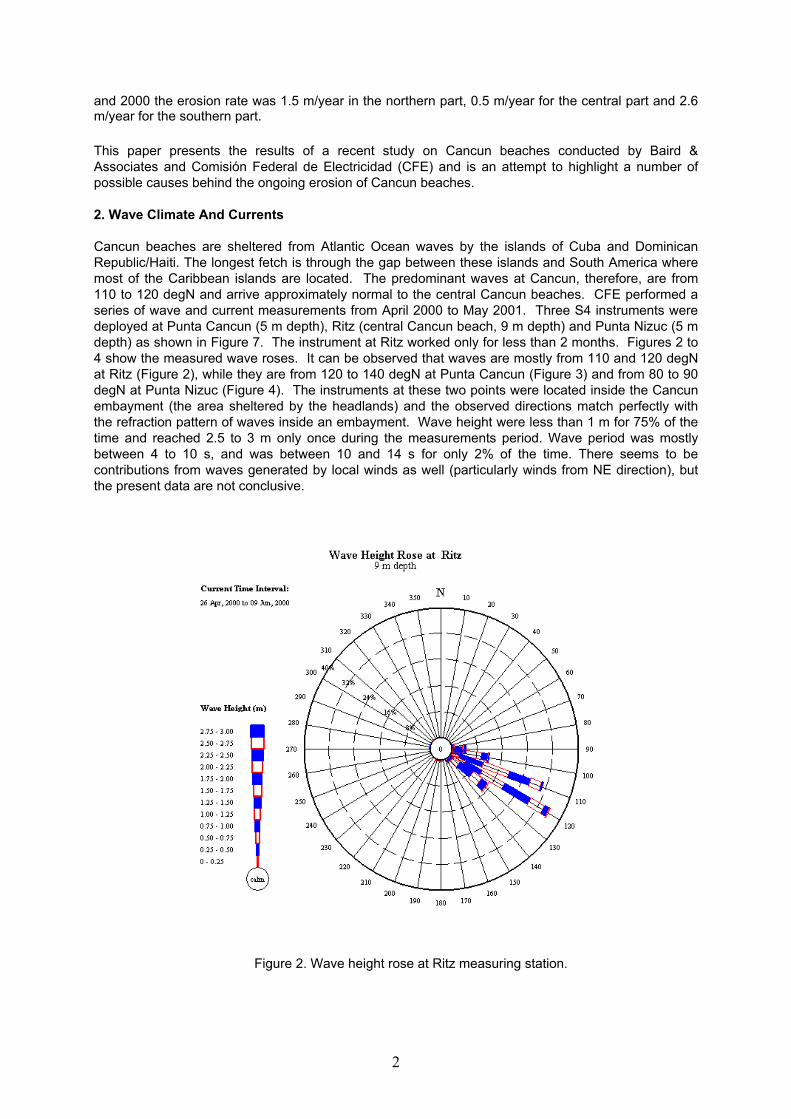
This paper presents the results of a recent study on Cancun beaches conducted by Baird & Associates and Comisión Federal de Electricidad (CFE) and is an attempt to highlight a number of possible causes behind the ongoing erosion of Cancun beaches. 2. Wave Climate And Currents Cancun beaches are sheltered from Atlantic Ocean waves by the islands of Cuba and Dominican Republic/Haiti. The longest fetch is through the gap between these islands and South America where most of the Caribbean islands are located. The predominant waves at Cancun, therefore, are from 110 to 120 degN and arrive approximately normal to the central Cancun beaches. CFE performed a series of wave and current measurements from April 2000 to May 2001. Three S4 instruments were deployed at Punta Cancun (5 m depth), Ritz (central Cancun beach, 9 m depth) and Punta Nizuc (5 m depth) as shown in Figure 7. The instrument at Ritz worked only for less than 2 months. Figures 2 to 4 show the measured wave roses. It can be observed that waves are mostly from 110 and 120 degN at Ritz (Figure 2), while they are from 120 to 140 degN at Punta Cancun (Figure 3) and from 80 to 90 degN at Punta Nizuc (Figure 4). The instruments at these two points were located inside the Cancun embayment (the area sheltered by the headlands) and the observed directions match perfectly with the refraction pattern of waves inside an embayment. Wave height were less than 1 m for 75% of the time and reached 2.5 to 3 m only once during the measurements period. Wave period was mostly between 4 to 10 s, and was between 10 and 14 s for only 2% of the time. There seems to be contributions from waves generated by local winds as well (particularly winds from NE direction), but the present data are not conclusive.
Figure 2. Wave height rose at Ritz measuring station.
2

Figure 4. Wave height rose at Punta Nizuc measuring station.
Figure 3. Wave height rose at Punta Cancun measuring station.
3
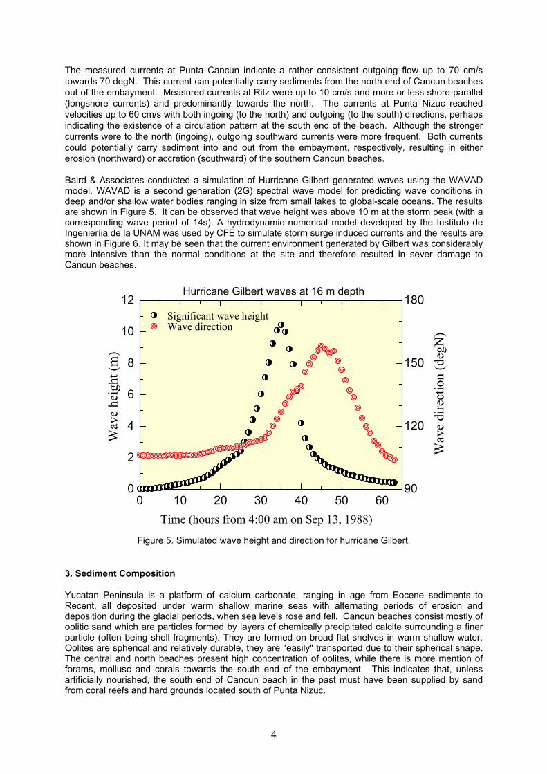
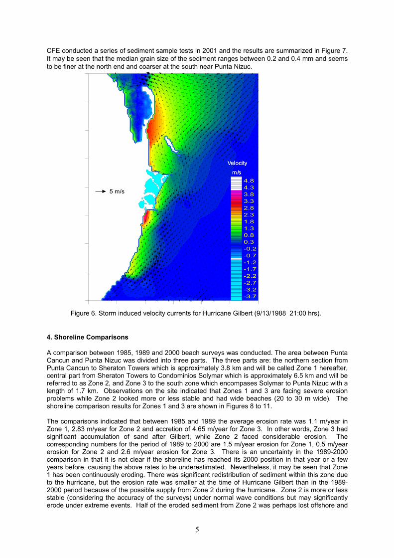
The measured currents at Punta Cancun indicate a rather consistent outgoing flow up to 70 cm/s towards 70 degN. This current can potentially carry sediments from the north end of Cancun beaches out of the embayment. Measured currents at Ritz were up to 10 cm/s and more or less shore-parallel (longshore currents) and predominantly towards the north. The currents at Punta Nizuc reached velocities up to 60 cm/s with both ingoing (to the north) and outgoing (to the south) directions, perhaps indicating the existence of a circulation pattern at the south end of the beach. Although the stronger currents were to the north (ingoing), outgoing southward currents were more frequent. Both currents could potentially carry sediment into and out from the embayment, respectively, resulting in either erosion (northward) or accretion (southward) of the southern Cancun beaches. Baird & Associates conducted a simulation of Hurricane Gilbert generated waves using the WAVAD model. WAVAD is a second generation (2G) spectral wave model for predicting wave conditions in deep and/or shallow water bodies ranging in size from small lakes to global-scale oceans. The results are shown in Figure 5. It can be observed that wave height was above 10 m at the storm peak (with a corresponding wave period of 14s). A hydrodynamic numerical model developed by the Instituto de Ingenieríia de la UNAM was used by CFE to simulate storm surge induced currents and the results are shown in Figure 6. It may be seen that the current environment generated by Gilbert was considerably more intensive than the normal conditions at the site and therefore resulted in sever damage to Cancun beaches.
0 10 20 30 40 50 600
2
4
6
8
10
12
90
120
150
180
Time (hours from 4:00 am on Sep 13, 1988)
Wav
e he
ight
(m)
Wav
e di
rect
ion
(deg
N)
Significant wave height Wave direction
Hurricane Gilbert waves at 16 m depth
Figure 5. Simulated wave height and direction for hurricane Gilbert.
3. Sediment Composition Yucatan Peninsula is a platform of calcium carbonate, ranging in age from Eocene sediments to Recent, all deposited under warm shallow marine seas with alternating periods of erosion and deposition during the glacial periods, when sea levels rose and fell. Cancun beaches consist mostly of oolitic sand which are particles formed by layers of chemically precipitated calcite surrounding a finer particle (often being shell fragments). They are formed on broad flat shelves in warm shallow water. Oolites are spherical and relatively durable, they are "easily" transported due to their spherical shape. The central and north beaches present high concentration of oolites, while there is more mention of forams, mollusc and corals towards the south end of the embayment. This indicates that, unless artificially nourished, the south end of Cancun beach in the past must have been supplied by sand from coral reefs and hard grounds located south of Punta Nizuc.
4
CFE conducted a series of sediment sample tests in 2001 and the results are summarized in Figure 7. It may be seen that the median grain size of the sediment ranges between 0.2 and 0.4 mm and seems to be finer at the north end and coarser at the south near Punta Nizuc.
-3.7-3.2-2.7-2.2-1.7-1.2-0.7-0.20.30.81.31.82.32.83.33.84.34.8
5 m/s
VelocityVelocity
m/sm/s
-3.7-3.2-2.7-2.2-1.7-1.2-0.7-0.20.30.81.31.82.32.83.33.84.34.8
5 m/s
VelocityVelocity
m/sm/s
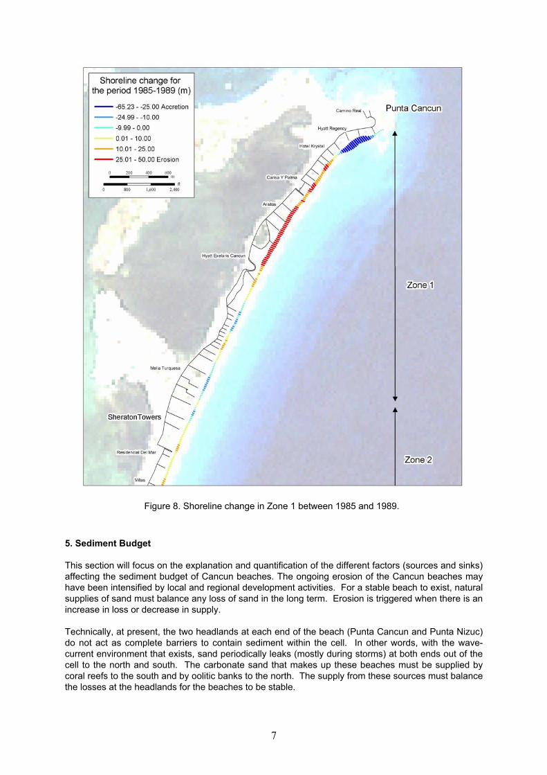
Figure 6. Storm induced velocity currents for Hurricane Gilbert (9/13/1988 21:00 hrs). 4. Shoreline Comparisons A comparison between 1985, 1989 and 2000 beach surveys was conducted. The area between Punta Cancun and Punta Nizuc was divided into three parts. The three parts are: the northern section from Punta Cancun to Sheraton Towers which is approximately 3.8 km and will be called Zone 1 hereafter, central part from Sheraton Towers to Condominios Solymar which is approximately 6.5 km and will be referred to as Zone 2, and Zone 3 to the south zone which encompases Solymar to Punta Nizuc with a length of 1.7 km. Observations on the site indicated that Zones 1 and 3 are facing severe erosion problems while Zone 2 looked more or less stable and had wide beaches (20 to 30 m wide). The shoreline comparison results for Zones 1 and 3 are shown in Figures 8 to 11. The comparisons indicated that between 1985 and 1989 the average erosion rate was 1.1 m/year in Zone 1, 2.83 m/year for Zone 2 and accretion of 4.65 m/year for Zone 3. In other words, Zone 3 had significant accumulation of sand after Gilbert, while Zone 2 faced considerable erosion. The corresponding numbers for the period of 1989 to 2000 are 1.5 m/year erosion for Zone 1, 0.5 m/year erosion for Zone 2 and 2.6 m/year erosion for Zone 3. There is an uncertainty in the 1989-2000 comparison in that it is not clear if the shoreline has reached its 2000 position in that year or a few years before, causing the above rates to be underestimated. Nevertheless, it may be seen that Zone 1 has been continuously eroding. There was significant redistribution of sediment within this zone due to the hurricane, but the erosion rate was smaller at the time of Hurricane Gilbert than in the 1989-2000 period because of the possible supply from Zone 2 during the hurricane. Zone 2 is more or less stable (considering the accuracy of the surveys) under normal wave conditions but may significantly erode under extreme events. Half of the eroded sediment from Zone 2 was perhaps lost offshore and
5
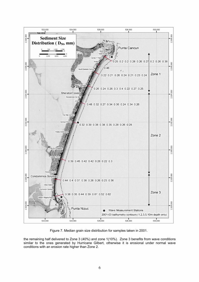
Figure 7. Median grain size distribution for samples taken in 2001.
the remaining half delivered to Zone 3 (40%) and zone 1(10%). Zone 3 benefits from wave conditions similar to the ones generated by Hurricane Gilbert, otherwise it is erosional under normal wave conditions with an erosion rate higher than Zone 2.
6
5. Sediment Budget
Figure 8. Shoreline change in Zone 1 between 1985 and 1989.
This section will focus on the explanation and quantification of the different factors (sources and sinks) affecting the sediment budget of Cancun beaches. The ongoing erosion of the Cancun beaches may have been intensified by local and regional development activities. For a stable beach to exist, natural supplies of sand must balance any loss of sand in the long term. Erosion is triggered when there is an increase in loss or decrease in supply. Technically, at present, the two headlands at each end of the beach (Punta Cancun and Punta Nizuc) do not act as complete barriers to contain sediment within the cell. In other words, with the wave-current environment that exists, sand periodically leaks (mostly during storms) at both ends out of the cell to the north and south. The carbonate sand that makes up these beaches must be supplied by coral reefs to the south and by oolitic banks to the north. The supply from these sources must balance the losses at the headlands for the beaches to be stable.
7
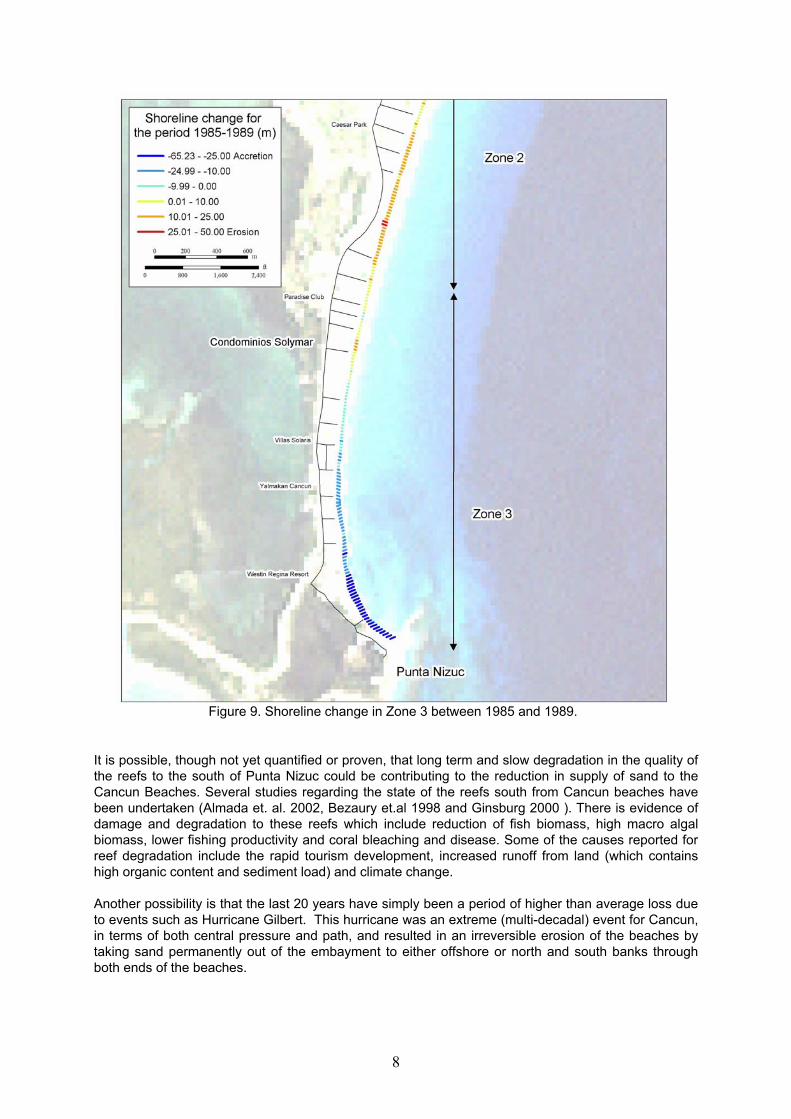
Figure 9. Shoreline change in Zone 3 between 1985 and 1989.
8
It is possible, though not yet quantified or proven, that long term and slow degradation in the quality of the reefs to the south of Punta Nizuc could be contributing to the reduction in supply of sand to the Cancun Beaches. Several studies regarding the state of the reefs south from Cancun beaches have been undertaken (Almada et. al. 2002, Bezaury et.al 1998 and Ginsburg 2000 ). There is evidence of damage and degradation to these reefs which include reduction of fish biomass, high macro algal biomass, lower fishing productivity and coral bleaching and disease. Some of the causes reported for reef degradation include the rapid tourism development, increased runoff from land (which contains high organic content and sediment load) and climate change.
Another possibility is that the last 20 years have simply been a period of higher than average loss due to events such as Hurricane Gilbert. This hurricane was an extreme (multi-decadal) event for Cancun, in terms of both central pressure and path, and resulted in an irreversible erosion of the beaches by taking sand permanently out of the embayment to either offshore or north and south banks through both ends of the beaches.

Figure 10. Shoreline change in Zone 1 between 1989 and 2000.
9
Finally, another contributing factor, at least on a local basis, may be the loss of sand dunes as a result of hotel development. This latter factor does not influence overall long term supply in any way but may contribute to greater local loss through reflections from coastal structures and more importantly removal of a natural reservoir. A natural undisturbed dune system can absorb sand from the beach (as a result of transport by wind) and consequently grow in height or further landward. Dunes, therefore, can potentially function as sand reservoirs that could naturally protect the beach by supplying sand to the beach during storm events to create bars and dissipate the waves. There is more erosion and slower beach recovery when dunes do not function.
6. Proposed Solution Extensive beach nourishment towards a 40m wide beach is considered as the most plausible solution for Cancun beaches. There will be more sand required for both ends (Zones 1 and 3) than for Zone 2. The design must take into consideration an average erosion rate of 2 m/year for zone 1, 0.5 m/year for zone 2 and 3 m/year for zone 3. This is equivalent to a total loss of 160,000 m3/year. The numbers for each zone are 76,000, 33,000 and 51,000 m3/year for zones 1, 2 and 3, respectively. Zone 1 will loose 20 m of beach in 10 years, while zone 3 would loose 30 m and zone 2 only 5 m in 10 years. These numbers are based on shoreline changes in the past 20 years and may change depending on future supply and loss rates as well as future storm intensity and frequency.

Figure 11. Shoreline change in Zone 3 between 1989 and 2000.
The nourished beaches can be protected and preserved through the implementation of an Integrated Coastal Zone Management plan. Requirements for successful ICZM are correct understanding of the geomorphology and regional and local sediment budgets of the project site, continuous monitoring of the project, preserving and/or restoring of sediment sources and possible control of sediment sinks. This may be achieved through: 1) development of a long-term wave climate for the site, 2) numerical modeling of waves, nearshore currents and sediment transport in and around the embayment, 3) extensive geophysical surveys to identify the location and extent of sand sources and sinks, 4) a monitoring program including regular bathymetry surveys and wave and current measurements to verify the numerical modeling results and confirm or modify the design, 5) environmental measures to improve water quality and protect/restore the sediment production by coral reefs and 6) find environmental friendly solutions to include appropriate structures which mitigate sand loss to reduce future nourishment requirements.
7. References Almada, V. P., Mfield, M., Kramer, P., Kramer R.P., and Gonzales A. E. 2002. Status of Coral Reefs of
Mesoamerica – Mexico, Belize, Guatemala, Honduras, Nicaragua and El Salvador. In Status of Coral Reefs of the World. Australian institute of Marine Science pp303- 324.
Creel, J.B., Santos,C.L., McCann, J., Islas, C.M., Carranza, J., Rubinoff, J., Goddard, T., Robadue, D., and Hale, L. 1998. Participatory Coastal and Marine Management in Quintana Roo, Mexico. In: International Tropical Marine Ecosystems Management Symposium, Townsville, Australia, Nov 23-26 1998.
Ginsburg R.N. 2000. Akumal and Xcalak, Mexico Field report. http://www.coral.noaa.gov/agra/reports/field-akumal.html.
10
Charles Fournier [email protected] Fernando Marván [email protected]