whitehouse drive kingstone lvia report - acla...
TRANSCRIPT
Housing Development off Whitehouse Drive, Kingstone, Herefordshire. LANDSCAPE AND VISUAL ASSESSMENT
Prepared by Branch Landscape Associates Lephins Studio, The Ridgeway, Wantage. OX12 8LX
T: 01235 770043 E:[email protected] W: branchlandscapeassociates .com BTD/RPT/LV01 – Sept’ 2012
1
Housing Development,
Whitehouse Drive, Kingstone,
Herefordshire.
LANDSCAPE & VISUAL ASSESSMENT
11th September 2012
Prepared by: Branch Landscape Associates
For:
Bayhill Property Developments Limited
Assessor: Anthony Clarkson BA Hons Dip LA
Reviewer:
Michael Branch Dip Hort, Cert LD UCL MLI
Ref:
BLA/BTD
Housing Development at Whitehouse Drive, Kingstone, Herefordshire. LANDSCAPE AND VISUAL ASSESSMENT
Prepared by Branch Landscape Associates Lephins Studio, The Ridgeway, Wantage. OX12 8LX
T: 01235 770043 E:[email protected] W: branchlandscapeassociates .com BTD/RPT/LV01 – Sept’ 2012
2
CONTENTS
1.0 INTRODUCTION 2.0 THE SITE & STUDY AREA 3.0 LANDSCAPE CHARACTER & IMPACTS 4.0 LANDSCAPE PLANNING CONTEXT & IMPACTS 5.0 VISUAL ASSESSMENT INTRODUCTION 6.0 VISUAL IMPACTS 7.0 SUMMARY OF EFFECTS 8.0 MITIGATION STRATEGY 9.0 CONCLUSION APPENDIX 1: METHODOLOGY FOR LANDSCAPE & VISUAL IMPA CT
ASSESSMENTS
APPENDIX 2: ILLUSTRATIVE MATERIAL
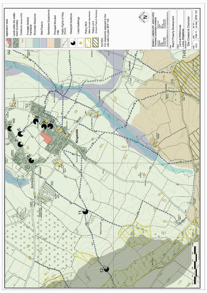
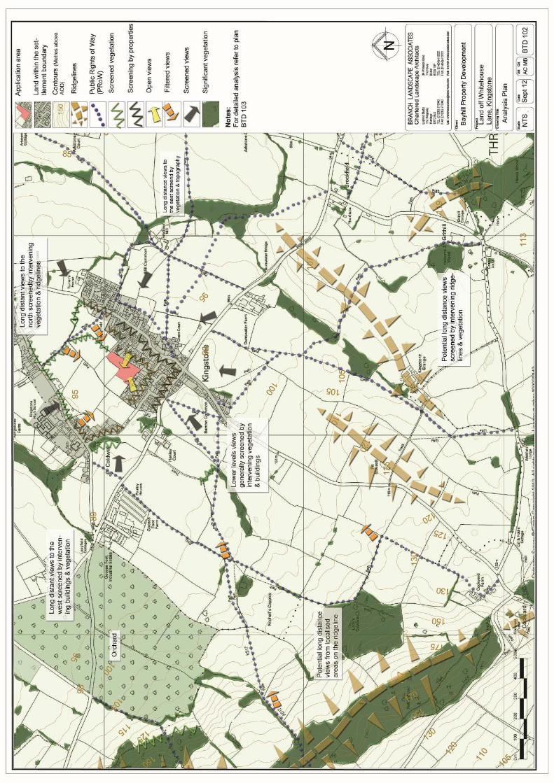
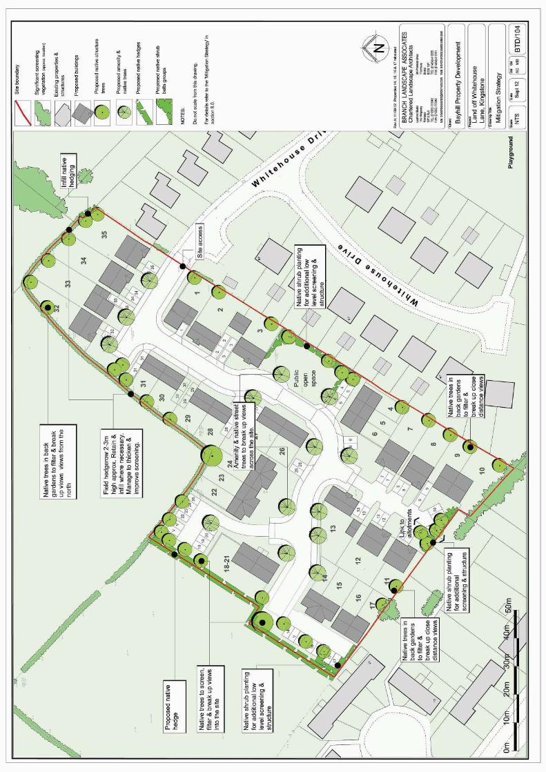
BTD 101 SITE CONTEXT AND CHARACTER BTD 102 ANALYSIS PLAN BTD 103 DETAILED ANALYSIS AND SITE LAYOUT BTD104 MITIGATION STRATEGY PV Sheets 1 to 4 PHOTO VIEW POINTS SHEETS 1 – 4
Housing Development at Whitehouse Drive, Kingstone, Herefordshire. LANDSCAPE AND VISUAL ASSESSMENT
Prepared by Branch Landscape Associates Lephins Studio, The Ridgeway, Wantage. OX12 8LX
T: 01235 770043 E:[email protected] W: branchlandscapeassociates .com BTD/RPT/LV01 – Sept’ 2012
3
1.0 INTRODUCTION 1.1 This report has been prepared to assess the landscape and visual effects
resulting from proposals to construct a housing development on land
adjacent to Whitehouse Drive, Kingstone, Herefordshire. For details of the
proposals refer to the plans produced by Quattro Design Architects and
plans BTD 101 to 104.
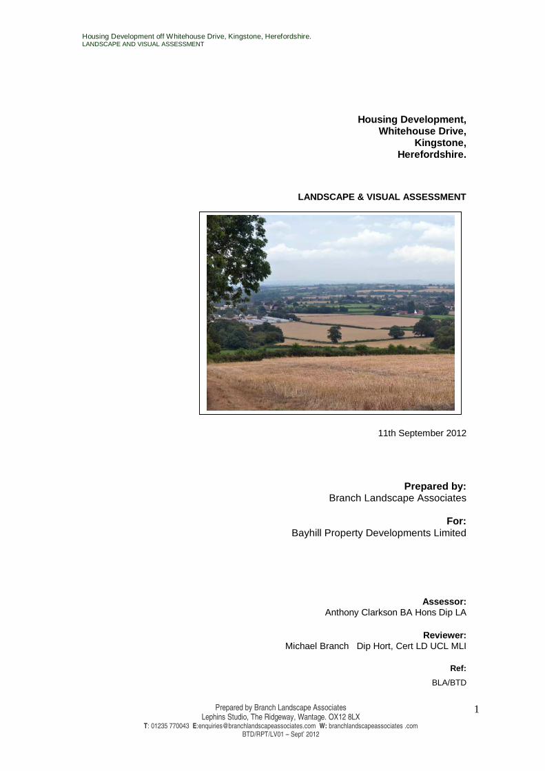
1.2 The site is located at OS co-ordinates SO423358 (E:342320 N1235880) on
the western perimeters of the village of Kingstone within open farmland and
located outside the settlement boundary. 20th century residential
developments, within Kingstone lie on the southern and western application
boundary. Elsewhere, the site boundaries comprise of field hedgerows with
open pasture beyond.
1.3 Landscape impacts relate to changes in the character and quality as a
result of the development and can be either positive or negative. Visual
impacts relate to the appearance of the development and can also be either
positive or negative.
1.4 This report will look at the following key issues associated with the
proposed development:
• Impacts on the landscape resources
• Impacts on visual amenity and the perception of the landscape
1.5 This report is prepared by Branch Landscape associates, a firm of
landscape architects who have broad experience in carrying out landscape
and visual assessments across the UK. The report has been prepared in
accordance with:
• Guidelines for Landscape and Visual Impact Assessment 2nd Edition –
The Landscape Institute and Institute of Environmental Management
and Assessment, (SPON Press 2002)
• Landscape Character Assessment Guidance for England & Scotland –
the Countryside Agency & Scottish Natural Heritage (2002)
Housing Development at Whitehouse Drive, Kingstone, Herefordshire. LANDSCAPE AND VISUAL ASSESSMENT
Prepared by Branch Landscape Associates Lephins Studio, The Ridgeway, Wantage. OX12 8LX
T: 01235 770043 E:[email protected] W: branchlandscapeassociates .com BTD/RPT/LV01 – Sept’ 2012
4
1.6 Branch Landscape Associates has been appointed by Bayhill Property
Developments Limited to produce this report as a supporting document for
a planning application for this housing development of 35 units.
1.7 Scope of the Report
This report is an abridged version of a full Landscape & Visual Impact
Assessment (LVIA). However, it does assess the landscape and visual
effects of the proposed development and is comprised of the following
components:
• Baseline assessment of the landscape and visual resources including a
desktop study and field surveys
• Identification of the landscape and visual effects
• Mitigation strategy
1.8 The base line study also forms the background against which to assess
the magnitude and significance of the predicted landscape and visual
impacts of the proposed development. The following resources have
been used to inform the field survey and analysis:
• Ordnance survey Maps
• Aerial Photographs
• Magic Interactive Map – Natural England & DEFRA
• Herefordshire Unitary Development Plan – March 2010
• Landscape Character Assessment -Supplementary Planning
Guidance 2004 – (Updated 2009) Herefordshire Council
1.9 The base line study provides a basic description and evaluation of the
landscape elements and the interaction between them. This then forms
the basis of the assessment of the impacts of the development.
1.10 Assessment of the Landscape & Visual Impacts
The assessment of the effects aims to:
• Identify the effects of the development
Housing Development at Whitehouse Drive, Kingstone, Herefordshire. LANDSCAPE AND VISUAL ASSESSMENT
Prepared by Branch Landscape Associates Lephins Studio, The Ridgeway, Wantage. OX12 8LX
T: 01235 770043 E:[email protected] W: branchlandscapeassociates .com BTD/RPT/LV01 – Sept’ 2012
5
• Estimate the magnitude of those effects
• Provide an assessment of the nature and significance of the effects in a
logical well-reasoned manner.
• Identify possible mitigation measures
1.11 The methodology for Landscape and visual Assessments is outlined in
Appendix 1.
2.0 THE SITE & STUDY AREA
2.1 The Study Area
Kingstone is a typical village settlement in a lowland landscape
dominated by rolling farmland, scattered farms and small villages and
hamlets. The site is located on farmland between the western boundary
of Kingstone and the settlements of Webton Court and Coldwell, to the
east. The areas surrounding the village and settlement mainly comprise
of pasture, arable fields, orchards and isolated farms and individual
properties. A wooded ridgeline also contains views to the south. The
landscape to the north, west and east tends to comprise of isolated
villages, a complex mosaic of field patterns and woodland belts within
the lowland landscape.
2.2 To the East
The eastern site boundary is contained by 20th century housing
developments within Kingstone. The existing housing limits intervisibility
with the proposals to areas on, and close to, the site boundary from
many areas. Elsewhere potential views from other areas within the
village and beyond are screened by a combination of intervening
properties in Kingstone and mature vegetation.
2.3 To The West
The western boundary comprises of open pasture fields and associated
field hedgerows. Webstone Court and Coldwell are linear settlements
associated with the B4349, located at approximately 300m beyond the
fields adjacent to the site. Kingstone High School is also located within
this area. Views to the site are generally well screened by roadside
Housing Development at Whitehouse Drive, Kingstone, Herefordshire. LANDSCAPE AND VISUAL ASSESSMENT
Prepared by Branch Landscape Associates Lephins Studio, The Ridgeway, Wantage. OX12 8LX
T: 01235 770043 E:[email protected] W: branchlandscapeassociates .com BTD/RPT/LV01 – Sept’ 2012
6
hedges along the B4349. Elsewhere views are screened by mature
vegetation and properties to Cooks Lane and other areas adjacent
areas, at around 200m from the site. To the west, localised views from
the rear of properties are possible from isolated areas, (see Viewpoint
5) although these tend to be screened at low level by hedgerows on the
site boundary and within adjacent fields. Overall the impact of the
proposals are likely to be limited to close distance and are generally
screened by a combination of built structure and mature hedgerows and
trees from many public areas.
2.4 To the South
Views to the south are contained by the distinctive wooded ridgeline
running in a north-westerly direction between Cockyard and Brampton
Hill, at around 2-3kms from the site (up to 190m AOD). Here long
distance, localised and elevated views to the site are possible (VP 12).
However, the views are set within the context of the modern housing
developments to the western boundaries of Kingstone which also
screen and filter views from many areas. Elsewhere, at lower levels,
intervening structures and vegetation beyond the village boundary
generally screen views to the site (VP 11) together with properties and
associated vegetation within Kingstone itself.
2.5 To the North
The village of Clehonger is located 3km to the north east and Madly at
3km to the north. The Satellite Earth Station tracking dishes are a
notable feature located at approximately 1.2 km to the north of the site.
Long and middle distance views within these areas are generally
screened by intervening vegetation. A Public Right of Way (PRoW) runs
in a westerly direction at approximately 150-200m from the northern
application boundary. Views are mainly screened and filtered by mature
boundary hedges and limited to localised area only (VP6). The PRoW
also runs through a recreation ground which adjoins the northern site
boundary. There is some intervisibility through and over mature tree
belts and hedgerows from areas within the playing fields (VP 8). There
is the possibility of long distance filtered or partial views from ridgelines
beyond 8km to the north. However, any potential impacts are likely to

Housing Development at Whitehouse Drive, Kingstone, Herefordshire. LANDSCAPE AND VISUAL ASSESSMENT
Prepared by Branch Landscape Associates Lephins Studio, The Ridgeway, Wantage. OX12 8LX
T: 01235 770043 E:[email protected] W: branchlandscapeassociates .com BTD/RPT/LV01 – Sept’ 2012
7
insignificant set within the context of other properties and the wider
landscape at this distance, therefore these locations have not been
considered in this report.
2.6 The study area has therefore been limited to close distance from the
north, east and west and at long distance to the south, up to
approximately 2.0km.
2.7 The Site’s Immediate Environs
The proposed housing development is on an ‘L’ shaped plot located in
open pasture. The eastern boundary consists of 20th century detached
houses associated with Whitehouse Drive These properties generally
screen views to the site from other areas to the east. Rear gardens and
windows to these properties are likely to experience close distance
views to and over the proposed development. The southern boundary of
the proposals adjoins the rear gardens of a modern housing
development. Four properties are located within close proximity of the
site boundary whilst other properties are generally set back at a
distance of approximately 40m. There is a small area of allotment
gardens within this area located between the rear gardens and the site
boundary. The other boundaries to the north and west adjoin open fields
and consist of well maintained field hedges. There are no other obvious
notable features in and around the sites’ boundaries.
2.8 The Site & Proposals
The proposals are for 35 No 2 storey detached, semi-detached and
terraced housing units accessed from Whitehouse Drive, on the eastern
boundary. The site area covers approximately 1.2 ha and falls gently
westwards from approximately 101m to 95.5m AOD. It is currently
farmed as pasture and there are no obvious notable features within the
application area. The proposals are for low density housing and allows
for the provision of public open space on the eastern boundary and a
link on the southern boundary to the existing allotments. The boundary
treatment will comprise of native hedges to the west and north and
close board fencing to the gardens of adjacent properties, to the west
and south.

Housing Development at Whitehouse Drive, Kingstone, Herefordshire. LANDSCAPE AND VISUAL ASSESSMENT
Prepared by Branch Landscape Associates Lephins Studio, The Ridgeway, Wantage. OX12 8LX
T: 01235 770043 E:[email protected] W: branchlandscapeassociates .com BTD/RPT/LV01 – Sept’ 2012
8
3.0 LANDSCAPE CHARACTER & IMPACTS
3.1 Natural England has published a series of National Character Areas
(NCA) that divide England into 159 broad countrywide based character
areas. These areas are defined by a unique combination of intrinsic
unifying landscape characters such as: geology, soils, topography,
vegetation, agriculture, ecology and human settlement. The proposals
are located within, and close to the western boundary of NCA 99: ‘Black
Mountains & Golden Valley’ and close to western the boundary of NCA
100 – ‘Herefordshire Lowlands’ .
3.2 The ‘Herefordshire Landscape Character Assessment, 2004,
Supplementary Planning Guidance (SPG)’ – {revised 2009} is a more
detailed county wide landscape study aimed at informing policy makers,
local authorities and developers on a local level. The Landscape
assessments provide detailed strategies and recommendations to
enhance and preserve the character and vernacular whilst incorporating
the need for the sustainable evolution of the landscape. These
recommendations have been incorporated in to the Landscape
mitigation strategy where appropriate.
3.3 The SPG states that future development should follow the steps set out
below in order to assess the potential impact of the proposal and the
most appropriate design treatment by;
• Identifying the Landscape Type in which the site is located.
• Assessing whether this is an unsettled landscape. If the proposal are for
built development within an unsettled landscape there would be a high
presumption against development.
• If the site is not within an unsettled landscape, assess the primary and
secondary characteristics of the landscape character for the appropriate
landscape type. New development that would cause unacceptable
adverse change to the landscape character will be resisted.
Housing Development at Whitehouse Drive, Kingstone, Herefordshire. LANDSCAPE AND VISUAL ASSESSMENT
Prepared by Branch Landscape Associates Lephins Studio, The Ridgeway, Wantage. OX12 8LX
T: 01235 770043 E:[email protected] W: branchlandscapeassociates .com BTD/RPT/LV01 – Sept’ 2012
9
• Ensure that detailed proposals fully take into account all site features
and that mitigation and enhancement measures conform to and
strengthen the key characteristics of the area.
3.4 The site lies within the settled landscape type ‘Principal Settled
Farmland’
The key characteristics of Principle Settled Farmland are:
Primary:
• Hedgerows used for field boundaries
Secondary:
• Mixed farming land use
Management Guidelines and Environmental Mitigation
The overall strategy for Principal Settled Farmlands would be to
conserve and enhance the unity of small to medium scale hedged
fields. Opportunities for new tree planting should be concentrated along
watercourses where the linear tree cover pattern could be strengthened.
Additional tree planting in the vicinity of settlement would also be
appropriate and would assist in emphasising the domestic quality of the
landscape. New woodland should not be introduced as it is out of place
and would compromise the landscape character. The mixed farming
land use is becoming increasingly arable and the small permanent
pastures are gradually declining. These are often species rich and
initiatives to safeguard them should be strongly promoted. New
development should remain at a low density with most housing
associated with existing hamlets and villages.
3.5 The proposed development site is located within the Principle Settled
Farmlands character area. This is a character area that occurs
frequently throughout Herefordshire and the scale of the development is
a minor element in relation to the character areas large scale. The
sensitivity of the area to this scale and type of development is likely to
be medium. There will the loss of a secondary key characteristic of the
area with the change of use from farmland to housing. However, the
Housing Development at Whitehouse Drive, Kingstone, Herefordshire. LANDSCAPE AND VISUAL ASSESSMENT
Prepared by Branch Landscape Associates Lephins Studio, The Ridgeway, Wantage. OX12 8LX
T: 01235 770043 E:[email protected] W: branchlandscapeassociates .com BTD/RPT/LV01 – Sept’ 2012
10
development is low density, medium in scale and retains the integrity
and the character of Kingstone when set within the context of adjacent
modern housing developments. Furthermore the proposals ensure the
retention and integrity of the existing hedgerow patterns together with a
further enhancement and mitigation strategy outlined in section 8.0.
Therefore the magnitude of landscape effects on the Principle Settled
Farmland character area is likely to be low and the landscape effects
slight.
3.6 The site has the potential to affect the setting of the settled landscape
type ‘Principle Wooded Hills’ on the ridgeline to the south of the site.
The key characteristics of Principle Wooded Hills are:
Primary:
• Varied, often steeply sloping topography.
• Ancient wooded character made up of mixed broadleaved
woodlands, often of ancient origin
Secondary:
• Wooded land use with occasional pasture.
• Hedges define field boundaries.
• Linked woodland pattern.
• Medium-framed views.
• Scattered settlement pattern
Management Guidelines and Environmental Mitigation
The aim of future management should be to retain the dominance of
woodland with a small proportion of integrated irregularly shaped
pastoral fields. Emphasis should be placed upon both restoring the
ancient semi-natural character of the woodland cover and maintaining
an overall interlocking pattern of woodland and grazed fields with a high
proportion of hedgerow and streamside trees. The three aspects of
conservation, restoration and enhancement are therefore applicable to
this landscape type.
Housing Development at Whitehouse Drive, Kingstone, Herefordshire. LANDSCAPE AND VISUAL ASSESSMENT
Prepared by Branch Landscape Associates Lephins Studio, The Ridgeway, Wantage. OX12 8LX
T: 01235 770043 E:[email protected] W: branchlandscapeassociates .com BTD/RPT/LV01 – Sept’ 2012
11
3.7 Principle Wooded Hills is a landscape character area that occurs
frequently throughout Herefordshire. The scale of the development is a
minor element in relation to the local character area along the ridge.
The proposals have the potential to impact on the setting of the
character area only and will not have any direct impacts. Therefore the
sensitivity of the Principle Wooded hills within the local area is likely to
be medium to this scale and type development and in this particular
context. The proposed development is a very minor alteration to
localised viewpoints and is therefore likely to have a negligible effect on
the overall setting of the character area. The magnitude of the impacts
on the setting of the character area are further reduced when the
proposals are views within a wider panoramic landscape and seen in
context of other recent residential developments within Kingstone.
Therefore the landscape effects on the setting of the Principle Wooded
Hills character area are likely to be negligible.
3.8 ‘Riverside Meadows’, ‘Wet pasture Meadows’ and ‘Sandstone
Estatelands’ character areas have also been identified close to the
application area. There will be no direct impacts or indirect impacts as a
result of the proposals due to limited intervisibility.
4.0 LANDSCAPE PLANNING CONTEXT & IMPACTS
4.1 Until the Local Development Framework takes over, the policies in the
Herefordshire Unitary Development Plan (UDP) have been “Saved” by
the Direction of the Secretary of State will remain in effect. However,
there are no landscape planning polices identified on or adjacent to the
site within the UDP which will be directly or indirectly effected by the
proposals. Polices and other designated landscape features and
protected features within or adjacent to the broader study are discussed
below.
4.2 Policy NC4
The study area has identified that the wooded ridgeline to the south is
covered under policy NC4 as a ‘Sites of local importance’ which will not
permit development that could directly or indirectly affect a Special
Housing Development at Whitehouse Drive, Kingstone, Herefordshire. LANDSCAPE AND VISUAL ASSESSMENT
Prepared by Branch Landscape Associates Lephins Studio, The Ridgeway, Wantage. OX12 8LX
T: 01235 770043 E:[email protected] W: branchlandscapeassociates .com BTD/RPT/LV01 – Sept’ 2012
12
Wildlife Site, Site of Importance to Nature Conservation, Local Nature
Reserve. As for similar reasons set out for Principle Wooded Hills (3.7)
the impacts on the policy area are likely to be negligible . There are no
other areas covered under policy NC4 which will be impacted, either
directly or indirectly, by the proposals.
4.3 Policy LA 4 Protection of Historic Parks and Gardens
An Historic Park and Garden is located at the Whitfield Estate
approximately 2.5kms to the south of the proposed site. The policy
protects the park from development which would destroy, damage or
otherwise adversely affect its character, appearance, features or
setting. However there was no identified intervisibility with the site and
therefore no potential effects.
4.4 Listed Buildings
There are a number of listed buildings within Kingstone, close to the
proposed site. Due regard should be given to the potential indirect
impact on the setting of listed buildings by the development. In this case
there is no intervisibility between the site and identified listed buildings
within Kingstone due to screening by intervening structures and
therefore no effects. For listed buildings elsewhere a combination of
intervening vegetation and distance to the proposals in a negligible
magnitude of impacts and a resultant negligible overall effect.
5.0 VISUAL ASSESSMENT INTRODUCTION
5.1 Site Survey
The impact of the proposed development on visual amenity was initially
undertaken as part of the desk study, and this was then tested and
assessed during the site survey carried out on the 21st of August 2012.
The survey assessed and photographed the landscape and character of
the site and surrounding areas and identified typical viewpoints. The site
visit also informed the potential extent of the zone of visual influence of
the proposals.
Housing Development at Whitehouse Drive, Kingstone, Herefordshire. LANDSCAPE AND VISUAL ASSESSMENT
Prepared by Branch Landscape Associates Lephins Studio, The Ridgeway, Wantage. OX12 8LX
T: 01235 770043 E:[email protected] W: branchlandscapeassociates .com BTD/RPT/LV01 – Sept’ 2012
13
5.2 The landscape effects and visual impacts of the proposed development
have been appraised using viewpoints from key locations on roads,
footpaths and other publicly accessible areas from where the desk
study suggests the site may be visible. The number and selection of the
viewpoints are considered to be appropriate for the scale and nature of
the development, however the views are representative and not totally
inclusive. The views will also be used to inform a mitigation strategy.
5.3 All photographs where taken using a Nikon D3100 DSLR camera and a
50mm lens mounted at eye height on a tripod, using a fixed focal length.
For photo locations see plans BTD 1017 103 and the photo view point
sheets in appendix 2 of this report.
5.4 Visual & Sensory Qualities
While not wholly exclusive, the principal factors which affect visual
impact are:
• Landform
• Backdrop
• Landscape Scale
• Vegetation Cover
• Building Design & Site Layout
• Seasonality
• Height of eye
5.4 Landform
The rolling lowland landscape and enclosure formed by the ridgeline to
the south are the dominant feature within the local landscape. The site
is located within the lowland landscape which comprises of a mosaic of
settlements, mature hedgerows and woodland belts. Therefore, low
level views are generally screened in all but close distance views. The
higher ridgelines to the south afford elevated views towards Kingstone
but are publicly assessable locations are very limited and no views from
properties or roads where identified.
Housing Development at Whitehouse Drive, Kingstone, Herefordshire. LANDSCAPE AND VISUAL ASSESSMENT
Prepared by Branch Landscape Associates Lephins Studio, The Ridgeway, Wantage. OX12 8LX
T: 01235 770043 E:[email protected] W: branchlandscapeassociates .com BTD/RPT/LV01 – Sept’ 2012
14
5.6 Backdrop
Visual impact will be strongly influenced by the backdrop against which
it is viewed. A building or structure will be at its most prominent when
viewed against an open skyline. It is least intrusive when viewed against
a backdrop, or within the context of similar structures. The proposals
are set against the complex mix of rooflines, vegetation and other built
structures and any visual prominence will decrease with distance.
5.7 Landscape Scale
Impacts can increase as a result of developments being out of scale
with their surrounding landscape. The proposals are consistent with the
shape, mass and scale of surrounding properties and other buildings
when set within the context of surrounding developments to the western
perimeters of Kingstone.
5.8 Vegetation Cover
The magnitude and eventual significance of impact can be reduced by
utilising existing groups of trees and hedgerows and strategic new
planting to screen views towards development from sensitive locations.
The site benefits from existing boundary hedgerows which help to filter
and screen potential low level views, particularly from the west and
north. A landscape strategy should provide for retention, management
and sensitive infilling to mitigate against significant visual impacts in key
areas.
5.9 Building Design & Site Layout
Building design, mass, height, detailing, layout colour, texture and
location will all individually influence visual impact. Due to close
distance views and potential impacts on the local area, the layout and
design needs to be carefully considered to ‘respects both the character
and size of the settlement concerned’ (Policy H10 -Herefordshire UDP).
5.10 Seasonality
Winter views are often more exaggerated than in summer due to lack of
leaf cover, but there is generally little reduced effect where there are
woodlands screening views or dense hedges at eye level. It can often
Housing Development at Whitehouse Drive, Kingstone, Herefordshire. LANDSCAPE AND VISUAL ASSESSMENT
Prepared by Branch Landscape Associates Lephins Studio, The Ridgeway, Wantage. OX12 8LX
T: 01235 770043 E:[email protected] W: branchlandscapeassociates .com BTD/RPT/LV01 – Sept’ 2012
15
be the case that close distance views have a greater potential for
screening then longer distance as thedue to the elevation of the line of
view decreasing with distance to the object.
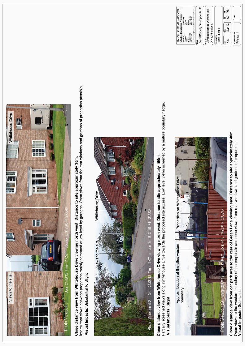
6.0 VISUAL IMPACTS ( refer to plan BTD 101, 102 & Photo Sheets 1 to 4)
6.1 Close Distance Views from Whitehouse Drive (VP 1 and 2)
Photo viewpoints (VP) represent close distance views from within the
housing development associated with Whitehouse Drive, on the eastern
boundary of the site. Views to the proposals are generally screened by
properties on the site boundaries. However, localised glimpsed views
over the site are possible between properties (VP1). Elsewhere views
are screened, with the exception of the long view towards the proposed
site access, along Whitehouse Lane (VP2). Here views are possible
over the boundary hedge where the road is slightly elevated in relation
to the site. There will also be open views to the site from the rear
windows and gardens of properties adjacent to the site. Long and
middle distance views from the east are not possible due to
containment by existing buildings within Kingstone.
6.2 The properties to the western site boundary will have direct views to the
proposed site from key living areas. The visual sensitivity is therefore
could be considered to be high. The proposals are a significant
alteration to the visual character of the current open fields and therefore
the magnitude of the change is high. Therefore visual effects to views
from properties adjacent to the site along Whitehouse Drive are likely to
be substantial . Elsewhere, within the immediate area, views from
roads and other properties are generally screened or glimpsed therefore
the sensitivity is medium with a low magnitude of change and the
resulting probable visual impacts are slight.
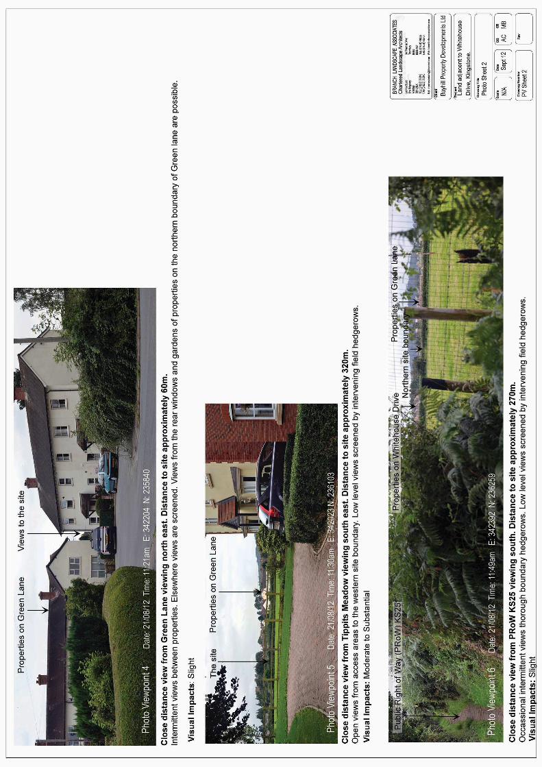
6.3 Close Distance views from Green Lane (VP 3 & 4)
Photo viewpoints (VP) represent close distance views from within the
housing development and from the car park to the rear of properties to
the west of the site. As above, views to the proposals from are generally
screened by properties on the site boundaries with glimpsed views only
Housing Development at Whitehouse Drive, Kingstone, Herefordshire. LANDSCAPE AND VISUAL ASSESSMENT
Prepared by Branch Landscape Associates Lephins Studio, The Ridgeway, Wantage. OX12 8LX
T: 01235 770043 E:[email protected] W: branchlandscapeassociates .com BTD/RPT/LV01 – Sept’ 2012
16
(VP4). Elsewhere views are screened by properties with the exception
of open views form the car park (VP 3). Again there will also be open
views to the site from the rear windows and gardens of properties
adjacent to the site. Other close and middle distance views from the
south are not possible due to containment by existing buildings within
the south of Kingstone.
6.4 The properties to the southern site boundary will have direct views to
the proposed site from key living areas although partially screened in
some areas by the allotment gardens and associated screening
vegetation. The visual sensitivity is therefore likely to be high. The
proposals are a significant alteration to the visual character of the
current open fields and therefore the magnitude of the change is high.
Visual effects to views from properties adjacent to the site along Green
Lane are likely to be substantial . Elsewhere, within the immediate
area, views from roads and other properties are generally screened or
glimpsed. Accordingly the sensitivity is likely to be medium with a low
magnitude of change and the resultant visual impacts will to be slight.
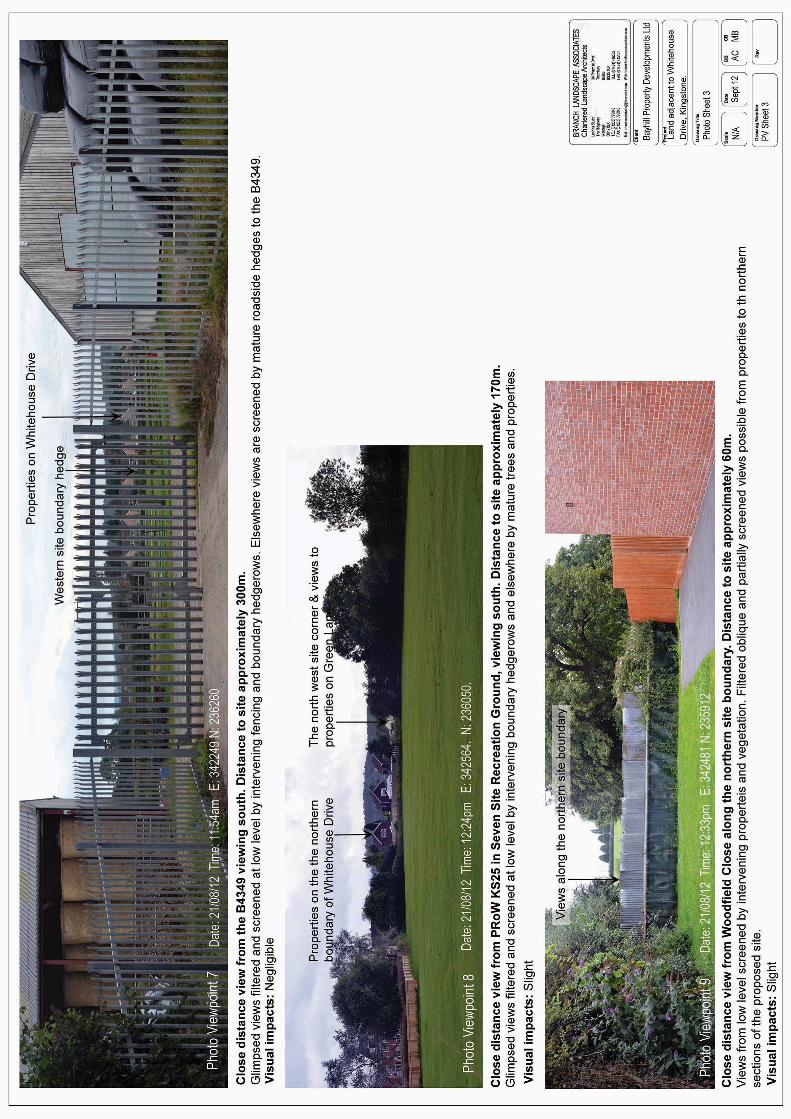
6.5 Close distance views from the west (VP 5 & 7)
Properties in Tippetts Meadow (VP5) and properties on the eastern
boundary of the B4349 are likely to experience open views to the
proposals although screened at low level by the site boundary and other
intervening hedgerows. Elsewhere views are screened by a
combination of mature roadside vegetation and intervening properties.
6.6 Therefore the visual sensitivity of properties within this area are likely to
be high where views from key areas are possible. The views are
partially screened at low level and set against the current backdrop of
20th century housing developments. However, the proposals are still
likely to still form a recognisable new element within the overall view.
The magnitude of the change is likely to be medium with a moderate to
substantial visual effect. Elsewhere, from the B4349, views are limited
to a gap in the hedgerow through an agricultural storage area (VP7).
Here the low sensitivity of the view and low magnitude of development
results in a negligible visual impact.
Housing Development at Whitehouse Drive, Kingstone, Herefordshire. LANDSCAPE AND VISUAL ASSESSMENT
Prepared by Branch Landscape Associates Lephins Studio, The Ridgeway, Wantage. OX12 8LX
T: 01235 770043 E:[email protected] W: branchlandscapeassociates .com BTD/RPT/LV01 – Sept’ 2012
17
6.7 Views from PRoW KS25 and the recreation area
The western section of the PRoW is generally screened by mature and
dense path side vegetation with occasional gaps allowing views towards
the proposals (VP6). To the east, the track passes through the
recreation ground where localise open views are possible towards the
site boundary. Although these potential views are generally screened by
mature hedgerows and trees (VP8). However, views are possible into
the north east corner of the site through a gap in the vegetation and
housing.
As the views from thee PRoW and recreation ground are partial and
glimpsed views the sensitivity of the area is likely to be medium. The
views constitute a minor alteration to the wider view and are set against
the backdrop of residential properties on the boundaries of Kingstone.
The magnitude is therefore likely to be low with a resultant slight visual
impact.
6.8 Other close views from the north (VP 10)
Views from roads to the north are likely to be substantially screened at
low level by hedgerows and other mature vegetation. Where views are
possible these will be to rooflines only and set against the backdrop of
existing rooflines within the village. The sensitivity is likely to be low and
the magnitude also low. The overall visual effects will be negligible.
6.9 Views from properties att Woodfield Close (VP9)
Woodfield Close is a recent housing development located at close
distance to the east of the site, to the north of properties on Whitehouse
Drive. There is the potential for oblique and filtered views through
mature vegetation to the northern sections of the proposed site only.
The sensitivity of the properties are likely to be medium and the
magnitude of the effects is low. Potential visual impacts are slight,
where views are possible.
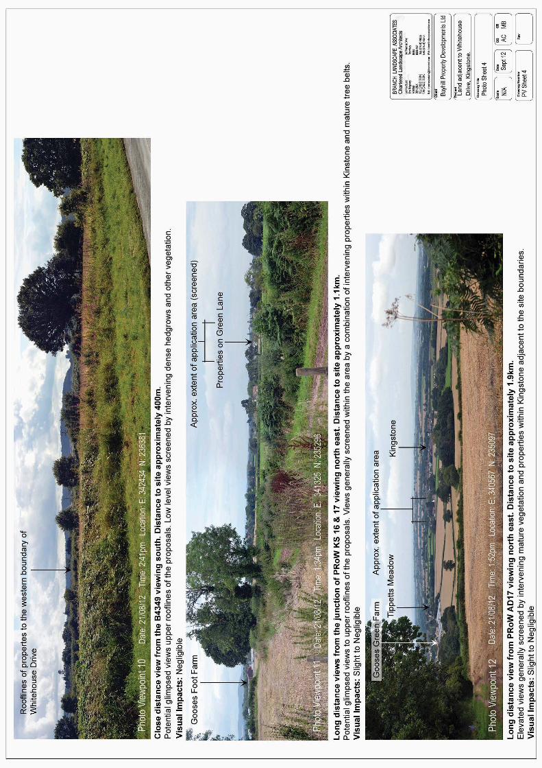
6.10 Long distance views from the South (VP 11 & 12)
Views from these areas are mainly from elevated location to the north of
the woodland on the ridgeline (VP12). The views are expensive and
Housing Development at Whitehouse Drive, Kingstone, Herefordshire. LANDSCAPE AND VISUAL ASSESSMENT
Prepared by Branch Landscape Associates Lephins Studio, The Ridgeway, Wantage. OX12 8LX
T: 01235 770043 E:[email protected] W: branchlandscapeassociates .com BTD/RPT/LV01 – Sept’ 2012
18
panoramic. The proposals will constitute a minor additional landscape
element set within the context of adjacent housing developments and
partially screened and filtered by intervening mature vegetation and
other buildings in Kingstone. Lower level views on the ridgeline and
adjacent lowlands tend to be screened (VP11).
.
6.11 The proposals will be barely perceptible, partial and glimpsed where
views are available due to the distance to the site and the context of
other developments. Therefore the PRoW have a medium sensitivity.
The proposals are a minor element at this distance set within the
context of other landscape features in a panoramic view and screened
and filtered form many locations. The magnitude of the development
impacts are will to be low and therefore, the visual effects on the area
will be slight to negligible.
7.0 SUMMMARY OF LANDSCAPE & VISUAL EFFECTS
.
7.1 The assessments concludes that the proposals are likely to have a
slight to negligible effect on the landscape character and designated
landscape within the study area. However, visual impacts are assessed
as greatest in close proximity from adjacent properties on Green Lane,
Whitehouse Drive and in the area of Tippitts Meadow, to the west. Here,
the impacts on these properties are assessed as being substantial to
moderate where the views are open and/or at close proximity.
Elsewhere visual impacts were found to be negligible to slight with
due to a combination of intervening properties and vegetation and
distance to site. Therefore mitigation measures will be predominantly
aimed at reducing the potential visual impacts on properties with open
views at close distance to the south, east and west of the site.
8.0 MITIGATION STRATEGY (See plan BTD 104)
8.1 The strategy outlined in this section has not only been designed to
mitigate potential visual impacts resulting from the development, but
also seeks to enhance the overall ecological benefits of the area and
enhance the landscape structure. The proposals have been developed
Housing Development at Whitehouse Drive, Kingstone, Herefordshire. LANDSCAPE AND VISUAL ASSESSMENT
Prepared by Branch Landscape Associates Lephins Studio, The Ridgeway, Wantage. OX12 8LX
T: 01235 770043 E:[email protected] W: branchlandscapeassociates .com BTD/RPT/LV01 – Sept’ 2012
19
in accordance with guidance offered in the Herefordshire Landscape
Character Assessment SPG for Principal Settled Farmland. The
landscape mitigation proposals aim to conserve and enhance the field
hedges and introduce new hedge, tree and shrub planting to create a
strong landscape structure and assist in emphasising the internal
domestic quality of the development. This mitigation strategy should be
utilised to form the framework for detailed landscape proposals at a
later stage. Therefore additional planting not show on plan BTB 104 will
be required to complete a full landscape scheme to comply with
planning conditions. At this stage detailed consideration needs to be
given to the location of individual tree and shrub species and detailed
soft and hard landscaping treatment to boundaries, house frontages
and the street scene.
8.2 The strategy aims to provide a range of structural landscape elements
to mitigate adverse visual effects. The principal landscape elements of
the strategy are outlined on the illustrative Mitigation strategy (See BTD
104) and broadly are:
• The retention and enhancement of field hedgerows.
• A new native boundary hedgerow
• Boundary tree planting
• Amenity tree planting within the development
• Native shrub planting
8.3 Retention & Enhancement of Field Hedgerows
Retain the north western boundary hedges and manage to thicken up,
increase height and improve screening. Maintain at a minimum height of
2m. Adjacent fencing should be stock type timber and rail/wire to allow
for growth and sufficient light. Gap up with native whip planting with a
high proportion of evergreen if/where necessary using species outlines
in section 8.4.
Objectives:
• Filter and screen low level views to the west and north.
• Maintain and enhance wildlife corridors and habitats.
Housing Development at Whitehouse Drive, Kingstone, Herefordshire. LANDSCAPE AND VISUAL ASSESSMENT
Prepared by Branch Landscape Associates Lephins Studio, The Ridgeway, Wantage. OX12 8LX
T: 01235 770043 E:[email protected] W: branchlandscapeassociates .com BTD/RPT/LV01 – Sept’ 2012
20
• Retain and enhance the landscape structure.
8.4 New Native Boundary Hedgerow
Plant a new native hedgerow along the western site boundary and the
north east corner of the site. Adjacent fencing should be stock type
timber and rail/wire to allow for growth and sufficient light. The hedge
should be planted as whips in a double staggered row 5 plants per
linear meter and comprise of a selection of the following species and
proportional mixes ;
• Crataegus monogyna (Hawthorn) 30%
• Cornus sanguinea (Dogwood) 10%
• Corylus avellana (Hazel) 10%
• Ilex aquifolium (Holly) 5%
• Prunus spinosa (Blackthorn) 25%
• Rosa canina (Dog Rose) 5%
• Viburnum opulus (Guelder Rose) 15%
Objectives
• To screen low level views from the west and north east.
• To contain and absorb the proposed development within the wider
landscape.
• Reinforce the landscape type and character of the area.
• Create a further wildlife corridor habitat and provide additional green
corridors links to off site habitats.
• Reverse the general decline in hedgerows.
8.5 Boundary Tree Planting
Standard and extra heavy standard tree planting to rear gardens,
parking areas and other amenity spaces around the site boundaries.
The trees to comprise of a selection of the following species:
• Acer campestre sp. (Field Maple)
• Alnus glutinosa (Alder)
• Betula pendula sp. (Silver birch)
• Fraxinus excelsior (Ash)
Housing Development at Whitehouse Drive, Kingstone, Herefordshire. LANDSCAPE AND VISUAL ASSESSMENT
Prepared by Branch Landscape Associates Lephins Studio, The Ridgeway, Wantage. OX12 8LX
T: 01235 770043 E:[email protected] W: branchlandscapeassociates .com BTD/RPT/LV01 – Sept’ 2012
21
• Juglans regia (Walnut)
• Prunus avium (Wild Cherry)
• Prunus padus (Bird cherry)
• Quercus robur (Oak)
• Sorbus aucuparia (Rowan)
• Tilia cordata (Lime)
Objectives:
• To screen and filter close and long distance views to the site in
strategic locations.
• To contain and absorb the proposed development in the wider
landscape.
• Create a strong boundary landscape structure to provide a setting
for the development
• Create further habitat interest.
8.6 Amenity Tree Planting Within the Development
Standard and extra heavy standard tree planting within the development
to comprise of a selection of the following species:
• Alnus cordata (Italian alder)
• Betula pendula (Silver birch)
• Carpinus betulus sp. (Hornbeam)
• Malus sp (Flowering crab apple)
• Sorbus aria sp (Whitebeam)
• Sorbus aucuparia (Mountain ash)
• Prunus padus (Bird cherry)
• Prunus avium (Wild cherry)
Objectives:
• Break up and filter views across the site and potentially from
elevated long distance views
• To provide a strong landscape structure and soften the street scene
to integrate the proposals with the village setting.
Housing Development at Whitehouse Drive, Kingstone, Herefordshire. LANDSCAPE AND VISUAL ASSESSMENT
Prepared by Branch Landscape Associates Lephins Studio, The Ridgeway, Wantage. OX12 8LX
T: 01235 770043 E:[email protected] W: branchlandscapeassociates .com BTD/RPT/LV01 – Sept’ 2012
22
8.7 Native Shrub Planting
Native shrub planting on the site boundary. To comprise of a selection
of the following species:
• Cornus sanguinea (Dogwood)
• Corylus avellana (Hazel)
• Ilex aquifolium (Holly)
• Ligustrum vulgare (Common privet)
• Rosa canina (Dog rose)
• Viburnum opulus (Guelder rose)
Objectives:
• To provide additional low level screening from adjacent properties in
strategic location on the site boundary
• Create structure to the site boundaries in amenity area
• Provide additional habitat.
9.0 CONCLUSIONS
9.1 This assessment into the proposed development on the site adjacent to
Whitehouse Drive, Kingstone has appraised the landscape and visual
character of the selected study area in terms of the polices and planning
guidance by Herefordshire Council. As a result of the appraisal it is
concluded that there will be no significant detrimental landscape or
character impacts.
9.2 The ‘Zone of Visual Influence’ of the proposals is greatly reduced by the
local ridgelines and intervening hedges and tree belts in and around
Kingstone. The existing properties are also a particularly significant
contributor to screening views to the site. Therefore the resultant visual
impacts are negligible from many outlying areas. However, there may
be substantial visual impacts when the proposals are viewed from key
areas to properties adjacent to the site and from localised areas to the
west, on and adjacent to Tippitts Meadow.
Housing Development at Whitehouse Drive, Kingstone, Herefordshire. LANDSCAPE AND VISUAL ASSESSMENT
Prepared by Branch Landscape Associates Lephins Studio, The Ridgeway, Wantage. OX12 8LX
T: 01235 770043 E:[email protected] W: branchlandscapeassociates .com BTD/RPT/LV01 – Sept’ 2012
23
9.3 Therefore a mitigation scheme has been developed to reduce the
impact of these close distance views to an acceptable level with the
introduction of native tree planting to the rear gardens of properties. The
trees will filter and break up close distance views in localised areas. In
strategic areas native shrub planting will also further screen and filter
low level views. Views to the west will be mitigated by the introduction of
a new native boundary hedge and native tree planting to screen, filter
and provide a setting to the development together with the retention and
sensitive management of the existing hedge.
8.3.1 As well as mitigating the local impact of the development, these
measures will have a significant incidental positive benefit by enhancing
boundaries and creating a strong local landscape structure which will
contribute towards the local distinctiveness, character and habitat value
of the area.

Housing Development at Whitehouse Drive, Kingstone, Herefordshire. LANDSCAPE AND VISUAL ASSESSMENT
Prepared by Branch Landscape Associates Lephins Studio, The Ridgeway, Wantage. OX12 8LX
T: 01235 770043 E:[email protected] W: branchlandscapeassociates .com BTD/RPT/LV01 – Sept’ 2012
24
APPENDIX 1: Methodology
The LVIA methodology is based on the principles outlined in the Guidelines for Landscape and
Visual Assessment, which is widely accepted as the industry standard, together with the
Landscape Character Assessment Guidance prepared by Scottish Natural Heritage (SNH). SNH’s
guidance on the presentation of visual assessment was also referred to as the principal source of
guidance on the subject. The LVIA report covers:
• Evaluation of the existing landscape character, designation and visual baseline and based on this, identification of potential landscape and visual receptors within the study area;
• Identification of other developments to be considered in the appraisal of cumulative effects and key factors to be taken into account;
• Evaluation of the sensitivity of potential landscape and visual receptors;
• Evaluation of the magnitude and nature of likely changes resulting from the proposals;
• Conclusion on the overall effects of the proposals on the landscape character and key views within the study area.
Receptors
Landscape receptors are things, those landscape elements, character areas or designations
potentially experiencing a change as a result of the proposals.
Visual receptors are contemporary humans, users of the landscape and residents potentially
experiencing a change to their views and visual amenity.
Though intrinsically interrelated, landscape character and visual receptors are therefore considered
as separate entities.
Landscape character can be defined as the combination of the inherent physical elements –
geology, soils, topography, vegetation and land cover, built form, field pattern, water bodies – and
perceived elements – time depth or connection to history, tranquillity, scale, texture, coherence –
that make an area of land different to the next. Landscape character receptors are therefore the
key components that define an area’s overall character, or the areas themselves.
Visual appraisal is related to this in that character is part of what defines a view, but the experience
of that view is also influenced by subjective personal values and interpretation, weather, distance,
time spent exposed to the view etc. A visual impact therefore needs a viewer to perceive it and
those viewers are separate visual receptors.
Essentially landscape character exists whether or not it is seen, as do any impacts upon it e.g. if
you clear a glade in an area of dense woodland it’s character will change regardless of whether it
can be viewed from a public path. If there are no points from which the glade can be viewed the
clearance cannot result in a visual impact, if there are effects on visual receptors this should be
considered.
Housing Development at Whitehouse Drive, Kingstone, Herefordshire. LANDSCAPE AND VISUAL ASSESSMENT
Prepared by Branch Landscape Associates Lephins Studio, The Ridgeway, Wantage. OX12 8LX
T: 01235 770043 E:[email protected] W: branchlandscapeassociates .com BTD/RPT/LV01 – Sept’ 2012
25
Sensitivity of Receptors
Landscape Sensitivity
The judgement of landscape sensitivity varies, can be influenced by subjectivity, and is often based
on landscape character. A number of studies have been carried out to identify a common definition,
the latest being a combined commission from Natural England and Scottish Natural Heritage
concentrating principally on the clarification of landscape character sensitivity building on advice in
Landscape Character Assessment Guidance Topic Paper 6. The Paper does not attempt to define
sensitivity instead noting that judging it requires professional judgement based on whether
significant characteristics elements of the landscape, and as a result its amenity value, will be lost
as a result of the development.
For this assessment, landscape sensitivity is a reflection of a landscape element, designation or
character area’s condition, value, and location in relation to the proposed development. Table 1
outlines the parameters used to define categories. The assessor should always consider a number
of the scenarios given in the table to choose the most appropriate sensitivity rating within the given
landscape and site context. Designated areas are considered to be of higher sensitivity due to the
public perceptions and often cumulative pressures for change attached to them and should never
receive a low sensitivity rating.
The overall consideration for a sensitivity rating should be the amount of change that can be
accommodated by a given receptor, without it being devalued or unacceptably changed in the long-
term, thereby damaging the overall landscape resource. High sensitivity receptors would either be
those in pristine condition, where change would be very obvious and distracting, or those that have
already been significantly damaged so that further change would result in the receptor being totally
devalued in the long-term removing the option for restoration. Medium sensitivity would be mainly
associated with average receptors of good condition, with some damage or distraction, but
generally still able to accept more change without irreversible damage. Low sensitivity receptors
would be for example those in a changing environment, where change is a defining element, those
of low quality, where change would lead to improvements or those of good quality and condition,
where there is plenty of capacity to accommodate more change without irreversible damage.
It should be noted that the sensitivity criteria in this report do not represent a detailed sensitivity
assessment of the landscape resource within the study area. It is a tool for the assessor to allow
some judgement on the perceived sensitivity and to incorporate some judgement on this in the
impact assessment. If more detailed local sensitivity assessments were available those would be
used to inform the assessment in preference to the criteria defined here. However, often such
assessments are not available or are proposal specific, and it is considered that the criteria used in
this report provide at least some context to the assessment, without increasing the scope of works
and survey effort beyond reason to arrive at detailed sensitivity scores for each proposal.
Housing Development at Whitehouse Drive, Kingstone, Herefordshire. LANDSCAPE AND VISUAL ASSESSMENT
Prepared by Branch Landscape Associates Lephins Studio, The Ridgeway, Wantage. OX12 8LX
T: 01235 770043 E:[email protected] W: branchlandscapeassociates .com BTD/RPT/LV01 – Sept’ 2012
26
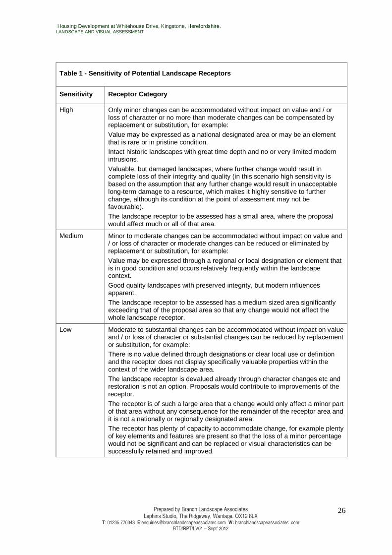
Table 1 - Sensitivity of Potential Landscape Recept ors
Sensitivity Receptor Category
High Only minor changes can be accommodated without impact on value and / or loss of character or no more than moderate changes can be compensated by replacement or substitution, for example:
Value may be expressed as a national designated area or may be an element that is rare or in pristine condition. Intact historic landscapes with great time depth and no or very limited modern intrusions.
Valuable, but damaged landscapes, where further change would result in complete loss of their integrity and quality (in this scenario high sensitivity is based on the assumption that any further change would result in unacceptable long-term damage to a resource, which makes it highly sensitive to further change, although its condition at the point of assessment may not be favourable). The landscape receptor to be assessed has a small area, where the proposal would affect much or all of that area.
Medium Minor to moderate changes can be accommodated without impact on value and / or loss of character or moderate changes can be reduced or eliminated by replacement or substitution, for example:
Value may be expressed through a regional or local designation or element that is in good condition and occurs relatively frequently within the landscape context.
Good quality landscapes with preserved integrity, but modern influences apparent. The landscape receptor to be assessed has a medium sized area significantly exceeding that of the proposal area so that any change would not affect the whole landscape receptor.
Low Moderate to substantial changes can be accommodated without impact on value and / or loss of character or substantial changes can be reduced by replacement or substitution, for example: There is no value defined through designations or clear local use or definition and the receptor does not display specifically valuable properties within the context of the wider landscape area. The landscape receptor is devalued already through character changes etc and restoration is not an option. Proposals would contribute to improvements of the receptor.
The receptor is of such a large area that a change would only affect a minor part of that area without any consequence for the remainder of the receptor area and it is not a nationally or regionally designated area. The receptor has plenty of capacity to accommodate change, for example plenty of key elements and features are present so that the loss of a minor percentage would not be significant and can be replaced or visual characteristics can be successfully retained and improved.
Housing Development at Whitehouse Drive, Kingstone, Herefordshire. LANDSCAPE AND VISUAL ASSESSMENT
Prepared by Branch Landscape Associates Lephins Studio, The Ridgeway, Wantage. OX12 8LX
T: 01235 770043 E:[email protected] W: branchlandscapeassociates .com BTD/RPT/LV01 – Sept’ 2012
27
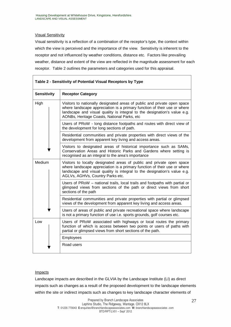
Visual Sensitivity
Visual sensitivity is a reflection of a combination of the receptor’s type, the context within
which the view is perceived and the importance of the view. Sensitivity is inherent to the
receptor and not influenced by weather conditions, distance etc. Factors like prevailing
weather, distance and extent of the view are reflected in the magnitude assessment for each
receptor. Table 2 outlines the parameters and categories used for this appraisal.
Table 2 - Sensitivity of Potential Visual Receptors by Type
Sensitivity Receptor Category
Visitors to nationally designated areas of public and private open space where landscape appreciation is a primary function of their use or where landscape and visual quality is integral to the designation’s value e.g. AONBs, Heritage Coasts, National Parks, etc
Users of PRoW - long distance footpaths and routes with direct view of the development for long sections of path.
Residential communities and private properties with direct views of the development from apparent key living and access areas.
High
Visitors to designated areas of historical importance such as SAMs, Conservation Areas and Historic Parks and Gardens where setting is recognised as an integral to the area’s importance
Visitors to locally designated areas of public and private open space where landscape appreciation is a primary function of their use or where landscape and visual quality is integral to the designation’s value e.g. AGLVs, AGHVs, Country Parks etc.
Users of PRoW – national trails, local trails and footpaths with partial or glimpsed views from sections of the path or direct views from short sections of the path
Residential communities and private properties with partial or glimpsed views of the development from apparent key living and access areas.
Medium
Users of areas of public and private recreational space where landscape is not a primary function of use i.e. sports grounds, golf courses etc.
Users of PRoW associated with highways or local routes the primary function of which is access between two points or users of paths with partial or glimpsed views from short sections of the path.
Employees
Low
Road users
Impacts
Landscape impacts are described in the GLVIA by the Landscape Institute (LI) as direct
impacts such as changes as a result of the proposed development to the landscape elements
within the site or indirect impacts such as changes to key landscape character elements of
Housing Development at Whitehouse Drive, Kingstone, Herefordshire. LANDSCAPE AND VISUAL ASSESSMENT
Prepared by Branch Landscape Associates Lephins Studio, The Ridgeway, Wantage. OX12 8LX
T: 01235 770043 E:[email protected] W: branchlandscapeassociates .com BTD/RPT/LV01 – Sept’ 2012
28
the study area, the integrity of landscape designations within the study area or the overall
landscape condition of the study area.
Visual impacts are described by the LI as direct impacts on the visual amenity or views
available to visual receptors located within publicly accessible areas and residential dwellings
resulting from changes to that view as a result of the proposed development such as
introduction, removal, obstruction, or modification of elements within the view. The
assessment of visual impacts is informed by the use of a series of viewpoints. The viewpoints
are selected to provide a comprehensive range of visual receptors, types and angles of view
and distances from the development site. If possible they should represent more than one
visual receptor category e.g. locating a viewpoint at the junction between a PRoW/cycleway
and road would illustrate the view experienced by road users and pedestrians/cyclists at a
point where they are more likely to pause and be more aware of their surroundings and view.
Cumulative impacts are described by the LI as those which result from changes as a result of
the proposed development in conjunction with other development, of intervisibility of a range
of developments or elements of the proposed development, and of actions that occurred in
the past, present or foreseeable future.
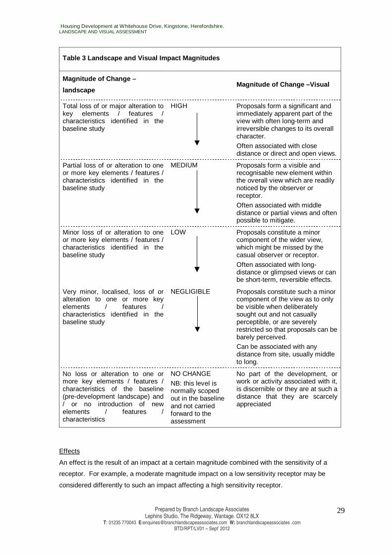
Magnitude of change
Magnitude of change is a measure of the level of an impact on potential receptors arising
from addition, alteration, or removal of baseline resources as a result of the proposed
development and is classed as high, medium, low or negligible. The parameters and
categories used for this appraisal are outlined in Table 3.
Magnitude is based on professional judgement and determined by a combination of:
• the scale of the change in relation to the proportion of the landscape or view affected
by the proposed development and the degree to which it is affected;
• the duration and reversibility of the change.
In addition to nature, scale, and duration of the change, the magnitude of change to visual
receptors takes into account the distance of the viewpoint from the proposed development as
this will determine visibility of the site, its landscape elements and proposed structures and
the context in which the view is experienced. It is another assessment tool which is evaluated
for each project based on site location, context and size, as well as the character and scale of
proposals.
For this assessment the following categories have been used for referring to distance from
the proposals: Long Distance Views (> 1km). Middle Distance Views (500m-1km). Close
Distance Views (< 500m).
Housing Development at Whitehouse Drive, Kingstone, Herefordshire. LANDSCAPE AND VISUAL ASSESSMENT
Prepared by Branch Landscape Associates Lephins Studio, The Ridgeway, Wantage. OX12 8LX
T: 01235 770043 E:[email protected] W: branchlandscapeassociates .com BTD/RPT/LV01 – Sept’ 2012
29
Table 3 Landscape and Visual Impact Magnitudes
Magnitude of Change –
landscape
Magnitude of Change –Visual
Total loss of or major alteration to key elements / features / characteristics identified in the baseline study
HIGH Proposals form a significant and immediately apparent part of the view with often long-term and irreversible changes to its overall character.
Often associated with close distance or direct and open views.
Partial loss of or alteration to one or more key elements / features / characteristics identified in the baseline study
MEDIUM Proposals form a visible and recognisable new element within the overall view which are readily noticed by the observer or receptor.
Often associated with middle distance or partial views and often possible to mitigate.
Minor loss of or alteration to one or more key elements / features / characteristics identified in the baseline study
LOW Proposals constitute a minor component of the wider view, which might be missed by the casual observer or receptor.
Often associated with long-distance or glimpsed views or can be short-term, reversible effects.
Very minor, localised, loss of or alteration to one or more key elements / features / characteristics identified in the baseline study
NEGLIGIBLE Proposals constitute such a minor component of the view as to only be visible when deliberately sought out and not casually perceptible, or are severely restricted so that proposals can be barely perceived. Can be associated with any distance from site, usually middle to long.
No loss or alteration to one or more key elements / features / characteristics of the baseline (pre-development landscape) and / or no introduction of new elements / features / characteristics
NO CHANGE
NB: this level is normally scoped out in the baseline and not carried forward to the assessment
No part of the development, or work or activity associated with it, is discernible or they are at such a distance that they are scarcely appreciated
Effects
An effect is the result of an impact at a certain magnitude combined with the sensitivity of a
receptor. For example, a moderate magnitude impact on a low sensitivity receptor may be
considered differently to such an impact affecting a high sensitivity receptor.
Housing Development at Whitehouse Drive, Kingstone, Herefordshire. LANDSCAPE AND VISUAL ASSESSMENT
Prepared by Branch Landscape Associates Lephins Studio, The Ridgeway, Wantage. OX12 8LX
T: 01235 770043 E:[email protected] W: branchlandscapeassociates .com BTD/RPT/LV01 – Sept’ 2012
30
Nature of Effects
This assessment does not assign a beneficial or adverse nature to impacts and effects, but relies
on a description of the type and scope of change likely to be experienced (for example addition of
prominent element influencing a large extent of the view or addition of minor element only seen in
a small part of the overall view).
Degree of Effect
The degree of effect of the proposed development on potential landscape and visual receptors is
measured as a combination of receptor sensitivity and magnitude of change using the matrix in
Table 4 below.
Whilst degree of effect is determined for any project, a consideration of significance is only
applicable to projects falling under the Environmental Impact Assessment (EIA) Regulations. This
project is not subject to EIA Regulations, so a significance assessment has not been undertaken.
Table 4 - Degree and Significance of Effects
Sensitivity
High Medium Low
High Substantial Moderate/Substantial Moderate
Medium Moderate/Substantial Moderate Slight
Low Moderate Slight Negligible
Mag
nitu
de
Negligible Slight Negligible Negligible
AC/LVIA BTD/ Sept 2012
Housing Development at Whitehouse Drive, Kingstone, Herefordshire. LANDSCAPE AND VISUAL ASSESSMENT
Prepared by Branch Landscape Associates Lephins Studio, The Ridgeway, Wantage. OX12 8LX
T: 01235 770043 E:[email protected] W: branchlandscapeassociates .com BTD/RPT/LV01 – Sept’ 2012
31
APPENDIX 2: ILLUSTRATIVE MATERIAL
BTD 101 SITE CONTEXT AND CHARACTER BTD 102 ANALYSIS PLAN BTD 103 DETAILED ANALYSIS AND SITE LAYOUT BTD104 MITIGATION STRATEGY PV Sheets 1 to 4 PHOTO VIEW POINTS SHEETS 1 – 4