white paper lidar - a key element of dot’s and cim.final.pdf · lidar - a key element of dot’s...
TRANSCRIPT

White Paper
LiDAR - A Key Element of DOT’sMove to Civil Integrated Management (CIM)
Co-Authored By
Joshua FranceKinematic Support Manager
RIEGL USA
and
Jackie VanderPolPresident
The Fulcrum International Inc.
DateSeptember 22, 2017
LiDAR - A Key Element of DOT’s Move to Civil Integrated Management (CIM) Page � of �1 19

LiDAR - A Key Element of DOT’s Move toCivil Integrated Management (CIM)by Josh France, RIEGL USA and Jackie VanderPol, The Fulcrum International Inc.
LiDAR - A Key Element of DOT’s Move to Civil Integrated Management (CIM) Page � of �2 19
Table of Contents Page
Executive Summary 3
A. CIM’s LiDAR-Based 3D Challenge 4
B. Solutions 6
B-1. Applications of LiDAR for 3D 6
B-2. Benefits of LiDAR-based 3D 7
B-3. FDOT’s CIM and ROADS 7
C. Technical Considerations 9
C-1. Changing An Industry's Way of Thinking 9
C-2. Scanning Equipment - Better to Buy or Outsource? 10
C-3. Other Cost Considerations 10
C-4. Choosing the Right Data Collection Method for the Job 10
C-5. Accuracy and Other Requirements 11
C-6. Workflow and Data Management - Be Deliberate 12
C-7. Scanning Conditions, Targets, Reflectivity 14
C-8. Software Choices and Hardware Requirements 14
C-9. Deliverables in 3D 14
C-10. Security and Storage 15
D. Bringing Staff Up to Speed 15
D-1. Training, Resources and Must Reads 15
D-2. Sample Work Outline & Work Plan Considerations 17
E. Conclusion 18
About the Authors 19

Executive SummaryState DOT’s across the country are gaining momentum in the transition to the Civil Integrated Management (CIM) approach to designing, constructing and maintaining highway assets. At the very core of CIM is the requirement for better quality and shared asset libraries of information, including LiDAR-based 3D plans and as-builts for multiple users to access both now and in the future.
This shift in how business is conducted, and moving up to 3D, can be daunting for design and construction leadership because it affects nearly every member of a team and nearly every workflow process.
Change is hard and progress has a price. Investments in time, technology and people are being made. But make no mistake, this change is taking the industry into the future and adds intrinsic value and financial ROI in a multitude of ways. The corner is being turned and there will be no going back. But once educated about CIM and 3D, it’s exciting to consider the many benefits, possibilities and applications.
As with any major change, when moving a design or construction team to working in 3D, it is important to determine the best ways for a company and it’s employees to get there. This paper will describe the applications, benefits, workflow and technical considerations of the 3D LiDAR applications within CIM.
CreditsThis paper relies heavily on two documents published by the National Cooperative Highway Research Program (NCHRP), Transportation Research Board (TRB). These documents are available online as PDF’s.
- Report 748, Guidelines for the Use of Mobile LIDAR in Transportation Applications, published in 2013. This report was drafted by respected professionals from across the U.S. and includes research sponsored by the American Association of State Highway and Transportation Officials (AASHTO) in cooperation with the Federal Highway
A d m i n i s t r a t i o n (FHWA): 208 pages in length.
-Report 831, Civil Integrated Management (CIM) for Departments of Transportation, Volume 2, Research Report, published in 2016. This report was drafted by professionals at the University of Texas at Austin and The University of Colorado Boulder, and includes research sponsored by AASHTO in cooperation with FHWA: 64 pages in length.
LiDAR - A Key Element of DOT’s Move to Civil Integrated Management (CIM) Page � of �3 19
STATE DOT’s HAVE VARYING LEVELS OF CIM AND 3D MATURITYCIM development is moving forward and will soon be the s tandard fo r s ta te DOT’s n a t i o n w i d e . D e s i g n a n d construction leadership must understand the DOT’s goals and find ways to meet them.
According to Civil Integrated M a n a g e m e n t ( C I M ) f o r Departments of Transportation, Volume 2: Research Report 831, published in 2016:
- Twenty-three state DOTs reported having already transitioned to 3D modeling.
- Seven state DOTs were using only traditional 2D plans and profile sections.
- Fifteen state DOTs stated that they were transitioning to 3D modeling.
THIS NATIONWIDE CIM MOVEMENT IS BEING DRIVEN BY DOT, FHWA, AASHTO AND OTHERS. The recen t l y enac ted MAP-21 legislation and FHWA’s Every Day Counts program have identified 3D technology as transformational. Report 748, page 2.

A. The CIM LiDAR-Based ChallengeAs state DOT’s across the U.S. move to implement CIM, the design and construction industry that supports these projects must adapt. The move from living and working in 2D to 3D is a necessary part of an overall national plan.
Moving from 2D into 3D by using LiDAR and other sensors presents a major shift in how surveyors and designers typically supply information today.
This paper will show where LiDAR included multi-sensor based collection platforms fit into the CIM structure and help meet DOT expectations, giving a macro-view of factors for surveyors, designers and contractors to consider and discuss with team members. To meet the inevitable 3D requirements, the industry needs to commit to the following:
•changing the approach to survey and overall workflow,
• training personnel at multiple levels, • obtaining additional equipment and software, • building a culture of cooperation with every member involved in the process.
LiDAR - A Key Element of DOT’s Move to Civil Integrated Management (CIM) Page � of �4 19
CIM DEFINEDAccording to FHWA (2012), CIM is the technology-enabled collection, organization, managed accessibility, and use of accurate data and information throughout the life cycle of a transportation asset. By combining multiple emerging technologies with an emphasis on digital practices…with the concept of integrated management, CIM has the potential to take project delivery and asset management to the next level.
CIM can enhance consistency and efficiency by improving access to information about highway projects and facilitating information-sharing among the various stakeholders, from owners and operators to designers, planners, surveyors, construction and operations personnel, and asset managers. The result is improved overall productivity of the highway industry through cost and time savings, plus safety benefits.
Note: the term CIM is sometimes replaced by BIM.
FINANCIAL INCENTIVES FOR TRANSITIONING TO 3DThe recently passed Map-21 legislation (Moving Ahead for Progress in the 21st Century Act, P.L. 112-141) provides financial incentives for the use of 3D technology (FHWA 2012). In addition, FHWA is also promoting the use of 3D through their Every Day Counts (EDC) initiative (FHWA 2012). This program is “ . . . designed to identify and deploy innovation aimed at shortening project delivery, enhancing the safety of our roadways, and protecting the environment.” In the recently announced second round of initiatives, 3D modeling is highlighted. As stated on the program website, “As the benefits are more widely recognized, many in the U.S. highway industry will transition to 3D modeling over the traditional two-dimensional (2D) design process” (FHWA 2012). Report 748, page 27.

An important step in the learning curve is understanding where within the CIM process LiDAR is called for and which tools are right for each portion of the scope. Below and on the following page are graphics taken directly from Report 831, Civil Integrated Management (CIM) for Departments of Transportation, Volume 2, found on page 4. One can see below that the LiDAR tools in the far-right column include C1 (Airborne, Mobile and Terrestrial LiDAR) and often C9 (Drone / Unmanned Aerial Vehicles or UAV’s).
LiDAR - A Key Element of DOT’s Move to Civil Integrated Management (CIM) Page � of �5 19
CIM Functions and the tools identified to address them, Report 831, page 12, CIM Tools, as shown on page 12 of The National Academies Press, Civil Integrated Management (CIM) for Departments of Transportation, Volume 2: Research Report, 2016.
CIM Tools, as shown on Report 831, page 12 of The National Academies Press, Civil Integrated Management (CIM) for Departments of Transportation, Volume 2, 2016.

Taking it to the next step, LiDAR tools C1 and C9 are then used for the following functions: site mapping, inventory mapping, materials management, and construction quality control, as shown on the table below.
LiDAR can also be integral in performing other functions such as utility mapping, ROW map development, digital design, design coordination, asset data integration, utility conflict analysis, visualization, traffic management planning, and inclusion in contracts.
B - Solutions
B-1—Applications of LiDAR for 3D
Below is an illustration from NCHRP Report 748, Guidelines for the Use of Mobile LiDAR in T r a n s p o r t a t i o n Applications, page 10, that shows the many applications of mobile ( a n d a l s o o f t e n terrestrial) LiDAR in the lifecycle of a project. The graphic deserves a careful study so that readers can get a more c o m p l e t e i d e a o f applications possible.
Applications include: project planning, project d e v e l o p m e n t , construction, operations, maintenance, safety, research, and asset management.
LiDAR - A Key Element of DOT’s Move to Civil Integrated Management (CIM) Page � of �6 19
REPORT 748, Page 10, http://onlinepubs.trb.org/onlinepubs/nchrp/nchrp_rpt_748.pdf
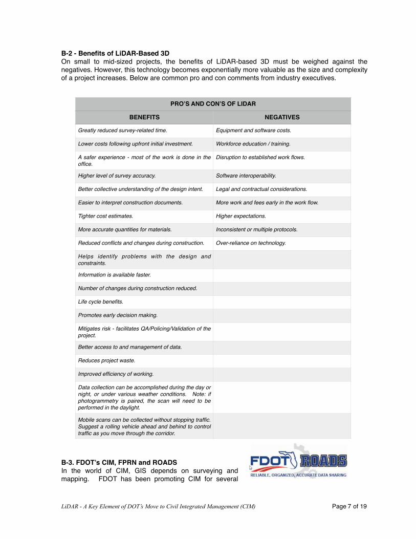
B-2 - Benefits of LiDAR-Based 3DOn small to mid-sized projects, the benefits of LiDAR-based 3D must be weighed against the negatives. However, this technology becomes exponentially more valuable as the size and complexity of a project increases. Below are common pro and con comments from industry executives.
B-3. FDOT’s CIM, FPRN and ROADSIn the world of CIM, GIS depends on surveying and mapping. FDOT has been promoting CIM for several
LiDAR - A Key Element of DOT’s Move to Civil Integrated Management (CIM) Page � of �7 19
PRO’S AND CON’S OF LIDAR
BENEFITS NEGATIVES
Greatly reduced survey-related time. Equipment and software costs.
Lower costs following upfront initial investment. Workforce education / training.
A safer experience - most of the work is done in the office.
Disruption to established work flows.
Higher level of survey accuracy. Software interoperability.
Better collective understanding of the design intent. Legal and contractual considerations.
Easier to interpret construction documents. More work and fees early in the work flow.
Tighter cost estimates. Higher expectations.
More accurate quantities for materials. Inconsistent or multiple protocols.
Reduced conflicts and changes during construction. Over-reliance on technology.
Helps identify problems with the design and constraints.
Information is available faster.
Number of changes during construction reduced.
Life cycle benefits.
Promotes early decision making.
Mitigates risk - facilitates QA/Policing/Validation of the project.
Better access to and management of data.
Reduces project waste.
Improved efficiency of working.
Data collection can be accomplished during the day or night, or under various weather conditions. Note: if photogrammetry is paired, the scan will need to be performed in the daylight.
Mobile scans can be collected without stopping traffic. Suggest a rolling vehicle ahead and behind to control traffic as you move through the corridor.

years now and it is enjoying increasing compl iance with i ts consul tants and contractors. It will be important to familiarize team members with a couple of items of note and terms regarding the FDOT CIM as it relates to LiDAR.
• FDOT is moving to full 3D design by encouraging designers to provide 3D models for all plans with both horizontal and vertical controlled cross sections.
• FPRN - Florida Permanent Reference Network consists of approximately 100 operating reference stations located throughout the state and provides the basis of centimeter level survey, the location of assets, and how they relate to each other. This information connects the various assets geospatially. This network is the backbone of the geospatial data.
• ROADS - Reliable Organized Accurate Data Sharing (2015).
• Overall, FDOT's current information management consists of discrete systems managing individual data elements with no effective system, such as a data warehouse, that would provide for a single, seamless view into a particular project, region, or aspect of service delivery. The lack of enterprise visibility to all data assets means that FDOT is data rich, but information poor.
• It is, therefore, important for FDOT to identify the full scope of the information it holds and the met and unmet needs for information across its enterprise. Armed with this knowledge, FDOT can more
effectively develop and i m p l e m e n t a n i n f o r m a t i o n management plan to meet its business needs.
•T h i s i n i t i a t i v e w i l l include defining and documenting the FDOT D a t a G o v e r n a n c e , completing an inventory of the Department's information assets, a recommended future s t a t e i n f o r m a t i o n m a n a g e m e n t arch i tec ture , and a roadmap implementation plan to implement the recommendations.
LiDAR - A Key Element of DOT’s Move to Civil Integrated Management (CIM) Page � of �8 19
What is CIM?
Source: FDOT’s CIM powerpoint presentation
Source: FDOT’s CIM powerpoint presentation

• In mid-March 2015, the ROADS Initiative began. The ROADS Initiative's goal is to improve data reliability and simplify data sharing across FDOT.
• Data Warehouse - A single resource for managing and sharing geospatial data representing a transportation asset with multiple users over the lifecycle of the asset.
• Data Governance - Making sure that data is collected, managed, and thus utilized to it’s maximum value.
C.Technical Considerations
C-1. Changing an Industry’s Way of ThinkingHow do team members get up to speed in embracing this new 3D world?
One suggestion is to create an internal 3D team of experts within each organization. These people will need to be charged with learning all about how LiDAR and 3D work and committed to helping others as questions arise, perhaps offering to hold internal lunch and learn’s or make the occasional presentation at internal meetings.
LiDAR scanning and the various software packages are not rocket science but there are definitely some skills that need to be taught and frankly, some people seem to thrive more than others in the LiDAR world. These people can be an enormous asset to the team and it probably won’t take long to identify those people once teams really dig into it. Early adopters will make themselves known by showing an eagerness to work with LiDAR and 3D.
Another suggestion is to always assign, on a project by project basis, an experienced geomatics person to oversee the entire process. Tap those individuals to become subject matter experts and make sure those individuals are given the resources and authority to ensure the process is done meticulously and will meet DOT’s requirements.
C-2. Scanning Equipment - Better to Buy or Outsource?
When new to 3D, consider outsourcing the LiDAR work through a reputable provider so that each team can get used to working with the data and learn i ts benefits and l imi tat ions. By observing an outside subcontractor, team members will get an idea of the kind of investment that is required -
LiDAR - A Key Element of DOT’s Move to Civil Integrated Management (CIM) Page � of �9 19
CHANGES IN THE PARADIGM.… “The use of mobile LIDAR systems (MLS) changes the survey paradigm from one where the decision making is done in the field to where it is now done in the office.” Report 748, page 2.
SOLE SOURCE VS OUT SOURCE - AGENCIES HAVE PERFORMED COST BENEFIT ANALYSESCaltrans and Washington DOT have performed detailed benefit-cost analyses that examined different strategies of using mobile LiDAR for agencies’ requirements (including such options as contract, rent and operate, purchase and operate, and partial ownership). The study concluded that purchasing and operating a survey-grade mobile LiDAR has tangible life-cycle benefits that considerably outweigh the initial investments (Yen et al. 2014). Some of the experts also noted that at a holistic level, investing in collecting 3D LiDAR data would be beneficial for agency-wide CIM implementation regardless of the mode of the ownership. Report 831, p 52.

equipment, software and skilled personnel. As a team proceeds, leadership can begin to weigh the pros and cons of continuing to outsource data collection, or investing in the scanning equipment and self-performing.
Another idea is to consider creating a pool of pre-qualified subcontractors from which to spread the team’s LiDAR collection work. That way it can be determined who is best to work with and the results expected with each.
Roadway LiDAR scanning can be accomplished with a variety of equipment types such as terrestrial, mobile, UAV and airborne. Not all LiDAR scanners are created equal and it pays to get the right equipment for the right needs. When purchasing, consider the project layout, accuracy needs, speed, ease of use, reliability, transportability, training, support and overall cost. The ability to integrate other sensors of opportunity, such as thermal cameras, ground penetrating radar and cameras is necessary when finding a sensor platform to support CIM projects.
C-3. Other Cost Considerations Cost consideration must be taken for the following: equipment, vehicle, skilled geospatial personnel, training, mobilization, acquisition, software, data processing computers, and software licenses. Also, scanners should be regularly calibrated on a schedule, according to the manufacturer’s recommendation. Often the calibration cost, training, software license, and warranty is included in the equipment sale.
C-4. Choosing the Right Data Collection Methods for the JobConsider the type of project the team will be performing and determine if it could best be scanned by terrestrial, mobile, UAV or aerial LiDAR collection methods. The scanner basically scans anything the eye can see, so if the job requires scanning a structure such as a bridge, terrestrial may be the best choice. If a long roadway is being scanned, then mobile is the best choice. For a wide area, or an area that is difficult to reach, UAV might be optimal. Very large projects might be best accomplished with airborne. Furthermore, the accuracy, resolution, coverage, and look angle of different types of LIDAR data can vary between equipment types. Bear in mind that the required accuracy is another key factor to consider when selecting the equipment you will use.
The graphic on the following page was taken from a presentation by RIEGL USA that shows the optimal scanning technologies for different jobs. Manufacturers can help a team plan well in advance of a project. Additionally, a geospatial specialist subcontractor works closely before and during the project to help the team plan and best utilize the right tool, or combination of tools, to meet project requirements.
LiDAR - A Key Element of DOT’s Move to Civil Integrated Management (CIM) Page � of �10 19
TYPES OF LiDAR COLLECTION EQUIPMENT AND APPROX COST
$140K $600K $350K $1.2M

NOTE: LiDAR does not replace traditional survey in all applications. On smaller projects, teams may want to conduct a cost/benefit analysis to determine if LiDAR or traditional survey is the right approach.
C-5 . Accuracy and Other RequirementsSpecifications need to be clear, p a r t i c u l a r l y w i t h a c c u r a c y requirements, regardless of whether one performs the scans with in-house surveyors or hires it out to a third-party contractor. Involve a geospatial consultant, other team members, and the end client (DOT) in the planning process to ensure that scans meet current and projected needs.
Ideally, the transportation agency can identify the general accuracy and density requirements for the point cloud for each application. DOT created representing the varying orders of accuracy (1 = High, 2 = Medium, 3 = Low), which will have the greatest influence on project cost. The letters represent the levels of point density (A = Coarse, B = Intermediate, C = Fine). Report 748, page 11.
LiDAR - A Key Element of DOT’s Move to Civil Integrated Management (CIM) Page � of �11 19
CHANGES IN HOW A JOB IS PRICED
Ted Knaak, President of Certainty 3D, explains problems in traditional survey payment and procurement standards that are focused on time in field work and minimal office processing time. The key factor with LIDAR scanning and 3D technology is that it reduces field time dramatically (80-90%) but shifts loads to processing. - Report 748, p A-38.
When billing for LiDAR-based 3D, the upfront data collection is one short-term line item - sometimes collected in only a few hours. Vastly more time consuming is the work on the point cloud an office setting. Pricing needs to be structured much differently on LiDAR-based 3D projects.
Factor in the costs of assignment planning by an experienced geomatics specialist, survey to set up targets, mobilization for the scan, the actual collection, delivery of a usable tiled point cloud, and then the actual work on the files.
Source: REIGL USA

Take into consideration all po ten t i a l uses when deciding on the level of accuracy and resolution for a specific project. Many agencies (FAA 2011; FGDC, 1998; NDEP 2004; NOAA 2009; USGS 2012) h a v e p r o v i d e d r e c o m m e n d a t i o n s , guidelines, or standards for geospatial data. Some of these (FGDC, 1998 and NDEP 2004) are broad specifications that pertain to all remotely sensed data while others pertain more directly to LIDAR data (FAA 2011; NOAA 2009; USGS 2010). The ASPRS has produced “ A S P R S G u i d e l i n e s : V e r t i c a l A c c u r a c y Reporting for LIDAR Data” ( A S P R S 2 0 0 4 ) a n d “(DRAFT) ASPRS LIDAR Guidelines: Horizontal A c c u r a c y Reporting” (ASPRS 2005), which more specifically d e c l a r e r e p o r t i n g s t a n d a r d s ( e . g . , f u n d a m e n t a l v e r t i c a l a c c u r a c y ( F V A ) , c o n s o l i d a t e d v e r t i c a l a c c u r a c y ( C V A ) , s u p p l e m e n t a l v e r t i c a l accuracy (SVA).
C-6. Workflow and Data Management - Be DeliberateAs teams move into the LiDAR-based 3D world, consider taking a long and deliberate look at the team’s typical workflows and business practices - including how teams will charge for LiDAR scanning and 3D services - in order to maximize the potential benefits of adopting LiDAR-based 3D. One can hire a geospatial specialist to walk a team through the first couple of projects and get everyone fully comfortable with the technology.
Be sure that whoever works on the LiDAR data understands micro and macro plans for using the point cloud and photographic information to ensure that they provide collection taken from the appropriate viewpoint and with proper lighting conditions. Additionally, request in the plan that co-acquired, colorized imagery be delivered with the LiDAR data and georeferenced to the point cloud.
Common trends can be seen in the various LiDAR specifications, including:1. Standard accuracy reporting methods
LiDAR - A Key Element of DOT’s Move to Civil Integrated Management (CIM) Page � of �12 19
Report 748, Page 11

2. Requirements for ground point density3. Requirements for scan overlap4. Number and distribution of control/check points for accuracy verification5. Types of deliverables
General Considerations• With the costs of mobilization and scanning relatively high, be sure to collect all of the data
that is needed the first time. • Although LiDAR scanners will capture objects within range and line of sight, non-visible
objects will not be mapped. For example, the bottoms of drainage ditches may be difficult to see in the dataset.
• When planning scans with a mobile scanner, consider implementing a rolling “slowdown” to minimize vehicles blocking the scanner view. Doing this will improve data completeness and reduce artifacts in the point cloud.
• “Noise” can be seen in a point cloud because of the high resolution; however, noise that is not seen in a point cloud also can be found in data obtained using other survey devices (e.g., total station data) because the points are spaced very far apart (several meters to tens of meters). Some noise can be removed.
• Many data processing algorithms are in research and development phases. Hence, processing currently is either semiautomatic or manual, depending on the application. Few completely automated procedures exist and those that do often are found in specialized software packages. However, automated ground and other surface extraction algorithms generally work well.
• Scanning geometry (position and orientation of the scanner with respect to the object of interest) determines how well objects are captured. For example, specialized systems exist to capture very detailed pavement surface data, but are not configured to acquire data on surrounding features.
• Natively, the points in a point cloud do not have attributes other than XYZ coordinates and intensity values. RGB color from co-acquired imagery can be mapped to the point cloud through automatic processes. However, attributes such as what the point represents (i.e., point classification) are applied later through manual, semi-automatic, and/or automatic processing. Report 748, page 50.
• Avoid or minimize the use of multiple formats and data transfer throughout a workflow.
SAMPLE - Workflow Stages See Report 748, page 12 for details. See expanded Workflow in Section D of this report.
1.1 Data Acquisition1.2 Georeferencing1.3 Post-processing1.4 Computation and Analysis1.5 Packaging and Delivery1.6 Models vs. Point Clouds1.7 Coverage1.8 Sequential and Traceable Processes1.9 Considerations for Information Technology1.10 File Management1.11 Information Transfer Latency
LiDAR - A Key Element of DOT’s Move to Civil Integrated Management (CIM) Page � of �13 19

1.12 Accessibility and Security1.13 Integrity1.14 Sunset Plan1.15 Software1.16 Hardware
C-7. Scanning Conditions, Targets, ReflectivityLaser scanners can collect data under a wide variety of lighting and weather conditions. However, for a large job, it may be best to wait for a clear day so that there is less noise to remove from the files.
Other Considerations• Highly reflective surfaces at close range can sometimes be problematic, creating saturation
and blooming effects.• Dark surfaces at long ranges are problematic for some scanners because they do not
reflect light well.• Wet pavements generally yield poor scanning results, as do conditions where refraction is
present (e.g., because of steam, precipitation, or heat rising from surfaces).• LiDAR does not penetrate water.
C-8 Software Choices and Hardware RequirementsLiDAR point clouds can be imported into many 3D software tools including both AutoCAD and MicroStation. Point cloud extraction tool sets like TopoDOT and ORBIT GT are developed specifically for using point cloud data for model generation. Using the right software and workflow for feature extraction is critical because extraction can take much longer if the photos do not line up with the LiDAR data.
Due to technical complexities with hardware and software, and the need to “get it right”, it is best that a trained technician is responsible for the tasks of editing and extraction.
C-9. Deliverables in 3D• Control Survey Report• Scanning details including date and time, technician/s, map showing control points,
trajectory and coverage extents.• Raw sensor data including angles, range, intensity, any filters used, GNSS data, IMU
readings, logs, calibration info, and any special notes. • Explanation of the QA/QC Process that was applied.• Data processing documentation, including notes of any special circumstances.• Tiled Point Cloud• Other imagery• Metadata files• Final project report
C-10. Security and StorageIt is imperative that identical, duplicate copies of the data be delivered, and verify the backup before any use of the data. It is much easier to create and verify a duplicate immediately after field collection than in the office days or weeks later.
Avoid large ( > few GB) files and be sure to tile data before delivery.
LiDAR - A Key Element of DOT’s Move to Civil Integrated Management (CIM) Page � of �14 19

A practical way to receive gigabytes or terabytes of data from a service provider in most cases is via external hard drives.
Plan Your Library- Confirm early on what TYPE/FORMAT of files you will save, how they will be named and
categorized, and that will be acceptable to your team and to DOT. - Store on a Local (files reside on a single host workstation), local area network (LAN), or wide
area network (WAN).- File back-ups on a different system and possibly in a totally different location.- Plan to purge files at a certain point in time. This is called Sunsetting.- Monitor the integrity of the files. If the files go bad on one storage device, check the others.- Bring staff up to speed. Make sure more than a few people know how to access the data and
the requirements to saving and storing.
D. Bring Your Staff Up to SpeedD1 - Training, Resources and Must ReadsIf self-performing, training on LiDAR scanning equipment is usually included in the purchase of the scanning equipment. It has been suggested previously in this paper to create a small group of experts within a company who are charged with keeping abreast of the technology and sharing it with the rest of the team. Also, for the first couple of projects, it is advised to employ a geospatial specialist to help guide and instruct the team.
If teams are outsourcing the LiDAR scans, then it is a matter of getting the team schooled on how to ask for what is needed. Again, a geospatial expert can be extremely beneficial to prevent errors in the planning and in the field.
With regard to working with the data, the software companies should offer training and there are numerous resources online. Different users will require different levels of understanding, so again, it would be an excellent plan to create a small group of experts within a firm who agree to stay current with the technology and serve as a resource to the team.
It is imperative that everyone involved understands the importance of data standards and consistency, as well as storage protocols and storage limits. These will evolve over time, but someone must be the keeper and insist that all standards and storage protocols are strictly enforced.
Must Reads- Report 748, Guidelines for the Use of Mobile LIDAR in Transportation Applications,
published in 2013. This report was drafted by respected professionals from across the US, and includes research sponsored by the American Association of State Highway and Transportation Officials (AASHTO) in cooperation with the Federal Highway Administration (FHWA). 208 pages in length.
- Report 831, Civil Integrated Management (CIM) for Departments of Transportation, Volume 2, Research Report, published in 2016. This report was drafted by professionals at the University of Texas at Austin and The University of Colorado Boulder, and includes research sponsored by AASHTO in cooperation with FHWA. 64 pages in length.
LiDAR - A Key Element of DOT’s Move to Civil Integrated Management (CIM) Page � of �15 19

- Civil Integrated Management and the Expanding Role of Surveying & Mapping at FDOT, by Brett Woods, PLS. http://www.fdot.gov/geospatial/.
Additional Resources• NCHRP 10-96: Guide for Civil Integrated Management in Departments of
Transportation available online at http://apps.trb.org/cmsfeed/TRBNetProjectDisplay.asp?ProjectID=3648.
• NCHRP 20-68A: Scan 13-02, Advances in Civil Integrated Management, available online at http://onlinepubs.trb.org/onlinepubs/nchrp/docs/NCHRP20-68A_13-02.pdf
• FHWA-IF-05-025, Innovation in Vertical and Horizontal Construction: Lessons for the Transportation Industry
• CIM 3D Technologies Implementation Plan• Oregon DOT 2008 Geometrics Documents: http://www.oregon.gov/ODOT/HWY/
GEOMETRONICS/docs/engautokeyconcepts.pdf • Wisconsin DOT 2013 3D Technologies Implementation Plan: http://cmsc.engr.wisc.edu/
WisDOT-3D-Technologies-Implementation-Plan-Final-Plan-2013-July-1.pdf• Utah DOT: 3D Engineered Models for Construction http://www.udot.utah.gov/main/f?
p=100:pg:0:::1:T,V:4450, • Iowa DOT, 2015, 3D Engineered Models for Highway Construction: The Iowa
Experience, http://trid.trb.org/view.aspx?id=1367947 • FHWA – HIF – 12 – 014, Identifying existing and emerging technologies in the area of
Intelligent Construction of highways• N C H R P S y n t h e s i s 3 7 2 , E m e r g i n g Te c h n o l o g i e s f o r C o n s t r u c t i o n
Delivery,,Transportation Research Board of the National Academies of Sciences, Engineering, and Medicine, Washington, D.C., 2016.
• FDOT CIM Workshop 2012, FTBA 2015 CIM Presentations, http://www.dot.state.fl.us/structures/DesignExpo2012/CIM2012.shtm, http: / /web.f tba.com/convent ion/2015_presentations.aspx
• ODOT Design to Paver 2014 Workshop, http://designtopaver.org/ • FHWA 3D Engineered Models Webinar Series, http://www.fhwa.dot.gov/construction/3d/
webinars.cfm • Digital Project Delivery Presentations, IHEEP 2014 and 2015 , http:/ /
www.iheep2014.com/webagenda.html, http://www.iheep2015.com/agenda.html • Leveraging A Data-Rich World by David Unkefer, Katherine Petros, Bryan Cawley, and
Alicia Sinlinger; Published in U.S. Department of Transportation, Federal Highway Administration, Public Roads, https://www.fhwa.dot.gov/publications/publicroads/16janfeb/06.cfm, Publication Number: FHWA-HRT-16-002, Issue No: Vol. 79 No. 4, Date: January/February 2016 https://www.fhwa.dot.gov/publications/publicroads/16janfeb/06.cfm
• What is LiDAR and Discuss it’s Importance and Possibilities, http://www.engineeringcivil.com/what-is-lidar-and-discuss-its-importance-and-possibilities.html, Civil Engineering Portal, By Rahul, Department Of Civil Engineering, AWH Engineering College, Calicut-8,Kerala, India
LiDAR - A Key Element of DOT’s Move to Civil Integrated Management (CIM) Page � of �16 19

D2. Sample Work Outline & Work Plan
SAMPLE: Statement of Work OutlinePROJECT TITLE
ContactsList contact information for primary representative of data / service provider, transportation agency, and any other organization involved.
BackgroundThe background will include the purpose and expected outcomes of the project. This will serve as communication to ensure the service provider understands the intent of the transportation agency for data acquisition and the transportation agency understands what is feasible. The intended application(s) and user(s) of the data should be discussed.
Project LocationInsert graphic or link to project limits and annotations for areas of special consideration. Note the sections of interest, and estimated length of project (including interchanges, ramps, etc.).Type of highway to be surveyed (interstate, urban highway, rural highway, etc.).
Agency Standard ReferencesList references (such as this Guidelines document and FGDC 1998) that will be followed for completion of the work.
Professional Licensure ExpectationsDoes the work require a Professional Land Surveyor, Professional Engineer, and/orCertified Photogrammetrist?
Resources To Be Provided By Transportation AgencyWhat the data provider can expect from the transportation agency such as road access (e.g., rolling slow down, control points, etc.).
ApproachDetails on equipment to be used and expertise of service provider.
Work Plan Considerations
Task 1 Project ManagementCoordination (Meetings, Teleconferences, Milestone reviews)Budget (Tracking, Reporting)Schedule (Tracking, Reporting) – should include field and office processing timeframesQuality Management ReportProgress ReportsSurvey Narrative ReportCalibration Requirements
Task 2 Project PlanningData Collection Plan (Survey Control, Collection Routes, GNSS Constellation Review, etc.)Safety Plan (Emergency Contacts, Daily safety assessment, Traffic concerns, etc.)
LiDAR - A Key Element of DOT’s Move to Civil Integrated Management (CIM) Page � of �17 19

Task 3 Horizontal/Vertical ControlCoordinate System used including Horizontal and Vertical Datum and UnitsDescription of existing control expectations including documentation, referencenetworks, GPS baseline lengths, etc.Survey Control Report
Task 4 Mobile Scanning Collection and ProcessingPoint cloud accuracy and resolution expectations (data collection category)Point cloud deliverable format (including whether RGB and Intensity values are needed)Imagery requirementsProcessing techniques
Task 5 Mapping/ModelingData formats required for deliverablesExtracted Points with attributes (classification)Digital Terrain Model2D or 3D linework/shapefiles3D solid modelSoftware formatsViewing software, if needed
Project Schedule/TimelineGraphic showing when each task will occur, including start and completion datesDelivery ScheduleWhen and where products should be delivered
Acceptance CriteriaDiscussion on what must be met for payment and if a pay scale will be used.Who will perform the QA/QC work (data provider, transportation agency, or external)?Accuracy should be reported following the FGDC standards.
CompensationDiscussion of costs involved with the project and how payments will be made
E. ConclusionLiDAR-based 3D is going to revolutionize the way the transportation industry performs work. Many resources exist including the documents referenced here from the TRB; published guides put out by AASHTO, ASPRS and others; manufacturers of the scanning equipment; software development firms; and geospatial specialists. DOT’s want and need industry support of CIM and should be very cooperative in helping outline exactly what needs to be done regarding LiDAR-based 3D to meet the needs. Data fusion from multiple sensors has been the gold standard in the remote sensing world for years. Getting it incorporated at the end user level strengthens and improves the quality of data. Successful implementation will lead to better data and more collection work, as its use will increase its value and need.
END
LiDAR - A Key Element of DOT’s Move to Civil Integrated Management (CIM) Page � of �18 19

About the Authors
Joshua France has over seven years of experience for key sales and support related functions in the terrestrial/mobile laser scanning business segment of RIEGL USA. He is considered a subject matter expert in the area of acquisition and data processing of laser data. He is also a leading authority on the integration of system components with many successful examples in both government and commercial sectors. Joshua can be reached at 407-248-9486 and [email protected]. Jackie VanderPol has over thirty years of success in the areas of infrastructure-related design and construction procurement and management. She specializes in infrastructure-related technology and services as they relate to better workflow, increased safety, and financial efficiencies. She is the president of The Fulcrum International, Inc. and consults with designers, contractors, attorneys and owners. Based in Orlando, Florida, Jackie can be reached at 407-228-1747 and [email protected].
LiDAR - A Key Element of DOT’s Move to Civil Integrated Management (CIM) Page � of �19 19