white oak river t - environmental education · insect-eating plants like the legally protected...
TRANSCRIPT
The New River subbasin (not to be confusedwith the New River Basin in the northwestern
part of the state) is the largest and most populated of the White Oak River Basin. It containsthe city of Jackson ville and the U.S. Marine Corps base at Camp Lejeune. But the basin drawsits name from the White Oak River, a remote, scenic, 48-mile river that spills into Bogue Soundpast the picturesque town of Swansboro. Still farther east is the basin’s Newport River, whichbegins near Havelock and flows into the eastern end of Bogue Sound. The shortest and eastern -most river in the basin is the North River, which empties into Back Sound near Harkers Island.
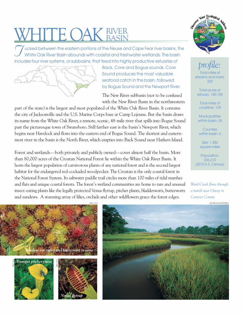
Forest and wetlands—both privately and publicly owned—cover almost half the basin. Morethan 80,000 acres of the Croatan National Forest lie within the White Oak River Basin. Ithosts the largest population of carnivorous plants of any national forest and is the second largesthabitat for the endangered red-cockaded woodpecker. The Croatan is the only coastal forest inthe National Forest System. Its saltwater paddle trail circles more than 100 miles of tidal marshesand flats and unique coastal forests. The forest’s wetland communities are home to rare and unusualinsect-eating plants like the legally protected Venus flytrap, pitcher plants, bladderworts, butter wortsand sundews. A stunning array of lilies, orchids and other wildflowers grace the forest edges.
T ucked between the eastern portions of the Neuse and Cape Fear river basins, theWhite Oak River Basin abounds with coastal and freshwater wetlands. The basin
includes four river systems, or subbasins, that feed into highly productive estuaries ofBack, Core and Bogue sounds. CoreSound produces the most valuableseafood catch in the basin, followed by Bogue Sound and the Newport River.
Total miles of streams and rivers:
320
Total acres ofestuary: 140,104
Total miles ofcoastline: 129
Municipalities within basin: 24
Counties within basin: 6
Size: 1,382 square miles
Population: 336,210
(2010 U.S. Census)
profile:
WHITE OAK RIVERBASIN
Ward Creek flows through
a marsh near Otway in
Carteret County.
Venus flytrap
Sundew (on right) and butterwort in moss
BILL LEA
BILL
LEA
BILL
LEA
GEORGE HUMPHRIES
Trumpet pitcher plant

The White Oak River Basin includes an area known as the Onslow Bightthat stretches from the lower Northeast Cape Fear River to the PamlicoRiver. The bight is characterized by its unique landforms of barrierislands, marshes, riverine wetlands, pocosins, longleaf pine savannasand other coastal ecosystems. Camp Lejeune, which is located withinthe Onslow Bight, harbors some of the highest quality longleaf pine andpocosin habitats remaining in North Carolina. Pocosins are raised bogswith a thick layer of peat. The deep soils absorb rainwater and releaseit slowly into adjacent estuaries. This filtering function helps to preservethe optimal balance of saltwater and freshwater that estuarine organ -isms, including fish and shellfish, need to survive.
The White Oak River has aesthetic, cultural, biological and recreationalattributes that qual ify it for designation as a National Wild and ScenicRiver. Some community groups are lobbying for this label, which wouldensure preservation of the river’s natural qual ities. The river drawscanoeists and other recrea tional boaters, anglers and shellfisher men.Birdwatchers flock to see osprey, wading birds and other waterfowl.The river wetlands include the rare tidal red cedar forest and 70important historical and archaeo logical sites lie along its banks.
Several rare and endangered animals are found in the White Oak RiverBasin, including the leatherback sea turtle, West Indian manatee,shortnose sturgeon, red-cockaded woodpecker and roseate tern,which are on the endangered species list. The loggerhead sea turtle
T he city of Jacksonville, with the support of its citizens,
city council and grant funding, has turned the New
River into an environmental success story. For more than 40
years, the city’s outdated wastewater treatment plant dis -
charged inadequately treated sewage into the river and
Wilson Bay. The water was depleted of oxygen—essentially
devoid of aquatic life—and off-limits to fishing, boating and
swimming. In 1998, the city replaced the facility with a state-
of-the-art land-application treatment plant at an inland
location. Biologists “planted” the riverbed with several million
oysters and other shellfish to filter pollutants and installed
devices to aerate the water. Water qual ity in the river is
improving, and the bay is once again open to recreation
and fishing. The old plant is now a hub for environmental
edu ca tion and a hands-on research institute for sec ond ary
school students. The center is named “Sturgeon City” in
homage to the imperiled fish species that once populated
the river—the federally endangered short nose sturgeon and
the federally threatened Atlantic sturgeon. One day, Sturgeon
City may help create a place in which the namesake
sturgeon can thrive once again.
Students examineaquatic animals atSturgeon City.
American alligator
Fragrant white lily
Green heron
BILL LEA
BILL LEA
BILL LEA
STURGEON CITY

and green sea turtle are federally listed as threatened species, meaning they are likely to becomeendangered. The American alligator is state-listed as a threatened species, and coastal NorthCarolina, including portions of the White Oak River Basin, is the northernmost part of itsrange. The diamond back terrapin is a state-listed species of special concern and two snakespecies found in the basin, the eastern diamondback rattlesnake and eastern coral snake, are listed as state endangered.
Increasing population density in the basin is putting new pressure on water quality in streams,rivers and estuaries. Between 1970 and 2000, the population grew by about 50 percent. Another25,818 people will live in the basin by 2020. Beach communities, particularly Atlantic Beachand Emerald Isle, are growing rapidly.
Many of the basin’s shellfish beds are closed to har vest dueto contaminated runoff from con struc tion sites, developedareas, streets and yards, farmland and forestry operations.After heavy rains, fecal coliform levels are often elevated inthe estuaries. This type of bacteria is associated with thewastes of warm-blooded animals, including humans, and is an indicator of harm ful pathogens in shellfish.
Polluted runoff includes nutrients like nitrogen and phosphorus (from fertilizers, detergentsand animal waste) that can trigger overgrowth of algae and cause fish kills. Runoff also containsoil, grease and chemicals from nonporous surfaces such as paved roads, parking lots, sidewalks anddriveways. More techniques are now available or in place to reduce runoff by slowing water so itcan be cleansed by plants and soil. New state rules require cities of a certain size to developstrategies to manage and treat stormwater runoff.
Due to persistent overgrowth of algae in the New River in 1991, the state classified the head -waters of the New River, Southwest Creek and Northeast Creek as nutrient sensitive watersand placed restrictions on nutrients in wastewater treatment plant discharges. Since that time,dramatic changes in wastewater treatment have occurred (see Sturgeon City sidebar). Thecity of Jacksonville stopped discharging waste into the river, and Camp Lejeune consolidated its seven separate facilities into one large, modern treatment plant. These changes have greatlyimproved the water quality of the New River.
Individuals in the basin can help prevent polluted runoff and eroded soil from entering streams andestuaries by preserving buffers of trees and shrubs along the edges of waterfront property. Suchvegetation can help filter harmful substances from runoff. If landowners use paving alter nativesthat allow rainwater to soak into the ground (crushed stones or permeable pavers, for example),they can limit runoff from their property along with the contaminants it carries. People canalso help by limiting their use of fertilizers and pesticides on landscapes and making sure septicsystems are maintained and working properly. Citizens wishing to get involved can help conserva -tion groups in the basin that are working to preserve wetlands and vegetated buffers along waterways.See the list on the back of this brochure. Red-cockaded woodpecker.
Manatee
MICHAEL BRAGG
BILL LEA

Cape Lookout
Ou
te
r
Ba
nk
s
Jacksonville Beaufort
BelgradeRichlands
Morehead CitySwansboro
CatfishLake
Lake Ellis Simon
GreatLake
Whi t e
Oak
Bogue Sound
Core
Soun
d
Wolf Swamp
JONES
ONSLOW
PAMLICO
CARTERET
HANOVER
PENDER
HIKING & BIKING
in the White Oak River Basin
8 Hofmann Forestwww.cnr.ncsu.edu/fer/dept/hofmann.html l
80,000 acres
9 Hoop Pole Creek Preservewww.nccoast.org/restoration-education/pdfs/HPTrail.pdf l 31 acres l .5-mile nature trailthrough maritime forest.
� 10 Hubert Bypass Parkhttp://www.onslowcountync.gov/Parks/
l 41 acres l .5-mile nature trail; wheel chair-accessible.
11 Masonboro Island Coastal Reservewww.nccoastalreserve.net l 5,046 acresl Island only reached by boat.
12 Neusiok Trail(shown with red dashed line above)www.fs.usda.gov/recarea/nfsnc/recreation/recarea/?recid=48466 l 21-mile hiking trailthrough Croatan National Forest (traversesboth the White Oak and Neuse river basins).
13 Oakhurst Nature Parkhttp://www.onslowcountync.gov/Parks/ l
253 acres l Two short nature trails within park.
14 OWLS Nature Trailwww.owlsonline.org/ l .5-mile trail passing a duck pond and enclosures for rehabilitatedraptors.
15 Patsy Pond Nature Trail (CroatanNational Forest)www.fs.usda.gov/recarea/nfsnc/recreation/recarea/?recid=48466 l 2.5 miles of trailsthrough open woods with longleaf pines.
16 Rachel Carson National EstuarineResearch Reservewww.nccoastalreserve.net l .5-mile inter -pretive trail on the west side of the reservehigh lights the area’s native species and specialfeatures. The trail meanders through mudflats,uplands and salt marshes, illustrating the var -ious unique environments found in estuarinesystems. Access is by boat.
l HIKING l
1 Bear Island/Hammocks Beach State Parkwww.ncparks.gov l 1,138 acres (33 on main -land, remainder on Bear Island). Access byferry or boat to walk the beaches on theundeveloped, 3.5-mile-long Bear Island.
2 Cape Lookout National Seashorewww.nps.gov/calo/ l 56-mile long section ofthe Outer Banks, including three undevelopedbarrier islands (North Core Banks, South CoreBanks and Shackleford Banks). Access byferries or boat.
� 3 Cedar Point Tideland Trail(Croatan National Forest)
www.fs.usda.gov/recarea/nfsnc/recreation/recarea/?recid=48466 l .6-mile loop crossessalt marsh (level and wide enough for wheel -chairs) and includes boardwalks; a 1.3-mileloop skirts White Oak River.
� 4 Core Sound Waterfowl Museumwww.coresound.com/ l .25-mile nature
trail to waterfowl observation blind; wheel -chair-accessible.
� 5 Emerald Isle Woods Parkwww.emeraldisle-nc.org/EIPRD/water
access.htm l 41 acres l 2 miles of naturetrails, including .5-mile wheelchair-accessiblenature trail with views of Bogue Sound.
6 Fort Fisher State Recreation Areawww.ncparks.gov/Visit/parks/fofi/main.phpl 287 acres l 1.1 mile trail.
7 Fort Macon State Parkwww.ncparks.gov/Visit/parks/foma/main.phpl 389 acres l .4-mile loop trail through denseshrub thicket and over low sand dunes to theedge of Beaufort Inlet.
� 17 Theodore Roosevelt Natural Areawww.ncaquariums.com/pine-knoll-
shores/ l .5-mile loop trail through maritimeforest (accessible from the N.C. Aquarium atPine Knoll Shores) and 1.25-mile trail travers -ing high dune ridges and expansive marsh;wheelchair-accessible boardwalk/ overlook has scopes for viewing waterfowl.
18 Weetock Trailwww.clis.com/canoe2/Weetock.html l 11-miletrail through Croatan National Forest.
� 19 Wrightsville Beach Trailswww.visitwrightsville.com l 3.2 miles of
trails; wheelchair accessible.
l HIKING and BIKING l
� 20 Jacksonville Parks and Greenways
www.ci.jacksonville.nc.us/Residents.aspx l2 miles of wheelchair-accessible greenways; 24 additional miles under development.Northeast Creek Park (22 acres) .25-milewaterfront boardwalk; .75-mile nature trail.Woodlands Park (12 acres) .75-mile woodedpath.
�= some trails designated as wheelchair accessible
l hiking
l hiking and biking
Neusiok Trail
12
1
2
3 4
57
8
916
1314
15
20
17
18
10
61119
The White Oak River Basin offers many oppor tunities to enjoy and explore nature through walking, hiking and biking. This list includes places with easy to moderate activity. Many sites include views of streams, rivers, creeks, lakes, wetlands and estuaries.
Ou
te
r
Ba
nk
s
Cape Lookout
Jacksonville Beaufort
BelgradeRichlands
Morehead City
CatfishLake
Lake Ellis Simon
GreatLake
Whi t e
Bogue Sound
Core
Soun
d
Wolf Swamp
JONES
ONSLOW
PAMLICO
CARTERET
HANOVER
PENDER
hike map notes: open illustratoropen old .eps mapcreate new layerplace map from poster: NC Basins Map Revised 3 2010.epssend behindungroup hike mapredraw borderadjust namesremove county line or rivers by clicking on lines, select minus pen tool, and click on points to removeexport as eps
paddle map notes:open illustratoropen old .eps mapgroup, copy and paste new hike mapcopy and paste paddle trails to new hike map(dk yellow = 20M100Y, 50% opacity)(lt yellow = 100Y, 50% opacitypaste on top, then select words, dots, etc to bring to front
Oak
Swansboro
9 Northeast Creek Parkwww.onlyinonslow.com/things-to-do/parks-recreation/outdoor-activities/northeast-creek-park/events/ l Boat ramp on New River tributary.
10 Oakhurst Nature Parkwww.onslowcountync.gov/Parks/ l Canoeaccess on Blue Creek.
11 Rachel Carson National EstuarineResearch Reservewww.nccoastalreserve.net l This string ofsmall islands is located across Taylor’s Creekfrom historic Beaufort and on the sound side ofShackleford Banks. A small herd of feral horsesroams the islands, and more than 200 birdspecies have been recorded here. The N.C.Maritime Museum (www.ncmaritime.org)provides tours, or you can reach the islands by canoe or kayak. It is only about 100 yardsacross the narrow channel to the reserve.Paddlers often land on the sandy beach at thewest end of Town Marsh and cross over to BirdShoal on foot. Marsh communities, like those ofHorse Island, are vulnerable to foot traffic andshould be avoided.
1 Cape Lookout National Seashorewww.nps.gov/calo/ l 56-mile long section ofthe Outer Banks, including three undevelopedbarrier islands (North Core Banks, South CoreBanks and Shackleford Banks). Access byferries.
2 Catfish Lake (Croatan National Forest)www.fs.usda.gov/recarea/nfsnc/recreation/recarea/?recid=48466 l 962 acres
3 Croatan National Forest SaltwaterAdventure Trail(shown with black dashed line above)www.fs.usda.gov/recarea/nfsnc/recreation/recarea/?recid=48466 l 100-mile trail circum -navigat ing the forest via the White Oak andNeuse rivers and Bogue Sound.
4 Great Lake (Croatan National Forest)*www.fs.usda.gov/recarea/nfsnc/recreation/recarea/?recid=48466 l 2,809 acres
5 Hammocks Beach State Park Canoe Trail(shown with blue dashed line above) www.ncparks.gov l 3-mile trail from the park’smainland boat ramp through salt marsh andestuary to north end of 892-acre Bear Island.
6 Huggins Island Trail www.ncsu.edu/paddletrails/southerncoast/sc12.html l 6-mile trail begins at the main -land boat ramp at Hammocks Beach StatePark, passing several small shoal islands andending at the 200-acre Huggins Island.
7 Masonboro Island Coastal Reservewww.nccoastalreserve.net l 5,046 acresl Island only reached by boat.
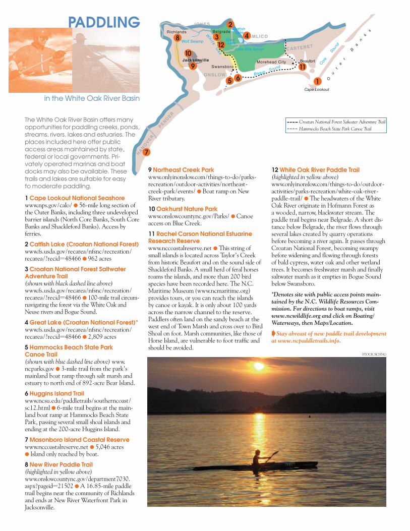
8 New River Paddle Trail(highlighted in yellow above)www.onslowcountync.gov/department7030.aspx?pageid=21502 l A 16.85-mile paddletrail begins near the community of Richlandsand ends at New River Waterfront Park inJacksonville.
PADDLING
in the White Oak River Basin
The White Oak River Basin offers many opportunities for paddling creeks, ponds,streams, rivers, lakes and estuaries. The places included here offer public access areas maintained by state, federal or local governments. Pri-vately operated marinas and boat docks may also be available. These trails and lakes are suitable for easy to moderate paddling.
Croatan National Forest Salwater Adventure Trail
Hammocks Beach State Park Canoe Trail
1
8
65
3
11
10
9
4
2
12
12 White Oak River Paddle Trail(highlighted in yellow above)www.onlyinonslow.com/things-to-do/outdoor-activities/parks-recreation/white-oak-river-paddle-trail/ l The head waters of the WhiteOak River originate in Hofmann Forest as a wooded, narrow, black water stream. Thepaddle trail begins near Belgrade. A short dis -tance below Belgrade, the river flows throughseveral lakes created by quarry operationsbefore becoming a river again. It passes throughCroatan National Forest, becoming swampybefore widening and flowing through forests of bald cypress, water oak and other wetlandtrees. It becomes fresh water marsh and finallysaltwater marsh as it empties in Bogue Soundbelow Swansboro.
*Denotes site with public access points main -tained by the N.C. Wildlife Resources Com -mission. For directions to boat ramps, visitwww.ncwildlife.org and click on Boating/Waterways, then Maps/Location.
BStay abreast of new paddle trail developmentat www.ncpaddletrails.info.
7
STOCK.XCHNG

WHERE SHOULD
I GO?
?
What makes the White Oak River Basin so special? See for yourself. Visit these Environ -mental Education Centers to discover more about your ecological address:l Cape Lookout National Seashore l North Carolina Coastal Federationl Fort Fisher State Recreation Area l North Carolina Maritime Museuml Fort Macon State Park l Outer Banks Wildlife Shelter (OWLS)l Hammocks Beach State Park l Riverworks at Sturgeon Cityl North Carolina Aquarium at Pine l Trinity Center Sound to Sea
Knoll Shores Environmental Education Program
For more information about Environmental Education Centers in North Carolina, check out the Office of Environmental Education and Public Affairs’ website atwww.eenorthcarolina.org.
You can gain a sense of community pride by learning more and helping to protect streams, riversand lakes in the White Oak River Basin. The contacts listed below can help you do just that. Tofind out about local river organizations and conservation groups, contact your local soil andwater conservation district. To find out about how you can get involved in local waterwayand other litter cleanups, contact North Carolina Big Sweep.
Croatan National
ForestBILL LEA
HOW CANI HELP
Clean Water Management Trust Fundwww.cwmtf.net/
Division of Water Quality, Stormwater and Runoff Pollutionwww.ncstormwater.org/
North Carolina Big Sweepwww.ncbigsweep.org/
North Carolina Coastal Reservewww.nccoastalreserve.net/
North Carolina Association of Soil & Water Conservation Districtswww.ncaswcd.org
North Carolina Stream Watchwww.ncwater.org/Education_and_Technical_Assistance/Stream_Watch/
North Carolina Water Science Centerhttp://nc.water.usgs.gov/
White Oak River Basinwide Plan*http://portal.ncdenr.org/web/wq/ps/bpu/basin/whiteoak
*Basinwide water quality planning is a nonregulatory, watershed-based approach to restoring and protecting thequality of North Carolina’s surface waters. The N.C. Division of Water Quality welcomes community input.
To order additional brochures on any of North Carolina’s 17 river basins, a general river basin booklet or a poster, fill out the online orderform at www.eenorthcarolina.org.t
State of North Carolina:Governor Pat McCrory • North Carolina Department of Environment and Natural Resources: Secretary John E. Skvarla, III • Office of Environmental Education and Public Affairs: Program Manager Lisa Tolley; Project Manager Ian Brown• Editor Carla Burgess • Designer Kimberly KC Schott, Red Gate Design • Special Thanks North Carolina Wildlife Resources Commission,North Carolina Division of Water Quality and North Carolina Natural Heritage Program • Date: 2013 • 5,500 copies of this public documentwere printed at a cost of $1,289.50 or $0.234 per copy. • This publication was funded through a Walmart Stormwater Compliance Grant.
Printed on recycled paper