white flint urban design guidelines - montgomery planning · the urban design guidelines ... in...
TRANSCRIPT

White FlintUrban Design Guidelines
June 2010

page White Flint Design Guidelines 2
Context
Montgomery County’s General Plan envisioned urban centers along the I-270 corridor as places where compact, transit serviceable growth and employment opportunities could be concentrated. The County’s Planning Department periodically undertakes sector planning efforts focusing on these areas, to serve as area-specific refinements to the vision outlined in the General Plan. The Urban Design Guidelines are companions to each sector plan, and provide greater detail for context-sensitive development to assist in the implementation of the Plan’s vision.

page Introduction 3
How to use the Guidelines
VisionDesign Objectives
GuidelinesStreets
Open SpaceBuildings
DistrictsMetro WestMetro East
Mid-Pike PlazaNoBe
Maple AvenueNebel
NRC White Flint Mall
5
67
9101216
272830323436384042
Contents

Montgomery County Planning Departmentpage White Flint Design Guidelines 4
Reconfigure existing transit, streets, trails, and sidewalks to improve connectivity between neighborhoods and to provide alternatives for moving safely through the area.
Combine responsible natural resource management with public open space design to create an integrated, sustainable, and compact fabric of buildings and streets.
Promote design excellence and encourage sustainable and efficient building design and construction practices.
Identify and incorporate distinctive local character into the development of new and vibrant compact centers.
Montgomery County Planning Department

page Introduction 5Montgomery County Planning Department
Urban Design Guidelines help implement the recommendations in approved and adopted master plans or sector plans. They provide information on how plan recommendations and Zoning Code requirements can be met, the area or district context for individual sites, and ideas about best practices in building and site design.
The planning process is structured in a hierarchy of decisions:
Master and sector plan recommendations provide the vision for a specific area.• Zoning Ordinance and other codes establish standards and regulations for development.• Design Guidelines provide inspiration and suggestions to fulfill the plan’s vision, and serve as a • problem-solving tool.
The guidelines are developed through work with property owners, residents, institutions, interest groups, and Executive agencies. They are approved by the Planning Board for use by planning staff in developing and evaluating proposed building projects and other applications. They will be revised and updated as necessary.
With the exception of street standards and other specific recommendations included in the Sector Plan, the guidelines are not regulations that mandate specific forms and locations for buildings and open space. They illustrate how plan recommendations and principles might be met, and encourage applicants to propose designs that create an attractive and successful public realm.
The examples and case studies included are intended to frame discussions regarding building design in a flexible way without prescribing specific standards.
The 2009 White Flint Sector Plan is available online at montgomeryplanning.org/community/whiteflint
How to Use the Guidelines
Principles
Connectivity
Environment
Design
Diversity

page White Flint Design Guidelines 6 Montgomery County Planning Department
Bethesda Avenua, Bethesda, MD
The White Flint Sector Plan envisions a vibrant new urban center organized around the Metro station and along Rockville Pike (MD 355). The Plan’s vision establishes policies for transforming an auto-oriented suburban development pattern into an urban center of residences where people walk to work, shops, and transit.
Vision
White Flint Sector Plan
The Plan seeks to unify White Flint around an urban core where active public spaces, streets, public parks, and plazas organize the built environment and give it character and style. This requires a connected street grid and a public open space system framed by buildings, creating walkable blocks with residences and local services. Increased pedestrian cativity brings more people into the public spaces increasing safety for all.
The Plan guides how the parts fit together as development occurs. The Design Guidelines provide greater detail for context- sensitive development, to ensure implementation of the Plan’s Vision.

page Introduction 7Montgomery County Planning Department
Design Objectives
The Adagio, Bethesda, MD
Connectivity
Design
Diversity
Environment
Improve how people connect to transit, services, and entertainment, and open space by:
establishing a grid of streets to improve access for • vehicles, pedestrians, and bicyclistspromoting continuous building facades along streets, • to define and activate the public realmproviding reduced vehicular speeds to increase safety• improving safety at pedestrian crossings.•
Apply sustainable principles to the way we build and how we live by:• promoting compact development and smarter buildings
to reduce impact on the natural environment• encouraging pedestrian activity by enhancing the
connections between local institutions, services, open spaces, and transit.
Reduce our impact on the natural environment by:creating walkable environments to reduce car use• promoting innovative stormwater management • techniques and reducing imperviousness promoting energy conservation and generation • as a primary building and public space design considerationencouraging building massing distribution that • improves air flow and access to natural lightpromoting the integration of sustainable components • into the design of buildings and public places.
Create a true mix of choices in how and where we live by:• recommending land use patterns that create a mix of
homes, jobs, shopping, and public places• recommending the creation of housing options that can
accommodate a range of ages and family needs• creating an attractive urban environment that will
attract people of all ages, incomes and ethnicities.Mid-PIke Plaza Preliminary Public Use Space Concept

page White Flint Design Guidelines 8 Montgomery County Planning Department

page General Guidelines 9Montgomery County Planning Department
Guidelines
page White Flint Design Guidelines 10 Montgomery County Planning Department
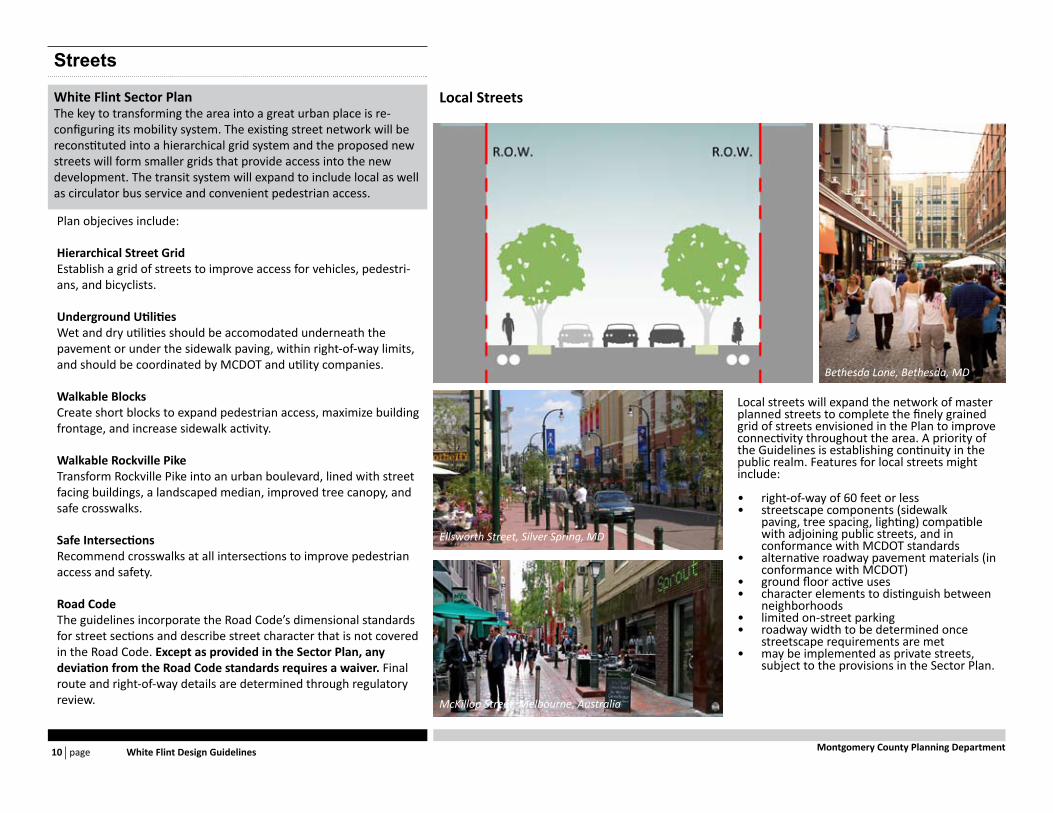
Streets
Plan objecives include:
Hierarchical Street GridEstablish a grid of streets to improve access for vehicles, pedestri-ans, and bicyclists.
Underground UtilitiesWet and dry utilities should be accomodated underneath the pavement or under the sidewalk paving, within right-of-way limits, and should be coordinated by MCDOT and utility companies.
Walkable BlocksCreate short blocks to expand pedestrian access, maximize building frontage, and increase sidewalk activity.
Walkable Rockville PikeTransform Rockville Pike into an urban boulevard, lined with street facing buildings, a landscaped median, improved tree canopy, and safe crosswalks.
Safe IntersectionsRecommend crosswalks at all intersections to improve pedestrian access and safety.
Road CodeThe guidelines incorporate the Road Code’s dimensional standards for street sections and describe street character that is not covered in the Road Code. Except as provided in the Sector Plan, any deviation from the Road Code standards requires a waiver. Final route and right-of-way details are determined through regulatory review.
White Flint Sector PlanThe key to transforming the area into a great urban place is re-configuring its mobility system. The existing street network will be reconstituted into a hierarchical grid system and the proposed new streets will form smaller grids that provide access into the new development. The transit system will expand to include local as well as circulator bus service and convenient pedestrian access.
Local streets will expand the network of master planned streets to complete the finely grained grid of streets envisioned in the Plan to improve connectivity throughout the area. A priority of the Guidelines is establishing continuity in the public realm. Features for local streets might include:
right-of-way of 60 feet or less• streetscape components (sidewalk • paving, tree spacing, lighting) compatible with adjoining public streets, and in conformance with MCDOT standardsalternative roadway pavement materials (in • conformance with MCDOT)ground floor active uses• character elements to distinguish between • neighborhoodslimited on-street parking• roadway width to be determined once • streetscape requirements are metmay be implemented as private streets, • subject to the provisions in the Sector Plan.
Local Streets
Ellsworth Street, Silver Spring, MD
Bethesda Lane, Bethesda, MD
McKillop Street, Melbourne, Australia

page General Guidelines 11Montgomery County Planning Department
Rockville Pike
Sector PlanMin. R.O.W.: 162 ft *Lanes: 6
GuidelinesParking: TBDTrees: 40-45’ o.c.Sidewalk: Per RoadCodeSetback: 14 ft west / Per WMATA Easement eastStreet Wall: 42-60’ H. maxMedian: Transitway/Turning Lanes/Planted
* Might be revised to 150 ft after County Council’s Public Hearing on Countywide BRT Study anticipated in 2011
Nicholson Lane
Sector PlanMin. R.O.W.: 90 ftLanes: 4
GuidelinesParking: NoneTrees: 40-45’ o.c.Sidewalk: Per RoadCodeSetback: NoneStreet Wall: 42-60’ H. maxMedian: Turning lane
Old Georgetown Road
Sector PlanMin. R.O.W.: 120 ftLanes: 4
GuidelinesParking: Off-peakTrees: 40-45’ o.c.Sidewalk: Per RoadCodeSetback: NoneStreet Wall: 42-60’ H. maxMedian: Planted with turning lanes
Business Street Market Street
Sector PlanMin. R.O.W.: 70 ftLanes: 2
GuidelinesParking: Both sidesTrees: 40-45’ o.c.Sidewalk: Per RoadCodeSetback: NoneStreet Wall: 42-60’ H. maxMedian: None
Sector PlanMin. R.O.W.: 70 ftLanes: 2
GuidelinesParking: Both sidesTrees: 40-45’ o.c.Sidewalk: Per RoadCodeSetback: 22 ft north sideStreet Wall: 42-60’ H. maxMedian: None
45 ft
R.O.W.
CL
60 ft
R.O.W.
CL
WMATA EASEMENT
35 ft
R.O.W.
CL
22 ft
R.O.W. R.O.W.
14 ft 30 ft min
Street Types

page White Flint Design Guidelines 12 Montgomery County Planning Department
Open Space
A successful public space system is made up of a variety of spaces or-ganized hierarchically; spaces of different size, use, and ownership. Large open green areas, frequent in suburban landscapes, are sup-plemented by smaller spaces in an urban environment. The White Flint public space system will provide a range of public spaces to meet a variety of needs. As the area develops, it is critical that meet-ing the public use space requirement works toward creating active urban places. Location and orientation of open space must reinforce the goal of creating spaces fronted with active uses.
All public use spaces should include (but not be limited to) some of the following design elements:
high visibility from sidewalks, streets, and buildings• accessible to all• sustainable design – native plants requiring minimal mainte-• nance, rainwater for natural irrigationopportunities for shade or sun, with water elements and wind • protectionrange of active and passive uses with the necessary infrastruc-• ture to promote flexibilityopportunities for art• integration with adjacent public rights-of-way.•
White Flint Sector Plan
Public Use SpaceThe Plan recommends a hierarchical open space system in which each space contributes variety in function and setting. A recreation loop connects the public use spaces, which include:
an active urban park• a central civic green• urban plazas at each cluster of offices, residences, or shops• a neighborhood green for each neighborhood• private recreation space for each building.•
Objectives
Encourage consolidation• - With the exception of public use spaces designated by the Sector Plan or spaces that are part of already approved development, locations shown on the map above are sug-gestions of where neighborhood public use spaces could be located. The Guidelines recommend consolidating the space allocated by individual properties to meet zoning public use space require-ments in locations central to each neighborhood to create substantial urban spaces for public use. Actual locations will be determined during the development review process.Create pedestrian priority places• - Vehicular intrusions should be limited to maintenance or secu-rity vehicles, or to service vehicles required for programmed events.Provide accessible spaces• - While neighborhood public use space should include large areas that can be programmed for special events, priority should be given to create substantial areas for unprogrammed use by residents, workers, and visitors.
Open Space PlanWhite Flint Sector Plan
page General Guidelines 13Montgomery County Planning Department
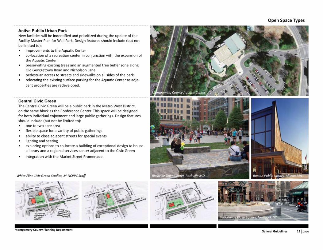
Active Public Urban ParkNew facilities will be indentified and prioritized during the update of the Facility Master Plan for Wall Park. Design features should include (but not be limited to):
improvements to the Aquatic Center• co-location of a recreation center in conjunction with the expansion of • the Aquatic Centerpreservating existing trees and an augmented tree buffer zone along • Old Georgetown Road and Nicholson Lanepedestrian access to streets and sidewalks on all sides of the park• relocating the existing surface parking for the Aquatic Center as adja-• cent properties are redeveloped.
Central Civic GreenThe Central Civic Green will be a public park in the Metro West District, on the same block as the Conference Center. This space will be designed for both individual enjoyment and large public gatherings. Design features should include (but not be limited to):
one to two acre area• flexible space for a variety of public gatherings• ability to close adjacent streets for special events• lighting and seating• exploring options to co-locate a building of exceptional design to house • a library and a regional services center adjacent to the Civic Green
integration with the Market Street Promenade.•
Open Space Types
Boston Public Library, Allston MARockville Town Center, Rockville MD
Worldwide Plaza Square, New York NY
White Flint Civic Green Studies, M-NCPPC Staff
Montgomery County Aquatic Center
page White Flint Design Guidelines 14 Montgomery County Planning Department
Open Space Types
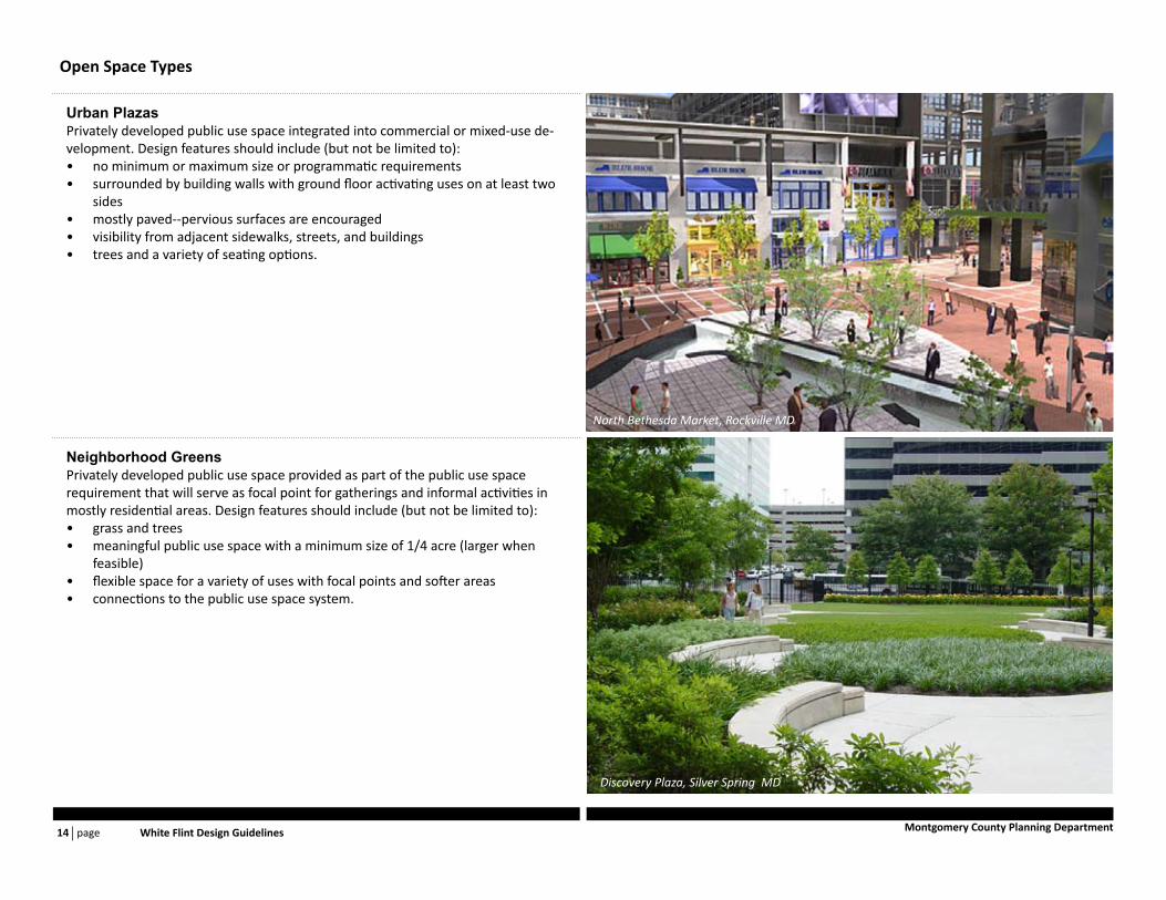
Neighborhood GreensPrivately developed public use space provided as part of the public use space requirement that will serve as focal point for gatherings and informal activities in mostly residential areas. Design features should include (but not be limited to):
grass and trees• meaningful public use space with a minimum size of 1/4 acre (larger when • feasible)flexible space for a variety of uses with focal points and softer areas• connections to the public use space system.•
Urban PlazasPrivately developed public use space integrated into commercial or mixed-use de-velopment. Design features should include (but not be limited to):
no minimum or maximum size or programmatic requirements• surrounded by building walls with ground floor activating uses on at least two • sidesmostly paved--pervious surfaces are encouraged• visibility from adjacent sidewalks, streets, and buildings• trees and a variety of seating options.•
Discovery Plaza, Silver Spring MD
North Bethesda Market, Rockville MD

page Introduction 15Montgomery County Planning Department
Open Space Types
Private Recreation SpaceRoof gardens, recreation rooms, balcony/terrace/deck/patio, or day care facilities provided by individual properties for the use of building occupants. Design features should include (but not be limited to):
common indoor and outdoor spaces for resident use included as part of devel-• opmentoptions for group and individual enjoyment•
Recreation LoopThe Recreation Loop is a continuous recreational pathway connecting public use spaces to the Civic Green and Wall Local Park. It will be identified primarily by a signage program recommended by the Sector Plan as elegible for amenity fund support. Elements may include:
wayfinding components orienting pedestrians to points of interest and transit, • and to regional trail connections (i.e., The Bethesda Trolley Trail) identifiable paving at crossings of the Loop and major streets such as Rockville • Pikesignature landscape elements• integration with adjacent bikeways on segments where both occur alongside • each other (i.e., north side of Nicholson Lane, west side of Nebel Street, and south side of Old Georgetown Rd/MD 187).
MTA Wayfinding Medallions, New York , NY Street Crossing Paving, ICT, Indianapolis IN
Pear Trees along Fifth Avenue, Brooklyn NY
The Metropolitan, Bethesda MD
Path Signage, ICT, Indianapolis IN
page White Flint Design Guidelines 16 Montgomery County Planning Department
Buildings
Building design can enhance pedestrian activity. Building compo-nents can work together to ensure that public spaces around build-ings create a quality of place. Design features should include:
build-to lines• that establish minimum setbacks from the right-of-way where a percentage of the ground floor frontage must be locatedpodium heights• that define the pedestrian level space. The po-dium is the lower massing component of a mixed-use structure, located closest to the street. It is the tallest part of a building the pedestrian can see. In White Flint podiums should be at least three to five floors of active usesstepbacks or podium setbacks• that distance the taller compo-nent of a building into the property to separate it from the po-dium, reducing the impact of its scale on the pedestrian space below. Subject to the CR incentive guidelines, this distance should generally be a minimum of 10 to 15 feet.reduced floor plate sizes• for the taller building portions, to mini-mize the structure’s perceived bulk.
White Flint Sector Plan
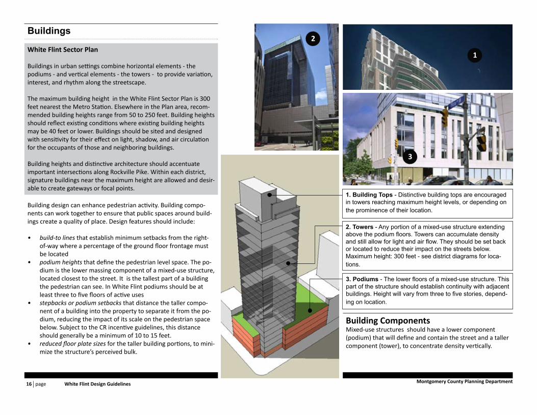
Buildings in urban settings combine horizontal elements - the podiums - and vertical elements - the towers - to provide variation, interest, and rhythm along the streetscape.
The maximum building height in the White Flint Sector Plan is 300 feet nearest the Metro Station. Elsewhere in the Plan area, recom-mended building heights range from 50 to 250 feet. Building heights should reflect existing conditions where existing building heights may be 40 feet or lower. Buildings should be sited and designed with sensitivity for their effect on light, shadow, and air circulation for the occupants of those and neighboring buildings.
Building heights and distinctive architecture should accentuate important intersections along Rockville Pike. Within each district, signature buildings near the maximum height are allowed and desir-able to create gateways or focal points.
Building ComponentsMixed-use structures should have a lower component (podium) that will define and contain the street and a taller component (tower), to concentrate density vertically.
3. Podiums - The lower floors of a mixed-use structure. This part of the structure should establish continuity with adjacent buildings. Height will vary from three to five stories, depend-ing on location.
2. Towers - Any portion of a mixed-use structure extending above the podium floors. Towers can accumulate density and still allow for light and air flow. They should be set back or located to reduce their impact on the streets below. Maximum height: 300 feet - see district diagrams for loca-tions.
1. Building Tops - Distinctive building tops are encouraged in towers reaching maximum height levels, or depending on the prominence of their location.
1
2
3

page General Guidelines 17Montgomery County Planning Department
Mix of Building TypesVarious building types combine to form a single urban environment. Compatibility between building components in adajacent structures is important to establish continuity in the urban realm.
Smaller Buildings: Maintain continu-ity with adjacent building podiums, and use their lower scale as a transition to adjacent, lower density neighbor-hoods
Larger Buildings: Podium heights should range between three and five floors, and connect or transition to adjacent buildings
1. Transition BuildingsResidential3 Stories35 to 48 feet high
2. Mixed-Use BuildingsRetail ground floorOffice or residential above3 to 5 stories high
3. Tower+ Base Mixed UseRetail ground floorOffice or residential above3 to 5 stories high100 to 250 feet high tower3 2 1

page White Flint Design Guidelines 18 Montgomery County Planning Department
Street Defining BuildingsPedestrian priority streets are defined by consistent street walls. Building podiums should meet build-to lines on both sides of the street where indicated on district maps.
2. Street Wall - Permit breaks along street walls on block frontages 200 feet or longer. Breaks should be away from block corners, and discouraged on retail priority streets.
1. Podium Height -Range between three and five stories. Active ground floor uses where feasible will be a priority to establish a successful pedestrian realm.
Building street wall to meet build-to line
1
2
3
3. Podiums - Podiums should meet build-to lines at corners. Facade articulation is strongly encouraged.

page General Guidelines 19Montgomery County Planning Department
Building TowersLocation of building towers should be carefully considered to reduce their visual impact on pedestrian priority streets.
3. Corners - Tower full height may be expressed at corners, as part of building articulation. Street wall continuity must be maintained through articulation.
2. Street Wall Recess - Tower full height may be fully expressed at street level if related to a frontal open space or setback from right-of-way.
1. Setback - Encouraged on streets with right-of way of 70 feet or less. Amount of setback shall be determined by build-ing’s structure, but should be no less than 10 feet.
Possible Retail
4. Tower Separation - Separation between adjacent towers is encouraged to allow for natural light and air flow.
Upper Base Tower
1
4
3
2
5
5. Tower Alignment - Tower face may align with podium face along streets with right-of-way 80 feet or greater, or as needed to achieve market size floorplates on limited size parcels.
page White Flint Design Guidelines 20 Montgomery County Planning Department
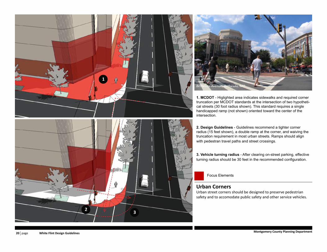
Urban CornersUrban street corners should be designed to preserve pedestrian safety and to accomodate public safety and other service vehicles.
3. Vehicle turning radius - After clearing on-street parking, effective turning radius should be 30 feet in the recommended configuration.
2. Design Guidelines - Guidelines recommend a tighter corner radius (15 feet shown), a double ramp at the corner, and waiving the truncation requirement in most urban streets. Ramps should align with pedestran travel paths and street crossings.
1. MCDOT - Higlighted area indicates sidewalks and required corner truncation per MCDOT standards at the intersection of two hypotheti-cal streets (30 foot radius shown). This standard requires a single handicapped ramp (not shown) oriented toward the center of the intersection.
Focus Elements
1
23
Bethesda Avenue, Bethesda, MD

page General Guidelines 21Montgomery County Planning Department
Retail CornersEstablish block corners with architectural articulation and activating uses. While market forces will dictate actual locations where retail operations are feasible, anchoring key block corners by including activating uses such as retail is encouraged.
Focus Elements
Bethesda Row, Bethesda, MD

page White Flint Design Guidelines 22 Montgomery County Planning Department
Narrow EntranceMinimize width of entrance and egress lanes.
Access off Side StreetProvide side street access to minimize traffic impact
Wrapped Parking DeckPlace garage centrally within the block
Access off AlleyMinimize curb cuts, provide garage access from alley
Minimize Street ExposureReduce the amount of the garage facade facing the street.
Ground Floor FrontageIf possible, activate ground floor with retail or other uses.
Parking
White Flint Sector Plan
Parking ManagementEncourage provision of public parking by private development • through incentives in the CR ZoneEstablish a parking management authority to assist in the • management of parking demand and promote shared parking efficiencies, particularly relieving the requirement for smaller properties to self park. Public/private parking agreements should be encouraged as private properties redevelop.

page General Guidelines 23Montgomery County Planning Department
Integrated Building FacadeWhen building above structured parking, garage and building facade should be compatible.
Access off Side StreetProvide side street access to minimize traffic impact
Parking Behind BuildingSignficant frontage shields cars from primary view points.
Building Anchors CornerBuilding prominently located at point of highest visibility.
Parking Best PracticesProjects shoulds seek to comply with the applicable parking best management practices.
Underground and Structured ParkingParking should minimize its impact on the pedestrian environment and public realm.
Locate entrances and exits on an alley or business district • street.Buildings above structured parking should make facades of • the garage portion of the building compatible with the rest of the structure, in order to enhance the overall architectural quality of the buildingMinimize the width and height of driveways and entrances.• Where possible, combine loading dock and garage access.•
Surface ParkingLocate parking on the back or side of building, with the building fronting the primary streets and sidewalks.

page White Flint Design Guidelines 24 Montgomery County Planning Department
Facade Arcticulation
Facades should be articulated to promote pedestrian activity and enhance overall urban environment.
Ground floors should incorporate a building’s most public and active 1. spaces.Facade organization should allow for active ground floor uses to be 2. visible from the street. Retail frontages should be as transparent as feasible. Avoid long stretches of blank walls; if required, provide articu-lation to minimize their impact on the pedestrian realm.Provide vertical articulation along street walls to reduce their visual 3. length.Design building entrances to be prominent elements in the street front-4. age.
Sustainability
Design new buildings to optimize energy performance and resource con-servation. All new development should obtain the highest possible LEED certification.
Wind generally accelerates down the face of a building; building podiums • should divert downward winds before they reach pedestrian areas.Long base walls can create a wind tunnel effect unless building elements • are provided to interrupt and disperse the wind flow.Wider spacing between building towers allows for sunlight to reach be-• tween buildings.Tall buildings with narrow floor plates will cast longer shadows that move • faster across any single point on the ground, reducing the impact of the building on adjacent pedestrian areas. Encourage taller narrower build-ings that have less impact than wider, shorter buildings of similar floor area.Anchoring street corners should be an integral building function.•
Additional Objectives

page General Guidelines 25Montgomery County Planning Department
Design Excellence
To achieve the Plan vision, high quality architectural design is encouraged. Good design enhances building sustainability, as more people will choose to live in attractive and accessible structures. This is especially important in the early stages of White Flint growth, when it will compete for users with more established areas in the region.
To achieve this, a diverse building product is encouraged to attract the growth that may otherwise go to other jurisdictions. Contemporary design, loft structures, and innovative materials can advance the cause of better design.
Pad lot parcels should no longer be viewed as sites for single-story chain stores. The architecture of these uses should fit in with the vision outlined in the Plan.
To achieve better design, discussion between Planning staff and property owners should begin early in the design review process. Buildings should always be considered in the context of the street and established design goals for the Plan area; owners should consider these goals when potential tenants are courted.
Design StrategiesInnovative use of building materials is encouraged.• Create exterior wall systems that improve building performance.• Encourage the pursuit of excellence in the design of all public struc-• tures.
Architectural Character

page White Flint Design Guidelines 26 Montgomery County Planning Department
Metro West Metro East Mid-Pike Plaza NoBe
Maple Avenue Nebel NRC White Flint Mall
page Districs 27Montgomery County Planning Department
Streets
Refer to guidelines for 1. Streets (page 10) for general guidelines regarding urban streets, local streets, and parkingGuideline recommendations within the public 2. right-of-way require coordination with the Montgomery County Department of Transpor-tation.Local streets should be compatible in charac-3. ter with business streets, and be constructed to similar standards.
Open Spaces
Refer to guidelines for 1. Open Space (page 12) for general guidelines regarding privately developed public use space that serves as neighborhood gath-ering space.The Plan may recommend a certain amount of open 2. space to be allocated for neighborhood open space, as part of the open space required by zoning.
Buildings
Refer to guidelines for 1. Buildings (page 16) for general guidelines regarding location of street walls along built-to lines, building mass distribution, facade articu-lation, and urban corners.Locate maximum building heights along Rockville Pike, 2. closest to the Metro Station (see district diagrams).Prioritize the establishment of consistent street walls 3. along public streets. Character at adjacent streets should be compatible.Consider signature structures or significant building 4. features at prominent locations.
DistrictsWhite Flint Sector Plan
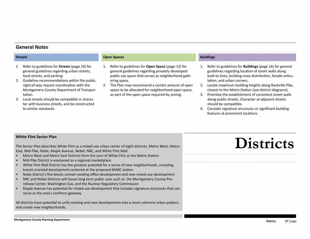
The Sector Plan describes White Flint as a mixed-use urban center of eight districts: Metro West, Metro East, Mid-Pike, Nobe, Maple Avenue, Nebel, NRC, and White Flint Mall.
Metro West and Metro East Districts form the core of White Flint at the Metro Station• Mid-Pike District is envisoned as a regional marketplace• White Flint Mall District has the greatest potential for a series of new neighborhoods, including • transit oriented development centered at the proposed MARC station Nobe District’s five blocks contain existing office development and new mixed-use development• NRC and Nebel Districts will house long term public uses such as the Montgomery County Pre-• release Center, Washington Gas, and the Nuclear Regulatory CommissionMaple Avenue has potential for mixed-use development that includes signature structures that can • serve as the area’s northern gateway
All districts have potential to unify existing and new developments into a more coherent urban pattern, and create new neighborhoods.
General Notes

page White Flint Design Guidelines 28 Montgomery County Planning Department
Allow for on-street parking along both sides of new business 1. streets, and along Old Georgetown Road (to be approved by MCDOT and MCFRS).Realign Executive Boulevard to meet Mid-Pike spine street to 2. the north.Create Market Street running east-west, north of the Con-3. ference Center. Allow for a 22-foot setback from the public right-of-way to create the Market Street Promenade.
StreetsMetro West District
BoundariesNorth - Old Georgetown Road between Rockville Pike and “Old” Old Georgetown RoadEast - Rockville Pike between Old Georgetown Road and Nicholson LaneWest - “Old” Old Georgetown Road between Old Georgetown Road and Nicholson LaneSouth - Nicholson Lane between “Old” Old Georgetown Road and Rockville Pike
FeaturesNorth Bethesda Conference CenterWall Park and the Aquatic CenterThe Wisconsin and The Grand apartments
Area54 acres (approximately)
page Districs 29Montgomery County Planning Department
Open Space Buildings
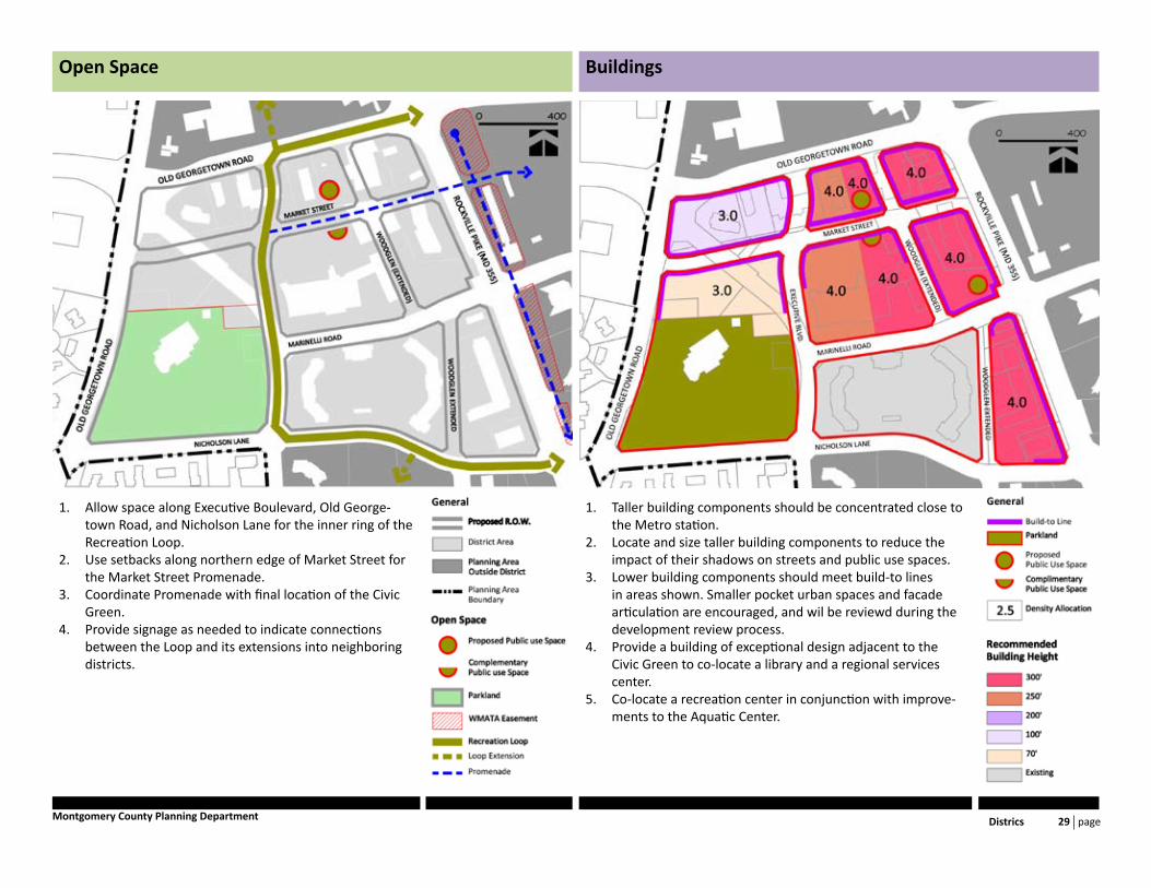
Taller building components should be concentrated close to 1. the Metro station.Locate and size taller building components to reduce the 2. impact of their shadows on streets and public use spaces.Lower building components should meet build-to lines 3. in areas shown. Smaller pocket urban spaces and facade articulation are encouraged, and wil be reviewd during the development review process.Provide a building of exceptional design adjacent to the 4. Civic Green to co-locate a library and a regional services center.Co-locate a recreation center in conjunction with improve-5. ments to the Aquatic Center.
Allow space along Executive Boulevard, Old George-1. town Road, and Nicholson Lane for the inner ring of the Recreation Loop.Use setbacks along northern edge of Market Street for 2. the Market Street Promenade.Coordinate Promenade with final location of the Civic 3. Green.Provide signage as needed to indicate connections 4. between the Loop and its extensions into neighboring districts.

page White Flint Design Guidelines 30 Montgomery County Planning Department
StreetsMetro East District
BoundariesNorth - Southern boundary of Maple Avenue districtEast - Nebel Street between Marinelli Street and Maple AvenueWest - Rockville Pike between Marinelli Street and the southern boundary of Maple Avenue District.South - Marinelli Street between Rockville Pike and Nebel Street
FeaturesWhite Flint Metro StationMarket Street will run east-west through the cen-ter of the district.
Area53 acres (approximately)
Coordinate new streets around the Metro station with pro-1. posed northern Metro entrance work.Ensure contunitity of streetscape around district’s perimeter.2.

page Districs 31Montgomery County Planning Department
Open Space Buildings
Coordinate contunuity of the recreation loop around the 1. district, and its alignment with segments adjoining neigh-boring districts.Coordinate Promenade along McGrath Boulevard with the 2. Market Street Promenade on the western side of Rockville Pike.Provide termination for the Rockville Pike Promenade in 3. coordination with proposed new Metro station northern entrance.
Activating uses should line areas designated as build-to 1. lines to ensure pedestrian activity along the outer perim-eter of the district.
page White Flint Design Guidelines 32 Montgomery County Planning Department
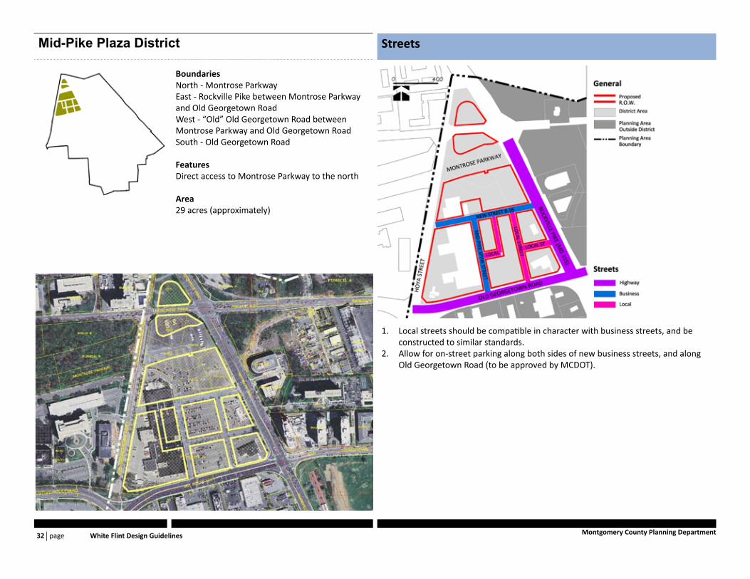
StreetsMid-Pike Plaza District
BoundariesNorth - Montrose ParkwayEast - Rockville Pike between Montrose Parkway and Old Georgetown RoadWest - “Old” Old Georgetown Road between Montrose Parkway and Old Georgetown RoadSouth - Old Georgetown Road
FeaturesDirect access to Montrose Parkway to the north
Area29 acres (approximately)
Local streets should be compatible in character with business streets, and be 1. constructed to similar standards.Allow for on-street parking along both sides of new business streets, and along 2. Old Georgetown Road (to be approved by MCDOT).

page Districs 33Montgomery County Planning Department
Open Space Buildings
Locate maximum building heights along Rockville Pike. Concentrate tallest ele-1. ments at the district’s the southeastern corner.Prioritize the establishment of consistent street walls along public streets. Char-2. acter along adjacent streets should be compatible.Consider signature structures or significant building features at prominent loca-3. tions, such as the corner of Rockville Pike and Old Georgetown Road, the corner of Old Georgetown Road and “Old” Old Georgetown Road, or the northern termi-nus of Mid-Pike spine street.Locate and size taller building components to reduce the impact of their shadows 4. on streets and public use spaces.
The Sector Plan recommends a combined total of one acre to be used as public 1. open space. Symbols designate approximate locations for possible prominent public use spaces. Final locations for these, and opportunities for smaller urban plazas and amenity spaces, should be established during development review.Neighborhood open spaces should be defined by surrounding building walls on 2. at least three sides on a mid-block location, or two sides on a corner location.Public use spaces should be located to reduce extended periods of shadow cover-3. age from surrounding buildings.Provide signage along Mid-Pike spine street’s sidewalk (either side) to indicate 4. connections to the Loop to the south, and the various public use spaces within the district.

page White Flint Design Guidelines 34 Montgomery County Planning Department
StreetsNoBe District
BoundariesNorth - Nicholson Lane between Executive Boule-vard and Rockville PikeEast - Rockville Pike, betwen Nicholson Lane and Hillery WayWest - Woodglen Drive from Nicholson Lane to the Plan’s southern boundarySouth - Plan’s southern boundary
FeaturesNorth Bethesda Market ProjectWSSC water storage facility
Area40 acres (approximately)
Streetscape elements along business streets should extend into proposed streets 1. to ensure pedestrian continuity.Encourage compatibility of streetscape elements between newly constructed and 2. future developments along Rockville Pike.

page Districs 35Montgomery County Planning Department
Open Space Buildings
Distribute activating uses along the designated build-to line to ensure pedestrian 1. activation in the more dense areas, and to encourage pedestrian activity along Rockville Pike.The Lutrell property should be considered as an alternative location for an el-2. ementary school.
Provide signage along designated recreation loop extensions Spine Street’s side-1. walk (either side) to indicate connections to the main ring of the Recreation Loop to the north, and public use spaces in adjacent districts. CLARIFY
page White Flint Design Guidelines 36 Montgomery County Planning Department
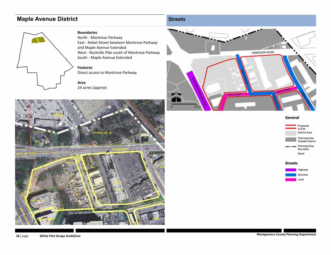
StreetsMaple Avenue District
BoundariesNorth - Montrose ParkwayEast - Nebel Street bewteen Montrose Parkway and Maple Avenue ExtendedWest - Rockville Pike south of Montrose ParkwaySouth - Maple Avenue Extended
FeaturesDirect access to Montrose Parkway
Area24 acres (approx)

page Districs 37Montgomery County Planning Department
Open Space Buildings
Encourage a signature element on the corner of Ran-1. dolph Road and Nebel Street, to serve as gateway to the district.Locate a new fire and emergency services facility on the 2. State Highway Administration right-of-way east of Rock-ville Pike and south of Randolph Road.
Provide neighborhood open space to attract pedestrian 1. activity fron neighboring districts and to serve future residents and ...?
page White Flint Design Guidelines 38 Montgomery County Planning Department
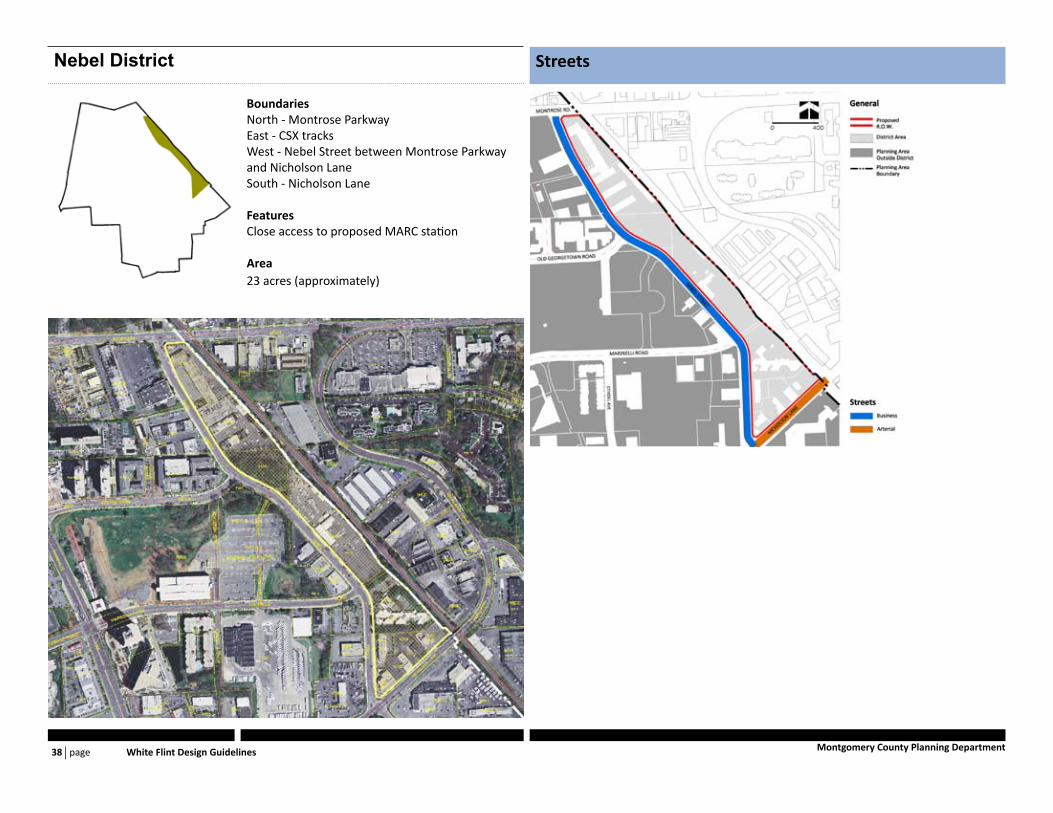
StreetsNebel District
BoundariesNorth - Montrose ParkwayEast - CSX tracksWest - Nebel Street between Montrose Parkway and Nicholson LaneSouth - Nicholson Lane
FeaturesClose access to proposed MARC station
Area23 acres (approximately)
page Districs 39Montgomery County Planning Department
Open Space Buildings
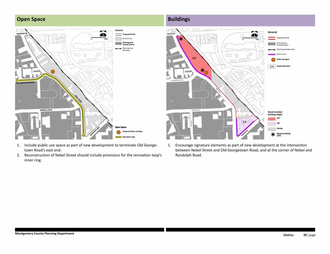
Encourage signature elements as part of new development at the intersection 1. between Nebel Street and Old Georgetown Road, and at the corner of Nebel and Randolph Road.
Include public use space as part of new development to terminate Old George-1. town Road’s east end.Reconstruction of Nebel Street should include provisions for the recreation loop’s 2. inner ring.

page White Flint Design Guidelines 40 Montgomery County Planning Department
StreetsNRC District
BoundariesNorth - Marinelli Road between Rockville Pike and Nebel StreetEast - Nebel Street bewteen Marinelli Street and Nicholson LaneWest - Rockville Pike between Marinelli Street and Nicholson LaneSouth - Nicholson Lane between Rockville Pike and CSX tracks
FeaturesHome to the Nuclear Regulatory Commission Strathmore Court Residential DevelopmentWMATA Bus facility
Area38 acres (approx)
page Districs 41Montgomery County Planning Department
Open Space Buildings
page White Flint Design Guidelines 42 Montgomery County Planning Department
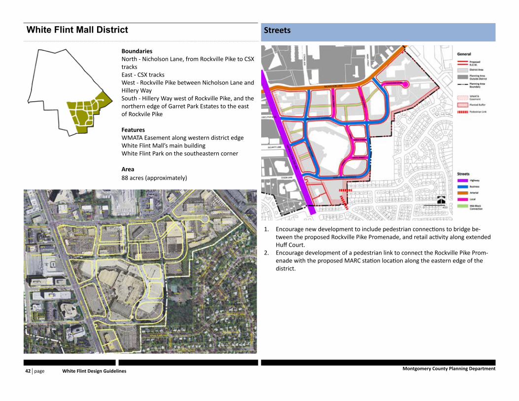
StreetsWhite Flint Mall District
BoundariesNorth - Nicholson Lane, from Rockville Pike to CSX tracksEast - CSX tracksWest - Rockville Pike between Nicholson Lane and Hillery WaySouth - Hillery Way west of Rockville Pike, and the northern edge of Garret Park Estates to the east of Rockvile Pike
FeaturesWMATA Easement along western district edgeWhite Flint Mall’s main buildingWhite Flint Park on the southeastern corner
Area88 acres (approximately)
Encourage new development to include pedestrian connections to bridge be-1. tween the proposed Rockville Pike Promenade, and retail activity along extended Huff Court.Encourage development of a pedestrian link to connect the Rockville Pike Prom-2. enade with the proposed MARC station location along the eastern edge of the district.

page Districs 43Montgomery County Planning Department
Open Space Buildings
Allocate the southern part of the White Flint Mall property, south of Nebel Street 1. (extended), as a site for an elementary school.