what’s out there - the cultural landscape foundation · · 2016-05-23parks and public open...
TRANSCRIPT

What’s Out There®
Houston

3www.tclf.org2 The Cultural Landscape Foundation
Photo by Natalie Keeton, courtesy Lauren Griffith
Houston, Texas
The Cultural Landscape Foundation (TCLF)TCLF provides the tools to see, understand and value landscape architecture and
its practitioners in the way many people have learned to do with buildings and
their designers. Through its website, lectures, outreach and publishing, TCLF
broadens the support and understanding for cultural landscapes nationwide to
help safeguard our priceless heritage for future generations.
learn more at tclf.org
Welcome to What’s Out There® Houston, organized by The Cultural Landscape Foundation (TCLF) with support from national and local partners. This guidebook provides details about more than 30 examples of Houston’s incredible legacy of parks and public open spaces—sites featured in free, expert-led tours that complemented Leading with Landscape II: The Houston Transformation conference, also organized by TCLF.
The story of zoning and planning in Houston is a fascinating study, one that lies at the very center of the conference and tours. It is a story characterized by political wrangling, economic boom and bust cycles, hurricanes and flooding, the influence of the automobile in infrastructure and housing development, public-private partnerships, and the presence of the many bayous that traverse the city. Houston provokes the question, “Can a city that has developed largely without a plan also be one that is leading with landscape?”
Although Houston was founded in 1837, its first comprehensive plan was not developed until 1913 when landscape architect Arthur Comey submitted a proposal for the city’s development. Since then, designers such as George Kessler, Ralph Ellifrit, Philip Johnson, Ian McHarg, Isamu Noguchi, and landscape architecture firms Hare & Hare, Sasaki Associates, SWA Group, Hanna/Olin, Clark Condon, Design Workshop, and Eckbo, Royston & Williams (and many others) have been attracted to Houston, the nation’s fourth largest city, which now encompasses some 600 square miles. Designs for parks, college campuses, civic and cultural institutions, suburbs, and cemeteries have
ranged from Picturesque and Beaux-Arts styles to Modernist and Postmodernist. The Houston Transformation conference and What’s Out There Weekend tours correspond with the 100th anniversary of the founding of the Houston Parks and Recreation Department, which today manages parks and open spaces comprising more than 37,800 acres.
This guidebook is a complement to TCLF’s much more comprehensive What’s Out There Houston Guide, an interactive online platform that includes all of the enclosed essays plus many others, as well as overarching narratives, maps, historic photographs, and biographical profiles. That Guide, viewable at tclf.org/houstonguide, is one of a number of online compendia of urban landscapes, dovetailing with TCLF’s Web-based What’s Out There, the nation’s most comprehensive searchable database of historic designed landscapes. The database currently features more than 1,900 sites, 10,000 images, and 900 designer profiles. What’s Out There is optimized for iPhones and similar handheld devices and includes What’s Nearby, a GPS-enabled function that locates all landscapes in the database within a 25-mile radius of any given location.
On behalf of The Cultural Landscape Foundation, I appreciate your interest in What’s Out There Houston and I hope you will enjoy experiencing the city’s unique and unparalleled landscape legacy.
Sincerely,
Charles A. Birnbaum, FASLA, FAAR PRESIDENT AND CEO, THE CULTURAL LANDSCAPE FOUNDATION

5www.tclf.org
➊ Allen's Landing Park
➋ Sesquicentennial Park
➌ Buffalo Bayou Park
➍ Sabine Promenade
➎ Glenwood Cemetery
➏ Gragg Park
➐ White Oak Bayou Greenway
➑ Allen Center
➒ Antioch Park
➓ Christ Church Cathedral
⓫ Discovery Green
⓬ Hermann Square
⓭ Sam Houston Park
⓮ Market Square Park
⓯ Tranquillity Park
⓰ CityCentre Houston
⓱ Bagby Park and Streetscape
⓲ Bethel Park
⓳ Bayou Bend Collection and Gardens
⓴ Memorial Park
•• Houston Arboretum and Nature Center
•• Rienzi House Museum
List of sites
Sabine Promenade
•• Broadacres Historic District
•• Hermann Park
•• Lillie and Hugh Roy Cullen Sculpture Garden
•• Menil Collection Campus
•• University of St. Thomas
•• Rice University + Raymond and Susan Brochstein Pavilion
•• Post Oak Boulevard
•• Gerald D. Hines Waterwall Park
•• The Woodlands
Photo by Tom Fox, courtesy SWA Group
HERMANNPARK
HoustonZoo
RiceUniversity
RiceStadium
WILSONMEMORIAL
PARK
GulfPalmsParks
BEVERLYHILLS PARK
JONES
PARK
BUFFALO BAYOU
BUFFALO BAYOU
Jersey Village
Aldine
Hedwig Village
WestUniversity
Place
MeadowsPlace
Missouri City
TexasSouthernUniversity University
Of Houston
CULLEN PARK
MOFFIT
Pine CrestCountry
Club
LakesideCountry Club
MemorialOaks Cemetery
Forest ParkCemetery
Royal OaksCountry Club
ALIEFCOMMUNITY PARK
BOONEROAD PARK
SANDCANYONPARK
WEST MOUNTHOUSTON PARK
Inwood ForestGolf And
Country Club
ParadiseCemetery
FREEDPARK
HoustonCounty Club
River OaksCounty Club
SharpstownPark And
Golf Course
WestwoodCountry Club
BraeburnCountry Club
HoustonHills GolfCourse
MARIANPARK
CAMERIDGEVILLAGE PARK
South MailGolf Center
BreaswoodParkway
MemorialPark GolfCourse
MEMORIAL PARK
KEITH WIESS PARK
MELROSE PARKMelroseGolf Course
SHADYLANE PARK
HIRSHROAD PARK
TROTTER
TIDWELLPARK
LAKEFOREST
PARK
GRANDRIVER PARK
Brock ParkMunicipal
Golf Course
TAYLOR
BROWN
MAXE PARK
TexacoCountry Club
Sheldon Reservoir
BlackhornLake
TONYMARRON PARK
MOODY PARK
STUDE PARK
SPOTTS PARK GlenwoodCemetery
BUFFALO BAYOU
JOE SKATE PARK
SAM HOUSTONPARK
WildcatGolf Club
TAYLOR
ANN PARK
ReliandStadium
ReliandAstrodome
Six FlagsAstroworld
SUNNYSIDEPARK
GRIMES
SIMSBAYOUPARK
SCHNURPARK
LAW PARK
Forest ParkCemetery
MASONPARK
Gus WorthamPark And
Golf Course
Gus WorthamPark Golf Course
Cullinan(J.S. And LH) Glenbrook
Park & GolfCourses
STUART
GARDENVILLAS PARK
DOW PARK
CLINTONPARK
45
45
10
10
69
69610
610
610
88
8
8
8
90
90
290
26
Munite MaidMunite MaidParPark
JonesPlazaJonessJo
azaza
GlenwoodCemetery
ToyotaCenter
PVT
Rai
lroad
Amtra
k Ra
ilroa
d
GlenwoodeGCemeterymeteCemCe
Commerce St.
Dallas St
Austi
n St
Bastr
op S
t
Dowl
ing S
tSt
Cha
rles S
t
St C
harle
s St
Live
Oak S
t
Delan
o St
Nage
l St
Hutch
ins S
t
St E
man
uel S
tEa
stex
Fwy
Navigat Blvd
Mila
n St
Trav
is St
N. M
ain St
Opelousas St
Main
St
Main
St
Main
StTr
avis
St
Smith
StBa
gby S
tLo
uisian
a St
Louis
iana
St
Braz
os S
t
Bagb
y St
Baldw
in St
Helen
a St
Alba
ny S
t
Craw
ford
St
Fann
in St
San
Jacin
to S
t
N S
an J
acin
to S
t
Ham
ilton
St
Dallas St
Texas Ave
Runnels St
Capitol St
Leeland StJefferson StWebster St
Gray St
Pierce St
Dennis St
Bell St
Clay St
Polk St
Pease St
Lamar St
Lamar St
McKinney St
McKinney St
Walker St
Walker St
Rusk St
Rusk St
Capitol St
Prairie St
Texas St Texas AveFranklin St
Baker St
Girard StGirard St
Franklin St
Congress St
Providence ST
Nance St
Sterrett St
Dart St
Summer StSummer St
Mem
oria
l Hts
Stud
emon
t St
Winter StBingham St
Edward St
Decator St
Washington Ave
Cou
rt S
t
Hem
phill
St
Gill
entte
St
Col
umbu
s S
t
Sta
nfor
d S
t
Mon
trose
Blv
d
Con
vers
e S
tC
rock
er S
t
Mor
gan
St
Mas
on S
t
Gen
esee
St
Talt
St
Talt
St
Wils
on S
t
Cus
hing
St Arth
ur S
tC
rosb
y
Gul
f Fw
y
Hen
ders
on S
t
Hol
ly S
t
Elde
r St Conti S
t
Whi
te S
t
Trin
ity S
t
Hou
ston
Ave
Saw
yer S
t
Kane StLubbock St
State St
W Dallas StW Dallas St
Tobin StW Polk StW Clay St
Ruthven St
Oneil St
Cook St
Peden St
W Drew St
W Gray St
Hyde Park Blvd
Fargo St
Victor StCleveland St
W Webster St
Andrews St Andrews St
Center St
Center St
FourthWard
45
45
90
59
59
10
Downtown Houston
••
⓰
⓯
⓳
⓮
••
➐
➊
••
⓱
➍
➓
⓲
••••
⓭➌
(6 mi)
(25
mi)
••
➎
➑
••
➏
⓴
⓬
➋
••
••
••
••
➒
⓫

7www.tclf.org6 The Cultural Landscape Foundation
Landscape Style:Modernist
Landscape Type:Public Park – Neighborhood ParkWaterfont DevelopmentCommemorative Landscape
Designed By:SWA GroupKevin Shanley
Related Landscapes: Sesquicentennial ParkBuffalo Bayou Park
This 1.76-acre park on the south bank of Buffalo Bayou commemorates the founding of Houston in 1836. Lying at the confluence of Buffalo and White Oak Bayous, this location served as a natural turning basin for large boats navigating from Galveston and the Gulf of Mexico. As shipping traffic to the nascent city increased, the bayou junction was designated Houston’s official port in 1841. Wharves were established and the city’s commercial center grew to encompass the area surrounding the port. In 1914, dredging of the bayou resulted in the relocation of the turning basin four miles to the east, precipitating a slow evacuation of waterborne commerce from the downtown commercial district.
In 1966, the Chamber of Commerce sought to revitalize the area with the construction of a waterfront park on a 4,000-square-foot parcel donated by the Southern Pacific Railroad. Dedicated a year later, the bi-level park comprised a semicircular lawn that abutted the existing concrete wharf, a few trees, and a curvilinear promenade extending over the river on stilts. Flooding in the 1970s led to the park’s ruination, and the site was revitalized in 1999. Led by landscape architect Kevin Shanley, SWA Group developed an entry plaza that frames significant views and grassy terraces that extend from street level to the river. Arcing walkways lead to an embarcadero with bollards, benches, and concrete paving inscribed with text that relays the history of the site. The park was extended westward to connect with Sesquicentennial Park, both of which are part of the 160-acre Buffalo Bayou Park, led by the Buffalo Bayou Partnership.
Allen's Landing Park
Photo by Jonnu Singleton, courtesy SWA Group
Photo courtesy Houston Parks and Recreation Department Ph
oto
by N
atal
ie K
eeto
n, c
ourte
sy L
aure
n Gr
iffith
Phot
o by
Nat
alie
Kee
ton,
cou
rtesy
Lau
ren
Griffi
th
Phot
o by
Pau
l Hes
ter,
cour
tesy
Lau
ren
Griffi
th
Landscape Style:Postmodernist
Landscape Type:Public Park Waterfront Development
Designed By: Team HouGuy HagstetteRobert LinerJohn LemrLauren Griffith
Related Landscapes: Allen’s Landing Park
Lying on both sides of Buffalo Bayou in the downtown Theater District, this four-acre linear park was developed in 1986 to celebrate the 150th anniversary of the founding of Houston. Although the site was used as a farmers’ market from 1927 to 1958, it had over time become a fragmented, concrete-lined riverbank dotted with columnar supports for overhead bridges and interrupted by various flood-control mechanisms and ramps that led to subterranean parking garages.
In 1985, the Rice Design Alliance organized a competition for the creation of a park. Of the 119 entries, the winning submission came from Team Hou, consisting of architects Guy Hagstette, Robert Liner, and John Lemr and landscape architect Lauren Griffith. The first phase, which was completed in 1989, included a multi-level entrance plaza, stairway, fountain, and promenade on the east bank. The second phase, finished in 1998 and encompassing both sides of the river, comprises a 1.25-acre semi-circular lawn, a 24-foot-wide cypress-lined promenade, and a serpentine walk that descends from street level to the river’s edge where pools and native plants are maintained by the Garden Club of Houston. Providing a pedestrian link between the two segments, wide sidewalks on the Preston Avenue Bridge were lined with replicas of historic lampposts. At key locations, seven 70-foot-tall pillars were erected, each featuring children’s drawings etched into steel plates. In 2004, a bronze statue of President George H. W. Bush was installed and, in 2010, a monument to James A. Baker was erected.
Sesquicentennial Park
400 Texas Avenue, Houston BayouBayou 1005 Commerce Street, Houston
Photo by Jonnu Singleton, courtesy SWA Group

9www.tclf.org8 The Cultural Landscape Foundation
Photo by Jonnu Singleton, courtesy SWA Group
Bayou Allen Parkway, Houston
Landscape Style:Postmodernist
Landscape Type:Public Park
Designed By:Charles R. TapleyJesús Bautista Moroles SWA GroupReed HilderbrandL’Observatoire International
Related Landscape: Sabine Promenade
Buffalo Bayou Park
Phot
o by
Jonn
u Si
ngle
ton,
cou
rtesy
SW
A Gr
oup
Allen Parkway, Houston Bayou
Stretching 2.3 miles along both sides of Buffalo Bayou between Sabine Street and Shepherd Drive, this 160-acre park transformed a formerly blighted area west of downtown Houston.
In his 1913 report to the Houston Park Commission, Arthur Comey recommended the acquisition of land along Buffalo Bayou for use as parkland. As the slowly moving waterway was also used for commercial shipping, many of Comey’s recommendations were not realized and, instead, the riverbank was steadily industrialized. Flood control infrastructure was added, a belowground cistern was constructed, and bridges and elevated highways came to characterize much of its downtown length.
In the 1970s and 1980s, architect Charles Tapley campaigned for downtown parks to be sited along Buffalo and White Oak Bayous. At a tributary feeding into Buffalo Bayou, he designed a small park with seating, granite steps, and riparian plantings. In 1986, the Buffalo Bayou Task Force (now the Buffalo Bayou Partnership) was created and, building upon Tapley’s recommendations, a master plan was developed. In 1991, a memorial to police officers (designed by Jesús Bautista Moroles) was built, with stacked granite pyramids and a pool. In 2012, construction of the park commenced, designed by SWA Group. The riverbank was naturalized with woodland and prairie plants, which, on occasion, resulted in garden rooms. Lawns for large gatherings were introduced, hike-and-bike trails were constructed, and a skate park was built. Four formal gardens were designed by the landscape architects Reed Hilderbrand. Lighting inspired by the lunar cycle, designed by L’Observatoire International, was installed throughout the park, as were several art installations.

11www.tclf.org10 The Cultural Landscape Foundation
Photo by William Tatham, courtesy SWA Group
Sabine and Bagby Streets, Houston Bayou
Landscape Style:Postmodernist
Landscape Type:Public Park
Designed By:SWA GroupJohn RunnelsStephen KornsL’Observatoire International
Related Landscape: Buffalo Bayou Park
Shortly after its establishment in 1986, the Buffalo Bayou Partnership commissioned SWA Group to design a master plan for Buffalo Bayou Park, of which the Promenade is a part. Situated between Sabine and Bagby Streets and traversed by numerous freeways and arterial roads, the 23-acre linear park increases the area’s ability to handle stormwater while providing significant opportunities for recreation. The design of the park included extensive re-grading of the site—improving access, enhancing views, reducing erosion, and increasing floodwater conveyance.
A sequence of stairs and ramps extend major street access into the park, demarcated with stainless steel canoes by sculptor John Runnels, each etched with narratives related to the importance of water. After meandering through overhead columns supporting the freeway above, paved walks and bridges provide interconnected pedestrian and cycling circulation, with connections to canoe launches along the Bayou and Eleanor Tinsley Park to the west. Recycled concrete gabions stabilize the steep banks while creating a porous foundation for the 300,000 native riparian plants that replaced weeds and bare soils. Material choices used for bridges, stairs, railings, signs, and lighting reference surrounding infrastructure. Dramatic lighting throughout the park was developed by artist Stephen Korns and designers L’Observatoire International to transition from blue to white in relation to phases of the moon. In 2009, the project received the Award of Excellence from the American Society of Landscape Architects.
Sabine Promenade
Bayou Sabine and Bagby Streets, Houston
Photo by Tom Fox, courtesy SW
A Group
Photo by William
Tatham, courtesy SW
A Group
Photo by Tom Fox, courtesy SW
A Group
Formerly a desolate and neglected area on both sides of Buffalo Bayou, this 1.2-mile section of the river serves as a pedestrian gateway to downtown Houston.

13www.tclf.org12 The Cultural Landscape Foundation
Photo by Barrett Doherty
Bayou 2525 Washington Avenue, Houston
Landscape Style:Picturesque
Landscape Type:Cemetery – Rural Cemetery
Designed By:Alfred WhitakerJohn Haywood ManlySWA Group
The Houston Cemetery Company purchased a 54-acre pasture in 1871; for the next fifteen years the company’s president, John Manly, and his colleague, gardener Alfred Whitaker, sculpted and refined the existing landscape into a park-like cemetery. A graceful network of carriage drives and paths, rustic wooden bridges and benches, and an enclosing white picket fence complemented the bucolic setting. Family burial plots with ornamental plantings and ornate marble and granite monuments were juxtaposed with rolling hills, native trees, and views of Buffalo Bayou, which formed the cemetery’s southern edge.
In the 1890s, the cemetery—plagued by poor maintenance, impacted by storms and flooding, and subject to looting—was forced into receivership. By 1910, however, conditions had improved: an idyllic lake was created from a natural oxbow (although mostly infilled a decade later), additional land was purchased and burial sections platted, and ravines were filled, culverts installed, and retaining walls constructed to prevent flooding and erosion. Development continued apace and, in 1994, Glenwood Cemetery assumed management of Washington Cemetery (established in 1887), which lies on adjacent property to the west. Now comprising 84 acres on undulating topography, Glenwood is the setting for more than 20,000 burials. A mature canopy of live oak, bald cypress, and loblolly pine shades irregularly shaped burial plots containing statues and markers, as well as terraced monuments. In 2005, SWA Group prepared a master plan to guide Glenwood Cemetery’s development and land use.
Glenwood Cemetery
2525 Washington Avenue, Houston Bayou
Opened in 1872, just one mile west of downtown Houston, this burial ground was designed to take advantage of the site’s naturally undulating topography, mature vegetation, network of ravines, and panoramic views to the emerging city skyline.

15www.tclf.org14 The Cultural Landscape Foundation
Landscape Style:PicturesqueModernist
Landscape Type:Public Park – Neighborhood ParkInstitutional Grounds – Governmental Institution or Facility
Designed By:Eckbo, Royston & WilliamsGarrett EckboMacKie & KamrathHarrison Kornberg ArchitectsAsakura RobinsonWhite Oak Studio
Designation:National Register of Historic Places
Located in Houston’s Greater East End, this site was the headquarters for engineers who developed manned space flight missions in the 1960s. A decade earlier, the Farnsworth & Chambers Company chose this property, then consisting of an undeveloped 46 acres, for the location of their administrative center. Designed by MacKie & Kamrath and completed in 1957, the Modernist building comprises four corridors that intersect to create a central courtyard, which was designed by Eckbo, Royston & Williams in 1956 (although the plantings are no longer extant).
W.D. York and Gragg Drilling Company acquired the building as a real estate investment in 1961. The following year, the National Aeronautics and Space Administration (NASA) moved into the building, but relocated by 1964. The building was purchased by the City of Houston in 1976 and the surrounding five-acre parcel was donated to the Parks Board by O.L. Gragg for use as a park. In 1977, the Parks and Recreation Department relocated their offices to the historic structure. Planning for the rehabilitation of the site began in 2006 and was completed three years later, led by Harrison Kornberg Architects and landscape architecture firm Asakura Robinson. In 2012, artworks commemorating Russian cosmonaut Yuri Gagarin and American astronaut John Glenn, Jr., were installed in the park. Today, the 48-acre park comprises spacious lawns, dotted with moss-draped oak, flowering crape myrtle, picnic tables, and a ball field. The Farnsworth & Chambers Building was listed in the National Register of Historic Places in 2009.
Gragg Park
Photo courtesy Houston Parks and Recreation Department Ph
oto
cour
tesy
Hou
ston
Par
ks B
oard
Phot
o by
Ale
x Mac
Lean
Phot
o co
urte
sy H
oust
on P
arks
Boa
rd
Designed By:Arthur Coleman ComeySWA GroupClark Condon
Originating 24 miles northwest of downtown Houston, this watercourse empties into Buffalo Bayou near the site of the city’s founding in 1837. When Arthur Comey presented his report to the Houston Park Commission in 1913, he recommended that sections of White Oak Bayou should be reserved for parks and parkways, citing the bayou’s “beautiful scenery with numerous bends” and “attractive grassy glades.” Due to political upheaval and economic downturns associated with two world wars and the Great Depression, many of Comey’s suggestions went unheeded. Instead, unchecked private development occurred along many of the city’s bayous, resulting in pollution and periodic flooding. In the 1960s, half of White Oak Bayou was channelized with reinforced concrete banks.
Draining some 111 square miles of dense urban infill, White Oak Bayou and its tributaries meander a distance of 146 miles. A number of public parks and trails—as well as flood mitigation measures—have been established along its banks. Today, the Houston Parks Board, the Harris County Flood Control District, and the Houston Parks and Recreation Department are leading the Bayou Greenways 2020 initiative, a plan to expand the already existing, but often discontinuous, network of trails and parks along the city’s bayous. A part of that effort, the White Oak Bayou Greenway consists of a pedestrian and bicycle path that, once complete, will create fifteen miles of linear green space. Landscape architects at SWA Group and Clark Condon have worked on various segments of the greenway.
White Oak Bayou Greenway
White Oak Bayou, Houston BayouBayou 2999 S. Wayside Drive, Houston

17www.tclf.org16 The Cultural Landscape Foundation
Landscape Style:Modernist
Landscape Type:Courtyard Plaza Roof Garden
Designed By:SWA GroupEdmond KagiJames Glenn Reeves
Situated atop a subterranean parking garage amidst skyscrapers in downtown Houston, this courtyard and streetscape were designed by SWA Group. The area was once the eastern edge of the Fourth Ward, one of four wards established by the City of Houston in 1839. Construction of Interstate 45 in the mid-1950s cleaved the Fourth Ward from Houston’s downtown, which was expanding rapidly with the building of high-rises and parking lots. In 1972, a 34-story office building was completed. Five years later, SWA Group, led by Edmond Kagi and James Reeves, was commissioned to design a master plan for the complex. As part of that effort, the firm also designed the neighboring Antioch Park, fronting an historic Baptist church. In 1978, two high-rises were added to the complex, followed by another in 1980, precipitating the rerouting of local streets.
Along Allen Center’s perimeter, the streetscape comprises bosques of mature shade trees, geometric planters with lush vegetation, sections of lawn, and outdoor sculpture atop constructed hillocks. The courtyard includes two interconnected pools: one is a shallow, U-shaped feature with a trio of raised stainless steel outlets that animate the water; the other consists of conjoined orthogonal basins organized in a staggered arrangement to create a zigzag pattern. Although the pools are shallow, their tiles—graduated from light to dark blue—simulate greater depth. Undulating lawns are shaded by mature trees and edged by densely vegetated planters. An amphitheater-like series of concentric steps, rectangular cast-concrete benches, and movable tables and chairs provide seating.
Allen Center
Photo by Jonnu Singleton, courtesy SWA Group
Photo by Gerry Campbell, courtesy SW
A Group All p
hoto
s th
is p
age
by To
m F
ox, c
ourte
sy S
WA
Grou
p
Landscape Style:Modernist
Landscape Type:Public Park – Neighborhood ParkInstitutional Grounds – Religious InstitutionRoof Garden
Designed By:SWA GroupJames Glenn Reeves
Designation: National Register of Historic Places
Constructed in 1875, Antioch Missionary Baptist Church is among Houston’s first brick structures built and owned by African Americans. Located in the historic Fourth Ward section of downtown (known as Freedman’s Town following the Emancipation Proclamation), the church is surrounded by high-rise development at a busy intersection. In the 1980s, SWA Group, led by James Reeves, developed designs for the triangular 0.65-acre parcel lying to the east of the church. Funded and maintained by Century Development Corporation as a public park, the parcel was donated to the City of Houston Parks and Recreation Department at the end of the decade.
Providing relief from the nearby streets, an elevated lawn is bounded on two sides by rows of mature evergreens spaced at generous intervals. At the park’s center, a circular granite monument commemorates the site’s significance. Facing the church, the west side of the elevated lawn steps down to a paved plaza via a terraced, concentric pattern of alternating concrete seat walls, perennial plantings, and lawn. Retaining walls extend from the seating elements to the adjacent sidewalks, terminating on axis with circular planting beds. Informal groves of live oak add to the play of light and shadow in the park. Scattered memorial plantings, custom fencing, and a shaded parking area complete the design. The church was listed in the National Register of Historic Places in 1976, and SWA Group received the American Society of Landscape Architects’ Merit Award in the Design category for Antioch Park in 1986.
Antioch Park
500 Clay Street, Houston DowntownDowntown 500 Dallas Street, Houston
Photo by Jonnu Singleton, courtesy SWA Group

19www.tclf.org18 The Cultural Landscape Foundation
Landscape Type:Institutional Grounds - Religious Designed By:William Ward WatkinJohn F. StaubRalph Ellis GunnAlfred Gregory CatlowClark Condon
Designation: National Register of Historic Places
Among the oldest structures in downtown Houston, this Gothic Revival church was designed by J. Arthur Tempest and Silas McBee. Constructed in 1893, it replaced two earlier buildings that the congregation had outgrown. After the church was damaged by fire in 1938, William Ward Watkin and Carl Mulvey led a restoration of the damaged section. In 1949, it became the Cathedral Church of the Diocese of Texas. In subsequent years, existing buildings were renovated and others added, including a chapel designed in 1953 by John Staub.
Encompassing an entire city block, the site includes four courtyards, with most landscape components dating to the 1970s. East of the church and separated from the street by an iron fence and a row of mature oak, the largest courtyard was designed by Ralph Gunn in 1969. Comprising geometric sections of lawn, trimmed hedges, flowering trees, and radial paths that converge on a centralized fountain, the design was later refined by Gregory Catlow. Smaller courtyards—variously featuring date palms, annual plantings, benches, and memorials—can also be found, with a columbarium in the center of the parcel. In 2007, a parking lot occupying the block to the east of the church was redeveloped to include diocesan offices and a multi-level parking structure. A quarter of the lot was maintained as public open space, designed by landscape architectural firm Clark Condon, with an expanse of lawn flanked by gravel beds, shade structures, benches, flowering trees, and water features. Christ Church Cathedral was listed in the National Register of Historic Places in 1979.
Christ Church Cathedral
Photo by Flickr user elnina
Photo courtesy Clark Condon Phot
o by
John
Gol
lings
, cou
rtesy
Har
grea
ves
Asso
ciat
es
Phot
o by
John
Gol
lings
, cou
rtesy
Har
grea
ves
Asso
ciat
es
Phot
o by
Pau
l Hes
ter,
cour
tesy
Har
grea
ves
Asso
ciat
es
Landscape Type:Public ParkRoof Garden
Designed By:Hargreaves AssociatesLauren Griffith Page Southerland Page
This twelve-acre park adjacent to the George R. Brown Convention Center opened in 2008. The site, surrounded by high-rises and enclosed by Houston’s street grid, was the location of a house built in 1868 for businessman Eugene Pillot. Almost a century later, the house was donated to the Heritage Society, which relocated it to Sam Houston Park in 1965. The site was occupied by parking lots and office buildings until several blocks were cleared for the construction of the convention center, which opened in 1987. To the west of the building, two parking lots were retained. Between these, a small park comprised a lawn, mature canopy trees, curvilinear paths, and a fountain. Between 2002 and 2004, the City of Houston acquired the lots and adjacent properties. The non-profit Discovery Green Conservancy was established to create a master plan for a park; Hargreaves Associates led the design team, which included Page Southerland Page and Lauren Griffith Associates.
Built atop a subterranean parking deck, Discovery Green includes a three-acre greensward on axis with the convention center entrance, an amphitheater and performance lawn, eleven thematic gardens, a jogging trail, and a one-acre constructed pond, which doubles as an ice rink in winter. An east-west promenade lined with mature live oak intersects with a north-south walk that is used for outdoor markets. A playground, interactive fountains, bocce courts, and a putting green promote active recreation while public displays of art, a bandstand, and an outdoor dining terrace accommodate more leisurely activities.
Discovery Green
1500 McKinney Street, Houston DowntownDowntown 1117 Texas Avenue, Houston
Photo by Alex Hill

21www.tclf.org20 The Cultural Landscape Foundation
Landscape Style:Beaux Arts / Neoclassical
Landscape Type:Institutional Grounds – Governmental Institution or FacilityPublic Park – Greens/Commons/SquaresPlaza
Designed By:Hare & HareRalph EllifritS. Herbert HareWhite Oak Studio
Designation: National Register of Historic Places
Occupying a downtown city block, this square serves as the forecourt to City Hall, completed in 1939. Formerly the homestead where George Hermann was born in 1843, the land for the square was bequeathed to the City upon Hermann’s death in 1914. In the following years, improvements were made to the parcel, with a cross-axial plan and centralized fountain in place by 1926, coinciding with the completion of the Houston Public Library on the adjacent property. That same year, Hare & Hare was commissioned to develop plans for a civic center at that location: A unified collection of buildings was proposed, oriented around Hermann Square, which was to be lengthened and ornamented with allées of live oak and an orthogonal pool. Although the Great Depression stymied the realization of the Hare & Hare plan, in 1939 the Art Moderne City Hall (the fifth in the city’s history) was built on the western portion of Hermann Square. Working for Hare & Hare, Ralph Ellifrit designed a park-like environment dominated by a shallow, rectilinear pool on axis with City Hall’s entry. The pool is animated by a cascade fountain on its western end. An elevated entry plaza leading into City Hall is ornamented with carved limestone seat walls and benches and is flanked on both sides by tall flagpoles on limestone pediments. The pool is enveloped by a gently sloping lawn that is bordered by paved walks lined by inward-facing benches. Buffering the square from the surrounding streets, a mature canopy of live oak is underplanted with azaleas and jasmine, ivy, and nandina. City Hall was listed in the National Register of Historic Places in 1990.
Hermann Square
Phot
os c
ourte
sy H
oust
on P
arks
and
Rec
reat
ion
Depa
rtmen
t
Landscape Style:Picturesque
Landscape Type:Public Park – Neighborhood Park
Designed By:John MaxcyHare & HareS. Herbert HareClark Condon
Dedicated in 1899, this nineteen-acre park is the oldest in Houston. The land belonged to Nathaniel Kellum, who established a farm, tannery, sawmill, and house on the gently rolling site in 1847. Kellum sold his holdings in 1850 to the Noble family and the house, shaded by live oak, was used as a school. The City purchased the property and remodeled the house, which was used as a museum and a zoo. City engineer John Maxcy designed a Victorian Gardenesque park with geometric plantings, a bandstand, and a lake, which featured fountains, statuary, and an island accessible by ornate bridges. The western section of the park was an open lawn while the eastern was shaded by cottonwood, live oak, sycamore, and palmetto.
In the early part of the twentieth century, several commemorative markers were introduced: two monuments to the Confederacy, a granite boulder dedicated to the Texas Rangers, and a bell from the Civil War. In the 1930s, the park was redesigned, with work by Hare & Hare. In 1954, the nonprofit Heritage Society was established to preserve the Kellum-Noble House. Since that time, nine nineteenth-century structures have been relocated to the park from other city locations. Today, the park is bounded on the north and east by freeways, while high-rise buildings stand to the west and south. Mature trees, meandering paths, an ornate fountain, and a naturalistic pond characterize the park’s landscape.
Sam Houston Park
1000 Bagby Street, Houston DowntownDowntown 900 Smith Street, Houston

23www.tclf.org22 The Cultural Landscape Foundation
Photo by Barrett Doherty
301 Milam Street, Houston Downtown
Landscape Style:Postmodernist
Landscape Type:Public Park – Neighborhood Park
Designed By:Frederick A. BuxtonFred Buxton & AssociatesLauren GriffithRay + Hollington Architects
Designation: National Register of Historic Places
Occupying a city block just south of the confluence of White Oak and Buffalo Bayous, this park marks the site of Houston’s founding in 1837. When the town was laid out, the block was designated Congress Square; by 1839 its name was changed to Market Square and the space was used for civic events and as an open-air market. City Hall was built on the site in 1841. In 1873, a new City Hall and market building were constructed, though these and subsequent constructions were destroyed by fires in 1876 and 1901. The market was relocated in 1929 and the government offices were moved to a newly constructed building nearby, completed in 1939. The former City Hall was converted into a bus depot and replaced by a parking lot when the building burned in 1960.
In the 1970s, the Junior League of Houston campaigned to establish a park at Market Square. Fred Buxton & Associates won the design competition and the park was dedicated in 1976 as part of the U.S. Bicentennial. In the mid-1980s, the City redeveloped the park, working with a team of artists who incorporated a range of art installations into their design. In 2008, the park was renovated by Lauren Griffith Associates and Ray + Hollington Architects. Here, public art and mature trees were retained while salvaged architectural remnants from the surrounding neighborhood were incorporated into walkways. A dining terrace, dog run, and lawns are located in the park, as well as a garden and fountain dedicated to lives lost on September 11, 2001.
Market Square Park
Downtown 301 Milam Street, Houston
In 1983, this park was listed as a contributing feature of the Main Street/Market Square Historic District in the National Register of Historic Places.
25www.tclf.org24 The Cultural Landscape Foundation
Landscape Style:Modernist
Landscape Type:Public Park – Greens/Commons/SquaresCommemorative LandscapeRoof Garden
Designed By:Charles R. Tapley
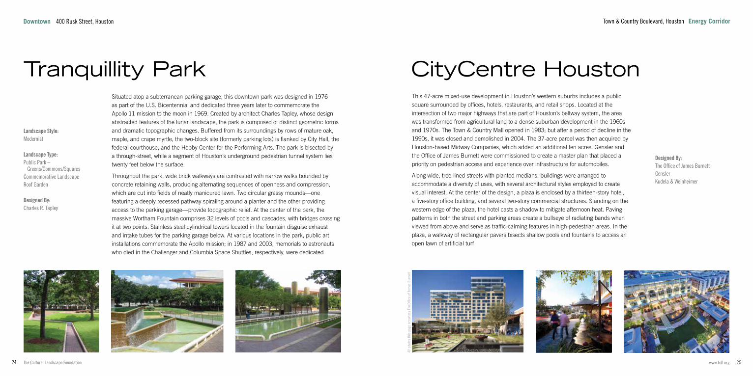
Situated atop a subterranean parking garage, this downtown park was designed in 1976 as part of the U.S. Bicentennial and dedicated three years later to commemorate the Apollo 11 mission to the moon in 1969. Created by architect Charles Tapley, whose design abstracted features of the lunar landscape, the park is composed of distinct geometric forms and dramatic topographic changes. Buffered from its surroundings by rows of mature oak, maple, and crape myrtle, the two-block site (formerly parking lots) is flanked by City Hall, the federal courthouse, and the Hobby Center for the Performing Arts. The park is bisected by a through-street, while a segment of Houston’s underground pedestrian tunnel system lies twenty feet below the surface.
Throughout the park, wide brick walkways are contrasted with narrow walks bounded by concrete retaining walls, producing alternating sequences of openness and compression, which are cut into fields of neatly manicured lawn. Two circular grassy mounds—one featuring a deeply recessed pathway spiraling around a planter and the other providing access to the parking garage—provide topographic relief. At the center of the park, the massive Wortham Fountain comprises 32 levels of pools and cascades, with bridges crossing it at two points. Stainless steel cylindrical towers located in the fountain disguise exhaust and intake tubes for the parking garage below. At various locations in the park, public art installations commemorate the Apollo mission; in 1987 and 2003, memorials to astronauts who died in the Challenger and Columbia Space Shuttles, respectively, were dedicated.
Tranquillity Park
All p
hoto
s th
is p
age
ccou
rtesy
The
Offi
ce o
f Jam
es B
urne
tt
Designed By:The Office of James Burnett Gensler Kudela & Weinheimer
This 47-acre mixed-use development in Houston’s western suburbs includes a public square surrounded by offices, hotels, restaurants, and retail shops. Located at the intersection of two major highways that are part of Houston’s beltway system, the area was transformed from agricultural land to a dense suburban development in the 1960s and 1970s. The Town & Country Mall opened in 1983; but after a period of decline in the 1990s, it was closed and demolished in 2004. The 37-acre parcel was then acquired by Houston-based Midway Companies, which added an additional ten acres. Gensler and the Office of James Burnett were commissioned to create a master plan that placed a priority on pedestrian access and experience over infrastructure for automobiles.
Along wide, tree-lined streets with planted medians, buildings were arranged to accommodate a diversity of uses, with several architectural styles employed to create visual interest. At the center of the design, a plaza is enclosed by a thirteen-story hotel, a five-story office building, and several two-story commercial structures. Standing on the western edge of the plaza, the hotel casts a shadow to mitigate afternoon heat. Paving patterns in both the street and parking areas create a bullseye of radiating bands when viewed from above and serve as traffic-calming features in high-pedestrian areas. In the plaza, a walkway of rectangular pavers bisects shallow pools and fountains to access an open lawn of artificial turf
CityCentre Houston
Town & Country Boulevard, Houston Energy CorridorDowntown 400 Rusk Street, Houston

27www.tclf.org26 The Cultural Landscape Foundation
Landscape Type:Public Park – Neighborhood ParkBoulevard
Designed By:Clark Condon Design WorkshopWalter P Moore
Located in the northwest section of Houston’s Midtown district, this park and street mark the transition from the high-rises of downtown to one of the oldest neighborhoods in the city. In the mid-1950s, a highway entrance ramp was installed nearby and Bagby Street became a busy four-lane road. The neighborhood underwent an economic decline in the 1980s, with residential parcels either converted to commercial uses or left vacant. In the mid-1990s, the area began to recover and the Midtown Redevelopment Authority was created. Stretching along Gray Street between Bagby and Brazos Streets, the 0.66-acre park was designed by landscape architecture firm Clark Condon. It included a sculptural water feature, a bosque of Spanish oak, a lawn, and shrubs around the perimeter.
In 2010, Design Workshop and Walter P Moore were commissioned to redesign the park and to improve the ten-block stretch of Bagby Street between Pierce and Tuam Streets. The firm opened the park to the surrounding streets to improve safety and access, removing perimeter plants but retaining mature canopy trees and adding red oak. A dog run was introduced and a food kiosk installed. Anchoring an improved lawn, a new water feature, boardwalks, and mist emitters animate the space. A large sign with programmable lighting and a stage have become a neighborhood icon. Along the length of Bagby Street, rain gardens were created to capture runoff, pedestrian crossings were enhanced, custom furniture was installed, and lane widths were reduced to slow traffic exiting the nearby freeway.
Bagby Park and Streetscape
All photos this page by Dale Horchner/Design Workshop Ph
oto
cour
tesy
Hou
ston
Par
ks a
nd R
ecre
atio
n De
partm
ent
Phot
o co
urte
sy H
oust
on P
arks
and
Rec
reat
ion
Depa
rtmen
t
Phot
o co
urte
sy W
hite
Oak
Stu
dio
Landscape Style:Postmodernist
Landscape Type:Commemorative LandscapePublic Park
Designed By:White Oak StudioPGAL
Completed in 2013, this 0.47-acre park is located on the site once occupied by Bethel Missionary Baptist Church, one of the oldest churches in Houston’s Fourth Ward, founded in a wood building constructed in 1891. After the church was destroyed in a hurricane in 1900, a similar structure was built, which burned in 1920. African American architect John Blount then designed a brick Gothic Revival church, which was built in 1923. In 1950, the congregation commissioned African American architect James Thomas to enlarge the church. In 1997, the structure was deemed unsound and the congregation relocated. A fire in 2005 left only three walls, the floor, and concrete pillars. The City of Houston acquired the parcel in 2009, stabilized the walls, and commenced planning a public park.
Houston-based landscape architecture firm White Oak Studio and the architecture firm PGAL collaborated on a design that preserved the ruins while creating a public amenity. The northern part of the park lies within the remains of the church walls. Steel trusses recall the form of the burned roof while preserving the park’s open-air quality. Colorful polycarbonate panels mimic stained glass windows while masonry benches—arranged to recall church pews—are positioned on an expanse of artificial turf that is bordered by masonry and concrete walks, the latter inscribed with phrases about community and history. Two fountains and decorative gates mark the southern limit of the former church, beyond which a greensward is flanked on two sides by seat walls and rows of sugar maple.
Bethel Park
801 Andrews Street, Houston Fourth WardFourth Ward 415 Gray Street, Houston

29www.tclf.org28 The Cultural Landscape Foundation
Photo by Barrett Doherty
Memorial Park 6003 Memorial Drive, Houston
Landscape Style:Beaux Arts / Neoclassical
Landscape Type:Garden and EstateCountry Place Era Garden
Designed By:Ruth LondonC.C. “Pat” FlemingFleming and SheppardJohn F. StaubEllen Shipman
Designation: National Register of Historic Places
In 1925, Ima Hogg and her brothers purchased 14.5 densely wooded acres in River Oaks, on a peninsular parcel that dramatically dropped down to Buffalo Bayou. In response to the site, architect John Staub centered the double-fronted house on a natural terrace, oriented to face the bayou. The thickly treed south entrance featured a curved drive and central lawn, while formal garden rooms were created to the north and east. The periphery was kept naturalistic, with trails winding through a woodland of native pine dogwood, and redbud. Landscape architect Ruth London created the East garden in 1932. The rectangular lawn, enclosed by a high hedge and adorned with pink azaleas, camellias, and blue pansies, features scrolled Japanese boxwood and a fountain with an octagonal basin.
Landscape architects Fleming and Sheppard, led by Pat Fleming and in consultation with Ellen Shipman, created the terraced north garden between 1937 and 1939. Grass-covered steps form an axis from the house, reaching toward a rectangular reflecting pool with arcing fountain jets. Terminating the axis is a marble statue of Diana, housed in an alcove framed by magnolias, azaleas, crape myrtles, low yaupon hedges and cylindrical Japanese yews. Two gardens lie on a cross axis: to the east lies a statue of Euterpe shaded by a towering sycamore, while a sculpture of Clio is centered in a parterre garden of concentric rings to the west. Today, the Museum of Fine Arts Houston operates the property as a museum. It was listed in the National Register of Historic Places in 1979.
Bayou Bend Collection and Gardens
6003 Memorial Drive, Houston Memorial Park

31www.tclf.org30 The Cultural Landscape Foundation
Photo by Steve Harris, courtesy Uptown Houston
6501 Memorial Drive, Houston Memorial Park
Landscape Type:Public Park – Large Municipal Park
Designed By:Hare & HareS. Herbert Hare John Bredemus Nelson Byrd Woltz Landscape Architects
Related Landscapes: Houston Arboretum and Nature Center
Related Institutions: Works Progress Administration
Because of its position on the north bank of the Buffalo Bayou, the site was a center of industry in Houston’s early days and, by the turn of the century, was a convergence point for passenger and freight railroads. During World War I, the War Department leased the wooded property for use as Camp Logan. The land was graded and cleared for the construction of temporary structures with capacity for more than 20,000 soldiers. In 1918, a hospital for veterans was established and a nine-hole golf course was built.
After the war, Catherine Emmott called for the property to be used for public enjoyment. The Hogg family purchased 1,503 acres in 1924 and sold it to the City for use as a park. Hare & Hare developed a master plan that included recreation areas, scenic drives, bridle paths, gardens, and an expanded golf course. In 1935, with the closing of the hospital, John Bredemus designed a 250-acre eighteen-hole golf course constructed by the Works Progress Administration. In the 1940s, the park was bisected by the construction of the east-west Memorial Drive; 265 acres on the western side of the park were set aside in 1951 to establish the Houston Arboretum and Nature Center. After decades of use, an advisory committee was established, which became the Memorial Park Conservancy in 2000. Nelson Byrd Woltz Landscape Architects was commissioned to develop a master plan in 2015. Today, the park—comprising a hardwood forest and dramatic topography—includes a tennis center, indoor pool facilities, trails, and playgrounds.
Memorial Park
Memorial Park 6501 Memorial Drive, Houston
Photos by Steve Harris, courtesy Uptown Houston
Located northwest of downtown, this 1,500-acre public park was created in 1924 and named to commemorate the military base that once occupied the site.
33www.tclf.org32 The Cultural Landscape Foundation
Photo by Dale Horchner/Design Workshop
Memorial Park 4501 Woodway Drive, Houston
Landscape Type:Arboretum
Designed By:Design WorkshopReed HilderbrandLake Flato Architects
Related Landscape: Memorial Park
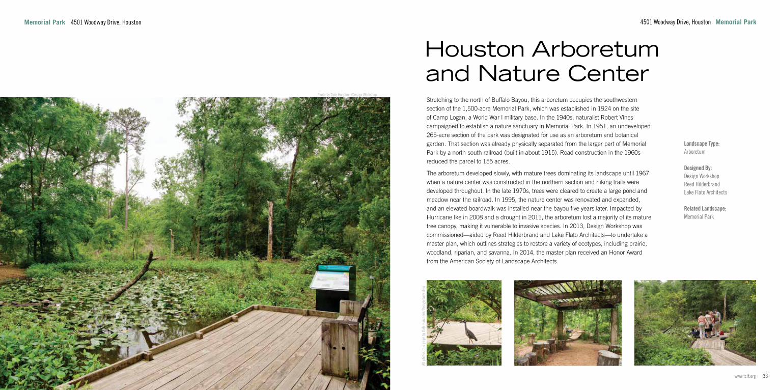
Stretching to the north of Buffalo Bayou, this arboretum occupies the southwestern section of the 1,500-acre Memorial Park, which was established in 1924 on the site of Camp Logan, a World War I military base. In the 1940s, naturalist Robert Vines campaigned to establish a nature sanctuary in Memorial Park. In 1951, an undeveloped 265-acre section of the park was designated for use as an arboretum and botanical garden. That section was already physically separated from the larger part of Memorial Park by a north-south railroad (built in about 1915). Road construction in the 1960s reduced the parcel to 155 acres.
The arboretum developed slowly, with mature trees dominating its landscape until 1967 when a nature center was constructed in the northern section and hiking trails were developed throughout. In the late 1970s, trees were cleared to create a large pond and meadow near the railroad. In 1995, the nature center was renovated and expanded, and an elevated boardwalk was installed near the bayou five years later. Impacted by Hurricane Ike in 2008 and a drought in 2011, the arboretum lost a majority of its mature tree canopy, making it vulnerable to invasive species. In 2013, Design Workshop was commissioned—aided by Reed Hilderbrand and Lake Flato Architects—to undertake a master plan, which outlines strategies to restore a variety of ecotypes, including prairie, woodland, riparian, and savanna. In 2014, the master plan received an Honor Award from the American Society of Landscape Architects.
Houston Arboretum and Nature Center
All p
hoto
s th
is p
age
by D
ale
Horc
hner
/Des
ign
Wor
ksho
p
4501 Woodway Drive, Houston Memorial Park

35www.tclf.org34 The Cultural Landscape Foundation
Photo by Barrett Doherty
1406 Kirby Drive, Houston Memorial Park
Landscape Style:Beaux-Arts / Neoclassical
Landscape Type:Garden and Estate – Picturesque Garden
Designed By:Ralph Ellis GunnJohn F. StaubGarden Club of Houston Thompson + Hanson Landscape Architects
The site was designed in 1952 for philanthropists Carroll and Harris Masterson III and named for Mr. Masterson’s grandfather, politician Rienzi Johnston. Observing the classical notions of centrality, form, and symmetry while echoing the property’s natural geologic formation and plant communities, the split-level house was situated amidst formal and naturalistic gardens on a descending bank of terraces.
With steep, wooded ravines on both sides, the house is approached via a picturesque drive providing glimpses of the gardens and surroundings. Low, serpentine walls enclose the gardens and provide stabilization of the steep terrain. Nested into the ravine on the east side of the house, a garden room encloses two parallel sets of stone stairs flanking a shallow rectangular pool. A formal boxwood parterre garden and fountain enhances the west side. The rear of the house is dominated by a pool set into lawns and the entire grounds are planted with beech, magnolias, oaks, and loblolly pines. In 1997 the property was donated to the Museum of Fine Arts, Houston, which maintains the gardens and exhibits European decorative arts inside the house. At that time, the Garden Club of Houston and Thompson + Hanson Landscape Architects assumed care of the gardens. In 2003, a bulb garden inspired by Belgian botanist Pierre-Joseph Redouté’s watercolors was installed for educational programming.
Rienzi House Museum
Memorial Park 1406 Kirby Drive, Houston
Responding to the dramatic topography of the ravines leading to Houston’s Buffalo Bayou, landscape architect Ralph Gunn collaborated with architect John Staub to develop this 4.4-acre property in the affluent River Oaks Community.

37www.tclf.org36 The Cultural Landscape Foundation
Photo by Barrett Doherty
Museum District North, South, and West Boulevards, Houston
Landscape Style:Beaux Arts / Neoclassical
Landscape Type:Suburb
Designed By:William Ward WatkinC.C. “Pat” FlemingJohn StaubBirdsall BriscoeBonner Means BakerEllen ShipmanJ. Allen Myers, Jr.
Designation: National Register of Historic Places
Lying just north of Rice University in Houston’s South End, this neighborhood comprises 25 large lots for single-family houses, a park, and harmonious boulevards lined with live oak. Captain James Baker purchased land for the 34-acre residential development in 1908. Between 1923 and 1930, eighteen houses were constructed, variously designed by architects William Ward Watkin, John Staub, and Birdsall Briscoe. Another seven houses were built between the end of the Great Depression and the early 1950s.
Watkin also designed entry pillars for the neighborhood and provided its overall design and plan: Along its eastern edge, he laid out a 2.5-acre trapezoidal park with groves of trees, open lawns, and a tennis court. Houses were organized around a U-shaped network of three boulevards. Developed with Bonner Means Baker (James Baker, Jr.’s wife), Watkin’s design for the boulevards comprised two one-way roads separated by wide, grassy medians with brick walks extending along their central axes. The boulevards and medians were lined with a staggered arrangement of live oak that formed a dramatic, rhythmic sequence at street level and an interlaced canopy overhead. Lot sizes ranged from four-fifths of an acre to two acres, houses were set 60 feet from the boulevards, and utilities were buried. Most houses were fronted by large lawns; landscape architects Ellen Shipman, C.C. “Pat” Fleming, and J. Allen Myers, Jr., each designed residential gardens in the neighborhood in the 1920s and 1930s.
Broadacres Historic District
North, South, and West Boulevards, Houston Museum District
Retaining a high degree of its historic character, the Broadacres Historic District was listed in the National Register of Historic Places in 1980.

39www.tclf.org38 The Cultural Landscape Foundation
Photo courtesy Hermann Park Conservancy
6001 Fannin Street, Houston Museum District
Landscape Style:PicturesqueBeaux-Arts / Neoclassical
Landscape Type:Public Park – Large Municipal Park
Designed By:George E. KesslerHare & HareS. Herbert HareSidney HareC.C. “Pat” FlemingHanna/OlinSWA Group
Related Landscapes: Hermann Park Japanese GardenMcGovern Centennial Gardens & Cherie Flores Garden Pavilion
The park is situated on the banks of Brays Bayou and across Main Street from Rice University on land donated by Parks Commissioner George Hermann in 1914. Mayor H. Baldwin Rice, a champion of the City Beautiful Movement, retained George Kessler in 1916 to transform the flat, vacant site into a park. Kessler’s design incorporated diagonal boulevards flanked by allées of live oaks, oval athletic fields, an outdoor theater, carriage trails, a golf course, and an artificial lake called the Grand Basin. The park entrance was established at the intersection of Main and Montrose Boulevards, adjacent to a landscaped traffic circle known as the Sunken Garden. When Kessler died in 1923, Hare & Hare took over as the landscape architects. They added a zoo and a botanical garden while maintaining the integrity of Kessler’s original vision for the landscape.
By the 1980s, Hermann Park was in poor condition. After a master plan by architect Charles Moore went unimplemented, the Heart of the Park design competition was instigated. In 1993, Hanna/Olin won the commission for the new master plan, which reinforced the historic core of the landscape while restructuring the pedestrian and vehicular circulation. SWA Group also served as a consultant on the revitalization project, focusing in particular on the renovation of the park’s central reflecting pool. In 2005, SWA Group and Hanna/Olin received the Design Award of Excellence from the American Society of Landscape Architects. Today, Hermann Park is managed by the Hermann Park Conservancy and the Houston Parks and Recreation Department.
Hermann Park
Museum District 6001 Fannin Street, Houston
Photo courtesy Hermann Park Conservancy
Photo courtesy Hermann Park Conservancy
Photo by Nash Baker
Spanning 445 acres within the city’s Museum District, the park is one of Houston’s most significant public green spaces.

41www.tclf.org40 The Cultural Landscape Foundation
Photo courtesy Hermann Park Conservancy
Museum District 6000 Fannin Street, Houston
Landscape Style:Japanese
Landscape Type:Public Park
Designed By:Takeshi “Ken” NakajimaLauren GriffithTerunobu NakaiHiroshi IwasakiAsakura Robinson
Related Landscape: Hermann Park
Occupying a 5.5-acre section in the northwest quadrant of Hermann Park, this strolling garden was opened in 1992. The prime minister of Japan visited Houston in 1990, and donated a traditional teahouse to the City. Preserving an existing pine grove, landscape architect Takeshi “Ken” Nakajima designed the garden to serve as the setting for the teahouse. Local landscape architect Lauren Griffith selected native plants that would thrive in Houston’s climate.
Drawing from seventeenth-century traditions, the garden comprises sculpted plantings, interconnected lakes, and Japanese structures, as well as vantage points that capitalize on borrowed scenery. A network of gravel paths traverses the undulating topography to reveal the garden as a sequence. Other elements include a waterfall carved into pink granite, yukimi lanterns (short stone lanterns with broad caps positioned near water features), a traditional entrance gate, and large boulders sandblasted with calligraphy providing a welcome message. Specimen trees such as flowering dogwood, Japanese maple, crape myrtle, red bud, and cherry are interspersed amidst oak and pine and complemented by iris, azalea, and camellia. In 2006, landscape architect Terunobu Nakai and gardener Hiroshi Iwasaki updated the garden (based on Nakajima’s original drawings) and provided training for the volunteers who maintain the delicately pruned plants. The Japanese government gave twenty cherry trees to Hermann Park in 2012, on the centennial of its earlier gift of cherries (planted in Washington, D.C.) to the United States.
Hermann Park Japanese Garden
Phot
o co
urte
sy H
erm
ann
Park
Con
serv
ancy
Phot
o co
urte
sy H
erm
ann
Park
Con
serv
ancy
6000 Fannin Street, Houston Museum District
Although Hare & Hare’s plan for Hermann Park, published in 1930, indicated that a “Japanese Garden” should be developed near Grand Basin (now McGovern Lake), six decades passed before the suggestion was realized.
43www.tclf.org42 The Cultural Landscape Foundation
Photo courtesy Hermann Park Conservancy
1500 Hermann Park Drive, Houston Museum District
Landscape Style:Modernist
Landscape Type:Public ParkBotanical Garden
Designed By:Doug HoerrHoerr SchaudtWhite Oak StudioPeter BohlinBohlin Cywinski Jackson
Related Landscape: Hermann Park
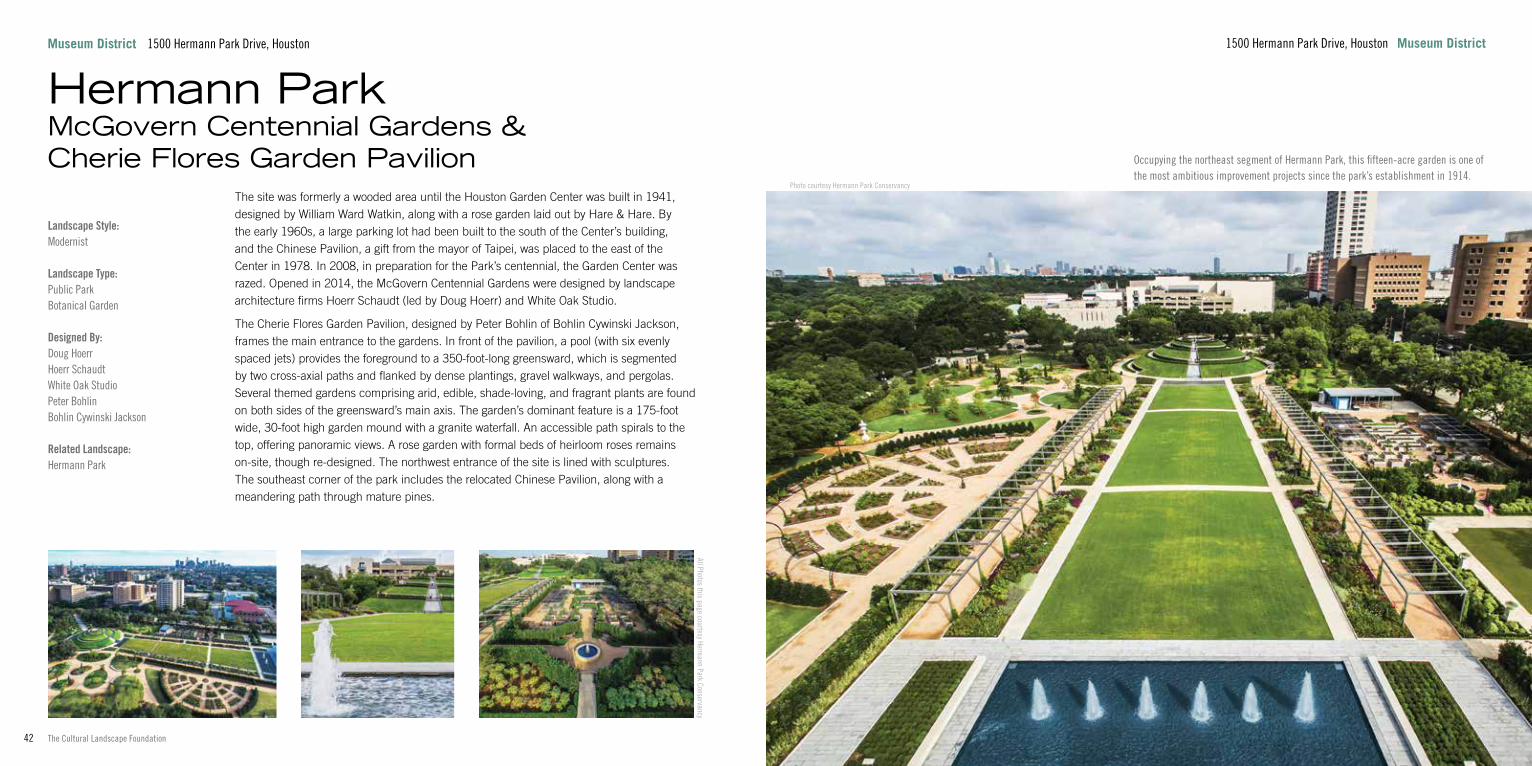
The site was formerly a wooded area until the Houston Garden Center was built in 1941, designed by William Ward Watkin, along with a rose garden laid out by Hare & Hare. By the early 1960s, a large parking lot had been built to the south of the Center’s building, and the Chinese Pavilion, a gift from the mayor of Taipei, was placed to the east of the Center in 1978. In 2008, in preparation for the Park’s centennial, the Garden Center was razed. Opened in 2014, the McGovern Centennial Gardens were designed by landscape architecture firms Hoerr Schaudt (led by Doug Hoerr) and White Oak Studio.
The Cherie Flores Garden Pavilion, designed by Peter Bohlin of Bohlin Cywinski Jackson, frames the main entrance to the gardens. In front of the pavilion, a pool (with six evenly spaced jets) provides the foreground to a 350-foot-long greensward, which is segmented by two cross-axial paths and flanked by dense plantings, gravel walkways, and pergolas. Several themed gardens comprising arid, edible, shade-loving, and fragrant plants are found on both sides of the greensward’s main axis. The garden’s dominant feature is a 175-foot wide, 30-foot high garden mound with a granite waterfall. An accessible path spirals to the top, offering panoramic views. A rose garden with formal beds of heirloom roses remains on-site, though re-designed. The northwest entrance of the site is lined with sculptures. The southeast corner of the park includes the relocated Chinese Pavilion, along with a meandering path through mature pines.
Hermann Park McGovern Centennial Gardens & Cherie Flores Garden Pavilion
Museum District 1500 Hermann Park Drive, Houston
All Photos this page courtesy Hermann Park Conservancy
Occupying the northeast segment of Hermann Park, this fifteen-acre garden is one of the most ambitious improvement projects since the park’s establishment in 1914.
45www.tclf.org44 The Cultural Landscape Foundation
Photo by Charles A. Birnbaum
Museum District Bissonnet Street and Montrose Boulevard, Houston
Landscape Style:Modernist
Landscape Type:Institutional Grounds - Cultural
Designed By:Isamu NoguchiJohnny Steele
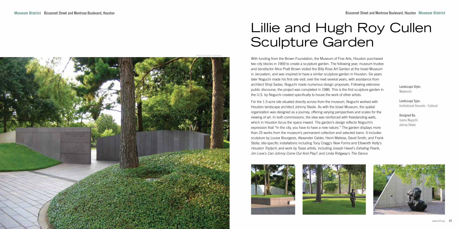
With funding from the Brown Foundation, the Museum of Fine Arts, Houston purchased two city blocks in 1969 to create a sculpture garden. The following year, museum trustee and benefactor Alice Pratt Brown visited the Billy Rose Art Garden at the Israel Museum in Jerusalem, and was inspired to have a similar sculpture garden in Houston. Six years later Noguchi made his first site visit; over the next several years, with assistance from architect Shoji Sadao, Noguchi made numerous design proposals. Following extensive public discourse, the project was completed in 1986. This is the first sculpture garden in the U.S. by Noguchi created specifically to house the work of other artists.
For the 1.5-acre site situated directly across from the museum, Noguchi worked with Houston landscape architect Johnny Steele. As with the Israel Museum, the spatial organization was designed as a journey, offering varying perspectives and scales for the viewing of art. In both commissions, the idea was reinforced with freestanding walls, which in Houston focus the space inward. The garden’s design reflects Noguchi’s expression that “In the city, you have to have a new nature.” The garden displays more than 25 works from the museum’s permanent collection and selected loans. It includes sculpture by Louise Bourgeois, Alexander Calder, Henri Matisse, David Smith, and Frank Stella; site-specific installations including Tony Cragg's New Forms and Ellsworth Kelly's Houston Triptych; and work by Texas artists, including Joseph Havel's Exhaling Pearls, Jim Love's Can Johnny Come Out And Play?, and Linda Ridgway's The Dance.
Lillie and Hugh Roy Cullen Sculpture Garden
Bissonnet Street and Montrose Boulevard, Houston Museum District

47www.tclf.org46 The Cultural Landscape Foundation
Photo by Kevin Keim, courtesy the Menil Collection
1533 Sul Ross St, Houston Museum District
Landscape Style:Modernist
Landscape Type:Institutional Grounds – CulturalContemporary Earthwork
Designed By:Philip JohnsonEugene AubryHoward BarnstoneRenzo PianoMichael HeizerFrancois de Menil Michael Van Valkenburgh Associates
Designation: National Register of Historic Places
Established on farmland at the beginning of the twentieth century, by the 1950s the neighborhood comprised residential bungalows along streets lined with live oak. John and Dominique de Menil began acquiring properties in the 1950s and, in 1964, they commissioned Mark Rothko to create fourteen paintings and to collaborate with architect Philip Johnson to design a building to house the completed artwork. Dedicated in 1971, the Rothko Chapel was positioned at the intersection of two streets, fronted by a plaza and a reflecting pool with sculptor Barnett Newman’s Broken Obelisk, and buffered by a stand of bamboo. The Chapel was listed in the National Register of Historic Places in 2001. In the early 1970s, Louis Khan and Harriett Pattison developed conceptual plans for the neighborhood, the campus, and a gallery, but their design was not realized.
In 1987, the main gallery was opened, designed by Renzo Piano. Occupying an entire city block and offset by three art installations by Michael Heizer, the gallery harmonizes with the surrounding neighborhood. Between the gallery and the chapel lies an open park shaded by mature canopy trees and ornamented with sculptural installations. In 1995, the Cy Twombly Gallery was opened adjacent to the main gallery. Two years later, the Byzantine Fresco Chapel (designed by architect Francois de Menil) was opened just southeast of the Rothko Chapel. A year later, a nearby grocery store was adapted to house a permanent installation by artist Dan Flavin. In 2013, Michael Van Valkenburgh Associates commenced the development of a master plan for the entire campus.
Menil Collection Campus
Museum District 1533 Sul Ross St, Houston
Photo by Kevin Keim, courtesy the M
enil Collection
Photo by Kevin Keim, courtesy the M
enil Collection
This 30-acre campus in the Montrose neighborhood southwest of downtown Houston provides a serene setting for several buildings that house the Menil Collection.

49www.tclf.org48 The Cultural Landscape Foundation
Photo by Charles A. Birnbaum
Museum District 3800 Montrose Boulevard, Houston
Landscape Style:Modernist
Landscape Type:Campus
Designed By:Philip Johnson
Located in the Montrose area of Houston, the university campus was originally sited in the 1912 Link-Lee mansion. When John and Dominique de Menil, renowned Houston philanthropists, turned their attention to creating a permanent, full service campus for the Catholic liberal arts university in the early 1950s, they instinctively thought of Philip Johnson, who had just completed their San Felipe Road residence, to design a campus master plan. After interviewing several architects, the selection committee chose Johnson.
Johnson based his concept on Thomas Jefferson’s Academical Village for the University of Virginia, expressed in the language of Mies van der Rohe’s Illinois Institute of Technology, which was begun over a decade before the plan for the University of St. Thomas. The master plan called for a campus stretching three blocks from north to south, with a central green or “mall.” Buildings connected by a continuous colonnade enclose the mall, with a chapel completing the southern end. The linear configuration of the campus allowed the university to add new buildings as funds allowed. The two-story, exposed steel column-and-beam structure buildings, three of which were started in 1958, are inspired by van der Rohe's work at IIT but with Johnson's own interpretation of the style. The campus, dedicated in 1958, is a strong example of the International Style in Houston.
University of St. Thomas
3800 Montrose Boulevard, Houston Museum District

51www.tclf.org50 The Cultural Landscape Foundation
Photo courtesy Rice University
6100 Main Street, Houston Museum District
Landscape Style:Beaux-Arts / Neoclassical
Landscape Type:Campus – Quadrangle Plan
Designed By:Ralph Adams CramRobert White
Related Landscape: Raymond and Susan Brochstein Pavilion
Rice Institute was chartered in 1907 and opened to students in 1912. Led by college president Edgar Odell Lovett, Rice was modeled after British residential colleges. The campus was laid out on a triangular parcel comprising 277 acres of flat coastal plain, with a master plan conceived by Ralph Adams Cram. Cram’s Beaux-Arts-inspired General Plan from 1910 offered a series of formalized quadrangles centered upon a primary east-west spine, flanked by parallel secondary axes and cross-axes. The main quad, Academic Court, was approached by an extended entrance drive planted with live oaks and Formosa azaleas. The Academic Court was planted with privet hedge parterres and Italian cypresses and edged on three sides by live oaks. The entire grounds followed suit, planted with privet hedges and trees in orderly rows, while buildings were constructed in a neo-Byzantine style, using the same striated brick and marble and featuring arcades that provided covered passages.
Following World War II the campus moved to a more automobile-focused model. The Cram plan was intentionally disrupted with the placement of Fondren Library in the middle of the central spine, physically closing Academic Court. From 1957 to 1960, landscape architect Robert White introduced a varied planting plan with trees placed informally, eschewing rows. As the campus expanded in the late 20th century, modern architectural styles and decentralized building clusters were implemented. Today, the campus comprises 285 densely wooded acres.
Rice University
Museum District 6100 Main Street, Houston
All photos this page courtesy Rice University
In 1891, Texas real-estate developer William Marsh Rice dedicated his fortune to establishing a modern and secular institute of higher education.
53www.tclf.org52 The Cultural Landscape Foundation
Photo by Hester + Hardaway
Museum District Central Quadrangle, Rice University, Houston
Landscape Style:Modernist
Landscape Type:Plaza
Designed By:The Office of James BurnettThomas Phifer and Partners
Related Landscape: Rice University
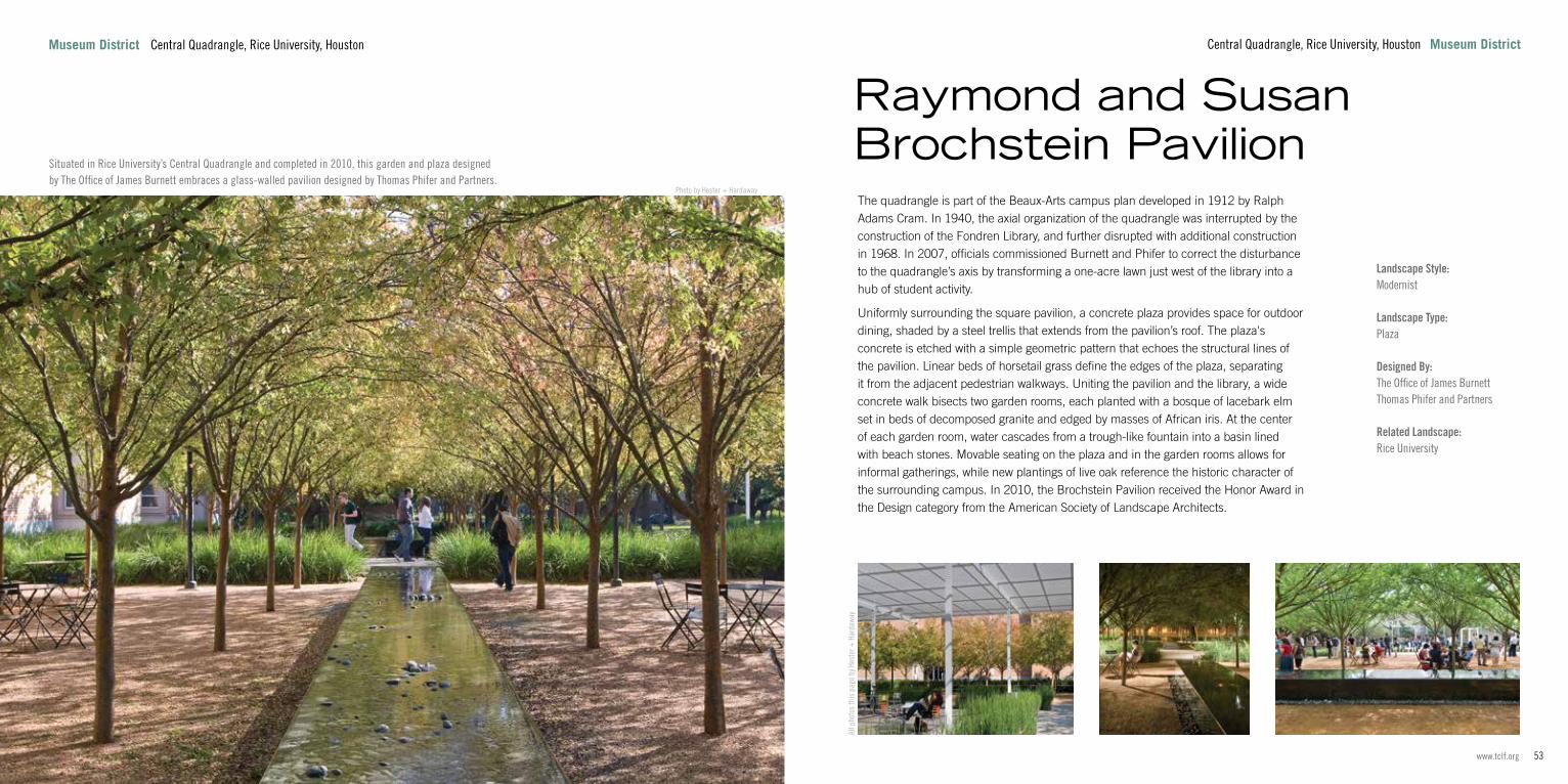
The quadrangle is part of the Beaux-Arts campus plan developed in 1912 by Ralph Adams Cram. In 1940, the axial organization of the quadrangle was interrupted by the construction of the Fondren Library, and further disrupted with additional construction in 1968. In 2007, officials commissioned Burnett and Phifer to correct the disturbance to the quadrangle’s axis by transforming a one-acre lawn just west of the library into a hub of student activity.
Uniformly surrounding the square pavilion, a concrete plaza provides space for outdoor dining, shaded by a steel trellis that extends from the pavilion’s roof. The plaza's concrete is etched with a simple geometric pattern that echoes the structural lines of the pavilion. Linear beds of horsetail grass define the edges of the plaza, separating it from the adjacent pedestrian walkways. Uniting the pavilion and the library, a wide concrete walk bisects two garden rooms, each planted with a bosque of lacebark elm set in beds of decomposed granite and edged by masses of African iris. At the center of each garden room, water cascades from a trough-like fountain into a basin lined with beach stones. Movable seating on the plaza and in the garden rooms allows for informal gatherings, while new plantings of live oak reference the historic character of the surrounding campus. In 2010, the Brochstein Pavilion received the Honor Award in the Design category from the American Society of Landscape Architects.
Raymond and Susan Brochstein Pavilion
All p
hoto
s th
is p
age
by H
este
r + H
arda
way
Central Quadrangle, Rice University, Houston Museum District
Situated in Rice University’s Central Quadrangle and completed in 2010, this garden and plaza designed by The Office of James Burnett embraces a glass-walled pavilion designed by Thomas Phifer and Partners.

55www.tclf.org54 The Cultural Landscape Foundation
Photo by Dale Horchner/Design Workshop
Uptown District, Houston Uptown
Landscape Type:Boulevard
Designed By:SWA GroupDesign Workshop
Related Landscape: Gerald D. Hines Waterwall Park
By the 1940s and 1950s, suburbs such as Afton Oaks and Tanglewood were beginning to extend Houston’s cityscape into the surrounding farmland. Post Oak Boulevard was, at that time, a two-lane asphalt road paralleled by drainage ditches and passing through open prairie and farms. In the 1960s, developer Gerald Hines began to develop a commercial center on remnant farmland lying on both sides of the boulevard. In 1970, his 600,000-square-foot Galleria shopping mall opened at the corner of Post Oak Boulevard and Westheimer Road. By 1983, the area had experienced such growth that three 24-story buildings on a seventeen-acre site, a 64-story office tower, and the 64-foot-tall Waterwall sculptural fountain (all designed by Philip Johnson) did not seem out of place. Post Oak Boulevard was a wide, six-lane artery with a grassy median but without trees or sidewalks.
In 1987, the Uptown Houston District was formed by the Texas Legislature to manage and improve economic and infrastructural development of the 500-acre area that encompasses Post Oak Boulevard. By the mid-1990s with bond funding, the boulevard’s streetscape, designed by SWA Group, had been improved with oak and flowerbed plantings, the installation of sidewalks and custom lighting, and the burying of utility lines. Massive stainless steel arches and rings designed by Communications Arts (now Stantec) were positioned at intersections while public art and pocket parks were added to create a pedestrian-friendly environment. In 2013, Design Workshop was commissioned to create a master plan that addresses transit and pedestrian concerns along Post Oak Boulevard.
Post Oak Boulevard
Uptown Uptown District, Houston
Photo by Dale Horchner/Design Workshop
Photo by Dale Horchner/Design Workshop
Photo courtesy Uptown Houston
Stretching two miles through the Uptown district west of downtown, this north-south boulevard is flanked on both sides by upscale mixed-use development.

57www.tclf.org56 The Cultural Landscape Foundation
Photo by Barrett Doherty
Uptown 2800 Post Oak Boulevard, Houston
Landscape Style:Postmodernist
Landscape Type:Public Park – Vest Pocket Park
Designed By:SWA GroupPhilip JohnsonJohn Burgee Architects
Related Landscape: Post Oak Boulevard
Designed by SWA Group and completed in 1985, this 2.77-acre park in the Uptown District frames the 64-foot-high, sculptural fountain popularly known as the Waterwall. The site was developed in the early 1980s by real estate magnate Gerald Hines, who commissioned a fountain to be built within a park-like setting adjacent to the nearby Williams Tower (formerly Transco Tower), commissioned by Hines at the same time.
The park’s sole architectural feature, the 64-foot-high, semi-circular Postmodernist fountain was designed by John Burgee Architects with Philip Johnson. Re-circulated water pours curtain-like over its inner and outer surfaces at the rate of 11,000 gallons per minute. The concave side of the fountain is enclosed by a low, pedimented arcade (the so-called scaenae frons) defined by centralized steps, with the whole form recalling an ancient Roman theater. The falling water creates noticeably cooler temperatures within the enclosure. On the convex side, channels of water cascade into a shallow pool set into a semi-circular, paved apron. The Waterwall sits opposite the south façade of Williams Tower, with the two united by an expansive sunken lawn that monumentalizes the approach to each. Flanked by a pair of linear walkways, the lawn and the fountain are embraced on three sides by 186 live oaks, set in a quadruple allée. In 2008 the City of Houston purchased the Waterwall and surrounding land from Hines and one year later re-named the site to honor him for his many civic contributions.
Gerald D. Hines Waterwall Park
2800 Post Oak Boulevard, Houston Uptown

59www.tclf.org58 The Cultural Landscape Foundation
Photo courtesy Clark Condon
9320 Lakeside Boulevard, The Woodlands Woodlands
Landscape Type:Suburb
Designed By:Ian McHargWallace McHarg Roberts & ToddKarl KamrathRobert HeinemanWilliam Pereira & AssociatesClark Condon
Related Landscape: The Woodlands Town Center
Located approximately 28 miles north of Houston, this 25,000-acre community was developed by oil and gas tycoon George Mitchell. Concerned about suburban sprawl and inner city decay, Mitchell aspired to develop The Woodlands in a more economically and environmentally balanced manner.
The project was partially financed under the Housing and Urban Development Act’s Title VII amendment. Preliminary plans were prepared in 1966 by architect Karl Kamrath, with Wallace, McHarg, Roberts and Todd (WMRT) brought on to do extensive ecological analysis and design in 1970. Led by Ian McHarg, WMRT’s diverse team consisted of geologists, hydrologists, and design professionals. The development was subdivided into villages, each with its own schools, places of worship, shops, parks, and greenways. Curvilinear streets were laid out to respond to the area’s many natural creeks and streams, with houses and other structures built to preserve as much of the dense loblolly pine woodland as possible. Efforts to utilize natural drainage systems and limit runoff are a hallmark of the design, and proved more cost-effective than curb and gutter drainage systems. Commercial development was clustered in village centers and the busier intersection with Interstate 45, and includes retail, office, healthcare and hospitality facilities along with park amenities. With the first houses completed in 1974, The Woodlands now includes a mix of housing types spread out over nine villages, a 1900-acre nature preserve, 200 miles of pathways, seven golf courses, 200-acre Lake Woodlands, 125 parks, and entertainment and shopping venues.
The Woodlands
Woodlands 9320 Lakeside Boulevard, The Woodlands

61www.tclf.org60 The Cultural Landscape Foundation
Photo courtesy Clark Condon
Woodlands Lake Robbins Drive, The Woodlands
Landscape Style:Postmodernist
Landscape Type:Waterfront DevelopmentPublic Park
Designed By:Robert HeinemanSasaki AssociatesClark Condon
Related Landscape: The Woodlands
This 1,000-acre mixed-use development in The Woodlands is bisected by a constructed canal called the Waterway, which is used for transportation between residential, commercial, entertainment, and office districts. When The Woodlands was conceived in the 1970s, the area now occupied by Town Center was a dense forest. In 1972, architect Robert Heineman developed a conceptual plan for the area, which included a centralized transit axis that would connect office and residential clusters. In the 1980s, a natural depression (now the 200-acre Lake Woodlands) was engineered to function as flood control and to serve as a recreational amenity. Funded by federal grants, a 1.2-mile-long canal was then constructed between Lake Woodlands and a smaller manmade waterbody, Lake Robbins, on the east. In 1990, a performance pavilion was constructed on the Waterway and, four years later, the Woodlands Mall opened to the north of Lake Robins. Commercial and corporate investment followed, resulting in a build out of Town Center with numerous high-rises.
In 2003, Sasaki Associates was commissioned to develop a master plan to address transportation and public open-space issues. As part of that project, the firm designed the one-acre Waterway Square, which comprises trees planted on a grid, expansive lawns, and a central water feature with choreographed fountains, lighting, and music. Along the Waterway, landscape architecture firm Clark Condon designed pedestrian bridges, water-taxi turning basins, lighting, and fountains. Scattered throughout Town Center, several small parks provide opportunities for active and passive recreation.
The Woodlands Town Center
Phot
o co
urte
sy C
lark
Con
don
Phot
o co
urte
sy C
lark
Con
don
Lake Robbins Drive, The Woodlands Woodlands
63www.tclf.org62 The Cultural Landscape Foundation
What’s Out There® Weekend highlights North America's rich and diverse landscape heritage through a series of free interpretive tours led by expert guides. Hosted in different cities every year, What’s Out There Weekend brings to light the unique landscape legacy and local character of each city, defined by its publicly accessible parks, gardens, plazas, cemeteries, memorials, and neighborhoods. An extension of the What’s Out There database, What’s Out There Weekend provides people with new ways to experience first-hand the landscapes that they see every day but often overlook.
tclf.org/landscapes Go online to learn more about the sites in this guide and What’s Out There.
tclf.org/publications Get more guidebooks in the What's Out There series.
Designed by Oviatt Media, this guidebook is the result of the scholarly support and photography provided by Charles Birnbaum, Scott Craver, Barrett Doherty, Matthew Traucht, and Nord Wennerstrom.
All photos by The Cultural Landscape Foundation, unless otherwise noted.
Cover: Photo by Jonnu Singleton, courtesy SWA Group
Left: Photo by John Gollings Photography, courtesy Hargreaves Associates
Lead Sponsors
Supporting SponsorsAsakura Robinson
Buffalo Bayou Partnership
Environmental Design, Inc.
Hermann Park Conservancy
Lake | Flato Architects
Landscape Forms
Memorial Park Conservancy
Millis Development &
Construction, Inc.
Suzanne Turner Associates
Walter P Moore
Presenting SponsorsClark Condon
Ben and Cynthia Guill
Houston First
Houston Parks and Recreation Department
Maglin Site Furniture
Museum of Fine Arts Houston
Nelson Byrd Woltz Landscape Architects
Reed Hilderbrand LLC
West 8
Partners in Education Rice Design Alliance
Rice School of Architecture
Texas Chapter of the American Society of Landscape Architects
Annual Sponsor
The production of this guidebook was made possible through the generous support of Sterling Associates and Chilton Capital Management.
Support for the Houston Transformation conference provided by:

The Cultural Landscape Foundation www.tclf.org