what’s new for quick terrain modeler version...
TRANSCRIPT
Applied Imagery • www.appliedimagery.com • [email protected] • (301) 589‐4446
What’s New for Quick Terrain Modeler Version 8.1.0.0 Applied Imagery is pleased to announce the release of QT Modeler v8.1.0. This is a huge release for us, adding some extremely powerful point cloud classification and feature extraction tools, totally revamping how textures (2D Imagery files) are loaded, and upgrading the interfaces of any tool that has a palette in it (e.g., height color, slope analysis). DoD users will like the new GRG tool. Read on for more info.
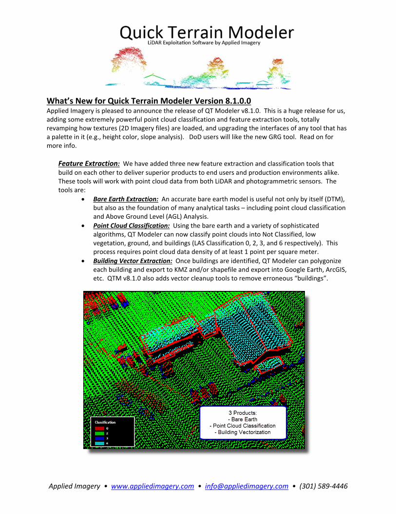
Feature Extraction: We have added three new feature extraction and classification tools that
build on each other to deliver superior products to end users and production environments alike. These tools will work with point cloud data from both LiDAR and photogrammetric sensors. The tools are:
Bare Earth Extraction: An accurate bare earth model is useful not only by itself (DTM), but also as the foundation of many analytical tasks – including point cloud classification and Above Ground Level (AGL) Analysis.
Point Cloud Classification: Using the bare earth and a variety of sophisticated algorithms, QT Modeler can now classify point clouds into Not Classified, low vegetation, ground, and buildings (LAS Classification 0, 2, 3, and 6 respectively). This process requires point cloud data density of at least 1 point per square meter.
Building Vector Extraction: Once buildings are identified, QT Modeler can polygonize each building and export to KMZ and/or shapefile and export into Google Earth, ArcGIS, etc. QTM v8.1.0 also adds vector cleanup tools to remove erroneous “buildings”.

Applied Imagery • www.appliedimagery.com • [email protected] • (301) 589‐4446
Imagery Streaming: Overlaying textures from large image files will now dynamically stream increased image detail to QT Modeler without having to manually sharpen the image (texture). This will be most apparent when overlaying large SID files and zooming in. Increasing levels of detail will appear automatically without having to click the “Resample Texture” button (much like the experience when zooming in on Google Earth/Maps). This feature also enables customizable, simple, high resolution image export for georegistered screen grabs and other custom 2D image export products and AVI movies. Revised Above Ground Level (AGL) Analyst Tool: QT Modeler’s AGL Analyst tool has been significantly improved. It now offers a variety of bare earth calculation methodologies, as well as a tabbed interface and more intuitive workflow for removing points based on AGL values (e.g., vegetation, buildings) – temporarily or permanently. There is no longer a need to open a second window for point filtering.
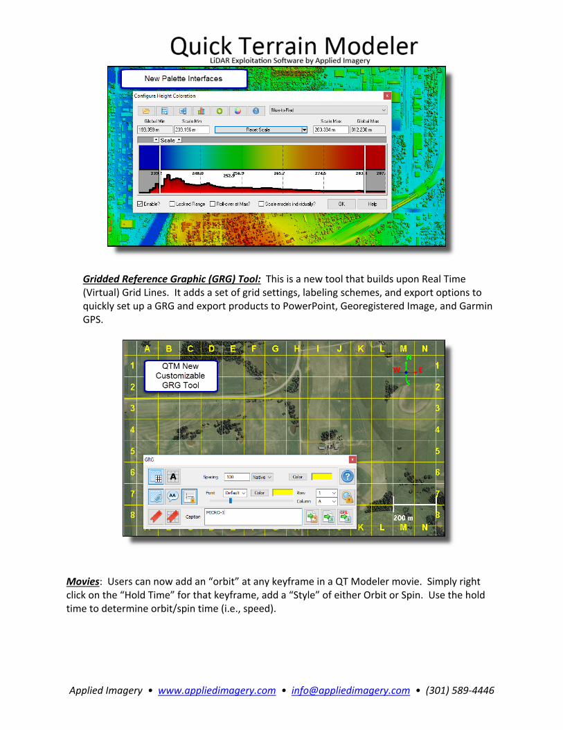
New Palette Interfaces: V8.1.0.0 updates all palette interfaces for Height Color, AGL Analyst, Slope Analysis, QTA Continuous Attribute Analysis, and Grid Statistics. This will make setting palettes and filtering analytical results faster, more intuitive, simpler, and more effective. QTA Analyst palettes will have real time sliders to change the range of values in the color ramp as well as for real time filtering.
Applied Imagery • www.appliedimagery.com • [email protected] • (301) 589‐4446
Gridded Reference Graphic (GRG) Tool: This is a new tool that builds upon Real Time (Virtual) Grid Lines. It adds a set of grid settings, labeling schemes, and export options to quickly set up a GRG and export products to PowerPoint, Georegistered Image, and Garmin GPS.
Movies: Users can now add an “orbit” at any keyframe in a QT Modeler movie. Simply right click on the “Hold Time” for that keyframe, add a “Style” of either Orbit or Spin. Use the hold time to determine orbit/spin time (i.e., speed).

Applied Imagery • www.appliedimagery.com • [email protected] • (301) 589‐4446
Transparency Style Analysis Results: Users can now add choose to make slope analysis, cumulative Line of Sight (LOS), and travel route LOS display as a “transparent” style. I.e., the analysis result layer will blend with color imagery and/or height color layers, rather than having the user choose either/or. There is no longer a need to use the opacity sliders to blend the layers.
Miscellaneous Tweaks and Enhancements (v8.1.0.0)
Model Info: Added button to inspect source file header info.
Line of Sight: In Virtual LOS, White target height lines should no longer disappear.
Snapshots: When asked whether to save a copy of the current, modified snapshot before performing an action, CANCEL is now one of the choices.
Tiled KMZ Import: Now better handles tiles with rotation
Cut/Crop: Implemented cut/crop for Vectors (accessed via Feature Manager) o Works at the Feature level, not the vertex levels. Can cut/crop Features and Parts but
won't break things up at the vertex level. o Does not currently support Undo.
Render Selection Area to Garmin: No longer requires a Selection Area. Will use the current screen extents if no selection area is present.
Model Search: Will prevent users from loading models that are already loaded.
Profile Analysis Tool: Added option to export profile to ASCII/LH.
Profile Analysis Tool (Edit Mode): When placing a selection area, left‐clicking while pressing DEL will remove the last‐placed‐node
Cross Section Analysis Tool: When CSAT exports to PPT it should now export one profile to each slide.
Contours Lines: Should now mark Index lines in the Feature Manager
Volume Calculation: Now includes sanity checks and handlers for extremely small values
Workspaces: Will now attempt to save/load Vertex Color and RT Filter legends in workspaces
Vectors: Added geoJSON to list of supported vector formats
Convert Model: QTM should fall back to old style conversion when converting QTC/QTA to QTT so that RGB is properly preserved.

Applied Imagery • www.appliedimagery.com • [email protected] • (301) 589‐4446
Open/Add Models: Added KMZ to file filter list
Snapshots Export: Cutoff for black transparent should now be 1,1,1 instead of 0,0,0
Render to TIFF: Background color should theoretically now be transparent
Default KMZ Export should now be GEOTIFF/Transparency in a KMZ rather than PNG
ATAK o Will copy source SIDs instead of generating GEOTIFF chips o For all other textures, will export a GEOTIFF at the best sampling that doesn't exceed
512 MB image size.
APASS o Will copy source SIDs and ECWs instead of generating KMZ/PNG chips. o For all other textures, will export a KMZ/PNG at the best sampling that doesn't exceed
512 MB image size.
Workspaces: o Fixed error saving WMS into workspace o Local workspaces should save WMS links instead of actual imagery. o Portable workspaces should save WMS imagery at the best possible sampling such that
the image size does not exceed 1 Gb. o WMS imagery saved into workspaces should be JPEG.
Vectors: Gave QTM ability to recognize "M" and "ZM" shapefile data types
QTM should now automatically disable Partial Rendering on Intel Video drivers
Gridding Options: Added Save, Load, and Default buttons to QT Gridding Options dialog
Support Files: o Updated to Proj 4.9.3 o Updated to Xerces 3.2.1 o Updated to GDAL 2.2.3 o Updated gdalData files to latest
Bug Fixes (v8.1.0.0) Surface Generation: Fixed broken Legacy Triangulation + Color by Minimum Distance to Point
Rendering: Fixed some issues mixing height colors with 2D textures
Measurements: Area and Volume displayed in Area Info and Water Level GUI corrected for Geodetic distortion.
Merge Models: Sped up and improved the progress bar for converting QTT to QTC.
Model Search: Fixed issue where check for pre‐existing files leads to infinite loop attempting to load models from model search
Merge Models: Fixed inconsistent memory issues when merging QTC models destructively
‐Vector Rendering: Fixed issue where terrain‐hugging vectors are evaluated for whether they intersect the screen at their floating height
Memory Management Options: Fixed ability to limit number of threads QT can use
Palette Tools: Fixed scaling issue properly labeling exported histograms
Toolbar: Fixed some issues with toolbar toggle states occasionally getting out of sync with reality (most prominently the height color toggle)
Rendering: Now forces a full refresh when switching between 2D/3D
Fixed Issue where clipping planes sometimes got confused in 2D mode
Fixed issue where view would reset when loading WMS imagery
Model Edit Position: Fixed min/max model space z readout. Now should show "N/A" for NoData all model types other than QTT
Applied Imagery • www.appliedimagery.com • [email protected] • (301) 589‐4446
Fixed issues treating UTM like ED50 as UTM/WGS84 for purposes of zone transitions
Vectors: Fixed broken recognition of SHP types on import
Textures: Fixed some issues with exporting with transparency from imagery that doesn't already have a transparency layer.
QTA Attribute Analysis: Fixed some issues doing QTA Analysis lookups on Z data as well as aed a long‐standing issue looking up QTA data when any given attribute is tagged for multiple purposes (like looking up Z when Z is being used for the filter channel as well).
Minimap: Fixed issue zooming to a selection area via the minimap in 2D mode
Bookmarks ‐ Fixed issue appending workspace bookmarks to existing list
Fixed issue with permanently disappearing "vertex colors" folder in layer tree
Fixed crash issue using measurement tool in CSAT
Fixed issues when importing ASCII‐>QTA with items tagged to non‐existent columns
Fixed issue manually setting values in GridStats
LAS: Fixed potential scaling issue when re‐exporting to LAS after coordinate conversion
Profile Analysis Tool: o Fixed broken hide/highlight selected edit points functionality o Fixed issue rendering measurement line backwards on complex mensuration lines
Markers: o Fixed placing checkpoints in a sub‐folder o Fixed issue properly saving AGL in Markers and Workspaces o Should now load prototypes from both MyDocuments\prototypes and QTM Install
folder\prototypes