wetland water balance monitoring protocol … · wetland water balance monitoring protocol, toronto...
TRANSCRIPT

WETLAND WATER BALANCE MONITORING PROTOCOL
Toronto and Region Conservation Authority
September 2016

i
Acknowledgements
This document is made possible by generous funding and contributions provided by:
The Great Lakes Sustainability Fund
The Regional Municipality of Peel
The Regional Municipality of York
Toronto Remedial Action Plan
The Regional Municipality of Durham
The City of Toronto
Credit Valley Conservation
We gratefully acknowledge the contributions of the members of the Wetland Water Balance
External Stakeholder Committee throughout the development of this document. The
stakeholder committee included technical experts in stormwater engineering, ecology,
hydrogeology, and planning with representation from both the public and private sectors.
For further information about this document, please contact:
Please reference this document as:
Wetland Water Balance Monitoring Protocol, Toronto and Region Conservation Authority, 2016
Laura Del Giudice, B.Sc., M.F.C. Manager, Watershed Planning Toronto and Region Conservation Authority 416-661-6600 ext. 5334 [email protected]
Christine Tu, M.Sc Manager, Research and Climate Programs Toronto and Region Conservation Authority 416-661-6600 ext. 5705 [email protected]

ii *Note: by this it is meant that TRCA staff will report back to the Authority two years after the Monitoring Protocol has been in use.
This document was endorsed by the TRCA Authority Board on September 23, 2016. RES.#A142/16 - TRCA WETLAND BALANCE MONITORING PROTOCOL
Authority approval of TRCA’s Wetland Water Balance Monitoring Protocol, a technical guideline developed to support Appendix D: Water Balance for Protection of Natural Features of TRCA’s Stormwater Management (SWM) Criteria document (2012) and The Living City Policies for Planning and Development in the Watersheds of the Toronto and Region Conservation Authority.
Moved by: Jennifer Innis Seconded by: Jack Heath AN AMENDMENT WAS ADDED TO THE RESOLUTION: AMENDMENT RES.#A143/16 - THAT the following be inserted before the last paragraph of the main motion:
THAT staff report back after two years on the results of the monitoring;* Moved by: Jennifer Innis Seconded by: Jack Heath
THE AMENDMENT WAS CARRIED; THE MAIN MOTION, AS AMENDED, WAS CARRIED; THE RESULTANT MOTION READS AS FOLLOWS:
WHEREAS Toronto and Region Conservation Authority (TRCA) staff review and provide advice on applications for development and site alteration affecting wetlands under the planning, environmental assessment and permitting processes; WHEREAS in 2014 and 2015, in response to requests from the development industry for more technical guidance, TRCA staff developed the draft Wetland Water Balance Monitoring Protocol to articulate TRCA objectives and study requirements for establishing a water balance monitoring program for the protection of wetland hydrology through the development process; AND WHEREAS in 2015, TRCA staff sought input on the draft Protocol from partner municipalities, provincial agencies, the Building Industry and Land Development Association (BILD), consulting firms, and neighbouring conservation authorities, and have now finalized the Protocol based on the input received; THEREFORE LET IT BE RESOLVED THAT the Authority endorse the TRCA Wetland Water Balance Monitoring Protocol for use by proponents of development and infrastructure, consultants, and TRCA staff in the planning and development submission, review and approval process; THAT staff report back after two years on the results of the monitoring;* AND FURTHER THAT the Ministry of Natural Resources and Forestry, Ministry of Transportation, Ministry of the Environment and Climate Change, Ministry of Municipal Affairs and Housing, regional and local municipalities in TRCA’s jurisdiction, Conservation Ontario, and neighbouring conservation authorities be so advised.

iii
TABLE OF CONTENTS
1. INTRODUCTION ............................................................................................................................................. 1
1.1 WETLAND WATER BALANCE STUDY ...................................................................................................................... 2
1.2 WETLAND WATER BALANCE IN THE PLANNING AND DEVELOPMENT PROCESS ............................................................... 2
2. WETLAND WATER BALANCE EQUATION ........................................................................................................ 5
3. DESIGNING A WETLAND WATER BALANCE MONITORING PROGRAM ............................................................ 7
STEP 1 – FRAMING THE QUESTIONS TO GUIDE MONITORING PROGRAM DESIGN ........................................................................ 7
STEP 2 – CHARACTERIZING THE WETLAND ECOLOGY AND HYDROLOGY ..................................................................................... 7
STEP 3 – DEVELOPING THE CONCEPTUAL MODEL ................................................................................................................. 9
STEP 4 – DATA COLLECTION AND INSTRUMENTATION ........................................................................................................... 9
STEP 5 – PHASING AND TIMING ...................................................................................................................................... 14
4. POST-PLANNING MONITORING PHASES ...................................................................................................... 15
5. REPORTING ................................................................................................................................................. 17
6. REFERENCES ................................................................................................................................................ 17
APPENDIX 1: OVERVIEW OF WETLAND WATER BALANCE PROCESS .................................................................... 19
APPENDIX 2: CORRECTING WATER LEVEL DATA USING MANUAL MEASUREMENTS ............................................ 20

1
1. INTRODUCTION This Wetland Water Balance Monitoring Protocol has been produced to provide consistent guidance to proponents of urban development, infrastructure or water extraction applications (e.g. water taking, pits, quarries, etc.) where they have the potential to impact wetland features. The guidelines assist in developing monitoring programs and associated reporting, once it has been determined through the planning, environmental assessment, or permitting processes that a wetland water balance analysis is required. Pre-development monitoring programs will include 1-3 years of monitoring, depending on planning stage and scope considerations (for further detail, see Figure 1). Post-planning monitoring, including both during and after construction, will be determined on a site-by-site basis. This Monitoring Protocol is intended to be applied where it has been determined through the environmental assessment and planning processes that a wetland will remain on the landscape as a natural feature, and includes constructed natural wetlands, but excludes stormwater management ponds and wastewater polishing wetlands. A water balance may be required for a variety of types of development applications, as determined through consultation with TRCA, depending on the scope and scale of anticipated impacts and the sensitivity of natural features. A water balance is unlikely to be required for linear infrastructure, such as roads and railways, where TRCA’s regular permitting process will generally be sufficient to address potential impacts to natural features and associated mitigation options (e.g. equalization or micro-drainage culverts under the road or railway). Hydrology is the scientific study of the properties, distribution, and circulation of the water on Earth and in the atmosphere in all of its forms. It is a key factor that determines a wetland‘s ecological composition, structure and function. One of the most significant impacts to wetlands caused by land-use changes is the alteration of wetland hydrology. As natural cover is replaced by impervious cover and runoff is efficiently directed towards drainage conveyance systems, the components of a wetland’s water balance may become highly altered, changing a wetland‘s natural hydrological regime. Similarly, large-scale groundwater withdrawals or aggregate extraction activities have the potential to reduce flows to wetlands with strong hydrological connections to aquifer systems. A water balance is the accounting of the inflows and outflows of water in a system, which are attributed to the various components of the hydrological cycle. The water balance includes, for example, the amount and timing of surface and/or ground water flow that feed a wetland and allow it to function as habitat for flora and fauna. Changes to the wetland’s hydrology can have negative impacts on the ecology of the wetland. In order to assist in mitigating these impacts, the Water Balance for the Protection of Natural Features criteria were developed as outlined in Appendix D of the Stormwater Management Criteria Guideline (TRCA, 2012). This protocol is intended to provide additional clarity on completing Step 2 and Step 6 in Appendix D, and should be used in conjunction with them. A summary of the steps presented in Appendix D of the SWM Criteria Guideline is provided at the end of this document as Appendix 1, to illustrate how the Monitoring Protocol fits into the overall water balance process.
For a glossary of terms, refer to
Appendix D of the Stormwater
Management Criteria (TRCA,
2012).

2
The pre-development monitoring data are to be used to: 1) Develop a calibrated wetland water balance model for existing conditions; 2) Collect data that can be used to compare pre-to-post development conditions; and 3) Guide mitigation efforts during and after construction.
The data obtained through the monitoring process will be used to assess the water balance for the wetland, evaluate the effectiveness of mitigation measures applied to reduce impacts on wetlands, and to facilitate adaptive management (post-construction adjustments to infrastructure to achieve desired results). To gather usable and effective data, it is necessary to develop a study design and monitoring program that is capable of achieving the desired objectives as outlined in the SWM Criteria guidelines. The appropriate water balance components need to be quantified and results must be presented clearly during reporting. 1.1 Wetland Water Balance Study In 2012, TRCA and CVC initiated a long-term study (i.e. 10+ years) that is intended to examine the biological and hydrological relationships in wetlands, as well as the hydrological impacts of land use development on natural heritage features. The study is initially focusing on wetlands, with watercourses and woodlands to be studied in later phases of the project. In large part, the intent of this project is to gain a better understanding of wetland hydrology and the sensitivity of different wetland communities to hydrological changes. We are also experimenting with various instrumentation methods, modelling analyses and mitigation approaches to identify and disseminate best practices. This work will include the development of tools, such as this monitoring protocol, that will be used to provide additional direction on the water balance analysis process as the study progresses, and will ultimately provide information to inform future updates to TRCA’s and CVC’s stormwater management criteria guidelines. The insights garnered through the study will assist with future land-use planning, impact assessment, and mitigation. As a secondary benefit, the study may also enhance our understanding of wetland ecological goods and services (e.g. flood attenuation, groundwater recharge, etc.) and provide insights into wetland restoration initiatives. The Wetland Water Balance Monitoring Protocol will be a living document and will be informed by findings of the CVC and TRCA study. Lessons learned will be used to update and improve the Protocol over time in order to ensure regulatory and policy mandates are achieved in the protection of these sensitive natural features. 1.2 Wetland Water Balance in the Planning and Development Process It is critically important that baseline monitoring occurs early on in the planning process, as comprehensive monitoring requires three years of baseline data. It is also essential that consultation with the conservation authority and municipality occur throughout the process to ensure that information provided is useful and complete. Figure 1 below outlines the information inputs required at each step within the planning process, as well as outputs that should result from that stage. For simplicity, and to recognize that planning processes vary from municipality to municipality, we have categorized the planning process into early, intermediate, and late planning stages.

3
Figure 1: Wetland Water Balance in the planning process
Early Stage The early stage is comprised of subwatershed studies and/or secondary plans, Infrastructure Master Plans, and Phases 1 and 2 of Comprehensive Studies, such as Master Environmental Servicing Plans (MESP), which include both existing conditions and impact assessment for the proposed development. During the early stage, natural heritage inventories will be undertaken to characterize the ecological features and their functions. It is recommended that during the early stage water balance monitoring be initiated for features where there is a high level of certainty that this type of monitoring will be required later on (e.g. Provincially Significant Wetlands). Also, during the early stage, typically the natural heritage system (NHS) is established based on the features and functions identified. The limits of the NHS should consider wetland sensitivities and protection requirements in consultation with the municipality and the conservation authority. Natural Heritage System limits for sensitive features should accommodate surface water catchments and groundwater recharge areas contributing significant quantities of water to features. In instances where this is accomplished, the need for a water balance analysis is typically negated. Where the protection of the wetland’s surface water catchment and recharge areas is not achieved, the requirement for a water balance analysis will be determined. In consultation with the conservation authority and municipality, the level of risk to the wetland from the proposed development will be

4
determined based on the sensitivity of the wetland and the scope and scale of changes to water inputs and outputs. The level of risk will help determine whether a water balance analysis is required, and the level of effort required for monitoring and modelling analysis. We reiterate that water balance monitoring and modelling can be avoided by eliminating or reducing development or water extraction/discharge activities within the surface and groundwater catchments of the wetland. Once the level of risk is classified and the monitoring requirements are determined, then the baseline wetland water balance monitoring program is established. A minimum total of three years of monitoring is required in instances where the early stage of planning includes wetland water balance monitoring in the terms of reference. Between 1 and 3 years of monitoring are completed during the early stage with any remaining years completed during the intermediate stage. These data are used as inputs for preliminary modelling conducted as part of the initial impact assessment. The outputs of this stage are:
1) Characterization of the NHS; 2) Establishment of NHS limits; 3) Determination of the level of risk to the wetland(s); 4) Initiation of baseline monitoring; and 5) Completion of preliminary modelling.
Intermediate Stage The intermediate stage includes the functional servicing studies in support of Draft Plan approval. At this stage, wetland water balance monitoring continues in order to complete the required three years of monitoring, if it was not completed during the early stage. Preliminary mitigation options should be identified at this point, and a mitigation plan developed to ensure that mitigation features are properly accommodated in the functional servicing design. Ideally, flexibility would be built into the design of mitigation features to allow for any necessary post-construction adjustments resulting from discrepancies between modelled and actual system behaviour. Draft Plan approval would follow completion of a minimum of 3 years of data collection; data collection will not be permitted to be a condition of Draft Plan approval. While the first year(s) of data are used to undertake preliminary modelling in the early stage, the second and/or third years of data are used to refine the modelling analysis and impact assessment during the intermediate stage. In the event that no comprehensive study was previously completed, or if the comprehensive study did not include wetland water balance as part of the terms of reference, and it is determined that a water balance analysis is required for the wetland, a minimum of one year of monitoring is required. The outputs of this stage are:
1) Completion of monitoring; 2) Refinement of the modelling analysis; and 3) Development of a preliminary mitigation plan.
Late Stage The late stage includes stormwater management reports and detailed design in support of the site plan and permit approvals. At this stage, the results of the water balance analysis completed at the intermediate stage feed into the development of the detailed design in support of final approvals. If

5
water balance analyses were not previously completed, then determine scoped work in consultation with the conservation authority and municipality. As stated previously, we recommend including flexibility where possible in the design of the mitigation features to allow for some degree of post-construction adjustment to flow conveyance systems, if necessary. The outputs of this stage are:
1) Development of a mitigation plan, if not completed earlier; and 2) Completion of detailed design.
2. WETLAND WATER BALANCE EQUATION The wetland water balance equation is used to understand a wetland’s hydrological dynamics and to quantitatively describe a wetland’s inputs and outputs. There are seven components to a wetland water balance that play varying roles in the model depending on a wetland’s hydrological regime. Given that some small components may still make important contributions to water quantity and water chemistry at critical times of the year, all of the water balance components must be considered in order to understand the inputs and outputs of the system. The contribution of water balance components may differ between the pre-to-post development scenarios. The equation can be described as the change in storage being equal to the inputs minus the outputs, as follows:
S = Storage P = Precipitation Si = Surface water inflows Gi = Groundwater inflows ET = Evapotranspiration So = Surface water outflows Go = Groundwater outflows
The hydroperiod of a wetland is the seasonal pattern of water level fluctuation, i.e. the change in the storage component of the water balance. It is determined by the cumulative influence of all the water balance components. Through its influence on the extent of aquatic habitat and the range of water and soil moisture conditions experienced throughout the year, the hydroperiod determines to a large extent the species that can exist within a wetland. Any given species will have a range of conditions it can tolerate, and may also have threshold conditions that preclude its survival. For instance, some frogs require standing water during the spring breeding period but not later in the year, and may be preyed on by fish in perennially flooded environments. Similarly, many treed swamps require dry periods during a portion of the year, even if only for short durations, to ensure root respiration can occur to allow trees to survive. See the text box below and Figure 2 for a description and visual representation of a hydroperiod analysis.
Change in Storage = Inputs – Outputs ∆S = P + Si + Gi - ET - So - Go

6
The steps outlined in Section 3 below will help determine which water balance components are important to the wetland in question. Note that the version of the water balance equation presented here does not include a residual or error term, but that it is nonetheless important to estimate the degree of uncertainty associated with each water balance component. It is also important to note that
the Si and So terms include interflow for the purposes of the modelling exercise as surface water models tend to be better equipped to accommodate interflow. This is in contrast to the definition provided in Appendix D of the SWM Criteria Guideline (TRCA, 2012) which suggests that interflow is considered to be a component of the groundwater system. Interflow is an important component to consider since it affects conditions in the shallow subsurface where the roots of vegetation occur.
Hydroperiod Analysis
There are five components of the wetland hydroperiod that are important to understanding the eco-hydrological processes and monitoring needs of the wetland:
Frequency– how often a water level above a given magnitude recurs over some specific time interval
Duration– the period of time associated with a specific water level condition (e.g. standing water)
Timing– the time of year at which a specific water level condition occurs, which may be of ecological significance
Magnitude– the maximum and minimum water levels or flow conditions over a given time period
Rate of change– how quickly water levels or flows change from one magnitude to another (i.e. flashiness).
Figure 2: An example of a visual analysis of a hydroperiod over 3 years of baseline monitoring; highlighted on the hydroperiod are the annual minimum and maximum water levels (magnitude), the timing of these events, and the duration and frequency of conditions where the water level is consistently either above or below the average ground surface for extended periods.
7
3. DESIGNING A WETLAND WATER BALANCE MONITORING PROGRAM A multi-disciplinary team of ecologists, hydrologists, and hydrogeologists must be involved in the process of developing a wetland water balance monitoring program. Step 1 – Framing the questions to guide monitoring program design At the initial stages of designing a wetland water balance monitoring program, there are a number of questions that need to be contemplated. Some of these questions may be answered easily with existing/secondary data (Ecological Land Classification, topographic mapping, etc.—see Step 2 below) while others must be tested through the monitoring program. Below is a list of general questions; however, there may be other questions that arise through consultations with the conservation authority and/or the municipality:
What types of wetland units will be affected by the proposal, and how many of them are there? What is the shape and size of the wetland and its catchment? Are the wetland units mainly groundwater-fed or surface water-fed? Does this change
throughout the year? What is the size and location of the up-gradient area that may be contributing significant
groundwater inputs? What are the surficial soils and what is the physiography of the area? What are the existing land-uses and drainage patterns within the catchment (e.g. tile drains,
crop/vegetative cover, topography, etc.)? Are the wetland units connected hydrologically? What are the hydrological flow paths
associated with the wetland units? Is the wetland type isolated (internally draining), palustrine (intermittent/no inflow and
intermittent/permanent outflow), riparian, or lacustrine? What is the hydroperiod of the wetland units? What are the ecological functions that may be sensitive to changes in hydroperiod?
While study questions are framed at the beginning of the study design process, this process is iterative and additional questions may arise once the wetland characterization and data collection steps are underway. It is important to document the questions. In the steps that follow, we examine how to answer the questions through data collection.
Step 2 – Characterizing the wetland ecology and hydrology The next step in designing an effective wetland water balance monitoring program is developing an understanding of the dynamics and sensitivities of the system through initial information collection. Various sources of information can be used to characterize the wetland ecology and hydrology including existing/secondary information and site surveys. If existing information is used, a reconnaissance survey of the site is required to confirm previous findings and validate assumptions made upon reviewing this information (e.g. confirming an outflow exists at a palustrine wetland). At a minimum, the following information needs to be gathered and reviewed:
Detailed topographic mapping and/or wetland bathymetry (as precise as possible, e.g. 25 cm; capture highs and lows within the wetland for hummocky wetlands,). Surveying during late autumn or spring can reduce constraints caused by leaf cover.
Surficial soils mapping and/or physiography

8
EXAMPLE - Characterizing the wetland This map of a study wetland illustrates data obtained at the initial information collection stage. This information provides a good initial understanding of the wetland’s dynamics and sensitivities. The wetland is palustrine as there is a concentrated flow path at the outflow. There are two hydrologically connected wetland units in this single wetland. It contains sensitive flora and fauna (e.g. spring peepers).

9
Surface water catchment area Position within regional hydrogeologic context Significant groundwater recharge area / groundwater catchment (if applicable) Flow measurements at any concentrated inflow or outflow locations Groundwater indicators (e.g. mottles, gleys) Description of the wetland vegetation communities (Ecological Land Classification or Ontario
Wetland Evaluation System) Species of conservation concern, including L-ranks Presence of any Significant Wildlife Habitat
Step 3 – Developing the conceptual model Once the wetland ecology and basic hydrology have been characterized, the next step is to develop the conceptual model. The components of the wetland water balance equation that affect the wetland need to be determined on a site-specific basis. For example, some wetlands will have an outflow into a defined surface water feature with a measurable So (see Section 2). Other wetlands may be internally draining (So=0), and are only linked to the downstream surface water system through a groundwater connection. Each of the various components of the water balance equation, including evapotranspiration, will need
to be measured or estimated independently. It may be valid to assume the ΔS term is zero where water levels remain very stable, but it should be estimated where water levels change over the duration of the monitoring period. Because the calculation of a component may contain errors, the equation may not always balance. An estimation of the measurement error within each component should be attempted to determine which terms may contain the largest proportion of error in the water balance. Step 4 – Data collection and instrumentation The collection of baseline data is important as it sets the parameters to be measured for the duration of the monitoring period. Without proper baseline data, it is impossible to compare future data to the pre-development scenario. The wetland sensitivities established in Step 1 and 2 will help determine the targets and scope for wetland monitoring. The level of risk that the project poses to the wetland will inform whether a comprehensive or scoped monitoring program is required. Ongoing monitoring of ELC, flora and fauna may be part of a monitoring program not specific to wetland water balance monitoring, such as species at risk monitoring. However, monitoring of flora and fauna beyond the inventories completed during the NHS characterization phase of the Early Planning Stage (see Figure 1) is not a requirement of wetland water balance monitoring. The main goal of wetland water balance monitoring is to ensure that the wetland’s hydrological conditions will persist following development, thereby enabling the suite of flora and fauna species reliant on those conditions to also persist. However, other stressors may influence their absence from the wetland after development. Nevertheless, ecological data could still be useful in helping to assess the efficacy of mitigation measures. In the event that ecological data are collected for another purpose, the monitoring protocols used to collect these data must adhere to standard data collection protocols for amphibians, birds and vegetation communities. See TRCA’s Environmental Impact Study Guidelines (TRCA, 2007) for further detail, but note that these guidelines only detail point-in-time methods. TRCA 2011 (a, b, and c) outlines
10
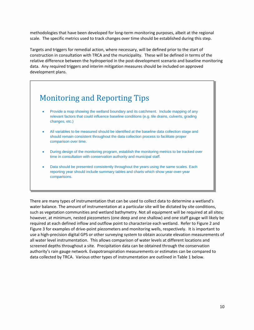
methodologies that have been developed for long-term monitoring purposes, albeit at the regional scale. The specific metrics used to track changes over time should be established during this step. Targets and triggers for remedial action, where necessary, will be defined prior to the start of construction in consultation with TRCA and the municipality. These will be defined in terms of the relative difference between the hydroperiod in the post-development scenario and baseline monitoring data. Any required triggers and interim mitigation measures should be included on approved development plans.
There are many types of instrumentation that can be used to collect data to determine a wetland’s water balance. The amount of instrumentation at a particular site will be dictated by site conditions, such as vegetation communities and wetland bathymetry. Not all equipment will be required at all sites; however, at minimum, nested piezometers (one deep and one shallow) and one staff gauge will likely be required at each defined inflow and outflow point to characterize each wetland. Refer to Figure 2 and Figure 3 for examples of drive-point piezometers and monitoring wells, respectively. It is important to use a high-precision digital GPS or other surveying system to obtain accurate elevation measurements of all water level instrumentation. This allows comparison of water levels at different locations and screened depths throughout a site. Precipitation data can be obtained through the conservation authority’s rain gauge network. Evapotranspiration measurements or estimates can be compared to data collected by TRCA. Various other types of instrumentation are outlined in Table 1 below.
Monitoring and Reporting Tips
Provide a map showing the wetland boundary and its catchment. Include mapping of any
relevant factors that could influence baseline conditions (e.g. tile drains, culverts, grading
changes, etc.)
All variables to be measured should be identified at the baseline data collection stage and
should remain consistent throughout the data collection process to facilitate proper
comparison over time.
During design of the monitoring program, establish the monitoring metrics to be tracked over
time in consultation with conservation authority and municipal staff.
Data should be presented consistently throughout the years using the same scales. Each
reporting year should include summary tables and charts which show year-over-year
comparisons.

11
Table 1: Summary of monitoring equipment/techniques and their descriptions.
Instrument /Technique
Variable Description
Piezometer GI and GO Piezometers are vertical pipes installed within and/or around the wetland that contain a short screen. They are used to monitor groundwater elevations in a particular geological formation, and are typically installed by hand. Nested, or paired, piezometers, one shallow and one deep, are required to determine vertical hydraulic gradients (recharge versus discharge). A minimum vertical distance of 1 m between screens is recommended for this purpose. Groundwater levels should be recorded with a data logger using an hourly time-step. Piezometers should ideally be installed to capture the full range of water level variation above and below ground. Barometric pressure loggers are required to correct for atmospheric pressure changes.
Monitoring well
GI and GO A monitoring well is an instrument that is installed outside the wetland to measure lateral groundwater movements around the wetland. These wells are typically deeper than piezometers, contain a longer screen, and are usually drilled in upland areas using machinery. At least three triangulated monitoring wells are required to determine the direction of groundwater flow within the wetland’s catchment.
Rain Gauge P A rain gauge is typically used to record rainfall at 15-minute or finer resolution intervals, or on an event basis. A variety of techniques exist for estimating water contributions from snowpack. Both of these data may be available from nearby existing rain/snow gauges, depending on site location. Ask the conservation authority for available data.
Staff Gauge
∆S Staff gauges measure the change in surface water storage within the wetland and help to define the hydroperiod of the feature. These can be installed by hand within depression areas. Water levels should be recorded with a data logger using an hourly time-step.
Flow Meter SI and SO A flow meter measures concentrated inflow or outflow discharges, but cannot be left in place with a data logger. They can either be used in an engineered structure (e.g. culvert), or in conjunction with a series of stage measurements to develop a rating curve. However, this equipment needs to be paired with a level logger in order to generate continuous stage data.
Flume or Weir SI and SO A flume or weir measures surface inflow or outflow water levels at a point of concentrated flow. These water levels are then matched to pre-calibrated rating curves in order to estimate discharge. Water levels should be recorded at hourly or finer resolution. Check with the CA to ensure that the flume or weir does not alter the hydrology or limit fish passage.
Hydraulic Conductivity Tests
SI, SO, GI, and GO
Various methods including slug tests, bail tests, and short-term pumping at piezometers may be used to assess the hydraulic conductivity of the subsurface soils. Proper characterization of wetland soils is particularly important when infiltration within the wetland is a dominant component of the water budget (i.e. internally-drained wetlands).
Boreholes SI, SO, GI, and GO
Boreholes are useful for determining the composition of soils within the catchment or the wetland in order to understand the stratigraphy (e.g. to help determine the location of well screens). Boreholes are drilled using machinery, or hand-augured soil cores may be taken within the wetland itself to avoid unnecessary disturbance.

12
Examples of Equipment
Photo Credit: Steve Usher
Figure 2: Typical construction of mini-piezometers (left) and mini-piezometer tips (right).
Photo credit: Geologic Resources
Figure 3: Monitoring well schematic
Some references for standard monitoring well and piezometer installations are provided at the end of this document.

13
EXAMPLE – Data collection and instrumentation This map illustrates the various types of instrumentation that can be installed at the study site and the locations that were selected for their installation. A flume or flow meter/level logger can be used to measure the outflow discharge. One nested piezometer, one surface water well, and a photo monitoring station are shown in each wetland unit. Monitoring wells are distributed around the wetland to establish the direction of groundwater flow. A barometric pressure gauge is located between the wetland units.

14
Step 5 – Phasing and timing There are several phases in a wetland water balance monitoring program and determining the timing and duration of the data collection period is an important part of the study design. Data collection will occur during three phases: the baseline (pre-development) phase, the development phase and the post-development phase. The data collected during the pre-development phase will be used to calibrate and verify the existing conditions water balance model. A minimum of one full year of baseline data is critical to this process; however, more baseline years will assist in accounting for climatic and ecological variability, errors or data gaps. At sites where the need for a wetland water balance has been identified early, and which involve a longer planning process such as a subwatershed plan, a block plan or a Master Environmental Servicing Plan, three years of baseline data collection is typically required. Where fewer years of data have been collected, it will be necessary to ensure that the data quality is high and that the data are placed within the context of a long-term data set (i.e. to determine whether the monitoring period is normal or extreme relative to 30-year climate averages). If it is a climatologically extreme year, effort should be made to understand how the wetland would function in an average year. This can be done using baseline meteorological data provided by TRCA and based on the conceptual model of the wetland’s hydrology, or using a calibrated model where one has been developed.
The study design will determine in what years and for how long data collection must continue. It is important that the monitoring data is collected for several years into the post-development phase to verify the effectiveness of mitigation measures, once
Installation Tips
Use data loggers with a minimum 10 m
range to ensure that all data are captured both pre- and post-development.
When manually installing piezometers or wells and there is standing water, ensure
that you pre-mark the side of the casing at
the appropriate place accounting for the water level to ensure that the instrument is
pounded to the correct depth.
Ensure that wells are properly vented using
either specially designed caps, or by drilling
or grinding a hole or slit into the well just below the top of the casing
Use existing water level data (if available) to determine how much stick-up is required.
The top of the well casings should never be
submerged. Similarly, wells should be installed such that they capture the entire
range of water level fluctuations below ground, where possible.
Ensure that the elevation survey captures the ground elevation and stick-up (i.e. the
top of the pipe protruding from the ground)
at the piezometer/well.
Drill a few boreholes prior to installation in
order to know how deep instruments need to go. The screens should be pounded into till
or mineral soils where possible to avoid
leakage into wells through the organic layer.
Ensure that you record the length of the
wells, cable lengths, and lengths of screens.
Ensure that manual measurements are taken
a minimum of seasonally, but preferably monthly, to corroborate automated water
level measurements.

15
implemented, in maintaining water balance to the wetland. This will require structuring the monitoring program around phases of development rather than designing the program for a certain period of time.
4. POST-PLANNING MONITORING PHASES While the monitoring program begins with the initial data collection and installation of the instrumentation, the program continues through the development and post-development phase. This process is outlined visually in Figure 4. The development and post-development phases may require different approaches if the findings of the monitoring program suggest that monitoring locations, frequency, or instrumentation need to be adapted to ensure that the stated monitoring objectives are achieved.
Development Phase Development phase monitoring is necessary to ensure that the wetland is protected during the construction and pre-mitigation period. The data collection program that was initiated at the pre-development stage will continue into the development phase. Water quality data should also be collected as part of the monitoring program during this period. The photographic monitoring that began at the initial information collection stage should also continue throughout construction.
Data Management Tips
Ensure that water level data collected using pressure transducers match manual water level measurements.
Manual measurements can be used to “anchor” water levels at a point in time if
elevation reference points change or if transducers drift from factory calibrations of pressure. Further technical details outlining this process are provided in Appendix 2.
Time-stamped photographs can also be useful in corroborating water levels.
Make sure that any suspicious or unreliable data are deleted prior to analysis
o Delete unusual data occurring during field activities, such as during installation and
removal of equipment.
o Ensure that rates of change in water level make sense given other relevant data (e.g. precipitation, evapotranspiration, surface water outflow rates).
Beware of water level data from wells screened in low-permeability layers; “recovery
curves” as water levels rebound following installation can extend for days to months, and are not representative of the true hydraulic head within the hydrogeologic layer.
Other artefacts can also affect wells in very low-permeability environments

16
On large construction projects, there is often a substantial amount of time when a wetland’s groundwater or surface water catchment has been altered, but mitigation measures have not yet been implemented. In these cases, it may be necessary to use triggers which initiate interim mitigation measures to protect the wetland. Triggers are defined in terms of specific hydroperiod conditions observed within the wetland. Interim mitigation measures may include pumping water into or out of the wetland to restore water levels if disturbances to the surface water or groundwater catchments have caused a wetland to become too dry or wet. Any required triggers and interim mitigation measures should be determined prior to the commencement of construction in consultation with the municipality and the Conservation Authority, and included on approved development plans. Post-Development Phase As discussed above, a monitoring plan must include a post-development data collection phase that should continue for a predetermined period. Post-development data collection is required to characterize the new wetland hydrology following construction and to understand any changes to the wetland’s ecological function. The hydrological monitoring instrumentation should remain in place post-development for a period agreed upon with the agencies, and continuous hydrological data should be collected during these years. The first year of post-development data collection may begin at 80-85% build-out as long as all mitigation measures designed to protect wetland hydrology have been implemented. As the purpose of post-development monitoring is to capture the passive operation of the mitigation system, this phase of the monitoring may not begin until these measures have been fully implemented. Figure 4 – Phasing and timing of monitoring program

17
5. REPORTING Reporting of the findings of the wetland water balance monitoring work should occur at key points throughout the various stages of development. The baseline data requires assessment prior to finalizing a water balance mitigation design and should be submitted to review agencies during the mitigation design process to ensure the mitigation strategy will be effective. It is important that data is presented in the same units and on the same scales at all monitoring locations and all stages throughout the water balance process.
Development phase reporting will vary from project to project. For example, if triggers for action during construction have been deemed necessary, development phase reporting frequency may be more intensive. The increased frequency of reporting will ensure that certain hydrological thresholds are not exceeded or, if they have been exceeded, that appropriate action has been taken. A schedule for development phase reporting should be developed at the monitoring program design stage and will be informed by the predicted impacts of the project on the wetlands to be protected.
Post-development reporting allows for an evaluation of the overall project as well as for the potential for adaptive management. This could mean reporting at the end of years 1, 3 and 5 post-development, as an example. This final reporting stage is integral to furthering our understanding of wetland water balance modelling and the effectiveness of mitigation measures and thus promoting the long-term health of wetland communities.
6. REFERENCES TRCA Environmental Impact Statement Guidelines, Toronto and Region Conservation Authority, November 2007. TRCA Wetland Vegetation Monitoring Protocol: Terrestrial Long-term Fixed Plot Monitoring Program, Toronto and Region Conservation Authority, November 2011a. TRCA Wetland Amphibian Monitoring Protocol: Terrestrial Long-term Fixed Plot Monitoring Program, Toronto and Region Conservation Authority, November 2011b. TRCA Wetland Bird Monitoring Protocol: Terrestrial Long-term Fixed Plot Monitoring Program, Toronto and Region Conservation Authority, November 2011c. Stormwater Management Criteria, Toronto and Region Conservation Authority, August 2012, v.1.

18
Well Installation References: Aller, L., T. W. Bennett, G. Hackett, R.J. Petty, J.H. Lehr, H. Sedoris, D.M. Nielson, and J.E. Denne. Handbook of Suggested Practices for the Design and Installation of Ground-Water Monitoring Wells, U.S. Environmental Protection Agency, 1991. Protocol for the Contaminated Sited Regulation Under the Environment Act, Protocol No. 7: Groundwater Monitoring Well Installation, Sampling and Decommissioning, Yukon Environment, 2011. Alberta, weblink to recommendations, regulations, and best practices: http://www1.agric.gov.ab.ca/$Department/deptdocs.nsf/all/epw13739 Ontario, weblink to MOECC recommendations, regulations, and best practices: http://www.ontario.ca/environment-and-energy/wells-your-property

19
Appendix 1: Overview of Wetland Water Balance Process
The Monitoring Protocol is meant to provide additional clarity and guidance on Step 2 and Step 6 in TRCA’s Stormwater Management Criteria Guideline, Appendix D: Water Balance for Natural Features. The following list summarizes the steps involved in this process for the purpose of illustrating where the Monitoring Protocol fits within the water balance submission process. For the sake of conciseness, many sub-components of the steps are omitted from this summary. We strongly recommend that proponents refer directly to the Stormwater Management Criteria Guideline in addition to this Protocol.
Step 1 – Determine the Need for a Water Balance: Identify the existing and proposed land uses, contributing catchment areas for both surface water and groundwater, and the scale of anticipated changes to water inputs/outputs, and/or catchment size. Step 2 – Establishing Baseline Conditions: Collect background and baseline data on wetland hydrology and ecology, as detailed in the Monitoring Protocol. Step 3 – Developing the Existing Conditions Water Budget Model: Use baseline data and information obtained through field and background studies to inform the development of a water budget model using an approved continuous model (where required, as determined through consultation with TRCA). Step 4 – Comparing Pre-development and Post-development: In consultation with the Conservation Authority, determine hydroperiod targets for the post-development scenario and use model analysis and/or other analyses to determine the post-development hydroperiod that would result from the proposed design. Step 5 – Applying Mitigation: Determine if the proposed design and mitigation measures are sufficient to meet the hydroperiod targets determined earlier in Step 4. Step 6 – Reporting and Monitoring: Compile a report based on the data collected and analyses completed in the above steps and submit to the Conservation Authority for review. This will include a post-development monitoring plan, with guidance from this Monitoring Protocol, along with thresholds in post-development monitoring results that would act as triggers for remedial action.
20
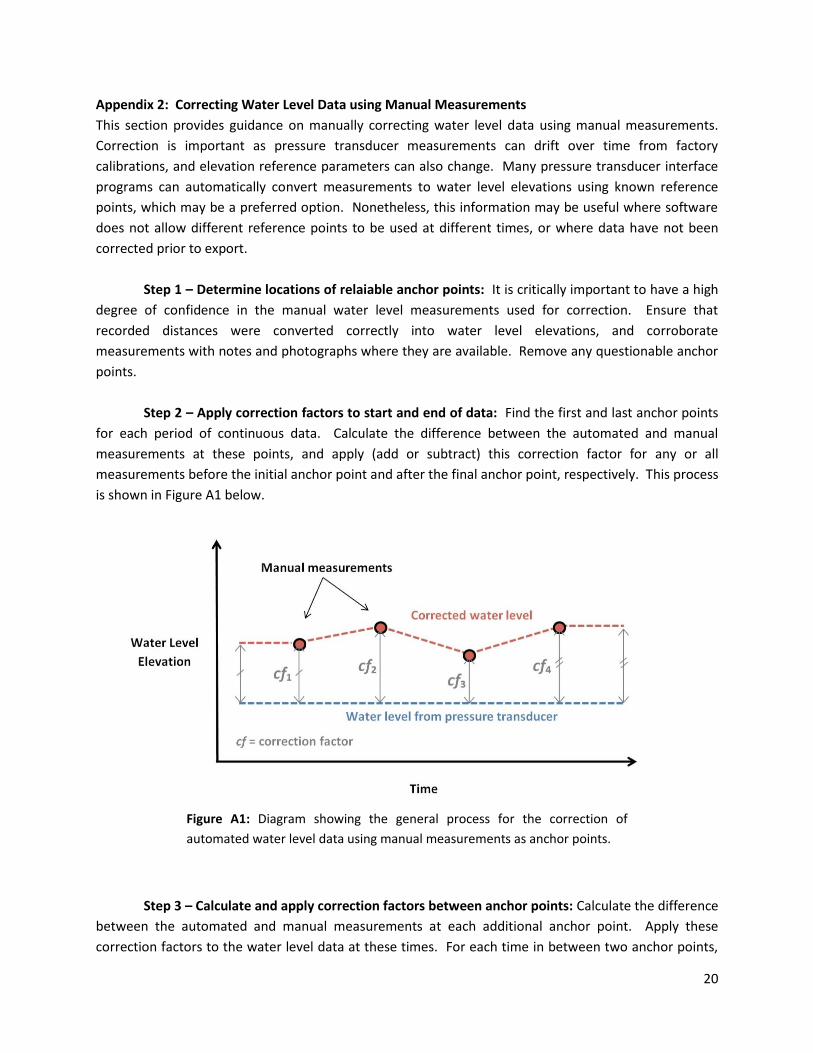
Appendix 2: Correcting Water Level Data using Manual Measurements
This section provides guidance on manually correcting water level data using manual measurements.
Correction is important as pressure transducer measurements can drift over time from factory
calibrations, and elevation reference parameters can also change. Many pressure transducer interface
programs can automatically convert measurements to water level elevations using known reference
points, which may be a preferred option. Nonetheless, this information may be useful where software
does not allow different reference points to be used at different times, or where data have not been
corrected prior to export.
Step 1 – Determine locations of relaiable anchor points: It is critically important to have a high
degree of confidence in the manual water level measurements used for correction. Ensure that
recorded distances were converted correctly into water level elevations, and corroborate
measurements with notes and photographs where they are available. Remove any questionable anchor
points.
Step 2 – Apply correction factors to start and end of data: Find the first and last anchor points
for each period of continuous data. Calculate the difference between the automated and manual
measurements at these points, and apply (add or subtract) this correction factor for any or all
measurements before the initial anchor point and after the final anchor point, respectively. This process
is shown in Figure A1 below.
Step 3 – Calculate and apply correction factors between anchor points: Calculate the difference
between the automated and manual measurements at each additional anchor point. Apply these
correction factors to the water level data at these times. For each time in between two anchor points,
Figure A1: Diagram showing the general process for the correction of
automated water level data using manual measurements as anchor points.
21
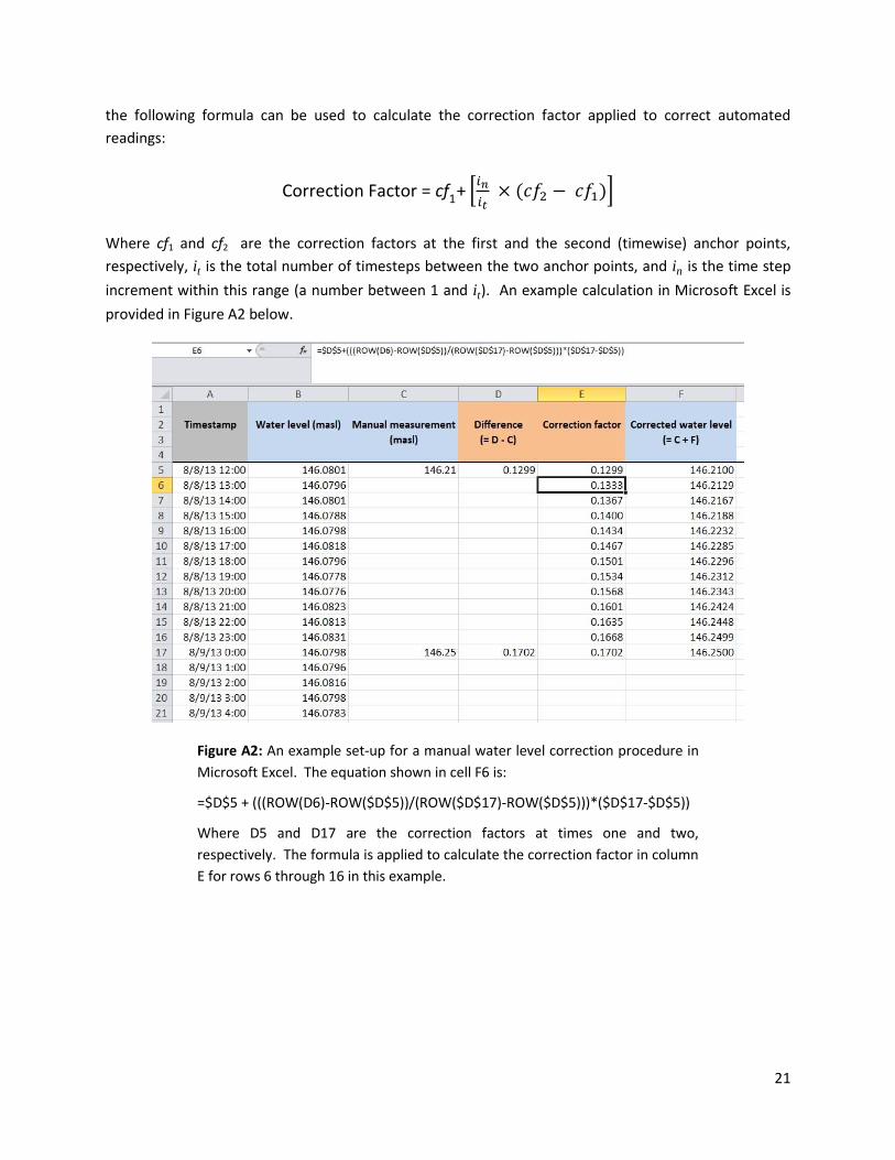
the following formula can be used to calculate the correction factor applied to correct automated
readings:
Correction Factor = cf1+ [𝑖𝑛
𝑖𝑡 × (𝑐𝑓2 − 𝑐𝑓1)]
Where cf1 and cf2 are the correction factors at the first and the second (timewise) anchor points,
respectively, it is the total number of timesteps between the two anchor points, and in is the time step
increment within this range (a number between 1 and it). An example calculation in Microsoft Excel is
provided in Figure A2 below.
Figure A2: An example set-up for a manual water level correction procedure in
Microsoft Excel. The equation shown in cell F6 is:
=$D$5 + (((ROW(D6)-ROW($D$5))/(ROW($D$17)-ROW($D$5)))*($D$17-$D$5))
Where D5 and D17 are the correction factors at times one and two,
respectively. The formula is applied to calculate the correction factor in column
E for rows 6 through 16 in this example.

22