west wiltshire district council · lighting design and street lighting ... based design guides or...
TRANSCRIPT
West Wiltshire District Council
CONTENTS
1.0 INTRODUCTION
2.0 USING THE GUIDE
3.0 POLICY BACKGROUNDLandscaping
Recycling and resource consumption
Open space and recreation
Affordable housing
Car parking provision
Highways and rights of way
Infrastructure
Water treatment
Access for all
Public art
4.0 GETTING STARTEDContext analysis
Making connections
Concept/character areas
5.0 DESIGNING STREETSRoad hierarchy
Designing the hierarchy
6.0 DESIGN THE PUBLIC REALMLighting design and street lighting
Finish materials
Street furniture
7.0 LANDSCAPING
West Wiltshire District Council
8.0 DESIGNING HOMESDesigning blocks
Building design
Housing mix
Amenity space
Boundary treatments
Materials
Car parking
Waste disposal
9.0 DESIGNING ADAPTABLE BUILDINGS
10.0 DESIGNING SAFER ENVIRONMENTS
11.0 DESIGNING FOR SUSTAINABILITYResource efficiency
Accessibility
Designing for density
Meeting policy requirements
12.0 DESIGNING FOR THE ENVIRONMENT
13.0 INFILL DEVELOPMENT
14.0 HOUSING IN VILLAGES
15.0 DEVELOPMENT IN THE HISTORIC ENVIRONMENT
16.0 THE DESIGN PROCESSDesign statements
Sustainability statements
Appendix 1 – Checklist of policy requirements
West Wiltshire District Council
4
1.0 INTRODUCTION
1.1 Residential development is a majorinvestment for both developers and localpeople. The design of new housing schemescan enhance the local environment andcreate or reinforce a sense of place as wellas producing attractive places for people tolive and invest in.
1.2 This design guide aims to increaseawareness and understanding of theprinciples of good design within residentialdevelopments. It is also intended to identifythe standard of design expected by WestWiltshire District Council in accordance withcurrent regional and national policy. This isan opportunity to enhance the character ofWest Wiltshire and its settlements.
1.3 The Council has already produced a DesignGuidance – Principles document, which hasbeen adopted as Supplementary PlanningGuidance (SPG). This sets out a step by stepformat for applicants to follow and explainsthe general principles involved in achievinggood design. The role of this new documentis to provide more specific information aboutresidential development.
1.4 This guide is intended for housingdevelopers, consultants and decision makerslooking at both large scale housingdevelopment or redevelopment and smallerinfill developments in accordance with theadopted District Plan 1st Alteration.Alterations or extensions to an existingresidential building should be referred to Howto Achieve Better Design on HouseAlterations and Extensions 2004.
1.5 This document is intended to steer applicantsand developers through the policybackground, appropriate design issues andthe design process.
1.6 In addition to general design guidancedocuments, there are a number of areabased design guides or informativedocuments that could influence the form ofnew residential developments, in particular:
Trowbridge Urban Design Framework Village Design Statements Conservation Area Character Appraisals
Consultation1.7 This document was adopted on the 30th
November 2005, following a full publicconsultation exercise and specificconsultation with councillors, local agentsand other relevant interest groups andstakeholders. This included an exhibition atthe Civic Hall, Trowbridge and inclusion inthe District Council stand at the 2005 WestWilts Show as well as a number of publicnotices in the Wiltshire Times.
1.8 In accordance with the requirements of thePlanning and Compulsory Purchase Act2004, this design guide has been producedin parallel with an accompanyingsustainability appraisal.
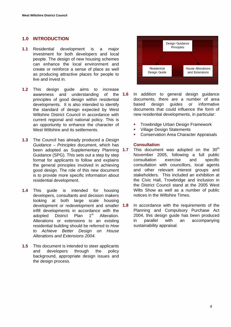
Design GuidancePrinciples
House Alterationsand Extensions
ResidentialDesign Guide
West Wiltshire District Council
5
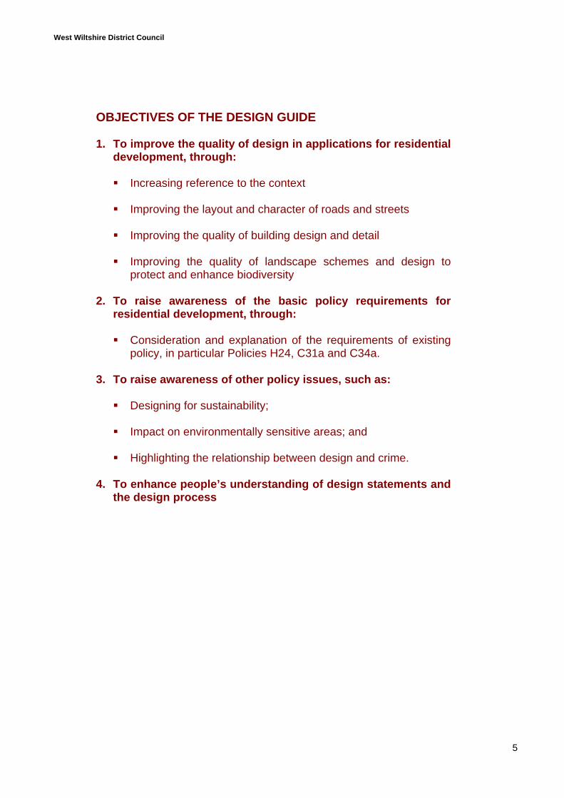
OBJECTIVES OF THE DESIGN GUIDE
1. To improve the quality of design in applications for residentialdevelopment, through:
Increasing reference to the context
Improving the layout and character of roads and streets
Improving the quality of building design and detail
Improving the quality of landscape schemes and design toprotect and enhance biodiversity
2. To raise awareness of the basic policy requirements forresidential development, through:
Consideration and explanation of the requirements of existingpolicy, in particular Policies H24, C31a and C34a.
3. To raise awareness of other policy issues, such as:
Designing for sustainability;
Impact on environmentally sensitive areas; and
Highlighting the relationship between design and crime.
4. To enhance people’s understanding of design statements andthe design process
West Wiltshire District Council
6
2.0 USING THE GUIDE
2.1 This guide is intended as a tool for bothdevelopers and decision makers. Not onlydoes it provide information on whatconstitutes good residential design, but itshould also serve to streamline theplanning application process.
Pre-application2.2 Using this guide should reduce the
consultation process by giving developersall of the initial information they need toproduce a scheme.
2.3 Developers should firstly seek to identifythat the principle of residentialdevelopment accords with the LDF. Thismay require confirmation fromDevelopment Control. More pre-application advice should then be soughtonce a context analysis has beenundertaken and a development concepthas been considered.
2.4 An additional pre-application meeting maybe required to consider the final draft ofthe scheme where all of the conceptshave been developed in accordance withthe principles outlined in this document.
Submission2.5 This document should be used by
developers to identify the level ofinformation required within their planningsubmission.
2.6 It should also enable development controlofficers to ensure that they have sufficientinformation to assess the scheme at anearly stage, e.g.
Is a design statement required? or Is there need for a sustainability
justification?
Decision making2.7 This document will form a material
consideration in the determination of allresidential planning applications.
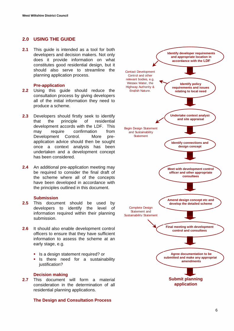
The Design and Consultation Process
Submit planningapplication
Contact DevelopmentControl and other
relevant bodies, e.g.Wessex Water, the
Highway Authority &English Nature.
Identify developer requirementsand appropriate location inaccordance with the LDF
Undertake context analysisand site appraisal
Identify connections anddesign concept
Meet with development controlofficer and other appropriate
consultees
Amend design concept etc anddevelop the detailed scheme
Final meeting with developmentcontrol and consultees
Begin Design Statementand Sustainability
Statement
Agree documentation to besubmitted and make any appropriat
amendments
Complete DesignStatement and
Sustainability Statement
Identify policyrequirements and issues
relating to local need
West Wiltshire District Council
7
3.0 POLICY BACKGROUND
3.1 There are a number of national policyguidance documents that should beconsidered when undertaking a residentialdevelopment scheme. The influences ofrelevant national policy guidance willbecome apparent throughout thisdocument. The two principle sources ofnational guidance are:
PPS1: Delivering Sustainable DevelopmentPPG3: Housing (to be replaced by PPS3)
3.2 The key principles are set out inParagraph 13 of PPS1, and one of thesestates that:
“Design which fails to take the opportunitiesavailable for improving the character andquality of an area should not be accepted.”
There is also emphasis on considering thelifespan of new developments andpromoting renewable energy in newdevelopments.
3.3 PPG3 sets out guiding principles for thelocation and density of new residentialdevelopment. It encourages sustainabledevelopment that responds positively to itssurroundings. The connection is alsomade between well designed residentialdevelopment and improving quality of life.
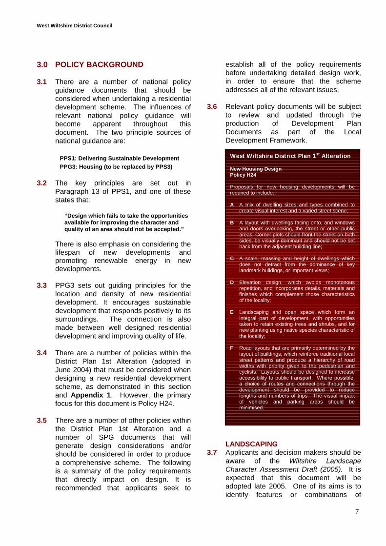
3.4 There are a number of policies within theDistrict Plan 1st Alteration (adopted inJune 2004) that must be considered whendesigning a new residential developmentscheme, as demonstrated in this sectionand Appendix 1. However, the primaryfocus for this document is Policy H24.
3.5 There are a number of other policies withinthe District Plan 1st Alteration and anumber of SPG documents that willgenerate design considerations and/orshould be considered in order to producea comprehensive scheme. The followingis a summary of the policy requirementsthat directly impact on design. It isrecommended that applicants seek to
establish all of the policy requirementsbefore undertaking detailed design work,in order to ensure that the schemeaddresses all of the relevant issues.
3.6 Relevant policy documents will be subjectto review and updated through theproduction of Development PlanDocuments as part of the LocalDevelopment Framework.
LANDSCAPING3.7 Applicants and decision makers should be
aware of the Wiltshire LandscapeCharacter Assessment Draft (2005). It isexpected that this document will beadopted late 2005. One of its aims is toidentify features or combinations of
West Wiltshire District Plan 1st Alteration
New Housing DesignPolicy H24
Proposals for new housing developments will berequired to include:
A A mix of dwelling sizes and types combined tocreate visual interest and a varied street scene;
B A layout with dwellings facing onto, and windowsand doors overlooking, the street or other publicareas. Corner plots should front the street on bothsides, be visually dominant and should not be setback from the adjacent building line;
C A scale, massing and height of dwellings whichdoes not detract from the dominance of keylandmark buildings, or important views;
D Elevation design, which avoids monotonousrepetition, and incorporates details, materials andfinishes which complement those characteristicsof the locality;
E Landscaping and open space which form anintegral part of development, with opportunitiestaken to retain existing trees and shrubs, and fornew planting using native species characteristic ofthe locality;
F Road layouts that are primarily determined by thelayout of buildings, which reinforce traditional localstreet patterns and produce a hierarchy of roadwidths with priority given to the pedestrian andcyclists. Layouts should be designed to increaseaccessibility to public transport. Where possible,a choice of routes and connections through thedevelopment should be provided to reducelengths and numbers of trips. The visual impactof vehicles and parking areas should beminimised.
West Wiltshire District Council
8
elements that contribute to the characterof the local landscape. This is importantinformation and useful for undertaking acontext analysis, particularly when lookingat new greenfield development anddevelopment adjacent to settlementboundaries.
3.8 The policies within the District Plan 1stAlteration seek to emulate national policyguidance by preserving landscapefeatures, as well as requiring appropriateprovision to be made for landscapingschemes within new developments.
3.9 Additional guidance is available from theCotswolds Conservation Board on thedesign of new development in areas ofnatural landscape significance, inparticular the Cotswolds AONBPartnership “Local Distinctiveness andLandscape Change”.
RECYCLING AND RESOURCECONSUMPTION
3.10 Wiltshire County Council and SwindonBorough Council have producedSupplementary Planning: Guidance WasteAudits & Provision for Recycling in Newand Refurbished Developments, whichwas adopted in March 2005. Although notobviously a design consideration, issuessuch as waste generated by construction,types of materials used and the need foradditional recycling facilities should beconsidered at the design stage.Consequently, it is desirable for thesepolicies to be addressed before submittinga planning application.
3.11 Policy C33 of the District Plan 1stAlteration requires the provision of arecycling station where the applicationincludes 50 or more residential units.However, in places where there isprovision for kerbside collection, thisstandard may be varied. Reference to thelevel and type of kerbside collection maymean that only certain types of materialsneed to be collected through recyclingstations (e.g. glass or plastic).
3.12 The District Plan policy on reducingresource consumption (C34a) also appliesto all proposals for 10 or more dwellings orsites over one hectare in size.
OPEN SPACE AND RECREATION3.13 In addition to Policy R4, supplementary
planning guidance on Open SpaceProvision in New Housing Developmentswas adopted in 2004. This seeks to clarify:
When there is a requirement forpublic open space;
The types of open space required; What is required in terms of
landscaping of public open space; How much public open space is
required; Appropriate walking distances to
different forms of public open space; When a financial contribution is
appropriate; and The method used for identifying the
amount of financial contribution.
A Leisure and Recreation NeedsAssessment was published in 2005 toinform the District Council in updating itsrecreation policies.
AFFORDABLE HOUSING3.14 Affordable Housing Supplementary
Planning Guidance was adopted in 2005.There are a number of design relatedissues which must be addressed in anysubmission in order to meet therequirements of this document:
The affordable houses should beindistinguishable from market housing.
Registered social landlord schemesmust comply with current HousingCorporation scheme developmentstandards and the required Eco Homesrating at the time of signing a S106agreement.
CAR PARKING PROVISION3.15 Maximum parking standards are
identified within Appendix G of theDistrict Plan 1st Alteration. As identified
West Wiltshire District Council
9
in Policy T10, the actual provision mustbe based on an assessment of thelocation’s relative accessibility by publicor alternative modes of transport.Consequently the maximum requirementwill not apply to all sites.
3.16 It is important not to over or underprovide car parking, and guidanceshould be sought from the HighwayAuthority at an early stage to identifywhat their requirements will be.
HIGHWAYS AND RIGHTS OF WAY3.17 The County Council, as the Highway
Authority, produced a Residential RoadDesign Guide in 1993. This sets outdetailed design standards for differenttypes of streets. However, due to therelease of Places Streets andMovements (1998) and changes in thethrust of national policy, greateremphasis should be put on the desiredcharacter of the street and the guidanceoutlined in this document is flexible.
3.18 Providing suitable pedestrian and cyclenetworks is also a requirement outlinedwithin Policies T11 and T12 of theDistrict Plan 1st Alteration. A network ofpedestrian routes should be consideredindependently of the road network, andappropriate pedestrian priority should besought in all schemes.
INFRASTRUCTURE3.19 The County Structure Plan 2011
contains policies with regards to theprovision or improvement toinfrastructure and states in Policy DP2that:
“Development should not proceedunless the infrastructure, services andamenities made necessary by thedevelopment can be provided at anappropriate time.”
3.20 Policy U1 and I1 within the District Plan1st Alteration, as well as site-specificpolicies in the housing section, elaborateon the need to ensure that there issufficient infrastructure to provide for
new housing developments. Thepotential for off-site works will dependon the circumstances and scale of theproposed development.
3.21 As part of the context analysis, andduring the consequent design process,an applicant should undertake anassessment of the site’s sustainability interms of access to facilities and services(see section 4 and paragraphs 11.7 and11.8). Consequently, applicants shouldseek to identify the need for additionalservices and facilities or improvementsto existing infrastructure at an earlystage in the design process.
WATER TREATMENT3.18 Policies H1 and U1 to U4 of the District
Plan 1st Alteration identify the need tomake suitable provision for disposing ofsurface water and the need to makesuitable provision for water supplies andsewage treatment, without adverselyaffecting the environment.
3.21 Policy C34a identifies the need toconsider preserving water resources, forexample through incorporating greywater use systems, incorporating waterefficient appliances and rainwaterharvesting systems or the use ofSustainable Drainage Systems (SUDS)(see section 11). English Nature andthe Environment Agency would like tosee SUDS incorporated into newschemes wherever possible.
3.22 Water companies also have specificdesign standards, which they requirewherever they are to adopt watersystems.
3.23 Opportunities for incorporatingsustainable water use and treatmentsystems and the requirements of watercompanies might impact on the designof residential developments and shouldtherefore be considered from the outsetfor further guidance on the design ofwaste water systems. In most cases, asubmission identifying sustainable water
West Wiltshire District Council
10
provision and treatment methods will berequired in order to meet therequirements of Policy C34a.
3.24 Wessex Water expect that all newdevelopment will comply with theDepartment for Environment Food andRural Affairs (DEFRA) “Protocol ondesign, construction and adoption ofsewers in Wales and England”. In orderto assess the impact these requirementsmay have on the layout of houses, newplanting and streets, Wessex Water alsomake reference to the fifth edition of“Sewers for Adoption” (2001), which isto be updated in 2006.
ACCESS FOR ALL3.25 In accordance with the Disability
Discrimination Act 1996, which cameinto full effect in 2005, the design of newbuildings has to consider the need fordisabled access.
3.26 The ODPM has produced Planning andAccess for Disabled People: A GoodPractice Guide, which highlights theneed to consider disabled access at thedesign stage to prevent poor designsolutions at a later date. In terms ofdesigning residential buildings, thismight impact on the design of windowsand doors, provision of disabled parkingand internal layouts.
3.27 It should also be noted that inclusiveaccess does not just relate to buildingsbut also spaces about them andmovement between them.Consequently, building layout should beconsidered in terms of providing accessfor disabled people, including wheelchairusers where practical.
3.28 Building Regulations Part M (2000),identifies the building control
requirements with regards to access toand use of buildings. Whilst not amaterial consideration in thedetermination of planning applications,consideration of this document at thedesign stage would prevent any need foraltering designs to get buildingregulations approval and would producea more comprehensive scheme.
3.29 Paragraph 0.22, Section 0, of BuildingRegulations Part M (2000), states thatan access statement provided forbuilding control purposes should beseen as complementary to theinformation provided at the planningstage. This identifies the need foraccess information at the planningapplication and, consequently, it isrecommended that a draft accessstatement be considered at the outsetand ideally submitted with the planningapplication.
PUBLIC ART3.30 Policy I2 requires the Council to
negotiate for the provision of public art.Provision for public art can serve tocreate or reinforce local identity, and itcan relate to materials patterns withinthe streets, landscaping or even thedesign of street furniture. It is importantthat the public art provision results infunctional elements within a scheme. Ifit is to be provided as an individualfeature, it is important that it serves tocreate legibility through appropriatepositioning and consideration of therelationship to the rest of the scheme.Potential for public art and consultationwith the community should be identifiedprior to or within the planningsubmission.
West Wiltshire District Council
11
4.0 GETTING STARTED
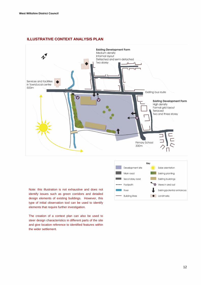
4.1 This section seeks to provide abackground for understanding thecharacter of a development site andconnecting development to its widercontext.
CONTEXT ANALYSIS
4.2 In order to give development identity andmaintain the existing character of thelocality, the overall design of any schemeshould address the desired relationshipsbetween existing built or landscapefeatures and the new development.Consequently, an understanding of thelocal context is fundamental to achievinggood design. There are essentially twostages in undertaking a context analysis:
Wider context - an understanding ofthe nature of the wider context thatsurrounds the site in terms of both thenatural and the built environment; and
Site analysis - the specifics of the siteand how this relates to the widercontext.
4.3 In summary, a complete context analysisshould consider:
Movement networks / accessibility Building layouts Streetscape Landscape features Detailed building design Site analysis
4.4 A summary of the issues, which should beconsidered within any context analysis, isshown on the following page.
CONTEXT ANALYSIS
A context analysis should gather the relevantinformation required to inform each stage of thedesign process. This information will include:
Position of the development siteIs it an entrance to a settlement?Is it or should it be a focal point?Is the site in a prominent location?Is the site adjacent to a designated area orarea of special character, e.g. a Conservation Area,AONB or a Special Landscape Area etc?
Movement networks / accessibility1. The layout and hierarchy of surrounding roads
and footpaths or cycleways2. The location of public transport3. The accessibility of the site in terms of the
location of any services and facilities4. Adjacent land uses5. The location of visible landmarksBuilding layouts6. Patterns in road layouts
(grid sizes and arrangement)7. The arrangement of buildings8. Treatment of road hierarchy,
i.e. width, building lines, length of front gardensStreetscape9. The use of materials10. Relationship between buildings and streets11. Prevailing patterns in building design12. Distinctive features in building design
(vertical and horizontal rhythms)Natural landscape assessment13. Changes in ground levels14. Views and vistas into and across the site15. Surrounding landscape features16. Open spaces, footpaths and green spaces17. Identification of potential wildlife habitatsDetailed building designThe design and appearance of surrounding buildingsin terms of features such as:18. Form19. Scale20. Materials21. Roof, window or doorway design etc.
Site analysisThe site analysis will look in detail at the existingcharacteristics of the development site, features tonote being:1. Existing entrances2. Existing routes through the site3. Boundary treatments4. Historic layouts and uses5. Existing buildings (to be retained where possible)6. Landscape features within the site,
i.e. trees, hedges or water features7. Potential wildlife habitats8. Views out of the site9. Orientation for solar gain10. Changes in ground levels11. Natural drainage
West Wiltshire District Council
12
Note: this illustration is not exhaustive and does notidentify issues such as green corridors and detaileddesign elements of existing buildings. However, thistype of initial observation tool can be used to identifyelements that require further investigation.
The creation of a context plan can also be used tosteer design characteristics in different parts of the siteand give location reference to identified features withinthe wider settlement.
IILLLLUUSSTTRRAATTIIVVEE CCOONNTTEEXXTT AANNAALLYYSSIISS PPLLAANN
West Wiltshire District Council
13
MAKING CONNECTIONS
4.5 An important factor in developing anysite is how its design, both visually andphysically, connects with itssurroundings.
Existing routes and connections4.6 In considering how to create visual and
physical links elements to consider mustinclude: available visual connections
(both long and short distances); pedestrian and cycle links; public transport; and vehicular access.
4.7 Views and vistas often correspond withthe layout of movement networks (i.e. animportant view can be along a street).However, visual connections can beabove ground level and can relate tolong distance views of distinctivefeatures within the skyline or viewsafforded by changes in ground level of asignificant landscape or architecturalfeature. Examples of long views includethe skylines above Bradford on Avonand Warminster, referenced in PolicyC30 of the District Plan 1st Alteration.
4.8 The network of existing routes around adevelopment site, and the level ofuse/importance of these routes, must beidentified to ensure that there aresuitable links proposed within thedevelopment scheme.
4.9 It is also necessary to identify whetherthere are any existing routes passingthrough the development site. However,it may not be desirable to retain allexisting routes, as they may not besuitable for encouraging pedestrianactivity and cycling.
Movement framework4.10 In accordance with the guidance in
PPG13:
“New development should facilitateconnections between places for the benefit ofpedestrians, cyclists and public transportaccess.”
Consequently, a movement frameworkshould be produced taking into accountthe following order of priority:
1. Pedestrian and cycle movements2. Public transport links3. Private car use
4.11 A movement framework will outlineprimary routes through the developmentsite for vehicles, pedestrians and cycles,based on an understanding of thesurrounding network of routes. It mustrecognise that all buildings will need tobe accessible, and that there will bedifferent levels of traffic on differentroutes depending on destination.
4.12 In developing a movement framework, itshould be recognised that planningroutes cannot be separated fromconsidering building design, layout andlandscaping.
4.13 The main reasons for consideringbuilding layouts and the landscapestructure at this time is to ensure thatpublic spaces and rights of way areaccessible and secure. Consequently,the priority should be identifying anetwork of public spaces and pedestrianroutes.
4.14 To ensure that connections are made inaccordance with the level of priority, itmay be useful to follow a number of keysteps:
Step 1 - Identify elements that canprovide visual connections.Step 2 - Identify existing access pointsand surrounding vehicular andpedestrian routes.Step 3 - Identify desire lines in terms ofpedestrian and cycle movements.Step 4 - Design the footpath network torespond to the location of facilities andservices, the location of existing ordesired public areas, and existing andproposed landscaping.
West Wiltshire District Council
14
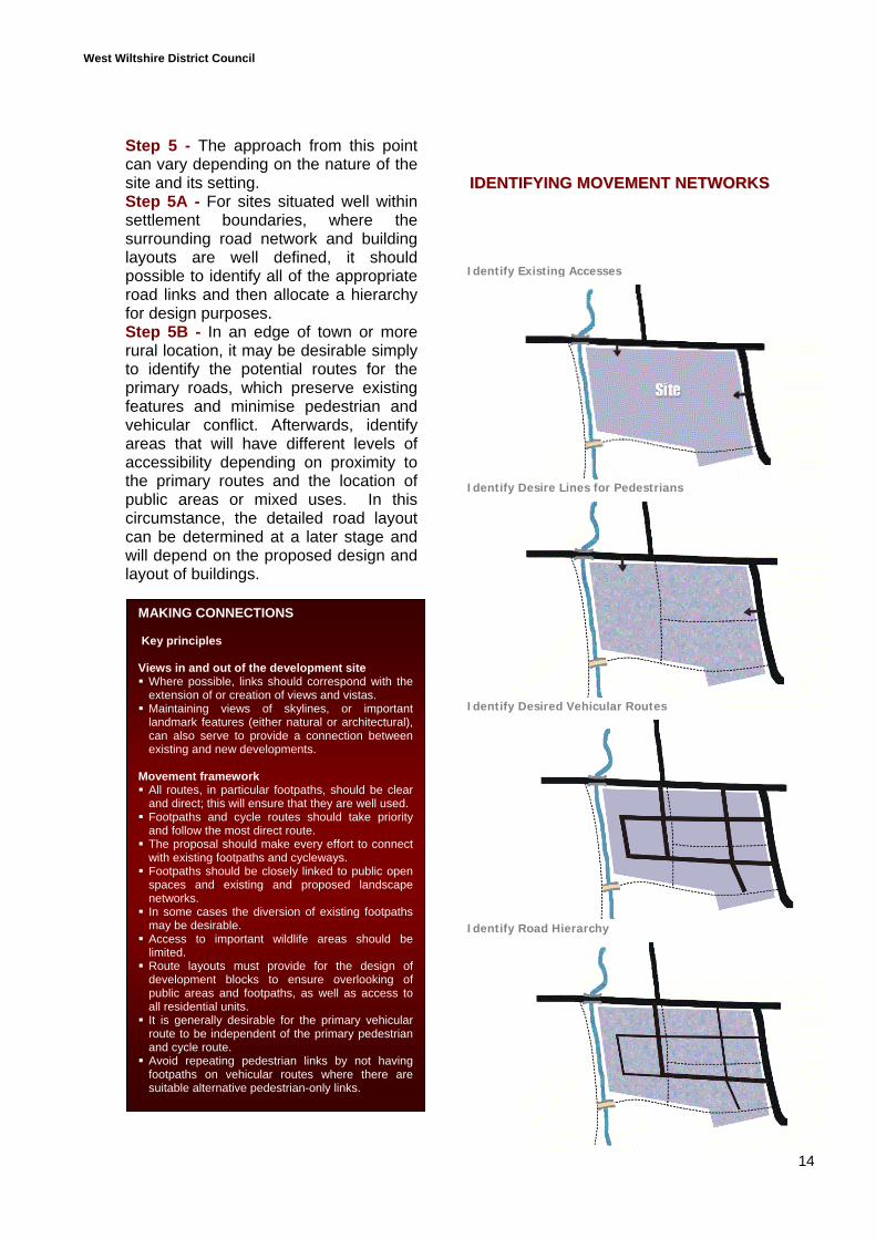
Step 5 - The approach from this pointcan vary depending on the nature of thesite and its setting.Step 5A - For sites situated well withinsettlement boundaries, where thesurrounding road network and buildinglayouts are well defined, it shouldpossible to identify all of the appropriateroad links and then allocate a hierarchyfor design purposes.Step 5B - In an edge of town or morerural location, it may be desirable simplyto identify the potential routes for theprimary roads, which preserve existingfeatures and minimise pedestrian andvehicular conflict. Afterwards, identifyareas that will have different levels ofaccessibility depending on proximity tothe primary routes and the location ofpublic areas or mixed uses. In thiscircumstance, the detailed road layoutcan be determined at a later stage andwill depend on the proposed design andlayout of buildings.
IIDDEENNTTIIFFYYIINNGG MMOOVVEEMMEENNTT NNEETTWWOORRKKSS
MAKING CONNECTIONS
Key principles
Views in and out of the development site Where possible, links should correspond with theextension of or creation of views and vistas.
Maintaining views of skylines, or importantlandmark features (either natural or architectural),can also serve to provide a connection betweenexisting and new developments.
Movement framework All routes, in particular footpaths, should be clearand direct; this will ensure that they are well used.
Footpaths and cycle routes should take priorityand follow the most direct route.
The proposal should make every effort to connectwith existing footpaths and cycleways.
Footpaths should be closely linked to public openspaces and existing and proposed landscapenetworks.
In some cases the diversion of existing footpathsmay be desirable.
Access to important wildlife areas should belimited.
Route layouts must provide for the design ofdevelopment blocks to ensure overlooking ofpublic areas and footpaths, as well as access toall residential units.
It is generally desirable for the primary vehicularroute to be independent of the primary pedestrianand cycle route.
Avoid repeating pedestrian links by not havingfootpaths on vehicular routes where there aresuitable alternative pedestrian-only links.
Identify Existing Accesses
Identify Desire Lines for Pedestrians
Identify Desired Vehicular Routes
Identify Road Hierarchy
West Wiltshire District Council
15
DESIGN CONCEPT
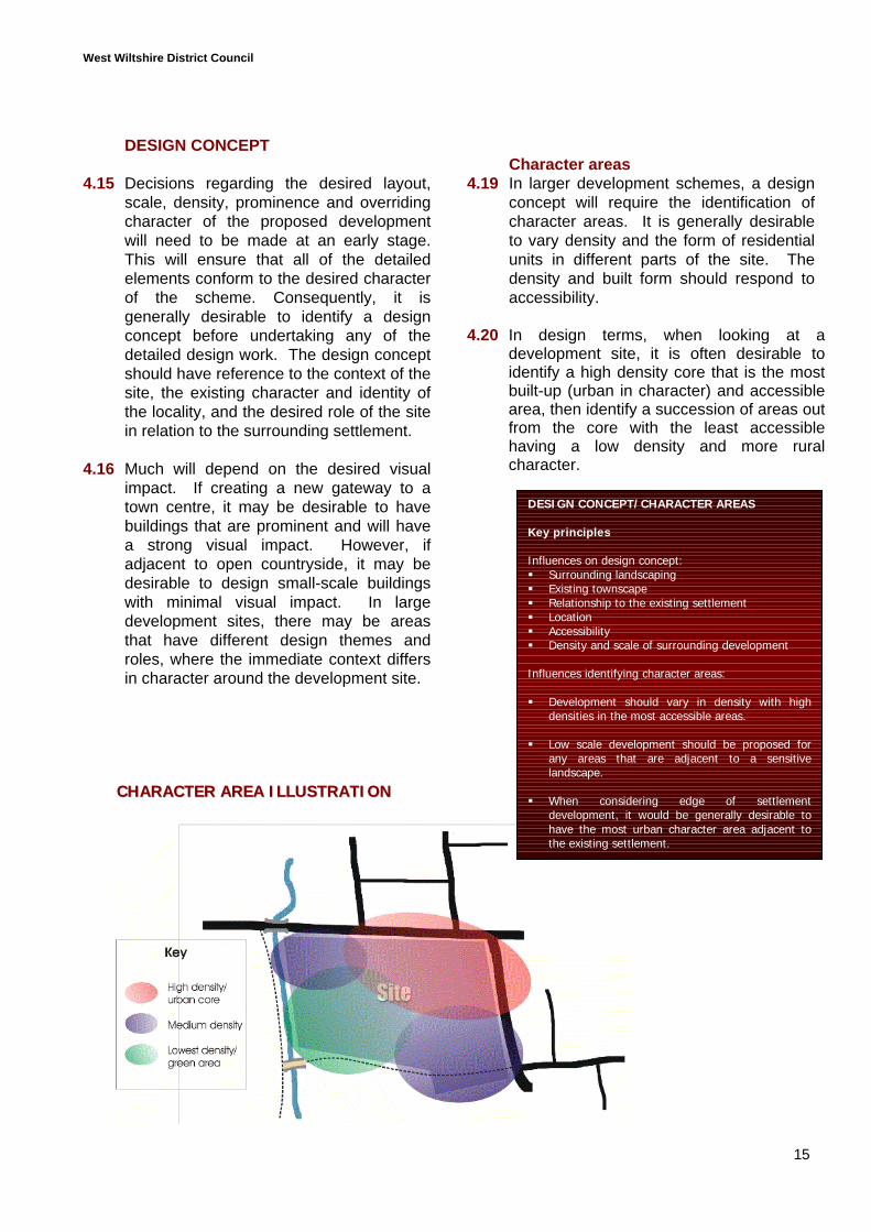
4.15 Decisions regarding the desired layout,scale, density, prominence and overridingcharacter of the proposed developmentwill need to be made at an early stage.This will ensure that all of the detailedelements conform to the desired characterof the scheme. Consequently, it isgenerally desirable to identify a designconcept before undertaking any of thedetailed design work. The design conceptshould have reference to the context of thesite, the existing character and identity ofthe locality, and the desired role of the sitein relation to the surrounding settlement.
4.16 Much will depend on the desired visualimpact. If creating a new gateway to atown centre, it may be desirable to havebuildings that are prominent and will havea strong visual impact. However, ifadjacent to open countryside, it may bedesirable to design small-scale buildingswith minimal visual impact. In largedevelopment sites, there may be areasthat have different design themes androles, where the immediate context differsin character around the development site.
Character areas4.19 In larger development schemes, a design
concept will require the identification ofcharacter areas. It is generally desirableto vary density and the form of residentialunits in different parts of the site. Thedensity and built form should respond toaccessibility.
4.20 In design terms, when looking at adevelopment site, it is often desirable toidentify a high density core that is the mostbuilt-up (urban in character) and accessiblearea, then identify a succession of areas outfrom the core with the least accessiblehaving a low density and more ruralcharacter.
DESIGN CONCEPT/CHARACTER AREAS
Key principles
Influences on design concept: Surrounding landscaping Existing townscape Relationship to the existing settlement Location Accessibility Density and scale of surrounding development
Influences identifying character areas:
Development should vary in density with highdensities in the most accessible areas.
Low scale development should be proposed forany areas that are adjacent to a sensitivelandscape.
When considering edge of settlementdevelopment, it would be generally desirable tohave the most urban character area adjacent tothe existing settlement.
CCHHAARRAACCTTEERR AARREEAA IILLLLUUSSTTRRAATTIIOONN
West Wiltshire District Council
16
5.0 DESIGNING STREETS
5.1 This section seeks to identify all of therelevant issues associated with designingstreets. Designing streets is not simplydesigning roads but considers the widercharacter of the development and is aimedat designing areas of character. Simplydesigning roads to accepted highwaystandards is no longer acceptable inaccordance with good design principles.
ROAD HIERARCHY
5.2 As identified in the previous sections,the road layout and design should relateto the level of use and be based on aclear hierarchy.
5.3 The extent of the road hierarchy willdepend on the size and characteristicsof the site. Wiltshire County Council’sResidential Road Design Guide (1993)identifies a number of road types thatrespond to road capacity requirements:
Local distributor road (750 dwellings)Transitional road (up to 400 dwellings)Major access road (300 dwellings)
Minor access road (150 dwellings)Access way (25 - 50 dwellings)
5.4 Guidance that has emerged since theResidential Road Design Guidesuggests a more flexible and informalapproach to road design. Consequently,the information in this document shouldonly be interpreted as guidance and notstrict requirements, and should beadapted to produce streets that aremore in tune with current best practice.It is generally accepted that reference toEssential Requirements should beapplied in a more flexible manner.
TTHHEE CCHHAARRAACCTTEERR OOFF SSTTRREEEETTSS
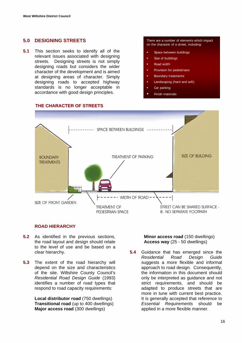
There are a number of elements which impacton the character of a street, including:
Space between buildings
Size of buildings
Road width
Provision for pedestrians
Boundary treatments
Landscaping (hard and soft)
Car parking
Finish materials
West Wiltshire District Council
17
The areas that have been highlighted fortheir impact on the character of streetsare:
footpaths size of verges road widths forward visibility surface materials
5.5 In accordance with more up to dateguidance, such as Places Streets andMovements produced by the DETR in1998, the emphasis should be oncreating streets of character andprioritising pedestrians over cars. Thiscalls for more informal street designs,less land being given over strictly tomotor vehicles, and a greater emphasison shared surfaces.
Footpaths5.6 Where it is necessary to locate footpaths
adjacent to roads, it is not generallyrequired to have a footpath on bothsides of the road, particularly wherebuildings do not face the road.
5.7 Where possible, efforts should be madeto achieve shared surface areas, whichmeans no separate footpath is needed,and the surfacing and arrangement ofbuildings must be designed to reducevehicle speeds and provide safe sharedareas.
Verges5.8 Verges separating the highway from
adjacent land can often constitutewasted space. Highway verges need tobe considered in terms of both functionand the desired character. A vergeshould only be provided where it wouldserve a practical function and/orcontribute visually to a developmentscheme.
5.9 If required, verges can provide anopportunity to encourage biodiversity,through planting street trees orcontributing to the network ofgreenways.
5.10 Green verges in areas of rural charactercan:
present soft edging for an informalplot frontage; or
make an important contribution as alandscape feature, where landadjacent to the highway is requiredfor visibility splays etc.
5.11 Hard landscaped verges in more urbanareas can accommodate any additionalturning space or road width required foremergency vehicles etc, and allow forreductions in highway widths.
Road widths5.12 Widths should be kept to a minimum. If
it is desirable to have a significant gapbetween building frontages, priorityshould be given to providing frontgardens, usable public space and/orareas which contribute to biodiversity.
5.13 Disrupting the free flow of traffic can bebeneficial. Consequently, providing fortwo-way traffic will not always bedesirable depending on the level of useand overall design concept.
Materials – see Detailed Section 6Designing the Public Realm
Building regulations5.14 Street design, in terms of the layout and
materials used, is an area whereconsideration of the building regulationsrequirements at the planning applicationstage may prevent the need foralterations and amendments after theinitial planning permission has beengranted. The main areas to consider willbe the design of footpaths, and theimpact of fire safety requirements onroad layouts. During the design ofstreets, reference to building regulationswould be beneficial for the designer.
West Wiltshire District Council
18
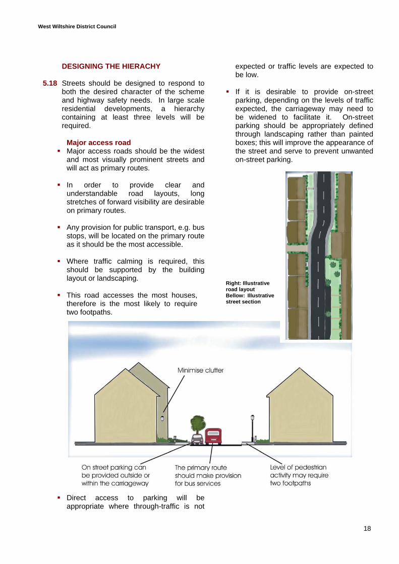
DESIGNING THE HIERACHY
5.18 Streets should be designed to respond toboth the desired character of the schemeand highway safety needs. In large scaleresidential developments, a hierarchycontaining at least three levels will berequired.
Major access road Major access roads should be the widest
and most visually prominent streets andwill act as primary routes.
In order to provide clear andunderstandable road layouts, longstretches of forward visibility are desirableon primary routes.
Any provision for public transport, e.g. busstops, will be located on the primary routeas it should be the most accessible.
Where traffic calming is required, thisshould be supported by the buildinglayout or landscaping.
This road accesses the most houses,therefore is the most likely to requiretwo footpaths.
Direct access to parking will beappropriate where through-traffic is not
expected or traffic levels are expected tobe low.
If it is desirable to provide on-streetparking, depending on the levels of trafficexpected, the carriageway may need tobe widened to facilitate it. On-streetparking should be appropriately definedthrough landscaping rather than paintedboxes; this will improve the appearance ofthe street and serve to prevent unwantedon-street parking.
Right: Illustrativeroad layoutBellow: Illustrativestreet section
West Wiltshire District Council
19
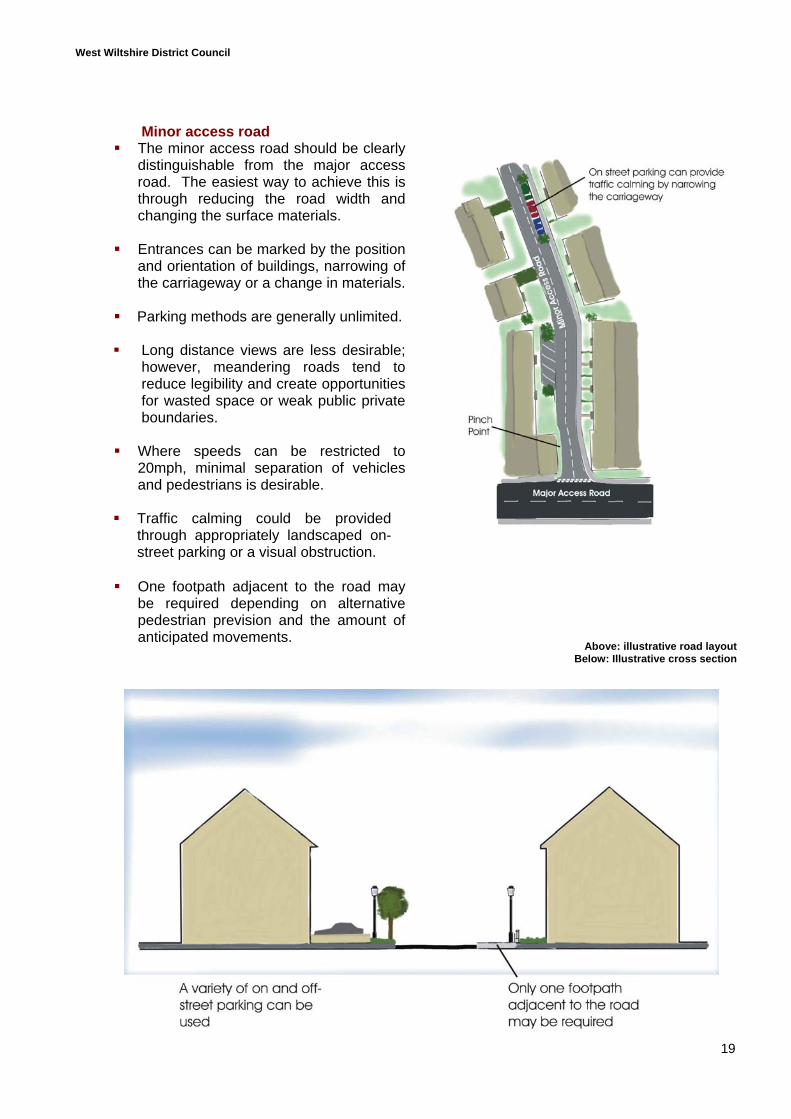
Minor access road The minor access road should be clearly
distinguishable from the major accessroad. The easiest way to achieve this isthrough reducing the road width andchanging the surface materials.
Entrances can be marked by the positionand orientation of buildings, narrowing ofthe carriageway or a change in materials.
Parking methods are generally unlimited.
Long distance views are less desirable;however, meandering roads tend toreduce legibility and create opportunitiesfor wasted space or weak public privateboundaries.
Where speeds can be restricted to20mph, minimal separation of vehiclesand pedestrians is desirable.
Traffic calming could be providedthrough appropriately landscaped on-street parking or a visual obstruction.
One footpath adjacent to the road maybe required depending on alternativepedestrian prevision and the amount ofanticipated movements.
Above: illustrative road layoutBelow: Illustrative cross section
West Wiltshire District Council
20
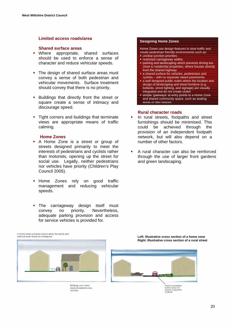
Limited access roads/area
Shared surface areas Where appropriate, shared surfaces
should be used to enforce a sense ofcharacter and reduce vehicular speeds.
The design of shared surface areas mustconvey a sense of both pedestrian andvehicular movements. Surface treatmentshould convey that there is no priority.
Buildings that directly front the street orsquare create a sense of intimacy anddiscourage speed.
Tight corners and buildings that terminateviews are appropriate means of trafficcalming.
Home Zones A Home Zone is a street or group of
streets designed primarily to meet theinterests of pedestrians and cyclists ratherthan motorists, opening up the street forsocial use. Legally, neither pedestriansnor vehicles have priority (Children’s PlayCouncil 2005).
Home Zones rely on good trafficmanagement and reducing vehicularspeeds.
The carriageway design itself mustconvey no priority. Nevertheless,adequate parking provision and accessfor service vehicles is provided for.
Rural character roads In rural streets, footpaths and street
furnishings should be minimised. Thiscould be achieved through theprovision of an independent footpathnetwork, but will also depend on anumber of other factors.
A rural character can also be reinforcedthrough the use of larger front gardensand green landscaping.
Left: Illustrative cross section of a home zoneRight: Illustrative cross section of a rural street
Designing Home Zones
Home Zones use design features to slow traffic andcreate pedestrian friendly environments such as: unclear junction priorities restricted carriageway widths parking and landscaping which prevents driving tooclose to residential properties, where houses directlyfront the shared highway
a shared surface for vehicles, pedestrians andcyclists – with no separate raised pavements.
a well designed public realm where the location anddesign of landscaping and street furniture (e.g.bollards, street lighting, and signage) are visuallyintegrated and do not create clutter
simple ‘gateways’ at entry points to a Home Zoneand shared community space, such as seatingareas or play spaces
West Wiltshire District Council
21
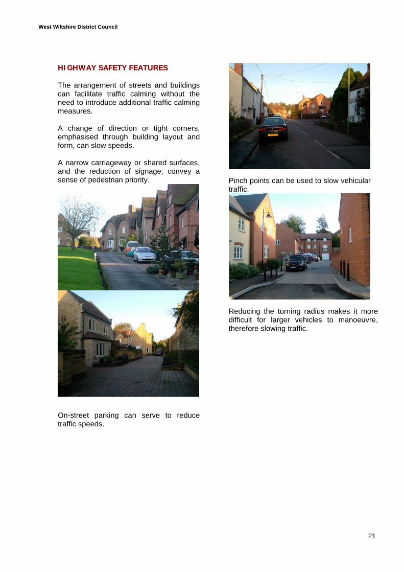
HHIIGGHHWWAAYY SSAAFFEETTYY FFEEAATTUURREESS
The arrangement of streets and buildingscan facilitate traffic calming without theneed to introduce additional traffic calmingmeasures.
A change of direction or tight corners,emphasised through building layout andform, can slow speeds.
A narrow carriageway or shared surfaces,and the reduction of signage, convey asense of pedestrian priority.
On-street parking can serve to reducetraffic speeds.
Pinch points can be used to slow vehiculartraffic.
Reducing the turning radius makes it moredifficult for larger vehicles to manoeuvre,therefore slowing traffic.
West Wiltshire District Council
22
Street design
Key principlesThe arrangement and design of residential streetsshould be based on a clear hierarchy and layout ofavenues, streets, squares and courts.
Hierarchy and character are created through changes inroad widths, the provision of footpaths, and surfacetreatments, as well as building design.
The governing factor in street design should be thedesired character of the locality and consideration ofpedestrian needs.
There are a number of elements that will impact on thecharacter of a street, including:
Space between buildings Road widths Size of buildings Architectural features Boundary treatments Provision for pedestrians Landscaping Car parking treatment Finish materials
Additional design detailsTo create quality road networks, there are a number ofprinciples that need to be considered:
To encourage pedestrian and cycle movements, it isdesirable to connect as many existing routes aspossible.
Each alternative route must be visible. New routes must be seen to go somewhere. Meandering routes reduce legibility and should be
avoided, especially on primary roads. Identifying where the most heavily used routes are
likely to be will help when it comes to detaileddesign.
Terminated views serve to slow vehicular traffic. Only the lowest roads in the hierarchy should have
dead ends.
West Wiltshire District Council
23
6.0 DESIGNING THE PUBLIC REALM
6.1 The main principle in designing the publicrealm is KEEP IT SIMPLE.
Avoid over-provision of street furnitureand clutter.
Consider requirements for futuremaintenance.
Avoid features that have no functionand might detract from a location’slegibility.
The amount of street furniture andmaterials used should reflect thecharacter of the proposed schemeand the wider locality.
Design should reflect urban and rurallocations. Formal hard paving may notbe appropriate within an area of ruralcharacter where soft edges and lessformal spaces are characteristic.
Lighting design and street signage6.2 Traffic engineering and safety
requirements, such as lighting columnsand signage, can detract from a sense oflocal distinctiveness if they arenondescript and can be found anywhere.These elements must contribute to anunderstanding of the area, but must bedesigned and used appropriately.
Avoid unnecessary lighting andsignage (the need to minimise lightingis also identified in Policy C35 of theDistrict Plan).
Ensure that provision is of a standardand level that won’t create streetclutter or result in light pollution.
Streets signs - in particular roadnames - should be considered inassociation with lighting.
Building design and layout shouldreduce the need for road signs.
6.3 The detailed design of street signs shouldnot simply reflect standard engineeringdesigns but should be considered interms of the development’s character.
6.4 Free-standing lighting columns and signscan create clutter and obstacles in astreet, and are also susceptible tovandalism.
6.5 Wall mounted lights illuminate buildings,making attractive features and minimisingthe impact of the streetlight withindwellings.
6.6 Lighting should not simply create a pool oflight at street level but should identifyfeatures that add interest to the streetscene at night.
Materials6.7 Varying surface materials within a road
hierarchy can help to define thathierarchy, i.e. the surface treatmentsused in a street will depend on itsposition in the hierarchy and the level ofvehicular or pedestrian activity. The useof materials also serves to define andreinforce identity and can significantlyenhance or degrade the street’sappearance. Particular care should betaken when dealing with the historicenvironment.
6.8 The use of paving materials can definepedestrian priority areas withoutrequiring large verges or raised paving.This will also allow for additional turningcapabilities on otherwise narrow roadsto accommodate emergency and servicevehicles etc.
6.9 The treatment of roads and pavementswill depend on the level of use andproposed formality of the designconcept. Where it is desirable to have ashared vehicular and pedestrian area,the surface treatment must be carefullyconsidered to ensure that the shareduse is clearly communicated.
West Wiltshire District Council
24
Street furniture6.10 Street furniture should only be provided
where it will be used and where it performan important function; for example, binsand benches should be located onpedestrian desire lines or in public nodes.However, under-provision of streetfurniture in terms of waste bins and dogbins can also be detrimental and result inthe littering of footpaths and public openspaces.
6.11 A different approach to street furniture indifferent areas can reinforce localdistinctiveness. Alternatively, if streetfurnishings are a characteristic feature ofthe existing locality, it may be appropriateto incorporate such features into newdevelopments.
6.12 When dealing with the historicenvironment, it is important to maintainand complement the character of thepublic realm. Consequently, the choice ofmaterials and furnishings will be carefullyscrutinised.
6.13 The use of features such as bollards,walls, gates, piers and railings within thepublic realm can be attractive in the streetscene, as well as having importantfunctions in crime prevention andownership issues.
6.14 The design of street furniture should beindividually considered in eachdevelopment area and not simply conformto standard designs. Nevertheless, thedesign of street furnishings should takeinto consideration health and safetyrequirements, particularly when dealingwith railings.
6.15 Developers could consider thecommissioning of artists and craftspeopleto deliver appropriate street furniture orother design features within adevelopment scheme, which wouldenable them to meet the requirements ofPolicy I2 as outlined in paragraph 3.25 ofthis document.Public art
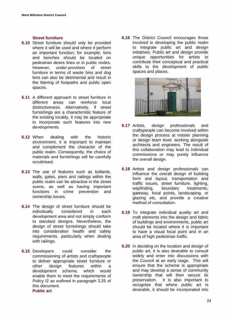
6.16 The District Council encourages thoseinvolved in developing the public realmto integrate public art and designinitiatives. Public art and design provideunique opportunities for artists tocontribute their conceptual and practicalskills to the development of publicspaces and places.
6.17 Artists, design professionals andcraftspeople can become involved withinthe design process at master planningor design team level, working alongsidearchitects and engineers. The result ofthis collaboration may lead to individualcommissions or may purely influencethe overall design.
6.18 Artists and design professionals caninfluence the overall design of buildingform and layout, transportation andtraffic issues, street furniture, lighting,wayfinding, boundary treatments,gateway, focal points, landscaping, orglazing etc, and provide a creativemethod of consultation.
6.19 To integrate individual quality art andcraft elements into the design and fabricof buildings and environments, public artshould be located where it is importantto have a visual focal point and in anarea of high pedestrian traffic.
6.20 In deciding on the location and design ofpublic art, it is also desirable to consultwidely and enter into discussions withthe Council at an early stage. This willensure that the scheme is appropriateand may develop a sense of communityownership that will then secure itspreservation. It is also important torecognise that where public art isdesirable, it should be incorporated into
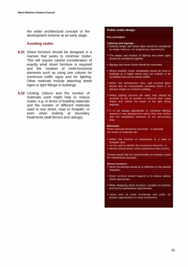
West Wiltshire District Council
25
the wider architectural concept of thedevelopment scheme at an early stage.
Avoiding clutter
6.21 Street furniture should be designed in amanner that seeks to minimise clutter.This will require careful consideration ofexactly what street furniture is requiredand the creation of multi-functionalelements such as using one column fornumerous traffic signs and for lighting.Other methods include attaching streetsigns or light fittings to buildings.
6.22 Limiting colours and the number ofmaterials used might help to reduceclutter, e.g. in terms of building materialsand the number of different materialsused in one street, road or footpath, oreven when looking at boundarytreatments (wall fences and railings).
Public realm design
Key principles
Lighting and signage Lighting design and street signs should be consideredas design features, not engineering requirements.
The design and location of lighting and street signsshould be considered together.
Signage and street clutter should be minimised.
Where possible, street nameplates should be fixed tobuildings at a height where they are unlikely to bevandalised and will be clearly visible.
Within new development sites, wall mounted lightsshould also be incorporated, providing there is noadverse impact on a historic building.
Where lighting columns are used, they should bespecified as low as possible to minimise their visualimpact and reduce the power of the light fittingrequired.
It is not always appropriate to introduce lightingsystems in new developments where they may conflictwith the established character of the surroundingarea.
MaterialsFinish materials should be functional - in particularthe choice of materials can:
reflect the function or importance of a road orfootpath; and
can be used to identify the movement hierarchy; or identify shared areas, where pedestrians have priority.
Tarmac would only be recommended on primary routesfor maintenance purposes.
Street furniture Street furnishings should be a reflection of the desiredcharacter.
Street furniture should respond to its historic settingwhere appropriate.
When designing street furniture, consider its functionand future maintenance requirements.
Issues such as street furnishings and public artpresent opportunities for local involvement.
West Wiltshire District Council
26
7.0 LANDSCAPING
7.1 A common misconception is that theterm landscape refers only to matters ofplanting or natural features, and thatlandscaping in reference to a newdevelopment only refers to a plantingscheme that is considered afterpermission is granted.
7.2 Landscape covers many issues relatedto: the existing nature of a development
site and it surroundings; the incorporation of new planting
schemes; and designing the built environment.
Whilst the details of the proposedlandscape treatment could be identifiedsubsequent to the granting of planningpermission as a condition, there arelandscape matters that must beconsidered from the beginning of thedesign process:
LANDSCAPING MATTERS
7.3 The identification of landscape mattersshould have reference to all of thepotential issues that might affect adevelopment site, including:
Preservation of existing landscapefeatures
Preservation and enhancement ofbiodiversity opportunities
Relating the development to thewider natural landscape setting
Relating the development to the builtcharacteristics of the settlement
7.5 In order to address these landscapematters, there are two stages or areas ofwork to be undertaken:
A landscape assessment The landscape treatment
LANDSCAPE ASSESSMENT
7.6 The landscape assessment requires thedesigner to study the development siteand the wider area, and develop anunderstanding of the existing naturaland built landscape features that willinfluence the design of the developmentscheme. This will therefore require astudy and an analysis.
A landscape study should identify:
Existing habitat networks within andaround the site, otherwise known asfunctional habitat networks or greencorridors. These should also identify allareas of ecological value.
The Town and Country PlanningAssociation (2004) define a functionalhabitat network as:
“A mosaic of smaller green spaces setwithin a continuous linked hierarchy oflarger green spaces, which aims tomaximise the extent and variety ofhabitats available.”
Important natural features within andadjacent to the development siteinclude:Slopes in ground levelsDistinctive viewsTrees and hedgesNatural water featuresOther distinctive landscape features
Characteristic landscape features withinthe built environment include:Traditional building materialsCharacteristic building featuresStreet furniturePublic squaresHighway designViews created by buildings
7.7 Following on from this study, thedesigner should analyse the data andcompile a concept or principles fortaking forward the overall schemedesign and landscape treatment.
7.8 An important part of the assessment willbe to identify the existing features to be
West Wiltshire District Council
27
retained. Reference to the widerlandscape features and characteristicsof the locality, and the retention ofnatural or built features within adevelopment site, contribute to thecreation of local distinctiveness and asense of place within all developments.Retaining existing trees and otherlandscape features will also:
provide a positive perception of alocality;
contribute to a sense of socialwellbeing; and
improve the visual attractiveness ofa scheme.
7.9 Another element of the assessment inlarger development sites will be toidentify a hierarchy of public areas andgreen areas. This will have to ensure afunctional habitat network within thedevelopment scheme and identifypractical or environmental functions forall of the green or public areas, toprevent wasted space.
LANDSCAPE TREATMENT
7.10 The landscape treatment is theproduction of a detailed landscapescheme, which should respondpositively to the landscape assessmentand be based on the concept orprinciples identified within it. This willidentify plant types and species, andfeatures relating to public realm andstreet design.
Retention and replacement planting7.11 A landscape treatment scheme should
enhance the sense of character.Existing planting and landscape featuresshould be retained wherever possible;this will enhance the sense of characterattractiveness and scheme’s biodiversitypotential. If the removal of a featuresuch as a hedge or tree is required, asuitable replacement must be secured.
7.12 An open space network provides visualamenity and should be developed in linewith the movement framework
(especially primary pedestrian routes)and building layouts to ensure naturalsurveillance and appropriate levels ofaccessibility.
Functional space7.13 Whilst it may be desirable to have a
break in the building frontage or openspaces within a development schemefor visual reasons, each landscape areashould have a definable function andvisible ownership, for example:
Recreation grounds Paths and streets Public greens and squares Play areas Wildlife preservation areas Private garden space Shared amenity areas Public greens Courtyards or squares Play areas
Public open space7.14 Most development schemes of 10
dwellings or more will need toincorporate open space facilities. Thelocation of such facilities should becarefully planned to ensure that they areaccessible and safe. In particular, playareas need to be conveniently locatedfor the housing group that they serve,and located within the protection of thebuilt community, to provide naturalsurveillance from surrounding houses.
Creating opportunities for wildlife7.15 It is important that new development
seeks to enhance opportunities forbiodiversity and create new habitats, aswell as preserve existing wildlife areas.This applies to both urban regenerationsites and greenfield sites. Moreinformation on biodiversity is containedwithin section 11.
It is also important to consider theenvironmental conditions that createopportunities for functional habitats. Inplaces where the local environmentprovides a good basis for biodiversity,
West Wiltshire District Council
28
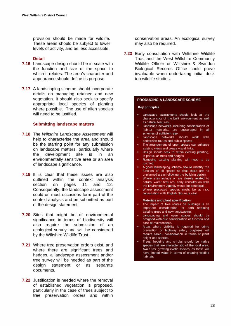
PRODUCING A LANDSCAPE SCHEME
Key principles
Landscape assessments should look at thecharacteristics of the built environment as wellas natural features.
Landscape networks, including consideration ofhabitat networks, are encouraged in allschemes of sufficient size.
Landscape networks should work withpedestrian routes and public spaces.
The arrangement of open spaces can enhanceexisting views and create visual links.
Design should seek to retain existing planting,in particular trees and hedges.
Removing existing planting will need to bejustified.
A good landscaping scheme should identify thefunction of all spaces so that there are nounplanned areas following the building design.
Where sites include or are closely related tonatural water features, early consultation withthe Environment Agency would be beneficial.
Where protected species might be at risk,consultation with English Nature is vital.
Materials and plant specification The impact of tree routes on buildings is an
important consideration for both retainingexisting trees and new landscaping.
Landscaping and open spaces should bedesigned with due consideration of function andease of maintenance.
Areas where visibility is required for crimeprevention or highway safety purposes willrequire careful consideration in terms of plantheight and species.
Trees, hedging and shrubs should be nativespecies that are characteristic of the local area.Avoid fast growing exotic species, as these willhave limited value in terms of creating wildlifehabitats.
provision should be made for wildlife.These areas should be subject to lowerlevels of activity, and be less accessible.
Detail7.16 Landscape design should be in scale with
the function and size of the space towhich it relates. The area’s character andappearance should define its purpose.
7.17 A landscaping scheme should incorporatedetails on managing retained and newvegetation. It should also seek to specifyappropriate local species of plantingwhere possible. The use of alien specieswill need to be justified.
Submitting landscape matters
7.18 The Wiltshire Landscape Assessment willhelp to characterise the area and shouldbe the starting point for any submissionon landscape matters, particularly wherethe development site is in anenvironmentally sensitive area or an areaof landscape significance.
7.19 It is clear that these issues are alsooutlined within the context analysissection on pages 11 and 12.Consequently, the landscape assessmentcould on most occasions form part of thecontext analysis and be submitted as partof the design statement.
7.20 Sites that might be of environmentalsignificance in terms of biodiversity willalso require the submission of anecological survey and will be consideredby the Wiltshire Wildlife Trust.
7.21 Where tree preservation orders exist, andwhere there are significant trees andhedges, a landscape assessment and/ortree survey will be needed as part of thedesign statement or as separatedocuments.
7.22 Justification is needed where the removalof established vegetation is proposed,particularly in the case of trees subject totree preservation orders and within
conservation areas. An ecological surveymay also be required.
7.23 Early consultation with Wiltshire WildlifeTrust and the West Wiltshire CommunityWildlife Officer or Wiltshire & SwindonBiological Records Office could proveinvaluable when undertaking initial desktop wildlife studies.
West Wiltshire District Council
29
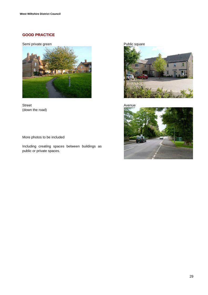
GGOOOODD PPRRAACCTTIICCEE
Semi private green
Street(down the road)
More photos to be included
Including creating spaces between buildings aspublic or private spaces.
Public square
Avenue
West Wiltshire District Council
30
8.0 DESIGNING HOUSES
8.1 This section looks at designing thedwellings themselves, from buildinglayouts to issues relating to boundarytreatments and car parking.
BUILDING BLOCKS
8.2 A building block is an arrangement ofbuildings that is outward looking andaddresses all surrounding highways. Adesign based on a building blockarrangement is considered goodpractice.
8.3 An arrangement of building blocks isdesirable as opposed to arrangingbuildings in a haphazard style or in smalldisjointed strips.
Arranging blocks8.4 Building blocks should enable the
efficient use of land and present activefrontages onto the public realm.
8.5 Using building blocks does not prohibitthe creation of public spaces or featuressuch as squares, courtyards andavenues. It seeks to ensure that aholistic view is taken of buildingarrangement and prevents inactivestreet frontages.
8.6 In identifying a general building blockarrangement, it is necessary to considerhow it will need to respond to:
Site boundaries The arrangement of immediately
adjoining buildings Connecting views and vistas Potential vehicular entrances Desire lines for pedestrian routes The location of proposed amenity areas
and landscaping The retention of existing buildings/
features where possible.
Extending on or simply utilising existingviews and vistas can serve to integrate adevelopment into its surroundings and isstrongly encouraged.
Designing blocks8.7 The layout of existing streets and
buildings in the locality can be used toinform the layout of a new scheme andprovide continuity. If the building layoutthat characterises the immediatesurroundings is undefined or poorlydefined, it may be desirable to look atthe wider context and the grid patternsor building layouts that are historicallycharacteristic of the town or village.
8.8 Building layout cannot be determinedindependently of an understanding ofscale. Changes in the character or feelof any locality are influenced by thescale of building and the spacesbetween. These factors combined willcreate a level or sense of enclosure.
8.9 When considering the desired spacesbetween buildings, and the heights ofbuildings, it is important to consider thelevel of enclosure required and thepublic or private function of the spacesbetween buildings. High levels ofenclosure created by buildings andboundary treatments results in a strongdestination between public and privatespaces. However, good enclosure iswasted when there is an abundance ofwasted space between buildings.
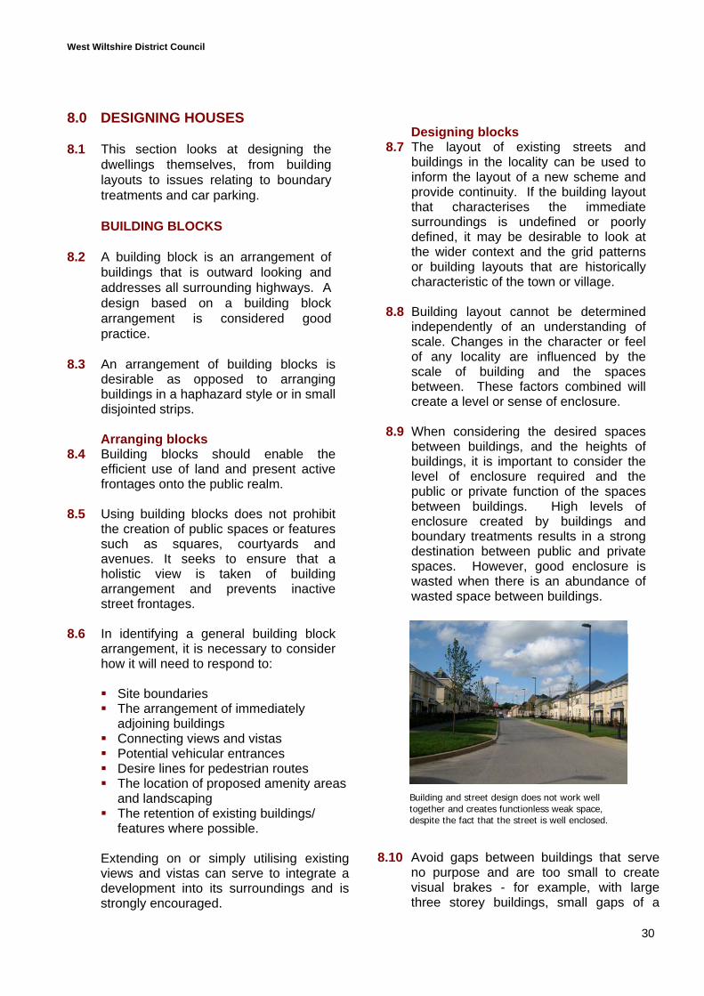
8.10 Avoid gaps between buildings that serveno purpose and are too small to createvisual brakes - for example, with largethree storey buildings, small gaps of a
Building and street design does not work welltogether and creates functionless weak space,despite the fact that the street is well enclosed.
West Wiltshire District Council
31
metre or two are damaging to the creationof strong building lines. They are alsovisually unattractive and are a form ofwasted space. Gaps between buildingsshould be relative to the scale ofdevelopment and have a function in thestreet scene, e.g. create a visual brake inan otherwise heavily built-up frontage.
8.11 A low level of enclosure created by longfront gardens, or where buildings front awell used public recreation area or node,creates a feeling of space, and cancontribute to the character of the locality.Consequently, high and low levels ofenclosure can be used to create streets orareas of different character.
8.12 The detailed arrangement of buildingsshould:
Provide entrances from buildings ontopublic spaces, which will increase thelevel of activity and naturalsurveillance.
Have buildings fronting onto cornersand turnings. This will give character,enhance legibility, and improvehighway safety by informing drivers ofa turning point.
Use landmark buildings throughout adevelopment site to add interest andenforce legibility. To be effective, thelocation of landmark buildings must becombined with appropriate visual andphysical links.
Introduce, where appropriate, differentuses to add variety and vitality to anarea.
Give strong definition to public andprivate space by using buildings thatterminate views.
Use continuity to enforce character; forexample, identifiable building linescreate a level of consistency within thestreet scene. A lack of identifiablebuilding lines can lead to poor legibilityand weaken a sense of character.
BUILDING DESIGN
8.13 Building design should complement theexisting settlement by emulating orrespecting features that are consideredcharacteristic of that locality. This willdepend on the scale of the proposeddevelopment and the characteristics ofthe surroundings.
8.14 Established elements of localdistinctiveness, building layouts, heights,massing, materials and local vernacularidentified within the context should beconsidered in terms of whether theyprovide useful reference points to inspirenew design.
8.15 The use of standard designs isunacceptable. Whilst innovative designsolutions are encouraged, these shouldhave an identifiable link to the widercharacter of the settlement rather thanbeing purely based on current fashions.
Scale8.16 Scale should respond to the design of
the streets and therefore should beconsidered during the concept stageand when considering the roadhierarchy and building layout.
8.17 The scale of individual buildings mustalso have regard to how the proposedbuildings will relate to existing buildingswithin the immediate context.
Height and sky line8.18 Varying the height of buildings within a
development block can serve to addinterest to the street scene and canbreak up frontages to reduce theperception of bulk.
8.19 The success of areas with continuousbuilding heights is dependent on theinterest of the detailed design, setting ofthe building block or terrace, and thelength of the frontage. Individual large-scale buildings or terraces, which havestrong architectural features, can have a
West Wiltshire District Council
32
strong presence within the street sceneand serve to create or reinforce identify.
8.20 Significant changes in height, orphysical breaks in the built frontage, canbe used to allow glimpses of landscapefeatures, adding interest to the skyline.Other features such as changing roofdesigns and chimneys can also be usedto add interest to the skyline.
8.21 In some areas, dormers are importanthistoric building features; however, theycan clutter roof designs. Dormers tendto be overused in recent housingdevelopments to maximise floorspace,but this can limit a building’sadaptability, overwhelm elevations andrequire constantly steep roof pitches.Consequently, the decision to includedormers within designs should becarefully considered and only used on alimited number of buildings within aproposed development, rather thanbeing a standard design feature.
Elevations8.22 It is often desirable for the choice of
materials and vernacular design detailssuch as doors and windows to representthose that are characteristic of thelocality, particularly when building insensitive areas such as villages orconservation areas.
8.23 Openings add interest and activity tobuilding elevations, but too many canresult in a cluttered appearance.Nevertheless, for visual amenity andcrime prevention reasons, blank wallsshould be avoided. If unavoidable,landscaping should be used to addvisual interest and discourage graffiti.
8.24 A variety of windows, doors and porchtreatments can add interest to the streetscene, depending on their design.However, fussy detailing can bedamaging to the overall appearance ofthe dwelling.
HOUSING MIX
8.25 Irrespective of the requirement foraffordable housing, developmentschemes should provide a mix of sizesand types to meet the needs of the areain accordance with the requirements ofPolicy H24.
8.26 A good mix of units must include differentsizes of houses as well as incorporatingflats. A two bedroom flat will meet theneeds of a single person or a couple butonly for a limited time, whereas a two-bedroom house is also suitable for a smallfamily.
8.27 A mix of unit types and sizes is alsoencouraged for reasons of crimeprevention (see section 10).
8.28 The mix and type of units should bebased on understanding the character ofthe locality and consideration of localneed. Early consultation with the HousingEnabling Manager will not only identifyaffordable housing requirements, but willalso serve to outline the size and type ofunits that are most in demand.
PRIVATE OUTDOOR SPACE
8.28 The Commission for Architecture and theBuilt Environment (CABE) has highlightedin several research documents that theprovision of private or shared gardens isgenerally desirable.
8.29 The benefit of providing quality gardenspace is that it meets the amenityrequirements of occupants and creates anattractive visual feature. Green spacewithin urban areas provides visual reliefand can create opportunities forbiodiversity.
8.30 Gardens can also provide important visualbreaks between buildings, allowing viewsof local features or becoming landscapefeatures in there own right.
8.31 The provision of private garden space forhouses is traditionally in the form of front
West Wiltshire District Council
33
and/or back gardens, both of which havevisual, environmental and amenity value.
8.32 In some areas, a usable front garden hasbecome an important historic feature - anexample is The Tory in Bradford on Avon.Whilst this method of accommodatingusable private amenity space is notcommon, front gardens can be used forthe owner or occupier’s enjoyment, andas a landscape feature, if set out properly.This may be particularly useful in areaswhere it is difficult to accommodatestandard rear gardens.
8.33 In the case of town centre flats,developers could consider providing somespace by incorporating balconies or rooftop gardens as well as shared gardens.
8.34 Whilst it is recognised that high qualitydevelopments exist which do not provideoutside amenity space, it is consideredthat amenity space is important to thevisual attractiveness of a developmentand to people’s quality of life. Someprovision for every dwelling unit should besought in all schemes and any proposalthat does not provide suitable levels ofamenity or garden space must besufficiently justified.
BOUNDARY TREATMENTS
8.35 Where boundaries are clearly defined,so are land use, ownership andmaintenance responsibilities.
Traditional front gardens
8.36 Boundary treatments should reflecthistoric development patterns and berelevant to the design concept. Forexample, in areas of Trowbridge, frontgardens are contained within low-risebrick or dry stone walls or railings, asthese are characteristic features of thetown. In more rural style developments,it may be desirable to use hedges, smallfences or even have open front gardens.
8.37 When deciding on front gardens, as wellas considering the desired character ofthe development, the likelihood of frontgardens being used as parking areasshould be considered and prevented.For example, this could be achieved byusing a solid boundary treatment suchas a wall, preventing vehicular access tothe front as well as ensuring that there issufficient parking provision.
8.38 In some instances, it will be desirable tohave buildings directly fronting onto thehighway with no provision for a frontgarden, particularly where you arepursuing Home Zones.
Private gardens
8.39 There is a greater need for securitywithin private gardens, so features suchas taller walls or close board fencing areoften used. This is appropriate whererear boundaries are not in the publicrealm.
8.40 Boundary treatments can make use ofexisting hedgerows or lines of trees.
West Wiltshire District Council
34
BUILDING MATERIALS
8.41 Using local materials that arecharacteristic of the area is encouraged.In considering the whole site, onematerial should be dominant, with theintroduction of other materials on a morelimited basis to create variety.
8.42 Materials should be chosen with dueconsideration to: maintenance requirements long term costs how the surfaces will react to weather
and pollution the material’s overall lifespan the need to consider recycled or
recyclable materials construction and operational
efficiency, e.g. thermal and solarproperties.
Local sourcing is also encouraged forreasons of sustainability and enhancinglocal character. The benefits of locallysourced materials relate to both theretention of character and sustainability interms of local economic benefits.
West Wiltshire District Council
35
CAR PARKING
8.43 For reasons of crime prevention, theWiltshire Constabulary would prefer tosee in-curtilage parking. However, this isnot always practical and in largerschemes a mix would be more visuallyappropriate. Nevertheless, for securityand visual amenity reasons, small groupsof parking spaces or garages are moredesirable than large car parks.
Frontage garages8.44 Attached garages can help to create
coherent and continuous frontageswhilst visually breaking up buildingmass, providing a gap betweenbuildings and enabling buildings to turncorners with ease.
8.45 Freestanding garages can result in anunnecessary waste of space and clutter,when frequently used and combinedwith detached dwellings.
8.46 Double garages can be features withinthe street scene, if imaginativelydesigned, but should be used sparinglyas they tend to be alien to establishedtownscapes and can become overlydominant in the street scene.
Rear garaging8.47 The provision of garaging to the rear of
a dwelling within its curtilage will need toconsider carefully how to createsufficient security. Large amounts ofgaraging to the rear of dwellings, incourts or along a loop, can createunattractive indefensible spaces proneto vandalism and neglect.
Garage courts8.48 Large garaging courts tend to be
unattractive features and should bediscouraged. In addition, guidance fromthe Wiltshire Constabulary states that,where parking areas are necessary,they should be in small groups andpreferably viewed from the premises towhich they relate.
Parking spaces8.49 On-street parking should be clearly
defined and well landscaped. On-streetparking can serve to slow vehiclespeeds in low traffic areas or HomeZones.
8.50 The impact of on-street parking spacescan be offset through the use ofappropriate landscaping.
Shared car parks8.51 The best location for shared car parks is
within courts or squares whereappropriate levels of surveillance can beprovided with ease.
8.52 Car parks should be small and easilyaccessible for the dwellings they serve.
8.53 The generally unattractive appearanceof car parks can again be offset byappropriate surfacing and landscapingtreatments.
Photo
PhotoPhoto
West Wiltshire District Council
36
WASTE DISPOSAL
8.54 The locations of bin storage areas needto be carefully considered to ensurethat: they can be easily accessed bins can be easily moved to the
appropriate collection point bins can be securely stored they are located and designed in a
manner that will not have a negativevisual impact on the scheme.
8.55 Bin stores are often a last considerationbut permission should not be granted fora scheme that has not outlinedappropriate waste treatment areas in thesubmitted plans.
8.56 Building Regulation H identifies therequired sizing and location of wastebins for residential developments.
Designing houses
Key issues
Building design and layout Buildings should be arranged in blocks to
complement the location and arrangement ofstreets and footpaths.
Houses that themselves terminate views createfeatures, and should be designed withparticular attention to visual interest. Theselocations present opportunities to create smalllandmark buildings that stand out in theirsurroundings.
The position of dwellings in relation to thestreet, and the treatment of the space to thefront of buildings, is key to defining the street’scharacter.
Blank walls provide dead frontages. Doors and windows can serve to create an
active frontage, although too many in onebuilding can make it look cluttered.
Narrow frontage buildings can provide verticalrhythm.
Incorporating projecting features withinfacades can provide an attractive appearance,but should be informed by the wider context.
The height and scale of new buildings shouldhave reference to the existing and proposedcontext.
Housing mix The mix of market houses should be based on
an understanding of local need. Justification for the housing mix may be
required.
Amenity space Developers are encouraged to think
imaginatively about the provision of gardenspace.
There are opportunities to apply various typesand levels of private or semi private amenityspace, even in the most restricted locationswith the use of some imagination.
Justification for not providing private or semiprivate gardens or other amenity space (whereappropriate) will be required.
Other Boundary treatments should have reference to
the design concept and impact on the streetscene.
The choice of building materials should bebased on an assessment of visualappropriateness, local reference andsustainability
Car parking should be approached in a varietyof ways within a larger scheme, withconsideration given to visual impact andsurveillance.
Requirements for bin storage should beconsidered before detailed design work, toensure that suitable provision can be made.
West Wiltshire District Council
37
9.0 DESIGNING FOR ADAPTABLEHOMES
9.1 Detailed design should make provision forcreating adaptable buildings.
9.2 Such buildings should offer opportunities toadapt for the changing needs of residentialoccupants and alternative uses.
9.3 In residential terms, this means buildingsthat can be suitable for a number of usesand can accommodate subdivision andexpansion. The factors to consider are:
Height and roof design - Some roofpitches and internal designs lendthemselves better to conversion thanothers.
Width and depth - A narrow building interms of frontage width often means thatthere is no hallway and you have to walkthrough rooms to get to other rooms. Thisdoes not lend itself well to conversion orsubdivision, as it is not easy to provideseparate office space or provide living andsleeping accommodation on one floor.
Internal layout - Having an additional roomat ground floor level, that does not functionas a living room and is situated towards therear of the house, means that there issomewhere that can be adapted to functionas a bedroom if the occupant becomes lessmobile. A downstairs cloakroom or toilet isnow mandatory in accordance with buildingregulations; however, ensuring that it hassufficient space to function as a bathroom isalso very practical.
Staircases - simple staircase designarranged along a single line means lessspace is wasted and it is easier andcheaper to install a chair lift for disabledpeople. This also means it is more likely tobe a home for life.
Access - The ability to adapt the approachto a building and the entranceway forwheelchair access, as well as providing for
internal circulation, is also important toensuring lifetime homes.
West Wiltshire District Council
38
10.0 DESIGNING SAFERENVIRONMENTS
10.1 The ODPM’s Safer Places: The PlanningSystem and Crime Prevention highlightsthe need to consider community safety innew developments. It is widely recognisedthat there are urban design elements thatcan influence both the likelihood andperception of crime within residentialareas. A number of attributes have beenidentified for safe sustainable places,including:
Access and movement - should notcompromise security.
Structure - there should be cleardefinition between public and privatespace, and uses should be located tominimise conflict.
Surveillance - buildings should bedesigned around public areas and rightsof way to ensure that they areoverlooked.
Physical protection - areas withincreased protection needs, due to useor location, should be provided for withappropriately designed boundarytreatments etc and perhaps an elementof surveillance from surroundingbuildings.
Ownership - the creation of anenvironment over which there is a senseof community ownership can invoke localresponsibility and pride, which is adeterrent to crime and acts of vandalism.Within existing settlements, one of thebest ways to achieve this is not simplythrough design but through involvingcommunity members in the designprocess at the concept stage.
Management and maintenance -places that are designed withmanagement and maintenance in mind.
10.2 There are a number of design guidedocuments that offer advice on limitingcrime through good design. The most
significant are those produced by theAssociation of Chief Police Officers(ACPO), including:
Secured By Design - Principles Secured By Design - New Homes
Design principles that should beconsidered when looking at residentialdevelopment include:
Natural surveillance maximisedthrough the orientation of buildings.
A mix of dwelling sizes providinggreater potential for mixed age andsocial groups, with lifestyles ensuringsurveillance throughout the day.
Vehicular and pedestrian routesdesigned so that they are open anddirect, to ensure that they are wellused.
Identification of limited accesses, e.g.through a change in surface treatment,road width or pillars. This will help todefine defensible space.
Through-roads designed to be wellused. This requires a variation ofapproach throughout the hierarchy.
Landscaping should not considercompromise surveillance and ease ofmaintenance should ensure thatopportunities for crime are reduced.
Avoid windowless elevations and blankwalls adjacent to spaces that havepublic access.
Pedestrian routes designed accordingto purpose function and destinations.
Footpaths should not have dead ends,even during phased construction.
Increased surveillance aroundcommunal areas such as playgrounds.
Rear gardens and boundarytreatments should be considered in
West Wiltshire District Council
39
terms of the need for physicalprotection and surveillance.
It is preferable that footpaths are notrouted at the back of properties wherethere is no surveillance.
Car parks should be small and visiblefrom the owners’ premises.
Street lighting serves to increasesurveillance and reduces perception ofcrime.
Other safety issues
10.3 Where required to deal with issues ofperceived crime, or when looking at anarea which is important within the publicrealm, early consultation with theArchitectural Liaison Officer within theWiltshire Constabulary is encouraged.
10.4 A “Secured By Design” application, whereapplicable, should be submitted to theArchitectural Liaison Officer at the sametime as the planning application is made.
10.5 Minor simple actions in the construction ofhouses, such as the location of unityboxes and utilising water sprinklers,particularly in multiple occupancy buildingslike flats, can improve community safety.
West Wiltshire District Council
40
11.0 DESIGNING FOR SUSTAINABILITY
11.1 The two major sustainability issues thatneed to be addressed in residential designare concerned with providing access tofacilities and services, and resourcesconsumption. These issues relate toadopted District Plan policies and arestrongly supported by English Nature, theEnvironment Agency and the South WestRegional Assembly.
RESOURCE EFFICIENCY ON SITE
11.2 Buildings are the fastest growing source ofCO2 emissions. Dwellings in the UnitedKingdom now consume three times moreenergy than private cars, while energy usefor non-domestic buildings is increasing asfast as for air travel.
11.3 Policy C34a requires developers todemonstrate that all practical measureshave been taken to include elements ofenergy efficiency in design.
Design and technology11.4 When considering building layouts,
orientation and window design, it isimportant to consider the potential forachieving:
Daylight - maximising daylight within abuilding can reduce the need to useartificial lighting.
Passive solar gain - relates to heat andreducing the need for space heating bymaking an efficient use of internal spaces.
Other features that may need to be providedfor on site include:
Water treatment - The District Plan 1stAlteration makes specific reference toSustainable Urban Drainage Systems(SUDS), the benefits of which include:
Reduced potential for flooding Protecting and enhancing river and
ground water quality Encouraging wildlife Enhancing landscape quality
SUDS aim to control surface water run-off atsource through methods that could impacton the detailed design of a housing scheme,such as:
Porous surfacing Permeable paving systems Infiltration/attenuation trenches Retention ponds Reed beds
The use of SUDS is strongly supported byboth The Environment and English Nature.The Environment Agency in particular wouldlike SUDS to be sought as a pre-requisite.
Recycling - provision of on-site recyclingfacilities, where appropriate. In constructionthere are also opportunities to recycle andreduce waste
Impact on construction
11.5 There are a number of sustainability andresource issues that will impact on thedetailed construction of buildings. The aimshould be to create a ‘green building’.
11.6 Sustainable or ‘green building’ design andconstruction is the opportunity to use ourresources more efficiently while creatinghealthier and more energy-efficient homes.
Relevant issues to consider include:
Policy C34a – resource consumption andreduction
Development will only be permitted where all practicalmeasures for the following have been included in thedesign, layout and siting of the proposal:
A Energy efficiency – design for low energy demandthrough orientation, siting, construction, ventilation
B Water use efficiency – use of grey water, lowwater units and natural techniques to treat wastewater.
C Waste minimisation – efficient use of materials inconstruction
West Wiltshire District Council
41
The use of materials that have a longlifespan and where the appearance doesnot degrade rapidly.
Natural materials can be recycled.
Efficient use of materials and recycling ofmaterials in construction.
The use of grey water and low waterunits.
Building in low water use appliances.
Incorporating Photovoltanic modules thatcan convert solar radiation directly intoelectricity.
The use of solar panels that are designedto use solar radiation to heat water.
Provision of renewable energy plants tosupplement domestic energyrequirements such as “Bio Gas” systemsor wind power generators, although smallwind turbines could be incorporated intoroof designs to supplement individualdomestic units.
ACCESSIBILITY
11.7 RPG10 as part of the development plan iscurrently the only document that makesspecific reference to appropriate levels ofaccessibility in terms of walking, cycling,using the bus or going by train. The policystates that:
“Residential development should beproposed within walking distance of afood shop and a primary school.
Major residential development shouldbe within walking distance of, orshould have access by publictransport to, employment,convenience and comparisonshopping, secondary and tertiaryeducation, primary and secondaryhealth care, leisure and otheressential facilities.
Provision should also be made forcycling between the development andthe non-residential facilities referredto, where these lie within 4km of thedevelopment.”
For more information see Annex A ofRPG10.
11.8 Residential development must be locatedin accordance with other policies within theDistrict Plan 1st Alteration. Nevertheless,accessibility must be assessed todetermine whether additional facilities arerequired and as one of the most significantfactors in determining density.Consequently, accessibility should form akey part of any submission.
DESIGNING FOR DENSITY
11.9 Density is interpreted as the number ofdwellings per hectare. PPG3 identifies lessthan 30 dwellings per hectare as aninefficient use of land and identifies higherdensities as achievable, particularly in towncentre locations. Whilst this provides abaseline, the developer shoulddemonstrate how the density of theproposed scheme has responded to thevisual characteristics of the locality, as wellas accessibility.
11.10 How density is accommodated is also asignificant issue in design terms. Highdensities should not mean overcrowdeddevelopment, but efficient development thatdoes not create wasted land and puts agreater focus on terraces, flats andmaisonettes rather than detached houses.CABE - in Better Neighbourhoods: MakingHigher Densities Work - makes specificreference to the fact that “future demandscannot be met by building detachedhouses.”
11.11 This often involves returning to whathistorically have been some of the mostsuccessful housing development styles,such as streets of townhouse stylebuildings.
West Wiltshire District Council
42
11.12 National policy guidance in PPG3 placesparticular emphasis on good quality designin housing development, stating that high-density schemes do not have tocompromise design quality. PPG3 againputs the onus on applicants to demonstratehow they have taken account of the needfor good layout and design.
11.13 In particular, increased densities call for amore imaginative approach to residentialdevelopments and a more intelligent use ofspace. This can mean a move away fromcramped houses in small plots toconsidering greater proportions ofapartments and flats, allowing for:
more usable internal spaces
a more sensible application of scale
more open areas of spaces betweenbuildings
enhanced building settings.
MEETING POLICY REQUIREMENTS
11.14 In accordance with Policy 34a of theDistrict Plan 1st Alteration, any applicationfor more than 10 houses or a site morethan one hectare in size should
demonstrate that all practical methods ofenhancing sustainability through designand construction have been incorporated.There are a number of ways in which thedeveloper might present this information -such as:
Including a detailed section onsustainability within the designstatement;
Commissioning an assessment (e.g.BRE); or
Submitting a sustainability statement.
Sustainability
Key principles
All applications for 10 or more dwellingsmust have reference to Policy C34a and beaccompanied by a statement or assessmentof sustainability.
Sustainability must be addressed withineach application in terms of resourceefficiency in design and construction.
The identification of an appropriate densityshould be based on:
1. An understanding of the location’ssustainability in terms of access tofacilities and services.
2. An understanding of the locality’scharacter and what is likely to be visuallyappropriate.
West Wiltshire District Council
43
12.0 DESIGNING FOR THEENVIRONMENT
12.1 New residential environments can serve tofoster greater biodiversity and support thenatural environment by providing newhabitats. The Council will greatly supportschemes that seek to enhance opportunitiesfor biodiversity in the same way that it wouldnot support the loss of valuable habitats.The content of this section is supported by:
The Environment Agency; English Nature; The South West Regional Assembly
(see Policy SC4 of the (2005) DraftRegional Spatial Strategy); and
The relevant AONB bodies.
12.2 Any significant change in the localenvironment is likely to have a negativeimpact on wildlife habitats and cause theloss of species, including:
Changes in water flows Water chemistry Air quality Shading Ground disturbance
The fragmentation of habitats will also limittheir ability to foster different species.
12.3 In response to these issues, biodiversityneeds to be considered in relation to threeissues:
1. Conserving existing biodiversity Retain existing landscape features or
ecologically valuable species.
Ensure that the location of buildingsand levels of disturbance etc willminimise harm to these areas.
Recognise and retain existinggreenways.
2. Enhancing existing biodiversity
Sensitive management of existingecologically valuable areas requires
less intensive grass cutting andpruning. This may make an area lessattractive or useful for recreationpurposes; consequently, this approachshould vary in response to the valueand role of different areas.
Sensitive new landscaping (identifyingplants for reasons of ecologicalcapability/ appropriateness as well asaesthetic qualities).
New greenways should link or extendthe network of existing sites providinggreen corridors (a network ofconnected landscape areas that runparallel to public footpaths).
3. Creating opportunities forbiodiversity
Street trees provide an opportunity forboth visual enhancement and fosteringbiodiversity in urban areas.
Benefits of nature in the urbanenvironment
Environmental benefits
Reducing carbon dioxide (natural air filters)
Noise attenuation
Air cooling within micro climates
Flood prevention (reducing run-off andincreasing rainfall capture)
Social benefits
Providing visually attractive environments Opportunities for recreation Encouraging social interaction Opportunities for education
Economic benefits
Increasing the environmental attractivenessof an area can increase property prices(TCPA identify a 6-18% increase in propertyvalues due to street trees and views ofnatural landscapes)
Biodiversity can be less costly in terms ofmanagement through the creation of self-sustaining landscapes
Improving air quality can reduce healthcarecosts
West Wiltshire District Council
44
Planting native species as a continuouscanopy will maximise the habitatpotential, particularly for birds andinsects. However, other species mightbe more resilient to pollution and limitedwater supplies; consequently, anydecision on species must be carefullythought out.
Putting in landscaping that varies insize and age will foster a greaterdiversity of wildlife and be more visuallyattractive.
Building to higher densities tends toresult in more courtyard, doorstep andpockets of green space. These havepotential to contribute to biodiversity butdevelopers should seek to activelyencourage biodiversity and beimaginative in their approach.
Wall and roof terraces, balconies androof top gardens can be areas foraccommodating biodiversity, forexample:
Using and providing for climbingplants.
Designing in bird or bat boxes onshaded elevations or withincourtyards.
Using green roofs or makingprovision for roof top gardens bycreating a decked area.
West Wiltshire District Council
45
13.0 INFILL
13.1 A development site that can accommodateonly a small amount of infill within an existingsettlement requires detailed consideration ofthe character and built form in the immediatevicinity, with particular focus on adjacentbuildings.
13.2 In terms of the design concept, a decisionmust be made about the visual role of theproposed buildings:
Is it in a location where it should be alandmark or a prominent feature thatstands out within the street scene?
Should the proposed developmentemulate the character and prominence ofexisting/adjacent buildings?
Should the proposed buildings appearsubservient to the established characterof the built form?
Nevertheless:
Development should conform withestablished building lines or patterns ofdevelopment.
Development should be of a scale that iscompatible with adjacent buildings (i.e.not adversely greater in height and massand not significantly smaller).
Detailed design should aim tocomplement (not copy) the featureswithin adjacent buildings.
Development should enhance thecharacter of the locality.
West Wiltshire District Council
46
14.0 HOUSING IN VILLAGES
14.1 Building styles tend to be more traditionaland less varied within village settlements.Consequently, the character of villagescan be more sensitive to change thandevelopment within towns.
14.2 Villages tend to be characterised by lowdensities, and urban-style developmentswould often be harmful to a village’scharacter. However, with some initiative,high-density schemes can be achieved,provided their appearance does notdetract from the overriding character of thevillage. The main principles for anydevelopment would be to:
Respect the landscape setting.
Respect the established scale ofbuildings and arrangement of plots.
Ensure that street design reflects theestablished character of the village.
Match building materials to thosealready used, particularly where aparticular finish is considered to becharacteristic of the village.Introducing new or uncharacteristicmaterials will only be appropriatewhere it is a feature within anappropriate design concept.
Emulate styles that are characteristicof the village when consideringboundary treatments and frontgardens.
Ensure that any additional lighting andsignage complements the establishedcharacter of the village.
Avoid unnecessary lighting andsignage.
14.3 Three villages within West Wiltshire haveproduced Village Design Statements,which have been adopted by the DistrictCouncil as Supplementary PlanningGuidance:
Hilperton Keevil Steeple Ashton
14.4 Village Design Statements provide aninsight into the existing character ofvillages and should be used to inform newhousing development.
Conversion of rural buildings14.5 Policy H21 of the District Plan 1st
Alteration allows for the conversion ofrural buildings outside of village policylimits in certain circumstances. However,conversion for residential purposes isonly permissible where it has beendemonstrated that the building is notsuitable for business, tourism orsport/recreation use and every attempthas been made to secure one of theseuses.
14.6 The retention and conversion of ruralbuildings is particularly desirable wherethey are listed, and it will ensure thecontinuing use and maintenance of listedstructures.
Replacement dwellings in thecountryside
14.7 In accordance with Policy H20,replacement dwellings in the countrysidewill be permitted providing the newdwelling is not significantly larger than theone that is being replaced. As one of thefew forms of residential developmentpermissible in the countryside, the designand appearance of proposed replacementdwellings should be carefully considered interms of the impact on the widerlandscape setting.
Avoiding light pollution14.7 Another key element in lighting design is
the creation of light pollution. Particularlyin rural locations, the creating of alienlighting is damaging both to visualamenities and to nocturnal animals. Inconsequence, the need for lighting andlevels of lighting must be carefullyconsidered. The preservation of wildlifeand visual amenities, as well as respectingthe character of the existing locality, may
West Wiltshire District Council
47
outweigh standard street lightingrequirements.
14.8 Where new lighting is required, the designshould ensure that the light is directed onlytowards the areas where it is needed andthat there is appropriate screening to theside and above to prevent unnecessarylight spilling into surrounding areas,therefore minimising the negative impact.
Environmentally sensitive sites14.9 There are a number of environmentally
sensitive areas within the district, wheredevelopment is limited but some infilldevelopment or replacement dwellingsmight be proposed. These areas include:
Areas of Outstanding Natural Beauty Special Landscape Areas Sites of Special Scientific Interest Areas of High Ecological Value
When looking at development that mightaffect these areas, particular care must betaken over issues such as:
Impact on the landscape setting Long distance views Ecological impact
Pre-application consultation
14.10When considering an application thatwould impact on the countryside, inparticular environmentally sensitive areas,undertaking consultation with WiltshireWildlife Trust or the relevant AONB bodywould be beneficial in gathering data forthe context analysis or landscapeassessment. It would also help to identifyopportunities for preserving and enhancingbiodiversity.
14.11Development in areas that are ecologicallyrich should also consider what provisionscan be made to minimise the impact onthe natural environment, in particularmaking provision for protected species.
West Wiltshire District Council
48
15.0 THE HISTORIC ENVIRONMENT
15.1 Development within or adjacent toconservation areas, and developmentwhich would influence the setting of alisted building, will need to haveparticular regard to its immediateand/or wider context. Policy requiresdevelopment to preserve and enhancethe character of the locality; thereforethe design must respect thefundamental principles of the area andpositively relate to its surroundings.
15.2 Demolition within a conservation areawill also require conservation areaconsent. A conservation statement tojustify both the demolition and theproposed replacement scheme shouldaccompany an application for this.
15.3 The scheme will need to be aware ofits immediate context and theoverriding character or characteristicfeatures of the conservation area,which serve to distinguish it from thewider area. The application and thedesign of any scheme within aconservation area should havereference to relevant conservationarea character assessments wherethey exist.
15.4 Developers should firstly clarify therole of any structure or developmentscheme, in the context of the historicbuilding or area:
Will it be a new landmark orprominent feature in the streetscene?
Should it aim to be subservient toadjacent buildings?
15.5 Generally, in order to retain the statusof the listed building or buildings,development should be subservient insize unless it can be demonstrated thatit would have no detrimental oroverbearing impact on the listedbuilding or buildings.
15.6 A development of significantly greaterscale is likely to detract from itssurroundings, but this does not meanthat a developer cannot seek to createa landmark building, in an appropriatelocation.
15.7 Development should connect with itssurroundings through consideration ofthe distinguishing features of theconservation area or adjacent listedbuildings. Things to look for are:
Vertical or horizontal features;
Visual breaks in the developedfrontages;
Varying heights of buildings; and
Finer details such as window designsor porches etc, which serve toenhance or establish the character ofthe locality.
Reference to the history of thedevelopment in the locality based onaccurate archaeological documents orinvestigation can be used to guide thelayout and/or form, or newdevelopments in a historic context.
MATERIALS
15.7 One of the principle elements ofdesigning in the historic environmentwill be the choice of finish materials (asoutlined in Policy C18).
The Conservation Area Assessmentswhich are currently being undertakenshould provide more details on the useof materials in different localities.However, P Slocombe (1998) made abroad assessment of predominantmaterials used across the whole ofWiltshire before the twentieth century.
This was translated into the followingMap.
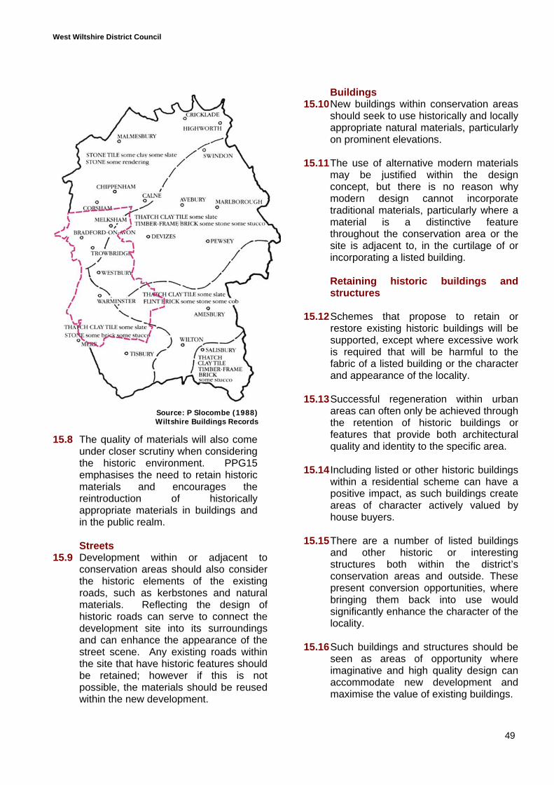
West Wiltshire District Council
49
15.8 The quality of materials will also comeunder closer scrutiny when consideringthe historic environment. PPG15emphasises the need to retain historicmaterials and encourages thereintroduction of historicallyappropriate materials in buildings andin the public realm.
Streets15.9 Development within or adjacent to
conservation areas should also considerthe historic elements of the existingroads, such as kerbstones and naturalmaterials. Reflecting the design ofhistoric roads can serve to connect thedevelopment site into its surroundingsand can enhance the appearance of thestreet scene. Any existing roads withinthe site that have historic features shouldbe retained; however if this is notpossible, the materials should be reusedwithin the new development.
Buildings15.10New buildings within conservation areas
should seek to use historically and locallyappropriate natural materials, particularlyon prominent elevations.
15.11The use of alternative modern materialsmay be justified within the designconcept, but there is no reason whymodern design cannot incorporatetraditional materials, particularly where amaterial is a distinctive featurethroughout the conservation area or thesite is adjacent to, in the curtilage of orincorporating a listed building.
Retaining historic buildings andstructures
15.12 Schemes that propose to retain orrestore existing historic buildings will besupported, except where excessive workis required that will be harmful to thefabric of a listed building or the characterand appearance of the locality.
15.13 Successful regeneration within urbanareas can often only be achieved throughthe retention of historic buildings orfeatures that provide both architecturalquality and identity to the specific area.
15.14 Including listed or other historic buildingswithin a residential scheme can have apositive impact, as such buildings createareas of character actively valued byhouse buyers.
15.15 There are a number of listed buildingsand other historic or interestingstructures both within the district’sconservation areas and outside. Thesepresent conversion opportunities, wherebringing them back into use wouldsignificantly enhance the character of thelocality.
15.16 Such buildings and structures should beseen as areas of opportunity whereimaginative and high quality design canaccommodate new development andmaximise the value of existing buildings.
Source: P Slocombe (1988)Wiltshire Buildings Records
West Wiltshire District Council
50
16.0 STATEMENTS
16.1 The Government, through PPS1, has madeit clear that a design statement should besought with the majority of planningapplications.
16.2 The purpose of a design statement is todemonstrate how the specific design of theproposal will relate to its surroundings andhow it will enhance the quality ofdevelopment and the character of thesettlement to which it relates.
When is a design statement required?16.3 The Principles Design Guide specifically
considers Policy C31a within the DistrictPlan, which states:
“A design statement may be requiredfor prominent or sensitive sites, whichshould analyse the site, show how theproposal relates to the existing builtcontext and patterns of movement, andset out the principles behind thebuilding and landscape design.”
16.4 Whilst there is some clarification of when adesign statement might be required withinthe Principles document, it is felt that thereis a need for greater clarification:
Design statements should be provided wherethe development:
Is within a conservation area; Bounds important areas in the public realm; Will be prominent when viewed from well
used public highways; Adjoins designated countryside, particularly
protected areas such as the Green Belt,AONBs and other areas recognised for theirlandscape quality; or
Proposes 10 or more residential units.
What should a design statementcontain?
16.5 The size and level of detail containedwithin any design statement shouldrespond to the scale of the proposeddevelopment and the sensitivity of thelocation.
16.6 The form of a design statement should bean independent report of one or two pages
for small-scale development (less than 10houses) to a substantial document forlarge-scale developments.
16.7 By Design: Urban Design in the PlanningSystem (DETR 2000) identifies a twostage design statement. The first is aworking document, providing the contextand site analysis information andproducing design principles on which thedevelopment proposal in progress isbased, and this should be agreed with thelocal planning authority. The secondstage should develop the agreedprinciples and demonstrate how the finalscheme has responded to characteristicsof the site and its wider context.
16.8 The key to undertaking a design statementwill be a thorough context analysis. Thestatement must demonstrate how all of thefeatures and issues identified within thecontext analysis have been consideredand relate to the final design concept anddetails of the scheme.
16.9 It should be clear that the starting point ofthe design process was a context analysis;consequently it is not a statement withregards to what are perceived to be themerits of the application but should clearlybe a informative working document.
The basic requirements for any designstatement are:
A context analysis that demonstratesan understanding of the character andimportant features within the locality.
A site analysis (identifying issuesoutlined on page 12)
Identification of the connections anddesign concept, and how this relates tothe context analysis, includingconsideration of:
Visual and physical links;Road hierarchy;Landscape network;Density; andBuilding design etc

West Wiltshire District Council
51
Illustrations, e.g. street sceneelevations or a perspective, showinghow the proposed development willrelate to immediately adjacent sitesand buildings.
Unless a separate sustainabilitysubmission is proposed, it may benecessary to include reference toissues of sustainable design in order tomeet policy requirements.
Sustainability statement
16.10As identified in sections 3 and 11, allapplications for 10 dwellings or more aresubject to Policy C34a and must submit astatement on how they have sought toincorporate sustainable design andconstruction methods to reduce resourceconsumption.
16.11In order to achieve sustainable design, thesustainability statement should beproduced as a working documentidentifying all of the opportunities forsustainable construction within the contextanalysis, and working through to see whatimpact this has on design and whatappropriate provisions can be made.Consequently, a sustainability statementwill begin with the identification of:
Features and areas important forbiodiversity.
Opportunities for:
Water efficiency and treatment, inparticular the use of SUDS.
Maximising energy efficiencythrough design layout andconstruction.
Creating renewable energy, eitherthrough the design or constructionof each dwelling or independently.
The accessibility of facilities andservices.
16.12 The sustainability statement should thendemonstrate how these observations andopportunities have been incorporated intothe proposed scheme.
16.13 As a working document, a sustainabilitystatement should run parallel to the designstatement, identifying how each issue andstage in the design process wasinfluenced by consideration ofsustainability.
16.14 In accordance with Policy C34a andsection 11 of this document, it should benoted that this information does not haveto be provided in the form of asustainability statement but can beincorporated into other requireddocuments such as the design statement.Nevertheless, all of these issues should beaddressed in the submission.
West Wiltshire District Council
52
Glossary
Accessibility - The ability of people to moveround an area and reach places andfacilities, utilising different means oftransport.
Adaptability - The capacity of buildings orspaces to respond to changing needs withinsociety or to accommodate different usesand changes in technology.
Context - The setting of a development.
Desire line - Imaginary line linking routes orplaces which people would find it convenientto travel along.
Enclosure - The use of buildings orstructures to create a sense of definedspace.
Green Corridor - A green corridor isgenerally considered to be a linear featurethat might form part of the wider network.
Landmark - A building, structure orlandscape feature that stands out from thebackground by virtue of size or appearance.
Landscape - The character and appearanceof land, including its shape, form, ecologyand natural features, colours and elementsand the way these components combine.
Landscaping - The treatment of land,including soft and hard treatments such aspaving or street furnishings as well asplanting.
Legibility - The degree to which a place canbe easily understood and travelled through.
Node - A place where activity and routes areconcentrated often occurs where a numberof routes meet.
View - What is visible from a particular point.
Vista - An enclosed view, e.g. view along astreet.
53
APPENDIX 1
This appendix is split into two parts:
Policy Requirements Summary - lists policy requirements that are not specificallydesign requirements. Please note this is not exhaustive, but does try to cover mostissues.
Submission Checklist - lists key documents to be submitted where appropriate andidentifies potential sources of financial contributions.
POLICY REQUIREMENTS SUMMARY
C4a, C7 - landscape features and nature conservation
Any features of landscape or nature conservation value should be identified andprotected. This may have a direct impact on the developable area.
The applicant should identify at an early stage whether an environmental impactassessment or ecological assessment is required.
C15 & C16 - archaeology
An archaeological assessment or recording may be required.
C17 - C23 & C27 - conservation areas and listed buildings
Redevelopment or new development within a conservation area may require aconservation area statement, particularly in circumstances where demolition isproposed and conservation area consent is also required.
There is a presumption against allowing conservation area consent for demolitionwhere there is no suitable proposal for replacement or redevelopment beingproposed.
Development schemes should seek to retain buildings or features of architecturalhistoric interest within the conservation areas, where possible.
C31a - design
C33 - recycling (developments of 50 or more dwellings)
Wiltshire County Council has other policies covering recycling and the treatment ofwaste that also require the submission of a Waste Audit. See Wiltshire CountyCouncil’s Supplementary Planning Guidance Waste Audits & Provision forRecycling in New and Refurbished Developments.
C34a - resource consumption and reduction
The design of the proposed development should have been based on investigationof certain design and sustainability criteria and an assessment of the locality. Alldevelopments proposing 10 or more dwellings must submit supporting sustainabilityinformation ideally in the form of a sustainability assessment.
54
C37 - contaminated land
Where it is only suspected that there may be contamination on site, a desktop studymay reveal nothing, in which case a detailed on-site investigation may not berequired or may be conditioned. If a desktop study is submitted with theapplication, this will prevent unnecessary delays.
R4 - open space in new housing developments
Provision is required for all developments of 10 units or more. A financialcontribution may be appropriate in some situations. Please refer to the relevantSPG or SPD for detailed guidance on the level of provision.
H2 - affordable housing provision
The thresholds at present for provision of affordable housing are: over 25 dwellings or one hectare in towns; and All new dwellings within defined village boundaries.
It is also identified that the Council will seek to achieve up to 30% affordable units intowns and 50% in villages.
The applicant should contact Housing Needs as soon as possible to identify the needrequirements within the locality (see Affordable Housing SPD adopted 2005 for moreinformation).
T9 - bus services
Planning obligations towards introduction and improvement of bus services can besought where appropriate.
T10 - car parking
The car parking standards identified within Appendix G are maximum requirements.Parking provision should be assessed against accessibility by alternative means oftransport.
R11, T11 & T12 - footpaths, bridleways and cycleways
Development proposals should protect and enhance public rights of way includingcycle routes and bridleways. Appropriate provision within development sites isrequired. Extensions and improvements may also be sought as part of adevelopment proposal.
U1 - infrastructure
Where there is insufficient infrastructure to cater for the proposed development,provision will be required including education and health facilities as well as roadand service provision. Please consult utility providers, the Education Authority andthe Highway Authority.

55
U2 and U4 - surface and ground water
Development will only be permitted where sufficient provision has been made forthe disposal of surface water and protection of ground water sources. Inaccordance with Policy C31a, sustainable drainage systems should be incorporatedunless it can be demonstrated that it would be impractical or have an adverse effecton the water table etc. This is strongly supported by English Nature and theEnvironment Agency.
U3 - flooding
Development schemes should retain existing water/drainage systems, ensuring thatrun off does not create or exacerbate flood risk to others and avoid high flood riskareas.
I1 - implementation
Appropriate use of Section 106 agreements.
I2 - the arts
An appropriate percentage of the overall cost will be sought for public art provisionwith regard to the appearance of the scheme and the area’s amenities.
SUBMISSION CHECKLIST
Documentation
Design Statement
Sustainability Statement
Environmental Impact Assessment
Ecological Survey
Landscape Assessment (if a thorough context analyse is undertaken this will includeall of the issues associated with a landscape assessment, however, on some sites anadditional ecological survey may be required)
Tree Survey
Archaeological Assessment or Investigation
Conservation Statement
Waste Audit
Contamination Survey
Acoustic Assessment
Flood Risk Assessment
Green Travel Plan and/or Traffic Assessment
Financial or on-site requirements
Affordable housing
Public open space
Highway improvements
Provision for utilities
Education
Health
Public art
Improvements to existing cycle and pedestrian networks
Highway or transport improvements
APPENDIX 2
CHECKLIST OF QUESTIONS
This is for the benefit of those receiving planning applications as well as a roughchecklist of questions for applicants submitting an application. Please note it is notexhaustive and simply aims to cover some of the key principles.
It is also recognised that the level of information submitted will depend on the scale ofthe development scheme and the sensitivity or prominence of the location.
Does the application require a design statement?Does the design statement include a complete context analysis?
Does the application require a sustainability submission?Does the sustainability submission include reference to resource preservation as wellas accessibility?
Context analysisHas the design been led by a thorough context analysis and an understanding of thelocality’s character?
Making connectionsHas the proposal sought to connect with all surrounding pedestrian routes?Is the pedestrian network well related to buildings in terms of providing naturalsurveillance?Is there a clear prioritisation of pedestrian and cycle routes?Can vehicles access all of the development areas?
Designing streetsIs there a clear hierarchy of routes?Have footpaths and cycle routes been given priority?Is the character and status of each road apparent in the design approach?Does the scheme seek to minimise the impact of roads and make efficient use ofhighway space?
Public realmDoes the scheme minimise clutter?Does the treatment of public spaces have a character reference?Is the level of lighting and signage minimal?
LandscapingShould the scheme be accompanied by an ecological assessment or more detailedlandscape assessment?Does the proposed landscaping seek to link with surrounding networks in terms ofrecreation space and linking to functional habitat networks?Are the planting schemes appropriate both in terms of visual appropriateness and forcreating wildlife habitats?
Building form and layoutDoes the building layout address public spaces and streets etc?
Do the building styles and layout have a contextual reference rather than beingstandard designs?Do the styles and sizes of dwellings represent an appropriate mix?Is there sufficient provision for private or public amenity space?
SustainabilityDoes the submission make reference to both design and technology issues?Is there specific reference to water treatment and dealing with surface water?Is the density of the proposed scheme efficient and based on an understanding of thelocality?Does the submission make reference to preserving and opportunities for enhancingbiodiversity?
Houses in villagesHow does the development scheme complement the established character of thevillage?Does the development proposal interrupt important views?Does the proposal visually conform with the size and arrangement of existingbuildings?Does the proposal achieve an appropriate density - bearing in mind accessibility andvisual impact on the character of the village?If not, has the developer sought to achieve a suitable density through imaginativedesign?
The historic environmentDoes the scheme respect the historic character of the conservation area or listedbuilding?Is the scale of the building appropriate to the setting?Is the proposed development subservient to the listed building, particularly where it isdirectly adjacent to a listed building?