west vaughan sewage system environmental study report
TRANSCRIPT

P-13-43 West Vaughan Sewage System January 2016 Environmental Study Report (ESR) Addendum
West Vaughan Sewage System
Environmental Study Report
Addendum
Report prepared for:
The Regional Municipality of York
Contract P-13-43
DelcanGEODATA
January 2016
Page 1

P-13-43 West Vaughan Sewage System January 2016 Environmental Study Report (ESR) Addendum
Table of Contents
32T1. Introduction32T ............................................................................................................................... 3 32T1.1 Background32T........................................................................................................................... 3 32T1.2 Purpose of Class EA Project Addendum32T ............................................................................... 6 32T1.3 Overview of the Addendum Process32T .................................................................................... 6
32T2. Description of the Proposed Design Changes, Potential Effects and Mitigation Measures32T ..... 6 32T2.1 Proposed Tunneling Modifications from the ESR Configuration32T ......................................... 7
32T2.1.1 Northern Segment32T ......................................................................................................... 7 32T2.1.2 Central Segment32T .......................................................................................................... 10 32T2.1.3 Southern Segment32T ....................................................................................................... 12
32T2.2 Property Acquisition32T ........................................................................................................... 14 32T3. Public and Stakeholder Consultation32T ....................................................................................... 27 32T4. Conclusion32T ................................................................................................................................ 28
List of Tables
32T32TUUTable 1: Potential Effects of the Proposed Modifications on the Northern Segment .................. 8 Table 2: Potential Effects of the Proposed Modifications on the Central Segment ..................... 11 Table 3: Potential Effects of the Proposed Modifications on the Southern Segment ................. 13 Table 4: Property Requirements Comparison of ESR and Preliminary Design Proposed Alignment....................................................................................................................................................... 15 Table 5: Summary of Key Issues Discussed with Agencies ........................................................... 27
List of Figures
Figure 1: West Vaughan Sewage System Project, Original and Proposed Alignment .................... 5 Figure 2: Compound 2 Site Plan, Highway 27 at Rutherford Road .............................................. 19 Figure 3: Compound 3 Site Plan, Rutherford Road at Huntington Road ...................................... 20 Figure 4: Compound 4 Site Plan, Highway 27 at Langstaff Road .................................................. 21 Figure 5: Compound 5 Site Plan, Highway 27 at Highway 7 ......................................................... 22 Figure 6a: Compound 6a Site Plan, Wallace Street (Preferred Option) ....................................... 23 Figure 6b: Compound 6b Site Plan, Wallace Street (Alternative Option) ................................... 23 Figure 7: Compound 7 at the Humber Pumping Station .............................................................. 25 Figure 8: Tunnel Alignment from Highway 7 to the Humber PS .................................................. 26
Page 2

P-13-43 West Vaughan Sewage System January 2016 Environmental Study Report (ESR) Addendum
1. Introduction 1.1 Background In 2009, the Regional Municipality of York (York Region) completed the York Region Water and Wastewater Master Plan Update. This update identified a need for additional servicing capacity to meet the planned and projected growth servicing demands to the year 2051 in West Vaughan. York Region began development of a regional sewage servicing plan in 2010, and in 2013, completed the MEA Municipal Class Environmental Assessment (Class EA) ‘Schedule C’ process for its West Vaughan Sewage System (WVSS) Project.
The WVSS Class EA Environmental Study Report (ESR) documents the proposed series of nearly 14-kilometre sewer tunnels running from the Kleinburg Water Resource Recovery Facility (WRRF) and ending at the Humber Sewage Pumping Station (Humber PS). The original sewer alignment was divided into four segments (Northern, Western, Central and Southern) based on the potential for different construction methods to be applied along various sections of the sewer. Specific details on the four segments are shown below:
• Northern Segment (length ≈ 2.8 kilometres): following the north-south alignment along Highway 27 between the Kleinburg WRRF and Rutherford Road
• Western Segment (length ≈ 2.3 kilometres): following the east-west alignment along Rutherford Road between Huntington Road and Highway 27
• Central Segment (length ≈ 7.0 kilometres): oriented north-south along Highway 27 from Rutherford Road to Highway 7, and then east-west from Highway 27 to the Canadian Pacific Rail (CPR) right-of-way
• Southern Segment (length ≈ 1.9 kilometres): following the north-south alignment from just south of Highway 7 to the Humber PS
Following the filing of the ESR for the WVSS Project, proposed modifications were identified during the preliminary design phase that are intended to improve the tunnel alignment while reducing actual or potential impacts to the environment. The proposed modifications decreased the number of maintenance and microtunneling shafts required by using a larger, three-metre diameter Tunnel Boring Machine (TBM) for all sewer segments. In general, project modifications include:
• Realignment of portions of the sewer tunnel • A change in the location and a reduction in the number of shafts • Implementing a different method of tunneling
Page 3

P-13-43 West Vaughan Sewage System January 2016 Environmental Study Report (ESR) Addendum
As a result of these proposed modifications, the Region has completed an addendum to document these changes and evaluate the potential impacts.
Figure 1 depicts the original ESR Proposed Alignment and the modified alignment (“Preliminary Design Proposed Alignment”) of the sewer tunnel and shaft locations. The maintenance shafts (MS) illustrate the original ESR shaft locations and the compounds depict the shaft locations for the Preliminary Design Proposed Alignment. The microtunneling shafts, which are smaller and shallower than the maintenance shafts, are not shown on the Figure for clarity, but would typically have been spaced approximately 200 metres apart along the alignment. Note that the Northern and Western Segments were combined into the Northern Segment, due to similarities in the new alignment.
Page 4

P-13-43 West Vaughan Sewage System January 2016 Environmental Study Report (ESR) Addendum
Figure 1: West Vaughan Sewage System Project, Original and Proposed Alignment
Page 5

P-13-43 West Vaughan Sewage System January 2016 Environmental Study Report (ESR) Addendum
1.2 Purpose of Class EA Project Addendum The requirements of the Class EA indicate that any significant modifications proposed to the project after the ESR is filed requires an addendum to be written by the proponent. In addition to reviewing the new changes and the environmental impacts (includes the social, economic, and natural environments), the proponent is required to provide public notification of the addendum and its changes.
The addendum’s purpose is in keeping with the original principles of the Environmental Assessment Act. This includes evaluating net environmental effects to all aspects of the environment and providing clear and complete documentation of the process.
1.3 Overview of the Addendum Process In order to comply with the Municipal Class EA, this addendum has been prepared to review the proposed changes to the project and its potential impacts on the environment. This review documents:
• Identifying the circumstances necessitating the change; • Determining potential environmental implications of the proposed changes along with
any measures to mitigate potential adverse environmental effects; and, • Filing the addendum for a period of 30 calendar days, with a Notice of Filing of
Addendum issued to potentially affected members of the public, review agencies, and those who were notified during the preparation of the ESR.
Following the issue of the Notice of Filing of Addendum, the report becomes available for public review. This means the public, affected parties, and review agencies may review and respond to the addendum. This includes the public’s right to request a Part II Order within the 30-day review period.
2. Description of the Proposed Design Changes, Potential Effects and Mitigation Measures Significant modifications to the West Vaughan Sewage System project were made that will result in a reduced number of impacts from what was originally described in the ESR. As a result, the project’s modifications will lead to an overall net positive effect on several aspects of the environment.
The major differences from the project described in the ESR and the proposed modifications relate to the tunneling method used and the location of portions of the sewer tunnel and shafts. The resulting impact assessment of the modifications was divided into two sections.
Page 6

P-13-43 West Vaughan Sewage System January 2016 Environmental Study Report (ESR) Addendum
Section 2.1 documents the potential natural environment and socioeconomic effects and mitigation measures associated with the proposed modifications. Section 2.2 identifies the potential property impacts and mitigation measures associated with the proposed modifications.
2.1 Proposed Tunneling Modifications from the ESR Configuration This section covers the potential impacts associated with the proposed modifications to the WVSS Project. The modifications and potential impacts are further described by segment and identify the potential impacts to the environment, proposed mitigation features (if required), and the net effects. All of the commitments made in the original ESR relative to any additional monitoring or follow up work required still applies and will be undertaken.
2.1.1 Northern Segment The Northern Segment in the proposed design is a combination of the Northern and Western sections of the ESR. The primary modification proposed for the Northern Segment includes replacing the smaller diameter microtunnelling method with a larger, three-metre diameter, TBM configuration. The results of the proposed modifications include:
• Increasing the tunnel depth below ground surface from an average depth of 5 to 10 metres to an average depth of 15 to 20 metres, resulting in less vibration and less potential for ground surface subsidence and related impacts since the new profile will be deeper and partially in bedrock.
• Removing the requirements for 17 microtunnel shafts and construction compounds along the Northern Segment alignment and eight shafts along the Western Segment, resulting in fewer surface disturbances;
• Reducing the amount of property required for construction as well as the surface area affected by microtunnelling, which will result in fewer traffic impacts as there will be fewer shaft sites and construction zones;
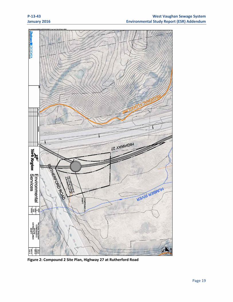
• Reducing the impact on traffic and CPR rail operations as a result of moving the TBM shaft connection point (connection of the Northern/Central segments) from west of Rutherford Road to the northeast corner of Rutherford Road and Highway 27 (Compound 2). The location of the connection point was originally located on private property and adjacent to the CPR right-of-way. The new compound will be located closer to the Humber River within City of Vaughan and Toronto and Region Conservation Authority (TRCA) lands and the flood plain, but away from adjacent wetlands. It will be designed for strict environmental containment; and,
• Reducing the depth of a drop shaft and the potential for odour issues related to the operation of the drop shaft.
Page 7

P-13-43 West Vaughan Sewage System January 2016 Environmental Study Report (ESR) Addendum
Table 1 summarizes the potential modifications and effects anticipated along the Northern Segment, as well as the proposed measures to mitigate the impacts and net environmental effects.
Table 1: Potential Effects of the Proposed Modifications on the Northern Segment
Factor Potential Effect of Proposed Modifications Proposed Mitigation Measures Net Effects
Natural Environment Vegetation • Potential impact on
vegetation at Compound 2 resulting from the alignment shifting closer to the Humber River.
• Vegetation survey to characterize and quantify temporary losses; full restoration plan to be carried out post-construction; seed and cover will be completed within specified timing window.
• Overall effects on vegetation will be minimized through implementation of the restoration plan.
• Long term net benefit from removal of Common Reed (Phragmites australis), an invasive species.
Riparian Buffers
• Temporary loss of riparian buffers to be mitigated during construction.
• If vegetation removals are unavoidable, then riparian surveys will be completed to document/ quantify the removals, and a restoration planting plan will be prepared using native, non-invasive species suited to the site.
• Overall effects on riparian buffers minimized through restoration planting plan.
• If vegetation removed, long term net benefit from reintroduction of non-invasive, native species.
Wetlands • Temporary, indirect impacts to wetlands adjacent to Compound 2 during construction.
• Wetlands at Compound 2 will be avoided by minimizing the necessary compound size and adjusting its boundaries further south and east.
• Perimeter controls and erosion and sediment controls (ESCs) will be used to prevent construction materials, equipment and workers from entering the wetland. Strict erosion and sediment control measures will be introduced.
• Existing wetland mapping will be checked against recent aerial
• Overall effects on wetlands will be minimized through implementation of the proposed mitigation measures.
Page 8

P-13-43 West Vaughan Sewage System January 2016 Environmental Study Report (ESR) Addendum
Table 1: Potential Effects of the Proposed Modifications on the Northern Segment
Factor Potential Effect of Proposed Modifications Proposed Mitigation Measures Net Effects
photography and on-site verification; staking and surveying the wetland boundary in cooperation with relevant agencies may be completed if existing mapping is not deemed accurate or recent enough.
Aquatic Habitat
• Minimal impact on aquatic habitat with mitigation measures in place.
• A minimum 30 metre buffer will be maintained from the high water mark of active watercourse channels. This will reduce the potential impacts and demonstrate to Fisheries and Oceans Canada (DFO) that design modifications were considered to protect aquatic organisms and habitat.
• Implementation of a minimum 30 metre buffer minimizes overall effects on aquatic habitat.
Wildlife Habitat
• Minor disturbance of marginal wildlife habitat is anticipated. Compound 3 does not contain any natural habitat; Compound 2 (outside of the wetlands and immediate river surroundings) is old field/upland that has been previously disturbed, with some trees and shrubs that have been planted on the site.
• Wildlife surveys will be completed to supplement those completed during the Class EA, as appropriate, to address the new compound locations: namely, breeding bird and frog surveys at the previously-unassessed Compound 2 (Note: April and May 2015 frog surveys did not result in any observations at that location).
• Wildlife surveys of Compound 2 and 3 will minimize and mitigate overall effects on surrounding wildlife habitat.
Sediment • Minimal impacts with strict controls in place to protect the Humber River and adjacent wetlands at Compound 2.
• At a minimum, perimeter controls (such as wire-backed silt fence lined with fibre filtration tubes) will be installed and maintained around the compound work sites. In addition, site-specific ESC plans will be developed in conjunction with the contractor for each work location.
• Disturbed soils will be stabilized by the application of seed and cover within specified time limits (e.g., 15 days from the completion of
• Overall effects on sediment will be minimized through implementation of the proposed mitigation measures.
Page 9

P-13-43 West Vaughan Sewage System January 2016 Environmental Study Report (ESR) Addendum
Table 1: Potential Effects of the Proposed Modifications on the Northern Segment
Factor Potential Effect of Proposed Modifications Proposed Mitigation Measures Net Effects
grading). Social Environment Socio-economic
• No anticipated impacts as the change in alignment, and removal of microtunnel shafts and construction compounds, will result in no additional disturbances to the socio-economic environment and will reduce the number of potential impacts with fewer shafts and compounds.
• No additional mitigation measures required.
• No anticipated impacts, thus no net effects to the socio-economic environment.
Cultural • No anticipated impacts, as the change in alignment, and removal of microtunnel shafts and construction compounds, will result in no additional disturbances to the built heritage and cultural environment.
• Update archaeological studies based on new compound locations.
• No anticipated impacts, thus no net effects to the cultural environment.
2.1.2 Central Segment The sewer configuration identified in the ESR showed six maintenance shaft locations; however, modifications have reduced the number of shafts to two locations, a maintenance shaft and a TBM work shaft to accomodate a change in the tunnelling direction of the TBM (Compounds 4 and 5, respectively). The reduction in the number of shafts, from six to two, will result in significantly fewer disturbances, particularly along the heavily travelled portions of Highway 27 and Highway 7. The major decrease in entry points will also result in fewer property impacts as well as less impacts on traffic as a result of the reduced number of shaft sites and associated construction zones.
Page 10

P-13-43 West Vaughan Sewage System January 2016 Environmental Study Report (ESR) Addendum
Table 2 summarizes the proposed modifications and potential effects anticipated along the Central Segment, as well as the proposed measures to mitigate the potential impacts and net environmental effects.
Table 2: Potential Effects of the Proposed Modifications on the Central Segment
Factor Potential Effect of Proposed Modifications Proposed Mitigation Measures Net Effects
Natural Environment Vegetation • Some minor removal
of old field/upland habitat will be required from Compound 5.
• Vegetation removal will be minimized by reducing the size of Compound 5 as much as possible.
• A vegetation survey will be completed to characterize and quantify all removals, and a restoration plan will be prepared if necessary. Present knowledge indicates that Compound 5 is located within an old field/meadow area that is not likely to contain sensitive plant species.
• Overall net effects on vegetation will be minimized through mitigation efforts and a restoration plan.
Riparian Buffers
• Minimal loss to riparian buffers as the proposed design provides a minimum of 30 metres between disturbed areas and any watercourse. This ensures the maintenance of at least that much riparian buffer/habitat.
• A survey will be conducted, and a restoration plan will be prepared if necessary.
• Implementation of a minimum 30 metre buffer will minimize the effects on riparian land that falls within the buffer. Opportunity exists to provide a net improvement if restoration efforts are implemented.
Aquatic Habitat
• Minimal impact on aquatic habitat because compound areas will be situated at least 30 metres from all watercourses, and no aboveground work is located adjacent to streams bearing Species at Risk.
• A watercourse habitat review will be conducted.
• Implementation of a minimum 30 metre buffer minimizes overall effects on aquatic habitat.
Wildlife Habitat
• The area around Compound 5 is a potential Bobolink breeding ground.
• Conduct breeding bird survey to confirm presence/absense of breeding birds. Mitigation measures to be determined after
• Potential impacts on breeding birds will be compensated
Page 11

P-13-43 West Vaughan Sewage System January 2016 Environmental Study Report (ESR) Addendum
Table 2: Potential Effects of the Proposed Modifications on the Central Segment
Factor Potential Effect of Proposed Modifications Proposed Mitigation Measures Net Effects
the survey, may include “no touch” areas.
through “no touch” areas, resulting in no net negative impact.
Sediment • Minimal impact with erosion control measures implemented.
• At minimum, perimeter controls (e.g., silt fence) around compounds; site-specific erosion and sediment control plan will need to be developed based on proposed construction at each location.
• Overall effects on sediment will be minimized through implementation of the proposed mitigation measures.
Social Environment Socio-economic
• Fewer shafts will result in reduced potential for noise, vibration, odour and other effects. It will also result in fewer potential property impacts.
• No additional mitigation measures required.
• Net positive effects due to reduced potential for disturbance and property impacts.
Cultural • No anticipated impacts, as the reduction in shafts will result in no additional disturbances to the built heritage and cultural environment.
• Update archaeological report based on new compound locations.
• No anticipated impacts, thus no net effects to the cultural environment are anticipated.
2.1.3 Southern Segment Modifications to the Southern Segment tunnel alignment were made in order to expand the Central Segment tunnel in bedrock, while mitigating the TBM tunnel transition from bedrock to soil below sensitive surface infrastructure (road/railway bridges and private land). The Southern Segment’s configuration recommended in the ESR originally identified five maintenance shafts and a launch shaft at the Humber Pumping Station (PS). Additional review has resulted in the elimination of three maintenance shafts, resulting in two shaft locations (Compound 6 and Compound 7MS) and fewer potential disturbances. The new configuration also moves Compound 6 away from the active railway and highway bridge structures.
Table 3 summarizes the potential modifications and effects anticipated along the Southern Segment, as well as the proposed measures to mitigate the impacts.
Page 12

P-13-43 West Vaughan Sewage System January 2016 Environmental Study Report (ESR) Addendum
Table 3: Potential Effects of the Proposed Modifications on the Southern Segment
Factor Potential Effect of Proposed Modifications Proposed Mitigation Measures Net Effects
Natural Environment Vegetation • Some minor removal
of vegetation is anticipated at Compound 6.
• Removals have already been minimized along the southern segment by the elimination of additional compound sites and the associated construction disturbance.
• A vegetation survey will be completed to characterize and quantify all removals, and a restoration plan will be prepared if necessary. Present knowledge indicates that Compound 6 is primarily located within an old field/meadow area that is unlikely to contain sensitive plant species; some woody plants are present which will be characterized.
• Overall net effects on vegetation is reduced due to the elimination of some compound sites and implementation of the restoration plan.
Riparian Buffers
• Impacts are not anticipated at Compound 6 because the location is more than 20 metres away from the Humber River.
• Mitigation measures would coincide with those identified for “Vegetation” above.
• No anticipated impacts, as the location of Compound 6 is more than 20 metres away from the Humber River.
Wildlife Habitat
• Potential impacts to nesting birds via removal of woody vegetation.
• All removal of woody vegetation will be completed within timing windows intended to protect nesting birds.
• Overall effects on nesting birds from the removal of woody vegetation will be minimized through mitigation efforts.
Sediment • Minimal impact with erosion control.
• At minimum, perimeter controls (such as wire-backed silt fence lined with fibre filtration tubes) will be installed and maintained around the compound work sites. In addition, site-specific erosion and sediment control (ESC) plans will be developed in conjunction with the contractor for each work location.
• Overall effects on sediment will be minimized through implementation of the proposed mitigation measures.
Social Environment Socio-economic
• The elimination of maintenance shafts
• Those mitigation measures originally identified in the ESR will
• Overall, a positive net effect due to
Page 13

P-13-43 West Vaughan Sewage System January 2016 Environmental Study Report (ESR) Addendum
Table 3: Potential Effects of the Proposed Modifications on the Southern Segment
Factor Potential Effect of Proposed Modifications Proposed Mitigation Measures Net Effects
will result in fewer disturbances to the socio-economic environment, although there will still be potential vibration impacts to the CPR bridge and adjacent residences.
address potential impacts to the CPR bridge and adjacent residences.
the reduction of maintenance shafts. Potential vibration impacts still exist; however, they will be minimized through the migitation measures identified in the ESR.
Cultural • The elimination of maintenance shafts will result in fewer disturbances to the built heritage and cultural environment.
• Update archaeological reports to include new alignment and compound locations.
• The elimination of maintenance shafts should have an overall positive net effect (reduced chance of impact).
2.2 Property Acquisition The Preliminary Design Proposed Alignment (see Figure 1) will result in the elimination of several property impacts and/or acquisitions by moving a significant portion of the alignment into the Regional road right-of-way and away from private property, while eliminating several maintenance shafts.
Shafts at Compounds 2, 5, and 6 will be located on property that was not previously identified in the ESR. Compound 2, shown in Figure 2, will be located adjacent to the Highway 27 right-of-way owned by the City of Vaughan. Compound 5, depicted in Figure 5, will be located on private property adjacent to Highway 27 and Highway 7. Compound 6, depicted in Figure 6, will be located on private property south of Wallace Street.
Compound 3 (Figure 3) is proposed to be located on the same Rutherford Road parcel at the Rutherford Road / Huntington Road intersection as indicated in the ESR. This parcel, located on private property, requires a permanent easement to accommodate the shaft. Compound 3 will also require adjacent property for temporary staging during construction, which was not identified in the ESR.
Figures 6a and 6b depict the property acquisition required for the two options: Compound 6a and 6b. As a result of tunnel alignment modifications to reduce the risk of constructing under the Highway 7 bridge over the Humber River, the Region relocated the alignment to run to the
Page 14

P-13-43 West Vaughan Sewage System January 2016 Environmental Study Report (ESR) Addendum
west and south of Wallace Street. This will require an extraction shaft to be constructed on property south of Wallace Street. Permanent property is needed for either shaft site. The preferred alignment is Compound 6a. If the Region is not able to resolve land acquisition for this parcel, then option Compound 6b would be pursued.
Figure 7 depicts the property acquisition required around Compound 7 at the Humber PS. The ESR previously identified a temporary easement around the Humber PS for construction of the tunnel and pump station. The ESR also identified private land that would be permanently required adjacent to the existing Humber PS property. As a result of the tunnel alignment modifications, the Region will be required to expand the permanent property needed around the pump station, although the temporary easement limits would remain unchanged.
Where there are new property requirements, appropriate compensation will be provided in accordance with standard York Region procedures and policies, which constitutes a mitigation measure for landowners.
Table 4 documents the proposed changes to the property requirements originally identified in the ESR. Figures 2–to-7 illustrate the site plans for those compounds located within the Preliminary Design Proposed Alignment. Figure 8 depicts the alignment as it runs from Highway 7 to the Humber PS.
Table 4: Property Requirements Comparison of ESR and Preliminary Design Proposed Alignment
Item ESR Design ESR Comments Prelim. Design Prelim. Design Comments
Northern Segment 1 Microtunneling
shaft at Kleinburg WRRF
Located at Kleinburg WRRF.
Extraction Shaft at Compound 1. Located at Kleinburg WRRF.
Private property is avoided as this is York Region property and Highway 27 right-of-way.
2 Tunneled sewer segment parallel to CPR tracks
Located just west of CPR tracks property line between Rutherford Road and Highway 27. Two private properties are involved.
Located within Highway 27 right-of-way. A small section of City of Vaughan public property will be impacted adjacent to Compound 2.
Private property is avoided and tunneling adjacent to CPR tracks is reduced.
3 Launch Shaft #1 compound
Located on the southwest quadrant of the Rutherford Road and CP Railway intersection. Private property is involved.
Launch Shaft at Compound 2. Moved to the northeast quadrant of the Highway 27 and Rutherford Road intersection. City of Vaughan public property is involved.
Eliminates private property by tunneling within the Highway 27 right-of-way until entering on City of Vaughan property at the intersection of Highway 27 and Rutherford Road.
Page 15

P-13-43 West Vaughan Sewage System January 2016 Environmental Study Report (ESR) Addendum
Table 4: Property Requirements Comparison of ESR and Preliminary Design Proposed Alignment
Item ESR Design ESR Comments Prelim. Design Prelim. Design Comments
4 Huntington Road and Rutherford Road intersection
Connecting manhole at the intersection of Rutherford Road and Huntington Road.
Extraction shaft at Compound 3.
Shaft site located on same private property as in the ESR; private property temporarily required for staging during construction.
Central Segment 5 Maintenance
Shaft #1 Located on the west side of Highway 27 approximately 100 metres north of Martin Grove Road. Private property is involved.
Eliminated. Private property is avoided.
6 Maintenance Shaft #2
Located on the west side of Highway 27 just north of Sanremo Court. Private property is involved.
Eliminated. Private property is avoided.
7 Maintenance Shaft #3
Located on the west side of Highway 27 approximately 100 metres north of Langstaff Road. Private property is involved.
Maintenance Shaft at Compound 4. Move the compound to northeast corner of the property to reduce impact on developable area and eliminate an additional subterranean easement.
Compound 4 stays within the same private property parcel in the northeast corner of the existing lot.
8 Maintenance Shaft #4
Located on the west side of Highway 27 south of Milani Boulevard. Private property is involved.
Move the shaft 400 metres south to stay within road right-of-way and reduce impact on developable area.
Only to be constructed if City of Vaughan requires a sanitary sewer connection for Block 58 development. Otherwise delete and avoid construction impact along roadway.
9 Maintenance Shaft #4A
Located on the northwest corner of Highway 27 and Highway 7.
Launch Shaft at Compound 5. Move MS-4A to southeast corner of Highway 27 and Highway 7 and change to a launch shaft. Private property is involved.
Private property is required for the launch shaft. Access could be obtained from an adjacent cul-de-sac avoiding access directly from Highway 27 or Highway 7.
Page 16

P-13-43 West Vaughan Sewage System January 2016 Environmental Study Report (ESR) Addendum
Table 4: Property Requirements Comparison of ESR and Preliminary Design Proposed Alignment
Item ESR Design ESR Comments Prelim. Design Prelim. Design Comments
10 Maintenance Shaft #5
Located on the south side of Highway 7, approximately 400 metres east of Highway 27. Hydro corridor land.
Eliminated. Hydro corridor property is avoided.
Southern Segment 11 Maintenance
Shaft #6/Tentative Extraction Shaft #1 compound
Located on the north side of Highway 7 between Martin Grove Road and Kipling Avenue. City of Vaughan property would be impacted.
Eliminated. City of Vaughan property is avoided.
12 Maintenance Shaft #7/Tentative Extraction Shaft #2 compound
No comments in ESR. Eliminated. York Region right-of-way property is avoided.
13 Maintenance Shaft #8/Tentative Extraction Shaft #4 compound
Located at the end of Legion Court Road on the southwest side of Highway 7 and Islington Avenue. City of Vaughan and private property is involved.
This location becomes an extraction Shaft at Compound 6. Two options located at the end of Wallace Street south of Highway 7 and east of CPR right-of-way. Private property is involved. The two options are shown in Figure 6a and 6b.
Moves the tunnel alignment away from the Highway 7 and CPR bridges. Two options were proposed due to private property constraints. The preferred option is shown in Figure 6a, but should there be difficulty in acquiring that property, Figure 6b would be a feasible alternative. Private property is required for both.
14 Tunneled sewer segment
Located between Highway 7 and Humber PS. Several properties are involved, including TRCA, Crown land and private property.
Similar to ESR except alignment moved west. Located between Highway 7 and Humber PS. The same properties are involved as with the ESR, including TRCA, Crown land and private property.
Moves the tunnel alignment away from a bridge over Highway 7 and CPR bridge abutments as described for Compound 6.
Page 17

P-13-43 West Vaughan Sewage System January 2016 Environmental Study Report (ESR) Addendum
Table 4: Property Requirements Comparison of ESR and Preliminary Design Proposed Alignment
Item ESR Design ESR Comments Prelim. Design Prelim. Design Comments
15 Maintenance Shaft #9
Located on the south side of the Humber River, east of the CPR tracks managed by Infrastructure Ontario. Crown land/ MOI property is involved
No change. No change. Renamed to Maintenance Shaft 7.
16
Maintenance Shaft #10
Located just south of 407 ETR. Crown land/MOI property is involved.
Eliminated. Surface access to Crown land and MOI property is avoided.
Launch Shaft #2 compound /Humber PS Expansion
Located at Humber PS site. Private property and City of Toronto land is involved.
Similar to ESR, except there will be an increase in the size of the permanent property acquisition for the Humber PS (Compound 7). The temporary construction easement limit remains the same as indicated in the ESR.
Additional permanent property acquisition is required to accommodate the new pump station configuration and allow the existing pump station to remain operational while the new facility and the tunnel launch shaft are constructed.
Page 18
P-13-43 West Vaughan Sewage System January 2016 Environmental Study Report (ESR) Addendum
Figure 2: Compound 2 Site Plan, Highway 27 at Rutherford Road
Page 19

P-13-43 West Vaughan Sewage System January 2016 Environmental Study Report (ESR) Addendum
Figure 3: Compound 3 Site Plan, Rutherford Road at Huntington Road
Page 20

P-13-43 West Vaughan Sewage System January 2016 Environmental Study Report (ESR) Addendum
Figure 4: Compound 4 Site Plan, Highway 27 at Langstaff Road
Page 21

P-13-43 West Vaughan Sewage System January 2016 Environmental Study Report (ESR) Addendum
Figure 5: Compound 5 Site Plan, Highway 27 at Highway 7
Page 22

P-13-43 West Vaughan Sewage System January 2016 Environmental Study Report (ESR) Addendum
Figure 6a: Compound 6a Site Plan, Wallace Street (Preferred Option)
Page 23

P-13-43 West Vaughan Sewage System January 2016 Environmental Study Report (ESR) Addendum
Figure 6b: Compound 6b Site Plan, Wallace Street (Alternative Option)
Page 24

P-13-43 West Vaughan Sewage System January 2016 Environmental Study Report (ESR) Addendum
Figure 7: Compound 7 at the Humber Pumping Station
Page 25

P-13-43 West Vaughan Sewage System January 2016 Environmental Study Report (ESR) Addendum
Figure 8: Tunnel Alignment from Highway 7 to the Humber PS
Page 26

P-13-43 West Vaughan Sewage System January 2016 Environmental Study Report (ESR) Addendum
3. Public and Stakeholder Consultation York Region notified property owners, residents and other stakeholders who may be potentially affected by the proposed modifications to the WVSS Project through notices, meetings, and other methods of communication.
The Region also met with several agencies to review the modifications of the WVSS Project. Table 5 depicts the key issues discussed with relevant agencies and the responses provided.
Table 5: Summary of Key Issues Discussed with Agencies Agency Date Key Issues Discussed Responses
Toronto and Region Conservation Authority (TRCA)
October 1, 2015
1. Will there be any air shafts? 2. Will there be contingencies
for high water events? 3. Did the original alignment
demonstrate more impacts on habitat?
4. How will groundwater upwellings be addressed?
1. Yes, the need for air shafts will be the same as for the ESR where the local sewers will require a drop connection to the tunnel at the Kleinburg WRRF, the intersection of Huntington Road, and at Compound 7MS. The deep drop shaft at the intersection of Highway 27 and Rutherford Road has been eliminated.
2. Yes, as we move forward to final design, we will meet with TRCA to determine what those will be.
3. Yes. 4. Most of the sediment is low
permeability, so the chances of impacting wetlands may be low. We are identifying seven-to-nine locations for mini piezometers to assess the upwelling potential and estimated flow rates.
City of Vaughan December 1 and 18, 2015
1. Please be aware there are several ongoing projects in the area including realignment of Major Mackenzie Drive, a widening of the Highway 27 overpass, and construction of a new watermain on Islington Avenue.
2. How are residents being consulted?
1. Noted. 2. We are meeting with individual
residents and property owners to discuss the project, making them aware of the project through notifications, and publishing newspaper ads on consecutive weeks. We will also be posting the notification and addendum on the Region’s website.
Ministry of Transportation (MTO)
December 2, 2015
1. Where is the proposed Highway 427 Expansion Project in relation to the
1. Locations of the Highway 427 Expansion Project and the West Vaughan Sewage System were
Page 27

P-13-43 West Vaughan Sewage System January 2016 Environmental Study Report (ESR) Addendum
sewer project in West Vaughan?
identified. Both MTO and York Region agreed to coordinate going forward.
Ministry of Natural Resources and Forestry (MNRF)
December 4, 2015
1. Was a Species-at-Risk (SAR) screening updated this year?
2. What permits might apply to this project?
3. MNRF does not anticipate impacts to the receiving streams based on the current design.
4. MNRF does not have any concerns with the EA Addendum submission.
1. Yes. 2. An Endangered Species Act (ESA)
permit is not anticipated; a Redside Dace letter of advice may be issued; and, a Public Lands Act Permit would follow after construction is completed.
3. Noted. 4. Noted.
Ministry of Environment and Climate Change (MOECC)
December 4, 2015
1. What are they key changes that have occurred since the completion of the ESR in 2013?
2. How are agencies, residents and other stakeholders going to be consulted?
3. Please include a statement in the addendum that the commitments made during the original Class EA will still be maintained by the Region.
1. Described in detail including: alignment modifications, reduction of shafts, and a different tunneling method.
2. We are meeting with individual residents and property owners to discuss the project, making them aware of the project through notifications, and publishing newspaper ads on consecutive weeks. We will also be posting the notification and addendum on the Region’s website.
3. Agreed. A Notice of Filing of Addendum will be issued and a 30-day review period will be provided for the public and review agencies to review and respond to the Addendum. The Region will notify all residents, review agencies, Aboriginal communities and stakeholders who were previously engaged in the 2013 WVSS Project, as well as additional residents and stakeholders who may be potentially affected by the proposed modifications. A copy of the Notice of Filing of Addendum is provided in Appendix A.
4. Conclusion As a result of a large number of proposed modifications to the preliminary design of the WVSS project, York Region has completed an addendum to the 2013 WVSS ESR that identifies the proposed modifications and potential impacts of the modified project. While the project modifications will result in some new impacts to property and the natural and socio-economic environment, the overall net effects are positive and will reduce or eliminate many of the anticipated impacts originally identified in the completed ESR.
Page 28

Appendix A
Notice of Filing of Addendum

The Regional Municipality of York Region
NOTICE OF FILING OF ADDENDUM
MUNICIPAL CLASS ENVIRONMENTAL ASSESSMENT STUDY WEST VAUGHAN SEWAGE SERVICING
CITY OF VAUGHAN
The Regional Municipality of York (York Region) completed a Class Environmental Assessment (Class EA) study in 2013 to identify and evaluate practical sewage servicing alternatives for the West Vaughan area. The Class EA Study was conducted under Schedule ‘C’ of the Municipal Engineers Association Municipal Class Environmental Assessment process (October, 2000, as amended) approved under the Environmental Assessment Act.
The Environmental Study Report (ESR) completed as part of the Class EA, identified a 14-kilometre sewer route from the Kleinburg Water Resource Recovery Facility (WRRF) to the Humber Sewage Pumping Station as the preferred solution for future sewage servicing in West Vaughan.
During the design phase, it was determined that twenty-three (23) microtunnelling shafts could be replaced with two (2) shafts using a Tunnel Boring Machine (TBM) for the northern section of the sewer route. The alignment from Highway 7 to the Humber Sewage Pumping station has been revised to avoid potential issues with respect to existing and future bridge crossings. The alignment was originally planned to travel along Legion Road and is now proposed to follow a City of Vaughan right-of-way, just west of Wallace Street. The proposed modifications will reduce potential disruptions to the community and minimize potential impacts to the natural environment.
This review is complete and an Addendum added to the ESR, which includes details of modified alignment and shaft locations, as well as the amended construction schedule. Only the Addendum is open for review. Subject to any comments, York Region intends to proceed with the design and construction as presented.

This Notice places the Addendum on the public record. The Addendum is available for public review for 30 calendar days from January 14, 2016 to February 12, 2016 at the following locations during regular business hours of each location: The Regional Municipality of York Clerk’s Department 17250 Yonge Street, Newmarket, Ontario Monday to Friday: 8:30 a.m. to 4:30 p.m.
Vaughan City Hall 2141 Major Mackenzie Drive, Vaughan, ON Monday to Friday: 8:30 a.m. to 4:30 p.m. Telephone: 905-832-2281
Woodbridge Library 150 Woodbridge Avenue, Woodbridge, ON Monday to Thursday: 10 a.m. to 9 p.m. Friday: closed Saturday: 10 a.m. to 5 p.m. Sunday: 1 p.m. to 5 p.m. Telephone: 905-653-7323
Interested persons may provide written comments to the York Region representative listed below within this review period. Accessible formats or communication supports are available upon request.
Alvaro Baca, P. Eng., PMP Senior Project Manager
The Regional Municipality of York Environmental Services Department - Capital Planning &
Delivery Branch 17250 Yonge Street
Newmarket, Ontario L3Y 6Z1 Phone: 1-877-464-9675 ext. 75091
Fax: 905-830-6927 Email: [email protected]
Lori Bowers Communications & Community Engagement Specialist
The Regional Municipality of York Environmental Services Department - Capital Planning &
Delivery Branch 17250 Yonge Street
Newmarket, Ontario L3Y 6Z1 Phone: 1-877-464-9675 ext. 75502
Fax: 905-830-6927 Email: [email protected]
If concerns regarding the revisions to the ESR, as set out in the Addendum, cannot be resolved through discussions with York Region, a person may request the Minister of the Environment and Climate Change issue a Part II Order requesting this project comply with Part II of the Environmental Assessment Act. A Part II Order Request must be received by the Minister at the address below no later than February 12, 2016.
Honourable Glen Murray
Minister of the Environment and Climate Change 77 Wellesley Street West, 11P
thP Floor, Ferguson Block
Toronto, ON M7A 2T5
A copy of any Part II Order Request must also be sent to:
The Regional Municipality of York Clerk’s Department 17250 Yonge Street
Newmarket, ON L3Y 6Z1
Personal information submitted (e.g., name, address and phone number) is collected, maintained and disclosed under the authority of the Environmental Assessment Act and the Municipal Freedom of Information and Protection of Privacy Act for transparency and consultation purposes. Personal information you submit will become part of a public record that is available to the general public, unless you request that your personal information remain confidential.