west pointe a la hache siphon construction1.pdf · the west pointe a la hache project area lies...
TRANSCRIPT
Coastal Protection and Restoration Authority of Louisiana Office of Coastal Protection and Restoration 2009 Operations, Maintenance, and Monitoring Report for WEST POINTE A LA HACHE SIPHON CONSTRUCTION State Project Number BA-04 State Funded Project August 2009 Plaquemines Parish Prepared by: William M. Boshart And Chris Carrell CPRA/Office of Coastal Protection and Restoration New Orleans Field Office CERM, Suite 309 2045 Lakeshore Dr. New Orleans, La 70122
ii 2009 Operations, Maintenance, and Monitoring Report for CPRA/Office of Coastal Protection and Restoration West Pointe a la Hache (BA-04)
Suggested Citation: Boshart, W. M. and C. Carrell. 2009 Operations, Maintenance, and Monitoring Report for West Pointe a la Hache Siphon Construction (BA-04), Louisiana Coastal Protection and Restoration Authority, Office of Coastal Protection and Restoration, New Orleans, Louisiana. 18pp.
iii 2009 Operations, Maintenance, and Monitoring Report for CPRA/Office of Coastal Protection and Restoration West Pointe a la Hache (BA-04)
2009 Operations, Maintanance, and Monitoring Report for
West Pointe a la Hache Siphon Construction (BA-04)
Table of Contents I. Introduction .................................................................................................................... 1 II. Maintenance Activity ..................................................................................................... 1
a. Project Feature Inspection Procedures ....................................................................... 1 III. Operation Activity ......................................................................................................... 4
a. Operation Plan........................................................................................................... 4 b. Actual operations ...................................................................................................... 4
IV. Monitoring Activity
a. Monitoring Goals ...................................................................................................... 4 b. Monitoring Elements ................................................................................................ 5 c. Preliminary Monitoring Results and Discussion ...................................................... 6
V. Conclusions ................................................................................................................... 15
a. Project Effectiveness ............................................................................................... 15 b. Recommended Improvements ................................................................................ 15
c. Lessons Learned ............................................................................................................ 16
VI. Literature Cited ............................................................................................................ 17
1 2009 Operations, Maintenance, and Monitoring Report for CPRA/Office of Coastal Protection and Restoration West Pointe a la Hache (BA-04)
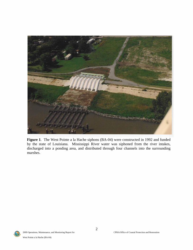
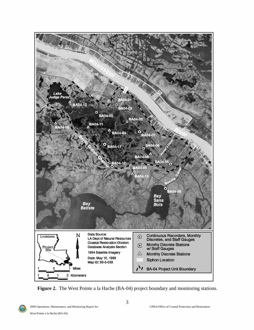
I. Introduction In 1992, the state-funded West Pointe a la Hache siphon construction (BA-04) project was built to re-introduce (or divert) freshwater from the Mississippi River into the adjacent marshes through a set of eight siphons (Figure 1). The freshwater re-introduction was intended to recreate the physical and ecological functions supported by periodic over-bank flooding that occurred prior to the placement of the flood-control levee system. The West Pointe a la Hache project area lies within the Barataria Basin in Plaquemines Parish, Louisiana. The area is bordered by Lake Judge Perez to the northwest, Bayou Grand Cheniere to the south, Socola Canal to the southeast, and the Mississippi River back protection levee to the north (Figure 2). The project area consists of approximately 16,297 acres (6,519 ha) of open water and brackish marsh. The objective of the West Pointe a la Hache project was to protect the project area from continued degradation by introducing freshwater from the Mississippi River. In doing so, the project sought to obtain the benefit of sediment and nutrients introduced into the project area. Specific goals were to (1) reduce and stabilize mean salinity (2) improve the growing conditions and increase the relative abundance of the target plant species Spartina patens, and (3) increase the marsh to open-water ratio. The principal project features include:
• A set of 8 separate siphons, each consisting of a steel pipe 6 ft (1.8 m) in diameter and 2600 ft (793 m) in length, which cross over the west levee of the Mississippi River at West Pointe a la Hache, Louisiana (Figure 1)
II. Maintenance Activity
a. Project Feature Inspection Procedures The last annual inspection by OCPR occurred on June 5, 2002 and the report was included in the 2005 OM&M report. There have been no annual inspections since then due to operations and maintenance budget constraints on state only projects. However, following Hurricane Katrina, a damage assessment report was prepared on November 5, 2005, which reported that the siphon structure had been damaged. Since then, the structures have been repaired and maintained by the Plaquemines Parish Government (PPG). The OCPR Engineering section is currently preparing design plans to improve siphon operations, thereby increasing the amount of time the siphons will flow.
2 2009 Operations, Maintenance, and Monitoring Report for CPRA/Office of Coastal Protection and Restoration West Pointe a la Hache (BA-04)
Figure 1. The West Pointe a la Hache siphons (BA-04) were constructed in 1992 and funded by the state of Louisiana. Mississippi River water was siphoned from the river intakes, discharged into a ponding area, and distributed through four channels into the surrounding marshes.
3 2009 Operations, Maintenance, and Monitoring Report for CPRA/Office of Coastal Protection and Restoration West Pointe a la Hache (BA-04)
Figure 2. The West Pointe a la Hache (BA-04) project boundary and monitoring stations.

4 2009 Operations, Maintenance, and Monitoring Report for CPRA/Office of Coastal Protection and Restoration West Pointe a la Hache (BA-04)
III. Operation Activity
a. Operation Plan Two different operational plans have been utilized since the beginning of the project. The original operation plan recommended interim operation of the siphons throughout the year to accommodate critical periods of time when habitat was used as nursery grounds for fish and shellfish (Brown and Root 1992). The current operation plan recommends for the siphons to be operated at full capacity when water at the Mississippi River gauge at Carrollton is rising and reaches 4.0 NGVD however, limited operation will be used during the shrimp season (Tom Bernard pers comm.). All operations are performed by PPG.
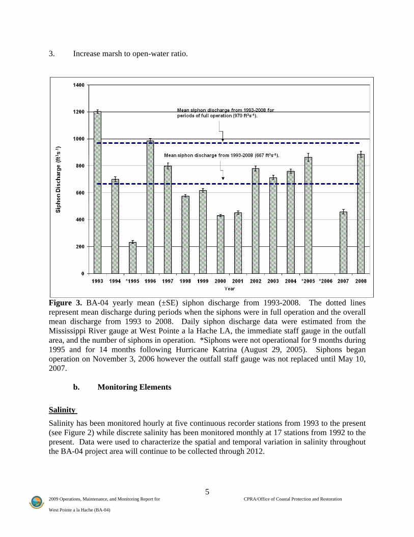
b. Actual Operations Daily siphon discharge from 1993-2008 was calculated from the head differential between the river and the immediate outfall area and the number of siphon pipes in operation. Water elevation data were obtained from the Mississippi River gauge readings at West Pointe a la Hache and the immediate outfall area staff gauge (BA04-01, see Figure 2). Operation data, which contains both the date and number of siphon pipes in operation, were obtained from PPG. The siphons are capable of a maximum discharge of 2144 ft3s-1 (61 m3s-1) during high river stages i.e., when all 8 siphons are in full operation. Through 2008, the structure was in operation 63% of the time and averaged 970 ft3s-1 (27.5 m3s-1) when fully operational (i.e. all eight pipes) and averaged 667 ft3s-1 (19 m3s-1) including periods of time when the siphons were not running or in limited operation (Figure 3). Siphon flow varied each year due to limited operations, as well as seasonal low river stages and droughts. At water levels below 1.5 ft NAVD88 on the Mississippi River gauge at West Pointe a la Hache, LA, the siphons begin to lose prime and are rendered inoperable. Additional obstacles to operations included: marine fisheries, tropical storms, oil spills, maintenance problems, and staffing limitations within PPG. IV. Monitoring Activity This report includes all data collected from the pre-construction period and post-construction period through December 2008.
a. Monitoring Goals The objective of the project is to protect the project area from continued degradation by introducing freshwater from the Mississippi River, thereby increasing the inflow of sediment and nutrients into the project area. The following goals will contribute to the evaluation of the above objective: 1. Reduce mean project area salinity. 2. Improve growing conditions and increase relative abundance of the target plant species,
Spartina patens (marsh-hay cordgrass).
5 2009 Operations, Maintenance, and Monitoring Report for CPRA/Office of Coastal Protection and Restoration West Pointe a la Hache (BA-04)
3. Increase marsh to open-water ratio.
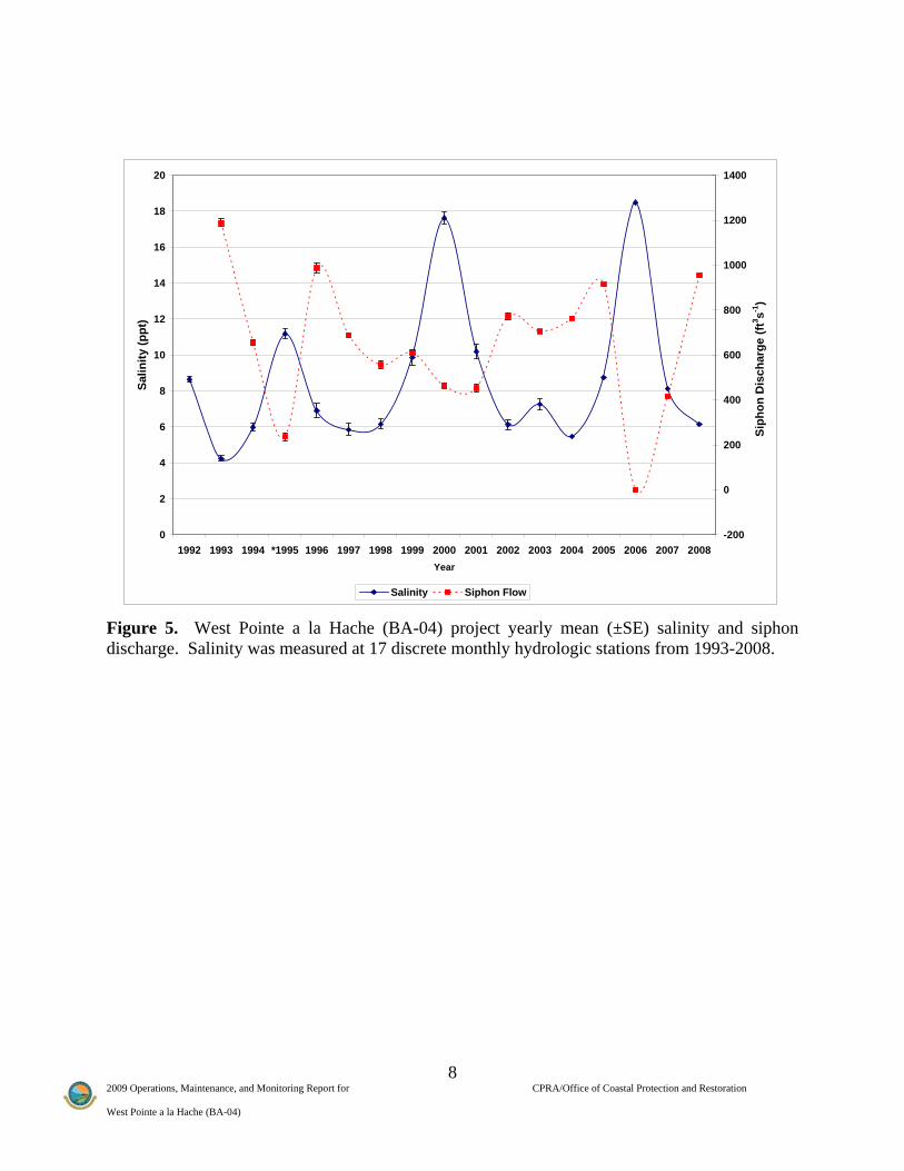
Figure 3. BA-04 yearly mean (±SE) siphon discharge from 1993-2008. The dotted lines represent mean discharge during periods when the siphons were in full operation and the overall mean discharge from 1993 to 2008. Daily siphon discharge data were estimated from the Mississippi River gauge at West Pointe a la Hache LA, the immediate staff gauge in the outfall area, and the number of siphons in operation. *Siphons were not operational for 9 months during 1995 and for 14 months following Hurricane Katrina (August 29, 2005). Siphons began operation on November 3, 2006 however the outfall staff gauge was not replaced until May 10, 2007.
b. Monitoring Elements
Salinity Salinity has been monitored hourly at five continuous recorder stations from 1993 to the present (see Figure 2) while discrete salinity has been monitored monthly at 17 stations from 1992 to the present. Data were used to characterize the spatial and temporal variation in salinity throughout the BA-04 project area will continue to be collected through 2012.
6 2009 Operations, Maintenance, and Monitoring Report for CPRA/Office of Coastal Protection and Restoration West Pointe a la Hache (BA-04)
Water Elevation Water level data were collected hourly at the five continuous recorder stations from August 1997 through 2008 while discrete water level measurements were recorded monthly at 10 staff gauge station from 1992 through 2008. These data were used to characterize the spatial and temporal variation in water level throughout the project area and will continue to be collected through 2012.
Vegetation Species composition and relative abundance of emergent vegetation were quantified using techniques described in Steyer et al. (1995). Twenty-one stations were monitored visually in 1992 (pre-construction) and in 1995 (post-construction). Thirty-six stations were monitored using (4m2) plots for years 1997, 2001, 2003, 2006, and will continue in 2009. The relative abundance raw data was square root transformed and similarities were found through a Bray-Curtis similarity matrix in Primer 6.1.6. A multi-dimensional scaling (MDS) ordination plot was also created using the raw data. The MDS ordination plots were then translated to GIS. Distichlis spicata and Polygonum punctatum were used as indicator species for salt and freshwater vegetation. Similar species were also analyzed (Spartina patens, S. alterniflora, Cyperus odoratus, Juncus romerianus, Panicum repens, and Vigna luteola) but only D. spicata and P. punctatum were represented.
Habitat Mapping In order to document vegetated and non vegetated areas, color-infrared aerial photography (1:12,000 scale with ground controls) was obtained following procedures outlined in Steyer et al. (1995). Photography was obtained on November 5, 1991 (pre-construction) and January 26, 1999 (post-construction) and will be collected in 2009 and 2017.
c. Preliminary Monitoring Results and Discussion
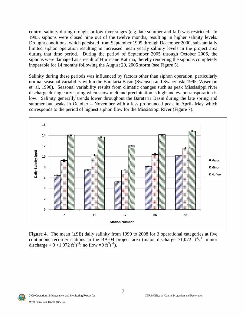
Salinity Mean daily salinity was lower during periods when all siphons were in major or minor operation versus no-flow. This is an indication that the siphons are capable of reducing salinity in the project area (Figure 4). Further evidence from the monthly discrete readings indicated that salinity levels were higher in the project area during 1995 when the siphons were not operating (Figure 5). In addition, mean monthly discrete salinity readings indicated that stations in the northern and western sections of the project area were similar to one another, and salinity in these areas was lower than in the southern project area. This suggests that the effect of the diversion on salinity decreases with distance from the siphons and there is a general north to south salinity gradient from low to high. Figure 6 shows that the diversion creates an area of lower salinity in an immediate area around the siphon and along the canals where the water from the siphon flows. Salinity in the area increased significantly in years 1995, 1999 and 2006 due to drought conditions and limited operations. Siphon flow is a function of river stage; thus, ability to
7 2009 Operations, Maintenance, and Monitoring Report for CPRA/Office of Coastal Protection and Restoration West Pointe a la Hache (BA-04)
control salinity during drought or low river stages (e.g. late summer and fall) was restricted. In 1995, siphons were closed nine out of the twelve months, resulting in higher salinity levels. Drought conditions, which persisted from September 1999 through December 2000, substantially limited siphon operation resulting in increased mean yearly salinity levels in the project area during that time period. During the period of September 2005 through October 2006, the siphons were damaged as a result of Hurricane Katrina, thereby rendering the siphons completely inoperable for 14 months following the August 29, 2005 storm (see Figure 5). Salinity during these periods was influenced by factors other than siphon operation, particularly normal seasonal variability within the Barataria Basin (Swenson and Swarzenski 1995; Wiseman et. al. 1990). Seasonal variability results from climatic changes such as peak Mississippi river discharge during early spring when snow melt and precipitation is high and evapotransporation is low. Salinity generally trends lower throughout the Barataria Basin during the late spring and summer but peaks in October – November with a less pronounced peak in April- May which corresponds to the period of highest siphon flow for the Mississippi River (Figure 7).
Figure 4. The mean (±SE) daily salinity from 1999 to 2008 for 3 operational categories at five continuous recorder stations in the BA-04 project area (major discharge >1,072 ft3s-1; minor discharge > 0 <1,072 ft3s-1; no flow =0 ft3s-1).
0
2
4
6
8
10
12
14
16
7 10 17 55 56
Dai
ly S
alin
ity (p
pt)
Station Number
Major
Minor
Noflow
8 2009 Operations, Maintenance, and Monitoring Report for CPRA/Office of Coastal Protection and Restoration West Pointe a la Hache (BA-04)
Figure 5. West Pointe a la Hache (BA-04) project yearly mean (±SE) salinity and siphon discharge. Salinity was measured at 17 discrete monthly hydrologic stations from 1993-2008.
0
2
4
6
8
10
12
14
16
18
20
1992 1993 1994 *1995 1996 1997 1998 1999 2000 2001 2002 2003 2004 2005 2006 2007 2008Year
Salin
ity (p
pt)
-200
0
200
400
600
800
1000
1200
1400
Siph
on D
isch
arge
(ft3 s-1
)
Salinity Siphon Flow
9 2009 Operations, Maintenance, and Monitoring Report for CPRA/Office of Coastal Protection and Restoration West Pointe a la Hache (BA-04)
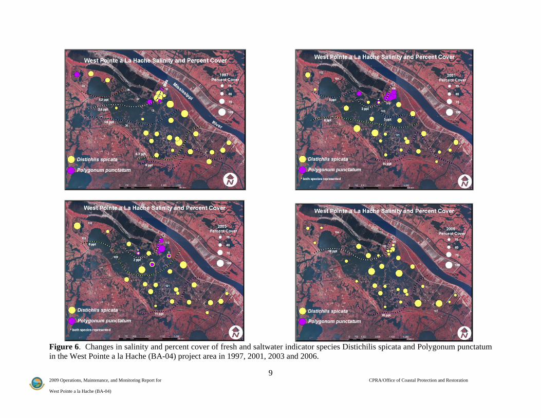
Figure 6. Changes in salinity and percent cover of fresh and saltwater indicator species Distichilis spicata and Polygonum punctatum in the West Pointe a la Hache (BA-04) project area in 1997, 2001, 2003 and 2006.

10 2009 Operations, Maintenance, and Monitoring Report for CPRA/Office of Coastal Protection and Restoration West Pointe a la Hache (BA-04)
Figure 7. West Pointe a la Hache (BA-04) project mean monthly salinity for continuous recorder stations and mean siphon flow (ft3s-1) for the period 1993-2008. Water Elevation Monthly water level readings from 10 staff gauges during siphon operation was significantly higher (P<0.05) at the monitoring station nearest the outfall structure (station BA04-01; see Figure 2) than the remaining stations. The mean water level at station BA04-01 during major flow conditions (>1,072 ft3s-1) was 0.56 ft (NAVD) greater than the mean water level measured during no-flow conditions. However, increased water surface elevations dissipated with distance from the discharge area.
Vegetation Different methodologies, sampling season, and sampling sites were used for the 1992 and 1995 vegetation surveys, than were used for the 1997, 2001, 2003, and 2006 surveys. The 1992 and 1995 surveys consisted of a visual observation of each individual area surrounding the 20 stations. In 1997, 2001, 2003, and 2006, Braun-Blanquet sampling was conducted at 36 (4m2) sites. Therefore, vegetation data collected since 1997 could not be statistically compared to data from years 1992 and 1995. The vegetation data within the project area suggested a freshening between 1992 and 1997. Between 1997 and 2001 vegetation types at many sites remained the same. Sites closest to the siphon became fresher which is evident from the increase of the freshwater indicator species Polygonum punctatum immediately around the diversion (see Figure 6). However, sites farthest

11 2009 Operations, Maintenance, and Monitoring Report for CPRA/Office of Coastal Protection and Restoration West Pointe a la Hache (BA-04)
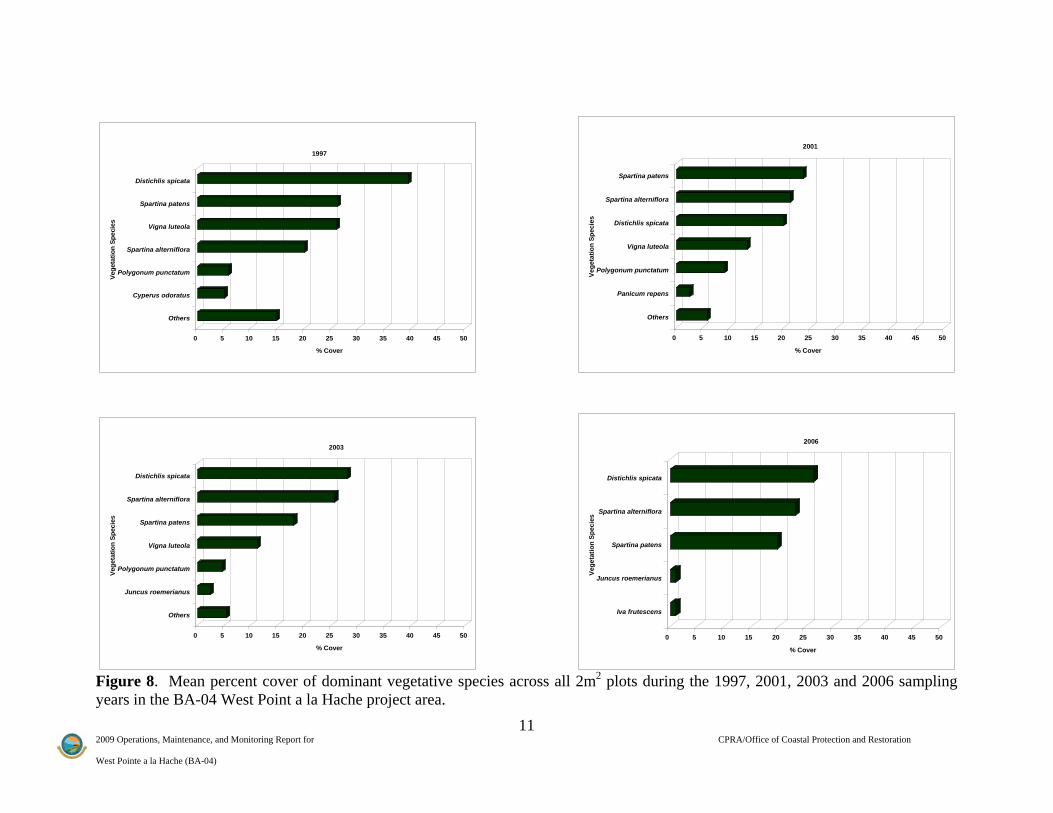
from the siphon became more saline possibly due to the drought conditions which occurred from 1999 through 2000 (Evers and Sasser 2002). Between 2001 and 2003, there was a decrease in the freshwater indicator species P. punctatum abundance in the immediate outfall area, however it was found in plots further from the outfall which can be attributed to the proper hydrologic functioning of the siphon (see Figure 6). Between 2003 and 2006, the majority of the area was dominated by saltwater species and many of the freshwater species were no longer found in the plots (Figure 8). Species located in the southern part of the project area were less diverse and consisted mainly of Spartina alterniflora, Spartina patens, Vigna luteola and Distichilis spicata, which were the dominant species in both percent cover and frequency of occurrence for the entire project area (see Figure 8 and Table 1). This is most likely due to the impact of the storm surges from Hurricane Katrina and Hurricane Rita and an indication that areas farthest from the diversion are influenced less by the diversion waters. Storm surges from hurricanes tend to increase salinities and stress freshwater species permitting the dominance of saltwater species (Carrell (in progress); Conner et. al. 1997). Also, the siphons were inoperable for some time after Hurricane Katrina, and therefore unable to help flush the system with fresh water. There is an overall trend of decreasing freshwater species and increasing saltwater species in the project area, which indicates a transition from a fresh/brackish marsh to a salt marsh. The 2009 vegetation survey data will provide more information on how the system reacts to major storm events.
Habitat Mapping: Historical loss rates for the project area taken from the Pointe a la Hache quadrangle were as follows: 0.18%/yr for 1932-1956, 0.54%/yr for 1956-1974, 1.10%/yr for 1974-1983, and 1.29%/yr for 1983-1990. Based on the 1991 and 1999 land/water analyses, the West Pointe a la Hache project area lost 460.4 acres (184.2 ha) of land between 1991 and 1999 (Figures 9 and 10). This represents a loss of 7.2% of land present in 1991 or 1.03% per year. The siphon area lost a total of 21.2 acres (8.5 ha) or a loss of 10.7% of land or 1.46% per year. Although the project area continues to lose land, rates are lower than recent historical rates, except in the siphon area. Land loss comparisons were made between January 1999 when siphons were running at a mean of 1248 ft3s-1, and November 1991 when there were no siphons or distributary channels yet constructed. Therefore, higher land loss rates calculated for the siphon area may have been due to elevated water levels in adjacent areas during siphon operation as well as the direct loss of land from construction of distributary channels.
11 2009 Operations, Maintenance, and Monitoring Report for CPRA/Office of Coastal Protection and Restoration West Pointe a la Hache (BA-04)
Figure 8. Mean percent cover of dominant vegetative species across all 2m2 plots during the 1997, 2001, 2003 and 2006 sampling years in the BA-04 West Point a la Hache project area.
0 5 10 15 20 25 30 35 40 45 50
% Cover
Others
Cyperus odoratus
Polygonum punctatum
Spartina alterniflora
Vigna luteola
Spartina patens
Distichlis spicata
Vege
tatio
n Sp
ecie
s
1997
0 5 10 15 20 25 30 35 40 45 50
% Cover
Others
Panicum repens
Polygonum punctatum
Vigna luteola
Distichlis spicata
Spartina alterniflora
Spartina patens
Vege
tatio
n Sp
ecie
s
2001
0 5 10 15 20 25 30 35 40 45 50
% Cover
Others
Juncus roemerianus
Polygonum punctatum
Vigna luteola
Spartina patens
Spartina alterniflora
Distichlis spicata
Vege
tatio
n Sp
ecie
s
2003
0 5 10 15 20 25 30 35 40 45 50
% Cover
Iva frutescens
Juncus roemerianus
Spartina patens
Spartina alterniflora
Distichlis spicata
Vege
tatio
n Sp
ecie
s
2006

12 2009 Operations, Maintenance, and Monitoring Report for CPRA/Office of Coastal Protection and Restoration West Pointe a la Hache (BA-04)
Table 1. The total number of species observed by year and frequency percentage of vegetation plots each species occurs in the West Pointe a la Hache Project (BA-04). Scientific Name Common Name
1997 2001 2003 2006Alternanthera philoxeroides Alligatorweed 2.77 2.94 2.94Amaranthus australis Southern amaranth 8.82 11.11Amaranthus sp. Pigweed 11.76Ammannia coccinea Valley redstem 2.94Ammannia latifolia Pink redstem 2.94Baccharis halimifolia Eastern baccharis 2.94Colocasia esculenta Coco yam 2.94 2.94Cynanchum angustifolium Gulf coast swallow-wort 2.94Cyperus sp. Flatsedge 2.94Cyperus odoratus Fragrant flatsedge 25 8.82 8.82Distichlis spicata Seashore saltgrass 69.44 67.65 70.59 86.11Echinochloa walteri Coast cockspur 5.55 5.88Eleocharis cellulosa Gulf coast spikerush 2.94Ipomoea sp. Morning-glory 2.94Ipomoea sagittata Saltmarsh morning-glory 8.33 5.88 5.88Iva frutescens Bigleaf sumpweed 2.94 2.94 13.88Juncus effusus Common rush 8.82Juncus roemerianus Needlegrass rush 8.33 5.88 8.33Kosteletzkya virginica Virginia saltmarsh mallow 5.55Ludwigia leptocarpa Angelstem Primrose willow 2.77Lythrum lineare Wand lythrum 5.55 8.82Panicum sp. Panicgrass 2.94Panicum hemitomon Maidencane 2.94Panicum repens Torpedograss 5.88Paspalum distichum Knotgrass 8.33Paspalum sp. Crowngrass 2.77Pluchea odorata Sweetscent 2.77Polygonum pensylvanicum Pennsylvania smartweed 2.77Polygonum punctatum Dotted smartweed 11.11 23.53 20.59Schoenoplectus pungens Common threesquare 2.77Schoenoplectus robustus Sturdy bulrush 2.77 5.88Setaria magna Giant bristlegrass 2.94Solidago sp. Goldenrod 5.88 2.77Solidago sempervirens Seaside goldenrod 2.94Sorghum halepense Johnsongrass 11.76 2.94Spartina alterniflora Smooth cordgrass 41.66 47.06 50 66.66Spartina patens Marshay cordgrass 52.77 52.94 44.11 58.33Symphyotrichum subulatum Eastern annual saltmarsh aster 19.44Symphyotrichum tenuifolium Perennial saltmarsh aster 11.11 8.82 2.94 25Toxicodendron radicans Eastern poison ivy 2.77Vigna luteola Hairypod cowpea 38.88 47.06 47.05Vitis sp. Grape 8.33Number of species 20 19 25 8
Occurrence (%)
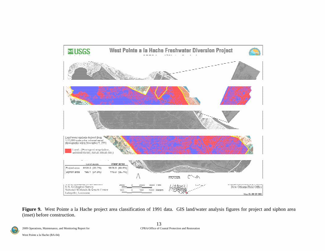
2009 O West P
Figu(inse
Operations, Maintenance, an
ointe a la Hache (BA-04)
ure 9. West Poet) before constr
nd Monitoring Report for
ointe a la Hacheruction.
e project area cl
CPRA/Of
lassification of
13 ffice of Coastal Protection a
1991 data. GIS
and Restoration
S land/water annalysis figures f
for project and ssiphon area

2009 O West P
Figu(inse
Operations, Maintenance, an
ointe a la Hache (BA-04)
ure 10. West Pet) after constru
nd Monitoring Report for
Pointe a la Hachuction.
he project area c
CPRA/Of
classification of
14 ffice of Coastal Protection a
f 1999 data. GI
and Restoration
IS land/water annalysis figures ffor project and ssiphon area
15 2009 Operations, Maintenance, and Monitoring Report for CPRA/Office of Coastal Protection and Restoration West Pointe a la Hache (BA-04)
V. Conclusions
a. Project Effectiveness
The first goal of the project, which was the reduction of salinity, was met. Salinity levels were reduced at data collection sites during periods of major and minor flow compared to no-flow conditions. Results from hydrologic modeling of the West Pointe a la Hache Outfall Management Project indicated that salinity reduction was possible in the magnitude of 5 to 10 ppt during siphon discharge periods (Fenstermaker 2004). Data indicated that there was a 6-7ppt reduction in salinity during full operation for stations 7, 10, 17, and 55 which were closest to the siphon compared to a 5ppt reduction for station 56 which is furthest from the siphon. A second goal of the project, to improve the growing conditions and increase the relative abundance of S. patens, was not met. Survey results showed that the percent cover of S .patens decreased marginally in the project area from 1997 through 2003. It was recommended (Evers and Sasser 2002) that looking at change in the overall plant community (i.e., vegetation types) instead of a single species (i.e., S. patens) better reflected the effects of diverting fresh water into the coastal marsh. Their results indicated that the vegetation community types became fresher over the period 1992-1997. Drought conditions also affected the vegetation community during 1997-2001 as indicated by a reversion to higher salinity vegetation at some stations in 2001. Higher salinity vegetation was also seen during 2006 which can be attributed to the storm surge from Hurricane Katrina and lack of operations. A third goal, to increase the marsh to open water ratio, has not been attained. Aerial photography analyses indicate that land loss was still occurring in the project area from the period 1991 through 1999. However, land loss has decreased in relation to the historical loss rates.
b. Recommended Improvements
The BA04c Outfall management was a candidate project for the third priority list of The Coastal Wetlands Planning, Protection and Restoration Act (CWPPRA). The project was proposed in 1993 to optimize the distribution of the BA-04 fresh water siphon introduction and sediment by managing water flow through the area through the utilization of water control structures and spoil bank maintenance. To assess the proposed project features, hydrologic modeling was incorporated in November 2004. Results from the model indicated that the project features would reduce area salinities, but only by 2 ppt or less. It was determined by LDNR and NRCS to forego the originally proposed features and change the project scope from “Outfall Management” to “Siphon Repair and Improvement”. At the November 5, 2008 Technical Committee meeting the Project Team received approval for “Change in Scope”. The project is currently being redesigned with an anticipated design completion date of November 2009 and an anticipated request for Construction Approval at the January 2010 Task Force meeting. As recommended in the 2005 OM&M report, new project features such as an automated priming system and flow meters have been incorporated into the new design plans for the new project scope “Siphon Repair and Improvement”. These will enable the siphons to promptly resume operation once the river stage is at an appropriate level and flow meters to accurately record siphon discharge.

16 2009 Operations, Maintenance, and Monitoring Report for CPRA/Office of Coastal Protection and Restoration West Pointe a la Hache (BA-04)
c. Lessons learned The monitoring of this project increased the learning curve for wetland projects of this type. Lessons learned include: (1) project goals should have been quantified as much as possible to aid evaluation of project effectiveness, for example, quantify the desired percent increase for S. patens or the percent decrease of salinity; (2) hydrodynamic and salinity transport numerical modeling along with outfall management should have been implemented in the beginning phase of the siphon project to assess the impact of the proposed outfall management project features and to determine if the proposed project features would help achieve the primary goals of the project; (4) a reference area could have been included during the project planning or developmental stages of this project, but will be addressed in the future with the Coastwide Reference Monitoring System-Wetlands (CRMS Wetlands). CRMS stations were in place at the completion of this report however the data collected had been for a period of less than one year.
17 2009 Operations, Maintenance, and Monitoring Report for CPRA/Office of Coastal Protection and Restoration West Pointe a la Hache (BA-04)
VI. Literature Cited Brown and Root, Inc. 1992. West Pointe a la Hache freshwater diversion siphon. A
management, operation, and monitoring plan. Unpublished final report prepared for Plaquemines Parish government, Department of Health and Hospitals. Belle Chasse, La: Brown and Root, Inc. 60pp.
Carrell, C. E. In progress. Wetland Assembly Rules and Hurricane Induced Wetland Habitat-
State Change. Masters Thesis. Southeastern Louisiana University, Hammond, Louisiana, U.S.A.
Conner, W. H., K. W. Mcleod, and J. K. McCarron 1997. Flooding and salinity effects on
growth and survival of four common forested wetland species. Wetlands Ecology and Management 5:99-109.
Evers, D. E., and C. E. Sasser. 2002. CWPPRA Adaptive Management Review BA-04 (West
Pointe a la Hache) Vegetation. Unpublished report prepared for the Louisiana Department of Natural Resources/Coastal Restoration Division. Baton Rouge, LA: Coastal Ecology Institute.
Fenstermaker and Associates. 2004. Hydrodynamic Modeling of the West Pointe a la Hache
Outfall Management Project (BA-04c). Unpublished report prepared for the Louisiana Department of Natural Resources and the Natural Resources Conservation Service. Baton Rouge, LA. 139 pp.
Swenson, E. M., and C. M. Swarzenski. 1995. Water levels and salinity in the Barataria-
Terrebonne Estuarine System . In D. J. Reed, ed. Status and Historical Trends of Hydrologic Modification, Reduction in Sediment Availability, and Habitat Loss/Modification in the Barataria and Terrebonne Estuarine System. BTNEP Publ. No. 20, Barataria-Terrebonne National Estuary Program, Thibodaux, Louisiana. 338 pp.
Steyer, G. D., R. C. Raynie, D. L. Steller, D. Fuller, and E. Swenson. 1995. Quality management
plan for the Coastal Wetlands Planning, Protection, and Restoration Act monitoring program. Open-file series no. 95-01 (Revised June 2000). Baton Rouge: Louisiana Department of Natural Resources, Coastal Restoration Division. 97 pp.
Wiseman, W. J., E. M. Swenson, and F. J. Kelly. 1990. Control of estuarine salinities by coastal
ocean salinity. In Residual Currents and Long-Term Transport, ed. R. T. C.