west malita graben the ugly duckling or another …...west malita graben: the ugly duckling 1. early...
TRANSCRIPT

Asia-Pacific G&G Team: J. Mather & N. Hand
West Malita Graben
The Ugly Duckling or another Phoenix
SEAPEX 2019 – Session 4-4

West Malita Graben: The Ugly Duckling ?
Agenda
• Location & Setting
• Why the Ugly Duckling
• Appearances can be deceiving
• Spectrum Database - Kyranis MC3D
• Data Quality uplift & Challenges
• Chuditch-1
• Durville-1
• Prospectivity Overview
• Conclusion
West
Malita
Mrs Bonaparte
Laminaria
East
Malita
Sahul
The Bonaparte Family
Note: This is a high level overview due to the time allowed.
For a more detailed presentation please do not hesitate to contact the SpectrumGeo Team in Perth.

West Malita Graben:
Location &
Setting
• Halfway between Australia
& East Timor (≈ 250km)
• Only two minor
discoveries
Chuditch in Plover Fm
Durville in Sandpiper
• Review focuses on the
Kyranis MC3D
Top Elang/Plover Fm Sand Play
(Oxfordian Unc., JO) TWT map , showing
the regional setting of Malita Graben and
location of the Kyranis Multi-client 3D
Location & Geological Setting
• The Malita Graben is SW-
NE trending Late
Carboniferous – Early
Permian rift that over
printed the NW-SE
Precambrian-Paleozoic
Petrel Basin
• A broad post rift sag basin
developed during the
Triassic through to Middle
Jurassic
• A second phase of rifting
commenced in the
Callovian (JC) during
Pangea continental
break-up
• Post rift sag followed in
the early Cretaceous

West Malita Graben:
The Ugly
Duckling
1. Early wells targeted
big structures
2. A lot of CO2
3. Boundary with Timor
L’ Este in dispute
Why the Ugly Duckling
Drilling History
• Newby first well in area
(1969 – Aust. Aquitaine)
• Heron-1 first discovery
(1971 - Arco) CO2: 40%
• Laperouse-1 last well
(2011 - Total)
• Kanase-1 Drilling (ENI)
Testing Jur. & Triassic Kanase
Top Elang/Plover Fm Sand Play
(Oxfordian Unc., JO) TWT map , showing
the regional setting of Malita Graben and
location of the Kyranis Multi-client 3D

Nth Bonaparte: Multiple Petroleum Systems? • Paleozoic Petroleum system mainly seen in the
Petrel Basin but there is clearly some contribution
around the flanks of the West Malita Graben that
should not be ignored, (Kelp Deep).
• Mid Jurassic Plover is the main gas drive for the
region
• Petroleum Geochemistry supports the presence of
an Echuca Shoals source – often invoked as a
driver for an oil play, seen in several wells in the
region, ie.; Bard, Beluga, Blackwood, Chuditch,
Cornea, Firebird, Elang West
• Heron-2 supports the presence of a Frigate SR
Adapted from COP Caldita 3D Interp Report Permo-Paleozoic SR ?
Chuditch-1
Stable carbon isotope signatures have the advantage over
molecular composition in that they are not affect by phase
fractionation.
Chuditch-1 shows a disconnect indicating the gas & oil sampled
come from different kitchens and source rocks.
Durville-1
(West Malita)
Malita
Graben
Chuditch (West Malita)
Sahul
Platform
Darwin
Shelf
FORMATION
Kelp Deep-1 (Sahul Plat.) CO2 ?
? P
erm
o-P
ale
ozo
ic S
R E
xpuls
ion ?
? C
O2 E
xpuls
ion
?
Ascalon-1 (Londonderry)
Petrel/Tern..(Petrel Basin)
Ascalon-1 (Londonderry)
Blackwood
Heron-2
Sandpiper 2
Sandpiper 1
?
?
?
?
Appearances can be deceiving
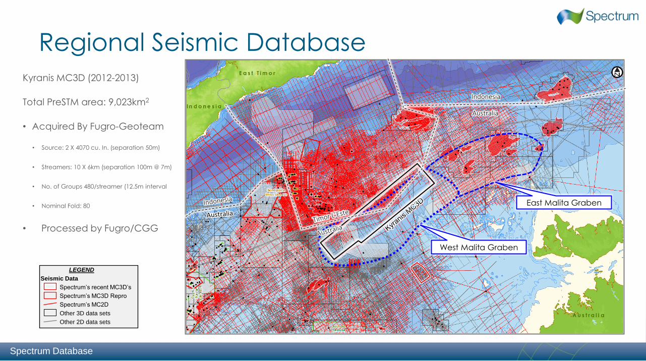
Regional Seismic Database
Kyranis MC3D (2012-2013)
Total PreSTM area: 9,023km2
• Acquired By Fugro-Geoteam
• Source: 2 X 4070 cu. In. (separation 50m)
• Streamers: 10 X 6km (separation 100m @ 7m)
• No. of Groups 480/streamer (12.5m interval
• Nominal Fold: 80
• Processed by Fugro/CGG
LEGEND
Seismic Data
Spectrum’s recent MC3D’s
Spectrum’s MC3D Repro
Spectrum’s MC2D
Other 3D data sets
Other 2D data sets
Spectrum Database
West Malita Graben
East Malita Graben
Indonesia
Australia

Kyranis MC3D: Sea floor velocity artefacts Near Top Hibernia (Eoc.) TWT Map (ms)
Shows over print of the sea floor and shallow strong
lateral velocity variations – Main causes are the rugose
sea floor topography and the drowned carbonate
platform below present day un-compacted silt.
Subsurface imaging
• Very challenging,
particularly for 2D time
data
• Structures have a
large uncertainty in
depth
Kyranis MC3D
Australia
Australia
Kyranis 3D
Gulf of Bonaparte Bathymetry
Chuditch
Durville
Bayu-Undan
Blackwood
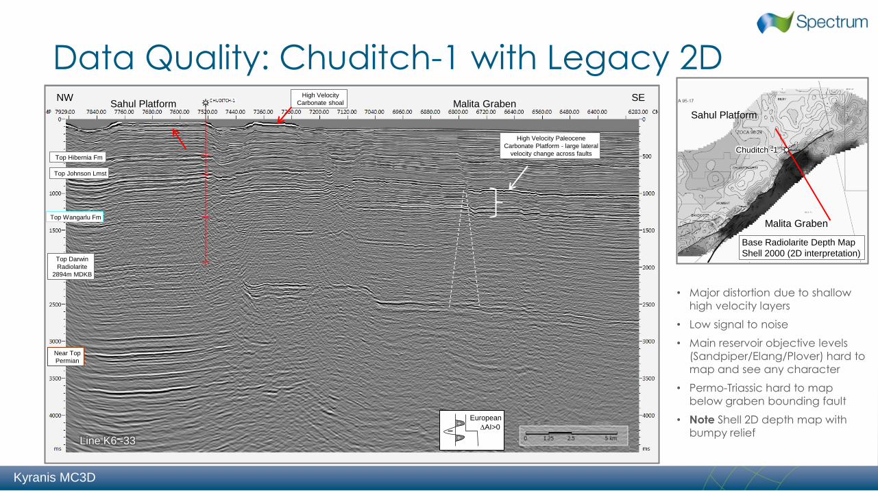
Data Quality: Chuditch-1 with Legacy 2D NW
Top Darwin
Radiolarite
2894m MDKB
Top Wangarlu Fm
Line K6 -33
Near Top
Permian
Sahul Platform SE
Malita Graben
Base Radiolarite Depth Map
Shell 2000 (2D interpretation)
Malita Graben
Sahul Platform
AI>0
European +
+
• Major distortion due to shallow
high velocity layers
• Low signal to noise
• Main reservoir objective levels
(Sandpiper/Elang/Plover) hard to
map and see any character
• Permo-Triassic hard to map below graben bounding fault
• Note Shell 2D depth map with
bumpy relief
Top Hibernia Fm
Top Johnson Lmst
High Velocity
Carbonate shoal
High Velocity Paleocene
Carbonate Platform - large lateral
velocity change across faults Chuditch -1
Kyranis MC3D

Data Quality: Chuditch-1 with Kyranis PreSTM
• Improved water bottom statics
(Replacement & residual statics)
• Improvement in signal to noise
• Marked improvement at main
reservoir objective levels
(Sandpiper/Flamingo/Elang/Plover)
• Can now map and see character in the deeper
sediments (Permo-Triassic)
• Note Kyranis 3D TWT map - much
smoother and simpler
Kyranis MC3D
Malita Graben
Sahul Platform
Chuditch -1
Base Radiolarite TWT Map
Kyranis MC3D & 2D interp.

Malita Graben
Sahul Platform
Chuditch -1
Base Radiolarite TWT Map
Kyranis MC3D & 2D interp.
Data Quality: Chuditch-1 with Interpretation
Main Plays & Picks on Seismic
Note: No direct calibration of
events within the Malita Graben
Kyranis MC3D

Durville-1: Seismic Interpretation
Inline 2000
Base Aptian (Radiolarite)
TWT Map (Kyranis MC3D)
Late CO2 charge
Objectives Structural fault closure at top Elang/Plover but Not Reached
Results Discovered 36m Gas column (CGR
not known, 38% CO2) Possible residual oil column > 40m in Sandpiper Fm
• Oil shows noted on core sample & fluorescence present on core photographs with slightly elevated resistivity profile. Possibly due to invasion during coring?
• Tests:. No DSTs – MDT samples recovered
Top Elang Depth Map (m)
Not reached by well
Durville
CO2 migrating up
basin centre faults
Kyranis MC3D
4 Km
Source: Durville WCR

Durville-1: Untested Play & Up-dip Gas • Sandpiper 2 gas up dip ?
• Elang/Plover play remains untested
• Fault shadow makes the panel look faulted
• Perhaps deeper objectives (ENI currently
testing Triassic to north at Kanase-1)
Prospectivity

Wombat
Chuditch
West
Chuditch
Bilby
Chuditch West
Wombat
Bandicoot Quokka
Chuditch
Chuditch Area: Shell Vols & Deeper Objectives
Base Radiolarite Depth Map
Shell 2000
2D mapping suggests a series of small
bumpy structures
3D time mapping suggests broader subtle
structures that appear to partially coalesce
Prospectivity
Possibility of stacked objectives
• Elang/Plover Sands
• Triassic Sands? (Ascalon Sst. Early Triassic)
• Lower shoreface could extend further or
• Basin floor turbdite fans could be present
• Permian Sands (Upper most
Cape Hay)
• Fractured Carbonates (Darwin, Pearce. . . ?)
Source:
Permo-Triassic reservoir fairways of the Petrel Sub-basin, Timor Sea
Paul H. Robinson1 and Kim B. McInerney2
Timor Sea Symposium 2003
Gross depositional environment palaeogeographic
reconstruction of the Ascalon sandstones (K. saeptatus
- earliest Triassic) for the Petrel Basin
Malita Graben
Base Radiolarite TWT Map
Kyranis MC3D & 2D interp.
Elang/Plover Sands

Sanpiper 2 Sands (Berr-Tith): Paleogeography ? Durville & Laperouse:
• Reservoir: Thick submarine fan
deposits – West Malita subsided
early
• Seal: Tight overlying Sandpiper 1
sands, Flamingo Shales and
Cretaceous Bathurst Gp exceeds
2000m in Graben
• Source: Paleo Oil Column?
Echuca & Flamingo Shales
Beluga-1
• Reservoir: Shelfal Fan deposits -
Sediments from north – Sahul
Platform
• Seal: Flamingo Shales and
Cretaceous Bathurst Gp exceeds
2000m in Graben
• Source: Light oil/wet gas shows -
Flamingo Group & Elang Fm.
(early mature)
• AVO?: High amplitude anomalies
in the Tithonian down-dip
(SANTOS having a 2nd look)
Caldita-1 & 2: supports syn-rift
thickening (Sands present)
Evans Shoal & ES Sth has just the
Cleia Fm (restricted deep Marine
silt/claystones) sands absent or
bypassed
Heron-2: Supports more liquid prone
basal Flamingo (Frigate) SR
Overlying Sandpiper 1 Sands more wide spread in south Prospectivity

West Malita Graben: Prospects / Concepts
Key Challenges
• Map sands (Seismic
quality for QI)
• Find undrilled structures
(Depth conversion issue)
• Show reservoir presence
and preservation at
depth (understanding
porosity preservation
processes better)
Prospectivity
LEGEND
Opportunities
Prospects
Concepts
Seismic Data
Spectrum’s recent MC3D’s
Other 3D data sets
Bilby
Indonesia
Australia
Abadi
Caldita
Barossa
Evan Shoals
Sunrise-Troubadour
Bayu-Undan
Kelp Deep
Plover/Elang Seal Risk
Deep Wonarah
Rossel Darwinia Deep
Mimosa
Wombat
Chuditch West
Bilby
Asterix
Heron
Blackwood
Chuditch
Kanase-1
Drilling Trias

Thank you to the Spectrum APAC team for their support & management
for allowing me to present seismic images from the Kyranis MC3D
Conclusion
• All the ingredients are there for the area to rise from the
ashes.
• Multiple functioning petroleum systems
• The area has a complex history and is under explored
• Plenty of potential for a good surprise
• Kyranis 3D to be reprocessed with a modern flow
• Perhaps like the Bedout Basin with the Phoenix South
discovery then Roc, knowledge improves &
confidence builds . . . . . . Leading to Dorado
“Discovery consists of looking at the same thing as
everyone else and thinking something Different”
Albert Szent Gyorgi