west coast bays marine park - part b
TRANSCRIPT

khkhkh
kh
kh
kh kh
kh
kh
kh
kh
kh
kh
khkh
kh
G1 yellow, suggested alternative to be 100m around islands(excluding spits)
I1 yellow, suggested alternative
H1 green, suggested alternative
G2 green, suggested alternative
G3 pink, suggested alternative (exclude spits)
F
G
I
H
-30
-50
-20
-15
-5
-2-10
-1
-12
-30
-2
-2
-2
-20
-15
-2
-15
-2
-2
-20
-15
-1
134°45'0"E
134°45'0"E
134°40'0"E
134°40'0"E
134°35'0"E
134°35'0"E
134°30'0"E
134°30'0"E
33°1
0'0"S
33°1
0'0"S
33°1
5'30"S
33°1
5'30"S
West Coast Bays Marine Park - PART B
Data Source
Compiled Projection Datum
Suggestions - MPLAGTopographic Data, Parks and Reserves,Bathymetry - DENR24 February 2011Lambert Conformal ConicGeocentric Datum of Australia, 1994
0 3
Kms
±
DEH Standard
Zoning Advice from MPLAG Meeting 4 - 22/2/2011
Parks and ReservesPreliminary Zoning ScenariosMarine ParkBathymetry
kh Navigation Markers
This map represents initial zoning advice from MPLAG members.IMPORTANT: Please note that this initial zoning advice from MPLAG members:- is not yet complete;- does not necessarily represent the views of all MPLAG members;- is subject to change.The MPLAGs will meet again in late April/early May to consider any further informationbefore finalising their advice on preferred zoning arrangements.
0 2
Nautical Miles
MPLAG SuggestionsMPLAG SuggestionsMPLAG Suggestions
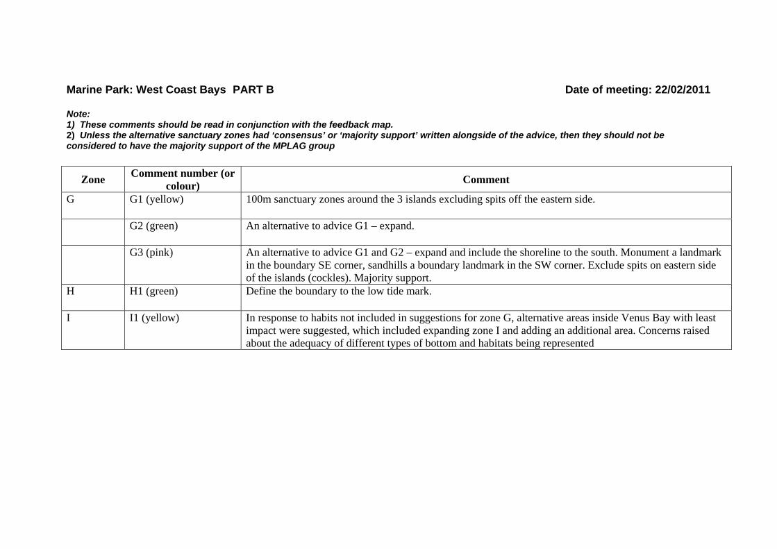
Marine Park: West Coast Bays PART B Date of meeting: 22/02/2011 Note: 1) These comments should be read in conjunction with the feedback map. 2) Unless the alternative sanctuary zones had ‘consensus’ or ‘majority support’ written alongside of the advice, then they should not be considered to have the majority support of the MPLAG group
Zone Comment number (or colour) Comment
G G1 (yellow) 100m sanctuary zones around the 3 islands excluding spits off the eastern side.
G2 (green) An alternative to advice G1 – expand.
G3 (pink) An alternative to advice G1 and G2 – expand and include the shoreline to the south. Monument a landmark in the boundary SE corner, sandhills a boundary landmark in the SW corner. Exclude spits on eastern side of the islands (cockles). Majority support.
H H1 (green) Define the boundary to the low tide mark.
I I1 (yellow) In response to habits not included in suggestions for zone G, alternative areas inside Venus Bay with least impact were suggested, which included expanding zone I and adding an additional area. Concerns raised about the adequacy of different types of bottom and habitats being represented