welcome! 1. editor’s note · la evolución de la petrografía sedimentaria ha sido mejorada con...
TRANSCRIPT
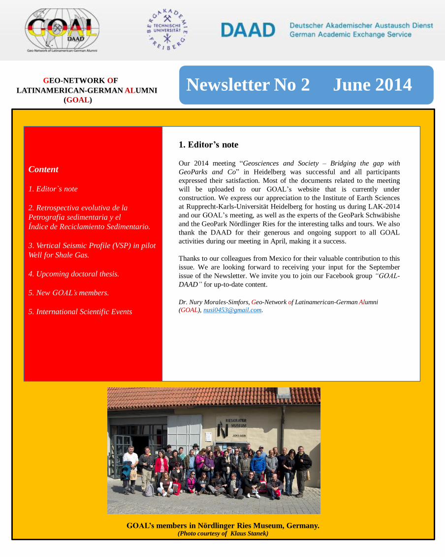
GOAL’s members in Nördlinger Ries Museum, Germany. (Photo courtesy of Klaus Stanek)
GEO-NETWORK OF
LATINAMERICAN-GERMAN ALUMNI
(GOAL)
Newsletter No 2 June 2014
Content
1. Editor`s note
2. Retrospectiva evolutiva de la
Petrografía sedimentaria y el
Índice de Reciclamiento Sedimentario.
3. Vertical Seismic Profile (VSP) in pilot
Well for Shale Gas.
4. Upcoming doctoral thesis.
5. New GOAL’smembers.
5. International Scientific Events
WELCOME!
Welcome to the first edition of our GOAL’s quarterly newsletter 2014! The last newsletter was published in December 2013, and since then, GOAL’s network continues to grow and support the field of geosciences between Latin America and Germany, opening up to a much wider scientific audience.
We would like to thank our colleagues for sharing their knowledge, experiences, and research in their fields of expertise with us in this issue. We look forward to seeing you in Heidelberg during the 23rd Latin American Colloquium LAK 2014 and GOAL meeting in March. Thank you to DAAD for their continued support to the network, making it
Our 2014 meeting “Geosciences and Society – Bridging the gap with
GeoParks and Co” in Heidelberg was successful and all participants
expressed their satisfaction. Most of the documents related to the meeting
will be uploaded to our GOAL’s website that is currently under
construction. We express our appreciation to the Institute of Earth Sciences
at Rupprecht-Karls-Universität Heidelberg for hosting us during LAK-2014
and our GOAL’s meeting, as well as the experts of the GeoPark Schwäbishe
and the GeoPark Nördlinger Ries for the interesting talks and tours. We also
thank the DAAD for their generous and ongoing support to all GOAL
activities during our meeting in April, making it a success.
Thanks to our colleagues from Mexico for their valuable contribution to this
issue. We are looking forward to receiving your input for the September
issue of the Newsletter. We invite you to join our Facebook group “GOAL-
DAAD” for up-to-date content.
Dr. Nury Morales-Simfors, Geo-Network of Latinamerican-German Alumni
(GOAL), [email protected].
1. Editor’s note

a
2. Retrospectiva evolutiva de la Petrografía sedimentaria y el Índice de Reciclamiento
Sedimentario
Igor Ishi Rubio-Cisneros, Petroleum GeoServices (PGS), Av. Paseo Tabasco 1406, 3° Piso, Torre Plaza Atenas, Tabasco 2000,
Villahermosa, Tabasco, México, C.P. 86030, [email protected]; Yam Zul Ernesto Ocampo-Díaz, Áreas de Ciencias de la
Tierra, Facultad de Ingeniería, Universidad Autónoma de San Luis Potosí, Av. Dr. Manuel Nava No. 8, Zona Universitaria,
San Luis Potosí, México, C.P., 78290, [email protected]
La evolución de la petrografía sedimentaria ha sido mejorada con el desarrollo de la geología sedimentaria por
medio de métodos que permiten cuantificar y evaluar la clasificación de muestras (e.g. Folk, 1980; Okada, 1971;
Ocampo-Díaz, 2011), reconocer los ambientes tectónicos del cual derivan los sedimentos (e.g., Crook, 1974;
Dickinson y Suczek, 1979; Ingersoll y Suczek, 1979), y por último determinar el tipo de cuenca sedimentaria.
El establecimiento para la clasificación cualitativa y cuantitativa de rocas sedimentarias se registran en trabajos
pioneros de finales de 1800, extendiéndose hasta mediados del siglo XX (Rubio-Cisneros y Ocampo-Díaz, 2011).
Sin embargo, los trabajos más destacados que describen areniscas de manera numérica son de la década de 1960 y
han servido como guía en trabajos posteriores destinados a describir la firma genética de rocas clásticas (e.g.,
McBride, 1963; Zuffa, 1980; Ingersoll, 1983).
Un segundo gran avance del método es la definición y documentación de la petrogénesis de las áreas fuente y su
composición. Esta actualización está representada en la clasificación e interpretación de los tipos de cuarzos, la
caracterización de feldespatos, las asociaciones de fragmentos líticos, y en la determinación del grado de
intemperismo que las rocas fuente han sufrido (e.g., Basu et al., 1963; Pitman, 1963; Dickinson, 1970; Marsaglia et
al, 1992; Garzanti y Vezolli, 2003).
Finalmente, la composición del sedimento y áreas fuentes se consolidan para alcanzar el último eslabón científico-
académico para la petrografía sedimentaria, el de resolver en detalle el depósito de arenas en un ambiente tectónico
específico o una determinada cuenca sedimentaria. La integración de datos de un análisis de procedencia
cuantitativo y las vías para la génesis del sedimento buscan dar cierre al ciclo espacio-temporal de la cuentca al
depósito (“source-to-sink).
Recientemente Ocampo-Díaz y Rubio-Cisneros documentan el Índice de Reciclamiento Sedimentario (InReSe;
Ecuación 1) y su relación a cambios composicionales ligados a discordancias angulares-erosivas que delimitan a las
unidades clásticas dentro de la columna estratigráfica de la Fosa de Monterrey en el Noreste de México (Figuras 1 y
2). Estos autores utilizan los datos composicionales de las formaciones clásticas del Triásico Superior hasta el
Cretácico Inferior para evaluar estadísticamente su relación con la génesis de las discordancias desde el punto de
vista petrogenético (Ocampo-Díaz y Rubio-Cisneros, 2013).
Qp– Cuarzos policristalinos; Qt– Cuarzo total; Qm– Cuarzos monocristalinos; Lm– Líticos metamórficos; Ls– Líticos sedimentarios; Lv– Líticos volcánicos; F– Feldespatos; P– Plagioclasas
Newsletter No 2 June 2014
donde:
Xi = X1 (Qp) + X2 (Qt) + X3 (Qm)
Yi = Y1 (Lm) + Y2 (Ls) + Y3 (Lv) +Y4 (F) + Y5 (P)

a
Figura 2. Columna estratigráfica de la Fosa de Monterrey (Modificada de Michalzik, 1988)
.
Newsletter No 2 June 2014
Figura 1. Localización y geología
regional del área de estudio (Tomada de
Michalzik, 1988).
Figura 2. Columna estratigráfica
de la Fosa de Monterrey
(Modificada de Michalzik, 1988)

Newsletter No 1 March 2014
Newsletter No 2 June 2014
Figura 3. Esquema de las posibles áreas fuentes en las secuencias clásticas de la Fosa de
Monterrey, y los cambios que presenta el InReSe en relación con las discordancias y los cambios de
aporte de sedimentos. Nótese que por medio de los cambios de los valores del
InReSe, se pueden documentar posibles discordancias.
Agradecimientos
Los autores agradecen a la Universidad Autónoma de Nuevo León, Georg-August-Universität
Göttingen, Westfälische Wilhelms-Universität Münster; Goethe-Institut, al programa Deutscher
Akademischer Austauschdienst (DAAD); y a los profesores-investigadores Uwe Jenchen, Carita
Augustsson, Heinrich Bahlburg, Dieter Michalzik, Hilmar von Eynatten, István Dunkl, y Tamás Mikes.

Newsletter No 1 March 2014
Newsletter No 2 June 2014
Referencias
Basu, A., Young, S.W., Suttner, L.J., James, C.W., Mack, G.H., 1975, Re-evaluation of the use of undulatory extinction
and polycrystallinity in detrital quartz provenance interpretation. Journal of Sedimentary Petrology, 45, 873-882.
Crook, K.A.W., 1974, Lithogenesis and geotectonics: the significance of compositional variations in flysch arenites
(graywackes). En: Dott, J. R., Shaver, R. H. (eds.), Modern and ancient geosinclinal sedimentation. Tulsa, Oklahoma,
Society of Economic Paleontologists and Mineralogists, Special publications 19, 304-310.
Dickinson, W.R., 1970, Interpreting detrital modes of graywacke and arkose. Journal of Sedimentary Petrology, 40 (2),
695-707.
Dickinson, W.R., Suczek, C.A., 1979, Plate tectonics and sandstone compositions. American Association of Petroleum
Geologists Bulletin, 63(12), 2164.
Dickinson, W.R., Suczek, C.R., 1979, Plate tectonics and sandstone composition. American Association of Petroleum
Geologists, Bulletin, 63 (12), 2164-2182.
Folk R. L., 1980, Petrology of sedimentary rocks: Austin, Texas, Hemphill publishing co., 192 p.
Garzanti, E., Vezzoli, G., 2003, A classification of Metamorphic grains in sands based on their composition and grade.
Journal of Sedimentary Research, 73, 830-837.
Ingersoll, R.V., 1983, Petrofacies and provenance of late Mesozoic forearc basin, northern and central California.
American Association of Petroleum Geologists Bulletin, 67 (7), 1125.
Ingersoll, R.V., Suczek, C.A., 1979, Petrology and provenance of Neogene sand from Nicobar and Bengal fans, DSDP
sites 211 and 218. Journal of Sedimentary Petrology, 49 (4), 1217-1228.
Marsaglia, K.M., Ingersoll, R.V., Packer, B.M., 1992, Tectonic evolution of the Japanese Islands as reflected in modal
compositions of Cenozoic forearc and backarc sand and sandstone. Tectonics, 11(5), 1028-1044.
McBride, E.F., 1963, A classification of common sandstones. Journal of Sedimentary Research, 33, 664-669.
Michalzik, D., 1988, Trias bis tiefste Unter-Kreide der nordöstlichen Sierra Madre Oriental, Mexico: Fazielle
Entwicklung eines passiven Kontinentalrandes: Darmstadt, Alemania, Technischen Hachschule Darmstadt, tesis doctoral,
247 p.
Ocampo-Díaz, Y.Z.E., 2011, Implicaciones tectono-sedimentarias de las intercalaciones clásticas en el límite Jurásico-
Cretácico del noreste de México (fosa de Monterrey y cuenca de Sabinas): Linares, Nuevo León, Facultad de Ciencias de
la Tierra, Universidad Autónoma de Nuevo León, tesis doctoral, 275 p.
Ocampo-Díaz, Y.Z.E., Rubio-Cisneros, I.I., 2013, Reciclamiento sedimentario: Análisis composicional asociado a
discordancias del noroeste de México, un ejemplo del Triásico Superior al Cretácico Inferior. Boletín de la Sociedad
Geológica Mexicana, 65 (3), 553-572.
Okada, H., 1971, Classification of Sandstone: Analysis and Proposal. The Journal of Geology, 79, 509-525.
Pitman, E.D., 1963, Use of zoned plagioclase as an indicator of provenance: Journal of Sedimentary Petrology, 33, 380-
386.
Rubio-Cisneros, I.I., 2013, Análisis de procedencia de las formaciones El Alamar, La Boca y La Joya, noreste de México
(Triásico superior–Jurásico medio): Linares, Nuevo León, Facultad de Ciencias de la Tierra, Universidad Autónoma de
Nuevo León, tesis doctoral, 243 p.
Rubio-Cisneros, I.I., Ocampo-Díaz, Y.Z.E., 2010, Compositional analysis and sedimentary recycling evidences
associated to unconformities in the northeastern Mexico, a Late Triassic-Early Cretaceous example (resumen). Geological
Society of America Annual Meeting, Branson,Missouri: Geological Society of America, Abstracts with Programs, 42 (2),
p. 70.
Rubio-Cisneros, I.I., Ocampo-Díaz, Y.Z.E., 2011, Source-to-Sink: a retrospection of the sedimentary petrography
evolution (resumen). Geological Society of America Annual Meeting, Minneapolis, Minnesota: Geological Society of
America, Abstracts with Programs, 43, p. 431.
Zuffa, G.G., 1980, Hybrid arenites: their composition and classification. Journal of Sedimentary Petrology, 50, 21-2
a
3. Vertical Seismic Profile (VSP) in pilot Well for Shale Gas
M. Vargas1, Schlumberger, Data Services MXS, Borehole Seismic Group, [email protected]; S. Peralta, Schlumberger,
Wireline MCA, [email protected],
Summary
Nowadays, the petroleum industry is focusing on the exploration and exploitation of unconventional reservoirs, such
as Shale-Gas. Due to this recent approach, new techniques and cutting-edge technology logs are required,
considering new applications in order to maximize the success probability in this type of reservoirs. This work
describes how a Vertical Seismic Profile (VSP) from a pilot well (Vertical) can help and contribute to place the
programmed Horizontal Well in the most attractive zone from a seismic point of view, due to the current Surface
Seismic does not have the necessary resolution to support the perforation of a Horizontal Well. And also taking into
account that the VSP will provide higher vertical resolution, it would be capable to define the navigation of the
horizontal well in a better way. The results showed an increase in vertical resolution helping to define with accuracy
the horizon of interest. Even though the identification of this horizon was performed from a Corridor Stack, it was of
great help because the VSP only observes the proximity of the well (~150m) and with the contribution from other
logs such as Borehole Image Log it was determined that the structural model showed a slight dip angle in the
Formation, which was taken into account for the navigation of the horizontal well.
Introduction
Taking into account the successful experience the United States has had during the last 20 years on exploring and
exploiting Shale-Gas reservoirs, several countries have decided to follow the same path. This exploration involves
investing in order to get all possible information, in this particular case with the VSP acquisition to reduce risk when
placing the Horizontal Well.
The objectives of the VSP were to obtain higher vertical resolution than the Surface Seismic, to calibrate the Surface
Seismic with the Time-Depth Curve in order to place the well in its accurate depth position and to identify the
reservoir to navigate below it with the Horizontal Well.
It was decided to acquire only the Zero Offset VSP (ZVSP), although in the VSP proposal an Offset VSP (OVSP)
and Walkaway (WVSP) geometry were included and recommended to identify and observe the continuity of the
reflector in order to see if it was flat or with a certain dip.
The acquisition of the ZVSP took place at the pilot phase of the well, which means at a Vertical Well. In ZVSP
geometry, the source is placed approximately 50-100m from the Well Head and the receivers are placed downhole in
order to simulate vertical incidence, hence the information is only limited to around the well.
Newsletter No 2 June 2014

a
Vertical Seismic Profile (VSP) in pilot Well for Shale Gas
Method
The General Processing Workflow includes:
• Data Load.
• Trace Selection and Stacking.
• Transit Time Picking.
• Normalization & True Amplitude Recovery.
• Wavefield Separation (Downgoing & Upgoing Wavefield)
• Waveshape Deconvolution (see Figure 1)
• Corridor Stack (see Figure 1)
Newsletter No 2 June 2014
Figure 1. Upgoing P-Wavefield after Velocity
Filter and WaveShape Deconvolution plotted
in TWT (Left) and Corridor Stack BPF
8_70Hz, 0.150s Window after Transit Time
and 5 complete last traces.
a
Vertical Seismic Profile (VSP) in pilot Well for Shale Gas
Newsletter No 2 June 2014
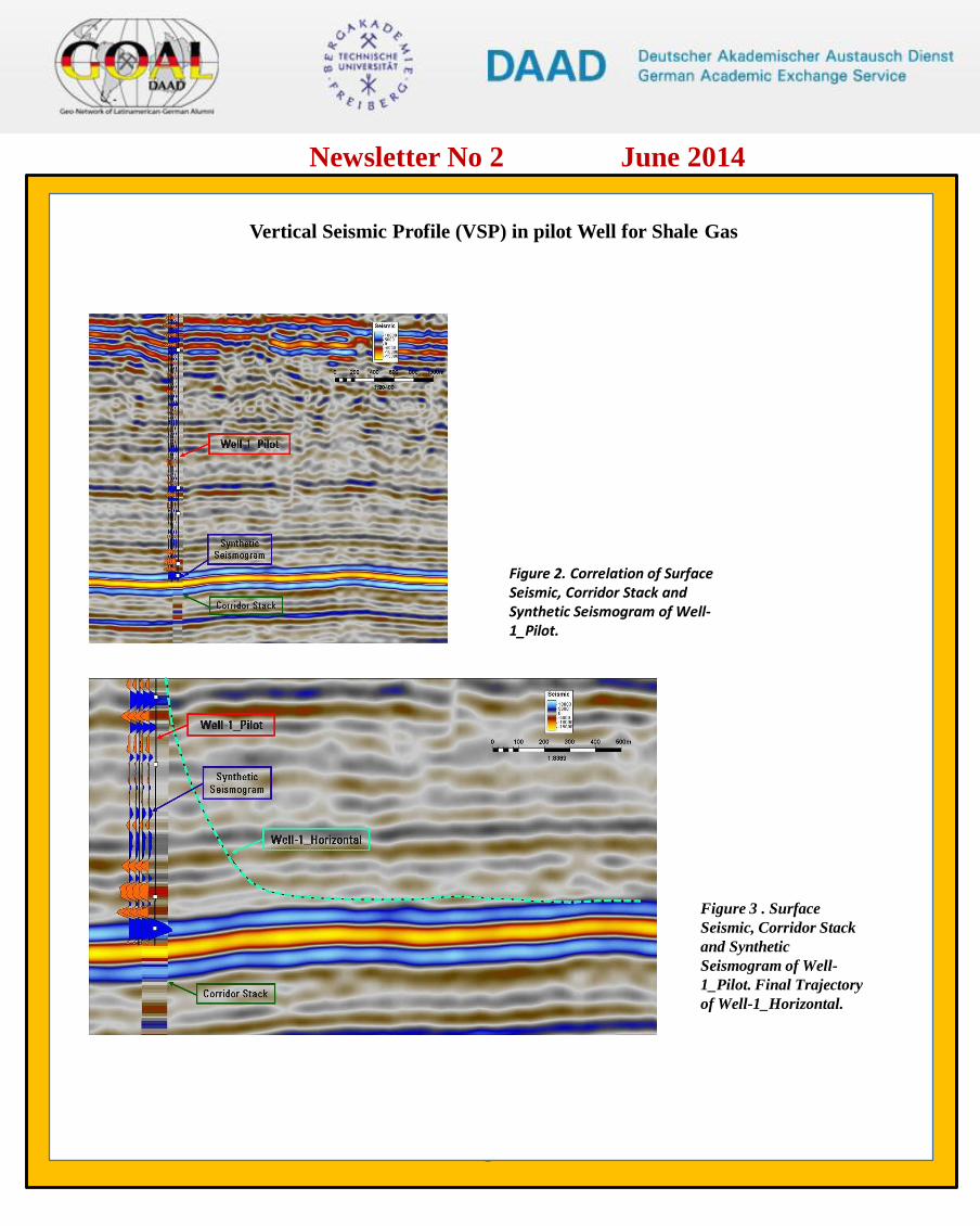
Figure 2. Correlation of Surface Seismic, Corridor Stack and Synthetic Seismogram of Well-1_Pilot.
Figure 3 . Surface
Seismic, Corridor Stack
and Synthetic
Seismogram of Well-
1_Pilot. Final Trajectory
of Well-1_Horizontal.

a
Vertical Seismic Profile (VSP) in pilot Well for Shale Gas
Conclusions
The Zero Offset VSP (ZVSP) acquisition of the vertical Well-1_Pilot showed excellent quality of the compressional
waves. The ZVSP information allowed obtaining a quality Time-Depth Curve in order to have a better velocity
control of the Well-1_Pilot and place it in its accurate position.
There was excellent correlation between the Surface Seismic, the Corridor Stack and Synthetic Seismogram. The
Formation can be identified by a negative peak (Acoustic Impedance decrease). According to the Surface Seismic
there was an estimated dip of 4-5 degrees of the Top of the Formation, which led to decide to navigate the Well-
1_Horizontal taking into account this dip. However, according to further analysis using resistivity measurements, the
navigation was performed considering a flat horizon placing the well below the desired Formation.
In conclusion, due to the exploration of unconventional reservoirs being in a development phase, we encourage to
have more investment to get as much information as possible in order to reduce the risk when finally placing a
horizontal well, fracturing and producing on shale gas reservoirs. As mention before, the VSP proposal also included
an Offset VSP and a Walkaway geometry, which could have helped to map the Top of Formation with better
resolution than the Surface Seismic.
Acknowledgements
We would like to thank the contribution of the following petrophysicists: Violeta Lujan, Belkys del Valle Guerra and
Pierre Bonningue.
References
US Energy Information Administration (2011): World Shale Gas Resources: An Initial Assessment of 14 Regions
Outside the United States. http://www.eia.gov/analysis/studies/worldshalegas/pdf/fullreport.pdf (05.05.2012)
Newsletter No 2 June 2014
a
4. Upcoming doctoral thesis
Caracterización geoambiental de la Bahía de Cayo Moa, Cuba
MSc. Yosbanis Cervantes Guerra, [email protected]
Resumen
El Centro de Estudios del Medio Ambiente del Instituto Superior Minero Metalúrgico de Moa (Cuba) y el Instituto
de Geología y Paleontología de la Universidad Técnica de Claustlal (Alemania), han realizado estudios de monitoreo
y evaluación geoambiental en la Bahía de Cayo Moa desde hace más de una década. Estas investigaciones han
permitido caracterizar el ambiente geológico en este sector costero a partir de la evaluación de cambios
geomorfológicos de la costa y los fondos marinos, el análisis de parámetros oceánicos y el grado de contaminación
de los sedimentos superficiales. Estos resultados permiten determinar el grado de repercusión que tienen los
principales impactos de la minería en la región sobre el ecosistema marino y conforman la tesis doctoral del MSc.
Yosbanis Cervantes (Cuba).
Newsletter No 2 June 2014
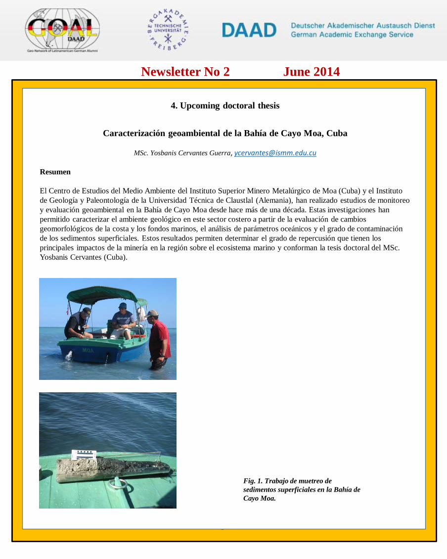
Fig. 1. Trabajo de muetreo de
sedimentos superficiales en la Bahía de
Cayo Moa.

a
5. New GOAL’s members.
Welcome to our new members from Peru and Brazil who have recently joined GOAL. We hope to have the opportunity to meet
them during our workshops.
Newsletter No 2 June 2014
Aldo Alván ([email protected]) got a bachelor degree in Geology at
Universidad Nacional Mayor de San Marcos, Peru. He obtained the
degree of Geologist Engineer with a thesis at INGEMMET (Geological
Survey of Peru), ranking the 2° position in the geosciences contest of
the year 2013 (Sociedad Geológica del Perú). Currently, he is working in
a PhD thesis at Georg-August University of Göttingen, Germany sponsored
by the DAAD and the Center of Geosciences of the University of
Göttingen. His thesis consists of an analysis of heavy minerals of the
Camaná Formation (Cenozoic) and ages of uplift of the Coastal Cordillera,
southern Peru. His homepage is:
http://www.uni-goettingen.de/de/aldo-alvan/473691.html
Ana Rosa Passos Pereira ([email protected]) has a bachelor degree in Chemistry. Currently she is working at Federal University of Minas Gerais (UFMG) where she completed her MSc and PhD on the transformation of iron oxides in a deposit of the Quadrilátero Ferrífero in Minas Gerais. Between 2011-2014, she completed a postdoctoral fellowship on the interaction of organic matter and iron oxides in Minas Gerais at Technical University of Munich (TUM). This fellowship was sponsored by CNPq (Brasilien company). She also has extensive experience using Mössbaurg Spectrography (57Fe).
Marcelo Gomes Speziali ([email protected]; [email protected]) got a master degree in the area of catalysis at Federal University of Minas Gerais (UFMG). He completed his PhD at Federal University of Rio Grande do Sul (UFRGS) with a period in Munich. He also studied German and German Culture at Goethe Institute in Freiburg where he was sponsored by DAAD. Between 2011-2012 he moved to Munich and there he started to work in the team of Professor Thorsten Bach at TU München. In the AKBach he worked with catalysis and Organic Chemistry. During his internship was sponsored by CNPq (Brasil) and DAAD (Germany). Currently he is a Professor at Department of Chemistry, Federal University of Ouro Preto (UFOP).
H
5. International Scientific Events
Geothermal Congress for Latin American and the Caribbean – GEOLAC 2014 on “Where Regional Geothermal Resources meet
world class technology. Financing and Expertise”, 16-17 julio, San José, Costa Rica. More información:
http://www.geothermlac.com/
International Conference and Field Seminar on "Karst without Boundaries”, 11-15 June, Bosnia and Herzegovina. More
information: http://www.speleogenesis.info/directory/calendar/event.php?id=237.html
II Latin-American and Caribbean Symposium on “Geophysics and Seismicity on exploration”, 23-25 July 2014, Bogotá, Colombia.
More information: http://geoslac.org/english/
II European Conference on “Earthquake Engineering and Seismology”, 24-29 August 2014, European Seismological Commission,
Istanbul, Turkey. More information: http://www.2eceesistanbul.org/
VI International Tsunami Symposium on “A Glimse into the future”, Tsunami Society International, 2 – September, 2014, Nicoya,
Costa Rica. More information: http://www.tsunamisociety.org
III Chilean International Renewable Energy Congress, 9-10 September 2014, Santiago, Chile. More information:
www.cirec2014.com
XVI International Symposium on “The Geoinformation serving to Society”, 29 September – 3 October, 2014, Medellin, Colombia.
More information: http://selpercolombia2014.com/en/
Our homepage is under construction. If you have any question or
comments about our Newsletter, please contact
Dr. Nury Morales-Simfors, [email protected]
Reviewed by: Prof. Reinaldo García,
Regional Coordinator - GOAL, [email protected]
Newsletter No 2 June 2014