web mapping service of natural background values of
TRANSCRIPT

Bayerisches Landesamt für Umwelt
Bayerisches Landesamt für Umwelt
Web Mapping Service of Natural Background Values
of Groundwater in Germany
Bernhard Wagner, LfU Bayern

Bayerisches Landesamt für Umwelt
2
Project background values of groundwater in Germany
Regional background values of groundwater –
legal requirements
• EU-Water Framework Directive: 2000/60/EG, 2006/118/EG:
achievement of good chemical status of groundwater bodies
• Soil Protection Act (Germany): BBodSchG (1999) (federal),
e.g. BayBodSchG (1999) (provincial)
definition of allowed threshold values of pollutants in groundwater

Bayerisches Landesamt für Umwelt
3
Project background values of groundwater in Germany
Project goals and concept
• Working group "Background values of groundwater": launched by the Geological Surveys of Germany 2005 within the
context of the EU-Water Framework Directive
• Goal: determine background values of groundwater in Germany
and make them available in an interactive internet application
• Reference: upper aquifer
• Data basis: abt. 48.000 groundwater measuring points
• Parameters: anorganic major and trace elements
physicochemical parameters

Bayerisches Landesamt für Umwelt
4
Project background values of groundwater in Germany
Parameters
naturally occurring anorganic elements:
Major elements: Ca, K, Mg, Na, HCO3, SO4, Cl
Trace elements: Br, F, PO4, SIO2, Fe, Mn, Ba, Sr
Ag, Al, As, B, Bi, Cd, Co, Cr, Cu, Hg, Li, Mo, Ni,
Pb, Sb, Se, Sn, T, Tl, U, V, Zn
Physicochemical
parameters: electrical conductivity, pH

Bayerisches Landesamt für Umwelt
5
Project background values of groundwater in Germany
Definition background value
Background value: the upper margin of the concentration of an
element to be expected in the groundwater
of a hydrogeochemical unit under natural
conditions
The background value is defined as the 90th percentile of the normal
distribution of the parameters.
Challenge:
Separation of the background population from geogenic or
anthropogenic anomalies within the data sets (component separation)

Bayerisches Landesamt für Umwelt
6
Project background values of groundwater in Germany
Hydrogeochemical units:
resulting from aggregation of hydrogeological units of the
Hydrogeological Map of Germany 1:200.000 (HÜK200)
Hydrogeological Regions
abt. 1000 hydrogeological units
186 hydrogeochemical units

Bayerisches Landesamt für Umwelt
7
Project background values of groundwater in Germany
Hydrogeochemical units:
resulting from aggregation of hydrogeological units of the
Hydrogeological Map of Germany 1:200.000 (HÜK200)

Bayerisches Landesamt für Umwelt
8
Project background values of groundwater in Germany
Background values and anomalies in the histogram
concentration, classified
freq
uen
cy o
f o
ccu
rren
ce
Background
Anomaly

Bayerisches Landesamt für Umwelt
9
Project background values of groundwater in Germany
From the histogram to the probability net
histogram
sum curve presentation in the
probability net
DIN 53804-1

Bayerisches Landesamt für Umwelt
10
Identification and exclusion of anomalies
Standard deviation from median value
99,5% 97,5% 90% 75% 50% 25% 10% 2,5% 0,5%
0,1
1
10
100
1000
-3 -2 -1 0 1 2 3
Measu
red
co
ncen
trati
on
MW
median value
threshold upper anomaly
threshold lower anomaly
no
rmal
dis
trib
uti
on
15,00
1,45
15,00
up
per
an
om
aly
low
er
an
om
aly
Project background values of groundwater in Germany
Bayerisches Landesamt für Umwelt
11
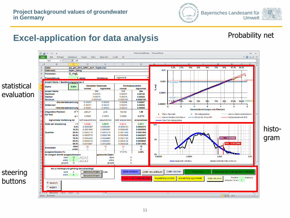
Excel-application for data analysis
steering buttons
statistical evaluation
Probability net
histo- gram
Project background values of groundwater in Germany

Bayerisches Landesamt für Umwelt
12
Advantages of the probability net
• Quick analysis of data distribution (anomalies, normal-lognormal dist.)
• Optical examination of data set on heterogeneities
• Suitable method for determination of statistical distribution parameters
for the background population
• Applicable to all data sets with at least 10 measured values, therefore
also suitable for units with only few measurements
• In combination with GIS a quick examination of systematic distribution of
anomalies possible (detection of patterns)
Project background values of groundwater in Germany

Bayerisches Landesamt für Umwelt
13
Project background values of groundwater in Germany
Statistical information of the hydrogeochemical units
Maximum
90%-Quantil
75%-Quantil
Median (entspricht 50%-Quantil)
arithmetisches Mittel
25%-Quantil
Minimum
10%-Quantil
80%der Werte
Ko
nze
ntr
ation
50%der Werte
Statistical measures: 5-, 10-, 25-, 50-, 75-, 90-, 95-percentiles
Minimum
75%-percentile
Median (50%-percentile)
25%-percentile
10%-percentile
50 %
of values
Maximum
90%-percentile
80 %
of values
Me
asu
red
co
nce
ntr
ations
Bayerisches Landesamt für Umwelt
14
Project background values of groundwater in Germany
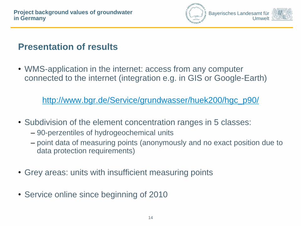
Presentation of results
• WMS-application in the internet: access from any computer connected to the internet (integration e.g. in GIS or Google-Earth)
http://www.bgr.de/Service/grundwasser/huek200/hgc_p90/
• Subdivision of the element concentration ranges in 5 classes:
– 90-perzentiles of hydrogeochemical units
– point data of measuring points (anonymously and no exact position due to data protection requirements)
• Grey areas: units with insufficient measuring points
• Service online since beginning of 2010

Bayerisches Landesamt für Umwelt
IAH Krakow 2010
15
Project background values of groundwater in Germany
Examples for different parameters:
Sulfate observation points

Bayerisches Landesamt für Umwelt
IAH Krakow 2010
16
Project background values of groundwater in Germany
Examples for different parameters:
Sulfate distribution 90-perzentile

Bayerisches Landesamt für Umwelt
IAH Krakow 2010
17
Project background values of groundwater in Germany
Examples for different parameters:
Vanadium observation points

Bayerisches Landesamt für Umwelt
IAH Krakow 2010
18
Project background values of groundwater in Germany
Examples for different parameters:
Vanadium distribution 90-perzentile

Bayerisches Landesamt für Umwelt
IAH Krakow 2010
19
Project background values of groundwater in Germany
Examples for different parameters:
Calcium distribution 90-perzentile

Bayerisches Landesamt für Umwelt
IAH Krakow 2010
20
Project background values of groundwater in Germany
Examples for different parameters:
Hydrogencarbonate distribution 90-perzentile

Bayerisches Landesamt für Umwelt
IAH Krakow 2010
21
Project background values of groundwater in Germany
Examples for different parameters:
Chloride distribution 90-perzentile

Bayerisches Landesamt für Umwelt
IAH Krakow 2010
22
Project background values of groundwater in Germany
Examples for different parameters:
Arsenic distribution 90-perzentile

Bayerisches Landesamt für Umwelt
23
Project background values of groundwater in Germany
Using the WMS in ArcGIS: Example sulfate

Bayerisches Landesamt für Umwelt
24
Project background values of groundwater in Germany
Using the WMS in ArcGIS: Example sulfate

Bayerisches Landesamt für Umwelt
25
Project background values of groundwater in Germany
Using the WMS in ArcGIS: Example sulfate

Bayerisches Landesamt für Umwelt
26
Project background values of groundwater in Germany
Using the WMS in ArcGIS: Example sulfate

Bayerisches Landesamt für Umwelt
27
Project background values of groundwater in Germany
Using the WMS in ArcGIS: Example sulfate

Bayerisches Landesamt für Umwelt
28
Project background values of groundwater in Germany
Using the WMS in ArcGIS: Example sulfate

Bayerisches Landesamt für Umwelt
29
Project background values of groundwater in Germany
Using the WMS in ArcGIS: Example sulfate

Bayerisches Landesamt für Umwelt
30
Project background values of groundwater in Germany
Using the WMS in ArcGIS: Example sulfate

Bayerisches Landesamt für Umwelt
31
Project background values of groundwater in Germany
Example: combination of different WMS in ArcGIS

Bayerisches Landesamt für Umwelt
32
Project background values of groundwater in Germany
Example: combination of different WMS in ArcGIS

Bayerisches Landesamt für Umwelt
33
Project background values of groundwater in Germany
Example: combination of different WMS in ArcGIS

Bayerisches Landesamt für Umwelt
34
Project background values of groundwater in Germany
Example: combination of different WMS in ArcGIS

Bayerisches Landesamt für Umwelt
35
Project background values of groundwater in Germany
Example: combination of different WMS in ArcGIS

Bayerisches Landesamt für Umwelt
36
Project background values of groundwater in Germany
Example: combination of different WMS in ArcGIS

Bayerisches Landesamt für Umwelt
37
Project background values of groundwater in Germany
Example: combination of different WMS in ArcGIS

Bayerisches Landesamt für Umwelt
38
Project background values of groundwater in Germany
Presentation of results
GeoViewer BGR

Bayerisches Landesamt für Umwelt
39
Project background values of groundwater in Germany
Presentation of results
Soil Information System Bavaria

Bayerisches Landesamt für Umwelt
40
Project background values of groundwater in Germany
Benefits of the Web Map Service
• Direct and straightforward availability of data via the internet
• Basis for evaluation of the chemical status of groundwater bodies
• Evaluation of groundwater analyses based on the regional
background values
• Easier identification of groundwater contaminations
• Local specific features of groundwater chemical properties can be
identified through the point data

Bayerisches Landesamt für Umwelt
41
Project background values of groundwater in Germany
Outlook: ongoing works
• Following requirements of the EU-Water Framework Directive, many
additional measurements of groundwater quality have been
performed in the meantime
• Trace elements with larger gaps in the dataset are being re-
evaluated:
As, B, Ba, Cd, Co, Cr, Cu, F, Hg, Mo, Ni, Pb, Sb, Se, Tl, U, V, Zn
• Improvement of usability of the WMS
• Add maps of medians (50-percentiles) adding up to >120 layers
• New WMS with enlarged dataset and new functions shall be available
at the end of the year