web based coastal gis for southern coastal tamilnadu by ... · web based coastal gis for southern...
TRANSCRIPT

INTERNATIONAL JOURNAL OF GEOMATICS AND GEOSCIENCES Volume 1, No 3, 2010
© Copyright 2010 All rights reserved Integrated Publishing services Research article ISSN 0976 – 4380
649
Web based coastal GIS for southern coastal Tamilnadu by using ArcIMS server technology
Sheik Mujabar.P 1 , Chandrasekar.N 2 1 Associate Professor, National College of Engineering, Tirunelveli,
2 Center for GeoTechnology, Manonmaniam Sundaranar University, Tirunelveli [email protected]
ABSTRACT
There is a need for a wider dissemination of knowledge relevant to the importance of coastal and marine areas to the world’s wellbeing, sustainable development, environmental safety and a reevaluation of societies. There are multiinterest groups in the coastal zone and each group has its own area of interest and aspects of coastal environment, be it the shipping and harbors facilities, fisheries, developmental projects, sand and mineral mining, military maneuvers, recreation and conservation. The web based coastal GIS can provide all these specific requirements required by these multi interest groups.
This paper presents the information on the development and implication of webbased coastal GIS (STNCOASTGIS, www.geotechmsu.co.cc) for analysing the dynamics of coastal landform features along the southern coastal Tamil Nadu of India by using ArcIMS server technology. It also deals with the concept, architecture and advantages of ArcIMS technology. The integration of spatial and nonspatial database for the study area has been discussed. The effective dissemination of geospatial information and the findings of the recent researches on the southern coastal Tamil Nadu have been visualised through the web based coastalGIS. The webGIS for the study area have wide applications in the field of geology, coastal zone management and developmental projects. It provides upto date information and dynamics of the various coastal landform features such as sandy beaches, sand dunes, spits, sand bars etc. It also provides the landuse and landcover mapping along the southern coastal Tamil Nadu. Thus the developed web based coastal GIS is very useful for the coastal planers, engineers and policy makers to plan various developmental projects in sustainable environmental way.
Key Words:WebGIS, Server GIS, Coastal feature, STNCOASTGIS, India.
1. Introduction
The sustainable development in coastal zone is vital to our society (CicinSain, 1993), given that many cities around the world are concentrated in the coastal fringe. Despite the high appraisals of the potential of GIS application in coastal and marine environment, the development of coastal GIS is still relatively slow (Bartlett, 2000; Hooge, et al., 2000) due to the complexity of highly dynamic coastal and marine systems and lack of communication between coastal experts and GIS professional (Green, 1995).

INTERNATIONAL JOURNAL OF GEOMATICS AND GEOSCIENCES Volume 1, No 3, 2010
© Copyright 2010 All rights reserved Integrated Publishing services Research article ISSN 0976 – 4380
650
The development of coastal GIS has begun as early as 1970’s (Ellis, 1972), and is well developed in the last decade. The development of web based coastal GIS, which totally resides on remote server, allows users to access and analyse the dynamic geospatial information through a web browser or equivalent, thus requiring no user installed software. The system provides enough core GIS capability and allows the creation of GIS data layers but is user friendly enough to provide access to users who are not GIS specialists. Web based GIS could provide interactive mapping and spatial analysis capabilities reducing the problem of data ownership as data providers could open their sources for online mapping and analysis. WebGIS is the latest advances in GIS technologies that bring spatial information and nonspatial information via internet. Access to data over the internet is growing rapidly and information sharing through web GIS Server is important as it reduces cost of data; provide standard data, conformity of data and data interoperability. The web lets data provider make spatial information available to a wider audience. The data provider can therefore provide a virtually centralised repository of resources without having to change the physical location of the data. This prevents any problems that might arise from maintaining or updating duplicate data sources, such as limited space or corrupt data. The web therefore makes it easy to provide the most up to date spatial data (Fitzgerald, 2000).
Lan and Martin (2007) states that the data collection, management and synthesis are very important for solving any geotechnical engineering problem. Lan et al. (2009) states that the webbased GIS tools were designed to facilitate the all the above tasks. The use of WebGIS makes geographic information available to larger audiences than conventional GIS packages (GuoJing et al., 2005) or data files stored in a simple server (Hess, 2002). It also enables the integration of geospatial datasets of land and water resources or other spatial information (Mathiyalagan et al., 2005). This allows realtime access to a high volume of data for all users that need it (Kraak, 2004). Yank et al. (2007) used web GIS for disaster management in Taiwan. They states that by providing realtime and correct information for response actions, rescue plans, and rehabilitation programs, the utility of WebGIS techniques will be widely noticed in the future establishments of disaster prevention and rescue information systems. In order to enhance the comprehension of the WebGIS information system, it will remain to be updated and extended the current GIS maps in the future.
The WebGIS is very essential for coastal zone management that deals with geographic information for decision support on a distributed and highly dynamic coastal environment. It becomes more important when the locationspecific information is dynamic and decisions have to be made on real time basis. A highly costeffective way to make geographic data and analyses more widely available and more accessible across an enterprise is to develop web applications. This permits visualization and simple query of spatial information, but also complex spatial operations such as geocoding and route networking. Gillavry (2000) state that, the combination of easy access to data and visual presentation of its location some of the primary difficulties in performing geosciences evaluations. The web application allows the user for visual interaction with the geographic data and to produce interactive maps of dynamic coastal features such as

INTERNATIONAL JOURNAL OF GEOMATICS AND GEOSCIENCES Volume 1, No 3, 2010
© Copyright 2010 All rights reserved Integrated Publishing services Research article ISSN 0976 – 4380
651
shorelines and landforms. Since these data are frequently updated, the clients can immediately view these updates, which help to speed up the evaluation and analysis process.
2. Geological Settings
The proposed area for the WebGIS is the coast between Kanyakumari and Tuticorin along the southern coastal Tamil Nadu (Figure 1), which extends over a distance of 160 km. The Kanyakumari coast is highly influenced by tourism and other developments. The Tuticorin is one of the major ports in India. The coast between Kanyakumari and Tuticorin has different morphological features and is highly dynamic in nature. The coast is endowed with a wide range of ecosystems such as mangroves, coral reefs, sea grasses, salt marshes, sand dunes, and estuaries and each of these ecosystems are in turn characterised by distinct biotic and abiotic processes. The drainage pattern along the study area is controlled by a major river Tambraparni, minor streams like Palaiyar, Nambiyar, Hanuman Nadhi and seasonal streams like Nilapparai channel, Puttanar channel. Cliffs are along the Kanyakumari coast which projects towards the Indian Ocean forming promontory. Most of the coastal areas have sandy beaches and some areas are rocky in nature. Headlands are also present along the coast of Manappad, Tiruchendur and Kayalpattinam.
Figure 1: Study Area Map for Coastal GIS
INTERNATIONAL JOURNAL OF GEOMATICS AND GEOSCIENCES Volume 1, No 3, 2010
© Copyright 2010 All rights reserved Integrated Publishing services Research article ISSN 0976 – 4380
652
The entire study area is vitally used for various developmental purposes. Recently various projects like Kudankulam nuclear power plant, Sethusamuthiram ship canal are also started along the study area. Coastal sand mining is actively pursued along the coasts of Idinthakarai, Navaladi, Ovari and Periathalai. Due to abundant natural resources, the urbanization and population increases rapidly on the coastal areas. They put high pressure on the coastal areas and finally they are under severe threat and hazards. The coast has also experiences drastic changes in the beach morphology. Both natural and anthropogenic activities leads to coastal degradation and various hazards like sea water intrusion, coastal erosion, floods, Tsunami etc. Chandrasekar et al. (2005) and Mujabar et al. (2007) reported that the recent December 2004 tsunami in the Indian Ocean induced large amount of beach erosion and accretion along the study area. Channels were deepened by tsunamiinduced currents, and sometimes made shallow by transported and deposited sediments.
3. Architecture and Advantages of ArcIMS
3.1. Architecture of ArcIMS
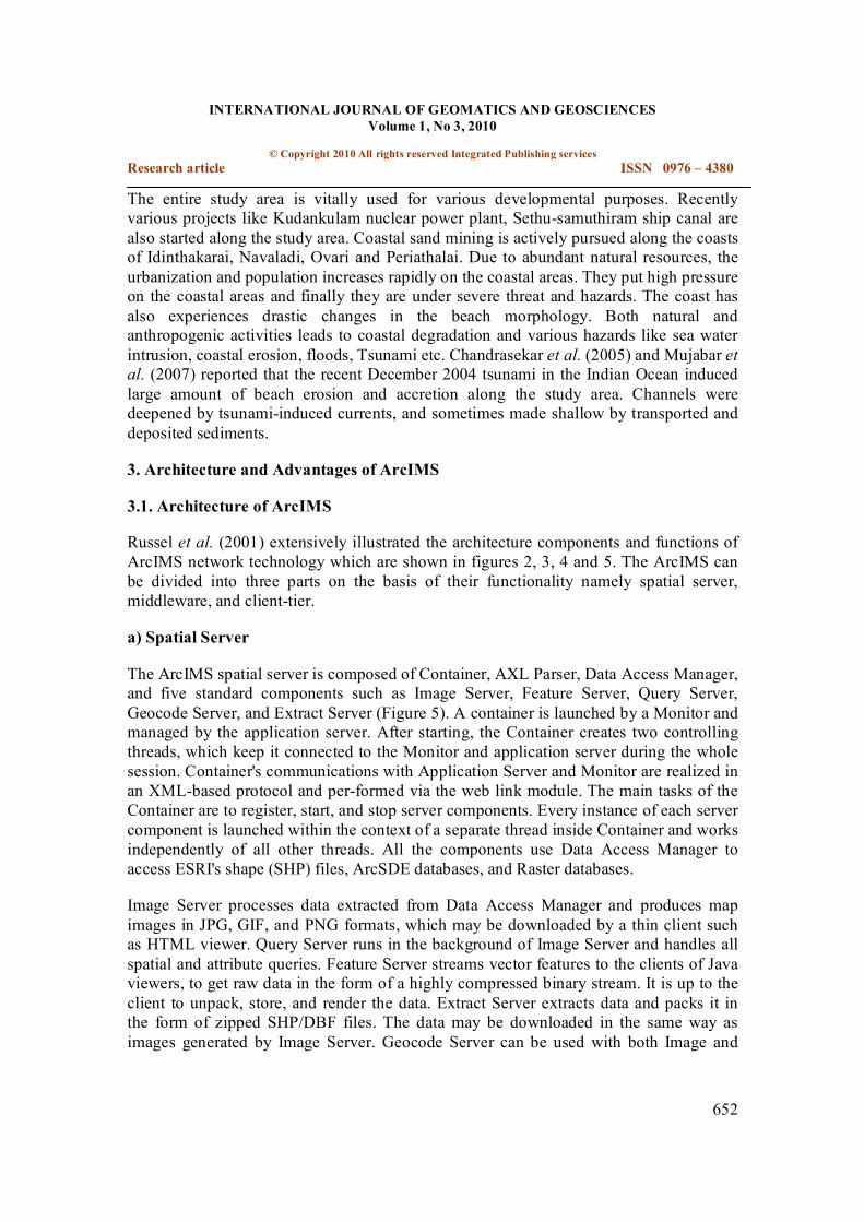
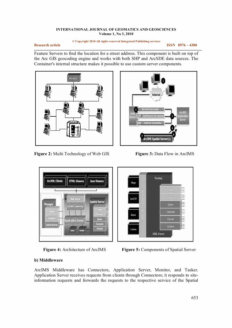
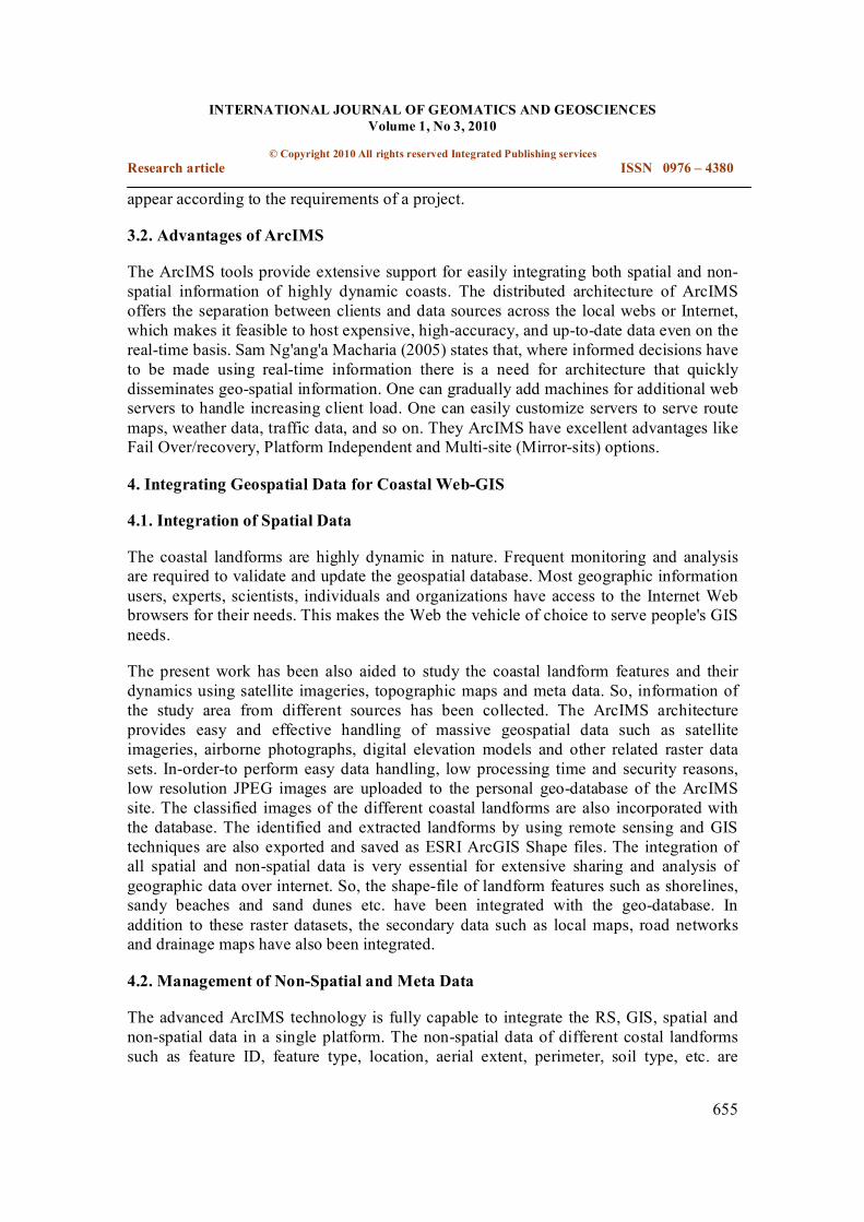
Russel et al. (2001) extensively illustrated the architecture components and functions of ArcIMS network technology which are shown in figures 2, 3, 4 and 5. The ArcIMS can be divided into three parts on the basis of their functionality namely spatial server, middleware, and clienttier.
a) Spatial Server
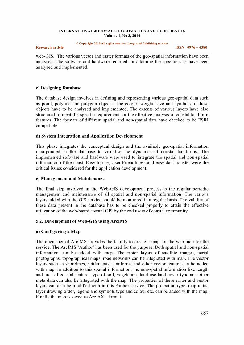
The ArcIMS spatial server is composed of Container, AXL Parser, Data Access Manager, and five standard components such as Image Server, Feature Server, Query Server, Geocode Server, and Extract Server (Figure 5). A container is launched by a Monitor and managed by the application server. After starting, the Container creates two controlling threads, which keep it connected to the Monitor and application server during the whole session. Container's communications with Application Server and Monitor are realized in an XMLbased protocol and performed via the web link module. The main tasks of the Container are to register, start, and stop server components. Every instance of each server component is launched within the context of a separate thread inside Container and works independently of all other threads. All the components use Data Access Manager to access ESRI's shape (SHP) files, ArcSDE databases, and Raster databases.
Image Server processes data extracted from Data Access Manager and produces map images in JPG, GIF, and PNG formats, which may be downloaded by a thin client such as HTML viewer. Query Server runs in the background of Image Server and handles all spatial and attribute queries. Feature Server streams vector features to the clients of Java viewers, to get raw data in the form of a highly compressed binary stream. It is up to the client to unpack, store, and render the data. Extract Server extracts data and packs it in the form of zipped SHP/DBF files. The data may be downloaded in the same way as images generated by Image Server. Geocode Server can be used with both Image and
INTERNATIONAL JOURNAL OF GEOMATICS AND GEOSCIENCES Volume 1, No 3, 2010
© Copyright 2010 All rights reserved Integrated Publishing services Research article ISSN 0976 – 4380
653
Feature Servers to find the location for a street address. This component is built on top of the Arc GIS geocoding engine and works with both SHP and ArcSDE data sources. The Container's internal structure makes it possible to use custom server components.
Figure 2:Multi Technology of Web GIS Figure 3: Data Flow in ArcIMS
Figure 4: Architecture of ArcIMS Figure 5: Components of Spatial Server
b) Middleware
ArcIMS Middleware has Connectors, Application Server, Monitor, and Tasker. Application Server receives requests from clients through Connectors; it responds to site information requests and forwards the requests to the respective service of the Spatial

INTERNATIONAL JOURNAL OF GEOMATICS AND GEOSCIENCES Volume 1, No 3, 2010
© Copyright 2010 All rights reserved Integrated Publishing services Research article ISSN 0976 – 4380
654
Server. Once Spatial Server sends back the response, it conveys it back to the client that sent the request. A Monitor starts Spatial Servers and makes sure that Spatial Servers are always running. The Tasker cleans up the images generated by Image Server after a predefined time interval so that the Web site does not run out of disk space.
c) Client Tier
The client tier provides a user interface for the end user of the system to interact with the distributed GIS. It displays maps in a web page and manage map services on the server. In ArcIMS, this tier uses ArcXML as the language of interaction with all components within the system over HTTP transport. The significance of ArcXML in ArcIMS is that any application that can read and/or write XML can be a client to ArcIMS. Client tier uses the following applications for accomplishing its tasks.
i) ArcIMS Administrator
It is a Java 2 Application and applet that enables the ArcIMS Administrator to manage map services, Spatial and Virtual Servers, and Folders Creating and managing an ArcIMS site is simplified using this tool.
ii) ArcIMS Author
It is a tool that enables an end user to author an electronic map or the Web. The tool allows a user to visually create a configuration file that can be used by the ArcIMS Administrator to create a map service. Users can add spatial data, symbolize the data, set scale dependencies, and perform similar operations on a map window using a Java 2 application or applet running inside of the ArcIMS Manager web pages.
iii) ArcIMS Designer
It is a tool that enables a user to generate a "readytorun" Web site using a wizard. The Designer is a Java 2 Application and applet that is run after a map service is created. This enables a user to get up and running quickly with a web site that can be modified to suit the project needs. The Designer outputs the three ArcIMS ViewersHTML, Java Custom, and Java Standard.
iv) ArcIMS Manager
It is a web site designed for enabling a user to quickly begin using and managing an ArcIMS site. The Manager consists of the ArcIMS Administrator, Author, and Designer.
v) HTML, Java Standard and Custom Viewers
There are three ArcIMS viewersHTML, Java Custom, and Java Standarduse a Web site template to provide the functionality and graphic look of a Web site. Since these viewers are implemented as a template or a starting point, they can be modified to behave and
INTERNATIONAL JOURNAL OF GEOMATICS AND GEOSCIENCES Volume 1, No 3, 2010
© Copyright 2010 All rights reserved Integrated Publishing services Research article ISSN 0976 – 4380
655
appear according to the requirements of a project.
3.2. Advantages of ArcIMS
The ArcIMS tools provide extensive support for easily integrating both spatial and non spatial information of highly dynamic coasts. The distributed architecture of ArcIMS offers the separation between clients and data sources across the local webs or Internet, which makes it feasible to host expensive, highaccuracy, and uptodate data even on the realtime basis. Sam Ng'ang'a Macharia (2005) states that, where informed decisions have to be made using realtime information there is a need for architecture that quickly disseminates geospatial information. One can gradually add machines for additional web servers to handle increasing client load. One can easily customize servers to serve route maps, weather data, traffic data, and so on. They ArcIMS have excellent advantages like Fail Over/recovery, Platform Independent and Multisite (Mirrorsits) options.
4. Integrating Geospatial Data for Coastal WebGIS
4.1. Integration of Spatial Data
The coastal landforms are highly dynamic in nature. Frequent monitoring and analysis are required to validate and update the geospatial database. Most geographic information users, experts, scientists, individuals and organizations have access to the Internet Web browsers for their needs. This makes the Web the vehicle of choice to serve people's GIS needs.
The present work has been also aided to study the coastal landform features and their dynamics using satellite imageries, topographic maps and meta data. So, information of the study area from different sources has been collected. The ArcIMS architecture provides easy and effective handling of massive geospatial data such as satellite imageries, airborne photographs, digital elevation models and other related raster data sets. Inorderto perform easy data handling, low processing time and security reasons, low resolution JPEG images are uploaded to the personal geodatabase of the ArcIMS site. The classified images of the different coastal landforms are also incorporated with the database. The identified and extracted landforms by using remote sensing and GIS techniques are also exported and saved as ESRI ArcGIS Shape files. The integration of all spatial and nonspatial data is very essential for extensive sharing and analysis of geographic data over internet. So, the shapefile of landform features such as shorelines, sandy beaches and sand dunes etc. have been integrated with the geodatabase. In addition to these raster datasets, the secondary data such as local maps, road networks and drainage maps have also been integrated.
4.2. Management of NonSpatial and Meta Data
The advanced ArcIMS technology is fully capable to integrate the RS, GIS, spatial and nonspatial data in a single platform. The nonspatial data of different costal landforms such as feature ID, feature type, location, aerial extent, perimeter, soil type, etc. are

INTERNATIONAL JOURNAL OF GEOMATICS AND GEOSCIENCES Volume 1, No 3, 2010
© Copyright 2010 All rights reserved Integrated Publishing services Research article ISSN 0976 – 4380
656
integrated as attributes with the personal geodatabase. This will enhance the GIS analysis capability of the ArcIMS site. Thus the geodatabase is discrete representation of geographical reality with spatial and nonspatial data to compute and perform extensive and effective GIS analysis.
5. Designing and Development of Web based Coastal GIS
5.1. Design and Developmental Cycle of WebGIS
Figure 6: Development Cycle of Web based CoastalGIS
Several strategies have been proposed to provide successful implementation of a web based coastal GIS system (Alesheikh and Helali, 2001). The implementation strategies have been successfully assessed so that the proposed application would meet the requirements with high efficiency. The Figure 6 shows the workflow (Development Cycle) followed in the development of the coastal GIS application for analysing the dynamics of coastal landforms.
a) Requirement Analysis
The present coastal webGIS is to visualise the available information on the coastal landform features along the southern coastal Tamil Nadu. The various visualizations functions such as Pan, Zoon, and Spatial Query for the analysis for the dynamics coastal landform features have been analysed. The required GIS layers such as shorelines, landform layers which have to incorporate with the GIS have been properly discussed.
b) Conceptual Design
The information gained in the requirement analysis leads to the conceptual design of
INTERNATIONAL JOURNAL OF GEOMATICS AND GEOSCIENCES Volume 1, No 3, 2010
© Copyright 2010 All rights reserved Integrated Publishing services Research article ISSN 0976 – 4380
657
webGIS. The various vector and raster formats of the geospatial information have been analysed. The software and hardware required for attaining the specific task have been analysed and implemented.
c) Designing Database
The database design involves in defining and representing various geospatial data such as point, polyline and polygon objects. The colour, weight, size and symbols of these objects have to be analysed and implemented. The extents of various layers have also structured to meet the specific requirement for the effective analysis of coastal landform features. The formats of different spatial and nonspatial data have checked to be ESRI compatible.
d) System Integration and Application Development
This phase integrates the conceptual design and the available geospatial information incorporated in the database to visualise the dynamics of coastal landforms. The implemented software and hardware were used to integrate the spatial and nonspatial information of the coast. Easytouse, UserFriendliness and easy data transfer were the critical issues considered for the application development.
e) Management and Maintenance
The final step involved in the WebGIS development process is the regular periodic management and maintenance of all spatial and nonspatial information. The various layers added with the GIS service should be monitored in a regular basis. The validity of these data present in the database has to be checked properly to attain the effective utilization of the webbased coastal GIS by the end users of coastal community.
5.2. Development of WebGIS using ArcIMS
a) Configuring a Map
The clienttier of ArcIMS provides the facility to create a map for the web map for the service. The ArcIMS ‘Author’ has been used for the purpose. Both spatial and nonspatial information can be added with map. The raster layers of satellite images, aerial photographs, topographical maps, road networks can be integrated with map. The vector layers such as shorelines, settlements, landforms and other vector feature can be added with map. In addition to this spatial information, the nonspatial information like length and area of coastal feature, type of soil, vegetation, land useland cover type and other metadata can also be integrated with the map. The properties of these raster and vector layers can also be modified with in this Author service. The projection type, map units, layer drawing order, legend and symbols type and colour etc. can be added with the map. Finally the map is saved as Arc AXL format.
INTERNATIONAL JOURNAL OF GEOMATICS AND GEOSCIENCES Volume 1, No 3, 2010
© Copyright 2010 All rights reserved Integrated Publishing services Research article ISSN 0976 – 4380
658
b) Creating a Web Map Service
The web map service such as feature service or image service is required for the incorporating the map. The web map service can be created by using the ArcIMS Administrator. It provides tools to create a web map service. The developed ArcIMS map in Arc AXL format or mxd format can be used to produce the map service. The type of image data (such as jpeg, png etc.), output directory, website directory and html location can also modified by the ArcIMS Administrator.
c) Development of Graphical User Interface (GUI)
The ArcIMS Designer provides tools to produce interactive websites for publishing the map. The name of website directory, title of web page, ArcIMS hostname can be specified in the designer. The type of viewers such as html, Java custom and Java standard can be selected and integrated. The extent of all feature layers, data source units, scale bar units can also be modified. The designer also helps to incorporate various functional tools such as zoon, pan, query etc. with the website. Thus the ArcIMS designer provides an interactive graphical user interface (web page) for the service.
d) Client Viewer Tools and Controls
The ArcIMS browser interface supplies the user with a number of tools to view, select, and search spatial data. These tools allow the user to zoom in or out, pan, measure, select, find, create custom map views, and buffer or query spatial features and their associated attributes.
e) Publication of Coastal Geographic Data
The developed website namely ‘STNCOASTGIS’ (Figure 7) has been launched through the local intranet. It is incorporated with major coastal landform features along the study area with more interactive GIS tools. The developed site has been modified and managed by the ArcIMS Administrator.
5.3 Applications of the Developed Coastal GIS
The coastal GIS provide the different landform features along the coast. All the spatial and nonspatial information of the southern coastal Tamil Nadu can be visualised. The basic GIS functions such as Pan and Zoom in, Zoom out and Identify and GIS analysis can be performed by using the coastal GIS. Advanced GIS analysis such as spatial Query and attributes data can also be performed. This query tool can be used to make a single criteria query on the records from the active layer. Buffer can also be created around the coastal features. This tool also finds the features of one layer within a set buffer distance of the selected features of another layer.
The coastal GIS can provide the landuse and landcover type of any geographic region along the southern coastal Tamil Nadu. It also provides the interactive maps of the

INTERNATIONAL JOURNAL OF GEOMATICS AND GEOSCIENCES Volume 1, No 3, 2010
© Copyright 2010 All rights reserved Integrated Publishing services Research article ISSN 0976 – 4380
659
different landforms along the coast. By using latest landform maps, one can easily and quickly analyze the dynamics of different coastal landform features along the southern coastal Tamil Nadu on the realtime basis. The developed maps can also be exported and printed. The coastal GIS have tools to measure the distances between any geographic locations on the map. To use this tool, the user leftclicks within the map frame (keeping the left mouse button held down), drags, and then releases the left mouse button (also within the map frame) to measure the distance between two points. The distance is then precisely measured and displayed. The identify tool can be used to obtain all the Meta data linked with the point, line and polygon data.
Figure 7: Graphical User Interface of STNCOASTGIS (ArcIMS Website)
5.4 Comments and Conclusion
Internet is a standard technology which is widely available and commonly used. Based on this technology, the advanced GIS analysis and applications can be provided which are easy to use even for non GIS experts. Many users can easily access large volume of geographic data stored in data servers through high speed Internet. The information stored on different servers can also be linked together easily by using the hyperlink
INTERNATIONAL JOURNAL OF GEOMATICS AND GEOSCIENCES Volume 1, No 3, 2010
© Copyright 2010 All rights reserved Integrated Publishing services Research article ISSN 0976 – 4380
660
techniques of GIS servers. The Web GIS development processes faces new challenges such as technology innovations, voluminous data transfer rate, and nonspecialist users. The development and applications of web based coastal GIS for the southern coastal Tamil Nadu using ArcIMS server has been attempted and presented in this paper. The architectures and advantages of ArcIMS technology for producing successful applications in developing coastal GIS have also been reviewed. The development cycle which has to be followed in developing the coastal GIS has been illustrated. The integration of various geographic data and their attributes has been dealt with proper care and attention.
The developed Web based GIS for the southern coastal Tamil Nadu provides several capabilities that can greatly help the geoscientists, coastal planers, engineers, researchers and policy makers. The web application allows the user for visual interaction with the geographic data. They also produce interactive maps of different coastal features such as shorelines and landforms. The dynamics of coastal landform features can be analysed. Since these data are frequently updated, the clients can immediately view these updates, which help to speed up the evaluation and analysis process.
Acknowledgement
The authors are thankful to Dr. Bhoop Singh, Director, NRDMS, Department of Science and Technology, New Delhi for providing the financial assistance under NRDMS Scheme (ES/11/546/2000 and ES/11/936(5)/05).
6. References
1. Chandrasekar, N. and Immanuel, J. L. (2005): GIS Supported Categorisation of Tsunami Experienced Beaches along the Southern East Coast of India. Usage in Mitigation Activities. In: Proc. National Seminar on GIS Application in Rural Development, Hyderabad, India, pp 349362.
2. CicinSain, (1993): Sustainable development and integrated coastal management. Ocean and Coastal Management, 21(13), pp 1143.
3. Ellis, (1972): Coastal zone management system: a combination of tools. In Marine Technology Society (eds): Tools for Coastal Zone Management, Washington, D.C.: Marine Technology Society.
4. Fitzgerald, J., (2000): CARIS Spatial Fusion: an Internet GIS. White Paper #7 http://www.spatialcomponents.com/techpapers/fusion.pdf. Fredericton, New Brunswick, Canada, February 4.
5. Gillavry, E.M., (2000): Cartographic aspects of Web GISsoftware. Department of Cartography Utrecht University, Submitted thesis for degree of Ph.D.

INTERNATIONAL JOURNAL OF GEOMATICS AND GEOSCIENCES Volume 1, No 3, 2010
© Copyright 2010 All rights reserved Integrated Publishing services Research article ISSN 0976 – 4380
661
6. Green, (1995): Useraccess to information: a priority for estuary information systems. CoastGIS’95, pp 3550.
7. GuoJing, Y., Vounatsou, P., XiaoNong, Z., Utzinger, J., Tanner, M., (2005): A review of geographic information system and remote sensing with applications to the epidemiology and control of schistosomiasis in China. Acta Tropica 96, pp117129.
8. Hess, S., (2002): GRASS on the Web. Proceedings of the Open source GIS GRASS users conference 2002Trento, Italy, 1113 September 2002.
9. Hooge, P. N., Eichenlaub, Q. M. and Solomon, E. K., (2000): Using GIS to Analyze Animal Movements in the Marine Environment. (Personnel Communication).
10. Kraak, M., (2004): The role of the map in a WebGIS environment. Journal of Geographical Systems. 6, 8393.
11. Lan, H. and Martin, C. D., (2007): A digital approach for integrating geotechnical data and stability analyses, in: Rock Mechanics:Meeting Society’s Challenges and Demands, edited by: Eberhardt, E., Stead, D., and Morrison, T., London, Taylor & Francis, pp 45–52.
12. Lan, H. X., Martin, C. D., Froese, C. R., Kim, T. H., Morgan A. J., Chao, D. and Chowdhury,S., (2009): A webbased GIS for managing and assessing landslide data for the town of Peace River, Canada. Natural Hazards Earth Syst. Sci., 9, pp 1433–1443.
13. Mathiyalagan, V., Grunwald, S., Reddy, R., Bloom,S., (2005): A WebGIS and geodatabase for Florida's wetlands. Computers and Electronics in Agriculture. 47, pp 6975.
14. Mujabar, P.S., Chandrasekar, N., Saravanan, P., Loveson, S., (2007)” Impact of the 26 th December 2004 Tsunami along the Coast between Kanyakumari and Ovari, Tamil Nadu, South India. Shore and Beach, 75(2), pp 2229.
15. Russell, E., Roop Goyal, Art Haddad, (2001): The Architecture of ArcIMS, a Distributed Internet Map Server. SpringerVerlag Berlin Heidelberg, C.S. Jensen et al. (Eds.): SSTD 2001, LNCS 2121, pp 387403.
16. Sam, Ng'ang'a Macharia, (2005): New Directions for Coastal and Marine Monitoring: Web Mapping and Mobile Application Technologies, GIS for Coastal Zone Management, Darius Bartlett and Jennifer Smith (Edi.) CRC PRESS, Boca Raton London New York Washington.
INTERNATIONAL JOURNAL OF GEOMATICS AND GEOSCIENCES Volume 1, No 3, 2010
© Copyright 2010 All rights reserved Integrated Publishing services Research article ISSN 0976 – 4380
662
17. Yank, M. D., Lin, C. C., Chen, S. C, Su, T. C., (2007): A WebGIS Disaster Management System Applied in Central Taiwan, 2nd International Conference on Urban Disaster Reduction November 2729.